Embed Size (px)
Citation preview

August 28, 2013
La Plata Archuleta Water District
c/o Harris Water Engineering
Mr. Brett Sherman, P.E.
954 East 2nd Avenue, Suite 202
Durango, Colorado 81301
PN: 53225GE
Subject: Geotechnical Engineering Subsurface Exploration
The Proposed LAPLAWD Phase 1E 12” Main Water Line
Durango, Colorado
Mr. Sherman,
This letter presents our test bore logs from our field exploration for the LAPLAWD Phase 1E 12” Main
Water Line along the east and north side of County Road 510 between the intersections of La Plata
County Road 513 and La Plata County Road 225A . The figure below shows the approximate locations
of our test borings, and where potential shallow formational material may be encountered during the
water line trench excavation. The logs of our test borings are attached to this letter.
We encountered formational material in Test Borings Three, Five, Eight, and Nine in Phase 1E at depths
that ranged from one (1) to two and one-half (2 1/2) feet below the existing ground surface. The
formational material encountered in Test Boring Three was consisted of hard claystone material. The
formational material encountered in Test Boring Eight and Nine consisted of very hard sandstone
material. We encountered extremely weathered claystone material in Test Boring Five at one (1) foot
below the ground surface. In addition to the test borings, we observed formational material adjacent to
the roadway and the proposed waterline alignment in locations depicted on the attached figure.
In the remaining test borings, we encountered sandy clay soil with few gravels and cobbles to the bottom
of the test borings at depths that ranged from four (4) to eight (8) feet.
We anticipate that the weathered formational material can be excavated with conventional excavation
equipment, but may require substantial effort in some areas or where competent formational material is
encountered.
Please contact us if you have any questions, or if we may be of additional service.
Respectfully,
TRAUTNER GEOTECH
Tom R. Harrison, P.E.

PN:53225GE
August 28, 2013
Page 2
Potential Shallow Formational Material and Test Boring Location Map for LAPLAWD PHASE 1E.
TB-5
TB-3
TB-1
TB-2
LEGEND
Potential Shallow
Formational Material
Test Boring Location
TB-6
TB-7
TB-4
TB-8
TB-9
TB-10

08-29-2013 T:\Current GE\53143GE, LAPLAWD Phase 1D\Logs of Test Borings\LAPLAWD Phase 1D TB-1.bor
Field Engineer : T. Harrison
Hole Diameter : 4" Solid
Drilling Method : Continuous Flight Auger
Sampling Method : Standard Split Spoon
Date Drilled : 8/26/13
Total Depth (approx.) : 4 feet
Location : See Figure in Letter
LOG OF BORING TB-1
PN:53225GE
Durango, CO Harris Water Engineering
Mr. Brett ShermanLAPLAWD Phase 1E
Depth
in
feet
0
1
2
3
4
5
DESCRIPTION
Sample Type
Mod. California Sampler
Bag Sample
Standard Split Spoon
Water Level
Water Level During Drilling
Water Level After Drilling
CLAY, sandy, few gravels, few cobbles, stiff, slightly moist to moist, brown
Bottom of test boring at four (4) feet
USCS
CL
GRAPHIC
Samples
Blow Count
Water Level
REMARKS

08-29-2013 T:\Current GE\53143GE, LAPLAWD Phase 1D\Logs of Test Borings\LAPLAWD Phase 1D TB-1.bor
Field Engineer : T. Harrison
Hole Diameter : 4" Solid
Drilling Method : Continuous Flight Auger
Sampling Method : Standard Split Spoon
Date Drilled : 8/26/13
Total Depth (approx.) : 4 feet
Location : See Figure in Letter
LOG OF BORING TB-2
PN:53225GE
Durango, CO Harris Water Engineering
Mr. Brett ShermanLAPLAWD Phase 1E
Depth
in
feet
0
1
2
3
4
5
DESCRIPTION
Sample Type
Mod. California Sampler
Bag Sample
Standard Split Spoon
Water Level
Water Level During Drilling
Water Level After Drilling
CLAY, sandy, few gravels, few cobbles, stiff, slightly moist to moist, brown
Bottom of test boring at four (4) feet
USCS
CL
GRAPHIC
Samples
Blow Count
Water Level
REMARKS

08
-29
-20
13
T
:\C
urr
en
t G
E\5
32
25
PE
, L
AP
LA
WD
Ph
ase
1E
\Lo
gs o
f T
est B
ori
ng
s\L
AP
LA
WD
Ph
ase
1E
TB
-10
.bo
r
Field Engineer : T. Harrison
Hole Diameter : 4" Solid
Drilling Method : Continuous Flight Auger
Sampling Method : Standard Split Spoon
Date Drilled : 8/26/13
Total Depth (approx.) : 4.5 feet
Location : See Figure in Letter
LOG OF BORING TB-3
PN:53225GE
Durango, CO Harris Water Engineering
Mr. Brett ShermanLAPLAWD Phase 1E
Depth
in
feet
0
1
2
3
4
5
DESCRIPTION
Sample Type
Mod. California Sampler
Bag Sample
Standard Split Spoon
Water Level
Water Level During Drilling
Water Level After Drilling
US
CS
GR
AP
HIC
Sa
mp
les
Blo
w C
ou
nt
Wa
ter
Le
ve
l
REMARKS
CLAY, sandy, few gravels, few cobbles, stiff, slightly moist to moist, brown
Formational material, claystone, hard, slightly moist, tan
Bottom of test boring at four and one-half (4.5) feet
CL
32/6
50/6
08-29-2013 T:\Current GE\53143GE, LAPLAWD Phase 1D\Logs of Test Borings\LAPLAWD Phase 1D TB-1.bor
Field Engineer : T. Harrison
Hole Diameter : 4" Solid
Drilling Method : Continuous Flight Auger
Sampling Method : Standard Split Spoon
Date Drilled : 8/26/13
Total Depth (approx.) : 4 feet
Location : See Figure in Letter
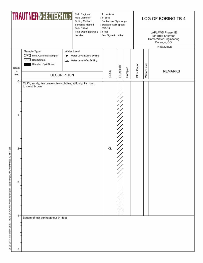
LOG OF BORING TB-4
PN:53225GE
Durango, CO Harris Water Engineering
Mr. Brett ShermanLAPLAWD Phase 1E
Depth
in
feet
0
1
2
3
4
5
DESCRIPTION
Sample Type
Mod. California Sampler
Bag Sample
Standard Split Spoon
Water Level
Water Level During Drilling
Water Level After Drilling
CLAY, sandy, few gravels, few cobbles, stiff, slightly moist to moist, brown
Bottom of test boring at four (4) feet
USCS
CL
GRAPHIC
Samples
Blow Count
Water Level
REMARKS

08
-29
-20
13
T
:\C
urr
en
t G
E\5
32
25
PE
, L
AP
LA
WD
Ph
ase
1E
\Lo
gs o
f T
est B
ori
ng
s\L
AP
LA
WD
Ph
ase
1E
TB
-3.b
or
LOG OF BORING TB-5
PN:53225GE
Durango, CO Harris Water Engineering
Mr. Brett ShermanLAPLAWD Phase 1E
Depth
in
feet
0
1
2
3
4
5
DESCRIPTION
Sample Type
Mod. California Sampler
Bag Sample
Standard Split Spoon
Water Level
Water Level During Drilling
Water Level After Drilling
CLAY, sandy, few gravels, few cobbles, stiff, slightly moist to moist, brown
Weathered Formational material, clay and claystone, hard, slightly moist, tan
Bottom of test boring at four (4) feet
US
CS
CL
GR
AP
HIC
Sa
mp
les
Blo
w C
ou
nt
Wa
ter
Le
ve
l
REMARKS
Field Engineer : T. Harrison
Hole Diameter : 4" Solid
Drilling Method : Continuous Flight Auger
Sampling Method : Standard Split Spoon
Date Drilled : 8/26/13
Total Depth (approx.) : 4 feet
Location : See Figure in Letter

08
-29
-20
13
T
:\C
urr
en
t G
E\5
32
25
PE
, L
AP
LA
WD
Ph
ase
1E
\Lo
gs o
f T
est B
ori
ng
s\L
AP
LA
WD
Ph
ase
1E
TB
-6.b
or
LOG OF BORING TB-6
PN:53225GE
Durango, CO Harris Water Engineering
Mr. Brett ShermanLAPLAWD Phase 1E
Depth
in
feet
0
1
2
3
4
5
6
7
8
9
DESCRIPTION
Sample Type
Mod. California Sampler
Bag Sample
Standard Split Spoon
Water Level
Water Level During Drilling
Water Level After Drilling
CLAY, sandy, few gravels, few cobbles, stiff, slightly moist to moist, brown
Bottom of test boring at eight (8) feet
US
CS
CL
GR
AP
HIC
Sa
mp
les
Blo
w C
ou
nt
Wa
ter
Le
ve
l
REMARKS
Field Engineer : T. Harrison
Hole Diameter : 4" Solid
Drilling Method : Continuous Flight Auger
Sampling Method : Standard Split Spoon
Date Drilled : 8/26/13
Total Depth (approx.) : 8 feet
Location : See Figure in Letter

08
-29
-20
13
T
:\C
urr
en
t G
E\5
32
25
PE
, L
AP
LA
WD
Ph
ase
1E
\Lo
gs o
f T
est B
ori
ng
s\L
AP
LA
WD
Ph
ase
1E
TB
-7.b
or
Field Engineer : T. Harrison
Hole Diameter : 4" Solid
Drilling Method : Continuous Flight Auger
Sampling Method : Standard Split Spoon
Date Drilled : 8/26/13
Total Depth (approx.) : 4 feet
Location : See Figure in Letter
LOG OF BORING TB-7
PN:53225GE
Durango, CO Harris Water Engineering
Mr. Brett ShermanLAPLAWD Phase 1E
Depth
in
feet
0
1
2
3
4
5
DESCRIPTION
Sample Type
Mod. California Sampler
Bag Sample
Standard Split Spoon
Water Level
Water Level During Drilling
Water Level After Drilling
CLAY, sandy, few gravels, few cobbles, stiff, slightly moist to moist, brown
Bottom of test boring at four (4) feet
US
CS
CL
GR
AP
HIC
Sa
mp
les
Blo
w C
ou
nt
Wa
ter
Le
ve
l
REMARKS

08
-29
-20
13
T
:\C
urr
en
t G
E\5
32
25
PE
, L
AP
LA
WD
Ph
ase
1E
\Lo
gs o
f T
est B
ori
ng
s\L
AP
LA
WD
Ph
ase
1E
TB
-3.b
or
LOG OF BORING TB-8
PN:53225GE
Durango, CO Harris Water Engineering
Mr. Brett ShermanLAPLAWD Phase 1E
Depth
in
feet
0
1
2
3
4
5
DESCRIPTION
Sample Type
Mod. California Sampler
Bag Sample
Standard Split Spoon
Water Level
Water Level During Drilling
Water Level After Drilling
US
CS
GR
AP
HIC
Sa
mp
les
Blo
w C
ou
nt
Wa
ter
Le
ve
l
REMARKS
Field Engineer : T. Harrison
Hole Diameter : 4" Solid
Drilling Method : Continuous Flight Auger
Sampling Method : Standard Split Spoon
Date Drilled : 8/26/13
Total Depth (approx.) : 4 feet
Location : See Figure in Letter
50/3
CLAY, sandy, few gravels, few cobbles, stiff, slightly moist to moist, brown
Formational material, sandstone, very hard, slightly moist, tan
Bottom of test boring at four (4) feet
CL
SS

08
-29
-20
13
T
:\C
urr
en
t G
E\5
32
25
PE
, L
AP
LA
WD
Ph
ase
1E
\Lo
gs o
f T
est B
ori
ng
s\L
AP
LA
WD
Ph
ase
1E
TB
-3.b
or
LOG OF BORING TB-9
PN:53225GE
Durango, CO Harris Water Engineering
Mr. Brett ShermanLAPLAWD Phase 1E
Depth
in
feet
0
1
2
3
4
5
DESCRIPTION
Sample Type
Mod. California Sampler
Bag Sample
Standard Split Spoon
Water Level
Water Level During Drilling
Water Level After Drilling
US
CS
GR
AP
HIC
Sa
mp
les
Blo
w C
ou
nt
Wa
ter
Le
ve
l
REMARKS
Field Engineer : T. Harrison
Hole Diameter : 4" Solid
Drilling Method : Continuous Flight Auger
Sampling Method : Standard Split Spoon
Date Drilled : 8/26/13
Total Depth (approx.) : 4 feet
Location : See Figure in Letter
CLAY, sandy, few gravels, few cobbles, stiff, slightly moist to moist, brown
Formational material, sandstone, very hard, slightly moist, tan
Bottom of test boring at four (4) feet
CL
SS
50/2

08
-29
-20
13
T
:\C
urr
en
t G
E\5
32
25
PE
, L
AP
LA
WD
Ph
ase
1E
\Lo
gs o
f T
est B
ori
ng
s\L
AP
LA
WD
Ph
ase
1E
TB
-7.b
or
Field Engineer : T. Harrison
Hole Diameter : 4" Solid
Drilling Method : Continuous Flight Auger
Sampling Method : Standard Split Spoon
Date Drilled : 8/26/13
Total Depth (approx.) : 4 feet
Location : See Figure in Letter
LOG OF BORING TB-10
PN:53225GE
Durango, CO Harris Water Engineering
Mr. Brett ShermanLAPLAWD Phase 1E
Depth
in
feet
0
1
2
3
4
5
DESCRIPTION
Sample Type
Mod. California Sampler
Bag Sample
Standard Split Spoon
Water Level
Water Level During Drilling
Water Level After Drilling
CLAY, sandy, few gravels, few cobbles, stiff, slightly moist to moist, brown
Bottom of test boring at four (4) feet
US
CS
CL
GR
AP
HIC
Sa
mp
les
Blo
w C
ou
nt
Wa
ter
Le
ve
l
REMARKS

![[ CIVIL ENGINEERING ] WATER RESOURCES ENGINEERING · 5th Semester B.TECH. [ CIVIL ENGINEERING ] WATER RESOURCES ENGINEERING The Need… water is curative in indigestion, water is](https://img.pdfslide.us/doc/110x75/5c9bbd4309d3f21a138bbd83/-civil-engineering-water-resources-5th-semester-btech-civil-engineering.jpg)


![[ CIVIL ENGINEERING ] WATER RESOURCES ENGINEERING€¦ · 5th Semester B.TECH. [ CIVIL ENGINEERING ] WATER RESOURCES ENGINEERING The Need… water is curative in indigestion, water](https://img.pdfslide.us/doc/110x75/5e95b6ba269fea172b4b7b4e/-civil-engineering-water-resources-engineering-5th-semester-btech-civil-engineering.jpg)