Embed Size (px)
Citation preview

CNN-based Large Scale Landsat Image Classification
Xuemei Zhao1, Lianru Gao1,*, Zhengchao Chen1, Bing Zhang1,2, Wenzhi Liao3
1 Key Laboratory of Digital Earth Science, Institute of Remote Sensing and Digital Earth, Chinese Academy of
Sciences, Beijing, 100094, China
2 University of Chinese Academy of Sciences, Beijing, 100049, China
3 Department Telecommunications and Information Processing, Ghent University, Ghent 9000, Belgium
Abstract— Large scale Landsat image classification is the key
to acquire national even global land cover map. Traditional
methods typically use only a small set of samples to train the
classifier and result in unsatisfied classification results. To
improve the performance of large scale Landsat image
classification, we apply a convolutional neural network (CNN)-
based method named PSPNet in this paper to learn spectral-
spatial features from a large training set. By considering the
complexities and the various sizes of objects captured in large
scale Landsat images, PSPNet can utilize the global information
as well as consider the targets with different sizes. In addition, the
research area is oversampled with a small offset which can
increase the amount of training samples in order to improve the
performance of PSPNet on Landsat images. Moreover, PSPNet is
finely tuned on the pretrained Resnet50. Experimental results
show the efficiency of the CNN based methods for the large-scale
land cover mapping. In particular, PSPNet can produce better
results even than the provided reference land cover map, with
overall accuracy reaching 83%.
I. INTRODUCTION
Landsat data is one of the most significant resources in
medium resolution remote sensing image classification which
has made a great contribution to the FROM-GLC [1],
GlobeLand30 [2] and some other national or regional land
cover products [3, 4]. Generally, the accuracy of the products
highly depends on the ability of image classification algorithms.
Therefore, tremendous efforts have been made to improve the
accuracy of image classification algorithms [5, 6]. Traditional
classifiers, such as maximum likelihood classifier [7], decision
trees [8] and random forest [9], describe the characteristics of
each class by human-designed features. However, when we
want to classify the images with large scales, the scenes are
always complicate due to the large coverage and the variation
in terrains. Human-designed features cannot accurately model
the variation of a class in a large scene when used on Landsat
images. To solve this problem, machine learning algorithms,
including Multilayer Perceptron (MLP) [10] and Support
Vector Machine (SVM) [11], have drawn considerable
attention in remote sensing image classification. MLP is expert
in learning nonlinear spectral features, thus is widely used in
high quality image classification. Nevertheless, the fully
connected nature restricts its use in complicated scenes. As for
SVM algorithm, it aims at finding the hyperplane which has the
maximum margin between two classes. So only a few data
points representing the boundaries between two classes
contribute to the classifier while most samples are not capable
to affect the final classification result. It is hard to find such
fine samples in Landsat image for training SVM classifer.
Therefore, the algorithms mentioned above do not perform
well on large scale Landsat image classification.
The outstanding performance of Alexnet [12] in the 2012
ImageNet Large Scale Visual Recognition Competition
(ILSVRC) stirs up a passion for research and application of
deep learning. A lot of breakthroughs have been made from
then on [13-18]. Among them, convolutional neural network
(CNN) is one of the most suitable architectures for image
classification. CNN uses stacked convolutional kernel to learn
the features of images, so not only the spectral but also the
texture information in spatial space is learned. Together with
the depth of the neural network and the pooling layers, CNN is
capable of establishing the connections between the input
samples and the output labels. Then the connections can be
used to obtain the classification result.
In recent years, CNN has produced state-of-the-art results in
remote sensing image classification. However, it is mainly used
in high resolution remote sensing images which have fine
texture features and fixed shapes as natural images employed
in computer vision [19-20]. While texture features of Landsat
images are not as fine as high resolution remote sensing images
and objects captured with 30m resolution generally do not have
fixed shapes. Some researchers have focused on deep learning-
based Landsat image object detection [21-22] and
classification [23-24]. Ikasari et al. [25] used deep neural
networks and 1-D CNN for Landsat images and compared them
with Logistic regression, SVM, Random forest and Boost
algorithms. The maximum accuracy obtained by deep neural
network with batch normalization and dropout layer is 71.79%.
Li et al. [26] employed stacked autoencoder to train Landsat
images. Compared with random forest, SVM and artificial
neural network (76.03%, 77.74%, 77.86%), the stacked
autoencoder produces 78.99% with 1% improvement.
Although some deep learning-based algorithms have been
introduced and tested for Landsat images, the classification
results are still not satisfied. Considering the rough texture
features and various sizes of Earth objects in large scale image
captured by Landsat, a new deep learning-based algorithm
named PSPNet [18] is employed to train the samples of Landsat
images. In the early layers, stacked residual blocks are able to
learn the spectral and spatial features of Landsat images by
concatenating the extracted feature maps before and after the
611
Proceedings, APSIPA Annual Summit and Conference 2018 12-15 November 2018, Hawaii
978-988-14768-5-2 ©2018 APSIPA APSIPA-ASC 2018
convolutional layers. Then the pyramid pooling combines the
information obtained with various pooling scales. By treating
the reference land cover map as the ground truth, we can
achieve overall classification accuracy more than 80% for
Landsat images covering the Jingjinji Area of China.
The rest of this paper is organized as follows. Section 2
introduces the research area and reference land cover map. The
methodology is presented in Section 3. Section 4 gives the
experimental results and analyses. Section 5 draw the
conclusions.
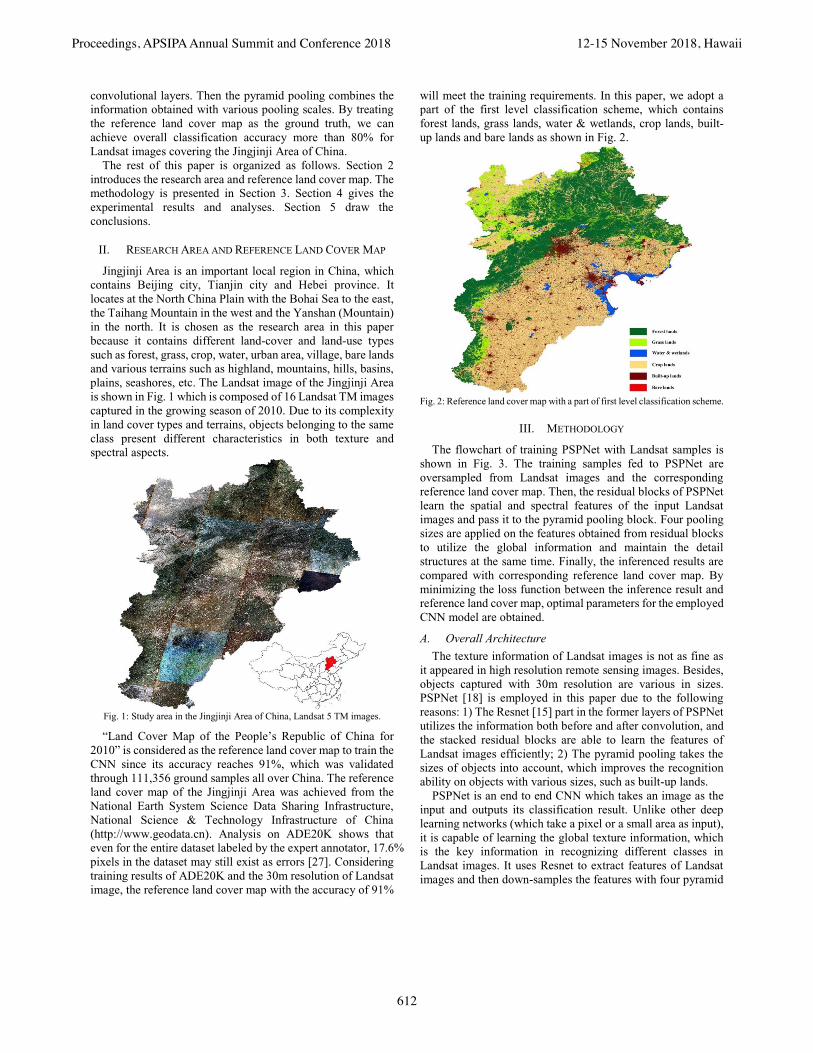
II. RESEARCH AREA AND REFERENCE LAND COVER MAP
Jingjinji Area is an important local region in China, which
contains Beijing city, Tianjin city and Hebei province. It
locates at the North China Plain with the Bohai Sea to the east,
the Taihang Mountain in the west and the Yanshan (Mountain)
in the north. It is chosen as the research area in this paper
because it contains different land-cover and land-use types
such as forest, grass, crop, water, urban area, village, bare lands
and various terrains such as highland, mountains, hills, basins,
plains, seashores, etc. The Landsat image of the Jingjinji Area
is shown in Fig. 1 which is composed of 16 Landsat TM images
captured in the growing season of 2010. Due to its complexity
in land cover types and terrains, objects belonging to the same
class present different characteristics in both texture and
spectral aspects.
Fig. 1: Study area in the Jingjinji Area of China, Landsat 5 TM images.
“Land Cover Map of the People’s Republic of China for
2010” is considered as the reference land cover map to train the
CNN since its accuracy reaches 91%, which was validated
through 111,356 ground samples all over China. The reference
land cover map of the Jingjinji Area was achieved from the
National Earth System Science Data Sharing Infrastructure,
National Science & Technology Infrastructure of China
(http://www.geodata.cn). Analysis on ADE20K shows that
even for the entire dataset labeled by the expert annotator, 17.6%
pixels in the dataset may still exist as errors [27]. Considering
training results of ADE20K and the 30m resolution of Landsat
image, the reference land cover map with the accuracy of 91%
will meet the training requirements. In this paper, we adopt a
part of the first level classification scheme, which contains
forest lands, grass lands, water & wetlands, crop lands, built-
up lands and bare lands as shown in Fig. 2.
Fig. 2: Reference land cover map with a part of first level classification scheme.
III. METHODOLOGY
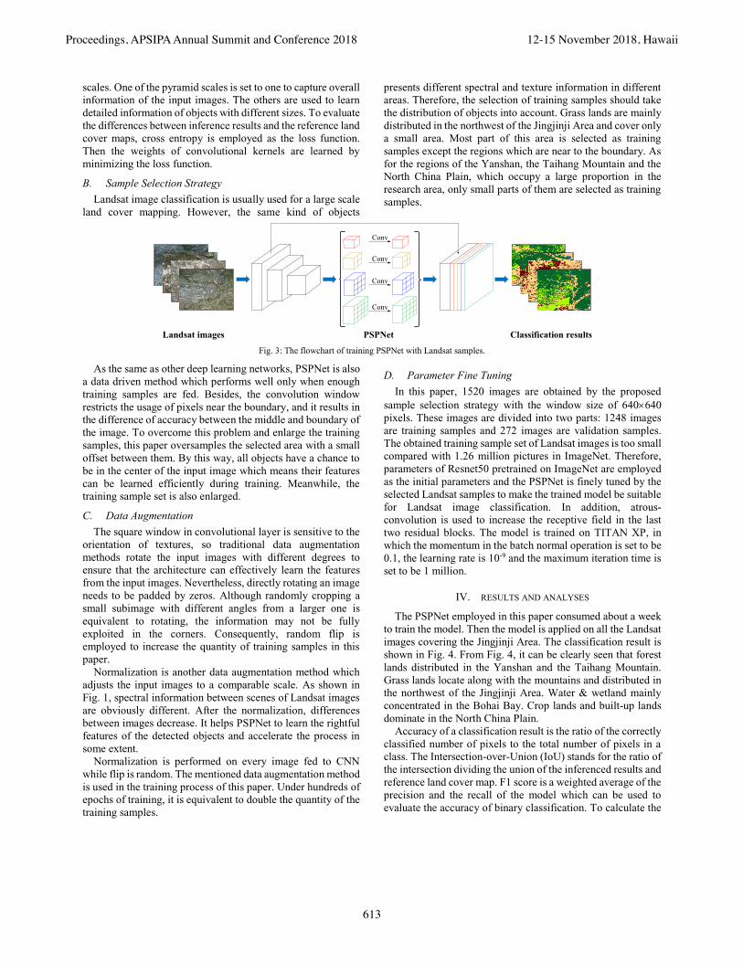
The flowchart of training PSPNet with Landsat samples is
shown in Fig. 3. The training samples fed to PSPNet are
oversampled from Landsat images and the corresponding
reference land cover map. Then, the residual blocks of PSPNet
learn the spatial and spectral features of the input Landsat
images and pass it to the pyramid pooling block. Four pooling
sizes are applied on the features obtained from residual blocks
to utilize the global information and maintain the detail
structures at the same time. Finally, the inferenced results are
compared with corresponding reference land cover map. By
minimizing the loss function between the inference result and
reference land cover map, optimal parameters for the employed
CNN model are obtained.
A. Overall Architecture
The texture information of Landsat images is not as fine as
it appeared in high resolution remote sensing images. Besides,
objects captured with 30m resolution are various in sizes.
PSPNet [18] is employed in this paper due to the following
reasons: 1) The Resnet [15] part in the former layers of PSPNet
utilizes the information both before and after convolution, and
the stacked residual blocks are able to learn the features of
Landsat images efficiently; 2) The pyramid pooling takes the
sizes of objects into account, which improves the recognition
ability on objects with various sizes, such as built-up lands.
PSPNet is an end to end CNN which takes an image as the
input and outputs its classification result. Unlike other deep
learning networks (which take a pixel or a small area as input),
it is capable of learning the global texture information, which
is the key information in recognizing different classes in
Landsat images. It uses Resnet to extract features of Landsat
images and then down-samples the features with four pyramid
612
Proceedings, APSIPA Annual Summit and Conference 2018 12-15 November 2018, Hawaii
scales. One of the pyramid scales is set to one to capture overall
information of the input images. The others are used to learn
detailed information of objects with different sizes. To evaluate
the differences between inference results and the reference land
cover maps, cross entropy is employed as the loss function.
Then the weights of convolutional kernels are learned by
minimizing the loss function.
B. Sample Selection Strategy
Landsat image classification is usually used for a large scale
land cover mapping. However, the same kind of objects
presents different spectral and texture information in different
areas. Therefore, the selection of training samples should take
the distribution of objects into account. Grass lands are mainly
distributed in the northwest of the Jingjinji Area and cover only
a small area. Most part of this area is selected as training
samples except the regions which are near to the boundary. As
for the regions of the Yanshan, the Taihang Mountain and the
North China Plain, which occupy a large proportion in the
research area, only small parts of them are selected as training
samples.
PSPNetLandsat images Classification results
Conv
Conv
Conv
Conv
Fig. 3: The flowchart of training PSPNet with Landsat samples.
As the same as other deep learning networks, PSPNet is also
a data driven method which performs well only when enough
training samples are fed. Besides, the convolution window
restricts the usage of pixels near the boundary, and it results in
the difference of accuracy between the middle and boundary of
the image. To overcome this problem and enlarge the training
samples, this paper oversamples the selected area with a small
offset between them. By this way, all objects have a chance to
be in the center of the input image which means their features
can be learned efficiently during training. Meanwhile, the
training sample set is also enlarged.
C. Data Augmentation
The square window in convolutional layer is sensitive to the
orientation of textures, so traditional data augmentation
methods rotate the input images with different degrees to
ensure that the architecture can effectively learn the features
from the input images. Nevertheless, directly rotating an image
needs to be padded by zeros. Although randomly cropping a
small subimage with different angles from a larger one is
equivalent to rotating, the information may not be fully
exploited in the corners. Consequently, random flip is
employed to increase the quantity of training samples in this
paper.
Normalization is another data augmentation method which
adjusts the input images to a comparable scale. As shown in
Fig. 1, spectral information between scenes of Landsat images
are obviously different. After the normalization, differences
between images decrease. It helps PSPNet to learn the rightful
features of the detected objects and accelerate the process in
some extent.
Normalization is performed on every image fed to CNN
while flip is random. The mentioned data augmentation method
is used in the training process of this paper. Under hundreds of
epochs of training, it is equivalent to double the quantity of the
training samples.
D. Parameter Fine Tuning
In this paper, 1520 images are obtained by the proposed
sample selection strategy with the window size of 640640
pixels. These images are divided into two parts: 1248 images
are training samples and 272 images are validation samples.
The obtained training sample set of Landsat images is too small
compared with 1.26 million pictures in ImageNet. Therefore,
parameters of Resnet50 pretrained on ImageNet are employed
as the initial parameters and the PSPNet is finely tuned by the
selected Landsat samples to make the trained model be suitable
for Landsat image classification. In addition, atrous-
convolution is used to increase the receptive field in the last
two residual blocks. The model is trained on TITAN XP, in
which the momentum in the batch normal operation is set to be
0.1, the learning rate is 10-9 and the maximum iteration time is
set to be 1 million.
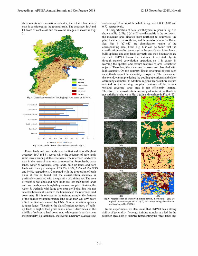
IV. RESULTS AND ANALYSES
The PSPNet employed in this paper consumed about a week
to train the model. Then the model is applied on all the Landsat
images covering the Jingjinji Area. The classification result is
shown in Fig. 4. From Fig. 4, it can be clearly seen that forest
lands distributed in the Yanshan and the Taihang Mountain.
Grass lands locate along with the mountains and distributed in
the northwest of the Jingjinji Area. Water & wetland mainly
concentrated in the Bohai Bay. Crop lands and built-up lands
dominate in the North China Plain.
Accuracy of a classification result is the ratio of the correctly
classified number of pixels to the total number of pixels in a
class. The Intersection-over-Union (IoU) stands for the ratio of
the intersection dividing the union of the inferenced results and
reference land cover map. F1 score is a weighted average of the
precision and the recall of the model which can be used to
evaluate the accuracy of binary classification. To calculate the
613
Proceedings, APSIPA Annual Summit and Conference 2018 12-15 November 2018, Hawaii
above-mentioned evaluation indicator, the refence land cover
map is considered as the ground truth. The accuracy, IoU and
F1 score of each class and the overall image are shown in Fig.
5.
Fig. 4: Classification result of the Jingjingji Area based on PSPNet.
Fig. 5: IoU and F1 score of each class shown in Fig. 4.
Forest lands and crop lands have the first and second highest
accuracy, IoU and F1 scores while the accuracy of bare lands
is the lowest among all the six classes. The reference land cover
map in the research area was composed by forest lands, grass
lands, water & wetlands, crop lands, built-up lands and bare
lands with their percentages of 33.5%, 9.5%, 2.8%, 43.9%, 9.9%
and 0.4%, respectively. Compared with the proportion of each
class, it can be found that the classification accuracy is
positively correlated with the quantity of training set. The area
of water & wetlands and bare lands are less than forest lands
and crop lands, even though they are oversampled. Besides, the
water & wetlands with large area near the Bohai Sea was not
selected because it is near to the boundary in the reference land
cover map. If it is selected as the training sample, the features
of the images without reference land cover map will obviously
affect the features learned by CNN. Similar situation appears
to grass lands. Therefore, the classification accuracy of built-
up lands is higher than grass lands since it distributes in the
middle of reference land cover map while grass lands lay near
the boundary. Nevertheless, the overall accuracy, average IoU
and average F1 score of the whole image reach 0.83, 0.83 and
0.72, respectively.
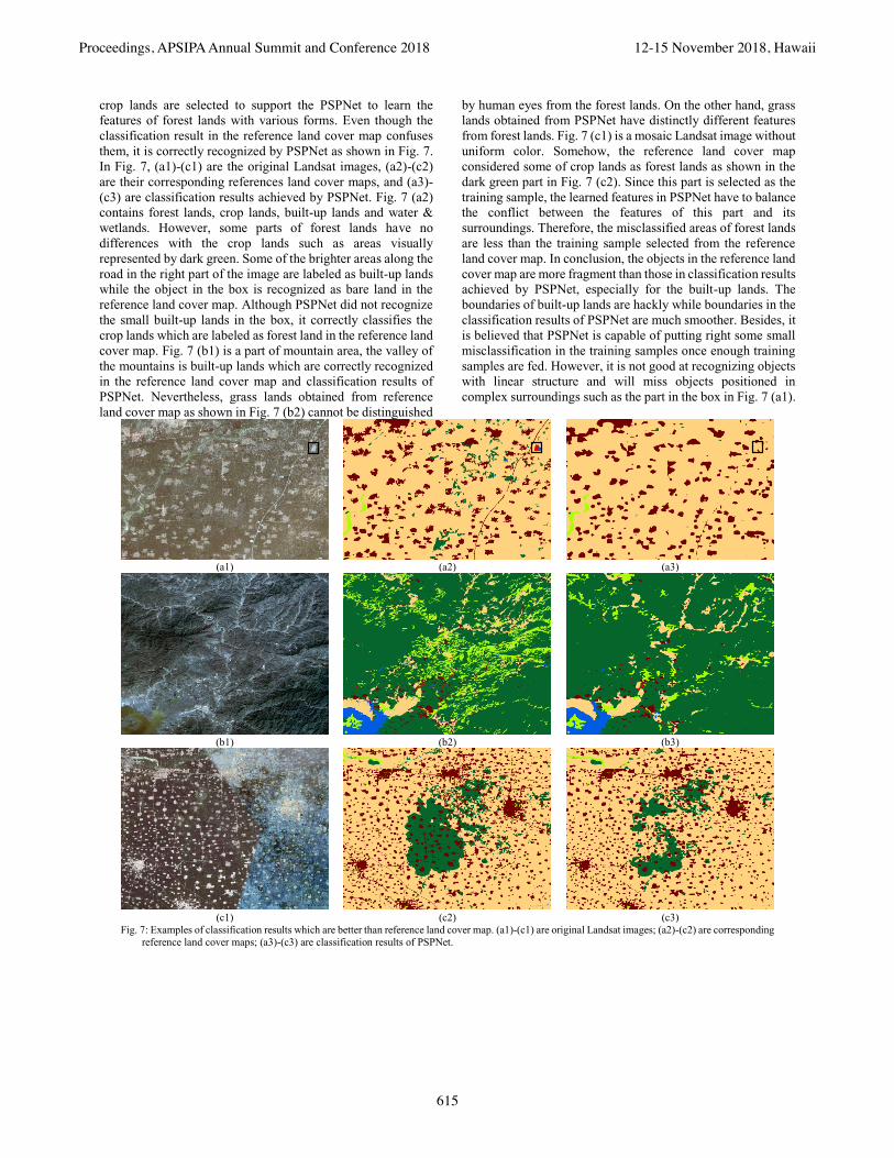
The magnification of details with typical regions in Fig. 4 is
shown in Fig. 6. Fig. 6 (a1)-(d1) are the prairie in the northwest,
the mountain area directed from northeast to southwest, the
plain locates in the southeast, and the seashores near the Bohai
Sea. Fig. 6 (a2)-(d2) are classification results of the
corresponding area. From Fig. 6 it can be found that the
classification results can recognize the grass lands, forest lands,
built-up lands and crop lands correctly and their boundaries are
satisfied. PSPNet learns the features of detected objects
through stacked convolution operation, so it is expert in
learning the spectral and texture features of areal structured
objects. Therefore, the mentioned classes are classified with
high accuracy. On the contrary, linear structured objects such
as wetlands cannot be accurately recognized. The reasons are
the over down sample during the pooling operation and the lack
of training examples. In addition, regions near seashore are not
selected as the training samples. Features of herbaceous
wetland covering large area is not efficiently learned.
Therefore, the classification accuracy of water & wetlands is
not satisfied as shown in Fig. 6 (a2) and seashore in Fig. 6 (d2).
(a1) (a2)
(b1) (b2)
(c1) (c2)
(d1) (d2)
Fig. 6: Magnification of details with typical terrain, in which (a1)-(d1) are
original Landsat images and (a2)-(d2) are corresponding classification
results achieved by PSPNet.
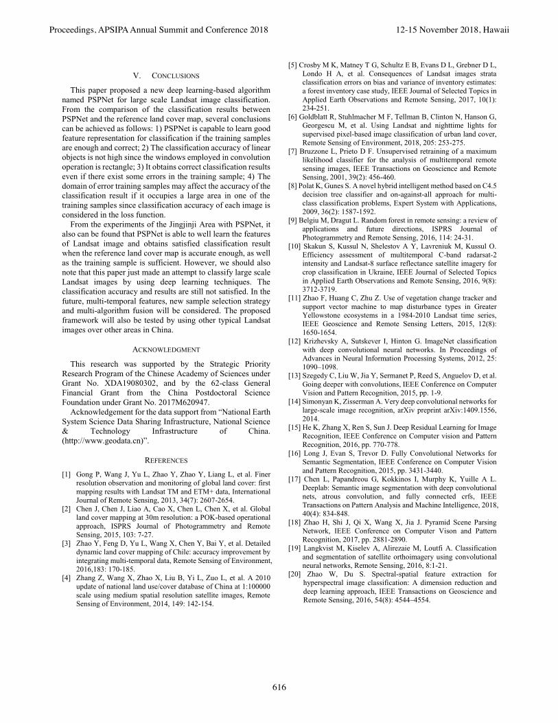
In the experiments we also found that PSPNet has a strong
ability of generality if enough training samples are fed. In the
research area, a lot of samples representing the forest lands and
614
Proceedings, APSIPA Annual Summit and Conference 2018 12-15 November 2018, Hawaii
crop lands are selected to support the PSPNet to learn the
features of forest lands with various forms. Even though the
classification result in the reference land cover map confuses
them, it is correctly recognized by PSPNet as shown in Fig. 7.
In Fig. 7, (a1)-(c1) are the original Landsat images, (a2)-(c2)
are their corresponding references land cover maps, and (a3)-
(c3) are classification results achieved by PSPNet. Fig. 7 (a2)
contains forest lands, crop lands, built-up lands and water &
wetlands. However, some parts of forest lands have no
differences with the crop lands such as areas visually
represented by dark green. Some of the brighter areas along the
road in the right part of the image are labeled as built-up lands
while the object in the box is recognized as bare land in the
reference land cover map. Although PSPNet did not recognize
the small built-up lands in the box, it correctly classifies the
crop lands which are labeled as forest land in the reference land
cover map. Fig. 7 (b1) is a part of mountain area, the valley of
the mountains is built-up lands which are correctly recognized
in the reference land cover map and classification results of
PSPNet. Nevertheless, grass lands obtained from reference
land cover map as shown in Fig. 7 (b2) cannot be distinguished
by human eyes from the forest lands. On the other hand, grass
lands obtained from PSPNet have distinctly different features
from forest lands. Fig. 7 (c1) is a mosaic Landsat image without
uniform color. Somehow, the reference land cover map
considered some of crop lands as forest lands as shown in the
dark green part in Fig. 7 (c2). Since this part is selected as the
training sample, the learned features in PSPNet have to balance
the conflict between the features of this part and its
surroundings. Therefore, the misclassified areas of forest lands
are less than the training sample selected from the reference
land cover map. In conclusion, the objects in the reference land
cover map are more fragment than those in classification results
achieved by PSPNet, especially for the built-up lands. The
boundaries of built-up lands are hackly while boundaries in the
classification results of PSPNet are much smoother. Besides, it
is believed that PSPNet is capable of putting right some small
misclassification in the training samples once enough training
samples are fed. However, it is not good at recognizing objects
with linear structure and will miss objects positioned in
complex surroundings such as the part in the box in Fig. 7 (a1).
(a1) (a2) (a3)
(b1) (b2) (b3)
(c1) (c2) (c3)
Fig. 7: Examples of classification results which are better than reference land cover map. (a1)-(c1) are original Landsat images; (a2)-(c2) are corresponding
reference land cover maps; (a3)-(c3) are classification results of PSPNet.
615
Proceedings, APSIPA Annual Summit and Conference 2018 12-15 November 2018, Hawaii
V. CONCLUSIONS
This paper proposed a new deep learning-based algorithm
named PSPNet for large scale Landsat image classification.
From the comparison of the classification results between
PSPNet and the reference land cover map, several conclusions
can be achieved as follows: 1) PSPNet is capable to learn good
feature representation for classification if the training samples
are enough and correct; 2) The classification accuracy of linear
objects is not high since the windows employed in convolution
operation is rectangle; 3) It obtains correct classification results
even if there exist some errors in the training sample; 4) The
domain of error training samples may affect the accuracy of the
classification result if it occupies a large area in one of the
training samples since classification accuracy of each image is
considered in the loss function.
From the experiments of the Jingjinji Area with PSPNet, it
also can be found that PSPNet is able to well learn the features
of Landsat image and obtains satisfied classification result
when the reference land cover map is accurate enough, as well
as the training sample is sufficient. However, we should also
note that this paper just made an attempt to classify large scale
Landsat images by using deep learning techniques. The
classification accuracy and results are still not satisfied. In the
future, multi-temporal features, new sample selection strategy
and multi-algorithm fusion will be considered. The proposed
framework will also be tested by using other typical Landsat
images over other areas in China.
ACKNOWLEDGMENT
This research was supported by the Strategic Priority
Research Program of the Chinese Academy of Sciences under
Grant No. XDA19080302, and by the 62-class General
Financial Grant from the China Postdoctoral Science
Foundation under Grant No. 2017M620947.
Acknowledgement for the data support from “National Earth
System Science Data Sharing Infrastructure, National Science
& Technology Infrastructure of China.
(http://www.geodata.cn)”.
REFERENCES
[1] Gong P, Wang J, Yu L, Zhao Y, Zhao Y, Liang L, et al. Finer
resolution observation and monitoring of global land cover: first
mapping results with Landsat TM and ETM+ data, International
Journal of Remote Sensing, 2013, 34(7): 2607-2654.
[2] Chen J, Chen J, Liao A, Cao X, Chen L, Chen X, et al. Global
land cover mapping at 30m resolution: a POK-based operational
approach, ISPRS Journal of Photogrammetry and Remote
Sensing, 2015, 103: 7-27.
[3] Zhao Y, Feng D, Yu L, Wang X, Chen Y, Bai Y, et al. Detailed
dynamic land cover mapping of Chile: accuracy improvement by
integrating multi-temporal data, Remote Sensing of Environment,
2016,183: 170-185.
[4] Zhang Z, Wang X, Zhao X, Liu B, Yi L, Zuo L, et al. A 2010
update of national land use/cover database of China at 1:100000
scale using medium spatial resolution satellite images, Remote
Sensing of Environment, 2014, 149: 142-154.
[5] Crosby M K, Matney T G, Schultz E B, Evans D L, Grebner D L,
Londo H A, et al. Consequences of Landsat images strata
classification errors on bias and variance of inventory estimates:
a forest inventory case study, IEEE Journal of Selected Topics in
Applied Earth Observations and Remote Sensing, 2017, 10(1):
234-251.
[6] Goldblatt R, Stuhlmacher M F, Tellman B, Clinton N, Hanson G,
Georgescu M, et al. Using Landsat and nighttime lights for
supervised pixel-based image classification of urban land cover,
Remote Sensing of Environment, 2018, 205: 253-275.
[7] Bruzzone L, Prieto D F. Unsupervised retraining of a maximum
likelihood classifier for the analysis of multitemporal remote
sensing images, IEEE Transactions on Geoscience and Remote
Sensing, 2001, 39(2): 456-460.
[8] Polat K, Gunes S. A novel hybrid intelligent method based on C4.5
decision tree classifier and on-against-all approach for multi-
class classification problems, Expert System with Applications,
2009, 36(2): 1587-1592.
[9] Belgiu M, Dragut L. Random forest in remote sensing: a review of
applications and future directions, ISPRS Journal of
Photogrammetry and Remote Sensing, 2016, 114: 24-31.
[10] Skakun S, Kussul N, Shelestov A Y, Lavreniuk M, Kussul O.
Efficiency assessment of multitemporal C-band radarsat-2
intensity and Landsat-8 surface reflectance satellite imagery for
crop classification in Ukraine, IEEE Journal of Selected Topics
in Applied Earth Observations and Remote Sensing, 2016, 9(8):
3712-3719.
[11] Zhao F, Huang C, Zhu Z. Use of vegetation change tracker and
support vector machine to map disturbance types in Greater
Yellowstone ecosystems in a 1984-2010 Landsat time series,
IEEE Geoscience and Remote Sensing Letters, 2015, 12(8):
1650-1654.
[12] Krizhevsky A, Sutskever I, Hinton G. ImageNet classification
with deep convolutional neural networks. In Proceedings of
Advances in Neural Information Processing Systems, 2012, 25:
1090–1098.
[13] Szegedy C, Liu W, Jia Y, Sermanet P, Reed S, Anguelov D, et al.
Going deeper with convolutions, IEEE Conference on Computer
Vision and Pattern Recognition, 2015, pp. 1-9.
[14] Simonyan K, Zisserman A. Very deep convolutional networks for
large-scale image recognition, arXiv preprint arXiv:1409.1556,
2014.
[15] He K, Zhang X, Ren S, Sun J. Deep Residual Learning for Image
Recognition, IEEE Conference on Computer vision and Pattern
Recognition, 2016, pp. 770-778.
[16] Long J, Evan S, Trevor D. Fully Convolutional Networks for
Semantic Segmentation, IEEE Conference on Computer Vision
and Pattern Recognition, 2015, pp. 3431-3440.
[17] Chen L, Papandreou G, Kokkinos I, Murphy K, Yuille A L.
Deeplab: Semantic image segmentation with deep convolutional
nets, atrous convolution, and fully connected crfs, IEEE
Transactions on Pattern Analysis and Machine Intelligence, 2018,
40(4): 834-848.
[18] Zhao H, Shi J, Qi X, Wang X, Jia J. Pyramid Scene Parsing
Network, IEEE Conference on Computer Vison and Pattern
Recognition, 2017, pp. 2881-2890.
[19] Langkvist M, Kiselev A, Alirezaie M, Loutfi A. Classification
and segmentation of satellite orthoimagery using convolutional
neural networks, Remote Sensing, 2016, 8:1-21.
[20] Zhao W, Du S. Spectral-spatial feature extraction for
hyperspectral image classification: A dimension reduction and
deep learning approach, IEEE Transactions on Geoscience and
Remote Sensing, 2016, 54(8): 4544–4554.
616
Proceedings, APSIPA Annual Summit and Conference 2018 12-15 November 2018, Hawaii
[21] Yu L, Wang Z, Tian S, Ye F, Ding J, Kong J. Convolutional
neural networks for water body extraction from Landsat imagery,
International Journal of Computational Intelligence and
Applications, 2017, 16(1): 1750001.
[22] Kussul N, Lavreniuk M, Skakun S, Shelestov A. Deep learning
classification of land cover and crop types using remote sensing
data, IEEE Geoscience and Remote Sensing Letters, 2017, 14(5):
778-782.
[23] Perez A, Yeh C, Azzari G, Burke M, Lobell D, Ermon S. Poverty
Prediction with Public Landsat 7 Satellite Imagery and Machine
Learning, 2017, arXiv preprint arXiv:1711.03654.
[24] Kussul N, Shelestov A, Lavreniuk M, Butko I, Skakun S. Deep
learning approach for large scale land cover mapping based on
remote sensing data fusion, 2016 IEEE International Geoscience
and Remote Sensing Symposium, 2016, pp.198-201.
[25] Ikasari I H, Ayumi V, Fanany M I, Mulyono S. Multiple
regularizations deep learning for paddy growth stages
classification from LANDSAT-8, 2016 International Conference
on Advanced Computer Science and Information Systems, 2016,
pp. 512-517.
[26] Li W, Fu H, Yu L, Gong P, Feng D, Li C, et al. Stacked
autoencoder-based deep learning for remote-sensing image
classification: a case study of African land-cover mapping,
International Journal of Remote Sensing, 2016, 37(23): 5632-
5646.
[27] Zhou B, Zhao H, Puig X, Fidler S, Barriuso A, Torralba A.
Semantic understanding of scenes through the ADE20K dataset,
arXiv: 1608.05442, 2016.
617
Proceedings, APSIPA Annual Summit and Conference 2018 12-15 November 2018, Hawaii