Embed Size (px)
Citation preview
Antarctica
SENTINEL RANGE
VINSON MASSIF
Vinson, summary, record numbers and newroute. Over 120 people attempted VinsonMassif this season, far surpassing the previ-ous record of 78 attempts set in 2000-01.This year only two people failed to summit,giving a success rate of nearly 99%. Thoughthe weather this season was not alwaysgood, it was never terrible, with no majorstorms at any time. The Vinson expeditions supported by Antarctic Logistics & Expeditions (ALE)are now around 15 days total in duration, longer than in previous seasons, which gives peoplemore time to acclimatize, rest and wait out bad weather.
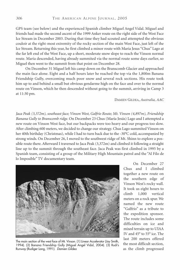
The extra time also allows teams to attempt other objectives, if they are up to it and theweather complies. This season several teams took short day-trips out from various camps andfour teams attempted Mt. Shinn (4,661m) from Camp 3. Three of the four were successful—a Spanish soloist, the two ALE guides Heather Morning and Neil Stephenson and a guided teamfrom Alpine Ascents International led by Todd Passey. AAI Guide Vern Tejas spent most of theseason on the mountain, leading four separate ascents. One of these ascents included JohnnyStrange, at 13 years old the youngest person to summit Vinson. New Zealander Guy Cotter,owner and head guide of Adventure Consultants, doubled as marriage celebrant on December8 to two of his group who tied the knot on the summit. On a more serious note, at least twoclimbers had roped crevasse falls on the section leading up to Camp 3 and one climber had aminor fall on Mt. Shinn. TheVinson route between Camp 2and Camp 3, beneath the head-wall, passed through significantavalanche debris this year, ema-nating from the seracs up to theright on Vinson. The opposingseracs on Shinn also calved severaltimes, on one occasion strafing theroute below the headwall shortlyafter climbers had passed through.The objective danger of this routeis not insignificant and is notimproving.
Only two expeditionsattempted anything new in theMassif this season: the Omega
CL I M B S A N D EX P E D I T I O N S : AN TA RC T I C A 305
Remember this picture next time you hear how “safe” it is on Vinson.The leading edge of the avalanche is 30m from the track of the normalroute at this point; 30 minutes earlier about eight people had walkedright through here (7 p.m., Jan. 4, 2005). Damien Gildea
TH E AM E R I C A N AL P I N E JO U R NA L, 2005306
GPS team (see below) and the experienced Spanish climber Miguel Angel Vidal. Miguel andfriends had made the second ascent of the 1999 Anker route on the right side of the West FaceIce Stream in December 2003. During that time they had scouted and attempted the obviouscouloir at the right-most extremity of the rocky section of the main West Face, just left of theIce Stream. Returning this year, he first climbed a minor route with Maria Jesus “Chus” Lago atthe far left end of the West Face, up a short, moderate snow slope to reach the Vinson normalroute. Maria descended, having already summited via the normal route some days earlier, soMiguel then went to the summit from that point on December 28.
On December 31 Miguel left his camp down on the Branscomb Glacier and approachedthe main face alone. Eight and a half hours later he reached the top via the 1,800m BananaFriendship Gully, overcoming much poor snow and several rock sections. His route took him up to and behind a small but obvious gendarme high on the face and over to the normalroute on Vinson, which he then descended without going to the summit, arriving in Camp 3 at 11:30 pm.
DAMIEN GILDEA, Australia, AAC
Jaca Peak (3,372m), southeast face; Vinson West, Galfrío Route; Mt. Vinson (4,897m), FriendshipBanana Gully to Branscomb ridge. On December 23 Chus (María Jesús) Lago and I attempted anew route on Vinson West face, but our backpacks were too heavy and our progress too slow.After climbing 600 meters, we decided to change our strategy. Chus Lago summited Vinson onher 40th birthday (Christmas), while I had to turn back due to the -30°C cold, accompanied bystrong winds. On December 26, I moved to the southwest ridge of Mt. Shinn to explore a pos-sible route there. Afterward I traversed to Jaca Peak (3,372m) and climbed it following a straightline up to the summit through the southeast face. Jaca Peak was first climbed in 1995 by aSpanish team, consisting of a group of the Military High Mountain patrol and the “Al Filo delo Imposible” TV documentary team.
On December 27Chus and I climbedtogether a new route onthe southern edge ofVinson West’s rocky wall.It took us eight hours toclimb 1,000 verticalmeters on a rock spur. Wenamed the new route“Galfrío” as a tribute tothe expedition sponsor.The route includes somedifficulties on ice andmixed terrain up to UIAAIV and 45° to 55° ice. Thelast 200 meters offeredthe most difficult section,as the climb progressed
The main section of the west face of Mt. Vinson. (1) Linear Accelerator (Jay Smith,1994). (2) Banana Friendship Gully (Miguel Angel Vidal, 2004). (3) Rudi’sRunway (Rudiger Lang, 1991). Damien Gildea
CL I M B S A N D EX P E D I T I O N S : AN TA RC T I C A 307
on very hard blue ice and unstable snow.On December 28, I climbed the four-km-long Branscomb Ridge, past the point where it
joins the new Galfrío route, up to the main summit of that ridge.On December 31 I climbed a new route on Mt. Vinson following an unmistakable
banana-shaped couloir that crosses Vinson’s west face. Therefore, I named the new itinerary“Friendship Banana Gully.” It took me 8.5 hours to climb 1,700 vertical meters from the foot ofthe wall to the Branscomb Ridge at 4,400m. The new route follows 50°-55° slopes on alterna-tively crusted and loose snow, along with some rock outcrops. There were some mixed sectionsup to IV. I found no ice at all, just some patches of hard snow.
MIGUEL ANGEL VIDAL, Spain
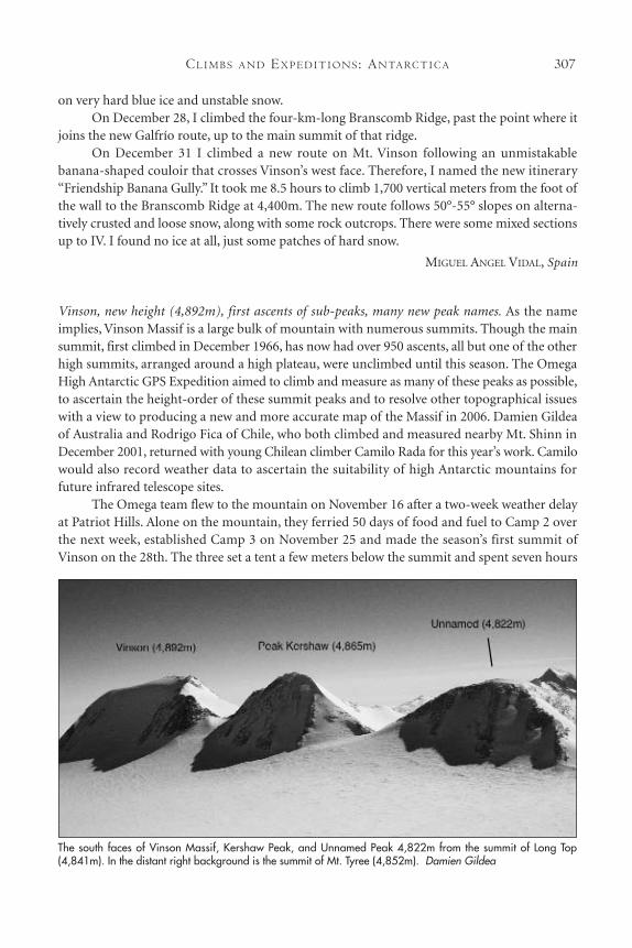
Vinson, new height (4,892m), first ascents of sub-peaks, many new peak names. As the nameimplies, Vinson Massif is a large bulk of mountain with numerous summits. Though the mainsummit, first climbed in December 1966, has now had over 950 ascents, all but one of the otherhigh summits, arranged around a high plateau, were unclimbed until this season. The OmegaHigh Antarctic GPS Expedition aimed to climb and measure as many of these peaks as possible,to ascertain the height-order of these summit peaks and to resolve other topographical issueswith a view to producing a new and more accurate map of the Massif in 2006. Damien Gildeaof Australia and Rodrigo Fica of Chile, who both climbed and measured nearby Mt. Shinn inDecember 2001, returned with young Chilean climber Camilo Rada for this year’s work. Camilowould also record weather data to ascertain the suitability of high Antarctic mountains forfuture infrared telescope sites.
The Omega team flew to the mountain on November 16 after a two-week weather delayat Patriot Hills. Alone on the mountain, they ferried 50 days of food and fuel to Camp 2 overthe next week, established Camp 3 on November 25 and made the season’s first summit ofVinson on the 28th. The three set a tent a few meters below the summit and spent seven hours
The south faces of Vinson Massif, Kershaw Peak, and Unnamed Peak 4,822m from the summit of Long Top(4,841m). In the distant right background is the summit of Mt. Tyree (4,852m). Damien Gildea
TH E AM E R I C A N AL P I N E JO U R NA L, 2005308
there without sleeping bags, waiting for the GPS to run in its position atop the highest piece ofsolid rock. Operating data collectors for recording temperature and relative humidity, they laterdiscovered temperatures reached -46°C that night. The GPS data was processed via satellitephone, laptop and the AUSPOS website to give a new height of 4,892m—5m lower than theprevious official USGS height, but within the margin of error associated with that older figure.
On November 30 the trio climbed and measured Peak Kershaw, the obvious peak to theleft of Vinson seen by all those doing the normal route to the highest peak. A first ascent of thispeak was claimed by Britons Sundheep Dhillon and Andre Hedger on December 15, 1992 butit may well have been climbed in December 1989 by Canadian Rob Mitchell, who mistook it forthe highest point, only learning his mistake later (see Climbing No.128 Oct/Nov 1991 p.120).Dhillon and Hedger coined the name “Kershaw” in memory of Giles Kershaw, one of thefounders of Adventure Network International (ANI), who opened up the area to private expe-ditions in the late 1980s. Giles was killed in a gyrocopter accident on the Antarctic Peninsula in1991. Gildea, Fica, and Rada ran the GPS on the highest point—an ice crest, just below whichwas a green ski pole stuck in the ice, presumably left by the Brits. The height was later found tobe 4,865m—only 27m lower than the main summit of Vinson. The Omega team consideredthis a testament to the skill of the USGS personnel who made the original map of the area,correctly pinpointing the true summit of Vinson amongst so many close contenders and in afield where “official” altitudes are often incorrect by much more than 27m.
Requiring very good weather for their work on the high plateau, the Omega team waitedat Camp 3 until December 8 when they traveled up the normal Vinson route until just beforethe final pyramid, then continued straight south through a narrow but easy col that leads outon to the high plateau south of Vinson’s main summit. Crossing the plateau they made campin the evening and immediately attempted the high peak to the southwest. This peak is visiblefrom Vinson BC and has been eyed by dozens of wishful climbers over the years. It was attempt-ed by a Spanish team in January 1995 who climbed the nearby Pico Principe de Asturias. TheSpanish thought this big peak to be 4,860m, named it Monte Espana, and attempted it via a
Looking east from the summit of Pyramid South (4,634m), across the Vinson High Plateau to Long Top, East Peak,Pyramid East, and The Turrets. All peaks received their first ascent in December 2004 by the Omega GPS team.Damien Gildea

CL I M B S A N D EX P E D I T I O N S : AN TA RC T I C A 309
route similar to that used for Asturias, butfailed some distance from the summit. TheOmega team ascended the narrow southridge of the peak, getting good views of theterrain to the southwest of Vinson, and sum-mited just before midnight. Gildea suggest-ed changing the name to International Peakin honor of all the nationalities that hadpassed underneath the mountain in the last15 years and because the Spanish had notactually climbed it when they named it.They left the GPS running for around 10hours until it was retrieved by Fica the nextmorning.
Immediately after that Rada andGildea set off for a nearby sharp peak theynamed Sphinx Peak, due to its appearancefrom the north. Fica later joined them andbelayed Gildea to a soft, crumbling, andwildly exposed summit, too small to standon, where he placed the GPS. Fica and Radareturned to retrieve the unit later that night.Continuing straight away, they joined Gildeaen route to another nearby sub-peak whichthey named Pyramid South due its appear-ance and location on the plateau. This wasan easy ascent up a steep snow-ice slope to avery useful flat rock summit, where theyplaced the GPS just after midnight, havingnow reached the top of three previouslyunclimbed peaks in 24 hours.
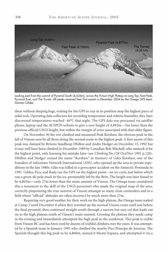
After a long sleep Gildea retrieved thereceiver alone, then joined up with Rada andFica to move camp across the plateau closerto their next objectives. First the teamclimbed Pyramid East by both the west andsouth faces on snow and rock, then afterretrieving the GPS from that summit, Gildeaand Rada climbed Long Top on December11 via its broad south face. Long Top is thepeak often seen in the background of thesummit photos of Vinson summiteers. It is alarge peak with a long summit ridge, thehighest point a crenellated rocky spine at the southern end. Here Rada and Gildea
Camilo Rada (Chile) on the summit of The Turrets(4,551m). In the background is East Peak (4,743m), withthe unclimbed east ridge of Vinson dropping down to the right. Damien Gildea
The west face of Sphinx Peak (4,729m) showing the Fica-Gildea-Rada route. Damien Gildea
TH E AM E R I C A N AL P I N E JO U R NA L, 2005310
experienced extreme wind gusts over 120km/h while setting up the GPS. Fica soloed the peaklater that night, in similar conditions, to retrieve the unit. The data showed that Long Top hadbeen the highest unclimbed peak in Antarctica (though not an independent mountain).Immediately after Fica returned to the tent, they all packed up and plodded back across theplateau in increasing winds through the narrow col and back down the normal Vinson route toreach Camp 3 at 2:30am on December 12.
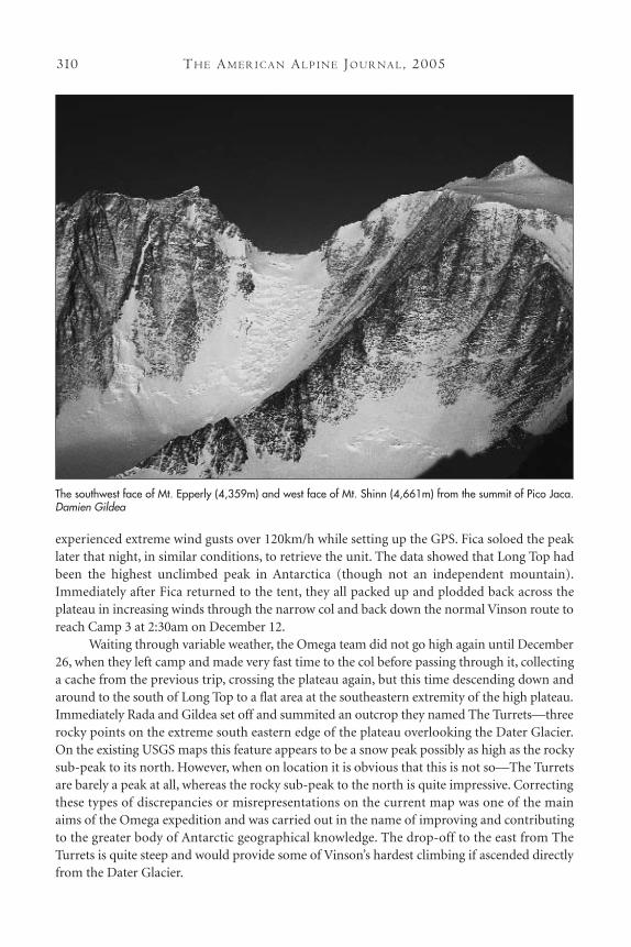
Waiting through variable weather, the Omega team did not go high again until December26, when they left camp and made very fast time to the col before passing through it, collectinga cache from the previous trip, crossing the plateau again, but this time descending down andaround to the south of Long Top to a flat area at the southeastern extremity of the high plateau.Immediately Rada and Gildea set off and summited an outcrop they named The Turrets—threerocky points on the extreme south eastern edge of the plateau overlooking the Dater Glacier.On the existing USGS maps this feature appears to be a snow peak possibly as high as the rockysub-peak to its north. However, when on location it is obvious that this is not so—The Turretsare barely a peak at all, whereas the rocky sub-peak to the north is quite impressive. Correctingthese types of discrepancies or misrepresentations on the current map was one of the mainaims of the Omega expedition and was carried out in the name of improving and contributingto the greater body of Antarctic geographical knowledge. The drop-off to the east from TheTurrets is quite steep and would provide some of Vinson’s hardest climbing if ascended directlyfrom the Dater Glacier.
The southwest face of Mt. Epperly (4,359m) and west face of Mt. Shinn (4,661m) from the summit of Pico Jaca.Damien Gildea
CL I M B S A N D EX P E D I T I O N S : AN TA RC T I C A 311
Fica soon retrieved the GPS and he and Rada immediately set off and summited the biggerrocky peak to the north, which we had named East Peak. Climbed via an easy ridge connectingit to the back of Long Top, East Peak is quite steep on other sides and is in fact the terminus ofthe long and impressive east ridge of Vinson—the last major feature in the Massif that remainsunclimbed. Gildea later retrieved the unit alone and upon returning to camp all three set off indeteriorating weather to return via the col to Camp 3 late on December 28th.
Over the next few days Fica and Rada climbed two minor points north of Vinson mainsummit. Manana Point (climbed and named by Dhillon and Hedger in 1992) is on the ridgerunning parallel to the normal route above Camp 3 on the left. Branscomb Point is the highestpoint of the Branscomb Ridge, which is the top of the main west face and runs parallel to thenormal route, but on the climber’s right as s/he ascends the upper cwm.
With all the major sub-peaks climbed and measured, Gildea set off on January 1 to summit Vinson and collect a second set of data. The work on the summit was conducted inextreme winds and Gildea was forced to descend via the less windy western side of the summitpyramid, going down a broad bowl and traversing around the western side past BranscombPoint to rejoin the normal route, on the way seeing Miguel Angel Vidal’s tracks from his ascentof the west face the previous day. On this occasion the GPS ran for over 10hrs and reconfirmedthe earlier figure of 4,892m. Fica retrieved the unit on January 2nd and later that day all threeof the Omega team walked across the Vinson-Shinn col from Camp 3 to the eastern extremityof the col, where they ascended a very small peak that gives fantastic views north down the eastern side of the range. Having run the GPS for an hour they returned to Camp 3 in the earlyhours of January 3. That evening they packed up Camp 3—where they had stayed for over onemonth—and descended to Camp 2. After erecting the tent at Camp 2 the trio set off and madethe third ascent of Pico Jaca, a rocky peak west of the main massif, on a ridge running parallelto the upper Branscomb. This peak is seen by all who descend from Camp 3 on Vinson but wasonly climbed first in 1995 by the Spanish team (mentioned previously) then for the second timeby Miguel Angel Vidal around Christmas this season. The peak has a very sharp summit and gives wonderful views north down the western side of the range, past Epperly, Tyree,and Gardner.
Returning from Pico Jaca, after running the GPS for an hour, the Omega team sleptbriefly then awoke to pack the entire expedition load, including over 25kg of human waste, ontotheir sleds, eventually pulling into Vinson BC late in the evening of January 5, from where theyflew out the next day.
Heights of the Vinson Massif:Main Summit: 4,892mKershaw Peak: 4,865mLong Top: 4,841mUnnamed Peak: 4,822mInternational Peak: 4,790mEast Peak: 4743mSphinx Peak: 4,729mPyramid East: 4,677mPyramid South: 4,634mThe Turrets: 4,551m
TH E AM E R I C A N AL P I N E JO U R NA L, 2005312
Note: These names areunofficial and were assignedmerely to aid in the efficient run-ning of the expedition and rele-vant communication. There iscurrently no intention for themto be officially submitted for con-sideration by any Antarctic PlaceNames Committee.
For more information see:www.theomegafoundation.org
DAMIEN GILDEA, Australia, AAC
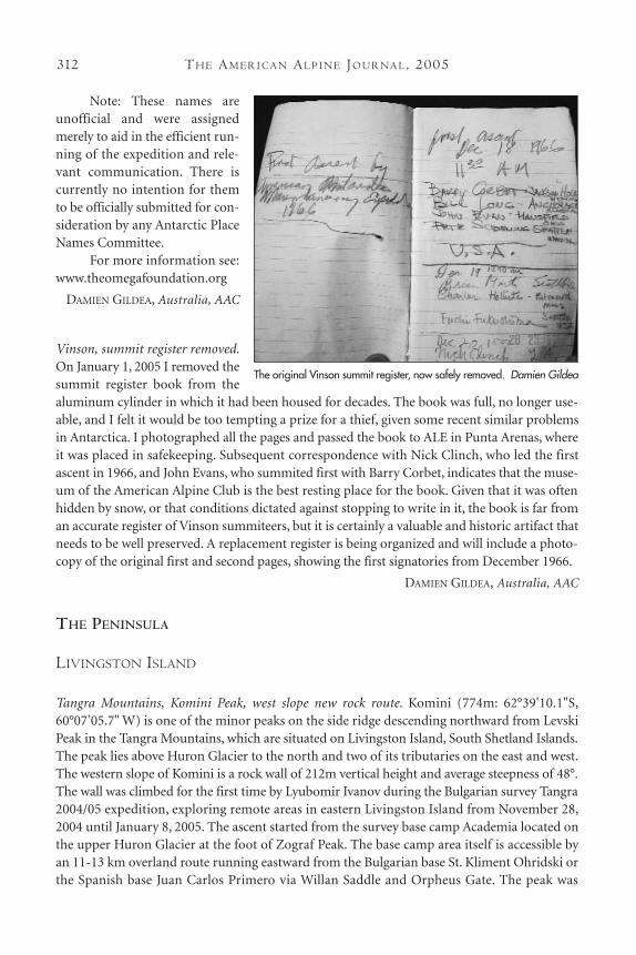
Vinson, summit register removed.On January 1, 2005 I removed thesummit register book from thealuminum cylinder in which it had been housed for decades. The book was full, no longer use-able, and I felt it would be too tempting a prize for a thief, given some recent similar problemsin Antarctica. I photographed all the pages and passed the book to ALE in Punta Arenas, whereit was placed in safekeeping. Subsequent correspondence with Nick Clinch, who led the firstascent in 1966, and John Evans, who summited first with Barry Corbet, indicates that the muse-um of the American Alpine Club is the best resting place for the book. Given that it was oftenhidden by snow, or that conditions dictated against stopping to write in it, the book is far froman accurate register of Vinson summiteers, but it is certainly a valuable and historic artifact thatneeds to be well preserved. A replacement register is being organized and will include a photo-copy of the original first and second pages, showing the first signatories from December 1966.
DAMIEN GILDEA, Australia, AAC
THE PENINSULA
LIVINGSTON ISLAND
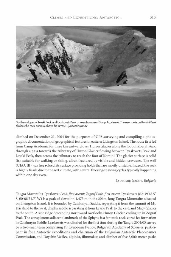
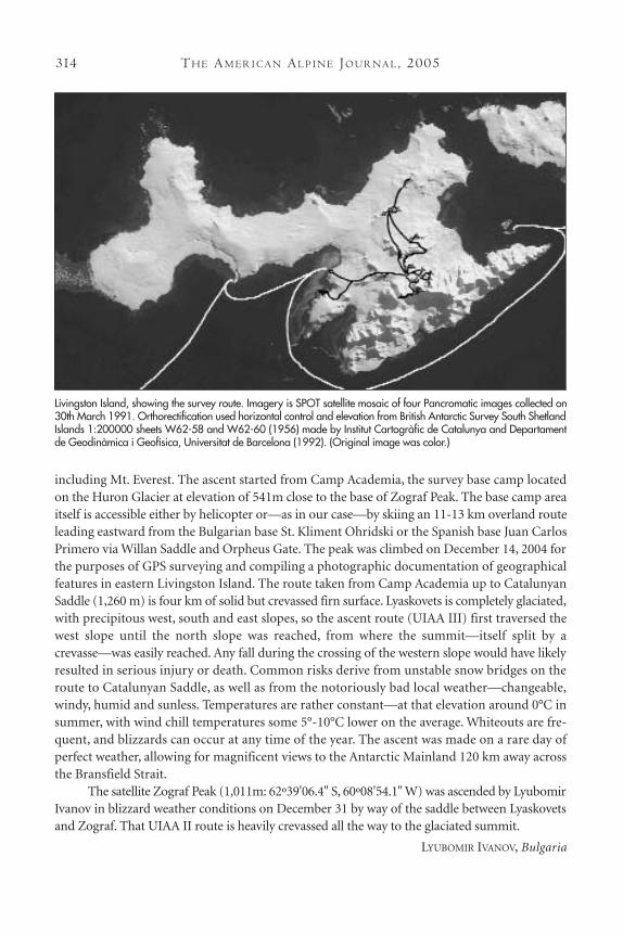
Tangra Mountains, Komini Peak, west slope new rock route. Komini (774m: 62°39'10.1"S,60°07’05.7" W) is one of the minor peaks on the side ridge descending northward from LevskiPeak in the Tangra Mountains, which are situated on Livingston Island, South Shetland Islands.The peak lies above Huron Glacier to the north and two of its tributaries on the east and west.The western slope of Komini is a rock wall of 212m vertical height and average steepness of 48°.The wall was climbed for the first time by Lyubomir Ivanov during the Bulgarian survey Tangra2004/05 expedition, exploring remote areas in eastern Livingston Island from November 28,2004 until January 8, 2005. The ascent started from the survey base camp Academia located onthe upper Huron Glacier at the foot of Zograf Peak. The base camp area itself is accessible byan 11-13 km overland route running eastward from the Bulgarian base St. Kliment Ohridski orthe Spanish base Juan Carlos Primero via Willan Saddle and Orpheus Gate. The peak was
The original Vinson summit register, now safely removed. Damien Gildea
CL I M B S A N D EX P E D I T I O N S : AN TA RC T I C A 313
climbed on December 21, 2004 for the purposes of GPS surveying and compiling a photo-graphic documentation of geographical features in eastern Livingston Island. The route first ledfrom Camp Academia for three km eastward over Huron Glacier along the foot of Zograf Peak,through a pass towards the tributary of Huron Glacier flowing between Lyaskovets Peak andLevski Peak, then across the tributary to reach the foot of Komini. The glacier surface is solidfirn suitable for walking or skiing, albeit fractured by visible and hidden crevasses. The wall(UIAA III) was free soloed, its surface providing holds that are mostly unstable. Indeed, the rockis highly fissile due to the wet climate, with several freezing-thawing cycles typically happeningwithin one day even.
LYUBOMIR IVANOV, Bulgaria
Tangra Mountains, Lyaskovets Peak, first ascent; Zograf Peak, first ascent. Lyaskovets (62º39'48.5"S, 60º08'34.7" W) is a peak of elevation 1,473 m in the 30km-long Tangra Mountains situatedon Livingston Island. It is bounded by Catalunyan Saddle, separating it from the summit of Mt.Friesland to the west, Shipka saddle separating it from Levski Peak to the east, and Macy Glacierto the south. A side ridge descending northward overlooks Huron Glacier, ending up in ZografPeak. The conspicuous adjacent landmark of the Sphynx is a fantastic rock-cored ice formationin Catalunyan Saddle. Lyaskovets was climbed for the first time during the Tangra 2004/05 surveyby a two-man team comprising Dr. Lyubomir Ivanov, Bulgarian Academy of Sciences, partici-pant in four Antarctic expeditions and chairman of the Bulgarian Antarctic Place-namesCommission, and Doychin Vasilev, alpinist, filmmaker, and climber of five 8,000-meter peaks
Northern slopes of Levski Peak and Lyaskovets Peak as seen from near Camp Academia. The new route on Komini Peakclimbes the rock buttress above the arrow. Lyubomir Ivanov
TH E AM E R I C A N AL P I N E JO U R NA L, 2005314
including Mt. Everest. The ascent started from Camp Academia, the survey base camp locatedon the Huron Glacier at elevation of 541m close to the base of Zograf Peak. The base camp areaitself is accessible either by helicopter or—as in our case—by skiing an 11-13 km overland routeleading eastward from the Bulgarian base St. Kliment Ohridski or the Spanish base Juan CarlosPrimero via Willan Saddle and Orpheus Gate. The peak was climbed on December 14, 2004 forthe purposes of GPS surveying and compiling a photographic documentation of geographicalfeatures in eastern Livingston Island. The route taken from Camp Academia up to CatalunyanSaddle (1,260 m) is four km of solid but crevassed firn surface. Lyaskovets is completely glaciated,with precipitous west, south and east slopes, so the ascent route (UIAA III) first traversed thewest slope until the north slope was reached, from where the summit—itself split by a crevasse—was easily reached. Any fall during the crossing of the western slope would have likelyresulted in serious injury or death. Common risks derive from unstable snow bridges on theroute to Catalunyan Saddle, as well as from the notoriously bad local weather—changeable,windy, humid and sunless. Temperatures are rather constant—at that elevation around 0°C insummer, with wind chill temperatures some 5°-10°C lower on the average. Whiteouts are fre-quent, and blizzards can occur at any time of the year. The ascent was made on a rare day ofperfect weather, allowing for magnificent views to the Antarctic Mainland 120 km away acrossthe Bransfield Strait.
The satellite Zograf Peak (1,011m: 62º39'06.4" S, 60º08'54.1" W) was ascended by LyubomirIvanov in blizzard weather conditions on December 31 by way of the saddle between Lyaskovetsand Zograf. That UIAA II route is heavily crevassed all the way to the glaciated summit.
LYUBOMIR IVANOV, Bulgaria
Livingston Island, showing the survey route. Imagery is SPOT satellite mosaic of four Pancromatic images collected on30th March 1991. Orthorectification used horizontal control and elevation from British Antarctic Survey South ShetlandIslands 1:200000 sheets W62-58 and W62-60 (1956) made by Institut Cartogràfic de Catalunya and Departamentde Geodinàmica i Geofísica, Universitat de Barcelona (1992). (Original image was color.)
CL I M B S A N D EX P E D I T I O N S : AN TA RC T I C A 315
Vidin Heights, Melnik Peak, Melnik Ridge, first ascent. Miziya Peak (604m: 62°36'06.4" S,60°09'11.2" W) is the main summit of Vidin Heights, a cluster of peaks, nunataks, and hillsextending eight km in the northeast extremity of Livingston Island. Miziya was climbed for thefirst time by Lyubomir Ivanov during the Bulgarian survey expedition. The ascent started fromthe bivouac at Leslie Hill, set up after man-sledding 10 km north from the survey base campAcademia on the upper Huron Glacier, by way of Wörner Gap and then crossing Bowles Ridgeand upper Kaliakra Glacier. Miziya Peak was climbed on December 25, 2004. The route ofascent went five km from Leslie Hill via Leslie Gap to a 481m peak and 453m knoll in the south-west extremity of Vidin Heights. From here Miziya itself was gained. The peak is completelyglaciated, with a precipitous east slope overlooking Kaliakra Glacier, and a gentle albeitcrevassed west slope (UIAA II), which was ascended.
The two-man team of Lyubomir Ivanov and Doychin Vasilev returned from Leslie Hill toCamp Academia on December 28 by a more easterly 14km route crossing Kaliakra Glacier, YankovSaddle (575m) between Bowles Ridge and Melnik Ridge, then sledding down Struma Glacier toreach Huron Glacier via the pass between Atanasoff Nunatak and Maritsa Peak on the easternBowles Ridge. In the process, they made a UIAA II diversion from Yankov Saddle to climb MelnikPeak (696m), the summit of the two km-long Melnik Ridge situated north of the eastern BowlesRidge. The peak is glaciated except for the precipitous northern slope overlooking Kaliakra Glacier.
LYUBOMIR IVANOV, Bulgaria
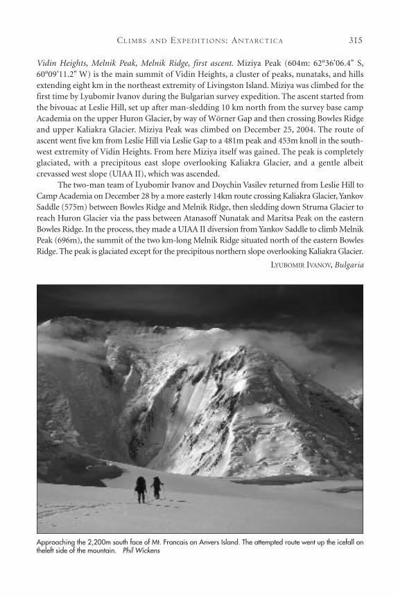
Approaching the 2,200m south face of Mt. Francais on Anvers Island. The attempted route went up the icefall ontheleft side of the mountain. Phil Wickens
TH E AM E R I C A N AL P I N E JO U R NA L, 2005316
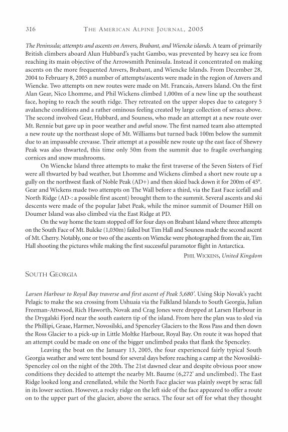
The Peninsula; attempts and ascents on Anvers, Brabant, and Wiencke islands. A team of primarilyBritish climbers aboard Alun Hubbard’s yacht Gambo, was prevented by heavy sea ice fromreaching its main objective of the Arrowsmith Peninsula. Instead it concentrated on makingascents on the more frequented Anvers, Brabant, and Wiencke Islands. From December 28,2004 to February 8, 2005 a number of attempts/ascents were made in the region of Anvers andWiencke. Two attempts on new routes were made on Mt. Francais, Anvers Island. On the firstAlan Gear, Nico Lhomme, and Phil Wickens climbed 1,000m of a new line up the southeastface, hoping to reach the south ridge. They retreated on the upper slopes due to category 5 avalanche conditions and a rather ominous feeling created by large collection of seracs above.The second involved Gear, Hubbard, and Souness, who made an attempt at a new route overMt. Rennie but gave up in poor weather and awful snow. The first named team also attempteda new route up the northeast slope of Mt. Williams but turned back 100m below the summitdue to an impassable crevasse. Their attempt at a possible new route up the east face of ShewryPeak was also thwarted, this time only 50m from the summit due to fragile overhanging cornices and snow mushrooms.
On Wiencke Island three attempts to make the first traverse of the Seven Sisters of Fiefwere all thwarted by bad weather, but Lhomme and Wickens climbed a short new route up agully on the northwest flank of Noble Peak (AD+) and then skied back down it for 200m of 45°.Gear and Wickens made two attempts on The Wall before a third, via the East Face icefall andNorth Ridge (AD-: a possible first ascent) brought them to the summit. Several ascents and skidescents were made of the popular Jabet Peak, while the minor summit of Doumer Hill onDoumer Island was also climbed via the East Ridge at PD.
On the way home the team stopped off for four days on Brabant Island where three attemptson the South Face of Mt. Bulcke (1,030m) failed but Tim Hall and Souness made the second ascentof Mt. Cherry. Notably, one or two of the ascents on Wiencke were photographed from the air, TimHall shooting the pictures while making the first successful paramotor flight in Antarctica.
PHIL WICKENS, United Kingdom
SOUTH GEORGIA
Larsen Harbour to Royal Bay traverse and first ascent of Peak 5,680'. Using Skip Novak’s yachtPelagic to make the sea crossing from Ushuaia via the Falkland Islands to South Georgia, JulianFreeman-Attwood, Rich Haworth, Novak and Crag Jones were dropped at Larsen Harbour inthe Drygalski Fjord near the south eastern tip of the island. From here the plan was to sled viathe Phillipi, Graae, Harmer, Novosilski, and Spenceley Glaciers to the Ross Pass and then downthe Ross Glacier to a pick-up in Little Moltke Harbour, Royal Bay. On route it was hoped thatan attempt could be made on one of the bigger unclimbed peaks that flank the Spenceley.
Leaving the boat on the January 13, 2005, the four experienced fairly typical SouthGeorgia weather and were tent bound for several days before reaching a camp at the Novosilski-Spenceley col on the night of the 20th. The 21st dawned clear and despite obvious poor snowconditions they decided to attempt the nearby Mt. Baume (6,272' and unclimbed). The EastRidge looked long and crenellated, while the North Face glacier was plainly swept by serac fallin its lower section. However, a rocky ridge on the left side of the face appeared to offer a routeon to the upper part of the glacier, above the seracs. The four set off for what they thought
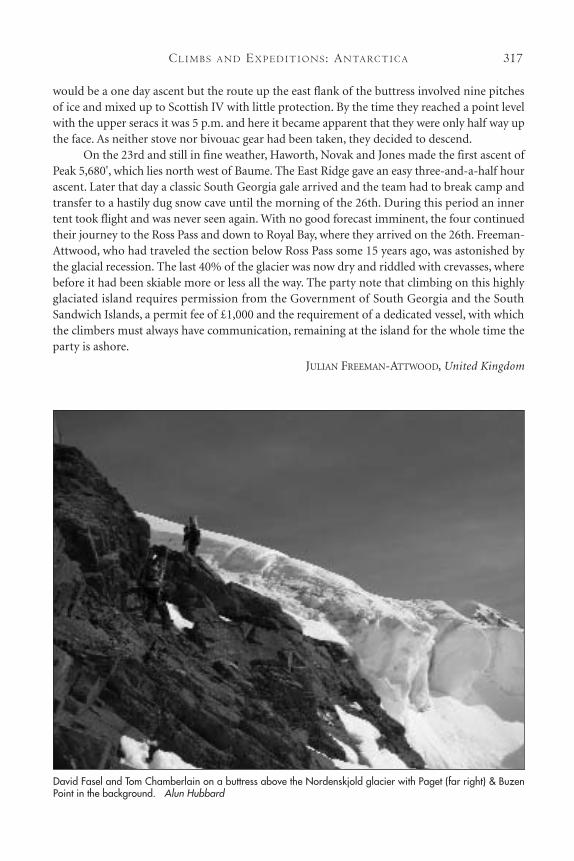
CL I M B S A N D EX P E D I T I O N S : AN TA RC T I C A 317
would be a one day ascent but the route up the east flank of the buttress involved nine pitchesof ice and mixed up to Scottish IV with little protection. By the time they reached a point levelwith the upper seracs it was 5 p.m. and here it became apparent that they were only half way upthe face. As neither stove nor bivouac gear had been taken, they decided to descend.
On the 23rd and still in fine weather, Haworth, Novak and Jones made the first ascent ofPeak 5,680', which lies north west of Baume. The East Ridge gave an easy three-and-a-half hourascent. Later that day a classic South Georgia gale arrived and the team had to break camp andtransfer to a hastily dug snow cave until the morning of the 26th. During this period an innertent took flight and was never seen again. With no good forecast imminent, the four continuedtheir journey to the Ross Pass and down to Royal Bay, where they arrived on the 26th. Freeman-Attwood, who had traveled the section below Ross Pass some 15 years ago, was astonished bythe glacial recession. The last 40% of the glacier was now dry and riddled with crevasses, wherebefore it had been skiable more or less all the way. The party note that climbing on this highlyglaciated island requires permission from the Government of South Georgia and the SouthSandwich Islands, a permit fee of £1,000 and the requirement of a dedicated vessel, with whichthe climbers must always have communication, remaining at the island for the whole time theparty is ashore.
JULIAN FREEMAN-ATTWOOD, United Kingdom
David Fasel and Tom Chamberlain on a buttress above the Nordenskjold glacier with Paget (far right) & BuzenPoint in the background. Alun Hubbard
TH E AM E R I C A N AL P I N E JO U R NA L, 2005318
Mt. Paget and other attempts. From February to May 2005 a multi-national team of climberssailed the yacht Gambo from Ushuaia in Argentina to King Edward Point in South Georgia, andthen back to Pireapolis in Uruguay. The team, which included Tom Chamberlain (UK), DavidFasel (Switzerland), Daniel Haywood (UK), Tim Hall (UK), the yacht skipper Alun Hubbard(UK), and additional (non-climbing) crew members Alastair Gunn (UK) and Rory Williams(US) attempted various ascents on this highly glaciated sub-Antarctic island. Not atypical SouthGeorgia weather thwarted any major achievements, though there were some near misses. Whilebased between Husvik and Grytviken the climbers made three attempts on the unclimbedQuad 5 and Mt. Paulsen, and the once-previously climbed Mt. Spaaman (1,940m). All faileddue to either weather or poor rock. On the way to Spaaman one party managed to make anascent of the previously climbed Admiralty Peak. A total of 14 days were spent attempting a pre-vious Hubbard nemesis, the unclimbed east ridge of Paget, the highest peak on the island andalso the highest on British soil. One of these nearly made the top. However, they did make thefirst ascent of a 7,000' subsidiary summit of Paget, which has been named Buzen Point. Shortlyafter getting down from one attempt on Paget, the climbers experienced a classic South Georgiablow, caused by the rapid onset of a 929mb low pressure at sea level. Things got a trifle breezyand the roof was blown off the British Antarctic Survey hut at King Edward Point, one of themore sheltered locations on the island.
ALUN HUBBARD, Wales


![CLIMBS AND EXPEDITIONS, I984 295c498469.r69.cf2.rackcdn.com/1985/295_india_aaj1985.pdfSisne Himal actually lies farther west.-Editor. ] On April 19 Adams alone reached the expedition’s](https://img.pdfslide.us/doc/110x75/60d156c4ac0387197f55eca4/climbs-and-expeditions-i984-295c498469r69cf2-sisne-himal-actually-lies-farther.jpg)