Embed Size (px)
Citation preview
1
Climate Data Initiative: A Geocuration Effort to Support Climate
Resilience
Rahul Ramachandran1, Kaylin Bugbee2, Curt Tilmes3 and Ana Pinheiro
Privette3
1 NASA/MSFC 2 University of Alabama in Huntsville
3 NASA/GSFC
Abstract
Curation is traditionally defined as the process of collecting and organizing information
around a common subject matter or a topic of interest and typically occurs in museums,
art galleries, and libraries. The task of organizing data around specific topics or themes
is a vibrant and growing effort in the biological sciences but to date this effort has not
been actively pursued in the Earth sciences. In this paper, we introduce the concept of
geocuration and define it as the act of searching, selecting, and synthesizing Earth
science data/metadata and information from across disciplines and repositories into a
single, cohesive, and useful compendium We present the Climate Data Initiative (CDI)
project as an exemplar example. The CDI project is a systematic effort to manually curate
and share openly available climate data from various federal agencies. CDI is a broad
multi-agency effort of the U.S. government and seeks to leverage the extensive existing
federal climate-relevant data to stimulate innovation and private-sector entrepreneurship
to support national climate-change preparedness. We describe the geocuration process
used in CDI project, lessons learned, and suggestions to improve similar geocuration
efforts in the future.
1.Introduction
The definition of curation can vary depending on one’s perspective. Curation is
traditionally defined as the process of collecting and organizing information around a
common subject matter or a topic of interest and typically occurs in museums, art
https://ntrs.nasa.gov/search.jsp?R=20160002432 2018-02-18T03:28:38+00:00Z

2
galleries, and libraries. In the library community, the curation process has become more
nuanced with the advent of digital content. The digital library community defines curation
as “actions people take to maintain and add value to digital information over its lifecycle,
including the processes used when creating digital content” (Walters, 2011). Similarly,
Lord et al. (2004) define curation as the “activity of managing and promoting the use of
data from its point of creation, to ensure it is fit for contemporary purpose, and available”.
A cornerstone component of this curation activity is archiving, whereby selected digital
resources are stored and made accessible for future use.
Like the library community, the Earth science data communities also perform curation
activities but under the broader umbrella of data stewardship (Peng et al. 2015). These
data stewardship activities support the data life cycle by enabling data preservation,
accessibility, usability, and sustainability, thereby ensuring quality and reproducibility. The
task of organizing data around specific topics or themes is a vibrant and growing effort in
the biological sciences (Howe and Yon, 2008) but to date this effort has not been actively
pursued in the Earth sciences. One reason for this activity gap is that most Earth science
repositories have mission statements centered on broad science objectives to support a
defined set of science stakeholders [around field campaigns, observation platforms and
missons]. The types of data ingested, archived, published, and distributed must adhere
to these guidelines. NASA’s Earth Science Data Active Archive Centers (DAACs) are a
good example of distributed science repositories (Kobler and Berbert, 1991); with each
DAAC’s data holdings focused on specific science themes. The data within each
repository is aggregated around science projects/missions, instruments or science
keywords, and is presented to the user community using this same organizational
structure.
There are rapidly emerging causes that drive the need for a finer-grained curation of data
and information within Earth science. First, there has been a rapid increase in the growth
of the number of Earth science datasets and publications. For example, there are over
14,600 Earth science related data collections (not individual files) available in the

3
Data.gov catalog (Wright, 2014) from various U.S. federal agencies1. A recent search on
Elsevier’s journals related to Earth science produced a result of over 40,000 papers
published in 2014 alone. Second, the study of Earth as a system has revealed that a
specialized focus on one facet of the system does not necessarily capture the dynamics
of an interdependent system. Accordingly, research within Earth science has become
exceedingly interdisciplinary. This interdisciplinary nature of research requires discovery
of both data and information from distributed, multiple domain data and publication
repositories.
In this paper, we introduce the concept of geocuration and present the Climate Data
Initiative (CDI) project (CDI, 2014) as an exemplar example. The CDI project is a
systematic effort to manually curate and share openly available climate data from various
federal agencies. CDI is a broad multi-agency effort of the U.S. government which seeks
to leverage ‘extensive federal climate-relevant data to stimulate innovation and private-
sector entrepreneurship in support of national climate-change preparedness.’ (Climate
Action Plan). CDI utilizes Subject Matter Experts (SMEs) from different federal agencies
to manually curate data around key Climate resiliency themes. CDI exemplifies the need
for geocuration given both the complexity of the topic and the types of relevant data
available from different federal agencies for climate change. The subsequent sections
describe geocuration, the Climate Data Initiative project, the geocuration process used,
lessons learned, and suggestions to improve future geocuration efforts.
2.Geocuration
Geocuration is the act of searching, selecting, and synthesizing Earth science
data/metadata and information from across disciplines and repositories into a single,
cohesive, and useful compendium. Geocuration is analogous to the concept of
verticalization in tool development, where verticalization refers to the customization of a
tool (Kohavi et al. 2002) based on a specific science use or domain application.
1 This number does not include other useful publicly available datasets distributed by research laboratories, universities and other organizations.
4
Geocuration serves the same purpose by searching, selecting, and synthesizing data and
information based on specific science needs.
Geocuration requires following several systematic steps, each of which serves a specific
purpose. The Search step is guided by the cumulative domain expertise of the curators.
The domain experts utilize the collective domain knowledge to identify all possible
relevant data and information resources. Information resources could include citations
for relevant literature, specific workflows, tools, web sites, reports, and documents. The
Selection step entails culling the search results based on some “fitness or relevancy”
criteria. The fitness criteria can range from simple spatial temporal bounds and resolution,
a set of framing questions that define the contextual narrative around the curation effort
or fully described use cases. Performing a literature review and identifying relevant data
in published journal articles (Karasti et al. 2006) is another approach for selection. Finally,
targeting the needs of the intended consumers of the curated compendium is another
effective way to filter identified information and to determine what needs to be provided
by the curation (Goble et al. 2008).
Once the selection step is complete, the identified data and other information is
synthesized into a cohesive compendium. The goal of synthesis is to address a set of
questions. What has been gathered? Are all the data and information pieces easily
identifiable and their associations understandable? Why are these data and information
pieces important to the topic? The synthesis should provide contextual framework for all
the gathered information objects. How can this information unit be used? The consumers
of the compendium should be able to use the information in his or hers own research or
applications with minimal effort.
The synthesized information can contain data virtually or locally with different level of
granularity. Local data can be aggregated as data bundles containing individual data
granules or files. Data can also be aggregated as a single new product or a file containing
curated data parameters from different data sets. Using metadata, one can create Virtual
Collections where the synthesized compendium contains only links to the data to its actual
data repository for access and use. Virtual collections can also have different levels of

5
granularity and can contain individual data files or specific data parameters. The ability to
create virtual collections using the existing rich metadata catalogs in Earth science offers
a promising potential for enhancing data access and use.
There are two approaches to geocuration: manual curation and automated curation.
Manual Curation requires Subject Matter Experts to serve as digital librarians, or
geocurators, who discover and synthesize data and information virtually. One of the main
advantages of manual curation is accuracy and trustworthiness to address “suitability of
purpose”. This is a key requirement for downstream consumers of this curated
information, especially in Earth Science. Peng et al., (2015) addresses this by asserting
that “...users are asking for data to be dependable in terms of quality and production
sustainability, to be from credible, secure, and authoritative sources, to be easily and
publicly accessible online.” Manual Curation, however, is labor intensive and “a non-
trivial undertaking that needs to balance content coverage against content quality” (Goble
et al. 2008). Moreover, to be effective, curation needs to become a community activity
promoting “collaboration where sheer scale of effort needed can deliver both breadth and
economies of scale not possible for each singular participant” [Macdonald, 6].
Community-driven curation can also provide the editorial oversight to minimize any biases
that may occur based on an individual curator’s preferences. One example of successful
manual curation is described by Howe and Yon (2008) as “biocuration,” a topic within the
Biomedical field, focusing on the activity of organizing, representing and making biological
information accessible and usable for specific specialized sub-themes. Biocuration
facilitates community-based curation to address the existing gaps in knowledge, provides
researchers with a means to quickly find and use massive amounts of complex data
quickly, offers insights concerning specific areas of interest, and makes it possible to
process information faster as data and information is synthesized as part of curation.
Extracting, tagging with control vocabularies, and representing data from published
literature are the core tasks within biocuration.
Curation is still difficult to achieve in a fully automated manner. There are different
approaches and tools that support topic or theme-based searches using text mining or

6
ontological based algorithms (Shamsfard et al. 2006; Yue et al. 2009; Liu 2010). These
approaches by themselves are not enough but can be used as tools to filter down
resources that are then manually re-ranked and synthesized (Alex et al. 2008). These
tools can support searches across domains and provide automated mediation between
different vocabularies used in different repositories to represent similar data (Klien et al.
2001). An example of an automated curation prototype is the “Data Albums” described in
Ramachandran et al (2014). Data Albums are compiled virtual collections of information
related to a specific science topic or an event, containing links to relevant data files
(granules) from different instruments as well as tools and services for visualization and
analysis and information about the event contained in news reports, images, or videos to
supplement research analysis. Curation is achieved via an ontology-based relevancy
ranking algorithm that filters out non-relevant information and data. We envision in the
near future, specialized relevancy ranking algorithms will be able to generate virtual
collections for defined curation tasks.
3.Climate Data Initiative Project Overview
The President’s Climate Action Plan and the Executive Order 136532, Preparing the
United States for the Impacts of Climate Change, call for the Federal Government to
“…develop and provide authoritative, easily accessible, usable, and timely data,
information, and decision-support tools on climate preparedness and resilience” to
support federal, regional, state, local, tribal, private-sector and nonprofit-sector efforts to
prepare for the impacts of climate change. In response to this call, NASA and NOAA were
asked to lead the Climate Data Initiative (CDI) and development of a Climate Resilience
Toolkit (CRT), respectively.
The Climate Data Initiative (CDI) focuses on preparing the United States for the impacts
of climate change by leveraging “extensive federal climate-relevant data to stimulate
2 http://www.gpo.gov/fdsys/pkg/FR-2013-11-06/pdf/2013-26785.pdf

7
innovation and private-sector entrepreneurship in support of national climate-change
preparedness.” (President’s Climate Plan, 16). It also supports the broader Open Data
Policy and integrates this effort with other Open Data Initiatives by adding the new
Climate.Data.gov which includes an online catalog of datasets and data products. The
Climate Data Initiative is a collaborative effort across federal agencies and scientific
disciplines that seeks to make federal climate data both usable and accessible for its
defined stakeholders. So far, the CDI and CRT include seven themes, or topics, relevant
to climate change resiliency. These themes include Coastal Flooding, Food Resilience,
Water, Ecosystem Vulnerability, Human Health, Energy Infrastructure, and
Transportation. Each theme is a curated virtual data collection that is relevant to
addressing the challenges of climate resiliency as it relates to a specific aspect of the
Earth system and the resulting societal impacts.
Since knowing for whom curation is intended can serve as guide for what curation to
provide (Goble et al. 2008), the Climate Data Initiative defined its stakeholders to include
decision makers and innovators. Decision makers are individuals responsible for shaping
policy, legislation, finances, social programs, funding, and disaster planning at the
national, state, and local levels. These decision makers include policy makers and
planners who need to analyze data related to activities that are essential to planning for
climate change resiliency. A key need for decision makers such as GIS analysts,
emergency management responders, and natural resource managers is accessible,
ready to use data in formats or standard APIs supported by a decision support system.
Example formats range from KMLs and ESRI’s shapefiles to geoTIFFs which can be
easily used in Geographic Information Systems.
The CDI is focused on stimulating innovation, and entrepreneurship, among data
innovators in the private sector and the general public who will use data to create and
build information and applications for end users. Data innovators are public and private
sector software developers that wish to develop new applications that leverage the federal
government’s openly available climate data. Recognizing that some of the best ideas for

8
government come from outside the government, CDI targeted innovators to stimulate the
growth of innovative websites, innovative new apps, and other creative tools around the
various climate resiliency themes.
4.CDI Curation Process
The three components of the CDI project are: the data system infrastructure supporting
the project, curation team consisting of Subject Matter Experts (SME) and informatics
experts, and the curation process itself. Fig 1 provides a bird's-eye view of the CDI
curation process and its components.
9
Figure 1: Overview of the CDI Curation process, participants based on roles and
infrastructure components used to publish the final results.
Curation Infrastructure
To curate a virtual data collection that includes information about data from various
agencies across the Federal government, a catalog is required to hold all the metadata
in a single repository or location. All federal agencies are mandated to publish metadata
for their datasets in the Data.gov (US EOP-OMB, 2009) catalog. Therefore, the Data.gov
catalog was the natural choice to serve as the core infrastructure component for the CDI
interagency curation effort.
The underlying Data.gov catalog [and its sister site, Geoplatform.gov,] use the
Comprehensive Knowledge Archive Network (CKAN) (Wainwright, 2012) data
management system . CKAN is a widely used data management system which makes
data discoverable and accessible. It provides tools to streamline publishing, sharing,
finding, and using data. Data publishers use CKAN to create a catalog that both describes
and makes the data discoverable. Data.gov supports CKAN’s open source nature by
adding new functionality and customizations as well as repairing CKAN-related bugs.
CKAN also provides a RESTful API to programmatically query its catalog, generate
statistics, and list datasets by theme.
There are two main types of metadata in Data.gov: geospatial and non-geospatial. All
non-geospatial metadata must comply with the Project Open Data (POD) metadata
schema. The POD metadata schema is based on Data Catalog Vocabulary (DCAT) and
requires JavaScript Object Notation (JSON) format encoding for its records. All agencies
provide metadata in POD-compliant JSON files. These metadata records are harvested
daily. Validation for schema conformance is performed during the harvest process before
the metadata is ingested and published in the data.gov catalog.
10
For describing geospatial datasets, the Data.gov catalog supports two types of geospatial
metadata standards: ISO-19115:2003 and the Federal Geographic Data Committee’s
Content Standard for Digital Geospatial Metadata (FGDC CSDGM). Geospatial metadata
is typically provided in a Catalog Service for the Web (CSW) endpoint. A mapping,
implemented by a crosswalk, is required to transform geospatial metadata to the native
Data.gov Project Open Data schema. The crosswalk maps the ISO 19115:2003 metadata
into the POD schema. The CSDGM/FGDC metadata is first mapped into the ISO
19115:2003 schema and then subsequently transformed into the POD schema using this
same crosswalk.
Curation Team
For CDI, geocuration is a manual activity completed by two teams – the theme team and
the data coordination team. The theme team consists of subject matter experts from
multiple agencies. The theme team is responsible for recommending sources of
authoritative data relevant for a particular climate resilience topic. Each theme team is
assigned a team lead and a Technical Point of Contact. The role of the Technical Point
of Contact is to liaison with and assist the Data Coordination team in interacting with
different federal agencies in the course of adding missing data to the Data.gov catalog or
correcting any metadata issues identified. The Data Coordination team consists of Earth
Science informatics experts with the primary responsibility to check catalog metadata
quality, identify problem datasets, suggest ways to different agencies to improve
metadata quality and track metrics on data accessibility and usability.
Curation Process
Data must meet three criteria to be added to a CDI Compendium – in this case, a specific
climate resiliency theme. First, a curated dataset should be scientifically relevant to the
given climate resiliency topic. The subject matter experts on the theme team ensure that

11
the selected datasets meet this scientific criterion. Second, the curated dataset must be
from a reputable source, preferably from a federal agency [ in this phase the focus is on
federal data resources or data produced under sponsorship of a federal agency]. Third,
a curated dataset must be accessible and usable. The data coordination team, with
assistance from the theme team and the original data providers, is primarily responsible
for ensuring that datasets meet these criteria.
The process begins with the theme team creating a series of framing questions to guide
the selection of datasets that are suitable and relevant to the climate resiliency topic. The
theme team uses the Data.gov catalog as a starting point for searching the relevant data
for curation. The theme team identifies any missing data and notifies the agency
producing the data to publish the requisite metadata. The agency producing the data is
responsible for providing the metadata to publish and make discoverable in the Data.gov
catalog. After the completion of this curation phase, the theme team gives the data
coordination team a list of data and other ancillary information upon which to perform
quality checks.
The data coordination team performs quality control checks on the metadata to verify that
data is accessible and the associated metadata is robust enough to ensure users can
utilize these datasets in their applications. The CDI project defines accessible data as
data that is available in convenient and well-known mechanisms that can be easily
consumed such as machine APIs or downloadable files in standard formats. Accessible
data are sub-divided into data that are directly usable by decision makers and those more
suitable for input to tools and applications that an innovator might develop. Accessible
data usable by decision makers include data formats that can be readily interoperable
with decision support systems such as Geographic Information Systems including ESRI’s
ArcGIS, and Google Earth. Accessible data, usable by innovators includes common data
formats that are machine-readable. Machine-readable data are reasonably structured to

12
allow users to write code for automated processing. Machine-readable data provide the
most value to innovators by allowing them to quickly reprocess the data or obtain the data
automatically in order to populate applications. These types of data can also have
application programming interfaces, or APIs, to allow innovators to build new tools using
these datasets or to bring together information from various disparate sources.
The quality assessment for all of the metadata in a curated collection is compiled in a
document. This document provides feedback for each individual metadata record and
includes all identified issues along with suggestions for improving the records. The
responsible data providers within specific agencies are given the feedback document.
These quality improvements are performed in an iterative manner. If by chance the
metadata corrections are not completed by an agency at the time of the theme release,
those datasets are not included in the published theme collection. Since the curation for
each theme is an ongoing continuous process, improvements to the metadata records
are made after the theme release and new metadata records can be subsequently added
to the collection.
5.Curation Results
Each theme in CDI is incrementally rolled out. The incremental release process for each
theme ensures that they are highlighted individually. Additionally, the incremental process
encourages users to return to the climate collection, thus creating repeat users. Once a
theme is made public, the theme teams are encouraged to continue to add additional
datasets to the collection. This ensures the climate themes remain fresh and relevant to
returning users.
The user accesses the collection through the main climate page on Data.gov at
Data.gov/climate (Figure 2). The pages can be sorted by theme which results in the data
collections also being listed by theme. The user can select the ‘data’ tab to obtain the

13
relevant data catalog listing (Figure 2). The catalog listing is then displayed in the order
of the most recent views where ‘recent views’ quantifies as the number of views within
the last two weeks. Once the user selects a record, information about the dataset is
displayed including the agency that provides the data, the spatial extent of the data (if
applicable), a short summary about the dataset, and links to access the data (Figure 2).
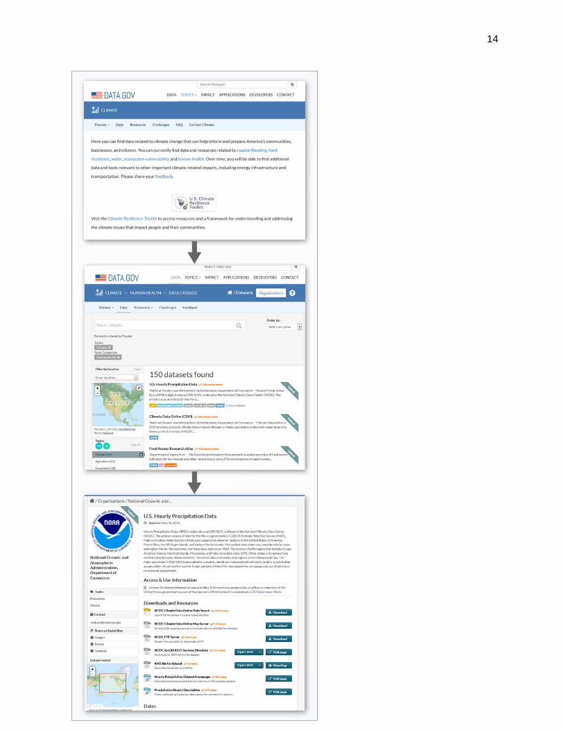
14

15
Figure 2: The steps to discover a specific curated data for a given theme are presented
in the three snapshots. The top image shows the CDI home page. Once a user selects
a theme and the data tab, the curated datasets are presented (middle image). The
lower image is an example of a specific data set landing page.
To date, seven themes have been released as a part of the Climate Data Initiative (Table
1). These themes were curated by subject matter experts from several Federal agencies,
including NOAA, USDA, USGS, and HHS/CDC.
Theme Date Released Lead Agency
Coastal Flooding March 2014 NOAA
Food Resilience July 2014 USDA
Water November 2014 USGS
Ecosystem Vulnerability December 2014 USGS
Energy Infrastructure June 2015 DOE
Transportation June 2015 DOT
Human Health April 2015 HHS/CDC
Table 1: Different climate resilience themes released by CDI
The Climate Data Initiative collection currently consists of 560 unique datasets (Figure
3). Due to some datasets being included in multiple themes, the number of datasets by
theme appears to be higher than the total collection.

16
Figure 3: Number datasets curated under the CDI effort categorized by the different
climate resilience themes.
The CDI website was instrumented with Google Analytics on January, 2015 after four of
the themes had been released. The numbers from January 2015 are significant. There
were around 47,000 unique page views on the CDI site. About 2% of the total visitors
browsed the curated data.
Over 700 datasets from pre-release theme team submissions were checked for quality
by the data coordination team. Of these, 543 were made available at the theme release,
118 are a part of themes that have not been released yet, and approximately 100 did not
pass the metadata quality checks at the time of release.
6.Challenges
Some of the main challenges faced during the CDI curation process are described here:

17
1. Need for Discoverable, Open, and Accessible Data
Federal agencies are mandated to make their data accessible and publish metadata in in
Data.gov. However, more often that not, a desired dataset by the SMEs on the theme
team was not always readily available. The theme teams encountered various challenges
when requesting the desired data be added to the Data.gov catalog. These challenges
included finding the original data producer, identifying an agency or organization’s
individual responsible for publishing the metadata into Data.gov, or simply educating the
organization on the Data.gov metadata requirements. The theme teams were able to
overcome these challenges within their own organizations; however, reaching across
agencies sometimes proved difficult.
2. Importance of Synthesis
The curated list of data is unable to accurately capture the subject matter experts’ intent.
While having a curated collection of datasets approved by subject matter experts is
valuable, in the end the collection essentially becomes a long directory or a list.
Establishing valuable connections between datasets and their intended use is lost in a
list. Therefore, the user knows that the datasets in the list have been approved by the
subject matter experts but has less certainty when making connections between the
various datasets and their possible applications.
3. Curation is a non-trivial process
The process of data curation for CDI is complicated because of the involvement of many
people from multiple agencies using many different infrastructure components and short
deadlines for each theme release. Even though a systematic process designed by the
CDI data coordination team was utilized, finding and fixing errors ranging from missing
data sets to broken URLs was an extremely labor intensive effort. This was primarily the
role of the data coordination team. As the data coordination team’s work progressed, the
process of identification and resolution of metadata issues improved. This improvement
was due to a better understanding of the Data.gov catalog and their harvesting processes,
gained by collaborating with both the Data.gov team and metadata experts from different
agencies. This more nuanced understanding of where issues were originating from
enabled the data coordination team to provide specific feedback to the theme teams and
agencies. Overall, these targeted diagnostics increased the likelihood of metadata
records getting fixed by the data producers in time for the theme release.

18
4. Metadata standards help but there are always some issues
Data.gov uses the POD schema to define metadata elements to store in its catalog.
However, Data.gov holds metadata for both geospatial and non-geospatial data. Mapping
geospatial metadata elements geospatial standards such as FGDC or ISO 19115 to the
POD schema can often be problematic. Two types of error typically cause the mapping
issues. First, if there are no obvious one-to-one semantic mappings of certain elements
between the two schemas. Second, if there are problems in the software code itself
transforming metadata records from one standard to the other.
5. Curation cannot be a one-off activity
Curation cannot be a one-off activity especially for projects like CDI with ambitious goals
and large scope. The curation process is dynamic because the curated list changes over
time and requires periodic monitoring. The search and selection process can drive these
changes, allowing the curators to discover new relevant data sets that are then added to
the relevant theme or topic list. The changes can also be driven by other factors such as
data sets no longer being published by the data producer, changes in the infrastructure
causing metadata harvesting issues, metadata errors during updates, etc.
Figure 4: Plot tracking the number of datasets curated under the Water theme over time
showing the evolving nature of geocuration.

19
The Water theme report figure (Figure 4) illustrates these arguments. The initial push of
curation by the theme team can be seen leading up to mid-October. During this period,
the data coordination team is also checking all submitted metadata records for
accessibility and usability. The decline in the number of datasets around the beginning
of November illustrates the process of removing all datasets that do not pass quality
checks in preparation for the theme release. Notice that the number of associated broken
links also decline around this time. Finally, the collection shows continued growth over
time as the theme team continues to add new relevant datasets to the collection.
7.Discussion
Using subject matter experts to curate data for the climate resiliency themes for the
Climate Data Initiative was, overall, a successful endeavor. However, steps can be taken
to improve the curation process and resolve some of the issues listed in the section
above. Some of the lessons learned from this project that can be applied to any similar
curation effort in the future are:
Any successful data curation activity (both local and virtual) requires a large pool
of open and accessible datasets that are discoverable. Also, metadata catalog(s)
play a critical role in enabling successful data curation, especially if the curated
data collections are virtual.
The role of synthesis in curation is often overlooked or glossed over; however, this
synthesis often turns out to be an important element to determine the utility of the
curated compendium. Selected data must be synthesized with the intent of
curation, captured in a formal structure or information model, and presented to
users in a meaningful manner instead of just being presented as a long list of data
sets per topic.
The use of standards does not eliminate metadata issues, especially if
transformations are required between different standards.

20
Curation should not be a one-off process. As long as the curated collection is
relevant, it requires periodic updates and monitoring to maintain both its quality
and value to end users.
The curation process can be streamlined to encourage continued participation.
Making the original curators into moderators of the collection instead of just the
primary source of content would lighten the burden of curation (Goble et al. 2008).
There is a need to reward or incentivize the curation process. In order to encourage
participation, a streamlined citation method for curation efforts would ensure that
curators receive recognition for work done. Citation could also potentially
encourage the continued use of the curated data which could potentially contribute
to a longer lifespan for the curated data.
There is a need to capture usage metrics because assessing the impact made by
the curation effort (Howe et al. 2008) could persuade others of the validity of the
process.
The methodology followed by the Climate Data Initiative of using both subject matter
experts and data experts to curate a collection of climate-related data from across the
federal government lends trustworthiness and reliability to the collection. This
trustworthiness is essential for decision makers and innovators who wish to plan for
climate change resiliency. Additionally, the collaborative nature of the Climate Data
Initiative model lays the foundation for future cross-discipline curation efforts in the Earth
sciences. The study of Earth as a system has revealed that a specialized focus on one
facet of the system does not necessarily capture the dynamics of an interdependent
system. The mechanisms of climate change and climate resiliency are similarly
interdependent. Better synthesis of the curated data to the capture of these
interdependent relationships is a logical step forward in the pursuit of data discoverability,
data accessibility, and ultimately, in the case of the Climate Data Initiative, climate
resiliency.
8.References

21
Alex, Beatrice, Claire Grover, Barry Haddow, Mijail Kabadjov, Ewan Klein, Michael Matthews, Stuart Roebuck, Richard Tobin, and Xinglong Wang. 2008. “Assisted Curation: Does Text Mining Really Help?” Pacific Symposium on Biocomputing. Pacific Symposium on Biocomputing 567: 556–567.
Burnett, Michael, Beth Weinstein, and Andrew Mitchell. 2007. “ECHO - Enabling Interoperability with NASA Earth Science Data and Services.” In International Geoscience and Remote Sensing Symposium (IGARSS), 4012–4015. doi:10.1109/IGARSS.2007.4423729.
CDI. 2014. “Climate Data Initiative.” http://www.data.gov/climate/.
Goble, Carole, Robert Stevens, Duncan Hull, Katy Wolstencroft, and Rodrigo Lopez. 2008. “Data Curation + Process Curation = Data Integration + Science.” Briefings in Bioinformatics 9 (6): 506–517. doi:10.1093/bib/bbn034.
Howe, Doug, and Seung Yon. 2008. “The Future of Biocuration.” Nature 455 (7209): 47–50. doi:10.1038/455047a. http://dx.doi.org/10.1038/455047a.
Karasti, Helena, Karen S. Baker, and Eija Halkola. 2006. “Enriching the Notion of Data Curation in E-Science: Data Managing and Information Infrastructuring in the Long Term Ecological Research (LTER) Network.” Computer Supported Cooperative Work 15: 321–358. doi:10.1007/s10606-006-9023-2.
Klien, Eva, Michael Lutz, and Werner Kuhn. 2001. “Ontology-Based Discovery of Geographic Information Services – An Application in Disaster Management Motivating Example : Discovering Services for Estimating Storm Damage in Forests.” Computers, Environment and Urban Systems 30 (1): 102–123.
Kobler, B., and J. Berbert. 1991. “NASA Earth Observing System Data Information System (EOSDIS).” [1991] Digest of Papers Eleventh IEEE Symposium on Mass Storage Systems. doi:10.1109/MASS.1991.160199.
Kohavi, Ron, Neal. J. Rothleder, and Evangelos Simoudis. 2002. “Emerging Trends in Business Analytics.” Commun. ACM 45 (8): 45–48.
Liu, Wei. 2010. “Ontology-Based Retrieval of Geographic Information.” In 18th International Conference on Geoinformatics, 1–6. doi:10.1109/GEOINFORMATICS.2010.5567612.
Peng, Ge, Jeffrey L Privette, Edward J Kearns, Nancy A Ritchey, and Steve Ansari. 2015. “A UNIFIED FRAMEWORK FOR MEASURING STEWARDSHIP PRACTICES APPLIED TO DIGITAL ENVIRONMENTAL DATASETS.” Data Science Journal 13 (February): 231–253.

22
Philip Lord, Alison Macdonald, Liz Lyon, and David Giaretta. 2004. “From Data Deluge to Data Curation.” Journal of Documentation 67 (2): 214–237. doi:10.1.1.111.7425. http://citeseerx.ist.psu.edu/viewdoc/summary?doi=?doi=10.1.1.111.7425.
Ramachandran, Rahul, Ajinkya Kulkarni, Manil Maskey, Rohan Bakare, Sabin Basyal, and Xiang Li. 2014. “DATA ALBUMS : AN EVENT DRIVEN SEARCH , AGGREGATION AND CURATION TOOL FOR EARTH SCIENCE.” In IEEE Geoscience and Remote Sensing Society 2014. Quebec City, Canada.
Shamsfard, Mehrnoush, Azadeh Nematzadeh, and Sarah Motiee. 2006. “ORank : An Ontology Based System for Ranking Documents.” International Journal of Computer Science 1 (3): 225–231.
U.S. EOP-OMB. 2009. “M-10-06: Open Government Directive.” http://www.whitehouse.gov/sites/default/files/omb/assets/memoranda_2010/m10-06.pdf.
Wainwright, Mark. 2012. “Using CKAN : Storing Data for Re-Use.” In OR2012: Open Repositories. http://ckan.org/files/2012/08/OKF-OR12-poster.pdf.
Walters, Tyler. 2011. New Roles for New Times : Digital Curation for Preservation. Humanities. Vol. 330. http://www.arl.org/bm~doc/nrnt_digital_curation17mar11.pdf.
Wright, Forrest. 2014. “Data.gov.” Journal of Business & Finance Librarianship 19 (1): 77–82. doi:10.1080/08963568.2014.855090. http://www.tandfonline.com/doi/abs/10.1080/08963568.2014.855090.
Yue, Peng, Jianya Gong, Liping Di, Lianlian He, and Yaxing Wei. 2009. Integrating Semantic Web Technologies and Geospatial Catalog Services for Geospatial Information Discovery and Processing in Cyberinfrastructure. GeoInformatica. Vol. 15. doi:10.1007/s10707-009-0096-1. http://link.springer.com/10.1007/s10707-009-0096-1.