Embed Size (px)
Citation preview

UPPER DERWENT VALLEY HARD‐ROCK QUARRY
MAYDENA, TASMANIA
DEN AND BURROW PRE‐CLEARANCE SURVEY REPORT
Van Diemen CONSULTING PO BOX 1, NEW TOWN, TAS 7008
Assessed by the Department of Primary Industries, Parks, Water and Environment under the Right to Information Act 2009
1
RTI-DL-R
ELEASE-D
PIPWE

UPPER DERWENT VALLEY HARD‐ROCK QUARRY – DEN AND BURROW PRE‐CLEARANCE SURVEY REPORT
Van Diemen Consulting Pty Ltd
PO Box 1
New Town, Tasmania
T: 0438 588 695 E: [email protected]
This document has been prepared in accordance with the scope of services agreed upon between Van Diemen Consulting (VDC) and the Client.
To the best of VDC’s knowledge, the report presented herein represents the Client’s intentions at the time of completing the document. However, the passage of time, manifestation of latent conditions or impacts of future events may result in changes to matters that are otherwise described in this document. In preparing this document VDC has relied upon data, surveys, analysis, designs, plans and other information provided by the client, and other individuals and organisations referenced herein. Except as otherwise stated in this document, VDC has not verified the accuracy or completeness of such data, surveys, analysis, designs, plans and other information.
No responsibility is accepted for use of any part of this document in any other context or for any other purpose by third parties.
This document does not purport to provide legal advice. Readers should engage professional legal advisers for this purpose.
Document Status
Revision Author Review Date
1 C McCoull R Barnes R Barnes 21‐01‐2020
Assessed by the Department of Primary Industries, Parks, Water and Environment under the Right to Information Act 2009
2
RTI-DL-R
ELEASE-D
PIPWE

UPPER DERWENT VALLEY HARD‐ROCK QUARRY – DEN AND BURROW PRE‐CLEARANCE SURVEY REPORT
CONTENTS
1. INTRODUCTION.......................................................................................... 4
1.1 BACKGROUND ..................................................................................................4
1.2 OBJECTIVES ......................................................................................................5
2. METHODS .................................................................................................. 6
2.1 SURVEY AREA...................................................................................................6
2.2 SURVEY TECHNIQUE ..........................................................................................6
2.3 RELEVANT FAUNA ..............................................................................................8
2.3.1 Tasmanian devil (Sarcophilus harrisii) .................................................8
2.3.2 Spotted‐tailed quoll (Dasyurus maculatus maculatus) ........................9
3. RESULTS ................................................................................................... 11
3.1.1 HOLES ................................................................................................ 11
3.1.2 WOODPILES ....................................................................................... 12
4. DISCUSSION AND RECOMMENDATIONS ................................................... 15
4.1 HOLES ......................................................................................................... 15
4.2 WOODPILES .................................................................................................. 15
5. REFERENCES ............................................................................................. 16
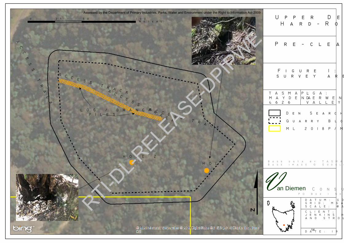
Figure 1. Pre‐clearance survey area and results
Assessed by the Department of Primary Industries, Parks, Water and Environment under the Right to Information Act 2009
3
RTI-DL-R
ELEASE-D
PIPWE

UPPER DERWENT VALLEY HARD‐ROCK QUARRY – DEN AND BURROW PRE‐CLEARANCE SURVEY REPORT
Page 4 of 20
1. INTRODUCTION
1.1 BACKGROUND
Activity Description
The Upper Derwent Valley Hard Rock quarry is to be located on land accessed from Roberts Road to the west of Maydena, Tasmania.
The product is limestone and the lifespan of the activity is projected to be at least 80 years if full production levels are achieved every year and the full development extent is extracted.
The extraction of limestone will occur in three blocks ‐
Block 1 has a lifespan of 8‐11 years,
Block 2 of about 45 years and
Block 3 of about 40 years.
The main quarrying activities will be the following:
installation of access road and establishment of laydown area;
installation of sediment control measures (bunding, drains, channels and sediment pond(s));
surface site preparation by soil removal and stockpiling;
drilling and blasting (1 to 5 per annum) to liberate rock material;
excavation, ripping and crushing of gravel material;
stockpiling of processed material in quarry area;
loading trucks with wheel loader from stockpile area in quarry; and the
transport of materials by trucks ranging from 12 to 30 tonne capacity.
Assessment and Approvals
A Development Application and associated Development Proposal and Environmental Management Plan (DPEMP) was submitted to the Derwent Valley Council in 2018.
A permit (DA83A/2016) was granted on 18 April 2018 by the Derwent Valley Council at the direction of the Resource Management and Planning Appeals Tribunal to resolve Appeal No. 96/17P. The permit included conditions imposed by the Environment Protection Authority in Permit Conditions Environmental No. 9592.
The DPEMP lodged by the quarry proponent contained several commitments in relation to envirojmental management.
The commitment relevant to this report is ‐
‘Tasmanian devil (Sarcophilus harrisii) and Spotted‐tailed quoll (Dasyurus maculatus maculatus). The following management measures are proposed for these species –
Piles of slash/logs created through vegetation removal will be arranged such that it can be used in site rehabilitation works to create quoll habitat;
Any potential Tasmanian devil dens located during construction works will be left undisturbed until they are checked by a suitably qualified person and advice given as to their management; and
A speed limit on Roberts Road of 40 km/hr will be imposed from dusk to dawn.’
Assessed by the Department of Primary Industries, Parks, Water and Environment under the Right to Information Act 2009
4
RTI-DL-R
ELEASE-D
PIPWE
UPPER DERWENT VALLEY HARD‐ROCK QUARRY – DEN AND BURROW PRE‐CLEARANCE SURVEY REPORT
Page 5 of 20
1.2 OBJECTIVES
The objectives of the pre‐clearance survey and this report were to –
1. Search Block 1 and associated access track and infrastructure locations for den and burrow structures;
2. Record structures observed, if any, and assess them for current, historical or potential future use by devils and/or quolls for maternal denning purposes; and
3. Provide recommendations to manage or decommission the observed (if any) dens and burrows or other devil/quoll habitat structures.
Assessed by the Department of Primary Industries, Parks, Water and Environment under the Right to Information Act 2009
5
RTI-DL-R
ELEASE-D
PIPWE

UPPER DERWENT VALLEY HARD‐ROCK QUARRY – DEN AND BURROW PRE‐CLEARANCE SURVEY REPORT
Page 6 of 20
2. METHODS
2.1 SURVEY AREA
The Survey Area is Block 1 and associated buffer depicted in Figure 1.
The access track from Roberts Road into the Survey Area (to be upgraded) and location of the sediment pond for the management of stormwater was also included in the search for the survey.
2.2 SURVEY TECHNIQUE
The Survey Area had been searched in detail by ecological practititoners (Van Diemen Consulting 2015) for vegetation types, threatened flora and fauna species and burrows/dens (quoll and devil). No burrows or dens were recorded during the ecological assessments by Van Diemen Consulting (2015).
The Survey Area was searched again on 18 January 2020 for dens/burrows for the pre‐clearance survey.
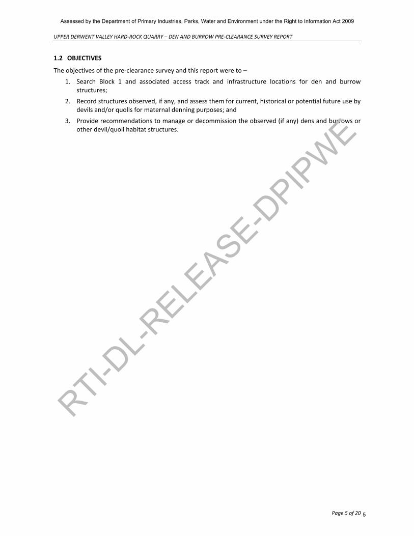
The understorey in Block 1 is relatively sparse with occasional areas dominated by moss (usually a cover on skeletal limestone), leaf litter and sparse ferns (eg bracken, mother‐shield fern, and emergent tree‐fern). The images below show the typical structure of the forest present, which has been logged in the past and is now young regrowth forest with a sparse midstorey and very sparse understorey. Fallen logs are also sparse in number, and where present they tend to be wattles that have reached maturity and died and fallen or have been blown over by strong winds.
The detectability of dens and burrows is high irrespective of the presence of leaf litter, ground ferns and/or moss because if present, the use of a burrow or den would make detection relatively easy (eg tracks, scats). It is very unlikely that any dens or burrows present went undetected during the survey of 18 January 2020.
Assessed by the Department of Primary Industries, Parks, Water and Environment under the Right to Information Act 2009
6
RTI-DL-R
ELEASE-D
PIPWE
UPPER DERWENT VALLEY HARD‐ROCK QUARRY – DEN AND BURROW PRE‐CLEARANCE SURVEY REPORT
Page 7 of 20
Assessed by the Department of Primary Industries, Parks, Water and Environment under the Right to Information Act 2009
7
RTI-DL-R
ELEASE-D
PIPWE
UPPER DERWENT VALLEY HARD‐ROCK QUARRY – DEN AND BURROW PRE‐CLEARANCE SURVEY REPORT
Page 8 of 20
2.3 RELEVANT FAUNA
Two species of conservation significance were considered in the pre‐clearance survey; Tasmanian devil and spotted‐tailed quoll. In addition to the two species listed in this section, burrows formed by the common wombat (Vombatus ursinus) can be used by the Tasmanian devil or spotted‐tailed quoll. Wombat burrows were also searched for and recorded, if any were found, for the pre‐clearance survey.
Information about the two focus species is provided below.
2.3.1 TASMANIAN DEVIL (SARCOPHILUS HARRISII)
The Survey Area is within the known geographic range of this carnivorous marsupial, and several observations of the species have been made around the Survey Area (Natural Values Atlas records) including Styx Road and Gordon River Roads.
The DEWHA Species Profile and Threats Database for this species states:
‘Habitat
Tasmanian Devils are found throughout Tasmania, in all native habitats, as well as in forestry plantations and pasture, from sea level to all but the highest peaks of Tasmania (Jones & Barmuta 2000; Jones & Rose 1996). Densities are lowest in the buttongrass plains of the south‐west and highest in the dry and mixed sclerophyll forests and coastal heath of Tasmania's eastern half and north‐west coast.
Open forests and woodlands are preferred, while tall or dense wet forests are avoided (Jones & Barmuta 2000; Jones & Rose 1996). The highest population densities are found in mixed patches of grazing land and forest or woodland. Relative trapping success and spool‐and‐line tracking indicates that Tasmanian Devils travel through lowlands, saddles and along creeks, avoiding steep slopes and rocky areas, and favouring predictably rich sources of food such as carcasses, rubbish dumps, and roads (Jones & Barmuta 2000).
Dens are typically underground burrows (such as old wombat burrows), dense riparian vegetation, thick grass tussocks and caves. Adults are thought to remain faithful to their dens for life so den disturbance is destabilising to populations (Owen & Pemberton 2005).
The Tasmanian devil is not part of, nor does it rely on any listed threatened ecological community. The species is directly associated with an invertebrate, Dasyurotaenia robusta, which is currently listed as Rare under the Tasmanian Threatened Species Protection Act 1995. This invertebrate is a tapeworm found only in Tasmanian Devils.
Movement Patterns
Devils are primarily nocturnal. There is no data to suggest seasonal changes in patterns of movement, apart from reduced activity of females with young in their dens (Pemberton 1990). Tasmanian Devils occupy several different dens, changing dens every 1–3 days, and travelling an average nightly distance of 8.6 km (Pemberton 1990). However, individuals have occasionally been observed to move up to 50 km in a single night (M. Jones, pers. comm. 2006). Home ranges overlap considerably. A typical home range across a two to four week period is estimated to be 13 km², ranging from 4–27 km² (Pemberton 1990).‘
The highest population densities of this species are found in mixed patches of grazing land and native forest or woodland. Relative trapping success and spool‐and‐line tracking indicates that Tasmanian devils travel through lowlands, saddles and along creeks, avoiding steep slopes and rocky areas, and favouring, predictably, rich sources of food such as carcasses, rubbish dumps, and roads (DEWHA, 2010a). Dens are typically underground burrows (such as old wombat burrows), dense riparian vegetation, thick grass tussocks and caves. Adult devils are thought to remain faithful to their dens for life so den disturbance is destabilising to populations (DEWHA, 2010a).
Assessed by the Department of Primary Industries, Parks, Water and Environment under the Right to Information Act 2009
8
RTI-DL-R
ELEASE-D
PIPWE

UPPER DERWENT VALLEY HARD‐ROCK QUARRY – DEN AND BURROW PRE‐CLEARANCE SURVEY REPORT
Page 9 of 20
As reported in the DRAFT Recovery Plan (DPIPWE 2010; and references cited therein):
‘Tasmanian devils are primarily nocturnal (active at night) in most of their range. They will come out during the day to sun bathe, but mostly rest in hollow logs, caves, dense vegetation, dens or burrows. If hot, they pant to reduce body heat, as they do not sweat (Hulbert and Rose 1972). Devils may occupy several dens or resting sites and they change dens every 1‐3 days (Pemberton 1990). Adult devils are faithful to particular den sites (Owen and Pemberton 2005), and maternal dens may be clustered together if there is limited soil suitable for burrows (D. Pemberton unpublished). Tasmanian devils are mostly solitary, but do not defend territories.’
The Survey Area is within the ‘Core Devil Habitat’ area identified by DPIPWE in Figure 4 on page 5 of the Tasmanian Devil DRAFT Recovery Plan and is also within the DFTD (Devil Facial Tumour Disease) affected area as shown in Figure 6 on page 9 of the Tasmanian Devil DRAFT Recovery Plan (DPIPWE 2010).
No dens attributable to the Tasmanian devil were recorded in or around the Survey Area during the surveys by Van Diemen Consulting (2015). The geological formation in the Survey Area, being limestone bedrock with relatively skeletal soils (and some areas of colluvium from landslip), are not easily dug either by wombats (wombat burrows can be used by devils to den) or devils themselves. There are also very few denning opportunities within fallen timber as most of the Survey Area has no fallen timber (very open understorey) or the logs that are present are extremely large (single fallen trees as opposed to ‘woodpiles’) and geographically concentrated towards the southern third of the Survey Area.
Of note is the wildlife camera ‘identification’ of devils at two locations near the Survey Area, south‐west of the Survey Area at Site 3 in Period 1 and Sites 1 and 3 in Period 2 (see Figure 13 in Van Diemen Consulting 2015). Two animals were recorded at each of these three locations – for Site 3 in both periods it appeared that the animal caught on the camera is the same and was simply recorded twice. The three locations where the devils were observed by cameras are associated with alluvial systems (Pillinger Creek and a tributary of Pillinger Creek) and complex vegetation associated with those systems. All three locations are associated with tracks between native vegetation and pine plantation and adjoining land where the geology is more easily dug (see area of QA in Figure 3) for the construction of burrows. Furthermore, the wombats (which can create burrow systems that can be used by devils to den) recorded in the area during the surveys for this study were all recorded near land systems which have more easily dug soils rather than a skeletal limestone bedrock.
2.3.2 SPOTTED‐TAILED QUOLL (DASYURUS MACULATUS MACULATUS)
The spotted‐tailed quoll is a carnivorous marsupial which occurs in Tasmania and eastern Australia from Queensland to Victoria. On mainland Australia, the species population has declined dramatically and now Tasmania is its stronghold. It is primarily a forest‐dwelling species being most abundant in higher rainfall areas containing rainforest, wet forest and blackwood swamp forest. Important habitat components appear to be structurally complex forest, old growth forest with tree hollows and coastal scrub (such areas provide opportunities for arboreal hunting and avoidance of Tasmanian devils which compete for prey).
The DEWHA Species Profile and Threats Database for this species states:
‘Habitat
The Spotted‐tailed Quoll (Tasmanian population) is a forest dependent species that occupies a large range of habitats. The species habitat is characterized by high annual rainfall and predictable rain patterns. The southern subspecies has been recorded in rainforests, wet and dry sclerophyll forest, coastal heathland, scrub and dunes, woodland, heathy woodland, swamp forest, mangroves, on beaches and sometimes in grassland or pastoral areas adjacent to forests. High densities of the species have been recorded in both dry and wet forests (Andrew 2005; Jones & Barmuta 2000).
The species has an extensive home range, from several hundred to several thousand hectares. They are known to use multiple dens and change dens every 1–4 days. Den sites have been recorded at a
Assessed by the Department of Primary Industries, Parks, Water and Environment under the Right to Information Act 2009
9
RTI-DL-R
ELEASE-D
PIPWE

UPPER DERWENT VALLEY HARD‐ROCK QUARRY – DEN AND BURROW PRE‐CLEARANCE SURVEY REPORT
Page 10 of 20
variety of locations including rock crevices, hollow logs, hollow tree buttresses, tree hollows, windrows, clumps of vegetation, caves, boulder tumbles, under buildings, and in the dens of rabbits and wombats. Maternal den sites are similar to those mentioned above. Female Spotted‐tailed Quolls (Tasmanian population) are known to dig burrows when a suitable substrate is available (Long & Nelson 2010a).
A study of Spotted‐tailed Quolls in south‐eastern Australia (mainland population) revealed that prey density and den availability are the two main factors in the use of habitat. These results are likely to apply to the Tasmanian population in which suitable prey habitat is associated with predictable rainfall patterns and warm mean annual temperatures. Habitat critical to both subspecies of the Spotted‐tailed Quoll contain adequate denning resources in large forest areas. This provides the species with a high density of mammalian prey (Long & Nelson 2010a).
Spotted‐tailed quolls tend to disappear in highly fragmented environments and where canopy cover is reduced by over 50%. Home ranges (non‐mating season) are large (in the order of 20 square kilometres for males and 10 square kilometres for females), and female ranges are virtually exclusive for large parts of the year. These two attributes contribute to low natural population densities and natural rarity. This means that the species is vulnerable to population decline.’
Bryant and Jackson (1999) identify key sites as being –
• Forested areas of the north bounded by Wynyard, Gladstone and the central and north‐eastern highlands;
• Northwest wet forests, encompassing the entire catchments of the Arthur and Montagu Rivers;
• Dry eucalypt forests in the central north coast area bounded by the Tamar, Devonport and the Western Tiers (Dazzler Range, Wurra Wurra Hills); and
• Patches between the King River and Strahan, the Gordon River and Huon River catchments, and the coastal strip from Strahan to Temma.
The Survey Area is not within a key site identified by Bryant and Jackson (1999) nor is it an important population identified by Long and Nelson (2010).
The species would forage and travel within the Survey Area. Wet eucalypt forest types in the Survey Area are the most likely areas where the species may ‘den’ although no dens attributable to the spotted‐tailed quoll were recorded in the Survey Area during the surveys. An animal was recorded during spotlight surveys conducted by Van Diemen Consulting (2015) west of the Survey Area on Gordon River Road and a wildlife camera also captured an animal at Site 1 in Period 2 – the same location where a wombat and devils were recorded.
Assessed by the Department of Primary Industries, Parks, Water and Environment under the Right to Information Act 2009
10
RTI-DL-R
ELEASE-D
PIPWE

UPPER DERWENT VALLEY HARD‐ROCK QUARRY – DEN AND BURROW PRE‐CLEARANCE SURVEY REPORT
Page 11 of 20
3. RESULTS
3.1.1 HOLES
Two holes were recorded in the Survey Area. The location of each hole is shown in Figure.
Hole 1
This hole is the remnant void of a rotten out tree root/stem system about 600 mm deep. There are no scats associated with the hole (within, adjacent to or nearby), nor is there are animal tracks leading to or past the hole. The images below show the surface form of the hole and the internal structure.
Assessed by the Department of Primary Industries, Parks, Water and Environment under the Right to Information Act 2009
11
RTI-DL-R
ELEASE-D
PIPWE

UPPER DERWENT VALLEY HARD‐ROCK QUARRY – DEN AND BURROW PRE‐CLEARANCE SURVEY REPORT
Page 12 of 20
Hole 2
This hole is a digging in a rotted‐out tree root system of a eucalypt.
There are no devil or quoll scats present in or adjacent to the hole, but wombat scats were observed nearby. The digging is less than 500 mm deep, with the back of it easily seen with a naked eye.
3.1.2 WOODPILES
During the survey, it was observed that several woodpiles had been created from the exploration works carried out at the site under the auspices of the previous Exploration Licence. The location of the woodpiles is shown in Figure 1. Most of the woody debris is dogwood (Pomaderris apetala), wattles (Acacia dealbata, A. melanoxylon) and some eucalypt (Eucalyptus regnans).
Woodpiles can be places where devils or quolls den, especially if the landscape has few other opportunities to den – such as areas where there is a paucity of woodpiles from natural events (eg tree falls) or other man‐made events (eg logging operations) or ground‐conditions are such that digging is difficult (burrows created by wombats can also be rare in these situations).
The images below show the form and nature of the woodpiles observed in the Survey Area.
Assessed by the Department of Primary Industries, Parks, Water and Environment under the Right to Information Act 2009
12
RTI-DL-R
ELEASE-D
PIPWE

UPPER DERWENT VALLEY HARD‐ROCK QUARRY – DEN AND BURROW PRE‐CLEARANCE SURVEY REPORT
Page 13 of 20
Assessed by the Department of Primary Industries, Parks, Water and Environment under the Right to Information Act 2009
13
RTI-DL-R
ELEASE-D
PIPWE
Van Diemen
$
!
!
DDDDDDDDDDDDDDDDDDDDDDDDDDDDDDDDDDDDDDDDDDDDDDDDDDDDDD
Assessed by the Department of Primary Industries, Parks, Water and Environment under the Right to Information Act 2009
14
RTI-DL-R
ELEASE-D
PIPWE

UPPER DERWENT VALLEY HARD‐ROCK QUARRY – DEN AND BURROW PRE‐CLEARANCE SURVEY REPORT
Page 15 of 20
4. DISCUSSION AND RECOMMENDATIONS
Given the absence of any dens or burrows in the Survey Area, there are few recommendations to make.
4.1 HOLES
The two holes recorded in the Survey Area are animal diggings in rotted out tree root systems. They do not represent dens or burrows that could or would be used for denning by either of the two focus species.
The diggings should be filled in with rock/soil (easily done using handtools) after they have been checked that no animals (of any native species) are present. The back of the diggings can be seen with ease so there is no need to place wildliufe cameras on them to check for use.
4.2 WOODPILES
The woodpiles that were created by the exploration works should be carefully pulled apart with a suitably qualified ecologist present in case an animal of the two focus species is encountered.
Assessed by the Department of Primary Industries, Parks, Water and Environment under the Right to Information Act 2009
15
RTI-DL-R
ELEASE-D
PIPWE

UPPER DERWENT VALLEY HARD‐ROCK QUARRY – DEN AND BURROW PRE‐CLEARANCE SURVEY REPORT
Page 16 of 20
5. REFERENCES
Andrew, D.L. (2005). Ecology of the tiger quoll Dasyurus maculatus maculatus in coastal New South Wales. M. Sc thesis, Wollongong: University of Wollongong.
Ayers, D., S. Nash and K. Baggett (Eds) (1996). Threatened Species of Western New South Wales. Hurstville: NSW NPWS.
Department of Primary Industries, Parks, Water and Environment (2010) Recovery Plan for the Tasmanian devil (Sarcophilus harrisii). Department of Primary Industries, Parks, Water and Environment, Hobart.
Jones, M.E. and L.A. Barmuta (2000). Niche differentiation among sympatric Australian dasyurid carnivores. Journal of Mammalogy. 81:434‐447.
Jones, M.E. and R.K. Rose (1996). Preliminary assessment of distribution and habitat associations of the spotted‐tailed quoll (Dasyurus maculatus maculatus) and eastern quoll (D. viverrinus) in Tasmania to determine conservation and reservation status. Report to the Tasmanian Regional Forest Agreement Environment and Heritage Technical Committee, Tasmanian Public Land Use Commission, Hobart, Tasmania.
Long, K and J. Nelson (2010). (Draft) National Recovery Plan for the Spotted‐tailed Quoll Dasyurus maculatus. Victorian Department of Sustainability and Environment.
Owen, D. and D. Pemberton (2005). The Tasmanian devil: a unique and threatened animal. Allen & Unwin, Australia.
Pemberton, D. (1990). Social organisation and behaviour of the Tasmanian devil, PhD thesis. Ph.D. Thesis. University of Tasmania.
Van Diemen Consulting (2015). ECOLOGICAL SURVEY, UPPER DERWENT VALLEY HARD‐ROCK QUARRY, MAYDENA, For Jenkins Hire Pty and Stroud Pty Limited.
Assessed by the Department of Primary Industries, Parks, Water and Environment under the Right to Information Act 2009
16
RTI-DL-R
ELEASE-D
PIPWE