Embed Size (px)
Citation preview
8/3/2019 Class11 Geography 1 Physical Geography Unit13 NCERT TextBook English Edition
http://slidepdf.com/reader/full/class11-geography-1-physical-geography-unit13-ncert-textbook-english-edition 1/9
W ATER (O CEANS )
This unit deals with
Hydrological Cycle
• Oceans — submarine relief; distribution of temperature and salinity; movements of ocean water-waves, tides and currents
UNIT
V
8/3/2019 Class11 Geography 1 Physical Geography Unit13 NCERT TextBook English Edition
http://slidepdf.com/reader/full/class11-geography-1-physical-geography-unit13-ncert-textbook-english-edition 2/9
W ATER (OCEANS)
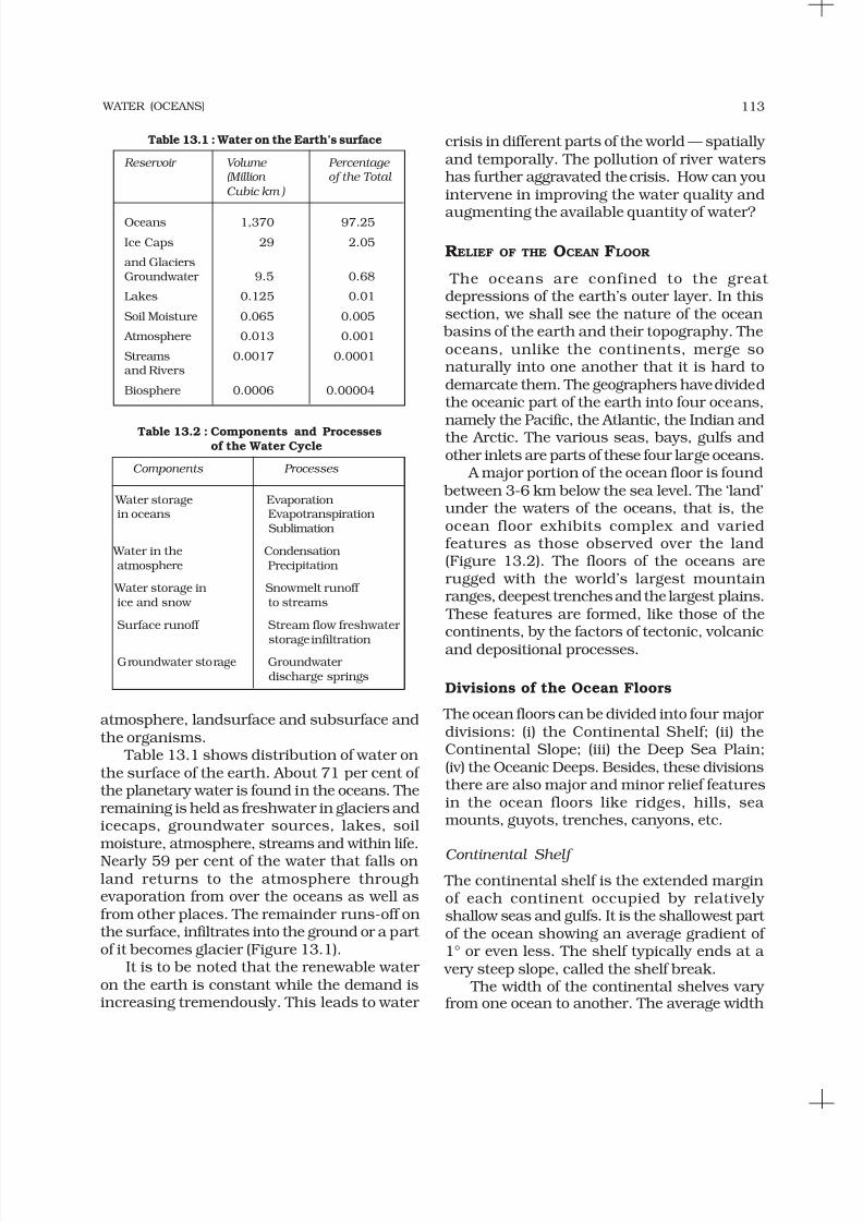
the ocean to land and land to ocean. Thehydrological cycle describes the movement of
water on, in, and above the earth. The water
cycle has been working for billions of yearsand all the life on earth depends on it. Next toair, water is the most important element required for the existence of life on earth. Thedistribution of water on earth is quite uneven.Many locations have plenty of water whileothers have very limited quantity. Thehydrological cycle , is the circulation of water
within the earth’s hydrosphere in different forms i.e. the liquid, solid and the gaseousphases. It also refers to the continuousexchange of water between the oceans,
C H A P T E R
Figure 13.1 : Hydrological Cycle
C
an we think of life without water? It issaid that the water is life. Water is anessential component of all life forms that
exist over the surface of the earth. The creatureson the earth are lucky that it is a water planet,otherwise we all would have no existence. Water is a rare commodity in our solar system. Thereis no water on the sun or anywhere else in thesolar system. The earth, fortunately has anabundant supply of water on its surface. Hence,our planet is called the ‘Blue Planet’.
H YDROLOGICAL C YCLE
Water is a cyclic resource. It can be used andre-used. Water also undergoes a cycle from
8/3/2019 Class11 Geography 1 Physical Geography Unit13 NCERT TextBook English Edition
http://slidepdf.com/reader/full/class11-geography-1-physical-geography-unit13-ncert-textbook-english-edition 3/9
WATER (OCEANS) 113
atmosphere, landsurface and subsurface andthe organisms.
Table 13.1 shows distribution of water onthe surface of the earth. About 71 per cent of the planetary water is found in the oceans. Theremaining is held as freshwater in glaciers andicecaps, groundwater sources, lakes, soilmoisture, atmosphere, streams and within life.
Nearly 59 per cent of the water that falls onland returns to the atmosphere throughevaporation from over the oceans as well asfrom other places. The remainder runs-off onthe surface, infiltrates into the ground or a part of it becomes glacier (Figure 13.1).
It is to be noted that the renewable water on the earth is constant while the demand isincreasing tremendously. This leads to water
crisis in different parts of the world — spatially and temporally. The pollution of river watershas further aggravated the crisis. How can youintervene in improving the water quality and
augmenting the available quantity of water?
RELIEF OF THE OCEAN FLOOR
The oceans are confined to the great depressions of the earth’s outer layer. In thissection, we shall see the nature of the ocean
basins of the earth and their topography. Theoceans, unlike the continents, merge sonaturally into one another that it is hard todemarcate them. The geographers have dividedthe oceanic part of the earth into four oceans,
namely the Pacific, the Atlantic, the Indian andthe Arctic. The various seas, bays, gulfs andother inlets are parts of these four large oceans.
A major portion of the ocean floor is found between 3-6 km below the sea level. The ‘land’under the waters of the oceans, that is, theocean floor exhibits complex and variedfeatures as those observed over the land(Figure 13.2). The floors of the oceans arerugged with the world’s largest mountainranges, deepest trenches and the largest plains.
These features are formed, like those of thecontinents, by the factors of tectonic, volcanicand depositional processes.
Divisions of the Ocean Floors
The ocean floors can be divided into four major divisions: (i) the Continental Shelf; (ii) theContinental Slope; (iii) the Deep Sea Plain;(iv) the Oceanic Deeps. Besides, these divisionsthere are also major and minor relief featuresin the ocean floors like ridges, hills, sea mounts, guyots, trenches, canyons, etc.
Continental Shelf
The continental shelf is the extended marginof each continent occupied by relatively shallow seas and gulfs. It is the shallowest part of the ocean showing an average gradient of 1° or even less. The shelf typically ends at a
very steep slope, called the shelf break. The width of the continental shelves vary
from one ocean to another. The average width
Table 13.1 : Water on the Earth’s surface
Reservoir Volume Percentage (Million of the Total
Cubic km )
Oceans 1,370 97.25
Ice Caps 29 2.05
and GlaciersGroundwater 9.5 0.68
Lakes 0.125 0.01
Soil Moisture 0.065 0.005
Atmosphere 0.013 0.001
Streams 0.0017 0.0001and Rivers
Biosphere 0.0006 0.00004
Table 13.2 : Components and Processesof the Water Cycle
Components Processes
Water storage Evaporationin oceans Evapotranspiration
Sublimation
Water in the Condensationatmosphere Precipitation
Water storage in Snowmelt runoff ice and snow to streams
Surface runoff Stream flow freshwater
storage infiltrationGroundwater storage Groundwater
discharge springs

8/3/2019 Class11 Geography 1 Physical Geography Unit13 NCERT TextBook English Edition
http://slidepdf.com/reader/full/class11-geography-1-physical-geography-unit13-ncert-textbook-english-edition 4/9
FUNDAMENTALS OF PHYSICAL GEOGRAPHY 114
of continental shelves is about 80 km. Theshelves are almost absent or very narrow alongsome of the margins like the coasts of Chile,the west coast of Sumatra, etc. On the contrary,
the Siberian shelf in the Arctic Ocean, thelargest in the world, stretches to 1,500 km in
width. The depth of the shelves also varies. It may be as shallow as 30 m in some areas whilein some areas it is as deep as 600 m.
The continental shelves are covered with variable thicknesses of sediments brought down by rivers, glaciers, wind, from the landand distributed by waves and currents. Massivesedimentary deposits received over a long time
by the continental shelves, become the sourceof fossil fuels.
Continental Slope
The continental slope connects the continentalshelf and the ocean basins. It begins where the
bottom of the continental shelf sharply dropsoff into a steep slope. The gradient of the sloperegion varies between 2-5°. The depth of theslope region varies between 200 and 3,000 m.
The slope boundary indicates the end of thecontinents. Canyons and trenches are observedin this region.
Deep Sea Plain
Deep sea plains are gently sloping areas of theocean basins. These are the flattest andsmoothest regions of the world. The depths
vary between 3,000 and 6,000m. These plainsare covered with fine-grained sediments likeclay and silt.
Oceanic Deeps or Trenches
These areas are the deepest parts of the oceans. The trenches are relatively steep sided, narrow basins. They are some 3-5 km deeper thanthe surrounding ocean floor. They occur at the
bases of continental slopes and along islandarcs and are associated with active volcanoes
and strong earthquakes. That is why they are very significant in the study of platemovements. As many as 57 deeps have beenexplored so far; of which 32 are in the PacificOcean; 19 in the Atlantic Ocean and 6 in theIndian Ocean.
Minor Relief Features
Apart from the above mentioned major relief features of the ocean floor, some minor but significant features predominate in different parts of the oceans.
Mid-Oceanic Ridges
A mid-oceanic ridge is composed of two chainsof mountains separated by a large depression.
The mountain ranges can have peaks as highas 2,500 m and some even reach above theocean’s surface. Iceland, a part of the mid-
Atlantic Ridge, is an example.Figure 13.2 : Relief features of ocean floors
8/3/2019 Class11 Geography 1 Physical Geography Unit13 NCERT TextBook English Edition
http://slidepdf.com/reader/full/class11-geography-1-physical-geography-unit13-ncert-textbook-english-edition 5/9
WATER (OCEANS) 115
Seamount
It is a mountain with pointed summits, risingfrom the seafloor that does not reach the surfaceof the ocean. Seamounts are volcanic in origin.
These can be 3,000-4,500 m tall. The Emperor seamount, an extension of the Hawaiian Islandsin the Pacific Ocean, is a good example.
Submarine Canyons
These are deep valleys, some comparable tothe Grand Canyon of the Colorado river. They are sometimes found cutting across thecontinental shelves and slopes, often extendingfrom the mouths of large rivers. The HudsonCanyon is the best known canyon in the world.
Guyots
It is a flat topped seamount. They show evidences of gradual subsidence throughstages to become flat topped submergedmountains. It is estimated that more than10,000 seamounts and guyots exist in thePacific Ocean alone.
Atoll
These are low islands found in the tropicaloceans consisting of coral reefs surroundinga central depression. It may be a part of thesea (lagoon), or sometimes form enclosing a
body of fresh, brackish, or highly saline water.
TEMPERATURE OF OCEAN W ATERS
This section deals with the spatial and vertical variations of temperature in various oceans.Ocean waters get heated up by the solar energy
just as land. The process of heating and coolingof the oceanic water is slower than land.
Factors Affecting Temperature Distribution The factors which affect the distribution of temperature of ocean water are :
(i) Latitude : the temperature of surface water decreases from the equator towards thepoles because the amount of insolationdecreases poleward.
(ii) Unequal distribution of land and water :the oceans in the northern hemisphere
receive more heat due to their contact withlarger extent of land than the oceans inthe southern hemisphere.
(iii) Prevailing wind : the winds blowing from
the land towards the oceans drive warmsurface water away form the coast resulting in the upwelling of cold water from below. It results into the longitudinal
variation in the temperature. Contrary tothis, the onshore winds pile up warm
water near the coast and this raises thetemperature.
(iv) Ocean currents : warm ocean currentsraise the temperature in cold areas whilethe cold currents decrease thetemperature in warm ocean areas. Gulf
stream (warm current) raises thetemperature near the eastern coast of North America and the West Coast of Europe while the Labrador current (coldcurrent) lowers the temperature near thenorth-east coast of North America.
All these factors influence the temperatureof the ocean currents locally. The enclosed seasin the low latitudes record relatively higher temperature than the open seas; whereas theenclosed seas in the high latitudes have lower temperature than the open seas.
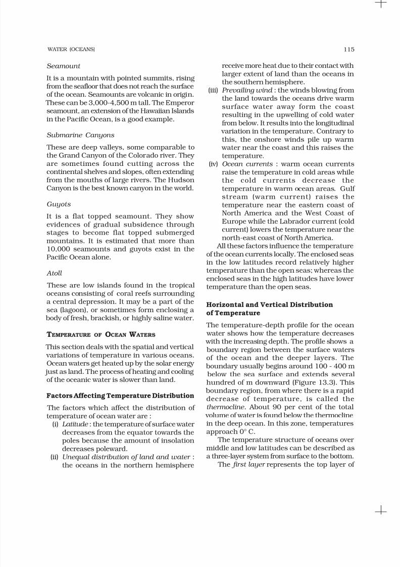
Horizontal and Vertical Distributionof Temperature
The temperature-depth profile for the ocean water shows how the temperature decreases with the increasing depth. The profile shows a boundary region between the surface watersof the ocean and the deeper layers. The
boundary usually begins around 100 - 400 m below the sea surface and extends severalhundred of m downward (Figure 13.3). This
boundary region, from where there is a rapid
decrease of temperature, is called thethermocline . About 90 per cent of the total
volume of water is found below the thermoclinein the deep ocean. In this zone, temperaturesapproach 0° C.
The temperature structure of oceans over middle and low latitudes can be described asa three-layer system from surface to the bottom.
The first layer represents the top layer of
8/3/2019 Class11 Geography 1 Physical Geography Unit13 NCERT TextBook English Edition
http://slidepdf.com/reader/full/class11-geography-1-physical-geography-unit13-ncert-textbook-english-edition 6/9
FUNDAMENTALS OF PHYSICAL GEOGRAPHY 116
The third layer is very cold and extendsupto the deep ocean floor. In the Arctic and
Antartic circles, the surface water temperaturesare close to 0° C and so the temperature change
with the depth is very slight. Here, only onelayer of cold water exists, which extends from
surface to deep ocean floor. The average temperature of surface water
of the oceans is about 27°C and it gradually decreases from the equator towards the poles.
The rate of decrease of temperature withincreasing latitude is generally 0.5°C per latitude. The average temperature is around22°C at 20° latitudes, 14° C at 40° latitudesand 0° C near poles. The oceans in the northern
hemisphere record relatively higher temperaturethan in the southern hemisphere. The highest temperature is not recorded at the equator but slightly towards north of it. The average annual
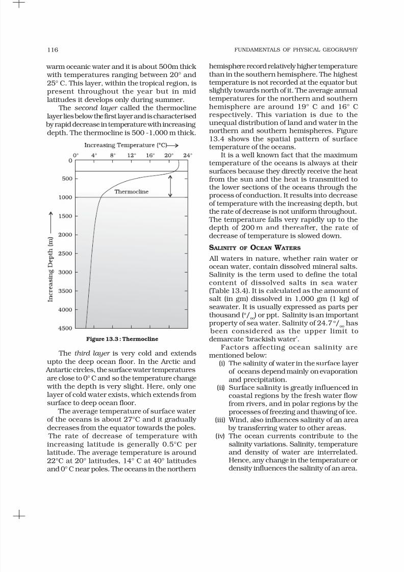
temperatures for the northern and southernhemisphere are around 19° C and 16° Crespectively. This variation is due to theunequal distribution of land and water in thenorthern and southern hemispheres. Figure13.4 shows the spatial pattern of surfacetemperature of the oceans.
It is a well known fact that the maximumtemperature of the oceans is always at their surfaces because they directly receive the heat from the sun and the heat is transmitted tothe lower sections of the oceans through theprocess of conduction. It results into decreaseof temperature with the increasing depth, but the rate of decrease is not uniform throughout.
The temperature falls very rapidly up to thedepth of 200 m and thereafter, the rate of decrease of temperature is slowed down.
S ALINITY OF OCEAN W ATERS
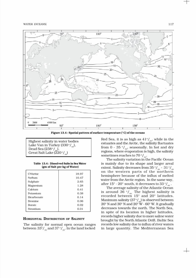
All waters in nature, whether rain water or ocean water, contain dissolved mineral salts.Salinity is the term used to define the totalcontent of dissolved salts in sea water (Table 13.4). It is calculated as the amount of
salt (in gm) dissolved in 1,000 gm (1 kg) of seawater. It is usually expressed as parts per thousand (o/
oo) or ppt. Salinity is an important
property of sea water. Salinity of 24.7 o/oo
has been considered as the upper limit todemarcate ‘brackish water’.
Factors affecting ocean salinity arementioned below:
(i) The salinity of water in the surface layer of oceans depend mainly on evaporationand precipitation.
(ii) Surface salinity is greatly influenced incoastal regions by the fresh water flow from rivers, and in polar regions by theprocesses of freezing and thawing of ice.
(iii) Wind, also influences salinity of an area by transferring water to other areas.
(iv) The ocean currents contribute to thesalinity variations. Salinity, temperatureand density of water are interrelated.Hence, any change in the temperature or density influences the salinity of an area.
Figure 13.3 : Thermocline
warm oceanic water and it is about 500m thick with temperatures ranging between 20° and25° C. This layer, within the tropical region, ispresent throughout the year but in mid
latitudes it develops only during summer. The second layer called the thermocline
layer lies below the first layer and is characterised by rapid decrease in temperature with increasingdepth. The thermocline is 500 -1,000 m thick.
8/3/2019 Class11 Geography 1 Physical Geography Unit13 NCERT TextBook English Edition
http://slidepdf.com/reader/full/class11-geography-1-physical-geography-unit13-ncert-textbook-english-edition 7/9
WATER (OCEANS) 117
Red Sea, it is as high as 41o/oo
, while in theestuaries and the Arctic, the salinity fluctuates
from 0 - 35 o/oo, seasonally. In hot and dry regions, where evaporation is high, the salinity sometimes reaches to 70 o/
oo.
The salinity variation in the Pacific Oceanis mainly due to its shape and larger arealextent. Salinity decreases from 35 o/
oo- 31 o/
oo
on the western parts of the northernhemisphere because of the influx of melted
water from the Arctic region. In the same way,after 15° - 20° south, it decreases to 33 o/
oo.
The average salinity of the Atlantic Oceanis around 36 o/
oo. The highest salinity is
recorded between 15° and 20° latitudes.Maximum salinity (37 o/
oo) is observed between
20° N and 30° N and 20° W - 60° W. It gradually decreases towards the north. The North Sea,in spite of its location in higher latitudes,records higher salinity due to more saline water
brought by the North Atlantic Drift. Baltic Sea records low salinity due to influx of river watersin large quantity. The Mediterranean Sea
Figure 13.4 : Spatial pattern of surface temperature (°C) of the oceans
Table 13.4 : Dissolved Salts in Sea Water(gm of Salt per kg of Water)
Chlorine 18.97
Sodium 10.47
Sulphate 2.65
Magnesium 1.28
Calcium 0.41
Potassium 0.38Bicarbonate 0.14
Bromine 0.06
Borate 0.02
Strontium 0.01
Highest salinity in water bodies
Lake Van in Turkey (330o
/oo),Dead Sea (238 o/oo
),Great Salt Lake (220 o/
oo)
HORIZONTAL DISTRIBUTION OF S ALINITY
The salinity for normal open ocean ranges between 33o/
ooand 37 o/
oo. In the land locked
8/3/2019 Class11 Geography 1 Physical Geography Unit13 NCERT TextBook English Edition
http://slidepdf.com/reader/full/class11-geography-1-physical-geography-unit13-ncert-textbook-english-edition 8/9
FUNDAMENTALS OF PHYSICAL GEOGRAPHY 118
records higher salinity due to high evaporation.Salinity is, however, very low in Black Sea dueto enormous fresh water influx by rivers. Seethe atlas to find out the rivers joining Black Sea.
The average salinity of the Indian Ocean is35 o/
oo. The low salinity trend is observed in
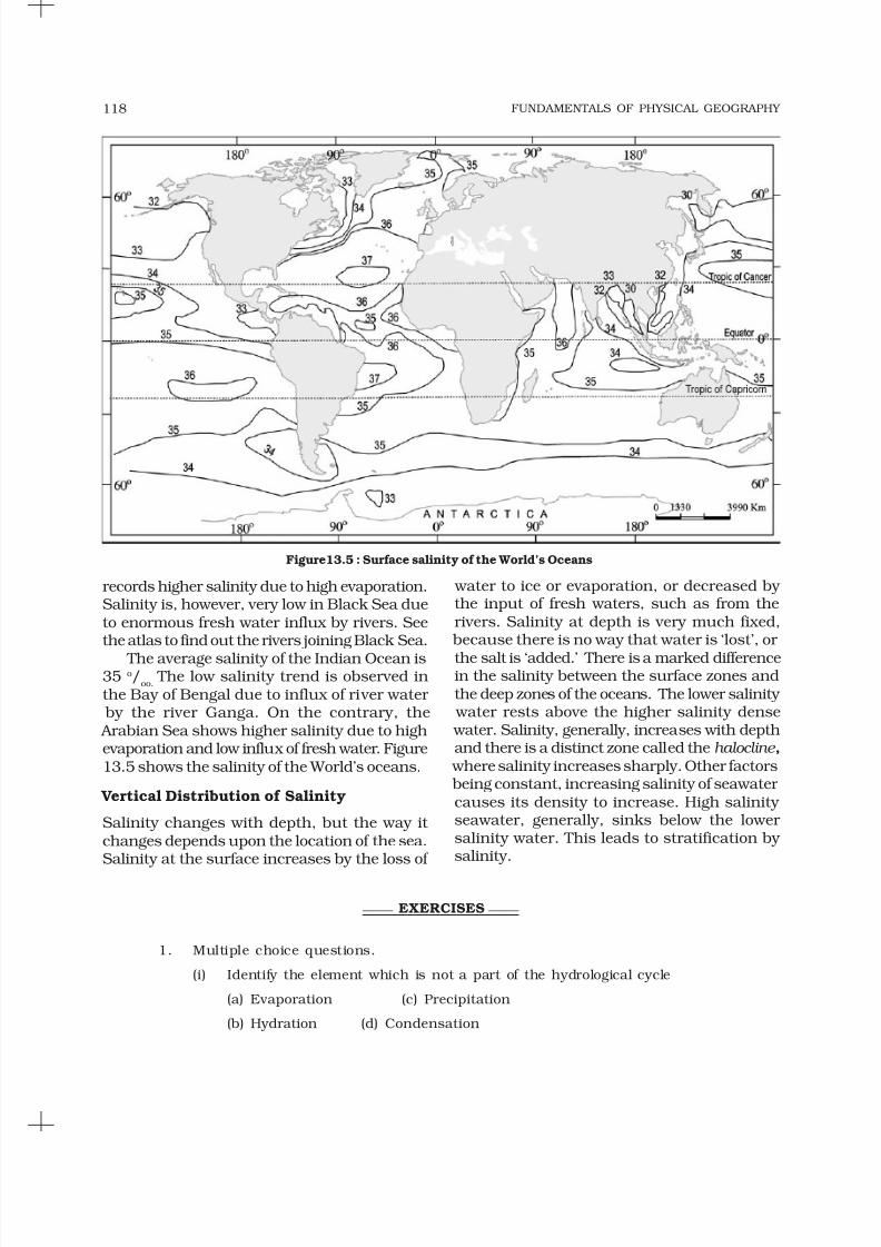
the Bay of Bengal due to influx of river water by the river Ganga. On the contrary, the Arabian Sea shows higher salinity due to highevaporation and low influx of fresh water. Figure13.5 shows the salinity of the World’s oceans.
Vertical Distribution of Salinity
Salinity changes with depth, but the way it changes depends upon the location of the sea.Salinity at the surface increases by the loss of
Figure13.5 : Surface salinity of the World’s Oceans
water to ice or evaporation, or decreased by the input of fresh waters, such as from therivers. Salinity at depth is very much fixed,
because there is no way that water is ‘lost’, or
the salt is ‘added.’ There is a marked differencein the salinity between the surface zones andthe deep zones of the oceans. The lower salinity
water rests above the higher salinity dense water. Salinity, generally, increases with depthand there is a distinct zone called the halocline ,
where salinity increases sharply. Other factors being constant, increasing salinity of seawater causes its density to increase. High salinity seawater, generally, sinks below the lower salinity water. This leads to stratification by salinity.
EXERCISES
1. Multiple choice questions.
(i) Identify the element which is not a part of the hydrological cycle
(a) Evaporation (c) Precipitation
(b) Hydration (d) Condensation
8/3/2019 Class11 Geography 1 Physical Geography Unit13 NCERT TextBook English Edition
http://slidepdf.com/reader/full/class11-geography-1-physical-geography-unit13-ncert-textbook-english-edition 9/9
WATER (OCEANS) 119
(ii) The average depth of continental slope varies between
(a) 2-20m (c) 20-200m
(b) 200-2,000m (d) 2,000-20,000m
(iii) Which one of the following is not a minor relief feature in the oceans:(a) Seamount (c) Oceanic Deep
(b) Atoll (d) Guyot
(iv) Salinity is expressed as the amount of salt in grams dissolved in sea water per
(a) 10 gm (c) 100 gm
(b) 1,000 gm (d) 10,000 gm
(v) Which one of the following is the smallest ocean:
(a) Indian Ocean (c) Atlantic Ocean
(b) Arctic Ocean (d) Pacific Ocean
2. Answer the following questions in about 30 words.
(i) Why do we call the earth a Blue Planet?
(ii) What is a continental margin?
(iii) List out the deepest trenches of various oceans.
(iv) What is a thermocline?
(v) When you move into the ocean what thermal layers would you encounter? Why the temperature varies with depth?
(vi) What is salinity of sea water?
3. Answer the following questions in about 150 words.
(i) How are various elements of the hydrological cycle interrelated?
(ii) Examine the factors that influence the temperature distribution of theoceans.
Project Work
(i) Consult the atlas and show ocean floor relief on the outline of the worldmap.
(ii) Identify the areas of mid oceanic ridges from the Indian Ocean.