Embed Size (px)
Citation preview

Best Management Practices for Placer Mining in Yukon Wetlands
by Anne Michon
and Randy Clarkson
June 2018
This is area was mined in 1983-1993 and has recovered to wetlands without any intentional reclamation measures.
NEW ERA Engineering Corporation

About the Authors • Anne Michon - Masters of Science
Montpelier University, France
• Specialist in Bird Ecology
• Conducted Research in 3 Continents
• Conducted Field Surveys in 2014/15 to assess natural reclamation of Post-Mined vs. Unmined Areas of the Indian River Valley
• Author of Indian River Wetland Study, BMP Background & Summary Report
Photo of Anne (Chevreux or Michon?)

About the Authors • Randy - Professional mining engineer
working out of Whitehorse Yukon Territory since 1980 on placer, lode mining and small hydro
• Author of several publications/seminars on placer exploration, sampling, gold recovery and mining
• 32 years of work on Regulatory and Environmental Issues and Research
• 30 years of work in the Indian River Wetlands
• 33 years of living beside a marsh shallow water wetland in Whitehorse
• 38 years of northern hydrology
• Co-Author of Wetland Reclamation BMP

Family Farm of the North
• Almost all Yukon 160 placer mines are family-owned and operated
• Cornerstone of Yukon’s Economy – 2nd or 3rd largest industry
• Virtually continuous gold production for over
130 years - even during depression/recessions
• Placer miners committed for the long term
• Yukon residents - 90% of owners - 68% of employees -92% of expenses spent in Yukon
• Expectations have to be tempered with what is physically achievable and what is economically feasible for family-based Yukon placer mining operations.

Yukon Placer Deposits
• Most Yukon placer gold deposits occur under or beside streams which may be located in wetlands.
• Activities involve the stripping of surface vegetation, the thawing and removal of overlying permafrost soils and gravels.
• Typical wetland avoidance strategies found in other kinds of mining activity are often impractical for this industry.
Placer mining in the Indian River Wetlands.

Wetlands
• All classes of wetlands provide wildlife habitat, store carbon and purify water
• Fundamental differences between the nature and functions of northern permafrost wetlands and their southern counterparts (upon which almost all published research is based).
• Most areas of the developed world have permanently altered or destroyed their wetlands - construction of subdivisions, industrial parks, marinas and farms.
• Yukon has vast areas of intact wetlands.
• Proportion of areas impacted by industrial activity (principally human occupation, placer mining and oil/gas exploration) is low & most can be temporary impacts.
Passive post mined wetlands.
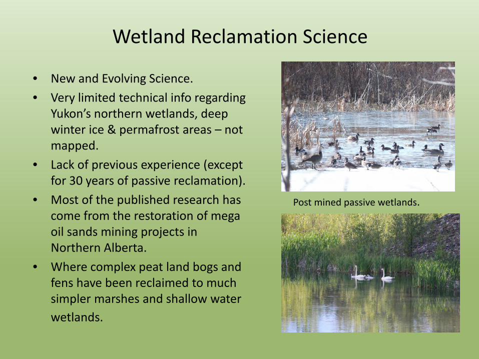
Wetland Reclamation Science
• New and Evolving Science. • Very limited technical info regarding
Yukon’s northern wetlands, deep winter ice & permafrost areas – not mapped.
• Lack of previous experience (except for 30 years of passive reclamation).
• Most of the published research has come from the restoration of mega oil sands mining projects in Northern Alberta.
• Where complex peat land bogs and fens have been reclaimed to much simpler marshes and shallow water wetlands.
Post mined passive wetlands.

Passive (Unaided) & Semi-Designed Wetlands
• Marshes, Shallow Open Water Wetlands form spontaneously with no intentional reclamation measures undertaken (passive).
• Why set up for Failure?
• When you can enhance passive reclamation with important topographic and reclamation features added during the mining operation.
• Use of our BMP’s enhances natural reclamation to productive uplands with marshes and shallow water wetlands.
This is area was mined in 1983-1993 and has recovered to wetlands without any intentional reclamation measures.

Marsh (< 1 m, 3 feet)
Shallow open water (< 2 m, 7 feet)
Most Common Types of Reclaimed Wetlands

Passive Post Mine Marsh and Shallow Open Water wetlands in the Indian River Valley.
Reclaimed Wetlands & Uplands
Some species such as moose, caribou, foxes and many birds can use both wetland and upland habitats. Many species such as waterfowl, fish and aquatic insects are completely dependent on (open water) wetlands for breeding habitat and survival. Research conducted by EDI (2013) indicated a high density of moose and other wildlife species in post mined areas. Marsh & Shallow Water complexes are by far the most significant wetlands in terms of wildlife diversity (National Wetlands Working Group, 1988).

Habitat for Beavers and Muskrats
• Beavers will inevitably invade the reclaimed landscape.
• Beaver activity will enlarge and deepen existing wetlands.
• Marshes and shallow-water wetlands can be expected to form in areas constructed as streams and fens.
• Muskrats can produce channels through marshes and affect the proportion of shallow water through grazing.
Reclaimed wetland post-mined Aquatic Habitat

Where Do Moose Get Most of Their Calories
In the summer, moose can be found more in marshes and lakes, filling up on aquatic vegetation. During winter, moose will forage near the edge of forests eating bark and twigs as other vegetation will have dried up. Moose get most of their calories and sodium from aquatic plants in the open water season.

Overview of Best Management Practices
• Create a complex of various wetlands and uplands which support a wide diversity of wildlife species.
• Exact location and type of wetlands created is difficult to predict in advance of placer mining.
• Need to be able to adapt quickly to changing pay gravels, site conditions & economics.
• Use and adapt existing post mined landscape features as much as possible.
• Work closely with these BMP’s to help ensure successful and cost effective reclamation.
Marshes often develop on the shallow underwater shorelines of Shallow Water wetlands located previous open pits and settling ponds. This is a post mine passive (unaided) wetland about 10- 15 years old.

1 Avoid Disturbing Wetlands
• Avoid disturbing wetlands where practical so that you do not have to reclaim them.
• This is usually not possible for placer mining when economic placer gravels are located directly under wetlands.
• Use upland or dry areas for the storage of overburden and other stripped material when working on the edge of a wetland complex.
• Try to avoid building roads, camps and other infrastructure on wetlands. • This will often save money and time during construction and also save the
wetlands. • Protect some of the remaining intact wetlands located over uneconomic
pay gravel areas to help revegetate the constructed wetlands.
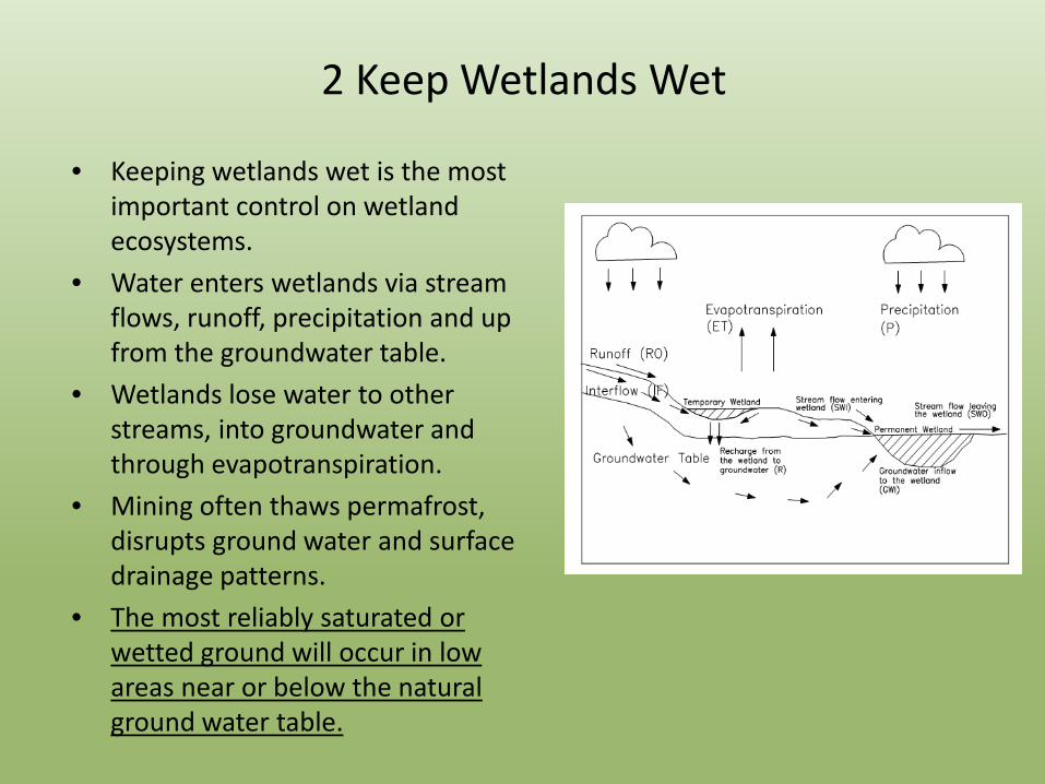
2 Keep Wetlands Wet
• Keeping wetlands wet is the most important control on wetland ecosystems.
• Water enters wetlands via stream flows, runoff, precipitation and up from the groundwater table.
• Wetlands lose water to other streams, into groundwater and through evapotranspiration.
• Mining often thaws permafrost, disrupts ground water and surface drainage patterns.
• The most reliably saturated or wetted ground will occur in low areas near or below the natural ground water table.

3 Stockpile Organics – Grade & Contour Post Mined Areas
• Separate fine soils, black muck and other organic materials and stockpile in stable piles during stripping operations.
• Conserve in convenient place to be spread out later.
• Protect from erosion by keeping the pile slopes at low angles, covering them with trees and shrubs or ditching around the perimeter of the piles.
• If the disturbed surfaces are very smooth or compacted you should roughen them and/or spread woody debris
Stockpiled fine soils spread out over disturbed areas and roughened to allow more rapid natural revegetation to occur.

4 Use Old Open Pits for Settling Ponds
• While mining, use old mine pits and/or low areas for settling ponds.
• Fine sediments from process water will help to seal the bottom of mine pits and low areas and make them more suitable for reclaimed wetland areas.
• Do not refill or cap old settling ponds with coarse rock unless there is a risk of erosion.
• Old settling ponds below or near the ground water table often reclaim rapidly on their own into marsh and shallow water wetlands.
Recent Naturally Reclaimed Settling Ponds

5 Use Existing Post Mine Pits & Depressions
• Use the existing depressions, mine pits and settling ponds for shallow water and marsh wetlands.
• Often fill with water naturally through precipitation or ground water infiltration.
• These depressions can be modified to help create productive wetlands.
• Fewer modifications are required to meet end goal when it is part of the mining process.
Passive Shallow Water & Marsh wetlands.

6 Don’t Completely Backfill Open Pits
• Don’t completely backfill open pits if the natural ground surface is above the water table.
• From 0.3 to 2 m depth of water in the pit is preferable.
• Low areas such as pits and settling ponds are the easiest to fill with water.
• Upper Wetland areas - may need to connect with closest stream/pup to keep saturated.
• Seal off the pit bottoms if necessary by lining with fine soils or use as a settling pond.
• Block any drainage ditches if required.
This is another “passive” wetland formed without any intentional land or wetland reclamation measures – grey areas are coarse gravel/boulder tailings – about 20 years old – pre land use regs.

-Shallow slopes to promote emergent vegetation
Deeper excavations (>2m, 7 feet) = Lakes
-Irregular shape of shoreline
-Peninsulas for waterfowl where
practical to do so
-Deeper depth for beaver, muskrat, fish

7 Size and shape the pond • Create ponds between 0.2
and 5 ha (0.5 to 12 acres) in area.
• Complex shapes as practical in the existing depressions.
• Provides more habitats for more wetland species and minimizes bank erosion resulting from wave action.
• Rectangular shape of most placer mine pits can be made more irregular by pushing material in from the sides of the pit and/or excavating the walls of pit.
This area was mined in 1983-1993. Light colored areas are coarse gravel and boulder tailings which were not covered with fine soils – prior to mining land use regs.
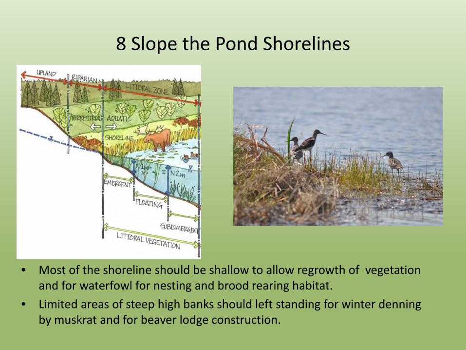
8 Slope the Pond Shorelines
• Most of the shoreline should be shallow to allow regrowth of vegetation and for waterfowl for nesting and brood rearing habitat.
• Limited areas of steep high banks should left standing for winter denning by muskrat and for beaver lodge construction.

9 Connect the Ponds
• Connect the wetlands with ditches.
• Connect to the stream if there is not enough groundwater to fill up the pond.
• Facilitates the exchange and movement of aquatic animals and plants among reclaimed and unaffected wetlands.
• Check with DFO before connecting wetlands to salmon bearing streams.
• Surround wetlands with upland habitat with some mounds (overburden) covered by fine soils.

10 Revegetate Disturbed Areas if Required
• Disturbed areas should be left in a state conducive to successful revegetation by plant species native to the area.
• Seeding, fertilizing or “assisted” revegetation is generally not required where there is sufficient organics and/or black muck .
• Where fine soils are not available and natural regeneration is problematic, apply appropriate seeds and/or fertilizer.

Natural Revegetation
Annual Progress in Natural Revegetation of a Post Mined Pit in an Upper Narrow Valley

11 Allow Natural Reclamation to Occur

12 Monitor the Progress of Reclamation
• Establishment of wetland will take in the order of 10 to 15 years. • Should be well covered with succession (pioneer) vegetation and evolving. • Reclaimed wetlands should not require long-term maintenance and
management. • Also possible that the habitat will not evolve in the way it was intended &
a few former wetlands may have to be reclaimed as dry lands (or dry-wet). • Monitoring should be conducted to see if adjustments need to be made to
these Best Management Practices from time to time. • This monitoring information should be used to gauge restoration success
and not to justify tearing up and re-reclaiming former wetland areas. • Monitoring should be conducted by mines inspectors to ensure that
erosion has been limited, revegetation of disturbed areas has occurred, and that the reclaimed wetlands are saturated and/or under water.

Potential problems with constructed wetlands and adaptive management strategies
Problem Indicators Adaptive Management Strategies
Water loss / drying Exposed soil area Salts present
-Convert drier areas from wetland habitat to upland habitat -Change height of discharge structure (if present)
Water gain / flooding
Higher Water Level Aquatic Vegetation Diminishing
-Change height of discharge structure (if present) -Add more soils if available and not already reclaimed -Remove beavers by trapping and remove dam (if present) -Allow habitat for beavers and muskrats to develop
High rate of infilling with sediments
Increased Turbidity Reduced Aquatic Plant Growth
-Check for and correct any erosion Issues -Block off access to silty water -Change height of discharge structure (if present)
Shoreline erosion
Excess Sediments Around Edges Decreased Vegetation on Shoreline
-Install rip-rap or coarse aggregate on eroded area -Cover shoreline with timber and woody debris -Plant willow cuttings on shoreline
Lack of vegetation Bare areas -Check for loss of organic soils -Replace as necessary and reduce soil losses by erosion -Transplant willows or pods of vegetation
Low plant diversity All the same -Increase connections with other wetlands -Control invasive species (if present)
Low aquatic organism diversity
Less use by water birds - less clear
-Eliminate or reduce predatory fish population (go fishing!) -Create more shallows on edges of ponds

Acknowledgements Klondike Placer Miners’ Association – Schmidt Mining Corporation - Energy, Mines & Resources - Department of the Environment - Indian River Miners – Ducks Unlimited Photos: Rob Lake, Jim Leary, Hailey Reimer, Stuart Schmidt, Anne Michon, Randy Clarkson
Passive Post Mined Shallow Water & Marsh Wetlands in the Indian River – mined in 1985-1995.