Embed Size (px)
Citation preview

Clackmannanshire Local Plan Site Appraisal
Draft Report
APPENDICES
A Report to Clackmannanshire Council
by Land Use Consultants
December 2008
37 Otago Street Glasgow G12 8JJ
Tel: 0141 334 9595 Fax: 0141 334 7789


1
CONTENTS Appendix 1 Policy documents included in the policy review............................................................3 Policy documents included in the policy review: .................................................................................4 Appendix 2 General development policies which apply to all development sites .......................5 APPENDIX 3 Site Assessment Matrices .................................................................................15 Site 1 Lornshill Farm, Alloa.....................................................................................................................16 Site 2 West Earlsfield, Alloa....................................................................................................................22 Site 3 Earlsfield, South Earlsfield, Alloa ................................................................................................28 Site 4 Alloa East (1), Carsebridge, Alloa ..............................................................................................34 Site 5 Alloa East (2), Carsebridge, Alloa ..............................................................................................39 Site 6 Alloa west expansion area, Alloa ...............................................................................................44 Site 7 Jellyholm, Sauchie, Alloa (north east)........................................................................................50 Site 8A: Land south of Brook Street, West of B908 Alva ...............................................................56 Site 8 B: West Alva, to line with settlement edge Land south of Brook Street, Alva...............62 Site 8 C: East of B908, Alva ....................................................................................................................68 Site 9 Birkhill Castlebridge......................................................................................................................73 Site 10 Ladywood, east of Clackmannan .............................................................................................79 Site 11 Kennetpans, Clackmannan ........................................................................................................85 Site 12 Helensfield, Clackmannan..........................................................................................................91 Site 13 Meadowend Farm Clackmannan..............................................................................................96 Site 14 Kilbagie (north) ......................................................................................................................... 101 Site 15 Clackmannan (east) Tullygarth, Clackmannan ................................................................... 106 Site 16 Clackmannan south, Clackmannan....................................................................................... 112 Site 17 Land South of James Place, Coalsnaughton ........................................................................ 118 Site 18 Devonside East ......................................................................................................................... 122 Site 19 Lover’s Loan .............................................................................................................................. 126 Site 20 Dollarfield Farm........................................................................................................................ 131 Site 21 Dollarfield................................................................................................................................... 136 Site 22 Upper Hillfoot Road, Hillfoot Road, Dollar ....................................................................... 141 Site 23a Dollar (South), West of Devon Road................................................................................ 147 Site 23B Dollar (South), east of Devon Road.................................................................................. 151 Site 24a Forestmill (includes assessment of restoration of Meadowhill) ................................. 155 Site 24b Forestmill (includes assessment of restoration of Meadowhill) .................................. 162 Site 26 Aitkenhead Forestmill (north)............................................................................................... 169 Site 27 Middletonkerse, Menstrie....................................................................................................... 175 Site 28, Menstrie East, Glenochil, Menstrie...................................................................................... 181 Site 29 Land at Devonpark, Muckhart............................................................................................... 187 Site 30 North Side of A91, west side of Pool of Muckhart......................................................... 193 Site 31 Land East of Pool of Muckhart .............................................................................................. 198 Site 32, Alloa North West, Branshill, Sauchie ................................................................................. 204 Site 33 Oak Mills, Lower Mill Street, Tillicoultry............................................................................ 210

2
Site 34 Land south of Dollar Road Tillicoultry................................................................................ 216 Site 35 Cambus East, Cambus, Tullibody.......................................................................................... 222 Site 36 Lornshill Farm STeading.......................................................................................................... 228 Site 37 Redwell, Alloa ........................................................................................................................... 233 APPENDIX 4 Criteria to which weighting was applied................................................................. 239 APPENDIX 5 Summary Results of Assessment of Alternatives.................................................. 247

3
APPENDIX 1 POLICY DOCUMENTS INCLUDED IN THE POLICY REVIEW

4
Policy documents included in the policy review: Clackmannanshire and Stirling Structure Plan; Clackmannanshire Local Plan; Contaminated land strategy; Clackmannanshire Local Biodiversity Action Plan; Supplementary Advice Note 1: Recreational Open Space; Supplementary advice note 9: Planning and flooding; Clackmannanshire Community Plan 2006-2009; Outdoor Access Strategy and Core Paths Plan; Clackmannanshire Council Biennial Report (November 2007) As required by The Flood Prevention and Land Drainage (Scotland) Act 1997; Transport and the Environment 2006 - 2009 Road Traffic Reduction Plan 2006 - 2009 Road Safety Plan 2006 - 2009 Local Transport Strategy 2006 - 2009 Tourism in Clackmannanshire A Strategy for Growth Final Report (2006); Clackmannanshire Landscape Character Assessment. Clackmannanshire Sustainability and Climate Change Strategy Open Space Strategy SSP1 The Planning System; SPP3 Planning for Housing; SPP7 Planning and Flooding; SPP11 Open Space and Physical Activity; NPPG14 Natural Heritage; SPP17 Planning for Transport; NPPG18 Planning and the Historic Environment; Scottish Historic Environment Policy 1 Scotland’s Historic Environment. PAN33 Development of Contaminated Land (2000) NPPG5 Archaeology and Planning (1998) NPPG13 Coastal Planning (1997) SPP21 Green Belts (2006) SNH Natural Heritage Futures (2002) SPP2 Economic Development (2002) Historic Scotland, Passed to the Future: Historic Scotland’s Policy for the Sustainable Management of the Historic Environment, (2002)

5
APPENDIX 2 GENERAL DEVELOPMENT POLICIES WHICH APPLY TO ALL DEVELOPMENT SITES

7
Policy Document
Policy/Plan reference
Summary
Clackmannanshire and Stirling Structure Plan
Policy SD1 – Key Principles
In assessing development proposals, consideration will be taken of the contribution the development will make towards the Structure Plan’s overarching goal of ‘Working Towards Sustainable Development’ and give consideration to environmental, social and economic factors.
Clackmannanshire and Stirling Structure Plan
Policy ENV1 – Nature Conservation
The policy aims to promote the protection of wildlife, habitats and other natural features. It states that development which will potentially negatively impact upon internationally or nationally designated sites will not be permitted unless it can be demonstrated that their will be no adverse effect from the proposal, or no viable alternative solution. Similarly, proposals which may affect a site of local importance will only be allowed where it can be demonstrated that there will be no significant negative impact on the conservation value of the site.
Clackmannanshire and Stirling Structure Plan
Policy ENV2 – Protected Landscapes
The policy states that development will only be permitted in Areas of Great Landscape Value where it satisfies the criteria of Policy ENV3 (below) and can be accommodated without adversely affecting the overall quality of the area.
Clackmannanshire and Stirling Structure Plan
Policy ENV3 – Development in the Countryside
The policy states that development in the Countryside (as defined in Local Plans i.e. areas not within settlement boundaries) be suitable for it’s location in function and design and should accord with Policy ED4 – Rural Development (discussed below).
Clackmannanshire and Stirling Structure Plan
Policy ENV4 – Green Belts
In green belt areas there will be a strong presumption against development – any developments which are permitted will have to demonstrate appropriate environmental enhancement.
Clackmannanshire and Stirling Structure Plan
Policy ENV5 – Environmental Enhancement
Policy ENV5 highlights the priority given by the council to environmental enhancement measures, in particular the remediation of contaminated land, through new development.
Clackmannanshire and Stirling Structure Plan
Policy ENV6 – The Historic and Built Environment
Policy ENV6 aims to protect and enhance cultural heritage features, as well as ensure that new developments are in keeping with the character and quality of the area.
Clackmannanshire and Stirling Structure Plan
Policy ENV7 – Agricultural Land
Development which would result in the permanent loss of prime agricultural land will only be permitted where such land is identified for development in Local Plans and lower quality land

8
Policy Document
Policy/Plan reference
Summary
cannot reasonably be used. Clackmannanshire and Stirling Structure Plan
Policy ENV9 – Water Resources Management
The policy states that development will not normally be permitted in undeveloped flood plain areas, in areas of known significant flood risk, or if it will adversely affect the forth estuary. Exceptions will be made only when it can be demonstrated that no alternative locations can be found, or that suitable mitigation measures can be implemented.
Clackmannanshire and Stirling Structure Plan
Policy ENV10 – Minerals – General Principles
“Economically important mineral resources will be protected from sterilisation by permanent development. Alternatively, working of minerals in advance of development will be encouraged”
Clackmannanshire and Stirling Structure Plan
Policy ENV14 – Renewable Energy and Energy-Efficient Development
The policy states that ‘development proposals must demonstrate that energy conservation and efficiency are integral to the design, and to the layout of new buildings’.
Clackmannanshire and Stirling Structure Plan
Policy ED4 – Rural Development
The policy states that economic and social development in rural areas will be supported within the following criteria: • Focussing development within existing towns
and villages • Restricting development within greenbelt and
countryside. Clackmannanshire and Stirling Structure Plan
Policy H1 – Maintaining a 5 year land supply
The policy states that the councils will work to ensure sufficient provision is made for a minimum effective five year land supply for housing
Clackmannanshire and Stirling Structure Plan
Policy H2 – Brownfield Sites
The policy states that the council will allocate appropriate brownfield opportunity sites and facilitate development on brownfield sites.
Clackmannanshire and Stirling Structure Plan
Policy H3 – Housing to meet a range of needs
Policy H3 states that the provision of a range and choice of house types should be supported. In particular, sites suitable for affordable and special needs housing should be identified.
Clackmannanshire and Stirling Structure Plan
Policy H5 – Housing in the Upland Area
Policy H5 supports rural development in the Upland Area within the settlement boundaries defined in the Local Plan.
Clackmannanshire and Stirling Structure Plan
Policy H6 – Housing in the Countryside
The policy states that new housing developments in the Countryside will only be approved where the development is essential, involves the conversion of an existing building, or is consistent with Policy H5 above.
Clackmannanshire and Stirling Structure Plan
Policy TR1 – Integrated Transport
The policy aims to reduce the need to travel by promoting development within areas of good transport access.

9
Policy Document
Policy/Plan reference
Summary
Clackmannanshire and Stirling Structure Plan
Policy TR2 – Transport
The policy aims to promote a wide range of transport choices by requiring developers to consider a range of transport options as part of new development proposals. This will ensure that new development integrates with and enhances the wider transport network.
Clackmannanshire Local Plan
Policy EN1 – Sites of Local Ecological Importance
The policy states that any application for development will be guided by the Local Biodiversity Action Plan. It also states that any development proposals should consider the importance of non-designated sites of local nature conservation or biodiversity importance and should minimise negative impacts on the natural heritage resource.
Clackmannanshire Local Plan
Policy EN2 – Landscape and Ecology
The policy includes conditions which must be met if a development is to be permitted in an AGLV. The policy also states that appropriate consideration must be given to woodland, habitats, natural and landscape features when making a planning application.
Clackmannanshire Local Plan
Policy EN4 – Water Resources
The policy states that where a development area is determined as being at risk of flooding, planning permission will not be granted except where it can be proved that there are no viable alternative sites.
Clackmannanshire Local Plan
Policy EN5 – The Coast
The policy states that the undeveloped coast will be protected from further development except where it can be proved that there are no viable alternatives sites.
Clackmannanshire Local Plan
Policy EN7 – Archaeological or Historic Sites
The policy states that development will not be permitted where it can adversely affect a SAM or other important archaeological or historical site unless it can be demonstrated that there is no alternative viable site or the development is of national public importance.
Clackmannanshire Local Plan
Policy EN8 – Site assessment, evaluation and recording
Where a development could affect a site of archaeological importance, an assessment of the historical value must be undertaken prior to permission being granted.
Clackmannanshire Local Plan
Policy EN10 – Conservation Areas
The policy states that new developments must contribute to the protection of conservation areas and that proposals will be assessed in terms of the need to ensure the preservation and enhancement of the areas character.
Clackmannanshire Local Plan
Policy EN11 – Enhancing
The policy states that new development will be expected to positively contribute to its immediate

10
Policy Document
Policy/Plan reference
Summary
Environmental Quality
environment through sensitive design and consideration of landscape, ecological and amenity issues.
Clackmannanshire Local Plan
Policy EN12 – Area Environmental Enhancement
The Local Plan identifies three key Environmental Enhancement Areas where an improvement in environmental quality is desired: • the rivers • the A91 corridor • the Conservation Areas Policy EN12 states that proposals which would detract from the setting or aesthetics of these areas will not normally be permitted, and that developers must demonstrate how proposals can be integrated with proposed enhancement measures.
Clackmannanshire Local Plan
Policy EN 15 - Contaminated Land
The council will only permit development on or around areas of contaminated land where remediation is possible and potential risk can be overcome.
Clackmannanshire Local Plan
Policy EN18 – Development in the Countryside
The policy sets criteria which must be met if planning permission is to be granted to a proposed development which is outwith the settlement boundaries in the Local Plan Countryside map.
Clackmannanshire Local Plan
Policy EN19 – Green belt
The policy states that development will only be permitted in green belt where no alternative location can be found or the development would provide an opportunity to enhance the green belt.
Clackmannanshire Local Plan
Policy EN24 – Protection of Minerals
The policy states that permanent development which would result in the sterilisation of viable mineral resources will not be permitted except where this would prevent residential development which contributes to the strategic housing land requirement and no other sites area available to meet this requirement.
Clackmannanshire Local Plan
Policy RES1 – Housing Land Supply
The policy states that at all times at least 5 years supply of effective housing land will be available, taking into account the need to provide choice in terms of location, type and different market segments.
Clackmannanshire Local Plan
Policy RES2 – Brownfield Development
The policy prioritises development which will take place on brownfield sites which will utilise vacant, derelict, contaminated and underused land and property within settlement boundaries.
Clackmannanshire Local Plan
Policy RES5 – Affordable and particular
The policy aims to secure a proportion of affordable/particular needs housing on all developments over 30 houses.

11
Policy Document
Policy/Plan reference
Summary
needs housing Clackmannanshire Local Plan
Policy RES7 – The layout and form of development
The policy states that new development must be consistent with the form and character of surrounding development and should reflect surrounding densities.
Clackmannanshire Local Plan
Policy RES8 – Amenity Standards
The policy sets standards for amenity which must be adhered to in all development proposals.
Clackmannanshire Local Plan
Policy RES9 – Open Space Principles
The policy states that recreational and amenity open space must be provided as part of any new housing development.
Clackmannanshire Local Plan
Policy RES11 – Development principles for large housing developments
For developments of all housing sites (particularly those of 30 or more units), a high quality of design and landscaping should be aspired to.
Clackmannanshire Local Plan
Policy INF2 – Integration of Transport and Development Proposals
The policy states that new developments should be located where they are capable of being conveniently and safely accessed by public transport, foot or cycle as well as by private vehicle.
Clackmannanshire Local Plan
Policy INF3 – Local Access
The policy states that development will not be permitted where it will result in the loss of an asserted right of way, footpath or a path forming part of the Clackmannanshire path network unless the provision of an alternative path can be assured.
Clackmannanshire Local Plan
Policy INF14 – Existing Public Parks, Amenity Open Spaces, Allotment Gardens, Playing Fields and Sports Pitches
The policy states that existing amenity resources will be protected from unrelated development which would negatively affect their recreational or amenity value.
Clackmannanshire Biodiversity Action Plan (July 2003)
n/a The Clackmannanshire LBAP aims to implement the UK wide BAP through the identification of biodiversity resources and priorities in the local area. Habitat Action Plans have been devised for virtually all of the habitats recorded in the Clackmannanshire area. Species Action Plans have been developed for numerous mammals, birds, fish, invertebrates and plants in the Clackmannanshire area.
Clackmannanshire Community Plan
Regeneration The Clackmannanshire Community Plan (published by the Clackmannanshire Alliance) aims to promote

12
Policy Document
Policy/Plan reference
Summary
2006-2009 the regeneration and development of Clackmannanshire by focussing on four key aims: • Economic Development; • Health improvement; • Community safety; and • Environment. Of particular relevance to the site appraisal is the section relating to regeneration – the Community Planning Partnership has received £1 million annually between 2005 and 2008 to invest in Alloa South and East, Tullibody, Sauchie, Coalsnaughton and Devonside (these areas were identified as being in need of targeted economic support using the SIMD).
Clackmannanshire Local Transport Strategy 2006-2009
Policy W2 The policy states that any development proposal will need to provide quality pedestrian routes which are direct, safe and accessible by all (this will include the introduction of speed reduction measures, 20mph zones and priority schemes through innovative layout and design).
Clackmannanshire Local Transport Strategy 2006-2009
Policy W3 The policy states that developments will not be supported where an existing footpath or cycle route will be lost unless a suitable replacement can be agreed upon.
Clackmannanshire Local Transport Strategy 2006-2009
Policy C4 The policy states that new residential developments will be required to provide appropriate facilities for cyclists (including secure parking and links to cycle routes).
Clackmannanshire Local Transport Strategy 2006-2009
Policy PT4 The policy states that any proposals to develop in the vicinity of a former railway line shall demonstrate appropriate measures to safeguard access and future provision of the route for reinstatement or other modes of transport e.g. cycling.
Clackmannanshire Local Transport Strategy 2006-2009
Policy PT6 The policy states that new housing will only be supported where there are existing links to public transport or where the development can support new services or remove the need for subsidy to existing services.
Clackmannanshire Local Transport Strategy 2006-2009
Policy ST4 The policy states that developers of new residential areas will be expected to provide safer routes to the nearest primary and secondary schools in the catchment area.
Clackmannanshire Local Transport
Policy TM1 New residential developments will require to give due consideration to the incorporation of natural

13
Policy Document
Policy/Plan reference
Summary
Strategy 2006-2009
traffic calming features into the site master plan to give pedestrians equal priority with vehicles and to reduce speeds.
Clackmannanshire Local Transport Strategy 2006-2009
Policy P2 The policy states that in new residential areas, developers will be required to provide adequate residential and visitor parking spaces.

14

15
APPENDIX 3 SITE ASSESSMENT MATRICES

16
Site reference and location: SITE 1 LORNSHILL FARM, ALLOA
Size (ha) 9.62
Size (group) Medium
Summary description including site access and public transport connections
The site comprises an unmanaged field adjacent to the B9096 between Alloa and Tullibody, on the south east facing slopes of Lornshill. Enclosed by woodland belts on three sides and open to the road. The site is located outwith the settlement boundary.
Transport issues to consider include the impact of a new access junction in relation to school traffic at the nearby Lornshill Academy. Access could be taken directly onto the B9096. There is an opportunity to improve the access around the school and development of the site could support a long term plan to develop an Alloa – Tullibody cycle route.
A signed Right of Way runs along the southern boundary of the site and provides access to the nearby housing area, and informal paths run through the woodland belts and connect to Tullibody.
Overriding constraints to development
None
Site specific investigations Ground stability
Presence of bats within boundary woodlands.
Constraints to development Moderate - Surface water drainage. Ground stability
Summary of area remaining following mitigation
Implementation of SUDS to mitigate surface water drainage issue
Environmental features Vegetation: Rough grass with rushes bounded by mature woodland to the north, south-east and south. The mature mixed deciduous woodland contributes landscape setting to the site and are intact. An area of scrub woodland with extensive willow growth is located in the south east corner of the site, and Area A consists of overgrown herbaceous vegetation.
Field boundaries: The field is unmanaged and boundaries comprise a post and wire fence, outgrown hedgerow trees and a broken down stone wall on the southern boundary.
Water: A drain runs through the woodland to the south of the site, and water collects in the south east corner of the site, contributing to surface flow into the road in wet weather.
Other features: The site plays a role in providing setting for the listed building at Lornshill.
Site ownership:
Site type: Settlement expansion
Current land use Unmanaged pasture
Surrounding land use Residential, educational (Lornshill Academy), woodland and farmland

17
Planning policy framework: Clackmannanshire and Stirling Structure Plan Policy ENV3 – Development in the Countryside: The policy states that development in the Countryside (as defined in Local Plans i.e. areas not within settlement boundaries) be suitable for it’s location in function and design and should accord with Policy ED4 – Rural Development (see below).
Clackmannanshire and Stirling Structure Plan Policy ED4 – Rural Development: The policy states that economic and social development in rural areas will be supported within the following criteria:
• Focusing development within existing towns and villages
• Restricting development within Green Belt and countryside.
Clackmannanshire and Stirling Structure Plan Policy H6 – Housing in the Countryside: The policy states that new housing developments in the Countryside will only be approved where the development is essential, involves the conversion of an existing building, or is consistent with Policy H5 ‘Housing in the Upland Area’.
Clackmannanshire Local Plan Policy EN18 – Development in the Countryside: Criteria for the granting of planning permission to a proposed development in the countryside.
This site also lies within the Green Belt and therefore the following planning policies apply:
Clackmannanshire and Stirling Structure Plan Policy ENV4 – Green Belts: In Green Belt areas there will be a strong presumption against development – any developments which are permitted will have to demonstrate appropriate environmental enhancement.
Clackmannanshire Local Plan Policy EN19 – Green Belt: The policy states that development will only be permitted in Green Belt where no alternative location can be found or the development would provide an opportunity to enhance the Green Belt.
Planning History The site was subject to a previous planning application which went to appeal. The council lost the appeal.
SEA /site assessment topic
Site appraisal criteria Site issues Summary of Effect of development (++/+/0/-/--)
Enhancement and mitigation options Potential effect following mitigation
Biodiversity, flora and fauna
Does the site impact on designated sites?
Tree preservation orders cover the woodland belts to the southern boundary of the site.
Development of the site would not impact directly on the adjacent tree preservation orders, provided development of the site protected the tree canopy, root and nutrient zones. However the site may provide a role in providing habitat for a number of bird and mammal species due to the provision of open ground with a woodland boundary habitat.
0 Ensure protection of tree root and nutrient zones should development of the site take place.
No adverse impacts on designated sites.
Does the site impact on priority habitats or species?
The site is identified in the Phase 1 Habitat Survey as arable and pasture. The development of the site would result in the loss of the habitat provided by the site which may be important for species such as bats.
0/- There are limited opportunities to enhance the biodiversity value of the surrounding area.
The loss of the site would result in a reduction in the area of foraging habitat, however the creation of SUDS pond would create new habitat.
Does the development of the site avoid adverse effects on the integrity of the Firth of Forth SPA and Ramsar site?
The site is over 1km from the Firth of Forth SPA and Ramsar site and development of the site should not impact on the integrity of the site.
0
Does the development of the site maintain and enhance populations of European Protected Species including protection of their resting places?
The woodland, wetland and perimeter woodlands may provide habitat for some protected species. Site specific survey should be undertaken prior to development of the site to ascertain the presence of European Protected Species and appropriate mitigation implemented if these species are identified.
0/- Following site specific survey, appropriate mitigation should be identified and implemented.

18
SEA /site assessment topic
Site appraisal criteria Site issues Summary of Effect of development (++/+/0/-/--)
Enhancement and mitigation options Potential effect following mitigation
Does the site facilitate the restoration and enhancement of biodiversity in all our urban and rural environments through better planning, design and practice?
The woodland belts at the perimeter of the site form part of the woodland generalist 1km dispersal network, and the area of wet woodland at the south eastern corner of the site provide habitat value. Development of the site could potentially result in the loss of these resources.
- The areas of woodland and wetland should be protected and enhanced.
Minor negative
Population and human health
Is the site connected to the local core path network?
The site is connected to the core path network providing links to the housing to the south, along the B9096 and through the woodland to the north west.
++ Connectivity could be enhanced through providing access onto the core path network across the southern boundary of the site to provide direct access to the network. Enhancement of the informal path network within the woodland belts to the west would enhance the local access network.
Enhancement of the access opportunities would have a positive effect on connectivity to the local core path network.
How does the site relate to areas with high SIMD?
Tullibody ROA agreement area lies to the north and west of this site, within 500m. The area within which the site is located does not have a high SIMD. The site will not directly or significantly facilitate regeneration. However the location of the site in closer proximity to Tullibody town centre, than Alloa town centre may assist in support for local services within Tullibody.
0 n/a No effect
What is the relationship of the site with existing open space resources?
The site is within 500m of Braehead Golf Club. Also within 500m are the grounds surrounding Gean house and also the par surrounding Inglewood House.
The grounds of Lornshill Academy are identified for community recreation development in the local plan and provide a recreation resource.
The surrounding area to the north and east (Gubber Hill and Blackmuir Wood) includes a network of paths and provides an open space resource. The site is well connected to existing access routes and areas of open space.
+ n/a No effect
Water
Is the site at risk of flooding?
The site is located on a gentle slope and does not lie within the flood risk areas identified in the SEPA flood risk mapping. However surface water drainage is an issue for this site which comprises rushy pasture and the area of willow scrub in the south eastern corner. Surface water flows from this corner over the pavement and road during wet weather. Flooding is unlikely to be a significant issue for this site, however surface water drainage would require management. Development of the site would increase the rate of run off and would require the implementation of a SUDS scheme in the south eastern corner of the site.
- The implementation of a SUDS scheme would positively contribute to the management of surface water drainage issues on this site.
+
Are there water courses within the site or which would be affected by increased levels of pollution from development within the site?
A drain runs through the woodland to the immediate south of the site and this is then culverted. Run off from development of the site could potentially enter this watercourse. There is potentially a minor risk of increased pollution to the minor water course from site run off.
- The implementation of SUDS would reduce the impact of pollution resulting from run off associated with this site.
0
Are there water courses within the site or which would be affected by increased levels of flooding resulting from development of the site?
Development of this site would increase the rate of run off from the site. There are no recorded flooding incidents in relation to this site (2007). The site is small in extent and therefore the quantity of
0 The lower part of this site could potentially accommodate a SUDS scheme.
No effect

19
SEA /site assessment topic
Site appraisal criteria Site issues Summary of Effect of development (++/+/0/-/--)
Enhancement and mitigation options Potential effect following mitigation
increased run off is likely to be minimal
Soil Does the site include areas of vacant or derelict land?
The site is not vacant or derelict. 0 n/a n/a
Is the site prime agricultural land?
The site is not an area of prime quality agricultural land. 0 n/a n/a
Air Quality and Transport
Is the site easily accessible by the local path network, and provide access to settlements and services?
The site is located a short distance from the centre of Tullibody and Alloa but is well connected by the core path network providing easy access to these centres.
+ Development of the site could support the development of a cycleway between Alloa and Tullibody.
n/a
Is the site easily accessible by public transport? The site is located adjacent to the B9096 which provides bus services to Tullibody and Alloa.
+ n/a n/a
Does the site lie within an area where levels of air pollution are close to current limit values?
The closest air quality monitoring stations for nitrogen dioxide indicate no significant trend in levels between 2002 and 2007.
0 n/a n/a
Would development on the site contribute to higher traffic flows along transport routes or at key junctions (potentially outwith the local authority area) where levels of air pollution are close to current limit values?
Development of the site will potentially contribute to a minor increase in traffic levels on the A907 and in Alloa town centre.
However cumulative effects require to be assessed in Stage 2.
- n/a n/a
Climatic Factors
Does the location of the development reduce the need to travel?
The centres of Tullibody and Alloa are accessible on foot, cycle and by public transport from the site. Schools and services are accessible within close proximity to the site, however the size of the site would not be sufficient to support new facilities. Local services can be accessed without the use of the private car.
+ n/a n/a
Is the site at risk of increased flooding or instability as a result of climate change?
The site is located on a low rise and within an area of undulating landform. The site characteristics and surrounding landform do not suggest a significant increased risk of flooding or instability as a result of climate change There is an identified issue with surface water drainage which would require to be addressed should the site be developed.
0 n/a n/a
Material Assets
Is the site located close to existing transport, services, water and energy infrastructure?
The site lies close to other residential areas and therefore anticipated to be provided from existing infrastructure.
+ n/a n/a
Is the site located to make best use of shelter, solar gain and reduce the need to travel?
The site is located on a south east facing slope and partially enclosed by woodland belts. The site lies within 1.5km of Tullibody town centre, and 2km of Alloa town centre facilitating accessibility and would form an extension to existing settlement. The site characteristics are favourable for accessibility, aspect, and shelter.
+ n/a n/a
Would development on the site reduce future potential for mineral extraction?
The site is located close to a residential area and would not be developed for mineral extraction due to a lack of opportunity for sufficient separation distances from settlement.
0 n/a n/a

20
SEA /site assessment topic
Site appraisal criteria Site issues Summary of Effect of development (++/+/0/-/--)
Enhancement and mitigation options Potential effect following mitigation
Does the site include any hazard areas? (oil or gas pipelines)
No hazard areas. 0 n/a n/a
Does the site reduce waste generation and promote waste recovery, recycling and composting?
The site does not have a significant impact on waste generation, however as it is located within the urban area it will not generate significant additional waste related journeys.
-
Cultural Heritage
Would development within the site impact on the integrity of sites, monuments, buildings or areas designated for their cultural heritage value?
Lornshill farmhouse is located immediately outwith the site boundary on the hill and is a B listed building. Development of the site would have some impact on the setting of the farmhouse which overlooks the slopes.
- n/a n/a
Would development within the site impact on archaeological remains?
There are no known archaeological remains within the site boundary. The site is identified in the HLA as 18th – 19th century fields and farming.
0 n/a n/a
Landscape Does the site lie within an area designated for its landscape value?
The site lies within an area of land currently designated as Greenbelt. The site lies within the Carse of Forth landscape character area. This landscape is characterised by its open character and flatness of landform which contrasts with the steeply rising Ochil Hills to the north. Development of this site would result in loss of Greenbelt, however this would not breach the Greenbelt which separates Tullibody and Alloa, but it would reduce it to the width of a single field bounded by woodland belts.
- Guidelines for this area include protection of the open agricultural character, but also highlighting roads through roadside planting and the River Forth. Enhancement and mitigation would not reduce the impact of the loss of separation between Alloa and Tullibody.
Development of the site would result in loss of separation between Alloa and Tullibody.
Would development within the site impact on settlement setting and identity (drawing on issues of landscape character and capacity for development)?
The existing settlement form of the housing at Alloa consists of housing development extending along the B9096 on both sides of the road and partially contained by policy woodland. The settlement edge of Tullibody is contained by the policy woodland. Development already extends to the north of the B9096, and within open areas between policy woodland. However development of this area would reduce the actual and perceived separation between the two settlements. Lornshill Academy already compromises the separation between Tullibody and Alloa.
- The sloping character of the site reduces opportunity for enhancement or mitigation.
Development of the site would result in loss of separation between Alloa and Tullibody.
Would development within the site impact on key views to landscape features or from key transport routes?
The site lies immediately adjacent to the B9096, with no visual barrier at the road boundary making this site highly visible. The wider landscape has an undulating topography. Development within the site would be highly visible from the B9096, but would not be more widely significant.
0/- As above.

21
View north west towards Lornshill farm
View west along southern tree belt and illustrating woodland growing within poorly drained area on site

22
Site reference and location: SITE 2 WEST EARLSFIELD, ALLOA
Size (ha) 1.02
Size (group) Small
Summary description including site access and public transport connections
Located on the south eastern outskirts of Alloa. Adjacent to Earlsfield Rugby Football Ground and surrounded by residential properties to the north, south and west. The site lies within the settlement boundary. Access to the site would be taken onto Forth Crescent.
Overriding constraints to development
Surface water drainage
Site specific investigations Drainage
Ground stability
Constraints to development
Major – surface water drainage
Summary of area remaining following mitigation
Topography and water table may limit opportunity for SUDS and therefore the scope for mitigation.
Environmental features Vegetation: Mown grass at the road edge, and rough grass and trees to the east of the site. The rest of the site is bordered by road and residential properties.
Field boundaries: There are a few field trees along the eastern boundary with the rugby club.
Water: There are no surface water features within 200m of the site, however the flat and low lying nature of the site results in issues associated with surface water drainage. Additionally the Brothie Burn has been culverted through the site and the location and depth of this need to be established.
Role as part of FHN: The site forms part of the woodland generalist 1km dispersal network and is associated with the adjacent areas of open space which are also part of the network.
Other features: No other features of note.
Site ownership:
Site type: Settlement expansion
Current land use Unmanaged and used for informal recreation
Surrounding land use Residential, educational (St Mungos Primary School), recreational (Earlsfield rugby ground)
Planning policy framework
There are no specific planning designations relating to the site however the following policy may be of relevance as the site lies within an area of multiple deprivation:
Clackmannanshire and Stirling Structure Plan Policy H3 – Housing to meet a range of needs states that the provision of a range and choice of house types should be supported. In particular, sites suitable for affordable and special needs housing should be identified.
Planning History This site forms part of a larger development proposal for the area and has been subject to a detailed planning application for a nursing home.
Other policy considerations
The Clackmannanshire Community Plan 2006-2009 aims to promote the regeneration of Clackmannanshire and this designates Alloa South and East as an area eligible for regeneration funding under the Regeneration Outcome Agreement. The designation of this area as a focus for regeneration should be considered when further development is proposed.

23
SEA /site assessment topic
Site appraisal criteria Site issues and discussion Summary of Effect of development (++/+/0/-/--)
Enhancement and mitigation options
Potential effect following mitigation
Biodiversity, flora and fauna
Does the site impact on designated sites?
The site lies within 500m of ancient woodland (Pond Wood) and within 2km of the Forth Estuary SPA, Ramsar and SSSI.
It is unlikely that development of West Earlsfield would have any impact on the ancient woodland or on Forth Estuary as the site lies on the outskirts of Alloa and as such is surrounded by existing developed areas. However cumulative impacts resulting in the loss of habitat adjacent to the Forth Estuary should be considered.
0 Mitigation unlikely to be required. No adverse effect on designated sites.
Does the site impact on priority habitats or species?
There are numerous Phase 1 habitat survey Target Note sites within 500 metres of the site. Pond Wood is also within 500m of the site where Clackmannanshire Council keeps records of Phase 1 and Phase 2 surveys.
The site is identified in the Phase 1 Habitat Survey as amenity grassland.
It is unlikely that development at West Earlsfield would have an impact on priority habitats or species because, as discussed above, the site is surrounded by existing development to the north, south and west. As such, any development could be viewed as an extension to the existing sites.
0 Mitigation is unlikely to be required.
Does the development of the site avoid adverse effects on the integrity of the Firth of Forth SPA and Ramsar site?
The site does not impact directly on the Firth of Forth SPA and Ramsar site as the site lies on the outskirts of Alloa and as such is surrounded by existing developed areas.
0
Does the development of the site maintain and enhance populations of European Protected Species including protection of their resting places?
The mature boundary trees may provide bat roosts. Site specific survey should be undertaken prior to development of the site to ascertain the presence of European Protected Species and appropriate mitigation implemented if these species are identified.
0/- Following site specific survey, appropriate mitigation should be identified and implemented.
Does the site facilitate the restoration and enhancement of biodiversity in all our urban and rural environments through better planning, design and practice?
The site forms part of the woodland generalist 1km dispersal network and is associated with the adjacent areas of open space which are also part of the network. The development of the site could potentially result in loss of trees and open space which provide local biodiversity value.
- The woodland belt to the eastern site boundary should be protected and enhanced.
Minor negative effect.
Population and human health
Is the site connected to the local core path network?
Whilst no Core Paths are directly within the site, West Earlsfield is relatively well connected to the Core Path Network and is within 100m of paths which provide links to The Black Devon in the south and areas of woodland (Black Wood and Mary Wood) and Clackmannan in the east.
+ Connectivity could be enhanced through designation of Riverside View as part of the Core Path Network as this links directly onto existing routes.
No effect
How does the site relate to areas with high SIMD?
West Earlsfield has a high SIMD rating and lies within an area classed as one of the most deprived in Scotland. It is also within the Alloa ROA area. As such, development of the site will have a significant positive effect on regeneration.
+/++ Development of the site could be further enhanced by promoting links to core paths, recreational resources and centres of employment.
No mitigation will be required as the effect of development on population and human health will be positive.
What is the relationship of the site with existing open space resources?
The site is located adjacent to Earlsfield Rugby ground is within 300m of both Alloa Park and the nearby school playing field. In addition the site is well connected to the Core Path network and provides links to open space and nearby woodland in the east. The site is currently used as informal open space
+/++ No mitigation will be required.
Water
Is the site at risk of flooding?
The site does not lie within the flood risk areas identified in the SEPA flood risk map. However, the Black Devon and culverted area of the Bothie Burn which runs through the town of Alloa are identified as at risk of flooding in the SEPA flood risk map and the Clackmannanshire Council Biennial flooding report (2007).
- The use of SUDS in the development of the site may be used to mitigate the impacts of flooding, however there may be limitations on the
-

24
SEA /site assessment topic
Site appraisal criteria Site issues and discussion Summary of Effect of development (++/+/0/-/--)
Enhancement and mitigation options
Potential effect following mitigation
Flooding from the Forth Estuary is also identified as a risk.
Therefore whilst the site itself is not identified as being at risk of flooding, the cumulative effect arising from the potential flood risk of the surrounding areas increases the likelihood of a flood event.
Furthermore the site is flat and low lying and there may be issues associated with surface water drainage.
scope and effectiveness due to the flat and low lying nature of the site.
Are there water courses within the site or which would be affected by increased levels of pollution from development within the site?
There are no open water courses directly within or adjacent to the site. There is a drain approximately 500m south east of the site which links to the Black Devon and the Firth of Forth to the south.
There are unlikely to be any adverse effects on watercourses as a result of development of the site.
0 The implementation of SUDS. No effect
Are there water courses within the site or which would be affected by increased levels of flooding resulting from development of the site?
There are no recorded flooding incidents in relation to this site although surrounding areas are considered to be at risk from flooding as discussed above and could be affected by increased run off as a result of development of the area.
The site is relatively small in extent and therefore the quantity of increased run off is likely to be minimal.
0/- Implementation of SUDS could help to alleviate any increased risk of flooding should the site be developed.
There is unlikely to be any residual effect following mitigation.
Soil Does the site include areas of vacant or derelict land?
The site is not vacant or derelict land. 0
Is the site prime agricultural land?
The site is not an area of prime quality agricultural land. 0
Air Quality and Transport
Is the site easily accessible by the local path network, and provide access to settlements and services?
The site is located on the outer fringes of Alloa and is also well linked with Clackmannan via the Core Path Network. Development could therefore have a positive effect on local air quality and could increase the use of sustainable forms of travel.
+ Promotion of the Core Path Network could help facilitate access between the site and Clackmannan.
Is the site easily accessible by public transport? The site is located about 1km away from the centre of Alloa and the new Alloa train station.
The site has reasonable accessibility to public transport and development could therefore have a positive effect on air quality by encouraging those who live there to use public transport instead of private vehicle.
+
Does the site lie within an area where levels of air pollution are close to current limit values?
The site would be accessible by foot, cycle, bus and rail and has reasonable accessibility without private car use. As a result of the high level of accessibility by sustainable transport modes, the development of the site would be unlikely to have a significant impact on air quality.
0
Would development on the site contribute to higher traffic flows along transport routes or at key junctions (potentially outwith the local authority area) where levels of air pollution are close to current limit values?
Available air quality data indicates that there are no exceedences of Nitrogen Dioxide or Particulates within the council area. There are no AQMAs within Clackmannanshire however air quality monitoring is ongoing. Traffic monitoring is also carried out at 16 permanent sites in the council area (none of which are located near West Earlsfield.
There are no significant air quality issues associated with the site or the immediate surrounding area. The site is relatively small in scale and as such, development of
0 No mitigation required however promotion of cycling/walking through the development of pathways and good access to town centres could help reduce the number of journeys made by private vehicle and have a knock on positive effect on emission

25
SEA /site assessment topic
Site appraisal criteria Site issues and discussion Summary of Effect of development (++/+/0/-/--)
Enhancement and mitigation options
Potential effect following mitigation
the area would be unlikely to result in significantly increased levels of air pollution or traffic.
levels.
Climatic Factors
Does the location of the development reduce the need to travel?
Development of the site would result in increased levels of traffic on local roads during construction but this is likely to be reduced once the development is complete.
However cumulative effects require to be assessed in Stage 2.
As the site is relatively small there is unlikely to be any significant change in the amount of traffic generated locally if development were to take place.
- No mitigation is required.
Is the site at risk of increased flooding or instability as a result of climate change?
Although the site itself is not identified as being at risk of flooding, it is surrounded by three areas which are (as discussed above).
Extreme weather conditions and flooding as a result of climate change could potentially result in flooding of the site due to the proximity of other flood risk areas.
-
Material Assets
Is the site located close to existing transport, services, water and energy infrastructure?
The site lies close to other residential areas and therefore anticipated to be provided from existing infrastructure.
0
Is the site located to make best use of shelter and solar gain?
The site is flat and in a sheltered location and is favourably located to make best use of shelter and solar gain.
0/+
Would development on the site reduce future potential for mineral extraction?
The site is located close to the urban edge of Alloa and although an area of search for open cast coal is identified to the east of the site, this is a restricted area.
0
Does the site include any hazard areas? (oil or gas pipelines)
There is a pipeline hazard area approximately 50m south east of the site, but not within the site boundary.
0
Does the site reduce waste generation and promote waste recovery, recycling and composting?
The site does not have a significant impact on waste generation, however as it is located within the urban area it will not generate significant additional waste related journeys.
-
Cultural Heritage
Would development within the site impact on the integrity of sites, monuments, buildings or areas designated for their cultural heritage value?
The site is approximately 150m away from the Old Alloa Conservation Area and several listed buildings in the town. This includes Alloa Tower which is located within 500m of the site, and there are also distant views across the parkland to Clackmannan Tower.
Development of the site would have no effect on the cultural heritage value of the area as it is surrounded by existing residential developments to the north, south and west.
0
Would development within the site impact on archaeological remains?
There are no known archaeological remains within the site boundary. The site is identified in the HLA as a 19th century recreation area.
0 No mitigation would be required. No effect.
Landscape Does the site lie within an area designated for its landscape value?
The site lies within the settlement boundary and there are no areas nearby designated for their landscape value. However the site forms part of the wider parkland setting for distant views to Clackmannan Tower.
0
Would development within the site impact on settlement setting and identity (drawing on issues of landscape character and capacity for development)?
The site is surrounded to the north, south and west by existing developments. As such, development of the site would have no effect on settlement setting and identity.
0 No mitigation required.

26
SEA /site assessment topic
Site appraisal criteria Site issues and discussion Summary of Effect of development (++/+/0/-/--)
Enhancement and mitigation options
Potential effect following mitigation
Would development within the site impact on key views to landscape features or from key transport routes?
The site lies on local roads and is surrounded by existing residential areas. The site forms part of the wider parkland landscape which provides distant views to Clackmannan Tower and development of the site may reduce appreciation of these views.
0

27
Mown grass area to east of site
Unmanaged vegetation to west of site

28
Site reference and location: SITE 3 EARLSFIELD, SOUTH EARLSFIELD, ALLOA
Size (ha) 3.86
Size (group) Small
Summary description including site access and public transport connections
Located on the south eastern outskirts of Alloa. South of Earlsfield Rugby Football Ground with existing residential development to the west and Pond Wood to the east. The remainder of the site is surrounded by enclosed by residential properties to the north, south and west. The site lies within the settlement boundary.
Access to the site could potentially be linked to the new access road proposed as part of the masterplan for the surrounding area.
Overriding constraints to development
None
Site specific investigations Ground stability
Drainage
Constraints to development
Major – surface water drainage
Moderate – pipeline hazard zone over approximately one third of site area
Summary of area remaining following mitigation
Topography and water table may limit opportunity for SUDS.
Environmental features Vegetation: Rough grass and trees within the site, woodland to the east including an attractive stand of mature oak trees.
Field boundaries: A broken down post and wire fence adjoins the rugby pitch, and a stone wall extends along the southern boundary.
Water: There is a drain approximately 50m south east of the site. Surface water drainage is an issue for this site.
Role as part of FHN: The site includes part of woodland generalist 1km dispersal networks and an area of broadleaved species 500m dispersal network. The site is also important for its proximity to Pond Wood*
Other features: Views to Clackmannan Tower.
Site ownership:
Site type: Settlement expansion
Current land use Unmanaged, used for informal recreation
Surrounding land use Residential, educational (St Mungos Primary School), recreational (Earlsfield rugby ground), open space.
Planning policy framework:
There are no specific planning designations related to the site, although generic development policies will apply
Other policy considerations
The Clackmannanshire Community Plan 2006-2009 aims to promote the regeneration of Clackmannanshire and this designates Alloa South and East as an area eligible for regeneration funding under the Regeneration Outcome Agreement. The site is lies adjacent to this designated area and this should be considered when further development is proposed.
SEA /site assessment topic
Site appraisal criteria Site issues and discussion Summary of Effect of development (++/+/0/-/--)
Enhancement and mitigation options
Potential effect following mitigation
Biodiversity, flora and
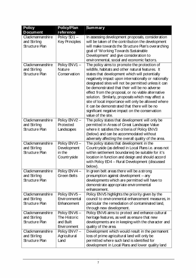
Does the site impact on designated sites? The eastern boundary of the site is adjacent to ancient woodland on (Pond Wood) and is within approximately 1km of the Forth Estuary SPA, Ramsar and SSSI. As
0 Mitigation unlikely to be required. No adverse effect on
29
SEA /site assessment topic
Site appraisal criteria Site issues and discussion Summary of Effect of development (++/+/0/-/--)
Enhancement and mitigation options
Potential effect following mitigation
fauna the site is relatively small, it is unlikely that there would be any negative effect on designated areas as a result of development.
designated sites.
Does the site impact on priority habitats or species?
There are numerous Phase 1 habitat survey Target Note sites within 500m of the site; there are several within Pond Wood in particular. This is also an area where Clackmannanshire Council keeps records of Phase 1 and Phase 2 surveys.
The site is identified in the Phase 1 Habitat Survey as arable and pasture.
The woodland to the east of the site provides habitat connectivity to Pond Wood
The site is presently an area of open space but is not safeguarded or designated as a countrypark or local nature reserve. Development of the Earlsfield site is unlikely to have a significant effect on local wildlife conservation, however it is likely to provide an area of habitat for species foraging.
0 Mitigation is unlikely to be required.
Does the development of the site avoid adverse effects on the integrity of the Firth of Forth SPA and Ramsar site?
The site does not impact directly on the Firth of Forth SPA and Ramsar site as the site lies on the outskirts of Alloa and as such is surrounded by existing developed areas
0
Does the development of the site maintain and enhance populations of European Protected Species including protection of their resting places?
The mature boundary trees may provide bat roosts. Site specific survey should be undertaken prior to development of the site to ascertain the presence of European Protected Species and appropriate mitigation implemented if these species are identified.
0/- Following site specific survey, appropriate mitigation should be identified and implemented.
Does the site facilitate the restoration and enhancement of biodiversity in all our urban and rural environments through better planning, design and practice?
The site includes part of woodland generalist 1km dispersal networks and an area of broadleaved species 500m dispersal network. The site is also important for its proximity to Pond Wood. Development of the site would result in the loss of the open space and woodland habitat.
- The woodland to the eastern site boundary should be protected and enhanced.
Minor negative effect.
Population and human health
Is the site connected to the local core path network?
The site is directly connected to the Core Path Network providing links to The Black Devon, areas of woodland (Black Wood and Mary Wood) and Clackmannan in the east.
Development at the Earlsfield site could help to strengthen these connections.
+ Connectivity could be enhanced through designation of Riverside View as part of the Core Path Network as this links directly onto existing routes.
How does the site relate to areas with high SIMD?
West Earlsfield has a relatively high SIMD rating but is outwith the Alloa ROA agreement area.
Development of the site will have a positive effect on regeneration.
+ Development of the site could be further enhanced by promoting links to core paths, recreational resources and centres of employment.
No mitigation will be required as the effect of development on population and human health will be positive.
What is the relationship of the site with existing open space resources?
The site is located directly south of Earlsfield Rugby ground and is within 400m of both Alloa Park and the nearby St Mungo’s school playing field. In addition the site is well connected to the Core Path network and provides links to nearby woodland in the east. The area of woodland is also identified as an area with potential for recreational development as part of the proposed housing development to the north of the site.
The site currently plays a role in providing an area of informal open space and development of the site would result in a loss of this function. However this role is not considered significant due to the poor drainage and tussocky vegetation which limits access.
Earlsfield is therefore well positioned with respect to open space and development
++ Access links to these resources should be implemented should these sites be developed.

30
SEA /site assessment topic
Site appraisal criteria Site issues and discussion Summary of Effect of development (++/+/0/-/--)
Enhancement and mitigation options
Potential effect following mitigation
of the site could further enhance this resource.
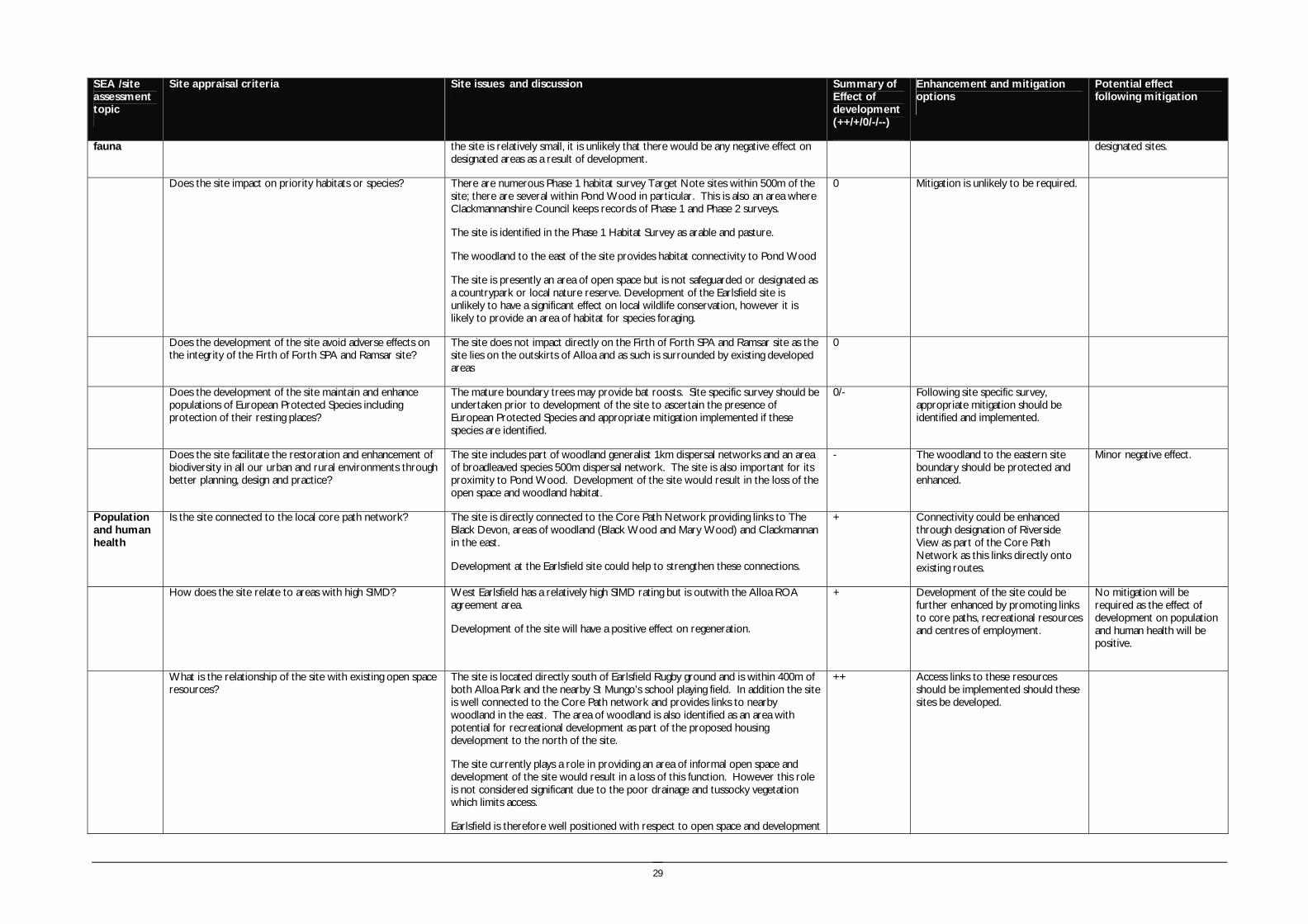
Water
Is the site at risk of flooding?
The site does not lie within the flood risk areas identified in the SEPA flood risk mapping. However, the Black Devon and culverted area of the Bothie Burn which runs through the town of Alloa are identified as at risk of flooding in the SEPA flood risk map and the Clackmannanshire Council Biennial flooding report (2007). Flooding from the Forth Estuary is also identified as a risk, and the Black Devon to the east of the site is also tidal at this point.
The cumulative effect arising from the risk of all areas flooding could result in flooding at the site. In addition the flat and low lying nature of the site results in surface water drainage issues which would have to be addressed through development, and limits opportunities for mitigation of the effects of flooding.
- A detailed assessment of the flood risk associated with the site should be undertaken and SUDS should be implemented on site.
Further investigation required.
Are there water courses within the site or which would be affected by increased levels of pollution from development within the site?
There are no water courses directly within the site. There is a drain approximately 50m south east of the site which links to the Black Devon (approximately 200m from the site boundary) and the Firth of Forth to the south.
Whilst there are unlikely to be any adverse effects on watercourses as a result of development of the site, the risk of pollution always remains.
-/0 The implementation of SUDS and good environmental management practices should prevent any pollution of water course as a result of development at the site.
No effect
Are there water courses within the site or which would be affected by increased levels of flooding resulting from development of the site?
There are no recorded flooding incidents in relation to this site although surrounding areas are considered to be at risk from flooding as discussed above and could be affected by increased run off as a result of development of the area. In particular, there could be an increase in water flowing to the Black Devon from the drain located approximately 50m from the site boundary. However, the site is relatively small in extent and therefore the quantity of increased run off is likely to be minimal.
0 Implementation of SUDS could help to alleviate any increased risk of flooding should the site be developed.
Further investigation required.
Soil Does the site include areas of vacant or derelict land?
The site is not vacant or derelict land. 0
Is the site prime agricultural land?
The site is not an area of prime quality agricultural land. 0
Air Quality and Transport
Is the site easily accessible by the local path network, and provide access to settlements and services?
The site is located on the outer fringes of Alloa and is well linked with Clackmannan via the Core Path Network.
+ Promotion of the Core Path Network could help facilitate access between the site and Clackmannan.
Is the site easily accessible by public transport? The site is located about 1km away from the centre of Alloa and the new Alloa train station and has reasonable accessibility to public transport Development of the site could therefore have a positive effect on the number of people in the council area choosing to opt for public transport instead of using private cars to commute to work and access local services.
+
Does the site lie within an area where levels of air pollution are close to current limit values?
Available air quality data indicates that there are no exceedences of Nitrogen Dioxide or Particulates within the council area. There are no AQMAs within Clackmannanshire however air quality and traffic monitoring is ongoing. The site itself is not identified as being problematic in terms of air pollution levels and as such, development of the site is unlikely to have any significant effect on this criterion.
0
Would development on the site contribute to higher traffic flows along transport routes or at key junctions (potentially
As the site is relatively small there is unlikely to be any significant change in the 0 No mitigation required however promotion of cycling/walking through

31
SEA /site assessment topic
Site appraisal criteria Site issues and discussion Summary of Effect of development (++/+/0/-/--)
Enhancement and mitigation options
Potential effect following mitigation
outwith the local authority area) where levels of air pollution are close to current limit values?
amount of traffic generated locally if development were to take place.
Cumulative effects require to be assessed in Stage 2.
the development of pathways and good access to town centres could help reduce the number of journeys made by private vehicle and have a knock on positive effect on emission levels.
Climatic Factors
Does the location of the development reduce the need to travel?
Alloa and Clackmannan are both readily accessible from the site and schools and services are accessible within close proximity to the site. Development of this site would therefore reduce the need to travel for those who lived there.
+ n/a
Is the site at risk of increased flooding or instability as a result of climate change?
Extreme weather conditions and flooding as a result of climate change could potentially result in flooding of the site due to the proximity of other flood risk areas as discussed above.
- Development of this site and the surrounding area should take future flood risk into account in the design and layout of the development.
Further investigation required.
Material Assets
Is the site located close to existing transport, services, water and energy infrastructure?
The site lies close to other residential areas and therefore anticipated to be provided from existing infrastructure.
0
Is the site located to make best use of shelter and solar gain?
The site is flat and in a sheltered location and is favourably located to make best use of shelter and solar gain.
0/+
Would development on the site reduce future potential for mineral extraction?
The site is located close to the urban edge of Alloa and although an area of search for open cast coal is identified to the east of the site, this is a restricted area.
0
Does the site include any hazard areas? (oil or gas pipelines)
There is a hazard area which partly overlaps the west of the site, occupying approximately one third of the available land area.
- The hazard area could potentially form an area of open space within the development, or to accommodate SUDS however the role of this area for the provision of SUDS may be affected by the scope to excavate in the hazard zone.
Further investigation required.
Does the site reduce waste generation and promote waste recovery, recycling and composting?
The site will generate additional waste arisings, however as it is located within the urban area it will not generate significant additional waste related journeys.
-
Cultural Heritage
Would development within the site impact on the integrity of sites, monuments, buildings or areas designated for their cultural heritage value?
The site is approximately 250m away from the Old Alloa Conservation Area and several listed buildings in the town. This includes Alloa Tower which is located within 500m of the site, and there are also distant views across the parkland to Clackmannan Tower.
However there are no designated sites of monuments within the site boundary itself. As such, development of the site would be unlikely to have an effect on the cultural heritage value of the area.
0 No mitigation would be required.
Would development within the site impact on archaeological remains?
There are no known archaeological remains within the site boundary. The site is identified in the HLA as a relict designed landscape from the 17th-19th century.
0 No mitigation would be required. No effect.
Landscape Does the site lie within an area designated for its landscape value?
The site lies within the settlement boundary and there are no areas nearby designated for their landscape value. However the site forms part of the wider parkland setting for distant views to Clackmannan Tower.
0
Would development within the site impact on settlement setting and identity (drawing on issues of landscape character and capacity for development)?
There is an existing settlement directly to the west of the site boundary however it is unlikely that development of Earlsfield would have any effect on the setting
0 No mitigation required.

32
SEA /site assessment topic
Site appraisal criteria Site issues and discussion Summary of Effect of development (++/+/0/-/--)
Enhancement and mitigation options
Potential effect following mitigation
and identity of this area.
Would development within the site impact on key views to landscape features or from key transport routes?
The site would potentially be viewed from local roads to and around it however the development would primarily be seen as a small extension to an existing area of urban development with surrounding areas of open space.
The wider landscape of which this site is part has a strong policy character, although this is of degraded quality. The oak trees at the eastern end are an important local landscape feature which should be retained, however in association with the area of land identified as a hazard zone, this would result in a reduction in the viable available area of land for development on this site.
- Enhancement and retention of the oak trees at the eastern end of the site, in association with enhancement of the wider former policy landscape.

33
Mature trees to east of site and unmanaged vegetation

34
Site reference and location: SITE 4 ALLOA EAST (1), CARSEBRIDGE, ALLOA
Size (ha) 7.93
Size (group) Medium
Summary description including site access and public transport connections
Lying between the B909 and the Alloa – Dunfermline railway line and to the east of Alloa town centre. Within 1 km of Alloa train station and closely accessibly to the A907 and A908 main roads and bus links. The site lies within the settlement boundary and is allocated for housing development in the local plan.
The main access to this site would be directly onto the B909 is on embankment through the area and this would present issues for access onto this road. However there is existing access to the warehouse.
Overriding constraints to development
None
Site specific investigations Drainage
Ground stability
Constraints to development Major – inundation risk associated with Gartmorn Dam
Moderate – surface water drainage, flood risk
Summary of area remaining following mitigation
Implementation of SUDS
Management of risk associated with Gartmorn Dam
Environmental features The site was recently modified by the construction of the B909 and the construction works associated with the new railway.
Trees and vegetation A small woodland belt is located in the south eastern corner of the site, the site comprises unmanaged rushy pasture.
Field boundaries: Post and wire adjacent to B909, industrial style fencing adjacent to bonded warehouse with poplars along boundary.
Water (ponds, rivers and streams): There are no water courses located within the site. Surface water forms a shallow pond which is developing over a large part of this site.
Role as part of FHN: The site includes parts of the woodland generalist 1km dispersal network which provides connectivity to the wider FHN to the east.
Site ownership:
Site type: Settlement expansion
Current land use Unmanaged agricultural field.
Surrounding land use The railway line and fire station are located to the south, residential housing lies to the west and there are fields and warehouses to the north. To the east is open farmland.
Planning policy framework: Clackmannanshire Local Plan Schedule of Sites – H1 (2) Hilton Sites 1 & 2 Development Guidelines:
Existing Uses: Business/Vacant/Grazing Subject to Masterplan for entire expansion area, (Residential and Businesses uses – see Business Site 11). Subject to Development Brief for each site. Provision of active/passive open space. Developer contributions required for provision of Eastern Relief Road/ associated traffic management measures. Part redevelopment of bonded warehouses required. Access from Hilton Road for Site 1. Access from new Relief Road for Site 2. Structural planting/landscaping to boundaries. Enhance and retain existing burn and woodland on site. Ground conditions will require investigation (White land for future allocation development).
Also Policy RES5 - Affordable and Particular Needs Housing: The policy aims to secure a proportion of affordable/particular needs housing on all developments over 30 houses.
35
SEA /site assessment topic
Site appraisal criteria Site issues and discussion Summary of Effect of development (++/+/0/-/--)
Enhancement and mitigation options
Potential effect following mitigation
Biodiversity, flora and fauna
Does the site impact on designated sites?
There are no designated sites within the site boundary or within the identified buffers. 0
Does the site impact on priority habitats or species?
The site is identified as improved grassland in the Phase 1 Habitat Survey. 0
Does the development of the site avoid adverse effects on the integrity of the Firth of Forth SPA and Ramsar site?
The site does not impact directly on the Firth of Forth SPA and Ramsar site as the site lies on the outskirts of Alloa and is over 1km from the site.
0
Does the development of the site maintain and enhance populations of European Protected Species including protection of their resting places?
The woodland may provide bat roosts and the wetland may provide habitat for species such as great crested newt. Site specific survey should be undertaken prior to development of the site to ascertain the presence of European Protected Species and appropriate mitigation implemented if these species are identified.
0/- Following site specific survey, appropriate mitigation should be identified and implemented.
Does the site facilitate the restoration and enhancement of biodiversity in all our urban and rural environments through better planning, design and practice?
The development of the site would potentially result in loss of wetland and woodland. The site includes parts of the woodland generalist 1km dispersal network which provides connectivity to the wider FHN to the east.
- The existing woodland and wetland should be protected and enhanced.
Minor negative effect.
Population and human health
Is the site connected to the local core path network?
A core path connection provides recreational access from the north east of the site, however there is no other access by core paths from the site. However there is access on local roads and pavements to Alloa town centre.
+
How does the site relate to areas with high SIMD?
The site lies adjacent to areas within the top 15% ranking of the Scottish Index of Multiple Deprivation 2006, and the Alloa Regeneration area.
Development within this area may contribute to the regeneration of the area through providing new development and investment.
+
What is the relationship of the site with existing open space resources?
There is a playing field located at the western end of the site and the football ground is within 200m of the site.
The site is well connected and provided with access to recreational open space due to the playing field to the west of the site.
++
Water
Is the site at risk of flooding?
Parts of the site are identified on the SEPA flood map as being at risk of flooding from rivers, which is likely to be from the Brothie Burn. The site contains an area of developing standing water and rushy pasture which identifies issues with surface water drainage.
- The presence of standing water may reduce the opportunity for the development of SUDS.
The flood risk of the site should be investigated further. This is a low lying site in close proximity to a watercourse with evidence of surface water drainage issues.
Are there water courses within the site or which would be affected by increased levels of pollution from development within the site?
The Brothie Burn is culverted, and this reduces the opportunity for pollution from development within the site.
There is some potential for diffuse pollution caused by run off from the development of the site.
0/- The implementation of SUDS on the site could reduce the impacts of contamination from run off. The size of the site may reduce opportunities to accommodate SUDS.
Are there water courses within the site or which would be affected by increased levels of flooding resulting from development of the site?
The development of the site would potentially increase run off to the Brothie Burn. - Further detailed investigation of site drainage constraints should be carried out.

36
SEA /site assessment topic
Site appraisal criteria Site issues and discussion Summary of Effect of development (++/+/0/-/--)
Enhancement and mitigation options
Potential effect following mitigation
There are known flooding issues associated with the Brothie Burn.
Soil Does the site include areas of vacant or derelict land?
The site is not vacant or derelict land. 0
Is the site prime agricultural land?
The site is not prime agricultural land. 0
Air Quality and Transport
Is the site easily accessible by the local path network, and provide access to settlements and services?
The site lies within 1.5km of Alloa town centre and this can be accessed along roads and pavements. There are core path connections which provide recreational access to the north east of the site.
The site is well connected to the services and transport nodes within Alloa town centre.
++
Is the site easily accessible by public transport? The site lies within 1km of Alloa railway station and the A907 and A908 which provide access to regular bus services.
The site lies within close proximity to Alloa town centre and public transport connections.
++
Does the site lie within an area where levels of air pollution are close to current limit values?
The closest air quality monitoring stations for nitrogen dioxide indicate no significant trend in levels between 2002 and 2007.
Development of the site is unlikely to have a significant impact on local air quality. However, should several sites within the local area be developed, the cumulative effect on air quality should be considered.
0
Would development on the site contribute to higher traffic flows along transport routes or at key junctions (potentially outwith the local authority area) where levels of air pollution are close to current limit values?
The site will potentially have a minor effect on traffic levels on the A907 and A908, however the site is small in extent and therefore this effect is not likely to be significant.
Development of the site is unlikely to have a significant impact on local traffic flows. However, should several sites within the local area be developed, the cumulative effect should be considered
0
Climatic Factors
Does the location of the development reduce the need to travel?
The site is located within Alloa and with close access to public transport and services. ++
Is the site at risk of increased flooding or instability as a result of climate change?
The site is identified as having some potential flood risk, which may be exacerbated by climate change.
- The implementation of SUDS may reduce the impacts of this.
Material Assets
Is the site located close to existing transport, services, water and energy infrastructure?
The site is located within the built up area of Alloa and therefore close to existing transport, services, water and energy infrastructure.
++
Is the site located to make best use of shelter and solar gain?
The site is located on a flat to gently sloping area partially screened from the south by the existing woodland belt adjacent to the railway. This is a sheltered location, although some of the woodland would reduce solar gain.
+
Would development on the site reduce future The development of the site would not further reduce future potential for mineral 0

37
SEA /site assessment topic
Site appraisal criteria Site issues and discussion Summary of Effect of development (++/+/0/-/--)
Enhancement and mitigation options
Potential effect following mitigation
potential for mineral extraction? extraction.
Does the site include any hazard areas? (oil or gas pipelines)
The site does not lie within any oil or gas pipeline hazard areas. 0
Does the site reduce waste generation and promote waste recovery, recycling and composting?
Development of the site would generate additional waste arisings, however the site is small in extent and lies adjacent to an existing urban areas for which recycling facilities will be provided.
-
Cultural Heritage
Would development within the site impact on the integrity of sites, monuments, buildings or areas designated for their cultural heritage value?
There are no known historic environment features within the site or in the identified buffer of the site. The site is identified in the HLA as 18th -19th century fields and farming.
0
Would development within the site impact on archaeological remains?
There are no known archaeological remains within the site boundary. 0
Landscape Does the site lie within an area designated for its landscape value?
The site is not designated AGLV or Greenbelt. The landscape lies within the Lower Devon Carselands landscape character area which is characterised by the twisting course of the Devon contrasting with the channelled drainage ditches and large scale rectilinear fields. The Ochil hills are a dominant feature and the hillfoot villages nestle at their base.
0 The guidelines for this character area support the definition of settlement boundaries which should be defined through woodland planting to reflect existing field patterns and woodland planting.
Would development within the site impact on settlement setting and identity (drawing on issues of landscape character and capacity for development)?
The development of the site would not impact negatively on settlement setting and identity. The site does not strongly visually relate to the existing settlement and development could be accommodated within this area.
0
Would development within the site impact on key views to landscape features or from key transport routes?
The site is highly visible from the B909, however the local area is already influenced by the developed character contributed by the warehouses and although locally prominent, is not widely visible.
0

38
Area of standing water and rushes within site
Woodland to south of site boundary

39
Site reference and location:
SITE 5 ALLOA EAST (2), CARSEBRIDGE, ALLOA
Size (ha) 6.42
Size (group) Medium
Summary description including site access and public transport connections
Lying north of the B909 and to the east of Alloa town centre. Within 1 km of Alloa train station and accessibly to the A907 and A908 main roads and bus links. The site lies within the settlement boundary.
Site access would have to be taken from the B909. If site 4 was also developed a roundabout on the B909 could serve to provide access to both sites.
Overriding constraints to development
None
Site specific investigations Drainage
Ground stability
Constraints to development Major – inundation risk associated with Gartmorn Dam
Moderate – Flood risk
Minor – surface water drainage
Summary of area remaining following mitigation
The whole of the site is assumed at potential inundation risk associated with Gartmorn Dam
Environmental features The site was recently modified by the construction of the B909 as a result of the railway reinstatement.
Trees and vegetation A small woodland belt is located to the east of the site. The site comprises unmanaged pasture.
Field boundaries: The boundary with the road is post and wire fence and there is security fencing with poplars along the boundary with the bonded warehouse. Hedgerow trees extend along the boundary with the footpath to the east of the site.
Water (ponds, rivers and streams):The culverted Brothie Burn runs through the site.
Site ownership:
Site type: Settlement expansion
Current land use Unmanaged agricultural land
Surrounding land use There are warehouses to the immediate north of the site. To the east is open farmland, located beyond a shelterbelt.

40
Planning policy framework: Clackmannanshire Local Plan Schedule of Sites – H1 (2) Hilton Sites 1 & 2 Development Guidelines:
Existing Uses: Business/Vacant/Grazing Subject to Masterplan for entire expansion area, (Residential and Businesses uses – see Business Site 11). Subject to Development Brief for each site. Provision of active/passive open space. Developer contributions required for provision of Eastern Relief Road/ associated traffic management measures. Part redevelopment of bonded warehouses required. Access from Hilton Road for Site 1. Access from new Relief Road for Site 2. Structural planting/landscaping to boundaries. Enhance and retain existing burn and woodland on site. Ground conditions will require investigation (White land for future allocation development).
Also: Policy RES5 - Affordable and Particular Needs Housing: The policy aims to secure a proportion of affordable/particular needs housing on all developments over 30 houses.
Due to the risk of flooding the following should also be taken into account:
Clackmannanshire and Stirling Structure Plan Policy ENV9 – Water Resource Management: The policy states that development will not normally be permitted in undeveloped flood plain areas, in areas of known significant flood risk, or if it will adversely affect the Forth Estuary. Exceptions will be made only when it can be demonstrated that no alternative locations can be found, or that suitable mitigation measures can be implemented. Clackmannanshire Local Plan Policy EN4 – Water Resources: The policy states that where a development area is determined as being at risk of flooding, planning permission will not be granted except where it can be proven that there are no viable alternative sites.
SEA /site assessment topic
Site appraisal criteria Site issues and discussion Summary of Effect of development (++/+/0/-/--)
Enhancement and mitigation options
Potential effect following mitigation
Biodiversity, flora and fauna
Does the site impact on designated sites?
There are no designated sites within the site boundary or within the identified buffers. 0
Does the site impact on priority habitats or species?
The site is identified in the Phase 1 Habitat Survey as arable and pasture 0
Does the development of the site avoid adverse effects on the integrity of the Firth of Forth SPA and Ramsar site?
The site does not impact directly on the Firth of Forth SPA and Ramsar site as the site lies on the outskirts of Alloa over 1km from the site and is surrounded by existing developed areas.
0
Does the development of the site maintain and enhance populations of European Protected Species including protection of their resting places?
The mature boundary trees may provide bat roosts. Site specific survey should be undertaken prior to development of the site to ascertain the presence of European Protected Species and appropriate mitigation implemented if these species are identified.
0/- Following site specific survey, appropriate mitigation should be identified and implemented.
Does the site facilitate the restoration and enhancement of biodiversity in all our urban and rural environments through better planning, design and practice?
The woodland along the eastern site boundary is part of the woodland generalist 1km dispersal network. The development of the site could potentially result in loss of trees and open space which provide local biodiversity value.
- The woodland belt to the eastern site boundary should be protected and enhanced.
Minor negative effect.
Population and human health
Is the site connected to the local core path network?
A core path connection provides recreational access through the shelterbelt to the east of the site where access can be gained north and east to Gartmorn Dam.
However there is access on local roads and pavements to Alloa town centre.
+
How does the site relate to areas with high SIMD?
The site lies adjacent to areas within the top 15% ranking of the Scottish Index of Multiple Deprivation 2006, and the Alloa Regeneration area.
Development within this area may contribute to the regeneration of the area through providing new development and investment.
+

41
SEA /site assessment topic
Site appraisal criteria Site issues and discussion Summary of Effect of development (++/+/0/-/--)
Enhancement and mitigation options
Potential effect following mitigation
What is the relationship of the site with existing open space resources?
Notes connections to key recreational area or designation as a safeguarded open space or country park
There is a playing field located in close proximity to the site and the football ground is within 500m of the site.
The site is well connected and provided with access to recreational open space due to the proximity of the playing field to the west of the site.
++
Water
Is the site at risk of flooding?
Parts of the site are identified on the SEPA flood map as potentially being at risk of flooding from rivers, which is likely to be from the Brothie Burn.
- The flood risk of the site should be investigated further. This is a low lying site in close proximity to a watercourse.
Are there water courses within the site or which would be affected by increased levels of pollution from development within the site?
The Brothie Burn is culverted, and this would reduce the opportunity for pollution from development within the site.
There is some potential for diffuse pollution caused by run off from the development of the site.
0/- The implementation of SUDS on the site could reduce the impacts of contamination from run off. The size of the site may reduce opportunities to accommodate SUDS.
Are there water courses within the site or which would be affected by increased levels of flooding resulting from development of the site?
The development of the site would potentially increase run off to the Brothie Burn.
There are known flooding issues associated with the Brothie Burn. (confirm that these are downstream)
-
Soil Does the site include areas of vacant or derelict land?
The site is not vacant or derelict land. 0
Is the site prime agricultural land?
The site is not prime agricultural land. 0
Air Quality and Transport
Is the site easily accessible by the local path network, and provide access to settlements and services?
The site lies within 2km of Alloa town centre and this can be accessed along roads and pavements. There are core path connections which provide recreational access to the north east of the site.
The site is well connected to the services and transport nodes within Alloa town centre.
++
Is the site easily accessible by public transport? The site lies within 1km of Alloa railway station and the A907 and A908 which provide access to regular bus services.
The site lies within close proximity to Alloa town centre and public transport connections.
++
Does the site lie within an area where levels of air pollution are close to current limit values?
The closest air quality monitoring stations for nitrogen dioxide indicate no significant trend in levels between 2002 and 2007.
0
Would development on the site contribute to higher traffic flows along transport routes or at key junctions (potentially outwith the local authority area) where levels of air pollution are close to current limit values?
The site will potentially have a minor effect on traffic levels on the A907 and A908, however the site is small in extent and therefore this effect is not likely to be significant.
0

42
SEA /site assessment topic
Site appraisal criteria Site issues and discussion Summary of Effect of development (++/+/0/-/--)
Enhancement and mitigation options
Potential effect following mitigation
Climatic Factors
Does the location of the development reduce the need to travel?
The site is located within Alloa and with close access to public transport and services. ++
Is the site at risk of increased flooding or instability as a result of climate change?
The site is identified as having some potential flood risk, which may be exacerbated by climate change.
- The implementation of SUDS may mitigate these impacts
Material Assets
Is the site located close to existing transport, services, water and energy infrastructure?
The site is located within the built up area of Alloa and therefore close to existing transport, services, water and energy infrastructure.
++
Is the site located to make best use of shelter and solar gain?
The site is located on a flat to gently sloping area in a sheltered location. +
Would development on the site reduce future potential for mineral extraction?
The development of the site would not further reduce future potential for mineral extraction.
0
Does the site include any hazard areas? (oil or gas pipelines)
The site does not lie within any oil or gas pipeline hazard areas. 0
Does the site reduce waste generation and promote waste recovery, recycling and composting?
The site does not have a significant impact on waste generation, however as it is located within the urban area it will not generate significant additional waste related journeys.
-
Cultural Heritage
Would development within the site impact on the integrity of sites, monuments, buildings or areas designated for their cultural heritage value?
There are no known historic environment features within the site or in the identified buffer of the site. The site is identified in the HLA as 18th -19th century fields and farming.
0
Would development within the site impact on archaeological remains?
There are no known archaeological remains within the site boundary. 0
Landscape Does the site lie within an area designated for its landscape value?
The site is not designated AGLV or Greenbelt. The landscape lies within the Lower Devon Carselands landscape character area.
0
Would development within the site impact on settlement setting and identity (drawing on issues of landscape character and capacity for development)?
The development of the site would not impact negatively on settlement setting and identity. The site does not strongly visually relate to the existing settlement and development could be accommodated within this area.
0
Would development within the site impact on key views to landscape features or from key transport routes?
The site is highly visible from the B909, however the local area is already influenced by the developed character contributed by the warehouses and although locally prominent, is not widely visible.
0

43
Poplars adjacent to bonded warehouses
Woodland to north east of site boundary

44
Site reference and location:
SITE 6 ALLOA WEST EXPANSION AREA, ALLOA
Size (ha) 18.86
Size (group) Medium
Summary description including site access and public transport connections
The site lies in close proximity to the River Forth on the south western edge of Alloa. The site comprises a flat area of farmland adjacent to industrial and residential development at the riverside. The majority of the site lies within the settlement boundary, part of the western edge lies outwith the boundary.
Access should be taken onto Smithfield Loan to the existing roundabout on the A907.
Overriding constraints to development
None
Site specific investigations Drainage
Ground stability
Constraints to development Major – flood risk. Potential impact on Firth of Forth SPA
Summary of area remaining following mitigation
Implementation of SUDS may be limited due to low lying nature of the site.
Environmental features The site comprises very flat arable farmland with natural regeneration woodland on the disused sidings to the north of the site. The route of a disused railway passes through the southern part of the site.
Trees and vegetation An area of woodland extends along the northern boundary of the site on the location of former railway sidings.
Field boundaries: The majority of the site is not enclosed by field boundaries, with post and wire fences at the southern boundary of the site. The northern site boundary includes outgrown hedgerow trees and the western site boundary includes deciduous pioneer woodland
Water (ponds, rivers and streams): There are no water resources on the site, however a pond lies within 50m of the site boundary at Longcarse and the Firth of Forth is within 200m of the site boundary.
Site ownership:
Site type: Settlement expansion
Current land use Predominantly arable agriculture with some pasture to the south of the dismantled railway.
Surrounding land use To the north and east is the residential and industrial area of Alloa, to the east is housing, industrial, business and warehouse use. There is farmland to the south and west of the area.
45
Planning policy framework: The site includes an area designated for ‘Jobs’ in the Local Plan:
Clackmannanshire Local Plan Schedule of Sites - J16 New Alloa Business Park:
Development Guidelines: Access from Arnsbrae Roundabout/Smithfield Loan. High quality business park geared to appropriate Class 4 uses with potential for Classes 5 and 6 to south east part of site, subject to protection of amenity for neighbouring uses. Incorporates Pavilions Business Park and Alloa “Smart Village”.
The site lies partly within the areas designated as ‘Developed and ‘Undeveloped Coast’ in the Local Plan:
Clackmannanshire Local Plan Policy EN5 – The Coast:: The policy states that the Undeveloped Coast will be protected from further development except where it can be proven that there are no viable alternative sites.
The site is in proximity to the Firth of Forth SPA, RAMSAR and SSSI and therefore the following Structure Plan policy should be taken into account:
Clackmannanshire and Stirling Structure Plan Policy ENV1 – Nature Conservation: The policy aims to promote the protection of wildlife, habitats and other natural features. It states that development which will potentially negatively impact upon internationally or nationally designated sites will not be permitted unless it can be demonstrated that their will be no adverse effect from the proposal, or no viable alternative solution.
Due to the limited opportunities for managing flood risk on the site, the following policies are of relevance:
Clackmannanshire and Stirling Structure Plan Policy ENV9 – Water Resource Management: The policy states that development will not normally be permitted in undeveloped flood plain areas, in areas of known significant flood risk, or if it will adversely affect the Forth Estuary. Exceptions will be made only when it can be demonstrated that no alternative locations can be found, or that suitable mitigation measures can be implemented. Clackmannanshire Local Plan Policy EN4 – Water Resources: The policy states that where a development area is determined as being at risk of flooding, planning permission will not be granted except where it can be proven that there are no viable alternative sites.
As the site comprises vacant or derelict land the following policy is of relevance:
Clackmannanshire Local Plan - Policy RES2 – Brownfield Development: The policy prioritises development which will take place on brownfield sites which will utilise vacant, derelict, contaminated and underused land and property within settlement boundaries.
As the site includes two core paths the following should be considered:
Clackmannanshire Local Plan Policy INF3 – Local Access: The policy states that development will not be permitted where it will result in the loss of an asserted right of way, footpath or a path forming part of the Clackmannanshire path network unless the provision of an alternative path can be assured.
NB. For the part of the site outwith the settlement boundary the following apply:
Clackmannanshire and Stirling Structure Plan Policy ENV3 – Development in the Countryside: The policy states that development in the Countryside (as defined in Local Plans i.e. areas not within settlement boundaries) be suitable for it’s location in function and design and should accord with Policy ED4 – Rural Development (see below).
Clackmannanshire and Stirling Structure Plan Policy ED4 – Rural Development: The policy states that economic and social development in rural areas will be supported within the following criteria:
• Focusing development within existing towns and villages
• Restricting development within Green Belt and countryside.
Clackmannanshire Local Plan Policy EN18 – Development in the Countryside: Sets out the criteria for the granting of planning permission to a proposed development in the countryside.
Clackmannanshire and Stirling Structure Plan Policy H6 – Housing in the Countryside: The policy states that new housing developments in the Countryside will only be approved where the development is essential, involves the conversion of an existing building, or is consistent with Policy H5 ‘Housing in the Upland Area’.
Planning History An outline planning application for housing and business uses adjacent to and south of the distributor road has been given consent.

46
SEA /site assessment topic
Site appraisal criteria Site issues and discussion Summary of Effect of development (++/+/0/-/--)
Enhancement and mitigation options
Potential effect following mitigation
Biodiversity, flora and fauna
Does the site impact on designated sites?
There are no designated sites within the site boundary, however the Forth SPA, Ramsar, SSSI lies within 200m of the site boundary. The SPA citation statement seeks to avoid significant disturbance to the qualifying species and ensuring that the integrity of the site is maintained. Development close to the SPA may result in disturbance to the species for which the SPA is designated. Alloa New Marshalling Yards are identified as a wildlife site in the north western corner of the site.
-- Development of this site has a potential cumulative impact in association with loss of other undisturbed areas within the Forth Valley. A recreation and access management plan would reduce additional disturbance to the adjacent Firth of Forth SPA and Ramsar.
Does the site impact on priority habitats or species?
The disused sidings to the north of the site have been subject to Phase 2 habitat survey and there are 5 Phase 1 Habitat Survey target note sites within this area.
Development of the site would potentially result in disturbance to the bird species noted in the SPA citation.
The site is identified in the Phase 1 Habitat Survey as arable and pasture, with unimproved neutral pasture along the route of the disused railway.
-
Does the development of the site avoid adverse effects on the integrity of the Firth of Forth SPA and Ramsar site?
The development of the site may result in increased disturbance to the species for which the Firth of Forth SPA and Ramsar is designated.
-- Reduction in the area of the site proposed for development may reduce the potential impact of the development of the site. Site specific survey should be undertaken to ascertain the extent of any likely disturbance resulting from development of the site.
Does the development of the site maintain and enhance populations of European Protected Species including protection of their resting places?
The mature boundary trees may provide bat roosts. Site specific survey should be undertaken prior to development of the site to ascertain the presence of European Protected Species and appropriate mitigation implemented if these species are identified.
0/- Following site specific survey, appropriate mitigation should be identified and implemented.
Does the site facilitate the restoration and enhancement of biodiversity in all our urban and rural environments through better planning, design and practice?
The woodland to the north of the site forms part of the woodland generalist 1km dispersal network. Development of the site may result in loss of boundary woodland which provides local biodiversity value.
- The role of the perimeter woodland as part of the habitat network should be protected and enhanced.
Population and human health
Is the site connected to the local core path network?
The site is includes two core paths and is well connected to the wider core path network providing access into the urban area and to the west for recreation. The disused railway is an important access route and the area is popular for recreation.
++ There is opportunity to improve the access along the former railway.
How does the site relate to areas with high SIMD?
The site does not lie close to or within the top 15% ranking of the Scottish Index of Multiple Deprivation 2006.
0
What is the relationship of the site with existing open space resources?
There are no open space resources per se, however the riverside and access networks provide an open space resource.
+ The access routes should be maintained should the development of the site take place.
Water
Is the site at risk of flooding?
The site lies immediately adjacent to the Firth of Forth and lies adjacent to areas identified on the SEPA flood map as potentially being at risk of flooding from the sea. This is a flat site and therefore there may be limited opportunity to manage flood risk on the site.
The pumping station located to the east of the site boundary has previously resulted
-- The low lying nature of the site and proximity to the River Forth reduces the options for flood mitigation.
47
SEA /site assessment topic
Site appraisal criteria Site issues and discussion Summary of Effect of development (++/+/0/-/--)
Enhancement and mitigation options
Potential effect following mitigation
in flooding of the area when breakdown occurs.
Are there water courses within the site or which would be affected by increased levels of pollution from development within the site?
There is a pond at Longcarse and the Firth of Forth may be affected by run off from the site.
- The implementation of SUDS will reduce the impact of run off from the site.
Are there water courses within the site or which would be affected by increased levels of flooding resulting from development of the site?
There are no watercourses within the site, however the site may play a current role in holding surface water and contribute to reducing the rate of run off to the Firth of Forth.
-
Soil Does the site include areas of vacant or derelict land?
The majority of the site comprises an area of vacant or derelict land. ++
Is the site prime agricultural land?
The site is not prime quality agricultural land. 0
Air Quality and Transport
Is the site easily accessible by the local path network, and provide access to settlements and services?
The site is well connected by the core path network and although located on the periphery of Alloa lies within 2km of the central area of the town.
++
Is the site easily accessible by public transport? The site is located a short distance from the A907 and local bus routes.
Alloa station is within 2km of the site.
+
Does the site lie within an area where levels of air pollution are close to current limit values?
The nearest air quality monitoring locations for NO2 are at Norwood Avenue and Glasshouse Loan and these do not show any clear trends in NO2 concentrations between 2002 and 2007.
0
Would development on the site contribute to higher traffic flows along transport routes or at key junctions (potentially outwith the local authority area) where levels of air pollution are close to current limit values?
Development on the site would increase traffic flows on the A907. -
Climatic Factors
Does the location of the development reduce the need to travel?
The development is located close to Alloa town centre and therefore potentially reduces the need to travel to access local services and facilities.
++
Is the site at risk of increased flooding or instability as a result of climate change?
The site is flat and low lying and therefore is at risk of increased flooding or instability as a result of climate change.
-- Mitigation options to reduce the increased flood risk associated with climate change are limited.
Material Assets
Is the site located close to existing transport, services, water and energy infrastructure?
The site is located adjacent to the existing built up area of Alloa and therefore close to existing transport, services, water and energy infrastructure.
+
Is the site located to make best use of shelter and solar gain?
The site is located on the flat low lying ground at the edge of the River Forth and is moderately well located to make best use of solar gain. Additional shelter could be provided through landscape planting.
+

48
SEA /site assessment topic
Site appraisal criteria Site issues and discussion Summary of Effect of development (++/+/0/-/--)
Enhancement and mitigation options
Potential effect following mitigation
Would development on the site reduce future potential for mineral extraction?
The site is located adjacent to residential areas and would not be appropriate for mineral extraction.
0
Does the site include any hazard areas? (oil or gas pipelines)
There are no hazard areas on site. 0
Does the site reduce waste generation and promote waste recovery, recycling and composting?
The site does not have a significant impact on waste generation, however as it is located within the urban area it will not generate significant additional waste related journeys.
-
Cultural Heritage
Would development within the site impact on the integrity of sites, monuments, buildings or areas designated for their cultural heritage value?
There are no designated features or buildings on the site or close to the site. 0
Would development within the site impact on archaeological remains?
There are no known archaeological remains within the site boundary. The HLA identifies the site as 19th century to present fields and farming.
0
Landscape Does the site lie within an area designated for its landscape value?
The site lies within the Carse of Forth landscape character area. The landscape is characterised by its broad width and flatness, and openness emphasised by a lack of woodland and field boundaries. Human settlement is a prominent feature within the landscape. The site lies partly in an area of ‘undeveloped coast’ and partly in an area of ‘developed coast’ however the majority of the site is unclassified.
0 Guidelines for this area include protection of the open agricultural character, but also highlighting roads through roadside planting and the River Forth.
Would development within the site impact on settlement setting and identity (drawing on issues of landscape character and capacity for development)?
The site lies at the periphery of Alloa and is not highly visible from the surrounding area. It is not a prominent location when approaching Alloa on the A907 due to the screening provided by the scrub and woodland to the north of the site. Development of the site would not conflict with the current settlement pattern.
0
Would development within the site impact on key views to landscape features or from key transport routes?
Development of this site would increase the extent of built development on the riverside, reducing the open expansive landscape character of the carse of Forth.
- No mitigation suitable to reduce loss of open character.

49
View north to new business development
Woodland to east of site boundary along disused railway

50
Site reference and location: SITE 7 JELLYHOLM, SAUCHIE, ALLOA (NORTH EAST)
Size (ha) 61.50
Size (group) Large
Summary description including site access and public transport connections
The site lies adjacent to the urban edge of Sauchie and Alloa and comprises gently undulating farmland with the low Post Hill at the western end. There are some mature trees at the boundary and demarking field boundaries. The site includes Jellyholm and some residential properties. A disused shaft is also marked on the OS map, to the east of the site. The site lies outwith the settlement boundary.
All of the site is within 1.4km of the A908 where bus routes are accessible.
Development within a site of this size would potentially require two access points. Site access could be taken onto Gartmorn Road which provides the main access to Sauchie and Gartmorn Dam. However this route already serves a large number of houses within the Sauchie area, and although the junction with the A908 could be upgraded to include a roundabout, an alternative option would be to use Jellyholm Road as the main site access, however this is a private road along the majority of its length and there may be issues in securing access to this site. This connects to Carsebridge Road which joins the A908 at the existing roundabout. There are known capacity issues associated with the roundabout with the B909.
Overriding constraints to development
Inundation risk from Gartmorn Dam.
Site specific investigations Ground stability
Constraints to development Major - Inundation risk from Gartmorn Dam.
Moderate – Instability. Prime agricultural land. The site also has odour amenity issues associated with the proximity to the bonded warehouses.
Minor – The woodland to the southern site boundary is covered by TPO.
Summary of area remaining following mitigation
Approximately one third of the area of the site is estimated to lie outwith the area of potential inundation risk.
Environmental features The site comprises gently undulating farmland with the low Post Hill at the western end.
Trees and vegetation Two small woodland belts adjoin the site boundary in places, and trees run alongside Gartmorn Road. The route of the Brothie Burn is wooded. The land is under both arable and pasture cultivation
Field boundaries: There are some field trees and a number of hedgerows and also outgrown hedgerow trees.
Water (ponds, rivers and streams): The Brothie Burn runs to the south of the site and a disused mill lade runs along the site boundary at Keilarsbrae.
Site ownership:
Site type: New settlement
Current land use Arable and pasture agriculture
Surrounding land use To the north is the residential area of Sauchie, to the east is industrial, business and warehouse use. There is farmland to the south and west of the area.
51
Planning policy framework: Clackmannanshire and Stirling Structure Plan Policy ENV3 – Development in the Countryside: The policy states that development in the Countryside (as defined in Local Plans i.e. areas not within settlement boundaries) be suitable for it’s location in function and design and should accord with Policy ED4 – Rural Development (see below).
Clackmannanshire and Stirling Structure Plan Policy ED4 – Rural Development:: The policy states that economic and social development in rural areas will be supported within the following criteria:
• Focusing development within existing towns and villages
• Restricting development within Green Belt and countryside.
Clackmannanshire and Stirling Structure Plan Policy H6 – Housing in the Countryside: The policy states that new housing developments in the Countryside will only be approved where the development is essential, involves the conversion of an existing building, or is consistent with Policy H5 ‘Housing in the Upland Area’.
Clackmannanshire Local Plan Policy EN18 – Development in the Countryside: Criteria for the granting of planning permission to a proposed development in the countryside.
As the site includes areas of prime agricultural land the following is of relevance:
Clackmannanshire and Stirling Structure Plan Policy ENV7 – Agricultural Land: Development which would result in the permanent loss of prime agricultural land will only be permitted where such land is identified for development in Local Plans and lower quality land cannot reasonably be used.
As there are areas of woodland within the site the following should be considered:
Clackmannanshire Local Plan Policy EN2 – Landscape and Ecology: The policy states that appropriate consideration must be given to existing woodland, habitats, natural and landscape features when making a planning application.
As there is a core path connection through the site the following applies:
Clackmannanshire Local Plan Policy INF3 – Local Access: The policy states that development will not be permitted where it will result in the loss of an asserted right of way, footpath or a path forming part of the Clackmannanshire path network unless the provision of an alternative path can be assured.
, SEA /site assessment topic
Site appraisal criteria Site issues and discussion Summary of Effect of development (++/+/0/-/--)
Enhancement and mitigation options
Potential effect following mitigation
Biodiversity, flora and fauna
Does the site impact on designated sites?
Gartmorn Dam SSSI lies to the east of the site, and is upstream of the site, but connected by the Brothie Burn. There are tree preservation orders covering the woodland to the south at Keilarsbrae, which includes stands of woodland within the site boundary. The site is not designated as of local wildlife importance.
0
Does the site impact on priority habitats or species?
The site is identified in the Phase 1 Habitat Survey as arable and pasture and includes small areas of broadleaved semi natural woodland at Keilarsbrae and along the route of the Brothie Burn.
There are two Phase 1 habitat survey target note sites outwith the area and in the woodland connected to the site. An area to the north east of the site has been subject to Phase 1 and Phase 2 habitat survey.
The site provides an open farmland habitat with hedgerows and boundary trees.
0
Does the development of the site avoid adverse effects on the integrity of the Firth of Forth SPA and Ramsar site?
The site is remote from the Firth of Forth SPA and Ramsar site and development of the site should not impact on the integrity of the site.
0
Does the development of the site maintain and enhance populations of European Protected Species including protection of their resting places?
The mature boundary trees may provide bat roosts, proximity to the Brothie Burn may support otter and hedgerows may provide habitat for other protected species. Site specific survey should be undertaken prior to development of the site to ascertain the presence of European Protected Species and appropriate mitigation
0/- Following site specific survey, appropriate mitigation should be identified and implemented.

52
SEA /site assessment topic
Site appraisal criteria Site issues and discussion Summary of Effect of development (++/+/0/-/--)
Enhancement and mitigation options
Potential effect following mitigation
implemented if these species are identified.
Does the site facilitate the restoration and enhancement of biodiversity in all our urban and rural environments through better planning, design and practice?
The southern and northern boundary of the site provide part of the woodland generalist 1km dispersal network, along with the woodland at the base of Post Hill and west of Jellyholm. Further connections could be created through the northern edge of the site and from north to south across the site. The development of the site could potentially result in loss of trees, hedgerows and open space which provide local biodiversity value.
- The areas of woodland, hedgerows and riparian habitat should be protected and enhanced.
Minor negative effect.
Population and human health
Is the site connected to the local core path network?
A core path connection provides recreational access through site along Jellyholm road from where access can be gained east to Gartmorn Dam. The core paths also connect to other routes and networks to the north, south and west.
++
How does the site relate to areas with high SIMD?
The site lies close to areas within the top 15% ranking of the Scottish Index of Multiple Deprivation 2006, and the Sauchie Regeneration area.
Development within this area may contribute to the regeneration of the area through providing new development and investment.
+
What is the relationship of the site with existing open space resources?
The site lies within 1km of the Gartmorn Dam Country Park which is a significant and important open space resource. Other open space resources of note within 1km include Sauchie Football ground and Alloa Golf club.
++
Water
Is the site at risk of flooding?
Parts of the site immediately adjacent to the Brothie Burn are identified on the SEPA flood map as potentially being at risk of flooding from rivers.
Inundation risk associated with the Gartmorn Dam would be high within the area.
-- This is a gently sloping site and therefore there may be opportunity to manage flooding risk on the site through careful layout and design.
Are there water courses within the site or which would be affected by increased levels of pollution from development within the site?
The site slopes from east to west, with the majority of the site draining towards the Brothie Burn. There is some potential for diffuse pollution caused by run off from the development of the site entering the Brothie Burn.
- The implementation of SUDS on the site could reduce the impacts of contamination from run off.
Are there water courses within the site or which would be affected by increased levels of flooding resulting from development of the site?
The development of the site would potentially increase run off to the Brothie Burn. There are known flooding issues associated with the Brothie Burn downstream from this site.
- The implementation of SUDS on the site could reduce the quantity of run off resulting from development of the site.
Soil Does the site include areas of vacant or derelict land?
The site is not vacant and derelict land. 0
Is the site prime agricultural land?
A third of the site area is prime quality agricultural land. -
Air Quality and Transport
Is the site easily accessible by the local path network, and provide access to settlements and services?
The site lies within 1km of Sauchie Main Street and 2km of Alloa town centre.
Alloa town centre can be accessed along roads and pavements and also off road core paths. There are core path connections which provide recreational access to the north east of the site.
++
53
SEA /site assessment topic
Site appraisal criteria Site issues and discussion Summary of Effect of development (++/+/0/-/--)
Enhancement and mitigation options
Potential effect following mitigation
Is the site easily accessible by public transport? The site lies within 2km of Alloa railway station and the A907 and A908 which provide access to regular bus services.
+
Does the site lie within an area where levels of air pollution are close to current limit values?
The closest air quality monitoring stations for nitrogen dioxide indicate no significant trend in levels between 2002 and 2007.
0
Would development on the site contribute to higher traffic flows along transport routes or at key junctions (potentially outwith the local authority area) where levels of air pollution are close to current limit values?
The site will potentially increase traffic levels on the A908. 0
Climatic Factors
Does the location of the development reduce the need to travel?
The site is located within Alloa and with close access to public transport and services. ++
Is the site at risk of increased flooding or instability as a result of climate change?
The site is identified as having some potential flood risk, which may be exacerbated by climate change.
-
Material Assets
Is the site located close to existing transport, services, water and energy infrastructure?
The site is located within the built up area of Alloa and therefore close to existing transport, services, water and energy infrastructure.
++
Is the site located to make best use of shelter and solar gain?
The site is located on a gently sloping predominantly south facing area in a sheltered location.
+
Would development on the site reduce future potential for mineral extraction?
The site is identified as lying within the New Sauchie restricted area of search for open cast coal, however the site lies within 500m of settlement and would not be suitable for development.
0
Does the site include any hazard areas? (oil or gas pipelines)
The site does not lie within any oil or gas pipeline hazard areas. 0
Does the site reduce waste generation and promote waste recovery, recycling and composting?
Development of the site would generate additional waste arisings. - Local recycling and composting facilities should be provided as part of the site masterplan.
No effect.
Cultural Heritage
Would development within the site impact on the integrity of sites, monuments, buildings or areas designated for their cultural heritage value?
There are no known historic environment features within the site. The listed buildings of Carsewood and Keilarsbrae lie within close proximity to the site boundary. Both listed buildings are located within a wooded setting and intervisibilty with development on the site would be limited. The site is identified in the HLA as 18th-19th century fields and farming.
0
Would development within the site impact on archaeological remains?
There are no known archaeological remains within the site boundary. 0
Landscape Does the site lie within an area designated for its landscape value?
The site is not designated AGLV or Greenbelt, however the eastern site boundary adjoins the Forest AGLV and development within the site would affect the rural character of this area. The site lies within the Devon/Forth landscape character area
- This landscape character area is noted for its diversity of landscape features and high landscape value. In particular
54
SEA /site assessment topic
Site appraisal criteria Site issues and discussion Summary of Effect of development (++/+/0/-/--)
Enhancement and mitigation options
Potential effect following mitigation
with varied farmland characterised by undulating landform and coniferous blocks of forestry. Key attributes of the landscape character area are the diversity of features and dramatic outlook to the Ochils. The corridor of the Black Devon is identified as important.
guidelines for development include new woodland planting and restructuring of existing coniferous plantations.
Would development within the site impact on settlement setting and identity (drawing on issues of landscape character and capacity for development)?
The landscape has a strong rural character with limited visual association with the urban area. Development within this area would be in close proximity to an area of industrial development and this would isolate the development from the settlement.
-
Would development within the site impact on key views to landscape features or from key transport routes?
The site itself is not highly visible within the wider landscape, however development within this area would destroy the integrity of this rural landscape.
0

55
South east to woodland along route of Brothie Burn
View east illustrating strong rural character of the landscape
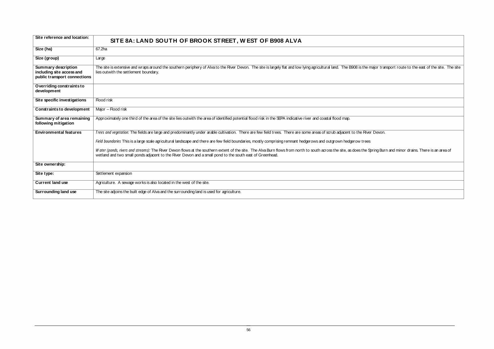
56
Site reference and location:
SITE 8A: LAND SOUTH OF BROOK STREET, WEST OF B908 ALVA Size (ha) 67.2ha
Size (group) Large
Summary description including site access and public transport connections
The site is extensive and wraps around the southern periphery of Alva to the River Devon. The site is largely flat and low lying agricultural land. The B908 is the major transport route to the east of the site. The site lies outwith the settlement boundary.
Overriding constraints to development
Site specific investigations Flood risk
Constraints to development Major – Flood risk
Summary of area remaining following mitigation
Approximately one third of the area of the site lies outwith the area of identified potential flood risk in the SEPA indicative river and coastal flood map.
Environmental features Trees and vegetation: The fields are large and predominantly under arable cultivation. There are few field trees. There are some areas of scrub adjacent to the River Devon.
Field boundaries This is a large scale agricultural landscape and there are few field boundaries, mostly comprising remnant hedgerows and outgrown hedgerow trees
Water (ponds, rivers and streams): The River Devon flows at the southern extent of the site. The Alva Burn flows from north to south across the site, as does the Spring Burn and minor drains. There is an area of wetland and two small ponds adjacent to the River Devon and a small pond to the south east of Greenhead.
Site ownership:
Site type: Settlement expansion
Current land use Agriculture. A sewage works is also located in the west of the site.
Surrounding land use The site adjoins the built edge of Alva and the surrounding land is used for agriculture.

57
Planning policy framework: Clackmannanshire and Stirling Structure Plan Policy ENV3 – Development in the Countryside: The policy states that development in the Countryside (as defined in Local Plans i.e. areas not within settlement boundaries) be suitable for it’s location in function and design and should accord with Policy ED4 – Rural Development (see below).
Clackmannanshire and Stirling Structure Plan Policy ED4 – Rural Development:: The policy states that economic and social development in rural areas will be supported within the following criteria:
• Focusing development within existing towns and villages
• Restricting development within Green Belt and countryside.
Clackmannanshire Local Plan Policy EN18 – Development in the Countryside: Sets out the criteria for the granting of planning permission to a proposed development in the countryside.
Clackmannanshire and Stirling Structure Plan Policy H6 – Housing in the Countryside: The policy states that new housing developments in the Countryside will only be approved where the development is essential, involves the conversion of an existing building, or is consistent with Policy H5 ‘Housing in the Upland Area’.
The site also lies within the Green Belt and therefore the following policies apply:
Clackmannanshire and Stirling Structure Plan Policy ENV4 – Green Belts: In Green Belt areas there will be a strong presumption against development – any developments which are permitted will have to demonstrate appropriate environmental enhancement.
Clackmannanshire Local Plan Policy EN19 – Green Belt:: The policy states that development will only be permitted in Green Belt where no alternative location can be found or the development would provide an opportunity to enhance the Green Belt.
As the site has been identified as being at risk of flooding the following policies apply:
Clackmannanshire and Stirling Structure Plan Policy ENV9 – Water Resources: The policy states that development will not normally be permitted in undeveloped flood plain areas, in areas of known significant flood risk, or if it will adversely affect the Forth Estuary. Exceptions will be made only when it can be demonstrated that no alternative locations can be found, or that suitable mitigation measures can be implemented.
Clackmannanshire Local Plan Policy EN4 – Water Resources: The policy states that where a development area is determined as being at risk of flooding, planning permission will not be granted except where it can be proven that there are no viable alternative sites.
As the site is close to the River Devon and the A91Corridor the following policy applies:
Clackmannanshire Local Plan Policy EN12 – Area Environmental Enhancement states that proposals which would detract from the setting or aesthetics of areas adjacent to Conservation Areas or in proximity to rivers or the A91 corridor will not normally be permitted. Developers must also demonstrate how proposals can be integrated with proposed enhancement measures.
SEA /site assessment topic
Site appraisal criteria Site issues and discussion Summary of Effect of development (++/+/0/-/--)
Enhancement and mitigation options
Potential effect following mitigation
Biodiversity, flora and fauna
Does the site impact on designated sites?
There are no sites designated for their wildlife value within the site boundaries or buffer zone.
The Craigleith and Myreton Hill SSSI lies to the north of the site on the steep slopes of the Ochils, part of which is within 200m of the northern site boundary. The site is designated for its woodland, bog and flush grassland and basic rock outcrop. Development of the site would not impact on SSSI as it is upstream from the development site and is steep and not easily accessible.
0
Does the site impact on priority habitats or species?
Two areas adjacent to the River Devon have been subject to Phase 1 and Phase 2 habitat surveys, and include two target species note sites.
The site is identified in the Phase 1 Habitat Survey as predominantly arable and pasture, with some areas of semi improved neutral grassland, swamp and a pond and an area of tall ruderal herbs adjacent to the River Devon,
0
Does the development of the site avoid adverse effects on the integrity of the Firth of Forth SPA and Ramsar site?
The site is remote from the Firth of Forth SPA and Ramsar site and development of the site should not impact on the integrity of the site.
0

58
SEA /site assessment topic
Site appraisal criteria Site issues and discussion Summary of Effect of development (++/+/0/-/--)
Enhancement and mitigation options
Potential effect following mitigation
Does the development of the site maintain and enhance populations of European Protected Species including protection of their resting places?
The mature trees adjacent to the River Devon may provide bat roosts, the river may support otter and the ponds and remnant hedgerows may provide habitat for other protected species. Site specific survey should be undertaken prior to development of the site to ascertain the presence of European Protected Species and appropriate mitigation implemented if these species are identified.
0/- Following site specific survey, appropriate mitigation should be identified and implemented.
Does the site facilitate the restoration and enhancement of biodiversity in all our urban and rural environments through better planning, design and practice?
The route of the River Devon and Alva Burn includes some areas of woodland generalist 1km dispersal network, and there are some isolated areas along field boundaries to the east of the site. Overall the sites does not make a strong contribution to the network. There are key opportunities to enhance the FHN along the route of the River Devon and to connect the currently isolated areas of FHN. The development of the site could potentially result in loss of trees, hedgerows and open space which provide local biodiversity value.
- The trees, remnant hedgerows, ponds and wetland vegetation should be protected and enhanced.
Minor negative effect.
Population and human health
Is the site connected to the local core path network?
The site is generally well connected to the core path network with links along the riverside to Alva, the route along the southern settlement edge, routes through the site and also the on road core path routes along the B908.
++
How does the site relate to areas with high SIMD?
The site is not within or close to areas in the top 15% SIMD. 0
What is the relationship of the site with existing open space resources?
Access along the riverside provides a recreational resource. There are the safeguarded recreational open space resources of Cochrane Park, Johnstone Park and playing fields at Greenhead. These can be accessed on local roads and pavements from the site.
+ New open space provision would need to be integral to the development of this site.
Water
Is the site at risk of flooding?
The SEPA indicative river and coastal flood map suggests areas adjacent to the River Devon have potential flood risk.
-- Development should be focused on the area immediately adjacent to the existing built edge of Alva.
Are there water courses within the site or which would be affected by increased levels of pollution from development within the site?
The site drains into ditches and burns which enter the River Devon, and adjoins the River Devon itself and therefore diffuse pollution resulting from development of the site could potentially enter the River Devon.
- The use of SUDS could mitigate the impacts of increased diffuse pollution resulting from development of the site, however the low lying nature of the site and proximity to the River Devon may limit opportunities for implementing SUDS.
Are there water courses within the site or which would be affected by increased levels of flooding resulting from development of the site?
The development of the site will increase the rate of run off from the site contributing to increased water levels in the tributary burns and the River Devon.
- The impacts of developing the site could be mitigated through developing only part of the site, and including SUDS in the site design, however the low lying nature of the site and proximity to the River Devon may limit opportunities for implementing SUDS.
Soil Does the site include areas of vacant or derelict land?
The site is not vacant or derelict land. 0
Is the site prime agricultural land? The site is not prime quality agricultural land. 0

59
SEA /site assessment topic
Site appraisal criteria Site issues and discussion Summary of Effect of development (++/+/0/-/--)
Enhancement and mitigation options
Potential effect following mitigation
Air Quality and Transport
Is the site easily accessible by the local path network, and provide access to settlements and services?
The development of the site would result in growth around the periphery of Alva and all areas of the site would be within 1km of the town centre by foot or cycle.
+
Is the site easily accessible by public transport? Alva town centre provides regular bus services to the surrounding settlements. + New bus service provision would be required to service this site.
Does the site lie within an area where levels of air pollution are close to current limit values?
Air quality is not monitored within Alva. The development of the site would increase the quantity of local traffic and contribute to an overall decrease in air quality.
- The creation of new pedestrian and cycle routes would decrease the dependence on the private car, however the development of the site will generate journeys to surrounding settlements to access services and employment.
Would development on the site contribute to higher traffic flows along transport routes or at key junctions (potentially outwith the local authority area) where levels of air pollution are close to current limit values?
Traffic flows are measured to the east of Alva and to the west of Alva on the A91, and both of these routes have shown a minor decrease in traffic levels between 2006 and 2007. Development of this site would potentially increase traffic levels on the A91 and the B908.
- The creation of new pedestrian and cycle routes would decrease the dependence on the private car, however the development of the site will generate journeys to surrounding settlements to access services and employment.
Climatic Factors
Does the location of the development reduce the need to travel?
The site is located close to the centre of Alva and therefore reduces the need to travel to access local services. However, travel to larger centres such as Alloa and Stirling is likely to be generated.
0/-
Is the site at risk of increased flooding or instability as a result of climate change?
The site has a potential flood risk and therefore an increase in future storm events and rainfall intensity will further increase the vulnerability of this site.
-- The flood risk results from the proximity to watercourses which rapidly drain the Ochils for which there is no mitigation option.
Material Assets
Is the site located close to existing transport, services, water and energy infrastructure?
The site forms an extension to Alva and can make use of existing infrastructure. 0
Is the site located to make best use of shelter and solar gain?
The site is low lying and south of the Ochils and is well located to make use of solar gain and shelter.
+
Would development on the site reduce future potential for mineral extraction?
The site does not lie in an area identified as having open cast coal potential. 0
Does the site include any hazard areas? (oil or gas pipelines)
The site does not include any hazard areas. 0
Does the site reduce waste generation and promote waste recovery, recycling and composting?
Development of the site would generate additional waste arisings. - Local recycling and composting facilities should be provided as part of the site masterplan.
Cultural Heritage
Would development within the site impact on the integrity of sites, monuments, buildings or areas designated for their cultural heritage
There are no sites designated for their cultural heritage value within the site boundary or buffer. The HLA identifies that the majority of the site is 18th -19th century fields and farming.
0

60
SEA /site assessment topic
Site appraisal criteria Site issues and discussion Summary of Effect of development (++/+/0/-/--)
Enhancement and mitigation options
Potential effect following mitigation
value?
Would development within the site impact on archaeological remains?
The only known archaeological feature is a track mark recorded in the NMRS to the south west of the sewage treatment work.
0
Landscape Does the site lie within an area designated for its landscape value?
The site does not lie within an area designated as AGLV, however the Ochil Hills AGLV extends to the north of Alva over the steeply rising slopes to the north of the site.
The site lies within the Lower Devon Carselands landscape character area which is characterised by the twisting course of the Devon contrasting with the channelled drainage ditches and large scale rectilinear fields. The Ochil hills are a dominant feature and the hillfoot villages nestle at their base. Development of this site would impact on the setting and views to the Ochils from the flat carselands.
- The restriction of the development area to the area outwith the identified potential flood risk area would limit the extent of the landscape impact of development on the carselands.
Minor negative effect.
Would development within the site impact on settlement setting and identity (drawing on issues of landscape character and capacity for development)?
The proposed development site would form a large scale extension to Alva. Development of the site would increase the size of Alva, reducing the extent of the flat carseland landscape to the south of the town although partly reflecting the traditional hillfoot settlement pattern
- Development should reflect the existing settlement pattern and form of the hillfoot villages.
Minor negative effect.
Would development within the site impact on key views to landscape features or from key transport routes?
Development of the site would have high visibility from the B908. Development extending across the flat carselands would impact on the appreciation of the Ochil Hills from the south through reducing the flat agricultural foreground landscape which extends in front of the hillfoot settlement.
- The implementation of structural planting to integrate the new development into the landscape would reduce the landscape impact. Focusing development on the area without identified potential flood risk will limit the extent of the landscape impact of developing the site.
Minor negative effect.
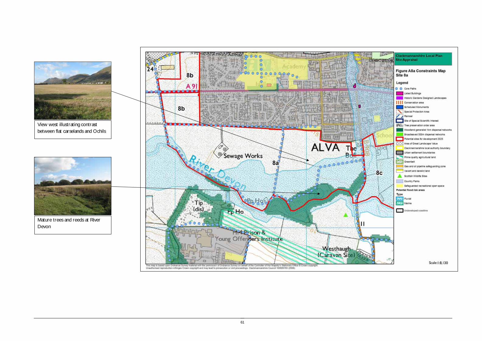
61
Mature trees and reeds at River Devon
View west illustrating contrast between flat carselands and Ochils

62
Site reference and location:
SITE 8 B: WEST ALVA, TO LINE WITH SETTLEMENT EDGE LAND SOUTH OF BROOK STREET, ALVA
Size (ha) 12.6
Size (group) Medium
Summary description including site access and public transport connections
The site lies to the western periphery of Alva. The site is flat and low lying agricultural land. The A91 is the major transport route through the site. The site lies outwith the settlement boundary.
Access onto the A91 could require extension of the 30mph speed limit to the west, however there are issues with capacity of the A91.
Overriding constraints to development
None
Site specific investigations Flood risk
Constraints to development Moderate - Flood risk resulting from overland flow to the north
Minor – TPO covers trees to the north of the site
Summary of area remaining following mitigation
n/a
Environmental features Trees and vegetation: The fields are large and predominantly under arable cultivation.
Field boundaries: Hedgerow adjacent to the A91and to the west and hedgerow and field trees along the southern boundary. Garden boundaries to the east.
Water (ponds, rivers and streams): There are no watercourses within the site. The River Devon flows to the south west of the site.
Site ownership:
Site type: Settlement expansion
Current land use Agriculture.
Surrounding land use The site adjoins the built edge of Alva and the surrounding land is used for agriculture, with an industrial building and storage yard surrounded by woodland to the west.

63
Planning policy framework: Clackmannanshire and Stirling Structure Plan Policy ENV3 – Development in the Countryside: The policy states that development in the Countryside (as defined in Local Plans i.e. areas not within settlement boundaries) be suitable for it’s location in function and design and should accord with Policy ED4 – Rural Development (see below).
Clackmannanshire and Stirling Structure Plan Policy ED4 – Rural Development:: The policy states that economic and social development in rural areas will be supported within the following criteria:
• Focusing development within existing towns and villages
• Restricting development within Green Belt and countryside.
Clackmannanshire Local Plan Policy EN18 – Development in the Countryside: Sets out the criteria for the granting of planning permission to a proposed development in the countryside.
Clackmannanshire and Stirling Structure Plan Policy H6 – Housing in the Countryside: The policy states that new housing developments in the Countryside will only be approved where the development is essential, involves the conversion of an existing building, or is consistent with Policy H5 ‘Housing in the Upland Area’.
The site also lies within the Green Belt and therefore the following policies apply:
Clackmannanshire and Stirling Structure Plan Policy ENV4 – Green Belts: In Green Belt areas there will be a strong presumption against development – any developments which are permitted will have to demonstrate appropriate environmental enhancement.
Clackmannanshire Local Plan Policy EN19 – Green Belt: The policy states that development will only be permitted in Green Belt where no alternative location can be found or the development would provide an opportunity to enhance the Green Belt.
As the site is close to the River Devon and the A91Corridor the following policy applies:
Clackmannanshire Local Plan Policy EN12 – Area Environmental Enhancement states that proposals which would detract from the setting or aesthetics of areas adjacent to Conservation Areas or in proximity to rivers or the A91 corridor will not normally be permitted. Developers must also demonstrate how proposals can be integrated with proposed enhancement measures.
SEA /site assessment topic
Site appraisal criteria Site issues and discussion Summary of Effect of development (++/+/0/-/--)
Enhancement and mitigation options
Potential effect following mitigation
Biodiversity, flora and fauna
Does the site impact on designated sites?
There are no sites designated for their wildlife value within the site boundary. A tree preservation order extends over the Back Road area which adjoins the north western extent of the site.
The Craigleith and Myreton Hill SSSI lies to the north of the site on the steep slopes of the Ochils, part of which is within 200m of the northern site boundary. The site is designated for its woodland, bog and flush grassland and basic rock outcrop. Development of the site would not impact on SSSI as it is upstream from the development site and is steep and not easily accessible.
0
Does the site impact on priority habitats or species?
The site is identified in the Phase 1 Habitat Survey as predominantly arable and pasture.
0
Does the development of the site avoid adverse effects on the integrity of the Firth of Forth SPA and Ramsar site?
The site is remote from the Firth of Forth SPA and Ramsar site and development of the site should not impact on the integrity of the site.
0
Does the development of the site maintain and enhance populations of European Protected Species including protection of their resting places?
The hedgerows may provide habitat for some protected species. Site specific survey should be undertaken prior to development of the site to ascertain the presence of European Protected Species and appropriate mitigation implemented if these species are identified.
0/- Following site specific survey, appropriate mitigation should be identified and implemented.

64
SEA /site assessment topic
Site appraisal criteria Site issues and discussion Summary of Effect of development (++/+/0/-/--)
Enhancement and mitigation options
Potential effect following mitigation
Does the site facilitate the restoration and enhancement of biodiversity in all our urban and rural environments through better planning, design and practice?
There are no elements of the FHN within the site. The site is bounded by hedgerows which provide some habitat value, and development of the site could potentially result in loss of these resources.
- The hedgerows should be protected and enhanced through the development of the site. Additional woodland habitat should be created along the southern site boundary.
Minor negative
Population and human health
Is the site connected to the local core path network?
The site is generally well connected to the core path network with links around the perimeter of the site.
++
How does the site relate to areas with high SIMD?
The site is not within or close to areas in the top 15% SIMD. 0
What is the relationship of the site with existing open space resources?
The path links from the site provide access to the Riverside and also Alva Glen. There are the safeguarded recreational open space resources of Cochrane Park, Johnstone Park and playing fields at Greenhead. These can be accessed on local roads and pavements from the site.
+ New open space provision would need to be integral to the development of this site.
Water
Is the site at risk of flooding?
The SEPA indicative river and coastal flood map does not identify the site as at risk of flooding, however there may be issues associated with overland flow and surface water drainage.
0/-
Are there water courses within the site or which would be affected by increased levels of pollution from development within the site?
There are no water courses within the site boundary however development of the site would result in diffuse pollution entering neighbouring water courses.
- The use of SUDS could mitigate the impacts of increased diffuse pollution resulting from development of the site, however the low lying nature of the site and proximity to the River Devon may limit opportunities for implementing SUDS.
Are there water courses within the site or which would be affected by increased levels of flooding resulting from development of the site?
The development of the site will increase the rate of run off from the site contributing to increased water levels in the tributary burns and the River Devon.
- The impacts of developing the site could be mitigated through including SUDS in the site design, however the low lying nature of the site and proximity to the River Devon may limit opportunities for implementing SUDS.
Soil Does the site include areas of vacant or derelict land?
The site is not vacant or derelict land. 0
Is the site prime agricultural land?
The site is not prime quality agricultural land. 0
Air Quality and Transport
Is the site easily accessible by the local path network, and provide access to settlements and services?
The development of the site would result in growth around the western periphery of Alva and all areas of the site would be within 1km of the town centre by foot or cycle.
+
Is the site easily accessible by public transport? Alva town centre provides regular bus services to the surrounding settlements. + New bus service provision would be required to service this site.
Does the site lie within an area where levels of Air quality is not monitored within Alva. - The creation of new pedestrian and cycle routes would decrease the

65
SEA /site assessment topic
Site appraisal criteria Site issues and discussion Summary of Effect of development (++/+/0/-/--)
Enhancement and mitigation options
Potential effect following mitigation
air pollution are close to current limit values?
The development of the site would increase the quantity of local traffic and contribute to an overall decrease in air quality.
dependence on the private car, however the development of the site will generate journeys to surrounding settlements to access services and employment.
Would development on the site contribute to higher traffic flows along transport routes or at key junctions (potentially outwith the local authority area) where levels of air pollution are close to current limit values?
Traffic flows are measured to the east of Alva and to the west of Alva on the A91, and both of these routes have shown a minor decrease in traffic levels between 2006 and 2007. Development of this site would potentially increase traffic levels on the A91 and the B908.
- The creation of new pedestrian and cycle routes would decrease the dependence on the private car, however the development of the site will generate journeys to surrounding settlements to access services and employment.
Climatic Factors
Does the location of the development reduce the need to travel?
The site is located close to the centre of Alva and therefore reduces the need to travel to access local services. However, travel to larger centres such as Alloa and Stirling is likely to be generated.
0/-
Is the site at risk of increased flooding or instability as a result of climate change?
The site has a potential flood risk and therefore an increase in future storm events and rainfall intensity will further increase the vulnerability of this site.
- The flood risk results from overland flow from the Ochils for which there is no mitigation option.
Material Assets
Is the site located close to existing transport, services, water and energy infrastructure?
The site forms an extension to Alva and can make use of existing infrastructure. 0
Is the site located to make best use of shelter and solar gain?
The site is low lying and south of the Ochils and is well located to make use of solar gain and shelter.
+
Would development on the site reduce future potential for mineral extraction?
The site does not lie in an area identified as having open cast coal potential. 0
Does the site include any hazard areas? (oil or gas pipelines)
The site does not include any hazard areas. 0
Does the site reduce waste generation and promote waste recovery, recycling and composting?
Development of the site would generate additional waste arisings, however the site is small in extent and lies adjacent to an existing urban areas for which recycling facilities will be provided.
-
Cultural Heritage
Would development within the site impact on the integrity of sites, monuments, buildings or areas designated for their cultural heritage value?
There are no sites designated for their cultural heritage value within the site boundary or surrounding area. The HLA identifies that the majority of the site is 18th -19th century fields and farming.
0
Would development within the site impact on archaeological remains?
There are no known archaeological remains within the site boundary. 0
Landscape Does the site lie within an area designated for its landscape value?
The site does not lie within an area designated as AGLV, however the Ochil Hills AGLV extends from Back Road over the steeply rising slopes to the immediate north of the site. The site lies immediately adjacent to the existing settlement edge and would have a minor impact on the landscape setting of the Ochil hills through reducing the appreciation of the flat farmland and contrasting rising slopes behind.
The site lies within the Lower Devon Carselands landscape character area which is characterised by the twisting course of the Devon contrasting with the channelled drainage ditches and large scale rectilinear fields. The Ochil hills are a dominant
-

66
SEA /site assessment topic
Site appraisal criteria Site issues and discussion Summary of Effect of development (++/+/0/-/--)
Enhancement and mitigation options
Potential effect following mitigation
feature and the hillfoot villages nestle at their base.
Would development within the site impact on settlement setting and identity (drawing on issues of landscape character and capacity for development)?
The proposed development site would form a western extension to Alva and the development site would mirror of the existing settlement pattern, however this would effectively reduce the perceived separation with Menstrie to the west.
- Development should reflect the existing settlement pattern and form of the hillfoot villages.
Minor negative effect.
Would development within the site impact on key views to landscape features or from key transport routes?
Development of the site would have high visibility from the A91. Development extending across the flat carselands would impact on the appreciation of the Ochil Hills and reduce the distinction between the hillfoot settlements.
- The implementation of structural planting to integrate the new development into the landscape would reduce the landscape impact.
Minor negative effect.

67
Flat farmland and hedgerow
View south east from Back Road towards settlement edge

68
Site reference and location:
SITE 8 C: EAST OF B908, ALVA Size (ha) 41.9
Size (group) Medium
Summary description including site access and public transport connections
The site lies at the south eastern edge of Alva. The site is gently undulating agricultural land. The B908 is the major transport route adjacent to the site. The site lies outwith the settlement boundary.
Overriding constraints to development
Flood risk
Site specific investigations n/a
Constraints to development See overriding constraints above.
Summary of area remaining following mitigation
The whole of the site lies within an area identified as at risk of flooding on the SEPA indicative river and coastal flood map.
Environmental features Trees and vegetation: The site comprises a large arable field.
Field boundaries: The site is bounded by hedgerows, garden boundaries and the woodland of the adjacent land to the west.
Water (ponds, rivers and streams): There is a small area of marshy ground within the eastern area of the site.
Site ownership:
Site type: Settlement expansion
Current land use Agriculture.
Surrounding land use The site adjoins the built edge of Alva to the north and the surrounding land is used for agriculture.
Planning policy framework: Clackmannanshire and Stirling Structure Plan Policy ENV3 – Development in the Countryside: The policy states that development in the Countryside (as defined in Local Plans i.e. areas not within settlement boundaries) be suitable for it’s location in function and design and should accord with Policy ED4 – Rural Development (see below).
Clackmannanshire and Stirling Structure Plan Policy ED4 – Rural Development:: The policy states that economic and social development in rural areas will be supported within the following criteria:
• Focusing development within existing towns and villages
• Restricting development within Green Belt and countryside.
Clackmannanshire Local Plan Policy EN18 – Development in the Countryside: Sets out the criteria for the granting of planning permission to a proposed development in the countryside.
Clackmannanshire and Stirling Structure Plan Policy H6 – Housing in the Countryside: The policy states that new housing developments in the Countryside will only be approved where the development is essential, involves the conversion of an existing building, or is consistent with Policy H5 ‘Housing in the Upland Area’.
The site also lies within the Green Belt and therefore the following policies apply:
Clackmannanshire and Stirling Structure Plan Policy ENV4 – Green Belts: In Green Belt areas there will be a strong presumption against development – any developments which are permitted will have to demonstrate appropriate environmental enhancement.
Clackmannanshire Local Plan Policy EN19 – Green Belt:: The policy states that development will only be permitted in Green Belt where no alternative location can be found or the development would provide an opportunity to enhance the Green Belt.
As the site is on the A91 Corridor the following policy applies:
Clackmannanshire Local Plan Policy EN12 – Area Environmental Enhancement states that proposals which would detract from the setting or aesthetics of areas adjacent to Conservation Areas or in proximity to rivers or the A91 corridor will not normally be permitted. Developers must also demonstrate how proposals can be integrated with proposed enhancement measures.
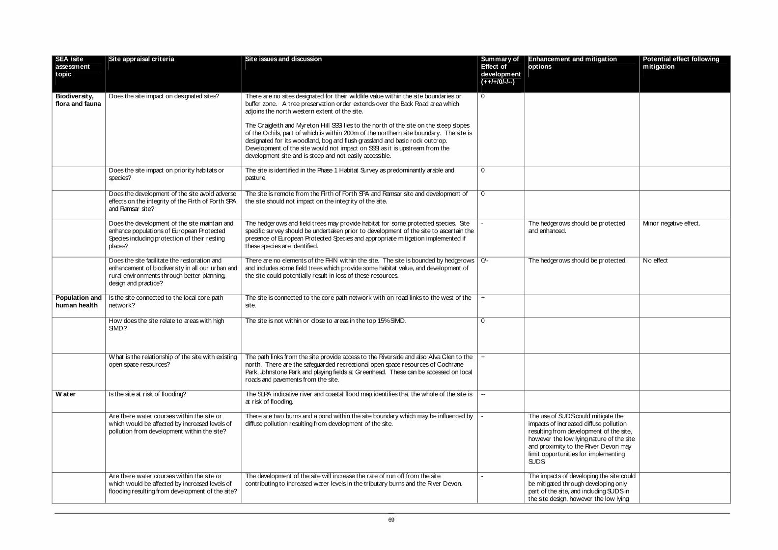
69
SEA /site assessment topic
Site appraisal criteria Site issues and discussion Summary of Effect of development (++/+/0/-/--)
Enhancement and mitigation options
Potential effect following mitigation
Biodiversity, flora and fauna
Does the site impact on designated sites?
There are no sites designated for their wildlife value within the site boundaries or buffer zone. A tree preservation order extends over the Back Road area which adjoins the north western extent of the site.
The Craigleith and Myreton Hill SSSI lies to the north of the site on the steep slopes of the Ochils, part of which is within 200m of the northern site boundary. The site is designated for its woodland, bog and flush grassland and basic rock outcrop. Development of the site would not impact on SSSI as it is upstream from the development site and is steep and not easily accessible.
0
Does the site impact on priority habitats or species?
The site is identified in the Phase 1 Habitat Survey as predominantly arable and pasture.
0
Does the development of the site avoid adverse effects on the integrity of the Firth of Forth SPA and Ramsar site?
The site is remote from the Firth of Forth SPA and Ramsar site and development of the site should not impact on the integrity of the site.
0
Does the development of the site maintain and enhance populations of European Protected Species including protection of their resting places?
The hedgerows and field trees may provide habitat for some protected species. Site specific survey should be undertaken prior to development of the site to ascertain the presence of European Protected Species and appropriate mitigation implemented if these species are identified.
- The hedgerows should be protected and enhanced.
Minor negative effect.
Does the site facilitate the restoration and enhancement of biodiversity in all our urban and rural environments through better planning, design and practice?
There are no elements of the FHN within the site. The site is bounded by hedgerows and includes some field trees which provide some habitat value, and development of the site could potentially result in loss of these resources.
0/- The hedgerows should be protected. No effect
Population and human health
Is the site connected to the local core path network?
The site is connected to the core path network with on road links to the west of the site.
+
How does the site relate to areas with high SIMD?
The site is not within or close to areas in the top 15% SIMD. 0
What is the relationship of the site with existing open space resources?
The path links from the site provide access to the Riverside and also Alva Glen to the north. There are the safeguarded recreational open space resources of Cochrane Park, Johnstone Park and playing fields at Greenhead. These can be accessed on local roads and pavements from the site.
+
Water
Is the site at risk of flooding?
The SEPA indicative river and coastal flood map identifies that the whole of the site is at risk of flooding.
--
Are there water courses within the site or which would be affected by increased levels of pollution from development within the site?
There are two burns and a pond within the site boundary which may be influenced by diffuse pollution resulting from development of the site.
- The use of SUDS could mitigate the impacts of increased diffuse pollution resulting from development of the site, however the low lying nature of the site and proximity to the River Devon may limit opportunities for implementing SUDS.
Are there water courses within the site or which would be affected by increased levels of flooding resulting from development of the site?
The development of the site will increase the rate of run off from the site contributing to increased water levels in the tributary burns and the River Devon.
- The impacts of developing the site could be mitigated through developing only part of the site, and including SUDS in the site design, however the low lying
70
SEA /site assessment topic
Site appraisal criteria Site issues and discussion Summary of Effect of development (++/+/0/-/--)
Enhancement and mitigation options
Potential effect following mitigation
nature of the site and proximity to the River Devon may limit opportunities for implementing SUDS.
Soil Does the site include areas of vacant or derelict land?
The site is not vacant or derelict land. 0
Is the site prime agricultural land?
The site is not prime quality agricultural land. 0
Air Quality and Transport
Is the site easily accessible by the local path network, and provide access to settlements and services?
The development of the site would result in growth to the south east of Alva and all areas of the site would be within 1km of the town centre by foot or cycle.
+
Is the site easily accessible by public transport? Alva town centre provides regular bus services to the surrounding settlements. +
Does the site lie within an area where levels of air pollution are close to current limit values?
Air quality is not monitored within Alva.
The development of the site would increase the quantity of local traffic and contribute to an overall decrease in air quality.
- The creation of new pedestrian and cycle routes would decrease the dependence on the private car, however the development of the site will generate journeys to surrounding settlements to access services and employment.
Would development on the site contribute to higher traffic flows along transport routes or at key junctions (potentially outwith the local authority area) where levels of air pollution are close to current limit values?
Traffic flows are measured to the east of Alva and to the west of Alva on the A91, and both of these routes have shown a minor decrease in traffic levels between 2006 and 2007. Development of this site would potentially increase traffic levels on the A91.
- The creation of new pedestrian and cycle routes would decrease the dependence on the private car, however the development of the site will generate journeys to surrounding settlements to access services and employment.
Climatic Factors
Does the location of the development reduce the need to travel?
The site is located close to the centre of Alva and therefore reduces the need to travel to access local services. However, travel to larger centres such as Alloa and Stirling is likely to be generated.
0/-
Is the site at risk of increased flooding or instability as a result of climate change?
The site has a high flood risk and therefore an increase in future storm events and rainfall intensity will further increase the vulnerability of this site.
-- The site is low lying and has an identified flood risk and therefore options to mitigate flood risk may be limited.
Material Assets
Is the site located close to existing transport, services, water and energy infrastructure?
The site forms an extension to Alva and can make use of existing infrastructure. 0
Is the site located to make best use of shelter and solar gain?
The site is low lying and south of the Ochils and is well located to make use of solar gain and shelter.
+
Would development on the site reduce future potential for mineral extraction?
The site does not lie in an area identified as having open cast coal potential. 0
Does the site include any hazard areas? (oil or gas pipelines)
The site does not include any hazard areas. 0

71
SEA /site assessment topic
Site appraisal criteria Site issues and discussion Summary of Effect of development (++/+/0/-/--)
Enhancement and mitigation options
Potential effect following mitigation
Does the site reduce waste generation and promote waste recovery, recycling and composting?
Development of the site would generate additional waste arisings, however the site is small in extent and lies adjacent to an existing urban areas for which recycling facilities will be provided.
-
Cultural Heritage
Would development within the site impact on the integrity of sites, monuments, buildings or areas designated for their cultural heritage value?
There are no sites designated for their cultural heritage value within the site boundary or buffer. The HLA identifies that the site is 18th -19th century fields and farming.
0
Would development within the site impact on archaeological remains?
There are no known archaeological features within the site boundary. 0
Landscape Does the site lie within an area designated for its landscape value?
The site does not lie within an area designated as AGLV, however the Ochil Hills AGLV from the northern edge of Alva. Development of the site would result in extension of the settlement to the south, reducing the contrast between the flat carselands and the steeply rising slopes of the Ochils.
- Minor negative effect.
Would development within the site impact on settlement setting and identity (drawing on issues of landscape character and capacity for development)?
The proposed development site would form a southern extension to Alva which would be contrary to the existing settlement pattern.
- Development should reflect the existing settlement pattern and form of the hillfoot villages.
Minor negative effect.
Would development within the site impact on key views to landscape features or from key transport routes?
Development of the site would have high visibility from the B908. Development extending across the flat carselands would impact on the appreciation of the Ochil Hills from the south through reducing the flat agricultural foreground landscape which extends in front of the steeply rising slopes.
- The implementation of structural planting to integrate the new development into the landscape would reduce the landscape impact.
Minor negative effect.

72
Wetland vegetation south of business park
View south west illustrating flat farmland and areas of standing water
73
Site reference and location:
SITE 9 BIRKHILL CASTLEBRIDGE Size (ha) 109.81
Size (group) Very large
Summary description including site access and public transport connections
Centred around Birk Hill which rises to 65m AOD and includes the mixed forestry of the Gartlove Plantation which extends over around half of the site area. The site lies outwith the settlement boundary. The site could potentially be accessed from the A977, however junction treatment would be required.
Overriding constraints to development
Site specific investigations Drainage
Stability
Constraints to development Major- AGLV.
Moderate – Road access. Nature conservation.
Minor – surface water drainage
Summary of area remaining following mitigation
Retaining the woodland area results in loss of approximately half of the site area.
Environmental features Trees and vegetation: The site comprises agricultural fields with an extensive area of woodland to the east of the site. Woodland is also found along the course of the unnamed burn in the southern part of the site.
Field boundaries: Stone walls to north, post and wire, outgrown hedgerows along disused railway.
Water (ponds, rivers and streams): An unnamed burn flows from the Gartlove Plantation south and east along the southern extent of the site, where it joins the River Black Devon.
Site ownership:
Site type: Settlement expansion/new settlement
Current land use The site is currently used for agriculture and forestry.
Surrounding land use The site is surrounded by agriculture and forestry, the B910 and the A977 and adjoins Castlebridge Business Park.

74
Planning policy framework: Clackmannanshire and Stirling Structure Plan Policy ENV3 – Development in the Countryside: The policy states that development in the Countryside (as defined in Local Plans i.e. areas not within settlement boundaries) be suitable for it’s location in function and design and should accord with Policy ED4 – Rural Development (see below).
Clackmannanshire and Stirling Structure Plan Policy ED4 – Rural Development:: The policy states that economic and social development in rural areas will be supported within the following criteria:
• Focusing development within existing towns and villages
• Restricting development within Green Belt and countryside.
Clackmannanshire Local Plan Policy EN18 – Development in the Countryside: Sets out the criteria for the granting of planning permission to a proposed development in the countryside.
Clackmannanshire and Stirling Structure Plan Policy H6 – Housing in the Countryside: The policy states that new housing developments in the Countryside will only be approved where the development is essential, involves the conversion of an existing building, or is consistent with Policy H5 ‘Housing in the Upland Area’.
As the site is located within an AGLV the following policies apply:
Clackmannanshire and Stirling Structure Plan Policy ENV2 – Protected Landscapes: The policy states that development will only be permitted in Areas of Great Landscape Value where it satisfies the criteria of Policy ENV3 (below) and can be accommodated without adversely affecting the overall quality of the area.
Clackmannanshire Local Plan Clackmannanshire Local Plan Policy EN2 – Landscape and Ecology: The policy includes conditions which must be met if a development is to be permitted in an AGLV. The policy also states that appropriate consideration must be given to woodland, habitats, natural and landscape features when making a planning application.
Due to the proximity to the River Devon the following policy applies:
Clackmannanshire Local Plan Policy EN12 – Area Environmental Enhancement states that proposals which would detract from the setting or aesthetics of Conservation Areas, rivers or the A91 corridor will not normally be permitted, and that developers must demonstrate how proposals can be integrated with proposed enhancement measures.
As the site lies in an area of search identified as having a potentially workable opencast resource the following should be considered:
Clackmannanshire and Stirling Structure Plan Policy ENV10 – Minerals – General Principles states that economically important mineral resources will be protected from sterilisation by permanent development. Alternatively, working of minerals in advance of development will be encouraged. Clackmannanshire Local Plan Policy EN24 – Protection of Minerals: The policy states that permanent development which would result in the sterilisation of viable mineral resources will not be permitted except where this would prevent residential development which contributes to the strategic housing land requirement and no other sites are available to meet this requirement.
SEA /site assessment topic
Site appraisal criteria Site issues and discussion Summary of Effect of development (++/+/0/-/--)
Enhancement and mitigation options
Potential effect following mitigation
Biodiversity, flora and fauna
Does the site impact on designated sites?
There are no sites designated for their nature conservation value within the site boundary. Linn Mill SSSI adjoins the northern boundary of the site and is designated for its woodland mire. The SSSI is upstream of the site and therefore impacts will be limited.
0
Does the site impact on priority habitats or species?
The site is identified in the Phase 1 Habitat Survey as predominantly arable and pasture and coniferous plantation. There is a small area of swamp surrounded by unimproved neutral grassland to the south of the site and small areas of broadleaved semi natural woodland associated with the minor burn which drains into the Black Devon. Red squirrels are known within the woodland, development which resulted in loss of woodland would have an adverse impact on these species.
- Protection of the woodland resource within the site masterplan.
No impact
Does the development of the site avoid adverse effects on the integrity of the Firth of Forth SPA and Ramsar site?
The site is remote from the Firth of Forth SPA and Ramsar site and development of the site should not impact on the integrity of the site.
0
Does the development of the site maintain and enhance populations of European Protected
The woodlands and burn, area of swamp and unimproved neutral grassland may provide habitat for some protected species. Site specific survey should be undertaken
0/- Following site specific survey, appropriate mitigation should be

75
SEA /site assessment topic
Site appraisal criteria Site issues and discussion Summary of Effect of development (++/+/0/-/--)
Enhancement and mitigation options
Potential effect following mitigation
Species including protection of their resting places?
prior to development of the site to ascertain the presence of European Protected Species and appropriate mitigation implemented if these species are identified.
identified and implemented.
Does the site facilitate the restoration and enhancement of biodiversity in all our urban and rural environments through better planning, design and practice?
The site includes extensive areas of FHN woodland generalist 1km dispersal networks along the southern and western boundaries and in the eastern extent of the area, and areas of riparian habitat. Development of the site could potentially result in the loss of these resources.
- The hedgerows and woodland and habitat associated with the burn and swamp should be protected and enhanced.
Minor negative
Population and human health
Is the site connected to the local core path network?
National Cycle Route 76 on the route of a disused railway runs to the immediate south of the site.
+
How does the site relate to areas with high SIMD?
The site is not in an area with high SIMD. 0
What is the relationship of the site with existing open space resources?
Notes connections to key recreational area or designation as a safeguarded open space or country park
There are no open space resources close to the site, however the size of the site would require the provision of open space facilities within the site. Gartmorn Country Park provides a large open space resource within 2km of the site.
+
Water
Is the site at risk of flooding?
The River Black Devon runs to the west of the site and has an identified potential flood risk, however the river is in a valley at this location and flooding events would not affect the site.
0
Are there water courses within the site or which would be affected by increased levels of pollution from development within the site?
The site is drained by a number of small watercourses which join on to the unnamed burn which flows into the River Devon and would potentially be affected by diffuse pollution resulting from development of the site.
- The implementation of SUDS would reduce the impact of diffuse pollution on watercourses.
Are there water courses within the site or which would be affected by increased levels of flooding resulting from development of the site?
The development of the site would potentially increase the rate of run off and contribute to increased levels of flow within the unnamed burn and the River Black Devon.
- The implementation of SUDS would reduce the rate of run off.
Soil Does the site include areas of vacant or derelict land?
The site does not include areas of vacant or derelict land, however the site lies adjacent to the site of the former Castlebridge colliery which is now used as a business park. The main pithead remains and is a tall and prominent landscape structure.
0
Is the site prime agricultural land?
The site is not prime quality agricultural land. 0
Air Quality and Transport
Is the site easily accessible by the local path network, and provide access to settlements and services?
The site is linked by both on and off road core paths to Clackmannan and Alloa. +
Is the site easily accessible by public transport? As a new settlement, public transport would be required to service the site. - A new bus service would be required to service the site, however frequency of service may be limited.
0
Does the site lie within an area where levels of The site does not lie within an area currently monitored for air pollution. However it 0

76
SEA /site assessment topic
Site appraisal criteria Site issues and discussion Summary of Effect of development (++/+/0/-/--)
Enhancement and mitigation options
Potential effect following mitigation
air pollution are close to current limit values?
lies in a rural location and unlikely to have any key air pollution issues.
Would development on the site contribute to higher traffic flows along transport routes or at key junctions (potentially outwith the local authority area) where levels of air pollution are close to current limit values?
Access would be taken onto the A977 which would generate increased traffic flows on the A977 and at Gartarry roundabout.
- There are limited opportunities for mitigation of transport impacts.
Climatic Factors
Does the location of the development reduce the need to travel?
The development site is of sufficient size to include provision of local facilities, however access to education, employment and other services will generate trips.
- The additional services provided as a result of development of other sites in the eastern expansion area may reduce the need to travel.
Is the site at risk of increased flooding or instability as a result of climate change?
The site extends over a low hill and does not have an identified potential flooding risk, therefore it is unlikely to be at increased risk of flooding or instability as a result of climate change.
0
Material Assets
Is the site located close to existing transport, services, water and energy infrastructure?
The site is located a short distance from Clackmannan, however additional service provision is likely to be required to service the site.
-
Is the site located to make best use of shelter and solar gain?
The site is located over a low hill with a predominantly southerly aspect and is well located to make good use of shelter and solar gain.
+
Would development on the site reduce future potential for mineral extraction?
The site lies in an area of search identified as having a potentially workable opencast resource, however there are also known constraints to working this site.
-
Does the site include any hazard areas? (oil or gas pipelines)
The site does not include any oil or gas pipeline hazard areas. 0
Does the site reduce waste generation and promote waste recovery, recycling and composting?
Development of the site would generate additional waste arisings associated with a large development area.
- Local recycling and composting facilities should be provided as part of the site masterplan.
Cultural Heritage
Would development within the site impact on the integrity of sites, monuments, buildings or areas designated for their cultural heritage value?
There are no sites designated for their cultural heritage value within the site boundary. Linn Mill and the old Bridge over the River Black Devon are listed structures, but lie outwith the site boundary.
The HLA identifies that the site comprises 20th century coniferous plantation, and 18th-19th century and 19th century fields and farming.
0
Would development within the site impact on archaeological remains?
There are no known archaeological remains within the site boundary. 0
Landscape Does the site lie within an area designated for its landscape value?
The site lies within The Forest AGLV.
The site is not within the area designated as Greenbelt.
The site lies within the Devon/Forth landscape character area with varied farmland characterised by undulating landform and coniferous blocks of forestry.
-- This landscape character area is noted for its diversity of landscape features and high landscape value. In particular guidelines for development include new woodland planting and restructuring of existing coniferous plantations.

77
SEA /site assessment topic
Site appraisal criteria Site issues and discussion Summary of Effect of development (++/+/0/-/--)
Enhancement and mitigation options
Potential effect following mitigation
Would development within the site impact on settlement setting and identity (drawing on issues of landscape character and capacity for development)?
The site would create a new settlement distinct from the existing urban areas. The site is not highly visible and would form a new settlement. However, the site has an intrinsically rural character and development would be out of character with the rural landscape within the AGLV.
0
Would development within the site impact on key views to landscape features or from key transport routes?
There are limited views to this landscape area due to undulating topography. This further serves to reduce intervisibility with existing settlement. The conifer plantation adjacent to the A977 limits visibility to the east.
The site lies in an area of undulating topography, however development on the hill summit should be avoided as this would have a negative impact on the prominence of the site. The sloping character of the site would also increase visibility.
- Retaining the boundary woodland planting would reduce visibility of the site, however comparative elevation of the area constrains the opportunities for mitigation.
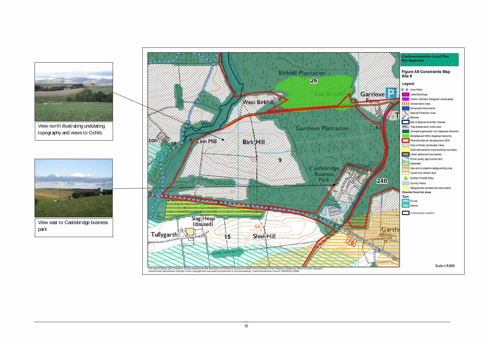
78
View east to Castlebridge business park
View north illustrating undulating topography and views to Ochils

79
Site reference and location:
SITE 10 LADYWOOD, EAST OF CLACKMANNAN Size (ha) 2.33
Size (group) Small
Summary description including site access and public transport connections
A small site comprising a field located on the periphery of Clackmannan. This is a gently sloping site which rises to the south from the Goudnie Burn to Alloa Road. The site lies outwith the settlement boundary. Access to the site would be taken from Alloa Road and there is access to existing public transport provision within Clackmannan. Junction treatment would be required for the access onto Alloa Road.
Overriding constraints to development
None
Site specific investigations Drainage
Ground stability
Constraints to development Moderate – Prime quality agricultural land
Minor- Flood risk
Summary of area remaining following mitigation
n/a
Environmental features
Trees and vegetation: There is some scrub alongside the course of the Goudnie Burn. The field is pasture.
Field boundaries: Stone wall adjacent to Alloa Road, garden boundaries and post and wire fencing.
Water (ponds, rivers and streams): The northern boundary of the site immediately adjoins the Goudnie Burn.
Role as part of FHN: The site does not currently play a role as part of the FHN.
Site ownership:
Site type: Settlement expansion.
Current land use The field is currently under pasture and used for grazing.
Surrounding land use A residential area of Clackmannan adjoins the western boundary of the site. To the north is the Goudnie Burn, a narrow field and the Alloa – Dunfermline railway line. To the east is a field and to the south is Alloa Road bounded by thick woodland belts.

80
Planning policy framework: Clackmannanshire and Stirling Structure Plan Policy ENV7 – Agricultural Land: Development which would result in the permanent loss of prime agricultural land will only be permitted where such land is identified for development in Local Plans and lower quality land cannot reasonably be used.
Clackmannanshire and Stirling Structure Plan Policy ENV3 – Development in the Countryside: The policy states that development in the Countryside (as defined in Local Plans i.e. areas not within settlement boundaries) be suitable for it’s location in function and design and should accord with Policy ED4 – Rural Development (see below).
Clackmannanshire and Stirling Structure Plan Policy ED4 – Rural Development:: The policy states that economic and social development in rural areas will be supported within the following criteria:
• Focusing development within existing towns and villages
• Restricting development within Green Belt and countryside.
Clackmannanshire Local Plan Policy EN18 – Development in the Countryside: Sets out the criteria for the granting of planning permission to a proposed development in the countryside.
Clackmannanshire and Stirling Structure Plan Policy H6 – Housing in the Countryside: The policy states that new housing developments in the Countryside will only be approved where the development is essential, involves the conversion of an existing building, or is consistent with Policy H5 ‘Housing in the Upland Area’.
As part of the site has been identified as of potential risk of flooding the following policies apply:
Clackmannanshire and Stirling Structure Plan Policy ENV9 – Water Resource Management: The policy states that development will not normally be permitted in undeveloped flood plain areas, in areas of known significant flood risk, or if it will adversely affect the Forth Estuary. Exceptions will be made only when it can be demonstrated that no alternative locations can be found, or that suitable mitigation measures can be implemented.
Clackmannanshire Local Plan Policy EN4 – Water Resources: The policy states that where a development area is determined as being at risk of flooding, planning permission will not be granted except where it can be proven that there are no viable alternative sites.
As the site has been identified as an area of prime agricultural land the following applies:
Clackmannanshire and Stirling Structure Plan Policy ENV7 – Agricultural Land: Development which would result in the permanent loss of prime agricultural land will only be permitted where such land is identified for development in Local Plans and lower quality land cannot reasonably be used.
SEA /site assessment topic
Site appraisal criteria Site issues and discussion Summary of Effect of development (++/+/0/-/--)
Enhancement and mitigation options
Potential effect following mitigation
Biodiversity, flora and fauna
Does the site impact on designated sites?
The site does not impact on any sites designated for their nature conservation value.
0
Does the site impact on priority habitats or species?
The woodland belts to the south of the site have been subject to Phase 2 Habitat survey. The site comprises pasture and may play some role in providing foraging habitat for species such as bats which may roost in the adjacent woodland.
0
Does the development of the site avoid adverse effects on the integrity of the Firth of Forth SPA and Ramsar site?
The site is remote from the Firth of Forth SPA and Ramsar site and development of the site should not impact on the integrity of the site.
0
Does the development of the site maintain and enhance populations of European Protected Species including protection of their resting places?
The site includes an area of marshy ground, and is unlikely to provide habitat for protected species. However, site specific survey should be undertaken prior to development of the site to ascertain the presence of European Protected Species and appropriate mitigation implemented if these species are identified.
0/- Following site specific survey, appropriate mitigation should be identified and implemented.
Does the site facilitate the restoration and enhancement of biodiversity in all our urban and
The site does not currently play a role as part of the FHN, however development of the site would result in the loss of an area of open ground which may provide foraging
0/- Habitat creation would reduce the
81
SEA /site assessment topic
Site appraisal criteria Site issues and discussion Summary of Effect of development (++/+/0/-/--)
Enhancement and mitigation options
Potential effect following mitigation
rural environments through better planning, design and practice?
habitat. impact of loss of open ground.
Population and human health
Is the site connected to the local core path network?
There is access on local roads and pavements into Clackmannan and the pavement route to Kennet is a core path. There are also core paths within the woodland belts which provide recreational access within the woodland and farmland adjacent to the site.
+
How does the site relate to areas with high SIMD?
The site does not lie in an area within the top 15% SIMD, nor is it close to areas with high levels of deprivation.
0
What is the relationship of the site with existing open space resources?
Notes connections to key recreational area or designation as a safeguarded open space or country park
There are safeguarded areas of recreational open space within Clackmannan within 1km of the site. The access network within the woodland belts and surrounding farmland provides an open space resource.
+
Water
Is the site at risk of flooding?
Part of the site at the northern edge is identified on the SEPA flood map as of potential risk of flooding by rivers. Flooding events have also been recorded in the urban area to the west at Duke Street and Brucefield Crescent, although none have been recorded since 2005.
A drain carries a small burn under the site, which flows from the woodland to the south of the site.
The Goudnie Burn is a tributary of the River Black Devon.
- Location of the proposed development to avoid the areas of land with identified flood risk would mitigate this impact.
No effect
Are there water courses within the site or which would be affected by increased levels of pollution from development within the site?
The Goudnie Burn which runs at the northern boundary of the site would potentially be affected by run off from the site should it be developed.
- The implementation of SUDS would potentially mitigate this impact.
Are there water courses within the site or which would be affected by increased levels of flooding resulting from development of the site?
The development of the site would increase the rate of run off to the Goudnie Burn which may potentially increase the risk of flooding downstream from the site. Although the site is small in extent the cumulative effect of development within the wider area should be considered.
- The implementation of SUDS would potentially mitigate this impact.
Soil Does the site include areas of vacant or derelict land?
The site is not vacant or derelict land. 0
Is the site prime agricultural land?
The site is identified as prime quality agricultural land. The site is small in extent and therefore the loss would not be significant within Clackmannanshire as a whole. However the cumulative impact of the loss of this quality of farmland should be considered in light of the results of the full site assessment.
- No mitigation.
Air Quality and Transport
Is the site easily accessible by the local path network, and provide access to settlements and services?
The centre of Clackmannan lies within approximately 1km of the site, and the centre of Alloa is approximately 4km away. The centre of Clackmannan can be accessed by pavements and local roads. There is off road access via core paths to Alloa town centre, however the distance does not make a practical option for pedestrian access from the site. National Cycle Route 76 links Clackmannan and Alloa.
+
82
SEA /site assessment topic
Site appraisal criteria Site issues and discussion Summary of Effect of development (++/+/0/-/--)
Enhancement and mitigation options
Potential effect following mitigation
Is the site easily accessible by public transport? The site is located close to bus stops within Clackmannan which would provide access. +
Does the site lie within an area where levels of air pollution are close to current limit values?
The site does not lie in an area where air quality is monitored. 0
Would development on the site contribute to higher traffic flows along transport routes or at key junctions (potentially outwith the local authority area) where levels of air pollution are close to current limit values?
The nearest site where air quality is monitored is Clackmannan Road in Alloa which has the highest levels of NO2 recorded from the ten monitoring sites. Trends across all monitoring sites have varied between 2002 and 2007, however Clackmannan Road is one of only three sites to show an increase in NO2 concentrations between 2005 and 2007.
- The site is small in extent and would not make a significant contribution to traffic flows.
Climatic Factors
Does the location of the development reduce the need to travel?
The site is located close to a local centre which will provide local services, however access to employment will require travel outwith the local area.
-
Is the site at risk of increased flooding or instability as a result of climate change?
The site is located on a gentle slope above the Goudnie Burn which may experience an increased risk of flooding as a result of climate change.
- Site layout and design can avoid the areas of the site with greatest flood risk.
Material Assets
Is the site located close to existing transport, services, water and energy infrastructure?
The site forms an extension to Clackmannan and is therefore close to existing transport, water and energy infrastructure.
++
Is the site located to make best use of shelter and solar gain?
The site is located on a very gently sloping north east facing field with a thick woodland belt to the south. The woodland will provide shelter from prevailing winds but may also create some shading for housing at the southern edge of the site.
0
Would development on the site reduce future potential for mineral extraction?
The site lies close to the Tullygarth area identified as having potential for development, however the site is constrained by existing settlement and transport links and is unlikely to be considered for extraction.
0
Does the site include any hazard areas? (oil or gas pipelines)
The site does not include any hazard areas. 0
Does the site reduce waste generation and promote waste recovery, recycling and composting?
Development of the site would generate additional waste arisings, however the site is small in extent and lies adjacent to an existing urban areas for which recycling facilities will be provided.
-
Cultural Heritage
Would development within the site impact on the integrity of sites, monuments, buildings or areas designated for their cultural heritage value?
Kennet Lodge is a ‘B’ listed building and located within 200m of the site boundary. There is some screening provided by the woodland and the setting of the lodge is already influenced by the proximity of the urban edge of Clackmannan. The HLA identifies that the site is 18th -19th century fields and farming.
0
Would development within the site impact on archaeological remains?
There are no known archaeological remains within the site boundary. 0
Landscape Does the site lie within an area designated for its landscape value?
The site does not lie within an area designated for its landscape value. The site lies within the Devon/Forth landscape character area with varied farmland characterised by undulating landform and coniferous blocks of forestry. Key attributes of the landscape character area are the diversity of features and dramatic outlook to the Ochils. The corridor of the Black Devon is identified as important.
0 This landscape character area is noted for its diversity of landscape features and high landscape value. In particular guidelines for development include new woodland planting and restructuring of existing coniferous plantations.
Would development within the site impact on settlement setting and identity (drawing on issues
Development of this site would form an extension to Clackmannan, and reduce the perceptual separation between Clackmannan and Kennet. However development of
- Provision of a firm and defensible

83
SEA /site assessment topic
Site appraisal criteria Site issues and discussion Summary of Effect of development (++/+/0/-/--)
Enhancement and mitigation options
Potential effect following mitigation
of landscape character and capacity for development)?
the site would also provide an opportunity to improve the landscaping of the existing settlement edge.
settlement edge to Clackmannan.
Would development within the site impact on key views to landscape features or from key transport routes?
The site would be visible from the A907 however this would appear as part of Clackmannan and would not have a significant negative impact on views.
0

84
View west to existing settlement edge
View north illustrating surface water drainage issues

85
Site reference and location: SITE 11 KENNETPANS, CLACKMANNAN
Size (ha) 5.95
Size (group) Small - medium
Summary description including site access and public transport connections
The site is located at the edge of the River Forth at Kennetpans and comprises an area of land with perimeter woodland trees and a former market garden. The land is flat, rising gently to the north and adjoins the cluster of residential buildings at Kennet Pans. The site is accessed from a minor road from Clackmannan and the track from this road to Kennetpans is single track with passing places. The site is approximately 3km from the centre of Clackmannan to the north west, and approximately 3km from Kincardine to the south east. The new Clackmannanshire Bridge passes a short distance to the east of the site
Overriding constraints to development
Coastal flood risk affecting access to the site.
Site specific investigations
Flood risk
Constraints to development
Major – flood risk. Potential impact on Firth of Forth SPA and Ramsar
Moderate - access
Summary of area remaining following mitigation
The whole of the site is at risk from coastal flooding.
Environmental features
Trees and vegetation: The site comprises areas of open grassland, the enclosed former orchard and a large area of scrub woodland. The site adjoins the wooded surrounds of the Kennetpans distillery.
Field boundaries: There are perimeter trees and outgrown hedgerow trees. The site is partly bounded by stone wall and the existing buildings to the east.
Water (ponds, rivers and streams): There are no watercourses within the site boundary, however it adjoins the shore of the Forth Estuary.
Site ownership:
Site type: Development in the countryside
Current land use
Derelict nursery.
Surrounding land use
Firth of Forth, agriculture and site of former Kennetpans Distillery. Residential

86
Planning policy framework:
Clackmannanshire and Stirling Structure Plan Policy ENV3 – Development in the Countryside: The policy states that development in the Countryside (as defined in Local Plans i.e. areas not within settlement boundaries) be suitable for it’s location in function and design and should accord with Policy ED4 – Rural Development (see below).
Clackmannanshire and Stirling Structure Plan Policy ED4 – Rural Development:: The policy states that economic and social development in rural areas will be supported within the following criteria:
• Focusing development within existing towns and villages
• Restricting development within Green Belt and countryside.
Clackmannanshire Local Plan Policy EN18 – Development in the Countryside: Sets out the criteria for the granting of planning permission to a proposed development in the countryside.
Clackmannanshire and Stirling Structure Plan Policy H6 – Housing in the Countryside: The policy states that new housing developments in the Countryside will only be approved where the development is essential, involves the conversion of an existing building, or is consistent with Policy H5 ‘Housing in the Upland Area’
As the site is adjacent to the Firth of Forth SPA, RAMSAR and SSSI the following policies are of relevance:
Clackmannanshire and Stirling Structure Plan Policy ENV1 – Nature Conservation: The policy aims to promote the protection of wildlife, habitats and other natural features. It states that development which will have a potential negative impact upon internationally or nationally designated sites will not be permitted unless it can be demonstrated that their will be no adverse effect from the proposal, or no viable alternative solution. Similarly, proposals which may affect a site of local importance will only be allowed where it can be demonstrated that there will be no significant negative impact on the conservation value of the site.
As the site lies within the area of Undeveloped Coast in the Local Plan the following policy applies:
Clackmannanshire Local Plan Policy EN5 – The Coast:: The policy states that the undeveloped coast will be protected from further development except where it can be proven that there are no viable alternative sites.
Due to the risk of flooding the following policies are of relevance:
Clackmannanshire and Stirling Structure Plan Policy ENV9 – Water Resource Management: The policy states that development will not normally be permitted in undeveloped flood plain areas, in areas of known significant flood risk, or if it will adversely affect the Forth Estuary. Exceptions will be made only when it can be demonstrated that no alternative locations can be found, or that suitable mitigation measures can be implemented.
Clackmannanshire Local Plan Policy EN4 – Water Resources: The policy states that where a development area is determined as being at risk of flooding, planning permission will not be granted except where it can be proven that there are no viable alternative sites.
Due to the proximity of the Kennetpans Distillery SAM the following policies apply::
Clackmannanshire Local Plan Policy EN7 – Archaeological or Historic Sites: The policy states that development will not be permitted where it can adversely affect a SAM or other important archaeological or historical site unless it can be demonstrated that there is no alternative viable site or the development is of national public importance.
Clackmannanshire Local Plan Policy EN8 – Site assessment, evaluation and recording: Where a development could affect a site of archaeological importance, an assessment of the historical value must be undertaken prior to permission being granted.
As the site is adjacent to the Firth of Forth the following policy relating to environmental enhancement applies:
Clackmannanshire Local Plan Policy EN12 – Area Environmental Enhancement states that proposals which would detract from the setting or aesthetics of Conservation Areas, the A91 corridor or rivers will not normally be permitted, and that developers must demonstrate how proposals can be integrated with proposed enhancement measures.
SEA /site assessment topic
Site appraisal criteria Site issues and discussion Summary of Effect of development (++/+/0/-/--)
Enhancement and mitigation options
Potential effect following mitigation
Biodiversity, flora and fauna
Does the site impact on designated sites?
The site adjoins an area of mudflat designated as the Firth of Forth SPA, Ramsar and SSSI. Development of the site would increase the level of disturbance to the SPA.
-- No mitigation

87
SEA /site assessment topic
Site appraisal criteria Site issues and discussion Summary of Effect of development (++/+/0/-/--)
Enhancement and mitigation options
Potential effect following mitigation
Does the site impact on priority habitats or species?
The site is identified in the Phase 1 Habitat Survey as amenity grassland with an area of unimproved neutral grassland at the coastal edge. There is a Phase 1 Habitat Survey target note site at the coastal edge within the site.
0
Does the development of the site avoid adverse effects on the integrity of the Firth of Forth SPA and Ramsar site?
The site is located immediately adjacent to the Firth of Forth SPA and Ramsar site and development of the site would result in increased disturbance to this site.
-- No mitigation
Does the development of the site maintain and enhance populations of European Protected Species including protection of their resting places?
The trees and buildings may provide habitat for some protected species. Site specific survey should be undertaken prior to development of the site to ascertain the presence of European Protected Species and appropriate mitigation implemented if these species are identified.
0/- Following site specific survey, appropriate mitigation should be identified and implemented.
Does the site facilitate the restoration and enhancement of biodiversity in all our urban and rural environments through better planning, design and practice?
The site and its immediate surrounds comprises part of the woodland generalist 1km dispersal network, and are one of the larger coastal areas of FHN within Clackmannanshire. Development of the site could potentially result in loss of these resources.
- The trees should be protected and enhanced through development of the site.
Population and human health
Is the site connected to the local core path network?
The site is connected to the core path network and NCN 76 runs along the minor road to the north of the site. However the site is approximately 3km from Clackmannan and not closely accessible.
+
How does the site relate to areas with high SIMD?
The area does not lie within an area in the top 15% of the SIMD and therefore the development of the site will not contribute significantly to regeneration.
0
What is the relationship of the site with existing open space resources?
Notes connections to key recreational area or designation as a safeguarded open space or country park
The site is isolated from settlement and does not have access to existing open space resources.
0 On site open space provision should be provided.
Water
Is the site at risk of flooding?
The site is low lying and adjacent to the River Forth. The SEPA indicative flood map shows the site itself as potentially not at risk of flooding from the sea, but the surrounding area is identified as being at risk of flooding. The flood map is indicative and the close proximity of areas identified at risk of flooding suggests risk to the site itself. In addition the minor road from Clackmannan and the access road to the site are identified as at risk of flooding from the sea which could result in the site becoming cut off during flooding events.
--
Are there water courses within the site or which would be affected by increased levels of pollution from development within the site?
The site immediately adjoins the River Forth and run off from the site would potentially directly enter the River Forth contributing to diffuse pollution.
- The implementation of SUDS on site could be used to reduce any impacts of diffuse pollution.
No effect.
Are there water courses within the site or which would be affected by increased levels of flooding resulting from development of the site?
The site will drain into the River Forth and would have a minor impact on increasing levels of run off. This impact is likely to be negligible in light of the scale of the site, however cumulative effects resulting from numerous developments at the river edge should be considered.
0 Consider cumulative impacts of riverside development.
Potential cumulative impact.

88
SEA /site assessment topic
Site appraisal criteria Site issues and discussion Summary of Effect of development (++/+/0/-/--)
Enhancement and mitigation options
Potential effect following mitigation
Soil Does the site include areas of vacant or derelict land?
The site is not vacant or derelict land. 0
Is the site prime agricultural land?
The site is not prime quality agricultural land. 0
Air Quality and Transport
Is the site easily accessible by the local path network, and provide access to settlements and services?
The site is approximately 3km from Clackmannan and approximately 3km from Kincardine, both settlements can be reached using minor roads which are identified as core paths and form part of the national cycle network. Although walking and cycling access is possible, the distances involved mean that it is not a quick alternative to driving.
-
Is the site easily accessible by public transport? The site is not easily accessible by public transport because public transport can only be accessed from Clackmannan or Kincardine which are a journey of 3km from the site.
-
Does the site lie within an area where levels of air pollution are close to current limit values?
The site does not lie in an area with identified air quality issues, however the route of the A876 Clackmannanshire Bridge lies within 1km of the site, and the new road will reduce congestion and pollution within Kincardine.
0
Would development on the site contribute to higher traffic flows along transport routes or at key junctions (potentially outwith the local authority area) where levels of air pollution are close to current limit values?
Travel from the site will be through Kincardine or Clackmannan, and contribute to increased levels of local traffic within these settlements and on the minor roads which provide access to the site which have a rural character and low traffic flows.
- No mitigation.
Climatic Factors
Does the location of the development reduce the need to travel?
The site is located in a rural area, and although accessible to the nearest settlements by foot and cycle, from which public transport connections can be accessed, the development of the site is likely to generate journeys by private car to access services and employment.
-- No mitigation. Development of the site will increase the need to travel.
Is the site at risk of increased flooding or instability as a result of climate change?
The site is located within an area with an identified potential flooding risk. An increase in future severity of flooding events resulting from climate change, or sea level rise would result in an increased risk to this site.
-- Policy of managed retreat would mean that this area would not be defended from flooding.
Material Assets
Is the site located close to existing transport, services, water and energy infrastructure?
The site is accessed from a minor road and there are houses immediately adjacent to the site, and therefore services are provided.
+
Is the site located to make best use of shelter and solar gain?
The existing perimeter trees provide shelter to the site which is more open in aspect to the south, and reasonably well located to make good use of shelter and solar gain.
+
Would development on the site reduce future potential for mineral extraction?
The site lies close to the Broadcarse Controlled Area of search for open cast coal. The area is identified as controlled however there may be practical constraints to working the site due to flooding and uncertainty over the extent and quality of the coal reserves.
0
Does the site include any hazard areas? (oil or gas pipelines)
The site is not located within any hazard areas. 0
Does the site reduce waste generation and Development of the site would generate additional waste arisings, however the site is -
89
SEA /site assessment topic
Site appraisal criteria Site issues and discussion Summary of Effect of development (++/+/0/-/--)
Enhancement and mitigation options
Potential effect following mitigation
promote waste recovery, recycling and composting?
small in extent and lies adjacent to existing residential properties for which recycling collection services will be provided.
Cultural Heritage
Would development within the site impact on the integrity of sites, monuments, buildings or areas designated for their cultural heritage value?
The site lies immediately adjacent to the Scheduled Ancient Monument which comprises the roofless remains of the Kennetpans Distillery dating from the 1770s. This includes the main distillery building and associated maltings and bonded stores. A wooden pier was used for shipping spirit and later coal. The cottages on the access road are ‘C’ listed buildings. Development of the site will impact on the immediate setting of the Kennetpans Distillery and also the listed cottages. The listed building is in a poor state of repair with significant damage caused by vegetation growth.
-
Would development within the site impact on archaeological remains?
There are no known archaeological remains within the site boundary. The HLA identifies that the site is late 20th century to present industrial scale farming.
0
Landscape Does the site lie within an area designated for its landscape value?
The site is not designated for its landscape value and lies within the Carse of Forth Landscape Character Area. This character area is dominated by the width of the valley and flatness of the landform, combined with the openness of the landscape. Built features are also a key characteristic of this landscape character area, and the site is enclosed by a stone boundary wall and perimeter woodland which reduces the open character of this area. The site lies in an area of ‘undeveloped coast’ and therefore development would conflict with this character.
0 Guidelines for this area include protection of the open agricultural character, but also highlighting roads through roadside planting and the River Forth. Development of the site would not have a significant adverse impact on the landscape character of the area, however it would conflict with the character of undeveloped coast.
Would development within the site impact on settlement setting and identity (drawing on issues of landscape character and capacity for development)?
The site is remote from larger settlement, although it would relate to the existing buildings and cottages adjacent to the site. The site lies within an area bounded by trees and therefore development would not be as visually prominent, as without this existing screen. Development could be accommodated in landscape terms.
0
Would development within the site impact on key views to landscape features or from key transport routes?
The site is located close to the route of the new Clackmannanshire Bridge. It is anticipated that the elevation of the road would result in visibility of this site from this route. However this would be in the context of views into the site of the former Kincardine Power station.
0
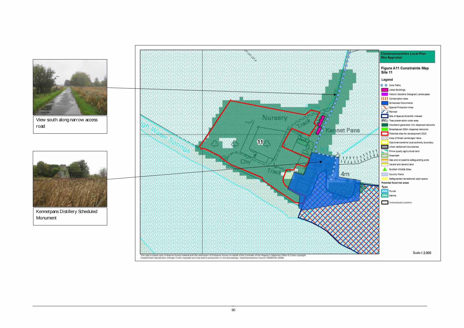
90
Kennetpans Distillery Scheduled Monument
View south along narrow access road

91
Site reference and location:
SITE 12 HELENSFIELD, CLACKMANNAN Size (ha) 6.13
Size (group) Small - medium
Summary description including site access and public transport connections
A gently sloping south facing site located to the north of Clackmannan, north of the Black Devon. The site lies between the A907 and the Alloa – Dunfermline railway. The site lies within the settlement boundary, however does not relate closely to the existing settlement of Clackmannan.
Site access would require to be taken from the A907 and a new roundabout would be required.
Overriding constraints to development
None
Site specific investigations Ground stability
Constraints to development Major – Impact on views to Clackmannan Tower. Ground stability.
Moderate - Road access requirements.
Summary of area remaining following mitigation
Ground stability may be a greater issue on the area of disturbed ground which occupies less than a sixth of the site.
Environmental features Trees and vegetation: There are some trees and scrub in the eastern part of the site and the course of the river is wooded.
Field boundaries: Post and wire with occasional field trees along the eastern road boundary.
Water (ponds, rivers and streams): The site adjoins the Black Devon and a minor tributary enters the river to the east of the site.
Role as part of FHN: The course of the Black Devon forms part of the 1km woodland generalist dispersal network.
Site ownership:
Site type: Settlement expansion
Current land use Agriculture
Surrounding land use The site is bounded by the railway line and A907. The land to the north of the site is managed for agriculture. To the south is the Black Devon and residential development, to the west is residential development surrounded by open space.
Planning policy framework: Due to the proximity of the River Black Devon the following policy is of relevance:
Clackmannanshire Local Plan Policy EN12 – Area Environmental Enhancement states that proposals which would detract from the setting or aesthetics of Conservation Areas, the A91 corridor or rivers will not normally be permitted, and that developers must demonstrate how proposals can be integrated with proposed enhancement measures.
Due to the presence of a core path link the following policy applies:
Clackmannanshire Local Plan Policy INF3 – Local Access: The policy states that development will not be permitted where it will result in the loss of an asserted right of way, footpath or a path forming part of the Clackmannanshire path network unless the provision of an alternative path can be assured.
SEA /site assessment topic
Site appraisal criteria Site issues and discussion Summary of Effect of development (++/+/0/-/--)
Enhancement and mitigation options
Potential effect following mitigation

92
SEA /site assessment topic
Site appraisal criteria Site issues and discussion Summary of Effect of development (++/+/0/-/--)
Enhancement and mitigation options
Potential effect following mitigation
Biodiversity, flora and fauna
Does the site impact on designated sites?
There are no designated sites within the site boundary or within the buffer of the site. 0
Does the site impact on priority habitats or species?
The Phase 1 habitat survey identifies the site is predominantly arable and pasture with a small area of unimproved neutral grassland in the eastern part of the site. There is one target note species in the eastern part of the site.
0
Does the development of the site avoid adverse effects on the integrity of the Firth of Forth SPA and Ramsar site?
The site is remote from the Firth of Forth SPA and Ramsar site and development of the site should not impact on the integrity of the site.
0
Does the development of the site maintain and enhance populations of European Protected Species including protection of their resting places?
The trees and scrub and proximity to the River Black Devon may provide habitat for some protected species. Site specific survey should be undertaken prior to development of the site to ascertain the presence of European Protected Species and appropriate mitigation implemented if these species are identified.
0/- Following site specific survey, appropriate mitigation should be identified and implemented.
Does the site facilitate the restoration and enhancement of biodiversity in all our urban and rural environments through better planning, design and practice?
The course of the Black Devon forms part of the 1km woodland generalist dispersal network. Development of the site is unlikely to impact directly on this habitat, however the development of the site will result in the loss of open habitat which may provide foraging areas.
0/-
Population and human health
Is the site connected to the local core path network?
A core path link passes through the centre of the site and provides access alongside the A907. This also provides links to other paths to the north and west of the site for recreational access.
+
How does the site relate to areas with high SIMD?
The site does not lie in within an area in the top 15% SIMD. 0
What is the relationship of the site with existing open space resources?
Notes connections to key recreational area or designation as a safeguarded open space or country park
The recreation ground off the B910 is the closest safeguarded open space. In addition the woodland areas and path network at Back Wood and Mary Wood provide a recreational resource.
+
Water
Is the site at risk of flooding?
The land immediately adjacent to the River Black Devon is identified as at potential risk of river flooding on the SEPA indicative river and coastal flood map, however the river is in a steeply incised valley. There may be issues with surface water drainage in parts of the site which are very flat.
- Implementation of SUDS and adequate site drainage can address issues with surface water drainage.
No effect
Are there water courses within the site or which would be affected by increased levels of pollution from development within the site?
The River Black Devon would potentially be affected by diffuse pollution resulting from run off from development of the site.
- The implementation of SUDS would mitigate the impact of diffuse pollution.
No effect
Are there water courses within the site or which would be affected by increased levels of flooding resulting from development of the site?
The River Black Devon has a potential risk of flooding along its length downstream of the site identified in the SEPA indicative river and coastal flood map. Development of the site would contribute to increased rate of run off to the River Black Devon.
- The implementation of SUDS would mitigate the impact of increase flood risk.
No effect
Soil Does the site include areas of vacant or derelict land?
The site does not include any identified areas of vacant and derelict land, however the HLA identifies that part of the eastern area of the site is a former mining area.
0

93
SEA /site assessment topic
Site appraisal criteria Site issues and discussion Summary of Effect of development (++/+/0/-/--)
Enhancement and mitigation options
Potential effect following mitigation
Is the site prime agricultural land?
The site is not prime quality agricultural land. 0
Air Quality and Transport
Is the site easily accessible by the local path network, and provide access to settlements and services?
The site is connected to the core path network and is within 1km of from Clackmannan town centre. Alloa town centre is accessible using off road access routes and is within 3km.
+
Is the site easily accessible by public transport? Bus access is provided from Clackmannan village, however a short walk is required to reach the nearest bus stop.
0
Does the site lie within an area where levels of air pollution are close to current limit values?
Air quality is monitored on Clackmannan Road in Alloa which would be the main route for traffic entering Alloa. Although recent trends have varied, there has been an increase in NO2 concentrations between 2005 and 2007 at this location.
- The site is comparatively small in extent and therefore the net increase in traffic flows would not have a significant impact on air pollution, however cumulative impacts in combination with other sites should be noted.
Would development on the site contribute to higher traffic flows along transport routes or at key junctions (potentially outwith the local authority area) where levels of air pollution are close to current limit values?
Development of the site would contribute to increased traffic flows on the A907, however the size of the site would not make a significant contribution to traffic levels.
-
Climatic Factors
Does the location of the development reduce the need to travel?
The development would provide easy access to Clackmannan town centre, and Alloa town centre is easily accessible by public transport.
+
Is the site at risk of increased flooding or instability as a result of climate change?
Parts of the site adjacent to the River Black Devon have an identified potential flood risk which may be increased as a result of climate change. The development of this site will contribute to increased run off to the River Black Devon.
- The implementation of SUDS will mitigate the impacts of increased run off resulting from development of the site.
No effect, however cumulative impacts in association with the development of other sites should be noted.
Material Assets
Is the site located close to existing transport, services, water and energy infrastructure?
The site is located adjacent to Clackmannan with access to transport services, water and energy infrastructure.
++
Is the site located to make best use of shelter and solar gain?
The site is located on a gently south facing slope and is well located to make use of shelter and solar gain.
++
Would development on the site reduce future potential for mineral extraction?
The site does not lie within an area identified as having open cast potential. 0
Does the site include any hazard areas? (oil or gas pipelines)
The site does not lie within any hazard areas. 0
Does the site reduce waste generation and promote waste recovery, recycling and composting?
Development of the site would generate additional waste arisings, however the site is small in extent and lies adjacent to an existing urban areas for which recycling facilities will be provided.
-
Cultural Heritage
Would development within the site impact on the integrity of sites, monuments, buildings or areas designated for their cultural heritage value?
There are no sites or features designated for their cultural heritage value within the site boundary. To the immediate south of the site the bridge over the Black Devon is a category C listed structure. Development of the site would not impact directly on the integrity of the monument. The development of the site would impact on views
-- Alterations to site layout would not mitigate the screening effect of development on the views to Clackmannan Tower.
No change.

94
SEA /site assessment topic
Site appraisal criteria Site issues and discussion Summary of Effect of development (++/+/0/-/--)
Enhancement and mitigation options
Potential effect following mitigation
to Clackmannan Tower from the A907.
Would development within the site impact on archaeological remains?
There are no known archaeological remains within the site boundary. The HLA identifies that the majority of the site is 18th-19th century fields and farming and part of the site adjacent to the River Black Devon is a relict 19th-20th century mining area.
0
Landscape Does the site lie within an area designated for its landscape value?
The site does not lie within an area designated for its landscape value. The site lies within the Devon/Forth landscape character area noted for its varied farmland characterised by undulating landform and coniferous blocks of forestry. Key attributes of the landscape character area are the diversity of features and dramatic outlook to the Ochils. The corridor of the Black Devon is identified as important. This landscape character area is noted for its diversity of landscape features and high landscape value. In particular guidelines for development include new woodland planting.
0
Would development within the site impact on settlement setting and identity (drawing on issues of landscape character and capacity for development)?
The development of the site would create an extension to Clackmannan which would be visible from the A907. Clackmannan Tower and the church are landscape features which contribute to the identity of Clackmannan and development of this site would affect views to these features.
- The development of the site will impact on views to the tower and church.
Would development within the site impact on key views to landscape features or from key transport routes?
The development of the site would screen views from the A907 to Clackmannan Tower and the church and would have a negative impact on these views.
-- The presence of built structures will impact on views.
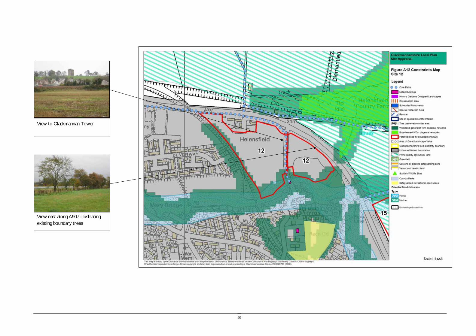
95
View to Clackmannan Tower
View east along A907 illustrating existing boundary trees

96
Site reference and location:
SITE 13 MEADOWEND FARM CLACKMANNAN Size (ha) 9.02
Size (group) Medium
Summary description including site access and public transport connections
Located adjacent to the Gartarry roundabout between the A977 and Alloa Road, and the A876 trunk road and the Alloa – Dunfermline railway. The site comprises a gently sloping field and is well connected to the road network. The site lies outwith the settlement boundary. Access could be taken onto the new roundabout on the A977 south of Gartarry.
Overriding constraints to development
Site specific investigations Access onto trunk road
Constraints to development Moderate – Road access. Prime quality agricultural land
Summary of area remaining following mitigation
None
Environmental features Trees and vegetation: Arable field with small number of deciduous trees at Gartarry roundabout.
Field boundaries: Hedgerow adjacent to Alloa Road, and post and wire fencing on other boundaries
Water (ponds, rivers and streams): A drain runs along the eastern boundary of the site.
Site ownership:
Site type: Development in the countryside
Current land use Agriculture
Surrounding land use Transport network and agriculture
Planning policy framework: Clackmannanshire and Stirling Structure Plan Policy ENV3 – Development in the Countryside: The policy states that development in the Countryside (as defined in Local Plans i.e. areas not within settlement boundaries) be suitable for it’s location in function and design and should accord with Policy ED4 – Rural Development (see below).
Clackmannanshire and Stirling Structure Plan Policy ED4 – Rural Development: The policy states that economic and social development in rural areas will be supported within the following criteria:
• Focusing development within existing towns and villages
• Restricting development within Green Belt and countryside.
Clackmannanshire Local Plan Policy EN18 – Development in the Countryside: Sets out the criteria for the granting of planning permission to a proposed development in the countryside.
Clackmannanshire and Stirling Structure Plan Policy H6 – Housing in the Countryside: The policy states that new housing developments in the Countryside will only be approved where the development is essential, involves the conversion of an existing building, or is consistent with Policy H5 ‘Housing in the Upland Area’.
As the site lies within an area of prime agricultural land the following policy applies:
Clackmannanshire and Stirling Structure Plan Policy ENV7 – Agricultural Land: Development which would result in the permanent loss of prime agricultural land will only be permitted where such land is identified for development in Local Plans and lower quality land cannot reasonably be used.
SEA /site assessment topic
Site appraisal criteria Site issues and discussion Summary of Effect of development (++/+/0/-/--)
Enhancement and mitigation options
Potential effect following mitigation

97
SEA /site assessment topic
Site appraisal criteria Site issues and discussion Summary of Effect of development (++/+/0/-/--)
Enhancement and mitigation options
Potential effect following mitigation
Biodiversity, flora and fauna
Does the site impact on designated sites?
The site does not include any sites designated for their nature conservation value. 0
Does the site impact on priority habitats or species?
The site does not impact on priority habitats or species.
The Phase 1 habitat survey identifies this site as arable and pasture.
0
Does the development of the site avoid adverse effects on the integrity of the Firth of Forth SPA and Ramsar site?
The site is remote from the Firth of Forth SPA and Ramsar site and development of the site should not impact on the integrity of the site.
0
Does the development of the site maintain and enhance populations of European Protected Species including protection of their resting places?
The hedgerows may provide habitat for some protected species. Site specific survey should be undertaken prior to development of the site to ascertain the presence of European Protected Species and appropriate mitigation implemented if these species are identified.
0/- Following site specific survey, appropriate mitigation should be identified and implemented.
Does the site facilitate the restoration and enhancement of biodiversity in all our urban and rural environments through better planning, design and practice?
There are no elements of the FHN within the site. The site is bounded by hedgerows which provide some habitat value, and development of the site could potentially result in loss of these resources.
- The hedgerows should be protected and enhanced through the development of the site. Additional woodland habitat should be created along the southern site boundary.
Minor negative
Population and human health
Is the site connected to the local core path network?
The site is not directly connected to the core path network, however a core path extends through the nearby woodland belt to the west of the site. The national cycle network is routed over the new Clackmannanshire Bridge.
+
How does the site relate to areas with high SIMD?
The site is not located within or close to any areas within the top 15% SIMD. 0
What is the relationship of the site with existing open space resources?
Notes connections to key recreational area or designation as a safeguarded open space or country park
There are no open space resources close to the site, however the network of paths in the adjacent woodland and farmland to the west provides a recreation resource.
+ Formal open space provision.
Water
Is the site at risk of flooding?
The site is not identified as at risk of flooding on the SEPA indicative river and coastal flooding map. The site is low lying in relation to the surrounding topography.
-
Are there water courses within the site or which would be affected by increased levels of pollution from development within the site?
There is a drain at the eastern boundary of the site which may be affected by diffuse pollution resulting from development of the site.
0
Are there water courses within the site or which would be affected by increased levels of flooding resulting from development of the site?
Development of the site may result in increased rate of run off, however the site has a comparatively small area. There is a drain at the eastern boundary of the site.
-

98
SEA /site assessment topic
Site appraisal criteria Site issues and discussion Summary of Effect of development (++/+/0/-/--)
Enhancement and mitigation options
Potential effect following mitigation
Soil Does the site include areas of vacant or derelict land?
The site is not vacant or derelict land. 0
Is the site prime agricultural land?
The site is prime quality agricultural land. -
Air Quality and Transport
Is the site easily accessible by the local path network, and provide access to settlements and services?
The site is over 2km from the centre of Clackmannan and 3.5km from the centre of Kincardine. A core path through the woodland belt at Kennet provides off road access to Clackmannan.
There is no pavement access along Alloa Road from Gartarry roundabout to Kennet.
-
Is the site easily accessible by public transport? The site is not currently serviced by public transport, with the nearest bus stops in Kennet, however provision could be made.
0
Does the site lie within an area where levels of air pollution are close to current limit values?
Air quality is not monitored within close proximity of the site, however the site lies at the junction of five major roads which will have a local impact on amenity.
-
Would development on the site contribute to higher traffic flows along transport routes or at key junctions (potentially outwith the local authority area) where levels of air pollution are close to current limit values?
The development of the site would contribute to traffic flows on the A907 to Alloa and Alloa Road into Clackmannan.
-
Climatic Factors
Does the location of the development reduce the need to travel?
The site is not located close to existing settlement and services and therefore would increase the need to travel.
-
Is the site at risk of increased flooding or instability as a result of climate change?
The site is not identified as at high risk of flooding or instability as a result of climate change, however the site is essentially low lying in nature and potentially vulnerable to flood events.
0
Material Assets
Is the site located close to existing transport, services, water and energy infrastructure?
The site is located close to existing transport, water and energy infrastructure. +
Is the site located to make best use of shelter and solar gain?
The site is gently sloping and suitably located to make use of solar gain. +
Would development on the site reduce future potential for mineral extraction?
The site is not identified as a potential site for mineral extraction. 0
Does the site include any hazard areas? (oil or gas pipelines)
The site is not within any oil or gas pipeline hazard areas. 0
Does the site reduce waste generation and promote waste recovery, recycling and composting?
Development of the site would generate additional waste arisings, however the site is small in extent and lies adjacent to an existing urban areas for which recycling facilities will be provided.
-
Cultural Heritage
Would development within the site impact on the integrity of sites, monuments, buildings or
The Kennet Conservation Area lies to the west of the site beyond the railway. Development of this site would introduce additional built development to the east of
0

99
SEA /site assessment topic
Site appraisal criteria Site issues and discussion Summary of Effect of development (++/+/0/-/--)
Enhancement and mitigation options
Potential effect following mitigation
areas designated for their cultural heritage value?
Kennet, however this would remain separated from the village by the railway line and would not impact on the immediate setting or form of the conservation area.
Would development within the site impact on archaeological remains?
There are no known archaeological remains within the site boundary. The HLA identifies that the site is 19th century to present fields and farming.
0
Landscape Does the site lie within an area designated for its landscape value?
The site does not lie in an area of AGLV or Greenbelt. It lies within the Devon/Forth landscape character area with varied farmland characterised by undulating landform and coniferous blocks of forestry. Key attributes of the landscape character area are the diversity of features and dramatic outlook to the Ochils. The corridor of the Black Devon is identified as important.
0 This landscape character area is noted for its diversity of landscape features and high landscape value.
Would development within the site impact on settlement setting and identity (drawing on issues of landscape character and capacity for development)?
The development of the site would introduce a new area of development into an area of otherwise intact rural landscape.
The development of the site would not impact directly on existing settlement and identity, however it would introduce development alongside the A977. The site has a high level of intervisibility with site 16 which should also be considered.
0/- Views from the new Clackmannanshire Bridge and A977 from the south are elevated and therefore landscaping would have limited role in screening views.
Would development within the site impact on key views to landscape features or from key transport routes?
The site is highly visible from the A876 trunk road, the A977 and Alloa Road and development would detract from the intrinsically rural character of the area.
- As above

100
View north east to Gartarry roundabout
View east to A977

101
Site reference and location:
SITE 14 KILBAGIE (NORTH) Size (ha) 14.40
Size (group) Medium
Summary description including site access and public transport connections
Lying to the east of the A876 Trunk road, west of the A977 and straddling the Alloa – Dunfermline railway line this site is strongly influenced by the surrounding transport infrastructure. The site rises gently to the west and comprises two large fields with the wooded route of the railway line running through the centre of the site.
Overriding constraints to development
Oil and gas pipeline hazard zone
Site specific investigations n/a
Constraints to development See overriding constraint above.
Moderate – Prime quality agricultural land
Summary of area remaining following mitigation
The whole of the site is affected by the overriding constraint to development of the oil and gas pipeline hazard zone.
Environmental constraints Trees and vegetation: Agriculture with occasional shrubs and trees on boundaries.
Field boundaries: Post and wire.
Water (ponds, rivers and streams): A drain runs through the eastern part of the site and along the southern boundary of the site
Role as part of FHN: No role
Site ownership: This information will be gathered from the desk based review and consultation
Site type: Development in the countryside
Current land use Agriculture and railway.
Surrounding land use The site is bounded by the A876 and A977 with agricultural land to the west, north and east. To the south is the complex of buildings and grounds of the Kilbagie paper mill.
Planning policy framework: Clackmannanshire and Stirling Structure Plan Policy ENV3 – Development in the Countryside: The policy states that development in the Countryside (as defined in Local Plans i.e. areas not within settlement boundaries) be suitable for it’s location in function and design and should accord with Policy ED4 – Rural Development (see below).
Clackmannanshire and Stirling Structure Plan Policy ED4 – Rural Development:: The policy states that economic and social development in rural areas will be supported within the following criteria:
• Focusing development within existing towns and villages
• Restricting development within Green Belt and countryside.
Clackmannanshire Local Plan Policy EN18 – Development in the Countryside: Sets out the criteria for the granting of planning permission to a proposed development in the countryside.
Clackmannanshire and Stirling Structure Plan Policy H6 – Housing in the Countryside: The policy states that new housing developments in the Countryside will only be approved where the development is essential, involves the conversion of an existing building, or is consistent with Policy H5 ‘Housing in the Upland Area’.
As the site lies within an area of prime agricultural land the following policy applies:
Clackmannanshire and Stirling Structure Plan Policy ENV7 – Agricultural Land: Development which would result in the permanent loss of prime agricultural land will only be permitted where such land is identified for development in Local Plans and lower quality land cannot reasonably be used.
NB. The site is also identified as being within a Gas and Oil Pipeline Hazard Area on the Local Plan Countryside Wide Map.

102
SEA /site assessment topic
Site appraisal criteria Site issues and discussion Summary of Effect of development (++/+/0/-/--)
Enhancement and mitigation options
Potential effect following mitigation
Biodiversity, flora and fauna
Does the site impact on designated sites?
There are no designated sites within the site boundary or site buffer. 0
Does the site impact on priority habitats or species?
A small area of woodland to the west of the site (which formed part of the boundary woodlands to site 16) was subject to Phase 2 Habitat survey.
The site is identified as arable and pasture in the Phase 1 habitat survey.
0
Does the development of the site avoid adverse effects on the integrity of the Firth of Forth SPA and Ramsar site?
The site is remote from the Firth of Forth SPA and Ramsar site and development of the site should not impact on the integrity of the site.
0
Does the development of the site maintain and enhance populations of European Protected Species including protection of their resting places?
The hedgerows may provide habitat for some protected species. Site specific survey should be undertaken prior to development of the site to ascertain the presence of European Protected Species and appropriate mitigation implemented if these species are identified.
0/- Following site specific survey, appropriate mitigation should be identified and implemented.
Does the site facilitate the restoration and enhancement of biodiversity in all our urban and rural environments through better planning, design and practice?
There are no elements of the FHN within the site. The site is bounded by hedgerows which provide some habitat value, and development of the site could potentially result in loss of these resources.
- The hedgerows should be protected and enhanced through the development of the site. Additional woodland habitat should be created along the southern site boundary.
Minor negative
Population and human health
Is the site connected to the local core path network?
The site is not connected to the core path network and pedestrian or cycle access from the site would be adjacent to main roads.
--
How does the site relate to areas with high SIMD?
The site does not lie within an area within the top 15% SIMD. 0
What is the relationship of the site with existing open space resources?
The site does not lie close to any existing open space resources. -- The site is of insufficient size to support open space resources.
Water
Is the site at risk of flooding?
The site is not identified as having any risk of flooding on the SEPA indicative river and coastal flood map. The north eastern part of the site is low lying compared to the surrounding landform.
0
Are there water courses within the site or which would be affected by increased levels of pollution from development within the site?
There are minor drains at the perimeter of the site which may be affected by diffuse pollution resulting from the development of the site.
-
Are there water courses within the site or which would be affected by increased levels of flooding resulting from development of the site?
Development of the site may result in increased rate of run off, however the site has a comparatively small area and drains towards the Kilbagie site which is not recorded as having flooding issues.
0 Potential flooding risk can be mitigated through the provision of SUDS within the site.
Soil Does the site include areas of vacant or derelict land?
The site is not vacant or derelict land. 0
Is the site prime agricultural land? The site is identified as prime quality agricultural land. -

103
Air Quality and Transport
Is the site easily accessible by the local path network, and provide access to settlements and services?
The site is over 3km from the centre of Clackmannan and over 2.5km from the centre of Kincardine. There are no core paths which connect the site to either Clackmannan or Kincardine. The site is close to the NCN which is routed across the Clackmannanshire Bridge.
--
Is the site easily accessible by public transport? There are bus services from Kennet and on the A977. -
Does the site lie within an area where levels of air pollution are close to current limit values?
Air quality is not monitored within close proximity of the site, however the site is comparatively small in size and development would not make a significant impact on air quality.
0
Would development on the site contribute to higher traffic flows along transport routes or at key junctions (potentially outwith the local authority area) where levels of air pollution are close to current limit values?
The development of the site would contribute to increased traffic levels at the roundabout between the A876 trunk road and the A977 and Gartarry roundabout.
-
Climatic Factors
Does the location of the development reduce the need to travel?
The site is located outwith convenient walking distance to the nearest settlement and therefore does not reduce the need to travel.
-- No mitigation.
Is the site at risk of increased flooding or instability as a result of climate change?
The site is not identified as being of significant risk of flooding or instability as a result of climate change due to the current site characteristics which include a gently slope and no major watercourses.
0
Material Assets
Is the site located close to existing transport, services, water and energy infrastructure?
Is the site located to make best use of shelter and solar gain?
The site is located on a gently sloping south east facing site and therefore is well located to make use of shelter and solar gain.
+
Would development on the site reduce future potential for mineral extraction?
The site is constrained by the oil and gas pipeline hazard zone and is not identified as a potential site for mineral extraction.
0
Does the site include any hazard areas? (oil or gas pipelines)
All of the site lies within the oil and gas pipeline hazard zone. -- No mitigation.
Does the site reduce waste generation and promote waste recovery, recycling and composting?
Development of the site would generate additional waste arisings, and the site is remote from existing settlement and would require additional collection services.
-
Cultural Heritage
Would development within the site impact on the integrity of sites, monuments, buildings or areas designated for their cultural heritage value?
There are no features designated for their cultural heritage value within the site boundary.
The ‘B’ listed Kilbagie House and Garden Walls lies within 50m of the site boundary and Kilbagie Mill House (C) lies within 200m. However these features are located downslope from the site and intervisibility is limited.
0
Would development within the site impact on archaeological remains?
There are no known archaeological remains within the site boundary. The HLA identifies that to the east of the railway line is 19th century to present fields and farming, and to the west of the railway line is also 19th century to present fields and
0

104
farming with the relict category of settlement and agriculture.
Landscape Does the site lie within an area designated for its landscape value?
The site is not Greenbelt and does not lie within an AGLV. The site lies within the Devon/Forth landscape character area with varied farmland characterised by undulating landform and coniferous blocks of forestry. Key attributes of the landscape character area are the diversity of features and dramatic outlook to the Ochils. This landscape character area is noted for its diversity of landscape features and high landscape value.
0
Would development within the site impact on settlement setting and identity (drawing on issues of landscape character and capacity for development)?
The site does not relate to existing areas of settlement and would create an isolated area of development with no physical or perceptual links to settlement. Although the developed site of Kilbagie lies to the south of this site, this does not have a strong visual relationship with the site.
0/-
Would development within the site impact on key views to landscape features or from key transport routes?
The site would be visible from the A977 and the A876 trunk road.
-

105
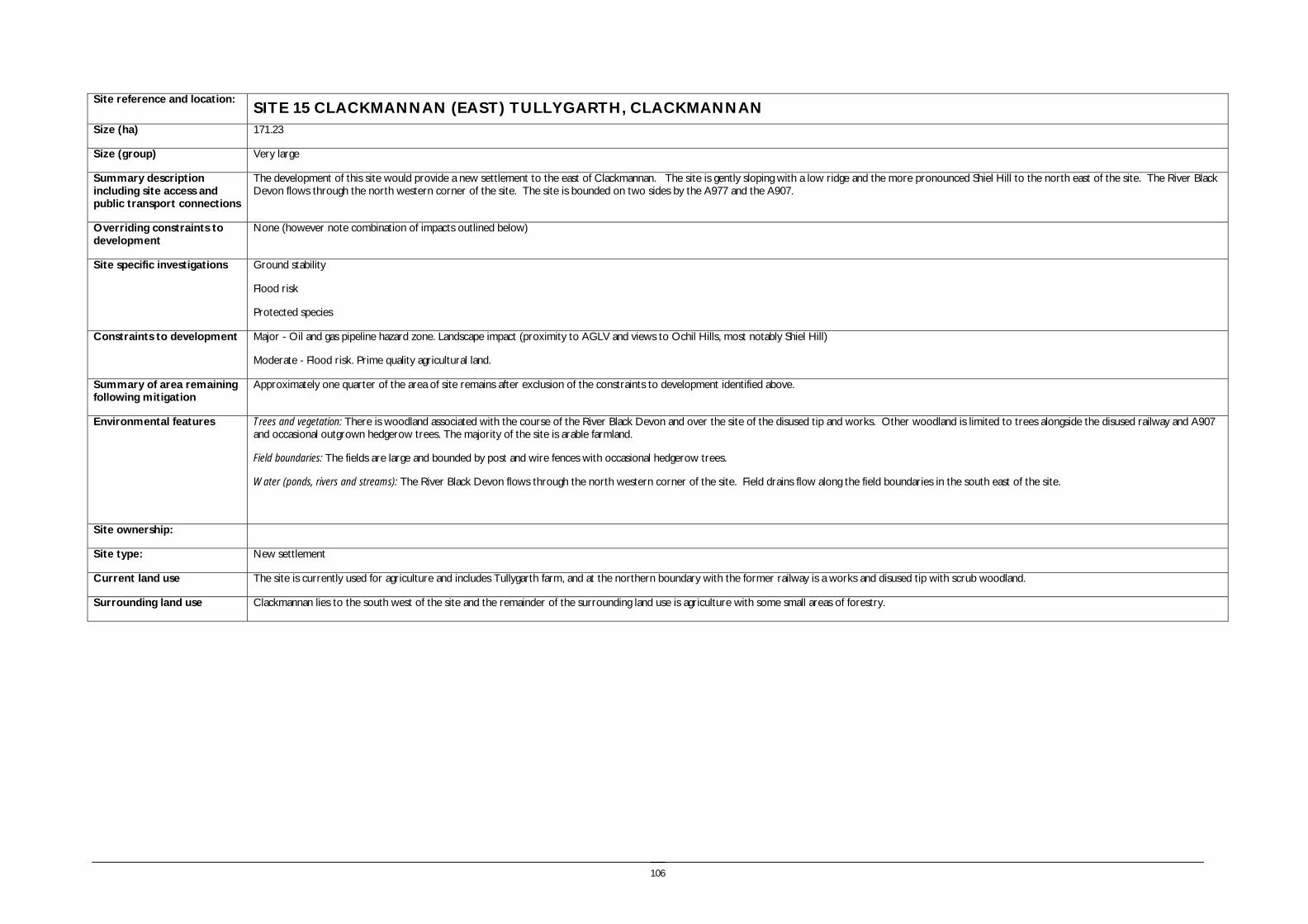
106
Site reference and location:
SITE 15 CLACKMANNAN (EAST) TULLYGARTH, CLACKMANNAN Size (ha) 171.23
Size (group) Very large
Summary description including site access and public transport connections
The development of this site would provide a new settlement to the east of Clackmannan. The site is gently sloping with a low ridge and the more pronounced Shiel Hill to the north east of the site. The River Black Devon flows through the north western corner of the site. The site is bounded on two sides by the A977 and the A907.
Overriding constraints to development
None (however note combination of impacts outlined below)
Site specific investigations Ground stability
Flood risk
Protected species
Constraints to development Major - Oil and gas pipeline hazard zone. Landscape impact (proximity to AGLV and views to Ochil Hills, most notably Shiel Hill)
Moderate - Flood risk. Prime quality agricultural land.
Summary of area remaining following mitigation
Approximately one quarter of the area of site remains after exclusion of the constraints to development identified above.
Environmental features Trees and vegetation: There is woodland associated with the course of the River Black Devon and over the site of the disused tip and works. Other woodland is limited to trees alongside the disused railway and A907 and occasional outgrown hedgerow trees. The majority of the site is arable farmland.
Field boundaries: The fields are large and bounded by post and wire fences with occasional hedgerow trees.
Water (ponds, rivers and streams): The River Black Devon flows through the north western corner of the site. Field drains flow along the field boundaries in the south east of the site.
Site ownership:
Site type: New settlement
Current land use The site is currently used for agriculture and includes Tullygarth farm, and at the northern boundary with the former railway is a works and disused tip with scrub woodland.
Surrounding land use Clackmannan lies to the south west of the site and the remainder of the surrounding land use is agriculture with some small areas of forestry.

107
Planning policy framework: Clackmannanshire and Stirling Structure Plan Policy ENV3 – Development in the Countryside: The policy states that development in the Countryside (as defined in Local Plans i.e. areas not within settlement boundaries) be suitable for it’s location in function and design and should accord with Policy ED4 – Rural Development (see below).
Clackmannanshire and Stirling Structure Plan Policy ED4 – Rural Development: The policy states that economic and social development in rural areas will be supported within the following criteria:
• Focusing development within existing towns and villages
• Restricting development within Green Belt and countryside.
Clackmannanshire Local Plan Policy EN18 – Development in the Countryside: Sets out the criteria for the granting of planning permission to a proposed development in the countryside.
Clackmannanshire and Stirling Structure Plan Policy H6 – Housing in the Countryside: The policy states that new housing developments in the Countryside will only be approved where the development is essential, involves the conversion of an existing building, or is consistent with Policy H5 ‘Housing in the Upland Area’.
As part of the site lies within an area of prime agricultural land the following policy applies:
Clackmannanshire and Stirling Structure Plan Policy ENV7 – Agricultural Land: Development which would result in the permanent loss of prime agricultural land will only be permitted where such land is identified for development in Local Plans and lower quality land cannot reasonably be used.
As part of the site is vacant or derelict land the following policy applies:
Clackmannanshire Local Plan - Policy RES2 – Brownfield Development: The policy prioritises development which will take place on brownfield sites which will utilise vacant, derelict, contaminated and underused land and property within settlement boundaries.
Due to the presence of a core path link the following policy applies:
Clackmannanshire Local Plan Policy INF3 – Local Access: The policy states that development will not be permitted where it will result in the loss of an asserted right of way, footpath or a path forming part of the Clackmannanshire path network unless the provision of an alternative path can be assured.
As there is some potential for flooding the following policies should be taken into account:
Clackmannanshire and Stirling Structure Plan Policy ENV9 – Water Resource Management: The policy states that development will not normally be permitted in undeveloped flood plain areas, in areas of known significant flood risk, or if it will adversely affect the Forth Estuary. Exceptions will be made only when it can be demonstrated that no alternative locations can be found, or that suitable mitigation measures can be implemented.
Clackmannanshire Local Plan Policy EN4 – Water Resources: The policy states that where a development area is determined as being at risk of flooding, planning permission will not be granted except where it can be proven that there are no viable alternative sites.
As the site has an identified potential for open cast coal extraction (within a Constraint Area) the following apply:
Clackmannanshire and Stirling Structure Plan Policy ENV10 – Minerals – General Principles: states that economically important mineral resources will be protected from sterilisation by permanent development. Alternatively, working of minerals in advance of development will be encouraged.
Clackmannanshire Local Plan Policy Policy EN24 – Protection of Minerals: The policy states that permanent development which would result in the sterilisation of viable mineral resources will not be permitted except where this would prevent residential development which contributes to the strategic housing land requirement and no other sites area available to meet this requirement.
As the River Black Devon flows through part of the site the following policy applies:
Clackmannanshire Local Plan Policy EN12 – Area Environmental Enhancement states that proposals which would detract from the setting or aesthetics of Conservation Areas, the A91 corridor or rivers will not normally be permitted, and that developers must demonstrate how proposals can be integrated with proposed enhancement measures.
NB. The site is also identified as being within a Gas and Oil Pipeline Hazard Area on the Local Plan Countryside Wide Map.
SEA /site assessment topic
Site appraisal criteria Site issues and discussion Summary of Effect of development (++/+/0/-/--)
Enhancement and mitigation options
Potential effect following mitigation
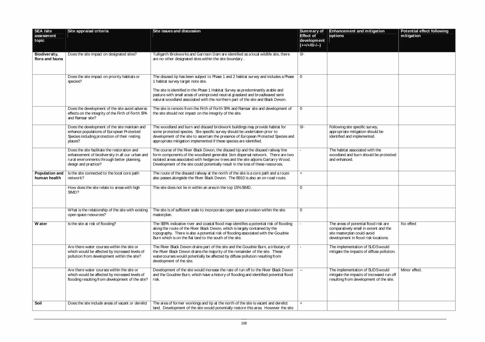
108
SEA /site assessment topic
Site appraisal criteria Site issues and discussion Summary of Effect of development (++/+/0/-/--)
Enhancement and mitigation options
Potential effect following mitigation
Biodiversity, flora and fauna
Does the site impact on designated sites?
Tulligarth Brickworks and Garrison Dam are identified as a local wildlife site, there are no other designated sites within the site boundary .
0/-
Does the site impact on priority habitats or species?
The disused tip has been subject to Phase 1 and 2 habitat survey and includes a Phase 1 habitat survey target note site.
The site is identified in the Phase 1 Habitat Survey as predominantly arable and pasture with small areas of unimproved neutral grassland and broadleaved semi natural woodland associated with the northern part of the site and Black Devon.
0
Does the development of the site avoid adverse effects on the integrity of the Firth of Forth SPA and Ramsar site?
The site is remote from the Firth of Forth SPA and Ramsar site and development of the site should not impact on the integrity of the site.
0
Does the development of the site maintain and enhance populations of European Protected Species including protection of their resting places?
The woodland and burn and disused brickwork buildings may provide habitat for some protected species. Site specific survey should be undertaken prior to development of the site to ascertain the presence of European Protected Species and appropriate mitigation implemented if these species are identified.
0/- Following site specific survey, appropriate mitigation should be identified and implemented.
Does the site facilitate the restoration and enhancement of biodiversity in all our urban and rural environments through better planning, design and practice?
The course of the River Black Devon, the disused tip and the disused railway line form components of the woodland generalist 1km dispersal network. There are two isolated areas associated with hedgerow trees and the site adjoins Gartarry Wood. Development of the site could potentially result in the loss of these resources.
- The habitat associated with the woodland and burn should be protected and enhanced.
Population and human health
Is the site connected to the local core path network?
The route of the disused railway at the north of the site is a core path and a route also passes alongside the River Black Devon. The B910 is also an on road route.
+
How does the site relate to areas with high SIMD?
The site does not lie in within an area in the top 15% SIMD. 0
What is the relationship of the site with existing open space resources?
The site is of sufficient scale to incorporate open space provision within the site masterplan.
0
Water
Is the site at risk of flooding?
The SEPA indicative river and coastal flood map identifies a potential risk of flooding along the route of the River Black Devon, which is largely contained by the topography. There is also a potential risk of flooding associated with the Goudnie Burn which is on the flat land to the south of the site.
- The areas of potential flood risk are comparatively small in extent and the site masterplan could avoid development in flood risk locations.
No effect
Are there water courses within the site or which would be affected by increased levels of pollution from development within the site?
The River Black Devon drains part of the site and the Goudnie Burn, a tributary of the River Black Devon drains the majority of the remainder of the site. These watercourses would potentially be affected by diffuse pollution resulting from development of the site.
- The implementation of SUDS would mitigate the impacts of diffuse pollution.
Are there water courses within the site or which would be affected by increased levels of flooding resulting from development of the site?
Development of the site would increase the rate of run off to the River Black Devon and the Goudnie Burn, which have a history of flooding and identified potential flood risk.
-- The implementation of SUDS would mitigate the impacts of increased run off resulting from development of the site.
Minor effect.
Soil Does the site include areas of vacant or derelict The area of former workings and tip at the north of the site is vacant and derelict land. Development of the site would potentially restore this area. However the site
+

109
SEA /site assessment topic
Site appraisal criteria Site issues and discussion Summary of Effect of development (++/+/0/-/--)
Enhancement and mitigation options
Potential effect following mitigation
land?
provides some habitat value in its current form and this should be investigated further.
Is the site prime agricultural land?
The low lying areas of land within the site are prime quality agricultural land. - No mitigation.
Air Quality and Transport
Is the site easily accessible by the local path network, and provide access to settlements and services?
The site is accessible via the local path network which provides connections into Clackmannan, and toward Alloa, however the route to Clackmannan is not direct.
+ New links would require to be developed from the more easterly parts of the site, including the provision of safe crossing points over the A907.
Is the site easily accessible by public transport? The site is located adjacent to the A907, however the development of the site would require the provision of public transport.
+ Public transport provision.
Does the site lie within an area where levels of air pollution are close to current limit values?
The site does not lie in an area where air quality is monitored. 0
Would development on the site contribute to higher traffic flows along transport routes or at key junctions (potentially outwith the local authority area) where levels of air pollution are close to current limit values?
The development of the site would make a significant contribution to traffic levels on either the A907 or the A977.
Traffic leaving the site would travel to Alloa on the A907 to make use of the services within the town. This would generate higher traffic levels within Alloa town centre and the nearest monitoring location on Clackmannan Road had the highest level of NO2 of the ten monitoring locations.
--
Climatic Factors
Does the location of the development reduce the need to travel?
The development would comprise a new settlement, which would be provided with local services. The location of the development will not reduce the need to travel.
- The masterplanning of the site can ensure the best use of the site so that car use is minimised and walking and cycling are facilitated.
Minor negative effect.
Is the site at risk of increased flooding or instability as a result of climate change?
Parts of the site have an identified potential flood risk which is likely to increase as a result of predicted climate change.
- These areas can be avoided through site masterplanning and the implementation of SUDS.
No effect.
Material Assets
Is the site located close to existing transport, services, water and energy infrastructure?
The site is located to the north of Clackmannan and is therefore close to existing transport, water and energy infrastructure.
+
Is the site located to make best use of shelter and solar gain?
The site occupies a predominantly south facing gently sloping site and is well located to make best use of shelter and solar gain.
+
Would development on the site reduce future potential for mineral extraction?
The site has an identified potential for open cast coal extraction. However a number of technical constraints may exist to extraction.
- No mitigation
Does the site include any hazard areas? (oil or gas pipelines)
There is a gas and oil pipeline hazard safeguarding zone running south west to north east through the site.
- Exclusion of this area from development reduces the overall potential area of land for development
Does the site reduce waste generation and promote waste recovery, recycling and
Development of the site would generate additional waste arisings associated with a large development area.
- Local recycling and composting facilities should be provided as part of the site

110
SEA /site assessment topic
Site appraisal criteria Site issues and discussion Summary of Effect of development (++/+/0/-/--)
Enhancement and mitigation options
Potential effect following mitigation
composting? masterplan.
Cultural Heritage
Would development within the site impact on the integrity of sites, monuments, buildings or areas designated for their cultural heritage value?
There are no designated archaeological features within the site boundary or the immediate buffer. The HLA identifies that the majority of the site is 18th-19th century and 19th century to present fields and farming.
0
Would development within the site impact on archaeological remains?
Brucefield Colliery and brickworks are recorded in the National Monuments Record of Scotland, as is Cherryford Brickworks.
-
Landscape Does the site lie within an area designated for its landscape value?
The site lies adjacent to The Forest AGLV. -
Would development within the site impact on settlement setting and identity (drawing on issues of landscape character and capacity for development)?
The site constitutes a new settlement and would impact on the character and identity of Clackmannan through creating a lack of physical and perceptual distinction between the two settlements.
- The layout of the site could provide separation between Clackmannan and the new settlement, however this would not fully mitigate the visual impacts of the close proximity of the settlements.
Outstanding impact.
Would development within the site impact on key views to landscape features or from key transport routes?
The development of the site would be highly visible from the A907 and the A977 and be highly visible as a developed foreground to the Ochils when viewed from Gartarry roundabout. This view is one of the most important views when travelling through Clackmannan and the landscape character should be protected.
-- No mitigation.

111
View east to Shiel Hill
View west to Clackmannan
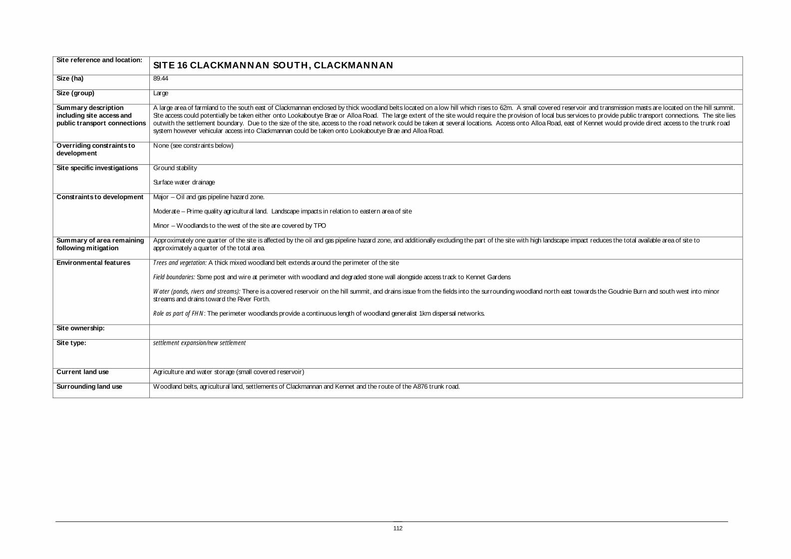
112
Site reference and location:
SITE 16 CLACKMANNAN SOUTH, CLACKMANNAN Size (ha) 89.44
Size (group) Large
Summary description including site access and public transport connections
A large area of farmland to the south east of Clackmannan enclosed by thick woodland belts located on a low hill which rises to 62m. A small covered reservoir and transmission masts are located on the hill summit. Site access could potentially be taken either onto Lookaboutye Brae or Alloa Road. The large extent of the site would require the provision of local bus services to provide public transport connections. The site lies outwith the settlement boundary. Due to the size of the site, access to the road network could be taken at several locations. Access onto Alloa Road, east of Kennet would provide direct access to the trunk road system however vehicular access into Clackmannan could be taken onto Lookaboutye Brae and Alloa Road.
Overriding constraints to development
None (see constraints below)
Site specific investigations Ground stability
Surface water drainage
Constraints to development Major – Oil and gas pipeline hazard zone.
Moderate – Prime quality agricultural land. Landscape impacts in relation to eastern area of site
Minor – Woodlands to the west of the site are covered by TPO
Summary of area remaining following mitigation
Approximately one quarter of the site is affected by the oil and gas pipeline hazard zone, and additionally excluding the part of the site with high landscape impact reduces the total available area of site to approximately a quarter of the total area.
Environmental features Trees and vegetation: A thick mixed woodland belt extends around the perimeter of the site
Field boundaries: Some post and wire at perimeter with woodland and degraded stone wall alongside access track to Kennet Gardens
Water (ponds, rivers and streams): There is a covered reservoir on the hill summit, and drains issue from the fields into the surrounding woodland north east towards the Goudnie Burn and south west into minor streams and drains toward the River Forth.
Role as part of FHN: The perimeter woodlands provide a continuous length of woodland generalist 1km dispersal networks.
Site ownership:
Site type: settlement expansion/new settlement
Current land use Agriculture and water storage (small covered reservoir)
Surrounding land use Woodland belts, agricultural land, settlements of Clackmannan and Kennet and the route of the A876 trunk road.

113
Planning policy framework: Clackmannanshire and Stirling Structure Plan Policy ENV3 – Development in the Countryside: The policy states that development in the Countryside (as defined in Local Plans i.e. areas not within settlement boundaries) be suitable for it’s location in function and design and should accord with Policy ED4 – Rural Development (see below).
Clackmannanshire and Stirling Structure Plan Policy ED4 – Rural Development: The policy states that economic and social development in rural areas will be supported within the following criteria:
• Focusing development within existing towns and villages
• Restricting development within Green Belt and countryside.
Clackmannanshire Local Plan Policy EN18 – Development in the Countryside: Sets out the criteria for the granting of planning permission to a proposed development in the countryside.
Clackmannanshire and Stirling Structure Plan Policy H6 – Housing in the Countryside: The policy states that new housing developments in the Countryside will only be approved where the development is essential, involves the conversion of an existing building, or is consistent with Policy H5 ‘Housing in the Upland Area’.
As the site lies within an area of prime agricultural land the following policy applies:
Clackmannanshire and Stirling Structure Plan Policy ENV7 – Agricultural Land: Development which would result in the permanent loss of prime agricultural land will only be permitted where such land is identified for development in Local Plans and lower quality land cannot reasonably be used.
As there are two core paths which cross the site the following applies:
Clackmannanshire Local Plan Policy INF3 – Local Access: The policy states that development will not be permitted where it will result in the loss of an asserted right of way, footpath or a path forming part of the Clackmannanshire path network unless the provision of an alternative path can be assured.
As the site is adjacent to a Conservation Area the following should be considered:
Clackmannanshire and Stirling Structure Plan Policy ENV6 – The Historic and Built Environment: aims to protect and enhance cultural heritage features, as well as ensure that new developments are in keeping with the character and quality of the area.
Clackmannanshire Local Plan Policy EN12 – Area Environmental Enhancement: states that proposals which would detract from the setting or aesthetics of Conservation Areas, the A91 corridor or rivers will not normally be permitted, and that developers must demonstrate how proposals can be integrated with proposed enhancement measures.
As the site is surrounded by woodland the following policy should be taken into account:
Clackmannanshire Local Plan Policy EN2 – Landscape and Ecology: The policy also states that appropriate consideration must be given to existing woodland, habitats, natural and landscape features when making a planning application.
NB. The site includes two gas and oil pipeline hazard areas as noted on the Local Plan Countryside Wide Map.
SEA /site assessment topic
Site appraisal criteria Site issues and discussion Summary of Effect of development (++/+/0/-/--)
Enhancement and mitigation options
Potential effect following mitigation
Biodiversity, flora and fauna
Does the site impact on designated sites?
The site does not impact directly or indirectly on sites designated for their biodiversity value. The woodland belt which adjoins the built edge of Clackmannan is designated as a tree preservation order area.
0 The protection and enhancement of the area of woodland subject to the tree preservation order should be incorporated within the development of the site.
Does the site impact on priority habitats or species?
The woodland belts have been subject to Phase 2 Habitat survey and include Phase 1 target note sites.
The site is identified in the Phase 1 Habitat Survey as arable and pasture with a small area of semi improved neutral grassland at the extreme west of the site and mixed plantation surrounding the site, as identified in the Phase I habitat survey.
0
Does the development of the site avoid adverse effects on the integrity of the Firth of Forth SPA
The site is remote from the Firth of Forth SPA and Ramsar site and development of the site should not impact on the integrity of the site.
0

114
SEA /site assessment topic
Site appraisal criteria Site issues and discussion Summary of Effect of development (++/+/0/-/--)
Enhancement and mitigation options
Potential effect following mitigation
and Ramsar site?
Does the development of the site maintain and enhance populations of European Protected Species including protection of their resting places?
The site includes extensive perimeter woodlands and arable farmland. The woodlands may provide habitat for protected species. Site specific survey should be undertaken prior to development of the site to ascertain the presence of European Protected Species and appropriate mitigation implemented if these species are identified
0/- Following site specific survey, appropriate mitigation should be identified and implemented.
Does the site facilitate the restoration and enhancement of biodiversity in all our urban and rural environments through better planning, design and practice?
The perimeter woodlands provide a continuous length of woodland generalist 1km dispersal networks. Development of the site could result in loss of an area of open ground which may provide foraging habitat.
0/- Habitat creation would reduce the impact of loss of open ground.
Population and human health
Is the site connected to the local core path network?
Two core paths cross the site and other connections extend through the perimeter woodlands. The site is well connected to the core path network.
+
How does the site relate to areas with high SIMD?
The site is not within an area in the top 15% in the SIMD, and is not in close proximity to deprived areas.
0
What is the relationship of the site with existing open space resources?
Notes connections to key recreational area or designation as a safeguarded open space or country park
The perimeter woodland belts with their network of paths provide an open space resource. King George’s Field lies within 200m of the site boundary at the north western edge and is a safeguarded open space. The size of the site would provide opportunity for open space provision within the site boundaries.
+ The pipeline hazard zones provide opportunity to create an open space resource within the site.
Water
Is the site at risk of flooding?
The site is located on a hill and is not identified as at risk of flooding in the SEPA indicative flood map.
++
Are there water courses within the site or which would be affected by increased levels of pollution from development within the site?
Several minor watercourses drain the site and would potentially be affected by pollution resulting from run off from development of the site.
- The implementation of SUDS would mitigate impacts associated with pollution resulting from development of the site.
Are there water courses within the site or which would be affected by increased levels of flooding resulting from development of the site?
The development of the site would increase the rate of run off and this would potentially increase the quantity of water entering the Goudnie Burn to the north east of the site. The Goudnie Burn has previously been subject to flooding and development of this site could contribute to future flooding incidence.
- The implementation of SUDS would mitigate flooding impacts associated with development of the site.
Soil Does the site include areas of vacant or derelict land?
The site is not vacant, derelict or contaminated. 0
Is the site prime agricultural land?
The whole of the site is prime quality agricultural land. -- The area of land remaining following exclusion of areas with oil and gas pipeline hazard zones and significant landscape impact is comparatively small in extent. Should only the smaller western part of the site be taken forward for development the overall impact on prime quality agricultural land
Minor negative

115
SEA /site assessment topic
Site appraisal criteria Site issues and discussion Summary of Effect of development (++/+/0/-/--)
Enhancement and mitigation options
Potential effect following mitigation
is reduced.
Air Quality and Transport
Is the site easily accessible by the local path network, and provide access to settlements and services?
The site is well connected to the local path network which provides links into Clackmannan. The size of the site will allow the provision of some local services within the development.
+ Access links within the site should be provided to ensure links to the existing core path network and within the site itself.
Is the site easily accessible by public transport? The site is of sufficient size to require provision of additional bus services. However should only the western part of the site be taken forward for development, this would have access to existing bus services within Clackmannan.
+ Additional bus services should be provided to the site should it be developed.
Does the site lie within an area where levels of air pollution are close to current limit values?
There is no air quality monitoring information for this area. 0/-
Would development on the site contribute to higher traffic flows along transport routes or at key junctions (potentially outwith the local authority area) where levels of air pollution are close to current limit values?
Development of the site would potentially increase traffic flows within the centre of Clackmannan and Alloa as people travel to access services and employment.
- No mitigation
Climatic Factors
Does the location of the development reduce the need to travel?
The site is located close to the centre of Clackmannan, however local services will be accessed within Alloa and access to employment will generate additional journeys.
- No mitigation
Is the site at risk of increased flooding or instability as a result of climate change?
The site is located on a low hill and is unlikely to be at increased risk of flooding or instability as a result of climate change.
0
Material Assets
Is the site located close to existing transport, services, water and energy infrastructure?
The site is adjacent to Clackmannan and Kennet and therefore is located close to existing transport, water and energy infrastructure.
+
Is the site located to make best use of shelter and solar gain?
The site extends over a low hill at the edge of the Forth valley. Although surrounded by perimeter woodlands, parts of the site are elevated and exposed to the prevailing wind. The topography of the site provides a variety of aspects which can be accommodated in the design and layout of development on site.
0 Development on the more elevated and exposed slopes to the immediate south west of the reservoir should be avoided, as should the north facing slopes. Avoidance of the highest ground will assist in reducing the landscape impact of the site, however in combination with the oil and gas pipeline hazard zones, which effectively reduce the area of site suitable for built development, the opportunity to make best use of aspect may be limited.
Would development on the site reduce future potential for mineral extraction?
The site does not lie in an area identified as having potential for open cast coal extraction
0
Does the site include any hazard areas? (oil or gas pipelines)
The site includes two oil and gas pipeline hazard zones. The first runs across the site to the west of the reservoir from south west to north east. The second lies immediately adjacent to the route of the Clackmannanshire Bridge link road at the south east of the site.
- No mitigation
Does the site reduce waste generation and promote waste recovery, recycling and composting?
Development of the site would generate additional waste arisings, however the site lies adjacent to an existing urban areas for which recycling facilities will be provided.
- Local recycling and composting facilities should be provided as part of the site masterplan.

116
SEA /site assessment topic
Site appraisal criteria Site issues and discussion Summary of Effect of development (++/+/0/-/--)
Enhancement and mitigation options
Potential effect following mitigation
Cultural Heritage
Would development within the site impact on the integrity of sites, monuments, buildings or areas designated for their cultural heritage value?
There are no features designated for their cultural heritage value within the site boundary. The site adjoins Kennet Village conservation area, however a belt of woodland separates the conservation area from the development site which reduces intervisibilty.
Cumulative impacts resulting from development of this site and the sites identified to the east should be considered in their impact on Kennet Village conservation area.
0
Would development within the site impact on archaeological remains?
The National Monuments Record of Scotland identifies two enclosures in the vicinity of the reservoir, of which there are no visible remains.
The area to the south west of the reservoir was the site of Kennet House and Stables (now demolished). The HLA identifies that the farmland to the west is a relict designed landscape, as illustrated by the woodland belts. The farmland to the east is relict agriculture and settlement.
0
Landscape Does the site lie within an area designated for its landscape value?
The site does not lie in an area designated for its landscape value or as Greenbelt. The site lies within the Devon/Forth landscape character area with varied farmland characterised by undulating landform and coniferous blocks of forestry. Key attributes of the landscape character area are the diversity of features and dramatic outlook to the Ochils. The corridor of the Black Devon is identified as important.
0 This landscape character area is noted for its diversity of landscape features and high landscape value. In particular guidelines for development include new woodland planting and restructuring of existing coniferous plantations.
Would development within the site impact on settlement setting and identity (drawing on issues of landscape character and capacity for development)?
The perimeter woodland belts provide a high degree of screening for the site and this would reduce the impact on settlement setting and identity. However this would also serve to identify the development within the site as a separate settlement without strong visual or physical association with existing settlement. Development in the western part of the site would have some visual association with the existing settlement, but would be largely screened by the woodland belts. The eastern slopes of the site are particularly open when viewed from the east and the route of new Clackmannanshire Bridge further increases the visibility of this area.
- No mitigation
Would development within the site impact on key views to landscape features or from key transport routes?
Similar to above, the perimeter woodland belts limit views into the site but the new A876 trunk road provides open views to the eastern part of the site.
In addition the development of the slopes would potentially be visible in distant views when approaching the new Clackmannanshire Bridge from the south.
0/- Avoid locating development on these slopes.

117
Path through woodlands to west
View south to hill with masts and covered reservoir

118
Site reference and location: SITE 17 LAND SOUTH OF JAMES PLACE, COALSNAUGHTON Size (ha) 24.23
Size (group) Medium
Summary description including site access and public transport connections
The site is located south of the village of Coalsnaughton in an area of agricultural land. The site lies outwith the settlement boundary. Access to the western part of the site would be onto James Place, with potential junction improvements with Ramsay Street. Access from the eastern part of the site could be taken onto James Place or the main road.
Overriding constraints to development
None
Site specific investigations Ground stability
Constraints to development
Moderate – ground stability
Summary of area remaining following mitigation
n/a
Environmental features Trees and vegetation: there are small areas of mixed woodland to the west and north west of the site. The site is predominantly pasture. Field boundaries: the north site boundary adjoins with the existing residential developments at Coalsnaughton. The remaining boundaries include some hedgerows and some post and wire fences. Water: there is a drain in the north eastern corner of the site. Other features: n/a
Site ownership: Site type: Settlement expansion Current land use Agricultural Surrounding land use The north of the site adjoins the existing settlement of Coalsnaughton. The south of the site borders with agricultural and farm land. Planning policy framework:
Clackmannanshire and Stirling Structure Plan Policy ENV3 – Development in the Countryside: The policy states that development in the Countryside (as defined in Local Plans i.e. areas not within settlement boundaries) be suitable for it’s location in function and design and should accord with Policy ED4 – Rural Development (see below).
Clackmannanshire and Stirling Structure Plan Policy ED4 – Rural Development: The policy states that economic and social development in rural areas will be supported within the following criteria:
• Focusing development within existing towns and villages
• Restricting development within Green Belt and countryside.
Clackmannanshire Local Plan Policy EN18 – Development in the Countryside: Sets out the criteria for the granting of planning permission to a proposed development in the countryside.
Clackmannanshire and Stirling Structure Plan Policy H6 – Housing in the Countryside: The policy states that new housing developments in the Countryside will only be approved where the development is essential, involves the conversion of an existing building, or is consistent with Policy H5 ‘Housing in the Upland Area’.
As there are core path routes which pass through the site the following should be taken into account:
Clackmannanshire Local Plan Policy INF3 – Local Access: The policy states that development will not be permitted where it will result in the loss of an asserted right of way, footpath or a path forming part of the Clackmannanshire path network unless the provision of an alternative path can be assured.
SEA /site assessment topic
Site appraisal criteria Site issues and discussion Summary of Effect of development (++/+/0/-/--)
Enhancement and mitigation options
Potential effect following mitigation
Biodiversity, flora and fauna
Does the site impact on designated sites?
Gartmorn Dam Local Nature Reserve is approximately 750m south of the site. It is unlikely that development of the site will affect the nature reserve.
0

119
SEA /site assessment topic
Site appraisal criteria Site issues and discussion Summary of Effect of development (++/+/0/-/--)
Enhancement and mitigation options
Potential effect following mitigation
Does the site impact on priority habitats or species?
There are Phase 1 and Phase 2 habitat survey records for several areas close to the site including Devonknowes Bing, Glenfoot Devon Wetlands, Brandyhill Wood and Cowpark wood. The site is identified in the Phase 1 Habitat Survey as arable and pasture.
0
Does the development of the site avoid adverse effects on the integrity of the Firth of Forth SPA and Ramsar site?
The site is remote from the Firth of Forth SPA and Ramsar site and development of the site should not impact on the integrity of the site.
0
Does the development of the site maintain and enhance populations of European Protected Species including protection of their resting places?
The site includes areas of hedgerow which may provide habitat for protected species. Site specific survey should be undertaken prior to development of the site to ascertain the presence of European Protected Species and appropriate mitigation implemented if these species are identified.
0/- Following site specific survey, appropriate mitigation should be identified and implemented.
Does the site facilitate the restoration and enhancement of biodiversity in all our urban and rural environments through better planning, design and practice?
Small areas of mixed woodland to the south west and north east of the site play a role as part of the woodland generalist 1km dispersal network. The site includes hedgerows and development of the site could potentially result in the loss of these resources.
- The hedgerows and woodland habitat should be protected and enhanced.
Population and human health
Is the site connected to the local core path network?
The site is well connected with the Core Path Network (several routes pass through and adjacent to the site) and is within easy access of Coalsnaughton and Tillicoultry where there are numerous paths leading to Alva in the west, Dollar in the east, Sauchie in the south west and the wider countryside of Clackmannanshire. Development of the site may result in more people utilising the Core Path Network which could have a knock on positive effect on the health of the local population.
++ There are opportunities to improve the informal paths to the west of the site.
How does the site relate to areas with high SIMD?
The site lies just south of an area identified as having a high SIMD. The same area is also an ROA area. Development of the site is likely to have a positive effect on levels of deprivation in the surrounding area.
+
What is the relationship of the site with existing open space resources?
In addition to being well located in relation to the Core Path Network, the site is within easy access of several areas of safe recreational open space as identified by Clackmannanshire Council. There two areas identified of safeguarded open recreational open space within Coalsnaughton and two community recreation sites north west of the site. Development at the site may result in a greater number of people using the available recreational resources and could have a positive effect on population and human health.
++
Water
Is the site at risk of flooding?
The site is not identified as being at risk of flooding. 0
Are there water courses within the site or which would be affected by increased levels of pollution from development within the site?
There is a drain at the north eastern boundary of the site however it is unlikely that any significant effect would arise if a pollution event were to occur on site as a result of the development.
0
Are there water courses within the site or which would be affected by increased levels of flooding resulting from development of the site?
There are no watercourses which are likely to be affected by increased flood risk as a result of development on the site.
0
Soil Does the site include areas of vacant or derelict land?
The site is not identified as an area of vacant or derelict land. 0
Is the site prime agricultural land?
The site is not prime quality agricultural land. 0
Air Quality and Transport
Is the site easily accessible by the local path network, and provide access to settlements and services?
The site is easily accessible by the Core Path Network and is well positioned to access services in Coalsnaughton and Tillicoultry. However the site is located up a steep hill from Tillicoultry which limits the potential for pedestrian access to and from the site.
0

120
SEA /site assessment topic
Site appraisal criteria Site issues and discussion Summary of Effect of development (++/+/0/-/--)
Enhancement and mitigation options
Potential effect following mitigation
Is the site easily accessible by public transport? The site is approximately a 5 minute walk of Tillicoultry and is well positioned to make use of the existing public transport network.
+
Does the site lie within an area where levels of air pollution are close to current limit values?
The closest air quality monitoring site is at Tillicoultry bus station however near the site however available air quality data indicates that there are no exceedences of Nitrogen Dioxide or Particulates within the council area. There is no indication that air quality is an issue at the site and it is unlikely that development of the site will have an adverse effect.
0
Would development on the site contribute to higher traffic flows along transport routes or at key junctions (potentially outwith the local authority area) where levels of air pollution are close to current limit values?
Whilst development of the site is likely to result in increased levels of traffic on local roads it is unlikely that this will have a significant adverse effect on air quality or pollution levels as no potential issues have been identified in this area. The main road access to Tillicoultry is limited in its capacity to accommodate increased traffic levels which limits the accessibility of the site. Cumulative effects require to be assessed in Stage 2.
0
Climatic Factors
Does the location of the development reduce the need to travel?
The site is very well linked with Tillicoultry and will benefit from the existing transport infrastructure available here. People will therefore not need to travel far to access services and facilities.
+
Is the site at risk of increased flooding or instability as a result of climate change?
The site is gently undulating and is not identified as having a high risk of flooding or instability as a result of climate change.
0
Material Assets
Is the site located close to existing transport, services, water and energy infrastructure?
The settlement is well positioned to make use of the existing infrastructure present in Tillicoultry.
+
Is the site located to make best use of shelter and solar gain?
The site is well positioned to make use of both solar gain and shelter. +
Would development on the site reduce future potential for mineral extraction?
The Gartmornhill area is identified as a restricted area of search for coal mining. It is identified as the only area of remaining shallow coal resources in the neighbourhood, however the site would not be suitable for development due to its proximity to settlement and other restrictions.
0
Does the site include any hazard areas? (oil or gas pipelines)
There are no hazard areas within or near the site. 0
Does the site reduce waste generation and promote waste recovery, recycling and composting?
Development of the site would generate additional waste arisings associated with a large development area.
- Local recycling and composting facilities should be provided as part of the site masterplan.
Cultural Heritage
Would development within the site impact on the integrity of sites, monuments, buildings or areas designated for their cultural heritage value?
There are no features of archaeological interest within the site. 0
Would development within the site impact on archaeological remains?
Development of the site would not impact on any archaeological remains. 0
Landscape Does the site lie within an area designated for its landscape value?
The Ochil Hills AGLV is over 1km north of the site boundary. Development of the site will have no effect on this designated area as it is buffered by the existing settlement of Tillicoultry to the north. The Forest AGLV lies within 250m of the southern boundary of the site and the boundary is created by the woodland edge.
0
Would development within the site impact on settlement setting and identity (drawing on issues of landscape character and capacity for development)?
Development of the site would affect the existing setting and identity of Coalsnaughton which has a traditional linear character, however it would also form a logical extension to the existing settlement area which has already expanded to the north.
0
Would development within the site impact on key views to landscape features or from key transport routes?
Development of the site would be unlikely to impact on key views to landscape features or from key transport routes, particularly as it would be viewed as an extension to the existing settlement of Coalsnaughton. Development would be visible in glimpse views from the B9140.
0

121
View north east to settlement edge and Ochils
View west from B9140

122
Site reference and location: SITE 18 DEVONSIDE EAST Size (ha) 7.78
Size (group) Medium
Summary description including site access and public transport connections
The site is located on the southern fringes of the settlement of Tillicoultry to the north of the village of Coalsnaughton. The site lies outwith the settlement boundary. Access would be taken onto The Glen. Junction improvements may be required with Alexandra Street.
Overriding constraints to development
None (see constraints below)
Site specific investigations Surface water drainage
Constraints to development
Moderate – Surface water drainage and overland flow Road access. Topography
Summary of area remaining following mitigation
n/a
Environmental features Trees and vegetation: there are small areas of mixed woodland within and north of the site. Field boundaries: The north and south site boundaries adjoin with existing residential developments. The east of the site is open to fields and open space. The western boundary of the site corresponds with The Glen road. Boundaries are predominantly hedgerows and woodland belts. Water: A sink runs through the north eastern portion of the site. Role as part of FHN: small areas of woodland to the north east of the site form part of the woodland generalist 1km dispersal network, however these areas are not well connected to the surrounding areas of FHN. Other features: A deep gorge lies to the east of the site.
Site ownership: This information will be gathered from the desk based review and consultation Site type: Settlement expansion Current land use Pasture Surrounding land use The north, west and south of the site are a mixture of residential and commercial developments including Sterling Mills shopping outlet to the north. Undeveloped open space and agricultural land extend from the
eastern boundary of the site. Planning policy framework:
Clackmannanshire and Stirling Structure Plan Policy ENV3 – Development in the Countryside: The policy states that development in the Countryside (as defined in Local Plans i.e. areas not within settlement boundaries) be suitable for it’s location in function and design and should accord with Policy ED4 – Rural Development (see below).
Clackmannanshire and Stirling Structure Plan Policy ED4 – Rural Development: The policy states that economic and social development in rural areas will be supported within the following criteria:
• Focusing development within existing towns and villages
• Restricting development within Green Belt and countryside.
Clackmannanshire Local Plan Policy EN18 – Development in the Countryside: Sets out the criteria for the granting of planning permission to a proposed development in the countryside.
Clackmannanshire and Stirling Structure Plan Policy H6 – Housing in the Countryside: The policy states that new housing developments in the Countryside will only be approved where the development is essential, involves the conversion of an existing building, or is consistent with Policy H5 ‘Housing in the Upland Area’.
As part of the Local Plan Schedule of sites the woodland area to the west of the site is designated as follows:
Plan Ref: CE8 – The Glen: Environmental enhancement as integral part of adjoining housing development (related to Local Plan Residential Sites 101 and 102).
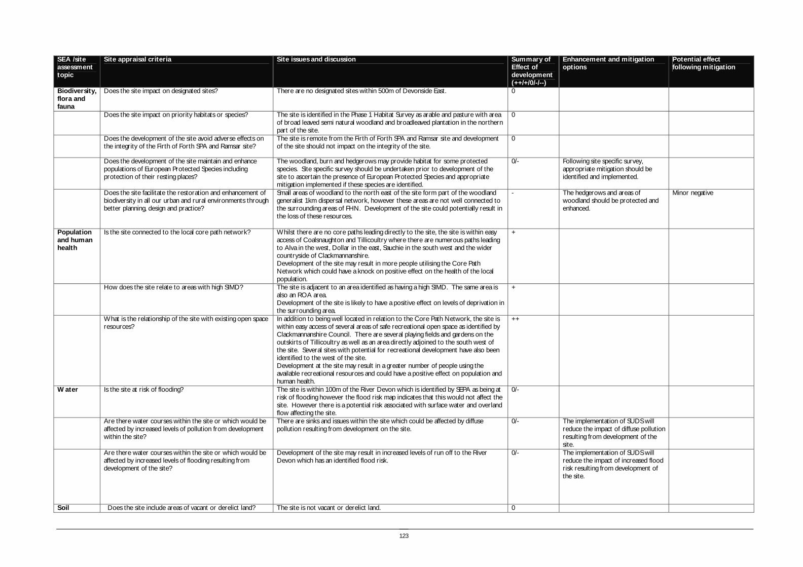
123
SEA /site assessment topic
Site appraisal criteria Site issues and discussion Summary of Effect of development (++/+/0/-/--)
Enhancement and mitigation options
Potential effect following mitigation
Biodiversity, flora and fauna
Does the site impact on designated sites?
There are no designated sites within 500m of Devonside East. 0
Does the site impact on priority habitats or species?
The site is identified in the Phase 1 Habitat Survey as arable and pasture with area of broad leaved semi natural woodland and broadleaved plantation in the northern part of the site.
0
Does the development of the site avoid adverse effects on the integrity of the Firth of Forth SPA and Ramsar site?
The site is remote from the Firth of Forth SPA and Ramsar site and development of the site should not impact on the integrity of the site.
0
Does the development of the site maintain and enhance populations of European Protected Species including protection of their resting places?
The woodland, burn and hedgerows may provide habitat for some protected species. Site specific survey should be undertaken prior to development of the site to ascertain the presence of European Protected Species and appropriate mitigation implemented if these species are identified.
0/- Following site specific survey, appropriate mitigation should be identified and implemented.
Does the site facilitate the restoration and enhancement of biodiversity in all our urban and rural environments through better planning, design and practice?
Small areas of woodland to the north east of the site form part of the woodland generalist 1km dispersal network, however these areas are not well connected to the surrounding areas of FHN. Development of the site could potentially result in the loss of these resources.
- The hedgerows and areas of woodland should be protected and enhanced.
Minor negative
Population and human health
Is the site connected to the local core path network?
Whilst there are no core paths leading directly to the site, the site is within easy access of Coalsnaughton and Tillicoultry where there are numerous paths leading to Alva in the west, Dollar in the east, Sauchie in the south west and the wider countryside of Clackmannanshire. Development of the site may result in more people utilising the Core Path Network which could have a knock on positive effect on the health of the local population.
+
How does the site relate to areas with high SIMD?
The site is adjacent to an area identified as having a high SIMD. The same area is also an ROA area. Development of the site is likely to have a positive effect on levels of deprivation in the surrounding area.
+
What is the relationship of the site with existing open space resources?
In addition to being well located in relation to the Core Path Network, the site is within easy access of several areas of safe recreational open space as identified by Clackmannanshire Council. There are several playing fields and gardens on the outskirts of Tillicoultry as well as an area directly adjoined to the south west of the site. Several sites with potential for recreational development have also been identified to the west of the site. Development at the site may result in a greater number of people using the available recreational resources and could have a positive effect on population and human health.
++
Water
Is the site at risk of flooding?
The site is within 100m of the River Devon which is identified by SEPA as being at risk of flooding however the flood risk map indicates that this would not affect the site. However there is a potential risk associated with surface water and overland flow affecting the site.
0/-
Are there water courses within the site or which would be affected by increased levels of pollution from development within the site?
There are sinks and issues within the site which could be affected by diffuse pollution resulting from development on the site.
0/- The implementation of SUDS will reduce the impact of diffuse pollution resulting from development of the site.
Are there water courses within the site or which would be affected by increased levels of flooding resulting from development of the site?
Development of the site may result in increased levels of run off to the River Devon which has an identified flood risk.
0/- The implementation of SUDS will reduce the impact of increased flood risk resulting from development of the site.
Soil Does the site include areas of vacant or derelict land? The site is not vacant or derelict land. 0

124
SEA /site assessment topic
Site appraisal criteria Site issues and discussion Summary of Effect of development (++/+/0/-/--)
Enhancement and mitigation options
Potential effect following mitigation
Is the site prime agricultural land?
The site is not prime quality agricultural land. 0
Air Quality and Transport
Is the site easily accessible by the local path network, and provide access to settlements and services?
The site is easily accessible by the Core Path Network and is well positioned to access services in Coalsnaughton and Tillicoultry.
+
Is the site easily accessible by public transport? The site is accessible to the bus service in Coalsnaughton and is approximately a 5 minute walk of Tillicoultry and is well positioned to make use of the existing public transport network.
+
Does the site lie within an area where levels of air pollution are close to current limit values?
The closest air quality monitoring site is at Tillicoultry bus station however near the site however available air quality data indicates that there are no exceedences of nitrogen dioxide or particulates within the council area. There is no indication that air quality is an issue at the site and it is unlikely that development of the site will have an adverse effect.
0
Would development on the site contribute to higher traffic flows along transport routes or at key junctions (potentially outwith the local authority area) where levels of air pollution are close to current limit values?
Whilst development of the site is likely to result in increased levels of traffic on local roads both during construction and post-development it is unlikely that this will have any significant adverse effect on air quality or pollution levels as no potential issues have been identified in this area. However the local road providing the main access to the site is identified as having low capacity to accommodate additional traffic flows. Cumulative effects require to be assessed in Stage 2.
0
Climatic Factors
Does the location of the development reduce the need to travel?
The site is very well linked with Tillicoultry and will benefit from the existing transport infrastructure available here. People will therefore not need to travel far to access services and facilities.
+
Is the site at risk of increased flooding or instability as a result of climate change?
The site is located on a steep north facing slope, which in combination with overland flow may result in issues of instability
0/-
Material Assets
Is the site located close to existing transport, services, water and energy infrastructure?
The settlement is well positioned to make use of the existing infrastructure present in Tillicoultry.
+
Is the site located to make best use of shelter and solar gain?
The site is located on a steep north facing slope and does not make best us of shelter and solar gain.
-
Would development on the site reduce future potential for mineral extraction?
The site would not impact on future potential for mineral extraction. The Balhearty area has been worked and coaling is finished.
0
Does the site include any hazard areas? (oil or gas pipelines)
There are no hazard areas within or nearby the site. 0
Does the site reduce waste generation and promote waste recovery, recycling and composting?
Development of the site would generate additional waste arisings however the site is small in extent and lies adjacent to an existing urban areas for which recycling facilities and waste collection will already be provided.
-
Cultural Heritage
Would development within the site impact on the integrity of sites, monuments, buildings or areas designated for their cultural heritage value?
There are no features of archaeological interest within the site. 0
Would development within the site impact on archaeological remains?
Development of the site would not impact on any known archaeological remains. The HLA identifies that the site comprises 18th – 19th century fields and farming.
0
Landscape Does the site lie within an area designated for its landscape value?
The Ochil Hills AGLV is approximately 1km north of the site boundary. Development of the site will have no effect on this designated area as it is buffered by the existing settlement of Tillicoultry to the north.
0
Would development within the site impact on settlement setting and identity (drawing on issues of landscape character and capacity for development)?
Development of the site would result in coalescence between Coalsnaughton and Devonside, however the separation between these two settlements is already compromised by the development to the west of this site.
0
Would development within the site impact on key views to landscape features or from key transport routes?
Development of the site would be unlikely to impact on key views to landscape features or from key transport routes, as it is screened by woodland belts and areas of housing development.
0

125
SEA /site assessment topic
Site appraisal criteria Site issues and discussion Summary of Effect of development (++/+/0/-/--)
Enhancement and mitigation options
Potential effect following mitigation
View north east from Coalsnaughton settlement edge

126
Site reference and location: SITE 19 LOVER’S LOAN
Size (ha) 13.91
Size (group) Medium
Summary description including site access and public transport connections
Located south east of the settlement of Dollar, small areas of mixed woodland to the north and east of the site, open space to the south. The site is traversed by several paths and tracks and links to the wider countryside of Clackmannanshire in the east. The site lies outwith the settlement boundary. Access would be taken onto the A91, however junction treatment would be required.
Overriding constraints to development
None
Site specific investigations Ground stability
Surface water drainage and flood risk
Constraints to development
Major – Scheduled Monument
Moderate - Surface water drainage and flood risk
Summary of area remaining following mitigation
n/a
Environmental features Vegetation: Woodland along the northern, western and eastern boundaries of the site which comprises rough grass.
Field boundaries: Woodland and post and wire fencing
Water: There are several drains and issues north, south and west of the site
Other features: Scheduled Monument
Site ownership:
Site type: Settlement expansion
Current land use Informal open space
Surrounding land use Open space, mixed woodland and farmland to the east. Residential, recreational and educational to the west.

127
Planning policy framework:
Clackmannanshire and Stirling Structure Plan Policy ENV3 – Development in the Countryside: The policy states that development in the Countryside (as defined in Local Plans i.e. areas not within settlement boundaries) be suitable for it’s location in function and design and should accord with Policy ED4 – Rural Development (see below).
Clackmannanshire and Stirling Structure Plan Policy ED4 – Rural Development: The policy states that economic and social development in rural areas will be supported within the following criteria:
• Focusing development within existing towns and villages
• Restricting development within Green Belt and countryside.
Clackmannanshire Local Plan Policy EN18 – Development in the Countryside: Sets out the criteria for the granting of planning permission to a proposed development in the countryside.
Clackmannanshire and Stirling Structure Plan Policy H6 – Housing in the Countryside: The policy states that new housing developments in the Countryside will only be approved where the development is essential, involves the conversion of an existing building, or is consistent with Policy H5 ‘Housing in the Upland Area’.
As there is a Scheduled Monument on the site the following applies:
Clackmannanshire Local Plan Policy EN7 – Archaeological or Historic Sites: The policy states that development will not be permitted where it can adversely affect a SAM or other important archaeological or historical site unless it can be demonstrated that there is no alternative viable site or the development is of national public importance; and
Policy EN8 – Site assessment, evaluation and recording Clackmannanshire Local Plan Policy EN8 – Site assessment, evaluation and recording: Where a development could affect a site of archaeological importance, an assessment of the historical value must be undertaken prior to permission being granted.
A section of the west part of the site is designated as a Community and Recreation Development Area in the Local Plan(CR32 Kellyburn, Dollar), this includes the following development guidelines:
Provision of playing field, accessed from Lovers. Protect and enhance burn and introduce new structural planting.
Planning history Part of site committed for a cemetery, playing field and enabling housing.
SEA /site assessment topic
Site appraisal criteria Site issues and discussion Summary of Effect of development (++/+/0/-/--)
Enhancement and mitigation options
Potential effect following mitigation
Biodiversity, flora and fauna
Does the site impact on designated sites?
Damhead wood is approximately 600m south of the site but this is separated from the site River Devon and the dismantled railway line. Dollar Glen is approximately 750m north of Lover’s Loan but is separated from the site by the existing settlement of Dollar. There is an area of ancient woodland approximately 400m north of Lover’s Loan but again, this is separated from the site by existing development and farmland.
0
Does the site impact on priority habitats or species?
There are small areas of mixed woodland surrounding the northern half of the Lover’s Loan site. The site is identified in the Phase 1 Habitat Survey as arable and pasture.
0
Does the development of the site avoid adverse effects on the integrity of the Firth of Forth SPA and Ramsar site?
The site is not in proximity to the Firth of Forth SPA and RAMSAR site. 0
Does the development of the site maintain and enhance populations of European Protected Species including protection of their resting places?
Although there are no significant habitat features on site a site specific survey should be undertaken prior to development to ascertain the presence of European Protected Species and appropriate mitigation implemented if these species are identified.
0/- Following site specific survey, appropriate mitigation should be identified and implemented.
Does the site facilitate the restoration and enhancement of biodiversity in all our urban and rural environments through better planning, design and practice?
An area of woodland generalist 1km dispersal network lies at the north east of the site. This is an isolated area of FHN with no other areas of FHN in close proximity. Development of the site would result in a loss of open ground.
0/-
Population and human
Is the site connected to the local core path network?
The site is well connected to the Core Path Network and is in the centre of a loop of paths. A number of informal paths cross the site. Links to the wider countryside and north into Perth and Kinross are easily accessible. Development
++
128
SEA /site assessment topic
Site appraisal criteria Site issues and discussion Summary of Effect of development (++/+/0/-/--)
Enhancement and mitigation options
Potential effect following mitigation
health at the site could lead to a greater number of people using the paths which could have knock on benefits on health.
How does the site relate to areas with high SIMD?
The site is not part of an ROA area or located in an area which has a high SIMD. Development of the site will therefore have no impact on this criterion.
0
What is the relationship of the site with existing open space resources?
The site has good access to the Core Path Network, and the safeguarded open space of the school playing fields to the west of the site.
+
Water
Is the site at risk of flooding?
The site does not lie in an area of flood risk identified on the SEPA flood map. However the site has some issues with localised flooding from the Kelly Burn and surface water drainage issues. The Kelly Burn flows from the Ochils and may cause flooding risk during periods of intense rainfall or rapid snowmelt.
- Site layout to avoid locating development close to the areas of flood risk would mitigate this risk.
No effect
Are there water courses within the site or which would be affected by increased levels of pollution from development within the site?
There are several drains and issues around the site boundary. Development on the site could therefore result in increased levels of pollution entering these drains and flowing on to surrounding water courses.
- The implementation of SUDS would mitigate this impact.
No effect.
Are there water courses within the site or which would be affected by increased levels of flooding resulting from development of the site?
Development at the site would increase the rate of run off to the River Devon. The cumulative impacts of development along the water course should be considered.
- The implementation of SUDS would mitigate this impact, however some impact would remain.
Soil Does the site include areas of vacant or derelict land?
The site is not vacant or derelict land. 0
Is the site prime agricultural land?
The site is not an area of prime quality agricultural land. 0
Air Quality and Transport
Is the site easily accessible by the local path network, and provide access to settlements and services?
The site is well linked with the Core Path Network and close to the centre of Dollar.
0/+
Is the site easily accessible by public transport? The site is located a short distance from the centre of Dollar. +
Does the site lie within an area where levels of air pollution are close to current limit values?
Air quality is not monitored near the site however available air quality data indicates that there are no exceedences of nitrogen dioxide or particulates within the council area. Development of the site is unlikely to contribute significantly to air pollution.
0
Would development on the site contribute to higher traffic flows along transport routes or at key junctions (potentially outwith the local authority area) where levels of air pollution are close to current limit values?
Development of the site would result in increased levels of traffic on the A91 and contribute to increased traffic levels in the centre of Dollar.
Cumulative effects require to be assessed in Stage 2.
- No mitigation
Climatic Does the location of the development reduce the need to Development of the site will not reduce the need to travel. Although local - Improved public transport

129
SEA /site assessment topic
Site appraisal criteria Site issues and discussion Summary of Effect of development (++/+/0/-/--)
Enhancement and mitigation options
Potential effect following mitigation
Factors travel?
services are provided in Dollar people will travel outwith the local area to access employment and a wider range of retail services
Is the site at risk of increased flooding or instability as a result of climate change?
Extreme weather conditions and flooding as a result of climate change could potentially result in flooding of the site.
- Site layout can reduce the potential impacts of flood risk associated with the site.
Material Assets
Is the site located close to existing transport, services, water and energy infrastructure?
The site is located within Dollar, and therefore close to existing infrastructure. 0
Is the site located to make best use of shelter and solar gain?
The site is well positioned to make use of both solar gain and shelter being located on a south facing slope.
+
Would development on the site reduce future potential for mineral extraction?
The site is within close proximity to Dollar and is identified as a restricted area for open cast.
0
Does the site include any hazard areas? (oil or gas pipelines)
There are no hazard areas within or nearby the site. 0
Does the site reduce waste generation and promote waste recovery, recycling and composting?
The site is medium in size and will have some household waste arisings following development.
- Provision of on site waste recovery, recycling and composting should be considered if feasible.
Cultural Heritage
Would development within the site impact on the integrity of sites, monuments, buildings or areas designated for their cultural heritage value?
The site is outwith the Dollar conservation area and would not impact on the integrity of this designation.
0
Would development within the site impact on archaeological remains?
There is a Scheduled Monument located in the western section of the site, which is the remains of a pallisaded enclosure.
- Site masterplanning could ensure the accommodation of the scheduled monument within open space provision within the site.
Landscape Does the site lie within an area designated for its landscape value?
The Ochil Hills AGLV is located within approximately 1km to the north west of the site, however development within this site will not impact on views to this area.
-/0
Would development within the site impact on settlement setting and identity (drawing on issues of landscape character and capacity for development)?
This site does not relate strongly to the existing settlement due to the separation created by the woodland belts. Views to the site are limited by the woodland belts alongside the A91.
0/-
Would development within the site impact on key views to landscape features or from key transport routes?
Development on the site would be viewed from the A91, but is not widely visible. 0
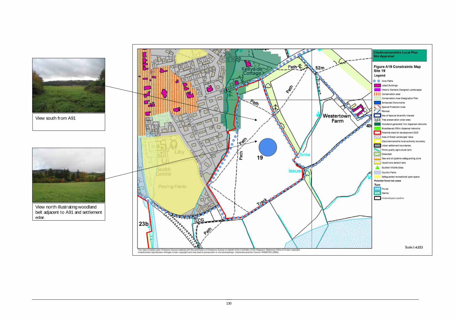
130
View south from A91
View north illustrating woodland belt adjacent to A91 and settlement edge

131
Site reference and location: SITE 20 DOLLARFIELD FARM
Size (ha) 1.98
Size (group) Small
Summary description including site access and public transport connections
Located approximately 300m south of the settlement of Dollar on the south side of the dismantled railway line. The surrounding land is mostly agricultural and the River Devon is approximately 200m south of the site. The site is located outwith the settlement boundary. Access would be taken onto the B913 however access would require to be taken along a private road.
Overriding constraints to development
Flood risk
Site specific investigations Flood risk
Constraints to development
Major - Flood risk. Issues with private site access.
Moderate - Impact on settlement character
Summary of area remaining following mitigation
The eastern area of the site is at risk of flooding from the Dollar Burn.
Environmental features Trees and Vegetation: Small areas of mixed woodland to the east and west of the site and unmanaged grassland. Field boundaries: The east of the site is bordered by a small area of mixed woodland. The south west boundary of the site adjoins Dollarfield Farm buildings. Water: the Dollar Burn runs along the eastern boundary of the site and leads into the River Devon approximately 200m south of the site.
Site ownership:
Site type: Development in the countryside
Current land use Unmanaged agricultural
Surrounding land use Open space, small areas of mixed woodland and farm land to the east and west.

132
Planning policy framework:
Clackmannanshire and Stirling Structure Plan Policy ENV3 – Development in the Countryside: The policy states that development in the Countryside (as defined in Local Plans i.e. areas not within settlement boundaries) be suitable for it’s location in function and design and should accord with Policy ED4 – Rural Development (see below).
Clackmannanshire and Stirling Structure Plan Policy ED4 – Rural Development: The policy states that economic and social development in rural areas will be supported within the following criteria:
• Focusing development within existing towns and villages
• Restricting development within Green Belt and countryside.
Clackmannanshire Local Plan Policy EN18 – Development in the Countryside: Sets out the criteria for the granting of planning permission to a proposed development in the countryside.
Clackmannanshire and Stirling Structure Plan Policy H6 – Housing in the Countryside: The policy states that new housing developments in the Countryside will only be approved where the development is essential, involves the conversion of an existing building, or is consistent with Policy H5 ‘Housing in the Upland Area’.
Due to the risk of flooding the following apply:
Clackmannanshire and Stirling Structure Plan Policy ENV9 – Water Resource Management: The policy states that development will not normally be permitted in undeveloped flood plain areas, in areas of known significant flood risk, or if it will adversely affect the Forth Estuary. Exceptions will be made only when it can be demonstrated that no alternative locations can be found, or that suitable mitigation measures can be implemented.
Clackmannanshire Local Plan Policy EN4 – Water Resources: The policy states that where a development area is determined as being at risk of flooding, planning permission will not be granted except where it can be proven that there are no viable alternative sites.
SEA /site assessment topic
Site appraisal criteria Site issues and discussion Summary of Effect of development (++/+/0/-/--)
Enhancement and mitigation options
Potential effect following mitigation
Biodiversity, flora and fauna
Does the site impact on designated sites?
Damhead wood SSSI is approximately 200m south of the site but is separated from it by the River Devon. Dollar Glen SSSI is approximately 1.5km north of the site on the other side of the existing settlement of Dollar. It is unlikely that development of the site would have any impact on the designated sites mentioned due to their distance from Dollarfield Farm. There are no designated Local Nature Reserves near the site however the Damhead Wood SSSI and includes locally rare woodland species and rare woodland habitat.
0
Does the site impact on priority habitats or species?
The site is identified in the Phase 1 Habitat Survey as arable and pasture. There are small areas of mixed woodland around the north and west of the Dollarfield Farm site as well as the SSSI 200m to the south which is designated for its rare woodland habitat.
0
Does the development of the site avoid adverse effects on the integrity of the Firth of Forth SPA and Ramsar site?
The site is not in proximity to the Firth of Forth SPA and RAMSAR site. 0
Does the development of the site maintain and enhance populations of European Protected Species including protection of their resting places?
As the site comprises some woodland and a watercourse along the eastern boundary site specific survey should be undertaken prior to development of the site to ascertain the presence of European Protected Species and appropriate mitigation implemented if these species are identified.
0/- Following site specific survey, appropriate mitigation should be identified and implemented.
Does the site facilitate the restoration and enhancement of biodiversity in all our urban and rural environments through better planning, design and practice?
Although the site is not identified as part of the Forest Habitat Network the site could be important for habitat connectivity in terms of linking the Dollar Burn to the River Devon. In addition, the small areas of woodland east of the site connect to Damhead Wood SSSI south of the site.
0/- The potential for habitat networks following the natural habitat features of the site should be considered at the development planning stage.
Population and human health
Is the site connected to the local core path network?
The site is not directly linked to the Core Path Network but is within easy access of a route along the B913. However this is not a pleasant or safe route and the informal route along Dollar Burn provides an off road alternative to access the town.
0
How does the site relate to areas with high SIMD? The site is not part of an ROA area or located in an area which has a high SIMD. 0

133
SEA /site assessment topic
Site appraisal criteria Site issues and discussion Summary of Effect of development (++/+/0/-/--)
Enhancement and mitigation options
Potential effect following mitigation
What is the relationship of the site with existing open space
resources?
The site is within easy access of the Core Path Network which provides links to the wider countryside and areas of open space. The site is approximately 250m from the playing fields on the outskirts of the settlement of Dollar. Development at the site may result in a greater number of people using this resource thus having a positive effect on population and human health.
+
Water
Is the site at risk of flooding?
The Dollar Burn runs along the eastern boundary of the site which is identified by SEPA as being at risk from flooding. The River Devon approximately 200m south of the site is also identified as being at risk of flooding. If development were to take place on this site it would be at significant risk of flooding.
-- The proximity to watercourses
Are there water courses within the site or which would be affected by increased levels of pollution from development within the site?
The Dollar Burn which flows past the eastern boundary of the site could be affected by increased levels of pollution as a result of development. Whilst the site is relatively small and run off levels are likely to be low, the risk to the water environment remains.
- The implementation of SUDS would reduce the impact of diffuse pollution resulting from development of the site.
Are there water courses within the site or which would be affected by increased levels of flooding resulting from development of the site?
The Dollar Burn could be affected by increased levels of flooding resulting from development of the site at Dollarfield Farm. However, it is likely that the effect will be relatively small owing to the small size of the site.
0/-
Soil Does the site include areas of vacant or derelict land?
The site is not vacant or derelict land. 0
Is the site prime agricultural land?
The site is not an area of prime quality agricultural land. 0
Air Quality and Transport
Is the site easily accessible by the local path network, and provide access to settlements and services?
The site is not directly linked to the Core Path Network but is within easy access of it. The paths provide links to Dollar, Tillicoultry and the wider countryside. Development of the site will have a positive effect on local access and could encourage more people to utilise the available routes, resulting in positive knock on effects on private car use and air quality as a consequence.
+
Is the site easily accessible by public transport? The site will benefit from use of the public transport facilities available in Dollar and development of the site may help to improve the public transport network in the area.
--
Does the site lie within an area where levels of air pollution are close to current limit values?
Air quality is not monitored near the site however available air quality data indicates that there are no exceedences of nitrogen dioxide or particulates within the council area. Development of the site is unlikely to result in local problems of air pollution.
0
Would development on the site contribute to higher traffic flows along transport routes or at key junctions (potentially outwith the local authority area) where levels of air pollution are close to current limit values?
Presently there is only one road which would provide access to the site (the B913) therefore development would be likely to result in increased levels of traffic on this route both during construction and post-development. However, as there are no identified issues of air pollution currently, this is unlikely to have a significant effect on air quality. There are known capacity issues associated with the junction of the B913 and the A91. Cumulative effects require to be assessed in Stage 2.
-
Climatic Factors
Does the location of the development reduce the need to travel?
Whilst the site is close to, and well linked with, the settlements of Dollar and Tillicoultry via the Core Path Network, it is unlikely that development of the site will reduce the need to travel. The road network to the site is limited and as such, public transport may not be sufficient for people who need to commute for work or access to services.
-
Is the site at risk of increased flooding or instability as a result of climate change?
Extreme weather conditions and flooding as a result of climate change could potentially result in flooding of the site.
-
Material Assets
Is the site located close to existing transport, services, water and energy infrastructure?
The site would be expected to utilise the existing infrastructure present in the settlement of Dollar.
+

134
SEA /site assessment topic
Site appraisal criteria Site issues and discussion Summary of Effect of development (++/+/0/-/--)
Enhancement and mitigation options
Potential effect following mitigation
Is the site located to make best use of shelter and solar gain? The site is well positioned to make use of both solar gain and shelter. + Would development on the site reduce future potential for
mineral extraction? The development of the site would not impact on areas identified for future open cast.
0
Does the site include any hazard areas? (oil or gas pipelines)
There are no hazard areas within or nearby the site. 0
Does the site reduce waste generation and promote waste recovery, recycling and composting?
Although the site is small in site, household development will result in some household waste arisings.
- Consideration of some on-site small scale recycling facilities.
Cultural Heritage
Would development within the site impact on the integrity of sites, monuments, buildings or areas designated for their cultural heritage value?
There are no sites monuments or buildings designated for their cultural heritage value within the site boundary. Dollar conservation area, and numerous listed buildings within the settlement, are located approximately 500m north of the site.
0
Would development within the site impact on archaeological remains?
Development of the site would not impact on any known archaeological remains. The HLA identifies that the site is a relict designed landscape.
0
Landscape Does the site lie within an area designated for its landscape value?
The Ochil Hills AGLV is over 1km away Dollarfield Farm site boundary. Development of the site is therefore unlikely to have an effect on this designated area as it is buffered by the existing settlement of Dollar.
0
Would development within the site impact on settlement setting and identity (drawing on issues of landscape character and capacity for development)?
Development of Dollarfield Farm may impact on the rural setting and identity of the landscape surrounding it however this will be fairly limited as some farm buildings and residential properties are already present within and nearby the site. The development of this site would also effectively extend the built development of Dollar south along the B913.
-/0
Would development within the site impact on key views to landscape features or from key transport routes?
The development of the site would not be highly visible from transport routes, however it would be partially visible in views from the Ochils where it would appear as an extension to Dollar.
0

135
View west from Dollar Burn to Dollarfield Steading

136
Site reference and location: SITE 21 DOLLARFIELD
Size (ha) 2.89
Size (group) Medium
Summary description including site access and public transport connections
The site is located approximately 500m south of the settlement of Dollar on the south side of the dismantled railway line. Riverside Caravan Park and the River Devon are directly south of the site. The site is located outwith the settlement boundary and access would be taken onto the B913. The access road is a private road which may limit opportunities for further development of the site.
Overriding constraints to development
Flood risk
Site specific investigations
Constraints to development
Moderate - Site access
Summary of area remaining following mitigation
The whole of the site lies within the area identified as at risk of flooding by the River Devon on the SEPA indicative flood map.
Environmental features Trees and vegetation: Small areas of mixed woodland north of the site. Field boundaries: existing farm/residential buildings border the north of the site, the east and north of the site is bordered by private grounds. Riverside Caravan Park borders the south of the site and the west of the site is adjacent to the B913. Water: the Dollar Burn is 30m from the east of the site at its closest point. The River Devon is approximately 30m south of the site at its closes point. Role as part of FHN: The site does not form part of the FHN.
Site ownership: Site type: Development in the countryside Current land use Agriculture Surrounding land use Caravan site, scattered residential properties, B913 road to the west.

137
Planning policy framework:
Clackmannanshire and Stirling Structure Plan Policy ENV3 – Development in the Countryside: The policy states that development in the Countryside (as defined in Local Plans i.e. areas not within settlement boundaries) be suitable for it’s location in function and design and should accord with Policy ED4 – Rural Development (see below).
Clackmannanshire and Stirling Structure Plan Policy ED4 – Rural Development: The policy states that economic and social development in rural areas will be supported within the following criteria:
• Focusing development within existing towns and villages
• Restricting development within Green Belt and countryside.
Clackmannanshire Local Plan Policy EN18 – Development in the Countryside: Sets out the criteria for the granting of planning permission to a proposed development in the countryside.
Clackmannanshire and Stirling Structure Plan Policy H6 – Housing in the Countryside: The policy states that new housing developments in the Countryside will only be approved where the development is essential, involves the conversion of an existing building, or is consistent with Policy H5 ‘Housing in the Upland Area’.
Due to the risk of flooding the following apply:
Clackmannanshire and Stirling Structure Plan Policy ENV9 – Water Resource Management: The policy states that development will not normally be permitted in undeveloped flood plain areas, in areas of known significant flood risk, or if it will adversely affect the Forth Estuary. Exceptions will be made only when it can be demonstrated that no alternative locations can be found, or that suitable mitigation measures can be implemented.
Clackmannanshire Local Plan Policy EN4 – Water Resources: The policy states that where a development area is determined as being at risk of flooding, planning permission will not be granted except where it can be proven that there are no viable alternative sites. Due to the presence of a core path along one of the site boundaries the following applies: Clackmannanshire Local Plan Policy INF3 – Local Access: The policy states that development will not be permitted where it will result in the loss of an asserted right of way, footpath or a path forming part of the Clackmannanshire path network unless the provision of an alternative path can be assured.
SEA /site assessment topic
Site appraisal criteria Site issues and discussion Summary of Effect of development (++/+/0/-/--)
Enhancement and mitigation options
Potential effect following mitigation
Biodiversity, flora and fauna
Does the site impact on designated sites?
Damhead Wood SSSI is approximately 50m south of the site but is separated from it by the River Devon. Damhead Wood SSSI is a rare woodland habitat and important for local wildlife conservation.
0
Does the site impact on priority habitats or species?
The site is identified in the Phase 1 Habitat Survey as arable and pasture. 0
Does the development of the site avoid adverse effects on the integrity of the Firth of Forth SPA and Ramsar site?
The site is not in proximity to the Firth of Forth SPA and RAMSAR site. 0
Does the development of the site maintain and enhance populations of European Protected Species including protection of their resting places?
Although there are no outstanding habitat features within the site, site specific survey should be undertaken prior to development to ascertain the presence of European Protected Species and appropriate mitigation implemented if these species are identified.
0/- Following site specific survey, appropriate mitigation should be identified and implemented.
Does the site facilitate the restoration and enhancement of biodiversity in all our urban and rural environments through better planning, design and practice?
The site does not form part of the Forest Habitat Network and there are limited opportunities for habitat connectivity on site. Development of the site would result in a loss of open habitat.
0/-
Population and human health
Is the site connected to the local core path network?
The western boundary of the site corresponds with a designated Core Path on the B913 road. This links to the wider countryside in the south and the settlement of Dollar and Tillicoultry in the north and east respectively. Development of the site may result in more people using the Core Path Network and have knock on positive effects on human health.
0
How does the site relate to areas with high SIMD?
The site is not part of an ROA area or located in an area which has a high SIMD.
0
What is the relationship of the site with existing open space resources?
The site is very well linked with the Core Path Network which provides access to the wider countryside east of Dollar. The site is also within 400m of the playing fields on the outskirts of the settlement of Dollar.
+
138
SEA /site assessment topic
Site appraisal criteria Site issues and discussion Summary of Effect of development (++/+/0/-/--)
Enhancement and mitigation options
Potential effect following mitigation
Development at the site may result in a greater number of people using the available recreational resources and could have a positive effect on population and human health.
Water
Is the site at risk of flooding?
The site is located less than 50m north of the River Devon and west of the Dollar Burn and is identified as being at risk flooding in the SEPA flood risk map. In addition, the caravan site at Rackmill (which adjoins the southern boundary of the site) has experienced minor flooding in the past (Biennial report, November 2007).
-- No mitigation
Are there water courses within the site or which would be affected by increased levels of pollution from development within the site?
The Dollar Burn and the River Devon could both be affected by pollution caused by development on the site due to their close proximity to Dollarfield.
- The implementation of SUDS would reduce the impact of diffuse pollution resulting from development of the site.
Are there water courses within the site or which would be affected by increased levels of flooding resulting from development of the site?
Both the Dollar Burn and the River Devon could be affected by increased levels of flooding as a result of development on the Dollarfield site.
- The implementation of SUDS would reduce the impact of increased run off resulting from development of the site
Soil Does the site include areas of vacant or derelict land?
The site is not vacant or derelict land. 0
Is the site prime agricultural land?
The site is not an area of prime quality agricultural land. 0
Air Quality and Transport
Is the site easily accessible by the local path network, and provide access to settlements and services?
The site is directly linked to the Core Path Network on at its western boundary. This provides further links into Dollar itself as well as to the wider countryside and east to Tillicoultry. Development of the site will have a positive effect on local access and could encourage more people to utilise the available routes, resulting in positive knock on effects on levels of private car use and air quality as a consequence.
+
Is the site easily accessible by public transport? The site is located approximately 1km from the centre of Dollar, however access to public transport services would be limited by the poor access from the site to the centre of Dollar.
- Improved path access from this site to the centre of Dollar would enhance the accessibility of the site.
Does the site lie within an area where levels of air pollution are close to current limit values?
Air quality is not monitored near the site however available air quality data indicates that there are no exceedences of nitrogen dioxide or particulates within the council area. Development of the site is unlikely to result in local problems of air pollution due to the existing levels and size of the site.
0
Would development on the site contribute to higher traffic flows along transport routes or at key junctions (potentially outwith the local authority area) where levels of air pollution are close to current limit values?
Presently there is only one road which would provide access to the site (the B913) therefore development would be likely to result in increased levels of traffic on this route. However, as there are no identified issues of air pollution currently, this is unlikely to have a significant effect on air quality. Cumulative effects require to be assessed in Stage 2.
0
Climatic Factors
Does the location of the development reduce the need to travel?
Whilst the site is close to and well linked with the settlements of Dollar and Tillicoultry via the Core Path Network, it is unlikely that development of the site will reduce the need to travel. The road network to the site is limited and as such, public transport may not be sufficient for people who need to access services or commute to work.
- No mitigation
Is the site at risk of increased flooding or instability as a result of climate change?
Extreme weather conditions and flooding as a result of climate change could potentially result in flooding of the site.
-- No mitigation
Material Assets
Is the site located close to existing transport, services, water and energy infrastructure?
The site would be expected to utilise the existing infrastructure present in the settlement of Dollar.
+
Is the site located to make best use of shelter and solar gain?
The site is well positioned to make use of both solar gain and shelter. +
Would development on the site reduce future potential for The development of the site would not impact on areas identified for future open 0
139
SEA /site assessment topic
Site appraisal criteria Site issues and discussion Summary of Effect of development (++/+/0/-/--)
Enhancement and mitigation options
Potential effect following mitigation
mineral extraction? cast. Does the site include any hazard areas? (oil or gas pipelines)
There are no hazard areas within or nearby the site. 0
Does the site reduce waste generation and promote waste recovery, recycling and composting?
The site is medium in size and household development will result in some household waste arisings.
- Consideration of some on-site small scale recycling facilities if feasible.
Cultural Heritage
Would development within the site impact on the integrity of sites, monuments, buildings or areas designated for their cultural heritage value?
There are no sites monuments or buildings designated for their cultural heritage value within the site boundary. Dollar conservation area, and numerous listed buildings within the settlement, are located approximately 750m north of the site.
0
Would development within the site impact on archaeological remains?
Development of the site would not impact on any known archaeological remains. The HLA identifies that the site is 19th century to present fields and farming.
0
Landscape Does the site lie within an area designated for its landscape value?
The Ochil Hills AGLV is over 1km away from Dollarfield site boundary. Development of the site is therefore unlikely to have an effect on this designated area as it is buffered by the existing settlement of Dollar.
0
Would development within the site impact on settlement setting and identity (drawing on issues of landscape character and capacity for development)?
Development of Dollarfield may impact on the rural setting and identity of the landscape surrounding it however this will be fairly limited as some farm buildings and residential properties are already present within and nearby the site.
0/-
Would development within the site impact on key views to landscape features or from key transport routes?
The site would be visible when travelling along the B913, contributing to the perception of the development as an extension of Dollar. The site would also be viewed as an extension from Dollar when viewed from the elevation of the Ochils.
- Mature trees line the B913, however opportunities for screening would be limited.
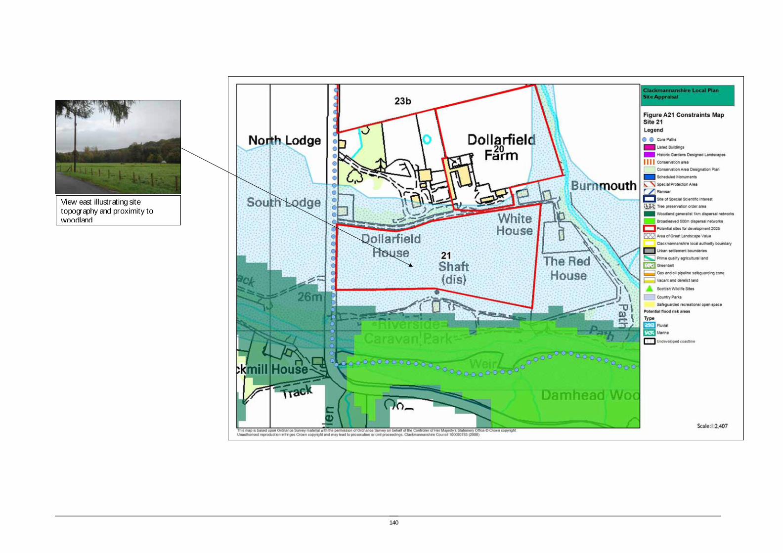
140
View east illustrating site topography and proximity to woodland

141
Site reference and location:
SITE 22 UPPER HILLFOOT ROAD, HILLFOOT ROAD, DOLLAR Size (ha) 8.69
Size (group) Medium
Summary description including site access and public transport connections
The site lies at the northern edge of Dollar surrounded by woodland. The site lies outwith the settlement boundary. The main site access is from Upper Hillfoot Road and through the settlement.
Overriding constraints to development
(see combined constraints below)
Site specific investigations
Constraints to development Major – AGLV. Impact on setting of Castle Campbell and settlement character
Medium – Bedrock. Surface water drainage. Site access. Landscape.
Summary of area remaining following mitigation
The whole of the site is affected by the landscape impact constraints and the access limitations.
Environmental features The site is located on a steeply sloping south east facing slope.
Trees and vegetation: The site is pasture surrounded on woodland on three sides, which includes coniferous forestry to the north and west and semi natural ancient woodland to the east. There are some individual mature trees within the site associated with the houses.
Field boundaries: Mostly post and wire with some degraded stone walls
Water (ponds, rivers and streams): Two minor water courses cross the site draining from the hillside above and enter the Kelly Burn.
Site ownership:
Site type: Settlement expansion
Current land use The site currently forms the grounds of four properties and is grassland with some mature trees and includes a covered reservoir.
Surrounding land use The site is surrounded by coniferous and deciduous woodland and the urban edge of Dollar adjoins part of the southern site boundary.
142
Planning policy framework: Clackmannanshire and Stirling Structure Plan Policy ENV3 – Development in the Countryside: The policy states that development in the Countryside (as defined in Local Plans i.e. areas not within settlement boundaries) be suitable for it’s location in function and design and should accord with Policy ED4 – Rural Development (see below).
Clackmannanshire and Stirling Structure Plan Policy ED4 – Rural Development: The policy states that economic and social development in rural areas will be supported within the following criteria:
• Focussing development within existing towns and villages
• Restricting development within Green Belt and countryside.
Clackmannanshire Local Plan Policy EN18 – Development in the Countryside: Sets out the criteria for the granting of planning permission to a proposed development in the countryside.
Clackmannanshire and Stirling Structure Plan Policy H6 – Housing in the Countryside: The policy states that new housing developments in the Countryside will only be approved where the development is essential, involves the conversion of an existing building, or is consistent with Policy H5 ‘Housing in the Upland Area’.
As there is a risk of flooding the following apply:
Clackmannanshire and Stirling Structure Plan Policy ENV9 – Water Resource Management: The policy states that development will not normally be permitted in undeveloped flood plain areas, in areas of known significant flood risk, or if it will adversely affect the Forth Estuary. Exceptions will be made only when it can be demonstrated that no alternative locations can be found, or that suitable mitigation measures can be implemented.
Clackmannanshire Local Plan Policy EN4 – Water Resources: The policy states that where a development area is determined as being at risk of flooding, planning permission will not be granted except where it can be proven that there are no viable alternative sites.
As the site lies within the Ochil Hills AGLV the following policies are of relevance:
Clackmannanshire and Stirling Structure Plan Policy ENV2 – Protected Landscapes: The policy states that development will only be permitted in Areas of Great Landscape Value where it satisfies the criteria of Policy ENV3 (see above) and can be accommodated without adversely affecting the overall quality of the area.
Clackmannanshire Local Plan Policy EN2 – Landscape and Ecology: The policy includes conditions which must be met if a development is to be permitted in an AGLV. The policy also states that appropriate consideration must be given to woodland, habitats, natural and landscape features when making a planning application.
SEA /site assessment topic
Site appraisal criteria Site issues and discussion Summary of Effect of development (++/+/0/-/--)
Enhancement and mitigation options
Potential effect following mitigation
Biodiversity, flora and fauna
Does the site impact on designated sites?
There are no designated sites within the site boundary. Dollar Glen SSSI lies within 500m of the site boundary to the south west.
0
Does the site impact on priority habitats or species?
The site is identified in the Phase 1 Habitat Survey as predominantly arable and pasture with a small area of semi improved acid grassland to the north of the houses. There is an area identified as amenity grassland and coniferous plantation to the north of the site.
0
Does the development of the site avoid adverse effects on the integrity of the Firth of Forth SPA and Ramsar site?
The site is not in proximity to the Firth of Forth SPA and RAMSAR site. 0

143
SEA /site assessment topic
Site appraisal criteria Site issues and discussion Summary of Effect of development (++/+/0/-/--)
Enhancement and mitigation options
Potential effect following mitigation
Does the development of the site maintain and enhance populations of European Protected Species including protection of their resting places?
There are some habitat features on the site including watercourses and mature trees and therefore site specific survey should be undertaken prior to development to ascertain the presence of European Protected Species and appropriate mitigation implemented if these species are identified.
0/- Following site specific survey, appropriate mitigation should be identified and implemented.
Does the site facilitate the restoration and enhancement of biodiversity in all our urban and rural environments through better planning, design and practice?
The woodland surrounding the site forms part of the woodland generalist 1km dispersal network and is therefore an important habitat connection
0/- Development should take into account the potential for habitat linkages across the site linking parts of the FHN.
Population and human health
Is the site connected to the local core path network?
Core paths surround the perimeter of the site and there is a network of paths in Dollar Glen and the woodland to the east of the site.
+
How does the site relate to areas with high SIMD?
The site does not lie within an area within the top 15% SIMD 0
What is the relationship of the site with existing open space resources?
Notes connections to key recreational area or designation as a safeguarded open space or country park
Dollar Glen provides an important open space resource and lies within 500m of the site. Access can be gained to the Ochil Hills close to Castle Campbell and there are access networks in Lawhill Community Woodland to the south east of the site.
+
Water
Is the site at risk of flooding?
The site is located on a steeply sloping hillside and may experience high levels of surface run off due to its proximity to the Ochil Hills.
- The steepness of the site and proximity to the Ochils may reduce mitigation options to reduce the impact of surface water run off.
Are there water courses within the site or which would be affected by increased levels of pollution from development within the site?
There are two minor watercourses which drain across the site - The steepness of the site may reduce mitigation options to reduce the impact of diffuse pollution resulting from development of the site.
Are there water courses within the site or which would be affected by increased levels of flooding resulting from development of the site?
Development of the site would potentially increase the rate of run off from the site into the Kelly Burn which is a tributary of the River Devon. However the scale of the site would mean that this would not be significant, however the cumulative effect of developments which drain into the River Devon should be considered.
0/-
Soil Does the site include areas of vacant or derelict land?
The site is not vacant or derelict land. 0
Is the site prime agricultural land?
The site is not prime quality agricultural land. 0
Air Quality Is the site easily accessible by the local path network, and provide access to settlements and
The site is located to the north of Dollar and within 1.5km of the centre on roads and +
144
SEA /site assessment topic
Site appraisal criteria Site issues and discussion Summary of Effect of development (++/+/0/-/--)
Enhancement and mitigation options
Potential effect following mitigation
and Transport services? pavements.
Is the site easily accessible by public transport? There is public transport provision in the centre of Dollar, however the site is located up a steep hill on the periphery of the settlement and is not easily accessible.
-
Does the site lie within an area where levels of air pollution are close to current limit values?
Air pollution is not monitored within Dollar, however the site is located at the northern periphery of Dollar and away from main roads and therefore air quality is unlikely to be an issue in this area.
0
Would development on the site contribute to higher traffic flows along transport routes or at key junctions (potentially outwith the local authority area) where levels of air pollution are close to current limit values?
Development of the site would result in higher levels of traffic flow on the A91and at the road junctions joining the A91 within Dollar.
-
Climatic Factors
Does the location of the development reduce the need to travel?
The site is located close to the centre of Dollar which may reduce the need to travel to access local services. However the majority of travel for employment will be outwith the local area which will generate a need to travel to the surrounding area.
- No mitigation
Is the site at risk of increased flooding or instability as a result of climate change?
The site is located on a steep slope beneath the steep wooded slopes of Hillfoot Hill. Climate change may cause increased risk of flooding and instability on this site.
- Changes in land management on the surrounding slopes may impact on site stability.
Material Assets
Is the site located close to existing transport, services, water and energy infrastructure?
The site is located on the northern perimeter of Dollar and is therefore close to existing transport, water and energy infrastructure.
+
Is the site located to make best use of shelter and solar gain?
The site is located on a steeply sloping south east facing area with woodland at the north, east and western boundaries. The site is elevated lying between 130m and 195m AOD which will increase exposure.
0 Although south facing the comparative elevation of the site increases exposure to prevailing winds, reducing the positive effect of orientation. However the design and layout of the development on site should make best use of the elevation and orientation for solar heating.
Would development on the site reduce future potential for mineral extraction?
The site is not in an area identified as having open cast coal mining potential. 0
Does the site include any hazard areas? (oil or gas pipelines)
The site does not include any oil or gas hazard areas. 0
Does the site reduce waste generation and promote waste recovery, recycling and composting?
The site is medium in size and development will result in household waste arisings. - Consideration of small scale waste recycling facilities on site if feasible.
Cultural Heritage
Would development within the site impact on the integrity of sites, monuments, buildings or areas designated for their cultural heritage value?
Castle Campbell and Dollar Glen comprise the Castle Campbell Historic Garden and Designed Landscape. The castle and grounds are a scheduled monument and the castle is a category A listed building.
Castle Campbell lies within 500m of the site boundary, but the topography of the area limits visual relationship between the two areas. However in views from the south, the site is of a similar elevation to Castle Campbell and would have some minor
-
145
SEA /site assessment topic
Site appraisal criteria Site issues and discussion Summary of Effect of development (++/+/0/-/--)
Enhancement and mitigation options
Potential effect following mitigation
negative impact on setting.
Would development within the site impact on archaeological remains?
There are no known archaeological remains within the site boundary.
The HLA identifies that the northern part of the site is a relict designed landscape, and the southern parts of the site are 18th to 19th century and 19th century to present fields and farming with the relict land use of settlement and agriculture.
0
Landscape Does the site lie within an area designated for its landscape value?
The site lies within the Ochil Hills AGLV. The site lies partly within the Ochil hills landscape character area and partly within the middle Devon Water landscape character area. The middle Devon Water landscape character area is characterised by a detailed scale of topography and proportion of woodland cover. Development of the site would introduce built development into an essentially undeveloped area.
--
Would development within the site impact on settlement setting and identity (drawing on issues of landscape character and capacity for development)?
The site lies outwith the Dollar Conservation area, however it would form a northerly extension to the settlement onto elevated slopes with little built development. This would be contrary to the existing settlement character.
-
Would development within the site impact on key views to landscape features or from key transport routes?
As noted above, development of the site would compromise the landscape setting of Castle Campbell and impact on the Ochil Hills AGLV.
--

146
View east illustrating site watercourses and slope
View north from Dollar illustrating site context within Ochil Hills AGLV (site is located south of felled woodland)

147
Site reference and location: SITE 23A DOLLAR (SOUTH), WEST OF DEVON ROAD
Size (ha) 8.5 ha
Size (group) Medium
Summary description including site access and public transport connections
The site is located approximately 500m south of the settlement of Dollar and west of the B913. The site lies outwith the settlement boundary and access would be taken from the B913.
Overriding constraints to development
None
Site specific investigations n/a
Constraints to development
Moderate – Landscape impacts and impact on settlement form.
Summary of area remaining following mitigation
n/a
Environmental features Trees and vegetation: Arable farmland with hedgerows. Field boundaries: the northern boundary of the site is adjacent to the existing settlement of Dollar and Lower Mains to the west, the boundaries include garden boundaries and trees and hedgerows. Water: The River Devon is approximately 300m south of the site at its closes point.
Site ownership: Site type: Settlement expansion Current land use Agriculture Surrounding land use Small cluster of residential properties at the western site boundary, the B913 and Dollar to the north. Planning policy framework:
Clackmannanshire and Stirling Structure Plan Policy ENV3 – Development in the Countryside: The policy states that development in the Countryside (as defined in Local Plans i.e. areas not within settlement boundaries) be suitable for it’s location in function and design and should accord with Policy ED4 – Rural Development (see below).
Clackmannanshire and Stirling Structure Plan Policy ED4 – Rural Development: The policy states that economic and social development in rural areas will be supported within the following criteria:
• Focusing development within existing towns and villages
• Restricting development within Green Belt and countryside.
Clackmannanshire Local Plan Policy EN18 – Development in the Countryside: Sets out the criteria for the granting of planning permission to a proposed development in the countryside.
Clackmannanshire and Stirling Structure Plan Policy H6 – Housing in the Countryside: The policy states that new housing developments in the Countryside will only be approved where the development is essential, involves the conversion of an existing building, or is consistent with Policy H5 ‘Housing in the Upland Area’.
SEA /site assessment topic
Site appraisal criteria Site issues and discussion Summary of Effect of development (++/+/0/-/--)
Enhancement and mitigation options
Potential effect following mitigation
Biodiversity, flora and fauna
Does the site impact on designated sites?
The site does not impact on designated sites. 0
Does the site impact on priority habitats or species?
The site is identified in the Phase 1 Habitat Survey as arable and pasture. 0
Does the development of the site avoid adverse effects on the integrity of the Firth of Forth SPA and Ramsar site?
The site is not in proximity to the Firth of Forth SPA and Ramsar site. 0

148
SEA /site assessment topic
Site appraisal criteria Site issues and discussion Summary of Effect of development (++/+/0/-/--)
Enhancement and mitigation options
Potential effect following mitigation
Does the development of the site maintain and enhance populations of European Protected Species including protection of their resting places?
The site includes some mature boundary trees which may provide habitat for protected species. Site specific survey should be undertaken prior to development of the site to ascertain the presence of European Protected Species and appropriate mitigation implemented if these species are identified.
0/- Following site specific survey, appropriate mitigation should be identified and implemented.
Does the site facilitate the restoration and enhancement of biodiversity in all our urban and rural environments through better planning, design and practice?
The site is not identified as part of the FHN, however the mature trees associated with the disused railway to the north of the site provide some local habitat value. Development of the site would result in the loss of open ground.
0/-
Population and human health
Is the site connected to the local core path network?
A route alongside the B913 which is part of the Core Path network dissects the site leading to the settlement of Dollar in the north and the River Devon, Damhead Wood and the wider countryside in the south. Development of the site may result in more people utilising the Core Path Network which could have a knock on positive effect on the health of the local population.
+
How does the site relate to areas with high SIMD?
The site is not part of an ROA area or located in an area which has a high SIMD.
0
What is the relationship of the site with existing open space resources?
The site is well linked with the Core Path Network. The Core Path which runs alongside the dismantled railway track on the northern boundary of the site also provides links to the playing fields on the outskirts of the town.
+
Water
Is the site at risk of flooding?
The site is not identified in the SEPA indicative flood map as being at risk of flooding.
0
Are there water courses within the site or which would be affected by increased levels of pollution from development within the site?
There are no identified watercourses which would be affected by pollution resulting from development of the site.
0
Are there water courses within the site or which would be affected by increased levels of flooding resulting from development of the site?
The River Devon could be affected by increased levels of flooding as a result of development on the site.
- The implementation of SUDS may mitigate some of the impacts of development of the site increasing the rate of run off to the River Devon.
Soil Does the site include areas of vacant or derelict land?
The site is not derelict or vacant land. 0
Is the site prime agricultural land?
The site is not an area of prime quality agricultural land. 0
Air Quality and Transport
Is the site easily accessible by the local path network, and provide access to settlements and services?
Core paths link along part of the sites northern boundary. As such, these routes provide access to services and facilities within the settlement of Dollar and further west to Tillicoultry.
+
Is the site easily accessible by public transport? The site will benefit from use of the public transport facilities available in Dollar and development of the site may help to improve the public transport network in the area.
+
Does the site lie within an area where levels of air pollution are close to current limit values?
Air quality is not monitored near the site however available air quality data indicates that there are no exceedences of nitrogen dioxide or particulates within the council area. Development of the site is unlikely to result in local problems of air pollution.
0
Would development on the site contribute to higher traffic flows along transport routes or at key junctions (potentially outwith the local authority area) where levels of air pollution are close to current limit values?
The site will be accessed from the B913 which passes to the east of the site. Devon Road makes up the western boundary of the site. It is likely that development of the site would result in increased levels of traffic on these roads. However, as there are no identified issues of air pollution currently, this is unlikely to have a significant effect on air quality. However the development of the site would require treatment of the junction between the B913 and the A91.
-- No mitigation

149
SEA /site assessment topic
Site appraisal criteria Site issues and discussion Summary of Effect of development (++/+/0/-/--)
Enhancement and mitigation options
Potential effect following mitigation
Cumulative effects require to be assessed in Stage 2. Climatic Factors
Does the location of the development reduce the need to travel?
Whilst the site is close to and well linked with the settlements of Dollar and Tillicoultry via the Core Path Network, it is unlikely that development of the site will reduce the need to travel.
-
Is the site at risk of increased flooding or instability as a result of climate change?
Extreme weather conditions and flooding as a result of climate change could potentially result in flooding of the site.
-
Material Assets
Is the site located close to existing transport, services, water and energy infrastructure?
The site would be expected to utilise the existing infrastructure present in the settlement of Dollar.
+
Is the site located to make best use of shelter and solar gain?
The site is well positioned to make use of both solar gain and shelter. +
Would development on the site reduce future potential for mineral extraction?
The site is not in an area identified as having open cast coal mining potential. 0
Does the site include any hazard areas? (oil or gas pipelines)
There are no hazard areas within or nearby the site. 0
Does the site reduce waste generation and promote waste recovery, recycling and composting?
The site will have a minor impact on waste generation, however as it is located within the urban area it will not generate significant additional waste related journeys.
-
Cultural Heritage
Would development within the site impact on the integrity of sites, monuments, buildings or areas designated for their cultural heritage value?
There are no sites monuments or buildings designated for their cultural heritage value within the site boundary. Ochilton, which is a category B listed building, is beside the northern boundary of the site. In addition, Dollar conservation area, which contains numerous listed buildings, is located approximately 100m north of the site on the other side of the dismantled railway line. It is unlikely that development of the site would have any adverse effect on the cultural heritage features mentioned above as there is a significant area of residential property between the site and the conservation area.
0
Would development within the site impact on archaeological remains?
Development of the site would not impact on any known archaeological remains. The HLA identifies the site as 19th century to present fields and farming
0
Landscape Does the site lie within an area designated for its landscape value?
The Ochil Hills AGLV is approximately 550m north west of the site boundary. Development of the site will not impact directly on the AGLV, however it reduces the extent of the undeveloped valley floor which provides a foreground in views to the Ochils. Development of the valley floor will reduce the contrast provided by the undeveloped flat valley foreground.
- No mitigation
Would development within the site impact on settlement setting and identity (drawing on issues of landscape character and capacity for development)?
Development of the site would impact on the existing settlement character of Dollar, through a southern extension to the traditionally linear hillfoot settlements.
- No mitigation
Would development within the site impact on key views to landscape features or from key transport routes?
Development of the site would impact on views to the Ochils, particularly when travelling along the B913. The introduction of built development would detract from the open views across the flat valley floor to the steeply rising slopes.
- No mitigation

150
View west illustrating settlement edge at Lower Mains
View north to Ochil Hills
151
Site reference and location: SITE 23B DOLLAR (SOUTH), EAST OF DEVON ROAD
Size (ha) 9.2 ha
Size (group) Medium
Summary description including site access and public transport connections
The site is located approximately 500m south of the settlement of Dollar on the south side of the dismantled railway line. Riverside Caravan Park and the River Devon are to the south of the site. The site lies outwith the settlement boundary and would be accessed from the B913.
Overriding constraints to development
None
Site specific investigations Flood risk associated with Dollar Burn
Constraints to development
Moderate - Landscape impacts and impact on settlement form Minor - Flood risk associated with Dollar Burn
Summary of area remaining following mitigation
The area potentially affected by flood risk associated with the Dollar Burn is limited to the eastern boundary of the site which does not impact significantly on the available area of site.
Environmental features Vegetation: Arable farmland with mature deciduous trees along boundary with Dollar, Dollar Burn and the boundary with Dollarfield Farm. Field boundaries: the northern boundary of the site is adjacent to the existing settlement of Dollar and comprises trees. The Dollar Burn flows along the eastern boundary of the site and includes some mature trees and outgrown hedgerow trees. Part of the southern boundary adjoins on to Dollarfield farm and other properties and includes mature trees and post and wire fencing. A hedgerow adjoins the B913. Water: the Dollar Burn corresponds with the eastern boundary of the site; the River Devon is approximately 300m south of the site at its closes point.
Site ownership: Site type: Settlement expansion Current land use Agriculture Surrounding land use Agriculture, settlement and road. Planning policy framework:
Clackmannanshire and Stirling Structure Plan Policy ENV3 – Development in the Countryside: The policy states that development in the Countryside (as defined in Local Plans i.e. areas not within settlement boundaries) be suitable for it’s location in function and design and should accord with Policy ED4 – Rural Development (see below).
Clackmannanshire and Stirling Structure Plan Policy ED4 – Rural Development: The policy states that economic and social development in rural areas will be supported within the following criteria:
• Focusing development within existing towns and villages
• Restricting development within Green Belt and countryside.
Clackmannanshire Local Plan Policy EN18 – Development in the Countryside: Sets out the criteria for the granting of planning permission to a proposed development in the countryside.
Clackmannanshire and Stirling Structure Plan Policy H6 – Housing in the Countryside: The policy states that new housing developments in the Countryside will only be approved where the development is essential, involves the conversion of an existing building, or is consistent with Policy H5 ‘Housing in the Upland Area’.
As there is a risk of flooding the following apply:
Clackmannanshire and Stirling Structure Plan Policy ENV9 – Water Resource Management: The policy states that development will not normally be permitted in undeveloped flood plain areas, in areas of known significant flood risk, or if it will adversely affect the Forth Estuary. Exceptions will be made only when it can be demonstrated that no alternative locations can be found, or that suitable mitigation measures can be implemented.
Clackmannanshire Local Plan Policy EN4 – Water Resources: The policy states that where a development area is determined as being at risk of flooding, planning permission will not be granted except where it can be proven that there are no viable alternative sites. Due to the presence of a core path route the following applies: Clackmannanshire Local Plan Policy INF3 – Local Access: The policy states that development will not be permitted where it will result in the loss of an asserted right of way, footpath or a path forming part of the Clackmannanshire path network unless the provision of an alternative path can be assured.

152
SEA /site assessment topic
Site appraisal criteria Site issues and discussion Summary of Effect of development (++/+/0/-/--)
Enhancement and mitigation options
Potential effect following mitigation
Biodiversity, flora and fauna
Does the site impact on designated sites?
Damhead wood SSSI is approximately 300m south of the site but is separated from it by the River Devon and the existing properties at Dollarfield Farm. It is unlikely that development of the site will have any effect on the SSSI.
0
Does the site impact on priority habitats or species?
The site is identified in the Phase 1 Habitat Survey as arable and pasture. 0
Does the development of the site avoid adverse effects on the integrity of the Firth of Forth SPA and Ramsar site?
The site is not in proximity to the Firth of Forth SPA and RAMSAR site. 0
Does the development of the site maintain and enhance populations of European Protected Species including protection of their resting places?
The Dollar Burn and associated woodland may provide habitat for protected species. Site specific survey should be undertaken prior to development of the site to ascertain the presence of European Protected Species and appropriate mitigation implemented if these species are identified.
0/- Following site specific survey, appropriate mitigation should be identified and implemented.
Does the site facilitate the restoration and enhancement of biodiversity in all our urban and rural environments through better planning, design and practice?
The site does not play a role as part of FHN, however the habitat associated with the Dollar burn may provide an important corridor. Development of the site would affect the habitat value associated with the corridor of the Dollar Burn.
0/- The woodland and corridor of the Dollar Burn should be protected and enhanced.
Population and human health
Is the site connected to the local core path network?
An on-road route which is part of the Core Path network runs along the western boundary of the site leading to the settlement of Dollar in the north and the River Devon, Damhead Wood and the wider countryside in the south. An informal path runs alongside the route of the Dollar Burn providing a link to Dollar.
+
How does the site relate to areas with high SIMD?
The site is not part of an ROA area or located in an area which has a high SIMD.
0
What is the relationship of the site with existing open space resources?
The site is well linked with the Core Path Network which provides access to the wider countryside east of Dollar. The Core Path which runs alongside the dismantled railway track on the northern boundary of the site also provides links to the playing fields on the outskirts of the town.
+
Water
Is the site at risk of flooding?
The site could be at risk from flooding from the Dollar Burn to the east. - Site layout and design to avoid development within close proximity of Dollar Burn.
Are there water courses within the site or which would be affected by increased levels of pollution from development within the site?
The Dollar Burn could potentially be affected by pollution caused by development on the site.
- The implementation of SUDS would reduce the impacts of pollution resulting from development of the site.
Are there water courses within the site or which would be affected by increased levels of flooding resulting from development of the site?
Both the Dollar Burn and the River Devon could be affected by increased levels of flooding as a result of development on the Dollarfield site.
- The implementation of SUDS would reduce the impacts of increased flood risk resulting from development of the site.
Soil Does the site include areas of vacant or derelict land?
The site is not derelict or vacant land. 0
Is the site prime agricultural land?
The site is not an area of prime quality agricultural land. 0
Air Quality and Transport
Is the site easily accessible by the local path network, and provide access to settlements and services?
Core paths run along the western and make up part of its northern boundary. As such, these routes provide access to services and facilities within the settlement of Dollar and further west to Tillicoultry. Development of the site could encourage more people to utilise the available routes, resulting in positive knock on effects on levels of private car use and air quality as a consequence.
+

153
SEA /site assessment topic
Site appraisal criteria Site issues and discussion Summary of Effect of development (++/+/0/-/--)
Enhancement and mitigation options
Potential effect following mitigation
Is the site easily accessible by public transport? Bus services are available in Dollar and development of the site may help to support improvement of the public transport network in the area.
+ Off road access should be provided to facilitate safe access to the centre of Dollar.
Does the site lie within an area where levels of air pollution are close to current limit values?
Air quality is not monitored near the site however available air quality data indicates that there are no exceedences of nitrogen dioxide or particulates within the council area. Development of the site is unlikely to result in local problems of air pollution.
0
Would development on the site contribute to higher traffic flows along transport routes or at key junctions (potentially outwith the local authority area) where levels of air pollution are close to current limit values?
The site will be accessed from the B913 which passes to the west of the site. It is likely that development of the site would result in increased levels of traffic with particular impacts on the junction with the A91. Cumulative effects require to be assessed in Stage 2.
-- Junction improvement may be required, however increased traffic levels will remain.
Climatic Factors
Does the location of the development reduce the need to travel?
Whilst the site is close to and well linked with the settlements of Dollar and Tillicoultry via the Core Path Network, it is unlikely that development of the site will reduce the need to travel to larger service centres.
- No mitigation
Is the site at risk of increased flooding or instability as a result of climate change?
Extreme weather conditions and flooding as a result of climate change could potentially result in flooding of the site.
- No mitigation
Material Assets
Is the site located close to existing transport, services, water and energy infrastructure?
The site would be expected to utilise the existing infrastructure present in the settlement of Dollar.
+
Is the site located to make best use of shelter and solar gain?
The site is well positioned to make use of both solar gain and shelter. +
Would development on the site reduce future potential for mineral extraction?
The site is not in an area identified as having open cast coal mining potential. 0
Does the site include any hazard areas? (oil or gas pipelines)
There are no hazard areas within or close to the site. 0
Does the site reduce waste generation and promote waste recovery, recycling and composting?
The site will generate additional waste arisings, however as it is located within the urban area it will not generate significant additional waste related journeys.
- No mitigation
Cultural Heritage
Would development within the site impact on the integrity of sites, monuments, buildings or areas designated for their cultural heritage value?
There are no sites monuments or buildings designated for their cultural heritage value within the site boundary. Ochilton, which is a category B listed building, is to the north west of the site. In addition, Dollar conservation area, which contains numerous listed buildings, is located approximately 100m north of the site on the other side of the dismantled railway line. It is unlikely that development of the site would have any adverse effect on the cultural heritage features mentioned above as there is a significant area of residential property between the site and the conservation area.
0
Would development within the site impact on archaeological remains?
Development of the site would not impact on any known archaeological remains. The HLA identifies the site as 19th century to present fields and farming
0
Landscape Does the site lie within an area designated for its landscape value?
The Ochil Hills AGLV is approximately 550m north west of the site boundary. Development of the site will not impact directly on the AGLV, however it reduces the extent of the undeveloped valley floor which provides a foreground in views to the Ochils. Development of the valley floor will reduce the contrast provided by the undeveloped flat valley foreground.
- No mitigation
Would development within the site impact on settlement setting and identity (drawing on issues of landscape character and capacity for development)?
Development of the site would impact on the existing settlement character of Dollar, though a southern extension to the traditionally linear hillfoot settlements. However the traditional settlement form is already compromised by the north eastern expansion of the town on the slopes of Gloom Hill.
- Restriction of the area of site developed to the immediate south of the town would reduce the impact on settlement form.
Would development within the site impact on key views to landscape features or from key transport routes?
Development of the site would impact on views to the Ochils, particularly when travelling along the B913. The introduction of built development would detract from the open views across the flat valley floor to the steeply rising slopes.
- Restriction of the area of site developed to the immediate south of the town would reduce the impact on settlement form.
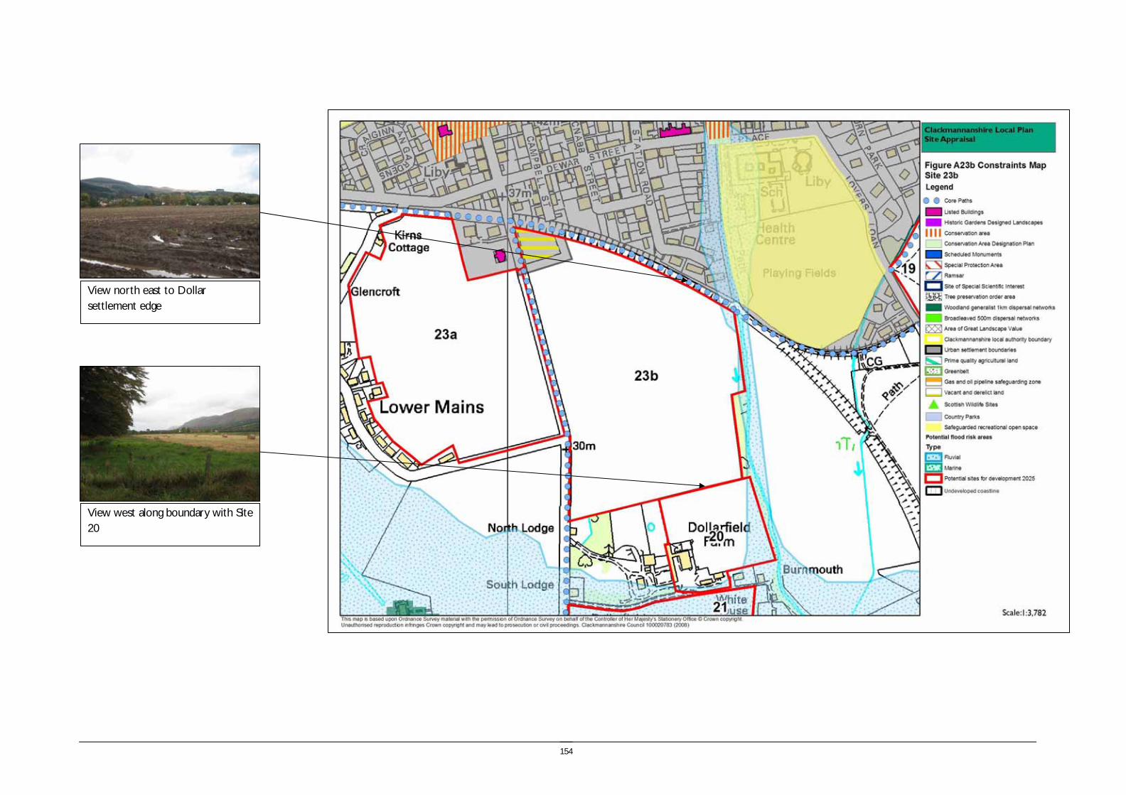
154
View north east to Dollar settlement edge
View west along boundary with Site 20

155
Site reference and location:
SITE 24A FORESTMILL (INCLUDES ASSESSMENT OF RESTORATION OF MEADOWHILL) Size (ha) 127.6
Size (group) Very large
Summary description including site access and public transport connections
The site is focused around the settlement of Forestmill, which lies approximately 6km from Clackmannan. The site extends to the east towards Meadowhill over the gently sloping land towards the flat bottomed valley of the River Black Devon. The site adjoins the A977, however access could also be taken onto the minor road which enters Forestmill from the south, before joining the A977. A planning application for a housing development proposal has been submitted for this site.
Overriding constraints to development
None
Site specific investigations EIA has been carried out for the proposed development on this site
Constraints to development Moderate – Landscape. Oil and gas pipeline hazard zone. Scheduled Monument.
Minor – Flood risk associated with the Dollar Burn
Summary of area remaining following mitigation
-
Trees and vegetation: South plantation is a coniferous forestry plantation and there are small pockets of broadleaved semi natural woodland within this area. To the east there are small areas of broadleaved semi natural woodland
Field boundaries: There is a mixture of occasional outgrown hedgerows, degraded stone walls and post and wire fences.
Water (ponds, rivers and streams): The site includes a number of minor drains and the River Black Devon which meanders along part of the northern boundary and through the site.
Site ownership:
Site type: New settlement
Current land use A mixture of arable and pasture farmland.
Surrounding land use Meadowhill open cast coal site lies to the immediate north of the eastern site, with areas of forestry to the south and farmland to the east.
156
Planning policy framework Clackmannanshire and Stirling Structure Plan Policy ENV3 – Development in the Countryside: The policy states that development in the Countryside (as defined in Local Plans i.e. areas not within settlement boundaries) be suitable for it’s location in function and design and should accord with Policy ED4 – Rural Development (see below).
Clackmannanshire and Stirling Structure Plan Policy ED4 – Rural Development: The policy states that economic and social development in rural areas will be supported within the following criteria:
• Focusing development within existing towns and villages
• Restricting development within Green Belt and countryside.
Clackmannanshire Local Plan Policy EN18 – Development in the Countryside: Sets out the criteria for the granting of planning permission to a proposed development in the countryside.
Clackmannanshire and Stirling Structure Plan Policy H6 – Housing in the Countryside: The policy states that new housing developments in the Countryside will only be approved where the development is essential, involves the conversion of an existing building, or is consistent with Policy H5 ‘Housing in the Upland Area’.
Due to the proximity of designated sites the following should be taken into account:
Clackmannanshire and Stirling Structure Plan Policy ENV1 – Nature Conservation: The policy aims to promote the protection of wildlife, habitats and other natural features. It states that development which will have a potential negative impact upon internationally or nationally designated sites will not be permitted unless it can be demonstrated that their will be no adverse effect from the proposal, or no viable alternative solution. Similarly, proposals which may affect a site of local importance will only be allowed where it can be demonstrated that there will be no significant negative impact on the conservation value of the site.
Clackmannanshire Local Plan Policy EN1 – Sites of Local Ecological Importance: The policy states that any application for development will be guided by the Local Biodiversity Action Plan. It also states that any development proposals should consider the importance of non-designated sites of local nature conservation or biodiversity importance and should minimise negative impacts on the natural heritage resource.
As part of the site is within The Forest AGLV, the following policies apply:
Clackmannanshire and Stirling Structure Plan Policy ENV2 – Protected Landscapes: The policy states that development will only be permitted in Areas of Great Landscape Value where it satisfies the criteria of Policy ENV3 (above) and can be accommodated without adversely affecting the overall quality of the area. Clackmannanshire Local Plan Policy EN2 – Landscape and Ecology: The policy includes conditions which must be met if a development is to be permitted in an AGLV. The policy also states that appropriate consideration must be given to existing woodland, habitats, natural and landscape features when making a planning application. As the site includes part of the River Black Devon the following should be considered: Clackmannanshire Local Plan Policy EN12 – Area Environmental Enhancement states that proposals which would detract from the setting or aesthetics of Conservation Areas, the A91 corridor or rivers will not normally be permitted, and that developers must demonstrate how proposals can be integrated with proposed enhancement measures.
As there is a Scheduled Ancient Monument the following should be taken into account:
Clackmannanshire Local Plan Policy EN7 – Archaeological or Historic Sites: The policy states that development will not be permitted where it can adversely affect a SAM or other important archaeological or historical site unless it can be demonstrated that there is no alternative viable site or the development is of national public importance. Clackmannanshire Local Plan Policy EN8 – Site assessment, evaluation and recording: Where a development could affect a site of archaeological importance, an assessment of the historical value must be undertaken prior to permission being granted.
As there is a potential flood risk the following policies are of relevance:
Clackmannanshire and Stirling Structure Plan Policy ENV9 – Water Resource Management: The policy states that development will not normally be permitted in undeveloped flood plain areas, in areas of known significant flood risk, or if it will adversely affect the Forth Estuary. Exceptions will be made only when it can be demonstrated that no alternative locations can be found, or that suitable mitigation measures can be implemented.
Clackmannanshire Local Plan Policy EN4 – Water Resources: The policy states that where a development area is determined as being at risk of flooding, planning permission will not be granted except where it can be proven that there are no viable alternative sites.
NB. The site is also identified as being within a Gas and Oil Pipeline Hazard Area on the Local Plan Countryside
Planning History The site is subject to an outline planning application for the development of a new village settlement and the reinstatement of Meadowhill Quarry cross funded by the proposed development.

157
SEA /site assessment topic
Site appraisal criteria Site issues and discussion Summary of Effect of development (++/+/0/-/--)
Enhancement and mitigation options
Potential effect following mitigation
Biodiversity, flora and fauna
Does the site impact on designated sites?
There are no designated sites within the site boundary, however Craigmad Wood SSSI immediately adjoins part of the southern boundary of the eastern extent of the site. Parklands Muir Wildlife Site was created as part of the restoration of Meadowhill open cast site.
- The land immediately adjacent to the SSSI should remain undeveloped to maintain the integrity of the site.
Impact of restoration of Site 25 The restoration of Meadowhill will not impact on any designated sites. 0
Does the site impact on priority habitats or species?
The site includes a greater mosaic of habitat types with areas of arable and pasture farmland, some areas of marsh/marshy grassland and small areas of Blanket Sphagnum bog associated with the River Black Devon. There are two small areas of broad leaved semi natural woodland. The woodland adjacent to the site is known to provide habitat for red squirrel and development of the site will result in disturbance and potential habitat loss.
0/-
Impact of restoration of Site 25 The restoration of Meadowhill will create new areas of grazing land with some small areas of new woodland planting.
0
Does the development of the site avoid adverse effects on the integrity of the Firth of Forth SPA and Ramsar site?
The site is not in proximity to the Firth of Forth SPA and Ramsar site. 0
Does the development of the site maintain and enhance populations of European Protected Species including protection of their resting places?
Site specific survey should be undertaken prior to development of the site to ascertain the presence of European Protected Species and appropriate mitigation implemented if these species are identified.
- Following site specific survey, appropriate mitigation should be identified and implemented.
Does the site facilitate the restoration and enhancement of biodiversity in all our urban and rural environments through better planning, design and practice?
The woodland along the southern boundary of the site comprises the woodland generalist 1km dispersal network. Development of the site will result in increased disturbance to the existing woodland areas and loss of open habitat.
- Habitat enhancement as part of the development of the site could improve the existing habitat value.
Minor negative
Population and human health
Is the site connected to the local core path network?
There are no existing core paths within the site boundaries, however there are connections from Forestmill which link to Gartmorn, and a connection to the NCN 76 on the disused railway line to the south.
0 Connections to these existing links should be developed within the site.
Positive effect.
Impact of restoration of Site 25 The restoration of Meadowhill will provide recreational access opportunities but will not provide functional access links.
0
How does the site relate to areas with high SIMD?
The site does not lie in an area with high SIMD, nor are there any areas with high SIMD close to the site.
0
Impact of restoration of Site 25 No impact 0
What is the relationship of the site with existing open space resources?
Gartmorn Dam country park lies approximately 3km to the west of the site. Devilla Forest to the south includes a network of paths and recreational opportunities. These are large scale recreational resources, however they are not closely accessible from the site.
- The restoration of Meadowhill with the creation of a path network will create an accessible open space resource.
Positive effect
Impact of restoration of Site 25 The restoration of Meadowhill will provide a local open space resource accessible from the new development at Forestmill.
+
Water
Is the site at risk of flooding?
The low lying land associated with the River Black Devon is identified on the SEPA indicative river and coastal flood map as at potential risk of flooding. The remainder
- Avoiding development within the area identified as at risk of flooding will
No impact.
158
SEA /site assessment topic
Site appraisal criteria Site issues and discussion Summary of Effect of development (++/+/0/-/--)
Enhancement and mitigation options
Potential effect following mitigation
of the site is elevated and gently sloping and is not identified as at risk of flooding. remove this risk.
Impact of restoration of Site 25 No impact
Are there water courses within the site or which would be affected by increased levels of pollution from development within the site?
The watercourses drain into the River Black Devon which would potentially be affected by increased levels from diffuse pollution resulting from development of the site.
- The impact of increased diffuse pollution resulting from development of the site can be mitigated through the implementation of SUDS.
Impact of restoration of Site 25 The Hydrology and Hydrogeology report (2007) for the restoration of Meadowhill identifies that during flood events it is possible that there may be impacts on water quality in the River Black Devon.
0/-
Are there water courses within the site or which would be affected by increased levels of flooding resulting from development of the site?
Development of the site would potentially increase the rate of run off to the River Black Devon, increasing the risk of flooding downsteam.
- The impact of increased run off resulting from development of the site can be mitigated through the implementation of SUDS.
Impact of restoration of Site 25 The void is largely fed by rainwater and if flows between the void and the River Black Devon occur this could impact on flooding in the River Black Devon.
Soil Does the site include areas of vacant or derelict land?
The site does not include any areas of vacant and derelict land, however it lies immediately adjacent to the Meadowhill open cast coal site which is to be restored.
++
Impact of restoration of Site 25 The restoration of Meadowhill will improve the quality of an existing area of vacant and derelict land
++
Is the site prime agricultural land?
The site is not prime quality agricultural land. 0
Impact of restoration of Site 25 The restoration will create areas of grazing land. 0
Air Quality and Transport
Is the site easily accessible by the local path network, and provide access to settlements and services?
The development of the site would constitute a new settlement. Local services would be provided, however access to other settlements would not be easy without the use of transport.
-- The development of the site within a rural location remote from service centres and employment limits opportunities for sustainable access to settlements and services.
Negative effect
Impact of restoration of Site 25 No impact
Is the site easily accessible by public transport? The development of the site would require the provision of additional bus services to serve the site. There is no public bus service to Forestmill.
-- Development of the site would require the provision of additional public transport services in order to support options for sustainable travel.
Depending on the level of service provision this would result in a positive effect.
Impact of restoration of Site 25 No impact
Does the site lie within an area where levels of air pollution are close to current limit values?
Air quality is not currently monitored within the immediate vicinity of the site. 0

159
SEA /site assessment topic
Site appraisal criteria Site issues and discussion Summary of Effect of development (++/+/0/-/--)
Enhancement and mitigation options
Potential effect following mitigation
Impact of restoration of Site 25 No impact
Would development on the site contribute to higher traffic flows along transport routes or at key junctions (potentially outwith the local authority area) where levels of air pollution are close to current limit values?
The development of the site would contribute to higher traffic flows at Gartarry roundabout and into Alloa and Kincardine.
- Development of the site would require the provision of additional public transport services in order to support options for sustainable travel.
Impact of restoration of Site 25 No impact
Climatic Factors
Does the location of the development reduce the need to travel?
The creation of a new settlement within a rural location would generate journeys because there is no access to services within close proximity of the site.
-- Development of the site would require the provision of additional public transport services in order to support options for sustainable travel.
Impact of restoration of Site 25 No impact
Is the site at risk of increased flooding or instability as a result of climate change?
The flood risk associated with the River Black Devon may become greater as a result of changes in rainfall patterns associated with climate change.
- Avoiding development within the area identified as at risk of flooding will remove this risk.
Impact of restoration of Site 25 There is a risk of flooding associated with the movement of water from the void into the River Black Devon.
-
Material Assets
Is the site located close to existing transport, services, water and energy infrastructure?
The site will make use of existing infrastructure at Forestmill and provide a new sewage treatment works.
0
Impact of restoration of Site 25 No impact
Is the site located to make best use of shelter and solar gain?
The site has a predominantly north facing aspect with the land rising to the south, however the slope is gentle and the reduction in insolation would not be significant. The land around Fearns Farm is south facing.
0
Impact of restoration of Site 25 No impact
Would development on the site reduce future potential for mineral extraction?
The area to the south of the site is identified as a restricted site for open cast coal therefore development would not take place within this area.
0
Impact of restoration of Site 25 No impact
Does the site include any hazard areas? (oil or gas pipelines)
The gas pipeline hazard zone extends through the centre of the eastern part of the site north of Gartgreenie.
0 The pipeline will either be armoured or diverted.
Impact of restoration of Site 25 No impact
Does the site reduce waste generation and promote waste recovery, recycling and composting?
The site will generate additional waste arisings and generate additional waste collection journeys.
- Due to the size of the site local composting and recycling facilities could be provided as part of the site masterplan,
Cultural Heritage
Would development within the site impact on the integrity of sites, monuments, buildings or areas designated for their cultural heritage
Gartmorn Lade extends alongside the northern edge of the River Black Devon and is a Scheduled Ancient Monument. Other features recorded in the NMRS include the
0/- The Gartmorn Lade lies within the potential flood risk area identified in the SEPA indicative river and coastal flood
160
SEA /site assessment topic
Site appraisal criteria Site issues and discussion Summary of Effect of development (++/+/0/-/--)
Enhancement and mitigation options
Potential effect following mitigation
value?
weir at Forestmill. map.
Development, infrastructure or other works should maintain the setting and character of the SAM.
Impact of restoration of Site 25 No impact
Would development within the site impact on archaeological remains?
The development of the site would potentially impact on the integrity of the remains listed above.
0 These resources are limited in extent and direct impacts could be avoided through awareness and mitigation.
Impact of restoration of Site 25 No impact
Landscape Does the site lie within an area designated for its landscape value?
The site lies immediately adjacent to the Forest AGLV which extends to the east of the site. Development of the site will not have a significant impact on the setting of the AGLV however it will introduce an area of built development within an intrinsically rural landscape.
0/-
Impact of restoration of Site 25 The restoration of Meadowhill will have a positive impact on the local landscape. +
Would development within the site impact on settlement setting and identity (drawing on issues of landscape character and capacity for development)?
The site lies within the Devon/Forth landscape character area with varied farmland characterised by undulating landform and coniferous blocks of forestry. Key attributes of the landscape character area are the diversity of features and dramatic outlook to the Ochils. The corridor of the Black Devon is identified as important. The development of the site would have a significant impact on the character and setting of Forestmill which is a small settlement focused alongside the Black Devon.
- This landscape character area is noted for its diversity of landscape features and high landscape value. In particular guidelines for development include new woodland planting and restructuring of existing coniferous plantations.
The development will use the existing landscape structure provided by the existing woodland blocks, however the new development will result in significant change to the character of Forestmill.
Impact of restoration of Site 25 The restoration of Meadowhill will have a positive impact on the local landscape. +
Would development within the site impact on key views to landscape features or from key transport routes?
The development of the site would be visible from the A977 which is a major transport route, and it would affect the landscape character of the wider area.
- Maintaining the wooded edge to the A977 reduces the impact of development within the AGLV, however the visual impact of the new development in views from the A977 will remain.
Minor negative effect.
Impact of restoration of Site 25 Meadowhill is visible from the A977 and restoration will have a positive impact on the local landscape.
+

161
View to Meadowhill open cast workings
View south to Gartgreenie, with Gartgreenie Wood behind
162
Site reference and location:
SITE 24B FORESTMILL (INCLUDES ASSESSMENT OF RESTORATION OF MEADOWHILL) Size (ha) 73.3
Size (group) Large
Summary description including site access and public transport connections
The site lies to the south west of the settlement of Forestmill, which lies approximately 6km from Clackmannan. The site includes South Plantation lying to the south of the A977. The site is proposed to form an area of leisure development in association with the planning application submitted for the proposed housing development proposal in area 24a at Forestmill.
Overriding constraints to development
None
Site specific investigations EIA has been carried out for the proposed development on this site
Constraints to development Major – Landscape.
Moderate – oil and gas pipeline hazard zone
Summary of area remaining following mitigation
Trees and vegetation: South plantation is a coniferous forestry plantation and there are small pockets of broadleaved semi natural woodland within this area. To the east there are small areas of broadleaved semi natural woodland
Field boundaries: The site includes an area of coniferous forestry plantation bounded by fencing.
Water (ponds, rivers and streams): There are two minor watercourses within the western part of the site. The eastern part of the site includes a number of minor drains and the River Black Devon which meanders along part of the northern boundary and through the site.
Site ownership:
Site type: New settlement
Current land use The site is currently under coniferous forestry
Surrounding land use The western area is bounded by forestry plantations and open farmland to the south.

163
Planning policy framework Clackmannanshire and Stirling Structure Plan Policy ENV3 – Development in the Countryside: The policy states that development in the Countryside (as defined in Local Plans i.e. areas not within settlement boundaries) be suitable for it’s location in function and design and should accord with Policy ED4 – Rural Development (see below).
Clackmannanshire and Stirling Structure Plan Policy ED4 – Rural Development: The policy states that economic and social development in rural areas will be supported within the following criteria:
• Focusing development within existing towns and villages
• Restricting development within Green Belt and countryside.
Clackmannanshire Local Plan Policy EN18 – Development in the Countryside: Sets out the criteria for the granting of planning permission to a proposed development in the countryside.
Clackmannanshire and Stirling Structure Plan Policy H6 – Housing in the Countryside: The policy states that new housing developments in the Countryside will only be approved where the development is essential, involves the conversion of an existing building, or is consistent with Policy H5 ‘Housing in the Upland Area’.
Due to the proximity of designated sites the following should be taken into account:
Clackmannanshire and Stirling Structure Plan Policy ENV1 – Nature Conservation: The policy aims to promote the protection of wildlife, habitats and other natural features. It states that development which will have a potential negative impact upon internationally or nationally designated sites will not be permitted unless it can be demonstrated that their will be no adverse effect from the proposal, or no viable alternative solution. Similarly, proposals which may affect a site of local importance will only be allowed where it can be demonstrated that there will be no significant negative impact on the conservation value of the site.
Clackmannanshire Local Plan Policy EN1 – Sites of Local Ecological Importance: The policy states that any application for development will be guided by the Local Biodiversity Action Plan. It also states that any development proposals should consider the importance of non-designated sites of local nature conservation or biodiversity importance and should minimise negative impacts on the natural heritage resource.
As part of the site is within The Forest AGLV, the following policies apply:
Clackmannanshire and Stirling Structure Plan Policy ENV2 – Protected Landscapes: The policy states that development will only be permitted in Areas of Great Landscape Value where it satisfies the criteria of Policy ENV3 (above) and can be accommodated without adversely affecting the overall quality of the area. Clackmannanshire Local Plan Policy EN2 – Landscape and Ecology: The policy includes conditions which must be met if a development is to be permitted in an AGLV. The policy also states that appropriate consideration must be given to existing woodland, habitats, natural and landscape features when making a planning application. As the site includes part of the River Black Devon the following should be considered: Clackmannanshire Local Plan Policy EN12 – Area Environmental Enhancement states that proposals which would detract from the setting or aesthetics of Conservation Areas, the A91 corridor or rivers will not normally be permitted, and that developers must demonstrate how proposals can be integrated with proposed enhancement measures.
As there is a Scheduled Ancient Monument the following should be taken into account:
Clackmannanshire Local Plan Policy EN7 – Archaeological or Historic Sites: The policy states that development will not be permitted where it can adversely affect a SAM or other important archaeological or historical site unless it can be demonstrated that there is no alternative viable site or the development is of national public importance. Clackmannanshire Local Plan Policy EN8 – Site assessment, evaluation and recording: Where a development could affect a site of archaeological importance, an assessment of the historical value must be undertaken prior to permission being granted.
As there is a potential flood risk the following policies are of relevance:
Clackmannanshire and Stirling Structure Plan Policy ENV9 – Water Resource Management: The policy states that development will not normally be permitted in undeveloped flood plain areas, in areas of known significant flood risk, or if it will adversely affect the Forth Estuary. Exceptions will be made only when it can be demonstrated that no alternative locations can be found, or that suitable mitigation measures can be implemented.
Clackmannanshire Local Plan Policy EN4 – Water Resources: The policy states that where a development area is determined as being at risk of flooding, planning permission will not be granted except where it can be proven that there are no viable alternative sites.
NB. The site is also identified as being within a Gas and Oil Pipeline Hazard Area on the Local Plan Countryside
Planning History The site is subject to an outline planning application for the development of a new village settlement and the reinstatement of Meadowhill Quarry cross funded by the proposed development.

164
SEA /site assessment topic
Site appraisal criteria Site issues and discussion Summary of Effect of development (++/+/0/-/--)
Enhancement and mitigation options
Potential effect following mitigation
Biodiversity, flora and fauna
Does the site impact on designated sites?
There are no designated sites within the site boundary. 0 The land immediately adjacent to the SSSI should remain undeveloped to maintain the integrity of the site.
Impact of restoration of Site 25 The restoration of Meadowhill will not impact on any designated sites. 0
Does the site impact on priority habitats or species?
The majority of the site is coniferous plantation with some smaller areas of broadleaved semi nature woodland in the southerly extent of the site.
The woodland is known to provide habitat for red squirrel and development of the site will result in disturbance and habitat loss.
- Restructuring of the woodland to create a greater diversity of habitats and species and grey squirrel control would reduce the impact of developing the site.
Impact of restoration of Site 25 The restoration of Meadowhill will create new areas of grazing land with some small areas of new woodland planting.
0
Does the development of the site avoid adverse effects on the integrity of the Firth of Forth SPA and Ramsar site?
The site is not in proximity to the Firth of Forth SPA and Ramsar site. 0
Does the development of the site maintain and enhance populations of European Protected Species including protection of their resting places?
Site specific survey should be undertaken prior to development of the site to ascertain the presence of European Protected Species and appropriate mitigation implemented if these species are identified.
- Following site specific survey, appropriate mitigation should be identified and implemented.
Does the site facilitate the restoration and enhancement of biodiversity in all our urban and rural environments through better planning, design and practice?
The whole of the western part of the site comprises the woodland generalist 1km dispersal network, and woodland extends alongside the south western boundary of the eastern part of the site. This element of the FHN forms part of a substantial swathe of FHN which extends from Fishcross to the Bath Moor Plantation and Devilla Forest in Fife. Development of the site would result in a loss of habitat and reduce the habitat value of the site.
- Habitat enhancement as part of the development of the site could improve the existing habitat value.
Minor negative
Population and human health
Is the site connected to the local core path network?
There are no existing core paths within the site boundaries, however there are connections from Forestmill which link to Gartmorn.
- Connections to these existing links should be developed within the site.
Positive effect.
Impact of restoration of Site 25 The restoration of Meadowhill will provide recreational access opportunities but will not provide functional access links.
0
How does the site relate to areas with high SIMD?
The site does not lie in an area with high SIMD, nor are there any areas with high SIMD close to the site.
0
Impact of restoration of Site 25 No impact 0
What is the relationship of the site with existing open space resources?
Gartmorn Dam country park lies approximately 3km to the west of the site. Devilla Forest to the south includes a network of paths and recreational opportunities. These are large scale recreational resources, however they are not closely accessible from the site.
- The restoration of Meadowhill with the creation of a path network will create an accessible open space resource.
Positive effect
Impact of restoration of Site 25 The restoration of Meadowhill will provide a local open space resource accessible from the new development at Forestmill.
+
Water
Is the site at risk of flooding?
The site is elevated and gently sloping and is not identified as at risk of flooding. 0
Impact of restoration of Site 25 No impact

165
SEA /site assessment topic
Site appraisal criteria Site issues and discussion Summary of Effect of development (++/+/0/-/--)
Enhancement and mitigation options
Potential effect following mitigation
Are there water courses within the site or which would be affected by increased levels of pollution from development within the site?
The watercourses drain into the River Black Devon which would potentially be affected by increased levels from diffuse pollution resulting from development of the site.
- The impact of increased diffuse pollution resulting from development of the site can be mitigated through the implementation of SUDS.
Impact of restoration of Site 25 The Hydrology and Hydrogeology report (2007) for the restoration of Meadowhill identifies that during flood events it is possible that there may be impacts on water quality in the River Black Devon.
0/-
Are there water courses within the site or which would be affected by increased levels of flooding resulting from development of the site?
Development of the site would potentially increase the rate of run off to the River Black Devon, increasing the risk of flooding downsteam.
- The impact of increased run off resulting from development of the site can be mitigated through the implementation of SUDS.
Impact of restoration of Site 25 The void is largely fed by rainwater and if flows between the void and the River Black Devon occur this could impact on flooding in the River Black Devon.
Soil Does the site include areas of vacant or derelict land?
The site does not include any areas of vacant and derelict land, however it lies immediately adjacent to the Meadowhill open cast coal site which is to be restored.
++
Impact of restoration of Site 25 The restoration of Meadowhill will improve the quality of an existing area of vacant and derelict land
++
Is the site prime agricultural land?
The site is not prime quality agricultural land. 0
Impact of restoration of Site 25 The restoration will create areas of grazing land. 0
Air Quality and Transport
Is the site easily accessible by the local path network, and provide access to settlements and services?
The development of the site would constitute a new settlement. Local services would be provided, however access to other settlements would not be easy without the use of transport.
-- The development of the site within a rural location remote from service centres and employment limits opportunities for sustainable access to settlements and services.
Negative effect
Impact of restoration of Site 25 No impact
Is the site easily accessible by public transport? The development of the site would require the provision of additional bus services to serve the site. There is no public bus service to Forestmill.
-- Development of the site would require the provision of additional public transport services in order to support options for sustainable travel.
Depending on the level of service provision this would result in a positive effect.
Impact of restoration of Site 25 No impact
Does the site lie within an area where levels of air pollution are close to current limit values?
Air quality is not currently monitored within the immediate vicinity of the site. 0
Impact of restoration of Site 25 No impact
Would development on the site contribute to higher traffic flows along transport routes or at
The development of the site would contribute to higher traffic flows at Gartarry - Development of the site would require the provision of additional public

166
SEA /site assessment topic
Site appraisal criteria Site issues and discussion Summary of Effect of development (++/+/0/-/--)
Enhancement and mitigation options
Potential effect following mitigation
key junctions (potentially outwith the local authority area) where levels of air pollution are close to current limit values?
roundabout and into Alloa and Kincardine. transport services in order to support options for sustainable travel.
Impact of restoration of Site 25 No impact
Climatic Factors
Does the location of the development reduce the need to travel?
The creation of a new settlement within a rural location would generate journeys because there is no access to services within close proximity of the site.
-- Development of the site would require the provision of additional public transport services in order to support options for sustainable travel.
Impact of restoration of Site 25 No impact
Is the site at risk of increased flooding or instability as a result of climate change?
The site is not identified as at significant risk of increased flooding or instability as a result of climate change.
0
Impact of restoration of Site 25 There is a risk of flooding associated with the movement of water from the void into the River Black Devon.
-
Material Assets
Is the site located close to existing transport, services, water and energy infrastructure?
The site will make use of existing infrastructure at Forestmill and provide a new sewage treatment works.
0
Impact of restoration of Site 25 No impact
Is the site located to make best use of shelter and solar gain?
The western extent of the site is partly north facing and partly south facing however it is also comparatively elevated.
0
Impact of restoration of Site 25 No impact
Would development on the site reduce future potential for mineral extraction?
The area to the south of the site is identified as a restricted site for open cast coal therefore extraction would not take place within this area.
0
Impact of restoration of Site 25 No impact
Does the site include any hazard areas? (oil or gas pipelines)
The gas pipeline hazard zone extends through a small area at the south eastern corner of this site.
0 The pipeline will either be armoured or diverted.
Impact of restoration of Site 25 No impact
Does the site reduce waste generation and promote waste recovery, recycling and composting?
The site will generate additional waste arisings and generate additional waste collection journeys.
- Due to the size of the site local composting and recycling facilities could be provided as part of the site masterplan,
Cultural Heritage
Would development within the site impact on the integrity of sites, monuments, buildings or areas designated for their cultural heritage value?
There are no designated features within the site boundary. 0
Impact of restoration of Site 25 No impact
Would development within the site impact on The remains of a possible limekiln are located within Starton Wood. Development of 0/- Protection and enhancement of the archaeological feature and its setting,
No impact

167
SEA /site assessment topic
Site appraisal criteria Site issues and discussion Summary of Effect of development (++/+/0/-/--)
Enhancement and mitigation options
Potential effect following mitigation
archaeological remains? the site would potentially have a minor impact on this feature. would result in no adverse impact as a result of development.
Impact of restoration of Site 25 No impact
Landscape Does the site lie within an area designated for its landscape value?
The site lies completely within The Forest AGLV. The AGLV is designated for its forested character.
-- The proposed development seeks to integrate the golf course and hotel and leisure club into the existing forest structure. The development within the AGLV will result in a change in character, however this will not be widely visible due to the retention of the perimeter woodland.
The eastern part of the site is not within the AGLV designation.
Minor negative effect.
Impact of restoration of Site 25 The restoration of Meadowhill will have a positive impact on the local landscape. +
Would development within the site impact on settlement setting and identity (drawing on issues of landscape character and capacity for development)?
The site lies within the Devon/Forth landscape character area with varied farmland characterised by undulating landform and coniferous blocks of forestry. Key attributes of the landscape character area are the diversity of features and dramatic outlook to the Ochils. The corridor of the Black Devon is identified as important. The development of the site would have a significant impact on the character and setting of Forestmill which is a small settlement focused alongside the Black Devon.
- This landscape character area is noted for its diversity of landscape features and high landscape value. In particular guidelines for development include new woodland planting and restructuring of existing coniferous plantations.
The development will use the existing landscape structure provided by the existing woodland blocks, however the new development will restul in a significant change to the character of Forestmill.
Impact of restoration of Site 25 The restoration of Meadowhill will have a positive impact on the local landscape. +
Would development within the site impact on key views to landscape features or from key transport routes?
The development of the site would be visible from the A977 which is a major transport route, and it would affect the landscape character of the wider area.
- Maintaining the wooded edge to the A977 reduces the impact of development within the AGLV, however the visual impact of the new development in views from the A977 will remain.
Minor negative effect.
Impact of restoration of Site 25 Meadowhill is visible from the A977 and restoration will have a positive impact on the local landscape.
+

168
169
Site reference and location:
SITE 26 AITKENHEAD FORESTMILL (NORTH) Size (ha) 312.00
Size (group) Very large
Summary description including site access and public transport connections
This is a large undulating site which includes the incised valley of the River Black Devon. The rounded hill of Birkhill Plantation (85m AOD) and the ridge of Fiddle Wood (95m AOD) are the highest points of the site The site includes several areas of forestry plantation including the extensive Birkhill plantation and North Plantation to the south of the Black Devon. The site is located to the north and west of Forestmill in a predominantly rural area. The main access road is the A977, however there are also minor roads extending along the northern and eastern perimeter of the site. Pedestrian and cycle links could be developed along the B910 to facilitate access to Clackmannan
Overriding constraints to development
Site specific investigations Ground stability
Constraints to development Major – Landscape, AGLV. Scheduled Monument.
Medium – Ground stability
Summary of area remaining following mitigation
Environmental features Trees and vegetation: The site includes the extensive Birkhill plantation and North Plantation to the south of the Black Devon and several smaller areas of woodland including semi natural ancient woodland extending along the course of the Black Devon. The site is enclosed by woodland on all sides, apart from the east.
Field boundaries: Hedgerows and post and wire fences.
Water (ponds, rivers and streams): The site is drained primarily by the River Black Devon and the Gartreilly Burn, a tributary of the Black Devon. The Black Devon follows a sinuous course through the centre of the site.
Site ownership:
Site type: New settlement
Current land use The site is currently under agriculture and forestry.
Surrounding land use There are forestry plantations to the south of the site and the surrounding landscape is agriculture and forestry.

170
Planning policy framework: Clackmannanshire and Stirling Structure Plan Policy ENV3 – Development in the Countryside: The policy states that development in the Countryside (as defined in Local Plans i.e. areas not within settlement boundaries) be suitable for it’s location in function and design and should accord with Policy ED4 – Rural Development (see below).
Clackmannanshire and Stirling Structure Plan Policy ED4 – Rural Development: The policy states that economic and social development in rural areas will be supported within the following criteria:
• Focusing development within existing towns and villages
• Restricting development within Green Belt and countryside.
Clackmannanshire Local Plan Policy EN18 – Development in the Countryside: Sets out the criteria for the granting of planning permission to a proposed development in the countryside.
Clackmannanshire and Stirling Structure Plan Policy H6 – Housing in the Countryside: The policy states that new housing developments in the Countryside will only be approved where the development is essential, involves the conversion of an existing building, or is consistent with Policy H5 ‘Housing in the Upland Area’.
Due to the proximity of designated sites the following should be taken into account: Clackmannanshire and Stirling Structure Plan Policy ENV1 – Nature Conservation: The policy aims to promote the protection of wildlife, habitats and other natural features. It states that development which will have a potential negative impact upon internationally or nationally designated sites will not be permitted unless it can be demonstrated that their will be no adverse effect from the proposal, or no viable alternative solution. Similarly, proposals which may affect a site of local importance will only be allowed where it can be demonstrated that there will be no significant negative impact on the conservation value of the site. Clackmannanshire Local Plan Policy EN1 – Sites of Local Ecological Importance: The policy states that any application for development will be guided by the Local Biodiversity Action Plan. It also states that any development proposals should consider the importance of non-designated sites of local nature conservation or biodiversity importance and should minimise negative impacts on the natural heritage resource. As part of the site is within The Forest AGLV, the following policies apply: Clackmannanshire and Stirling Structure Plan Policy ENV2 – Protected Landscapes: The policy states that development will only be permitted in Areas of Great Landscape Value where it satisfies the criteria of Policy ENV3 (above) and can be accommodated without adversely affecting the overall quality of the area. Clackmannanshire Local Plan Policy EN2 – Landscape and Ecology: The policy includes conditions which must be met if a development is to be permitted in an AGLV. The policy also states that appropriate consideration must be given to existing woodland, habitats, natural and landscape features when making a planning application. As the site contains the River Black Devon the following should be taken into account: Clackmannanshire Local Plan Policy EN12 – Area Environmental Enhancement states that proposals which would detract from the setting or aesthetics of Conservation Areas, the A91 corridor or rivers will not normally be permitted, and that developers must demonstrate how proposals can be integrated with proposed enhancement measures.
As the Aitkenhead area is within a restricted zone for open cast coal, the following policies apply:
Clackmannanshire and Stirling Structure Plan Policy ENV10 – Minerals – General Principles states that economically important mineral resources will be protected from sterilisation by permanent development. Alternatively, working of minerals in advance of development will be encouraged. Clackmannanshire Local Plan Policy EN24 – Protection of Minerals: The policy states that permanent development which would result in the sterilisation of viable mineral resources will not be permitted except where this would prevent residential development which contributes to the strategic housing land requirement and no other sites are available to meet this requirement.
As there are cultural heritage features the following should be taken into account:
Clackmannanshire Local Plan Policy EN7 – Archaeological or Historic Sites: The policy states that development will not be permitted where it can adversely affect a SAM or other important archaeological or historical site unless it can be demonstrated that there is no alternative viable site or the development is of national public importance. Clackmannanshire Local Plan Policy EN8 – Site assessment, evaluation and recording: Where a development could affect a site of archaeological importance, an assessment of the historical value must be undertaken prior to permission being granted. As there are core path connections within the site the following applies: Clackmannanshire Local Plan Policy INF3 – Local Access: The policy states that development will not be permitted where it will result in the loss of an asserted right of way, footpath or a path forming part of the Clackmannanshire path network unless the provision of an alternative path can be assured.
As the River Black Devon has been identified as having flood risk the following may be taken into account:
Clackmannanshire and Stirling Structure Plan Policy ENV9 – Water Resource Management: The policy states that development will not normally be permitted in undeveloped flood plain areas, in areas of known significant flood risk, or if it will adversely affect the Forth Estuary. Exceptions will be made only when it can be demonstrated that no alternative locations can be found, or that suitable mitigation measures can be implemented. Clackmannanshire Local Plan Policy EN4 – Water Resources: The policy states that where a development area is determined as being at risk of flooding, planning permission will not be granted except where it can be proven that there are no viable alternative sites.

171
SEA /site assessment topic
Site appraisal criteria Site issues and discussion Summary of Effect of development (++/+/0/-/--)
Enhancement and mitigation options
Potential effect following mitigation
Biodiversity, flora and fauna
Does the site impact on designated sites?
The route of the River Black Devon in the west of the site is part of the Linn Mill SSSI. This site is designated for its woodland mire and includes relatively undisturbed mixed valley woodland and long established acid oakwood which are uncommon habitats in Clackmannan District. The site includes the River Black Devon (Helensfield to Piperpool Moss) wildlife site.
- Site layout and design could avoid development close to this location and provide additional habitat to create a buffer around this area.
No significant effect.
Does the site impact on priority habitats or species?
The site includes a mosaic of habitats recorded in the Phase 1 habitat survey. This includes the areas of coniferous plantation to the south of the River Black Devon, areas of broad leaved semi natural woodland alongside the Black Devon and in the policy woodlands to the north of the site. The remainder of the site comprises arable and pasture, including some areas of semi improved neutral grassland. The areas of forestry are important for supporting red squirrels.
- The retention and restructuring of areas of forestry could provide habitat enhancement, however overall habitat loss and disturbance would have a negative impact on the biodiversity value of the area.
Minor negative impact
Does the development of the site avoid adverse effects on the integrity of the Firth of Forth SPA and Ramsar site?
The site is not in proximity to the Firth of Forth SPA and Ramsar site. 0
Does the development of the site maintain and enhance populations of European Protected Species including protection of their resting places?
The site includes extensive areas of woodland, hedgerows and a watercourse and may provide habitat for protected species. Site specific survey should be undertaken prior to development of the site to ascertain the presence of European Protected Species and appropriate mitigation implemented if these species are identified.
0/- Following site specific survey, appropriate mitigation should be identified and implemented.
Does the site facilitate the restoration and enhancement of biodiversity in all our urban and rural environments through better planning, design and practice?
The site includes extensive areas of woodland generalist 1km dispersal networks and the woodland associated with the course of the Black Devon includes 500m broadleaved dispersal network. The woodland provides important connections to the woodland at Gartmorn Dam and Forestmill. Development of the site may result in loss of these woodlands and disturbance to the riparian habitat.
- The site masterplan should protect the riparian corridor and woodland resource and create areas of new habitat.
Minor negative
Population and human health
Is the site connected to the local core path network?
Core path connections extend through the site from Forestmill, along the route of the Black Devon and connect to Gartmorn Dam. Connections also extend to the north to provide links to the more rural core path network. There are no existing paths within the site to the south of the Black Devon.
+ The development of the site should support the creation of additional path networks within the area.
Strong positive
How does the site relate to areas with high SIMD?
The site does not lie in an area of high SIMD. 0
What is the relationship of the site with existing open space resources?
Notes connections to key recreational area or designation as a safeguarded open space or country park
The western boundary of the site adjoins Gartmorn Dam country park which provides a local access resource and recreation area. Core paths link the site to Gartmorn.
+ The scale of the site would require the provision of open space resources within the site. These should complement the landscape features provided by the Black Devon and existing woodland.
Water
Is the site at risk of flooding?
The route of the River Black Devon is identified as at potential risk of flooding on the SEPA indicative river and coastal flood map. However the course of the river is contained within a narrow valley and does not affect wider areas of the site.
0
Are there water courses within the site or which would be affected by increased levels of pollution from development within the site?
The site is drained by the River Black Devon and the Gartreilly Burn and these watercourses would potentially be affected by increased levels of diffuse pollution as a result of run off from the development of the site.
- The implementation of SUDS as part of the development of the site would reduce the impacts of diffuse pollution

172
SEA /site assessment topic
Site appraisal criteria Site issues and discussion Summary of Effect of development (++/+/0/-/--)
Enhancement and mitigation options
Potential effect following mitigation
resulting from run off.
Are there water courses within the site or which would be affected by increased levels of flooding resulting from development of the site?
The River Black Devon follows an incised course and flows through Clackmannan, before flowing south of Alloa and meandering across the low farmland before joining the River Forth. Flood risk associated with the Black Devon does not directly affect built up areas and an increased flood risk on the river resulting from development of the site would not have a significant impact on flood risk down stream of the site.
0
Soil Does the site include areas of vacant or derelict land?
The site does not include areas of vacant or derelict land. 0
Is the site prime agricultural land?
The site is not prime quality agricultural land. 0
Air Quality and Transport
Is the site easily accessible by the local path network, and provide access to settlements and services?
The site to the north of the Black Devon includes a network of core paths. There are no core paths in the southern part of the site. The nearest settlement to the site is Forestmill, which provides no local services. Clackmannan is the next closest settlement and lies about 3km distant (depending on the location of chosen site access). The scale of the site would require the provision of on site local services.
- The provision of local education and retail facilities would be required, however access to employment and education services will generate longer distance journeys.
Minor negative
Is the site easily accessible by public transport? There is limited public transport to the site, and additional public transport services would have to be provided should the site be developed.
-- The provision of additional bus services to the site would provide public transport.
The overall impact would depend on the level of public transport provided.
Does the site lie within an area where levels of air pollution are close to current limit values?
Air quality is not monitored close to the site, however it lies in a rural area and is unlikely to have air quality issues.
++
Would development on the site contribute to higher traffic flows along transport routes or at key junctions (potentially outwith the local authority area) where levels of air pollution are close to current limit values?
Development of the site would contribute to an increase in traffic flows on the A977 and at the Gartarry roundabout.
- No mitigation
Climatic Factors
Does the location of the development reduce the need to travel?
The site is located remote from existing settlement and therefore generates need to travel.
-- No mitigation
Is the site at risk of increased flooding or instability as a result of climate change?
The flood risk associated with the site is limited to the course of the Black Devon and would not significantly affect the site as a result of increased risk from climate change.
0
Material Assets
Is the site located close to existing transport, services, water and energy infrastructure?
The site is located within a largely rural area and as a new settlement would require new infrastructure provision
- No mitigation
Is the site located to make best use of shelter and solar gain?
The site is undulating with varying aspects. The surrounding woodland and landform provides some shelter, however the site masterplan should seek to ensure best use of the landform.
0
Would development on the site reduce future potential for mineral extraction?
Aitkenhead is identified as a constraint site for open cast coal and development of the site would remove future potential for extraction.
- No mitigation
173
SEA /site assessment topic
Site appraisal criteria Site issues and discussion Summary of Effect of development (++/+/0/-/--)
Enhancement and mitigation options
Potential effect following mitigation
Does the site include any hazard areas? (oil or gas pipelines)
The site does not include any oil or gas pipeline hazard areas. 0
Does the site reduce waste generation and promote waste recovery, recycling and composting?
The site will generate additional waste arisings and generate additional waste collection journeys.
- Due to the size of the site local composting and recycling facilities could be provided as part of the site masterplan,
Cultural Heritage
Would development within the site impact on the integrity of sites, monuments, buildings or areas designated for their cultural heritage value?
Gartmorn Lade and adjoining sluices runs alongside the River Black Devon for its full length through the site. The Lade is a category B listed structure. Aberdona House is a grade C listed building dating from the early 18th century. The house is located in policy woodlands to the north of the Gartreilly Burn to the north of the site, and as such development of the site would have minimal impact on the setting of the property.
- Development should avoid the Black Devon valley to maintain the setting and integrity of the listed features
Would development within the site impact on archaeological remains?
The NMRS identifies that the remains of a waterwheel and associated conducts are located on the south bank of the Black Devon, a short distance NW of Shawbernaig Bridge.
- The preservation and interpretation of these remains could be implemented through the development of this site.
Landscape Does the site lie within an area designated for its landscape value?
The area to the south of the Black Devon lies within The Forest AGLV. This area has an undulating landform emphasised by the extensive woodland cover. Development within the AGLV would affect the rural character of the area. Development to the north of the Black Devon would impact on the character of the adjacent AGLV.
- Site layout and design which sympathetically reflect the pattern of landform and landcover would reduce the negative impact on the AGLV, however a minor negative impact would remain.
Would development within the site impact on settlement setting and identity (drawing on issues of landscape character and capacity for development)?
Development of the site would impact on the setting and identity of Forestmill, which is a small settlement comprising properties along the A977 and minor road to the south. Forestmill does not have a highly distinctive identity and contains a contrasting range of building ages and styles and therefore development of the surrounding area may provide an opportunity to create a stronger sense of local character and identity.
- The implementation of a high quality design and architecture could create a new identity to the settlement, however this would not mitigate the impact on the existing character of Forestmill.
Would development within the site impact on key views to landscape features or from key transport routes?
The development of the site would impact on the integrity of the Forest AGLV and would be visible in views from the A977. This would introduce built development into a strongly rural landscape.
-- Layout and design which reflects the landform and pattern of woodland cover would reduce the visual impact of the development of this site.
Minor negative effect.

174
View north to Lower Saline Wood
View north to Ochils from Gartlove

175
Site reference and location:
SITE 27 MIDDLETONKERSE, MENSTRIE Size (ha) 9.0
Size (group) Medium
Summary description including site access and public transport connections
The site comprises farmed fields lying to the immediate south of Menstrie. The site is bounded to the west by a disused railway line and to the east by a local road. A drain separates the two fields and is marked by a line of trees. There are also two roundels within the field to the east. The site lies within the settlement boundary. The site could be accessed through the existing housing estate or directly onto the road to the east of the site. The bridge over the former railway is a potential constraint to development which may require treatment.
Overriding constraints to development
None
Site specific investigations Flood risk
Constraints to development Moderate – site access
Minor - Flood risk. Tree protection order on roundels and trees within site boundary
Summary of area remaining following mitigation
Unknown, dependent on site specific investigation
Environmental features Trees and vegetation: Trees extend along the line of the burn and there are two woodland roundels.
Field boundaries: The field to the east is bounded by mature trees and hedgerows.
Water (ponds, rivers and streams): A drain flows along the line of the field boundary between the two fields.
Site ownership:
Site type: Settlement expansion
Current land use The site is currently used for agriculture,
Surrounding land use Residential housing lies to the north and farmland surrounds the site to the west, south and east.

176
Planning policy framework As there is a core path connection to the east of the site the following may apply: Clackmannanshire Local Plan Policy INF3 – Local Access: The policy states that development will not be permitted where it will result in the loss of an asserted right of way, footpath or a path forming part of the Clackmannanshire path network unless the provision of an alternative path can be assured. As there is a potential flood risk the following policies are of relevance:
Clackmannanshire and Stirling Structure Plan Policy ENV9 – Water Resource Management: The policy states that development will not normally be permitted in undeveloped flood plain areas, in areas of known significant flood risk, or if it will adversely affect the Forth Estuary. Exceptions will be made only when it can be demonstrated that no alternative locations can be found, or that suitable mitigation measures can be implemented. Clackmannanshire Local Plan Policy EN4 – Water Resources: The policy states that where a development area is determined as being at risk of flooding, planning permission will not be granted except where it can be proven that there are no viable alternative sites. As the site includes areas of woodland the following should be taken into account:
Clackmannanshire Local Plan Policy EN2 – Landscape and Ecology: The policy states that appropriate consideration must be given to existing woodland, habitats, natural and landscape features when making a planning application. As the site is in proximity to the River Devon the following should be considered: Clackmannanshire Local Plan Policy EN12 – Area Environmental Enhancement states that proposals which would detract from the setting or aesthetics of Conservation Areas, the A91 corridor or rivers will not normally be permitted, and that developers must demonstrate how proposals can be integrated with proposed enhancement measures.
SEA /site assessment topic
Site appraisal criteria Site issues and discussion Summary of Effect of development (++/+/0/-/--)
Enhancement and mitigation options
Potential effect following mitigation
Biodiversity, flora and fauna
Does the site impact on designated sites?
The areas of woodland within the site are protected by tree preservation orders. Loss of these woodland areas would have a negative effect.
- The protection of the areas of protected woodland and the associated root zones should be part of the site layout and design.
No effect.
Does the site impact on priority habitats or species?
There are no Phase 2 habitat survey sites or target notes within the site boundary or buffer. The site is identified in the Phase 1 habitat survey as arable and pasture.
0
Does the development of the site avoid adverse effects on the integrity of the Firth of Forth SPA and Ramsar site?
The site is not in proximity to the Firth of Forth SPA and Ramsar site. 0
Does the development of the site maintain and enhance populations of European Protected Species including protection of their resting places?
The site includes mature boundary trees and is in close proximity to the River Devon and may provide habitat for protected species. Site specific survey should be undertaken prior to development of the site to ascertain the presence of European Protected Species and appropriate mitigation implemented if these species are identified.
0/- Following site specific survey, appropriate mitigation should be identified and implemented.
177
SEA /site assessment topic
Site appraisal criteria Site issues and discussion Summary of Effect of development (++/+/0/-/--)
Enhancement and mitigation options
Potential effect following mitigation
Does the site facilitate the restoration and enhancement of biodiversity in all our urban and rural environments through better planning, design and practice?
The field boundaries and roundels form part of the woodland generalist 1km dispersal network and provide connections to the River Devon. Development of the site may result in loss or damage to these resources.
0/- The site layout and design should incorporate the existing woodland resources and create additional habitat through planting.
Population and human health
Is the site connected to the local core path network?
There is an on road core path connection to the east of the site. + There is potential to upgrade the disused railway to a formal access route.
Positive effect.
How does the site relate to areas with high SIMD?
The site does not lie in an area within the top 15% SIMD, however it is located close to areas with deprivation issues and development of the site could support community regeneration.
0/+
What is the relationship of the site with existing open space resources?
Notes connections to key recreational area or designation as a safeguarded open space or country park
There are areas of safeguarded open space to the north of the site in the centre of Menstrie and core paths provide access to the Ochil Hills.
0 Open space provision should be made as part of the site layout and design.
Water
Is the site at risk of flooding?
The SEPA indicative river and coastal flood map identifies potential flood risk from the River Devon to the immediate south of the site. Therefore there is a potential risk of flooding in the southern extent of the site.
- The low lying nature of the site limits opportunities to mitigate flood risk.
Minor negative effect.
Are there water courses within the site or which would be affected by increased levels of pollution from development within the site?
There is a drain across the middle of the site and the site drains into the River Devon. There is a potential risk of diffuse pollution entering these watercourses as a result of development of the site.
- The low lying nature of the site limits opportunities to implement SUDS.
Minor negative effect.
Are there water courses within the site or which would be affected by increased levels of flooding resulting from development of the site?
The development of the site would increase the rate of run off to the River Devon. The site is not large in extent, however the cumulative impact of new development sites along the River Devon should be considered. The scale of the site limits opportunities for utilising SUDS to mitigate flood risk.
- The low lying nature of the site limits opportunities to implement SUDS.
Minor negative effect.
Soil Does the site include areas of vacant or derelict land?
The site is not vacant or derelict land. 0
Is the site prime agricultural land?
The site is not prime quality agricultural land. 0
Air Quality and Transport
Is the site easily accessible by the local path network, and provide access to settlements and services?
An on road core path link provides connection to the east of the site and there is on road access to the town centre within 1km.
+
Is the site easily accessible by public transport? Public transport can be accessed from the town centre. +
Does the site lie within an area where levels of air pollution are close to current limit values?
Air quality is not monitored within Menstrie, however the site is located in a residential area and air quality is unlikely to be an issue for this site.
0
Would development on the site contribute to higher traffic flows along transport routes or at
The development of the site would potentially lead to increased levels of traffic on the A91 and the B9140. Increases in traffic counts between 2006 and 2007 at
- No mitigation

178
SEA /site assessment topic
Site appraisal criteria Site issues and discussion Summary of Effect of development (++/+/0/-/--)
Enhancement and mitigation options
Potential effect following mitigation
key junctions (potentially outwith the local authority area) where levels of air pollution are close to current limit values?
Muirside and the Tullibody bypass have been 12.3% and 12.2% respectively.
Climatic Factors
Does the location of the development reduce the need to travel?
Local services can be accessed within Menstrie by walking and cycling, however access to larger service centres and employment requires travel outwith the local area.
-
Is the site at risk of increased flooding or instability as a result of climate change?
The site lies immediately adjacent to an area with an identified potential risk of flooding and therefore is likely to be at risk of future flooding as a result of climate change.
-- No mitigation
Material Assets
Is the site located close to existing transport, services, water and energy infrastructure?
The site is located adjacent to the developed edge of Menstrie and is therefore close to existing transport, water and energy infrastructure.
+
Is the site located to make best use of shelter and solar gain?
The site is located on a gently sloping site to the south of Menstrie and makes reasonable use of shelter and solar gain.
+
Would development on the site reduce future potential for mineral extraction?
The site does not lie in an area with identified open cast coal potential. 0
Does the site include any hazard areas? (oil or gas pipelines)
The site does not include any oil or gas pipeline hazard zones. 0
Does the site reduce waste generation and promote waste recovery, recycling and composting?
The site will generate additional waste arisings, however as it is located within the urban area it will not generate significant additional waste related journeys.
-
Cultural Heritage
Would development within the site impact on the integrity of sites, monuments, buildings or areas designated for their cultural heritage value?
There are no designated features within the site boundary. 0
Would development within the site impact on archaeological remains?
There are no known archaeological remains within the site boundary. The HLA identifies that the site is 18th – 19th century and 19th century fields and farming.
0
Landscape Does the site lie within an area designated for its landscape value?
The site does not lie in an area designated for its landscape value. The site lies within the Lower Devon Carselands landscape character area. This landscape is characterised by the open floodplain, the hillfoot settlements and the large scale grid of rectilinear arable fields beneath the towering bulk of the Ochils.
The juxtaposition of the carselands and Ochils escarpment is a key feature which makes the area sensitive to change. Settlement boundaries need to be defined with woodland planting and the pattern of field boundaries needs to be reinforced.
0
Would development within the site impact on settlement setting and identity (drawing on issues of landscape character and capacity for development)?
The development of the site would create further extension of the settlement to the south, which is contrary to the east - west linear nature of the hill foot settlements, however this is already compromised by development to the west.
0
179
SEA /site assessment topic
Site appraisal criteria Site issues and discussion Summary of Effect of development (++/+/0/-/--)
Enhancement and mitigation options
Potential effect following mitigation
Would development within the site impact on key views to landscape features or from key transport routes?
The site would be visible from the B9140, however new development extends to the west of the site and this area is also highly visible, therefore the development of the site would be within the context of a wider developed area.
- Views from the south are elevated and therefore planting to reduce the visual impact of the new development would have limited visual effect. Riparian planting adjacent to the river would enhance this as a landscape feature.
Minor negative effect.

180
View north to urban edge of Menstrie
Woodland roundel

181
Site reference and location:
SITE 28, MENSTRIE EAST, GLENOCHIL, MENSTRIE Size (ha) 9.26
Size (group) Medium
Summary description including site access and public transport connections
The site comprises two agricultural fields separated by the Dam Burn. The A91 runs to the north of the site and local roads pass to the east and west of the site boundary. The site lies outwith the settlement boundary.
The preferred access for the site would be to implement junction improvements on the A91 to allow access to the site
Overriding constraints to development
None
Site specific investigations Flood risk
Constraints to development Moderate – Amenity associated with proximity to yeast factory. Flood risk
Summary of area remaining following mitigation
The flood risk is associated with the Dams Burn which extends through the centre of the site.
Environmental features Trees and vegetation: The fields are under pasture and arable cultivation. There are no trees within the site other than the hedgerow trees along the burn and along the southern site boundary.
Field boundaries: There is a hedgerow across the centre of the site, the northern edge and along part of the southern site boundary.
Water (ponds, rivers and streams):The Dams Burn flows across the centre of the site along a field boundary.
Site ownership:
Site type: Settlement expansion
Current land use The two fields are under agriculture.
Surrounding land use To the south of the site is an open space and a factory, bonded warehouses are located to the east.

182
Planning policy framework: Clackmannanshire and Stirling Structure Plan Policy ENV3 – Development in the Countryside: The policy states that development in the Countryside (as defined in Local Plans i.e. areas not within settlement boundaries) be suitable for it’s location in function and design and should accord with Policy ED4 – Rural Development (see below).
Clackmannanshire and Stirling Structure Plan Policy ED4 – Rural Development: The policy states that economic and social development in rural areas will be supported within the following criteria:
• Focusing development within existing towns and villages
• Restricting development within Green Belt and countryside.
Clackmannanshire Local Plan Policy EN18 – Development in the Countryside: Sets out the criteria for the granting of planning permission to a proposed development in the countryside.
Clackmannanshire and Stirling Structure Plan Policy H6 – Housing in the Countryside: The policy states that new housing developments in the Countryside will only be approved where the development is essential, involves the conversion of an existing building, or is consistent with Policy H5 ‘Housing in the Upland Area’.
As the site lies within the Green Belt designation the following applies: Clackmannanshire and Stirling Structure Plan Policy ENV4 – Green Belts: In Green Belt areas there will be a strong presumption against development – any developments which are permitted will have to demonstrate appropriate environmental enhancement. Clackmannanshire Local Plan Policy EN19 – Green Belt: The policy states that development will only be permitted in the Green Belt where no alternative location can be found or the development would provide an opportunity to enhance the Green Belt.
As there are core paths around the perimeter of the site the following should be considered:
Clackmannanshire Local Plan Policy INF3 – Local Access: The policy states that development will not be permitted where it will result in the loss of an asserted right of way, footpath or a path forming part of the Clackmannanshire path network unless the provision of an alternative path can be assured.
As the site is on the A91corridor the following policy must be considered:
Clackmannanshire Local Plan Policy EN12 – Area Environmental Enhancement: states that proposals which would detract from the setting or aesthetics of Conservation Areas, the A91 corridor or rivers will not normally be permitted, and that developers must demonstrate how proposals can be integrated with proposed enhancement measures.
SEA /site assessment topic
Site appraisal criteria Site issues and discussion Summary of Effect of development (++/+/0/-/--)
Enhancement and mitigation options
Potential effect following mitigation
Biodiversity, flora and fauna
Does the site impact on designated sites?
There are no sites designated for nature conservation within the site boundary. The Craigleith and Myreton Hill SSSI lies on the steep slopes of the Ochils to the north of the site, within 500m of the site boundary.
0
Does the site impact on priority habitats or species?
The site is identified in the Phase 1 habitat survey as arable and pasture. 0
Does the development of the site avoid adverse effects on the integrity of the Firth of Forth SPA and Ramsar site?
The site is not in proximity to the Firth of Forth SPA and Ramsar site. 0

183
SEA /site assessment topic
Site appraisal criteria Site issues and discussion Summary of Effect of development (++/+/0/-/--)
Enhancement and mitigation options
Potential effect following mitigation
Does the development of the site maintain and enhance populations of European Protected Species including protection of their resting places?
The site includes the route of the Dams Burn and may provide habitat for protected species. Site specific survey should be undertaken prior to development of the site to ascertain the presence of European Protected Species and appropriate mitigation implemented if these species are identified.
0/- Following site specific survey, appropriate mitigation should be identified and implemented.
Does the site facilitate the restoration and enhancement of biodiversity in all our urban and rural environments through better planning, design and practice?
The site does not play a role as part of the FHN. The nearest resources are beyond 200m of the site boundary. The Dams Burn may play a role in providing habitat connectivity.
0/- The development of the site should maintain and enhance the corridor of the Dams Burn and associated hedgerow.
Population and human health
Is the site connected to the local core path network?
Core path links include on road and off road routes around the perimeter of the site. +
How does the site relate to areas with high SIMD?
The site lies in an area of low SIMD ranking and development of the site may support the regeneration of the local area through providing greater demand for local services.
+
What is the relationship of the site with existing open space resources?
An open space lies to the south of the site, separated by the disused railway. There are two areas of safeguarded open space within 500m of the site boundary. These provide open space resources close to the site.
+
Water
Is the site at risk of flooding?
The SEPA indicative river and coastal flood map does not identify potential flood risk on the site. The site is low lying and crossed by a small burn, which drains from the Ochils. Due to the high rate of run off from the Ochils, there is a flood risk associated with the burn.
The site is over 700m from the River Devon and therefore unlikely to be affected by flooding from the River Devon.
- The site is fairly flat and this may limit opportunities for mitigation of the flood risk associated with the Dams Burn.
Are there water courses within the site or which would be affected by increased levels of pollution from development within the site?
The site is crossed by the Dams Burn which would potentially be affected by increased levels of diffuse pollution resulting from development of the site.
- The implementation of SUDS would reduce the impact of diffuse pollution resulting from development of the site.
Are there water courses within the site or which would be affected by increased levels of flooding resulting from development of the site?
Development of the site would potentially have a minor impact on the rate of run off to the Dams Burn, however the Dams Burn flows from the Ochil Hills and the impact of increased run off is unlikely to be significant except in combination with the development of additional sites.
The Dams Burn is a tributary of the River Devon which has an identified flooding risk and development of the site would have a minor impact on increasing rates of run off to the River Devon.
0/-
Soil Does the site include areas of vacant or derelict land?
The site is not vacant or derelict land. 0
Is the site prime agricultural land?
The site is not prime quality agricultural land. 0
184
SEA /site assessment topic
Site appraisal criteria Site issues and discussion Summary of Effect of development (++/+/0/-/--)
Enhancement and mitigation options
Potential effect following mitigation
Air Quality and Transport
Is the site easily accessible by the local path network, and provide access to settlements and services?
Core paths pass around the perimeter of the site which provides off road access to Alva to the east and Tullibody to the south.
++
Is the site easily accessible by public transport? The site is located adjacent to the A91 and within 1km of the town centre. +
Does the site lie within an area where levels of air pollution are close to current limit values?
Air quality is not monitored within Menstrie however the site lies adjacent to the A91 which carries heavy traffic flows and would impact on the amenity of the site.
0
Would development on the site contribute to higher traffic flows along transport routes or at key junctions (potentially outwith the local authority area) where levels of air pollution are close to current limit values?
Traffic flows are measured west and east of Menstrie on the A91 and changes in traffic flow between 2006 and 2007 show only minor increases (0.7% and 0.1% respectively). The development of the site would contribute to increased traffic flows on the A91, however this would not be significant, however cumulative effects in combination with other sites which may be developed should be considered.
- No mitigation
Climatic Factors
Does the location of the development reduce the need to travel?
Access into the centre of Menstrie is within 1km of the site and the centre of Alva is within 3km. However access for employment is likely to generate travel outwith the immediate local area.
+
Is the site at risk of increased flooding or instability as a result of climate change?
The site is comparatively low lying and may be subject to increased risk of flooding associated with the Dams Burn.
0/-
Material Assets
Is the site located close to existing transport, services, water and energy infrastructure?
The site is located on the periphery of Menstrie and is therefore served with transport water and energy infrastructure.
++
Is the site located to make best use of shelter and solar gain?
The site lies at the foot of the Ochils on a low lying area of land which makes some use of shelter and solar gain.
+
Would development on the site reduce future potential for mineral extraction?
The site does not lie in an area with identified open cast coal potential. 0
Does the site include any hazard areas? (oil or gas pipelines)
The site does not include any oil or gas pipeline hazard zones. 0
Does the site reduce waste generation and promote waste recovery, recycling and composting?
The site will generate additional waste arisings, however as it is located within the urban area it will not generate significant additional waste related journeys.
-
Cultural Heritage
Would development within the site impact on the integrity of sites, monuments, buildings or areas designated for their cultural heritage value?
There are no designated features within the site boundary. 0
Would development within the site impact on archaeological remains?
There are no known archaeological remains within the site boundary. The HLA identifies that the site is 18th -19th century fields and farming.
0
Landscape Does the site lie within an area designated for its landscape value?
The site is currently designated as Greenbelt. The site lies within the Lower Devon Carselands landscape character area. This landscape is characterised by the open floodplain, the hillfoot settlements and the large scale grid of rectilinear arable fields beneath the towering bulk of the Ochils.
- Development of the site would result in an eastern linear expansion of the settlement which would further reduce the existing character of open fields and no mitigation would reduce this impact

185
SEA /site assessment topic
Site appraisal criteria Site issues and discussion Summary of Effect of development (++/+/0/-/--)
Enhancement and mitigation options
Potential effect following mitigation
The juxtaposition of the carselands and Ochils escarpment is a key feature which makes the area sensitive to change. Settlement boundaries need to be defined with woodland planting and the patter of field boundaries needs to be reinforced.
due to the restricted size of the site.
Would development within the site impact on settlement setting and identity (drawing on issues of landscape character and capacity for development)?
The development of the site would further reduce the perception of separation between Menstrie and Alva, however this is already partly compromised by the bonded warehouses which extend to the east of the settlement.
- No mitigation
Would development within the site impact on key views to landscape features or from key transport routes?
Development of the site would be highly visible from the A91 and contribute to the perception of a developed corridor along the hillfoot settlements. This would not impact directly on the appreciation of views to the Ochils, however it would reduce the open farmland character of the carselands which provides a contrast to the steep rising slopes.
- There are limited options for landscape mitigation due to the site layout, however structural planting along the A91 would reduce visibility.

186
View west to urban edge of Menstrie and Ochil Hills
View east along Ochil scarp

187
Site reference and location: SITE 29 LAND AT DEVONPARK, MUCKHART
Size (ha) 5.66
Size (group) Medium
Summary description including site access and public transport connections
Located north east of the village of Pool of Muckhart close to the A823 and the A91. The area is rural in nature with a scattering of farms and residential properties nearby. The site lies outwith the settlement boundary. Access would be taken onto the A823, or if Site 31 was also developed access could be taken onto the A91.
Overriding constraints to development
Site specific investigations Surface water drainage
Constraints to development
Moderate – surface water drainage. Impact on settlement character
Summary of area remaining following mitigation
Environmental features Trees and vegetation: Woodland to the north and south of the site, pasture to the east and west. Occasional field trees
Field boundaries: Remnant hedgerow and occasional field tress with post and wire fences.
Water: There are several drains and issues north, south and west of the site.
Site ownership:
Site type: Settlement expansion
Current land use Pasture
Surrounding land use Open space and woodland, some isolated farms and residences.

188
Planning policy framework:
Clackmannanshire and Stirling Structure Plan Policy ENV3 – Development in the Countryside: The policy states that development in the Countryside (as defined in Local Plans i.e. areas not within settlement boundaries) be suitable for it’s location in function and design and should accord with Policy ED4 – Rural Development (see below).
Clackmannanshire and Stirling Structure Plan Policy ED4 – Rural Development: The policy states that economic and social development in rural areas will be supported within the following criteria:
• Focusing development within existing towns and villages
• Restricting development within Green Belt and countryside.
Clackmannanshire Local Plan Policy EN18 – Development in the Countryside: Sets out the criteria for the granting of planning permission to a proposed development in the countryside.
Clackmannanshire and Stirling Structure Plan Policy H6 – Housing in the Countryside: The policy states that new housing developments in the Countryside will only be approved where the development is essential, involves the conversion of an existing building, or is consistent with Policy H5 ‘Housing in the Upland Area’.
Due to the proximity of the Muckhart Village Conservation Area and the A91 corridor the following should be considered: Clackmannanshire and Stirling Structure Plan Policy ENV6 – The Historic and Built Environment: aims to protect and enhance cultural heritage features, as well as ensure that new developments are in keeping with the character and quality of the area.
Clackmannanshire Local Plan Policy EN12 – Area Environmental Enhancement: states that proposals which would detract from the setting or aesthetics of Conservation Areas, the A91 corridor or rivers will not normally be permitted, and that developers must demonstrate how proposals can be integrated with proposed enhancement measures. Due to the proximity of core path network connections the following should be taken into account:
Clackmannanshire Local Plan Policy INF3 – Local Access: The policy states that development will not be permitted where it will result in the loss of an asserted right of way, footpath or a path forming part of the Clackmannanshire path network unless the provision of an alternative path can be assured.
.
SEA /site assessment topic
Site appraisal criteria Site issues and discussion Summary of Effect of development (++/+/0/-/--)
Enhancement and mitigation options
Potential effect following mitigation
Biodiversity, flora and fauna
Does the site impact on designated sites?
There are no designated sites either within or close to the site at Devonpark. 0
Does the site impact on priority habitats or species?
There are extensive areas of woodland both north and south of the site however these have not been identified as being of importance for priority habitats or species. The site is identified in the Phase 1 habitat survey as arable and pasture.
0
Does the development of the site avoid adverse effects on the integrity of the Firth of Forth SPA and Ramsar site?
The site is not in proximity to the Firth of Forth SPA and Ramsar site. 0
Does the development of the site maintain and enhance populations of European Protected Species including protection of their resting places?
The field trees and areas of wetland within the site may provide habitat for protected species. Site specific survey should be undertaken prior to development of the site to ascertain the presence of European Protected Species and appropriate mitigation implemented if these species are identified.
0/- Following site specific survey, appropriate mitigation should be identified and implemented.
Does the site facilitate the restoration and enhancement of biodiversity in all our urban and rural environments through better planning, design and practice?
There is an area of woodland generalist 1km dispersal network to the north of the site. The community woodland to the south will also provide a habitat network resource., however the site is not identified as part of the FHN. Development of the site would result in the loss of an area of marshy ground which may provide foraging habitat.
- Development of the site could provide habitat enhancement however there would still be net loss of undeveloped ground.
189
SEA /site assessment topic
Site appraisal criteria Site issues and discussion Summary of Effect of development (++/+/0/-/--)
Enhancement and mitigation options
Potential effect following mitigation
Population and human health
Is the site connected to the local core path network?
The site is well connected to the Core Path Network and is in the centre of a loop of paths. Links to the wider countryside are easily accessible.
+
How does the site relate to areas with high SIMD?
The site is not part of an ROA area or located in an area which has a high SIMD. Development of the site will therefore have no impact on this criterion.
0
What is the relationship of the site with existing open space resources?
The site has good access to the Core Path Network and is adjacent to Drumburn Farm community woodland and is close to Muckhart Golf Course.
+
Water
Is the site at risk of flooding?
The site does not lie within a flood risk area as identified on the SEPA flood map. However, the watercourses in the area include the Black Burn (approximately 500m south of the site) and the River Devon (just under 1km north east of the site) are both identified as being at risk of flooding. In addition, some areas within Muckhart have been identified as having experienced flooding in the past (Biennial Report, 2007).
- Overland flow and surface water drainage may be mitigated through the implementation of SUDS
No significant effect.
Are there water courses within the site or which would be affected by increased levels of pollution from development within the site?
There are several drains and issues around the site boundary. Development on the site could therefore result in increased levels of pollution entering these drains and flowing on to surrounding water courses.
- The implementation of SUDS would mitigate the impacts of diffuse pollution.
No significant effect.
Are there water courses within the site or which would be affected by increased levels of flooding resulting from development of the site?
Development at the site could put pressure on the existing drain and issue network, potentially causing an increased chance of flooding of the Black Burn south of the site.
- The implementation of SUDS would mitigate the impacts of increased surface run off.
No significant effect.
Soil Does the site include areas of vacant or derelict land?
The site is not vacant or derelict land. 0
Is the site prime agricultural land?
The site is not an area of prime quality agricultural land. 0
Air Quality and Transport
Is the site easily accessible by the local path network, and provide access to settlements and services?
The site is well linked with the Core Path Network however the majority of the surrounding area is rural in nature and limited services are provided within Pool of Muckhart. There are links with Dollar which, as the nearest service centre, is approximately 4km away.
- Pool of Muckhart is a rural settlement, and the development will generate trips to access services, employment and secondary education.
Is the site easily accessible by public transport? The site is located between the A91and the A823 but Pool of Muckhart is infrequently served by public transport. Whilst development of the site may result in an improved public transport service in the area, it is unlikely to discourage people from using their cars.
- Pool of Muckhart is a rural settlement, and the development will generate trips to access services, employment and secondary education.
Does the site lie within an area where levels of air pollution are close to current limit values?
Traffic is monitored close to the site at Muckhart to determine Annual Average Daily Traffic levels – the results indicate that traffic numbers are not a cause for concern at present. As such, if development were to proceed on this site, it is unlikely that there would be any adverse effect air quality in the area.
0

190
SEA /site assessment topic
Site appraisal criteria Site issues and discussion Summary of Effect of development (++/+/0/-/--)
Enhancement and mitigation options
Potential effect following mitigation
Would development on the site contribute to higher traffic flows along transport routes or at key junctions (potentially outwith the local authority area) where levels of air pollution are close to current limit values?
Development of the site would result in increased levels of traffic on the A91and A823. As the site is relatively small in extent, there is unlikely to be any significant change in the amount of traffic generated locally if development were to take place.
Cumulative effects require to be assessed in Stage 2.
0
Climatic Factors
Does the location of the development reduce the need to travel?
Development of the site will not reduce the need to travel. The site is relatively remote and isolated from service centres and as such, private cars will be needed to access employment and services in surrounding areas of Clackmannanshire and beyond.
- Improved public transport
Is the site at risk of increased flooding or instability as a result of climate change?
Extreme weather conditions and flooding as a result of climate change could potentially result in flooding of the site.
- Surface water run off is a known issue for the area.
Material Assets
Is the site located close to existing transport, services, water and energy infrastructure?
The site is located close to the existing village at Pool of Muckhart therefore is likely to utilise much of the infrastructure available there.
0
Is the site located to make best use of shelter and solar gain?
The site is well positioned to make use of both solar gain and shelter. +
Would development on the site reduce future potential for mineral extraction?
The site is located in close proximity to settlement and would not impact on future potential for mineral extraction.
0
Does the site include any hazard areas? (oil or gas pipelines)
There are no hazard areas within or nearby the site. 0
Does the site reduce waste generation and promote waste recovery, recycling and composting?
The site will generate additional waste arisings, however as it is located within the urban area it will not generate significant additional waste related journeys.
-
Cultural Heritage
Would development within the site impact on the integrity of sites, monuments, buildings or areas designated for their cultural heritage value?
The site is approximately 200m east of Muckhart Village which is identified in the Clackmannanshire Local Plan as a Conservation Area. There are several listed buildings and monuments identified on the National Monuments Records of Scotland within Muckhart Village but there are no designated sites or monuments within the site boundary itself. As such, development of the area is unlikely to have a significant effect on the cultural heritage value of the area.
0 Ensure that development is in keeping with style of Muckhart Village conservation area.
Would development within the site impact on archaeological remains?
There are no known archaeological remains within the site boundary. The HLA identifies that the site is 18th-19th century fields and farming.
0
Landscape Does the site lie within an area designated for its landscape value?
The Ochil Hills AGLV is located approximately 150m west of the site therefore development could have a negative effect on the landscape resource. The proximity of the site to the existing village of Muckhart is likely to reduce this effect.
0/-
Would development within the site impact on settlement setting and identity (drawing on issues of landscape character and capacity for development)?
If development were to take place on the site, it would need to be in keeping with Muckhart Village conservation area to ensure no negative impact on the settlement setting and identity. The location of the site would potentially contribute to perceptual coalescence with Yetts o’ Muckhart.
-
Would development within the site impact on key views to landscape features or from key transport routes?
Development on the site would be viewed from the A823. - Structure planting would integrate the development site into the landscape which would mitigate the

191
SEA /site assessment topic
Site appraisal criteria Site issues and discussion Summary of Effect of development (++/+/0/-/--)
Enhancement and mitigation options
Potential effect following mitigation
visual impact.

192
View north to Devonpark

193
Site reference and location: SITE 30 NORTH SIDE OF A91, WEST SIDE OF POOL OF MUCKHART
Size (ha) 1.44
Size (group) Small
Summary description including site access and public transport connections
Located west of the village of Pool of Muckhart beside the A91. The site lies outwtih the settlement boundary and access would be taken directly onto the A91.
Overriding constraints to development
Landscape
Site specific investigations Surface water drainage
Constraints to development
Moderate – AGLV. Impact on settlement character. Road access.
Summary of area remaining following mitigation
Environmental features Trees and Vegetation: Pasture
Field boundaries: Garden boundaries, decayed stone wall and post and wire fencing.
Water: there is an issue running through the site and along the southern boundary of the side adjacent to the A91
Other features: Adjacent to community playing field
Site ownership:
Site type: Settlement expansion
Current land use Pasture
Surrounding land use Village residences south and east of the site, open space to the north and west.

194
Planning policy framework:
Clackmannanshire and Stirling Structure Plan Policy ENV3 – Development in the Countryside: The policy states that development in the Countryside (as defined in Local Plans i.e. areas not within settlement boundaries) be suitable for it’s location in function and design and should accord with Policy ED4 – Rural Development (see below).
Clackmannanshire and Stirling Structure Plan Policy ED4 – Rural Development: The policy states that economic and social development in rural areas will be supported within the following criteria:
• Focusing development within existing towns and villages
• Restricting development within Green Belt and countryside.
Clackmannanshire Local Plan Policy EN18 – Development in the Countryside: Sets out the criteria for the granting of planning permission to a proposed development in the countryside.
Clackmannanshire and Stirling Structure Plan Policy H6 – Housing in the Countryside: The policy states that new housing developments in the Countryside will only be approved where the development is essential, involves the conversion of an existing building, or is consistent with Policy H5 ‘Housing in the Upland Area’.
As the site lies within the Ochil Hills AGLV the following apply:
Clackmannanshire and Stirling Structure Plan Policy ENV2 – Protected Landscapes: The policy states that development will only be permitted in Areas of Great Landscape Value where it satisfies the criteria of Policy ENV3 (above) and can be accommodated without adversely affecting the overall quality of the area. Clackmannanshire Local Plan Policy EN2 – Landscape and Ecology: The policy includes conditions which must be met if a development is to be permitted in an AGLV. The policy also states that appropriate consideration must be given to existing woodland, habitats, natural and landscape features when making a planning application. Due to the proximity of the Muckhart Village Conservation Area and the A91 corridor the following should be considered: Clackmannanshire and Stirling Structure Plan Policy ENV6 – The Historic and Built Environment: aims to protect and enhance cultural heritage features, as well as ensure that new developments are in keeping with the character and quality of the area.
Clackmannanshire Local Plan Policy EN12 – Area Environmental Enhancement: states that proposals which would detract from the setting or aesthetics of Conservation Areas, the A91 corridor or rivers will not normally be permitted, and that developers must demonstrate how proposals can be integrated with proposed enhancement measures.
SEA /site assessment topic
Site appraisal criteria Site issues and discussion Summary of Effect of development (++/+/0/-/--)
Enhancement and mitigation options
Potential effect following mitigation
Biodiversity, flora and fauna
Does the site impact on designated sites?
There are no designated sites either within or close to the site at the North Side of the A91.
0
Does the site impact on priority habitats or species?
There are no areas identified as important for priority habitats or species within 500m of the site. The site is identified in the Phase 1 habitat survey as arable and pasture.
0
Does the development of the site avoid adverse effects on the integrity of the Firth of Forth SPA and Ramsar site?
The site is not in proximity to the Firth of Forth SPA and Ramsar site. 0
Does the development of the site maintain and enhance populations of European Protected Species including protection of their resting places?
The site includes open fields and a broken down stone wall. Site specific survey should be undertaken prior to development of the site to ascertain the presence of European Protected Species and appropriate mitigation implemented if these species are identified.
0/- Following site specific survey, appropriate mitigation should be identified and implemented.
Does the site facilitate the restoration and enhancement of biodiversity in all our urban and rural environments through better planning, design and practice?
The site does not play a role as part of FHN, however development of the site will result in the loss of open ground.
0/- Habitat enhancement would potentially increase the biodiversity value of the site.

195
SEA /site assessment topic
Site appraisal criteria Site issues and discussion Summary of Effect of development (++/+/0/-/--)
Enhancement and mitigation options
Potential effect following mitigation
Population and human health
Is the site connected to the local core path network?
The site is relatively well connected to the Core Path Network. Links to the wider countryside are easily accessible.
+
How does the site relate to areas with high SIMD?
The site is not part of an ROA area or located in an area which has a high SIMD. Development of the site will therefore have no impact on this criterion.
0
What is the relationship of the site with existing open space resources?
The site has relatively good access to the Core Path Network and is close to Muckhart Golf Course. There are also several recreational development areas identified by Clackmannanshire Council nearby. Development of the site could have a positive effect on the recreational resource through increased users and investment in the area as a whole.
+
Water
Is the site at risk of flooding?
The site does not lie within a flood risk area as identified on the SEPA flood map. However, some areas within Muckhart have been identified as having experienced flooding in the past (Biennial Report, 2007).
-
Are there water courses within the site or which would be affected by increased levels of pollution from development within the site?
An issue runs through the area and along the southern boundary of the site however there are no water courses within the site which are likely to be affected by increased levels of pollution as a result of development.
0 Good environmental management plan to prevent pollution
Are there water courses within the site or which would be affected by increased levels of flooding resulting from development of the site?
Development at the site could put pressure on the existing drain and issue network, potentially resulting in flooding.
-/0
Soil Does the site include areas of vacant or derelict land?
The site is not vacant or derelict land. 0
Is the site prime agricultural land?
The site is not an area of prime quality agricultural land. 0
Air Quality and Transport
Is the site easily accessible by the local path network, and provide access to settlements and services?
The site is relatively well linked with the Core Path Network however the majority of the surrounding area is rural in nature and as such, there are few links to nearby settlement and services areas.
0/+
Is the site easily accessible by public transport? The site is located on the A91 but Pool of Muckhart has infrequent services and therefore not easily accessible by public transport. Whilst development of the site may result in an improved public transport service in the area, it is unlikely to discourage people from using their cars.
- No mitigation
Does the site lie within an area where levels of air pollution are close to current limit values?
Traffic is monitored close to the site at Muckhart to determine Annual Average Daily Traffic levels however no air pollution problems have been identified. Due to the relatively small size of the site, a significant increase in traffic/air pollution would also be unlikely post development.
0
Would development on the site contribute to higher traffic flows along transport routes or at key junctions (potentially outwith the local authority area) where levels of air
Development of the site will result in increased levels of traffic however as the site is relatively small, this is unlikely to be significant.
0

196
SEA /site assessment topic
Site appraisal criteria Site issues and discussion Summary of Effect of development (++/+/0/-/--)
Enhancement and mitigation options
Potential effect following mitigation
pollution are close to current limit values?
Cumulative effects require to be assessed in Stage 2.
Climatic Factors
Does the location of the development reduce the need to travel?
Development of the site will not reduce the need to travel. The site is relatively remote and isolated from service centres and as such, private cars will be needed to access employment and services in surrounding areas of Clackmannanshire and beyond.
- Improved public transport
Is the site at risk of increased flooding or instability as a result of climate change?
Extreme weather conditions and flooding as a result of climate change could potentially result in flooding of the site associated with overland flow.
-
Material Assets
Is the site located close to existing transport, services, water and energy infrastructure?
The site is located adjacent to Pool of Muckhart therefore is likely to utilise much of the infrastructure available in the village.
0
Is the site located to make best use of shelter and solar gain?
The site is well positioned to make use of both solar gain and shelter. +
Would development on the site reduce future potential for mineral extraction?
Development of the site would not reduce future potential for mineral extraction. 0
Does the site include any hazard areas? (oil or gas pipelines)
There are no hazard areas within or close to the site. 0
Does the site reduce waste generation and promote waste recovery, recycling and composting?
The site will generate additional waste arisings, however as it is located within the urban area it will not generate significant additional waste related journeys.
-
Cultural Heritage
Would development within the site impact on the integrity of sites, monuments, buildings or areas designated for their cultural heritage value?
The site is adjacent to Muckhart Village which is identified in the Clackmannanshire Local Plan as a Conservation Area. There are several listed buildings and monuments identified on the National Monuments Records of Scotland within Muckhart Village but there are no designated sites or monuments within the site boundary itself. As such, development of the area is unlikely to have a significant effect on the cultural heritage value of the area.
0 Ensure that development is in keeping with style of Muckhart Village conservation area.
Ensure development guidance on archaeology is followed during construction.
Would development within the site impact on archaeological remains?
There are no known archaeological remains within the site boundary. The HLA identifies that the site is 18th-19th century fields and farming.
0 Ensure development guidance on archaeology is followed during construction.
Landscape Does the site lie within an area designated for its landscape value?
The site is within the Ochil Hills AGLV therefore development could have a negative effect on the landscape resource. However, the proximity of the site to the existing village of Muckhart could help to reduce any negative impact.
--
Would development within the site impact on settlement setting and identity (drawing on issues of landscape character and capacity for development)?
If development were to take place on the site, it would need to be in keeping with Muckhart Village conservation area , however the site is located on a steep slope and development would be prominent, resulting in further negative impact on the settlement character.
-
Would development within the site impact on key views to landscape features or from key transport routes?
Development on the site would be visible from the A91 and impact on views to the Ochil Hills AGLV.
-- No mitigation. The size of the site and topography limit opportunities to mitigate the landscape impact.
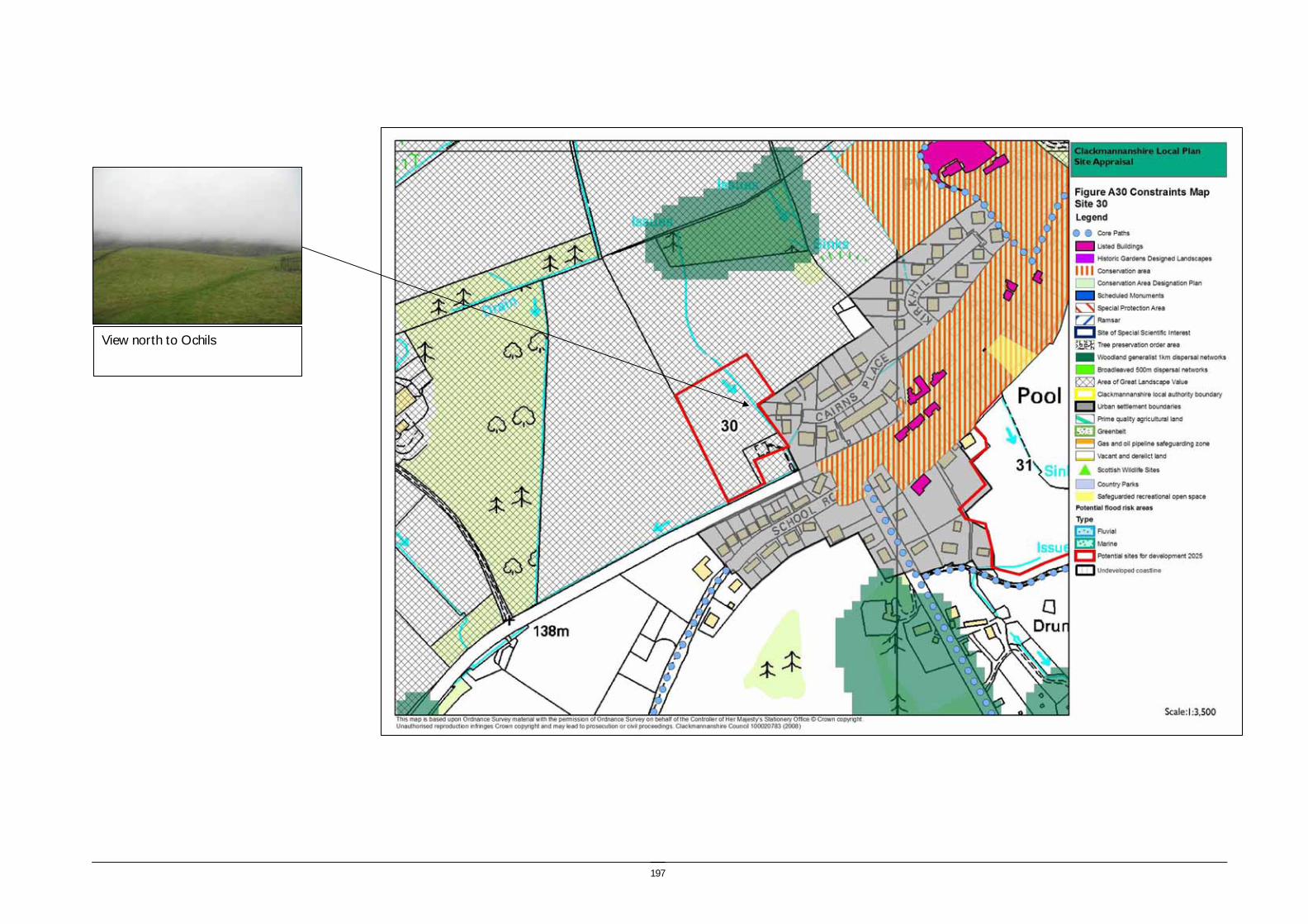
197
View north to Ochils
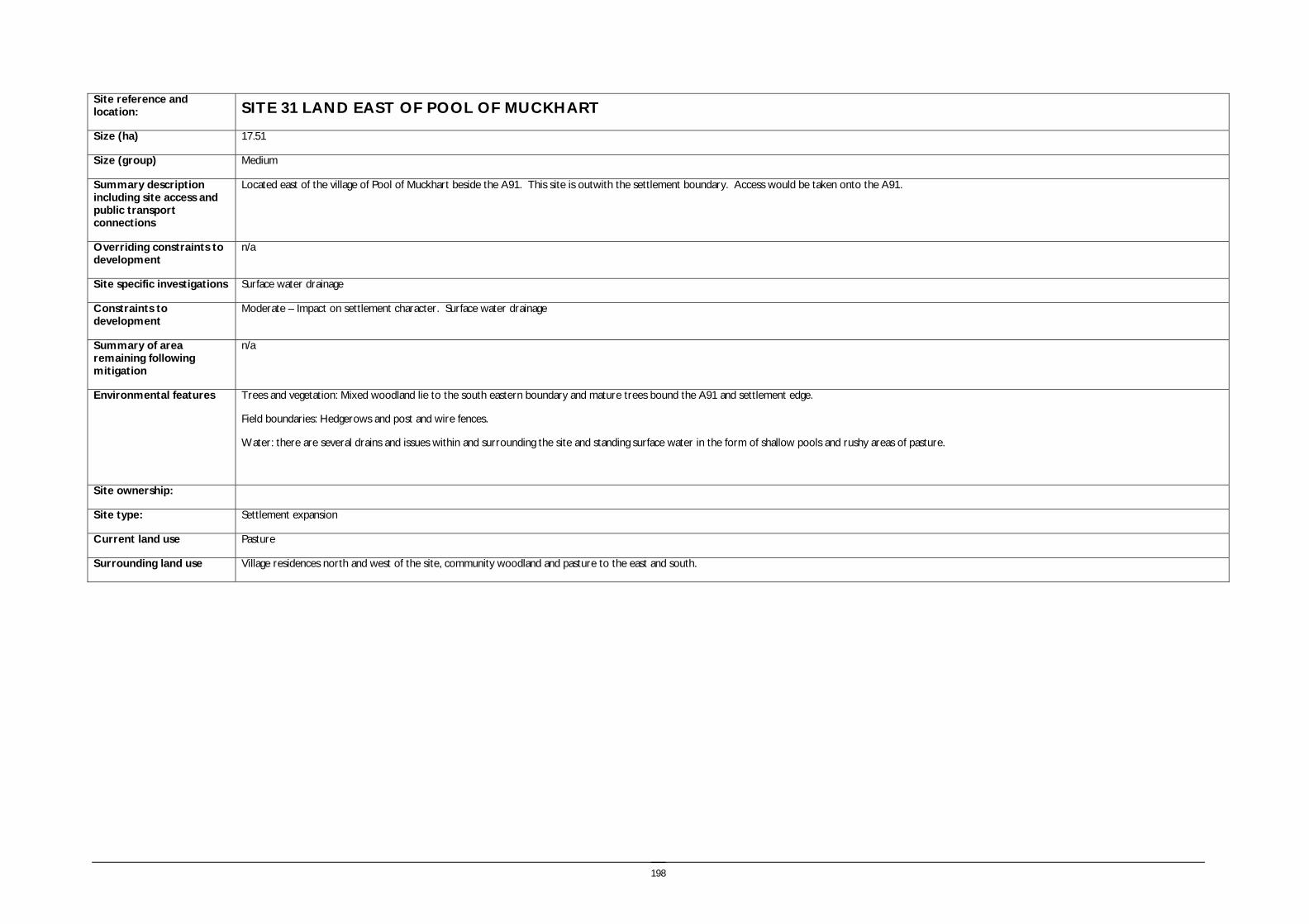
198
Site reference and location: SITE 31 LAND EAST OF POOL OF MUCKHART
Size (ha) 17.51
Size (group) Medium
Summary description including site access and public transport connections
Located east of the village of Pool of Muckhart beside the A91. This site is outwith the settlement boundary. Access would be taken onto the A91.
Overriding constraints to development
n/a
Site specific investigations Surface water drainage
Constraints to development
Moderate – Impact on settlement character. Surface water drainage
Summary of area remaining following mitigation
n/a
Environmental features Trees and vegetation: Mixed woodland lie to the south eastern boundary and mature trees bound the A91 and settlement edge.
Field boundaries: Hedgerows and post and wire fences.
Water: there are several drains and issues within and surrounding the site and standing surface water in the form of shallow pools and rushy areas of pasture.
Site ownership:
Site type: Settlement expansion
Current land use Pasture
Surrounding land use Village residences north and west of the site, community woodland and pasture to the east and south.

199
Planning policy framework:
Clackmannanshire and Stirling Structure Plan Policy ENV3 – Development in the Countryside: The policy states that development in the Countryside (as defined in Local Plans i.e. areas not within settlement boundaries) be suitable for it’s location in function and design and should accord with Policy ED4 – Rural Development (see below).
Clackmannanshire and Stirling Structure Plan Policy ED4 – Rural Development: The policy states that economic and social development in rural areas will be supported within the following criteria:
• Focusing development within existing towns and villages
• Restricting development within Green Belt and countryside.
Clackmannanshire Local Plan Policy EN18 – Development in the Countryside: Sets out the criteria for the granting of planning permission to a proposed development in the countryside.
Clackmannanshire and Stirling Structure Plan Policy H6 – Housing in the Countryside: The policy states that new housing developments in the Countryside will only be approved where the development is essential, involves the conversion of an existing building, or is consistent with Policy H5 ‘Housing in the Upland Area’.
Due to the proximity of the Muckhart Village Conservation Area and the A91 corridor the following should be considered: Clackmannanshire and Stirling Structure Plan Policy ENV6 – The Historic and Built Environment: aims to protect and enhance cultural heritage features, as well as ensure that new developments are in keeping with the character and quality of the area.
Clackmannanshire Local Plan Policy EN12 – Area Environmental Enhancement: states that proposals which would detract from the setting or aesthetics of Conservation Areas, the A91 corridor or rivers will not normally be permitted, and that developers must demonstrate how proposals can be integrated with proposed enhancement measures. Due to the proximity of core path network connections the following should be taken into account:
Clackmannanshire Local Plan Policy INF3 – Local Access: The policy states that development will not be permitted where it will result in the loss of an asserted right of way, footpath or a path forming part of the Clackmannanshire path network unless the provision of an alternative path can be assured.
SEA /site assessment topic
Site appraisal criteria Site issues and discussion Summary of Effect of development (++/+/0/-/--)
Enhancement and mitigation options
Potential effect following mitigation
Biodiversity, flora and fauna
Does the site impact on designated sites?
There are no designated sites either within or close to the site. The nearest designated site is Black Burn Wood and Meadows SSSI which is approximately 650m south of the site. Muckhart golf course lies between the site and the SSSI so development will have no adverse effect.
0
Does the site impact on priority habitats or species?
There are no areas identified as important for priority habitats or species within 500m of the site although there are a number of Phase 1 Habitat Survey Target Note Sites relatively close to the site. The site is identified in the Phase 1 Habitat Survey as arable and woodland, built up and there is a small area of broad leaved plantation.
0
Does the development of the site avoid adverse effects on the integrity of the Firth of Forth SPA and Ramsar site?
The site is not in proximity to the Firth of Forth SPA and Ramsar site. 0
Does the development of the site maintain and enhance populations of European Protected Species including protection of their resting places?
The site includes areas of marshy ground and boundary woodland and may provide habitat for protected species. Site specific survey should be undertaken prior to development of the site to ascertain the presence of European Protected Species and appropriate mitigation implemented if these species are identified.
0/- Following site specific survey, appropriate mitigation should be identified and implemented.
Does the site facilitate the restoration and enhancement of biodiversity in all our urban and rural environments through better planning, design and practice?
There are areas of woodland generalist 1km dispersal network to the north east and south west of the site. The development of the site would potentially result in loss of marshy and grassland habitat.
- Development of the site could implement habitat enhancement measures however the development of the site would result in overall loss of habitat.
Population and human
Is the site connected to the local core path network?
The site is very well connected to the Core Path Network; there are several paths through and around the boundary of the site. Links to the wider countryside are
++

200
SEA /site assessment topic
Site appraisal criteria Site issues and discussion Summary of Effect of development (++/+/0/-/--)
Enhancement and mitigation options
Potential effect following mitigation
health easily accessible.
How does the site relate to areas with high SIMD?
The site is not part of an ROA area or located in an area which has a high SIMD. Development of the site will therefore have no impact on this criterion.
0
What is the relationship of the site with existing open space resources?
The site has good access to the Core Path Network and is adjacent to Drumburn Farm community woodland and is close to Muckhart Golf Course.
+
Water
Is the site at risk of flooding?
The site does not lie within a flood risk area as identified on the SEPA flood map but is only 250m from the Black Burn which has been identified as being an area of risk. The site has identified surface water drainage issues.
- The surface water drainage issues may limit opportunities for the implementation of SUDS.
Are there water courses within the site or which would be affected by increased levels of pollution from development within the site?
Several issues run through the area and along the boundaries of the site however there are no water courses within the site which are likely to be affected by increased levels of pollution as a result of development.
- The implementation of SUDS would mitigate the impacts of diffuse pollution.
No significant effect.
Are there water courses within the site or which would be affected by increased levels of flooding resulting from development of the site?
Development at the site could put pressure on the existing drain and issue network, potentially resulting in flooding.
- The implementation of SUDS would reduce the impact of increased rate of run off resulting from development of the site. However opportunities for SUDS may be limited due to the topography and surface water drainage issues in the area.
No significant effect.
Soil Does the site include areas of vacant or derelict land?
The site is not vacant or derelict land. 0
Is the site prime agricultural land?
The site is not an area of prime quality agricultural land. 0
Air Quality and Transport
Is the site easily accessible by the local path network, and provide access to settlements and services?
The site is well linked with the Core Path Network however the majority of the surrounding area is rural in nature and limited services are provided within Pool of Muckhart. There are links with Dollar which, as the nearest service centre, is approximately 4km away.
- Pool of Muckhart is a rural settlement, and the development will generate trips to access services, employment and secondary education.
Is the site easily accessible by public transport? The site is located directly adjacent to the A91 but Pool of Muckhart is infrequently served by public transport. Whilst development of the site may result in an improved public transport service in the area, it is unlikely to discourage people from using their cars.
- Pool of Muckhart is a rural settlement, and the development will generate trips to access services, employment and secondary education.
Does the site lie within an area where levels of air pollution are close to current limit values?
Traffic is monitored close to the site at Muckhart to determine Annual Average Daily Traffic levels – the results indicate that traffic numbers are not a cause for concern at present. As such, if development were to proceed on this site, it is unlikely that there would be any adverse effect air quality in the area.
0

201
SEA /site assessment topic
Site appraisal criteria Site issues and discussion Summary of Effect of development (++/+/0/-/--)
Enhancement and mitigation options
Potential effect following mitigation
Would development on the site contribute to higher traffic flows along transport routes or at key junctions (potentially outwith the local authority area) where levels of air pollution are close to current limit values?
Development of the site would result in increased levels of traffic on the A91. Cumulative effects require to be assessed in Stage 2.
0
Climatic Factors
Does the location of the development reduce the need to travel?
Development of the land east of the Pool of Muckhart will not reduce the need to travel. The site is relatively remote and isolated from service centres and as such, private cars will be needed to access employment and services in surrounding areas of Clackmannanshire and beyond.
- Improved public transport
Is the site at risk of increased flooding or instability as a result of climate change?
Although the site is not identified by SEPA as being at risk of flooding, extreme weather conditions and flooding as a result of climate change could potentially result in flooding of the site.
- Surface water run off is a known issue for the area.
Material Assets
Is the site located close to existing transport, services, water and energy infrastructure?
The site is located adjacent to Pool of Muckhart therefore is likely to utilise much of the infrastructure available in the village. As the site is relatively large in comparison to the existing settlement, there is capacity for additional infrastructure to be accommodated in addition to housing developments.
0
Is the site located to make best use of shelter and solar gain?
The site is well positioned to make use of both solar gain and shelter. +
Would development on the site reduce future potential for mineral extraction?
The site is located in close proximity to settlement and would not impact on future potential for mineral extraction.
0
Does the site include any hazard areas? (oil or gas pipelines)
There are no hazard areas within or close to the site. 0
Does the site reduce waste generation and promote waste recovery, recycling and composting?
The site will generate additional waste arisings, however as it is located within the urban area it will not generate significant additional waste related journeys.
-
Cultural Heritage
Would development within the site impact on the integrity of sites, monuments, buildings or areas designated for their cultural heritage value?
The site is adjacent to Muckhart Village which is identified in the Clackmannanshire Local Plan as a Conservation Area. There are several listed buildings and monuments identified on the National Monuments Records of Scotland within Muckhart Village but there are no designated sites or monuments within the site boundary itself. As such, development of the area is unlikely to have a significant effect on the cultural heritage value of the area.
0 Ensure that development is in keeping with style of Muckhart Village conservation area.
Would development within the site impact on archaeological remains?
There are no known archaeological remains within the site boundary. The HLA identifies that the site is 19th century to present fields and farming.
0
Landscape Does the site lie within an area designated for its landscape value?
The site is separated from the Ochil Hills AGLV by the A91 in the north of the site and the village of Pool of Muckhart in the south. Whilst development could have a negative effect on the landscape resource, the proximity of the site to the existing village of Muckhart could help to reduce this.
-
Would development within the site impact on settlement setting and identity (drawing on issues of landscape character and capacity for development)?
The development of the site would extend the settlement to the south and contrast with the existing linear settlement pattern.
- If development were to take place on the site, it would need to be in keeping with Muckhart Village conservation area to ensure no negative impact on the settlement setting and identity.

202
SEA /site assessment topic
Site appraisal criteria Site issues and discussion Summary of Effect of development (++/+/0/-/--)
Enhancement and mitigation options
Potential effect following mitigation
Would development within the site impact on key views to landscape features or from key transport routes?
Development on the site would be visible from the A91 and the A823, however these would be interrupted views as a result of hedgerows and built features.
-

203
View west to settlement edge
View east towards Site 29

204
Site reference and location:
SITE 32, ALLOA NORTH WEST, BRANSHILL, SAUCHIE Size (ha) 70.92
Size (group) Large
Summary description including site access and public transport connections
This is an undulating site lying to the north of Alloa and west of Sauchie. It is a comparatively elevated site located within policy woodlands with a predominantly east to south easterly aspect. The site adjoins existing residential areas and the closest main access road is the B908. The majority of the site lies within the settlement boundary, with the exception of the western most field.
Overriding constraints to development
None
Site specific investigations
Constraints to development
Summary of area remaining following mitigation
Environmental features
Trees and vegetation: The thick shelterbelts at the site boundary are a key characteristic of this landscape and an important landscape feature within this part of Clackmannanshire. A small area of woodland lies in a dip on the hill crest to the south of the site.
Field boundaries: The majority of the field boundaries are formed by the shelterbelts and also include remnant stone walls and post and wire fences.
Water (ponds, rivers and streams) There are several small drains within the site and in the woodland belts at the periphery.
Site ownership:
Site type: Settlement expansion
Current land use Agriculture
Surrounding land use The site is bounded to the north and south by thick woodland belts and adjoins the residential area of Fairfield to the east. To the west of the site the area adjoins Lornshill Academy, and residential areas extend to the south beyond the woodland belts. To the north farmed fields extend beyond the woodland belts.

205
Planning policy framework: Part of the site is zoned for housing in the Local Plan as follows:
Plan Ref: H7 – Alloa North West Phase 1 - Existing Use: Agriculture First phase within the urban expansion area of North West Alloa. Subject to Masterplan for the entire expansion area. Enhancement to Green Belt setting required with enhancement of established adjacent woodlands. Enhancement of local footpath/leisure routes required to link with Sauchie, Lornshill and Inglewood. Structural planting and new woodland planting to south. Active and passive open space required within development. Potential for part provision to be off site. Roundabout required at B9140/B908 junction with road alignment of B908. Improvements to B9140 including potential for contribution to Tullibody By-Pass. Sterilisation of any coal reserves requires to be considered (Refer to Policy EN21).
Part of the site is zoned for Community Recreational Development in the Local Plan, as follows:
Plan Ref: CR5 – Alloa North West Provision of and suitable arrangements for long term management of recreational land (See Local Plan Residential Sites 12-16).
As there are core paths the following applies:
Clackmannanshire Local Plan Policy INF3 – Local Access: The policy states that development will not be permitted where it will result in the loss of an asserted right of way, footpath or a path forming part of the Clackmannanshire path network unless the provision of an alternative path can be assured.
As the site includes areas of Green Belt the following policies are of relevance:
Clackmannanshire and Stirling Structure Plan Policy ENV4 – Green Belts: In Green Belt areas there will be a strong presumption against development – any developments which are permitted will have to demonstrate appropriate environmental enhancement. Clackmannanshire Local Plan Policy EN19 – Green Belt: The policy states that development will only be permitted in the Green Belt where no alternative location can be found or the development would provide an opportunity to enhance the Green Belt.
SEA /site assessment topic
Site appraisal criteria Site issues and discussion Summary of Effect of development (++/+/0/-/--)
Enhancement and mitigation options
Potential effect following mitigation
Biodiversity, flora and fauna
Does the site impact on designated sites?
There are no designated sites within the site boundary, there are tree preservation orders covering the woodland to the immediate south west of the site at Inglewood House.
0 Ensure protection of tree root and nutrient zones should development of the site take place.
Does the site impact on priority habitats or species?
The woodland to the south of the site, and extending across part of the site in a shelterbelt has been subject to Phase 1 and Phase 2 habitat survey. There are Phase 1 Habitat survey Target Note sites within the woodland to the south of the site.
The Phase 1 Habitat Survey identifies the site as predominantly arable and pasture with areas of broadleaved semi natural woodland through the site and at the periphery.
0
Does the development of the site avoid adverse effects on the integrity of the Firth of Forth SPA and Ramsar site?
The site is not in proximity to the Firth of Forth SPA and Ramsar site. 0
Does the development of the site maintain and enhance populations of European Protected Species including protection of their resting places?
The site includes extensive perimeter woodlands, and a small burn. The site may provide habitat for protected species. Site specific survey should be undertaken prior to development of the site to ascertain the presence of European Protected Species and appropriate mitigation implemented if these species are identified.
0/- Following site specific survey, appropriate mitigation should be identified and implemented.
Does the site facilitate the restoration and enhancement of biodiversity in all our urban and rural environments through better planning, design and practice?
The woodland belts are an important part of the FHN with the woodland to the south providing one of the larger areas of broadleaved specialist 500m dispersal networks within Clackmannanshire. It is important that connectivity with this area of woodland is maintained and enhanced. The woodland generalist 1km dispersal network extends through the site along the shelterbelt and connects with the area of woodland to the north.
0/- The creation of additional woodland habitat connections through the site would enhance the habitat value of the site.

206
SEA /site assessment topic
Site appraisal criteria Site issues and discussion Summary of Effect of development (++/+/0/-/--)
Enhancement and mitigation options
Potential effect following mitigation
Population and human health
Is the site connected to the local core path network?
A core path passes through the centre of the site and a network of core paths extend through the surrounding woodland belts. The site is well connected to the core path network.
++
How does the site relate to areas with high SIMD?
The site is not within the top 15% of the SIMD and does not adjoin any areas within this category.
0
What is the relationship of the site with existing open space resources?
Notes connections to key recreational area or designation as a safeguarded open space or country park
The north western portion of the site and southern part of the site are identified in the local plan for community recreational development. In addition part of the woodland belt to the immediate south west of the site surrounding Inglewood House is safeguarded recreational open space. Other open space resources within the vicinity include Lornshill Academy school grounds, the grounds of Inglewood House and Fairfield recreation ground.
++
Water
Is the site at risk of flooding?
There is no risk of flooding identified on the SEPA flood map and the site is elevated and sloping and therefore the site itself does not have an identified flood risk. However development within close proximity to the central stream should be avoided and the stream has a history of flooding at the culvert adjoining the urban area.
0
Are there water courses within the site or which would be affected by increased levels of pollution from development within the site?
There is a drain to the south west of the site close to Inglewood House and also a small burn which drains the site toward Branshill. To the north a minor watercourse runs through the woodland belt draining to the north west. These could potentially be affected by diffuse pollution caused by run off from the development of the site.
- The implementation of a SUDS scheme would positively contribute to the management of issues associated with diffuse pollution resulting from development of the site.
Are there water courses within the site or which would be affected by increased levels of flooding resulting from development of the site?
The burn to the north of Inglewood House is identified as having caused previous flooding issues at Forrester Drive (2007 Biennial report), and remedial action has been taken by Clackmannanshire Council to direct the flow into Inglewood Pond. The stream which drains the main area of the site flows toward the Fairfield area and appears to enter a culvert. Increased rates of run off from the site resulting from development could contribute a local flooding problem at Fairfield.
- Potential impacts on the levels of flow within the watercourse at Inglewood House should be considered and location of development within the site should seek to avoid increasing the rate of run off to this watercourse, and also to the watercourse draining toward Fairfield. These potential impacts could be alleviated through the implementation of SUDS on site.
Soil Does the site include areas of vacant or derelict land?
The site is not vacant or derelict land. 0
Is the site prime agricultural land?
The site is not prime agricultural land. 0
Air Quality and Transport
Is the site easily accessible by the local path network, and provide access to settlements and services?
The site is easily accessible by the core path network providing links to the settlement to the east, west and south.
+
Is the site easily accessible by public transport? The site is close to residential areas served by public transport, however additional provision should be made to serve the site.
+
Does the site lie within an area where levels of The nearest monitoring location for NO2 on Shaftesbury Avenue does not show high 0
207
SEA /site assessment topic
Site appraisal criteria Site issues and discussion Summary of Effect of development (++/+/0/-/--)
Enhancement and mitigation options
Potential effect following mitigation
air pollution are close to current limit values?
levels of NO2, nor is there a clear trend in levels between 2002-2007.
Would development on the site contribute to higher traffic flows along transport routes or at key junctions (potentially outwith the local authority area) where levels of air pollution are close to current limit values?
The development of the site will primarily increase traffic levels on the A908 and B908 with travel into Alloa town centre. There are no current air quality issues identified on these routes.
- Improved public transport and maintenance and enhancement of the access routes will reduce the requirement for travel by private vehicle.
No significant effect.
Climatic Factors
Does the location of the development reduce the need to travel?
The site is located at the northern edge of Alloa and accessible by foot and cycle and public transport.
+
Is the site at risk of increased flooding or instability as a result of climate change?
The site may experience minor flooding problems associated with the burn at Branshill as a result of climate change, however this can be mitigated within the site layout and design and use of SUDS.
- The implementation of a SUDS scheme would positively contribute to the management of flood issues on this site.
No significant effect.
Material Assets
Is the site located close to existing transport, services, water and energy infrastructure?
The site is located within a developed area and is located close to existing transport services, water and energy infrastructure.
0
Is the site located to make best use of shelter and solar gain?
The site is undulating and is orientated to the east and enclosed by woodland shelterbelts to the west and south. These will contribute to providing shelter to the site. Some parts of the site are north easterly in aspect and are unable to take full advantage of solar gain.
+
Would development on the site reduce future potential for mineral extraction?
The site lies in the North West Alloa restricted area of search for opencast coal, however proximity to existing urban areas would also limit opportunities for extraction.
0 No impact
Does the site include any hazard areas? (oil or gas pipelines)
The site does not include any hazard areas. 0
Does the site reduce waste generation and promote waste recovery, recycling and composting?
The site will generate significant additional waste arisings, however as it is located within the urban area it will not generate significant additional waste related journeys.
- The site masterplan should provide for local composting and recycling facilities.
Minor negative
Cultural Heritage
Would development within the site impact on the integrity of sites, monuments, buildings or areas designated for their cultural heritage value?
There are no sites designated for their cultural heritage value within the site. 0
Would development within the site impact on archaeological remains?
There are no known archaeological remains within the site boundary or buffer. The HLA identifies 18th -20th century managed woodland and 18th -19th century and 19th century to present fields and farming.
0
Landscape Does the site lie within an area designated for its landscape value?
About half of the site lies within the area of Greenbelt identified within the local plan. The current area of greenbelt provides physical and perceptual separation between Alloa and Fairfield.
The site lies within the Carse of Forth landscape character area which is characterised by its flatness and open character which contrasts with the steeply rising Ochil Hills to the north. This part of the landscape character area has an undulating character
- Development of the site would result in the loss of the Greenbelt function provided by this landscape.

208
SEA /site assessment topic
Site appraisal criteria Site issues and discussion Summary of Effect of development (++/+/0/-/--)
Enhancement and mitigation options
Potential effect following mitigation
and has a strong rural character, however the landform also relates to the surrounding area of settlement.
Would development within the site impact on settlement setting and identity (drawing on issues of landscape character and capacity for development)?
Development within this area would form an effective extension to Fairfield and increase the extent of Alloa to the north. Development would be partially visually contained by the landform of the low hill and shelterbelt to the south of the B9140, which forms a defensible boundary. The thick shelterbelts to the south and west of the site further contain the landscape.
The growth of Alloa and Tullibody has extended into the structured landscape of low hills and fields enclosed by thick woodland belts, which are an attractive and distinctive landscape feature that provides identity to the local area.
0 The creation of new woodland belts within the site layout and design would reflect the character of the surrounding landscape and help to integrate the development into the landscape.
Would development within the site impact on key views to landscape features or from key transport routes?
The site is visible in views from the B908 and the surrounding residential area, however visibility is limited due to landform and woodland.
0/- The implementation of structure planting through site layout and retention of the most prominent ridges as open space would reduce the visual impacts of development of the site.

209
View west along path
View west towards settlement edge

210
Site reference and location:
SITE 33 OAK MILLS, LOWER MILL STREET, TILLICOULTRY Size (ha) 6.13
Size (group) Medium
Summary description including site access and public transport connections
The site lies to the west of Tillicoultry and comprises part of an arable field and an area of land adjacent to a works. The site lies outwith the settlement boundary. Access could be taken onto Lower Mill Street or onto the A91.
Overriding constraints to development
Flood risk
Site specific investigations Flood risk
Constraints to development Major – flood risk. Approximately two thirds of the site lie outwith the area identified as at risk of flooding in the SEPA indicative flood map.
Summary of area remaining following mitigation
Approximately two thirds of the site lie outwith the area identified as at risk of flooding in the SEPA indicative flood map.
Environmental features Trees and vegetation: The northern section of the site adjoins the recreation ground to the east and the boundary is defined by a number of mature trees. The southern section of the site includes some scrub woodland and young alder. To the west of the site is an extensive area of scrub woodland.
Field boundaries: There is a hedge adjacent to the A91 and a wire fence adjacent to the minor road to Glenfoot. There is no boundary to the west of the site.
Water (ponds, rivers and streams): The Tillicoultry Burn flows alongside Lower Mill Street, which is adjacent to the southern part of the site. The River Devon flows to the south of the site and an area of marshy woodland lies to the west.
Site ownership:
Site type: Settlement expansion
Current land use Unmanaged grassland with natural regeneration of scrub woodland and two small paddocks close to the works.
Surrounding land use The site adjoins the western edge of Tillicoultry, lying south of the golf course. The land to the west is arable farmland and the area of scrub woodland and the River Devon is a short distance to the south.

211
Planning policy framework: The majority of the site is designated as a Community Recreation Development site in the Local Plan, as follows:
Plan Ref: CR31 - Tillicoultry West:
Development Guidelines: Provision of playing field(s).
As the site is outwith the settlement boundary the following applies:
Clackmannanshire and Stirling Structure Plan Policy ENV3 – Development in the Countryside: The policy states that development in the Countryside (as defined in Local Plans i.e. areas not within settlement boundaries) be suitable for it’s location in function and design and should accord with Policy ED4 – Rural Development (see below).
Clackmannanshire and Stirling Structure Plan Policy ED4 – Rural Development: The policy states that economic and social development in rural areas will be supported within the following criteria:
• Focusing development within existing towns and villages
• Restricting development within Green Belt and countryside.
Clackmannanshire Local Plan Policy EN18 – Development in the Countryside: Sets out the criteria for the granting of planning permission to a proposed development in the countryside.
Clackmannanshire and Stirling Structure Plan Policy H6 – Housing in the Countryside: The policy states that new housing developments in the Countryside will only be approved where the development is essential, involves the conversion of an existing building, or is consistent with Policy H5 ‘Housing in the Upland Area’.
As the site is on the A91 corridor the following policy must be considered:
Clackmannanshire Local Plan Policy EN12 – Area Environmental Enhancement: states that proposals which would detract from the setting or aesthetics of Conservation Areas, the A91 corridor or rivers will not normally be permitted, and that developers must demonstrate how proposals can be integrated with proposed enhancement measures.
As there is a potential flood risk the following policies are of relevance:
Clackmannanshire and Stirling Structure Plan Policy ENV9 – Water Resource Management: The policy states that development will not normally be permitted in undeveloped flood plain areas, in areas of known significant flood risk, or if it will adversely affect the Forth Estuary. Exceptions will be made only when it can be demonstrated that no alternative locations can be found, or that suitable mitigation measures can be implemented. Clackmannanshire Local Plan Policy EN4 – Water Resources: The policy states that where a development area is determined as being at risk of flooding, planning permission will not be granted except where it can be proven that there are no viable alternative sites. As the site is within Green Belt the following policies are of relevance:
Clackmannanshire and Stirling Structure Plan Policy ENV4 – Green Belts: In Green Belt areas there will be a strong presumption against development – any developments which are permitted will have to demonstrate appropriate environmental enhancement. Clackmannanshire Local Plan Policy EN19 – Green Belt: The policy states that development will only be permitted in the Green Belt where no alternative location can be found or the development would provide an opportunity to enhance the Green Belt.
SEA /site assessment topic
Site appraisal criteria Site issues and discussion Summary of Effect of development (++/+/0/-/--)
Enhancement and mitigation options
Potential effect following mitigation
Biodiversity, flora and fauna
Does the site impact on designated sites?
There are no designated sites within the site boundary. 0
Does the site impact on priority habitats or species?
An area to the immediate west of the site and alongside the River Devon has been subject to Phase 2 habitat survey. The Phase 1 Habitat Survey identifies the site as arable and pasture.
0

212
SEA /site assessment topic
Site appraisal criteria Site issues and discussion Summary of Effect of development (++/+/0/-/--)
Enhancement and mitigation options
Potential effect following mitigation
Does the development of the site avoid adverse effects on the integrity of the Firth of Forth SPA and Ramsar site?
The site is not in proximity to the Firth of Forth SPA and Ramsar site. 0
Does the development of the site maintain and enhance populations of European Protected Species including protection of their resting places?
The site lies in close proximity to an area of wet woodland and scrub and may provide habitat for protected species. Site specific survey should be undertaken prior to development of the site to ascertain the presence of European Protected Species and appropriate mitigation implemented if these species are identified.
0/- Following site specific survey, appropriate mitigation should be identified and implemented.
Does the site facilitate the restoration and enhancement of biodiversity in all our urban and rural environments through better planning, design and practice?
The site plays no role in the FHN and there are no areas of FHN within 200m of the site. The site has habitat value as an area of unmanaged grassland and young trees. Development of the site would result in the loss of this role.
- The development of the site would result in the loss of this resource.
Population and human health
Is the site connected to the local core path network?
On road core paths are located along the A91 and Lower Mill Street. Access routes provide links to the Ochils to the north and over the River Devon to the south.
+
How does the site relate to areas with high SIMD?
The site adjoins an area with the highest SIMD in Tillicoultry, however there are no regeneration outcome agreement areas in Tillicoultry. Development of this area could contribute towards supporting neighbourhood renewal.
+
What is the relationship of the site with existing open space resources?
Notes connections to key recreational area or designation as a safeguarded open space or country park
The site lies immediately adjacent to a recreation ground and the site itself is identified as a community recreation development site in the local plan. In addition the Ochil Hills are accessible within 1km of the site boundary including Mill Glen and the Woodland Trust Ochil Hills Woodland Park.
++
Water
Is the site at risk of flooding?
The SEPA indicative river and coastal flood map suggests that the site is at potential risk of flooding associated with the Tillicoultry Burn and the River Devon. The site is low lying and gently sloping and an area of marshy land lies within 500m of the site boundary associated with the River Devon.
-- The low lying nature of the site reduces the potential for the implementation of SUDS to mitigate flooding issues.
Negative effect
Are there water courses within the site or which would be affected by increased levels of pollution from development within the site?
The site is closely associated with the Tillicoultry Burn and also the River Devon which would potentially be affected by increased levels of run off from the development of the site.
- The use of SUDS would reduce the impact of diffuse pollution resulting from the development of the site, however opportunities for the implementation of SUDS may be limited by the low lying nature of the site.
Minor negative effect
Are there water courses within the site or which would be affected by increased levels of flooding resulting from development of the site?
The development of the site would increase the rate of run off to the River Devon, however the greatest flooding risk associated with the River Devon is related to the high rates of flow from the Ochil Hills and therefore the additional impact resulting from the development of this site would be minor.
- The low lying nature of the site reduces the potential for the implementation of SUDS to mitigate flooding issues.
Minor negative effect
Soil Does the site include areas of vacant or derelict The site is not vacant or derelict land. 0

213
SEA /site assessment topic
Site appraisal criteria Site issues and discussion Summary of Effect of development (++/+/0/-/--)
Enhancement and mitigation options
Potential effect following mitigation
land?
Is the site prime agricultural land?
The site is not prime quality agricultural land. 0
Air Quality and Transport
Is the site easily accessible by the local path network, and provide access to settlements and services?
The site lies within 1km of the centre of Tillicoultry, with access on roads and pavements.
+
Is the site easily accessible by public transport? The site lies close to the A91 and is accessible by public transport +
Does the site lie within an area where levels of air pollution are close to current limit values?
Air quality is not monitored within Tillicoultry, however the site lies close to the A91 which is a main trunk road.
0 Development should be set back from the A91 to reduce impacts of air pollution.
Would development on the site contribute to higher traffic flows along transport routes or at key junctions (potentially outwith the local authority area) where levels of air pollution are close to current limit values?
Development of the site would contribute to higher traffic flows on the A91. - Development of the site could support the development of an access route between Tillicoultry and Alva.
Climatic Factors
Does the location of the development reduce the need to travel?
The site is well located to provide easy access to local services within Tillicoultry. However access to employment will generate travel outwith the local area.
+
Is the site at risk of increased flooding or instability as a result of climate change?
The site has an identified potential flood risk, and climate change predictions indicate increased annual precipitation, greater rainfall intensity, and an increase in the number of days of heavy rain. This is likely to result in an increased risk of future flooding.
-- No mitigation
Material Assets
Is the site located close to existing transport, services, water and energy infrastructure?
The site is located at the periphery of Tillicoultry and therefore accessible to existing transport services, water and energy infrastructure.
++
Is the site located to make best use of shelter and solar gain?
The site is flat and low lying and south of the Ochil Hills and is therefore well placed to make best use of shelter and solar gain.
+
Would development on the site reduce future potential for mineral extraction?
The land to the west of Tillicoultry is not identified as having potential for open cast coal.
0
Does the site include any hazard areas? (oil or gas pipelines)
The site does not lie within any oil or gas pipeline hazard areas. 0
Does the site reduce waste generation and promote waste recovery, recycling and composting?
The site would generate additional waste arisings, however as it is located within the urban area it will not generate significant additional waste related journeys and local recycling facilities would be accessible to residents.
-
Cultural Heritage
Would development within the site impact on the integrity of sites, monuments, buildings or areas designated for their cultural heritage value?
There are no features designated for their cultural heritage value within close proximity of the site.
The HLA identifies that the site is 19th century to present fields and farming.
0

214
SEA /site assessment topic
Site appraisal criteria Site issues and discussion Summary of Effect of development (++/+/0/-/--)
Enhancement and mitigation options
Potential effect following mitigation
Would development within the site impact on archaeological remains?
There are no known archaeological remains within the site boundary. Oak Mill located to the east of the site is recorded in the NMRS.
0
Landscape Does the site lie within an area designated for its landscape value?
The Ochil Hills AGLV to the north lies within 500m of the site boundary. The site lies within the Lower Devon Carselands landscape character area, noted for the sinuous route of the River Devon and rectilinear arable fields and scarcity of woodland. The hillfoot settlements are a key characteristic of this landscape character area.
Development of the site would result in an extension of Tillicoultry to the west, and loss of part of an agricultural field. This would have a minor impact on the landscape of the area.
- The guidelines for this character area support the definition of settlement boundaries with woodland planting. Development of the site would result in loss of the Green Belt function provided by the landscape.
Would development within the site impact on settlement setting and identity (drawing on issues of landscape character and capacity for development)?
Development of the site would result in an extension of Tillicoultry to the west which would reflect the existing settlement pattern centred along the A91. However it would further contribute to an elongation of the settlement form reducing accessibility to the centre of the settlement. The existing recreation ground and line of mature trees provides a robust settlement edge. Development to the east of this edge would not relate well to the existing settlement.
- No mitigation to reduce the impact on settlement form.
Would development within the site impact on key views to landscape features or from key transport routes?
Development of the site would be highly visible from the A91, and extend the settlement to the west. The Ochil Hills AGLV lies to the north of the site on the steeper slopes and the development of the valley floor would reduce the contrast provided by the flat valley floor and the steep rising slopes.
- No mitigation.

215
Scrub and marsh to west of site
View east towards settlement edge

216
Site reference and location:
SITE 34 LAND SOUTH OF DOLLAR ROAD TILLICOULTRY Size (ha) 4.00
Size (group) Small
Summary description including site access and public transport connections
The site lies to the east of Tillicoultry to the south of the A91 and is flat and low lying. The western part of the site is currently used as a golf driving range and the eastern part of the site is agricultural. The northern part of the site lies within the settlement boundary. The only option for site access is from the A91.
Overriding constraints to development
Flood risk
Site specific investigations Flood risk
Constraints to development Major – Flood risk. The whole of the site lies within an area identified as at potential risk of flooding on the SEPA indicative flood map.
Summary of area remaining following mitigation
The whole of the site lies within an area identified as at potential risk of flooding on the SEPA indicative flood map.
Environmental features Trees and vegetation The majority of the site comprises the mown grass of the golf driving range and the pasture to the east. There is woodland adjacent to the southern part of the western boundary and mature trees stand along the eastern field boundary.
Field boundaries: There are field trees and hedgerow at the site boundary. A small levee runs along the western boundary
Water (ponds, rivers and streams): The Kirk Burn flows along the western boundary of the site and a drain flows along the field boundary between the golf driving range and field. The River Devon lies within 50m of the southern site boundary.
Site ownership:
Site type: Settlement expansion
Current land use Golf driving range and agricultural field.
Surrounding land use To the west of the site is an area of woodland and beyond that a cemetery. To the south is the River Devon and the Devon Way access route and to the east is an agricultural field. Housing lies to the north.

217
Planning policy framework: Part of the site is designated for housing in the Local Plan as follows:
Plan Ref: H96 – Dollar Road:
Development Guidelines: Existing Use: Garden Centre/Golf Driving Range Subject to Development Brief. Single access from A91. Maximum 1½ storeys to front A91. Wide landscaping strip to road frontage. Traditional cottage style development. Structural planting to south and west boundaries. Protection and enhancement of existing burn. Flood appraisal may be required.
The following apply to the area of the site outwith the settlement boundary:
Clackmannanshire and Stirling Structure Plan Policy ENV3 – Development in the Countryside: The policy states that development in the Countryside (as defined in Local Plans i.e. areas not within settlement boundaries) be suitable for it’s location in function and design and should accord with Policy ED4 – Rural Development (see below).
Clackmannanshire and Stirling Structure Plan Policy ED4 – Rural Development: The policy states that economic and social development in rural areas will be supported within the following criteria:
• Focusing development within existing towns and villages
• Restricting development within Green Belt and countryside.
Clackmannanshire Local Plan Policy EN18 – Development in the Countryside: Sets out the criteria for the granting of planning permission to a proposed development in the countryside.
Clackmannanshire and Stirling Structure Plan Policy H6 – Housing in the Countryside: The policy states that new housing developments in the Countryside will only be approved where the development is essential, involves the conversion of an existing building, or is consistent with Policy H5 ‘Housing in the Upland Area’.
As the site is in close proximity to the River Devon and on the A91 corridor the following policy must be considered:
Clackmannanshire Local Plan Policy EN12 – Area Environmental Enhancement: states that proposals which would detract from the setting or aesthetics of Conservation Areas, the A91 corridor or rivers will not normally be permitted, and that developers must demonstrate how proposals can be integrated with proposed enhancement measures.
As there is a potential flood risk the following policies are of relevance:
Clackmannanshire and Stirling Structure Plan Policy ENV9 – Water Resource Management: The policy states that development will not normally be permitted in undeveloped flood plain areas, in areas of known significant flood risk, or if it will adversely affect the Forth Estuary. Exceptions will be made only when it can be demonstrated that no alternative locations can be found, or that suitable mitigation measures can be implemented. Clackmannanshire Local Plan Policy EN4 – Water Resources: The policy states that where a development area is determined as being at risk of flooding, planning permission will not be granted except where it can be proven that there are no viable alternative sites.
As the site lies within the Green Belt, the following apply:
Clackmannanshire and Stirling Structure Plan Policy ENV4 – Green Belts: In Green Belt areas there will be a strong presumption against development – any developments which are permitted will have to demonstrate appropriate environmental enhancement. Clackmannanshire Local Plan Policy EN19 – Green Belt: The policy states that development will only be permitted in the Green Belt where no alternative location can be found or the development would provide an opportunity to enhance the Green Belt.
SEA /site assessment topic
Site appraisal criteria Site issues and discussion Summary of Effect of development (++/+/0/-/--)
Enhancement and mitigation options
Potential effect following mitigation
Biodiversity, flora and fauna
Does the site impact on designated sites?
The site does not impact on any designated sites. 0

218
SEA /site assessment topic
Site appraisal criteria Site issues and discussion Summary of Effect of development (++/+/0/-/--)
Enhancement and mitigation options
Potential effect following mitigation
Does the site impact on priority habitats or species?
The site does not impact on priority habitats and species. The Phase 1 Habitat Survey identifies the site as amenity grassland to the west and arable and pasture to the east.
0
Does the development of the site avoid adverse effects on the integrity of the Firth of Forth SPA and Ramsar site?
The site is not in proximity to the Firth of Forth SPA and Ramsar site. 0
Does the development of the site maintain and enhance populations of European Protected Species including protection of their resting places?
The site includes two water courses and may provide habitat for protected species. Site specific survey should be undertaken prior to development of the site to ascertain the presence of European Protected Species and appropriate mitigation implemented if these species are identified.
0/- Following site specific survey, appropriate mitigation should be identified and implemented.
Does the site facilitate the restoration and enhancement of biodiversity in all our urban and rural environments through better planning, design and practice?
The site does not form part of the FHN however an area of woodland generalist 1km dispersal network lies to the immediate north of the site. The habitat associated with the watercourses should be protected and enhanced. Development of the site would result in loss of habitat associated with the watercourses.
- Development of the site would result in loss of open ground and impact on the habitat associated with the watercourses.
Population and human health
Is the site connected to the local core path network?
The Devon Way core path runs to the south of the site and there is an on road core path along the A91 to the north of the site
+
How does the site relate to areas with high SIMD?
The site does not lie in an area with a high SIMD 0
What is the relationship of the site with existing open space resources?
Notes connections to key recreational area or designation as a safeguarded open space or country park
There are safeguarded recreational open spaces to the immediate north of the site and the large cemetery to the east of the site.
+
Water
Is the site at risk of flooding?
The site is identified as at potential risk of flooding by rivers on the SEPA indicative river and coastal flood map. This reflects the low lying nature of the site and proximity to the River Devon.
-- The extent and proximity of watercourses and low lying nature of the site limits opportunities for the use of SUDS.
Significant negative effect
Are there water courses within the site or which would be affected by increased levels of pollution from development within the site?
Development of the site would result in increased levels of diffuse pollution entering the River Devon.
- See above Minor negative effect
Are there water courses within the site or which would be affected by increased levels of flooding resulting from development of the site?
The River Devon has an identified flood risk, largely attributable to the high levels of run off from the Ochil Hills. Development of the site would increase the rate of run off and reduce any current holding capacity provided by the site.
- See above Minor negative effect

219
SEA /site assessment topic
Site appraisal criteria Site issues and discussion Summary of Effect of development (++/+/0/-/--)
Enhancement and mitigation options
Potential effect following mitigation
Soil Does the site include areas of vacant or derelict land?
The site is not vacant or derelict land. 0
Is the site prime agricultural land?
The site is not prime quality agricultural land. 0
Air Quality and Transport
Is the site easily accessible by the local path network, and provide access to settlements and services?
The Devon Way provides off road access to the centre of Tillcoultry and there is also pavement access along the A91.
++
Is the site easily accessible by public transport? The site lies on the eastern edge of Tillicoultry, close to the A91 and has access to local bus services.
+
Does the site lie within an area where levels of air pollution are close to current limit values?
Air quality is not monitored in Tillicoultry, however the A91 is a major trunk road through the area.
0 Potential air quality impacts can be mitigated through setting development back from the A91.
Would development on the site contribute to higher traffic flows along transport routes or at key junctions (potentially outwith the local authority area) where levels of air pollution are close to current limit values?
The A91 is a major trunk road through the area and development of the site would contribute an increase in traffic levels on this road. The site is small in extent and therefore the quantity of traffic generated would not be significant. However cumulative impacts of developments contributing to traffic levels on this route should be considered.
0/-
Climatic Factors
Does the location of the development reduce the need to travel?
The site lies within 2km of the centre of Tillicoultry which reduces the need to travel to access local services and public transport. However travel for employment will generate trips outwith the local area.
+
Is the site at risk of increased flooding or instability as a result of climate change?
The site has an identified potential flood risk and climate change predictions indicate an increased future risk resulting from higher levels of rainfall and greater intensity of rainfall.
-- The low lying nature of the site and close proximity to watercourses limits opportunities for mitigation.
Significant negative effect.
Material Assets
Is the site located close to existing transport, services, water and energy infrastructure?
The site is located on the periphery of Tillicoultry and is close to existing transport, water and energy infrastructure.
++
Is the site located to make best use of shelter and solar gain?
The site is located in a low lying area and is reasonably well located to make best use of shelter and solar gain.
+
Would development on the site reduce future potential for mineral extraction?
The area to the north east of the site has an identified coal resource, however development of the site would be unlikely to influence future mining activities.
0
Does the site include any hazard areas? (oil or gas pipelines)
The site does not include any oil or gas pipeline hazard zones. 0
Does the site reduce waste generation and promote waste recovery, recycling and composting?
The site will generate additional waste arisings, however as it is located within the urban area it will not generate significant additional waste related journeys and residents can make use of local recycling facilities.
-
Cultural Heritage
Would development within the site impact on the integrity of sites, monuments, buildings or areas designated for their cultural heritage
The site does not include any features designated for their cultural heritage value and the site is identified in the HLA as a 19th century recreation area, 18th and 19th century and 19th century fields and farming. The site provides a foreground in views to the gatehouse from the disused railway access route and would reduce the appreciation
-

220
SEA /site assessment topic
Site appraisal criteria Site issues and discussion Summary of Effect of development (++/+/0/-/--)
Enhancement and mitigation options
Potential effect following mitigation
value?
of the parkland setting.
Would development within the site impact on archaeological remains?
There are no known archaeological remains within the site boundary. 0
Landscape Does the site lie within an area designated for its landscape value?
The Ochil Hills AGLV lies to the immediate north east of the site. The site lies within an area of Greenbelt and lies within the Lower Devon Carselands landscape character area, noted for the sinuous route of the River Devon and rectilinear arable fields and scarcity of woodland. The hillfoot settlements are a key characteristic of this landscape character area. Development of this site would extend the settlement to the east.
- The guidelines for this character area support the definition of settlement boundaries which should be defined through woodland planting to reflect existing field patterns and woodland planting. The existing trees on the eastern edge provide definition to the site boundary.
Would development within the site impact on settlement setting and identity (drawing on issues of landscape character and capacity for development)?
Tillicoultry is centred along the A91 and the development of this site would form an extension to the settlement along the A91, reflecting the existing character. However development in the field to the east would impact on the rural parkland character of the landscape to the east of Tillicoultry.
0
Would development within the site impact on key views to landscape features or from key transport routes?
Development of the site would be partly visible from the A91. The golf driving range and nursery buildings already contribute a built feature on the eastern edge of the settlement and the impact of development would not be significant on views from the A91.
0

221
View north to golf driving range and settlement edge
View north towards West Lodge and Ochils

222
Site reference and location:
SITE 35 CAMBUS EAST, CAMBUS, TULLIBODY
Size (ha) 9.81
Size (group) Medium
Summary description including site access and public transport connections
A flat and low lying site to the immediate east of Cambus, where new housing development has recently been built. The site lies to the south of the Stirling – Alloa railway and is visually screened from the railway by a belt of trees. The majority of the site lies outwith the settlement boundary, however the western extent of the site lies within the boundary.
Site access would be onto Station Road and joining the A907. The level crossing over the railway may represent a constraint to development through the potential for traffic queuing back from the traffic lights on the A907 resulting from increased traffic levels.
Overriding constraints to development
Access constraints associated with level crossing.
Site specific investigations Traffic management options for level crossing
Flood risk
Constraints to development Major – Flood risk. Traffic management. Impact on Firth of Forth SPA and Ramsar
Summary of area remaining following mitigation
An area of established standing water is located adjacent to the path through the site, however this does not significantly affect the available area of land for development.
Environmental features Trees and vegetation: A belt of scrub woodland lies to the north of the site along the route of the railway, and there are occasional field trees along the eastern field boundary.
Field boundaries: These include some field trees and outgrown hedgerow trees and post and wire fences.
Water (ponds, rivers and streams): A ditch runs along the field boundary at the south eastern corner of the site. There is standing water adjacent to the access route.
Site ownership:
Site type: Settlement expansion
Current land use Agriculture
Surrounding land use The residential area of Cambus lies to the immediate west and north beyond the Stirling - Alloa railway. The surrounding landscape is a mixture of arable and pasture farmland.

223
Planning policy framework: The following apply to the area of the site outwith the settlement boundary:
Clackmannanshire and Stirling Structure Plan Policy ENV3 – Development in the Countryside: The policy states that development in the Countryside (as defined in Local Plans i.e. areas not within settlement boundaries) be suitable for it’s location in function and design and should accord with Policy ED4 – Rural Development (see below).
Clackmannanshire and Stirling Structure Plan Policy ED4 – Rural Development: The policy states that economic and social development in rural areas will be supported within the following criteria:
• Focusing development within existing towns and villages
• Restricting development within Green Belt and countryside.
Clackmannanshire Local Plan Policy EN18 – Development in the Countryside: Sets out the criteria for the granting of planning permission to a proposed development in the countryside.
Clackmannanshire and Stirling Structure Plan Policy H6 – Housing in the Countryside: The policy states that new housing developments in the Countryside will only be approved where the development is essential, involves the conversion of an existing building, or is consistent with Policy H5 ‘Housing in the Upland Area’.
As the site lies within the area of undeveloped coast as identified on the Local Plan Clackmannanshire wide Countryside map the following policy applies: Clackmannanshire Local Plan Policy EN5 – The Coast: The policy states that the undeveloped coast will be protected from further development except where it can be proved that there are no viable alternative sites.
Due to the proximity of designated sites the following should be taken into account:
Clackmannanshire and Stirling Structure Plan Policy ENV1 – Nature Conservation: The policy aims to promote the protection of wildlife, habitats and other natural features. It states that development which will have a potential negative impact upon internationally or nationally designated sites will not be permitted unless it can be demonstrated that their will be no adverse effect from the proposal, or no viable alternative solution. Similarly, proposals which may affect a site of local importance will only be allowed where it can be demonstrated that there will be no significant negative impact on the conservation value of the site.
Clackmannanshire Local Plan Policy EN1 – Sites of Local Ecological Importance: The policy states that any application for development will be guided by the Local Biodiversity Action Plan. It also states that any development proposals should consider the importance of non-designated sites of local nature conservation or biodiversity importance and should minimise negative impacts on the natural heritage resource.
Due to the presence of a core path route the following applies: Clackmannanshire Local Plan Policy INF3 – Local Access: The policy states that development will not be permitted where it will result in the loss of an asserted right of way, footpath or a path forming part of the Clackmannanshire path network unless the provision of an alternative path can be assured.
As there is a potential flood risk the following policies are of relevance:
Clackmannanshire and Stirling Structure Plan Policy ENV9 – Water Resource Management: The policy states that development will not normally be permitted in undeveloped flood plain areas, in areas of known significant flood risk, or if it will adversely affect the Forth Estuary. Exceptions will be made only when it can be demonstrated that no alternative locations can be found, or that suitable mitigation measures can be implemented. Clackmannanshire Local Plan Policy EN4 – Water Resources: The policy states that where a development area is determined as being at risk of flooding, planning permission will not be granted except where it can be proven that there are no viable alternative sites.
SEA /site assessment topic
Site appraisal criteria Site issues and discussion Summary of Effect of development (++/+/0/-/--)
Enhancement and mitigation options
Potential effect following mitigation
Biodiversity, flora and fauna
Does the site impact on designated sites?
The site lies within 500m of the Firth of Forth SPA, Ramsar and SSSI. Development of the site would increase the level of disturbance to the SPA.
-- Management of access and recreation would reduce negative impacts on the Firth of Forth SPA and Ramsar.
224
SEA /site assessment topic
Site appraisal criteria Site issues and discussion Summary of Effect of development (++/+/0/-/--)
Enhancement and mitigation options
Potential effect following mitigation
Does the site impact on priority habitats or species?
The Phase 1 Habitat Survey identifies the site as arable and pasture with an area of unimproved neutral grassland along the route of the disused railway.
0
Does the development of the site avoid adverse effects on the integrity of the Firth of Forth SPA and Ramsar site?
The site is in close proximity to the Firth of Forth SPA and Ramsar site. Development of the site would potentially result in increased levels of disturbance to the SPA and Ramsar.
-- Management of access and recreation would reduce negative impacts on the Firth of Forth SPA and Ramsar.
Does the development of the site maintain and enhance populations of European Protected Species including protection of their resting places?
The site includes standing water, a ditch and mature boundary trees and may provide habitat for protected species. Site specific survey should be undertaken prior to development of the site to ascertain the presence of European Protected Species and appropriate mitigation implemented if these species are identified.
0/- Following site specific survey, appropriate mitigation should be identified and implemented.
Does the site facilitate the restoration and enhancement of biodiversity in all our urban and rural environments through better planning, design and practice?
There are elements of the woodland generalist 1km dispersal network to the north and east of the site. Development of the site would result in loss of the open water and loss of open ground.
- Habitat creation would reduce the impact of the loss of the standing water habitat.
Population and human health
Is the site connected to the local core path network?
A core path passes through the centre of the site providing off road recreational links toward Alloa, there are also routes providing links to the west and north
++
How does the site relate to areas with high SIMD?
The site does not lie in an area within the top 15% in the Scottish Index of Multiple Deprivation. The nearest Regeneration Outcome Agreement areas are in Tullibody to the north.
0
What is the relationship of the site with existing open space resources?
Notes connections to key recreational area or designation as a safeguarded open space or country park
There is a playground adjacent to the site which is safeguarded for community recreation development. There is also a bowling green within Cambus which is a safeguarded recreational open space. Within Tullibody to the north is Braehead golf club and playing field facilities.
+
Water
Is the site at risk of flooding?
The site lies immediately adjacent to an area identified on the SEPA flood map as at risk of flooding by the sea, and therefore there is a potential risk of flooding on the site which lies between the Black Devon and the River Forth. In addition the evidence of minor flooding adjacent to the access route further suggests investigation of flood risk on this site.
- The proximity to the two watercourses may limit opportunities to mitigate the flood risk associated with the site.
Are there water courses within the site or which would be affected by increased levels of pollution from development within the site?
The site lies within 500m of the Firth of Forth and therefore run off from the site could potentially increase levels of diffuse pollution in the River Forth.
- The implementation of SUDS will reduce the impact of diffuse pollution resulting from development of the site.
Are there water courses within the site or which would be affected by increased levels of flooding resulting from development of the site?
There is a minor ditch within the field boundary to the south east of the site which may incur increased water levels resulting from development of the site through increasing the rate of run off.
The Clackmannanshire biennial flood report (2007) identifies that Forth Street in
- The implementation of SUDS will reduce the impact of increased run off resulting from development of the site.

225
SEA /site assessment topic
Site appraisal criteria Site issues and discussion Summary of Effect of development (++/+/0/-/--)
Enhancement and mitigation options
Potential effect following mitigation
Cambus has been recorded as a previous flood prone site but no flooding has been recorded since 2005.
Soil Does the site include areas of vacant or derelict land?
The site is not vacant or derelict land. 0
Is the site prime agricultural land?
The site is not prime quality agricultural land. 0
Air Quality and Transport
Is the site easily accessible by the local path network, and provide access to settlements and services?
The site is well connected to the local path network for recreation. It lies within 1km of the centre of Tullibody, however pedestrian access to Tullibody requires the use of on road access.
- Creation of a new access route to facilitate safe off road pedestrian access to Tullibody.
Is the site easily accessible by public transport? The main A907 a short walk from the site and provides regular bus services.
0/- Provide pedestrian access from the north of the site over the railway to increase accessibility to the A907 for public transport connections. Future development of a station at Cambus would increase the accessibility of the site.
Does the site lie within an area where levels of air pollution are close to current limit values?
The nearest air quality monitoring location is in the centre of Tullibody on Stirling Road and there are no clear trends in NO2 concentrations between 2002-2007. Traffic counts to the west of Cambus indicate a minor increase in traffic levels between 2006 and 2007 of 1.4%.
0
Would development on the site contribute to higher traffic flows along transport routes or at key junctions (potentially outwith the local authority area) where levels of air pollution are close to current limit values?
Traffic resulting from development of the site would travel principally on the A907 into Alloa and west to Stirling. There are no declared AQMA in Stirling.
- Development of a new station at Cambus would reduce the reliance on the private car.
Climatic Factors
Does the location of the development reduce the need to travel?
The site is located at the edge of the urban areas of Tullibody and accessible to Alloa town centre by bus and pedestrian and cycle access.
+
Is the site at risk of increased flooding or instability as a result of climate change?
The site is low lying and in close proximity to the River Devon and the River Forth. It is immediately adjacent to an area identified by the SEPA flood map as being at risk of flooding by the sea, and therefore future risk to this site as a result of climate change should be considered.
-- The proximity to the two watercourses may limit opportunities to mitigate the flood risk associated with the site.
Material Assets
Is the site located close to existing transport, services, water and energy infrastructure?
The site is located close to an existing urban area and therefore close to existing transport services, water and energy infrastructure.
+
Is the site located to make best use of shelter and solar gain?
The site is flat and low lying, however it would be reasonably well placed to make use of solar gain due to the open aspect.
+
Would development on the site reduce future potential for mineral extraction?
The site does not lie in an area identified for its open cast extraction potential. 0

226
SEA /site assessment topic
Site appraisal criteria Site issues and discussion Summary of Effect of development (++/+/0/-/--)
Enhancement and mitigation options
Potential effect following mitigation
Does the site include any hazard areas? (oil or gas pipelines)
There are no hazard areas within the site boundary. 0
Does the site reduce waste generation and promote waste recovery, recycling and composting?
The site would generate additional waste arisings however as it is located within the urban area it will not generate significant additional waste collection journeys.
-
Cultural Heritage
Would development within the site impact on the integrity of sites, monuments, buildings or areas designated for their cultural heritage value?
There are no known features designated for their heritage value within the site boundary, and development of the site would not impact on the setting or integrity of any features designated for their cultural heritage value.
0
Would development within the site impact on archaeological remains?
The development of the site will not result in impacts on known archaeological remains. The HLA identifies that the site is 18th -19th century fields and farming.
0
Landscape Does the site lie within an area designated for its landscape value?
The site does not lie in an area designated for its landscape value. The site lies within the Carse of Forth landscape character area. The landscape is characterised by its width, flatness, and openness emphasised by a lack of woodland and field boundaries. Human settlement is a prominent feature within the landscape.
0
Would development within the site impact on settlement setting and identity (drawing on issues of landscape character and capacity for development)?
Development of the site would result in a significant expansion of Cambus, almost doubling the area of the settlement. The core of the settlement is linear in form and new development across the site will detract from this character.
- Guidelines for this landscape character area include protection of the open agricultural character, but also highlighting roads through roadside planting and the River Forth.
Would development within the site impact on key views to landscape features or from key transport routes?
The site is not visible from the A907 due to the screening effect of woodland at the northern edge, and this also serves to limit views from the Stirling – Alloa railway.
0

227
View west to settlement edge illustrating standing water adjacent to access route
View east field boundary and woodland associated with railway

228
Site reference and location:
SITE 36 LORNSHILL FARM STEADING
Size (ha) 0.8
Size (group) Small
Summary description including site access and public transport connections
This site comprises the cluster of buildings at Lornshill Farm Steading located on a low rise, which lies between Tullibody and Alloa. The site is located close to the existing public transport provision in Tullibody and Alloa. The site has an existing access road which could be improved to serve the site.
Overriding constraints to development
None
Site specific investigations Investigation of bats within steading buildings.
Constraints to development None
Summary of area remaining following mitigation
n/a
Environmental features Trees and vegetation: There are areas of scrub and a partial avenue of mature deciduous trees along the access road.
Field boundaries: The boundary comprises scrub, post and wire fences and garden boundary.
Water (ponds, rivers and streams): There are no watercourses within the site boundary.
Site ownership:
Site type: Brownfield
Current land use Plant hire storage and residential.
Surrounding land use Woodland and agricultural fields.
Planning policy framework: Clackmannanshire and Stirling Structure Plan Policy ENV3 – Development in the Countryside: The policy states that development in the Countryside (as defined in Local Plans i.e. areas not within settlement boundaries) be suitable for it’s location in function and design and should accord with Policy ED4 – Rural Development (see below).
Clackmannanshire and Stirling Structure Plan Policy ED4 – Rural Development: The policy states that economic and social development in rural areas will be supported within the following criteria:
• Focusing development within existing towns and villages
• Restricting development within Green Belt and countryside.
Clackmannanshire Local Plan Policy EN18 – Development in the Countryside: Sets out the criteria for the granting of planning permission to a proposed development in the countryside.
Clackmannanshire and Stirling Structure Plan Policy H6 – Housing in the Countryside: The policy states that new housing developments in the Countryside will only be approved where the development is essential, involves the conversion of an existing building, or is consistent with Policy H5 ‘Housing in the Upland Area’.
As the site lies within the Green Belt designation the following applies: Clackmannanshire and Stirling Structure Plan Policy ENV4 – Green Belts: In Green Belt areas there will be a strong presumption against development – any developments which are permitted will have to demonstrate appropriate environmental enhancement. Clackmannanshire Local Plan Policy EN19 – Green Belt: The policy states that development will only be permitted in the Green Belt where no alternative location can be found or the development would provide an opportunity to enhance the Green Belt. Due to the presence of a Listed Building the following policy applies: Clackmannanshire Local Plan Policy EN6 - Listed Buildings: When determining applications for listed building consent or planning applications that affect a listed building or its setting, the Council will seek to ensure preservation of the building, its setting, or any features of architectural or historic interest. Approval will normally be granted for uses that would secure a viable future for a listed building, provided that any alterations are sympathetic to the character of the building and its setting.

229
Planning History
SEA /site assessment topic
Site appraisal criteria Site issues and discussion Summary of Effect of development (++/+/0/-/--)
Enhancement and mitigation options
Potential effect following mitigation
Biodiversity, flora and fauna
Does the site impact on designated sites?
The site does not impact on any sites designated for their nature conservation value. 0
Does the site impact on priority habitats or species?
The site is identified in the Phase 1 habitat survey as arable and pasture and built up. 0
Does the development of the site avoid adverse effects on the integrity of the Firth of Forth SPA and Ramsar site?
The site is not in close proximity to the Firth of Forth SPA and Ramsar site. 0
Does the development of the site maintain and enhance populations of European Protected Species including protection of their resting places?
The derelict buildings and mature trees may provide habitat for protected species. Site specific survey should be undertaken prior to development of the site to ascertain the presence of European Protected Species and appropriate mitigation implemented if these species are identified.
0/- Following site specific survey, appropriate mitigation should be identified and implemented.
Does the site facilitate the restoration and enhancement of biodiversity in all our urban and rural environments through better planning, design and practice?
The areas to the south and north of the site form part of the woodland generalist 1km dispersal network. Development of the site would not impact directly on the FHN.
0 Additional avenue planting would enhance the habitat value of the entrance road.
Population and human health
Is the site connected to the local core path network?
Core paths run through the woodland to the north and west of the site and on road routes provide links to Alloa and Tullibody.
++
How does the site relate to areas with high SIMD?
Tullibody ROA agreement area lies to the north and west of this site, within 500m. The area within which the site is located does not have a high SIMD. The site will not directly or significantly facilitate regeneration. However the location of the site in closer proximity to Tullibody town centre, than Alloa town centre may assist in support for local services within Tullibody.
0
What is the relationship of the site with existing open space resources?
Notes connections to key recreational area or designation as a safeguarded open space or country park
The site is within 500m of Braehead Golf Club. Also within 500m are the grounds surrounding Gean house and also the par surrounding Inglewood House.
The grounds of Lornshill Academy are identified for community recreation development in the local plan and provide a recreation resource.
The surrounding area to the north and east (Gubber Hill and Blackmuir Wood) includes a network of paths and provides an open space resource. The site is well connected to existing access routes and areas of open space.
+
Water
Is the site at risk of flooding?
The site is located on the crest of a ridge and is not identified as being at risk of flooding.
0
230
SEA /site assessment topic
Site appraisal criteria Site issues and discussion Summary of Effect of development (++/+/0/-/--)
Enhancement and mitigation options
Potential effect following mitigation
Are there water courses within the site or which would be affected by increased levels of pollution from development within the site?
There are no identified water courses within the site boundary, however a drain runs to the south of the site.
0
Are there water courses within the site or which would be affected by increased levels of flooding resulting from development of the site?
The site comprises buildings and therefore development of the site would not contribute significantly to increased levels of run off resulting from development of the site.
0
Soil Does the site include areas of vacant or derelict land?
The site does not include areas of vacant or derelict land. 0
Is the site prime agricultural land?
The site is not prime quality agricultural land. 0
Air Quality and Transport
Is the site easily accessible by the local path network, and provide access to settlements and services?
The site is well connected by the local path network providing access to local settlements and services.
++
Is the site easily accessible by public transport? The site is located adjacent to the B9096 which provides bus services to Tullibody and Alloa.
++
Does the site lie within an area where levels of air pollution are close to current limit values?
The closest air quality monitoring stations for nitrogen dioxide indicate no significant trend in levels between 2002 and 2007.
0
Would development on the site contribute to higher traffic flows along transport routes or at key junctions (potentially outwith the local authority area) where levels of air pollution are close to current limit values?
Development of the site will potentially contribute to a minor increase in traffic levels on the A907 and in Alloa town centre.
However cumulative effects require to be assessed in Stage 2.
0/-
Climatic Factors
Does the location of the development reduce the need to travel?
The centres of Tullibody and Alloa are accessible on foot, cycle and by public transport from the site. Schools and services are accessible within close proximity to the site, however the size of the site would not be sufficient to support new facilities. Local services can be accessed without the use of the private car.
+
Is the site at risk of increased flooding or instability as a result of climate change?
The site is located on a low rise and within an area of undulating landform. The site characteristics and surrounding landform do not suggest a significant increased risk of flooding or instability as a result of climate change.
0
Material Assets
Is the site located close to existing transport, services, water and energy infrastructure?
The site lies close to other residential areas and therefore anticipated to be provided from existing infrastructure.
+
Is the site located to make best use of shelter and solar gain?
The site is located on a low rise. The site lies within 1.5km of Tullibody town centre, and 2km of Alloa town centre facilitating accessibility. The site characteristics are favourable for accessibility, aspect, and shelter.
+
Would development on the site reduce future potential for mineral extraction?
The site is located within close proximity to a residential area and would not be developed for mineral extraction due to a lack of opportunity for sufficient separation
0

231
SEA /site assessment topic
Site appraisal criteria Site issues and discussion Summary of Effect of development (++/+/0/-/--)
Enhancement and mitigation options
Potential effect following mitigation
distances from settlement.
Does the site include any hazard areas? (oil or gas pipelines)
No hazard areas. 0
Does the site reduce waste generation and promote waste recovery, recycling and composting?
The site will generate additional waste arisings, however as it is located within the urban area and already comprises residential development it will not generate significant additional waste related journeys.
0/-
Cultural Heritage
Would development within the site impact on the integrity of sites, monuments, buildings or areas designated for their cultural heritage value?
The site includes Lornshill farmhouse which is a B listed building, however it is surrounded by derelict steading buildings and heavy plant storage and therefore development of the site will provide an opportunity to enhance the quality of the immediate setting of the building.
- The design and layout of the site should respect the character and setting of the listed building.
Would development within the site impact on archaeological remains?
The development of the site would not impact on any known archaeological remains. 0
Landscape Does the site lie within an area designated for its landscape value?
The site lies within an area of land currently designated as Greenbelt. The site already has a developed character and therefore the redevelopment of the site would not significantly alter the character of this part of the Greenbelt.
- The design and layout of the site should respect the character and setting of the existing buildings.
Would development within the site impact on settlement setting and identity (drawing on issues of landscape character and capacity for development)?
The site already has a developed character and therefore the redevelopment of the site would not significantly affect the character of the surrounding settlement.
0
Would development within the site impact on key views to landscape features or from key transport routes?
The site is visible from the B9096, however it already has a developed character and therefore the impact of developing this site would not result in significant change provided the site layout and design reflects the character of the existing buildings.
0
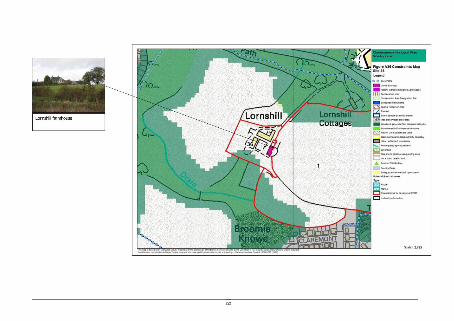
232
Lornshill farmhouse
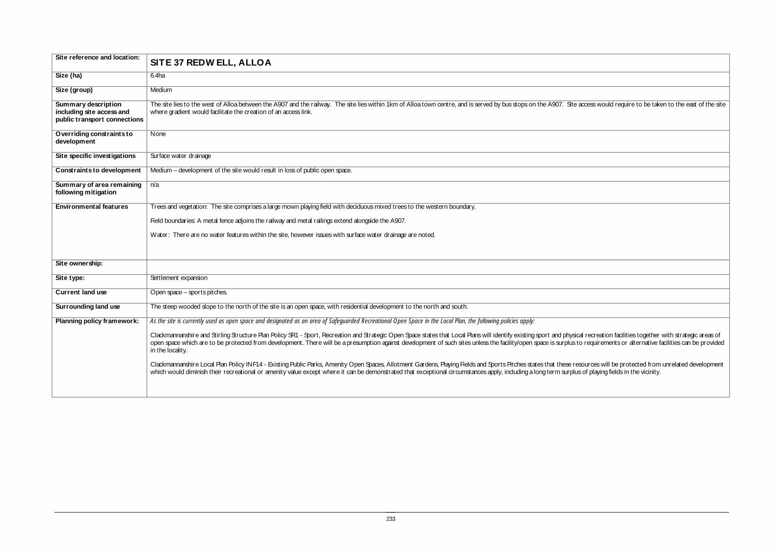
233
Site reference and location:
SITE 37 REDWELL, ALLOA
Size (ha) 6.4ha
Size (group) Medium
Summary description including site access and public transport connections
The site lies to the west of Alloa between the A907 and the railway. The site lies within 1km of Alloa town centre, and is served by bus stops on the A907. Site access would require to be taken to the east of the site where gradient would facilitate the creation of an access link.
Overriding constraints to development
None
Site specific investigations Surface water drainage
Constraints to development Medium – development of the site would result in loss of public open space.
Summary of area remaining following mitigation
n/a
Environmental features Trees and vegetation: The site comprises a large mown playing field with deciduous mixed trees to the western boundary.
Field boundaries: A metal fence adjoins the railway and metal railings extend alongside the A907.
Water: There are no water features within the site, however issues with surface water drainage are noted.
Site ownership:
Site type: Settlement expansion
Current land use Open space – sports pitches.
Surrounding land use The steep wooded slope to the north of the site is an open space, with residential development to the north and south.
Planning policy framework: As the site is currently used as open space and designated as an area of Safeguarded Recreational Open Space in the Local Plan, the following policies apply:
Clackmannanshire and Stirling Structure Plan Policy SR1 - Sport, Recreation and Strategic Open Space states that Local Plans will identify existing sport and physical recreation facilities together with strategic areas of open space which are to be protected from development. There will be a presumption against development of such sites unless the facility/open space is surplus to requirements or alternative facilities can be provided in the locality.
Clackmannanshire Local Plan Policy INF14 - Existing Public Parks, Amenity Open Spaces, Allotment Gardens, Playing Fields and Sports Pitches states that these resources will be protected from unrelated development which would diminish their recreational or amenity value except where it can be demonstrated that exceptional circumstances apply, including a long term surplus of playing fields in the vicinity.

234
SEA /site assessment topic
Site appraisal criteria Site issues and discussion Summary of Effect of development (++/+/0/-/--)
Enhancement and mitigation options
Potential effect following mitigation
Biodiversity, flora and fauna
Does the site impact on designated sites?
The site does not impact on any designated sites and is located within an existing built up area.
0
Does the site impact on priority habitats or species?
The site is identified in the Phase 1 habitat survey as amenity grassland. 0
Does the development of the site avoid adverse effects on the integrity of the Firth of Forth SPA and Ramsar site?
The site is not in close proximity to the Firth of Forth SPA and Ramsar site. 0
Does the development of the site maintain and enhance populations of European Protected Species including protection of their resting places?
The site does not include features likely to support protected species as it comprises short mown grass, however site specific survey should be undertaken prior to development of the site to ascertain the presence of European Protected Species and appropriate mitigation implemented if these species are identified.
0/- Following site specific survey, appropriate mitigation should be identified and implemented.
Does the site facilitate the restoration and enhancement of biodiversity in all our urban and rural environments through better planning, design and practice?
The site does not play a role as part of the FHN. Development of the site would result in a loss of urban open space.
0/- Habitat enhancement could be incorporated as part of the development of the site which would increase the habitat value of the site.
No effect
Population and human health
Is the site connected to the local core path network?
Core paths extend through the public park to the north, which provides links to the wider network.
++
How does the site relate to areas with high SIMD?
The site does not lie within an area with a high SIMD rating and lies outwtih the Alloa ROA area.
0
What is the relationship of the site with existing open space resources?
The site comprises a public open space and loss of this resource would have a negative impact for the local community. However there is a public park to the north of the site and Braehead golf course beyond.
+
Water
Is the site at risk of flooding?
The site is not identified as having a risk of flooding in the SEPA indicative flood map. However surface water drainage may be an issue for this site which is low lying and located between the embanked railway, A907 and Smithfield Loan.
-
Are there water courses within the site or which would be affected by increased levels of pollution from development within the site?
There are no water courses within the site boundary. 0
Are there water courses within the site or which would be affected by increased levels of flooding resulting from development of the site?
There are no water courses within the site boundary. 0

235
SEA /site assessment topic
Site appraisal criteria Site issues and discussion Summary of Effect of development (++/+/0/-/--)
Enhancement and mitigation options
Potential effect following mitigation
Soil Does the site include areas of vacant or derelict land?
The site is not vacant or derelict land. 0
Is the site prime agricultural land?
The site is not prime agricultural land. 0
Air Quality and Transport
Is the site easily accessible by the local path network, and provide access to settlements and services?
The site is located close to Alloa town centre and provides easy access to services. ++
Is the site easily accessible by public transport? The site is located close to Alloa town centre and is therefore easily accessible by public transport both by bus and through access to the railway station.
++
Does the site lie within an area where levels of air pollution are close to current limit values?
The nearest air quality monitoring locations for NO2 are at Norwood Avenue and Glasshouse Loan and these do not show any clear trends in NO2 concentrations between 2002 and 2007.
0
Would development on the site contribute to higher traffic flows along transport routes or at key junctions (potentially outwith the local authority area) where levels of air pollution are close to current limit values?
Development on the site would increase traffic flows on the A907. -
Climatic Factors
Does the location of the development reduce the need to travel?
The development is located close to Alloa town centre and therefore potentially reduces the need to travel to access local services and facilities.
+
Is the site at risk of increased flooding or instability as a result of climate change?
Although the site does not have an identified flooding risk, the potential issues with surface water drainage may increase as a result of future climate change.
-
Material Assets
Is the site located close to existing transport, services, water and energy infrastructure?
The site is located adjacent to the existing built up area of Alloa and therefore close to existing transport, services, water and energy infrastructure.
+
Is the site located to make best use of shelter and solar gain?
The site is located in a slight dip, however it is not poorly located in relation to shelter and solar gain.
+
Would development on the site reduce future potential for mineral extraction?
The site is located adjacent within a residential area and would not be appropriate for mineral extraction.
0
Does the site include any hazard areas? (oil or gas pipelines)
There are no hazard areas on site. 0
Does the site reduce waste generation and promote waste recovery, recycling and composting?
The site would generate additional waste arisings however as it is located within the urban area it will not generate significant additional waste collection journeys.
-
Cultural Heritage
Would development within the site impact on the integrity of sites, monuments, buildings or areas designated for their cultural heritage value?
There are no designated features or buildings on the site or close to the site. 0

236
SEA /site assessment topic
Site appraisal criteria Site issues and discussion Summary of Effect of development (++/+/0/-/--)
Enhancement and mitigation options
Potential effect following mitigation
Would development within the site impact on archaeological remains?
There are no known archaeological remains within the site boundary. The HLA identifies the site as 19th century to present recreation area.
0
Landscape Does the site lie within an area designated for its landscape value?
The site does not lie in an area designated for its landscape value, however it is an area of safeguarded open space and performs some landscape role as an open space within settlement.
0
Would development within the site impact on settlement setting and identity (drawing on issues of landscape character and capacity for development)?
Development of the site would result in loss of an established area of open space within Alloa, however this would not have a strong negative impact on wider settlement setting and identity.
0
Would development within the site impact on key views to landscape features or from key transport routes?
The site is a key feature in views from the A907 and particularly important as part of the approach to Alloa from the west, providing part of a green corridor on the approach to the town centre.
0

237
View east to settlement edge
View south to business units and railway

238

239
APPENDIX 4 CRITERIA TO WHICH WEIGHTING WAS APPLIED


241
Criteria to which weighting was applied
Environment criteria
Biodiversity, flora and fauna
Does the site impact on designated sites?
Does the site impact on priority habitats or species? (see buffers in methodology)
Does the development of the site avoid adverse effects on the integrity of the Firth of Forth SPA and Ramsar site?
Does the development of the site maintain and enhance populations of European Protected Species including protection of their resting places?
Does the site facilitate the restoration and enhancement of biodiversity in all our urban and rural environments through better planning, design and practice?
Population and human health
Is the site connected to the local core path network?
How does the site relate to areas with high SIMD?
What is the relationship of the site with existing open space resources?
Water Is the site at risk of flooding?
Are there water courses within the site or which would be affected by increased levels of pollution from development within the site?
Are there water courses within the site or which would be affected by increased levels of flooding resulting from development of the site?
Soil Does the site include areas of vacant or derelict land?
Is the site prime agricultural land?
Air Quality and Transport
Is the site easily accessible by the local path network, and provide access to settlements and services?
Is the site easily accessible by public transport?
Does the site lie within an area where levels of air pollution are close to current limit values?
Would development on the site contribute to higher traffic flows along transport routes or at key junctions (potentially outwith the local authority area) where levels of air pollution are close to current limit values?
Climatic Factors
Does the location of the development reduce the need to travel?
Is the site at risk of increased flooding or instability as a result of climate change?
Material Assets
Is the site located close to existing transport, services, water and energy infrastructure?
Is the site located to make best use of shelter, solar gain and reduce the need to travel?
Would development on the site reduce future potential for mineral extraction?
Does the site include any hazard areas? (oil or gas pipelines)
Does the site reduce waste generation and promote waste recovery, recycling and composting?
Cultural Heritage
Would development within the site impact on the integrity of sites, monuments, buildings or areas designated for their cultural heritage value?
242
Would development within the site impact on archaeological remains?
Landscape Does the site lie within an area designated for its landscape value?
Would development within the site impact on settlement setting and identity (drawing on issues of landscape character and capacity for development)?
Would development within the site impact on key views to landscape features or from key transport routes?

243
Community criteria
Biodiversity, flora and fauna
Does the site impact on designated sites?
Does the site impact on priority habitats or species? (see buffers in methodology)
Does the development of the site avoid adverse effects on the integrity of the Firth of Forth SPA and Ramsar site?
Does the development of the site maintain and enhance populations of European Protected Species including protection of their resting places?
Does the site facilitate the restoration and enhancement of biodiversity in all our urban and rural environments through better planning, design and practice?
Population and human health
Is the site connected to the local core path network?
How does the site relate to areas with high SIMD?
What is the relationship of the site with existing open space resources?
Water Is the site at risk of flooding?
Are there water courses within the site or which would be affected by increased levels of pollution from development within the site?
Are there water courses within the site or which would be affected by increased levels of flooding resulting from development of the site?
Soil Does the site include areas of vacant or derelict land?
Is the site prime agricultural land?
Air Quality and Transport
Is the site easily accessible by the local path network, and provide access to settlements and services?
Is the site easily accessible by public transport?
Does the site lie within an area where levels of air pollution are close to current limit values?
Would development on the site contribute to higher traffic flows along transport routes or at key junctions (potentially outwith the local authority area) where levels of air
pollution are close to current limit values? Climatic Factors
Does the location of the development reduce the need to travel?
Is the site at risk of increased flooding or instability as a result of climate change?
Material Assets
Is the site located close to existing transport, services, water and energy infrastructure?
Is the site located to make best use of shelter, solar gain and reduce the need to travel?
Would development on the site reduce future potential for mineral extraction?
Does the site include any hazard areas? (oil or gas pipelines)
Does the site reduce waste generation and promote waste recovery, recycling and composting?
Cultural Heritage
Would development within the site impact on the integrity of sites, monuments, buildings or areas designated for their cultural heritage value?
Would development within the site impact on archaeological remains?

244
Landscape Does the site lie within an area designated for its landscape value?
Would development within the site impact on settlement setting and identity (drawing on issues of landscape character and capacity for development)?
Would development within the site impact on key views to landscape features or from key transport routes?

245
Access criteria
Biodiversity, flora and fauna
Does the site impact on designated sites?
Does the site impact on priority habitats or species? (see buffers in methodology)
Does the development of the site avoid adverse effects on the integrity of the Firth of Forth SPA and Ramsar site?
Does the development of the site maintain and enhance populations of European Protected Species including protection of their resting places?
Does the site facilitate the restoration and enhancement of biodiversity in all our urban and rural environments through better planning, design and practice?
Population and human health
Is the site connected to the local core path network?
How does the site relate to areas with high SIMD?
What is the relationship of the site with existing open space resources?
Water Is the site at risk of flooding?
Are there water courses within the site or which would be affected by increased levels of pollution from development within the site?
Are there water courses within the site or which would be affected by increased levels of flooding resulting from development of the site?
Soil Does the site include areas of vacant or derelict land?
Is the site prime agricultural land?
Air Quality and Transport
Is the site easily accessible by the local path network, and provide access to settlements and services?
Is the site easily accessible by public transport?
Does the site lie within an area where levels of air pollution are close to current limit values?
Would development on the site contribute to higher traffic flows along transport routes or at key junctions (potentially outwith the local authority area) where levels of air pollution are close to current limit values?
Climatic Factors
Does the location of the development reduce the need to travel?
Is the site at risk of increased flooding or instability as a result of climate change?
Material Assets
Is the site located close to existing transport, services, water and energy infrastructure?
Is the site located to make best use of shelter, solar gain and reduce the need to travel?
Would development on the site reduce future potential for mineral extraction?
Does the site include any hazard areas? (oil or gas pipelines)
Does the site reduce waste generation and promote waste recovery, recycling and composting?
Cultural Heritage
Would development within the site impact on the integrity of sites, monuments, buildings or areas designated for their cultural heritage value?
Would development within the site impact on archaeological remains?

246
Landscape Does the site lie within an area designated for its landscape value?
Would development within the site impact on settlement setting and identity (drawing on issues of landscape character and capacity for development)?
Would development within the site impact on key views to landscape features or from key transport routes?

247
APPENDIX 5 SUMMARY RESULTS OF ASSESSMENT OF ALTERNATIVES

248
Table A5 Summary Results of Assessment of Alternatives from the Site Appraisal Process (based on results of individual site assessment) Environment ranking Community ranking Accessibility ranking
Site ID
Nam
e and Location
Locational Fram
ework
Site area (ha)
Environm
ent w
eighting
Site ID
Nam
e and Location
Locational Fram
ework
Site area (ha)
Com
munity
weighting
Site ID
Nam
e and Location
Locational Fram
ework
Site area (ha)
Accessibilty
weighting
17
Land south of James Place Rural Villages 24.23 a3 4 Alloa East (1)
Tullibody – Alloa-Clackmannan corridor 7.93 a1 17
Land south of James Place Rural Villages 24.23 a1
4 Alloa East (1)
Tullibody – Alloa-Clackmannan corridor 7.93 b2 5 Alloa East (2)
Tullibody – Alloa-Clackmannan corridor 6.42 a1 4 Alloa East (1)
Tullibody – Alloa-Clackmannan corridor 7.93 a1
5 Alloa East (2)
Tullibody – Alloa-Clackmannan corridor 6.42 b2 36
Lornshill farm steading
Tullibody – Alloa-Clackmannan corridor 0.8 a1 5 Alloa East (2)
Tullibody – Alloa-Clackmannan corridor 6.42 a1
36
Lornshill farm steading
Tullibody – Alloa-Clackmannan corridor 0.8 b2 17
Land south of James Place Rural Villages 24.23 a2 36
Lornshill farm steading
Tullibody – Alloa-Clackmannan corridor 0.8 a1
37 Redwell, Stirling road
Tullibody – Alloa-Clackmannan corridor 6.47 b2 2 West Earlsfield
Tullibody – Alloa-Clackmannan corridor 1.02 a3 3
South Earlsfield
Tullibody – Alloa-Clackmannan corridor 3.86 a2
2 West Earlsfield
Tullibody – Alloa-Clackmannan corridor 1.02 b3 18 Devonside East Rural Villages 7.78 a3 2
West Earlsfield
Tullibody – Alloa-Clackmannan corridor 1.02 a3
18 Devonside East Rural Villages 7.78 b3 37
Redwell, Stirling road
Tullibody – Alloa-Clackmannan corridor 6.47 b1 18
Devonside East Rural Villages 7.78 a3

249
Environment ranking Community ranking Accessibility ranking
Site ID
Nam
e and Location
Locational Fram
ework
Site area (ha)
Environm
ent w
eighting
Site ID
Nam
e and Location
Locational Fram
ework
Site area (ha)
Com
munity
weighting
Site ID
Nam
e and Location
Locational Fram
ework
Site area (ha)
Accessibilty
weighting
7 Jellyholm, Sauchie
Tullibody – Alloa-Clackmannan corridor 61.5 c2 3 South Earlsfield
Tullibody – Alloa-Clackmannan corridor 3.86 b2 37
Redwell, Stirling road
Tullibody – Alloa-Clackmannan corridor 6.47 b1
1 Lornshill Farm
Tullibody – Alloa-Clackmannan corridor 9.62 c3 32
Alloa North West, Branshill
Tullibody – Alloa-Clackmannan corridor 70.92 b2 7
Jellyholm, Sauchie
Tullibody – Alloa-Clackmannan corridor 61.5 b1
3 South Earlsfield
Tullibody – Alloa-Clackmannan corridor 3.86 c3 16
Clackmannan (south) Rural Villages 89.44 b3 32
Alloa North West, Branshill
Tullibody – Alloa-Clackmannan corridor 70.92 b1
10 Ladywood
Tullibody – Alloa-Clackmannan corridor 2.33 c3 28 Menstrie East
Hillfoots corridor 9.26 b4 34
Land south of Dollar Road Hillfoots corridor 4 b1
32
Alloa North West, Branshill
Tullibody – Alloa-Clackmannan corridor 70.92 c3 7
Jellyholm, Sauchie
Tullibody – Alloa-Clackmannan corridor 61.5 c1 1 Lornshill Farm
Tullibody – Alloa-Clackmannan corridor 9.62 b2
34
Land south of Dollar Road Hillfoots corridor 4 c3 34
Land south of Dollar Road
Hillfoots corridor 4 c2 16
Clackmannan (south) Rural Villages 89.44 b3
8c
Land south of Brook Street Hillfoots corridor c4 12 Helensfield
Tullibody – Alloa-Clackmannan corridor 6.13 c2 28 Menstrie East Hillfoots corridor 9.26 b3

250
Environment ranking Community ranking Accessibility ranking
Site ID
Nam
e and Location
Locational Fram
ework
Site area (ha)
Environm
ent w
eighting
Site ID
Nam
e and Location
Locational Fram
ework
Site area (ha)
Com
munity
weighting
Site ID
Nam
e and Location
Locational Fram
ework
Site area (ha)
Accessibilty
weighting
13 Meadowend Farm Rural Villages 9.02 c4 1 Lornshill Farm
Tullibody – Alloa-Clackmannan corridor 9.62 c3 20
Dollarfield farm Rural Villages 1.98 b4
16 Clackmannan (south) Rural Villages 89.44 c4 10 Ladywood
Tullibody – Alloa-Clackmannan corridor 2.33 c3 33 Oak Mills Hillfoots corridor 6.13 c1
19 Lover's Loan Rural Villages 13.91 c4 8c
Land south of Brook Street
Hillfoots corridor c3 12 Helensfield
Tullibody – Alloa-Clackmannan corridor 6.13 c1
20 Dollarfield farm Rural Villages 1.98 c4 19 Lover's Loan Rural Villages 13.91 c3 10 Ladywood
Tullibody – Alloa-Clackmannan corridor 2.33 c2
28 Menstrie East Hillfoots corridor 9.26 c4 8b
Land east of B908
Hillfoots corridor c3 8b
Land east of B908 Hillfoots corridor c2
29 Land at Devonpark Rural Villages 5.66 c4 23b Dollar (South) Rural Villages 9.2 c3 23a Dollar (South) Rural Villages 8.5 c2
6
Alloa West expansion area
Tullibody – Alloa-Clackmannan corridor 18.86 d2 27 Middletonkerse
Hillfoots corridor 9 c3 35 Cambus East
Tullibody – Alloa-Clackmannan corridor 9.81 c2
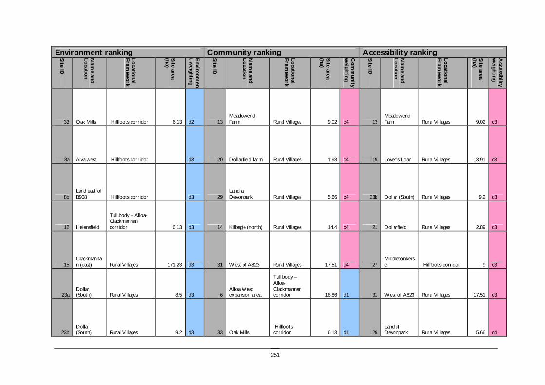
251
Environment ranking Community ranking Accessibility ranking
Site ID
Nam
e and Location
Locational Fram
ework
Site area (ha)
Environm
ent w
eighting
Site ID
Nam
e and Location
Locational Fram
ework
Site area (ha)
Com
munity
weighting
Site ID
Nam
e and Location
Locational Fram
ework
Site area (ha)
Accessibilty
weighting
33 Oak Mills Hillfoots corridor 6.13 d2 13 Meadowend Farm Rural Villages 9.02 c4 13
Meadowend Farm Rural Villages 9.02 c3
8a Alva west Hillfoots corridor d3 20 Dollarfield farm Rural Villages 1.98 c4 19 Lover's Loan Rural Villages 13.91 c3
8b Land east of B908 Hillfoots corridor d3 29
Land at Devonpark Rural Villages 5.66 c4 23b Dollar (South) Rural Villages 9.2 c3
12 Helensfield
Tullibody – Alloa-Clackmannan corridor 6.13 d3 14 Kilbagie (north) Rural Villages 14.4 c4 21 Dollarfield Rural Villages 2.89 c3
15 Clackmannan (east) Rural Villages 171.23 d3 31 West of A823 Rural Villages 17.51 c4 27
Middletonkerse Hillfoots corridor 9 c3
23a Dollar (South) Rural Villages 8.5 d3 6
Alloa West expansion area
Tullibody – Alloa-Clackmannan corridor 18.86 d1 31 West of A823 Rural Villages 17.51 c3
23b Dollar (South) Rural Villages 9.2 d3 33 Oak Mills
Hillfoots corridor 6.13 d1 29
Land at Devonpark Rural Villages 5.66 c4
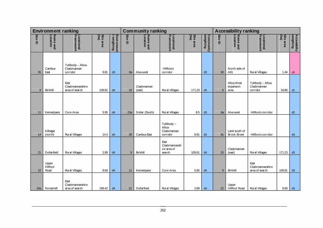
252
Environment ranking Community ranking Accessibility ranking
Site ID
Nam
e and Location
Locational Fram
ework
Site area (ha)
Environm
ent w
eighting
Site ID
Nam
e and Location
Locational Fram
ework
Site area (ha)
Com
munity
weighting
Site ID
Nam
e and Location
Locational Fram
ework
Site area (ha)
Accessibilty
weighting
35 Cambus East
Tullibody – Alloa-Clackmannan corridor 9.81 d3 8a Alva west
Hillfoots corridor d3 30
North side of A91 Rural Villages 1.44 c4
9 Birkhill
East Clackmannanshire area of search 109.81 d4 15
Clackmannan (east) Rural Villages 171.23 d3 6
Alloa West expansion area
Tullibody – Alloa-Clackmannan corridor 18.86 d1
11 Kennetpans Core Area 5.95 d4 23a Dollar (South) Rural Villages 8.5 d3 8a Alva west Hillfoots corridor d2
14 Kilbagie (north) Rural Villages 14.4 d4 35 Cambus East
Tullibody – Alloa-Clackmannan corridor 9.81 d3 8c
Land south of Brook Street Hillfoots corridor d3
21 Dollarfield Rural Villages 2.89 d4 9 Birkhill
East Clackmannanshire area of search 109.81 d4 15
Clackmannan (east) Rural Villages 171.23 d3
22
Upper Hillfoot Road Rural Villages 8.69 d4 11 Kennetpans Core Area 5.95 d4 9 Birkhill
East Clackmannanshire area of search 109.81 d3
24a Forestmill
East Clackmannanshire area of search 199.42 d4 21 Dollarfield Rural Villages 2.89 d4 22
Upper Hillfoot Road Rural Villages 8.69 d3

253
Environment ranking Community ranking Accessibility ranking
Site ID
Nam
e and Location
Locational Fram
ework
Site area (ha)
Environm
ent w
eighting
Site ID
Nam
e and Location
Locational Fram
ework
Site area (ha)
Com
munity
weighting
Site ID
Nam
e and Location
Locational Fram
ework
Site area (ha)
Accessibilty
weighting
24b Forestmill
East Clackmannanshire area of search d4 22
Upper Hillfoot Road Rural Villages 8.69 d4 26 Aitkenhead
East Clackmannanshire area of search 312 d3
26 Aitkenhead
East Clackmannanshire area of search 312 d4 24a Forestmill
East Clackmannanshire area of search 199.42 d4 11 Kennetpans Core Area 5.95 d4
27 Middletonkerse Hillfoots corridor 9 d4 24b Forestmill
East Clackmannanshire area of search d4 14
Kilbagie (north) Rural Villages 14.4 d4
30 North side of A91 Rural Villages 1.44 d4 26 Aitkenhead
East Clackmannanshire area of search 312 d4 24a Forestmill
East Clackmannanshire area of search 199.42 d4
31 West of A823 Rural Villages 17.51 d4 30
North side of A91 Rural Villages 1.44 d4 24b Forestmill
East Clackmannanshire area of search d4


255


257