Embed Size (px)
Citation preview
1
LOCH LOMOND & THE TROSSACHS NATIONAL PARK KILLIN CONSERVATION AREA APPRAISAL October 2011 CONTENTS Page 1. INTRODUCTION 3 2. PLANNING POLICY CONTEXT 3
3. CONSERVATION AREA REGENERATION SCHEME 4 4. SUMMARY OF HISTORIC AND ARCHITECTURAL INTEREST 4 5. CONSERVATION AREA BOUNDARY 5 6. LOCATION AND SETTING 7
Reasons for Location Geology Topography
7. HISTORICAL DEVELOPMENT 9 Early History Mediaeval History
18th
Century 19
th Century
20th
Century-present
8. CHARACTER APPRAISAL 11 Landscape and Surroundings Street Pattern and Village Approaches Plot Pattern Open Space Views and Landmarks Activity and Movement Architectural Character Public Realm Townscape Detail Building Materials Orientations and Density Condition Natural Heritage and Trees
2
9. CHARACTER ASSESSMENT 19
Assessment of Buildings Archaeology Scheduled Monuments Assessment of Areas Assessment of Significance
10. KEY FEATURES AND KEY CHALLENGES 21 11. OPPORTUNITIES FOR PRESERVATION AND ENHANCEMENT 23
Maintenance Development Information and Advice Public Realm Shopfronts and Signage St Fillans Mill Former Costcutters Site Garden Development Tree Planting Permitted Development Rights and Article 4 Directions
12. FUTURE MANAGEMENT PRIORITIES 25 13. MONITORING AND REVIEW 25 14. BIBLIOGRAPHY, USEFUL INFORMATION, CONTACTS 26
3
1. INTRODUCTION Killin is one of the most picturesque villages in the National Park located within a magnificent natural setting. The Falls of Dochart have been appreciated by artists and writers for centuries and the surrounding hills, such as Ben Lawers and the Tarmachans provide spectacular views. Killin Conservation Area was designated in 1973 in recognition of its special architectural and historic interest and was originally centred on the Falls of Dochart. The boundary was amended in 1978 and 2001 when the Conservation Area was extended to the north along Main Street. The purpose of this Appraisal is to define and evaluate the character and appearance of the Killin Conservation Area; to identify its important characteristics and ensure that there is a full understanding of what is worthy of preservation. The appraisal process has involved researching the areas historical development (Section 7), and carrying out a detailed character appraisal (Section 8) and character assessment (Section 9) leading to the identification of the Conservation Areas key features.(Section 10) Key features are the elements which should be considered when preparing development proposals for the Killin Conservation Area. The Appraisal also identifies key challenges where improvements are required (Section 10) and opportunities for preservation and enhancement (Section11) Following completion of the Appraisal the Conservation Area boundary has been amended to reflect what is of special interest. (Section 5). The Appraisal also provides a basis on which to prepare ongoing management and enhancement programmes as well as determining funding priorities. .
2. PLANNING POLICY CONTEXT
The Planning (Listed Buildings and Conservation Areas) (Scotland) Act 1997 (as amended by the Historic Environment (Amendment) Scotland Act 2011) states that conservation areas “are areas of special architectural or historic interest, the character or appearance of which it is desirable to preserve or enhance”. The designation of a conservation area is a means to safeguard and enhance the special qualities, character and appearance of our most valued historic places. The National Park Authority, as Planning Authority, is required to identify and designate such areas. Scottish Planning Policy (SPP) February 2010 contains the Scottish Government‟s over-arching policies on land-use planning, including conservation areas and encourages local planning authorities to prepare conservation area appraisals. This is reinforced in the Scottish Historic Environment Policy (SHEP) July 2009. Additional guidance is included in Planning Advice Note 71: Conservation Area Management which complements national policy and provides further advice on the management of conservation areas. The National Park Plan 2007-2012 contains Built Heritage policies and objectives and identifies Conservation Area Review and Appraisal as a priority for conserving and creating a stronger affinity with the historic built heritage. This has been implemented through the preparation of the Local Plan and is reinforced in the Historic and Built Environment policies contained within the National Park Local Plan which guide day to day planning decisions. The emerging new Park Plan for the period 2012 – 2017 (issued for consultation in August 2011) emphasised the importance of the Park‟s built heritage and includes priorities actions. Approved Conservation Area Appraisals will be regarded as Supplementary Planning Guidance to the Local Plan and will complement the Authorities Sustainable Design Guide which is due to be adopted soon.
4
3. CONSERVATION AREA REGENERATION SCHEME
An Historic Scotland Conservation Area Regeneration Scheme (CARS) was secured for the Killin Conservation Area. This is grant scheme jointly funded by Historic Scotland and the National Park, focussing on conservation–led regeneration. It is a 5-year grant scheme which terminates in March 2012. It has been instrumental in delivering a number of projects including the renewal of the mill wheel, grant funding the repair and restoration of number of traditional buildings, and completion of a Stone and Slate Audit of properties within the Conservation Area. The installation of interpretation panels and heritage trail are proposed for completion by the end of the Scheme. The National Park Authority is looking at options to extend conservation-led regeneration in Killin beyond the end of CARS.
4. SUMMARY OF HISTORIC AND ARCHITECTURAL INTEREST
The unique character of Killin is founded on the interplay of the natural and cultural heritage. This relationship stretches back in time to the iron-age fort and medieval McNab burial ground on Innes Bhuide in the middle of the Falls of Dochart. From the late 18th century onwards, the Falls were celebrated as part of the picturesque canon of highland scenery, and exploited as a tourist halt. Its architectural character is derived from a mixture of 18
th century cottages and Victorian
villas, interspersed with unique churches, exceptional engineering structures and fine examples of corrugated iron buildings all centred on the sinuous Main Street which follows the line of the River Dochart. The village continues to be a popular visitor destination and provides services for the villages surrounding rural hinterland.
5
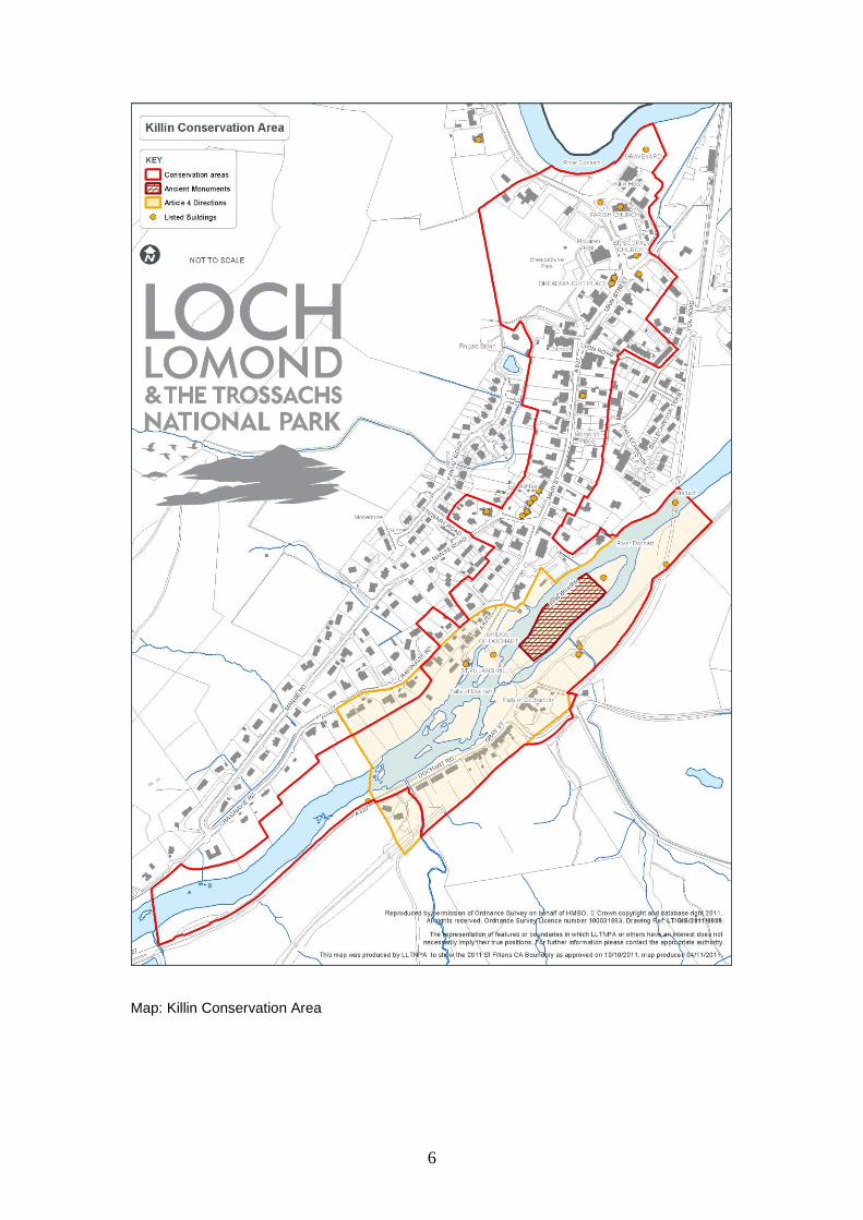
5. CONSERVATION AREA BOUNDARY Following completion of the Conservation Area Appraisal, eight boundary changes were implemented as follows:-
1. War Memorial, Dochart Road. A small amendment was made to include the Memorial and its setting. The War Memorial, sculpted by Alexander Carrick in 1920, is a landmark at the south-western entrance to the villageand is listed category C(S) denoting a structure of local interest. 2. Rowan Bank and Eilean-Cor, Dochart Road. A further amendment was made at the south-western entrance to the village re-drawing the boundary to exclude the modern houses, Rowan Bank and Eilean-Cor, on the south-east side of Dochart Road. The character of these properties differs from the traditional buildings in this part of the Conservation Area. 3. Riverside, Craiglinn, Brigairn, Muirfield and 18 and 19 Craignavie Road. Whilst the mature trees within the gardens of these houses are an important part of the natural setting of the River Dochart, the houses themselves are of relatively recent construction, and do not contribute to the character of the Conservation Area. The boundary was amended to run through the gardens of the properties, excluding the houses, but continuing to include the trees within the Conservation Area. 4. Ardshean and Inchbuie, Caignavie Road. Two picturesque gabled cottages are included within the Conservation Area at Craignavie Road. They are both of traditional stone-built construction with slated roofs and dormers consistent with the majority of buildings within the Conservation Area. 5. Mansefield, Manse Road. Mansefield is the former manse, which lends its name to the road and terminates the view from Main Street. It is noted on the 1
st edition of
the Ordnance Survey map of 1867. It is built in picturesque cottage style with overhanging eaves and decorative bargeboards. Mansefield and its garden are now included within the Conservation Area. 6. Myrtle Grove and Muileann Sabh, between Mill House and Mill Street. These are relatively recent houses of different character to those within the Conservation Area and have been excluded. 7. Primary School and Library, Main Street. The school and library occupy a key site at the heart of the Conservation Area. Whilst the school dates from the 1960s (and is a fair example of building from that time), the library occupies part of the old school building dating from the late 19
th century. This has some interest as a school
and school-house built in the prevailing picturesque gabled cottage style of the Breadalbane estate. In view of the interest of the old school building and the prominence of the site within the streetscape of Main Street, they have been included within the Conservation Area. 8. Lyon Cottages, Lyon Road. Two terraces of gabled houses have been included within the Conservation Area. Although a number of original windows have been replaced, this late 19
th century group of buildings retains considerable charm and
interest consistent with the qualities of the Conservation Area. Original details include overhanging eaves, gabled and canopy porches, decorative iron finials, and low boundary walls (missing the original iron railings).
6
Map: Killin Conservation Area
7
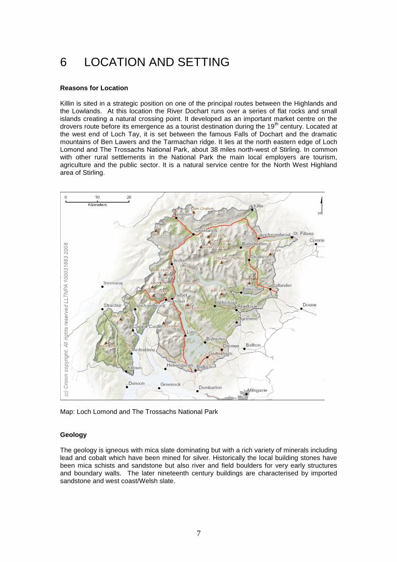
6 LOCATION AND SETTING Reasons for Location Killin is sited in a strategic position on one of the principal routes between the Highlands and the Lowlands. At this location the River Dochart runs over a series of flat rocks and small islands creating a natural crossing point. It developed as an important market centre on the drovers route before its emergence as a tourist destination during the 19
th century. Located at
the west end of Loch Tay, it is set between the famous Falls of Dochart and the dramatic mountains of Ben Lawers and the Tarmachan ridge. It lies at the north eastern edge of Loch Lomond and The Trossachs National Park, about 38 miles north-west of Stirling. In common with other rural settlements in the National Park the main local employers are tourism, agriculture and the public sector. It is a natural service centre for the North West Highland area of Stirling.
Map: Loch Lomond and The Trossachs National Park Geology The geology is igneous with mica slate dominating but with a rich variety of minerals including lead and cobalt which have been mined for silver. Historically the local building stones have been mica schists and sandstone but also river and field boulders for very early structures and boundary walls. The later nineteenth century buildings are characterised by imported sandstone and west coast/Welsh slate.

8
Topography The local topography has an overwhelming influence on the character of Killin. It was this topography which served to bring the village into existence and shape the linear form of the settlement along the banks of the River Dochart. This area is known as Breadalbane, „The High County‟, and is characterised by long glens and surrounding open upland hills with peaks, rocky outcrops, gullies and screes. The open upland hills surrounding Killin are visually dominant and valued by both local people and visitors to the area. They form distinctive landmarks that create a strong sense of identity and a valued landscape setting to the village.
9
7 HISTORICAL DEVELOPMENT Early History Killin has ancient origins. The earliest site is the important Neolithic stone circle in the grounds of Kinnell House on the east side of the village. Other prehistoric sites in the area include a stone axe factory site in the hills to the north of the village and also a late Bronze Age site. Innis Bhuide, the island which lies just below the Falls of Dochart is the location of two forts probably dating from the Iron Age. Fingal‟s stone, located to the south west of Breadalbane Park, may be a prehistoric standing stone. Legend has it that this stone marks the grave of Fingal, leader of the Fiann, a band of giant-killing, heroic age warriors.
Medieval History Early Christianity came to Killin in the 7th century and the Killin area has strong associations with the Celtic St Fillan. His seat and tree were located in the village and his healing stones were kept in the Breadalbane Folklore Centre until its closure in 2011. An area to the west of the village is traditionally identified as a monastic site. The church and mill are said to have been founded by St Fillan circa 664 AD. The church was traditionally said to have been sited at Fingal‟s Grave on Garadh Bhruaich, behind the Bank and the Primary School, a little up the hill from where Fingal‟s stone now stands, having been moved from its original site a good number of years ago. The village was granted to the Carthusian monastery in Perth in 1409. Although there is no definite evidence for an early earthwork castle, or motte, at Killin, there is a suggestion that the 17
th century Finlarig Castle, lying to the north east of the village, stands
on a mound which may be the site of an earlier timber structure. The area was originally the territory of the McNabs, McLarens and MacGregors, but the Campbells, based at Finlarig Castle, gradually became more important from the 15
th century,
making Killin part of their large Breadalbane Estate. The McNabs, traditional burial site is on Innis Bhuide and the clan seat was at Kinnell House for over 400 years. It is possible that burials were taking place here from the medieval period onwards but that formalisation of the island with its processional pathway, screen wall and enclosure was created in the late 18th century as a response to Highland Romanticism. 18
th Century
Killin‟s position on long distance routes made it a useful stopping point for drovers and the village grew as a market centre. The market place was located on the flat area at the confluence of the Rivers Dochart and Lochay and was probably one of the earliest parts of the present settlement. In the late eighteenth century there were six fairs held every year. In the mid eighteenth century the village became an overnight stop on the military road from Stirling to Fort William. The distinctive white-harled octagonal Killin and Ardeonaig Parish Church was built in 1744 and 16 year later the present bridge over the Falls of Dochart was constructed using stone from the Falls. Like most villages in this part of Scotland, Killin grew in size with the agricultural clearances, in an attempt to provide employment for ex-agricultural workers. Most of the houses were feued from the Earl of Breadalbane, together with a small plot of land.
10
In the 1790s the Old Statistical Account describes the village as „small, and formed on no regular plan…Most of the villagers [were] tradesmen, who ha[d] an acre of ground, along with a house and garden‟. 19
th Century
The needs of the village and surrounding estates were served during the nineteenth century by several mills situated on the River Dochart. The current mill, known as St Fillans Mill was constructed circa 1840, as a corn mill, probably replacing an earlier mill on the site, and was later used for weaving tweed. After the visit of Queen Victoria and Prince Albert in 1842 the public interest in visiting the Highlands increased. In 1870 a railway station was built at Lix Toll and then the Marquis of Breadalbane built the branch line, which opened in 1886 from Killin Junction to Killin and on to the Loch Tay Station and pier. Improvements in transport brought more visitors to the area, attracted by the Highland scenery resulting in the construction of a number of large villas. These can still be seen in Main Street, and continue to give the village much of its character. Two terraces in Lyon Road were also built during the late 19
th century.
The old school was built in 1873. St Fillans Episcopal Church referred to locally as the “Tin Church” or “Grouse Church”, was originally constructed by the 7
th Earl of Breadalbane in 1876 as a private chapel for his
shooting party guests. The Old Smiddy occupies a significant position at the junction of Main Street and Craignavie Road and while now a Bed and Breakfast and Coffee Shop/Restaurant it is a reminder of the former use on the site 20
th Century – present
The McLaren Hall, at the north end of the village, was bequeathed to the community in 1935 by the late Archibald McLaren of Dall Lodge. St Fillans Mill continued to weave tweed until around the 1950‟s. It was converted to form a visitor centre in 1994 and closed in 2011. Development in more recent times has been, mainly residential, built primarily on the north bank of the river to the south, east and west of the original settlement. The current school was built in 1959/60 on the site of the former United Free Church. The redundant old school building is now the local library. Killin Institute, next to the school was converted in to two houses and business. Other new buildings include the Capercaillie Restaurant which enjoys a fine position overlooking the river. The Killin Branch Railway operated until 1965. The Station House and viaduct still survive but the station itself has been demolished. Tourism continues to be a key industry in the area and the main source of employment. For the majority of tourists, the main activity is viewing the Falls of Dochart from the Bridge of Dochart, however Killin continues to develop as a popular base for outdoor activities. The village is also a busy service centre for local people and the surrounding area with a variety of shops located in small groups at various stages along Main Street.
11
8 CHARACTER APPRAISAL Landscape and Surroundings Killin has a spectacular Highland setting. The peaks of Ben Lawers and the Tarmachan Ridge are particularly prominent in views north from the village. The flat glen floors have been a focus for travel and settlement since prehistoric times. The village of Killin gives the appearance of being nestled within this dramatic landscape. The village sits between the west end of Loch Tay and the Falls of Dochart. Street Pattern and Village Approaches The south and western approach to the village begins at Lix Toll where the existing forestry encloses the road in a tunnel effect and obscures views of the River Dochart. Glimpses of the river gradually open out across fields with the road getting closer to the river as it nears the Falls of Dochart. From the north, Killin Hotel and the Parish Church are key townscape features. The simple design and white painted harling of the church gives it a sober and almost domestic character. The pyramidal tower of the McLaren Hall and the small ventilator of the Episcopal Church mark the gateway to the village proper. The street pattern in Killin has been shaped by the topography and is dominated by a single linear street which slopes gently downwards from south to north. As Gray Street crosses the River Dochart to Main Street it becomes sinuous in form, allowing for excellent views between and beyond buildings to the surrounding hills. This single street takes the form of the original drove road travelling through the village. The rows of traditional single storey cottages opening directly onto the pavement articulate the bends in the road. The Victorian and several modern developments break the building line, which is otherwise well defined. On the south side of the bridge the road to Ardeonaig and the south shore of Loch Tay branches eastwards as does the drive way to Kinnell House which follows the river northwards. On the north side of the bridge Craignavie Road follows the river upstream to Auchlyne. Subsidiary roads and lanes within the village branch off at right angles with later street patterns often terminating in cul-de-sacs. Plot Pattern The land was originally laid out in feus along Main Street and these are still visible to the rear of properties. A number of the buildings along Main Street have summer houses to rear which provided summer accommodation for local residents letting out their main houses to visitors. Open Space The Falls of Dochart are the focus for the most dramatic area of open space in the village. Mature trees flank the river bank and cover the islands in the river. The movement and noise from the flow of water dominates the area. Access to the rocks, in and around the Falls can be obtained from Gray Street where here is a gap in the stone wall. Access to the island of Innis Bhuidhe is via a gate and stone steps from the Falls of Dochart Bridge. The size and length of Innis Bhuidhe is not immediately apparent from the road side. Once through the pillars, entrance wall and arches an avenue of trees extends to the Clan MacNab burial ground. At the north end of Main Street a number of open areas of recreational and public open space contrast with the linear built form which dominates the central spine of KiIlin. On the south
12
side of the road Breadalbane Park, the bowling green and tennis courts provide formal and informal recreation space. On the north side, the footpath along the river bank is a natural green linear space dominated by mature trees complemented by the grassy slope of the hotel grounds which lead down to the river. This is a quiet tranquil area, where boats moor and bird song can be heard. The Killin Hotel and out-buildings and Killin and Ardeonaig Parish Church surround a small green with the railed James Stewart Memorial as a centrepiece. Stewart was the first translator of the New Testament into Scottish Gaelic and resided at the nearby manse, now Invertay House. The graveyard is hidden from view, to the rear of the hotel. Near the retail centre of the village, Grants Laundry is set back from the road and creates a small square, paved with granite setts and stone flags at the entrance to the Breadalbane Park which is marked by impressive gatepiers and cast iron gates. The hard landscaping and low walls extend northwards to the east of the shops delineating notional front gardens. The broad tarmacadam area at the coach drop-off lay-by, in contrast, is poorly detailed with a regimented row of benches providing the only point of interest. Views and Landmarks Views northwards through the village are dominated by the magnificent mountains beyond. Important views within the village include:
approaching Killin from the south the views of the Falls open up to include the Mill,
from the north, the Mill dominates the view with the Falls not visible until crossing the bridge.
views across the bridge to the Falls of Dochart Inn,
views of the fine group of vernacular buildings located on the corner of Manse Road and Main Street
Views north along Main Street terminated by Shutters Coffee Shop building and further north still, by the white and green-painted corrugated iron St Fillans Episcopal Church. It stands out against the dark background of vegetation and forms an attractive urban focal point as the road bends.
the view of the Killin and Ardeonaig Parish church when approaching the village from the north
the view up Manse Road is terminated by a fine view of Mansefield the two storeys, three bay, stone, former Free Church Manse (c1843)
The 3-storey mill, the white cottages and the Falls of Dochart Bridge contribute to the setting of Killin‟s most notable landmark, the Falls of Dochart. The picturesque A listed, stone bridge is an important element of streetscape with its narrow serpentine structure linking the two parts of the village and providing access to the MacNab burial ground on Innis Bhuidhe. Despite the obvious dangers, from passing vehicular traffic, it is a popular viewing point for the river and Falls. Activity and Movement The A827 runs through the centre of the Conservation Area and is used by traffic coming to and from the village as well as traffic passing through. Most pedestrian activity is concentrated around the Dochart Falls and Folklore Centre and the shops, school and library. The Outdoor shop at the north end of the village and the river generate activity from outdoor enthusiasts including canoeists and cyclists. The Falls and, until its closure in late 2011, the Folklore Centre, are the focus for coach parties visiting the village with many of the party members not progressing beyond the coach drop off lay by and the Falls.
13
There is a significant difference in activity levels between the daytime use of the village by shoppers, visitors and through traffic and the quiet evening/night. Although the area is popular throughout the year, the number of visitors increases during the summer months and therefore the level of activity and movement increases accordingly. Architectural character Architectural styles vary according to the age and location of the building within the Conservation Area. Killin is characterised by a mix of building types which include rows of small single storey or one and a half storey cottages and larger, substantial detached villas interspersed with public and commercial buildings. It also has two particularly fine engineering structures regarded as being of national significance. Cottages The earliest buildings are 18th century crofters‟ cottages located in small groups along Main Street. These are single storey and characterised by a long, low form and small widely spaced windows, gablehead chimneys and very plain detailing. They front directly onto the street many with the original boulder footings visible. Originally these cottages would have been thatched but have been substantially altered with a variety of replacement roofing materials, replacement windows, removal of chimney stacks and alterations to the wall treatments. The Dochart Falls Area The Falls of Dochart Inn is prominent at the east end of the bridge, against a backdrop of trees. This collection of single and two storey buildings still retains the impression of a simple row of houses, with varying rooflines, chimneys and windows. In Gray Street the buildings are predominantly single storey, small scale with slated roofs, consistent low eaves lines, constant roof pitch and building line which all contribute to their special character. Many have dormers, in a variety of styles and some have simple porches with slated roofs. Walls are harled and painted white, and chimney stacks are largely retained. Virtually all original windows have been replaced. No 6 is a good example of the early cottage style, single storey, very simply detailed with corrugated iron roof replacing thatch, and original thackstanes - stones built into the chimney to hold down the original thatch, still evident. The entrance is centrally located with windows positioned on either side. The more recent cottages to the south are generally sympathetic in design and materials, although semi-detached and set back from the road. Manse Road/Main Street Some of Killin‟s oldest two storey houses are located on the west side of Main Street just north of the junction with Manse Road and make a significant contribution to the streetscape. Ashlea, Upper Ashlea, Glengarry and Birchbank are unusually set back from the street with garden areas in front. They retain their traditional character with slated roofs, chimney stacks with thackstanes, exposed or painted/harled stonewalls and some original windows. The later (c 1845) Masonic Hall (formerly Sawmill Cottage), White House and Breadalbane Cottage complete this attractive group. Victorian Villas With the improvements in transport and the resultant growth in tourism in the mid to late 19
th
century many larger detached villas were built, particularly along Main Street, to replace the small vernacular cottages. The villas are mainly two or two and half storeys and most are set back from the street frontage behind natural stone garden walls, metal gates and railings. This gives variety and interest to the townscape. While local materials were still used in their

14
construction, imported Central belt sandstone was also used, - made possible with the opening of the railway. The predominant architectural style is the “picturesque cottage” style promoted by the Breadalbane estate. Substantial chimneystacks, overhanging eaves and timber bargeboards are seen on a range of buildings along Main Street. Terraces Lyon Road terraces, located to the east of Main Street date from the late 19
th century, and
consist of two terraces of gabled houses. They retain original details such as overhanging eaves, gabled and canopy porches, decorative iron finials, and low boundary walls. Tenements Killin also has a number of tenement buildings located along Main Street which extend to three storeys in height with commercial properties on the ground floor and flats above. Particularly fine traditional historic shop fronts survive at Morenish Place including original fascias and opening front window while decorative bargeboards and sash and case windows characterise Dreadnought Place. Corrugated Iron Buildings. There are some excellent examples of corrugated-iron structures in the Conservation Area, as a result of the Breadalbane Estate‟s interest in the manufacture of the material. St Fillans Episcopal Church is a notable example but others can be found along and just behind Main Street, including The Bake Shop and numerous outhouses, some with stone or timber walls and corrugated iron roofs. Industrial Buildings St Fillans Mill, dating from c 1840 is a reminder of Killin‟s industrial past. It is one of Killin‟s most important buildings, contributing to the significance of the Dochart Falls Area and its appeal to visitors. It was built in Breadalbane Gothic Estate style, with lime washed rubble walls, slated roof, and arched windows. The wheel has been replaced and was the first project to receive a grant from the Killin CARS fund. By St Fillans Mill an old laide can be seen which was originally built to carry water to a tweed mill downstream, which no longer survives. The small scale of the nearby cottages increases the dominance of the Mill, but even it is subservient to the power and magnificence of the natural elements. The Railway While the station no longer exists the former Station House in Station Road survives, - a villa which was remodelled to serve the needs of the new railway in 1886. The viaduct which spans the River Dochart carried the railway line to Loch Tay pier and now forms part of a path linking the north and south of the village, utilising the route of the old railway line. It is spectacularly sited and would have provided the rail passengers with an unrivalled view of the Falls of Dochart and the Clan Macnab Burial Place Public Realm Early photographs of the village indicate loosely bonded aggregate surfaces rather than setts or stone paving with no street lighting or other street furniture. Stone slabs provided access
15
from cottages over an open drain which flowed down Main Street. Today, the road and pavement surfaces are of tarmac, and the village is lit from end to end by freestanding lighting columns. Signage is generally unobtrusive, however some is redundant and could be rationalised. Public realm improvements have been carried out around the Breadalbane Park entrance and nearby shops introducing small stone walls, slabs, setts seating and planters. This does not continue for the full extent of the retail frontage, with tarmacadam at the Cooperative and fine gravel at Dreadnought Place. The pavement next to the roadway has a tarmacadam finish. Public car parking can be found at:-
The McLaren Hall where parking surrounds the hall on two sides and is separated from the street by a stone wall.
the east side of Main Street where a well screened carpark can be accessed by a narrow twisting roadway flanked by trees and shrubs.
Street furniture includes wooden benches at the Coach/bus stop and standard black and gold bins found throughout the village. There are no original paving or road surfaces surviving within the village. Townscape Detail The following contribute to the enrichment of the Conservation Areas character:
Windows - where original timber sash and case windows survive they contribute significantly to the character of the building, Some are quite decorative e.g. Dreadnought Place
Doors - Traditional panelled and tongue and grooved timber doors survive, some retain original door furniture, such as door handles, letterboxes, doorbell pulls and key plates.
Rainwater goods – examples of original or early cast-iron rainwater goods remain,
some of which are decorative.
Slate Roofs – The high proportion of buildings retaining traditional slate roofs is an important feature of Killin and contributes to the special historical character of the area.
Decorative bargeboards are distinctive features on many properties in Killin.
Decorative Cast Iron – Examples of fine original decorative cast-iron boundary railings and gates survive, along with decorative finials on roofs and dormers.
Boundary Walls and Gatepiers – rubble walls of varying heights are found throughout
the village, some drystane and others pointed. Gate piers mark the entrance to the larger properties and vary from the ball finial gate piers of Kinnell House and Innes Bhuide to the rubble pointed gatepiers at the Park.
Dormers – vary in design and size and are an important characteristic of properties in the Conservation Area
Porches – various styles with slated roofs, either dual pitched or lean-to.
16
Outhouses – in the form of washhouses, sheds, often built in timber and corrugated iron
Ventilators and cupolas – louvered examples can be found on St Fillans Episcopal Church and Killin and Ardeonaig Parish Church.
Cylindrical stone and slate shelter – found in the Breadalbane Park.
The movement and sound of running water created by the River Dochart as it flows and plummets through the village.
Building Materials Traditional materials form an essential part of the character of the Conservation Area. Materials such as stone, lime mortar, slate and timber were often sourced locally and put together by local tradesmen and craftsmen in a way that is distinctive to the area. They also provide an insight into the technological and craft skills of previous generations. Using inappropriate materials to repair an old building can harm not only its visual appearance, but also its performance as a wind and watertight structure. Further information on Killin‟s stone and slate is available in The British Geological Survey audit, entitled „The Building Stones and Slates of Killin, BGS Report GR_138832_1 Hyslop, E.K., Tracey, E.A., Albornoz-Parra, L.J., Everett, P., Parry, S.F., and Custance-Baker,A.B.,2010. This study was commissioned through the Killin Conservation Area Regeneration Scheme (CARS). Stone The predominant building material within the Conservation Area is stone of which there is a variety ranging from field and river boulders used for wall footings to mica schists and sandstone. The older cottages would have been constructed from local stone and dressed roughly for harling over and limewashing. The later nineteenth century buildings are characterised by imported sandstone which would have been reserved for window and door margins and raised quoins. These are a feature of many of the Victorian villas along Main Street. The traditional method of bonding stone was the use of lime or earth mortars, and renders or harls could be made from similar sources. Lime mortars and harling allowed moisture in the building to evaporate out. Modern repairs using hard cement can trap moisture in the building and cause damage to the surrounding stonework. Slate The small cottages, would have originally been thatched and replaced later with slate or in some cases corrugated iron. The slate used is predominantly West Highland or Highland Border with some Welsh imports. There are two principal ways of laying the slates: in regular courses from the bottom to the top of the roof pitch; or more typically in Killin in diminishing courses, starting with the largest at the bottom of the slope and the smallest at the top. Corrugated iron. Killin has many fine examples of corrugated iron being used as a building material, for entire buildings as well as roofs. It is a traditional material of considerable interest and character
17
which cannot be replicated by modern metals and the surviving examples are important both in the history of building materials and also in the development of Killin. Advice on repair and maintenance can be found in Historic Scotland‟s Inform Guide- Care and Maintenance of Corrugated Iron. Orientation and Density Apart from the properties in Dochart Road and Gray Street which have an open outlook over the Falls, properties along Main Street front onto the street facing either east or west. Density is highest along this street. Condition In general there is a high level of occupancy of buildings and adequate maintenance. The Conservation Area Regeneration Scheme grants encourage repair of traditional properties and will continue to do so until March 2012. While the former Tighnabruaich Hotel, which has been vacant for some time, is now under repair, the Parish graveyard wall is in a dilapidated state and in urgent need of attention. The closure of the Folklore Centre, is also a cause for concern. Natural Heritage and Trees The wooded nature of the riverbanks is an important feature of the Killin Conservation Area. Extent of tree and hedge cover Tree cover is an important feature of the western approach to the village, where it largely follows field boundaries and the banks of the River Dochart. Within the village, the tree cover in and around the Dochart at the Falls of Dochart Bridge is a major feature of the Conservation Area, providing the setting to historically important sites such as the McNab Burial Ground and fort on Innes Bhuidhe. They also screen the modern housing on Craignavie Road, maintaining the rural character. The mix of large specimen trees on the river banks and islands, particularly beech, Scots pine and firs, creates an attractive and contrasting mix and provides year-round interest. The regenerating Scots pine on Garbh Innes and the smaller islands around the Falls of Dochart are also a notable feature of the Conservation Area. The village itself nestles below dramatic mountains, the lower slopes of which are flanked in a mix of commercial plantation and native woodland, providing and enhancing the setting of the village. In addition, the surrounding farmland supports a large number of parkland and hedgerow trees, some of significant age and stature and which contribute to the historic character and special qualities of the village. An ash tree associated with St Fillan was located at the south post of the mill gate at the north west corner of Dochart Bridge. The tree was held sacred by local people but was blown down in a gale in 1893. In 1912 the dead stump still stood against the south post of the mill gate. A rock-cut seat associated with St. Fillan was said to be beside the tree but was swept away by a flood in 1856. Within the village there are a number of important trees and groups of trees, particularly those surviving trees associated with the planned gardens of the Victorian villas and other amenity plantings such as the row of limes on Station Road which provide the setting and backdrop to St Fillan‟s Episcopal Church.

18
Statutory Protection of Trees Trees within conservation areas are protected by the Town and Country (Scotland) Act 1972, as amended by the Town and Country Planning (Scotland) Act 1997. The National Park Authority must be given six weeks notice of the intention to fell or undertake works to trees in the Conservation Area. Failure to give notice renders the owner liable to the same penalties as for contravention of a Tree Preservation Order. Site of Special Scientific Interest The western end of Innis Bhuide, is scheduled as a "site of special scientific interest" and also identified as a site of Geological Conservation Review because of geomorphological features of special interest.. This means that it is protected under the Wildlife and Countryside Act 1981 and Nature Conservation (Scotland) Act 2004.
19
9. CHARACTER ASSESSMENT Assessment of Buildings An important part of character assessment involves the evaluation of buildings, identifying those that make a valuable contribution to the character and appearance of the Conservation Area.
Listed buildings Buildings that are „listed‟ have already been assessed by Historic Scotland as being of special architectural or historic interest and are included on the Scottish Ministers Statutory List. Information on the extent of listing and the requirement for listed building consent can be obtained from the National Park Authority. There are currently 20 listed buildings in the Killin Conservation Area, 2 at Category A, 3 at category B and 15 category C(S) reflecting the national, regional and local importance of the buildings and structures. The following are examples of listed buildings which contribute positively to the appearance of the Conservation Area providing points of interest and enriching the areas special character:
Killin and Ardeonaig Parish Church (Church of Scotland) including boundary walls (Listed Category B)- built 1744 by the mason Thomas Clark to a design probably by John Douglas with later alterations in 1831-2. It is composed of white harl with grey margins with predominantly round-headed windows and simple Y-tracery. The original choice of an octagonal plan is rare and sets this building apart from many of its contemporaries.
Island of Inchbuie (Innis Bhuidhe), Clan Macnab Burial Place including screen wall and gatepiers (Listed Category B)- a site with ancient origins, this important burial ground is located at the far end of the island and consists of a near square rubble enclosure with opening to south. On the walls to the west and east are two stone heads of Neish's or savages, which form part of the Clan crest and the arms of the Chief. There are 15 graves within the burial place, nine of them being clan chiefs, including an apparently medieval slab effigy and a number of graves lie outwith the enclosure.
St Fillan's Episcopal Church, including gates, gatepiers and boundary walls (Listed Category C(S))- built in 1876 by the Earl of Breadalbane for the membes of his shooting party to worship –“Grouse Chapel”. The church is particularly notable for its timber construction, extensive timber interior, and corrugated-iron cladding It was restored in summer 2011 with assistance from Killin CARS, Heritage Lottery Fund
and a number of Trusts..
Ashlea and Upper Ashlea including ancillary building and boundary walls (Listed Category C(S)) - probably dating from the later 18th century Ashlea and Upper Ashlea (likely to be originally 1 house) are part of a terraced group of 3) which comprises some of the oldest 2-storey houses in the village. They all strongly retain their traditional architectural character. Ashlea is a 2-storey 3-bay white harl house with a central projecting gable. There is a gable stack on the projecting gable and a thackstaned gable stack to the right and one adjoining the property to the left. Bridge of Dochart over Falls of Dochart (Listed Category A) - spans the Falls in an irregular serpentine fashion. Composed of rubble stone, it is dated 1760 with later repairs in 1831 to damaged central arch caused by flooding. It is of importance as a feat of engineering and a scenic contribution to the landscape at the South of Killin.
20
Railway Viaduct over River Dochart (Listed Category A) - is the second oldest mass-concrete constructed railway viaduct in Britain and its significance has been recognised by Historic Scotland with a category A listing. Constructed in 1885-6 it consists of 4 arches and is a prominent landscape landmark. It was part of a short branch line from the main Killin & Oban line intended to complement the tourist potential in Killin itself. Former St Fillan's Mill and Breadalbane Folklore Centre, (Listed Category B) built circa 1840, as a corn mill, and later a tweed weaving mill it probably replaced an earlier mill on the site. The L-plan 3-storey mill is rubble-built with a creamy (lime)wash and pointed-arch openings in Breadalbane Gothick Estate style. It is an important reminder of Killin's industrial history.
Unlisted Buildings of Townscape Merit These are buildings which although unlisted make a positive visual contribution to the character and appearance of the Conservation Area. In Killin the 18
th and 19
th century cottage
style properties unify the townscape through their age, design and materials as well as maintaining the visual rhythm created by the doors, windows, chimney stacks, and domer windows. Similarly the unlisted villas unify the townscape retaining the grandness typical of such Victorian developments.
Scheduled Monuments There is one scheduled monument within the boundaries of the Conservation Area, the remains of two forts of prehistoric date surviving as a series of earthworks at the eastern end of Innis Bhuide. Assessment of Areas While buildings of various types dominate the Conservation Area they are interspersed with areas of open space and sites which vary in quality and character. Killin is fortunate to have few sites that make a negative contribution to the character. The cleared, former Costcutters site however, has a negative impact on the streetscape, creating a noticeable gap in the Main Street with its temporary fencing contributing to its poor appearance. Planning permission exists for the construction of flats on the site Assessment of Significance The village enjoys a magnificent natural setting which has been instrumental in the growth of its tourist industry. The Falls of Dochart and its setting are of considerable significance while Main Street retains numerous examples of 18
th century cottages and Victorian development
brought about by the railway. Despite the several examples of poorly designed 20th century
developments in Main Street and unsympathetic replacement of traditional features such as sash and case windows and removal of chimneys, it is considered that the Killin Conservation Area is of high regional significance.
21
10. KEY FEATURES AND KEY CHALLENGES The Key Features Following an assessment of buildings, areas and significance it is now possible to identify the key features which define the special architectural and historic character of the Conservation Area. These are considered when determining development applications within the Conservation Area. :-
Street Pattern – the sinuous form of Dochart Road/Gray Street/Main Street dominates the Conservation Area acting as a central spine with streets and lanes branching off it.
Plot pattern- the narrow early cottage plots contrast with the larger Victorian villa plots
Building Line – while buildings have a strong presence lining both sides of Main Street the building line varies, with single storey cottages built right on the pavement and later developments set back with front gardens.
Building Height- Building height is generally defined by the original single, two and two and half storey buildings and the later three storey properties tenements located along Main Street.
Vernacular Architecture- traditional stone built single and two storey cottages with sash and case windows, slate roof, cast iron rainwater goods and chimneys are found in groups along Main Street and Gray Street.
Victorian Development – the Victorian villa are built on a grand scale within their own large grounds.
Traditional Materials – traditional materials predominate including slate, the local mica schists, sandstone, harling, timber windows and doors and contribute significantly to the character of the Conservation Area. Handcrafted natural materials have many merits including the variety and attractiveness of their appearance, longevity, sustainability, and good weathering qualities.
Roofline – chimney stacks and finials are important traditional features which contribute to the character of the streetscape.
Architectural details –original details such as sash and case windows, traditional timber entrance doors with fan lights above, decorative bargeboards, finials, stonework, and ironwork, contribute to the special character of the buildings.
River Dochart – the river flows through the Conservation Area – a natural attractive feature of interest linking the town with the surrounding landscape.
The Falls of Dochart - significant site , visitor attraction, and visually important to the character of the Conservation Area.
The Falls of Dochart Bridge – significant historical structure and an important focal point in the conservation area.
Green Character – The well stocked gardens, the river banks and trees and hedging contribute to its special character.
The Key Challenges These are inappropriate elements which detract from the character and appearance of the Conservation Area and provide opportunities for change;
Loss of architectural detail - Original architectural detail makes a defining contribution to the character and appearance of the Conservation Area. Its retention and repair is therefore an important aspect of the areas preservation and enhancement. Replacement doors, windows, roof coverings, gates and railings and removal of chimneys have to some extent eroded the special character of the Conservation Area..The installation of large dormers can also have a detrimental effect on the character of the building and street.
22
Use of inappropriate materials.- While the historic fabric is generally in a good state of repair where modern materials are introduced, there is a loss of character. Examples include the replacement of original timber windows with modern plastic substitutes and the introduction of plastic Dutch blinds.
Public Realm - Many streetscape issues impact on the character of the Conservation Area, including volume of traffic, road and pavement maintenance, design and coordination of street furniture, lighting, signage and car parking. The resolution of these issues is important if the character and appearance of the Conservation Area is to be maintained and improved.
Landscape Maintenance – Mature trees are an important element of the Conservation Area‟s landscape and make a positive contribution to its special character particularly in terms of amenity and environmental value. Their removal or unsympathetic pruning can have a negative impact on the area‟s character and biodiversity. Measures are required to ensure that the landscape is maintained, taking cognisance of 21
st Century concerns.
St Fillans Mill – the vacancy of this important building by Breadalbane Folklore Centre means that a new use will need to be found to secure its long-term future.
Killin Graveyard – the wall to this listed graveyard is in very poor condition detracting from the appearance of the Conservation Area.
23
11. OPPORTUNITIES FOR PRESERVATION AND ENHANCEMENT
Maintenance The best means of preserving the character and appearance of any area is through the routine maintenance of buildings and landscape. Roofs, chimneys, windows, doors, guttering, stonework, entrance steps, need regular attention to prolong their life, secure the future of the building and enhance its setting. Regular coordinated maintenance programmes can help reduce costs in the long–term. While repair and maintenance is the responsibility of owners, the Killin Conservation Area Regeneration Scheme (2007-2012) has provided grant assistance towards the repair of traditional buildings and restoration of original features. Development Minor works such as the removal of chimneys, the replacement or alteration of traditional windows, and doors with modern styles and materials are evident and can have the cumulative effect of eroding character and appearance of the Conservation Area. Alterations including the installation of front facing dormers, roof lights, plastic canopies and the erection of poorly designed new extensions and garages can have a similar effect. The National Park Authority is committed to the preservation of the areas unique character through the application and enforcement of the Local Plans policies (National Park Local Plan 2011). It will seek to achieve high quality sustainable design while acknowledging the key features which characterise the Conservation Area. Information and Advice Property owners, residents and businesses have a major role to play in the preservation and enhancement of the Killin Conservation Area. Information and advice explaining the implications of living in a Conservation Area and on the availability of grant assistance can be obtained from the National Park Built Environment Advisers, the NPA Callander Office, and National Park HQ in Balloch and on the National Park Website. Historic Scotland„s Inform Guides are also useful sources of advice and can be downloaded from www.historic-scotland.gov.uk. Other useful names, addresses and contact details are listed at the end of this document. The National Park Authority will continue to promote the importance of the built heritage, its protection and enhancement through various initiatives. Public Realm While improvements have been made to the public realm in certain locations, generally there is still a need to improve the standard of street surfaces, street furniture, and signage in the town centre, The National Park Authority will continue to work with Stirling Council to improve the Conservation Area streetscape. Shopfronts and Signage There are several shops in Killin which are of individual historic interest. and encouragement will be given to their retention and restoration. Simple improvements to signage, security and awnings could make a significant improvement to the townscape.
24
St Fillans Mill The closure of the Breadlalbane Folklore Centre, provides an opportunity for the local community or other interested parties to come forward with new ideas and plans for its future use. Former Costcutters Site The sympathetic development of this site would greatly enhance the character of the Conservation Area, Killin Graveyard The sympathetic repair and restoration of the boundary wall and graveyard would greatly enhance this part of the Conservation Area and secure the future of this important historical site Garden Development There is also pressure for development within rear garden areas. Few properties however have the degree of space to maintain the characteristics of the area by allowing a suitably generous setting to both the existing house and new development. Tree Planting There is considerable scope within and around Killin to plant trees that compliment and restore the character of the town and that once established will be the landmark trees of the future. Permitted Development Rights and Article 4 Directions Permitted development rights within conservation areas are restricted under the Town and Country Planning (General Permitted Development) (Scotland) Order 1992 (as amended). In summary, planning permission is required for stonecleaning, external painting, roof alterations and the formation of hard surfaces within the conservation area. The area of extensions to dwelling houses which may be erected without permission is restricted to 16m² or 10% of the existing size, whichever is greater. There are additional controls over satellite dishes. . Under Article 4 of the Town and Country Planning (General Permitted Development) (Scotland) Order 1992, the planning authority can seek approval of the Scottish Ministers for Directions that restrict permitted development rights. The Directions effectively control the proliferation of relatively minor alterations to buildings in conservation areas that can cumulatively lead to erosion of character and appearance. Development is not precluded, but such alterations will require planning permission and special attention will be paid to the potential effect of proposals. There is an Article 4 Direction in place covering the original Conservation Area around the Falls of Dochart. As a result, small extensions and alterations to dwelling houses, erection of gates, walls and fences, formation of access, temporary buildings and uses, and development by local authorities, all require planning permission. For full details on Article 4 Directions please contact our Planning Information Officer tel: 01389 722024 or email: [email protected].
25
12. FUTURE MANAGEMENT PRIORITIES It is recognised that Killin Conservation Area is a living place that will continue to change. It is intended to prepare a management plan to accompany the appraisal to ensure that change is managed to safeguard and enhance the special qualities, character and appearance of the Conservation Area. A Conservation Area Management Plan will be prepared in consultation with the community in due course.
13. MONITORING AND REVIEW Whilst it is difficult to undertake a scientific assessment of the condition of the Conservation Area, a number of indicators are suggested:
Number of buildings included on the Scottish Civic Trust‟s Buildings at Risk Register.
Review of types and numbers of planning applications, listed building consents and Conservation Area consents.
Condition comparison against the Conservation Area survey photographs undertaken in March 2006 and also the listed building resurvey in 2005.
Amount of money invested by public bodies in the built fabric of the Conservation Area. A brief review of the above indicators should be undertaken on an annual basis, with a further in-depth review every 5 years.
26
14. BIBLIOGRAPHY, USEFUL INFORMATION, CONTACTS
General References Historic Scotland (2006), Killin Conservation Area, Stirling, Merit Report Robin Kent Architecture and Conservation (2001) Killin Conservation Area Character Appraisal Walker, E (Undated), A Village History – Killin, www.killin.info/ Legislation and Statutory Instruments Planning (Listed Buildings & Conservation Areas)(Scotland) Act 1997.(As amended by the Historic Environment (Amendment) Scotland Act 2011) The Historic Buildings and Ancient Monuments Act 1953; (As amended by the Historic Environment (Amendment) Scotland Act 2011) The Ancient Monuments and Archaeological Areas Act 1979; (As amended by the Historic Environment (Amendment) Scotland Act 2011) Town and Country Planning (General Permitted Development) (Scotland) Order 1992, (and subsequent amendments). Wildlife and Countryside Act 1981 Nature Conservation (Scotland) Act 2004. Policy Context Scottish Planning Policy (SPP) February 2010 Scottish Historic Environment Policy (SHEP) July 2009. Planning Advice Note 71: Conservation Area Management Scottish Executive, Designing Places – A Policy Statement for Scotland (2001). Loch Lomond & The Trossachs National Park Plan (Approved 2007-2012). Loch Lomond and the Trossachs National Park Local Plan Adopted November 2011 Plans/strategies Killin Community Action Plan 2007-2010 Killin Community Futures (2006) Killin Community Profile Conservation Historic Scotland‟s INFORM Guides- including Care and Maintenance of Corrugated Iron. The Building Stones and Slates of Killin, BGS Report GR_138832_1 Hyslop, E.K., Tracey, E.A., Albornoz-Parra, L.J., Everett, P., Parry, S.F., and Custance-Baker,A.B.,2010. Online Loch Lomond & The Trossachs National Park Authority (planning policies and guidance):: www.lochlomond-trossachs.org/ Historic Scotland (Extensive guidance/advice available on the repair and maintenance of the historic built environment including INFORM Guides and Managing Change in the Historic Environment Guidance Notes):www.historic-scotland.gov.uk/
27
Scottish Executive (Planning policies and guidance)www.scotland.gov.uk/Topics/Planning Stirling Council (Local Plan, library service, archaeology): www.stirling.gov.uk/ Scottish Civic Trust (Buildings at Risk Register):www.buildingsatrisk.org.uk/ Royal Commission on the Ancient & Historical Monuments of Scotland [RCAHMS](photographs, books, plans, historic land use etc.):www.rcahms.gov.uk/ Maps and details of listed buildings, scheduled monuments, designed landscapes, RCAHMS records, and Sites & Monuments or Historic Environment Records:www.pastmap.org.uk/ National Library of Scotland (maps, books):www.nls.uk/ National Archives of Scotland (documents, manuscripts, plans):www.nas.gov.uk/ SCRAN (photographs, maps):www.scran.ac.uk/ Statistical Accounts of Scotland:edina.ac.uk/stat-acc-scot/ Contacts Forward Planning Team Loch Lomond and The Trossachs National Park Authority Carrochan Carrochan Road BALLOCH G83 8EG Tel: 01389 722600 Email: [email protected] Web: www.lochlomond-trossachs.org Built Environment Adviser Loch Lomond and The Trossachs National Park Authority Carrochan Carrochan Road BALLOCH G83 8EG Tel 01389 722620 or 01389 727744 Email: [email protected] or [email protected]