Embed Size (px)
Citation preview
'*! ^ I'T -<• 'f^'-
.i>,,'4.j-f / l a WSS 14:
'v-.
^Ji
.j?f i V .
•2fl5
M
i«?^t^r °*<^1^
»JS »
i * f'V.J, ^ •'•-1^%
Vf.-i 14 J * - , • ( ;
.»S?
r ^
«»e
V
lililiiiiiillll • 1046682-RSSDMS
C^JUjM*!^ ^S^gfl*
Tooele Army Depot-North Area
Record of Decision for
Operable Units 5, 6, 7, and 10
September 1994
U.S. Army Enviromnental Center Aberdeen Proving Ground, Maryland 21010-5401
Under Contract No. DAAA15-90-D-0007
In accordance with Army Regulation 200-2, this document is intended by the Anny to comply with the National Environmental Policy Act of 1969 (NEPA).
Tooele Army Depot-North Area
Record of Decision for
Operable Units 5, 6, 7, and 10
September 1994
U.S. Army Environmental Center Aberdeen Proving Ground, Maryland 21010-5401
Under Contract No. DAAA15-90-D-0007
In accordance with Army Regulation 200-2, this document is intended by the Anny to comply with the National Enviromnental Policy Act of 1969 (NEPA).

Contents
Page
Section 1: Background Information 1-1 1.0 Introduction 1-2
1.1 Purpose 1-2 1.2 Record of Decision Organization 1-6 1.3 General Background 1-6
1.3.1 Physical Setting 1-6 1.3.1.1 Surface Features 1-6 1.3.1.2 Meteorology 1-6 1.3.1.3 Geology 1-7 1.3.1.4 Soils 1-7 1.3.1.5 Hydrogeology 1-7 1.3.1.6 Surface Water 1-7 1.3.1.7 Land Use 1-8 1.3.1.8 Vegetation 1-8 1.3.1.9 Wildlife Species 1-8 1.3.1.10 Threatened and Endangered Species 1-8
1.3.2 History and Enforcement Activities 1-9 1.3.3 Highlights of Community Participation 1-10 1.3.4 Responsive Summary 1-11
Section 2: Record of Decision for Operable Unit 5 2-1 2.0 Decision Stimmary for Operable Unit 5 2-7
2.1 Scope and Role of Operable Unit 5 2-7 2.1.1 Description 2-7 2.1.2 Characteristics 2-7 2.1.3 Summary of Risks 2-9
2.1.3.1 Human Health 2-9 2.1.3.1.1 Noncarcinogenic Risk 2-10 2.1.3.1.2 Carcinogenic Risks 2-10
2.1.3.2 Ecological Risk 2-10 2.1.4 Description of the No-Action Altemative 2-11
Section 3: Record of Decision for Operable Unit 6 3-1 3.0 Decision Sunmiary for Operable Unit 6 3-7
3.1 Scope and Role of Operable Unit 6 3-7 3.1.1 Description 3-7 3.1.2 Characteristics 3-7 3.1.3 Summary of Risks 3-9 3.1.4 Description of the No-Action Altemative 3-9
ROD/Augusl5,1994 U
Contents (continued)
Page
Section 4: Record of Decision for Operable Unit 7 4-1 4.0 Decision Summary for Operable Unit 7 4-8
4.1 Scope and Role of Operable Unit 7 4-8 4.1.1 Description 4-8 4.1.2 Characteristics 4-8 4.1.3 Summary of Risks 4-10
4.1.3.1 Human Health 4-10 4.1.3.1.1 Noncarcinogenic Risk 4-11 4.1.3.1.2 Carcinogenic Risk 4-11
4.1.3.2 Ecological Risk 4-11 4.1.4 Description of Altematives 4-12 4.1.5 Summary ofthe Comparative Analysis of Altematives . . . . . . . . . . . . 4-12 4.1.6 Selected Remedy 4-16 4.1.7 Statutory Determinations 4-17
Section 5: Record of Decision for Operable Unit 10 5-1 5.0 Decision Summary for Operable Unit 10 5-8
5.1 Scope and Role of Operable Unit 10 5-8 5.1.1 Description 5-8 5.1.2 Characteristics 5-8 5.1.3 Summary of Risks 5-10
5.1.3.1 Human Health 5-10 5.1.3.1.1 Noncarcinogenic Risk 5-11 5.1.3.1.2 Carcinogenic Risk 5-11
5.1.3.2 Ecological Risk 5-11 5.1.4 Description of Altematives 5-12 5.1.5 Summary ofthe Comparative Analysis of Altematives 5-13 5.1.6 Selected Remedy 5-13 5.1.7 Statutory Determinations 5-18
Appendix
Appendix A Transcript of Tooele Army Depot Public Meeting A-1
ROD/Stptember 1994 111

Contents (continued)
Page
Figures (continued)
Figure 1-1. Location Map of Tooele Army Depot—North Area 1-3 1-2. Location Map of Operable Units and SWMUs at Tooele Army Depot-North
Area 1-4 1-3. Location Map of Operable Units and SWMUs at Tooele Army Depot-
North Area Covered by This Record of Decision 1-5 2-1. Location Map of Operable Unit 5, the Former Transformer Storage Area
(SWMU 17) and PCB Storage BuUding 659 (SWMU 33) 2-8 3-1. Location Map of Operable Unit 6 and SWMUs 9 and 18 at Tooele Army
Depot-North Area 3-8 4-1. Location Map for Operable Unit 7, the Pole Transformer PCB Spill Site
(SWMUS) 4-9 5-1. Location Map of OU 10, Box Elder Wash Drum Site (SWMU 41) . . . . 5-9
Tables
Table 1-1. Operable Units and SWMUs at TEAD-N Covered by This Record of Decision 1-2
4-1. Compliance of Altematives with ARARs for OU 7 4-13 4-2. Comparative Analysis of Remedial Altematives for OU 7 4-14 4-3. Total Capital Costs 4-17 5-1. Compliance of Altematives with ARARs for OU 10 5-14 5-2. Comparative Analysis of Remedial Altematives for Soils and Drums at
OU 10 5-15 5-3. Total Capital Costs 5-18
ROD/S«ptemb«r 1994 IV

Acronyms and Abbreviations
ARAR applicable or relevant and appropriate requirement BRAC Base Realignment and Closiure CAP Corrective Action Permit CERCLA Comprehensive Environmental Response, Compensation, and Liability Act CERFA Community Environmental Response Facilitation Act DEQ State of Utah Department of Environmental Quality DOT Department of Transportation EP extraction procedure EPA U.S. Environmental Protection Agency FFA Federal Facility Agreement HI hazard index HQ hazard quotient mg/day milligrams per day NCP National Oil and Hazardous Substances Pollution Contingency Plan NPL National Priorities List NRC Nuclear Regulatory Commission OSHA Occupational Safety and Health Administration OU operable unit PCBs polychlorinated biphenyls PCDDs polychlorinated dibenzodioxins PCDFs polychlorinated dibenzofurans ppm parts per million RCRA Resource Conservation and Recovery Act ROD Record of Decision SARA Superfund Amendments and Reauthorization Act SWMUs solid waste management units TCLP toxicity characteristic leaching procedure TEAD Tooele Army Depot TEAD-N Tooele Army Depot-North Area TEAD-S Tooele Army Depot-South Area TSCA Toxic Substances Control Act /ig/g micrograms per gram

Section 1
Background Information
ROtVAugust 5,1994 t - i

1.0 INTRODUCTION
1.1 PURPOSE
Tooele Army Depot-North Area (TEAD-N) is a National Priorities List (NPL) site under the Comprehensive Environmental Response, Compensation, and Liability Act (CERCLA) of 1986, as amended by the Superftind Amendments and Reauthorization Act (SARA). TEAD-N occupies approximately 24,732 acres ofthe Tooele Valley, in Tooele County, Utah. The facility is located just west of the city of Tooele, Utah, approximately 35 miles southwest of Salt Lake City (Figure 1-1). There are 7 Operable Units (OUs) containing 17 solid waste management units (SWMUs) under the Superfund program at TEAD-N (Figure 1-2). Of these, it has been determined that sufficient information is available to proceed to a decision on four OUs, which include six SWMUs. The remaining 11 SWMUs are undergoing additional field investigations prior to reaching a decision.
Assembled herein is the Record of Decision (ROD) for four OUs containing the six SWMUs for which sufficient information exists to establish appropriate response actions (Figure 1-3). These OUs and associated SWMUs are shown in Table 1-1.
Table 1-1. Operable Units and SWMUs at TEAD-N Covered by This Record of Decision
Operable Unit SWMU No. SWMU Name
5 17 Former Transformer Storage Area 33 PCB Storage Building 659
6 9 Dnitnmed Radioactive Waste Area
18 Radioactive Waste Storage Building
7 5 Pole Transformer PCB Spill
10 41 Box Elder Wash Drum Site
This ROD has been developed to comply with CERCLA and with the National Oil and Hazardous Substances Pollution Contingency Plan (NCP) in accordance with a Federal Facility Agreement (FFA) between U.S. Environmental Protection Agency (USEPA) Region VIII, State of Utah Department of Environmental Quality (DEQ), and Tooele Army Depot (TEAD).
1-9 ROD/Augus tS , 1994 ••• - ^

Figure 1-1. Location Map of Tooele Army Depot-North Area
R0D/August5,1994 1-3

N
' A" GRANTSVILLE / I _
'(Af;'"" ,'/ • ' 1 WW-5
# f .40/ \
/ I \
/
/ /
I—(
5 CD CO
z
1
W*-
\ \ \ \
0U8\ \
"^5g. '
\ ^EJder
W P ^ I FIRING COURSE FOR ^ -^ ' CHEMICAL RANGE
SOUTH MOUNTAIN STOCKTON BAR
SOURCE: OFTICE OF WE. FACILITIES ENGINEER, TOOELE ARMY DEPOT, JULY, 1989; ERTEC, 1982
SCALE IN FEET (APPROX.)
Legend
w*-r
PROPERTY LINE
LAND USE AREAS
TEAD-N WATER SUPPLY HELL LOCATION
STREAM - ARROW INDICATES FLOW DIRECTION
OPERABLE UNIT
1682HP02.DGN
Figure 1-2. Location Map of Operable Units and SWMUs at Tooele Army Depot-North Area

Ol
t / /
GRANTSVILLE ^
-0r \ A ffi N / A I
y \
.- 4-f- GREAT SALT LAKE
A ' \ WW-5
r,/ ^ 1
0U10
IGLOO STORAGE
#
^m-'i "'#C' ^ \
\ ^
Elder ^^ !'• 5
^?C>„ / FIRING COURSE FOR : ^ | CICMICAL RANGE
SOUTH MOUNTAIN STOCKTON BAR
3200 6400
SOURCE: OFFICE OF THE FACILITIES ENGINEER, TOOELE ARMY DEPOT, JULY, 1999; ERTEC, 1982
SCALE IN FEET (APPROX.)
Legend
ww-r
PROPERTY LINE - - LAND USE AREAS
TEAD-N WATER SUPPLY WaL LOCATION
e^ OPERABLE UNIT
STREAM - ARROW INDICATES • FLOW DIRECTION
1682HP77.DGN
Figure 1-3. Location Map of Operable Units and SWMUs at Tooele Army Depot-North Area Covered by This Record of Decision
1.2 RECORD OF DECISION ORGANIZATION
In accordance with EPA guidance, the ROD follows this general outline:
1. The Declaration—An abstract for key information in the ROD, which provides a brief description of the selected remedy for each site and a statement that the remedy complies with CERCLA and is consistent, to the extent practicable, with the NCP. It is signed by designated officials of all involved parties.
2. The Decision Summary for each OU—An overview of potential problems posed by the conditions at a site, possible remedies to any problems, a rationale for remedy selection, and an analysis of the selected remedy's satisfaction of statutory requirements.
3. The Responsiveness Summary—A summary of significant comments received from the public during the public comment period and TEAD responses to these comments.
1.3 GENERAL BACKGROUND
1.3.1 Physical Setting
1.3.1.1 Surface Features
TEAD-N is located in the southem portion of the Tooele Valley in Tooele County, Utah. The north-trending Oquirrh and Stansbury Mountains rise from the valley floor at elevations ranging from 5,000 to over 10,000 feet. TEAD-N is simated on the floor ofthe valley shaped by coalescing alluvial fans formed by erosional debris washed from the Oquirrh and Stansbury mountains. The valley floor in the vicinity of TEAD-N slopes toward the north. The average topographic gradient in the northem portion of the site is approximately 70 feet per mile, increasing to about 150 feet per mile at the southem boundary.
1.3.1.2 Meteorology
The climate of the Tooele Valley ranges from arid to semiarid at the salt flats near the Great Salt Lake to moderate in the mountains surrounding the valley. Rainfall is minimal in the valley, and the average annual precipitation between 1897 and 1985 was approximately 16.95 inches in Tooele, although in Grantsville the average annual precipitation was 11 inches between 1957 and 1977. The greatest precipitation occurs in the mountains surrounding the valley, where the average amount is more than 40 inches per year. Air temperatures at Tooele from 1941 to 1970 averaged 51 °F (10.6 "C).
ROEVAugust 5,1994 ••• ~ 0
1.3.1.3 Geology
The Tooele Valley is typical of basin and range physiography in which fault-block mountains rise above flat intermountain valleys. Bedrock in the mountain ranges bordering the valley has been extensively folded and faulted. The Tooele Valley is filled with a thick sequence of unconsolidated alluvial sediments of Tertiary and Quatemary age. The valley was formed as sand grains, gravels, and cobbles composed of quartzite, sandstone, and limestone, eroded primarily from the Oquirrh Mountains east of TEAD-N. Because alluvial deposits at TEAD-N generally are coarse grained, they form a productive aquifer system when saturated.
1.3.1.4 SoUs
Eight primary soil types have been identified in the vicinity of the TEAD-N facility: the (1) Abela, (2) Berent, (3) Hiko Peak, (4) Birdow, (5) Medbum, (6) Taylorsflat, (7) Doyce, and (8) Manessa. Additionally, two miscellaneous types (manmade) were identified, Bonow Pits and Disturbed Area. These soils, which developed in alluvial deposits or lacustrine sediments, consist primarily of gravelly loam, loam, or fine sand. Hydraulic conductivities of the soil in the TEAD-N area range from 1 x 10' to 1 x 10"* centimeters per second. Table 2-1 of the Final Remedial Investigation Report for Operable Units 4-10 presents general characteristics of surface soil at TEAD-N.
1.3.1.5 Hydrogeology
Groundwater in Tooele Valley is found in the alluvial valley fill deposits and, to a less extent, in underlying bedrock. Groundwater flow direction at TEAD-N is from the southeast to the northwest, but is altered somewhat in the northeastem area of the facility where the alluvial aquifer encounters a fault-block bedrock ridge. The potentiometric surface is relatively flat with a hydraulic gradient of approximately 0.007 foot per foot across the installation. The depth to the regional groundwater aquifer imder the facility is generally over 200 feet.
Numerous, localized moist zones may exist on the installation. It is believed that groundwater perched along these zones will eventually reach the regional alluvial aquifer. For a more in-depth discussion of the hydrogeology at TEAD-N, see Section 2.6 of the Final Remedial Investigation Report for Operable Units 4-10.
1.3.1.6 Surface Water
During rare periods of heavy rain or rapid melting of mountain snowpacks, surface water may occur at TEAD-N in Box Elder Wash and South Willow Creek, both of which cross TEAD-N near its westem boundaries.
1-7 ROD/August 5 , 1 9 9 4 •*• '

1.3.1.7 Land Use
Except for the city of Tooele, properties immediately adjacent to TEAD-N boundaries are undeveloped. Properties to the north are used for pasture or cultivation; properties to the west and south are used for rangeland grazing. Properties east of TEAD-N consist of Tooele and undeveloped rangeland along the lower westem slopes of the Oquirrh Mountains. Scattered gravel pits are also located southeast of TEAD-N along SR 36. Except for the southeastem portion (bounded by SR 36), TEAD-N is bounded on the east by the Union Pacific Railroad right-of-way. Residential development abuts the northem boundary of this portion of TEAD-N. Tooele Municipal Airport and scattered residential homes are located along the eastem boundary north to SR 112, which forms the northeastem boundary of TEAD-N. The area northeast of SR 112 is undeveloped except for a construction company and Tooele Landfill. There is on-base housing for both civilians and military families in the administrative area. For a complete discussion of cunent and future land use, see Sections 3.5.2.1.1 and 3.5.2.1.2, respectively, of the Final Remedial Investigation Report for Operable Units 4-10.
1.3.1.8 Vegetation
The Tooele Valley region is dominated by sagebmsh and saltbrash plant species. A total of seven range site types have been identified within the TEAD-N facility area: (1) Semidesert Sand (Utah Juniper), (2) Semidesert Gravelly Loam (Wyoming Big Sagebmsh), (3) Semidesert Loam (Wyoming Big Sagebmsh), (4) Semidesert Alkali Loam (Black Greasewood), (5) Upland Stony Loam (Pinyon-Utah Juniper), (6) Loamy Bottom (Basin Wildrye), and (7) Upland Loam (Mountain Big Sagebmsh). Characterization of these types is discussed in detail in Section 2.8 of the Final Remedial Investigation Report for Operable Units 4-10.
1.3.1.9 Wildlife Species
Approximately 127 species have been identified in the near vicinity of the TEAD-N facility area. Of these, 58 species were mammals and 63 were birds. Additionally, six reptiles were also identified. No fish or amphibians were identified. Wildlife species noted either have been observed during field investigations or considered as likely habitants based upon extensive previous studies conducted at TEAD-N.
1.3.1.10 Threatened and Endangered Species
There are 15 endangered, candidate, or sensitive mammalian and avian wildlife species either known to occur or potentially occur on the TEAD-N facility, 11 of which are protected by the Endangered Species Act of 1973, Section 668-668d. Ofthese 15, 9 are endangered, candidate, or sensitive bird species that have been either identified in the region or observed on the TEAD-N facility area; 2 are federal candidate mammalian species that may also occur on the site; and 4 are Utah State sensitive species that occur or may occur on the site either as
ROD/August 5,1994 - l - O

permanent or seasonal residents. Table 2-7 of the Final Remedial Investigation Report for Operable Units 4-10 presents a list of mammals, birds, and reptiles at TEAD-N.
An endangered species survey for flora has been conducted on the TEAD-N site, but no observations of endangered or sensitive species have been recorded. However, because of the types of vegetation communities present on the site or because of sightmgs in adjacent areas, the following federally listed species could possibly occur on the site: clay phacelia (Phacelia argillacea), cryptantha (Crypantha compacta), desert milkvetch (Astragalus desereticus), Pohl's milkvetch (Astragalus lentiginous ssp. pohlii), Ute lady's tresses (Spiranthes diluvialis), deep creek stickseed (Hackelia ibapensis), and basin fishhook cactus (Sclerocactus pubispinus). Only the clay phacelia is listed as endangered; all of the other species are listed as Category II species.
1.3.2 History and Enforcement Activities
TEAD-N was established as the Tooele Ordnance Depot on April 7, 1942, by the U.S. Army Ordnance Department. It was redesignated as TEAD-N in August of 1962. At that time, a second facility, Tooele Army Depot-South Area (TEAD-S; formerly the Deseret Chemical Warfare Depot) became part of the Tooele Army Depot, although the two facilities are located approximately 17 miles apart.
During World War II, TEAD was a back-up depot for the Stockton Ordnance Depot and Benicia Arsenal, both located in Califomia. It stored vehicles, small arms, and other equipment for export.
The current missions of TEAD-N include the maintenance, renovation, and storage of wheeled vehicles, and the reception, storage, issuance, maintenance, and disposal of munitions. Developed feamres at TEAD-N include igloos, magazines, administrative buildings, an industrial maintenance area, military and civilian housing, roads, hardstands for vehicle storage, and other allied infrastmcture.
Cunentiy, TEAD is one of the major ammunition storage and equipment maintenance installations in the U.S., supporting other Army installations throughout the westem U.S. However, portions of the installation are slated for closure under Base Realignment and Closure (BRAC) actions. BRAC legislation passed in September 1993 specifies that the Army's maintenance and related missions must cease at TEAD-N by September 1999. Cunent closure plans envision that the maintenance area (Figure 1-3) will be utilized for industrial purposes by private firms or other govemment entities. A total of about 1,700 acres would be transferred from TEAD-N by this action.
As a result of continuous operations since 1942, a variety of known and potential waste and spill sites have been identified at TEAD-N. A variety of environmental investigations have been conducted at TEAD-N from 1979 to the present. In 1987, a Final Interun Resource Conservation and Recovery Act (RCRA) Facility Assessment for TEAD-N was published,
1-9 ROD/August 5 , 1 9 9 4 ••• ^

identify mg 28 SWMUs. These SWMUs were suspected or known to have released contaminants into the environment. Subsequent investigations resulted in the identification of an additional 26 SWMUs, which resulted in a total of 54 potential hazardous waste sites at TEAD-N.
On October 2, 1984, the EPA proposed TEAD-N for inclusion on the NPL. The facility was listed on the NPL on October 1, 1990. As a result, the EPA, State of Utah, and TEAD entered into an FFA on September 16, 1991. In this agreement, 17 of the 46 SWMUs identified at the time were redesignated as CERCLA action areas contained within 7 OUs. The remaining 29 SWMUs are covered under a RCRA Corrective Action Permit (CAP), which was issued to TEAD by the State of Utah on January 7, 1991. Under the CAP, the SWMUs were divided into 9 known releases SWMUs and 20 suspected releases SWMUs. As a result of the FFA and CAP, work plans were prepared and field investigation activities were undertaken. Since that time, 8 additional SWMUs have been identified for investigation, bringing the total to 54 SWMUs identified on TEAD-N.
Guidelines for the remediation of hazardous constituents released from federal facilities are provided in Section 120 of CERCLA. Essentially, all guidelines, mles, regulations, and criteria carried out under CERCLA apply to federal facilities. In that context, environmental studies and remediation activities to be conducted at TEAD-N are govemed by CERCLA under the review and approval of the EPA Region VQI and the State of Utah (the Division of Environmental Response and Remediation). The FFA specifies the responsibilities of each agency for the study and cleanup of waste sites at TEAD-N. The FFA also includes a schedule for the completion of each major phase of the CERCLA process.
1.3.3 Highlights of Community Participation
A Community Relations Plan for TEAD remedial action was completed on Febmary 1, 1992. The plan development began in 1988 and included interviews with 24 individuals from the TEAD labor force and the local community. The Community Relations Plan is cunentiy undergoing revision. Additional community interviews will be conducted to update the database. Technical Review Committee meetings, which are open to the public, have been held locally every 3 months since Febmary 1988 to discuss specific characterization progress and planned clean-up activities involving TEAD Installation Restoration work. Specific presentations and site tours have been readily available upon request by public interest groups.
The Final Remedial Investigation Report for Operable Units 4-10 was released to the public on July 1993. The Firuil Feasibility Study Report for Operable Units 5, 6, 7, and 10 was released to the public on December 1993. The Proposed Plan for Operable Units 5, 6, 7, and 10 was released to the public on May 2, 1994. These documents were made available in the Administrative Record and in information repositories maintained in the Public Affairs Office at TEAD, the Tooele Public Library, the Grantsville Public Library, and the Maniott Library at the University of Utah. Information in these repositories is regularly updated. The notice of availability of these documents was published in the Deseret News on May 2, 1994, and the
ROD/SeptenibCTl994 i - l U

Transcript Bulletin on May 3, 1994. A public comment period on the Proposed Plan was held from May 9, 1994, through June 8, 1994. In addition, a public meeting was held on June 2, 1994, at the Tooele County Courthouse. At this meeting, representatives from TEAD, the EPA, and the DEQ answered questions about the site and remedial altematives considered for the site. A response to the conmients received during this period is included in the Responsiveness Sunimary, which is part of this ROD. A complete transcript of the meeting is provided as Appendix A to this ROD. This decision document presents the selected remedial action for OUs 5, 6, 7, and 10 at TEAD-N in accordance with CERCLA, as amended by SARA and, to the extent practicable, the NCP. The decision for these OUs is based on the Administrative Record.
1.3.4 Responsive Summary
As outlined in Section 1.3.3, the Feasibility Smdy and the Proposed Plan were made available to the public in the administrative record file located in the Public Affairs Office at TEAD-N and in information repositories located in the Tooele Public Library, the Grantsville Public Library, and the Marriott Library at the University of Utah.
The public comment period on the Proposed Plan was from May 9, 1994 through June 8, 1994. In addition, a public meeting was held at the Tooele County Courthouse on June 2, 1994. At this meeting, representatives of the U.S. Army and its contractor, the USEPA, and the State of Utah discussed with the public the preferred altematives for the four operable units containing the six SWMUs under consideration at this time.
Written comments were not received during the public comment period. This Responsiveness Sunimary addresses comments received during the public meeting. The comments are summarized and responses provided as applicable.
Public Comment No. 1
Who would be performing the actual field cleanup?
Response to Public Comment No. 1
After formal Record of Decision approval, the Army Corps of Engineers will assume responsibility for remedial design and implementation of cleanup. Contractors will be chosen by the Corps of Engineers for this work. Groundwater cleanup is cunentiy underway at TEAD-N.
Public Comment No. 2
Who is the contractor for the groundwater cleanup?
ROn/S«ptember 1994 1 - 1 i

Response to Comment No. 2
Metcalf and Eddy.
Public Comment No. 3
The Proposed Plan states that SWMU 33, the PCB Storage Building, is permitted under TSCA. This is not conect as no permits are required by the Toxic Substances Control Act (TSCA) for operation of this facility. The storage facility was operated under TSCA regulations, but did not require a permit.
Response to Public Comment No. 3
Although the comment is conect, the clarification of TSCA permitting does not affect the preferred altemative analysis for SWMU 33.
1-12 ROD/S€ptemberl994 ••• •'••^
Section 2
Record of Decision for Operable Unit 5
9-1 ROD/August 5, 1994 •^ •••
o
Section 2
Record of Decision for Operable Unit 5
2-1 ROD/August 5,1994 -^ ^

DECLARATION OF THE RECORD OF DECISION FOR OPERABLE UNIT 5
Operable Unit Name and Location
OU 5 has been or continues to be used to store electrical transformers or other switch gear, which may contain polychlorinated biphenyls (PCBs). It is located in the Maintenance Area of TEAD-N, Tooele, Utah. The SWMUs in this OU are SWMU 17, Former Transformer Storage Area, and SWMU 33, PCB Storage Building 659.
Statement of Basis and Purpose
This decision document records the selected remedy for OU 5 at TEAD-N. The actions were chosen in accordance with CERCLA, as amended by SARA, and to the extent practicable, the NCP. The decision on the selected remedy is based upon information contained in the Administrative Record for this OU.
The USEPA and the State of Utah concur with the selected remedy.
Description of the Selected Remedy: No Action
The selected remedy for OU 5 is No Action because cunent conditions at SWMU 17 do not present unacceptable risks to human health and the environment. Further, no action is designated for SWMU 33, the PCB Storage Building 659, because EPA is deferring authority on this SWMU to existing RCRA and TSCA regulating jurisdiction and to closure under BRAC requirements, which will require compliance with CERCLA.
Declaration Statement
No remedial action is necessary at OU 5 to ensure continued protection of human health and the environment. Conditions at SWMU 17 are protective of human health and the environment. SWMU 33 is cunentiy active, is operated under TSCA regulations, and is also regulated under the TEAD-N RCRA Post Closure Permit as specified in Section 5 of the TEAD-N FFA. There have been no known PCB releases to the environment from activities inside BuUding 659. Any future closure of the facility would be conducted under the appropriate TSCA, RCRA, and BRAC closure requirements.
2-2 ROD«<!pteniberl994 ^ •^

Signature and Support Agency Acceptance of the Remedy
Jesse L. Brokenbun Date COL, OD
Commanding Tooele Army Depot
2-3 ROD/August 5, 1994

g E P _ 2 g - i g g 4 1 3 : 5 3 FROM SfilLE-ESOH TD 913032947559 P.02
STf«atHT» and Snnpart AywiCT A<-CMitanrti of tl»ft T»<!w»»>*r
/ I
Lewis D. Waiker £>ate Dqptt^ Assistant Seczetazy of ^ Anny
(Envkottxttztt; Saftty. and Ooaqtational HeatHi)
•eCMai«(},t»f» 2-4

Signature and Support Agency Acceptance of the Remedy
V^ '^M William P. Yellowtail
Regional Administrator, Region VIH, USEPA
Date
O
RO[VAugust5,1994 2-5

Signature and Support Agency Acceptance of the Remedy
Tooele Army Depot - North Area, Record of Decision
For Operable Unit 5
7 —Dianne R. Nielson, Ph.D.
- A J t ^/ Date
Executive Director Utah Department of Environmental Quality
ROD/August 5,1994 2-6

2.0 DECISION SUMMARY FOR OPERABLE UNIT 5
2.1 SCOPE AND ROLE OF OPERABLE UNIT 5
Operable Unit 5, which consists of SWMU 17 and SWMU 33, is located in the Maintenance Area of TEAD-N (Figure 2-1). These areas are both associated with past or present storage of PCB-containing electrical transformers. Action on this OU will be to continue to protect the public health and the environment from possible risks due to current or ftiture exposure to contaminated soils or groundwater.
2.1.1 Description
SWMU 17, the Former Transformer Storage Area, is known as Open Storage Lot No. 675B. The lot is unpaved, but graveled, and covers an area of approximately 5 acres (350 by 600 feet). Lot 675B is currently used for storage of vehicle-related equipment. SWMU 33, PCB Storage Building 659, is a TSCA-regulated facility cunentiy used to store transformers on open pallets and in wooden crates within the building. The 180 feet by 250 feet PCB storage area has a sealed cement floor and an 8-inch-high perimeter berm and diversion stmctures at each entrance for the containment of oil spills. Much of the surface around the outside of the building is paved. Operation of the site is conducted under TSCA regulations. Any fiiture closure of SWMU 33 would also be conducted under TSCA regulations and BRAC requirements, which specify compliance with CERCLA, and will satisfy RCRA Corrective Action obligations as specified in the TEAD-N FFA.
2.1.2 Characteristics
One of the responsibilities of TEAD-N has been the receiving, storage, maintenance, and shipment of oil-containing electrical transformers and capacitors. Based upon TEAD-N records, prior to 1979 thousands of transformers and capacitors were stored at SWMU 17. Many of these transformers contained PCB-contaminated oil. In 1979, all transformers were removed from SWMU 17, which is cunentiy used for the storage of vehicle-related equipment. Transformers awaiting re-use are now stored in the enclosed building, SWMU 33.
Potential contaminants of concem to public health and the enviromnent at Operable Unit 5 are PCBs. PCBs are generally considered chemically and environmentally stable, exhibiting low volatilization rates. PCBs, however, may enter the atmosphere through adsorption to particles that become airbome. The most likely exposure pathways for PCBs at OU 5 are via dermal contact, incidental soU ingestion, and inhalation of fiigitive dust.
Although PCBs are not appreciably taken up by plants, they do bioconcentrate in fatty tissue in animals because of their stability, high lipid solubility and/or binding, and low water solubUity. In addition to the low bioavailability of PCBs in soils, the current physical nature of OU 5 (graveled storage lot or enclosed building) minimizes the likelihood of possible PCB
9-7 ROD/August 5 , 1 9 9 4 •^ '

3,200
SOURCE: OFFICE OF TV€ FACILITIES ENGINEER, TEAD-N SITE MAP, "EXISTING COrDITIONS", MAJKH, 1989: PA/SI FINAL DRAFT REPORT. EA. 1988
LEGEND
INTERPRETIVE GROUNDWATER FLOW DIRECTION
1682FP07.D(»I
Figure 2-1. Location Map of Operable Unit 5, the Former Transformer Storage Area (SWMU 17) and PCB Storage Building 659 (SWMU 33)
ROD/August 5,1994 2-8

/•
bioaccumulation. OU 5 is part of a large industrial complex at TEAD-N and, as such, is not available for locally grazed cattle or homegrown produce; therefore, these pathways are not considered complete for current land use conditions, but may be considered complete for a ftiture residential scenario. BRAC plans envision that OU 5 will be transferred to non-Army industrial use, further minimizing the possibility of potential future human habitation.
Contaminant fate and transport are discussed in Section 5.1.5 of the Final Remedial Investigation Report for Operable Units 4-10. Because of the relative immobility of PCBs in soil, the low concentration of PCBs detected in the soil, the great depth to groundwater (approximately 280 feet) at OU 5, and results of vadose zone contaminant fate and transport modeling, groundwater contaniination by PCBs from OU 5 was not considered likely.
2.1.3 Sununary of Risks
2.1.3.1 Human Health
Potential human health effects associated with the non-remediated site were evaluated to provide a baseline risk to detemiine if remediation was necessary according to EPA guidelines. The evaluation began with identification of chemicals present at the site that pose a potential risk to human health based on their prevalence and concentration in the environment and their inherent toxicity. For OU 5, risks were assessed for SWMU 17 based upon reported PCB concentrations. A similar risk assessment was not made for SWMU 33 because there is no evidence that PCBs have been released to the environment from activities inside the building.
Next, a toxicity assessment was conducted to estimate the relationship between the extent of exposure to a contaminant and the increased likelihood and/or severity of adverse effects. The next step in the risk assessment was to perform an exposure assessment to evaluate pathways by which humans could possibly contact contaminants. The final step consisted of determining the magnitude and probability of current and future human health risks associated with the identified contaminant of concem. Both carcinogenic and noncarcinogenic risks were evaluated.
In conducting an assessment as described, the health effects that could result from all applicable exposures are evaluated. For personnel who may be woridng on SWMU 17 within OU 5, effects that could result from direct exposure to the contaminants as a result of the soil coming into direct contact with the skin, from inadvertent direct ingestion of the soil, or from inhalation of dust particles were evaluated. Exposure to the contaminants for others not directly working on SWMU 17 was restricted to the inhalation pathway.
For comparison purposes, a hypothetical future case was calculated to show what might happen if SWMU 17 were released for public use and a residence was constmcted on the site. For this case, additional health effects were evaluated, including consumption of beef, vegetables, and fmit grown on site.
ROD/September 1994 2-9

2.1.3.1.1 Noncarcinogenic Risk. Noncarcinogenic risks are calculated as follows: The potential for noncarcinogenic health effects is estimated by comparing a daily intake of a compound through a specific exposure route to a reference dose for that compound. The ratio of the intake to reference dose for an individual chemical is termed the hazard quotient (HQ). A HQ greater than 1 indicates the potential for adverse health effects, since the intake exceeds the reference dose. A hazard index (HI) is calculated by adding all the HQs for a specific pathway. A residual HI of 1 or less means that, even without cleanup, insufficient contamination exists to cause adverse noncancer health effects during a normal human lifetime. For PCB concentrations in soils at SWMU 17, calculated cumulative noncarcinogenic hazard levels for all cunent and fiiture cases are less than 1.
2.1.3.1.2 Carcinogenic Risks. The excess lifetime cancer risk is the incremental increase in the likelihood of getting cancer if exposed to site contaminants as compared to the probability of that with no exposure to site contaminants. These cancer risks are stated as probabilities. A risk of lE-6 for example, represents the probability that one person in one million exposed to a carcinogen over a lifetime of 70 years will develop cancer. The EPA has set a lE-4 to lE-6 risk range as the "point of departure" for taking action at a Superftmd site.
All SWMU 17 carcinogenic risks fall below or within the risk range of lE-4 to lE-6. Carcinogenic risks for two of the potential receptors—the cunent on-site worker and the ftiture on-site resident—are calculated to be within the acceptable range. Carcinogenic risks for all other potential receptors are below the acceptable range. The on-site worker risk is calculated to be just within the acceptable range. The assumptions used in this calculation are conservative (e.g., assumes a worker will be on SWMU 17 for 250 days per year for 25 years).
For the ftiture on-site resident scenario, the assumptions used in these calculations are again conservative. For example, this scenario assumes an incidental soil ingestion rate of 200 milligrams per day (mg/day) for a child and 100 mg/day for an adult with all of the ingested soil emanating from SWMU 17. In addition, it is assumed that 75 percent of all beef consumed by a future SWMU 17 resident comes from cattle that have grazed on SWMU 17.
Further, EPA Guidance on Remedial Actions for Superfund Sites with PCB Contamination recommends that remedial action be considered when PCB levels exceed 1 part per million (ppm) for residential land use and 10 to 25 ppm for industrial land use. All available data for OU 5 indicate that soil contamination is below the most stringent of these levels.
2.1.3.2 Ecological Risk
OU 5 was also evaluated qualitatively and semi-quantitatively for ecological risks. There is no indication that this area is a critical habitat for any endangered or threatened species. The contaminant of concem is PCB Aroclor 1260. This compound is toxic and bioaccumulates. However, the levels of PCB were found to be too low to cause any direct toxic effects on
2-10 ROD/Septeinb«il994 ^ l.\J

wildlife. A model was used to evaluate the effects of bioaccumulation on raptors by ingestion of small animals and birds. The PCB levels at OU 5 were found to be lower than levels that could cause effects in raptors or other wildlife.
2.1.4 Description of the No-Action Alternative
As a result of this extensive review and analysis, it is detemiined that no remedial action is necessary at OU 5 to ensure continued protection of human health and the environment. In the process of arriving at this conclusion, several altematives were examined for SWMU 17 as outlined in the Final Feasibility Study Report for Operable Units 5, 6, 7, arui 10 (Sections 3.1.6 to 3.1.14). In addition to No Action, institutional controls such as fences, emplacement of a soil cover over the lot, cement stabilization of the storage lot soil, removal of storage lot soil to an approved landfill, and incineration of the storage lot soil were all evaluated. Because no unacceptable risks to human health and the environment were identified for SWMU 17, the No Action altemative has been selected.
The designation of No Action for SWMU 33 is protective of human health and the environment and is cost-effective. Building 659 will continue to operate as a storage facility for an indeterminate length of time. Continued operation of the facility will be conducted according to TSCA regulation. Any ftiture closure would be conducted under TSCA and BRAC requirements and satisfy RCRA Conective Action obligations as specified in the TEAD-N FFA. The statutory preference for remedies that employ treatment that reduces toxicity, mobility, or volume as a principal element will be addressed, as appropriate, by any later remedy. Review of this site and storage activities will be ongoing as the Army continues to develop final plans for TEAD-N. The FFA specifies that TEAD-N properties will be subject to a rigorous process to ensure compliance with all appropriate regulations prior to transfer to non-Army use. This process is designed to comply with CERCLA regulations; that is, the final disposition of SWMU 33 will protect human health and the environment.
ROD/September 1994 /-1 i

Section 3
Record of Decision for Operable Unit 6
ROD/August 5, 1994 ^'^
o
Section 3
Record of Decision for Operable Unit 6
ROD/August 5,1994 J - i

DECLARATION OF THE RECORD OF DECISION FOR OPERABLE UNIT 6
Operable Unit Name and Location
OU 6 is located m the Maintenance Area of TEAD-N, Tooele, Utah. The SWMUs in this OU are SWMU 9, the Drummed Radioactive Waste Storage Area, and SWMU 18, the Radioactive Waste Storage Building.
SWMU 9 consists of a concrete pad and nearby field area that were reportedly used for temporary storage of drummed low-level radioactive waste. SWMU 18 consists of a secured room in Building 659 and is an active facility for storing low-level radioactive materials.
Statement of Basis and Purpose
This decision document records the selected remedy for OU 6 at TEAD-N. The action was chosen in accordance with CERCLA, as amended by SARA, and to the extent practicable, the NCP. The decision is based upon the Administrative Record for this OU.
The EPA and the State of Utah concur with the selected remedy.
Description of the Selected Remedy; No Action
The selected remedy for OU 6 is No Action, Current conditions at SWMU 9 db not present unacceptable risks to human health and the environment so no action is appropriate. SWMU 18, the Radioactive Waste Storage Building, is designated as No Action because the USEPA is deferring authority to existing Nuclear Regulatory Commission (NRC) jurisdiction and to closure under BRAC requirements, which will meet CERLCA requirements and satisfy RCRA Conective Action obligations specified in the TEAD-N FFA.
Declaration Statement
No remedial action is necessary at OU 6 to ensure continued protection of human health and the environment. SWMU 18 is currently active, is a permitted NRC facility, and is also subject to the TEAD-N RCRA Post Closure Permit as specified in Section 5 of the TEAD-N FFA. The facility would be investigated under NRC, RCRA, and BRAC regulations if it is closed or the function changed at any future time. Conditions at SWMU 9 are protective of human health and the environment.
ROD/September 1994 ->~^
DECLARATION OF THE RECORD OF DECISION FOR OPERABLE UNIT 6
Operable Unit Name and Location
OU 6 is located in the Maintenance Area of TEAD-N, Tooele, Utah. The SWMUs in this OU are SWMU 9, the Drummed Radioactive Waste Storage Area, and SWMU 18, the Radioactive Waste Storage Building.
SWMU 9 consists of a concrete pad and nearby field area that were reportedly used for temporary storage of dmmmed low-level radioactive waste. SWMU 18 consists of a secured room in Building 659 and is an active facility for storing low-level radioactive materials.
Statement of Basis and Purpose
This decision document presents the selected remedy for OU 6 at TEAD-N. The action was chosen in accordance with CERCLA, as amended by SARA, and to the extent practicable, the NCP. The decision is based upon the Administrative Record for this OU.
The EPA and the State of Utah concur with the selected remedy.
Description of the Selected Remedy: No Action
The selected remedy for OU 6 is No Action. Cunent conditions at SWMU 9 do not present unacceptable risks to human health and the environment so no action is appropriate. SWMU 18, the Radioactive Waste Storage Building, is designated as No Action because the USEPA is deferring authority to existing Nuclear Regulatory Commission (NRC) jurisdiction and to closure under BRAC requirements, which wUl meet CERLCA requirements and satisfy RCRA Corrective Action obligations specified in the TEAD-N FFA.
Declaration Statement
No remedial action is necessary at OU 6 to ensure continued protection of human health and the environment. SWMU 18 is cunentiy active, is a permitted NRC facility, and is also subject to the TEAD-N RCRA Post Closure Permit as specified in Section 5 of the TEAD-N FFA. The facility would be investigated under NRC, RCRA, and BRAC regulations if it is closed or the function changed at any future time. Conditions at SWMU 9 are protective of human health and the environment.
ROD/August 5 , 1 9 9 4 • ^ " • ^
Signature and Support Agency Acceptance of the Remedy
Jesse L. Brokenburr Date COL, OD
Commanding Tooele Army Depot
2-3 ROD/August 5,1994

Signature and Support Agencv Acceptance of the Remedy
Jesse L. Brokenbun Date COL, OD
Commanding Tooele Army Depot
ROD/August 5,1994 3-3

u
SEP-29-19g4 13:53 FROM SPiILE-ESOH TO 913032947559 P.03
faggpatai» gnd .«;«ppart Aymcy Acceptancft of the Remedy
Lewis D. Widloer, Date Dqnity Assistant Secntacy of tbe Amy
(Eaviroomeitt, ^ ^ ^ ^ and Ocaqntdonal HealflO
3^

Signature and Support Agencv Acceptance of the Remedy
l/xi/?^
William P. Yellowtail Regional Administrator,
Region VHI, USEPA
Date
r
RODrAugustS,1994 3-5

Signature and Support Agency Acceptance of the Remedy
Tooele Army Depot - North Area, Record of Decision:
For Operable Unit 6
Dianne R. Nieflson, Ph.D. Executive Director
Utah Department of Environmental Quality
Date
ROD/August 5,1994 3-6
3.0 DECISION SUMMARY FOR OPERABLE UNIT 6
3.1 SCOPE AND ROLE OF OPERABLE UNIT 6
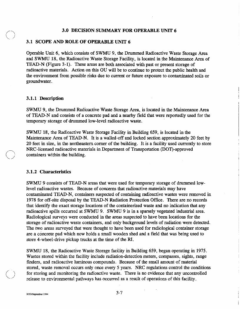
Operable Unit 6, which consists of SWMU 9, the Dmmmed Radioactive Waste Storage Area and SWMU 18, the Radioactive Waste Storage Facility, is located in the Maintenance Area of TEAD-N (Figure 3-1). These areas are both associated with past or present storage of radioactive materials. Action on this OU will be to continue to protect the public health and the environment from possible risks due to current or future exposure to contaminated soils or groundwater.
3.1.1 Description
SWMU 9, the Drummed Radioactive Waste Storage Area, is located in the Maintenance Area of TEAD-N and consists of a concrete pad and a nearby field that were reportedly used for the temporary storage of dmmmed low-level radioactive waste.
SWMU 18, the Radioactive Waste Storage Facility in Building 659, is located in the Maintenance Area of TEAD-N. It is a walled-off and locked section approximately 20 feet by 20 feet in size, in the northeastem comer of the building. It is a facility used cunentiy to store NRC-licensed radioactive materials in Department of Transportation (DOT)-approved containers within the buUding.
3.1.2 Characteristics
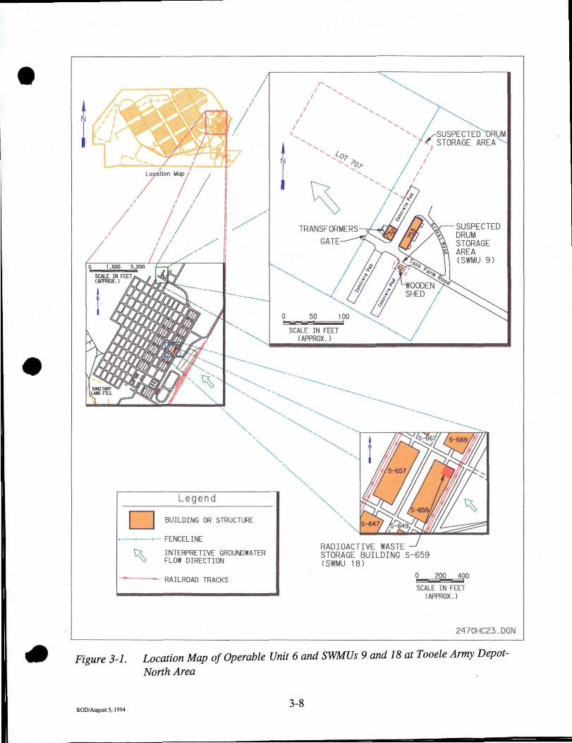
SWMU 9 consists of TEAD-N areas that were used for temporary storage of drummed low-level radioactive wastes. Because of concems that radioactive materials may have contaminated TEAD-N, containers suspected of containing radioactive wastes were removed in 1978 for off-site disposal by the TEAD-N Radiation Protection Office. There are no records that identify the exact storage locations of the containerized waste and no indication that any radioactive spills occuned at SWMU 9. SWMU 9 is in a sparsely vegetated industrial area. Radiological surveys were conducted in the areas suspected to have been locations for the storage of radioactive waste containers, and only background levels of radiation were detected. The two areas surveyed that were thought to have been used for radiological container storage are a concrete pad which now holds a small wooden shed and a field that was being used to store 4-wheel-drive pickup tmcks at the time of the RI.
SWMU 18, the Radioactive Waste Storage facility in Building 659, began operating in 1975. Wastes stored within the facility include radiation-detection meters, compasses, sights, range finders, and radioactive luminous compounds. Because of the small amount of material stored, waste removal occurs only once every 5 years. NRC regulations control the conditions
( \ for storing and monitoring the radioactive waste. There is no evidence that any uncontrolled release to environmental pathways has occuned as a result of operations of this facility.
ROD/S«ptember 1994 -^ '
Legend 1
^
BUILDING OR STRUCTURE
FENCELI^E
INTERPRETIVE GROUNDWATER FLOW DIRECTION
- RAILROAD TRACKS
RADIOACTIVE WASTE STORAGE BUILDING S-659 (SWMU 18)
0 200 400
SCALE IN FEET (APPROX.)
2470HC23.DGN
Figure 3-1. Location Map of Operable Unit 6 and SWMUs 9 and 18 at Tooele Army Depot-North Area
ROD/August 5,1994 3-8

Because the facility is operated in complete compliance with a NRC permit and there is no evidence or data to indicate that contaminated wastes have been released to the environment from operations of the Building 659 facility, no sampling or analytical investigations were conducted at SWMU 18.
3.1.3 Summary of Risks
Radiological surveys were conducted in the suspected drum storage areas of SWMU 9 as described in Section 6.1.2 of the Firuil Remedial Investigation Report for Operable Units 4-10. The north survey area was gridded and a walking survey was conducted over the entire area, using a hand-held probe with a 3-foot extension. Because of the presence of 4-wheel-drive vehicles in the survey area, it is estimated that approximately 90-percent coverage was achieved (i.e., only the soil directly under vehicle tires was not surveyed).
It was detemiined that an alpha radiation survey was not necessary because no elevated beta/gamma readings were reported and the beta/gamma radiation meter used was sensitive to all potential alpha emissions. Because there are no identified contaminants of concem for SWMU 9, a risk assessment was not performed.
Radiation surveys are conducted periodically at SWMU 18, as required by the NRC regulations. These surveys indicate that no uncontrolled releases have occuned and that the storage area is being properly controlled and maintained. Because there are no identified contaminants of concem for SWMU 18, a risk assessment was not performed.
3.1.4 Description of the No-Action Alternative
Because there are no indications of contamination at OU 6, No Action is the only remedial action that was evaluated and thus is the recommended altemative.
For SWMU 18, continued operation of the facility will be regulated by the NRC. Any future closure would be completed under NRC and the BRAC program, and satisfy RCRA Conective Action obligations as specified in the TEAD-N FFA. The statutory preference for remedies that employ treatment that reduces toxicity, mobility, or volume as a principal element will be addressed, as appropriate, by any later remedy. Review of this site and storage activities will be ongoing as the Army continues to develop final plans for TEAD-N. In October 1992, the Community Environmental Response Facilitation Act (CERFA) (Public Law 102-426) amended Section 120 (b) of CERCLA, establishing new requirements for contamination assessment, cleanup, and regulatory agency notification and concunence for Federal facility closures. CERFA requires the Federal govemment, before termination of Federal activities on real property owned, to identify property where no hazardous substances are stored, released, or disposed. CERFA designations must be concuned with by the EPA. These requirements are being implemented at TEAD-N. This process is designed to comply with CERCLA regulations; that is, the final disposition of SWMU 18 will protect human health and the environment.
ROEVSeptember 1994 •J - - '

comply with CERCLA regulations; that is, the final disposition of SWMU 18 will protect human health and the environment as dnected by CERCLA.
3-10 ROD/August 5 , 1 9 9 4 -" • • • "

Section 4
Record of Decision for Operable Unit 7
4.-1 ROD/August 5, 1994 ^ •••

cl 1 ^ '•
Section 4
Record of Decision for Operable Unit 7
ROD/August 5,1994 4-1

DECLARATION OF THE RECORD OF DECISION FOR OPERABLE UNIT 7
Operable Unit Name and Location
OU 7 contains SWMU 5, the Pole Transformer PCB Spill Site, which is located in the south-central portion of TEAD-N, Tooele, Utah.
Statement of Basis and Purpose
Tliis decision document records the selected remedy for OU 7 at TEAD-N. The action was chosen in accordance with CERCLA, as amended by SARA, and to the extent practicable, the NCP. The decision is based upon the Administrative Record for this OU.
The EPA and the State of Utah concur with the selected remedy.
Assessment of the SWMU
Actual or threatened releases of hazardous substances from this SWMU, if not addressed by implementing the action selected in this ROD, may present an endangerment to public health or the environment.
Description of the Selected Remedy
The function of the remedy selected for Operable Unit 7 is to ensure protection of public health and the environment from exposure to contaniination by PCB, dioxins, and dibenzofurans at SWMU 5, the Pole Transformer PCB Spill Site.
The components of the remedy are:
• Fill the excavated hole • Cover the site with 10 mches of clean soil • Cover the soil with gravel
In addition to protecting human health, this remedy will provide additional protection to cattle and wildlife by physically covering the contaminated soil.
Declaration Statement
The selected remedy is protective of human health and the enviromnent, complies with Federal and State requirements that are legally applicable or relevant and appropriate to the remedial action, and is cost-effective. This remedy utilizes permanent solutions and altemative
ROD/September 1994 ' + - - ^

treatment technologies to the maximum extent practicable for the SWMU. However, because treatment of the principal threat of the SWMU was not found to be practicable, this remedy does not satisfy the statutory preference for treatment as a principal element of the remedy. The size of the spill area and the fact that there are no on-site contaminant levels that represent risks outside of EPA targets preclude a remedy in which contanunants could be excavated and treated effectively.
4-3 ROD/August 5,1994 ^ -^

ROD/August 5,1994
Signature and Support Agency Acceptance of the Remedy
2-3
Jesse L. Brokenbun Date COL, OD
Commanding Tooele Army Depot

Signature and Support Agency Acceptance of the Remedy
Jesse L. Brokenbun COL, OD
Commanding Tooele Army Depot
Date
ROO/August 3,1994 4-4
SEP-2g-1994 13:54 FROM SfllLE-ESOH TO 913032947559 P.04
fflffnatePe and Support Aymqr A«gytagce of the Rw*t»dv
LewisD. Walker Date Deputy Assistant Secretary of ttie Anny
(Enyntmneoc Safety, and Oxopational Healtfa>
^ A
M»Aa(M3,l«4 4-5

Signature and Support Agency Acceptance of the Remedy
Vy/X^ / William P. Yellowtail
Regional Administrator, Region VEI, USEPA
f/z?/?i Date
ROD/Augun5,1994 4-6

Signature and Support Agencv Acceptance of the Remedy
Tooele Army Depot - North Area, Record of Decision
For Operable Unit 7
i^^.-i^/^^f^
Dianne R. Nielson, Ph.D. Executive Director
Utah Department of Environmental Quality
Date
ROD/August 5,1994 4-7
4.0 DECISION SUMMARY FOR OPERABLE UNIT 7
4.1 SCOPE AND ROLE OF OPERABLE UNIT 7
Operable Unit 7, which contains SWMU 5 in the southeastem area of TEAD-N, is the location of a 1976 transformer fire, which spilled PCB-containing oils, dioxins, and dibenzofurans on the ground near the utility pole on which the transformer had been mounted (Figure 4-1). Action on this OU will be to protect the public health and the environment from possible risks due to current or future exposure to contaminated soils or groundwater.
4.1.1 Description
OU 7 resulted when, in 1976, a fire occuned in a pole-mounted electrical transformer. During the fire, the transformer leaked PCB-containing oil to the sunounding soils. The oil-containing soils were excavated in an area adjacent to and north of the pole. The excavation measured approximately 5 feet by 5 feet wide and 3 feet deep. Eleven 55-gallon dmms of soil were collected from the excavation. Subsequently, the dmms were properly disposed of off site. The area of the excavation was not backfilled.
4.1.2 Characteristics
An earlier investigation at OU 7 included the collection of a composite sample from soil removed after the fire which was analyzed for PCBs. This sample contained 3.45 micrograms per gram O g/g) of PCB 1260. Recent sampling and analysis characterized the surface and subsurface soils within and immediately sunounding the former excavation to detennine if residual contamination is present. Some contaminants remained after the cleanup of soils in 1976. Residual contamination consists of the PCB Aroclor 1260, which is present in low but detectable concentrations in three of four surface-soil samples and in one of the subsurface-soil samples collected in the excavation. PCBs were not detected in subsurface samples collected at depths of up to 5 feet aroimd the perimeter of the excavation. Detectable concentrations of polychlorinated dibenzodioxins (PCDDs) and polychlorinated dibenzofurans (PCDFs) were also present in most of the samples collected. These contaminants are presumably the result of combustion of PCBs. These contaminants were detected in the parts per trillion range.
PCBs are generally considered chemically and environmentally stable, exhibiting low volatilization rates. PCBs, however, may enter the atmosphere through adsorption to particles which become airbome. The fate and transport of PCDDs and PCDFs are similar to the fate and transport of PCBs. They are chemically and environmentally stable, relatively insoluble in water, highly persistent, and have long environmental half-lives.
The most likely exposure pathways at OU 7 are via dermal contact, incidental soil ingestion, inhalation of fugitive dust, and ingestion of beef derived from cattle potentially exposed to
ROD/August 5.1994 ^~°

%
m
N
-POLE 184 (SWMU-5)
SCALE IN FEET (APPROX.)
Legend
INTERPRETIVE GROUNDWATER FLOW DIRECTION
RAILROAD TRACKS
1682HP32.DGN
Figure 4-1. Location Map for Operable Unit 7, the Pole Transformer PCB Spill Site (SWMUS)
ROD/August 5,1994 4-9

contaniination while grazing at TEAD-N. However, fugitive dust emissions from OU 7 are minimal because of the small size of the area.
Although PCBs, PCDDs, and PCDFs are not appreciably taken up by plants, they do bioconcentrate in fatty tissue in animals because of their stability, high lipid solubility and/or binding, and low water solubility. In addition to the low bioavailability of PCBs, PCDDs, and PCDFs in soils, the small size of OU 7 minimizes the likelihood of possible bioaccumulation. Currently, OU 7 is avaUable to grazing cattle on TEAD-N but is not available for homegrown produce; therefore, homegrown produce consumption is not considered a complete pathway for current land use conditions, but is for a ftiture residential scenario.
Because the groundwater is approximately 300 feet below the surface at OU 7 and the relative immobility of PCBs, PCDDs, and PCDFs in soil, the possibility of groundwater contamination from OU 7 soils is not considered likely. The results of vadose zone contaminant fate and transport modeling confirm this. In addition, PCB soil cleanup levels based on direct contact assumptions will generally provide sufficient protection of groundwater.
4.1.3 Summary of Risks
4.1.3.1 Human Health
Potential human health effects associated with the non-remediated site were evaluated to provide a baseline risk to determine if remediation was necessary according to EPA guidelines. The evaluation began with identification of chemicals present at the site that pose a potential risk to human health based on their prevalence and concentration in the environment and their inherent toxicity. For OU 7, risks were assessed using PCB concentrations found during the RI (see Section 7.1.3 of the Final Remedial Investigation Report for Operable Units 4-10).
Next, a toxicity assessment was conducted to estimate the relationship between the extent of exposure to a contaminant and the increased likelihood and/or severity of adverse effects. The next step in the risk assessment was to perform an exposure assessment to evaluate pathways by which humans could possibly contact contaminants. The final step consisted of determining the magnimde and probability of cunent and future human health risks associated with the identified contaminants of concem.
In conducting an assessment as described, the health effects, both carcinogenic and noncarcinogenic, that could result from all applicable exposures were evaluated. For personnel who may be working on OU 7, effects that could result from direct exposure to the contaminants as a result of the soil coming into direct contact with the skin, from inadvertent direct ingestion of the soil, or from inhalation of dust particles were evaluated. Exposure to the contaminants for others not directly working on OU 7 was evaluated in two ways: by inhalation of dust particles originating from OU 7 and by consumption of beef from cows that may have grazed on the site.
ROD/September 1994 4-lU

For comparison purposes, a hypothetical ftimre case was calculated to show what might happen if OU 7 were released for public use and a residence was constmcted next to the site. For this case, additional health effects were evaluated, including consumption of vegetables and fmit grown on site.
4.1.3.1.1 Noncarcinogenic Risk. Noncarcinogenic risks are calculated as follows: The potential for noncarcinogenic health effects is estimated by comparing a daily intake of a compound through a specific exposure route to a reference dose for that compound. The ratio of the intake to reference dose for an individual chemical is termed the hazard quotient (HQ). A HQ greater than 1 indicates the potential for adverse health effects, since the intake exceeds the reference dose. A hazard index (HI) is calculated by adding all the HQs for a specific pathway. A residual HI of 1 or less means that, even without cleanup, insufficient contamination exists to cause adverse noncancer health effects during a normal human lifetime. Using the Rl-derived concentrations for PCBs in the soils on OU 7, calculated cumulative noncarcinogenic hazard levels for all current and future cases are less than 1. This means that, even without cleanup, insufficient contaniination exists to cause adverse non-cancer health effects during a normal human lifetime.
4.1.3.1.2 Carcinogenic Risk. The excess lifetime cancer risk is the incremental increase in the likelihood of getting cancer if exposed to site contaminants as compared to the probability of that with no exposure to site contaminants. These cancer risks are stated as probabilities. A risk of lE-6 for example, represents the probability that one person in one million exposed to a carcinogen over a lifetime of 70 years will develop cancer. The EPA has set a lE-4 to lE-6 risk range as the "point of departure" for taking action at a Superfund site.
Residual concentrations of PCBs, PCDDs, and PCDFs were found to be present at OU 7. However, because of the low contaminant concentrations detected and the extremely small area of OU 7, the threat to public health and the environment is small. Carcinogenic risk factors for OU 7 are within or below the risk range of lE-4 to lE-6. Further, EPA Guidance on Remedial Actions for Superfurui Sites with PCB Contamiruition recommends that remedial action be considered when PCB levels exceed 1 ppm for residential land use and 10 to 25 ppm for industrial land use. All available data for OU 7 indicate that soil contamination is below the most stringent of these levels.
4.1.3.2 Ecological Risk
There is no Indication that this area is a critical habitat for any endangered or threatened species. The contaminants of concem—PCBs, dioxins, and furans—are toxic and tend to bioaccumulate to varying degrees; however, the levels found were too low to cause any direct toxic effects on wildlife. A model was used to evaluate the effects of bioaccumulation on raptors by ingestion of small mammals and birds. The contaminant levels at OU 7 were found to be lower than levels that would cause adverse effects in raptors or other wildlife.
ROD/September 1994 4 - 1 1

4.1.4 Description of Alternatives
Six remedial altematives were considered for this OU. Applicable or relevant and appropriate requirements (ARARs) for these altematives are tabulated in Table 4-1. Also, refer to Section 5.1.8 of the Final Feasibility Study for Operable Units 5, 6, 7, and 10.
Alternative 1: No Action. Site soils would remain in place.
Alternative 2: Institutional Controls. This altemative does not involve active remediation; site soils would be left in place. However, this altemative would limit the potential for human and fauna exposure to site contaminants by placing controls on access to the site. These controls would include fences or other barriers, waming signs, and regular surveillance. Deed restrictions would be developed for future protection in the event the property were released to the public.
Alternative 3: SoU Cover. This altemative involves filling the excavation hole and placing a 10-inch-thick clean soil and 2-inch-thick gravel cover over the OU. A 10-foot-by-10-foot area was chosen for remediation. This conservatively covers the known areas of contamination. This altemative does not involve active remediation; site soils would be left in place beneath the cover. However, this altemative would reduce the potential for human and fauna exposure to site contaminants and possible stumbling hazards by placing a soil cover over the area. It would also comply with current TSCA standards for back-filling excavated spill areas with clean soil.
Altemative 4: Stabilization. This altemative involves mixing the contaminated soil with a solidifying agent such as cement. Hardening of the solidifying agent binds and reduces the mobility of the soil contaminants. Stabilization can either be done in situ or in an extemal mixing vessel. There would be an overall volume mcrease. The soils would be left in place, but relatively immobilized.
Alternative 5: Landfill Disposal. This altemative involves excavation of contaminated soU and hauling it to a TSCA-approved disposal site. Clean soil from TEAD-N would be used to backfill the excavation. For OU 7, a volume of 20 cubic yards (10 feet by 10 feet by 6 feet deep minus the volume of the existing excavation) was used for remediation estimate purposes.
Alternative 6: Incineration. This altemative involves excavation of 20 cubic yards of potentially contaminated soil and hauling it to a TSCA-approved site for incineration. Clean soil from TEAD-N would be used to backfill the excavation.
4.1.5 Summary of the Comparative Analysis of Alternatives
Table 4-2 provides a comparative analysis of Altematives 1 through 6 for OU 7. Each altemative is discussed in more detail in Section 5.1.9 of the Feasibility Study for Operable Units 5, 6, 7, and 10.
ROD/September 1994 4" 1Z

o
^
4^ 1
1—k
statute
TSCA-Soils
EPA PCB Guidance-Soils
OSHA
Utah Air Conservation Act
Utah Solid & Hazardous Waste Act
Utah Solid Waste Mgmt. Act
Safe Drinking Water Act (MCLs)
40 CFR Part 268 Landfill Disposal
Utah Groundwater Protection Rule
Utah Safe Drinking Water Act (MCLs)
Hazaidous Materials Transport Act
Alternative 1: Action
Meets Stds.
X*
NA
NA
NA
NA
X
NA
X
X
NA
No
Does Not Meet Stds.
X
Table 4-1. Compliance of Altematives with
Alternative 2: Institutional ControU
Meets Stds.
X*
X
NA
NA
NA
X
NA
X
X
NA.
Does Not Meet Stds.
X
Alternatives: SoU Cover
Meets Stds.
X
X*
X
X**
NA
NA
X
NA
X
X
NA
Does Not Meet Stds.
ARARs for OU 7
Alternative 4: Stabilization
Meets Stds.
X*
X
X**
NA
NA
X
NA
X
X
NA
Does Not Meet Stds.
X
Alternatives: TSCA Approved Landfil Disposal
Meets Stds.
X
X*
X
X**
X
X
X
NA
X
X
X
Does Not Meet Stds.
Alternative 6: Incineration
Meets Stds.
X
X*
X
X**
X
X
X
X
X
X
X
Does Not Meet Stds.
ARAR Category
Chemical Specific
Chemical Specific
Action Specific
Action Specific
Action Specific
Chemical Specific
Chemical Specific
Action Specific
Chemical Specific
Chemical Specific
Action Specific
*=to be considered (TBC) **=action-specific, would apply during cleanup NA=not applicable

o Table 4-2. Comparative Analysis of Remedial Altematives for OU 7
Criterion Altemative 1: No Action Altemative 2: Institutional Controls
Alternative 3: Soil Cover Alternative 4: Stabilization Alternative 5: Landfill Disposal
Altemative 6: Incineration
Overall Protection
Compliance with ARARs"'
I Long-Term Effectiveness
Reduction of Toxicity, Mobility, and Volume
Meets the remedial-action objectives of protecting human health and the environment.
Meets TSCA**' and EPA standards for clean residual soils of less than 1 mg/kg PCBs. However does not meet TSCA requirements for clean soil fill material. Meets SDWA MCLs.
Would meet the remediation goals of limiting the cumulative excess cancer risk to human receptors to levels within or below the EPA target range for residual risk of lE-4 to lE-6 and limiting the cumulative noncancer hazard index to levels of 1 or less. The qualitadve risk to ecological receptors would be low.
There is no reduction of the toxicity, mobility, or volume of soil contaminants through treatment under this altemative.
Meets the remedial-action objectives of protecting human health and the environment.
Meets TSCA*' and EPA standards for clean residual soils of less than 1 mg/kg PCBs. However does not meet TSCA requirements for clean soil fill material. Would meet OSHA'" requirements for worker health and safety during implementation. Meets SDWA MCLs.
Would meet the remediadon goals of limiting the cumulative excess cancer risk to human receptors to levels within or below the EPA target range for residual risk of lE-4 to lE-6 and limiting the cumulative noncancer hazard index to levels of 1 or less. The qualitative risk to ecological receptors would be low.
There is no reduction of the toxicity, mobility, or volume of soil contaminants through treatment under this altemative.
Meets the remedial-action objectives of protecting human health and the environment.
Meets TSCA and EPA standards for a clean soil of less than 1 mg/kg PCBs. Would comply with TSCA requirement to fill excavated spill area with clean soil. Would meet OSHA requirements for worker health and safety during implementation. Meets SDWA MCLs.
Would meet the remediation goals of limiting the cumulative excess cancer risk to human receptors to levels within or below the EPA target range for residual risk of lE-4 to lE-6 and limiting the cumulative noncancer hazard index to levels of 1 or less. The qualitative risk to ecological receptors would be low.
There is no reduction of the toxicity, mobility, or volume of soil contaminants through treatment under this altemative.
Meets the remedial-action objectives of protecting human health and the environment.
Meets TSCA<" and EPA standards for clean residual soils of less than 1 rag/kg PCBs. However does not meet TSCA requirements for clean soil fill material. Would meet OSHA requirements for worker health and safety during implementation. Meets SDWA MCLs.
Would meet the remediation goals of limiting the cumulative excess cancer risk to human receptors to levels within or below the EPA target range for residual risk of lE-4 to lE-6 and limiting the cumulative noncancer hazard index to levels of 1 or less. The qualitative risk to ecological receptors would be low.
There is no reduction of toxicity with this treatment. Mobility of contaminants is significandy reduced. There is an overall increase in volume due to the addition of solidifying agent.
Meets the remedial-action objectives of protecting human health and the environment.
Meets TSCA and EPA standards for a clean soil of less than 1 mg/kg PCBs. Would meet OSHA requirements for worker health and safety during implementation. Also meets State and Federal Land Disposal and Hazard Waste Handling regulations. Meets SDWA MCLs.
Would meet the remediation goals of limiting the cumulative excess cancer risk to human receptors to levels within or below the EPA target range for residual risk of 1 E-4 to lE-6 and limiting the cumulative noncancer hazard index to levels of 1 or less. The qualitative risk to ecological receptors would be low.
There is no reduction of the toxicity, mobility, or volume of soil contaminants tbrough treatment under this altemative.
Meets the remedial-action objectives of protecting human health and the environment.
Meets TSCA and EPA standards for a clean soil of less than 1 mg/kg PCBs. Would meet OSHA requirements for worker health and safety during implementation. Also meets State and Federal Land Disposal and Hazardous Waste Handling regulations. Meets SDWA MCLs.
Would meet the remediation goals of limiting the cumulative excess cancer risk to human receptors to levels within or below the EPA target range for residual risk of lE-4 to lE-6 and limiting die cumulative noncancer hazard index to levels of 1 or less. The qualitative risk to ecological receptors would be low.
Toxicity and mobUity of contamination are permanendy removed by this altemative. Waste volume is unchanged.
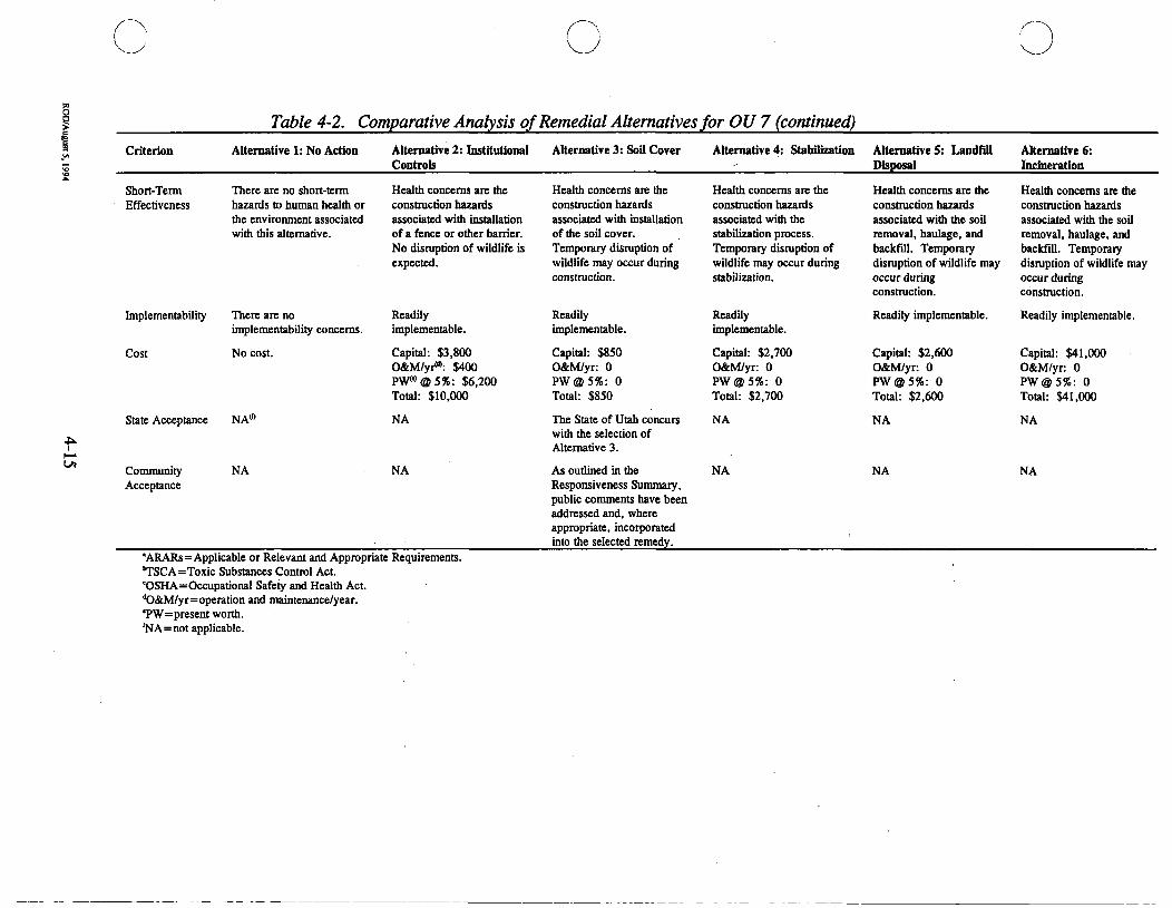
Table 4-2. Comparative Analysis of Remedial Altematives for OU 7 (continued)
Criterion Altemative 1: No Action Altemative 2: Institutional Controls
Alternative 3: Soil Cover Altemative 4: Stabilization Alternatives: Landfill Disposal
Altemative 6: Incineration
Short-Term Effectiveness
There are no short-term hazards to human health or the environment associated with diis altemative.
Implementability There are no implementability concems.
Cost No cost.
State Acceptance NA'"
I I—'
Community Acceptance
NA
Health concems are the construction hazards associated with installation of a fence or other barrier. No dismption of wildlife is expected.
Readily implementable.
Capital: $3,800 0&M/yi<*: $400 PW<"@5ro: $6,200 Total: $10,000
NA
NA
Health concems are the constmction hazards associated with installation of the soil cover. Temporary dismption of wildlife may occur during constmction.
Readily implementable.
Capital: $850 O&M/yr: 0 PW@5fo: 0 Total: $850
The State of Utah concurs with the selection of Altemative 3.
As oudined in die Responsiveness Summary, public comments have been addressed and, where appropriate, incoiporated into the selected remedy.
Health concems are the constmction hazards associated with the stabilization process. Temporary dismption of wildlife may occur during stabilization.
Readily implementable.
Capital: $2,700 O&M/yr: 0 PW@5%: 0 Total: $2,700
NA
NA
Health concems are the constmction hazards associated with the soil removal, haulage, and backfill. Temporary dismption of wildlife may occur during constmction.
Readily implementable.
Capital: $2,600 O&M/yr: 0 PW@5%: 0 Total: $2,600
Health concems are the constmction hazards associated with the soil removal, haulage, and backfill. Temporary dismption of wildlife may occur during constmction.
Readily implementable.
Capital: $41,000 O&M/yr: 0 PW@5%: 0 Total: $41,000
NA
NA
NA
NA
'ARARs=Applicable or Relevant and Appropriate Requirements. 'TSCA=Toxic Substances Control Act. 'OSHA=Occupational Safety and Healdi Act. ''0&M/yr=operation and maintenance/year. 'PW=present worth. 'NA=not applicable.

4.1.6 Selected Remedy
The selected remedy for OU 7 SWMU 5 is Alternative 3: Soil Cover. Based upon current information, this altemative provides the best balance of trade-offs when evaluated against the nine EPA criteria as follows:
Overall protection of human health and the environment. This altemative meets the remedial-action objectives.
Compliance with ARARs. This altemative meets the EPA guidance and the TSCA standard for clean soil of less than 1 mg/kg PCBs and current TSCA standards for back-filling excavated spill areas with clean soil. This altemative would also comply with Occupational Safety and Health Administration (OSHA) requirements for worker health and safety during the installation of the soil cover. The Utah Air Conservation Act would be the action-specific ARAR to regulate fugitive dust and particulates. Federal and Utah drinking water maximum contaminant levels (MCLs) are met by this altemative.
Long-term effectiveness and permanence. The baseline risk assessment indicates that the residual risk for this alternative would meet the remediation goals of limiting the cumulative excess cancer risk to human receptors to levels within or below the EPA target range for residual risk of lE-4 to lE-6 and limiting the cumulative noncancer hazard index to levels of 1 or less. By placing a clean soil cover on the site, this altemative could exceed the remediation goals by further reducing the residual excess cancer risk to on-site workers, current on-site residents, and current off-site residents. The qualitative ecological risk assessment also indicates that the potential risk to ecological receptors would be low. The installation of a soil cover is not expected to negatively impact the environment.
Reduction of toxicity, mobility, or volume through treatment. There is no reduction of the toxicity or volume of soil contaminants through treatment under this altemative. Mobility of windblown soil that may contain adsorbed PCBs would be reduced by this alterative.
Short-term effectiveness. Human health concem associated with the implementation of this altemative are limited to the constmction hazards to personnel involved with the installation of the soil cover at the site. The implementation time would be sufficiently short (less than 1 week), so that the health risk due to potential exposure to site contaminants would be negligible. Wildlife may be temporarily disturbed by the constraction activities.
Implementability. The placement of a soil cover over the site involves simple constraction activities. Contractors are readily available, so this altemative is readily implementable.
Cost. Costs for the selected remedy are summarized in Table 4-3.
ROD/September 1994 4-iO
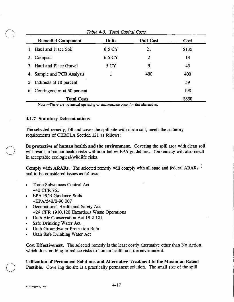
Table 4-3. Total Capital Costs
Remedial Component Units Unit Cost Cost
1.
2.
3.
4.
5.
6.
Haul and Place Soil
Compact
Haul and Place Gravel
Sample and PCB Analysis
Indirects at 10 percent
Contmgencies at 30 percent
Total Costs
6.5 CY
6.5 CY
5CY
1
21
2
9
400
$135
13
45
400
59
198
$850 Note.—There are no annual operating or maintenance costs for this altemative.
4.1.7 Statutory Determinations
The selected remedy, fill and cover the spill site with clean soil, meets the statutory requirements of CERCLA Section 121 as follows:
Be protective of human health and the environment. Covering the spill area with clean soil will result in human health risks within or below EPA guidelines. The remedy will also result in acceptable ecological/wildlife risks.
Comply with ARARs. The selected remedy will comply with all state and federal ARARs and to-be-considered issues as follows:
• Toxic Substances Control Act -40 CFR 761
• EPA PCB Guidance-Soils -EPA/540/0-90 007
• Occupational Health and Safety Act -29 CFR 1910.120 Hazardous Waste Operations
• Utah Air Conservation Act 19-2-101 • Safe Drinking Water Act • Utah Groundwater Protection Rule • Utah Safe Drinking Water Act
Cost Effectiveness. The selected remedy is the least costly altemative other than No Action, which does nothing to reduce risks to human health and the environment.
Utilization of Permanent Solutions and Alternative Treatment to the Maximum Extent Possible. Covering the site is a practically permanent solution. The small size of the spill
4-17 ROD/August 5,1994 t i /

area and very low contaminant concentration levels do not make altemative treatments practical.
The selected remedy represents the best trade-off of evaluation criteria as shown in Table 4-2. The remedy is permanently effective and reduces mobility of the contaminants. Health and environmental concem over the short term are negligible because the implementation time is very short. Labor and equipment are immediately available to implement the remedy. The public health/environment cost benefit ratio is detemiined to be the lowest of the evaluated altematives.
State and local community review of the mformation, which has gone into preparation of the Administrative Record for OU 7, has all been favorable toward the selected remedy.
ROD/August 5,1994 4 - 1 5
Section 5
Record of Decision for Operable Unit 10
ROD/August 5 , 1 9 9 4 • ' " • ' •

o Section 5
Record of Decision for Operable Unit 10
ROD/August 5,1994 5-1
DECLARATION OF THE RECORD OF DECISION FOR OPERABLE UNIT 10
Operable Unit Name and Location
OU 10 consists of the Box Elder Wash Drum Site (SWMU 41) located in the north-central section of TEAD-N, Tooele, Utah.
Statement nf Basis and Purpose
This decision document records the selected remedy for OU 10 at TEAD-N. The action was chosen in accordance with CERCLA as amended by SARA, and to the extent practicable, the NCP. The decision is based upon the Administrative Record for this OU.
The EPA and the State of Utah concur with the selected remedy.
Assessment of the SWMU
Actual or potential releases of hazardous substances from the drams on this site, if not addressed by implementing the response selected in this ROD, may present a threat to public health, welfare, or the environment.
Description of the Selected Remedy
The function of the remedy selected for this OU is to remove the source of possible soil, surface water, and groundwater contamination that may occur because of the presence of 21 drums previously dumped into Box Elder Wash. The remedy addresses the removal of these drums and cleanup of areas where the contents of the drums have spilled onto the ground.
The components of the remedy are:
• Prepare and remove drums • Remove small areas of stained soil • Characterize waste materials • Incinerate drummed materials
Declaration Statement
The selected remedy is protective of human health and the environment, complies with federal and state requirements that are legally applicable or relevant and appropriate to the remedial action, and is cost-effective. The remedy utilizes permanent solutions and altemative
5-2 ROD/September 1994 -^ ^

treatment technologies to the maximum extent practicable for this site. Because this remedy will not result in hazardous substances remaining on site above health-based levels, a 5-year review will not be required for this site.
5-3 ROIVAugust5,1994 -" -^
Signature and Support Agency Acceptance of the Remedy
Jesse L. Brokenburr Date COL, OD
Commanding Tooele Army Depot
2-3 ROD/August 5,1994 " "'
Signature and Support Agency Acceptance of the Remedy
Jesse L. Brokenburr Date COL, OD
Commanding Tooele Army Depot
5-4 ROD/August 5,1994 -^ ^
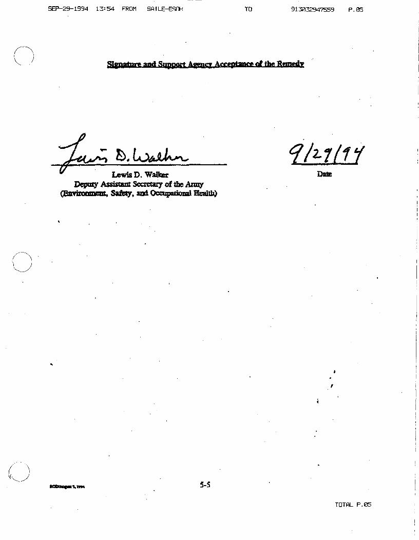
SEP-2g-19g4 13:54 FROM SftlLE-ESOH TO 913032947559 P . 0 5
glfttfrfm-^ vtd Snpporf Aff^ify A«yjptaa«» rf tiia Rtancdv
h,Lo^ju\^^ Lewis D. WaUoer
Depoiy Assistant Secretaiy of tbe Azmy (Saviroaniaic, Safb9> and Occopatiosai HeaitlO
fAy/f/ Date
vnM 5-S
TDTflL P.05
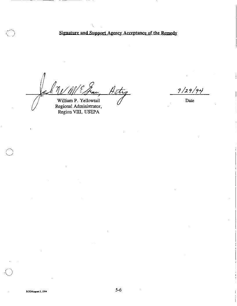
Signature and Support Agency Acceptance of the Remedy
y^ftfft^^ /TOACC<
William P. Yellowtail Regional Administrator,
Region Vm, USEPA
i/z^/ji Date
ROOrAugust3,1994 5-6

Signature and Support Agency Acceptance of the Remedy
Tooele Army Depot - North Area, Record of Decision
For Operable Unit 10
^o.^<£^A^f'/
Dianne R. Niefson, Ph.D. Executive Director
Utah Department of Environmental Quality
Date
ROD/August 5,1994 5-7
5.0 DECISION SUMMARY FOR OPERABLE UNIT 10
5.1 SCOPE AND ROLE OF OPERABLE UNIT 10
Operable Unit 10, which consists solely of SWMU 41, is an area containing 21 dmms dumped in the bottom of Box Elder Wash. Action on this OU will be to protect human health and the environment from possible risks due to current or future exposure to contaminants.
5.1.1 Description
SWMU 41, the Box Elder Wash Dram Site, is located southeast of row J of the Igloo Storage Area in the north-central section of TEAD-N (Figure 5-1). The site consists of 21 drums located in the wash, which carries intermittent mnoff from the southwestem comer of TEAD-N, north through the facility, and across the north-central TEAD-N boundary.
5.1.2 Characteristics
Operable Unit 10 (SWMU 41) was created when 21 drums were dumped off the eastem edge of Box Elder Wash into the lower bank and bottom of the wash. The drums are present in an approximately 200-foot-long stretch of the wash. Most of the drums are at least partially obscured by soil and/or vegetation. The soil cover appears to have resulted from sedimentation during periods of surface-water flow and from caving of the steep wash bank. The drums are in various stages of deterioration and have no obvious markings. The drums contain a substance that resembles roofing tar. There are small areas of stained soil and one area of a surface tar spill above the wash channel.
In April 1989, TEAD Environmental Management Office personnel collected samples from four of the open drams at the site. The samples were analyzed for certain organic compounds and for the characteristic of extraction procedure (EP) toxicity for selected metals. In addition to indicating the presence of several complex organic compounds, the analyses indicated that mercury was present in one sample at the minimum regulatory level for designation as a hazardous waste.
The scope of the Remedial Investigation included locating all of the drums, sampling of eight representative drums, sampling soils surrounding and downstream from the drums, and taking a biased sample at a tar spill above the wash. Analyses of the drums showed that they contained varying amounts of volatile organics, explosives, metals, and anions. However, toxicity characteristic leaching procedure (TCLP) analyses for metals of samples from the drums did not show any levels of leachable metals characteristic of hazardous waste. Soil samples indicated little, if any, contamination. One sample downstream of the drums showed a low concentration of pyrene. The biased sample collected from a small tar spill above the wash showed a concentration of nickel that exceeded background concentrations.
ROD/August 5,1994 5-8

' #
N
~4530-~-.^
Legend y\ , INTERPRETIVE GROUNDWATER \ r — ' FLOW DIRECTION
^ INTERMITTENT STREAM '~^-^-^ FLOW DIRECTION
—^ RAILROAD TRACKS
-4620- TOPOGRAPHIC CONTOURS IN FEET (MSL)
400 800
SCALE IN FEET (APPROX.)
1682HP40.D6N
Figure 5-1. Location Map of OU 10, Box Elder Wash Drum Site (SWMU 41)
ROD/August 5,1994 5-9

The drums are believed to be the only source of contaniination at the site. An analysis has indicated that mercury was present in the drammed material at levels designated by the EPA as hazardous. All available analyses show that the drams contain a complex mixture of organic and inorganic compounds. The removal of these drums and any visibly contaminated soils will prevent any ftirther spread of these contaminants to soils and water media.
For soils in Box Elder Wash, pyrene is a potential contaminant of concem, although it has been detected only in 1 of 13 samples at a low level. Pyrene strongly adsorbs to soil and is resistant to leaching. Pyrene exhibits low volatility, although it may enter the atmosphere through adsorption to airbome particles. Leaching of pyrene to groundwater at OU 10 is highly unlikely because the depth to groundwater is approximately 180 feet, the concentration of the contaminant is low, and pyrene has a strong adherence to soils. For soils that have been contaminated by material spilled from the drums, nickel could be a potential contaminant of concem if the soils were not removed. Nickel was detected in the sample taken fi'om a tar spill above the wash. The elevated nickel in this sample reflects the nickel concentrations found in the drummed material. Nickel is not present above the method reporting limits in any of the soil samples collected from soils in the wash.
The most likely exposure pathways at OU 10 are via dermal contact, incidental soil ingestion, inhalation of fugitive dust, and ingestion of beef derived from cattle potentially exposed to contamination while grazing at TEAD-N. However, fiigitive dust emissions from OU 10 are minimal because vegetative cover at this site limits potential dust emissions and OU 10 is located in a wash below ground surface.
Although pyrene is not appreciably taken up by plants, it does bioconcentrate in tissue because of its stability, high lipid solubility and/or binding, and low water solubility. The overall potential for pyrene to bioaccumulate at OU 10 is minimal because of the low concentration detected and the infrequency of detection.
Currently, OU 10 is available to grazing cattle on TEAD-N but is not available for homegrown produce; therefore, homegrown produce consumption was not considered a complete pathway for current land use conditions but was for a future residential scenario.
5.1.3 Summary of Risks
5.1.3.1 Human Health
Potential human health effects associated with the non-remediated site were evaluated in order to provide a baseline risk to determine if remediation was necessary according to EPA guidelines. The evaluation began with identification of chemicals present at the site that pose a potential risk to human health based on their prevalence and concentration in the environment and their inherent toxicity. Risks for OU 10 were assessed based upon reported pyrene in soil concentrations, assuming that the drums will be removed.
ROD/August 5,1994 5-10
Next, a toxicity assessment was conducted to estimate the relationship between the extent of exposure to a contaminant and the increased likelihood and/or severity of adverse effects.
The next step in the risk assessment was to perform an exposure assessment to evaluate pathways by which humans could possibly contact contaminants. The final step consisted of detemiining the magnitude and probability of current and fiiture human health risks associated with the identified contaminants of concem. Both carcinogenic and noncarcinogenic risks were evaluated.
The baseline risk assessment for OU 10 was designed to estimate the human health and environmental problems that could result if the drums were removed but soil contamination were not cleaned up. For personnel who may be working on the SWMU, effects that could result from direct exposure to the contaminants as a result of the soil coming into direct contact with the skin, from inadvertent direct ingestion of the soil, or from inhalation of dust particles were evaluated. Exposure to the contaminants for others not directly working on OU 10 was evaluated in two ways: by inhalation of dust particles originatmg from OU 10 and by consumption of beef from cows that may have grazed on the site.
For comparison purposes, a hypothetical fiiture case was calculated to show what might happen if OU 10 were released for public use and a residence was constracted on the site. For this case, additional health effects were evaluated, including consumption of vegetables and frait grown on site.
5.1.3.1.1 Noncarcinogenic Risk. Noncarcinogenic risks are calculated as follows: The potential for noncarcinogenic health effects is estimated by comparing a daily intake of a compound through a specific exposure route to a reference dose for that compound. The ratio of the intake to reference dose for an individual chemical is termed the hazard quotient (HQ). A HQ greater than 1 indicates the potential for adverse health effects, since the intake exceeds the reference dose. A hazard index (HI) is calculated by adding all the HQs for a specific pathway. A residual HI of 1 or less means that, even without cleanup, insufficient contamination exists to cause adverse noncancer health effects during a normal human lifetime. For all current and future use cases evaluated for post dram removal, calculated non-cancer hazard levels are less than 1. This means that, even without cleanup other than dram removal, insufficient contamination exists to cause adverse noncancer health effects during a normal human lifetime.
5.1.3.1.2 Carcinogenic Risk. The excess lifetime cancer risk is the incremental increase in the likelihood of getting cancer if exposed to site contaminants as compared to the probability of that with no exposure to site contaminants. These cancer risks are stated as probabilities. A risk of lE-6 for example, represents the probability that one person in one million exposed to a carcinogen over a lifetime of 70 years will develop cancer. The EPA has set a lE-4 to lE-6 risk range as the "point of departure" for taking action at a Superfund site. Evaluation of
ROD/September 1994 J - 1 1
"
risks attributable to OU 10 after removal of the drums shows that all cancer risks calculated for current use conditions as well as the hypothetical future case fall below the risk range.
5.1.3.2 Ecological Risk
OU 10 (SWMU 41) was also evaluated qualitatively for ecological risks. The primary contaminant of concem at this site is pyrene. While pyrene has a potentially high biological hazard because of its toxicity and propensity to bioaccumulate, the overall risk at OU 10 is considered low because pyrene was detected at a low level in only one sample.
Several chemicals of concem were identified for the material in the drums at this site. These chemicals could be of concem to wildlife if they come into contact with these contaminants. Small mammals frequently burrow, nest, or otherwise utilize habitat formed by natural rock caims, felled trees, or shmbs,- as well as manmade fonnations such as piles of frash, lumber, etc. In this case, small mammals may utilize habitat created by the drums, thereby being exposed to these contaminants. Six of the contaminants identified within the drums are metals: barium, cadmium, chromium, lead, mercury, and silver. These contaminants are known to bioaccumulate to some degree, although there is evidence that they are eventually eluninated or transformed to other metabolites. Additionally, these inorganic contaminants are known to be toxic. Many of the other contaminants identified are also toxic and may bioaccumulate as well. Thus, it is advisable that these drums and the associated contaminants be removed as quickly as practicable in order to eliminate this source of environmental degradation.
Actual or threatened releases of hazardous substances from the drams on this site, if not addressed by implementing the response action selected in this ROD, may present a threat to public health or the environment.
5.1.4 Description of Alternatives
The drums at OU 10 could pose a threat to human health and the environment. Once the dmms and stained soils are removed, the current condition of remaining soils would meet the remediation goals. Four remedial altematives have been considered for this site.
Alternative 1: No Action. Site soils and the drams would remain in place.
Alternative 2: Institutional Controls. This altemative does not involve active remediation; site soils and the drums would be left in place. However, this altemative would limit the potential for human and fauna exposure to site contaminants by placing controls on access to the site. These controls would include fences or other barriers, waming signs, and regular surveillance. Deed restrictions would be developed for future protection in the event the property were released to the public.
ROD/September 1994 0 -1Z

Alternative 3: Removal and Off-Site Incineration of Drums and Stained Soil. This altemative includes the removal and off-site disposal of 21 drums and approximately 35 cubic feet of visibly stamed soil from OU 10. The material would be properly handled and incinerated in a permitted hazardous waste incinerator. The drums would be transported by licensed hazardous waste handlers, utilizing manifests to track the shipment and the receipt of the waste by a licensed hazardous waste treatment, storage, and disposal facility. The materials may require treatment as part of, or prior to, disposal.
Alternative 4: Removal and Off-Site Landfill Disposal of Drums and Stained Soils. This altemative includes the removal and off-site disposal of 21 drums and approximately 35 cubic feet of visibly stained soil from OU 10. The material would be properly handled and placed in a permitted hazardous waste landfill. The material would be transported by licensed hazardous waste handlers utilizing manifests to track the shipment and to track the receipt of the waste at a licensed hazardous waste treatment, storage, and disposal facility. The materials may require treatment as part of, or prior to, disposal.
Table 5-1 lists compliance ofthe four altematives with ARARs. See also Section 6.1.7 of the Feasibility Study for Operable Units 5. 6, 7, and 10.
5.1.5 Summary of the Comparative Analysis of Altematives
Table 5-2 provides a comparative analysis of Altematives 1 through 4 for OU 10. Each altemative is discussed in more detail in Section 6.1.8 of the Feasibility Study for Operable Units 5, 6, 7, and 10.
5.1.6 Selected Remedy
The preferred alternative for Operable Unit 10, SWMU 41, is Altemative 3: Removal and Off-Site Incineration of Drums and Stained SoO. Based upon current information, this alternative would provide the best balance of trade-offs when evaluated against the nine EPA criteria as follows:
Overall protection of human health and the environment. This altemative meets the remedial action objectives for the drum contents and the stained soil and protects human health and the environment.
Compliance Mith ARARs. This altemative would comply with federal and state ARARs for removal, transportation, and disposal of the drums and stained soil at a hazardous waste incinerator. The owner and operator of the hazardous waste disposal facility would take responsibility for compliance with treatment, storage, and disposal requirements.
Long-term effectiveness and permanence. The baseline risk assessment indicates that the residual risk for this altemative would meet the remediation goals of limiting human health
ROD/September 1994 J- l J

Table 5-1. Compliance of Altematives with ARARs for OU 10
Alternative 1: No Action Alternative 2: Institutional Controls
Alternative 3: Incineration of Soil and
Drums
Alternative 4: RCRA Approved Landfill
Disposal
ARAR Category
Statute Meets Stds. Does Not Meet Stds.
Meets Stds. Does Not Meet Stds.
Meets Stds. Does Not Meet Stds.
Meets Stds.
Does Not Meet Stds.
OSHA
Utah Air Conservation Act
NA
NA
Lh
Utah Corrective Action Clean-Up Standards Policy (UAC-R-315-101)
Utah Transporter and Landfill Disposal Standards (R315-1 through -10)
Safe Drinking Water Act (MCLs)
40 CFR Part 268 Landfill Disposal
40 CFR Part 264 TSD Stds.
Utah Groundwater Protection Rule
Utah Safe Drinking Water Act (MCLs)
Hazardous Material Transport Act
NA
X
NA
NA
X
X
NA
X
X
NA
NA
X
NA
NA
X
X
NA
X
X
X*
X
X
X
X
X
X
X
X*
X
X**
X
X**
X
X
X
X
Action Specific
Action Specific
Action Specific
Action Specific
Chemical Specific
Action Specific
Action Specific
Chemical Specific
Chemical Specific
Action Specific
NA=not applicable. *=action-specific, would apply during cleanup. **=pretreatment standards may apply.

o a >
Table 5-2. Comparative Analysis of Remedial Altematives for Soils and Drums at OU 10
Criterion AJternative 1: No Action Alternative 2: Institutional Controls
Alternative 3: Removal and OfT-Site Incineration of Drums and Stained Soil
Alternative 4: Removal and OfF- ite Disposal of Drums and Stained Soil
Overall Protection
Compliance with ARARsW
U l I
Ul
Long-Term Effectiveness
Does not meet the remedial-action objectives of protecting human health and the environment because the drums would remain on site.
Does not comply with land disposal restrictions because the drums contain potentially hazardous waste.
Would meet the remediation goals for soil of limiting the cumulative excess cancer risk to human receptors to levels within or below the EPA target range for residual risk of 1E4 to lE-6 and limiting the cumulative noncancer hazard index to levels of 1 or less. The drum contents pose a threat to potential ecological receptors.
Does not meet the remedial-action objectives of protecting human health and the environment because the drums would remain on site.
Does not comply with land disposal restrictions because the drums contain potentially hazardous waste. Complies with OSHA*' requirements for worker health and safety during implementation.
Would meet the remediation goals for soil of limiting the cumulative excess cancer risk to human receptors to levels within or below the EPA target range for residual risk of lE-4 to lE-6 and limiting the cumulative noncancer hazard index to levels of 1 or less. The drum contents pose a threat to potential ecological receptors.
Meets the remedial-action objectives of protecting human health and the environment.
Complies with ARARs for transport of the drums to an off-site hazardous waste disposal faciUty. Complies with OSHA requirements for worker health and safety during implementation.
Would meet the remediation goals for soil of limiting the cumulative excess cancer risk to human receptors to levels below the EPA target range for residual risk of lE-4 to lE-6 and limiting the cumulative noncancer hazard index to levels of 1 or less. Would protect the environment and eliminate the need for long-term management of the site through the removal and proper off-site disposal of the 21 drums and stained soil.
Meets the remedial-action objectives of protecting human health and the environment.
Complies with ARARs for transport of the drums to an off-site hazardous waste disposal facility. Complies with OSHA requirements for worker health and safety during implementation.
Would meet the remediation goals for soil of limiting the cumulative excess cancer risk to human receptors to levels below the EPA target range for residual risk of lE-4 to lE-6 and limiting the cumulative noncancer hazard index to levels of 1 or less. Would protect the environment and eliminate the need for long-term management of the site through the removal and proper off-site disposal of the 21 drums and stained soil.

Table 5-2. Comparative Analysis of Remedial Altematives for Soils arul Dmms at OU 10 (continued)
Criterion Alternative 1: No Action Alternative 2: Institutional Controls
Alternative 3: Removal and On'-Site Incineration of Drums and Stained Soil
Alternative 4: Removal and Off-Site Disposal of Drums and Stained Soil
Reduction of Toxicity, MobiUty, and Volume
Short-Term Effectiveness
I
ON
Implementability
Cost
There is no reduction of the toxicity, mobUity, or volume of contaminants in the soil or in the drum contents through treatment imder this altemative.
There are no short-term hazards to human health or the environment associated with this altemative.
No implementability concems.
No cost.
There is no reduction of the toxicity, mobility, or volume of contaminants in the soil or in the drum contents through treatment under this altemative.
Health concems are the construction hazards associated with installation of a fence or other barrier. WildUfe may be temporarily disturbed by the construction activities.
Readily implementable.
Capital: $19,500 0&M<'Vyr: $500 PW<'«@5%: $7,700 Total: $27,200
Eliminates toxicity and mobiUty of contaminants through removal and off-site disposal by incineration. There is no reduction of waste volume under this altemative.
Health concems are the physical hazards associated with the removal and off-site transport of the drums and soil. WUdUfe may be tenqjorarily disturbed during removal and shipment of the drums.
Readily implementable.
Capital: $222,000 O&M/yr: 0 Total: $222,000
There is no reduction of the toxicity, mobiUty, or volume of contaminants in the soU or in the drum contents through treatment imder this altemative.
Health concems are the physical hazards associated with the removal and off-site transport of the drums and soil. WildUfe may be temporarily disturbed during removal and shipment of the soU.
Readily implementable.
Capital: $193,000 O&M/yr: 0 Total: $193,000
State Acceptance NA<" NA The State of Utah concurs with the selection of Altemative 3.
NA

Table 5-2. Comparative Artalysis of Remedial Altematives for Soils and Dmms at OU 10 (continued)
Criterion Alternative 1: No Action Alternative 2: Institutional Controls
Alternative 3: Removal vaA Off-Site Incineration of Drums and Stained Soil
Alternative 4: Removal and Off-Site Disposal of Drums and Stained Soil
Community Acceptance NA NA As outlined in the Responsiveness Summary for OU 10, pubUc comments have been addressed and, where appropriate, incorporated into the selected remedy.
NA
"ARARs=Applicable or Relevant and Appropriate Requirements. 'OSHA=Occupational Safety and Health Act. °0&M/yr=operation and maintenance per year. ''PW=present worth. 'NA=not applicable.
U\ I

risks to current human receptors to below EPA target levels. The qualitative ecological risk assessment also indicates that potential risk to ecological receptors would be low. By removmg the 21 drums and stained soil, this altemative eliminates the need for long-term management of the site.
Reduction of toxicity, mobility or volmne through treatment. This altemative provides permanent reductions in the toxicity, mobility, and volume of the dram contents and stained soil through incineration.
Short-term effectiveness. Human health concems associated with the implementation of this altemative are limited to personnel subject to physical hazards involved with the removal and off-site transport of the drums. The implementation time would be very short, so that the health risk due to potential exposure to site contaminants would be negligible. Personal protective equipment would be utilized in packaging the drums for disposal.
Implementability. Hazardous waste removal and disposal services for the 21 drams and 5 drums of contaminated soil are readily available in the Tooele area.
Cost. Costs for the selected remedy are summarized in Table 5-3.
Table 5-3. Total Capital Costs
Remedial Component Units Unit Cost Cost
1. Prepare and remove drams 2. Haul to Landfill 3. Characterize wastes 4. Incinerate drams 5. Indirects (g 10% 6. Contingencies @ 30%
Total Costs
26* Lump Sum
2 26
$5,000 1,000 550
1,000
$130,000 1,000 1,100
26,000 16,000 48,000
$222,000 Note.— There are no annual operating or maintenance costs for this altemative. •The 21 drums in the wash plus 5 drums of stained soU.
5.1.7 Statutory Determinations
The selected remedy, removal and off-site disposal of drums and stained soil, meets the statutory requirements of CERCLA Section 121 as follows:
Be protective of human health and the environment. Removal of the 21 drams and 5 drams of stained soil will result in human health risks below EPA guidelines.
ROD/September 1994 5-18

Short-term risks from implementation of this remedy would be negligible because of the very short time frame required for drum removal and because appropriate personal protective equipment would be used during drum handling.
Comply with ARARs. The selected remedy will comply with all state and federal ARARs as follows:
• Utah Solid and Hazardous Waste Act 19-6-101 et seq. - Citation R315-101
Sets standards for cleanups • Utah Solid Waste Management Act 19-6-501 et seq.
- Citation R315-301 Sets standards for disposal and incineration facility siting and operation
- Citation R315-101 Sets standards for cleanups
• Occupational Health and Safety Act - 29 CFR 1910.120 Hazardous Waste Operations Utah Air Conservation Act 19-2-101
• Resource Conservation and Recovery Act - 40 CFR 264 Standards for Owners and Operators of
Hazardous Waste Treatment, Storage, and Disposal Facilities
- 40 CFR 268.50 Prohibitions on Storage of Restricted Wastes
• Safe Drinking Water Act • Utah Safe Drinking Water Act • Utah Ground Water Protection Rule
Cost-Effectiveness. The selected remedy, removal and off-site disposal of drams and stained soil, appears to be the most cost-effective altemative evaluated for OU 10. Altematives 1 and 2, while less costly, do nothing to remove risks to human health and the environment.
Utilization of Permanent Solutions and Alternative Treatment to the Maximum Extent Possible. The selected remedy to remove the drams and stained soils from Box Elder Wash and appropriately dispose of them permanently eliminates contamination that may result from these materials and utilizes treatment to the maximum extent.
The selected remedy represents the best trade-off of evaluation criteria as shown in Table 5-1 above. The remedy is permanently effective and utilizes treatment technologies. The remedy effectively eliminates toxicity, mobility, and volume of the contamination. Health and environmental concerns over the short term are negligible because the implementation time for the remedy is very short. Contractors are readily available in the Tooele area to implement the selected remedy. The public health/environment cost benefit ratio is determined to be the lowest of the evaluated altematives.
ROD/Septeitiber 1994 J - 1 ! ?
The fact that hazardous waste disposal facilities exist near Tooele is the primary consideration in choosing the dmm and stained soil disposal remedy.
State and local community review of the information, which has gone into preparation of the administrative record for OU 10, has all been favorable toward the selected remedy.
5-20 ROD/September 1994 •> • ^ "
• Utah Solid Waste Management Act 19-6-501 et seq. - Citation R315-301
Sets standards for disposal and incineration facUity siting and operation
- Citation R315-101 Sets standards for cleanups
• Occupational Health and Safety Act - 29 CFR 1910.120 Hazardous Waste Operations Utah Air Conservation Act 19-2-101
• Resource Conservation and Recovery Act - 40 CFR 264 Standards for Owners and Operators of
Hazardous Waste Treatment, Storage, and Disposal Facilities
- 40 CFR 268.50 Prohibitions on Storage of Restricted Wastes
• Safe Drinking Water Act • Utah Safe Drinking Water Act • Utah Ground Water Protection Rule
Cost-Effectiveness. The selected remedy, removal and off-site disposal of drums and stained soil, appears to be the most cost-effective altemative evaluated for OU 10. Altematives 1 and 2, while less costly, do nothing to remove risks to human health and the environment.
Utilization of Permanent Solutions and Altemative Treatment to the Maximum Extent Possible. The selected remedy to remove the drums and stained soils from Box Elder Wash and appropriately dispose of them permanently eliminates contamination that may result from these materials and utilizes treatment to the maximum extent.
The selected remedy represents the best trade-off of evaluation criteria as shown in Table 5-1 above. The remedy is permanently effective and utilizes treatment technologies. The remedy effectively eliminates toxicity, mobility, and volume of the contamination. Health and environmental concems over the short term are negligible because the implementation time for the remedy is very short. Contractors are readily available in the Tooele area to implement the selected remedy. The public health/environment cost benefit ratio is determined to be the lowest of the evaluated altematives.
The fact that hazardous waste disposal facilities exist near Tooele is the primary consideration in choosing the dram and stained soil disposal remedy.
State and local community review of the information, which has gone into preparation of the administrative record for OU 10, has all been favorable toward the selected remedy.
5-19 ROD/August 5,1994 J i.7

APPENDIX A
TRANSCRIPT OF TOOELE ARMY DEPOT PUBLIC 1V€EETING
ROD/August 5,1994

Errata
Certain errors were made in the transcription of the public meeting. The following are corrections for those errors.
Page For Read
2, line 11
3, line 2
5, line 20
9, line 8
10, line 3
12, line 5
12, line 11
17, Ime 24
18, line 1 (2 places)
Environmental and Emphasis Stracture
Hal Hunting
calls
formate
compassitors
bums
known
TOSCA
TOSCA
Environment and Infrastracture
18, line 3 TOSCA
Hal Dunning
called
format
capacitors
berms
none
TSCA
TSCA
TSCA

DISCUSSION:
DATE:
TIME:
PLACE:
MELINDA J. ANDERSEN CSR No. 281
TOOELE ARMY DEPOT
PUBLIC MEETING
T o o e l e Army D e p o t - N o r t h A r e a CKRCLA p r o p o s e d p l a n f o r F e d e r a l F a c i l i t y A g r e e m e n t O p e r a b l e U n i t s 5 , 6 , 7 and 10
J u n e 2 , 1994
7 : 0 0 p . m .
T o o l e County C o u r t h o u s e 47 S o u t h Main S t r e e t T o o e l e , U t a h 8 4 0 7 4
CERTIFIED COPY
INDEPENDENT REPORTING SERVICE
Certified Shorthand Reporters
1710 Beneficial Life Tower 36 South State Street '
Salt Lake City, Utah 84111 (801) 538-2333

J u n e 2 , 1994 7 :10 p .m.
2 P R O C E E D I N G S
3 MR. FISHER: Good evening. My name is Larry
4 Fisher. I'm from the Tooele Army Depot Environmental
5 Office. I would like to welcome you tonight to the public
6 meeting in which we will be discussing Tooele Army Depot's
7 post plan for operable units 5, 6, 7 and 10. The proposed
8 plan actually presents the clean up options for six of tJie
9 17 superfund sites out at Tooele Army Depot.
10 Tonight we have Mr. Bob Sanders from the RUST
11 Environmental and Emphasis Structure. He will summarize
12 the results of our studies and present the chosen clean up
13 options for the six sites at the depot.
14 Before we begin with the presentation I would
15 like to introduce some other people who are here with us
16 tonight and have been working for us at the depot on this
17 project. We have Ms. Mary Ellen Maly. She is from the
18 Army Environment in Aberdeen Proving Grounds, which is an
19 organization that helps the depots all across the country
20 with these studies and working on those projects.
21 Basically the studies and the clean up of the superfund
22 projects.
2 3 I would also like to present the representatives
24 from the Utah Department of Environmental Quality. We have
25 Mr. Terry Hawkins and we have Ms. Diane Simmons. Also we
2

1
2
3
4
5
6
7
8
9
10
11
12
13
14
15
16
17
18
19
20
21
22
23
24
25
have representatives from our regional EPA offices in
Denver, Mr. Floyd Nichols and Mr. Hal Hunting. They've
been with us on this project also. They watch us very
closely as we go about our studies and our clean up and
processes.
If you haven't already signed our attendance
roster, please do so. It's right over there on the table.
If you'll do that on the way out we would appreciate it.
And also if you would like your name to be placed on the
mailing list there is a signup sheet over there also and
you'll be sent copies and documents and various things that
go along with our studies out at Tooele Army Depot.
And also please feel free to ask any questions
during the presentation tonight, or if you have any
comments or any discussion please feel free to interrupt at
any time. Bob won't mind. Please feel free to do that.
If there are no questions at this time what I
would like to do is turn the time over to Mr. Bob Sanders.
MR. SANDERS: Good evening. Tonight I will be
discussing the process that we are following to investigate
several locations at the Tooele Army Depot. In the past
these locations have been associated with the use of some
kind of hazardous materials. Because of this use of
hazardous materials the locations have been placed under
the federal environmental regulations associated with

1
2
3
4
5
6
7
8
9
10
11
12
13
14
15
16
17
18
19
20
21
22
23
24
25
superfund.
The superfund process requires that a series of
steps be performed in a very vigorous manner to insure
protection of the public health and the environment.
My presentation this evening explains this
overall process and presents the results of the Army's
investigation of six of the 17 locations.
Now associated with this work there are a lot of
acronyms. So what I'll do is on this overhead is a listing
of most of the acronyms that I'll be using tonight and also
their definitions. Now like I mentioned, there are a lot
of acronyms, so if you get confused you can refer back here
when I mention OU, FS, NPL or that kind of thing.
The outline for the presentation tonight. To
give you a little bit of the background we'll discuss the
remedial investigation/feasibility study process under
CERCLA or superfund, and then we'll also get into the
specific actions that we're going to take which were
addressed in the proposed plan.
Tooele Army Depot was listed on the NPL, the
national priorities list, which is a list associated with
superfund of sites across the United States that are
considered to be contaminated with hazardous chemicals.
The listing followed a series of preliminary
investigations designed to determine the hazards associated
4

2
3
4
5
6
7
8
9
10
11
12
13
14
15
16
17
18
19
20
21
22
23
24
25
with the installation out at Tooele. A series of
calculations were performed and the installation was given
a hazard ranking score. This hazard ranking score was
above the EPA minimum, and therefore Tooele Army Depot was
listed on the NPL.
Part of the superfund regulations require that
all federal facilities that are listed on the national
priorities list enter into what is known as a federal
facility agreement, or FFA, with the EPA, the environmental
protection agency, and also the state the facility is
located in. In the case of Tooele this agreement was
entered into between EPA Region 8 and the State of Utah and
this was signed in September of '91.
The federal facility agreement outlines exactly
what each one of the respective parties have responsibility
for during this process.
This federal facility agreement included 17
locations that were suspected of having hazardous
materials. These 17 locations were grouped into seven
common areas calls operable units. All seven operable
units were investigated by drilling monitoring wells,
taking soil samples, sediment samples, surface water
samples. And then those samples were sent to a chemical
laboratory for analysis. They were analyzed for the
presence or absence of hazardous materials. The

1
2
3
4
5
6
7
8
9
10
11
12
13
14
15
16
17
18
19
20
21
22
23
24
25
information that was received from the investigation was
analyzed and developed into a report called a remedial
investigation report.
Based on the RI report it was decided that three
of the operable units, 4, 8 and 9, retjuired more
investigation before we could carry them forward in this
process. Four of the operable units, 5, 6, 7 and 10, are
being carried on to the feasibility study, proposed plan
and record of decision. Part of the superfund process.
The record of decision, which isn't up here, is a legal
document that is signed between all parties of the federal
facility agreement that has the final remedy for clean up
of a site if it is required.
Also based on the results of the RI report it
was decided that more investigation needed to be performed
out at Tooele north area to determine if any plants and
animals were at risk. In order to do this there is going
to be a site-wide quantitative ecological risk assessment
performed.
This is a map of the Tooele Army Depot north
area to kind of orient you into where we're at here. In
the vicinity of this north area is where Tooele, Utah is
located, and over here north of OU 9 is where Grantsville
is located.
The areas that I'm going to be talking about
6

1 tonight are the ones in red. The ones that I mentioned
2 that are going to be carried on for further investigation
3 are the ones that are outlined in the yellow.
4 The overall remedial investigation and
5 feasibility process under superfund can really be broken
6 down into three major steps. The first step is a
7 preliminary study of a location. This involves record
8 searches, discussions with employees that might be at the
9 site, site walk overs and those types of things.
10 The results of this study determine whether or
11 not a site is listed on the superfund NPL. That's really
12 in these two blocks right here.
13 If it's warranted in the first step, which is
14 this part of the diagram, a more detailed study is
15 undertaken to determine the presence or absence of
16 hazardous materials. During this step actual monitoring
17 wells are drilled. Once again samples of water, air and
18 soil are taken and these samples are sent to an analytical
19 chemistry laboratory to be analyzed. And then the results
2 0 that are received from the lab are developed into a
21 detailed series of reports.
22 The outcome of this study results in detailed
2 3 recommendations about the need for the clean up of any
24 location. The study also provides the basis for the
25 completion of the third step, which is this one down here.

1
2
3
4
5
6
7
8
9
10
11
12
13
14
15
16
17
18
19
20
21
22
23
24
25
The third step of the process is what we are really
discussing tonight.
This is the point in this whole process where a
decision has been made as to the need of a location to be
cleaned up. And this step also evolves through remedial
design and remedial action the implementation of the actual
clean up through detailed engineering and public
participation.
To give everyone that's working in this area,
the EPA has developed some criteria that can be used or
that have to be used, I guess should say, in order for us
to determine if a clean up alternative is acceptable or
not. These nine criterias are listed on the overhead.
The first one, the clean up alternative that's
developed must be protective of human health and the
environment before it is acceptable. The alternative must
also comply with all federal, state and local regulations.
This is referred to as applicable or relevant and
appropriate requirements, ARARs. The alternative must also
provide for long-term effectiveness and also a permanent
solution. The alternative must reduce the toxicity,
mobility and volume of the hazardous chemical. The
alternative must be effective in the short term as well as
long term. The alternative must be readily able to be
implemented from both a cost and technical standpoint. The
8

2
3
4
5
6
7
8
9
10
11
12
13
14
15
16
17
18
19
20
21
22
23
24
25
alternative must be cost effective. The alternative must
have overall state and EPA acceptance. And lastly, the
alternative must also be accepted by the community.
Really the item that we're discussing tonight is
the proposed plan. The detailed or the clean up
alternatives that are developed during the detailed
engineering phase of this process are placed into a report
formate called a proposed plan. This proposed plan was
developed to help the public participate in selecting the
remedy.
There are three main areas that the proposed
plan is involved with that identifies the preferred
alternative from the FS. It describes other alternatives
that were evaluated during the feasibility study. It
solicits public review and comment. And the record of
decision, which is the legal document that I mentioned
earlier, is based on the proposed plan and any comments
that are received from the public on the proposed plan.
With that little bit of background what I would
like to do now is get into the specific sites that we're
talking about that were included in the proposed plan.
The first site is the former transformer storage
area, or location 17. This was an open storage lot that is
gravel and covers approximately five acres. This lot has
the size of about 350 by 600 feet. One of the
9

1
2
3
4
5
6
7
8
9
10
11
12
13
14
15
16
17
18
19
20
21
22
23
24
25
responsibilities of Tooele Army Depot north in the past has
been the receiving, storage, maintenance and shipment of
oil containing electrical transformers and compassitors.
Prior to 1979 long-term storage of those
compassitors and transformers happened at this site. Many
of these transformers contain PCB contaminated oil. In
1979 all the transformers were removed from this location
and either properly disposed of or transferred to the PCB
storage area, building 659, which is the next site that
I'll talk about. The potential of a PCB spill that might
have occurred in this area is the reason that this site was
listed as one of the locations under the federal facility
agreement.
With that in mind the proposed plan that has
been developed for this site is as follows: The chemicals
that we expected to find, or as I'll say on all of these
overheads from this point forward, the contaminants of
concern, were PCBs of this location.
What was found is that the maximum concentration
of PCBs at this location was a half a part per million.
Now to put that into perspective, a part per million is
like taking a teaspoon of water out of your swimming pool
is what that's about equivalent to.
The second thing is a risk assessment. The EPA
requires that a risk assessment be performed as part of the
10

1
2
3
4
5
6
7
8
9
10
11
12
13
14
15
16
17
18
19
20
21
22
23
24
25
entire process. The outcome of the risk assessment is a
determination of whether or not the location presents a
hazard to human health or the environment.
The EPA has come up actual values called the EPA
target range. In this case we were either within or below
the EPA target range for the risk associated with this
site.
The next step that we followed was to evaluate
the clean up alternatives. There were six of them in tJiis
case. There was no action, which means we do nothing.
Institutional controls, which is you put a fence up around
the property or you restrict access. We looked at a soil
cover, taking say a four inch protective soil cover over
the whole site. We looked at stabilization. That could be
as similar to mixing and pouring cement with the soil and
then stabilization will be accomplished. The other two
that we looked at is disposal of the material in a
permitted off-site landfill and also disposal in a
permitted off-site incinerator.
When it was all over and done with and the
alternatives were evaluated, it was determined that no
action in this case is the preferred alternative. And in
fact this does meet the EPA criteria that I discussed
earlier.
The next location is the PCB storage building
11

1 659, location 33. This building is currently being used to
2 store transformers inside. This facility was opened in
3 1979 as I mentioned earlier and received the items that
4 were removed from the storage lot. The building is
5 equipped with burns inside and a sealed concrete floor to
6 prevent any spills from being released in the environment.
7 There was a concern that there may have been a
8 spill in the past, therefore this building was included as
9 one of the locations under the federal facility agreement.
10 The proposed plan for this location,
11 contaminants of concern again were PCBs, but known were
12 found. A risk assessment in this case because we didn't
13 find any PCBs was not performed. And the only other
14 alternative that we evaluated was no action. And because
15 of these two items this does meet the EPA criteria.
16 The next area is the drummed radioactive waste
17 storage area, location 9. This is a picture of location 9,
18 this concrete building. This building had one 55 gallon
19 drum of material that contained gages and dials that had
2 0 been painted with radium paint. Now this type of material
21 can be considered a low level radioactive waste, therefore
22 the concern that maybe there was potential for
2 3 contamination within this area caused it to be listed
24 under the federal facility agreement.
25 The proposed plan that's been developed for this
12

1
2
3
4
7
8
9
10
11
12
13
14
15
16
17
18
19
20
21
22
23
24
25
location, a scan for radioactive materials was performed
and we didn't find any. Because of that no risk assessment
was performed and the only alternative that we looked at in
this case was no action. And it does meet the EPA
criteria.
The next location is the radioactive waste
storage area, which is located in a small room inside
building 659. This room has been used in the past, and is
also currently being used, to store radiation detection
meters, compasses, range finders and radioactive luminous
compounds. These items can contain radioactive materials.
And the potential for a release to the environment at this
location caused this area to be listed under the federal
facility agreement.
The proposed plan for location 18, the
contaminants of concern were radioactive materials. A scan
was performed and none were found. So here again, the risk
assessment, no evidence of contamination and the
alternatives evaluated were no action. And this does meet
the EPA criteria.
This is kind of an interesting site, the pole
transformer PCB spill site. Back in 1976 lighting struck
this utility pole, started the pole on fire and caused the
transformer that was on the pole to spill on the soil
below. Unfortunately the oil in the transformer contained
13

1
2
3
4
5
6
7
8
9
10
11
12
13
14
15
16
17
18
19
20
21
22
23
24
25
PCBs. The installation immediately cleaned up this oil and
disposed of the soil in an appropriate manner. However,
there is an approximately five foot by five foot by three
foot deep whole that's still left around the utility pole
and there was a concern that that may still contain some
PCBs. So it was included under the federal facility
agreement.
The contaminants of concern at this site were
PCBs as I mentioned because of the transformer spill. Soil
samples were taken and we found maximum concentration of
.33 ppm. A risk assessment was performed with this value
and it was determined that that is within or below the EPA
target range.
We evaluated more alternatives in this case. We
evaluated the no action alternative, institutional
controls, soil cover, stabilization, off-site landfill
disposal and off-site incineration. Through the detailed
engineering the soil cover is the preferred alternative,
just cover up the hole, grade it and that type of thing.
This does meet the EPA criteria.
The next site that we'll be talking about is the
Box Elder Wash site, location 41. This is a little
difficult to see. But what this is, this is a picture at
the bottom of this wash where 21 drums were dumped over the
edge. The drums are located in a 100 to 200 foot long
14

1 stretch of the dry wash. And as you can see — well, it's
2 a little difficult — most of the drums are covered with
3 soil or vegetation in most cases.
4 The drums contain a substance that resembles
5 roofing tar. These drums could have been left over from
6 the construction of the igloos that were constructed out at
7 Tooele. During construction of the igloos tar was actually
8 painted over the top of the concrete structures before they
9 were covered with soil. The unknown nature of the contents
10 of the drums and stained soil that exists around the drums
11 caused these to be listed under the federal facility
12 agreement.
13 The proposed plan for this location 41 — as I
14 mentioned, we expected to find chemicals associated with
15 roofing tar, and that is what we found, chemicals expected
16 in roofing tar. We found low levels of explosives in two
17 of the 21 drums. We also found chemicals similar to the
18 roofing tar chemicals found in the drums and around each
19 one of the drums.
2 0 A risk assessment was performed at this
21 location. And in this case if the drums and stained soil
2 2 are left in place they will represent a risk that is out of
23 the EPA target range. So we evaluated four alternatives in
2 4 this case, no action again, institutional controls,
25 off-site incineration of both the drums and the stained
15

1 soil, and then also removal to an off-site landfill of the
2 drums and the stained soil. In this case the preferred
3 alternative balanced against all the EPA nine criterias
4 turns out to be no. 3 or off-site incineration of the drums
5 and stained soil.
6 This completes my presentation. Larry already
7 indicated to you about the signup sheets. Also located in
8 the back are copies of the presentation that I just gave,
9 copies of the proposed plan, and we also have some copies
10 of the detailed engineering reports that I mentioned during
11 my presentation.
12 Are there any questions, comments or discussions
13 that anybody would like to ask?
14 MR. KLINGER: My name is Jeff Klinger. I'm here
15 with Salt Lake Community College. I'm going through an
16 environmental hazardous training program. I came to see
17 the public hearing. I was wondering who is doing the clean
18 up?
19 MR. SANDERS: I'll defer that to Mary Ellen.
20 MS. MALY: The clean up will actually be
21 performed by the Armed Corp of Engineers under contract.
22 Since we're just in the proposed plan stage and still have
23 to go through the formal record of decision, which is the
24 legal document, we're proposing that that will probably be
25 signed off by the Army regulatory agencies in October. At
16

1
2
3
4
5
6
7
8
9
10
11
12
13
14
15
16
17
18
19
20
21
22
23
24
25
which point the corp of engineers will go ahead and start
the design and actual implementation. They will have to go
out and bid through a contractor. So we don't know right
now.
There is currently is a clean up ongoing at the
depot at another site. It's some ground water
contamination. There is a pump and treating facility. I
think about 5,000 gallons of water per minute are being
extracted and treated then reinjected back into the ground
water.
Who is your contractor for that?
MR. FISHER: Metcalf and Eddie out of
California.
MS. MALY: There is currently several other
investigations that are ongoing at the depot both in the
north area and in the south area, and there are three other
contractors that are involved in those studies. Science
Applications International Corporation, Montgomery Watson
and Insearch as well as RUST. Quite a bit going on out
there.
MR. SANDERS: Any other questions?
MR. FISHER: I have a comment on my own
document. In the proposed plan it mentions in 33, the PCB
storage building, that that was a TOSCA permitted facility.
That is not correct. There are no permits required under
17

1
2
3
4
5
6
7
8
9
10
11
12
13
14
15
16
17
18
19
20
21
22
23
24
25
TOSCA and I just wanted to msdce that clear. It was a TOSCA
regulated facility a long time back when we had those
transformers stored there and we are inspected under TOSCA
regulations. But as far as the no action site goes, yes,
it was a no action site under CERCLA.
MR. SANDERS: Okay. Thank you.
(The public hearing concluded at 7:40 p.m.)
18

2
3
4
5
6
7
8
9
10
11
12
13
14
15
16
17
18
19
20
21
22
23
24
25
C E R T I F I C A T E
STATE OF UTAH )
COUNTY OF SALT LAKE)
I, Melinda J. Andersen Certified Shorthand Reporter
and Notary Public within and for the County of Salt Lake
and State of Utah, do hereby certify:
That the foregoing proceedings were taken before me
at the time and place herein set forth, and were tciken down
by me in shorthand and thereafter transcribed into
typewriting under my direction and supervision:
That the foregoing 18 pages contain a true and
correct transcription of my shorthand notes so taken.
WITNESS MY HAND and official seal at Salt Lake City,
Utah this 13th day of June, 1994.
My commission expires: December 9, 1995
A^lLAdAlAii\ (LI.<OUAIAU^^ Mel/inda J . Anciejrsen, CTSTRT
NOTARY PUBUC STATE OF UTAH
l»OyiiHiii.ir.|iw
HEIIOAX ANDERSEN 447a«fe»(M«
Teorii.Uih S4074
19