Embed Size (px)
Citation preview
page 1 of 12
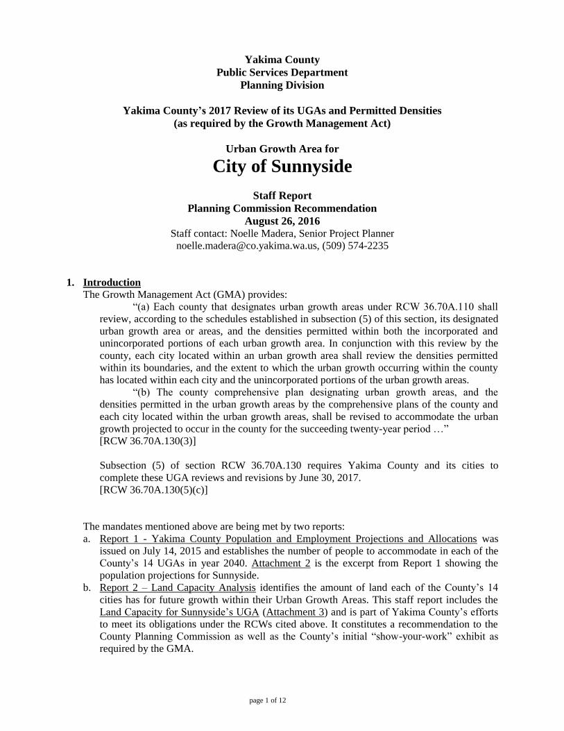
Yakima County
Public Services Department
Planning Division
Yakima County’s 2017 Review of its UGAs and Permitted Densities
(as required by the Growth Management Act)
Urban Growth Area for
City of Sunnyside
Staff Report
Planning Commission Recommendation
August 26, 2016 Staff contact: Noelle Madera, Senior Project Planner
[email protected], (509) 574-2235
1. Introduction
The Growth Management Act (GMA) provides:
“(a) Each county that designates urban growth areas under RCW 36.70A.110 shall
review, according to the schedules established in subsection (5) of this section, its designated
urban growth area or areas, and the densities permitted within both the incorporated and
unincorporated portions of each urban growth area. In conjunction with this review by the
county, each city located within an urban growth area shall review the densities permitted
within its boundaries, and the extent to which the urban growth occurring within the county
has located within each city and the unincorporated portions of the urban growth areas.
“(b) The county comprehensive plan designating urban growth areas, and the
densities permitted in the urban growth areas by the comprehensive plans of the county and
each city located within the urban growth areas, shall be revised to accommodate the urban
growth projected to occur in the county for the succeeding twenty-year period …”
[RCW 36.70A.130(3)]
Subsection (5) of section RCW 36.70A.130 requires Yakima County and its cities to
complete these UGA reviews and revisions by June 30, 2017.
[RCW 36.70A.130(5)(c)]
The mandates mentioned above are being met by two reports:
a. Report 1 - Yakima County Population and Employment Projections and Allocations was
issued on July 14, 2015 and establishes the number of people to accommodate in each of the
County’s 14 UGAs in year 2040. Attachment 2 is the excerpt from Report 1 showing the
population projections for Sunnyside.
b. Report 2 – Land Capacity Analysis identifies the amount of land each of the County’s 14
cities has for future growth within their Urban Growth Areas. This staff report includes the
Land Capacity for Sunnyside’s UGA (Attachment 3) and is part of Yakima County’s efforts
to meet its obligations under the RCWs cited above. It constitutes a recommendation to the
County Planning Commission as well as the County’s initial “show-your-work” exhibit as
required by the GMA.
page 2 of 12
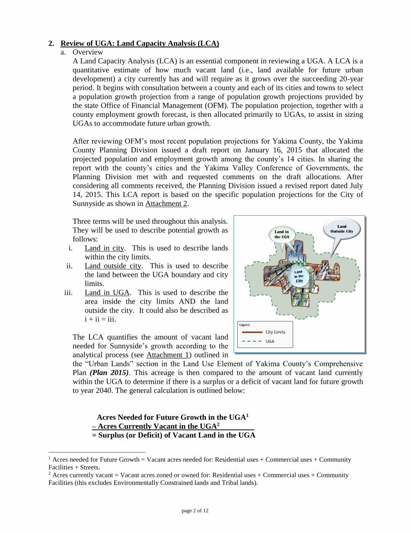
2. Review of UGA: Land Capacity Analysis (LCA)
a. Overview
A Land Capacity Analysis (LCA) is an essential component in reviewing a UGA. A LCA is a
quantitative estimate of how much vacant land (i.e., land available for future urban
development) a city currently has and will require as it grows over the succeeding 20-year
period. It begins with consultation between a county and each of its cities and towns to select
a population growth projection from a range of population growth projections provided by
the state Office of Financial Management (OFM). The population projection, together with a
county employment growth forecast, is then allocated primarily to UGAs, to assist in sizing
UGAs to accommodate future urban growth.
After reviewing OFM’s most recent population projections for Yakima County, the Yakima
County Planning Division issued a draft report on January 16, 2015 that allocated the
projected population and employment growth among the county’s 14 cities. In sharing the
report with the county’s cities and the Yakima Valley Conference of Governments, the
Planning Division met with and requested comments on the draft allocations. After
considering all comments received, the Planning Division issued a revised report dated July
14, 2015. This LCA report is based on the specific population projections for the City of
Sunnyside as shown in Attachment 2.
Three terms will be used throughout this analysis.
They will be used to describe potential growth as
follows:
i. Land in city. This is used to describe lands
within the city limits.
ii. Land outside city. This is used to describe
the land between the UGA boundary and city
limits.
iii. Land in UGA. This is used to describe the
area inside the city limits AND the land
outside the city. It could also be described as
i + ii = iii.
The LCA quantifies the amount of vacant land
needed for Sunnyside’s growth according to the
analytical process (see Attachment 1) outlined in
the “Urban Lands” section in the Land Use Element of Yakima County’s Comprehensive
Plan (Plan 2015). This acreage is then compared to the amount of vacant land currently
within the UGA to determine if there is a surplus or a deficit of vacant land for future growth
to year 2040. The general calculation is outlined below:
Acres Needed for Future Growth in the UGA1
– Acres Currently Vacant in the UGA2 .
= Surplus (or Deficit) of Vacant Land in the UGA
1 Acres needed for Future Growth = Vacant acres needed for: Residential uses + Commercial uses + Community
Facilities + Streets. 2 Acres currently vacant = Vacant acres zoned or owned for: Residential uses + Commercial uses + Community
Facilities (this excludes Environmentally Constrained lands and Tribal lands).
page 3 of 12
b. Quantity of land calculation for non-industrial uses
Yakima County’s Division of Geographic Information Services (GIS) determined the current
acreage of developed residential, commercial & retail, and community facilities. GIS also
determined the acreage of current vacant land and partially vacant3 land in each zoning
district to arrive at the figures used in the LCA spreadsheet (Attachment 3). These GIS data
are reported and depicted geographically in Attachment 4.
The Land Capacity Analysis calculations are described below. The spreadsheet in
Attachment 3 (“UGA Land Capacity Analysis”) performs the calculations and provides
additional information.
1) Population and Households Analysis: Based on Sunnyside’s projected 2015-2040
population growth, this analysis estimates 866 additional households will be added to the
city’s population by the year 2040.
2040 population forecast for city (County Planning) 19,397 people
2015 population in city (OFM’s April 1 estimate) 16,280 people
Population increase in city 2015-2040 3,117 people
Average household size in city (2010 Census) 3.60 people
Additional households in city 2015-2040 (3,117 ÷ 3.60) 866 households
2) Future Residential Land Need: The acreage needed for future residential growth through
2040 was calculated by assuming an average future density of 8,500 sq. ft. of land for
each household (i.e., 5.1 dwelling units per acre) and multiplying this amount by the
number of projected new future households:
8,500 sq. ft. x 866 households = 7,361,000 sq. ft. / 43,560 sq. ft. (1 acre) = 169 acres
3) Future Commercial & Retail Land Need: The acreage needed for future commercial and
retail growth through 2040 was calculated by multiplying the projected population
increase by the current per capita acreage of developed commercially-zoned lands within
the city after subtracting the acreage classified for community facilities (as determined by
GIS analysis):
3,117 people x 0.0264 acres per capita = 82 Acre
4) Future Community Facilities Land Need: The acreage needed for future community
facilities growth through 2040 was calculated by multiplying the projected population
increase by the current per capita acreage of developed community facilities land within
the city (as determined by GIS analysis):
3,117 people x 0.0342 acres per capita = 107 Acres
3 Parcels classified as “partially vacant” are those greater than one acre and have more than $10,000 in assessed
improvements. For such parcels GIS counts one acre as developed and counts the remainder acreage as vacant (i.e.,
available for development). Note: Not all parcel meeting these criteria are classified as partially vacant. Aerial photo
interpretation, local knowledge, and city input are used to limit this classification mostly to residential parcels.
page 4 of 12
5) Future Streets Land Need: The acreage needed for future rights-of-way to accommodate
streets and utilities through 2040 was calculated by multiplying the acreage needed for
future residential, commercial & retail, and community facilities by 15%:
Residential acreage needed 169 Acres
+Commercial/retail acreage needed 82 Acre
+Community facilities acreage needed 107 Acres
=Subtotal 358 Acres
Total streets acreage needed (Subtotal x 0.15) 54 Acres
6) Land Capacity Analysis for Non-Industrial Uses
Next, the needs for land identified above are compared with the amount of existing
vacant land to determine if there is currently a surplus or a deficit of vacant land within
the City and the UGA to accommodate projected growth through 2040. The calculations
are shown in Attachment 3 under Section 6 – “Land Capacity Analysis” and summarized
below:
Total amount of vacant land needed in UGA for future growth (excluding Industrial
growth): Adding the needed acres from the categories above results in the total acreage
calculated below:
Acres needed for future residential uses4 194 Acres
+Acres needed for future commercial & retail uses4 94 Acre
+Acres needed for future community facilities4 123 Acres
=Total vacant acres needed for future non-industrial uses4 411 Acres
Using the figures in Attachment 3, Table 1 summarizes whether each zoning group has a
surplus or a deficit of vacant land to accommodate growth through 2040.
Table 1: Land Capacity Analyses (LCA) Summary – Excluding Industrially-zoned Land
Zoning Group Within City
Limits
Outside City
Limits &
Within
Current UGA
Total: Within
City Limits and
Within Current
UGA
Outside City
Limits and
Within
Proposed UGA
Total: Within
City Limits and
Within
Proposed UGA
Residentially-
zoned4
Surplus:
277 acres
Vacant:
1,182 acres
Surplus:
1,459 acres
Vacant:
1,020 acres
Surplus:
1,297 acres
Commercially-
zoned4
Surplus:
260 acres
Vacant:
85 acres
Surplus:
345 acres
Vacant:
85 acres
Surplus:
345 acres
Community
Facilities4
Surplus:
293 acres
Vacant:
25 acres
Surplus:
318 acres
Vacant:
139 acres
Surplus:
432 acres
Total of above
Zoning Groups4
Surplus:
830 acres
Vacant:
1,292 acres
Surplus:
2,122 acres
Vacant:
1,244 acres
Surplus:
2,074 acres
Using the figures in Attachment 3, Table 2 Summarizes whether the city and the UGA
have a surplus or a deficit of vacant land to accommodate the growth through 2040.
4 Including associated streets
page 5 of 12
Table 2: LCA Summary – In City and In UGA – Excluding Industrially-zoned Land
Yakima County LCA Sunnyside Proposal
Capacity for Growth within City: No changes within City Proposed
1,241 (Acres of currently vacant land in City)
- 411 (Acres needed for growth)
= 830 (Surplus vacant acres in City)
Capacity for Growth within the UGA: Proposed Capacity for Growth within the UGA:
1292 (Acres of currently vacant land outside the
City)
1,241 (Acres vacant within City )
1,244 (Acres of currently vacant land within the
City)
1,241 (Acres vacant within City)
- 411 (Acres needed for growth) - 411 (Acres needed for growth)
= 2,122 (Surplus vacant acres within the Current
UGA)
= 2,074 (Surplus vacant acres within the Proposed
UGA)
A map showing the current configuration and total land area within the UGA is included
as Attachment 4. Proposed changes to the boundary and land area within the UGA are
shown in Attachment 5.
Computed Market Choice Factor (MCF) and “Years of Growth” (excluding Industrial
growth)
One way of quantifying the surplus (or deficit) of vacant land in a city and within its
UGA is to express the surplus (or deficit) as a percentage of the amount of vacant land
that is needed for growth over the 25-year period from 2015 to 2040. For example, if a
city has 120 vacant acres and needs 100 vacant acres for future growth, it has 20% more
vacant land than needed for growth. So the Computed MCF is 20%, as calculated below:
[(acres currently vacant) ÷ (acres needed for future growth)] – 1.00 = Computed MCF
Example: [125 acres ÷ 100 acres] - 1.00 = 0.25 = 25%
An additional way of quantifying the surplus (or deficit) of vacant land available for
future growth is to express the surplus (or deficit) as the number of years it would take to
fill all the vacant land at the projected future growth rate. This metric is a function of the
MCF. For example, if a city has a 0% MCF, this means that the acres of vacant land are
equal to the number of acres needed for growth over the 25 year period from 2015 to
2040, so it has enough land for 25 years of growth, as calculated below. If a city has a
MCF of 100%, this means that it has twice the number of vacant acres available as are
needed for 25 years of growth, so it has enough vacant land for 50 years of growth, as
calculated below:
(Computed MCF + 1) x 25 years = 25 years of growth available
Example 1: (0% MCF + 1) x 25 years = 25 years of growth available
Example 2: (100% MCF + 1) x 25 years = (1 + 1) x 25 years = 50 years of growth
available.
The figures for both the MCF and “years of growth” metrics for Sunnyside are provided
in Table 3.
page 6 of 12
Table 3: Sunnyside’s Computed MCF and Years of Growth Available (Excluding
Industrially zoned Lands)
Lands
within the
city
Lands outside
the city
Growth in
UGA
Proposed Growth in UGA
Computed
MCF
202% N/A 516% 505%
Years of
growth
available
76 years 78 years 154 years 151 years
c. Future Industrial Land Needs
As provided by the analytical process (see Attachment 1) outlined in the “Urban Lands”
section in the Land Use Element of Yakima County’s Comprehensive Plan (Plan 2015), the
amount of land needed for future industrial uses “is based on the city’s economic
development strategy and is not contingent on future population.”
The GIS analysis provides the following current acreages of industrially-zoned lands
(Attachment 3, Section “7 – Future Industrial Land Need”):
Current Proposed
Current developed industrially-zoned land in city 333 acres 333 acres
Current developed industrially-zoned land outside city 142 acres 128 acres
Current vacant industrially-zoned land in city 821 acres 821 acres
Current vacant industrially-zoned land outside city 823 acres 751 acres
Industrial acres to add to UGA 46 acres
Industrial acres to remove from UGA 149 acres
The City of Sunnyside is proposing an overall reduction of Industrial land to the UGA of 103
acres. The specific map additions and reductions can be viewed in Attachment 6. The
reductions to the UGA are driven by the ability of the city to provide capital facilities and
urban infrastructure to these areas within in the 25 year planning horizon. A map showing
the proposed changes to the UGA are included in Attachment 5.
3. Review of Densities Permitted in the UGA
In addition to reviewing Sunnyside’s UGA as done above, RCW 36.70A.130(3)(a) requires
Yakima County to review the densities permitted within both the incorporated and
unincorporated portions of the UGA to ensure project growth may be accommodated.
The City of Sunnyside has four Land Use Designations listed in its Comprehensive Plan that
identify residential growth identified as: Rural Residential/Residential Suburban, Low Density
Residential, Moderate Density Residential, and High Density Residential. The County has one
Residential zoning districts within the UGA and outside of the City. The zoning districts and
corresponding densities are as follows:
City of Sunnyside Zoning
Zoning District Min. Lot Size Density
URA 43,560 sq. ft. 1 du/acre
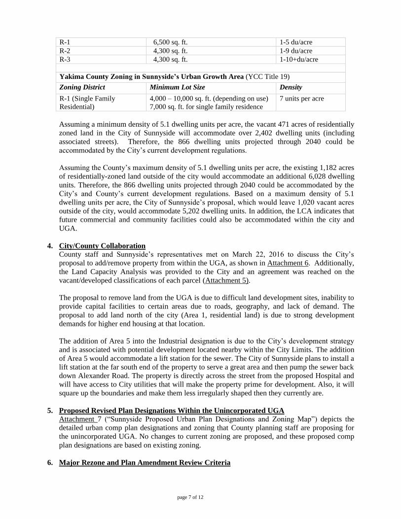
page 7 of 12
R-1 6,500 sq. ft. 1-5 du/acre
R-2 4,300 sq. ft. 1-9 du/acre
R-3 4,300 sq. ft. 1-10+du/acre
Yakima County Zoning in Sunnyside’s Urban Growth Area (YCC Title 19)
Zoning District Minimum Lot Size Density
R-1 (Single Family
Residential)
4,000 – 10,000 sq. ft. (depending on use)
7,000 sq. ft. for single family residence
7 units per acre
Assuming a minimum density of 5.1 dwelling units per acre, the vacant 471 acres of residentially
zoned land in the City of Sunnyside will accommodate over 2,402 dwelling units (including
associated streets). Therefore, the 866 dwelling units projected through 2040 could be
accommodated by the City’s current development regulations.
Assuming the County’s maximum density of 5.1 dwelling units per acre, the existing 1,182 acres
of residentially-zoned land outside of the city would accommodate an additional 6,028 dwelling
units. Therefore, the 866 dwelling units projected through 2040 could be accommodated by the
City’s and County’s current development regulations. Based on a maximum density of 5.1
dwelling units per acre, the City of Sunnyside’s proposal, which would leave 1,020 vacant acres
outside of the city, would accommodate 5,202 dwelling units. In addition, the LCA indicates that
future commercial and community facilities could also be accommodated within the city and
UGA.
4. City/County Collaboration
County staff and Sunnyside’s representatives met on March 22, 2016 to discuss the City’s
proposal to add/remove property from within the UGA, as shown in Attachment 6. Additionally,
the Land Capacity Analysis was provided to the City and an agreement was reached on the
vacant/developed classifications of each parcel (Attachment 5).
The proposal to remove land from the UGA is due to difficult land development sites, inability to
provide capital facilities to certain areas due to roads, geography, and lack of demand. The
proposal to add land north of the city (Area 1, residential land) is due to strong development
demands for higher end housing at that location.
The addition of Area 5 into the Industrial designation is due to the City’s development strategy
and is associated with potential development located nearby within the City Limits. The addition
of Area 5 would accommodate a lift station for the sewer. The City of Sunnyside plans to install a
lift station at the far south end of the property to serve a great area and then pump the sewer back
down Alexander Road. The property is directly across the street from the proposed Hospital and
will have access to City utilities that will make the property prime for development. Also, it will
square up the boundaries and make them less irregularly shaped then they currently are.
5. Proposed Revised Plan Designations Within the Unincorporated UGA
Attachment 7 (“Sunnyside Proposed Urban Plan Designations and Zoning Map”) depicts the
detailed urban comp plan designations and zoning that County planning staff are proposing for
the unincorporated UGA. No changes to current zoning are proposed, and these proposed comp
plan designations are based on existing zoning.
6. Major Rezone and Plan Amendment Review Criteria
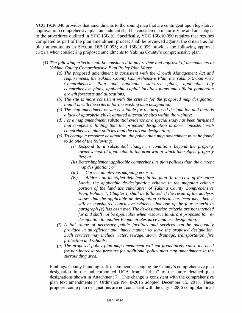
page 8 of 12
YCC 19.36.040 provides that amendments to the zoning map that are contingent upon legislative
approval of a comprehensive plan amendment shall be considered a major rezone and are subject
to the procedures outlined in YCC 16B.10. Specifically, YCC 16B.10.090 requires that rezones
completed as part of the plan amendment process shall be reviewed against the criteria as for
plan amendments in Section 16B.10.095; and 16B.10.095 provides the following approval
criteria when considering proposed amendments to Yakima County’s comprehensive plan:
(1) The following criteria shall be considered in any review and approval of amendments to
Yakima County Comprehensive Plan Policy Plan Maps:
(a) The proposed amendment is consistent with the Growth Management Act and
requirements, the Yakima County Comprehensive Plan, the Yakima Urban Area
Comprehensive Plan and applicable sub-area plans, applicable city
comprehensive plans, applicable capital facilities plans and official population
growth forecasts and allocations;
(b) The site is more consistent with the criteria for the proposed map designation
than it is with the criteria for the existing map designation;
(c) The map amendment or site is suitable for the proposed designation and there is
a lack of appropriately designated alternative sites within the vicinity;
(d) For a map amendment, substantial evidence or a special study has been furnished
that compels a finding that the proposed designation is more consistent with
comprehensive plan policies than the current designation;
(e) To change a resource designation, the policy plan map amendment must be found
to do one of the following:
(i) Respond to a substantial change in conditions beyond the property
owner’s control applicable to the area within which the subject property
lies; or
(ii) Better implement applicable comprehensive plan policies than the current
map designation; or
(iii) Correct an obvious mapping error; or
(iv) Address an identified deficiency in the plan. In the case of Resource
Lands, the applicable de-designation criteria in the mapping criteria
portion of the land use subchapter of Yakima County Comprehensive
Plan, Volume 1, Chapter I, shall be followed. If the result of the analysis
shows that the applicable de-designation criteria has been met, then it
will be considered conclusive evidence that one of the four criteria in
paragraph (e) has been met. The de-designation criteria are not intended
for and shall not be applicable when resource lands are proposed for re-
designation to another Economic Resource land use designation;
(f) A full range of necessary public facilities and services can be adequately
provided in an efficient and timely manner to serve the proposed designation.
Such services may include water, sewage, storm drainage, transportation, fire
protection and schools;
(g) The proposed policy plan map amendment will not prematurely cause the need
for nor increase the pressure for additional policy plan map amendments in the
surrounding area.
Findings: County Planning staff recommends changing the County’s comprehensive plan
designation in the unincorporated UGA from “Urban” to the more detailed plan
designations shown in Attachment 7. This change is consistent with the comprehensive
plan text amendments in Ordinance No. 8-2015 adopted December 15, 2015. These
proposed comp plan designations are not consistent with the City’s 2006 comp plan in all
page 9 of 12
locations, but Sunnyside may propose changes to the unincorporated area at a later date,
at which time consistency will be considered.
(2) The following criteria shall be considered in any review and approval of changes to
Urban Growth Area (UGA) boundaries:
(a) Land Supply:
(i) The amount of buildable land suitable for residential and local
commercial development within the incorporated and the unincorporated
portions of the Urban Growth Areas will accommodate the adopted
population allocation and density targets;
(ii) The amount of buildable land suitable for purposes other than residential
and local commercial development within the incorporated and the
unincorporated portions of the Urban Growth Areas will accommodate
the adopted forecasted urban development density targets within the
succeeding twenty-year period;
(iii) The Planning Division will use the definition of buildable land in YCC
16B.02.045, the criteria established in RCW 36.70A.110 and .130 and
applicable criteria in the Comprehensive Plan and development
regulations;
(iv) The Urban Growth Area boundary incorporates the amount of land
determined to be appropriate by the County to support the population
density targets;
(b) Utilities and services:
(i) The provision of urban services for the Urban Growth Area is prescribed,
and funding responsibilities delineated, in conformity with the
comprehensive plan, including applicable capital facilities, utilities, and
transportation elements, of the municipality;
(ii) Designated Ag. resource lands, except for mineral resource lands that
will be reclaimed for urban uses, may not be included within the UGA
unless it is shown that there are no practicable alternatives and the lands
meet the de-designation criteria set forth in the comprehensive plan.
Findings: Yakima County staff analysis above supports the conclusion that this proposal
is consistent with the above criteria.
(3) Land added to or removed from Urban Growth Areas shall be given appropriate policy
plan map designation and zoning by Yakima County, consistent with adopted
comprehensive plan(s).
Findings: Lands added and removed from the UGA in Attachment 6 will be consistent
with Yakima County Urban Growth Area future land use text amendments in Ordinance
No. 8-2015 and County zoning designations.
(4) Cumulative impacts of all plan amendments, including those approved since the original
adoption of the plan, shall be considered in the evaluation of proposed plan amendments.
Findings: A table showing the cumulative impacts of all proposed amendments being
considered in 2016 will be provided as part of the SEPA analysis (File#SEP2016-00006).
page 10 of 12
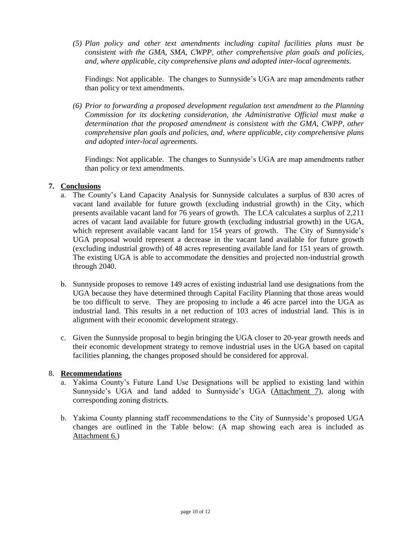
(5) Plan policy and other text amendments including capital facilities plans must be
consistent with the GMA, SMA, CWPP, other comprehensive plan goals and policies,
and, where applicable, city comprehensive plans and adopted inter-local agreements.
Findings: Not applicable. The changes to Sunnyside’s UGA are map amendments rather
than policy or text amendments.
(6) Prior to forwarding a proposed development regulation text amendment to the Planning
Commission for its docketing consideration, the Administrative Official must make a
determination that the proposed amendment is consistent with the GMA, CWPP, other
comprehensive plan goals and policies, and, where applicable, city comprehensive plans
and adopted inter-local agreements.
Findings: Not applicable. The changes to Sunnyside’s UGA are map amendments rather
than policy or text amendments.
7. Conclusions
a. The County’s Land Capacity Analysis for Sunnyside calculates a surplus of 830 acres of
vacant land available for future growth (excluding industrial growth) in the City, which
presents available vacant land for 76 years of growth. The LCA calculates a surplus of 2,211
acres of vacant land available for future growth (excluding industrial growth) in the UGA,
which represent available vacant land for 154 years of growth. The City of Sunnyside’s
UGA proposal would represent a decrease in the vacant land available for future growth
(excluding industrial growth) of 48 acres representing available land for 151 years of growth.
The existing UGA is able to accommodate the densities and projected non-industrial growth
through 2040.
b. Sunnyside proposes to remove 149 acres of existing industrial land use designations from the
UGA because they have determined through Capital Facility Planning that those areas would
be too difficult to serve. They are proposing to include a 46 acre parcel into the UGA as
industrial land. This results in a net reduction of 103 acres of industrial land. This is in
alignment with their economic development strategy.
c. Given the Sunnyside proposal to begin bringing the UGA closer to 20-year growth needs and
their economic development strategy to remove industrial uses in the UGA based on capital
facilities planning, the changes proposed should be considered for approval.
8. Recommendations a. Yakima County’s Future Land Use Designations will be applied to existing land within
Sunnyside’s UGA and land added to Sunnyside’s UGA (Attachment 7), along with
corresponding zoning districts.
b. Yakima County planning staff recommendations to the City of Sunnyside’s proposed UGA
changes are outlined in the Table below: (A map showing each area is included as
Attachment 6.)
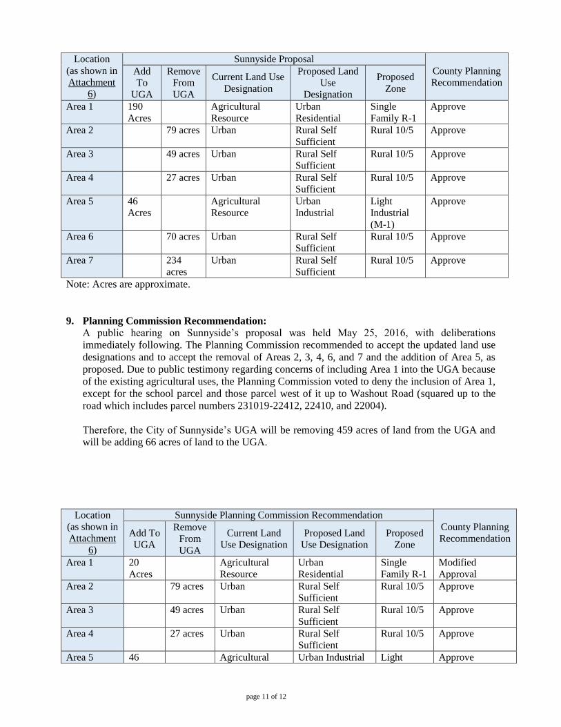
page 11 of 12
Location
(as shown in
Attachment
6)
Sunnyside Proposal
County Planning
Recommendation Add
To
UGA
Remove
From
UGA
Current Land Use
Designation
Proposed Land
Use
Designation
Proposed
Zone
Area 1 190
Acres
Agricultural
Resource
Urban
Residential
Single
Family R-1
Approve
Area 2 79 acres Urban Rural Self
Sufficient
Rural 10/5 Approve
Area 3 49 acres Urban Rural Self
Sufficient
Rural 10/5 Approve
Area 4 27 acres Urban Rural Self
Sufficient
Rural 10/5 Approve
Area 5 46
Acres
Agricultural
Resource
Urban
Industrial
Light
Industrial
(M-1)
Approve
Area 6 70 acres Urban Rural Self
Sufficient
Rural 10/5 Approve
Area 7 234
acres
Urban Rural Self
Sufficient
Rural 10/5 Approve
Note: Acres are approximate.
9. Planning Commission Recommendation:
A public hearing on Sunnyside’s proposal was held May 25, 2016, with deliberations
immediately following. The Planning Commission recommended to accept the updated land use
designations and to accept the removal of Areas 2, 3, 4, 6, and 7 and the addition of Area 5, as
proposed. Due to public testimony regarding concerns of including Area 1 into the UGA because
of the existing agricultural uses, the Planning Commission voted to deny the inclusion of Area 1,
except for the school parcel and those parcel west of it up to Washout Road (squared up to the
road which includes parcel numbers 231019-22412, 22410, and 22004).
Therefore, the City of Sunnyside’s UGA will be removing 459 acres of land from the UGA and
will be adding 66 acres of land to the UGA.
Location
(as shown in
Attachment
6)
Sunnyside Planning Commission Recommendation
County Planning
Recommendation Add To
UGA
Remove
From
UGA
Current Land
Use Designation
Proposed Land
Use Designation
Proposed
Zone
Area 1 20
Acres
Agricultural
Resource
Urban
Residential
Single
Family R-1
Modified
Approval
Area 2 79 acres Urban Rural Self
Sufficient
Rural 10/5 Approve
Area 3 49 acres Urban Rural Self
Sufficient
Rural 10/5 Approve
Area 4 27 acres Urban Rural Self
Sufficient
Rural 10/5 Approve
Area 5 46 Agricultural Urban Industrial Light Approve
page 12 of 12
Acres Resource Industrial
(M-1)
Area 6 70 acres Urban Rural Self
Sufficient
Rural 10/5 Approve
Area 7 234 acres Urban Rural Self
Sufficient
Rural 10/5 Approve
Note: Acres are approximate.
Attachments:
1. Plan 2015’s description of the analytical process for the UGA Land Capacity Analysis
2. County’s Population Projection for City of Sunnyside, 2015-2040
3. UGA Land Capacity Analysis (spreadsheet)
4. Sunnyside Current UGA Analysis 2016 (GIS map & report)
5. Sunnyside Proposed UGA Analysis 2016 (GIS map & report)
6. Sunnyside Proposed UGA Changes
7. Sunnyside Proposed Urban Plan Designations and Zoning Map
8. Sunnyside UGA Planning Commission’s Recommended Changes
9. Sunnyside UGA Planning Commission’s Recommended Plan Designations and Zoning Map

Plan 2015 - Policy Plan Land Use
I-LU-6 May 1997;GMA Update December 2007
Urban Lands Urban Growth Areas Purpose The intent of the Urban Growth Areas land use category is to implement the Growth Management Act’s Planning Goal 1: "Encourage development in urban areas where adequate public facilities and services exist or can be provided in an efficient manner." In determining areas to be set aside for future urbanization, the County and cities mutually endorsed a County-Wide Planning Policy. It states that areas designated for urban growth should be determined by preferred development patterns, residential densities, and the capacity and willingness of the community to provide urban governmental services. The Urban designation is intended to include land that is characterized by urban growth or will be needed for urbanization, consistent with forecasted population growth and the ability to extend urban services. The Urban Growth Area designation is intended to establish the area within which incorporated cities and towns may grow and annex over the next twenty years. Yakima County’s Urban Growth Area land use category is also intended to implement Washington Admini-strative Code, which states that "the physical area within which that jurisdiction's vision of urban development can be realized over the next twenty years." Specific discrete plan designations such as residential, open space, urban reserve, commercial or industrial are found in the respective jurisdiction’s compre-hensive, subarea or neighborhood plan. General Description In general, an urban growth area extends from each of Yakima County’s 14 cities and towns. Since the cities have historically developed in the valley floors, they tend to be surrounded by irrigated agri-culture, and are likely to include geologically hazardous areas, wetlands and other wildlife
habitat, or river gravels suitable for mining. "Urban growth" means that land is used so intensively for buildings, structures, and impermeable surfaces that viable agriculture, forestry or mining is not feasible. Urban governmental services are either available, or could be provided without excessive public cost. Urban governmental services typically include water and sewer systems, street cleaning services, fire and police protection services, and public transit services. Based on their respective comprehensive, subarea or neighborhood plans, cities and other service providers must be able to demonstrate both ability and willingness to supply designated urban areas with these services within the 20 year planning period. In evaluating the quantity of land necessary for urban growth, the following analytical process should be followed: 1. Determine how much housing is
necessary for 20 years of growth. Subtract the City’s current year population from the projected 20 year population figure to determine the additional number that represents 20 years of growth. Based on a city’s average household size, calculate the number of additional dwelling units to allow for.
2. Determine the necessary residential
acreage.
Determine the desired and appropriate housing densities in collaboration with the cities. Calculate how many acres are needed to accommodate the number of new dwelling units based on the desired and appropriate densities A percentage can be added to allow for market choice and location preference.
3. Determine the necessary commercial
and retail acreage.
Attachment 1
Plan 2015 - Policy Plan Land Use
May 1997; GMA Update December 2007 I-LU-7
Divide the existing commercial and retail acreage by the current population to arrive at a commercial/retail acreage per capita figure. Multiply this per capita number by the additional population identified in Step #1. This will give you the amount of additional commercial/retail acreage needed. A percentage can be added to allow for market choice and location preference.
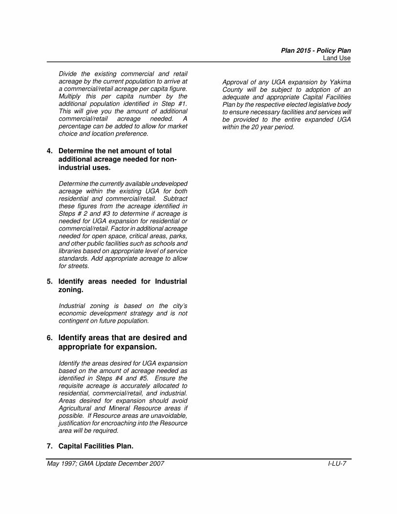
4. Determine the net amount of total
additional acreage needed for non-industrial uses.
Determine the currently available undeveloped acreage within the existing UGA for both residential and commercial/retail. Subtract these figures from the acreage identified in Steps # 2 and #3 to determine if acreage is needed for UGA expansion for residential or commercial/retail. Factor in additional acreage needed for open space, critical areas, parks, and other public facilities such as schools and libraries based on appropriate level of service standards. Add appropriate acreage to allow for streets.
5. Identify areas needed for Industrial zoning.
Industrial zoning is based on the city’s economic development strategy and is not contingent on future population.
6. Identify areas that are desired and appropriate for expansion.
Identify the areas desired for UGA expansion based on the amount of acreage needed as identified in Steps #4 and #5. Ensure the requisite acreage is accurately allocated to residential, commercial/retail, and industrial. Areas desired for expansion should avoid Agricultural and Mineral Resource areas if possible. If Resource areas are unavoidable, justification for encroaching into the Resource area will be required.
7. Capital Facilities Plan.
Approval of any UGA expansion by Yakima County will be subject to adoption of an adequate and appropriate Capital Facilities Plan by the respective elected legislative body to ensure necessary facilities and services will be provided to the entire expanded UGA within the 20 year period.
Attachment 2
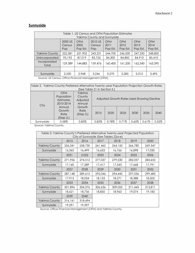
Sunnyside
Table 1. US Census and OFM Population Estimates
Yakima County and Sunnyside
2000 US
Census
Pop
OFM
2005
Pop Est.
2010 US
Census
Pop
OFM
2011
Pop Est.
OFM
2012
Pop Est.
OFM
2013
Pop Est.
OFM
2014
Pop Est.
Yakima County 222,581 231,902 243,231 244,700 246,000 247,250 248,800
Unincorporated 93,192 87,019 83,755 84,300 84,800 84,910 85,410
Incorporated
Total 129,389 144,883 159,476 160,400 161,200 162,340 163,390
Sunnyside 2,530 2,968 3,246 3,270 3,285 3,315 3,495
Source: US Census, Office Financial Management (OFM).
Table 2. Yakima County Preferred Alternative Twenty-year Population Projection Growth Rates
(See Table 21 in Section II.)
City
OFM
Population
Estimates
2010-2014
Annual
Growth
Rate
(Step 2.)
Yakima
County
Adjusted
Annual
Growth
Rate
(Step 3.)
Adjusted Growth Rates Used Showing Decline
2015 2020 2025 2030 2035 2040
Sunnyside 0.58% 0.83% 0.83% 0.78% 0.71% 0.65% 0.61% 0.55%
Source: Yakima County.
Table 3. Yakima County’s Preferred Alternative Twenty-year Projected Population
City of Sunnyside (See Tables 22a-e)
2015 2016 2017 2018 2019 2020
Yakima County 256,341 258,730 261,462 264,150 266,780 269,347
Sunnyside 16,365 16,499 16,633 16,766 16,898 17,030
2021 2,022 2023 2024 2025 2026
Yakima County 271,956 274,512 277,037 279,530 282,057 284,652
Sunnyside 17,160 17,289 17,417 17,543 17,668 17,791
2027 2028 2029 2030 2031 2032
Yakima County 287,148 289,615 292,046 294,445 297,036 299,485
Sunnyside 17,913 18,034 18,153 18,271 18,388 18,505
2033 2034 2035 2036 2037 2038
Yakima County 301,896 304,276 306,636 309,052 311,443 313,811
Sunnyside 18,621 18,736 18,850 18,963 19,074 19,183
2039 2040
Yakima County 316,161 318,494
Sunnyside 19,291 19,397
Source: Office Financial Management (OFM) and Yakima County.
Attachment 2
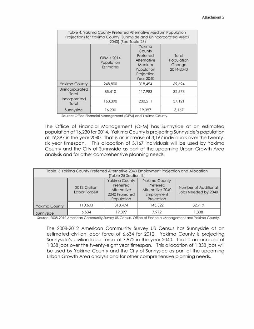
Table 4. Yakima County Preferred Alternative Medium Population
Projections for Yakima County, Sunnyside and Unincorporated Areas
(2040) (See Table 23)
OFM’s 2014
Population
Estimates
Yakima
County
Preferred
Alternative
Medium
Population
Projection
Year 2040
Total
Population
Change
2014-2040
Yakima County 248,800 318,494 69,694
Unincorporated
Total 85,410 117,983 32,573
Incorporated
Total 163,390 200,511 37,121
Sunnyside 16,230 19,397 3,167
Source: Office Financial Management (OFM) and Yakima County.
The Office of Financial Management (OFM) has Sunnyside at an estimated
population of 16,230 for 2014. Yakima County is projecting Sunnyside’s population
at 19,397 in the year 2040. That is an increase of 3,167 individuals over the twenty-
six year timespan. This allocation of 3,167 individuals will be used by Yakima
County and the City of Sunnyside as part of the upcoming Urban Growth Area
analysis and for other comprehensive planning needs.
Table. 5 Yakima County Preferred Alternative 2040 Employment Projection and Allocation
(Table 25 Section III.)
2012 Civilian
Labor Force#
Yakima County
Preferred
Alternative
2040 Projected
Population
Yakima County
Preferred
Alternative 2040
Employment
Projection
Number of Additional
Jobs Needed by 2040
Yakima County 110,603 318,494 143,322 32,719
Sunnyside 6,634 19,397 7,972 1,338
Source: 2008-2012 American Community Survey US Census, Office of Financial Management and Yakima County.
The 2008-2012 American Community Survey US Census has Sunnyside at an
estimated civilian labor force of 6,634 for 2012. Yakima County is projecting
Sunnyside’s civilian labor force at 7,972 in the year 2040. That is an increase of
1,338 jobs over the twenty-eight year timespan. This allocation of 1,338 jobs will
be used by Yakima County and the City of Sunnyside as part of the upcoming
Urban Growth Area analysis and for other comprehensive planning needs.
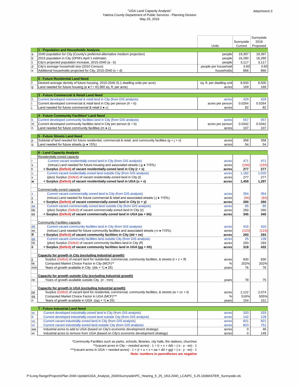
"UGA Land Capacity Analysis"
Yakima County Department of Public Services - Planning Division
May 25, 2016
Attachment 3
Units
Sunnyside
Current
Sunnyside
2016
Proposed
1 - Population and Households Analysis
a 2040 population for City (County's preferred alternative medium projection) people 19,397 19,397
b 2015 population in City (OFM's April 1 estimate) people 16,280 16,280
c City's projected population increase, 2015-2040 (a - b) people 3,117 3,117
d City's average household size (2010 Census) people per household 3.60 3.60
e Additional households projected for City, 2015-2040 (c ÷ d) households 866 866
2 - Future Residential Land Need
f Desired average density of future housing, 2015-2040 (5.1 dwelling units per acre) sq. ft. per dwelling unit 8,500 8,500
g Land needed for future housing (e ● f ÷ 43,560 sq. ft. per acre) acres 169 169
3 - Future Commercial & Retail Land Need
h Current developed commercial & retail land in City (from GIS analysis) acres 429 429
i Current developed commercial & retail land in City per person (h ÷ b) acres per person 0.0264 0.0264
j Land needed for future commercial & retail (i ● c) acres 82 82
4 - Future Community Facilities* Land Need
k Current developed community facilities land in City (from GIS analysis) acres 557 557
m Current developed community facilities land in City per person (k ÷ b) acres per person 0.0342 0.0342
n Land needed for future community facilities (m ● c) acres 107 107
5 - Future Streets Land Need
p Subtotal of land needed for future residential, commercial & retail, and community facilities (g + j + n) acres 358 358
q Land needed for future streets (p ● 15%) acres 54 54
6 - Land Capacity Analysis
Residentially-zoned capacity
r Current vacant residentially-zoned land in City (from GIS analysis) acres 471 471
s (minus) Land needed for future housing and associated streets (-g ● 115%) acres (194) (194)
t = Surplus (Deficit) of vacant residentially-zoned land in City (r + s) acres 277 277
u Current vacant residentially-zoned land outside City (from GIS analysis) acres 1,182 1,020
v (plus) Surplus (Deficit) of vacant residentially-zoned land in City (t) acres 277 277
w = Surplus (Deficit) of vacant residentially-zoned land in UGA (u + v) acres 1,459 1,297
Commercially-zoned capacity
x Current vacant commercially-zoned land in City (from GIS analysis) acres 354 354
y (minus) Land needed for future commercial & retail and associated streets (-j ● 115%) acres (94) (94)
z = Surplus (Deficit) of vacant commercially-zoned land in City (x + y) acres 260 260
aa Current vacant commercially-zoned land outside City (from GIS analysis) acres 85 85
bb (plus) Surplus (Deficit) of vacant commercially-zoned land in City (z) acres 260 260
cc = Surplus (Deficit) of vacant commercially-zoned land in UGA (aa + bb) acres 345 345
Community Facilities capacity
dd Current vacant community facilities land in City (from GIS analysis) acres 416 416
ee (minus) Land needed for future community facilities and associated streets (-n ● 115%) acres (123) (123)
ff = Surplus (Deficit) of vacant community facilities in City (dd + ee) acres 293 293
gg Current vacant community facilities land outside City (from GIS analysis) acres 25 139
hh (plus) Surplus (Deficit) of vacant community facilities land in City (ff) acres 293 293
ii = Surplus (Deficit) of vacant community facilities land in UGA (gg + hh) acres 318 432
Capacity for growth in City (excluding Industrial growth)
jj Surplus (Deficit) of vacant land for residential, commercial, community facilities, & streets (t + z + ff) acres 830 830
kk Computed Market Choice Factor in City (MCF)** % 202% 202%
mm Years of growth available in City ((kk + 1) ● 25) years 76 76
Capacity for growth outside City (excluding Industrial growth)
nn Years of growth available outside City (rr - mm) years 78 75
Capacity for growth in UGA (excluding Industrial growth)
pp Surplus (Deficit) of vacant land for residential, commercial, community facilities, & streets (w + cc + ii) acres 2,122 2,074
qq Computed Market Choice Factor in UGA (MCF)*** % 516% 505%
rr Years of growth available in UGA ((qq + 1) ● 25) years 154 151
7 - Future Industrial Land Need
ss Current developed industrially-zoned land in City (from GIS analysis) acres 333 333
tt Current developed industrially-zoned land outside City (from GIS analysis) acres 142 128
uu Current vacant industrially-zoned land in City (from GIS analysis) acres 821 821
vv Current vacant industrially-zoned land outside City (from GIS analysis) acres 823 751
ww Industrial acres to add to UGA (based on City's economic development strategy) acres 0 46
xx Industrial acres to remove from UGA (based on City's economic development strategy) acres 0 149
*Community Facilities such as parks, schools, libraries, city halls, fire stations, churches
**(vacant acres in City ÷ needed acres) - 1 = (r + x + dd) ÷ (-s - y - ee) - 1
***(vacant acres in UGA ÷ needed acres) - 1 = (r + u + x + aa + dd + gg) ÷ (-s - y - ee) - 1
Note: numbers in parentheses are negative
P:\Long Range\Projects\Plan 2040 Update\UGA_Analysis_2040\Sunnyside\PC_Hearing_5_25_16\3.2040_LCA(PC_5.25.16)MASTER_Sunnyside.xls
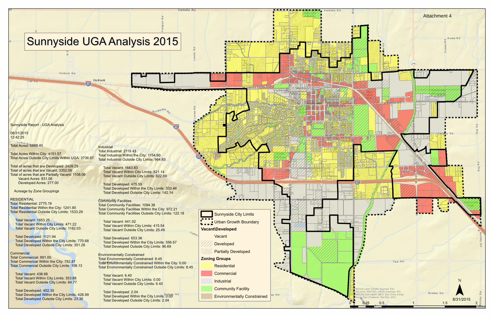
Sunnyside UGA Analysis 2015Sunnyside UGA Analysis 2015
0 0.5 1 1.5 20.25Miles
¯8/31/2015
Service Layer Credits: Sources: Esri,DeLorme, NAVTEQ, USGS, Intermap, iPC,NRCAN, Esri Japan, METI, Esri China (HongKong), Esri (Thailand), TomTom, 2013
Sunnyside City LimitsUrban Growth Boundary
Vacant\DevelopedVacantDevelopedPartially Developed
Zoning GroupsResidentialCommercialIndustrialCommunity FacilityEnvironmentally Constrained
Sunnyside Report - UGA Analysis08/31/201512:42:25Total Acres: 6888.45Total Acres Within City: 4151.57Total Acres Outside City Limits Within UGA: 2736.87Total of acres that are Developed: 2428.29Total of acres that are Vacant: 3352.09Total of acres that are Partially Vacant: 1108.06 Vacant Acres: 831.06 Developed Acres: 277.00 Acreage by Zone GroupingsRESIDENTIALTotal Residential: 2775.19Total Residential Within the City: 1241.90Total Residential Outside City Limits: 1533.29 Total Vacant: 1653.25 Total Vacant Within City Limits: 471.22 Total Vacant Outside City Limits: 1182.03 Total Developed: 1121.94 Total Developed Within the City Limits: 770.68 Total Developed Outside City Limits: 351.26CommercialTotal Commercial: 891.00Total Commercial Within the City: 782.87Total Commercial Outside City Limits: 108.13 Total Vacant: 438.66 Total Vacant Within City Limits: 353.88 Total Vacant Outside City Limits: 84.77 Total Developed: 452.35 Total Developed Within the City Limits: 428.99 Total Developed Outside City Limits: 23.36
IndustrialTotal Industrial: 2119.43Total Industrial Within the City: 1154.60Total Industrial Outside City Limits: 964.83 Total Vacant: 1643.83 Total Vacant Within City Limits: 821.14 Total Vacant Outside City Limits: 822.69 Total Developed: 475.59 Total Developed Within the City Limits: 333.46 Total Developed Outside City Limits: 142.14Community FacilitiesTotal Community Facilities: 1094.38Total Community Facilities Within the City: 972.21Total Community Facilities Outside City Limits: 122.18 Total Vacant: 441.02 Total Vacant Within City Limits: 415.54 Total Vacant Outside City Limits: 25.49 Total Developed: 653.36 Total Developed Within the City Limits: 556.67 Total Developed Outside City Limits: 96.69Environmentally ConstrainedTotal Environmentally Constrained: 8.45Total Environmentally Constrained Within the City: 0.00Total Environmentally Constrained Outside City Limits: 8.45 Total Vacant: 6.40 Total Vacant Within City Limits: 0.00 Total Vacant Outside City Limits: 6.40 Total Developed: 2.04 Total Developed Within the City Limits: 0.00 Total Developed Outside City Limits: 2.04
Attachment 4
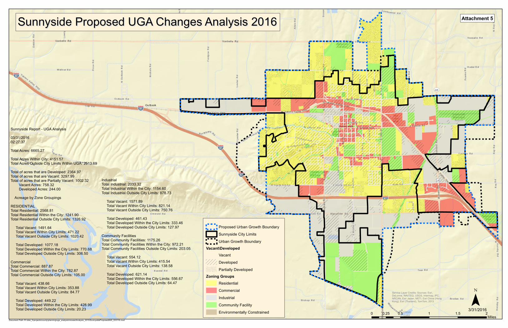
Sunnyside Proposed UGA Changes Analysis 2016Sunnyside Proposed UGA Changes Analysis 2016
0 0.5 1 1.5 20.25Miles
¯3/31/2016
Service Layer Credits: Sources: Esri,DeLorme, NAVTEQ, USGS, Intermap, iPC,NRCAN, Esri Japan, METI, Esri China (HongKong), Esri (Thailand), TomTom, 2013
Sunnyside Report - UGA Analysis03/31/201602:27:37Total Acres: 6665.27Total Acres Within City: 4151.57Total Acres Outside City Limits Within UGA: 2513.69Total of acres that are Developed: 2364.97Total of acres that are Vacant: 3297.99Total of acres that are Partially Vacant: 1002.32 Vacant Acres: 758.32 Developed Acres: 244.00 Acreage by Zone GroupingsRESIDENTIALTotal Residential: 2568.81Total Residential Within the City: 1241.90Total Residential Outside City Limits: 1326.92 Total Vacant: 1491.64 Total Vacant Within City Limits: 471.22 Total Vacant Outside City Limits: 1020.42 Total Developed: 1077.18 Total Developed Within the City Limits: 770.68 Total Developed Outside City Limits: 306.50CommercialTotal Commercial: 887.87Total Commercial Within the City: 782.87Total Commercial Outside City Limits: 105.00 Total Vacant: 438.66 Total Vacant Within City Limits: 353.88 Total Vacant Outside City Limits: 84.77 Total Developed: 449.22 Total Developed Within the City Limits: 428.99 Total Developed Outside City Limits: 20.23
IndustrialTotal Industrial: 2033.32Total Industrial Within the City: 1154.60Total Industrial Outside City Limits: 878.73 Total Vacant: 1571.89 Total Vacant Within City Limits: 821.14 Total Vacant Outside City Limits: 750.76 Total Developed: 461.43 Total Developed Within the City Limits: 333.46 Total Developed Outside City Limits: 127.97Community FacilitiesTotal Community Facilities: 1175.26Total Community Facilities Within the City: 972.21Total Community Facilities Outside City Limits: 203.05 Total Vacant: 554.12 Total Vacant Within City Limits: 415.54 Total Vacant Outside City Limits: 138.58 Total Developed: 621.14 Total Developed Within the City Limits: 556.67 Total Developed Outside City Limits: 64.47
Proposed Urban Growth BoundarySunnyside City LimitsUrban Growth Boundary
Vacant\DevelopedVacantDevelopedPartially Developed
Zoning GroupsResidentialCommercialIndustrialCommunity FacilityEnvironmentally Constrained
Document Path: R:\disk_5\projects\county\planning\uga_analysis\moxee\Analysis_2015\SunnysideProposedAtt5_033116.mxd
Attachment 5
Yakima Valley Hwy
Van Belle Rd
Emerald Rd
Scoo
n Rd
Alexander Rd
S 1st
St
E Edison Ave
Waneta RdS 6
th St
E Edison Rd
E Lincoln Ave
Zillah Ave
N 1s
t St
Midv
ale R
d
§̈¦I-82
§̈¦I-82
State
Route
241
Mabto
n Sun
nysid
e Rd
Sheller Rd
S 16th
StN
16th
StMa
bton S
unny
side R
d
Attachment 6
GEOGRAPHIC INFORMATION SERVICES
Y A K
I M A
C O
U N
T Y
SunnysideProposed UGA
Changes
Date:4/04/2016̈
0 2,400 4,800 7,200 9,600 feet
1 inch = 2700 feet
Parcel Lot lines are for visual displayonly. Do not use for legal purposes.
Sunnyside City Limits
Proposed Urban Growth Boundary
Urban Growth Boundary
R-1 - Single Family ResidentialAG - AgricuturalGC - General CommercialM-1 - Light IndustrialR-10/5 - Rural -10/5
County Zoning
County ComprehensivePlan Designations
U - UrbanUR - Urban ResidentialUP - Urban PublicUC - Urban CommercialUI - Urban IndustrialUT - Urban TribalAR - Agricultural ResourceRSS - Rural Self-Sufficient
Area 6) REMOVE 70 AcresU to RSS (Zone Rural 10/5)
Area 2) REMOVE 79 AcresU to RSS (Zone Rural 10/5)
Area 3) REMOVE 49 AcresU to RSS (Zone Rural 10/5)
Area 4) REMOVE27 AcresU to RSS(Zone Rural 10/5)
Area 5) Add 46 AcresAR to UI (Zone M-1)
Area 1) ADD 190 AcresAR to UR (Zone R-1)
Area 7) REMOVE 234 AcresU to RSS (Zone Rural 10/5)
Document Path: R:\disk_5\projects\county\planning\uga_analysis\sunnyside\Analysis2015\SunnysideChangesAtt6_040416.mxd
Yakima Valley Hwy
Van Belle Rd
Emerald Rd
Scoo
n Rd
Alexander Rd
§̈¦I-82
§̈¦I-82
State
Route
241
Attachment 7
GEOGRAPHIC INFORMATION SERVICES
Y A K
I M A
C O
U N
T Y Sunnyside
ProposedUrban Plan
Designations andZoning Map
Date:4/04/2016̈
0 2,400 4,800 7,200 9,600 feet
1 inch = 2700 feet
Parcel Lot lines are for visual displayonly. Do not use for legal purposes.
R-1 - Single Family ResidentialB-2 - Local BusinessHTC - Highway/Tourist CommercialGC - General CommercialM-1 - Light IndustrialR-10/5 - Rural -10/5
County Zoning
County ComprehensivePlan Designations
Document Path: R:\disk_5\projects\county\planning\uga_analysis\sunnyside\Analysis2015\SunnysideChangesAtt7_051116.mxd
M-1 M-1 GCR-1
R-1 R-1
R-1R-1 M-1
M-1
M-1M-1
R-1
R-10/5
R-10/5
R-1
GCB-2
HTCR-10/5M-1
M-1
M-1
R-1
R-10/5
R-1
M-1
M-1
R-1
R-1
R-10/5
Urban ResidentialUrban CommercialUrban IndustrialUrban PublicRural Self-Sufficient
Zone
Sunnyside City Limits
Proposed Urban Growth Boundary
Urban Growth Boundary
Yakima Valley Hwy
Van Belle Rd
Emerald Rd
Scoo
n Rd
Alexander Rd
S 1st
St
E Edison Ave
Waneta RdS 6
th St
E Edison Rd
E Lincoln Ave
Zillah Ave
N 1s
t St
Midv
ale R
d
§̈¦I-82
§̈¦I-82
State
Route
241
Mabto
n Sun
nysid
e Rd
Sheller Rd
S 16th
StN
16th
StMa
bton S
unny
side R
d
Attachment 8
GEOGRAPHIC INFORMATION SERVICES
Y A K
I M A
C O
U N
T Y
Sunnyside UGAPlanning Commission's
RecommendedChanges
Date:4/04/2016̈
0 2,400 4,800 7,200 9,600 feet
1 inch = 2700 feet
Parcel Lot lines are for visual displayonly. Do not use for legal purposes.
Sunnyside City Limits
Proposed Urban Growth Boundary
Urban Growth Boundary
R-1 - Single Family ResidentialAG - AgricuturalGC - General CommercialM-1 - Light IndustrialR-10/5 - Rural -10/5
County Zoning
County ComprehensivePlan Designations
U - UrbanUR - Urban ResidentialUP - Urban PublicUC - Urban CommercialUI - Urban IndustrialUT - Urban TribalAR - Agricultural ResourceRSS - Rural Self-Sufficient
Area 1) ADD 20 AcresAR to UR (Zone R-1)
Document Path: R:\disk_5\projects\county\planning\uga_analysis\sunnyside\Analysis2015\SunnysideChangesAtt8_081216.mxd
Note: The changes are to the UGAboundary, to comp plan
designations, and to zoning.
Area 7) REMOVE 234 AcresU to RSS (Zone Rural 10/5)
Area 2) REMOVE 79 AcresU to RSS (Zone Rural 10/5)
Area 3) REMOVE 49 AcresU to RSS (Zone Rural 10/5)
Area 4) REMOVE27 AcresU to RSS(Zone Rural 10/5)
Area 5) Add 46 AcresAR to UI (Zone M-1)
Area 6) REMOVE 70 AcresU to RSS (Zone Rural 10/5)
Yakima Valley Hwy
Van Belle Rd
Emerald Rd
Scoo
n Rd
Alexander Rd
§̈¦I-82
§̈¦I-82
State
Route
241
Attachment 9
GEOGRAPHIC INFORMATION SERVICES
Y A K
I M A
C O
U N
T Y Sunnyside UGA
Planning Commission'sRecommended Plan
Designations andZoning Map
Date:4/04/2016̈
0 2,400 4,800 7,200 9,600 feet
1 inch = 2700 feet
Parcel Lot lines are for visual displayonly. Do not use for legal purposes.
Document Path: R:\disk_5\projects\county\planning\uga_analysis\sunnyside\Analysis2015\SunnysideChangesAtt9_081216.mxd
M-1 M-1 GCR-1
R-1 R-1
R-1R-1 M-1
M-1
M-1M-1
R-1
R-10/5
R-10/5
R-1
GCB-2
HTCR-10/5
M-1
M-1
R-1
R-10/5
R-1
M-1
M-1
R-1
R-1
R-10/5
Sunnyside City Limits
Proposed Urban Growth Boundary
Urban Growth Boundary
Note: The changes are to the UGAboundary, to comp plan
designations, and to zoning.
County ComprehensivePlan Designations
Urban ResidentialUrban CommercialUrban IndustrialUrban PublicRural Self-Sufficient
R-1 - Single Family ResidentialB-2 - Local BusinessHTC - Highway/Tourist CommercialGC - General CommercialM-1 - Light IndustrialR-10/5 - Rural -10/5
County ZoningZone
M-1