Embed Size (px)
Citation preview
CONTENTS
CITY OF STIRLING
Local Planning Scheme No. 3
Updated to include AMD 117 GG 31/08/2021
Prepared by the
Department of Planning, Lands and Heritage
Original Town Planning Scheme Gazettal
6 August 2010
Disclaimer This is a copy of the Local Planning Scheme produced from an electronic version of the Scheme held and maintained by the Department of Planning, Lands and Heritage. Whilst all care has been taken to accurately portray the current Scheme provisions, no responsibility shall be taken for any omissions or errors in this documentation.
Consultation with the respective Local Government Authority should be made to view a legal version of the Scheme.
Please advise the Department of Planning, Lands and Heritage of any errors or omissions in this document.
Department of Planning, Lands and Heritage Gordon Stephenson House 140 William Street Perth WA 6000
Locked Bag 2506 Perth WA 6001
website: www.dplh.wa.gov.au email: [email protected]
tel: 08 6551 9000 fax: 08 6551 9001 National Relay Service: 13 36 77 infoline: 1800 626 477
Stirling Local Planning Scheme No. 3 Page No. 2
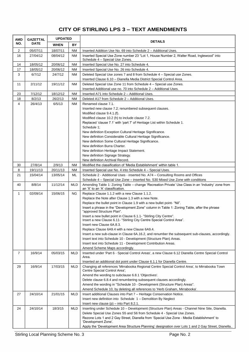
CITY OF STIRLING LPS 3 – TEXT AMENDMENTS
AMD NO.
GAZETTAL DATE
UPDATED DETAILS
WHEN BY
2 05/07/11 18/07/11 NM Inserted Addition Use No. 69 into Schedule 2 – Additional Uses.
16 27/04/12 08/04/12 NM Inserted Special Use Zone number 23 “Lot 1, House Number 2, Walter Road, Inglewood” into Schedule 4 – Special Use Zones.
14 18/05/12 20/06/12 NM Inserted Special Use No. 27 into Schedule 4.
17 18/05/12 20/06/12 NM Inserted Special Use No. 26 into Schedule 4.
3 6/7/12 24/7/12 NM Deleted Special Use zones 7 and 8 from Schedule 4 – Special use Zones.
Inserted Clause 6.10 – Dianella Media District Special Control Area.
11 2/11/12 19/11/12 NM Deleted Special Use Zone 11 from Schedule 4 – Special use Zones.
Inserted Additional use no. 70 into Schedule 2 – Additional Uses.
23 7/12/12 18/12/12 NM Inserted A71 into Schedule 2 – Additional Uses.
18 8/2/13 26/2/13 NM Deleted A17 from Schedule 2 – Additional Uses.
4 26/4/13 6/5/13 NM Renamed clause 7.1.
Inserted new clause 7.2; renumbered subsequent clauses.
Modified clause 9.4.1.(f).
Modified clause 10.2 (h) to include clause 7.2.
Replaced ‘clause 7.1’ with ‘part 7’ of Heritage List within Schedule 1.
Schedule 1;
New definition Exception Cultural Heritage Significance.
New definition Considerable Cultural Heritage Significance.
New definition Some Cultural Heritage Significance.
New definition Burra Charter.
New definition Heritage Impact Statement.
New definition Signage Strategy.
New definition Archival Record.
30 27/8/14 2/9/13 NM Modified the classification of ‘Media Establishment’ within table 1.
8 19/11/13 20/11/13 NM Inserted Special use No. 4 into Schedule 4 – Special Uses.
21 15/04/14 13/05/14 ML Schedule 2 - Additional Uses - inserted No. A74 – Consulting Rooms and Offices
Schedule 4 – Special Use Zone – inserted No. S30 Mixed Use Zone with conditions
40 8/8/14 11/12/14 MLD Amending Table 1: Zoning Table – change ‘Recreation Private’ Use Class in an ‘Industry’ zone from an ‘X’ to an ‘A’ classification.
1 02/09/14 15/06/15 NG Replace Clause 1.1.2 with a new Clause 1.1.2.
Replace the Note after Clause 1.3 with a new Note.
Replace the bullet point in Clause 1.9 with a new bullet point- “Nil”.
Insert a phrase in the “Development Zone” column in Table 1: Zoning Table, after the phrase "approved Structure Plan".
Insert a new bullet point in Clause 6.1.1- “Stirling City Centre". Insert a new Clause 6.11- “Stirling City Centre Special Control Area”.
Insert new Clause 6A.8.3.
Replace Clause 6A9.4 with a new Clause 6A9.4.
Insert a new sub-clause in Clause 6A.16.2, and renumber the subsequent sub-clauses, accordingly.
Insert text into Schedule 10 - Development (Structure Plan) Areas.
Insert text into Schedule 11 - Development Contribution Areas.
Amend Scheme Maps accordingly.
7 16/9/14 05/03/15 MLD Inserted under 'Part 6 - Special Control Areas', a new Clause 6.12 Dianella Centre Special Control Area.
Inserted an additional dot point under Clause 6.1.1 for Dianella Centre.
29 16/9/14 17/03/15 MLD Changing all references 'Mirrabooka Regional Centre Special Control Area', to Mirrabooka Town Centre Special Control Area';
Amend the wording to subclause 6.8.1 'Objectives'.
Delete clause 6.8.4 and renumbering subsequent clauses accordingly.
Amend the wording in "Schedule 10 - Development (Structure Plan) Areas".
Amend Schedule 10, by deleting all references to 'Herb Graham, Mirrabooka'.
27 24/10/14 21/01/15 MLD Insert additional Clauses into Part 7 – Heritage Conservation Notice.
Insert new definition into Schedule 1 – Demolition By Neglect
Insert new clause (p) – into Part 8.2.1.
24 24/10/14 18/3/15 MLD Inserting under Schedule 10 – Development (Structure Plan) Areas - Channel Nine Site, Dianella.
Delete Special Use Zones S5 and S6 from Schedule 4 - Special Use Zones.
Rezone Lots 1 and 2 Gay Street, Dianella from ‘Special Use Zone - Media Establishment’ to ‘Development Zone’.
Apply the ‘Development Area Structure Planning’ designation over Lots 1 and 2 Gay Street, Dianella..
Stirling Local Planning Scheme No. 3 Page No. 3
AMD NO.
GAZETTAL DATE
UPDATED DETAILS
WHEN BY
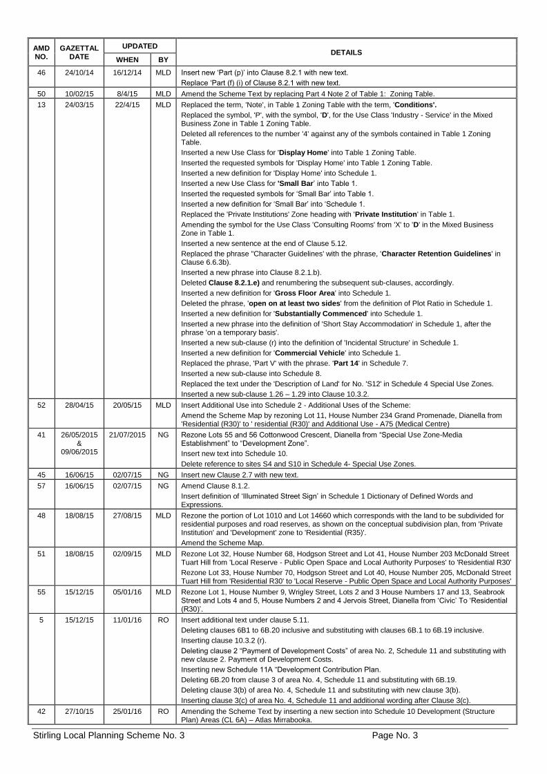
46 24/10/14 16/12/14 MLD Insert new ‘Part (p)’ into Clause 8.2.1 with new text.
Replace ‘Part (f) (i) of Clause 8.2.1 with new text.
50 10/02/15 8/4/15 MLD Amend the Scheme Text by replacing Part 4 Note 2 of Table 1: Zoning Table.
13 24/03/15 22/4/15 MLD Replaced the term, 'Note', in Table 1 Zoning Table with the term, 'Conditions'.
Replaced the symbol, 'P', with the symbol, 'D', for the Use Class 'Industry - Service' in the Mixed Business Zone in Table 1 Zoning Table.
Deleted all references to the number '4' against any of the symbols contained in Table 1 Zoning Table.
Inserted a new Use Class for 'Display Home' into Table 1 Zoning Table.
Inserted the requested symbols for 'Display Home' into Table 1 Zoning Table.
Inserted a new definition for 'Display Home' into Schedule 1.
Inserted a new Use Class for 'Small Bar’ into Table 1.
Inserted the requested symbols for ‘Small Bar’ into Table 1.
Inserted a new definition for ‘Small Bar’ into ‘Schedule 1.
Replaced the 'Private Institutions' Zone heading with 'Private Institution' in Table 1.
Amending the symbol for the Use Class 'Consulting Rooms' from 'X' to 'D' in the Mixed Business Zone in Table 1.
Inserted a new sentence at the end of Clause 5.12.
Replaced the phrase "Character Guidelines' with the phrase, 'Character Retention Guidelines' in Clause 6.6.3b).
Inserted a new phrase into Clause 8.2.1.b).
Deleted Clause 8.2.1.e) and renumbering the subsequent sub-clauses, accordingly.
Inserted a new definition for 'Gross Floor Area' into Schedule 1.
Deleted the phrase, 'open on at least two sides' from the definition of Plot Ratio in Schedule 1.
Inserted a new definition for 'Substantially Commenced' into Schedule 1.
Inserted a new phrase into the definition of 'Short Stay Accommodation' in Schedule 1, after the phrase 'on a temporary basis'.
Inserted a new sub-clause (r) into the definition of 'Incidental Structure' in Schedule 1.
Inserted a new definition for 'Commercial Vehicle' into Schedule 1.
Replaced the phrase, 'Part V' with the phrase. 'Part 14' in Schedule 7.
Inserted a new sub-clause into Schedule 8.
Replaced the text under the 'Description of Land' for No. 'S12' in Schedule 4 Special Use Zones.
Inserted a new sub-clause 1.26 – 1.29 into Clause 10.3.2.
52 28/04/15 20/05/15 MLD Insert Additional Use into Schedule 2 - Additional Uses of the Scheme:
Amend the Scheme Map by rezoning Lot 11, House Number 234 Grand Promenade, Dianella from 'Residential (R30)' to ' residential (R30)' and Additional Use - A75 (Medical Centre)
41 26/05/2015 &
09/06/2015
21/07/2015 NG Rezone Lots 55 and 56 Cottonwood Crescent, Dianella from “Special Use Zone-Media Establishment” to “Development Zone”.
Insert new text into Schedule 10.
Delete reference to sites S4 and S10 in Schedule 4- Special Use Zones.
45 16/06/15 02/07/15 NG Insert new Clause 2.7 with new text.
57 16/06/15 02/07/15 NG Amend Clause 8.1.2.
Insert definition of ‘Illuminated Street Sign’ in Schedule 1 Dictionary of Defined Words and Expressions.
48 18/08/15 27/08/15 MLD Rezone the portion of Lot 1010 and Lot 14660 which corresponds with the land to be subdivided for residential purposes and road reserves, as shown on the conceptual subdivision plan, from 'Private Institution' and 'Development' zone to 'Residential (R35)'.
Amend the Scheme Map.
51 18/08/15 02/09/15 MLD Rezone Lot 32, House Number 68, Hodgson Street and Lot 41, House Number 203 McDonald Street Tuart Hill from 'Local Reserve - Public Open Space and Local Authority Purposes' to 'Residential R30'
Rezone Lot 33, House Number 70, Hodgson Street and Lot 40, House Number 205, McDonald Street Tuart Hill from 'Residential R30' to 'Local Reserve - Public Open Space and Local Authority Purposes'
55 15/12/15 05/01/16 MLD Rezone Lot 1, House Number 9, Wrigley Street, Lots 2 and 3 House Numbers 17 and 13, Seabrook Street and Lots 4 and 5, House Numbers 2 and 4 Jervois Street, Dianella from ‘Civic’ To ‘Residential (R30)’.
5 15/12/15 11/01/16 RO Insert additional text under clause 5.11.
Deleting clauses 6B1 to 6B.20 inclusive and substituting with clauses 6B.1 to 6B.19 inclusive.
Inserting clause 10.3.2 (r).
Deleting clause 2 “Payment of Development Costs” of area No. 2, Schedule 11 and substituting with new clause 2. Payment of Development Costs.
Inserting new Schedule 11A “Development Contribution Plan.
Deleting 6B.20 from clause 3 of area No. 4, Schedule 11 and substituting with 6B.19.
Deleting clause 3(b) of area No. 4, Schedule 11 and substituting with new clause 3(b).
Inserting clause 3(c) of area No. 4, Schedule 11 and additional wording after Clause 3(c).
42 27/10/15 25/01/16 RO Amending the Scheme Text by inserting a new section into Schedule 10 Development (Structure Plan) Areas (CL 6A) – Atlas Mirrabooka.
Stirling Local Planning Scheme No. 3 Page No. 4
AMD NO.
GAZETTAL DATE
UPDATED DETAILS
WHEN BY
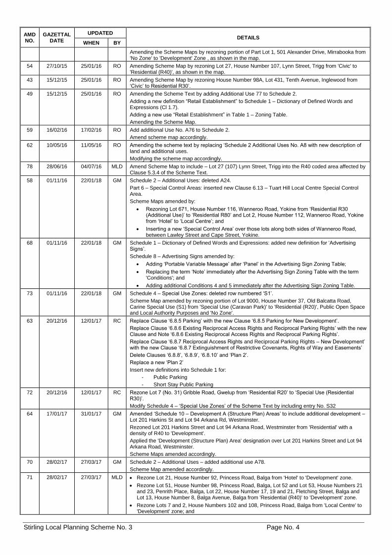
Amending the Scheme Maps by rezoning portion of Part Lot 1, 501 Alexander Drive, Mirrabooka from 'No Zone' to 'Development' Zone , as shown in the map.
54 27/10/15 25/01/16 RO Amending Scheme Map by rezoning Lot 27, House Number 107, Lynn Street, Trigg from 'Civic' to 'Residential (R40)', as shown in the map.
43 15/12/15 25/01/16 RO Amending Scheme Map by rezoning House Number 98A, Lot 431, Tenth Avenue, Inglewood from ‘Civic’ to Residential R30’.
49 15/12/15 25/01/16 RO Amending the Scheme Text by adding Additional Use 77 to Schedule 2.
Adding a new definition “Retail Establishment” to Schedule 1 – Dictionary of Defined Words and Expressions (Cl 1.7).
Adding a new use “Retail Establishment” in Table 1 – Zoning Table.
Amending the Scheme Map.
59 16/02/16 17/02/16 RO Add additional Use No. A76 to Schedule 2.
Amend scheme map accordingly.
62 10/05/16 11/05/16 RO Amending the scheme text by replacing ‘Schedule 2 Additional Uses No. A8 with new description of land and additional uses.
Modifying the scheme map accordingly.
78 28/06/16 04/07/16 MLD Amend Scheme Map to include – Lot 27 (107) Lynn Street, Trigg into the R40 coded area affected by Clause 5.3.4 of the Scheme Text.
58 01/11/16 22/01/18 GM Schedule 2 – Additional Uses: deleted A24.
Part 6 – Special Control Areas: inserted new Clause 6.13 – Tuart Hill Local Centre Special Control Area.
Scheme Maps amended by:
• Rezoning Lot 671, House Number 116, Wanneroo Road, Yokine from ‘Residential R30 (Additional Use)’ to ‘Residential R80’ and Lot 2, House Number 112, Wanneroo Road, Yokine from ‘Hotel’ to ‘Local Centre’; and
• Inserting a new ‘Special Control Area’ over those lots along both sides of Wanneroo Road, between Lawley Street and Cape Street, Yokine.
68 01/11/16 22/01/18 GM Schedule 1 – Dictionary of Defined Words and Expressions: added new definition for ‘Advertising Signs’.
Schedule 8 – Advertising Signs amended by:
• Adding ‘Portable Variable Message’ after ‘Panel’ in the Advertising Sign Zoning Table;
• Replacing the term ‘Note’ immediately after the Advertising Sign Zoning Table with the term 'Conditions'; and
• Adding additional Conditions 4 and 5 immediately after the Advertising Sign Zoning Table.
73 01/11/16 22/01/18 GM Schedule 4 – Special Use Zones: deleted row numbered ‘S1’.
Scheme Map amended by rezoning portion of Lot 9000, House Number 37, Old Balcatta Road, Carine Special Use (S1) from 'Special Use (Caravan Park)' to 'Residential (R20)', Public Open Space and Local Authority Purposes and 'No Zone'.
63 20/12/16 12/01/17 RC Replace Clause ‘6.8.5 Parking’ with the new Clause ‘6.8.5 Parking for New Development’.
Replace Clause ‘6.8.6 Existing Reciprocal Access Rights and Reciprocal Parking Rights’ with the new Clause and Note ‘6.8.6 Existing Reciprocal Access Rights and Reciprocal Parking Rights’.
Replace Clause ‘6.8.7 Reciprocal Access Rights and Reciprocal Parking Rights – New Development’ with the new Clause ‘6.8.7 Extinguishment of Restrictive Covenants, Rights of Way and Easements’
Delete Clauses ‘6.8.8’, ‘6.8.9’, ‘6.8.10’ and ‘Plan 2’.
Replace a new ‘Plan 2’
Insert new definitions into Schedule 1 for:
- Public Parking
- Short Stay Public Parking
72 20/12/16 12/01/17 RC Rezone Lot 7 (No. 31) Gribble Road, Gwelup from ‘Residential R20’ to ‘Special Use (Residential R30)’.
Modify Schedule 4 – ‘Special Use Zones’ of the Scheme Text by including entry No. S32
64 17/01/17 31/01/17 GM Amended ‘Schedule 10 – Development A (Structure Plan) Areas’ to include additional development – Lot 201 Harkins St and Lot 94 Arkana Rd, Westminster.
Rezoned Lot 201 Harkins Street and Lot 94 Arkana Road, Westminster from 'Residential' with a density of R40 to 'Development'.
Applied the 'Development (Structure Plan) Area' designation over Lot 201 Harkins Street and Lot 94 Arkana Road, Westminster.
Scheme Maps amended accordingly.
70 28/02/17 27/03/17 GM Schedule 2 – Additional Uses – added additional use A78.
Scheme Map amended accordingly.
71 28/02/17 27/03/17 MLD • Rezone Lot 21, House Number 92, Princess Road, Balga from 'Hotel' to 'Development' zone.
• Rezone Lot 51, House Number 98, Princess Road, Balga, Lot 52 and Lot 53, House Numbers 21 and 23, Penrith Place, Balga, Lot 22, House Number 17, 19 and 21, Fletching Street, Balga and Lot 13, House Number 8, Balga Avenue, Balga from 'Residential (R40)' to 'Development' zone.
• Rezone Lots 7 and 2, House Numbers 102 and 108, Princess Road, Balga from 'Local Centre' to 'Development' zone; and
Stirling Local Planning Scheme No. 3 Page No. 5
AMD NO.
GAZETTAL DATE
UPDATED DETAILS
WHEN BY
• Rezone Lot 4, House Number 17, Climping Street, Balga from 'Private Institution' to 'Development' zone.
79 27/06/17 27/06/17 MLD Amend the Scheme Map by rezoning Lots 76 and 100 Porter Street, Gwelup, from 'Residential R20' to 'Residential R25.'
76 27/06/17 05/07/17 RMc Amend Clause 6.6.1(b) - 'Objectives for the Heritage Protection Area Special Control Area' and inserting Clause 6.6.4.
81 27/06/17 10/07/17 GM Amended the Scheme Text by adding Additional Use No. A 90 into Schedule 2 – Additional Uses.
Amended the Scheme Map (Sheet 1) by rezoning Lot 81, House Number 10, Sanderling Street Stirling from 'Residential (R20)' to 'Local Centre and Additional Use - Residential.
65 15/08/17 04/09/17 GM Inserted new Clause 6.15 – Scarborough Beach Road West Special Control Area. Schedule 2 – Additional Uses:
• deleted Additional Uses: A20; A26; A29.
• added Additional Uses A79. Scheme Maps amended by:
• rezoning various lots in the Scarborough Beach Road West precinct area: i. from ‘Residential R30’ and ‘Residential R40’ to ‘Residential R-AC0’; ii. from ‘Local Centre’ to ‘Mixed Use’; iii. from ‘Business’ to ‘Mixed Use’; and iv. from ‘Service Station’ to ‘Residential R-AC0’. v. from 'Civic and Public Open Space' to 'Mixed Use and Public Open Space'.
• deleting Additional Use No. A20, A26 and A29.
• adding Additional Uses A79.
• adding the Scarborough Beach Road West Special Control Area to the Scheme Map.
66 15/08/17 04/09/17 GM Inserted new Clause 5.4.4. Modified Clause 6.1.1 to include 'Karrinyup Civic Centre' between 'Heritage Protection Area' and 'Main Street Plaza'. Inserted new Clause 6.14 – Karrinyup Civic Centre Special Control Area. Scheme Maps amended by:
• rezoning Lot 2 Davenport Street, Karrinyup from 'Civic' to 'Development'.
• applying a Special Control Area designation over Lot 2 Davenport Street, Karrinyup.
82 26/09/17 05/10/17 GM Table 1 – Zoning Table amended by reclassifying Family Dare Care as a Permitted (P) use within the Residential Zone. Inserted new sub-clause 8.2.1(q). Schedule 1 – Dictionary of Defined Words and Expressions – definitions of Family Day Care and Child Care Premises amended.
9 24/10/17 25/10/17 GM Part 5 – General Development Requirements:
• inserted new clause 5.5.4;
• inserted new clause 5.13. Sub-clauses 10.3 h and 10.3 q replaced. Schedule 1 – Dictionary of Defined Works and Expressions – General Definitions – inserted new definitions for Advanced Tree, Significant Tree and Street Tree.
74 28/11/17 30/11/17 HB Add Additional Use No. A88 to Schedule 2.
Scheme Map amended accordingly.
87 27/02/18 28/02/18 MLD Modifying the Scheme Map by rezoning Lot 256, House Number 249, West Coast Drive, North Beach from 'Residential (R20)' to 'Local Centre'.
93 27/02/18 28/02/18 MLD Modifying 'Table 1 - Zoning Table' in the Scheme Text by replacing the symbol 'X' with the symbol 'D2' into the 'Local Centre' Zone for the 'Short Stay Accommodation' Use Class.
89 27/02/18 01/03/18 GM Replaced 'ROW Map 1 DCA 5' contained in Schedule 11A Development Contribution Plan of the Scheme Text with the following modified map.
86 15/05/18 23/05/18 MLD Insert a new Condition 4 in 'Table 1 - Zoning Table'.
Replacing the number '2' within the 'Regional Centre' zone in 'Table 1 - Zoning Table', with the number '4' against certain Use Classes.
Inserting a new Clause 5.7.3. and figure.
85 12/06/18 13/06/18 MLD Amending Clause 6.8.1. Replace 'Clauses 6.8.3 Development' and '6.8.4 Subdivision' with new Clause. Insert new Clauses after Clause 6.8.3 'Subdivision and Development. Renumber and amend Clause 6.8.5 ‘Parking for New Development – 6.8.14. Renumber and amend Clause 6.8.6 ‘Existing Reciprocal Access Rights and Reciprocal Parking Rights’ – 6.8.15. Replace ‘Plan 2 Mirrabooka Town Centre Special Control Area - Existing Reciprocal Access Rights and Reciprocal Parking Rights (Affected Lots)’ with new plan and relocate after Clause 6.8.15 ‘Existing Reciprocal Access Rights and Reciprocal Parking Rights. Renumber and amend Clause 6.8.7 ‘Extinguishment of Restrictive Covenants, Rights of Way and Easements – 6.8.16. Amending ‘Schedule 10 - Development (Structure Plan) - Changing the heading of the first column from ‘Name of Structure Plan’ to ‘Name of Structure Plan / Activity Centre Plan’ & Changing the terminology in the third column of the Mirrabooka Town Centre Development Area from ‘Structure Plan’ to ‘Activity Centre Plan’. Modify the Scheme Map by rezoning the relevant land in the Mirrabooka Town Centre Special Control Area from ‘Development’ zone to various relevant zonings.
83 14/08/18 27/08/18 GM Schedule 10 – Development (Structure Plan) Areas - amended by:
• replacing the Purpose specified for the 'East Roselea, Balcatta' Structure Plan;
Stirling Local Planning Scheme No. 3 Page No. 6
AMD NO.
GAZETTAL DATE
UPDATED DETAILS
WHEN BY
• replacing the Requirements specified for the 'East Roselea, Balcatta 'Structure Plan. Scheme maps amended by rezoning Lot 150, House Number 732, and Lot 151, House Number 734, Karrinyup Road Balcatta from 'Business' to 'Development' and inclusion into the 'East Roselea Structure Plan Area'.
88 14/08/18 29/08/18 GM Schedule 2 – Additional Uses – inserted new A93, Lot 387, House Number 66, Francis Avenue, Karrinyup.
Amending the Scheme Map accordingly to classify Lot 387, House Number 66, Francis Avenue, Karrinyup as 'A93'.
39 21/08/18 30/08/18 GM Clause 6.1.1 amended by –
• deleting bullet point Glendalough Station;
• inserting new bullet point Herdsman Glendalough.
Deleting existing Clauses 6.4, 6.4.1, 6.4.2, and 6.4.3.
Inserting new Clause 6.4 Herdsman Glendalough Special Control Area and renumbering subsequent sub-clauses.
Schedule 2 – Additional Uses – deleted the following Additional Uses contained within the Herdsman Glendalough Development Zone Area - A15, A16, A41, A46 and A48 -A68.
Schedule 10 - Development (Structure Plan) Areas – inserted new row for Herdsman Glendalough Structure Plan.
Amended the Scheme Maps by deleting the Glendalough Station Special Control Area from the Scheme Map and Legend.
Modified the Scheme Map and Legend to include the:
• Herdsman Glendalough Special Control Area;
• Herdsman Glendalough Development Areas; and
• Development Zone as shown on the maps.
99 16/10/18 18/10/18 MLD Rezoning Lot 7261 Morris Road, Innaloo from ‘Public Use Reserve (Police Station)’ to ‘Residential’ with a ‘R40’ density code.
Amending the Scheme Map accordingly.
80 16/10/18 7/11/18 MLD Amend 'Schedule 2 - Additional Uses' [CL4.5] of the Scheme Text to introduce Additional Use A89. Rezone Lots 23, 24, 35, 36, 5, 28, 39 and 2 Cleveland Street and Lots 3, 6, 14 - 20 and 38 Harold Street from ‘Industry' to 'Residential R-AC0 and Additional Use (A89)'; and
Rezone Lot 40 Cleveland Street, Lot 41 Harold Street and Lot 43 Walter Road West from 'Industry' to 'Local Centre'.
80 2/11/18 7/11/18 MLD Correction Notice – insertion of additional address details into schedule 2 table.
90 11/12/18 18/12/18 HB Amend the Scheme Map (Sheet 1) by rezoning Lots 125-128, House Numbers 12,10, 8 and 6, Bazaar Terrace, Scarborough from 'Civic' to 'Residential (R30)'.
92 11/12/18 18/12/18 HB Amend the Scheme Map by rezoning Lot 1 Edale Way, House Number 31, Westminster from 'Civic' to 'Residential' (R40).
60 11/12/18 17/1/19 HB Insert a new clause 6.6.1 f) after clause 6.6.1 e)
Replacing clause 6.6.3
Insert new clause 6.6.5 after clause 6.6.4.
Insert new clause 6.6.6 after clause 6.6.5.
Insert new clause 6.6.7 after clause 6.6.6. Delete the following from ‘Schedule 2 Additional Uses [CL 4.5]’: A7, A36 and A47. Modify the following in ‘Schedule 2 Additional Uses [CL 4.5]’: A4, A6, A45, A69 and A74. Add the following to ‘Schedule 2 Additional Uses [CL 4.5]’: A80, A81, A82, A83, A84, A85, A86 and A87. Delete the following from ‘Schedule 4 Special Use Zones [CL 4.7.1]’: S30. Amend the Scheme Maps accordingly.
105 28/05/19 28/05/19 HB Reserving a portion of land, formerly road reserve, Lot 330 on Deposited Plan 72143, adjacent to Lot 150, House Number 13 Huckle Street, Tuart Hill, for ‘Public Open Space and Local Authority Purposes’ and amending the Scheme Map accordingly.
101 02/07/19 03/07/19 GM Inserting new Schedule 12 – Additional Site and Development Requirements. Amending the scheme map to: (a) reclassify No. 7 and 9 Field Street and Reserve 38780, Mount Lawley from Public Use – Hospital
to Residential with an R60 density code; (b) apply a AR1 notation to 7 and 9 Field Street and Reserve 38780, Mount Lawley.
Update the contents page to include Schedule 12.
84 16/07/19 17/07/19 MLD Amend ‘Clause 1.4 Contents of the Scheme’ by adding a third bullet point. Amend ‘Table 1: Zoning Table’ by replacing the text under the ‘Development’ Zone column. Amend ‘Clause 6.11.2 Special Control Area’ by reordering a) to f). Replace ‘Clause 6.11.3 Development’ and ‘Clause 6.11.6 Subdivision’ with the new Clause 6.11.3. Replace ‘Clause 6.11.4 Structure Plan and Detailed Area Plan’ with the new Clauses 6.11.4 and 6.11.5. Renumber ‘Clause 6.11.5 Residential Design Codes’ to Clause 6.11.6 and amend the clause.
Stirling Local Planning Scheme No. 3 Page No. 7
AMD NO.
GAZETTAL DATE
UPDATED DETAILS
WHEN BY
Delete ‘Clause 6.11.7 Precincts’ and insert the following new Clauses 6.11.7 to 6.11.16. Replace ‘Clause 6.11.8 Car Parking’ with Clauses 6.11.17 and 6.11.18 and Figure 6.11.17. Insert new Clauses 6.11.19 and 6.11.20. Amend ‘Schedule 10 - Development (Structure Plan) Areas’. Amend Note 3 of the ‘Advertising Sign Zoning Table’ (Clause 4.3) in Schedule 8 with additional new text. Amend the Scheme Maps by including a Development Contribution Area (DCA) designation over the Osborne Park Precinct of the Stirling City Centre Special Control Area.
106 23/07/19 24/07/19 MLD Insert a new clause – Clause 5.14. Insert AR2 into Schedule 12 – Lot 601 (2B) Rawlins Street, Glendalough. Amend the scheme maps accordingly
77 30/7/19 30/7/19 MLD Insert a new Clause - 6.17. Amend the Scheme Map and Legend accordingly.
102 30/7/19 30/7/19 MLD Rezone the following lots on the Scheme Map: Lot 15, House Number 118, Flora Terrace, North Beach from ‘Business’ to ‘Local Centre’; and Lot 50 House Number 20, Castle Street, North Beach from ‘Civic’ to ‘Local Centre’.
104 27/08/19 29/08/19 GM Insert new Clause 6.16 ‘Servite College Special Control Area’. Insert RU1, Servite College Special Control Area, into Schedule 3 – Restricted Uses. Amend the Scheme Map and Legend by –
• Rezone Lots 301, 302 and 1102 Cape Street, Lot 34 Stoneham Street, Lot 46 Myers Street and Lots 17, 18, 19, 21 and 23 Morgans Street, Tuart Hill from the ‘Residential (R30)’ to the ‘Private Institution’ zone and ‘Restricted Use (RU 1)’ designation;
• Apply the ‘Restricted Use (RU 1)’ designation to Lot 1 Myers Street and Lot 10 Cape Street.
• Apply a new Servite College Special Control Area’ over Lots 10, 301, 302 and 1102 Cape Street, Lot 34 Stoneham Street, Lots 1 and 46 Myers Street and Lots 17, 18, 19, 21 and 23 Morgans Street, Tuart Hill; and
• Amend the Scheme Map legend to include Restricted Uses.
110 21/01/2020 23/01/2020 MLD Insert new clause 6.8.3 b). Insert new note #5 under Table 6.8.14 a). Replace the symbol ‘X’ with the symbol ‘D’ for a ‘Nursing Home’ use in the ‘Mixed Use’ Land Use Sector of Table 6.8.6 – Mirrabooka Town Centre Land Use Permissibility Table. Delete clause 6.8.10 c).
108 29/09/2020 29/09/2020 GM Modifying Part 4 ‘Table 1: Zoning Table’ for the Use Class ‘Market’ by: Replacing the symbol ‘X’ with the symbol ‘P’ in the :
• ‘Business’ Zone;
• ‘Hotel’ Zone; and
• ‘Industry’ Zone. Replacing the symbol ‘D’ with the symbol ‘P’ in the:
• ‘Civic’ Zone;
• ‘District Centre’ Zone;
• ‘Local Centre’ Zone;
• ‘Mixed Business’ Zone; and
• ‘Regional Centre’ Zone. Replacing the symbol ‘X’ with the symbol ‘D’ in the ‘Private Institution’ Zone. Modifying Schedule 1 Section 2 ‘Land Use Definitions’ by including the following note below the definition for ‘Market’: ‘Note: For the purpose of this definition, a ‘stall’ includes any structure whether fixed or moveable, temporary or permanent, vehicles, trailers and the like. The sale of ‘goods’ includes the sale of food or drinks from a ‘stall’.
116 2/2/2021 3/2/2021 MLD Modifying ‘Schedule 3 – Restricted Uses’ to include Lot 44 (House Number 151), Lot 27 (House Number 155) and Lot 32 (House Number 162) Cape Street, Tuart Hill. Rezoning Lot 44 (House Number 151), Lot 27 (House Number 155), and Lot 32 (House Number 162) Cape Street, Tuart Hill from ‘Residential (R30) to ‘Private Institution’; Applying the ‘Restricted Use (RU1)’ designation to Lot 44 (House Number 151, Lot 27 (House
Stirling Local Planning Scheme No. 3 Page No. 8
AMD NO.
GAZETTAL DATE
UPDATED DETAILS
WHEN BY
Number 155) and Lot 32 (House Number 162) Cape Street, Tuart Hill; and Applying the ‘Servite College Special Control Area’ over Lot 44 (House Number 151), Lot 27 (House Number 155), and Lot 32 (House Number 162) Cape Street, Tuart Hill.
109 31/08/2021 15/09/2021 HB Amend the Scheme Text by, insert a new ‘Neighbourhood Centre’ Zone Clause into Part 4 – Zones and the use of land. Add a new “Neighbourhood Centre” zone in Part 4 Table 1 – Zoning Table after “Mixed Use” and insert the use symbols. Insert a new clause under Section 5.3 Special Application of Residential Design Codes -5.3.5. Delete the following Additional Use from ‘Schedule 2 Additional Uses [CL 4.5]. Amend the Scheme Map in accordance with the proposed zoning maps that form part of this scheme amendment, including amending the legend to include the Neighbourhood Centre zone.
117 31/08/2021 HB Amend Schedule 2- Additional Uses to include A94 over part Lot 9002 (House No. 139) Balcatta Rd, Balcatta with conditions. Amend the scheme map by designating Additional Use ‘A94’ over part Lot 9002 (House Number 139) Balcatta Road, Balcatta, as shown on the scheme amendment map.
Stirling Local Planning Scheme No. 3 Page No. 9
CONTENTS
PART 1 – PRELIMINARY ........................................................................... 13
1.1 CITATION ................................................................................................................................................... 13 1.2 RESPONSIBLE AUTHORITY .............................................................................................................................. 13 1.3 SCHEME AREA ............................................................................................................................................ 13 1.4 CONTENTS OF THE SCHEME ........................................................................................................................... 13 1.5 PURPOSES OF THE SCHEME ............................................................................................................................ 13 1.6 THE AIMS OF THE SCHEME ............................................................................................................................ 14 1.7 DEFINITIONS ............................................................................................................................................... 14 1.8 RELATIONSHIP WITH LOCAL LAWS ................................................................................................................... 14 1.9 RELATIONSHIP WITH OTHER SCHEMES .............................................................................................................. 14 1.10 RELATIONSHIP WITH THE METROPOLITAN REGION SCHEME ................................................................................. 15
PART 2 - LOCAL PLANNING POLICY FRAMEWORK ............................. 16
2.1 SCHEME DETERMINATIONS TO CONFORM WITH LOCAL PLANNING STRATEGY .......................................................... 16 2.2 LOCAL PLANNING POLICIES ............................................................................................................................ 16 2.3 RELATIONSHIP OF LOCAL PLANNING POLICIES TO SCHEME ................................................................................... 16 2.4 PROCEDURE FOR MAKING OR AMENDING A LOCAL PLANNING POLICY ................................................................... 16 2.5 REVOCATION OF LOCAL PLANNING POLICY........................................................................................................ 17 2.6 LOCAL PLANNING POLICIES MADE UNDER PREVIOUS SCHEME .............................................................................. 17 2.7 MINOR MODIFICATIONS TO A LOCAL PLANNING POLICY ...................................................................................... 17
PART 3 – RESERVES ................................................................................ 18
3.1 RESERVES ................................................................................................................................................... 18 3.2 REGIONAL RESERVES .................................................................................................................................... 18 3.3 LOCAL RESERVES ......................................................................................................................................... 18 3.4 USE AND DEVELOPMENT OF LOCAL RESERVES ................................................................................................... 18
PART 4 - ZONES AND THE USE OF LAND .............................................. 19
4.1 ZONES ....................................................................................................................................................... 19 4.2 OBJECTIVES OF THE ZONES ............................................................................................................................ 19 4.3 TABLE 1 - ZONING TABLE .............................................................................................................................. 22 4.4 INTERPRETATION OF THE TABLE 1 - ZONING TABLE ............................................................................................. 29 4.5 ADDITIONAL USES........................................................................................................................................ 29 4.6 RESTRICTED USES ........................................................................................................................................ 29 4.7 SPECIAL USE ZONES ..................................................................................................................................... 29 4.8 NON-CONFORMING USES ............................................................................................................................. 29 4.9 EXTENSIONS AND CHANGES TO A NON-CONFORMING USE .................................................................................. 30 4.10 DISCONTINUANCE OF NON-CONFORMING USE ................................................................................................. 30 4.11 TERMINATION OF A NON-CONFORMING USE .................................................................................................... 30 4.12 DESTRUCTION OF NON-CONFORMING USE BUILDINGS ....................................................................................... 30 4.13 DEVELOPMENT ON NO ZONED LAND ............................................................................................................... 30
PART 5 - GENERAL DEVELOPMENT REQUIREMENTS ......................... 31
5.1 COMPLIANCE WITH DEVELOPMENT STANDARDS AND REQUIREMENTS .................................................................... 31 5.2 RESIDENTIAL DESIGN CODES .......................................................................................................................... 31 5.3 SPECIAL APPLICATION OF RESIDENTIAL DESIGN CODES ........................................................................................ 31 5.4 RESTRICTIVE COVENANTS .............................................................................................................................. 32 5.5 VARIATIONS TO SITE AND DEVELOPMENT STANDARDS AND REQUIREMENTS ............................................................ 32 5.6 ENVIRONMENTAL CONDITIONS ....................................................................................................................... 33 5.7 DEVELOPMENT REQUIREMENTS ...................................................................................................................... 33 5.8 CASH-IN-LIEU OF CAR PARKING ...................................................................................................................... 34 5.9 RECIPROCAL CAR PARKING ............................................................................................................................ 35
Stirling Local Planning Scheme No. 3 Page No. 10
5.10 PARKING AND ACCESS PLANS ......................................................................................................................... 36 5.11 CEDING OF. RIGHTS-OF-WAY WIDENING ......................................................................................................... 37 5.12 REQUIREMENT TO PREPARE A DETAILED AREA PLAN........................................................................................... 37 5.13 TREES AND DEVELOPMENT ............................................................................................................................ 37 5.14 ADDITIONAL SITE AND DEVELOPMENT REQUIREMENTS FOR AREAS COVERED BY STRUCTURE PLAN, ACTIVITY CENTRE PLAN
OR LOCAL DEVELOPMENT PLAN ...................................................................................................................... 38
PART 6 - SPECIAL CONTROL AREAS ....................................................... 39
6.1 OPERATION OF SPECIAL CONTROL AREAS ......................................................................................................... 39 6.2 CARENIUP SWAMP SPECIAL CONTROL AREA ..................................................................................................... 39 6.3 COASTAL HEIGHT LIMIT - NON-RESIDENTIAL ZONES SPECIAL CONTROL AREA .......................................................... 43 6.4 HERDSMAN GLENDALOUGH SPECIAL CONTROL AREA.......................................................................................... 44 6.5 GWELUP WATER PROTECTION AREA SPECIAL CONTROL AREA .............................................................................. 45 6.6 HERITAGE PROTECTION AREA SPECIAL CONTROL AREA ....................................................................................... 46 6.7 MAIN STREET PLAZA SPECIAL CONTROL AREA ................................................................................................... 50 6.8 MIRRABOOKA TOWN CENTRE SPECIAL CONTROL AREA ....................................................................................... 50 6.9 SCARBOROUGH SPECIAL CONTROL AREA .......................................................................................................... 58 6.10 DIANELLA MEDIA DISTRICT SPECIAL CONTROL AREA........................................................................................... 70 6.11 STIRLING CITY CENTRE SPECIAL CONTROL AREA ................................................................................................. 71 6.12 DIANELLA CENTRE SPECIAL CONTROL AREA ...................................................................................................... 85 6.13 TUART HILL LOCAL CENTRE SPECIAL CONTROL AREA .......................................................................................... 87 6.14 KARRINYUP CIVIC CENTRE SPECIAL CONTROL AREA ............................................................................................ 88 6.15 SCARBOROUGH BEACH ROAD WEST SPECIAL CONTROL AREA .............................................................................. 88 6.17 BEACH ROAD SPECIAL CONTROL AREA ............................................................................................................. 90
PART 6A - DEVELOPMENT (STRUCTURE PLAN) AREAS ..................... 92
6A.1 INTERPRETATION ......................................................................................................................................... 92 6A.2 PURPOSE OF DEVELOPMENT AREAS ................................................................................................................ 92 6A.3 SUBDIVISION AND DEVELOPMENT IN DEVELOPMENT AREAS ................................................................................. 92 6A.4 STRUCTURE PLAN REQUIRED .......................................................................................................................... 92 6A.5 PREPARATION OF STRUCTURE PLANS ............................................................................................................... 92 6A.6 DETAILS OF PROPOSED STRUCTURE PLAN ......................................................................................................... 93 6A.7 SUBMISSION TO COUNCIL AND COMMISSION .................................................................................................... 94 6A.8 ADVERTISING OF STRUCTURE PLAN ................................................................................................................. 94 6A.9 ADOPTION OF PROPOSED STRUCTURE PLAN ..................................................................................................... 95 6A.10 ENDORSEMENT BY COMMISSION .................................................................................................................... 96 6A.11 NOTIFICATION OF STRUCTURE PLAN ................................................................................................................ 96 6A.12 OPERATION OF STRUCTURE PLAN ................................................................................................................... 96 6A.13 INSPECTION OF STRUCTURE PLAN ................................................................................................................... 96 6A.14 VARIATION TO STRUCTURE PLAN .................................................................................................................... 96 6A.15 EXISTING APPROVED STRUCTURE PLANS .......................................................................................................... 97 6A.16 DETAILED AREA PLAN ................................................................................................................................... 97 6A.17 APPEAL ...................................................................................................................................................... 99
PART 6B - DEVELOPMENT CONTRIBUTION AREAS .......................... 100
6B.1 INTERPRETATIONS ...................................................................................................................................... 100 6B.2 PURPOSE ................................................................................................................................................. 100 6B.3 DEVELOPMENT CONTRIBUTION PLAN REQUIRED .............................................................................................. 101 6B.4 DEVELOPMENT CONTRIBUTION PLAN PART OF SCHEME .................................................................................... 101 6B.5 SUBDIVISION, STRATA SUBDIVISION AND DEVELOPMENT ................................................................................... 101 6B.6 GUIDING PRINCIPLES FOR DEVELOPMENT CONTRIBUTION PLANS ........................................................................ 101 6B.7 RECOMMENDED CONTENT OF DEVELOPMENT CONTRIBUTION PLANS .................................................................. 102 6B.8 PERIOD OF DEVELOPMENT CONTRIBUTION PLAN ............................................................................................. 102 6B.9 LAND EXCLUDED ........................................................................................................................................ 102 6B.10 DEVELOPMENT CONTRIBUTION PLAN REPORT AND COST APPORTIONMENT SCHEDULE ........................................... 102 6B.11 COST CONTRIBUTIONS BASED ON ESTIMATES .................................................................................................. 103
Stirling Local Planning Scheme No. 3 Page No. 11
6B.12 VALUATION .............................................................................................................................................. 104 6B.13 LIABILITY FOR COST CONTRIBUTIONS ............................................................................................................. 104 6B.14 PAYMENT OF COST CONTRIBUTION ............................................................................................................... 105 6B.15 CHARGE ON LAND ...................................................................................................................................... 105 6B.16 ADMINISTRATION OF FUNDS ........................................................................................................................ 106 6B.17 SHORTFALL OR EXCESS IN COST CONTRIBUTIONS ............................................................................................. 106 6B.18 POWERS OF THE COUNCIL ........................................................................................................................... 106 6B.19 ARBITRATION ............................................................................................................................................ 106
PART 7 - HERITAGE PROTECTION ....................................................... 107
7.1 PREPARATION OF A HERITAGE LIST ................................................................................................................ 107 7.2 HERITAGE LIST PROVISIONS ......................................................................................................................... 108 7.3 DESIGNATION OF A HERITAGE AREA .............................................................................................................. 112 7.4 HERITAGE AGREEMENTS ............................................................................................................................. 113 7.5 HERITAGE ASSESSMENT .............................................................................................................................. 113 7.6 VARIATIONS TO SCHEME PROVISIONS FOR A HERITAGE PLACE OR HERITAGE AREA ................................................. 113 7.7 HERITAGE CONSERVATION NOTICE ................................................................................................................ 114
PART 8 - DEVELOPMENT OF LAND ...................................................... 115
8.1 REQUIREMENT FOR APPROVAL TO COMMENCE DEVELOPMENT .......................................................................... 115 8.2 PERMITTED DEVELOPMENT ......................................................................................................................... 115 8.3 AMENDING OR REVOKING A PLANNING APPROVAL ........................................................................................... 117 8.4 UNAUTHORISED EXISTING DEVELOPMENTS ..................................................................................................... 117 8.5 INCONSISTENT PLANNING APPROVALS ........................................................................................................... 117
PART 9 - APPLICATIONS FOR PLANNING APPROVAL ...................... 118
9.1 FORM OF APPLICATION ............................................................................................................................... 118 9.2 ACCOMPANYING MATERIAL ......................................................................................................................... 119 9.3 ADDITIONAL MATERIAL FOR HERITAGE MATTERS............................................................................................. 120 9.4 ADVERTISING OF APPLICATIONS .................................................................................................................... 120
PART 10 - PROCEDURE FOR DEALING WITH APPLICATIONS .......... 122
10.1 CONSULTATION WITH OTHER AUTHORITIES .................................................................................................... 122 10.2 MATTERS TO BE CONSIDERED BY THE COUNCIL ................................................................................................ 122 10.3 DETERMINATION OF APPLICATIONS ............................................................................................................... 123 10.4 FORM AND DATE OF DETERMINATION ........................................................................................................... 125 10.5 TERM OF PLANNING APPROVAL .................................................................................................................... 125 10.6 TEMPORARY PLANNING APPROVAL ............................................................................................................... 125 10.7 SCOPE OF PLANNING APPROVAL ................................................................................................................... 125 10.8 APPROVAL SUBJECT TO LATER APPROVAL OF DETAILS ....................................................................................... 126 10.9 DEEMED REFUSAL ...................................................................................................................................... 126 10.10 APPLICATION FOR A REVIEW ........................................................................................................................ 126
PART 11 - ENFORCEMENT AND ADMINISTRATION ............................ 127
11.1 POWERS OF THE COUNCIL ........................................................................................................................... 127 11.2 ADVERTISEMENTS ...................................................................................................................................... 127 11.3 DELEGATION OF FUNCTIONS ........................................................................................................................ 127 11.4 PERSON MUST COMPLY WITH PROVISIONS OF SCHEME .................................................................................... 127 11.5 COMPENSATION ........................................................................................................................................ 128 11.6 PURCHASE OR TAKING OF LAND.................................................................................................................... 128 11.7 NOTICE FOR REMOVAL OF CERTAIN BUILDINGS................................................................................................ 129
SCHEDULES ............................................................................................ 130
SCHEDULE 1 – DICTIONARY OF DEFINED WORDS AND EXPRESSIONS [CL 1.7] ................................................ 131 SCHEDULE 2 – ADDITIONAL USES [CL 4.5] ....................................................................................................... 145 SCHEDULE 3 – RESTRICTED USES [CL 4.6] ........................................................................................................ 154
Stirling Local Planning Scheme No. 3 Page No. 12
SCHEDULE 4 – SPECIAL USE ZONES [CL 4.7.1] .................................................................................................. 155 SCHEDULE 5 – FORM OF APPLICATION FOR PLANNING APPROVAL [CL 9.1.1] ................................................ 158 SCHEDULE 6 – NOTICE OF PUBLIC ADVERTISEMENT OF PLANNING PROPOSAL [CL 9.4.4] ....................... 159 SCHEDULE 7 – NOTICE OF DETERMINATION ON APPLICATION FOR PLANNING APPROVAL [CL 10.4.1] .......... 160 SCHEDULE 8 – ADVERTISING SIGNS [CL 5.7.2] ................................................................................................. 161 SCHEDULE 9 – RESTRICTIVE COVENANTS [CL 5.4.2] ........................................................................................ 168 SCHEDULE 10 – DEVELOPMENT (STRUCTURE PLAN) AREAS [CL 6A] ............................................................... 169 SCHEDULE 11 – DEVELOPMENT CONTRIBUTION AREAS [CL 6B] ..................................................................... 174 SCHEDULE 11A – DEVELOPMENT CONTRIBUTION PLAN ................................................................................. 177 SCHEDULE 12 – ADDITIONAL SITE AND DEVELOPMENT REQUIREMENTS ....................................................... 182
Stirling Local Planning Scheme No. 3 Page No. 13
PART 1 – PRELIMINARY
1.1 Citation
1.1.1 The City of Stirling Local Planning Scheme No. 3 ("the Scheme") comes into operation on its Gazettal date.
1.1.2 The following Schemes are revoked – AMD 1 GG 02/09/14
• City of Stirling District Planning Scheme No. 2 (Gazettal Date: 13 September 1985); and
• City of Stirling Town Planning Scheme No.38 (Gazettal Date: 18 July 1997).
1.2 Responsible Authority
The City of Stirling ("the Council" or "the City") is the responsible authority for implementing the Scheme.
1.3 Scheme Area
AMD 1 GG 02/09/14
The Scheme applies to the Scheme area, which covers that part of the local government district of the City of Stirling shown on the Scheme Maps. Note: The Scheme Area (or part) is also subject to the Metropolitan Region Scheme (refer Clause
1.10).
1.4 Contents of the Scheme
The Scheme comprises the –
• Scheme Text; and
• Scheme Maps
• Deemed Provisions in Schedule 2 of the Planning and Development (Local Planning Schemes) Regulations 2015. AMD 84 GG 16/7/19
The Scheme is to be read in conjunction with the Local Planning Strategy.
1.5 Purposes of the Scheme
The purposes of the Scheme are to – (a) set out the Council's planning aims and intentions for the Scheme area;
(b) set aside land as reserves for public purposes;
(c) zone land within the Scheme area for the purposes defined in the Scheme;
(d) control and guide land use and development;
(e) set out procedures for the assessment and determination of planning applications;
(f) make provision for the administration and enforcement of the Scheme; and
(g) address other matters set out in the First Schedule to the Act.
Stirling Local Planning Scheme No. 3 Page No. 14
1.6 The Aims of the Scheme
The aims of the Scheme are – (a) To provide for a range of housing choice in neighbourhoods with a strong community
identity and high levels of amenity;
(b) To provide for convenient attractive and viable commercial centres, which service the needs of the community and are accessible to pedestrians, cyclists and public transport users as well as motorists;
(c) To assist employment and economic growth by facilitating the timely provision of suitable land for retail, commercial, industrial, entertainment and tourist developments, as well as providing opportunities for home based employment;
(d) To protect and enhance the environmental values and natural resources of the local government area and to promote sustainable land use and development;
(e) To encourage the conservation and continued use of identified places and objects of cultural heritage significance;
(f) To assist in the effective implementation of regional plans and policies including the State Planning Strategy.
1.7 Definitions
1.7.1 Unless the context otherwise requires, words and expressions used in the Scheme have the same meaning as they have -
a) in the Planning and Development Act; or b) if they are not defined in that Act –
i. in the Dictionary of defined words and expressions in Schedule 1; or ii. in the Residential Design Codes.
1.7.2 If there is a conflict between the meaning of a word or expression in the Dictionary of
defined words and expressions in Schedule 1 and the meaning of that word or expression in the Residential Design Codes -
a) in the case of a residential development, the definition in the Residential Design
Codes prevails; and
b) in any other case the definition in the Dictionary prevails. 1.7.3 Notes, and instructions printed in italics, are not part of the Scheme.
1.8 Relationship with Local Laws
Where a provision of the Scheme is inconsistent with a local law, the provision of the Scheme prevails.
1.9 Relationship with other Schemes AMD 1 GG 02/09/14
By way of information, the following other Scheme of the City of Stirling is, at the Gazettal date of the Scheme, complementary to the Scheme –
• Nil
Stirling Local Planning Scheme No. 3 Page No. 15
1.10 Relationship with the Metropolitan Region Scheme
The Scheme is complementary to the Metropolitan Region Scheme and the provisions of the Metropolitan Region Scheme continue to have effect.
Note: The authority responsible for implementing the Metropolitan Region Scheme is the Western
Australian Planning Commission.
Stirling Local Planning Scheme No. 3 Page No. 16
PART 2 - LOCAL PLANNING POLICY FRAMEWORK 2.1 Scheme Determinations to Conform with Local Planning Strategy
Except to the extent that the Local Planning Strategy is inconsistent with the Scheme, determinations of the Council under the Scheme are to be consistent with the Local Planning Strategy.
2.2 Local Planning Policies
The Council may prepare a Local Planning Policy in respect of any matter related to the planning and development of the Scheme area so as to apply – (a) generally, or for a particular class or classes of matters; and
(b) throughout the Scheme area or in one or more parts of the Scheme area,
and may amend or add to or rescind the Policy.
2.3 Relationship of Local Planning Policies to Scheme
2.3.1 If a provision of a Local Planning Policy is inconsistent with the Scheme, the Scheme prevails.
2.3.2 A Local Planning Policy is not part of the Scheme and does not bind the Council in
respect of any application for planning approval, but Council is to have due regard to the provisions of the Policy and the objectives which the Policy is designed to achieve before making its determination.
Note: Local Planning Policies are guidelines used to assist the Council in making decisions under the
Scheme. Although Local Planning Policies are not part of the Scheme they must be consistent with, and cannot vary, the intent of the Scheme provisions, including the Residential Design Codes. In considering an application for planning approval, Council must have due regard to relevant Local Planning Policies as required under clause 10.2.
2.4 Procedure for Making or Amending a Local Planning Policy
2.4.1 If the Council resolves to prepare a Local Planning Policy, the Council –
a) is to publish a notice of the proposed Policy once a week for 2 consecutive weeks in a newspaper circulating in the Scheme area, giving details of –
i. where the draft Policy may be inspected; ii. the subject and nature of the draft Policy; and iii. in what form and during what period (being not less than 21 days
from the day the notice is published) submissions may be made;
b) may publish a notice of the proposed Policy in such other manner and carry out such other consultation as the Council considers appropriate.
2.4.2 After the expiry of the period within which submissions may be made, the Council is to -
a) review the proposed Policy in the light of any submissions made; and
b) resolve to adopt the Policy with or without modification, or not to proceed
with the Policy.
Stirling Local Planning Scheme No. 3 Page No. 17
2.4.3 If the Council resolves to adopt the Policy, the Council is to -
a) publish notice of the Policy once in a newspaper circulating in the Scheme area; and
b) if, in the opinion of the Council, the Policy affects the interests of the
Commission, forward a copy of the Policy to the Commission.
2.4.4 A Policy has effect on publication of a notice under Clause 2.4.3 a).
2.4.5 A copy of each Local Planning Policy, as amended from time to time, is to be kept and made available for public inspection during business hours at the offices of the Council.
a) Clauses 2.4.1 to 2.4.5, with any necessary changes, apply to the amendment of
a Local Planning Policy. 2.5 Revocation of Local Planning Policy
A Local Planning Policy may be revoked by - (a) the adoption by the Council of a new Policy under Clause 2.4 that is expressed to
supersede the existing Local Planning Policy; or
(b) publication of a notice of revocation by the Council once a week for 2 consecutive weeks in a newspaper circulating in the Scheme area.
2.6 Local Planning Policies Made Under Previous Scheme
2.6.1 Where a Local Planning Policy has been adopted in accordance with the requirements of the District Planning Scheme No.2, it shall continue to have effect, and may be amended or revoked as if it were a Local Planning Policy under the current scheme.
2.7 Minor Modifications to a Local Planning Policy
AMD 45 GG 16/06/15
2.7.1 Notwithstanding the provisions of Clause 2.4, the Council may adopt minor
administrative modifications to a Local Planning Policy without the need of formal public advertising where the modifications do not alter the objectives or standards contained within the Policy.
2.7.2 Clause 2.4.3 applies to a minor modification to a Local Planning Policy.
2.7.3 Modifications to a Local Planning Policy adopted under Clause 2.7.1 have effect on
adoption by the Council.
Stirling Local Planning Scheme No. 3 Page No. 18
PART 3 – RESERVES
3.1 Reserves
Certain lands within the Scheme area are classified as – (a) Regional Reserves; or
(b) Local Reserves.
3.2 Regional Reserves
3.2.1 The lands shown as "Regional Reserves" on the Scheme Map are lands reserved under the Metropolitan Region Scheme and are shown on the Scheme Map for the purposes of the Planning and Development Act 2005. These lands are not reserved under the Scheme.
3.2.2 The approval of the Council under the Scheme is not required for the commencement
or carrying out of any use or development on a Regional Reserve.
Note: The provisions of the Metropolitan Region Scheme continue to apply to such Reserves and approval is required under the Metropolitan Region Scheme from the Commission for the commencement or ' carrying out of any use or development on a Regional Reserve unless specifically excluded by the Region Scheme.
3.3 Local Reserves
"Local Reserves" are delineated and depicted on the Scheme Map according to the legend on the Scheme Map.
3.4 Use and Development of Local Reserves
3.4.1 A person must not –
a) use a Local Reserve; or b) commence or carry out development on a Local Reserve, without first having
obtained planning approval under Part 9 of the Scheme.
3.4.2 In determining an application for planning approval the Council is to have due regard to -
a) the matters set out in Clause 10.2; b) the ultimate purpose intended for the Reserve.
3.4.3 In the case of land reserved for the purposes of a public authority, the Council is to
consult with that authority before determining an application for planning approval.
Stirling Local Planning Scheme No. 3 Page No. 19
PART 4 - ZONES AND THE USE OF LAND 4.1 Zones
4.1.1 The Scheme area is classified into the zones shown on the Scheme Maps.
4.1.2 The zones are delineated and depicted on the Scheme Maps according to the legend on the Scheme Maps.
4.1.3 Land delineated on the Scheme Maps which is not classified into a zone or reserve is
classified as land with 'No Zone'.
Note: Typically, land with no zone may include roads, rights of way and pedestrian access ways. Generally, development on such land is for public purposes and is not subject to the provisions of the Scheme, However, from time to time such land may become surplus (such as for road closures) and is amalgamated with the abutting zoned land. In these circumstances, the objective is to facilitate the development of such land in accordance with the standards and requirements of the abutting zoned land to which it has been amalgamated.
4.2 Objectives of the Zones
The objectives of each of the zones are as follows, and are intended to provide the context for development within the respective zones:
4.2.1 UBusiness Zone
a) To provide for a limited range of small-scale commercial development which is
compatible with residential development. b) To provide for a range of housing types compatible with a mixed-use
environment.
4.2.2 UCivic Zone
a) To provide for a limited range of community facilities which are compatible with surrounding development.
b) To ensure that the design of development is in keeping with the scale and form of surrounding development.
4.2.3 UDevelopment Zone
a) To provide for coordinated development through the application of a
comprehensive structure plan to guide subdivision and development. b) To avoid the development of land for purposes likely to compromise its future
development for purposes, or in a manner likely to detract from the amenity or integrity of the area.
4.2.4 UDistrict Centre Zone
a) To provide for an extended range of shopping, commercial and community
services to meet the weekly needs of the catchment neighbourhoods, and contribute towards the employment needs of the local workforce.
b) To ensure the design and siting of development provides a high standard of
safety and amenity and contributes towards a sense of place and community.
Stirling Local Planning Scheme No. 3 Page No. 20
4.2.5 UHotel Zone
a) To provide for a limited range of entertainment and accommodation related facilities.
b) To ensure a high standard of development and design that contributes towards
a sense of place and community.
4.2.6 UIndustry Zone
a) To provide for a range of industrial and business development, as well as facilities for the storage and distribution of goods.
b) To ensure a high standard of development appropriate to a modern industrial
area and which is conducive to safe and convenient access by all clientele.
4.2.7 ULocal Centre Zone
a) To provide for a limited range of small-scale retail, commercial and community facilities to meet the day-to-day needs of the immediate neighbourhood.
b) To ensure safe and convenient access to facilities, in an environment which is
conducive to pedestrian movement. c) To ensure development is sited and designed so as to reinforce a sense of
place and attractive streetscapes.
4.2.8 UMixed Business Zone
a) To facilitate a development mix of showrooms and service industry of a higher aesthetic quality located on major traffic routes.
b) To provide a more intense commercial business development form within
established industrial areas of the City. c) To ensure that traffic management, road safety, site access, onsite parking,
building design and streetscape appearance are not compromised.
4.2.9 UMixed Use Zone
a) To provide for a wide variety of active uses on the street level that contribute to a vibrant and active street which are compatible with residential and other non-active uses on upper levels.
b) To facilitate the creation of employment within the area so as to reduce the
demand for travel, and enhance the level of self-sufficiency. c) To ensure a high standard of design that negates issues such as noise, smell
and vibration that are related to mixed use developments.
4.2.10 UPrivate Institutions Zone
a) To provide for a range of privately owned community facilities, and uses that are incidental and ancillary to the provision of such facilities, which are compatible with surrounding development.
b) To ensure that the standard of development is in keeping with surrounding
development and protects the amenity of the area.
Stirling Local Planning Scheme No. 3 Page No. 21
4.2.11 URegional Centre Zone
a) To provide for the full range of shopping, office, administrative, social, recreation, entertainment and community services, consistent with the region-serving role of the centre.
b) To facilitate the creation of employment within the centre so as to reduce the
demand for travel, and enhance the level of self-sufficiency within the sub-region.
c) To promote a high degree of accessibility to and within the centre, for users of
all modes of transport (bus, rail, private car, cycle and pedestrian) and to avoid fragmentation of commercial development.
d) To enhance pedestrian connectivity within the centre, so as to facilitate
movement between sites and from public and private transport nodes.
4.2.12 UResidential Zone
a) To provide for residential development at a range of densities with a variety of housing type and size, to meet the current and future needs of the community.
b) To provide for a range of non-residential uses, which are compatible with and
complementary to residential development.
4.2.13 UService Station Zone
a) To provide for the location of Service Stations throughout the City. b) To ensure that the design is appropriate and in keeping with surrounding
development. c) To ensure that development respects the amenity of the area.
4.2.14 USpecial Beach Development Zone
a) To provide a sound, coordinated strategy for the integrated development of public and private land to facilitate the creation of a safe, vibrant mixed use centre based on 'main street' design principles.
b) Development of a range of commercial facilities that will contribute towards
economic development, local employment and the viability of the area as a commercial centre servicing residents, visitors and the local workforce.
c) Development of a range of versatile, medium and high-density accommodation
suitable for both tourists and permanent residents, so as to maximise accessibility to the foreshore and enhance the level of support for a wide range of commercial and recreational facilities.
d) Buildings designed to contribute towards a distinctive urban-coastal character
and sense of place, and which are evocative of a beach-side town. e) Buildings designed to capitalise on the vistas and climatic attributes of the
location, but which will respect the visual amenities of the street and locality. f) Buildings designed to provide an attractive visual frame and sense of enclosure
for the adjacent street, but which are in 'scale' with the adjoining public spaces.
Stirling Local Planning Scheme No. 3 Page No. 22
g) Buildings designed to provide safe and efficient vehicular and pedestrian access and egress along the streets and to the foreshore.
4.2.15 USpecial Use Zone
To facilitate special categories of land uses that do not sit comfortably within any other zone.
4.2.16 Neighbourhood Centre Zone AMD 109 GG 31/08/2021
a) To provide for a range of shopping, commercial and community facilities to meet
the weekly and daily needs of the neighbourhood and contribute towards the employment needs of the local workforce.
b) To contain a small supermarket to provide for a mix of small retail and commercial land uses, in addition to entertainment, professional offices, business services.
c) To ensure that residential apartment development is an integral component of all neighbourhood centres, including within mixed use buildings.
d) To generally be between 1500m² and 6000m² in size and have a population catchment between 2,000 and 15,000 persons and a 1km radius.
e) To be located on public transport routes and on a district distributor road.
f) To provide for each centre to have a two-sided shopping street.
g) To provide for public plazas for dining and meeting points for the local community.”
h) Building scale to be low rise where residential properties abut and mid-rise towards the centre of larger lots.
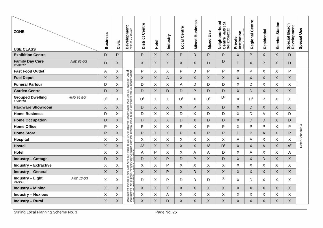
4.3 Table 1 - Zoning Table
4.3.1 Table 1 - Zoning Table indicates, subject to the provisions of the Scheme, the uses permitted in the Scheme area in the various zones. The permissibility of any uses is determined by cross reference between the list of use classes on the left-hand side of the Table 1 - Zoning Table and the list of zones at the top of the Table 1 - Zoning Table.
4.3.2 The symbols used in the cross reference in the Table 1 - Zoning Table have the
following meanings - 'P' means that the use is permitted by the Scheme providing the use complies with
the relevant development standards and the requirements of the Scheme; 'D' means that the use is not permitted unless the Council has exercised its
discretion by granting planning approval; 'A' means that the use is not permitted unless the Council has exercised its
discretion by granting planning approval after giving special notice in accordance with Clause 9.4;
'X' means a use that is not permitted by the Scheme.
Stirling Local Planning Scheme No. 3 Page No. 23
4.3.3 A change in the use of land from one use to another is permitted, if -
a) the Council has exercised its discretion by granting planning approval; b) the change is to a use which is designated with the symbol 'P' in the cross
reference to that zone in the Table 1 - Zoning Table and the proposed use complies with all the relevant development standards and any requirements of the Scheme;
c) the change is an extension of a use within the boundary of the lot which does
not change the predominant use of the lot; or d) the change is to an incidental use that does not change the predominant use of
the land.
Note
1. The planning approval of the Council is required for the development of land in addition to any approval granted for the use of land. In normal circumstances one application is made for both the use and development of land.
2. The Council will not refuse a ‘P’ use because of the unsuitability of the use for the zone but may impose conditions on the use of the land to comply with any relevant development standards or requirements of the Scheme, and may refuse or impose conditions on any development of the land.
3. In considering a 'D' or 'A' use, the Council will have regard to the matters set out in clause 10.2.
4. The Council must refuse to approve any 'X' use of land. Approval to an 'X' use of land may only proceed by way of an amendment to the Scheme.
Stirling Local Planning Scheme No. 3 Page No. 24
Table 1 – Zoning Table
ZONE USE CLASS B
usin
es
s
Civ
ic
Develo
pm
en
t A
MD
84
GG
16
/7/1
9
Dis
tric
t C
en
tre
Ho
tel
Ind
ustr
y
Lo
cal C
en
tre
Mix
ed
Bu
sin
ess
Mix
ed
Use
Neig
hb
ou
rho
od
Cen
tre
AM
D 1
09
GG
31/0
8/2
021
Pri
vate
Insti
tuti
on
A
MD
13
GG
24
/3/1
5
Reg
ion
al C
en
tre
Resid
en
tia
l
Serv
ice S
tati
on
Sp
ecia
l B
each
Develo
pm
en
t
Sp
ecia
l U
se
Aged or Dependent Persons Dwelling D2 A
Deve
lop
me
nt a
nd
use
of
land
sh
all
ha
ve d
ue
re
ga
rd to
an
y W
AP
C a
pp
rove
d A
ctivity C
en
tre P
lan
, a
nd
an
y a
pp
rove
d L
oca
l D
eve
lop
me
nt
Pla
n o
r L
oca
l P
lan
nin
g P
olic
y p
repa
red
un
der
this
Sch
em
e;
and
is t
o b
e in
accord
an
ce
with t
he
Sp
ecia
l C
on
tro
l A
rea
la
nd u
se
perm
issib
ility
pro
vis
ion
s u
nd
er
Pa
rt 6
.
A2 X X A2 X P2 D2 D P4 P X D2
Refe
r S
chedule
4
Amusement Parlour X X P D X P X P P X P X X P
Bed and Breakfast D X D X X D X D D X D A X X
Betting Agency X X D D X D D D D X D X X D
Boarding House AMD 86 GG
15/05/18 A2 X A2 X X A2 X D2 D2 X D4 A X A2
Car Park D P D D P D P D D D D X D D
Caravan Park X X X X X X X X X A X X X X
Caretaker’s Dwelling D D D D P D P P D D D D X D
Child Care Premises D P D X D D D A D D D A X D
Cinema / Theatre D X D D X X X D D X D X X D
Civic Use D P D D D D D P D X D A X P
Club Premises A X A A A A D P A D P X X A
Community Purposes A P P X X P X P P D P A X P
Club Premises A X A A A A D P A D P X X A
Community Purposes A P P X X P X P P D P A X P
Consulting Rooms AMD 13 GG
24/3/15 D X P X X P D P
P D P X X D
Convenience Store X X P X D3 P D3 P P D3 P X X P
Corrective Institution X X X X X X X X X X X X X X
Display Home AMD 13 GG
24/3/15 D X D X X D X D D X D D X D
Drive Through Fast Food Outlet X X D X X X D X D X D X X X
Educational Establishment D X D X X D D D D D D X X X
Stirling Local Planning Scheme No. 3 Page No. 25
ZONE USE CLASS B
usin
es
s
Civ
ic
Develo
pm
en
t A
MD
84
GG
16
/7/1
9
Dis
tric
t C
en
tre
Ho
tel
Ind
ustr
y
Lo
cal C
en
tre
Mix
ed
Bu
sin
ess
Mix
ed
Use
Neig
hb
ou
rho
od
Cen
tre
AM
D 1
09
GG
31/0
8/2
021
Pri
vate
Insti
tuti
on
A
MD
13
GG
24
/3/1
5
Reg
ion
al C
en
tre
Resid
en
tia
l
Serv
ice S
tati
on
Sp
ecia
l B
each
Develo
pm
en
t
Sp
ecia
l U
se
Exhibition Centre D D P X X P D P P X P X X D
Family Day Care AMD 82 GG
26/09/17 D X X X X X X D D D X P X D
Fast Food Outlet A X
Deve
lop
me
nt
an
d u
se
of
lan
d s
ha
ll ha
ve
due
re
gard
to
an
y W
AP
C a
pp
roved
Activity C
en
tre
Pla
n,
an
d a
ny a
pp
roved
Local
Deve
lop
me
nt
Pla
n o
r L
oca
l P
lan
nin
g P
olic
y p
rep
are
d u
nd
er
this
Sch
em
e;
and
is t
o b
e i
n a
cco
rdan
ce
with t
he
Sp
ecia
l C
on
tro
l
Are
a la
nd
use p
erm
issib
ility
pro
vis
ion
s u
nd
er
Pa
rt 6
.
P X X P D P P X P X X P
Refe
r S
chedule
4
Fuel Depot X X X X A X X X X X X X X X
Funeral Parlour D X D X X A D D D X D X X X
Garden Centre D X D X D D P D D X D X X X
Grouped Dwelling AMD 86 GG
15/05/18 D2 X D2 X X D2 X D2
D2 X D4 P X X
Hardware Showroom X X D X X X P X D X D X X X
Home Business D X D X X D X D D X D A X D
Home Occupation D X D X X D X D D X D D X D
Home Office P X P X X P X P P X P P X P
Home Store P X P X X P X P P D P A X P
Hospital X X X X X X X X X A A X X X
Hostel X X A2 X X X X A2 D2 X X A X A2
Hotel X X A P X X A A D X A X X A
Industry – Cottage D X D X P D P X D X X D X X
Industry – Extractive X X X X P X X X X X X X X X
Industry – General X X X X P X D X X X X X X X
Industry – Light AMD 13 GG
24/3/15 X X D X P D D D X X D X X X
Industry – Mining X X X X X X X X X X X X X X
Industry – Noxious X X X X A X X X X X X X X X
Industry – Rural X X X X D X X X X X X X X X
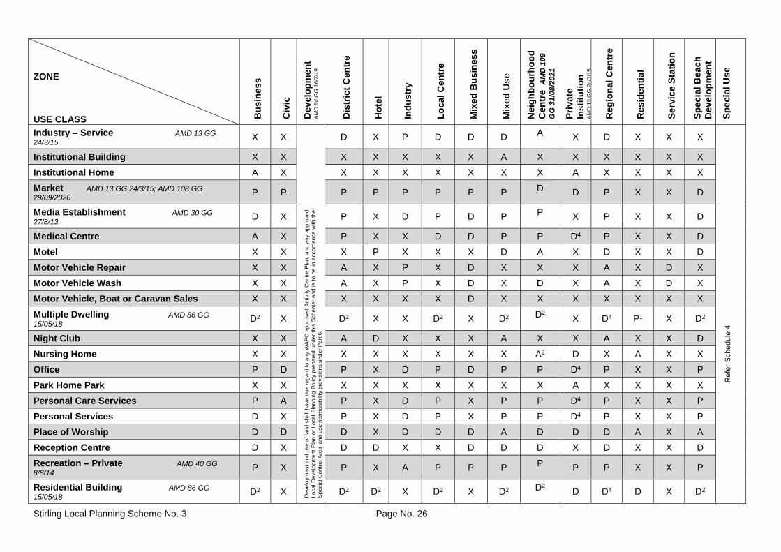
Stirling Local Planning Scheme No. 3 Page No. 26
ZONE USE CLASS B
usin
es
s
Civ
ic
Develo
pm
en
t A
MD
84
GG
16
/7/1
9
Dis
tric
t C
en
tre
Ho
tel
Ind
ustr
y
Lo
cal C
en
tre
Mix
ed
Bu
sin
ess
Mix
ed
Use
Neig
hb
ou
rho
od
Cen
tre
AM
D 1
09
GG
31/0
8/2
021
Pri
vate
Insti
tuti
on
A
MD
13
GG
24
/3/1
5
Reg
ion
al C
en
tre
Resid
en
tia
l
Serv
ice S
tati
on
Sp
ecia
l B
each
Develo
pm
en
t
Sp
ecia
l U
se
Industry – Service AMD 13 GG
24/3/15 X X D X P D D D A X D X X X
Institutional Building X X X X X X X A X X X X X X
Institutional Home A X X X X X X X X A X X X X
Market AMD 13 GG 24/3/15; AMD 108 GG
29/09/2020 P P P P P P P P D D P X X D
Media Establishment AMD 30 GG
27/8/13 D X
De
ve
lop
me
nt
an
d u
se o
f la
nd s
ha
ll h
ave
du
e r
eg
ard
to a
ny W
AP
C a
pp
rove
d A
ctivity C
en
tre
Pla
n,
an
d a
ny a
pp
rove
d
Lo
ca
l D
eve
lop
me
nt
Pla
n o
r Lo
ca
l P
lan
nin
g P
olic
y p
rep
are
d u
nde
r th
is S
ch
em
e;
an
d i
s t
o b
e i
n a
cco
rda
nce
with
th
e
Sp
ecia
l C
on
tro
l A
rea la
nd
use p
erm
issib
ility
pro
vis
ion
s u
nd
er
Pa
rt 6
.
P X D P D P P
X P X X D
Refe
r S
chedule
4
Medical Centre A X P X X D D P P D4 P X X D
Motel X X X P X X X D A X D X X D
Motor Vehicle Repair X X A X P X D X X X A X D X
Motor Vehicle Wash X X A X P X D X D X A X D X
Motor Vehicle, Boat or Caravan Sales X X X X X X D X X X X X X X
Multiple Dwelling AMD 86 GG
15/05/18 D2 X D2 X X D2 X D2 D2 X D4 P1 X D2
Night Club X X A D X X X A X X A X X D
Nursing Home X X X X X X X X A2 D X A X X
Office P D P X D P D P P D4 P X X P
Park Home Park X X X X X X X X X A X X X X
Personal Care Services P A P X D P X P P D4 P X X P
Personal Services D X P X D P X P P D4 P X X P
Place of Worship D D D X D D D A D D D A X A
Reception Centre D X D D X X D D D X D X X D
Recreation – Private AMD 40 GG
8/8/14 P X P X A P P P
P P P X X P
Residential Building AMD 86 GG
15/05/18 D2 X D2 D2 X D2 X D2 D2 D D4 D X D2
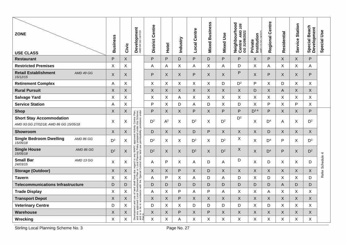
Stirling Local Planning Scheme No. 3 Page No. 27
ZONE USE CLASS B
usin
es
s
Civ
ic
Develo
pm
en
t A
MD
84
GG
16
/7/1
9
Dis
tric
t C
en
tre
Ho
tel
Ind
ustr
y
Lo
cal C
en
tre
Mix
ed
Bu
sin
ess
Mix
ed
Use
Neig
hb
ou
rho
od
Cen
tre
AM
D 1
09
GG
31/0
8/2
021
Pri
vate
Insti
tuti
on
A
MD
13
GG
24
/3/1
5
Reg
ion
al C
en
tre
Resid
en
tia
l
Serv
ice S
tati
on
Sp
ecia
l B
each
Develo
pm
en
t
Sp
ecia
l U
se
Restaurant P X P P D P D P P X P X X P
Restricted Premises X X A A X A X A D X A X X A
Retail Establishment AMD 49 GG
15/12/15 X X P X X P X X P X P X X P
Retirement Complex A X X X X X X D D2 P X D X X
Rural Pursuit X X X X X X X X X D X A X X
Salvage Yard X X X X A X X X X X X X X X
Service Station A X P X D A D X D X P X P X
Shop X X
Deve
lop
me
nt
and
use
of
lan
d s
ha
ll h
ave
due
re
ga
rd t
o a
ny W
AP
C a
pp
rove
d A
ctivity C
en
tre
Pla
n,
an
d a
ny a
pp
roved
Lo
ca
l D
eve
lop
men
t P
lan
or
Lo
ca
l P
lan
nin
g P
olic
y p
repa
red
un
de
r th
is S
ch
em
e;
an
d i
s t
o b
e i
n a
ccord
an
ce w
ith
th
e S
pe
cia
l C
on
tro
l A
rea
lan
d u
se
pe
rmis
sib
ility
pro
vis
ion
s u
nd
er
Pa
rt 6
.
P X X P X P P D3 4 P X X P
Refe
r S
chedule
4
Short Stay Accommodation
AMD 93 GG 27/02/18; AMD 86 GG 15/05/18 X X D2 A2 X D2 X D2
D2
X D4 A X D2
Showroom X X D X X D P X X X D X X X
Single Bedroom Dwelling AMD 86 GG
15/05/18 D2 X D2 X X D2 X D2
X X D4 P X D2
Single House AMD 86 GG
15/05/18 D2 X D2 X X D2 X D2 X X D4 P X D2
Small Bar AMD 13 GG
24/03/15 X X A P X A D A D X D X X D
Storage (Outdoor) X X X X P X D X X X X X X X
Tavern X X A P X A D A D X D X X D
Telecommunications Infrastructure D D D D D D D D D D D A D D
Trade Display X X A X P A P A X X A X X X
Transport Depot X X X X P X X X X X X X X X
Veterinary Centre D X D X X D D D D X D X X X
Warehouse X X X X P X P X X X X X X X
Wrecking X X X X A X X X X X X X X X
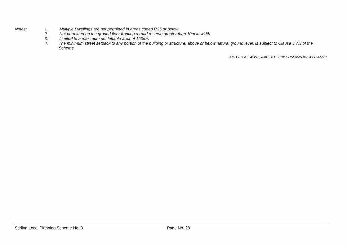
Stirling Local Planning Scheme No. 3 Page No. 28
Notes: 1. Multiple Dwellings are not permitted in areas coded R35 or below. 2. Not permitted on the ground floor fronting a road reserve greater than 10m in width. 3. Limited to a maximum net lettable area of 150m2.
4. The minimum street setback to any portion of the building or structure, above or below natural ground level, is subject to Clause 5.7.3 of the Scheme.
AMD 13 GG 24/3/15; AMD 50 GG 10/02/15; AMD 86 GG 15/05/18
Stirling Local Planning Scheme No. 3 Page No. 29
4.4 Interpretation of the Table 1 - Zoning Table
4.4.1 Where a specific use is mentioned in the Table 1 - Zoning Table, it is deemed to be excluded from the general terms used to describe any other use.
4.4.2 If a person proposes to carry out on land any use that is not specifically mentioned in
the Table 1 - Zoning Table and cannot reasonably be determined as falling within the type, class or genus of activity of any other use category the Council may – a) determine that the use is consistent with the objectives of the particular zone
and is therefore permitted; b) determine that the use may be consistent with the objectives of the particular
zone and thereafter follow the advertising procedures of Clause 9.4 in considering an application for planning approval; or
c) determine that the use is not consistent with the objectives of the particular zone
and is therefore not permitted. 4.5 Additional Uses
Despite anything contained in the Table 1 - Zoning Table, the land specified in Schedule 2 may be used for the specific use or uses that are listed in addition to any uses permissible in the zone in which the land is situated subject to the conditions set out in Schedule 2 with respect to that land.
Note: An additional use is a land use that is permitted on a specific portion of land in addition to the
uses already permissible in that zone that applies to the land.
4.6 Restricted Uses
Despite anything contained in the Table 1 - Zoning Table, the land specified in Schedule 3 may only be used for the specific use or uses that are listed and subject to the conditions set out in Schedule 3 with respect to that land.
Note: A restricted use is the only use or uses that is permitted on a specific portion of land and
other uses that would otherwise be permissible in the zone are not permitted.
4.7 Special Use Zones
4.7.1 Special use zones are set out in Schedule 4 and are in addition to the zones in the Table 1 - Zoning Table.
4.7.2 A person must not use any land, or any structure or buildings on land, in a special use
zone except for the purpose set out against that land in Schedule 4 and subject to compliance with any conditions set out in Schedule 4 with respect to that land.
Note: Special use zones apply to special categories of land use which do not comfortably sit within
any other zone in the Scheme.
4.8 Non-Conforming Uses
Except as otherwise provided in the Scheme, no provision of the Scheme is to be taken to prevent –
(a) the continued use of any premises for the purpose for which it was being lawfully used
immediately prior to the Gazettal date; (b) the carrying out of any development on that land for which, immediately prior to the
Gazettal date, an approval or approvals, lawfully required to authorise the development to be carried out, were duly obtained and are current; or
Stirling Local Planning Scheme No. 3 Page No. 30
(c) subject to Schedule 8 Clause 8.1, the continued display of advertisements which were lawfully erected, placed or displayed prior to the Gazettal date.
Note: "Land" has the same meaning as in the Act and includes houses, buildings and other works and
structures.
4.9 Extensions and Changes to a Non-Conforming Use
4.9.1 A person must not -
a) alter or extend a non-conforming use; b) erect, alter or extend a building used in conjunction with or in furtherance of a
nonconforming use; or
c) change the use of land from a non-conforming use to another non-conforming
use, without first having applied for and obtained planning approval under the Scheme.
4.9.2 An application for planning approval under Clause 4.9 is to be advertised in
accordance with Clause 9.4.
4.9.3 Where an application is for a change of use from an existing non-conforming use to another non-conforming use, the Council is not to grant its planning approval unless the proposed use is less detrimental to the amenity of the locality than the existing nonconforming use and is, in the opinion of the Council, closer to the intended purpose of the zone.
4.10 Discontinuance of Non-Conforming Use
Where a non-conforming use of any land has been discontinued for a period of 6 months the land must not be used after that period otherwise than in conformity with the provisions of the Scheme.
4.11 Termination of a Non-Conforming Use
The Council may effect the discontinuance of a non-conforming use by the purchase of the land, or by the payment of compensation to the owner or occupier or to both the owner and occupier of that land, and may enter into an agreement with the owner for that purpose.
Note: Section 13 of the Act enables the Council to purchase, or, with the consent of the Governor,
compulsorily acquire land for the purpose of a town planning scheme, subject to Part 9 of the Land Administration Act 1997, that section and the Scheme.
4.12 Destruction of Non-Conforming Use Buildings
If a building used for a non-conforming use is destroyed, demolished or damaged to 75% or more of its value, the building is not to be repaired, rebuilt, altered or added to for the purpose of being used for a non-conforming use or in a manner not permitted by the Scheme, except with the planning approval of the Council.
Note: Destruction of non-conforming residential buildings refer clause 5.3.3.
4.13 Development on No Zoned Land
Subject to the provisions of clause 8.1.2, where land classified as 'No Zone' has been amalgamated with abutting zoned or reserved land, all development shall be in accordance with the standards and requirements of the abutting zoned or reserved land to which it has been amalgamated.
Stirling Local Planning Scheme No. 3 Page No. 31
PART 5 - GENERAL DEVELOPMENT REQUIREMENTS
5.1 Compliance with Development Standards and Requirements
5.1.1 Any development of land is to comply with the provisions of the Scheme and have due regard for any relevant Local Planning Policies effective under the Scheme.
5.1.2 Unless otherwise specified in the Scheme development requirements shall be
determined by Council having regard to any relevant Local Planning Policies adopted under the Scheme.
5.2 Residential Design Codes
5.2.1 A copy of the Residential Design Codes is to be kept and made available for public inspection at the offices of the City.
5.2.2 Unless otherwise provided for in the Scheme, the development of land for any of the
residential purposes dealt with by the Residential Design Codes is to conform with the provisions of those Codes.
5.2.3 The Residential Design Codes density applicable to land within the Scheme area is to
be determined by reference to the Residential Design Codes density number superimposed on the particular areas contained within the borders shown on the Scheme Map or where such an area abuts another area having a Residential Design Code density, as being contained within the area defined by the centre-line of those borders.
5.3 Special Application of Residential Design Codes
5.3.1 Except as otherwise required in the Scheme or a Local Planning Policy, non-residential development within the Residential Zone is to comply with the requirements of the relevant R-Code of the Residential Design Codes.
5.3.2 Except as otherwise required in the Scheme or a Local Planning Policy, residential
development not in the Residential Zone is to comply with the requirements of multiple dwellings under the R80 R-Code.
5.3.3 Notwithstanding any other provision of the Scheme, where a site has been developed
(as approved by the Council) for residential purposes at a greater density than that permitted under the relevant R-Code applicable under the Scheme, the Council may permit the site to be redeveloped up to the same density, provided it is satisfied that the standard of development will be significantly improved as a result.
5.3.4 Notwithstanding the provisions of the Residential Design Codes, where land with a
residential density code of R40 is located outside the area of a walkable catchment of 800 metres around an activity centre, specialised centre or railway station on a high frequency rail route as shown on the Scheme Maps or as shown on a map contained in a schedule of the Scheme, the development of multiple dwellings on the land:
a) shall be subject to the average site area per grouped dwelling requirement
specified by the Residential Design Codes for grouped dwellings on land with an R40 residential density code; and
b) shall not be subject to any maximum plot ratio requirements specified by the
Residential Design Codes.
Stirling Local Planning Scheme No. 3 Page No. 32
5.3.5 Notwithstanding the provisions of the Residential Design Codes, subdivision of Single Houses and Grouped Dwellings in areas coded R-AC0 at and immediately adjoining the Balga Plaza, Mirrabooka Village and Nollamara neighbourhood centres is to be in accordance with the requirements of the R40 code, with the exception of Lot 21 (House Number 92) Princess Road, Balga, and Lot 22 (House Numbers 17-21) Fletching Street, Balga, which is to be in accordance with the requirements of the R60 code. AMD 109 GG 31/08/2021
5.4 Restrictive Covenants
5.4.1 Subject to Clause 5.4.2, a restrictive covenant affecting any land in the Scheme area by which, or the effect of which is that, the number of residential dwellings which may be constructed on the land is limited or restricted to less than that permitted by the Scheme, is hereby extinguished or varied to the extent that it is inconsistent with the provisions of the Residential Design Codes which apply under the Scheme.
5.4.2 The provisions of Clause 5.4.1 do not apply to any lots contained within the areas
defined in Schedule 9.
Note: 1. While it is not proposed that applicants be required to provide an up-to-date copy of the
Certificate of Title with every application for planning approval involving more than one dwelling on a lot, applications for planning approval require (under 'property details') the identification of any title encumbrances, including restrictive covenants. Where no such covenants have been identified, it will be taken that none are registered on title.
2. The purpose of restrictive covenants in those areas delineated in Schedule 9 is to restrict the number of dwellings to one on a lot.
5.4.3 Clause 5.4.1 applies whether the restrictive covenant was made before or after the
commencement of this Scheme.
5.4.4 The following are hereby extinguished: - AMD 66 GG 15/08/17
a) All restrictive covenants affecting the land comprising Lot 2 (Plan 10178) House 13, Davenport Street, Karrinyup, Western Australia (Certificate of Title Volume 1356 Folio 122) which are registered against the title of the land (Registration No. A883872) pursuant to a deed of restrictive covenant dated 16 September 1974 between the Commissioners of the Rural and Industries Bank of Western Australia and the City of Stirling.
b) Any and all easements and rights-of-way affecting the land comprising Lot 2
(Plan 10178) House 13, Davenport Street, Karrinyup, Western Australian (Certificate of Title Volume 1356 Folio 122).
5.5 Variations to Site and Development Standards and Requirements
5.5.1 Except for development in respect of which the Residential Design Codes apply, if a development is the subject of an application for planning approval and does not comply with a standard or requirement prescribed under the Scheme, the Council may, despite the non-compliance, approve the application unconditionally or subject to such conditions as the Council thinks fit.
5.5.2 In considering an application for planning approval under Clause 5.5.1, where, in the
opinion of the Council, the variation is likely to affect any owners or occupiers in the general locality or adjoining the site which is the subject of consideration for the variation, the Council is to -
a) consult the affected parties by following one or more of the provisions for
advertising uses under Clause 9.4; and b) have regard to any expressed views prior to making its determination to grant
the variation.
Stirling Local Planning Scheme No. 3 Page No. 33
5.5.3 Where:
a) an application for planning approval requires the exercise of Council's discretion under clause 5.5.1; and
b) in the opinion of Council, there is significant non-compliance with the standard
or requirement;
Council may impose conditions on its approval requiring the provision of specified community facilities at the applicants cost.
Note: 1 It is the intention of the Council to require the provision of community facilities where
there has been a significant increase in demand for that facility as a direct result of the proposed development.
2 Definition of community facilities is contained within Schedule 1.
5.5.4 The power conferred by Clause 5.5.1 may be exercised only if the Council is satisfied
that -
a) approval of the proposed development would be appropriate having regard to the criteria set out in Clause 10.2; and
b) the non-compliance will not have an adverse effect upon the occupiers or users
of the development, the inhabitants of the locality or the likely future development of the locality.
5.5.5 Notwithstanding Clause 5.5.4, the power conferred by Clause 5.5.1 may be exercised on the sole ground that non-compliance with the standard or requirement would enable retention of a significant tree on the site of the development. AMD 9 GG 24/10/17
5.6 Environmental Conditions
There are no environmental conditions imposed by the Minister for Environment which apply to the Scheme.
5.7 Development Requirements
5.7.1 Determination of Standards
Where a particular requirement is not readily determined from a study of the Scheme, Residential Design Codes or a Local Planning Policy, such requirement shall be determined by the Council.
5.7.2 Advertisements and Advertising Signs
The placement, erection or display of an advertisement or advertising sign, including:
a) advertising signs that do not require planning approval under clause 8.2.1 o);
and b) the use of any land, building or structure for that purpose, shall be in accordance with Schedule 8 of the Scheme.
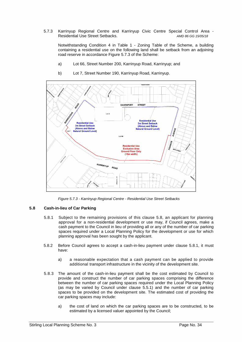
Stirling Local Planning Scheme No. 3 Page No. 34
5.7.3 Karrinyup Regional Centre and Karrinyup Civic Centre Special Control Area - Residential Use Street Setbacks. AMD 86 GG 15/05/18 Notwithstanding Condition 4 in Table 1 - Zoning Table of the Scheme, a building containing a residential use on the following land shall be setback from an adjoining road reserve in accordance Figure 5.7.3 of the Scheme: a) Lot 66, Street Number 200, Karrinyup Road, Karrinyup; and b) Lot 7, Street Number 190, Karrinyup Road, Karrinyup.
Figure 5.7.3 - Karrinyup Regional Centre - Residential Use Street Setbacks
5.8 Cash-in-lieu of Car Parking
5.8.1 Subject to the remaining provisions of this clause 5.8, an applicant for planning approval for a non-residential development or use may, if Council agrees, make a cash payment to the Council in lieu of providing all or any of the number of car parking spaces required under a Local Planning Policy for the development or use for which planning approval has been sought by the applicant.
5.8.2 Before Council agrees to accept a cash-in-lieu payment under clause 5.8.1, it must
have:
a) a reasonable expectation that a cash payment can be applied to provide additional transport infrastructure in the vicinity of the development site.
5.8.3 The amount of the cash-in-lieu payment shall be the cost estimated by Council to
provide and construct the number of car parking spaces comprising the difference between the number of car parking spaces required under the Local Planning Policy (as may be varied by Council under clause 5.5.1) and the number of car parking spaces to be provided on the development site. The estimated cost of providing the car parking spaces may include:
a) the cost of land on which the car parking spaces are to be constructed, to be
estimated by a licensed valuer appointed by the Council;
Stirling Local Planning Scheme No. 3 Page No. 35
b) the cost of constructing the car parking spaces; and c) the cost of constructing or installing signs, facilities or equipment to regulate the
permissible period during which a vehicle may occupy the car parking spaces. 5.8.4 Any costs incurred by Council in estimating the cost of providing the car parking
spaces shall be paid by the applicant.
5.8.5 The cash-in-lieu payment shall be payable in such a manner and at such time as Council determines.
5.8.6 If an applicant does not pay the cash-in-lieu payment and the costs referred to in
clause 5.8.4 in the manner or at the time determined by Council, Council may revoke the planning approval granted for the development or use to which the cash-in-lieu payment relates.
5.8.7 Cash-in-lieu payments received by a Council under this clause 5.8 shall be paid into
appropriate funds to be used for the provision and maintenance of transport infrastructure within reasonable proximity to the development. The cash-in-lieu payment may be used to reimburse Council for any expenses, including loan repayments, which it incurs in providing and maintaining car parking spaces or facilities.
5.8.8 Where this Scheme or a local planning policy made under this Scheme contains
provisions concerning the payment of cash-in-lieu of car parking spaces in particular parts of the Scheme area, those provisions shall apply to the exclusion of the provisions of clause 5.8.
5.9 Reciprocal Car Parking
5.9.1 Subject to the remaining provisions of this clause 5.9, where an application for planning approval is made for a non-residential development or use which does not provide the number of car parking spaces required by the Local Planning Policy, Council may permit the car parking spaces for that development or use to be provided jointly with one or more other developments or uses whether or not those other developments or uses have the number of car parking spaces required by the Local Planning Policy.
5.9.2 In considering an application under clause 5.9.1, Council shall be satisfied:
a) that the peak hours of operation of the developments or uses which are the
subject of the application and the developments or uses with which it is proposed to jointly provide car parking spaces are different and do not substantially overlap;
b) that the number of car parking spaces to be provided by the development or use which is not the subject of the application does not exceed the number of car parking spaces reasonably anticipated to be in excess of the requirement of that development or use during its off-peak hours of operation; and
c) any other matters which, in the circumstances of a proposed development or
use, are considered relevant by Council.
5.9.3 Council may require, and the applicant shall provide, information concerning the matters referred to in clause 5.9.2.
5.9.4 Where Council exercises its discretion under clause 5.9.1, it may require the owner of
the land to which the application relates and the owner of the land which is not the subject of the application and which is to provide car parking spaces and any other person specified by the City, to enter into a legal agreement, to which the City may also be a party, which provides for the provision and use of car parking spaces. The legal agreement:
Stirling Local Planning Scheme No. 3 Page No. 36
a) must be to Council's satisfaction; b) must be prepared at the expense of the applicant;
c) must, if required by Council, provide for easements, restrictive covenants, rights
of way and reciprocal access and circulation arrangements; and d) must ensure that the agreement and any easement, restrictive covenant, right
of way or reciprocal access and circulation arrangement made under the agreement are not amended, removed or terminated without the prior consent of the Council.
5.9.5 If:
a) a restrictive covenant, easement or right of way is made with respect to any land or building pursuant to an agreement entered into under clause 5.9.4; and
b) that land or building is subject to another restrictive covenant, easement or right
of way which:
i. exists for the purpose of regulating the parking, access or circulation of vehicles; and
ii. is inconsistent with the restrictive covenant, easement or right of way referred to in clause 5.9.5 a),
then the restrictive covenant, easement or right of way (as the case may be) referred to in clause 5.9.5 b) is hereby extinguished or varied to the extent that it is inconsistent with the restrictive covenant, easement or right of way referred to in clause 5.9.5 a).
5.10 Parking and Access Plans
5.10.1 Council may prepare a Parking and Access Plan with respect to any land or building for the better provision and coordination of parking, access or circulation of vehicles on that land or within that building or within the area in which the land or building is located.
5.10.2 A Parking and Access Plan may include details as to:
a) the location and form of access to or egress from the land or building; b) the circulation of vehicles on the land or within the building;
c) the parking of vehicles on the land or within the building; and
d) the integration of parking, vehicle access and circulation with other land or
buildings within the area.
5.10.3 A Parking and Access Plan may relate to more than one lot, building or survey or survey strata lot.
5.10.4 A Parking and Access Plan may extinguish or vary any restrictive covenant,
easement or right of way. The extinguishment or variation of the restrictive covenant, easement or right of way shall take effect upon adoption of the Parking and. Access Plan by Council under clause 5.10.7 b).
5.10.5 Council may give notice of a Parking and Access Plan in one or more of the ways referred to in clause 9.4.3 as if the Parking and Access Plan was an application for planning approval.
5.10.6 Any person may inspect the Parking and Access Plan referred to in the notice
and any material accompanying that Parking and Access Plan at the offices of the Council.
Stirling Local Planning Scheme No. 3 Page No. 37
5.10.7 After the expiry of the period within which submissions may be made, the Council is
to:
a) review the proposed Parking and Access Plan in light of any submissions made; and
b) resolve to adopt the Parking and Access Plan with or without modifications or
not to proceed with the Parking and Access Plan.
5.10.8 If Council resolves to adopt the Parking and Access Plan, it is to publish notice of the Parking and Access Plan once in a newspaper circulating in the Scheme area.
5.10.9 A Parking and Access Plan may be modified in the same manner as a Parking and
Access Plan is prepared and adopted under clauses 5.10.1 to 5.10.8.
5.10.10 Council shall have due regard to a Parking and Access Plan which affects any land or building which is the subject of an application for planning approval.
5.11 Ceding of. Rights-Of-Way Widening
The owner of any site affected by a right of way widening under the Local Planning Policy relating to Right of Ways shall cede such right of way widening free of cost as a condition of development approval or as a condition of subdivision or strata subdivision supported by the Council.
5.11A Where part of a lot within a Development Contribution Area has been transferred free
of costs to the Crown for the purpose of widening a road or Right of Way, the area ceded shall be added to the area of the lot for the purpose of calculating the minimum and average site area in determining development potential. AMD 5 GG 15/12/15
5.12 Requirement to Prepare a Detailed Area Plan
Council may require the preparation of a Detailed Area Plan for any lot or lots in accordance with Clause 6A.16.
All Development on land the subject of an adopted Detailed Area Plan is to comply with that Detailed Area Plan. AMD 13 GG 24/3/15
5.13 Trees and Development AMD 9 GG 24/10/17
5.13.1 Purpose
The purpose of this clause is to require the retention of significant trees or planting of new trees on:
a) zoned land which is the subject of an application for development approval
under the Scheme and on road reserves abutting that zoned land.
5.13.2 Objectives
a) To promote development that enables existing significant trees to be retained on zoned land and to protect existing street trees on abutting road reserves.
b) To minimise the removal of significant trees on zoned land and street trees
on abutting road reserves as a consequence of development; and
c) To ensure suitable advanced trees of appropriate size and maturity are planted where, on-site significant trees and street trees on abutting road reserves, have been removed or do not exist.
Stirling Local Planning Scheme No. 3 Page No. 38
5.13.3 Development
a) The retention of significant trees may be imposed as a condition of development approval.
b) Where the Council approves development on a site which, at the time does
not contain a significant tree or involves the removal of a significant tree from the site, the Council may, as a condition of development approval, require advanced trees approved by the Council to be planted in particular locations on the site at a maximum ratio of one advanced tree for every 500m² (or part thereof) of the site’s area. Where this ratio is inconsistent with the maximum ratio specified by a Local Planning Policy, Structure Plan or Local Development Plan which applies to the particular site or the area in which the site is located, the Council may vary the maximum ratio specified above having due regard to the maximum ratio of that Local Planning Policy, Structure Plan or Local Development Plan.
c) Where the Council approves development on a site with a condition of
development approval requiring the retention of a significant tree or the planting of an advanced tree, the Council may, as a condition of development approval, require adequate surrounding soil space at ground level around each tree to sustain its health and growth.
d) The Council may impose a condition of development approval to require the
planting of an advanced tree, at the applicant’s cost, on an abutting road reserve.
5.14 Additional Site and Development Requirements for Areas Covered by Structure Plan, Activity Centre Plan or Local Development Plan
AMD 106 GG 23/07/19
Sites with additional requirements for areas covered by a structure plan, activity centre plan or local development plan are included in Schedule 12 of this Scheme.
Stirling Local Planning Scheme No. 3 Page No. 39
PART 6 - SPECIAL CONTROL AREAS 6.1 Operation of Special Control Areas
6.1.1 The following Special Control Areas are shown on the Scheme Maps: AMD 1 GG 02/09/14; AMD 39 GG 21/08/18
• Careniup Swamp
• Coastal Height Limit Non-Residential Zones
• Gwelup Water Protection Area
• Heritage Protection Area
• Karrinyup Civic Centre AMD 66 GG 15/08/17
• Main Street Plaza
• Mirrabooka Town Centre
• Scarborough
• Dianella Media District
• Dianella Centre
• Stirling City Centre
• Herdsman Glendalough AMD 39 GG 21/08/18
6.1.2 In respect of a Special Control Area shown on the Scheme Maps, the provisions applying to the Special Control Area apply in addition to the provisions applying to any underlying zone or reserve and any general provisions of the Scheme.
6.2 Careniup Swamp Special Control Area
Note: In addition to the following provisions, the provisions of Clause 6A and Schedule 10 also apply to the Careniup Swamp Special Control Area
6.2.1 UObjectives
a) To ensure orderly subdivision of the Special Control Area; b) To ensure the ceding of Public Open Space;
c) To ensure water quality standards;
d) To ensure wildlife protection;
e) To control filling; and
f) To manage stormwater.
6.2.2 USpecial Control Area
The Careniup Swamp Special Control Area ("the Area") is all that land delineated on the Scheme Maps. In broad terms it is bounded by Balcatta Road, Mitchell Freeway, Erindale Road and North Beach Road.
6.2.3 UImplementation of Development Proposals
a) All subdivision and development within the Area shall have regard to the
requirements set out in clause 6.2 and the Rehabilitation Plan provided however that any development proposal not in conformity with clause 6.2 may be carried out with the approval of Council. Council may seek input from the Western Australian Planning Commission, Water Corporation and the Department of Environment and Conservation.
Stirling Local Planning Scheme No. 3 Page No. 40
b) When considering any application for approval to commence development, subdivision, strata subdivision or the amendment of the Scheme within the Area, the Council and the applicant shall have due regard to the provisions contained within clause 6.2.
c) When considering any application for subdivision or strata subdivision approval
within the Area, the Council shall inform the Western Australian Planning Commission of the Rehabilitation Plan and the Rehabilitation Strategy, particularly when determining any public open space contribution required as a condition of a subdivision or a strata subdivision approval.
6.2.4 UCeding of Land & Cash Payments in Lieu
a) Upon any amendment of the Scheme in respect of land within the Area, or the
granting of approval to subdivide any land within the Area, whichever shall first occur, the following provisions shall take effect:
i. Where any portion of land is within the Core Area delineated on the
Rehabilitation Plan, such portion shall be ceded to the State for vesting in the City by the owner free of costs and without any entitlement on the part of the owner or any other person with any interest therein to be paid compensation pursuant to the Public Works Act otherwise;
ii. If no portion of the land is within the Core Area delineated by the Rehabilitation Plan, the owner of such land shall pay to the City a sum equal to ten per centum (10%) of the market value of the land calculated as at the date of the gazettal of the amendment, the granting of approval to subdivide such land, or the granting of approval to commence development on such land as the case may be.
6.2.5 UWater Quality Standards
a) Objectives The Careniup Swamp and adjacent area is utilised by the Water Corporation as
a compensating basin and it is important to maintain sufficient capacity of not less than 26,000 cubic metres within the Core Area as a modified wetland to satisfy drainage and compensation requirements. It is also vital for wildlife retention to retain permanent water throughout the Area of modified wetland, with minimum summer depths being sufficient to maintain landscape and water quality.
b) Development and Subdivision Criteria
In order to satisfy the objectives, set out in the preceding sub-clause hereof, development shall conform with the following criteria and Council will recommend to the Commission in responding to a subdivision application that:
i. The lake be designed on the basis that the area has a maximum water
level of RL 7.0 metres AHD and a minimum water level of RL 6.3 metres AHD; and
ii. The moat and lake beds referred to in the Rehabilitation Plan shall be constructed to RL 4.1 metres AHD in order to maintain a minimum water depth of 1.0 metre during the summer period.
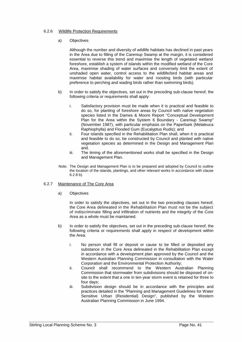
Stirling Local Planning Scheme No. 3 Page No. 41
6.2.6 UWildlife Protection Requirements
a) Objectives
Although the number and diversity of wildlife habitats has declined in past years in the Area due to filling of the Careniup Swamp at the margin, it is considered essential to reverse this trend and maximise the length of vegetated wetland foreshore, establish a system of islands within the modified wetland of the Core Area, maximise shading of water surfaces and conversely limit the extent of unshaded open water, control access to the wildlife/bird habitat areas and maximise habitat availability for water and roosting birds (with particular preference to perching and wading birds rather than swimming birds).
b) In order to satisfy the objectives, set out in the preceding sub-clause hereof, the
following criteria or requirements shall apply:
i. Satisfactory provision must be made when it is practical and feasible to do so, for planting of foreshore areas by Council with native vegetation species listed in the Dames & Moore Report "Conceptual Development Plan for the Area within the System 6 Boundary - Careniup Swamp" (November 1987), with particular emphasis on the Paperbark (Melaleuca Raphiophylla) and Flooded Gum (Eucalyptus Rudis); and
ii. Four islands specified in the Rehabilitation Plan shall, when it is practical and feasible to do so, be constructed by Council and planted with native vegetation species as determined in the Design and Management Plan and.
iii. The timing of the aforementioned works shall be specified in the Design and Management Plan.
Note: The Design and Management Plan is to be prepared and adopted by Council to outline
the location of the islands, plantings, and other relevant works in accordance with clause 6.2.8 b).
6.2.7 UMaintenance of The Core Area
a) Objectives
In order to satisfy the objectives, set out in the two preceding clauses hereof, the Core Area delineated in the Rehabilitation Plan must not be the subject of indiscriminate filling and infiltration of nutrients and the integrity of the Core Area as a whole must be maintained.
b) In order to satisfy the objectives, set out in the preceding sub-clause hereof, the
following criteria or requirements shall apply in respect of development within the Area:
i. No person shall fill or deposit or cause to be filled or deposited any
substance in the Core Area delineated in the Rehabilitation Plan except in accordance with a development plan approved by the Council and the Western Australian Planning Commission in consultation with the Water Corporation and the Environmental Protection Authority;
ii. Council shall recommend to the Western Australian Planning Commission that stormwater from subdivisions should be disposed of on-site to the extent that a one in ten-year storm event is retained for three to four days;
iii. Subdivision design should be in accordance with the principles and practices detailed in the "Planning and Management Guidelines for Water Sensitive Urban (Residential) Design", published by the Western Australian Planning Commission in June 1994.
Stirling Local Planning Scheme No. 3 Page No. 42
6.2.8 URehabilitation Programme
a) Objectives
The Core Area delineated in the Rehabilitation Plan is proposed to ultimately be vested in the Council, which intends to rehabilitate it in an orderly and comprehensive manner in accordance with the Rehabilitation Plan. A Design and Management Plan for the entire Core Area is to be prepared by the Council addressing issues such as midge and mosquito control, moat depth profiles, peat removal for housing and stormwater drainage prior to commencement of rehabilitation works.
b) The Design and Management Plan shall be prepared when sufficient land in the
Core Area has been ceded to the Crown and vested in the Council to enable rehabilitation to commence in an orderly manner or at such earlier time as determined by Council.
c) In respect of those portions of the Core Area ultimately vested in the Council,
it shall be the responsibility of the Council to carry out over time the rehabilitation of the Core Area referred to in the Rehabilitation Plan.
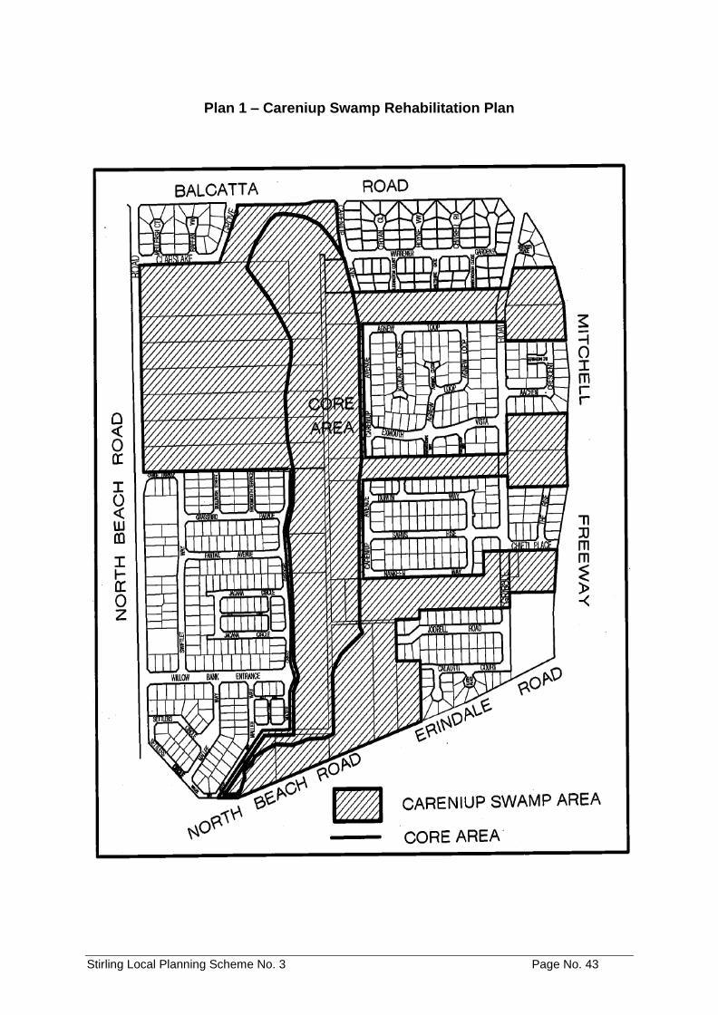
Stirling Local Planning Scheme No. 3 Page No. 43
Plan 1 – Careniup Swamp Rehabilitation Plan
Stirling Local Planning Scheme No. 3 Page No. 44
6.3 Coastal Height Limit - Non-Residential Zones Special Control Area
6.3.1 UObjective
To ensure that buildings over 12 metres in height do not have a detrimental impact on the amenity of the Special Control Area or adjoining sites.
6.3.2 USpecial Control Area
The Coastal Height Limit — Non-Residential Zones Special Control Area is all that land delineated as such on the Scheme Maps.
6.3.3 UApproval
a) An application requiring the approval of the Council under Clause 8.1 of the
Scheme shall include information which addresses the impact of the proposal having regard to matters such as amenity, overshadowing, wind impacts and building design, siting, bulk, scale and colour.
b) Before determination of an application requiring the approval of the Council
under Clause 8.1 of the Scheme, the Council shall cause the provisions of Clause 9.4 of the Scheme to be invoked in respect of the application.
6.4 Herdsman Glendalough Special Control Area
AMD 39 GG 21/08/18
6.4.1 Objectives
a) To provide a strategy for the integrated development of public and private land to facilitate the creation of a safe, vibrant mixed use environment based on main street design principles;
b) to enable the provision of an effective, efficient integrated and safe transport
network which is accessible to pedestrians, cyclists, public transport users and motorists;
c) to ensure greater utilisation of Glendalough Train Station through increased
density of both residential and commercial uses; d) To ensure the development of a diverse range of housing types; e) to ensure the development of a convenient network of public open space; f) to ensure the development of a range of commercial uses that will contribute
towards economic development, local employment and the viability of the area;
g) to ensure the development of a range of community facilities; h) to create a more permeable transport network through the provision of
additional road connections; i) to ensure the conservation and appropriate use of natural resources; and j) to enable developer contributions to help fund key infrastructure.
Stirling Local Planning Scheme No. 3 Page No. 45
6.4.2 Special Control Area
a) The Herdsman Glendalough Special Control Area is shown on the Scheme Maps and delineated as such.
b) Clause 5.3.2 of the Scheme shall not apply to residential development in the
Herdsman Glendalough Special Control Area.
6.4.3 Structure Plan
a) For the purpose of promoting the highest standard of development within the Hedsman Glendalough Special Control Area the Council shall adopt an appropriate Structure Plan for the Herdsman Glendalough Special Control Area in accordance with Part 6A of the Scheme.
b) The Structure Plan will define precincts within the Special Control Area.
6.4.4 Road Widening Requirements
a) The owner of any site affected by the Scarborough Beach Road Other
Regional Roads reservation or Planning Control Area shall cede such road widening to the Crown, free of cost and without any payment of compensation, as a condition of development approval that involves, in the opinion of the local government, the complete or substantial redevelopment of the site or as a condition of the subdivision or strata subdivision of a lot, whichever occurs first.
b) The owner of any site affected by a right of way widening under the Local
Planning Policy relating to Right of Ways shall cede such a right of way widening free of cost as a condition of development approval or subdivision or strata title approval recommended by the City.
6.5 Gwelup Water Protection Area Special Control Area
6.5.1 UObjectives
a) To provide a basis for the protection of the water resource through the control of activities which have the potential to adversely affect the quality of water supplies for public use.
b) To manage the risk of pollution of the water source, which is required to co-exist with other land uses such as residential, commercial and industrial development.
6.5.2 USpecial Control Area
The Gwelup Water Protection Area Special Control Area is that land delineated as such on the Scheme Maps in accordance with the Priority 3 classification applied by the Water and Rivers Commission.
6.5.3 Development
In its determination of any application for planning approval and its advice in relation to land subdivision for industry noxious or the use or storage of any hazardous goods of such quantities as require licensing under the Hazardous and Dangerous Goods Act and associated Regulations, the Council is to have particular regard to: a) the Water and Rivers Commission Water Quality Protection Note: Land Use
Compatibility in Public Drinking Water Source Areas, and any advice received from the Commission;
Stirling Local Planning Scheme No. 3 Page No. 46
b) the requirements of Statement of Planning Policy No. 2.7 Public Drinking Water
Source Policy; c) the potential impact of the proposal on the quality of the water resource; d) the practicability and cost of any ameliorative measures proposed for the
protection of the resource; e) the existing level of protection of the resource provided, with reference to
management of land and location of development; f) the nature, location and performance of any existing or proposed effluent
disposal system; and g) the drainage characteristics of the land, including surface and groundwater flow,
and the adequacy of proposed measures to manage run-off and drainage.
Note: The above Water Quality Protection Note identifies three levels of compatibility for land uses, namely: Incompatible (generally not acceptable); Conditional (may be acceptable subject to conditions); and Compatible (generally acceptable provided the use is conducted within the bounds of acceptable environmental practice).
6.5.4 UApproval
In respect to the Gwelup Water Protection Area Special Control Area the Council may refuse any application for planning approval or impose conditions on any planning approval so as to:
a) protect the resource; and b) require the registration of notification on title giving notice of any limitations or
constraints associated with the protection of resources.
Note: There is a general presumption against development or use of land, which is not compatible with Public Drinking Water Source Areas or which involves a significant risk to the resource. The onus will be on the proponent of development to demonstrate that the proposed activity will not prejudice the resource.
6.6 Heritage Protection Area Special Control Area
6.6.1 Objectives
a) To ensure the conservation and retention of buildings within the Heritage Protection Area Special Control Area dating from the early 1900s to the 1950s where the architectural style of the building is generally intact;
b) to ensure the retention of existing buildings referred to in a) irrespective of
whether the demolition of the building would have no adverse impact on the streetscape; AMD 76 GG 27/06/17
c) to ensure that new buildings (where permitted), alterations, additions to existing
buildings, carports, garages and front fences are in keeping with the heritage character of the area, respect the scale and proportions of surrounding buildings, and are designed to fit into the existing streetscape;
d) to maintain and improve existing street trees, grass verges and front gardens;
and e) to retain mature trees wherever possible.
Stirling Local Planning Scheme No. 3 Page No. 47
f) To ensure that new development within the area which is subject to the Beaufort Street Local Development Plan enhances and respects the heritage, character and amenity of Beaufort Street. AMD 60 GG 11/12/18
6.6.2 USpecial Control Area
The Heritage Protection Area Special Control Area is that land delineated as such on the Scheme Maps.
6.6.3 UDevelopment
a) All development shall conform with the objectives of the Heritage Protection
Area Special Control Area (clause 6.6.1);
b) All development shall have due regard to:
i. the Local Planning Policy adopted for the Heritage Protection Area Special
Control Area (Character Retention Guidelines Mt Lawley, Menora and
Inglewood); and
ii. the Beaufort Street Local Development Plan on land within the area which is subject to that plan. AMD 60 GG 11/12/18
6.6.4 Where it is proposed or necessary to demolish (other than partially) a building
described in Clause 6.6.1 a) located in Residential Zone, or partially or completely demolish a building located in all other zones in order to undertake any works on the land on which the building is located, development approval for the works shall not be granted until separate development approval has first been granted for the demolition of the building.
Note: Partial demolition of a building in a Residential zone within the Heritage Protection
Area Special Control Area will be considered as part of the assessment of a development application for additions or alterations to the building.
Partial demolition will be assessed in the context of the following objectives:
• To conserve and retain buildings within the Heritage Protection Area dating from the early 1900s to the 1950s where the architectural style of the building is generally intact.
• To retain the traditional house with minimum alterations.
This framework prevents the demolition of all but a portion of an existing building, and demolition proposals should be confined to those portions of the building behind the ridge line of the roof at the rear of the building. AMD 76 GG 27/06/17
6.6.5 Subdivision
a) The minimum area of all lots created by the subdivision of land zoned ‘Residential’ within the area which is subject to the Beaufort Street Local Development Plan shall be 500m2 and the minimum frontage of the lots shall be 20m;
b) Land fronting Beaufort Street shall not be subdivided where this would result in
vehicle access to any right of way at the rear of the land being restricted or removed for any of the new lots. AMD 60 GG 11/12/18
Stirling Local Planning Scheme No. 3 Page No. 48
6.6.6 Building Height
a) Building height shall be in accordance with the building heights shown on Figure 6.6.6.
b) The power conferred by clause 5.5.1 and clause 7.6 of Local Planning scheme
No.3 shall not apply to clause 6.6.6(a) and (c). c) Notwithstanding clause 6.6.6(a) variation in building height shall only be
permitted in the following instances:
i. Building height for House Numbers 683 and 685 Beaufort Street, Mt Lawley may include a fourth storey if a public plaza of a minimum 75m2 is provided, and all the above-mentioned lots are amalgamated.
ii. Building height for House Numbers 734 and 736 Beaufort Street, Mount Lawley may be up to 4 storeys on the Beaufort Street corner, to a maximum length of 30m along Beaufort Street, and 30m along First Avenue, provided all the above-mentioned lots are amalgamated.
iii. Building height for House Numbers 939, 941, 942, 943, 944, 945, 947 and 951 Beaufort Street, Inglewood may be up to 4 storeys, provided that a minimum of two adjoining lots are amalgamated.
iv. Building height on the following lots may include a fifth storey if a public plaza of a minimum 75m2 is provided on the site, is accessible by the public at all times, and faces Beaufort Street: a. House Number 96 Tenth Avenue, Inglewood. b. House Number 895 Beaufort Street, Inglewood. c. House Number 189, Eighth Avenue, Inglewood.
v. Building height for House Numbers 867, 871, 875, and 877 Beaufort Street, Inglewood, may be up to 5 storeys if a public plaza of a minimum 75m2 is provided, and all the above-mentioned lots are amalgamated.
AMD 60 GG 11/12/18
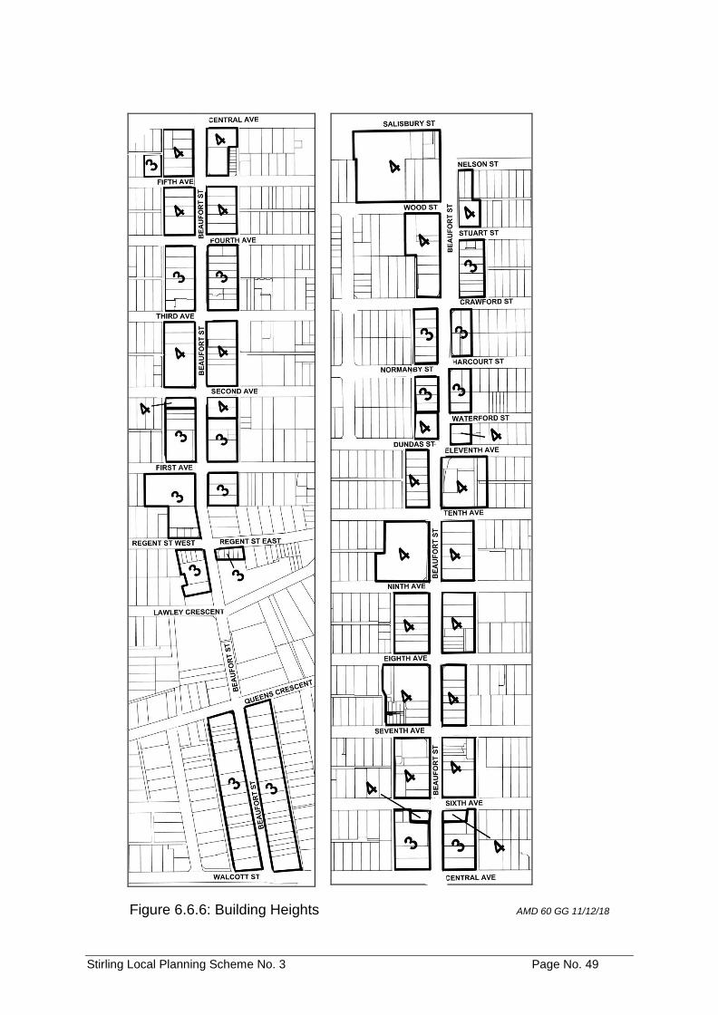
Stirling Local Planning Scheme No. 3 Page No. 49
Figure 6.6.6: Building Heights AMD 60 GG 11/12/18
Stirling Local Planning Scheme No. 3 Page No. 50
6.6.7 Special Application of Residential Design Codes AMD 60 GG 11/12/18
Notwithstanding clause 5.3.2 of the Scheme, residential development on land zoned Mixed Use within the Beaufort Street Local Development Plan area is subject to the requirements of multiple dwellings under the R-AC0 Code. Development requirements for the R-AC0 Code are outlined in the Beaufort Street Local Development Plan.
6.7 Main Street Plaza Special Control Area
6.7.1 UObjective
To permit development of office and/or residential uses contingent upon the provision of an integrated car parking and landscaping facility.
6.7.2 USpecial Control Area
The Main Street Plaza Special Control Area is the land delineated as such on the Scheme Maps.
6.7.3 UDevelopment
No development, except for maintenance of existing buildings, shall be approved by the Council until a Detailed Area Plan and a Development Contribution Plan for the Special Control Area has been adopted by the Council in accordance with Parts 6A & 6B of the Scheme and payment of a development contribution in accordance with the adopted Development Contribution Plan.
All development shall conform with the Detailed Area Plan and a Development Contribution Plan adopted by the Council for the Special Control Area.
6.8 Mirrabooka Town Centre Special Control Area
AMD 29 GG 16/9/14; AMD 63 GG 20/12/16; AMD 85 GG 12/06/18
6.8.1 UObjectives
a) To facilitate development of a safe, vibrant, mixed use town centre based on
sustainable design principles, integrated with public transport; b) to encourage greater use of the Mirrabooka public transport facilities through
increased density of both residential and non residential uses; c) to require the development of a diverse range of housing types; d) to promote the development of a variety of public open space areas; e) to facilitate the development of a range of non residential uses that contribute
to economic development, local employment and viability of the Centre; f) to encourage the development of a range of community facilities; g) to create a permeable transport network through the provision of additional
road connections; h) to facilitate the development of a vibrant main street; and i) to facilitate high quality private and public spaces and buildings that contribute
towards a sense of place.
Stirling Local Planning Scheme No. 3 Page No. 51
6.8.2 USpecial Control Area
The Mirrabooka Town Centre Special Control Area is the land delineated as such on the Scheme Maps.
6.8.3 USubdivision and Development
a) The subdivision and development of all land within the Mirrabooka Town
Centre Special Control Area shall have due regard to any Activity Centre Plan, Local Development Plan and Local Planning Policy that is adopted under or for the purposes of this Scheme subject to the provisions contained within the Scheme. AMD 85 GG 12/06/18
b) The power conferred by Clause 5.5.1 of this Scheme shall not apply to
clauses 6.8.8 a), 6.8.9, 6.8.10, 6.8.11, 6.8.12, 6.8.13 and the Maximum Car Parking standards of Table 6.8.14 a). AMD 110 GG 21/01/20
6.8.4 Activity Centre Plan
a) For the purpose of promoting the highest standard of development, an Activity
Centre Plan shall be approved for the Mirrabooka Town Centre Special Control Area in accordance with Part 5 - Activity Centre Plans of the Deemed Provisions in Schedule 2 of the Planning and Development (Local Planning Schemes) Regulations 2015. AMD 85 GG 12/06/18
6.8.5 Local Development Plan
a) The local government may require the preparation of a Local Development Plan for all or any land in the Mirrabooka Town Centre Special Control Area in accordance with Part 6 - Local Development Plans of the Deemed Provisions in Schedule 2 of the Planning and Development (Local Planning Schemes) Regulations 2015. AMD 85 GG 12/06/18
6.8.6 Land Use Table
a) Notwithstanding Clause 4.3 of this Scheme, land use permissibility for land in the Mirrabooka Town Centre Special Control Area is in accordance with Table 6.8.6 below. The symbols used in Table 6.8.6 shall have the same meaning as defined in Clauses 4.3.2 and 4.3.3. AMD 85 GG 12/06/18
b) If a person proposes to carry out on land any use that is not specifically
mentioned in Table 6.8.6 and cannot reasonably be determined as falling within the type, class or genus of activity of any other use category, the Council shall consider this use in accordance with the provisions of Clause 4.4.2 AMD 85 GG 12/06/18
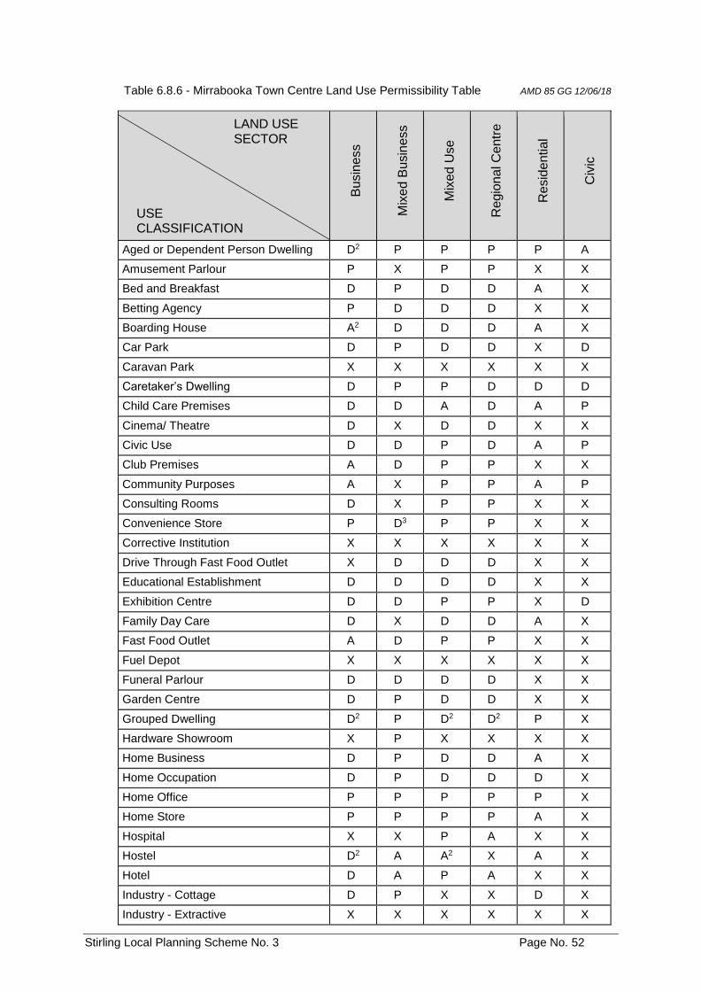
Stirling Local Planning Scheme No. 3 Page No. 52
Table 6.8.6 - Mirrabooka Town Centre Land Use Permissibility Table AMD 85 GG 12/06/18
LAND USE SECTOR USE CLASSIFICATION
Bu
sin
ess
Mix
ed B
usin
ess
Mix
ed U
se
Re
gio
na
l C
entr
e
Re
sid
en
tial
Civ
ic
Aged or Dependent Person Dwelling D2 P P P P A
Amusement Parlour P X P P X X
Bed and Breakfast D P D D A X
Betting Agency P D D D X X
Boarding House A2 D D D A X
Car Park D P D D X D
Caravan Park X X X X X X
Caretaker’s Dwelling D P P D D D
Child Care Premises D D A D A P
Cinema/ Theatre D X D D X X
Civic Use D D P D A P
Club Premises A D P P X X
Community Purposes A X P P A P
Consulting Rooms D X P P X X
Convenience Store P D3 P P X X
Corrective Institution X X X X X X
Drive Through Fast Food Outlet X D D D X X
Educational Establishment D D D D X X
Exhibition Centre D D P P X D
Family Day Care D X D D A X
Fast Food Outlet A D P P X X
Fuel Depot X X X X X X
Funeral Parlour D D D D X X
Garden Centre D P D D X X
Grouped Dwelling D2 P D2 D2 P X
Hardware Showroom X P X X X X
Home Business D P D D A X
Home Occupation D P D D D X
Home Office P P P P P X
Home Store P P P P A X
Hospital X X P A X X
Hostel D2 A A2 X A X
Hotel D A P A X X
Industry - Cottage D P X X D X
Industry - Extractive X X X X X X
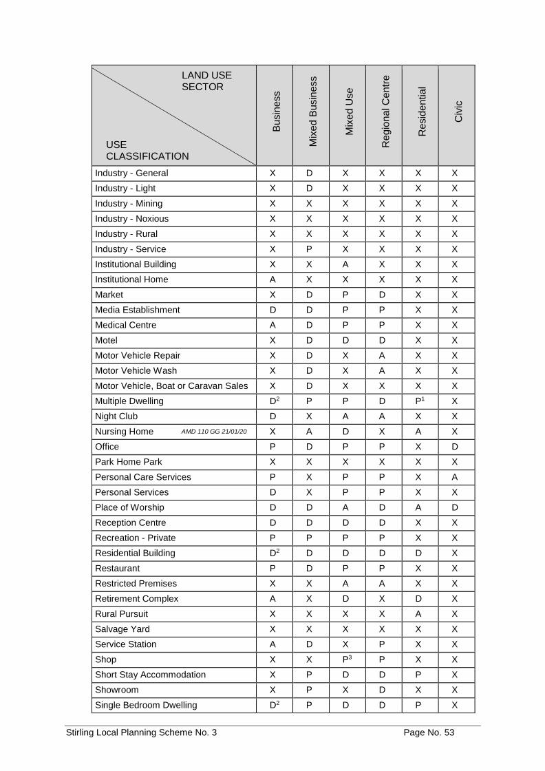
Stirling Local Planning Scheme No. 3 Page No. 53
LAND USE SECTOR USE CLASSIFICATION
Bu
sin
ess
Mix
ed B
usin
ess
Mix
ed U
se
Re
gio
na
l C
entr
e
Re
sid
en
tial
Civ
ic
Industry - General X D X X X X
Industry - Light X D X X X X
Industry - Mining X X X X X X
Industry - Noxious X X X X X X
Industry - Rural X X X X X X
Industry - Service X P X X X X
Institutional Building X X A X X X
Institutional Home A X X X X X
Market X D P D X X
Media Establishment D D P P X X
Medical Centre A D P P X X
Motel X D D D X X
Motor Vehicle Repair X D X A X X
Motor Vehicle Wash X D X A X X
Motor Vehicle, Boat or Caravan Sales X D X X X X
Multiple Dwelling D2 P P D P1 X
Night Club D X A A X X
Nursing Home AMD 110 GG 21/01/20 X A D X A X
Office P D P P X D
Park Home Park X X X X X X
Personal Care Services P X P P X A
Personal Services D X P P X X
Place of Worship D D A D A D
Reception Centre D D D D X X
Recreation - Private P P P P X X
Residential Building D2 D D D D X
Restaurant P D P P X X
Restricted Premises X X A A X X
Retirement Complex A X D X D X
Rural Pursuit X X X X A X
Salvage Yard X X X X X X
Service Station A D X P X X
Shop X X P3 P X X
Short Stay Accommodation X P D D P X
Showroom X P X D X X
Single Bedroom Dwelling D2 P D D P X
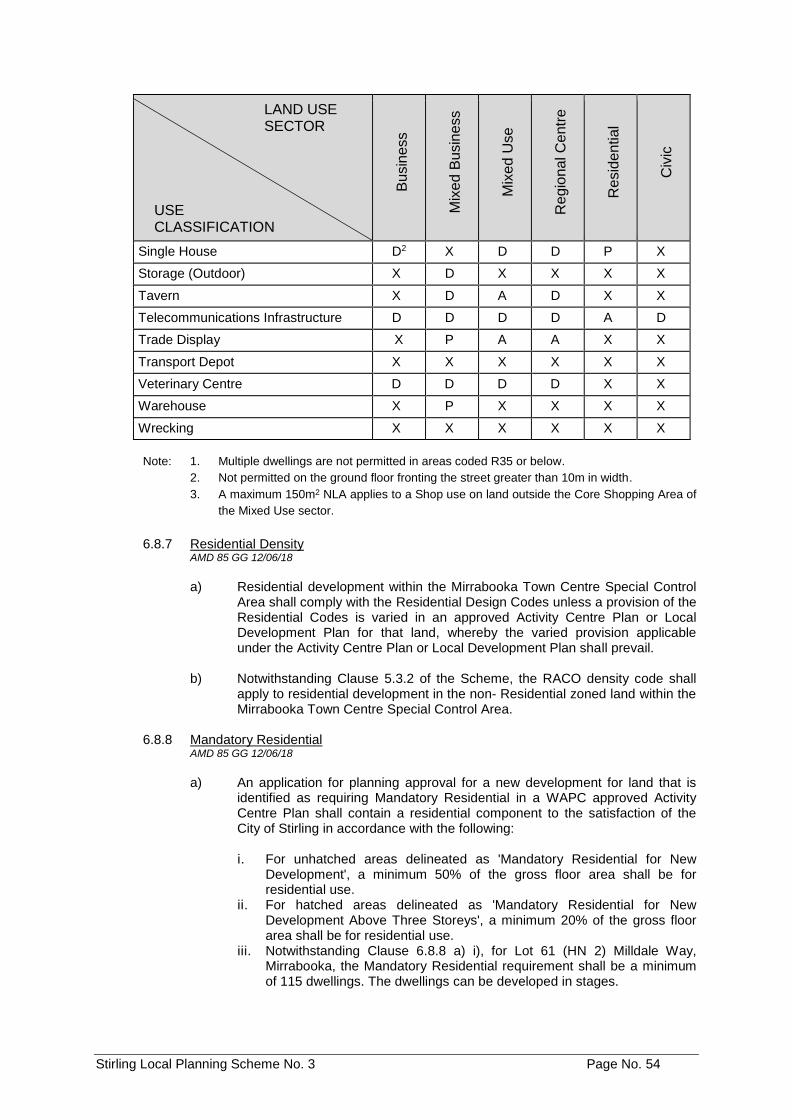
Stirling Local Planning Scheme No. 3 Page No. 54
LAND USE SECTOR USE CLASSIFICATION
Bu
sin
ess
Mix
ed B
usin
ess
Mix
ed U
se
Re
gio
na
l C
entr
e
Re
sid
en
tial
Civ
ic
Single House D2 X D D P X
Storage (Outdoor) X D X X X X
Tavern X D A D X X
Telecommunications Infrastructure D D D D A D
Trade Display X P A A X X
Transport Depot X X X X X X
Veterinary Centre D D D D X X
Warehouse X P X X X X
Wrecking X X X X X X
Note: 1. Multiple dwellings are not permitted in areas coded R35 or below.
2. Not permitted on the ground floor fronting the street greater than 10m in width.
3. A maximum 150m2 NLA applies to a Shop use on land outside the Core Shopping Area of
the Mixed Use sector.
6.8.7 Residential Density AMD 85 GG 12/06/18
a) Residential development within the Mirrabooka Town Centre Special Control
Area shall comply with the Residential Design Codes unless a provision of the Residential Codes is varied in an approved Activity Centre Plan or Local Development Plan for that land, whereby the varied provision applicable under the Activity Centre Plan or Local Development Plan shall prevail.
b) Notwithstanding Clause 5.3.2 of the Scheme, the RACO density code shall
apply to residential development in the non Residential zoned land within the Mirrabooka Town Centre Special Control Area.
6.8.8 Mandatory Residential
AMD 85 GG 12/06/18
a) An application for planning approval for a new development for land that is
identified as requiring Mandatory Residential in a WAPC approved Activity Centre Plan shall contain a residential component to the satisfaction of the City of Stirling in accordance with the following:
i. For unhatched areas delineated as 'Mandatory Residential for New
Development', a minimum 50% of the gross floor area shall be for residential use.
ii. For hatched areas delineated as 'Mandatory Residential for New Development Above Three Storeys', a minimum 20% of the gross floor area shall be for residential use.
iii. Notwithstanding Clause 6.8.8 a) i), for Lot 61 (HN 2) Milldale Way, Mirrabooka, the Mandatory Residential requirement shall be a minimum of 115 dwellings. The dwellings can be developed in stages.
Stirling Local Planning Scheme No. 3 Page No. 55
iv. Notwithstanding Clause 6.8.8 a) i, for Lot 9501 (HN 15) Milldale Way, Mirrabooka, the Mandatory Residential requirement shall be a minimum of 35 dwellings. The dwellings shall be constructed before any additional floorspace is provided after the first 25,000m2 of gross floor area is constructed on this site.
Note: The land uses of Hotel, Motel and Short Stay Accommodation shall be treated as
residential development for the purposes of Clause 6.8.8 a) iv.
b) Council shall impose a condition on the planning approval granted for a new
building on land identified as requiring Mandatory Residential in a WAPC approved Activity Centre Plan, to require delivery of the minimum residential standards referred to in paragraph a) above prior to occupation of that building development.
c) Notwithstanding Clause 6.8.9 b), the Council may consider allowing the
transfer of one development's minimum required gross residential floor area requirement to another lot subject to the following:
i. the lot in receipt of the additional residential floorspace requirement is
included in a Mandatory Residential area on a WAPC approved Activity Centre Plan; and
ii. it is demonstrated to the satisfaction of the Council by the landowner(s) and/or proponent of the development that the lot in receipt of the additional residential floorspace requirement can and will accommodate the additional residential floorspace whilst complying with all relevant standards and requirements applicable to that lot under this Scheme, the Activity Centre Plan, the Local Development Plan and any relevant Local Planning Policy.
6.8.9 Development of Lot 9501
AMD 85 GG 12/06/18
a) The first stage of development on Lot 9501 (HN 15) Milldale Way,
Mirrabooka, shall be on land that fronts Milldale Way and a minimum of 10m of frontage to Doncaster Road and Chesterfield Road, excluding the corner truncations.
6.8.10 Expansion of Shopping Centre
AMD 85 GG 12/06/18; AMD 110 GG 21/01/20
The following requirements apply to Lot 500 Yirrigan Drive and Lot 507 Sudbury Road, Mirrabooka:
a) For every 2,500m2 of additional retail floor space above 47,100m2, 500m2 of
street orientated floor space is to be provided first on land that fronts either Sudbury Road and the Town Square, then on land that fronts Chesterfield Road, Farrier Road or Yirrigan Drive and within a built form that has a nil setback to the street (a plaza or community space lined with awnings can be set back from the street subject to the agreement of the local government)
b) For planning applications that trigger the additional retail and non-retail
floorspace requirements referred to in paragraph a) above, the Council shall impose a condition on the planning approval to require that the additional floorspace be provided either prior to or in conjunction with the related expansion of the Mirrabooka Shopping Centre.
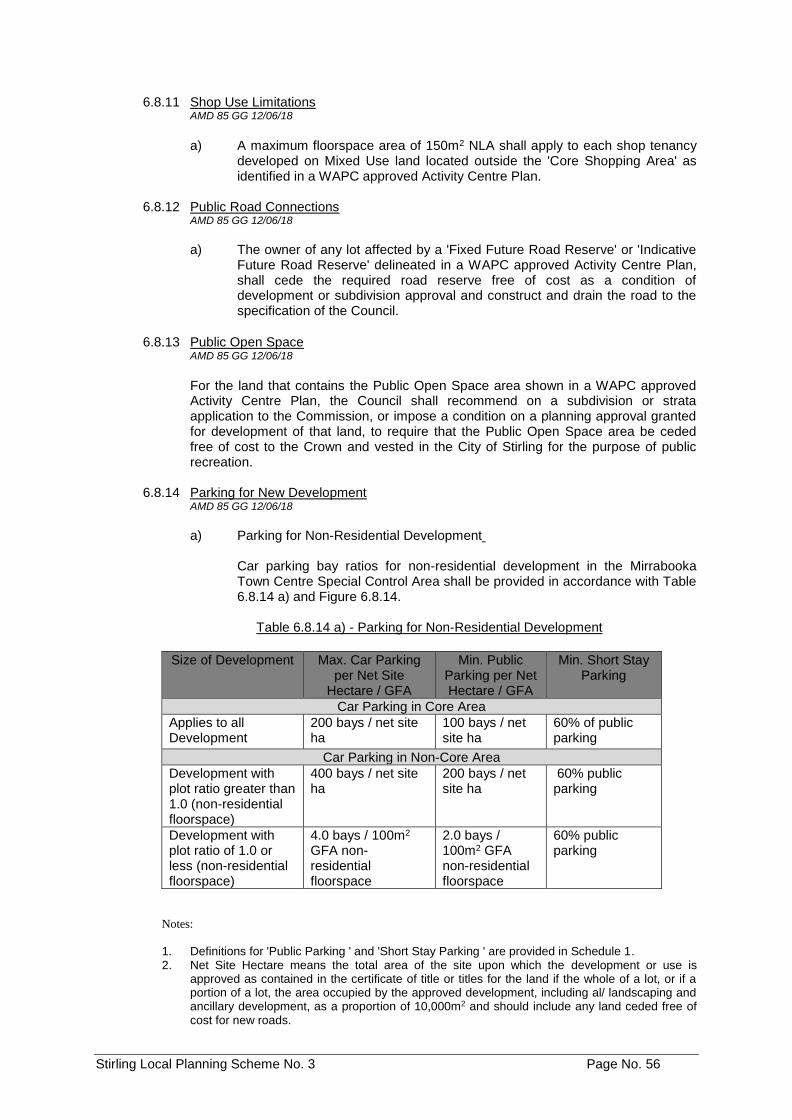
Stirling Local Planning Scheme No. 3 Page No. 56
6.8.11 Shop Use Limitations AMD 85 GG 12/06/18
a) A maximum floorspace area of 150m2 NLA shall apply to each shop tenancy developed on Mixed Use land located outside the 'Core Shopping Area' as identified in a WAPC approved Activity Centre Plan.
6.8.12 Public Road Connections
AMD 85 GG 12/06/18
a) The owner of any lot affected by a 'Fixed Future Road Reserve' or 'Indicative
Future Road Reserve' delineated in a WAPC approved Activity Centre Plan, shall cede the required road reserve free of cost as a condition of development or subdivision approval and construct and drain the road to the specification of the Council.
6.8.13 Public Open Space AMD 85 GG 12/06/18
For the land that contains the Public Open Space area shown in a WAPC approved Activity Centre Plan, the Council shall recommend on a subdivision or strata application to the Commission, or impose a condition on a planning approval granted for development of that land, to require that the Public Open Space area be ceded free of cost to the Crown and vested in the City of Stirling for the purpose of public recreation.
6.8.14 Parking for New Development
AMD 85 GG 12/06/18
a) Parking for Non-Residential Development
Car parking bay ratios for non-residential development in the Mirrabooka Town Centre Special Control Area shall be provided in accordance with Table 6.8.14 a) and Figure 6.8.14.
Table 6.8.14 a) - Parking for Non-Residential Development
Size of Development Max. Car Parking
per Net Site Hectare / GFA
Min. Public Parking per Net Hectare / GFA
Min. Short Stay Parking
Car Parking in Core Area
Applies to all Development
200 bays / net site ha
100 bays / net site ha
60% of public parking
Car Parking in Non-Core Area
Development with plot ratio greater than 1.0 (non-residential floorspace)
400 bays / net site ha
200 bays / net site ha
60% public parking
Development with plot ratio of 1.0 or less (non-residential floorspace)
4.0 bays / 100m2 GFA non-residential floorspace
2.0 bays / 100m2 GFA non-residential floorspace
60% public parking
Notes:
1. Definitions for 'Public Parking ' and 'Short Stay Parking ' are provided in Schedule 1. 2. Net Site Hectare means the total area of the site upon which the development or use is
approved as contained in the certificate of title or titles for the land if the whole of a lot, or if a portion of a lot, the area occupied by the approved development, including al/ landscaping and ancillary development, as a proportion of 10,000m2 and should include any land ceded free of cost for new roads.
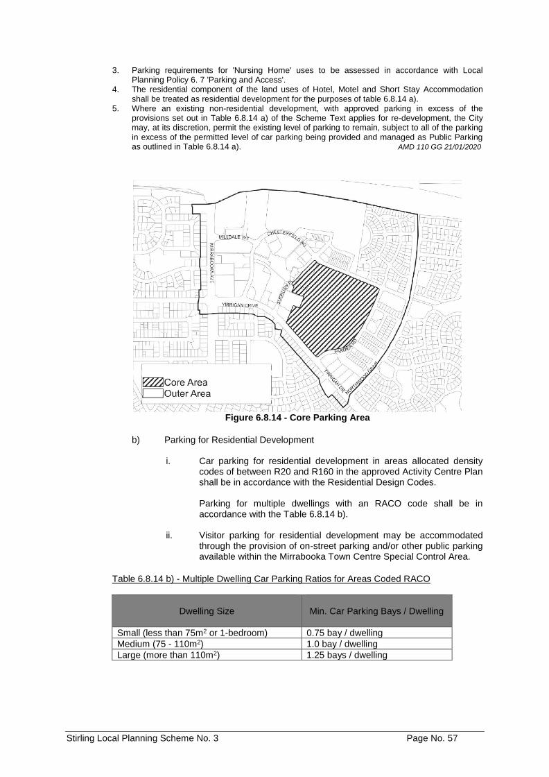
Stirling Local Planning Scheme No. 3 Page No. 57
3. Parking requirements for 'Nursing Home' uses to be assessed in accordance with Local Planning Policy 6. 7 'Parking and Access'.
4. The residential component of the land uses of Hotel, Motel and Short Stay Accommodation shall be treated as residential development for the purposes of table 6.8.14 a).
5. Where an existing non-residential development, with approved parking in excess of the provisions set out in Table 6.8.14 a) of the Scheme Text applies for re-development, the City may, at its discretion, permit the existing level of parking to remain, subject to all of the parking in excess of the permitted level of car parking being provided and managed as Public Parking as outlined in Table 6.8.14 a). AMD 110 GG 21/01/2020
Figure 6.8.14 - Core Parking Area
b) Parking for Residential Development
i. Car parking for residential development in areas allocated density
codes of between R20 and R160 in the approved Activity Centre Plan shall be in accordance with the Residential Design Codes.
Parking for multiple dwellings with an RACO code shall be in accordance with the Table 6.8.14 b).
ii. Visitor parking for residential development may be accommodated through the provision of on-street parking and/or other public parking available within the Mirrabooka Town Centre Special Control Area.
Table 6.8.14 b) - Multiple Dwelling Car Parking Ratios for Areas Coded RACO
Dwelling Size
Min. Car Parking Bays / Dwelling
Small (less than 75m2 or 1-bedroom) 0.75 bay / dwelling
Medium (75 - 110m2) 1.0 bay / dwelling
Large (more than 110m2) 1.25 bays / dwelling
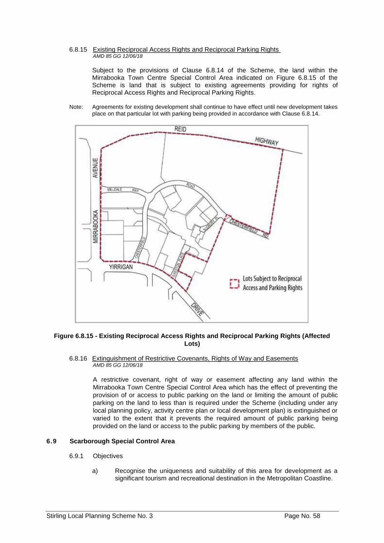
Stirling Local Planning Scheme No. 3 Page No. 58
6.8.15 Existing Reciprocal Access Rights and Reciprocal Parking Rights AMD 85 GG 12/06/18
Subject to the provisions of Clause 6.8.14 of the Scheme, the land within the Mirrabooka Town Centre Special Control Area indicated on Figure 6.8.15 of the Scheme is land that is subject to existing agreements providing for rights of Reciprocal Access Rights and Reciprocal Parking Rights.
Note: Agreements for existing development shall continue to have effect until new development takes
place on that particular lot with parking being provided in accordance with Clause 6.8.14.
Figure 6.8.15 - Existing Reciprocal Access Rights and Reciprocal Parking Rights (Affected
Lots)
6.8.16 Extinguishment of Restrictive Covenants, Rights of Way and Easements AMD 85 GG 12/06/18
A restrictive covenant, right of way or easement affecting any land within the
Mirrabooka Town Centre Special Control Area which has the effect of preventing the
provision of or access to public parking on the land or limiting the amount of public
parking on the land to less than is required under the Scheme (including under any
local planning policy, activity centre plan or local development plan) is extinguished or
varied to the extent that it prevents the required amount of public parking being
provided on the land or access to the public parking by members of the public.
6.9 Scarborough Special Control Area
6.9.1 Objectives
a) Recognise the uniqueness and suitability of this area for development as a significant tourism and recreational destination in the Metropolitan Coastline.
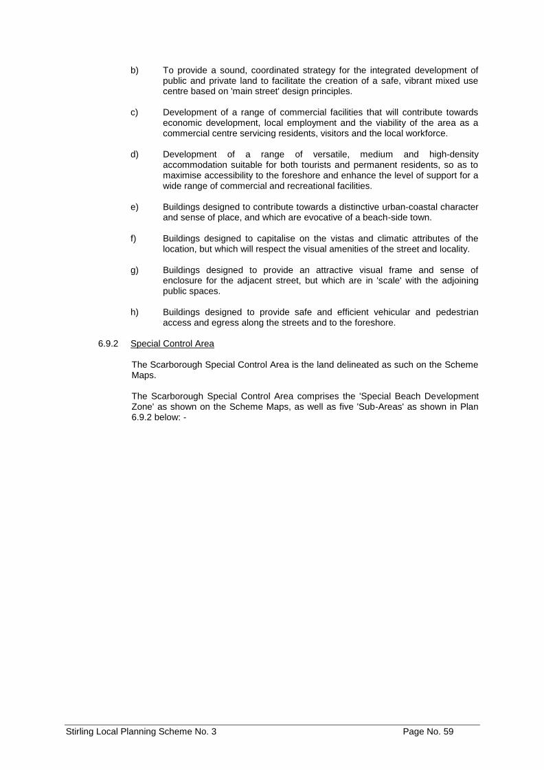
Stirling Local Planning Scheme No. 3 Page No. 59
b) To provide a sound, coordinated strategy for the integrated development of public and private land to facilitate the creation of a safe, vibrant mixed use centre based on 'main street' design principles.
c) Development of a range of commercial facilities that will contribute towards
economic development, local employment and the viability of the area as a commercial centre servicing residents, visitors and the local workforce.
d) Development of a range of versatile, medium and high-density
accommodation suitable for both tourists and permanent residents, so as to maximise accessibility to the foreshore and enhance the level of support for a wide range of commercial and recreational facilities.
e) Buildings designed to contribute towards a distinctive urban-coastal character
and sense of place, and which are evocative of a beach-side town. f) Buildings designed to capitalise on the vistas and climatic attributes of the
location, but which will respect the visual amenities of the street and locality. g) Buildings designed to provide an attractive visual frame and sense of
enclosure for the adjacent street, but which are in 'scale' with the adjoining public spaces.
h) Buildings designed to provide safe and efficient vehicular and pedestrian
access and egress along the streets and to the foreshore.
6.9.2 USpecial Control Area
The Scarborough Special Control Area is the land delineated as such on the Scheme Maps.
The Scarborough Special Control Area comprises the 'Special Beach Development Zone' as shown on the Scheme Maps, as well as five 'Sub-Areas' as shown in Plan 6.9.2 below: -
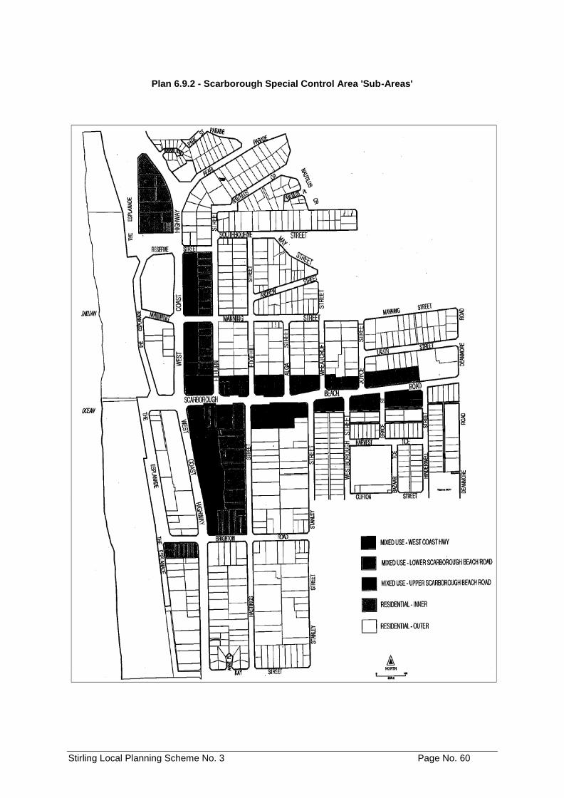
Stirling Local Planning Scheme No. 3 Page No. 60
Plan 6.9.2 - Scarborough Special Control Area 'Sub-Areas'
Stirling Local Planning Scheme No. 3 Page No. 61
6.9.3 UDevelopment
The development of all land within the Scarborough Special Control Area shall comply with any Structure Plan or Development Contribution Plan that is adopted under or for the purposes of this Scheme.
6.9.4 ULot 11 Corner West Coast Highway and Scarborough Beach Road Scarborough
a) Development of the existing seventeen storey building on the site is restricted
to a hotel development and any incidental use associated with hotel activity. b) If the building is destroyed, demolished or damaged to 75% or more of its
value, the predominant use of the site should be for tourist accommodation with no more than 25% of total dwelling units on site to be provided for permanent residential accommodation.
c) A variation to this provision may be approved by the Council provided it can be
demonstrated that the objectives for retaining the tourism focus and planning for tourism development on the site can be accommodated to the satisfaction of the Western Australian Planning Commission.
6.9.5 UPlot Ratio
a) In the Special Beach Development Zone, the following plot ratio requirements
apply:
i. Subject to clause 6.9.5.a) ii below, the total plot ratio of any development within the Special Beach Development Zone shall not exceed 2.0:1;
ii. For any development with a plot ratio of 2.0:1 or less the following shall apply:
the provision of a minimum of 0.5:1 of non-residential plot ratio at ground level (included in the total plot ratio permitted); and
a maximum of 1.0:1 of non-residential plot ratio (included in the total plot ratio permitted).
iii. Notwithstanding clauses 6.9.5.a) i and 6.9.5.a) ii above, the plot ratio of any development within the Special Beach Development Zone may be increased to a maximum of 3.0:1, but only subject to:
the provision of a minimum of 0.5:1 of non-residential plot ratio at ground level (included in the total plot ratio permitted); and
a maximum of 1.0:1 of non-residential plot ratio (included in the total plot ratio permitted).
compliance with clause 6.9.7 a) 'Dwelling Unit Size and Occupancy' of the Scheme, without modification;
compliance with the payment of cash-in-lieu in accordance with clause 6.9.9 'Cash-in-lieu for Parking' of the Scheme, without modification; and
payment of an infrastructure contribution in accordance with Development Contribution Schedule in the Scheme for the Special Beach Development Zone Area, without modification.
b) In the Mixed-Use 'Lower Scarborough. Beach Road' and Mixed-Use 'West
Coast Highway' Sub-Areas, the following plot ratio requirements apply: i. The total plot ratio of any development within the Mixed-Use Sub-Areas
(Lower Scarborough Beach Road and West Coast Highway) shall not exceed 2.0:1;
Stirling Local Planning Scheme No. 3 Page No. 62
ii. The plot ratio referred to in clause 6.9.5 b) i above may be increased to a
maximum of 3.0:1, but only subject to:
provision of commercial floor space at ground level with a plot ratio area of at least 0.2:1;
compliance with clause 6.9.7 b) 'Dwelling Unit Size and Occupancy' of the Scheme, without modification; and
payment of an infrastructure contribution in accordance with Schedule 11 of the Scheme, without modification.
iii. For the purposes of determining the plot ratio area for a particular site, where land is or has been ceded free of cost to the Crown for public access (including road widening), the area of land so ceded shall be deemed to remain part of the development site;
iv. Where a public parking facility is provided on a site designated for public parking in the 'Scarborough Design Guideline Area Access and Parking Map' contained within the Scarborough Design Guidelines, and is provided in accordance with clause 6.9.10 'Public Parking Facilities' of the Scheme, those public parking facilities shall be excluded from the plot ratio calculation for the site.
v. Where a public parking facility is provided on a site designated for public parking on the 'Scarborough Design Guideline Area Access and Parking Map' contained within the Scarborough Design Guidelines, and is provided in accordance with clause 6.9.10 'Public Parking Facilities' of the Scheme, the Council may allow an increase in the maximum permitted 3.0:1 plot ratio, provided the increased floor space does not exceed the amount of floor space allocated to the public parking facility to a maximum plot ratio of 1.0:1.
Note: The intention of the above two clauses iv. and v., is to facilitate the development
of public parking facilities without unduly prejudicing the development potential of the site, and to provide an additional incentive for the provision of such facilities. Where such a concession is provided, it should be reflected in any payment to secure the provision of public parking facilities.
c) In the Mixed-Use 'Upper Scarborough Beach Road' Sub-Area, the following plot ratio requirements apply:
i. The overall plot ratio shall not exceed 1.0:1 plus any ground level
commercial floor space; ii. For the purposes of determining the plot ratio area for a particular site,
where land is ceded free of cost to the Crown for public access (including road widening, the area of land so ceded shall be deemed to remain part of the development site.
Note: The intention of this provision, is to facilitate the designated widening of
roads, and the provision of supplementary vehicular access where required, without unduly prejudicing the development potential of the affected sites.
d) In the Residential Sub-Areas, the following plot ratio requirements apply:
i. In the Residential (Inner) Sub-Area, the overall plot ratio of development shall not exceed 2.0:1 provided that any increase above a plot ratio of 1.5:1 shall be conditional upon payment of an infrastructure contribution in accordance with Schedule 11 of the Scheme.
ii. In the case of the portion of land within the Residential (Inner) Sub-Area on Lot 1 (HN 242) West Coast Highway, the allowable plot ratio floor area may be transferred to the Mixed-Use (West Coast Highway) portion of the site on the basis that the portion of land on the Residential (Inner) Sub-Area (exclusive of the 7-metre public access thoroughfare) be developed and maintained as an area of open space accessible to the public to the satisfaction of the City.
Stirling Local Planning Scheme No. 3 Page No. 63
iii. In the case of land within the Residential (Outer) sub-area, the overall plot ratio of development shall not exceed 1.0:1.
iv. For the purposes of determining the plot ratio area for a particular site, where land is ceded free of cost to the Crown for public access (including road widening), the area of land so ceded shall be deemed to remain part of the development site.
Note: The intention of this provision, is to facilitate the designated widening of roads,
and the provision of supplementary vehicular access where required, without unduly prejudicing the development potential of the affected sites.
6.9.6 UResidential Density
For the purposes of this clause, the definition of 'short stay accommodation' in Schedule 1 of the Scheme shall include a hotel room.
a) In the Special Beach Development Zone, the following residential density
requirements apply:
i. A maximum residential density of R-160 shall apply, based on the number of dwelling units other than short stay accommodation.
ii. Single bedroom dwellings with a plot ratio area up to 60m2 and aged or dependent persons' dwellings with a plot ratio area up to 80m2 will be subject to the standard density bonus provisions of the Residential Design Codes.
b) In the Mixed-Use 'Lower Scarborough Beach Road' and Mixed-Use 'West Coast
Highway' Sub-Areas, the following residential density requirements apply:
i. a maximum residential density of R-160 shall apply, based on the total number of dwelling units other than short stay accommodation;
ii. single bedroom dwellings with a plot ratio area up to 60m2 and aged or dependent persons' dwellings with a plot ratio area up to 80m2 will be subject to the standard density bonus provisions of the Residential Design Codes; and
iii. for the purposes of determining the permissible number of dwellings for a particular site, where land is ceded free of cost to the Crown for public access (including road widening), the area of land so ceded shall be deemed to remain part of the development site.
Note: The intention of this provision is to facilitate the designated widening of roads,
and the provision of supplementary vehicular access where required, without unduly prejudicing the development potential of the affected sites.
c) In the Mixed-Use 'Upper Scarborough Beach Road' Sub-Area, the following
density requirements apply:
i. A maximum residential density of R-80 shall apply, based on the total number of dwelling units irrespective of the nature of occupancy.
ii. Single bedroom dwellings with a plot ratio area up to 60m2 and aged or dependent persons' dwellings with a plot ratio area up to 80m2 will be subject to the standard density bonus provisions of the Residential Design Codes.
iii. For the purposes of determining the permissible number of dwellings for a particular site, where land is ceded free of cost to the Crown for public access (including road widening), the area of land so ceded shall be deemed to remain part of the development site.
Note: The intention of this provision, is to facilitate the designated widening of roads,
and the provision of supplementary vehicular access where required, without unduly prejudicing the development potential of the affected sites.
Stirling Local Planning Scheme No. 3 Page No. 64
d) In the Residential Sub-Areas, the following density requirements apply:
i. in the case of land within the Residential (Inner) sub-area, a maximum residential density of R-160 shall apply, based on the total number of dwelling units irrespective of the nature of occupancy;
ii. in the case of land within the Residential (Outer) sub-area, a maximum residential density of R-80 shall apply, based on the total number of dwelling units irrespective of the nature of occupancy;
iii. single bedroom dwellings with a plot ratio area up to 60m2 and aged or dependent persons' dwellings with a plot ratio area up to 80m2 will be subject to the standard density bonus provisions of the Residential Design Codes; and
iv. for the purposes of determining the permissible number of dwellings for a particular site, where land is ceded free of cost to the Crown for public access (including road widening), the area of land so ceded shall be deemed to remain part of the development site.
Note: The intention of this provision, is to facilitate the designated widening of roads,
and the provision of supplementary vehicular access where required, without unduly prejudicing the development potential of the affected sites.
6.9.7 UDwelling Unit Size and Occupancy
For the purposes of this clause, the definition of 'short stay accommodation' in Schedule 1 of the Scheme shall include a hotel room.
a) In the Special Beach Development Zone, the following dwelling unit size and
occupancy requirements apply:
i. Of the total number of dwellings on any development site, a minimum of:
10 per cent shall be single bedroom dwellings, with a maximum plot ratio area of 60m2;
25 per cent, which may include the single bedroom dwellings referred to in the sub-paragraph immediately above, shall be designed and occupied for short stay accommodation, with a maximum plot ratio area of 85m2; and
10 per cent shall be designed for occupancy on a permanent basis, with a maximum plot ratio area of 85m2.
Note: For the purposes of determining the percentage of dwellings for short stay
accommodation, dwellings capable of separate access and occupancy (separately keyed) shall be deemed to be separate dwellings, notwithstanding that they may be available for occupation on a combined basis, e.g. twin key apartments.
ii. Dwellings required to be allocated for short stay accommodation:
shall be so designed as, in the opinion of the Council, to satisfactorily limit conflict with, or disturbance of the occupants of any dwelling (other than caretaker accommodation) available for occupancy on a permanent basis;
Note: Areas of potential conflict between permanent residents and the occupants of
short stay accommodation are generally related to different expectations concerning noise, privacy, and behaviour. Minimisation of conflicts relating to these matters will generally require some degree of segregation, and may also require design features to reduce the transmission of noise and limit visual intrusion.
shall be available for tenancy on a short-term basis, not exceeding a period of more than six weeks at any one time by the occupier or occupiers; and
shall be subject to a management agreement providing for occupancy controls, to the satisfaction of the Council.
Stirling Local Planning Scheme No. 3 Page No. 65
Note: It is anticipated that the required management agreement would be incorporated
as a Management Statement as provided for under the Strata Titles Act, and be subject to enforcement as part of the By-Laws of the relevant Strata company. Under these circumstances, any amendment or repeal of the Management Statement would require the consent of the Council.
b) In the Mixed-Use 'Lower Scarborough Beach Road' and Mixed-Use 'West Coast
Highway' Sub-Areas, the following dwelling unit size and occupancy requirements apply:
i. Of the total number of dwellings on any development site, a minimum of:
10 per cent shall be single bedroom dwellings, with a maximum plot ratio area of 60m2;
25 per cent, which may include the single bedroom dwellings referred to in the sub-paragraph immediately above, shall be designed and occupied for short stay accommodation, with a maximum plot ratio area of 85m2; and
10 per cent shall be designed for occupancy on a permanent basis, with a maximum plot ratio area of 85m2.
Note: For the purposes of determining the percentage of dwellings for short stay
accommodation, dwellings capable of separate access and occupancy (separately keyed) shall be deemed to be separate dwellings, notwithstanding that they may be available for occupation on a combined basis, e.g. twin key
apartments.
6.9.8 UBuilding Height
a) In the Special Beach Development Zone, the following building height requirements apply:
i. Subject to clauses 6.9.8.a.ii and 6.9.8.a.iii below, the building height of
any development shall not exceed 8 storeys or 32 metres (whichever is the lesser);
Note: Height in relation to a 'building' refers to the vertical distance at any point from
natural ground level to the uppermost part of the building above that point, and shall include all lift motor rooms, lift overruns, and architectural features.
ii. No part of any development shall extend above the level of the existing
building at Lot 11 corner West Coast Highway and Scarborough Beach Road Scarborough (i.e. the Rendezvous Hotel);
iii. The wall height of any development adjoining or immediately adjacent to any street shall be between 10 metres and 15 metres (3-4 storeys), above which there shall be a setback in accordance with the setback requirements applicable to this Zone so as to create a podium for any extension of height above this level;
iv. All developments shall include distinguishable roofing to a •height of between 3 metres and 5 metres above the highest point of the wall to which it relates, and within the overall maximum permitted height;
v. The minimum floor to ceiling heights of any development shall be 3.5 metres for the ground floor, and 3.0 metres for all other floors.
b) In the Mixed-Use 'Lower Scarborough Beach Road' and Mixed-Use 'West
Coast Highway' Sub-Areas, the following building height requirements apply:
i. Subject to clause 6.9.8.b.ii below, the maximum building height of
any building shall be limited to 8 storeys or 32 metres above natural ground level or 47 metres AHD (whichever is the lesser), except:
Stirling Local Planning Scheme No. 3 Page No. 66
where such a limit would otherwise restrict the building height to less than 14 metres above natural ground level or 3 storeys, in which case a 14 metres above natural ground level or 3 storey (whichever is the lesser) height limit shall apply;
where a public parking facility is provided on a site designated for a Public Parking Facility on the 'Scarborough Design Guideline Area Access and Parking Map' contained within the Scarborough Design Guidelines, and is provided in accordance with clause 6.9.10 'Public Parking Facilities' of the Scheme, a height bonus to a maximum building height of 44 metres above natural ground level or 12 storeys (whichever is the lesser), may be allowed provided the plot ratio floor area of the building above 32 metres above natural ground level is no more than the floor area allocated for the public parking facility; or
where a 7 metre public access thoroughfare is provided connecting Hastings Street and West Coast Highway as designated on the 'Scarborough Design Guideline Area Access and Parking Map' contained within the Scarborough Design Guidelines, and is provided in accordance with clause 6.9.11.a 'New Access Ways' of the Scheme, a height bonus to a maximum building height of 44 metres above natural ground level or 12 storeys (whichever is the lesser) may be allowed on that site.
Note: The height cap of 47 metres AHD is based on a standard 32 metre building height
above a nominal 15 metre AHD ground level. Where the natural ground level is above 15 metres AHD, the building height limit referred to above, shall be commensurately reduced.
Note: Height in relation to a 'building' refers to the vertical distance at any point from
natural ground level to the uppermost part of the building above that point, and shall include all lift motor rooms, lift overruns, and architectural features.
ii. The wall height of any development adjoining or immediately adjacent to
any street shall be between 6.5 metres and 10 metres (2-3 storeys), above which there shall be a setback in accordance with the setback requirements applicable to these Sub-Areas so as to create a podium for any extension of height above this level;
iii. All developments shall include distinguishable roofing to a height of between 3 metres and 5 metres above the highest point of the wall to which it relates, and within the overall maximum permitted height specified in clause 6.9.8.b) i above;
iv. The minimum floor to ceiling heights of any development shall be 3.5 metres for the ground floor, and 3.0 metres for all other floors.
c) In the Mixed-Use 'Upper Scarborough Beach Road' Sub-Area, the following
building height requirements apply:
i. The maximum building height of any building shall be limited to 17 metres above natural ground level or 4 storeys or 47 metres AHD (whichever is the lesser), except where such a limit would otherwise restrict the height to less than 14 metres above natural ground level or 3 storeys, in which case a 14 metres above natural ground level or 3 storey (whichever is the lesser) height limit shall apply; and
Note: The height cap of 47 metres AHD is based on a standard 32 metre building height
above a nominal 15 metre AHD ground level. Where the natural ground level is above 15 metres AHD, the building height limit referred to above, shall be commensurately reduced.
Note: Height in relation to a 'building' refers to the vertical distance at any point from
natural ground level to the uppermost part of the building above that point, and shall include all lift motor rooms, lift overruns, and architectural features.
Stirling Local Planning Scheme No. 3 Page No. 67
ii. All developments shall include a distinguishable roof element to a height of between 3 metres and 5 metres above the highest point of the wall to which it relates, and within the maximum permitted building height specified above.
d) In the Residential Sub-Areas, the following building height requirements apply:
i. in the Residential (Inner) Sub-Area, the maximum building height shall be
32 metres above natural ground level or 8 storeys or 47 metres AHD (whichever is the lesser), except where such a limit would otherwise restrict the height to less than 14 metres above natural ground level or 3 storeys, in which case a 14 metres above natural ground level or 3 storey (whichever is the lesser) height limit shall apply;
ii. in the Residential (Outer) Sub-Area, the maximum building height shall be 17 metres above natural ground level or 4 storeys or 47 metres AHD (whichever is the lesser), except where such a limit would otherwise restrict the height to less than 14 metres above natural ground level or 3 storeys, in which case a 14 metres above natural ground level or 3 storeys (whichever is the lesser) height limit shall apply;
iii. all developments shall include distinguishable roofing to a height of between 3 and 5 metres above the highest point of the wall to which it relates, and within the maximum permitted building height specified in clauses 6.9.8.d.i and 6.9.8.d) ii.
Note: The height cap of 47 metres AHD is based on a 32 metre building height above a
nominal 15 metre AHD ground level. Where the natural ground level is above 15 metres AHD, the building height limit referred to above, shall be commensurately reduced.
Note: Height in relation to a building' refers to the vertical distance at any point from
natural ground level to the uppermost part of the building above that point, and shall include all lift motor rooms, lift overruns, and architectural features.
6.9.9 UCash-in-lieu for Car Parking
A proportion of the required parking shall be subject to a cash-in-lieu contribution as provided for under paragraphs a), b) and c) below, and where cash-in-lieu is required, the number of on-site parking spaces required shall be reduced by the number of spaces for which cash-in-lieu is payable. a) In the Special Beach Development Zone, the following cash-in-lieu
contributions apply:
i. in the case of residential development, the cash-in-lieu contribution shall be 10 per cent of the total number of parking spaces required for the residential development;
ii. in the case of residential development, on-site parking spaces may be allocated for the exclusive use of the occupiers of individual dwellings, but there must remain unallocated a number of parking spaces equivalent to at least 10% of the total number of parking spaces required for the residential development;
iii. in the case of non-residential development, the cash-in-lieu contribution shall be in respect of 50 per cent of the total number of parking spaces required for the relevant use;
iv. the amount of the cash-in-lieu contribution payable shall be determined by the Council on the basis of the estimated cost of providing an equivalent number of parking spaces in the form of decked parking, and for non-residential development the amount payable shall be reduced by half.
Stirling Local Planning Scheme No. 3 Page No. 68
b) Other Zones within the Scarborough Special Control Area, the following cash-in-lieu contributions apply:
i. in the case of residential development, the cash-in-lieu contribution shall
be 10 per cent of the total number of parking spaces required for the residential development;
ii. in the case of residential development, car parking bays in excess of the required 90 per cent may be allocated for the exclusive use of the occupiers of individual dwellings, provided that additional common parking bays shall be provided on site to the same amount as those bays allocated for exclusive use to the residential occupants in excess of the 90 per cent;
iii. in the case of non-residential development, the cash-in-lieu contribution shall be 25 per cent of the total number of parking spaces required for the relevant use;
iv. the amount of cash-in-lieu contribution payable for development shall be determined by Council on the basis of the estimated cost of providing an equivalent number of commercial parking spaces and maneuvering areas in the form of decked parking in terms of land and construction cost, and for nonresidential development the amount payable shall be reduced by half.
Note: This means that where for example, 25% of the total non-residential parking
requirement is to be subject to a cash-in-lieu payment, the actual cash payable will be based on only 12.5% of the requisite number of parking spaces.
c) The following general provisions apply to all development within the
Scarborough Special Control area:
i. where cash-in-lieu of parking is payable, there shall be no reduction in parking standards otherwise applicable under the Scheme, except for the reduction in on-site parking as a consequence of the contribution to the cost of off-site parking;
Note: The purpose of this provision is to avoid a shortfall in parking contributions which
would otherwise arise from a reduction in parking requirements based on assumptions of shared use of on-site parking facilities. This reduction has already been accounted for by the 50% reduction in contributions for non-residential parking.
ii. the Council may agree to a cash-in-lieu contribution in respect of a
greater proportion of the total number of required parking spaces in circumstances where the provision of additional parking on-site is considered undesirable or not practicable;
iii. cash-in-lieu of required parking shall be placed in a trust account for use in the provision of transport infrastructure (in accordance with a Transport Infrastructure Strategy adopted by the Council) within the Scarborough Special Control area, or land adjacent to this area which may take the form of additional on-street parking or a public parking facility.
Stirling Local Planning Scheme No. 3 Page No. 69
6.9.10 UPublic Parking Facilities
These clauses apply to all land outside of the Special Beach Development Zone within the Scarborough Special Control Area. a) For the purposes of clause 6.9.5.b 'Plot Ratio' and clause 6.9.8.b 'Building
Height' of the Scheme, the term 'public parking facility' shall mean land used for the purpose of parking vehicles by members of the public, where the site on which it is located (which may comprise one or more lots) is used primarily for other purposes; and is not used as a car parking station;
b) the clauses mentioned above shall only apply where the public parking facility:
i. is to be located on land shown as the location of a public parking facility on the 'Scarborough Design Guidelines Access and Parking Map';
ii. is separate from any parking spaces provided on the land in relation to other uses of the land; and
iii. is not reserved for use in relation to the other uses of the land;
c) where Council grants approval for a public parking facility it may impose a condition requiring the owner of the land to enter into an agreement with the City in relation to the operation of the public parking facility specifically in relation to the hours of operation, long-term maintenance, and the level and nature of security measures provided for the public parking facility;
d) the public parking facility shall be operated in accordance with the terms of any
agreement entered into.
6.9.11 UNew Access Ways
These clauses apply to all land outside of the Special Beach Development Zone within the Scarborough Special Control Area.
a) A new 7 metre public access thoroughfare (5.5 metre two-way vehicle access,
1.5 metre pedestrian access) shall be provided for in accordance with the Scarborough Design Guidelines Access and Parking Map contained within the Scarborough Design Guidelines and in accordance with clause 6.9.8.b 'Building Height' for the Mixed-Use West Coast Highway Sub-Area of the Scheme;
Note: Such access may take the form of either a public road or an easement-in-gross and is
intended to be provided in conjunction with the re-development of the land on which it is situated. Where ceded free of cost to the Crown by the owner/developer the area of land so ceded shall be deemed to remain part of the original development site for the purposes of determining the site's development potential (plot ratio and residential density).
b) a new 5.5-metre-wide vehicular accessways depicted on the Scarborough Design Guidelines Access and Parking Map contained within the Scarborough Design Guidelines shall be created by the creation of public access easements in gross.
Note: In relation to the clause above, accessways that are not required for the full length of the
sites as shown on the Access and Parking Map, must have a minimum length of 25 metres to ensure that the accessway is continued to the rear of ground floor commercial tenancies and provide enough length for on-site circulation and manoeuvring.
Stirling Local Planning Scheme No. 3 Page No. 70
6.9.12 URoad Widening Requirements
The owner of any site affected by a road widening reservation under the Metropolitan Region Scheme shall cede such road widening free of cost on the date on which, in the opinion of the City, the development, subdivision or strata subdivision of the lot the subject of the road widening requirement, is commenced.
The owner of any site affected by a right of way widening under the Local Planning Policy relating to Right of Ways shall cede such right of way widening free of cost as a condition of development approval or subdivision or strata title approval recommended by the City.
6.10 Dianella Media District Special Control Area
AMD 3 GG 06/07/12
6.10.1 Objective
To ensure any potential development (i.e. rezoning, subdivision, land uses, development) within the Dianella media District Special Control Area delivers high quality sustainable outcomes in an integrated manner.
6.10.2 Special Control Area
The Dianella Media District Special Control Area is the land delineated as such on the Scheme Maps.
6.10.3 Development
a) All development of land within the Dianella Media District Special Control Area shall generally comply with any adopted local Planning Policy, Detailed Area Plan, precinct Plan and the Scheme for the area.
b) The owners of Lot 3, House Number 7, Gay Street and Lot 9, House Number
15, Osborne Road, Dianella shall undertake the following, to the satisfaction of the City:
i. The preparation of a Kangaroo Management Strategy specific to the
subject Lots 3 and 9, at the owner’s cost prior to the commencement of any subdivision site works on the Lots, to the satisfaction of the City of Stirling, on the advice of the Department of Environment and Conservation; and the provision of suitable reticulated turfed kangaroo grazing areas within the subject Lots in accordance with the Kangaroo Management Strategy, at the owner’s cost prior to the sale of any portion of the Lots; and a suitable staging plan detailing how a continuous supply of grazing areas and the capture and release of kangaroos will be provided through the construction phase of the development, prior to the commencement of any subdivision site works on the Lots; and the maintenance of the reticulated turfed kangaroo grazing areas within the subject Lots for a minimum of two years in accordance with the Kangaroo Management Strategy, at the owner’s cost.
ii. Provision of a minimum of 100 dwellings over the subject Lots.
6.10.4 Redevelopment Procedure Statement and Precinct Plan
For the purposes of promoting the highest standard of development within the Dianella Media District Special Control Area, the Council and applicants are to have due regard to the Media Zones Redevelopment Procedures Statement and the Media Zones Precinct Plan (as amended from time to time).
Stirling Local Planning Scheme No. 3 Page No. 71
The Council may require the preparation of a Detailed Area Plan for a particular lot or lots within the Dianella Media District Special Control Area, in accordance with Part 6A of the Scheme.
6.11 Stirling City Centre Special Control Area
AMD 1 GG 2/9/14
6.11.1 Objectives
a) To facilitate the development of the Stirling City Centre in a coordinated
manner, recognising its significance as a Strategic Metropolitan Centre; b) to provide a strategy for the integrated development of public and private land
to facilitate the creation of a safe, vibrant mixed-use centre; c) to ensure the provision of an effective, efficient, integrated and safe transport
network which is accessible to pedestrians, cyclists and public transport users and motorists;
d) to facilitate funding mechanisms for the provision of light rail and other
alternative transport infrastructure. e) to ensure the development of a diverse range of housing types (including
affordable housing) in unique precincts that have high levels of amenity; f) to ensure the development of a convenient network of public open space
(including an urban stream) offering a wide range of high quality facilities tailored to the requirements of the local community;
g) to ensure the development of a range of commercial uses that will contribute
towards economic development, local employment and the viability of the area as a commercial centre servicing residents, visitors and the local workforce;
h) to ensure the development of a range of community facilities that will service
residents, visitors and the local workforce and contribute towards community wellbeing; and
i) to ensure the conservation and appropriate use of natural resources including
(but not limited to) energy, water and land to enhance the sustainable management of finite resources.
6.11.2 Special Control Area
AMD 84 GG 16/7/19 The Stirling City Centre Special Control Area is the land delineated as such on the Scheme Maps.
The Stirling City Centre Special Control Area consists of six precincts, being:
a) Southern Precinct; b) Station Precinct;
c) Northern Precinct;
d) Innaloo Precinct;
e) Osborne Park Precinct; and
f) Woodlands Precinct,
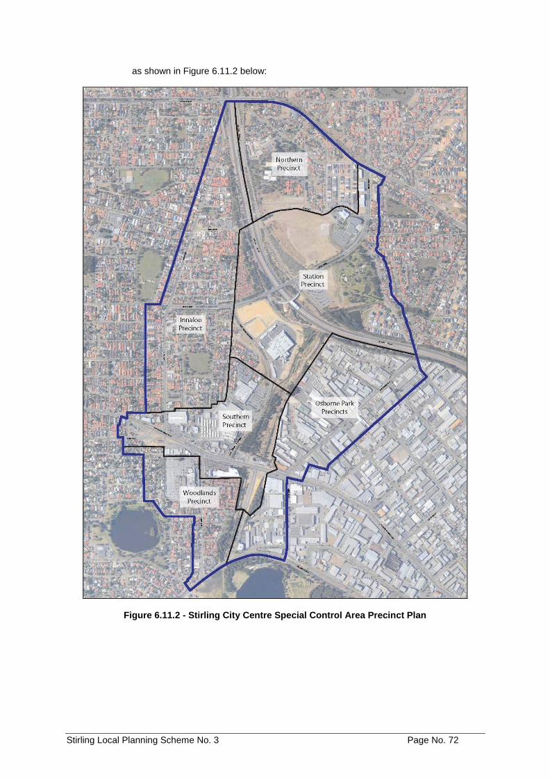
Stirling Local Planning Scheme No. 3 Page No. 72
as shown in Figure 6.11.2 below:
Figure 6.11.2 - Stirling City Centre Special Control Area Precinct Plan
Stirling Local Planning Scheme No. 3 Page No. 73
6.11.3 Subdivision and Development AMD 84 GG 16/7/19
a) The subdivision and development of all land within the Stirling City Centre
Special Control Area shall:
i. have due regard to any WAPC approved Activity Centre Plan, any approved Local Development Plan and Local Planning Policy that applies to that land and that is prepared under this Scheme;
ii. comply with the provisions of the Special Control Area which apply to
that land; and
iii. comply with any Development Contribution Plan that applies to that land and is prepared in accordance with the Scheme.
b) The power conferred by Clause 5.5.1 of this Scheme shall not apply to
clauses 6.11.11 a), 6.11.16 a) i., 6.11.9 e) and the ‘Maximum Total On-Site Parking’ standards of Table 6.11.17
6.11.4 Activity Centre Plan AMD 84 GG 16/7/19
For the purpose of promoting the highest standard of development an Activity Centre Plan shall be approved for the Stirling City Centre Special Control Area in accordance with Part 5 – Activity Centre Plans of the Deemed Provisions in Schedule 2 of the Planning and Development (Local Planning Scheme) Regulations, 2015.
6.11.5 Local Development Plan AMD 84 GG 16/7/19
No development shall be approved by the Council for land within the Activity Centre Plan area until a Local Development Plan has been adopted by the Council, except for minor development that will not prejudice the implementation of the Local Development Plan. The Local Development Plan is required to address the matters listed in Part 6A of the Scheme and Clause 48 of the Deemed Provisions of the Planning and Development (Local Planning Schemes) Regulations 2015.
6.11.6 Residential Design Codes AMD 84 GG 16/7/19
a) The Residential Design Codes apply only to residential development on land
within the Stirling City Centre Special Control Area which has been designated with a residential density code by an Activity Centre Plan made pursuant to Part 5 – Activity Centre Plans of the Deemed Provisions in Schedule 2 of the Planning and Development (Local Planning Scheme) Regulations 2015.
b) The subdivision or development of land referred to in paragraph a) above for
any of the residential purposes dealt with by the Residential Design Codes is to have due regard to the provisions of those Codes.
c) Residential development of land within the Stirling City Centre Special Control
Area which has not been designated with a residential density code shall be subject to the development requirements specified in any Local Development Plan approved for that land for the purpose of guiding the Local Government in determining applications for approval of such residential development.
d) Clause 5.3.2 shall not apply to residential development in the Stirling City
Centre Special Control Area.
Stirling Local Planning Scheme No. 3 Page No. 74
6.11.7 Land Use Sectors AMD 84 GG 16/7/19
a) Land within the Stirling City Centre Special Control Area is to be classified into
the Land Use Sectors in a WAPC approved Activity Centre Plan.
b) Subject to the classification of land in subclause a), subdivision and development of land within the Stirling City Centre Special Control Area shall comply with the relevant Scheme requirements, and have due regard to any relevant provisions in a WAPC approved Activity Centre Plan and any approved Local Development Plan.
6.11.8 Land Use Categories AMD 84 GG 16/7/19
a) An approved Local Development Plan shall assign a Land Use Category or
Categories to every lot located within its boundaries, consistent with the land use categories provided in the Scheme. A Land Use Category may be applied to the entire area within a lot; to a portion of land within a lot; or vertically to individual storeys of a multi-storey building contained within a lot.
b) The subdivision and development of land within the Stirling City Centre Special
Control Area shall be consistent with the requirements of the applicable Land Use Category or Categories as provided in this Scheme, and have due regard to any relevant provision in an approved Local Development Plan.
6.11.9 Land Use Permissibility
AMD 84 GG 16/7/19
a) The permissibility of land uses for each precinct is provided in Table 6.11.9.
The symbols used in Table 6.11.9 shall have the same meaning as defined in Clauses 4.3.2 and 4.3.3.
b) Table 6.11.9 is to be read in conjunction with Table 6.11.10 which provides
further detail on the location of land uses within multiple storey buildings. c) Notwithstanding the provisions of Clause 6.11.9, where a land use category is
Not Supported under Clause 6.11.10 for a relevant building storey, the land use is deemed to be an X use for that relevant building storey.
d) If a person proposes to carry out on land any use that is not specifically
mentioned in Table 6.11.9 and cannot reasonably be determined as falling within the type, class or genus of activity of any other use category, the Local Government shall consider this use in accordance with the provisions of Clause 4.4.2.
e) Showroom or Hardware Showroom uses on lots fronting Scarborough Beach
Road shall have a maximum plot ratio of 0.5 and shall incorporate other uses (not Showroom or Hardware Showroom uses) at a minimum plot ratio of 1.0.
f) Showroom or Hardware Showroom uses which abut Scarborough Beach Road
shall incorporate glazing to a minimum of 80% of the portion of the building which fronts Scarborough Beach Road.
Note: This clause does not apply to existing showroom or hardware showroom uses.
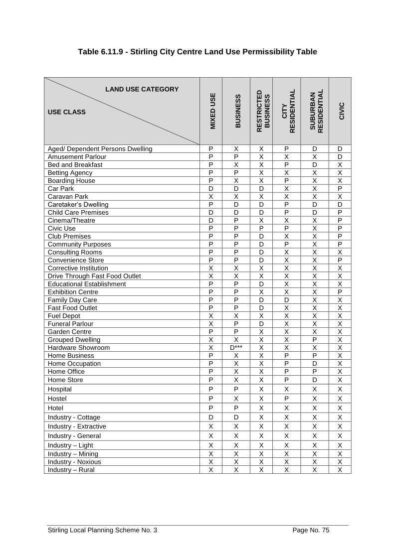
Stirling Local Planning Scheme No. 3 Page No. 75
Table 6.11.9 - Stirling City Centre Land Use Permissibility Table
LAND USE CATEGORY
USE CLASS
MIX
ED
US
E
BU
SIN
ES
S
RE
ST
RIC
TE
D
BU
SIN
ES
S
CIT
Y
RE
SID
EN
TIA
L
SU
BU
RB
AN
RE
SID
EN
TIA
L
CIV
IC
Aged/ Dependent Persons Dwelling P X X P D D
Amusement Parlour P P X X X D
Bed and Breakfast P X X P D X
Betting Agency P P X X X X
Boarding House P X X P X X
Car Park D D D X X P
Caravan Park X X X X X X
Caretaker’s Dwelling P D D P D D
Child Care Premises D D D P D P
Cinema/Theatre D P X X X P
Civic Use P P P P X P
Club Premises P P D X X P
Community Purposes P P D P X P
Consulting Rooms P P D X X X
Convenience Store P P D X X P
Corrective Institution X X X X X X
Drive Through Fast Food Outlet X X X X X X
Educational Establishment P P D X X X
Exhibition Centre P P X X X P
Family Day Care P P D D X X
Fast Food Outlet P P D X X X
Fuel Depot X X X X X X
Funeral Parlour X P D X X X
Garden Centre P P X X X X
Grouped Dwelling X X X X P X
Hardware Showroom X D*** X X X X
Home Business P X X P P X
Home Occupation P X X P D X
Home Office P X X P P X
Home Store P X X P D X
Hospital P P X X X X
Hostel P X X P X X
Hotel P P X X X X
Industry - Cottage D D X X X X
Industry - Extractive X X X X X X
Industry - General X X X X X X
Industry – Light X X X X X X
Industry – Mining X X X X X X
Industry - Noxious X X X X X X
Industry – Rural X X X X X X
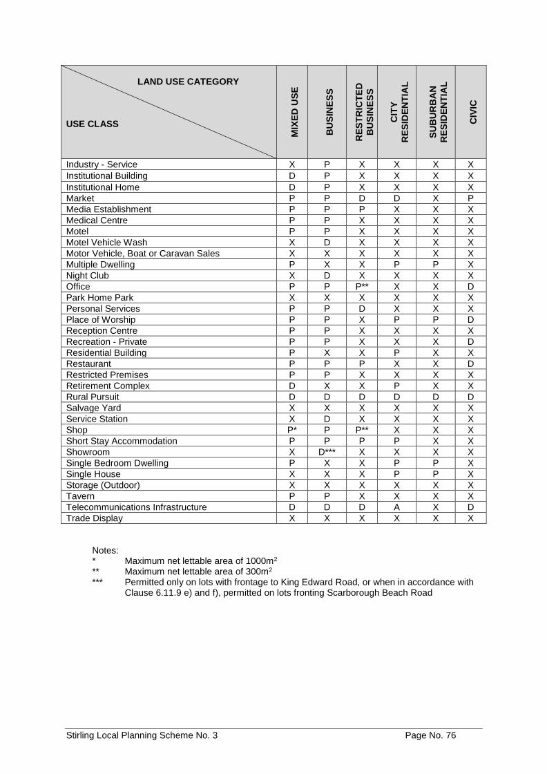
Stirling Local Planning Scheme No. 3 Page No. 76
Notes: * Maximum net lettable area of 1000m2 ** Maximum net lettable area of 300m2 *** Permitted only on lots with frontage to King Edward Road, or when in accordance with
Clause 6.11.9 e) and f), permitted on lots fronting Scarborough Beach Road
LAND USE CATEGORY USE CLASS M
IXE
D U
SE
BU
SIN
ES
S
RE
ST
RIC
TE
D
BU
SIN
ES
S
CIT
Y
RE
SID
EN
TIA
L
SU
BU
RB
AN
RE
SID
EN
TIA
L
CIV
IC
Industry - Service X P X X X X
Institutional Building D P X X X X
Institutional Home D P X X X X
Market P P D D X P
Media Establishment P P P X X X
Medical Centre P P X X X X
Motel P P X X X X
Motel Vehicle Wash X D X X X X
Motor Vehicle, Boat or Caravan Sales X X X X X X
Multiple Dwelling P X X P P X
Night Club X D X X X X
Office P P P** X X D
Park Home Park X X X X X X
Personal Services P P D X X X
Place of Worship P P X P P D
Reception Centre P P X X X X
Recreation - Private P P X X X D
Residential Building P X X P X X
Restaurant P P P X X D
Restricted Premises P P X X X X
Retirement Complex D X X P X X
Rural Pursuit D D D D D D
Salvage Yard X X X X X X
Service Station X D X X X X
Shop P* P P** X X X
Short Stay Accommodation P P P P X X
Showroom X D*** X X X X
Single Bedroom Dwelling P X X P P X
Single House X X X P P X
Storage (Outdoor) X X X X X X
Tavern P P X X X X
Telecommunications Infrastructure D D D A X D
Trade Display X X X X X X
Stirling Local Planning Scheme No. 3 Page No. 77
6.11.10 Land Use Permissibility for Multiple Storey Buildings
a) Where a land use class is designated with a P, D or A in a relevant land use
category in Table 6.11.9, Table 6.11.10 details the location of that land use in a two-dimensional context of a building, as follows:
Building Storey
i. Ground – refers to the ground floor of a development; and ii. Upper – refers to all storeys located above the ground storey.
b) Where a land use category is ‘S – Supported’, the development of that land use
can be approved in accordance with the relevant permissibility in Table 6.11.9. c) Where a land use category is ‘NS – Not Supported’, the development of that
land use on the relative floors of the building where it is not supported shall be considered an X use under Table 6.11.9.
d) The Local Government shall not approve a development application which is
inconsistent with the siting of development as detailed in Table 6.11.10. e) Where a parcel of zoned land has no land use permissibility identified in Table
6.11.10 the Local Government shall not approve development or recommend approval for subdivision where a proposal is inconsistent with the objectives and provisions of clause 6.11 of the Scheme, within a WAPC approved Activity Centre Plan or an approved Local Development Plan for Stirling City Centre.
f) Notwithstanding clause 6.11.10 d), the Council may recommend subdivision or
approve the development of land if Council is satisfied that this is consistent with the objectives and development standards of the Scheme, a WAPC approved Activity Centre Plan or an approved Local Development Plan.
g) To the extent that a requirement referred to in clause 6.11.9 or 6.11.10 of this
Scheme is inconsistent with a provision in a WAPC approved Activity Centre Plan or an approved Local Development Plan, the provisions in clauses 6.11.9 and 6.11.10 of this Scheme prevail.
h) Table 6.11.10 includes following Tables 6.11.10 a) to 6.11.10 f).
Stirling Local Planning Scheme No. 3 Page No. 78
Table 6.11.10 (a) – Northern Precinct
NORTHERN PRECINCT
Sub-Precincts (as per Local Development Plan)
Land Use Category Building Storey
A B C
D
E
F
MIXED USE Ground S NS S NS N/A NS
Upper S NS NS NS N/A NS
BUSINESS Ground S NS NS NS N/A NS
Upper NS NS NS NS N/A NS
RESTRICTED BUSINESS
Ground S NS NS NS N/A NS
Upper NS NS NS NS N/A NS
CITY RESIDENTIAL Ground NS S S NS N/A NS
Upper S S S NS N/A NS
SUBURBAN RESIDENTIAL
Ground NS NS NS S N/A NS
Upper NS NS NS S N/A NS
CIVIC Ground NS NS NS NS N/A NS
Upper NS NS NS NS N/A NS
Note: Refer to the Northern Precinct Local Development Plan for the location of permitted land use categories
Table 6.11.10 (b) – Innaloo Precinct
INNALOO PRECINCT
Sub-Precincts (as per Local Development Plan)
Land Use Category Building Storey
1 2 3 4 5 6 7
MIXED USE Ground NS NS S NS NS NS NS
Upper NS NS NS S S NS NS
BUSINESS Ground NS NS NS S S S S
Upper NS NS NS S NS NS NS
RESTRICTED BUSINESS
Ground NS NS NS NS NS NS NS
Upper NS NS NS NS NS NS NS
CITY RESIDENTIAL Ground NS NS S NS NS NS NS
Upper NS NS S S S NS NS
SUBURBAN RESIDENTIAL
Ground S S NS NS NS NS NS
Upper S S NS NS NS S S
CIVIC Ground NS NS NS NS NS NS NS
Upper NS NS NS NS NS NS NS
Note: Refer to the Innaloo Precinct Local Development Plan for the location of permitted land use categories
Stirling Local Planning Scheme No. 3 Page No. 79
Table 6.11.10 (c) – Osborne Park Precinct
OSBORNE PARK PRECINCT
Sub-Precincts (as per Local Development Plan)
Land Use Category Building Storey
A B C D E F G
MIXED USE Ground NS
TO BE DETERMINED
Upper S
BUSINESS Ground S
Upper NS
RESTRICTED BUSINESS
Ground NS
Upper NS
CITY RESIDENTIAL Ground NS
Upper S
SUBURBAN RESIDENTIAL
Ground NS
Upper NS
CIVIC Ground NS
Upper NS
Note: Refer to the Osborne Park Precinct Local Development Plan for the location of permitted land
use categories.
Table 6.11.10 (d) – Southern Precinct
SOUTHERN PRECINCT
Sub-Precincts (as per Local Development Plan)
Land Use Category
Building Storey
A1 (Figures 13-17)
A2 (Figures 18-19)
A3 (Figures 20-22)
B C D E F
MIXED USE Ground NS NS S S NS S NS S
Upper NS S S S S S S S
BUSINESS Ground NS S S S S S S S
Upper NS NS NS NS NS NS S NS
RESTRICTED BUSINESS
Ground NS NS NS NS NS NS NS NS
Upper NS NS NS NS NS NS NS NS
CITY RESIDENTIAL
Ground NS S NS NS S NS NS S
Upper NS S S NS S NS NS S
SUBURBAN RESIDENTIAL
Ground S S NS NS NS NS NS NS
Upper S S NS NS NS NS NS NS
CIVIC Ground NS NS NS NS NS NS NS NS
Upper NS NS NS NS NS NS NS NS
Note: Refer to the Southern Precinct Local Development Plan for the location of permitted land use
categories.
Stirling Local Planning Scheme No. 3 Page No. 80
Table 6.11.10 (e) – Station Precinct
STATION PRECINCT
Sub-Precincts (as per Local Development Plan) Land Use Category Building
Storey A B C D E F G
MIXED USE Ground S NS NS NS NS NS NS
Upper S NS NS S S S NS
BUSINESS Ground S NS NS S S S NS
Upper NS NS NS NS NS NS NS
RESTRICTED BUSINESS
Ground S NS NS NS NS NS NS
Upper NS NS NS NS NS NS NS
CITY RESIDENTIAL Ground NS NS NS NS S NS NS
Upper NS NS NS S S NS NS
SUBURBAN RESIDENTIAL
Ground NS S S NS NS NS S
Upper S S S NS NS NS S
CIVIC Ground NS NS NS NS NS NS NS
Upper NS NS NS NS NS NS NS
Note: Refer to the Station Precinct Local Development Plan for the location of permitted land use categories.
Table 6.11.10 (f) – Woodlands Precinct
WOODLANDS PRECINCT
Sub-Precincts (as per Local Development Plan)
Land Use Category Building Storey
1 2 3 4 5 6 7
MIXED USE Ground NS NS S NS
TO BE DETERMINED
Upper NS NS S NS
BUSINESS Ground NS NS S NS
Upper NS NS NS NS
RESTRICTED BUSINESS
Ground NS NS S NS
Upper NS NS NS NS
CITY RESIDENTIAL Ground NS NS S S
Upper NS NS S S
SUBURBAN RESIDENTIAL
Ground S S S NS
Upper S S S NS
CIVIC Ground NS NS NS NS
Upper NS NS NS NS
Note: Refer to the Woodlands Precinct Local Development Plan for the location of permitted land
use categories.
6.11.11 Mandatory Residential AMD 84 GG 16/7/19
a) An application for planning approval for a new development for land that is
identified as requiring Mandatory Residential in a WAPC approved Activity Centre Plan and/or an approved Local Development Plan shall contain a residential component to the satisfaction of the City of Stirling.
b) Subject to sub-clause a) the Local Government shall impose a condition on the
planning approval granted for a new building on land identified as requiring Mandatory Residential to require delivery of the minimum residential standards referred to in paragraph a) above prior to occupation of that building development.
c) Notwithstanding Clause 6.11.11 b), the Local Government may allow the
Stirling Local Planning Scheme No. 3 Page No. 81
transfer of one lot’s minimum number of residential dwellings to another lot subject to the following:
i) The lot in receipt of the residential dwellings is included in a Mandatory
Residential area on a WAPC approved Activity Centre Plan and/or an approved Local Development Plan; and
ii) It is demonstrated to the satisfaction of the Local Government by the
landowner(s) and/or proponent of the development that the lot in receipt of the required additional residential dwellings can and will accommodate the additional residential dwellings whilst complying with all relevant standards and requirements applicable to the lot under this Scheme, any WAPC approved Activity Centre Plan, any approved Local Development Plan and any approved Local Planning Policy.
6.11.12 Non-Residential Floorspace Requirements AMD 84 GG 16/7/19
a) For any land affected by ‘Minimum Non-residential Floorspace Requirements’
in a WAPC approved Activity Centre Plan and/or any approved Local Development Plan, the Local Government shall have due regard to those minimum floorspace requirements when considering an application for development approval.
6.11.13 Urban Design AMD 84 GG 16/7/19
a) No individual street block within the Stirling City Centre Special Control Area
shall have a dimension longer than 150m along any boundary without an intersecting street.
6.11.14 Active Frontage Streets AMD 84 GG 16/7/19
a) For any land affected by ‘Active Frontage Streets’ in a WAPC approved Activity
Centre Plan and/or any approved Local Development Plan, the Local Government shall have due regard to those minimum requirements when considering an application for development approval.
6.11.15 Public Open Space AMD 84 GG 16/7/19
a) For the land that contains the Public Open Space area shown in a WAPC
approved Activity Centre Plan, the Local Government shall recommend on a subdivision or strata application to the Commission, or impose a condition on a planning approval granted for development of that land, to require that the Public Open Space area be ceded free of cost to the Crown and vested in the City of Stirling for the purpose of public recreation.
b) Notwithstanding paragraph a) above, land identified as District Open Space
that is located within the Osborne Park Precinct in a WAPC approved Activity Centre Plan, shall form part of the Development Contribution Plan prepared for the Osborne Park Precinct (refer Clause 6.11.19) and will not be subject to the requirements of clause 6.11.15 a).
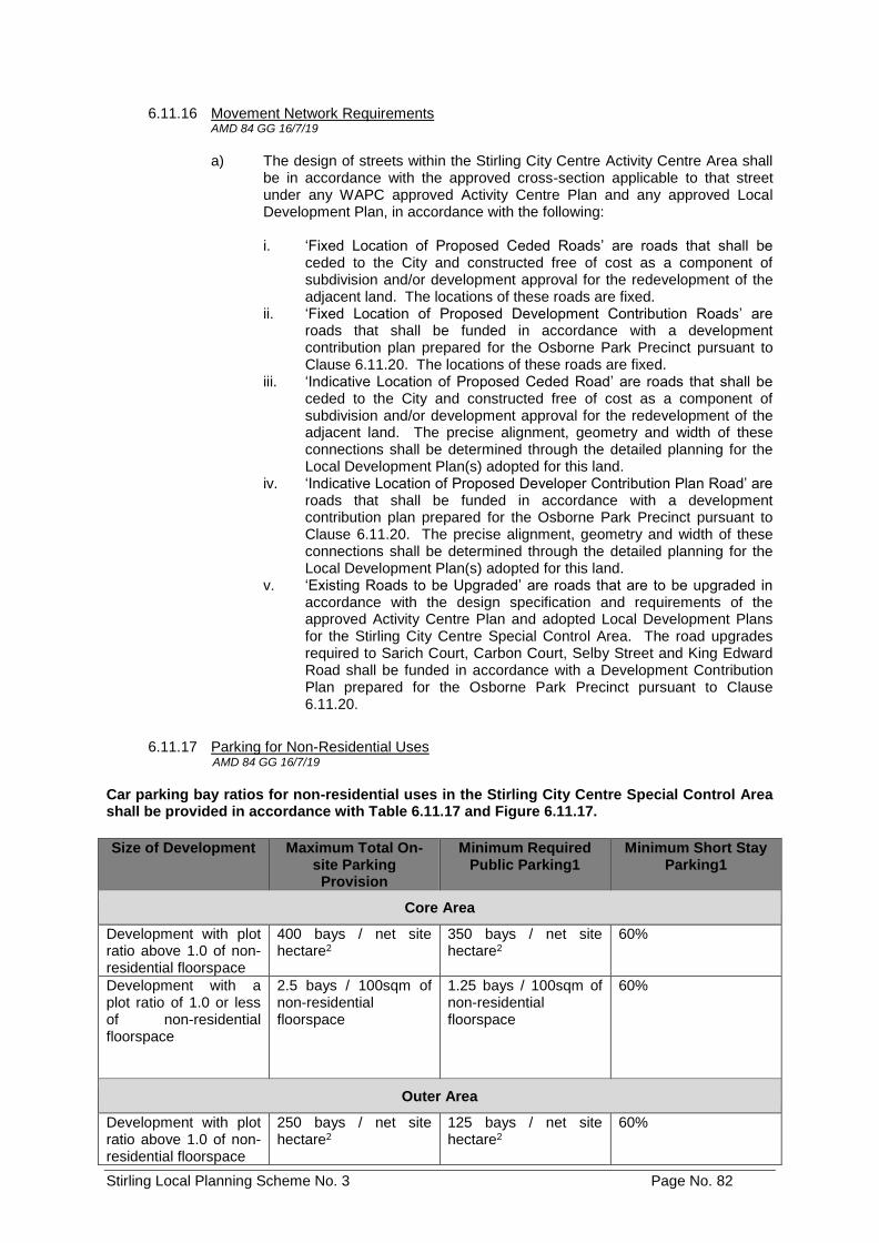
Stirling Local Planning Scheme No. 3 Page No. 82
6.11.16 Movement Network Requirements AMD 84 GG 16/7/19
a) The design of streets within the Stirling City Centre Activity Centre Area shall
be in accordance with the approved cross-section applicable to that street under any WAPC approved Activity Centre Plan and any approved Local Development Plan, in accordance with the following:
i. ‘Fixed Location of Proposed Ceded Roads’ are roads that shall be ceded to the City and constructed free of cost as a component of subdivision and/or development approval for the redevelopment of the adjacent land. The locations of these roads are fixed.
ii. ‘Fixed Location of Proposed Development Contribution Roads’ are roads that shall be funded in accordance with a development contribution plan prepared for the Osborne Park Precinct pursuant to Clause 6.11.20. The locations of these roads are fixed.
iii. ‘Indicative Location of Proposed Ceded Road’ are roads that shall be ceded to the City and constructed free of cost as a component of subdivision and/or development approval for the redevelopment of the adjacent land. The precise alignment, geometry and width of these connections shall be determined through the detailed planning for the Local Development Plan(s) adopted for this land.
iv. ‘Indicative Location of Proposed Developer Contribution Plan Road’ are roads that shall be funded in accordance with a development contribution plan prepared for the Osborne Park Precinct pursuant to Clause 6.11.20. The precise alignment, geometry and width of these connections shall be determined through the detailed planning for the Local Development Plan(s) adopted for this land.
v. ‘Existing Roads to be Upgraded’ are roads that are to be upgraded in accordance with the design specification and requirements of the approved Activity Centre Plan and adopted Local Development Plans for the Stirling City Centre Special Control Area. The road upgrades required to Sarich Court, Carbon Court, Selby Street and King Edward Road shall be funded in accordance with a Development Contribution Plan prepared for the Osborne Park Precinct pursuant to Clause 6.11.20.
6.11.17 Parking for Non-Residential Uses AMD 84 GG 16/7/19
Car parking bay ratios for non-residential uses in the Stirling City Centre Special Control Area shall be provided in accordance with Table 6.11.17 and Figure 6.11.17.
Size of Development Maximum Total On-site Parking Provision
Minimum Required Public Parking1
Minimum Short Stay Parking1
Core Area
Development with plot ratio above 1.0 of non-residential floorspace
400 bays / net site hectare2
350 bays / net site hectare2
60%
Development with a plot ratio of 1.0 or less of non-residential floorspace
2.5 bays / 100sqm of non-residential floorspace
1.25 bays / 100sqm of non-residential floorspace
60%
Outer Area
Development with plot ratio above 1.0 of non-residential floorspace
250 bays / net site hectare2
125 bays / net site hectare2
60%
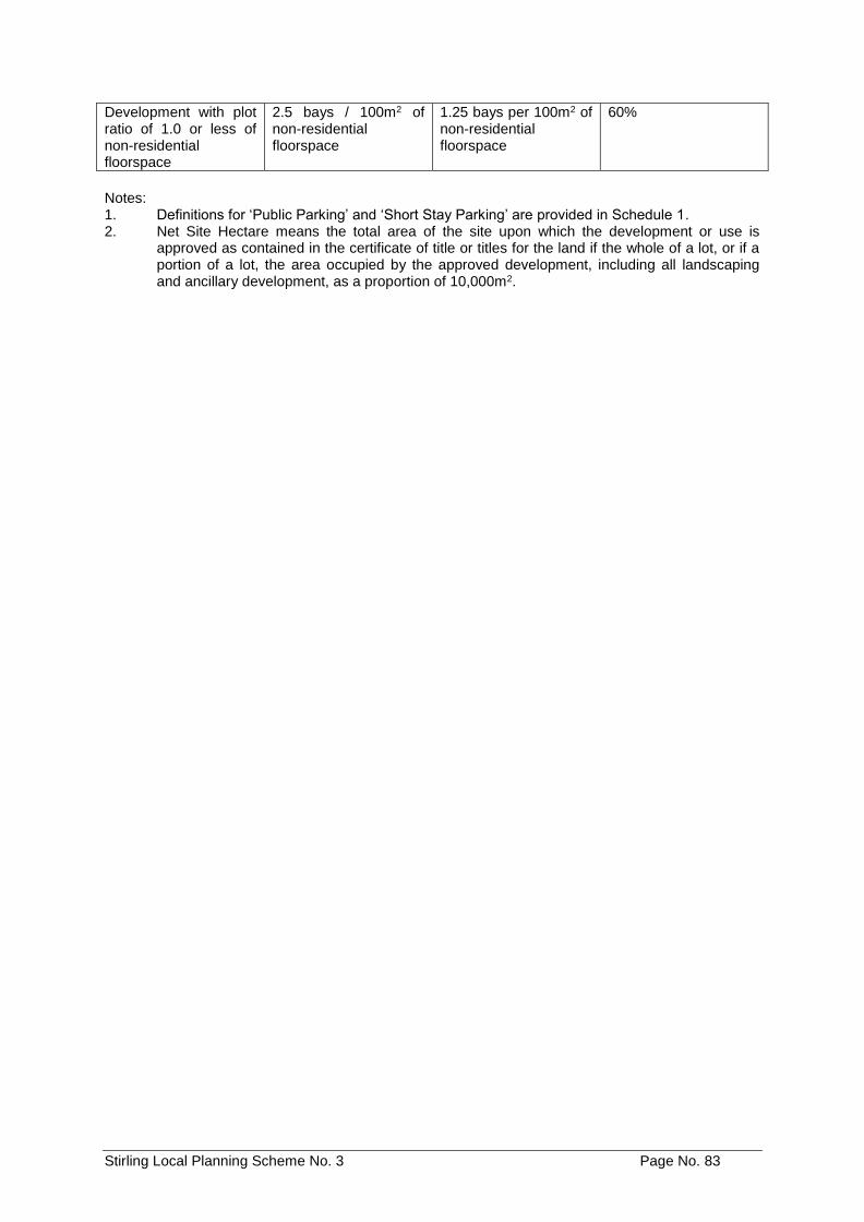
Stirling Local Planning Scheme No. 3 Page No. 83
Development with plot ratio of 1.0 or less of non-residential floorspace
2.5 bays / 100m2 of non-residential floorspace
1.25 bays per 100m2 of non-residential floorspace
60%
Notes: 1. Definitions for ‘Public Parking’ and ‘Short Stay Parking’ are provided in Schedule 1. 2. Net Site Hectare means the total area of the site upon which the development or use is
approved as contained in the certificate of title or titles for the land if the whole of a lot, or if a portion of a lot, the area occupied by the approved development, including all landscaping and ancillary development, as a proportion of 10,000m2.
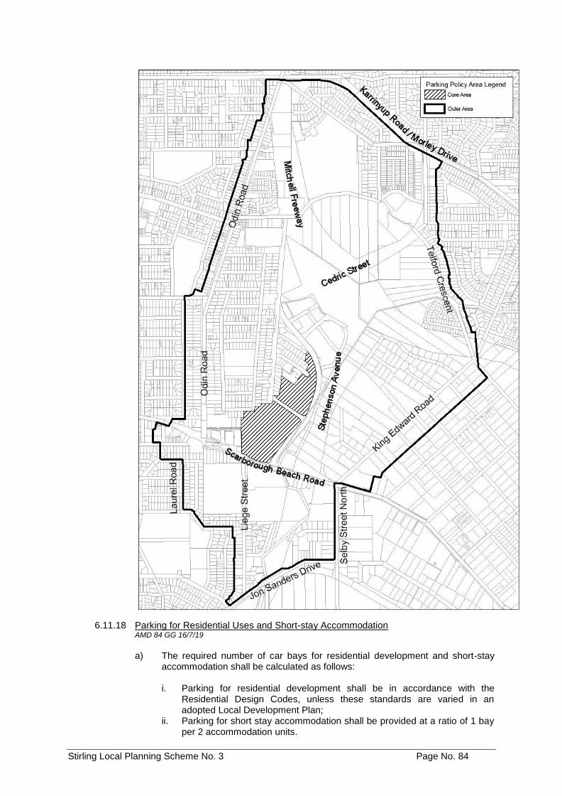
Stirling Local Planning Scheme No. 3 Page No. 84
6.11.18 Parking for Residential Uses and Short-stay Accommodation AMD 84 GG 16/7/19
a) The required number of car bays for residential development and short-stay
accommodation shall be calculated as follows:
i. Parking for residential development shall be in accordance with the Residential Design Codes, unless these standards are varied in an adopted Local Development Plan;
ii. Parking for short stay accommodation shall be provided at a ratio of 1 bay per 2 accommodation units.
Stirling Local Planning Scheme No. 3 Page No. 85
b) All other car parking requirements within the Stirling City Centre Special Control Area shall be in accordance with the adopted Stirling City Centre Activity Centre Plan, Local Development Plans and Local Planning Policy, and shall be guided by State Planning Policy 4.2 - Activity Centres for Perth and Peel.
6.11.19 Osborne Park Precinct Development Contribution AMD 84 GG 16/7/19
A Development Contribution Plan shall be approved for the Osborne Park Precinct (or part thereof) either prior to or at the same time as adoption of the Local Development Plan(s) for this Precinct. The Development Contribution Plan shall be prepared in accordance with the requirements of Part 68 of the Scheme and be incorporated into the Scheme in Schedules 11 and 11A.
6.11.20 Signage AMD 84 GG 16/7/19
a) When determining an application for development approval, the Local
Government shall have due regard to any Signage provisions contained in an approved WAPC Activity Centre Plan and any relevant approved Local Development Plans.
6.12 Dianella Centre Special Control Area
AMD 7 GG 16/9/14
6.12.1 Objectives
a) To ensure a diversity of uses and services which encourage reduced car travel, shorter trips and better social interaction.
b) To ensure the development of multiple functions benefiting the community
through appropriate social services and business mix.
c) To ensure integration of intensive building form and land uses with public transport infrastructure.
d) To ensure building forms provide for a long life span and adaptability for use,
changing with time.
e) To apply the activity centre standards of the Residential Design Codes, to encourage consolidated housing forms and diversity.
f) To apply minimum development standards to achieve the desired intensive
building form and land use mix.
6.12.2 Special Control Area
The Dianella Centre Special Control Area is the land delineated as such on the Scheme Map.
6.12.3 Centre Plan
The Dianella Centre Plan is to be read in conjunction with the provisions of Clause 6.12. Where there is an inconsistency between the provisions of the Scheme and the Dianella Centre Plan, the Scheme provisions shall prevail.
Stirling Local Planning Scheme No. 3 Page No. 86
6.12.4 Development
All development within the Dianella Centre Special Control Area shall comply with the following:
a) Building Height
i. Buildings on land zoned District Centre shall comply with the following
requirements:
1. Floor to ceiling height of the ground floor shall be a minimum of 3.5m.
2. Building Height measured from the natural ground level of the lot
boundary fronting Alexander Drive, Grand Promenade and Waverly Street shall be a minimum of:
• 15m - to the top of pitched roof, • 11m - to the top of external wall (concealed roof), and • 9.5m - to the top of external wall.
ii. Maximum height of buildings on land fronting Chester Avenue and
Waverly Street zoned Residential R-AC2 measured from the natural ground level of the lot shall comply with the following:
• 15m - to the top of pitched roof, • 11m - to the top of external wall (concealed roof), and • 9.5m - to the top of external wall.
iii. Except as otherwise required in the Scheme, the minimum building form
in residential zones shall be three (3) storeys.
b) Residential Design Codes
i. Figure 6.12.4.b outlines the applicable R-AC2 and R-AC3 codes and locations within the Dianella Special Control Area.
Figure 6.12.4.b – R-AC2 & R-AC3 Codes within Dianella Centre.
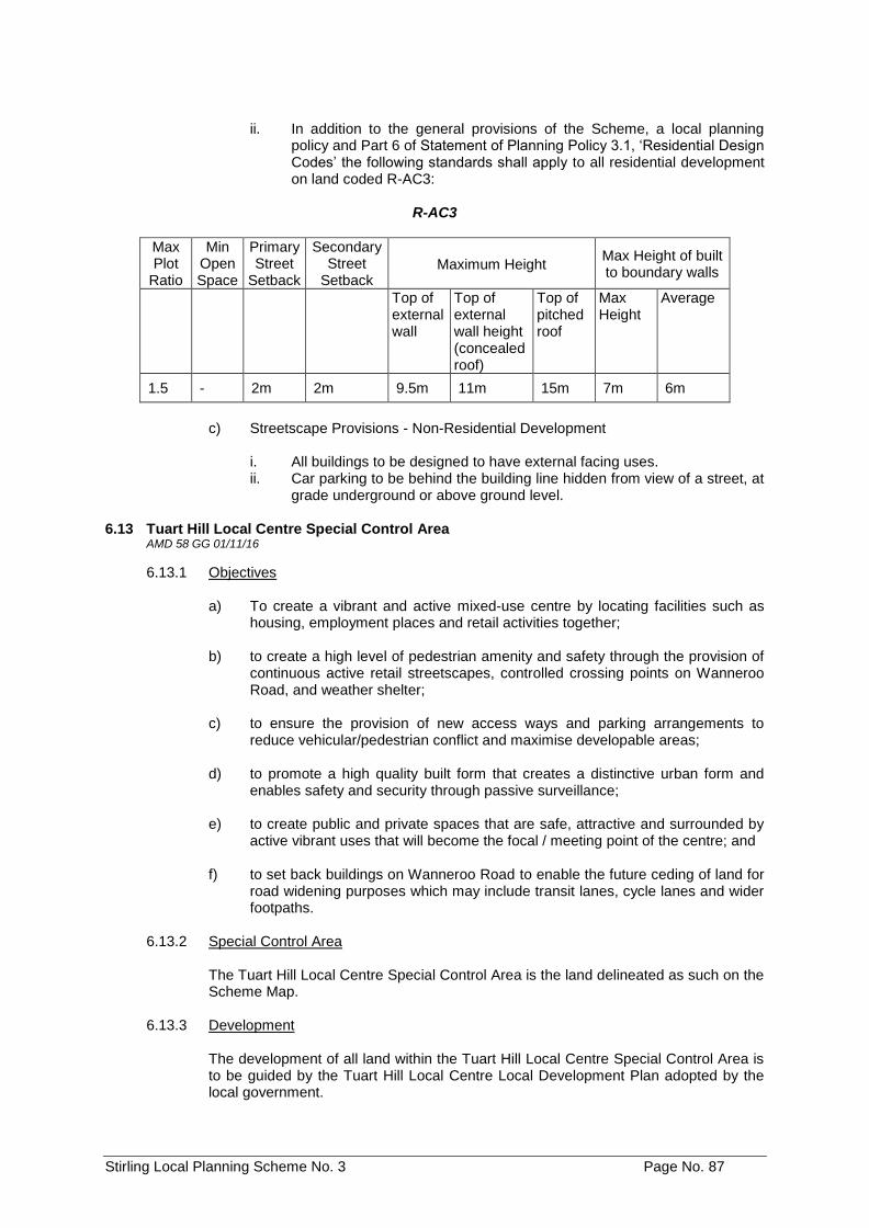
Stirling Local Planning Scheme No. 3 Page No. 87
ii. In addition to the general provisions of the Scheme, a local planning
policy and Part 6 of Statement of Planning Policy 3.1, ‘Residential Design Codes’ the following standards shall apply to all residential development on land coded R-AC3:
R-AC3
Max Plot
Ratio
Min Open Space
Primary Street
Setback
Secondary Street
Setback Maximum Height
Max Height of built to boundary walls
Top of external wall
Top of external wall height (concealed roof)
Top of pitched roof
Max Height
Average
1.5 - 2m 2m 9.5m 11m 15m 7m 6m
c) Streetscape Provisions - Non-Residential Development
i. All buildings to be designed to have external facing uses. ii. Car parking to be behind the building line hidden from view of a street, at
grade underground or above ground level. 6.13 Tuart Hill Local Centre Special Control Area
AMD 58 GG 01/11/16
6.13.1 Objectives
a) To create a vibrant and active mixed-use centre by locating facilities such as housing, employment places and retail activities together;
b) to create a high level of pedestrian amenity and safety through the provision of
continuous active retail streetscapes, controlled crossing points on Wanneroo Road, and weather shelter;
c) to ensure the provision of new access ways and parking arrangements to
reduce vehicular/pedestrian conflict and maximise developable areas; d) to promote a high quality built form that creates a distinctive urban form and
enables safety and security through passive surveillance; e) to create public and private spaces that are safe, attractive and surrounded by
active vibrant uses that will become the focal / meeting point of the centre; and f) to set back buildings on Wanneroo Road to enable the future ceding of land for
road widening purposes which may include transit lanes, cycle lanes and wider footpaths.
6.13.2 Special Control Area
The Tuart Hill Local Centre Special Control Area is the land delineated as such on the Scheme Map.
6.13.3 Development
The development of all land within the Tuart Hill Local Centre Special Control Area is to be guided by the Tuart Hill Local Centre Local Development Plan adopted by the local government.
Stirling Local Planning Scheme No. 3 Page No. 88
6.13.4 Road Widening Requirements
The owner of any site affected by road widening as identified in Figure 2 of the Tuart Hill Local Centre Local Development Plan shall cede such road widening to the Crown, free of cost and without any payment of compensation, as a condition of development approval that involves, in the opinion of the local government, the complete or substantial redevelopment of the site or as a condition of subdivision or strata subdivision of a lot, whichever occurs first.
6.13.5 Residential Design Codes
Notwithstanding clause 5.3.2 the residential component of mixed use development within the Tuart Hill Local Centre Special Control Area is to comply with the requirements of multiple dwellings under the R-AC0 code.
6.14 Karrinyup Civic Centre Special Control Area AMD 66 GG 15/08/17
6.14.1 Development of all land within the Karrinyup Civic Centre Special Control Area shall comply with the following objectives:
a) To provide for the integrated developments of public and private land uses to
facilitate the creation of a safe, vibrant mixed-use environment that integrates into the surrounding community.
b) To complement and support the desired planning and development outcomes
for the Karrinyup Town Centre. c) To minimise the impact of further development within the special control area
on the road network. d) To facilitate the development of a diverse range of housing types. e) To facilitate the development of a range of commercial uses that will contribute
to economic development and local employment. f) To provide for the continued provision of a range of community facilities. g) To create public spaces and facilitate public movement through the special
control area to promote its permeability. h) To ensure that development does not adversely impact on the amenity of
adjoining lots.
6.14.2 The Karrinyup Civic Centre Special Control Area is shown on the Scheme Maps. 6.15 Scarborough Beach Road West Special Control Area
AMD 65 GG 15/08/17
6.15.1 Objective
a) To ensure development (i.e. subdivision, land use and development) is generally consistent with the Scarborough Beach Road West Activity Corridor Strategy and Scarborough Beach Road West Area Local Development Plan.
b) To cede land for road widening purposes along Scarborough Beach Road; and c) To ensure subdivision of land does not restrict the access of lots to Right of
Ways.
Stirling Local Planning Scheme No. 3 Page No. 89
6.15.2 Special Control Area
The Scarborough Beach Road West Special Control Area is the land delineated as such on the Scheme Map.
6.15.3 Special Application of Residential Design Codes
Notwithstanding clause 5.3.2 of the Scheme, residential development on land zoned Mixed Use within the Special Control Area is to comply with the requirements of multiple dwellings under the R-AC0 R-Code. Development requirements for the R-AC0 R-Code are outlined in the Scarborough Beach Road West Area Local Development Plan.
6.15.4 Uses
Notwithstanding Table 1 - Zoning Table, single houses are not permitted on lots located within this Special Control Area which is subject to the Scarborough Beach Road West Area Local Development Plan.
6.15.5 Development
All development within the Scarborough Beach Road West Special Control Area shall conform with the objectives listed in clause 6.15.1 of this Scheme, and shall give due regard to the Scarborough Beach Road West Area Local Development Plan.
6.15.6 Subdivision
Subdivision of land fronting Scarborough Beach Road shall not be supported by the Council where this would result in vehicle access to any right of way at the rear of the land being restricted or removed for any of the new lots.
6.15.7 Land subject to ceding for road widening
a) The owner of any site affected by a road widening reservation under the
Metropolitan Region Scheme or relevant Planning Control Area shall cede such road widening free of cost on the date on which, in the opinion of the City, the development, subdivision or strata subdivision of the lot the subject of the road widening requirement, is commenced.
The owner of any site affected by a right of way widening under the Local Planning Policy relating to Right of Ways shall cede such a right of way widening free of cost as a condition of development approval or subdivision or strata title approval recommended by the City.
b) The power conferred by clause 5.5.1 of Local Planning Scheme No.3 shall not
apply to clause 6.15.7 a). c) Notwithstanding clause 6.15.7 a) the following properties are not required to
cede such road widening free of cost:
i. Lot 775, Strata 34435, No. 232 Flamborough Street, Doubleview ii. Lot 1, Strata 60985, No. 295 Scarborough Beach Road, Doubleview iii. Lot 1, Strata 38414, No. 299 Scarborough Beach Road, Doubleview iv. Lot 1, Strata 65169, No. 309A Scarborough Beach Road, Woodlands v. Lot 4, Strata 48196, No. 2A Mahlberg Avenue, Woodlands vi. Lot 8, Strata 48668, No. 317A Scarborough Beach Road, Woodlands vii. Lot 11, Strata 48622, No. 21A Grant Street, Woodlands viii. Lot 12, Strata 65405, No. 20 Grant Street, Woodlands ix. Lot 400, Strata 20235, No. 5 Hazel Avenue, Woodlands (2 properties
directly adjacent to Scarborough Beach Road only).
Stirling Local Planning Scheme No. 3 Page No. 90
x. Lot 1, Strata 8545, No. 1A Hazel Avenue, Woodlands xi. Lot 201, Strata 38818, No. 341A Scarborough Beach Road,
Woodlands xii. Lot 1, Strata 75807, No. 3D Muriel Avenue, Woodlands.
6.16 Servite College Special Control Area AMD 104 GG 27/08/19
6.16.1 Objectives
Development within the Servite College Special Control Area shall comply with the following objectives:
a) To provide for the continued provision of educational facilities at Servite
College. b) To provide for the expansion of Servite College, in an orderly and proper
manner. c) To protect the amenity of the surrounding residential uses, and to ensure that
any development is compatible with surrounding development. d) To ensure that a Local Development Plan is provided to achieve a), b) and c)
above.
6.16.2 Special Control Area
The Servite College Special Control Area is the land delineated as such on the Scheme Maps.
6.16.3 Development
Development on non-residential zoned land that proposes additional classrooms, additional floor space, or development higher than a single storey shall not be approved by the Council until a Local Development Plan for the Special Control Area has been adopted by the Council in accordance with Part 6A of the Scheme.
All Development shall conform with the Local Development Plan adopted by Council for the Special Control Area.
Note: The land uses in the Servite College Special Control Area are restricted to the uses
identified in Schedule 3 of the Scheme. 6.17 Beach Road Special Control Area AMD 77 GG 30/7/19
6.17.1 Special Control Area
The Beach Road Special Control Area is the land delineated as such on the Scheme Map.
6.17.2 Purpose
To ensure that development within the Beach Road Special Control Area does not have a detrimental impact on the amenity of the adjacent residential zone.
6.17.3 Land Use and Development a) A minimum 50% of the gross floor area of new development within the Beach
Road Special Control Area shall be for residential use.
Stirling Local Planning Scheme No. 3 Page No. 91
b) Notwithstanding Condition 2 of Table 1 - Zoning Table residential development is permitted on the ground floor fronting the street within the Beach Road Special Control Area.
c) The Shop land use shall be restricted to a maximum net lettable area of
300m2 per development site. d) All access to development in excess of an R20 density within the Beach Road
Special Control Area shall be from Glendale Avenue.
6.17.4 Maximum Height Notwithstanding the requirements of the Residential Design Codes, land within 20 metres of the Glendale Avenue street boundaries shall have a maximum building height of four storeys.
6.17.5 Setback Requirements
a) All development in excess of an R20 density within the Beach Road Special
Control Area, including non-residential development, shall comply with the minimum setbacks prescribed for R60 development in the Residential Design Codes, except where a setback is varied by Clause 6.17.5 b) below.
b) The following setbacks shall apply to the development of land within the
Beach Road Special Control Area which abuts a Residential zone: i. a minimum rear setback of 6 metres from an abutting Residential zone
for portions of buildings up to two storeys in height; ii. a minimum rear setback of 9 metres from an abutting Residential zone
for portions of buildings greater than two storeys in height; and iii. a minimum side setback of 6 metres from an abutting Residential zone
for portions of buildings greater than two storeys in height.
6.17.6 Variations to Development Standards
The power conferred by Clause 5.5.1 of the Scheme shall not apply to Clauses 6.17.3 a), 6.17.3 c), 6.17.4 and 6.17.5 above.
Stirling Local Planning Scheme No. 3 Page No. 92
PART 6A - DEVELOPMENT (STRUCTURE PLAN) AREAS
Note: The purpose of this Part is to enable Structure Plans to be prepared and adopted prior to subdivision,
use or development of land, where comprehensive planning is required to coordinate such subdivision, use or development.
6A.1 Interpretation
In clause 6A, unless the context otherwise requires:
`Owner' means an owner or owners of land in the Development Area; and `Structure Plan' means a structure plan that has come into effect in accordance with
clause 6A.12.1. 6A.2 Purpose of Development Areas
6A.2.1 The purpose of Development Areas are to:
a) Identify areas requiring comprehensive planning; and; b) Coordinate subdivision and development in areas requiring comprehensive
planning.
6A.2.2 Schedule 10 describes the Development Areas in detail and sets out the specific purposes and requirements that apply to Development Areas.
Note: Development Areas are shown on the Scheme Map, with the exception of `Careniup Swamp'
which is shown as a 'Special Control Area' (refer Clause 6.2)
6A.3 Subdivision and Development in Development Areas
6A.3.1 The development of land within a Development Area is to comply with Schedule 10.
6A.3.2 The subdivision and development of land within a Development Area is to be generally in accordance with any structure plan that applies to that land.
6A.4 Structure Plan Required
6A.4.1 The Council is not to:
a) consider recommending subdivision; or b) approve development
of land within a Development Area unless there is a structure plan for the Development Area or for the relevant part of the Development Area.
6A.4.2 Notwithstanding clause 6A4.1, the Council may recommend subdivision or approve
the development of land within a Development Area prior to a structure plan coming into effect in relation to that land, if the Council is satisfied that this will not prejudice the specific purposes and requirements of the Development Area.
6A.5 Preparation of Structure Plans
6A.5.1 A proposed structure plan may be prepared by:
a) the Council; or b) an owner.
Stirling Local Planning Scheme No. 3 Page No. 93
6A.6 Details of Proposed Structure Plan
6A.6.1 A proposed structure plan is to contain the following details:
a) A map showing the area to which the proposed structure plan is to apply. b) A site analysis map showing the characteristics of the site including:
i. landform, topography and land capability; ii. conservation and environmental values including bushland, wetlands,
damp lands, streams and water courses, foreshore reserves and any environmental policy areas;
iii. hydrogeological conditions, including approximate depth to water table; iv. site and features of Aboriginal and European heritage value.
c) A context analysis map of the immediate surrounds to the site including:
i. the pattern of neighbourhoods, and existing and planned neighbourhood,
town and regional centres; ii. transport routes, including freeways, arterial routes and neighbourhood
connector alignments, public transport routes, strategic cycle routes, bus stops and rail stations;
iii. existing and future land use.
d) For district structure plans a map showing proposals for:
i. the pattern of neighbourhoods around town and neighbourhood centres; ii. arterial routes and neighbourhood connector streets; iii. the protection of natural features such as water courses and vegetation; iv. major open spaces and parklands; v. major public transport routes and facilities; vi. the pattern and disposition of land uses; and vii. schools and community facilities.
e) For local structure plans a map showing proposals for:
i. neighbourhoods around proposed neighbourhoods and town centres; ii. existing and proposed commercial centres; iii. natural features to be retained; iv. street block layouts; v. the street network including street types; vi. transportation corridors, public transport network, and cycle and
pedestrian networks; vii. land uses including residential densities and estimates of population; viii. schools and community facilities; ix. public parklands; and x. urban water management areas.
f) A written report to explain the mapping and to address the following:
i. the planning framework for the structure plan including any applicable
regional or district structure plans, and any policies, strategies and scheme provisions which apply to the land, and any environmental conditions which apply under the scheme;
ii. the site analysis including reference to the matters listed in clause 6A.6.1 b) above and, in particular, the significance of the conservation, environmental and heritage values of the site;
iii. the context analysis including reference to the matters listed in clause 6A.6.1 c) above;
Stirling Local Planning Scheme No. 3 Page No. 94
iv. how planning for the structure plan area is to be integrated with the
surrounding land; v. the design rationale for the proposed pattern of subdivision, land use and
development; vi. traffic management and safety; vii. parkland provision and management; viii. urban water management; ix. proposals for public utilities including sewerage, water supply, drainage,
gas, electricity and communication services; x. the proposed method of implementation including any cost sharing
arrangements and details of any staging of subdivision and development.
6A.6.2 The maps referred to in clause 6A.6.1 are to:
a) be drawn to a scale that clearly illustrates the details referred to in clause 6A.6.1; and
b) include a north point, visual bar scale, key street names and a drawing title and
number.
6A.6.3 A proposed structure plan may, to the extent that it does not conflict with the Scheme, impose a classification on the land included in it by reference to reserves, zones or the Residential Design Codes, and where the proposed structure plan becomes a structure plan, the Council is to have due regard to such reserves, zones or Residential Design Codes when recommending subdivision or approving development of land within a Development Area.
6A.6.4 A proposed structure plan must, in the opinion of the Council, be consistent with orderly
and proper planning. 6A.7 Submission to Council and Commission
6A.7.1 A proposed structure plan prepared by an owner is to be submitted to the Council. 6A.7.2 Within 7 days of preparing or receiving a proposed structure plan which proposes the
subdivision of land, the Council is to forward a copy of the proposed structure plan to the Commission.
6A.7.3 The Commission is to provide comments to the Council as to whether it is prepared to
endorse the proposed structure plan with or without modifications. 6A.7.4 The Commission must provide its comments to the Council within 30 days of receiving
the proposed structure plan. 6A.8 Advertising of Structure Plan
6A.8.1 Within 60 days of preparing or receiving a proposed structure plan that conforms with clause 6A.6 and complies with the Scheme (or such longer time as may be agreed in writing between the owner who submitted the proposed structure plan and the Council), the Council is to:
a) Advertise, or require the owner who submitted the proposed structure plan to
advertise, the proposed structure plan for public inspection by one or more of the following ways:
i. notice of the proposed structure plan published in a newspaper
circulating in the Scheme area;
Stirling Local Planning Scheme No. 3 Page No. 95
ii. a sign or signs displaying notice of the proposed structure plan to be
erected in a conspicuous place or places in the Development Area, or part of the Development Area, to which the proposed structure plan applies; and
b) Give notice or require the owner who submitted the proposed structure plan to give notice, in writing to:
i. all owners whose land is included in the proposed structure plan; ii. all owners and occupiers who, in the opinion of the Council, are likely to
be affected by the adoption of the proposed structure plan; iii. such public authorities and other persons as the Council nominates.
6A.8.2 The advertisement and notice are to:
a) explain the scope and purpose of the proposed structure plan; b) specify when and where the proposed structure plan may be inspected; and
c) invite submissions to the Council by a specified date being not less than 21
days after the giving or erection of the notice or publication of the advertisement, as the case requires.
6A.8.3 A Structure Plan may be prepared and advertised in accordance with the provisions of
Part 6A prior to an amendment to the Scheme, which designates the area the subject of the Structure Plan as a Development Area, being published in the Government Gazette. Upon publication of the amendment in the Government Gazette, the provisions of Clause 6A.9 onwards shall apply to that Structure Plan, with the exception that the 60 day period referred to in Clause 6A.9.1 shall commence on the day on which the amendment is published in the Government Gazette.
AMD 1 GG 02/09/14
6A.9 Adoption of Proposed Structure Plan
6A.9.1 The Council is to consider all submissions received and within 60 days of the latest date specified in the notice or advertisement for the making of submissions is to: a) adopt the proposed structure plan, with or without modifications; or b) refuse to adopt the proposed structure plan and, where the proposed
structure plan was submitted by an owner, give reasons for this to the owner.
6A.9.2 a) In making a determination under clause 6A.9.1, the Council is to have due regard to the comments and advice received from the Commission in relation to the proposed structure plan; and
b) if the Commission requires modifications to the proposed structure plan, the
Council is to consult with the Commission prior to making a determination under clause 6.A.9.1.
6A.9.3 If the Council, after consultation with the Commission, is of the opinion that a
modification to the proposed structure plan is substantial, the Council may:
a) readvertise the proposed structure plan; or b) require the owner who submitted the proposed structure plan to
readvertise the proposed structure plan and thereafter, the procedures set out in clause 6A.8.1 onwards are to apply.
Stirling Local Planning Scheme No. 3 Page No. 96
6A.9.4 If within the period referred to in clause 6A.8.3 or clause 6A.9.1 (as the case may be) or such further time as may be agreed in writing between the owner who submitted the proposed Structure Plan and the Council, the Council has not made a determination under clause 6A.9.1, the Council is deemed to have refused to adopt the proposed Structure Plan. AMD 1 GG 02/09/14
6A.10 Endorsement by Commission
6A.10.1 If the proposed structure plan proposes the subdivision of land, then within 7 days
of making its determination under clause 6A.9.1, the Council is to forward the proposed structure plan to the Commission for its endorsement.
6A.10.2 As soon as practicable after receiving the proposed structure plan, the
Commission is to determine whether to endorse the proposed structure plan.
6A.10.3 The Commission is to notify the Council of its determination under clause 6A.10.2. 6A.11 Notification of Structure Plan
6A.11.1 As soon as practicable after adopting a proposed structure plan under clause 6A.9.1 and if clause 6A.10 applies, as soon as practicable after being notified of the Commission's decision under clause 6A.10.3, the Council is to forward a copy of the structure plan to:
a) any public authority or person that the Council thinks fit; and b) where the structure plan was submitted by an owner, to the owner.
6A.12 Operation of Structure Plan
6A.12.1 A structure plan comes into effect:
a) where the structure plan proposes the subdivision of land, on the day on which it is endorsed by the Commission pursuant to clause 6A.10.2; or
b) on the day on which it is adopted by the Council under clause 6A.9.1 in all other cases.
6A.12.2 If a provision of a structure plan is inconsistent with a provision of the Scheme, then
the provision of the Scheme prevails to the extent of the inconsistency. 6A.13 Inspection of Structure Plan
6A.13.1 The structure plan and the Commission's notification under clause 6A.10.3 is to be kept at the Council's administrative offices, and is to be made available for inspection by any member of the public during office hours.
6A.14 Variation to Structure Plan
6A.14.1 The Council may vary a structure plan:
a) by resolution if, in the opinion of the Council, the variation does not materially alter the intent of the structure plan;
b) otherwise, in accordance with the procedures set out in clause 6A.6
onwards.
6A.14.2 If the Council varies a structure plan by resolution, and the variation does not propose the subdivision of land, the Council is to forward a copy of the variation to the Commission within 10 days of making the resolution.
Stirling Local Planning Scheme No. 3 Page No. 97
6A.14.3 If the Council varies a structure plan by resolution, and the variation proposes the subdivision of land, the Council is to forward a copy of the variation to the Commission within 10 days of making the resolution for its endorsement.
6A.14.4 As soon as practicable after receiving the copy of the variation referred to in clause
6A.14.3, the Commission is to determine whether to endorse the proposed variation.
6A.14.5 The Commission is to notify the Council of its determination under clause 6A.14.4. 6A.14.6 A variation to a structure plan by resolution comes into effect:
a) where the variation proposes the subdivision of land, on the day on which it
is endorsed by the Commission pursuant to clause 6A.14.4; or b) on the day on which the Council resolves to make the variation under clause
6A.14.1 a).
6A.15 Existing Approved Structure Plans
6A.15.1 Any Structure Plan or Outline Development Plan duly approved by the Council and the Commission under the provisions of District Planning Scheme No.2, is to have the full force and effects as if it were approved as a Structure Plan under the Scheme.
6A.15.2 Any Structure Plan or Outline Development Plan that, on the Gazettal date, is
being prepared under the provisions of District Planning Scheme No. 2, may continue to be prepared in the manner required under that scheme, and following approval by the Council and the Commission, is to have the full force and effects as if it were approved as a Structure Plan or Outline Development Plan under the Scheme.
6A.16 Detailed Area Plan
6A.16.1 Where it is considered desirable to enhance, elaborate or expand the details or provisions contained in a structure plan or in other circumstances for a particular lot or lots, a detailed area plan may be prepared by:
a) the Council; or b) an owner.
6A.16.2 A detailed area plan may include details as to: AMD 1 GG 02/09/15
a) land uses including residential densities; b) building envelopes; c) distribution of land uses within a lot;
d) private open space; e) services;
f) vehicular access, parking, loading and unloading areas, storage yards and
rubbish collection closures; g) the location, orientation and design of buildings and the space between
buildings; h) advertising signs, lighting and fencing; i) landscaping, finished site levels and drainage;
Stirling Local Planning Scheme No. 3 Page No. 98
j) protection of sites of heritage, conservation or environmental significance; k) special development controls and guidelines; and l) such other information considered relevant by the council.
6A.16.3 When a proposed detailed area plan is prepared under clause 6A.16.1, the Council is to:
a) advertise, or require the owner who submitted the proposed detailed area
plan to advertise, the proposed detailed area plan for public inspection by one or more of the following ways:
i. notice of the proposed detailed area plan published in a newspaper
circulating in the Scheme area; ii. a sign or signs displaying notice of the proposed detailed area plan to
be erected in a conspicuous place or places in the Development Area, or part of the Development Area, to which the proposed detailed area plan applies; and
b) give notice or require the owner who submitted the proposed detailed area
plan to give notice, in writing to:
i. all owners whose land is included in the proposed detailed area plan; ii. all owners and occupiers who, in the opinion of the Council, are likely
to be affected by the adoption of the proposed detailed area plan; iii. such public authorities and other persons as the Council nominates.
6A.16.4 The advertisement and notice are to:
a) explain the scope and purpose of the proposed detailed area plan; b) specify when and where the proposed detailed plan may be inspected; and c) invite submissions to the Council by a specified date being not less than 21
days after the giving or erection of the notice or publication of the advertisement, as the case requires.
6A.16.5 The Council is to consider all submissions received and:
a) approve the detailed area plan with or without conditions; or b) refuse to approve the detailed area plan and, where the proposed detailed
area plan was submitted by an owner, give reasons for this to the owner.
6A.16.6 If within 60 days of receiving a detailed area plan prepared under clause 6A.16.1 b), or such longer period as may be agreed in writing between the owner and the Council, the Council has not made one of the determinations referred to in clause 6A.16.5, the Council is deemed to have refused to approve the detailed area plan.
6A.16.7 Once approved by the Council, the detailed area plan constitutes a variation of the
structure plan. 6A.16.8 The Council may vary a detailed area plan in accordance with the procedures set
out in clause 6A.16 onwards provided such variations do not prejudice the intention of any related structure plan.
Stirling Local Planning Scheme No. 3 Page No. 99
6A.17 Appeal
6A.17.1 An owner who has submitted a proposed structure plan under clause 6A.7.1 may appeal, under Part 14 of the Planning and Development Act:
a) any failure of the Council to advertise, or require the owner to advertise, a
proposed structure plan within the required time period under clause 6A.8.1; b) any determination of the Council:
i. to refuse to adopt a proposed structure plan (including a deemed refusal); or
ii. to require modifications to a proposed structure plan that are unacceptable to that owner.
6A.17.2 An owner who has submitted a detailed area plan in accordance with clause 6A.16
may appeal, in accordance with Part 14 of the Planning and Development Act, any discretionary decision made by the Council under clause 6A.16.
Stirling Local Planning Scheme No. 3 Page No. 100
PART 6B - DEVELOPMENT CONTRIBUTION AREAS AMD 5 GG 15/12/15
6B.1 Interpretations
In clause 6B, unless the context otherwise requires – ‘Administrative costs’ means such costs as are reasonably incurred for the preparation and (with respect to standard infrastructure items as provided in State Planning Policy 3.6) implementation of the development contribution plan.
‘Administrative items’ means the administrative matters required to be carried out by or on behalf of the local government in order to prepare and (with respect to standard infrastructure items as provided in State Planning Policy 3.6) implement the development contribution plan, including legal, accounting, planning, engineering, and other professional advice.
‘Cost apportionment schedule’ means a schedule prepared and distributed in accordance with clause 6B.10
‘Cost contribution’ means the contribution to the cost of infrastructure and administrative costs.
‘Development contribution area’ means the area shown on the scheme map as DCA with a number or included in schedule 11 and 11A.
‘Development contribution plan’ means a development contribution plan prepared in accordance with the provisions of State Planning Policy 3.6 Development Contributions for Infrastructure and the provisions of this clause 6B of the scheme (as incorporated in schedule 11 and 11A to this scheme).
‘Development contribution plan report’ means a report prepared and distributed in accordance with clause 6B.10.
‘Infrastructure’ means the standard infrastructure items (services and facilities set out in appendix 1 as provided in State Planning Policy 3.6) and community infrastructure, including recreational facilities; community centres; child care and after school centres; libraries and cultural facilities and such other services and facilities for which development contributions may reasonably be requested having regard to the objectives, scope and provisions of State Planning Policy 3.6.
‘Infrastructure costs’ means such costs as are reasonably incurred for the acquisition and construction of infrastructure.
‘Owner’ means an owner of land that is located within a development contribution area.
6B.2 Purpose
The purpose of having development contribution areas is to –
(a) provide for the equitable sharing of the costs of infrastructure and administrative costs between owners;
(b) ensure that cost contributions are reasonably required as a result of the subdivision
and development of land in the development contribution area; and
(c) coordinate the timely provision of Infrastructure.
Stirling Local Planning Scheme No. 3 Page No. 101
6B.3 Development Contribution Plan Required
A development contribution plan is required to be prepared for each development contribution area.
6B.4 Development Contribution Plan Part of Scheme
The development contribution plan is incorporated in schedule 11 and 11A as part of this scheme.
6B.5 Subdivision, Strata Subdivision and Development
The Council shall not withhold its support for subdivision, strata subdivision or refuse to approve a development solely for the reason that a development contribution plan is not in effect, there is no approval to advertise a development contribution plan, or that there is no other arrangement with respect to an owner’s contribution towards the provision of community infrastructure.
6B.6 Guiding Principles for Development Contribution Plans
The development contribution plan for any development contribution area is to be prepared in accordance with the following principles –
(a) Need and Nexus
The need for the infrastructure included in the plan must be clearly demonstrated (need) and the connection between the development and the demand created should be clearly established (nexus).
(b) Transparency
Both the method for calculating the development contribution and the manner in which it is applied should be clear, transparent and simple to understand and administer.
(c) Equity
Development contribution should be levied from all developments within a development contribution area, based on their relative contribution to need.
(d) Certainty
All development contributions should be clearly identified and methods of accounting for cost adjustments determined at the commencement of a development.
(e) Efficiency
Development contributions should be justified on a whole of life capital cost basis consistent with maintaining financial discipline on service providers by precluding over recovery of costs.
(f) Consistency
Development contributions should be applied uniformly across a development contribution area and the methodology for applying contributions should be consistent.
Stirling Local Planning Scheme No. 3 Page No. 102
(g) Right of consultation and review Owners have the right to be consulted on the manner in which development contributions are determined. They also have the opportunity to seek a review by an independent third party if they believe the calculation of the costs of the contributions is not reasonable.
(h) Accountable
There must be accountability in the manner in which development contributions are determined and expended.
6B.7 Recommended Content of Development Contribution Plans
6B.7.1 The development contribution plan is to specify –
a) the development contribution area to which the development contribution plan applies;
b) the infrastructure and administrative items to be funded through the
development contribution plan;
c) the method of determining the cost contribution of each owner; and
d) the priority and timing for the provision of infrastructure.
6B.8 Period of Development Contribution Plan
A development contribution plan shall specify the period during which it is to operate. 6B.9 Land Excluded
In calculating both the area of an owner’s land the total area of land in a development contribution area, the area of land provided in that development contribution area for –
(a) roads designated under the Metropolitan Region Scheme as primary roads and other
regional roads;
(b) existing public open space;
(c) existing government primary and secondary schools; and
(d) such other land as is set out in the development contribution plan,
is to be excluded.
6B.10 Development Contribution Plan Report and Cost Apportionment Schedule
6B.10.1 Within 90 days of the development contribution plan coming into effect, the Council is to adopt and make available a development contribution plan report and cost apportionment schedule to all owners in the development contribution area.
6B.10.2 The development contribution plan report and the cost apportionment schedule
shall set out in detail the calculation of the cost contribution for each owner in the development contribution area, based on the methodology provided in the development contribution plan, and shall take into account any proposed staging of the development.
Stirling Local Planning Scheme No. 3 Page No. 103
6B.10.3 The development contribution plan report and the cost apportionment schedule do not form part of the scheme, but once adopted by the Council they are subject to review as provided under clause 6B.11.
6B.11 Cost Contributions Based on Estimates
6B.11.1 The determination of Infrastructure costs and administrative costs is to be based on amounts expended, but when expenditure has not occurred, it is to be based on the best and latest estimated costs available to the Council and adjusted accordingly, if necessary.
6B.11.2 Where a cost apportionment schedule contains estimated costs, such estimated
costs are to be reviewed at least annually by the Council –
a) in the case of land to be acquired, in accordance with clause 6B.12; and b) in all other cases, in accordance with the best and latest information
available to the Council,
until the expenditure on the relevant item of infrastructure or administrative costs has occurred.
6B.11.3 The Council is to have such estimated costs independently certified by appropriate
qualified persons and must provide such independent certification to an owner when requested to do so.
6B.11.4 Where any cost contribution has been calculated on the basis of an estimated
cost, the Council –
a) is to adjust the cost contribution of any owner in accordance with the revised estimated costs; or
b) may accept a cost contribution, based upon estimated costs, as a final cost
contribution and enter into an agreement with the owner accordingly.
6B.11.5 Where an owner’s cost contribution is adjusted under clause 6B.11.4, the Council, on receiving a request in writing from an owner, is to provide the owner with a copy of estimated costs and the calculation of adjustments.
6B11.6 If an owner objects to the amount of a cost contribution, the owner may give notice
to the Council requesting a review of the cost contribution by an appropriate qualified person (‘independent expert’) agreed by the Council and the owner at the owner’s expense, within 28 days after being informed of the cost contribution.
6B.11.7 If the independent expert does not change the cost contribution to a figure
acceptable to the owner, the cost contribution is to be determined –
a) by any method agreed between the Council and the owner; or
b) if the Council and the owner cannot agree on a method pursuant to a) or on an independent expert, by arbitration in accordance with the Commercial Arbitration Act 1985, with the costs to be shared equally between the Council and owner.
Stirling Local Planning Scheme No. 3 Page No. 104
6B.12 Valuation
6B.12.1 Clause 6B.12 applies in order to determine the value of land to be acquired for the purpose of providing Infrastructure.
6B.12.2 In clause 6B.12
‘Value’ means the fair market value of land, at a specified date, which is defined as the capital sum that would be negotiated in an arm’s length transaction in an open and unrestricted market, assuming the highest and best use of the land with all its potential and limitations (other than the limitation arising from the transaction for which the land is being valued), wherein the parties act knowledgeably, prudently and without compulsion to buy or sell.
The value of land is to be determined according to the methodology outlined in State Planning Policy 3.6 ‘Development Contributions for Infrastructure’ and accompanying Guidelines.”
‘Valuer’ means a licensed valuer agreed by the Council and the owner, or, where
the Council and the owner are unable to reach agreement, by a valuer appointed by the President of the Western Australian Division of the Australian Property Institute.
6B.12.3 If an owner objects to a valuation made by a valuer, the owner may give notice to
the Council requesting a review of the amount of the value, at the owner’s expense, within 28 days after being informed of the value.
6B.12.4 If, following a review, the valuer’s determination of the value of the land is still not a
figure acceptable to the owner, the value is to be determined –
a) by any method agreed between the Council and the owner; or b) if the Council and the owner cannot agree, the owner may apply to the State
Administrative Tribunal for a review of the matter under part 14 of the Planning and Development Act 2005.
6B.13 Liability for Cost Contributions
6B.13.1 An owner must make a cost contribution in accordance with the applicable development contribution plan and the provisions of clause 6B.
6B.13.2 An owner’s liability to pay the owner’s cost contribution to the Council arises on the
earlier of –
a) the Western Australian Planning Commission endorsing its approval on the deposited plan or survey strata plan of the subdivision of the owner’s land within the development contribution area;
b) the commencement of any development on the owner’s land within the
development contribution area;
c) the approval of any strata plan by the Council or Western Australian
Planning Commission on the owner’s land within the development contribution area; or
d) the approval of a change or extension of use by the Council on the owner’s
land within the development contribution area.
The liability arises only once upon the earliest of the above listed events.
Stirling Local Planning Scheme No. 3 Page No. 105
6B.13.3 Notwithstanding clause 6B.13.2 and subject to a provision in a development contribution plan to the contrary, an owner’s liability to pay the owner’s cost contribution does not arise if the owner commences development of the first single house or outbuildings associated with that first single house on an existing lot which has not been subdivided or strata subdivided since the coming into effect of the development contribution plan.
6B.13.4 Where a development contribution area expires in accordance with clause 6B.8,
an owner’s liability to pay the owner’s cost contribution under that development contribution plan shall be deemed to continue in effect and be carried over to any subsequent development contribution plan which includes the owner’s land, subject to such liability.
6B.14 Payment of Cost Contribution
6B.14.1 The owner, with the agreement of the Council, is to pay the owner’s cost contribution by –
a) cheque or cash; b) transferring to the Council or a public authority land in satisfaction of the
cost contribution;
c) the provision of physical infrastructure;
d) some other method acceptable to the Council; or
e) any combination of these methods.
6B.14.2 The owner, with the agreement of the Council, may pay the owner’s cost
contribution in a lump sum, by instalments or in such other manner acceptable to the Council.
6B.14.3 Payment by an owner of the cost contribution, including a cost contribution base
upon estimated costs in a manner acceptable to the Council, constitutes full and final discharge of the owner’s liability under the development contribution plan and the Council shall provide certification in writing to the owner of such discharge if requested by the owner.
6B.15 Charge on land
6B.15.1 The amount of any cost contribution for which an owner is liable under clause 6B.13, but has not paid, is a charge on the owner’s land to which the cost contribution relates, and the Council may lodge a caveat, at the owner’s expense, against the owner’s certificate of title to that land.
6B.15.2 The Council, at the owner’s expense and subject to such other conditions as the
Council thinks fit, can withdraw a caveat lodged under clause 6B.15.1 to permit a dealing and may then re-lodge the caveat to prevent further dealings.
6B.15.3 If the cost contribution is paid in full, the Council, if requested to do so by the
owner and at the expense of the owner, is to withdraw any caveat lodged under clause 6B.15.
Stirling Local Planning Scheme No. 3 Page No. 106
6B.16 Administration of Funds
6B.16.1 The Council is to establish and maintain a reserve account in accordance with the Local Government Act 1995 for each development contribution area into which cost contributions for that development contribution area will be credited and from which all payments for the infrastructure costs and administrative costs within that development contribution area will be paid. The purpose of such a reserve account or the use of money in such a reserve account is limited to the application of funds for that development contribution area.
6B.16.2 Interest earned on cost contributions credited to a reserve account in accordance
with clause 6B.16.1 is to be applied in the development contribution area to which the reserve account relates.
6B.16.3 The Council is to publish an audited annual statement of accounts for that
development contribution area as soon as practicable after the audited annual statement of accounts becomes available.
6B.17 Shortfall or Excess in Cost Contributions
6B.17.1 If there is a shortfall in the total of cost contributions when all cost contributions have been made or accounted for in a particular development contribution area, the Council may –
a) make good the shortfall; b) enter into agreements with owners to fund the shortfall; or
c) raise loans or borrow from a financial institution,
but nothing in paragraph 6B.17.1 a) restricts the right or power of the Council to impose a differential rate to a specified development contribution area in that regard.
6B.17.2 If there is an excess in funds available to the development contribution area when
all cost contributions have been made or accounted for in a particular development contribution area, the Council is to refund the excess funds to contributing owners for that development contribution area. To the extent, if any, that it is not reasonably practicable to identify owners and/or their entitled amount of refund, any excess in funds shall be applied, to the provision of additional facilities or improvements in that development contribution area.
6B.18 Powers of the Council
The Council in implementing the development contribution plan has the power to – (a) acquire any land or buildings within the scheme area under the provisions of the
Planning and Development Act 2005; and
(b) deal with or dispose of any land which it has acquired under the provisions of the Planning and Development Act 2005 in accordance with the law and for such purpose may make such agreements with other owners as it considers fit.
6B.19 Arbitration
Subject to clauses 6B.12.3 and 6B.12.4, any dispute between an owner and the Council in connection with the cost contribution required to be made by an owner is to be resolved by arbitration in accordance with the Commercial Arbitration Act 1985.
Stirling Local Planning Scheme No. 3 Page No. 107
PART 7 - HERITAGE PROTECTION 7.1 Preparation of a Heritage List
7.1.1 The Council is to establish and maintain a Heritage List to identify those places within the Scheme Area which are of cultural heritage significance and worthy of conservation under the provisions of the Scheme, together with a description of each place and the reasons for its entry.
7.1.2 In the preparation of the Heritage List the Council is to -
a) have regard to the municipal inventory prepared by the Council under section
45 of the Heritage of Western Australia Act 1990; and b) include on the Heritage List such of the entries on the municipal inventory as it
considers to be appropriate.
7.1.3 In considering a proposal to include a place on the Heritage List the Council is to -
a) notify in writing the owner and occupier of the place and provide them with a copy of the description proposed to be used under clause 7.1.1 and the reasons for the proposed entry;
b) invite submissions on the proposal from the owner and occupier of the place
within 21 days of the day the notice is served; c) carry out such other consultations as it thinks fit; and d) consider any submissions made and resolve to enter the place on the Heritage
List with or without modification or reject the proposal after consideration of the submissions.
7.1.4 Where a place is included on the Heritage List, the Council is to give notice of the
inclusion to the Commission, the Heritage Council of Western Australia and to the owner and occupier of the place.
7.1.5 The Council is to keep a copy of the Heritage List with the Scheme documents for
public inspection. 7.1.6 The Council may add a place to the Heritage List or remove or modify the entry of a
place on the Heritage List by following the procedures set out in clause 7.1.3. AMD 4 GG 26/4/13
Note: 1. The purpose and intent of the heritage provisions are –
(a) to facilitate the conservation of places of heritage value; and (b) to ensure as far as possible that development occurs with due regard to heritage values.
2. A "place" is defined in Schedule 1 and may include works, buildings and contents of buildings.
3. Clause 9.4.1 (f) requires all development on a property listed as Management Category A on the heritage list to be advertised and Council shall have regard to clause 10.2 (h) when determining an application to commence development.
Stirling Local Planning Scheme No. 3 Page No. 108
7.2 Heritage List Provisions AMD 4 GG 26/4/13
7.2.1 Management Categories
Each Place on the Heritage List shall be allocated to one of the following Management Categories —
a) Management Category A: Place of Exceptional Cultural Heritage Significance; b) Management Category B: Place of Considerable Cultural Heritage Significance;
and
c) Management Category C: Place of Some Cultural Heritage Significance.
7.2.2 Management Category Provisions
7.2.2.1 Management Category A
a) Objectives
Notwithstanding any other provision in the scheme, for all development of or on a place allocated to Management Category A, under Clause 7.2.1, the following objectives apply —
– to retain and conserve the Place; – to ensure no part of the Place is demolished, except in
specified exceptional circumstances; – to ensure that any building or works affecting the Place (in
particular, the replacement of worn or damaged materials) match the existing colours and materials of the Place;
– to ensure that development has minimal impact on the cultural heritage significance of the Place and is in accordance with Burra Charter principles; and
– in the case of a Place located within a Heritage Protection Area Special Control Area, to ensure that development conforms with the provisions of Local Planning Policy Character Retention Guidelines Mount Lawley, Menora and Inglewood.
b) Relationship of Management Category A to Heritage Protection Area
Special Control Area
Where a Place allocated to Management Category A, under Clause 7.2.1, is located within a Heritage Protection Area Special Control Area and a provision of Part 6 of the Scheme is inconsistent with Part 7 of the Scheme, the provision of Part 7 prevails.
Note: 1. The purpose of this provision is to ensure compliance with the Burra Charter
principles over and above the requirements of the Local Planning Policy Character Retention Guidelines Mount Lawley, Menora and Inglewood.
Stirling Local Planning Scheme No. 3 Page No. 109
c) Application Requirements
(i) An application for approval is required for —
– the carrying out of any building or work which affects the interior of a building;
– the carrying out of any building or work which affects the external appearance of a building including the illumination, installation or alteration of signage and changes to exterior materials or colours of the building;
– a change of use; – the demolition of any part of the Place; or – the carrying out of any other works including fencing,
incidental structures, outbuildings and patios.
(ii) In addition to the requirements of Part 9 of the Scheme, each application for approval shall be accompanied by the following —
– Heritage Impact Statement; – Signage Strategy where any existing signs are being
modified or new signs are proposed; and – in the case of demolition an Archival Record and,
where approval of demolition is sought because the structural integrity of the building has failed to the extent that it cannot be rectified without permanent removal of the majority of its significant fabric, a structural engineer’s report verifying the failure.
(iii) Where an application for approval involves demolition of any
part of the Place, the Council may not grant approval to that application unless notice is first given in accordance with Clause 9.4.3; and
– the structural integrity of the Place or relevant part
thereof has failed to the extent that it cannot be rectified without the permanent removal of the majority of the significant fabric of the Place; or
– the portion of the Place to be demolished does not form part of the significant fabric of the Place and does not contribute to the cultural heritage significance of the Place
except where otherwise advised by the Heritage Council of Western Australia under Section 11 of the Heritage of Western Australian Act 1990 or by another appropriate heritage authority or agency.
Note: 1. The purpose of this provision is to ensure that Places listed as
Management Category A are not demolished except in exceptional circumstances.
Stirling Local Planning Scheme No. 3 Page No. 110
7.2.2.2 Management Category B
a) Objectives
Notwithstanding any other provision in the scheme, for all development of or on a place allocated to Management Category B, under Clause 7.2.1, the following objectives apply —
– to retain and conserve the Place; – to ensure no part of the Place is demolished, except in
specified exceptional circumstances; – to ensure that any building or works affecting the Place (in
particular, the replacement of worn or damaged materials) match the existing colours and materials of the Place;
– to ensure that development has minimal impact on the cultural heritage significance of the Place and is in accordance with Burra Charter principles; and
– in the case of a Place located within a Heritage Protection Area Special Control Area, to ensure that development conforms with the provisions of Local Planning Policy Character Retention Guidelines Mount Lawley, Menora and Inglewood.
b) Relationship of Management Category B to Heritage Protection Area
Special Control Area
Where a Place allocated to Management Category B, under Clause 7.2.1, is located within a Heritage Protection Area Special Control Area and a provision of Part 6 of the Scheme is inconsistent with Part 7 of the Scheme, the provision of Part 6 prevails.
Note: 1. The purpose of this provision is to ensure compliance with the Local Planning
Policy Character Retention Guidelines Mount Lawley, Menora and Inglewood over and above the requirements of the Burra Charter principles.
c) Application Requirements
(i) An application for approval is required for —
– the carrying out of any building or work which affects
the external appearance of a building including the illumination, installation or alteration of signage and changes to exterior materials or colours of the building;
– a change of Use; – the demolition of any part of the Place; or – the carrying out of any other external works including
fencing, incidental structures, outbuildings and patios.
(ii) In addition to the requirements of Part 9 of the Scheme, each application for approval shall be accompanied by the following —
– Heritage Impact Statement; – Signage Strategy where any existing signs are being
modified or new signs are proposed; and – in the case of demolition an Archival Record and,
where approval of demolition is sought because the structural integrity of the building has failed to the extent that it cannot be rectified without permanent removal of the majority of its significant fabric, a structural engineer’s report verifying the failure.
Stirling Local Planning Scheme No. 3 Page No. 111
(iii) Where an application for approval involves demolition of any part of the Place, the Council may not grant approval to that application unless notice is first given in accordance with Clause 9.4.3; and
– the structural integrity of the Place or relevant part
thereof has failed to the extent that it cannot be rectified without the permanent removal of the majority of the significant fabric of the Place; or
– the portion of the Place to be demolished does not form part of the significant fabric of the Place and does not contribute to the cultural heritage significance of the Place
except where otherwise advised by the Heritage Council of Western Australia under Section 11 of the Heritage of Western Australian Act 1990 or by another appropriate heritage authority or agency.
Note: 1. The purpose of this provision is to ensure that Places listed as
Management Category B are not demolished except in exceptional circumstances.
7.2.2.3 Management Category C
a) Objectives
Notwithstanding any other provision in the scheme, for all development of or on a place allocated to Management Category C, under Clause 7.2.1, the following objectives apply —
– to retain and conserve the Place; – to ensure that any building or works affecting the Place (in
particular, the replacement of worn or damaged materials) match existing colours and materials of the Place;
– to ensure that development has no impact on the cultural heritage significance of the Place and is in accordance with Burra Charter principles; and
– in the case of a Place located within a Heritage Protection Area Special Control Area, to ensure that development conforms with the provisions of Local Planning Policy Character Retention Guidelines Mount Lawley, Menora and Inglewood.
b) Relationship of Management Category C to Heritage Protection Area
Special Control Area Where a Place allocated to Management Category C, under Clause 7.2.1, is located within a Heritage Protection Area Special Control Area and a provision of Part 6 of the Scheme is inconsistent with Part 7 of the Scheme, the provision of Part 6 prevails.
Note: 1. The purpose of this provision is to ensure compliance with the Local Planning
Policy Character Retention Guidelines Mount Lawley, Menora and Inglewood over and above the requirements of the Burra Charter principles.
Stirling Local Planning Scheme No. 3 Page No. 112
c) Application Requirements
(i) An application for approval is required for —
– the carrying out of any building or work which affects the external appearance of a building including the illumination, installation or alteration of signage and changes to exterior materials or colours of the building; or
– the demolition of any part of the Place.
(ii) In addition to the requirements of Part 9 of the Scheme, each application for approval shall be accompanied by the following —
– Heritage Impact Statement; – Signage Strategy where any existing signs are being
modified or new signs are proposed; and – in the case of demolition, an Archival Record.
(iii) Where an application for approval involves demolition of any
part of the Place, the Council may not grant approval to that application unless notice is first given in accordance with Clause 9.4.3.
7.3 Designation of a Heritage Area
7.3.1 If, in the opinion of the Council, special planning control is needed to conserve and enhance the cultural heritage significance and character of an area, the Council may, by resolution, designate that area as a heritage area.
7.3.2 The Council is to –
a) adopt for each heritage area a Local Planning Policy which is to comprise –
i. a map showing the boundaries of the heritage area; ii. a record of places of heritage significance; and iii. objectives and guidelines for the conservation of the heritage area; and
b) keep a copy of the Local Planning Policy for any designated heritage area with
the Scheme documents for public inspection.
7.3.3 If the Council proposes to designate an area as a heritage area, the Council is to –
a) notify in writing each owner of land affected by the proposed designation and provide the owner with a copy of the proposed Local Planning Policy for the heritage area;
b) advertise the proposal by –
i. publishing a notice of the proposed designation once a week for 2
consecutive weeks in a newspaper circulating in the Scheme area; ii. erecting a sign giving notice of the proposed designation in a
prominent location in the area that would be affected by the designation; and
iii. such other methods as the Council considers appropriate to ensure widespread notice of the proposal; and
c) carry out such other consultation as the Council considers appropriate.
Stirling Local Planning Scheme No. 3 Page No. 113
7.3.4 Notice of a proposal under Clause 7.3.3 b) is to specify – AMD 4 GG 26/4/13
a) the area subject of the proposed designation; b) where the proposed Local Planning Policy which will apply to the
proposed heritage area may be inspected; and c) in what form and in what period (being not less than 21 days from the day the
notice is published, or the sign is erected, as the case requires) submissions may be made.
7.3.5 After the expiry of the period within which submissions may be made, the Council is to
-
a) review the proposed designation in the light of any submissions made; and b) resolve to adopt the designation with or without modification, or not to
proceed with the designation.
7.3.6 If the Council resolves to adopt the designation, the Council is to forward a copy of the designation to the Heritage Council of Western Australia, the Commission and each owner of land affected by the designation.
7.3.7 The Council may modify or revoke a designation of a heritage area.
7.3.8 Clauses 7.3.3 to 7.3.6 apply, with any necessary changes, to the amendment of a
designation of a heritage area. AMD 4 GG 26/4/13
7.4 Heritage Agreements
The Council may, in accordance with the Heritage of Western Australia Act 1990, enter into a heritage agreement with an owner or occupier of land or a building for the purpose of binding the land or affecting the use of the land or building insofar as the interest of that owner or occupier permits.
Note: 1. A heritage agreement may include a covenant intended to run with the land relating to
the development or use of the land or any part of the land. 2. Detailed provisions relating to heritage agreements are set out in the Heritage of
Western Australia Act 1990.
7.5 Heritage Assessment
Despite any existing assessment on record, the Council may require a heritage assessment to be carried out prior to the approval of any development proposed in a heritage area or in respect of a heritage place listed on the Heritage List.
7.6 Variations to Scheme Provisions for a Heritage Place or Heritage Area
Where desirable to –
(a) facilitate the conservation of a heritage place entered in the Register of Places under the Heritage of Western Australia Act 1990 or listed in the Heritage List under Clause 7.1.1; or
(b) enhance or preserve heritage values in a heritage area designated under Clause
7.3.1, AMD 4 GG 26/4/13
the Council may vary any site or development requirement specified in the Scheme or the Residential Design Codes by following the procedures set out in Clause 5.5.2.
Stirling Local Planning Scheme No. 3 Page No. 114
7.7 Heritage Conservation Notice AMD 27 GG 24/10/14
7.7.1 The owner, occupier or other person in control of a Place:
a) on the heritage list; b) in a Heritage Protection Area Special Control Area; or c) in an area designated as a heritage area under Clause 7.3, shall preserve the Place against demolition by neglect.
7.7.2 If it appears to the Council that a Place referred to in Clause 7.7.1 is threatened by
demolition by neglect, the local government may give a written notice to the owner, occupier or other person in control of the Place requiring the repair of all matters contributing to the demolition by neglect. The written notice:
a) is to identify the matters contributing to the demolition by neglect which
require repair; and
b) is to specify a time being not less than 60 days after the written notice is given, within which the written notice is to be complied with.
Works undertaken pursuant to a notice served under this Clause are subject to the provisions of Clause 8.2.1 p).
7.7.3 A written notice under Clause 7.7.2 may be given to a person in any of the ways
provided for by Sections 75 and 76 of the Interpretation Act 1984. If it is not reasonably practicable to give the written notice in one of these ways, it may be given in any way provided for by Section 9.52(2) and (3) of the Local Government Act 1995.
7.7.4 If the person to whom the written notice is given under Clause 7.7.2 fails to carry out
the required repairs within the time specified in the written notice, the local government may itself enter the place and undertake the repairs.
7.7.5 Any expenses incurred by the local government in carrying out repairs under Clause
7.7.4 may be recovered from the person to whom the written notice was given as a debt due in a court of competent jurisdiction.
7.7.6 The local government may:
a) extend the time specified in the written notice given under Clause 7.7.2 for
undertaking repairs; or b) revoke a written notice given under Clause 7.7.2.
7.7.7 A failure to comply with a written notice given under Clause 7.7.2 is a contravention of the Scheme.
7.7.8 A person given a written notice under Clause 7.7.2 may apply to the State
Administrative Tribunal for review of the written notice in accordance with Part 14 of the Act.
7.7.9 Clause 7.7.1 to 7.7.8 apply regardless of whether the demolition by neglect occurs
prior to or following the inclusion of those Clauses in the Scheme.
Stirling Local Planning Scheme No. 3 Page No. 115
PART 8 - DEVELOPMENT OF LAND
8.1 Requirement for Approval to Commence Development
8.1.1 Subject to Clause 8.2, all development on land zoned or reserved under the Scheme requires the prior approval of the Council. A person must not commence or carry out any development without first having applied for and obtained the planning approval of the Council under Part 9.
8.1.2 All development on land classified as 'No Zone' under the provisions of clause 4.1.3,
requires the prior approval of the Council except where such development is for public works and illuminated street signs. A person must not commence or carry out any development without first having applied for and obtained the planning approval of the Council under Part 9. AMD 57 GG 16/06/15
Note: 1. The planning approval of the Council is required for both the development of land
(subject of this Part) and the use of land (subject of Part 4). 2. Development includes the erection, placement and display of any advertisements
(subject to clause 8.2.1). 3. Approval to commence development may also be required from the Commission
under the Metropolitan Region Scheme. 4. The provisions of clause 8.1.2 are intended to require development approval for
proposed development on unzoned land such as may occur in road, ROW and PAW closures from time to time (refer clauses 4.1.3 and 4.13).
8.2 Permitted Development
8.2.1 Except as otherwise provided in the Scheme, for the purposes of the Scheme the following development does not require the planning approval of the Council:
a) Demolition of a building except where the building is:
i. included in the Heritage List; ii. located on land within a Heritage Protection Area; iii. located in a place that has been entered in a Register of Heritage
Places under the Heritage of Western Australia Act, 1990; or iv. the subject of an order under Part 6 of the Heritage of Western
Australia Act, 1990.
b) The carrying out of any building or work which affects only the interior of a building and which does not materially affect the external appearance of the building where such work to the external portion of a building does not alter the bulk or size of that building, except where: AMD 13 GG 24/3/15
i. the building is:
• located in a place that has been entered in the register of places under the Heritage of Western Australia Act, 1990;
• the subject of an order under Part 6 of the Heritage of Western Australia Act, 1990;
• included in the Heritage List; or
ii. the building or work:
• is to be undertaken in relation to a building used for office, commercial, industrial or recreational purposes; and
• would result in an increase in the gross floor area of the building or a use within a building.
Stirling Local Planning Scheme No. 3 Page No. 116
c) Incidental structures constructed of lightweight materials and not located within the front setback area (or attached to the front facing portion of a building including the roof) of land within a Heritage Protection Area or a place listed on the Heritage List, except for the following:
• satellite dish;
• air conditioner;
• solar panel;
• shade structure or sail;
• screening; and
• clothes line. AMD13 GG 24/3/15
d) Outbuildings, but only where outbuildings comply with all acceptable development requirements of the R-Codes.
e) Fences, but only where the fence:
i. complies with the requirements of the Scheme and the Local Planning
Policy adopted for Streetscapes; AMD 46 GG 24/10/14 ii. does not exceed 0.6 metres above natural ground level if in the street
setback area of land used for residential purposes within a heritage protection area;
iii. is not located on land included in the Heritage List; and iv. is not located within a visual truncation specified in the R-Codes.
f) Home office. g) Retaining walls that comply with all acceptable development requirements of
the R-Codes. h) The filling of land where it complies with all acceptable development
requirements of the R-Codes. i) Swimming pools not available for use by the public.
j) Tennis courts (including chain link fencing surrounding and associated with
these, additional to otherwise permissible fencing, to a total maximum height of 5.0 metres) not available for use by the public and not located within the front setback area.
k) Temporary buildings.
l) Patios which comply with the acceptable development requirements of the R-
Codes.
m) Parking of commercial vehicles on private land except where it is related to the use of that land as transport depot or it is located within a residential zone.
n) Advertising Signs that comply with the provisions of the Local Planning Policy relating to Advertising Signs.
o) Single house, including alterations, where they comply with the Scheme and Residential Design Codes ‘Deemed-to-Comply’ provisions and are not:
AMD 27 GG 24/10/14; AMD 46 GG 24/10/14
i. located within a ‘Heritage Protection Area Special Control Area’; ii. included in a Heritage List; iii. located in a place that has been entered in a Register of Heritage
Places under the Heritage of Western Australia Act 1990; or iv. the subject of an order under Part 6 of the Heritage of Western
Australia Act 1990.
Stirling Local Planning Scheme No. 3 Page No. 117
p) Any matters requiring repair prescribed in the notice served under clause 7.7.2. AMD 27 GG 24/10/14
q) Use of Land for the purpose of a family day care centre where located within the Residential zone. AMD 82 GG 26/09/17
8.2.2 Notwithstanding that a particular use or development may not require the planning
approval of the Council, the provisions of the Scheme shall apply to such use or development.
Note: Development carried out in accordance with a subdivision approval granted by
the Commission is exempt under section 20D of the Act.
8.3 Amending or Revoking a Planning Approval
8.3.1 The Council may, on written application from the owner of land in respect of which planning approval has been granted, revoke or amend the planning approval, prior to the commencement of the use or development subject of the planning approval.
8.3.2 Notwithstanding clause 8.3.1 above, if a Home Business, Home Occupation, Home
Office or the Parking of a Commercial Vehicle in the Residential Zone has been carried on with the approval of the Council and if in the opinion of the Council such Home Business, Home Occupation, Home Office or the Parking of a Commercial Vehicle in a Residential Zone is causing a nuisance or annoyance to neighbours or to owners or occupiers of land in the neighbourhood, the Council may rescind the approval granted by it and after such rescission, no person shall upon the land subject of a resolution for rescission, carry on a Home Business, Home Occupation, Home Office or the Parking of a Commercial Vehicle in the Residential Zone unless approval to do so shall subsequently be granted by the Council.
8.4 Unauthorised Existing Developments
8.4.1 The Council may grant planning approval to a use or development already commenced or carried out regardless of when it was commenced or carried out, if the development conforms to the provisions of the Scheme.
8.4.2 Development which was unlawfully commenced is not rendered lawful by the
occurrence of any subsequent event except the granting of planning approval, and the continuation of the development unlawfully commenced is taken to be lawful upon the grant of planning approval.
Note: 1. Applications for approval to an existing development are made under Part 9.
2. The approval by the Council of an existing development does not affect the power of the Council to take appropriate action for a breach of the Scheme or the Act in respect of the commencement or carrying out of development without planning approval.
8.5 Inconsistent Planning Approvals
Where, in relation to a particular premises the Council grants a planning approval which is inconsistent with an earlier planning approval in respect of the same premises, then, to the extent of the inconsistency, the later planning approval is to prevail.
Stirling Local Planning Scheme No. 3 Page No. 118
PART 9 - APPLICATIONS FOR PLANNING APPROVAL 9.1 Form of Application
9.1.1 An application for approval for one or more of the following -
a) a use or commencement of development on a Local Reserve under Clause 3.4;
b) commencement of a 'P' use which does not comply with all relevant
development standards and requirements of the Scheme as referred to in Clause 4.3.2;
c) commencement of a 'D' use or an 'A' use as referred to in Clause 4.3.2; d) commencement of a use not listed in the Zoning Table under Clause 4.4.2 b);
e) alteration or extension of a non-conforming use under Clause 4.9; f) a change of a non-conforming use under Clause 4.9; g) continuation of a non-conforming use under Clause 4.12; h) variation of a site or development requirement under Clause 5.5; i) commencement of development under Clause 8.1;
j) continuation of development already commenced or carried out under Clause
8.4; k) a subsequent planning approval pursuant to an approval under Clause 10.8.1;
and
l) the erection, placement or display of an advertisement,
is, subject to Clause 9.1.2, to be made in the form prescribed in Schedule 5 and is to be signed by the owner, and accompanied by such plans and other information as is required under the Scheme.
9.1.2 An application for the erection, placement or display of an advertisement is to be
accompanied by the additional information set out in the form prescribed in Schedule 8.
Note: 1. Under the provisions of the Metropolitan Region Scheme, an application for planning
approval in respect of land which is wholly within a regional reserve is to be referred by the local government to the Commission for determination. No separate determination is made by the local government.
2. An application for planning approval in respect of land which is wholly within the management area of the Swan River Trust is to be referred by the local government to the Swan River Trust for determination by the Minister responsible for the Swan River Trust Act 1988.
3. An application for planning approval in respect of land which is zoned under the Metropolitan Region Scheme and is – a) affected by a gazetted notice of resolution made by the Commission under
clause 32 of the Metropolitan Region Scheme;
Stirling Local Planning Scheme No. 3 Page No. 119
b) within or partly within a planning control area declared by the Commission
under section 35C of the Metropolitan Region Town Planning Scheme Act 1959 or section 37B of the Western Australian Planning Commission Act 1985;
c) partly within the management area of the Swan River Trust or which abuts waters that are in that area; or
d) affected by a notice of delegation published in the Gazette by the Commission under section 20 of the Western Australian Planning Commission Act 1985 and is not of a type which may be determined by the local government under that notice.
is to be referred by the local government to the Commission in accordance with the requirements of the Metropolitan Region Scheme and notice of delegation. Separate determinations are made by the local government under the Scheme and the Commission under the Region Scheme.
9.2 Accompanying Material
Unless the Council waives any particular requirement, every application for planning approval is to be accompanied by –
(a) a plan or plans to a scale of not less than 1:500 showing –
a) the location of the site including street names, lot numbers, north point and the
dimensions of the site; b) the existing and proposed ground levels over the whole of the land the subject
of the application and the location, height and type of all existing structures, and structures and vegetation proposed to be removed;
c) the existing and proposed use of the site, including proposed hours of
operation, and buildings and structures to be erected on the site; d) the existing and proposed means of access for pedestrians and vehicles to
and from the site; e) the location, number, dimensions and layout of all car parking spaces
intended to be provided; f) the location and dimensions of any area proposed to be provided for the
loading and unloading of vehicles carrying goods or commodities to and from the site and the means of access to and from those areas;
g) the location, dimensions and design of any open storage or trade display area
and particulars of the manner in which it is proposed to develop the same; and h) the nature and extent of any open space and landscaping proposed for the
site;
(b) plans, elevations and sections of any building proposed to be erected or altered and of any building it is intended to retain;
(c) any specialist studies that Council may require the applicant to undertake in
support of the application such as traffic, heritage, environmental, engineering or urban design studies; and
(d) any other plan or information that the Council may require enabling the application
to be determined.
Stirling Local Planning Scheme No. 3 Page No. 120
9.3 Additional Material for Heritage Matters
Where an application relates to a place entered on the Heritage Lis t or within a heritage area, the Council may require an applicant to provide one or more of the following to assist the Council in its determination of the application –
(a) street elevations drawn to a scale not smaller than 1:100 showing the proposed
development and the whole of the existing development on each lot immediately adjoining the land the subject of the application, and drawn as one continuous elevation;
(b) a detailed schedule of all finishes, including materials and colours of the proposed
development and, unless the Council exempts the applicant from the requirement or any part of it, the finishes of the existing developments on the subject lot and on each lot immediately adjoining the subject lot.
9.4 Advertising of Applications
9.4.1 Where an application is made for planning approval to commence a use or commence or carry out development which involves:
a) an 'A' use as referred to in Clause 4.3.2; b) a use not listed in Table 1 - Zoning Table; c) a change of non-conforming use as referred to in Clause 4.9; d) the parking of a commercial vehicle within the Residential Zone; e) development that exceeds 12m in height in a Non-Residential Zone and
within the Coastal Height Limit - Special Control Area; or f) Development of a property listed as Management Category A on the Heritage
List; AMD 4 GG 26/4/13
g) Demolition of a property listed on the Heritage List AMD 4 GG 26/4/13
the Council is not to grant approval to that application unless notice is given in accordance with Clause 9.4.3.
9.4.2 Despite Clause 9.4.1, where application is made for a purpose other than a purpose
referred to in that Clause, the Council may require notice to be given in accordance with Clause 9.4.3.
9.4.3 The Council may give notice or require the applicant to give notice of an application
for planning approval in one or more of the following ways -
a) notice of the proposed use or development served on nearby owners and occupiers who, in the opinion of the Council, are likely to be affected by the granting of planning approval, stating that submissions may be made to the Council by a specified date being not less than 14 days from the day the notice is served;
b) notice of the proposed use or development published in a newspaper
circulating in the Scheme area stating that submissions may be made to the Council by a specified day being not less than 14 days from the day the notice is published;
Stirling Local Planning Scheme No. 3 Page No. 121
c) a sign or signs displaying notice of the proposed use or development to be erected in a conspicuous position on the land for a period of not less than 14 days from the day the notice is erected.
9.4.4 The notice referred to in Clause 9.4.3 a) and b) is to be in the form prescribed in
Schedule 7 with such modifications as are considered appropriate by the Council.
9.4.5 Any person may inspect the application for planning approval referred to in the notice and the material accompanying that application at the offices of the Council.
9.4.6 After the expiration of the specified period from the serving of notice of the
application for planning approval, the publication of the notice or the erection of a sign or signs, whichever is the later, the Council is to consider and determine the application.
Stirling Local Planning Scheme No. 3 Page No. 122
PART 10 - PROCEDURE FOR DEALING WITH APPLICATIONS 10.1 Consultation with Other Authorities
10.1.1 In considering an application for planning approval the Council may consult with any other statutory, public or planning authority it considers appropriate.
10.1.2 In the case of land reserved under the Scheme for the purposes of a public authority,
the Council is to consult that authority before making its determination. 10.2 Matters to be Considered by the Council
The Council in considering an application for planning approval is to have due regard to such of the following matters as are in the opinion of the Council relevant to the use or development the subject of the application –
(a) the aims and provisions of the Scheme and the objectives of the relevant zone and
any other relevant town planning schemes operating within the Scheme area (including the Metropolitan Region Scheme);
(b) the requirements of orderly and proper planning including any relevant proposed new town planning scheme or amendment, or region scheme or amendment, which, has been granted consent for public submissions to be sought;
(c) any approved statement of planning policy of the Commission; (d) any approved environmental protection policy under the Environmental. Protection Act
1986; (e) any relevant policy or strategy of the Commission and any relevant policy adopted by
the Government of the State; (f) any Local Planning Policy adopted by Council under clause 2.4, any heritage policy
statement for a designated heritage area adopted under clause 7.3.2, and any other structure plan, detailed area plan or guidelines adopted by the Council under the Scheme; AMD 4 GG 26/4/13
(g) in the case of land reserved under the Scheme, the ultimate purpose intended for the
reserve; (h) the conservation of any place that has been entered in the Register within the
meaning of the Heritage of Western Australia Act 1990, or which is included in the Heritage List under Clause 7.1 and 7.2, and the effect of the proposal on the character or appearance of a heritage area and the following: AMD 4 GG 26/4/13
a) the effect of the proposed development on the heritage significance of the
place;
b) the measures proposed to conserve the heritage place;
c) if the proposal involves demolition, whether the heritage place is reasonably capable of conservation, and whether or not the place is structurally sound;
d) whether the character, design and aesthetics of any proposed replacement building and its relationships to character of adjacent buildings are appropriate.
(i) the compatibility of a use or development with its setting;
Stirling Local Planning Scheme No. 3 Page No. 123
(j) any social issues that have an effect on the amenity of the locality; (k) the cultural significance of any place or area affected by the development;
(l) the likely effect of the proposal on the natural environment and any means that are
proposed to protect or to mitigate impacts on the natural environment; (m) whether the land to which the application relates is unsuitable for the proposal by
reason of it being, or being likely to be, subject to flooding, tidal inundation, subsidence, landslip, bush fire or any other risk;
(n) the preservation of the amenity of the locality; (o) the relationship of the proposal to development on adjoining land or on other land in
the locality including but not limited to, the likely effect of the height, bulk, scale, orientation and appearance of the proposal;
(p) whether the proposed means of access to and egress from the site are adequate and
whether adequate provision has been made for the loading, unloading, manoeuvring and parking of vehicles;
(q) the amount of traffic likely to be generated by the proposal, particularly in relation to
the capacity of the road system in the locality and the probable effect on traffic flow and safety;
(r) whether public transport services are necessary and, if so, whether they are available
and adequate for the proposal; (s) whether public utility services are available and adequate for the proposal; (t) whether adequate provision has been made for access for pedestrians and cyclists
(including end of trip storage, toilet and shower facilities); (u) whether adequate provision has been made for access by disabled persons; (v) whether adequate provision has been made for the landscaping of the land to which
the application relates and whether any trees or other vegetation on the land should be preserved;
(w) whether the proposal is likely to cause soil erosion or land degradation; (x) the potential loss of any community service or benefit resulting from the planning
approval; (y) any relevant submissions received on the application; (z) the comments or submissions received from any authority consulted under Clause
10.1.1; (aa) any other planning consideration the Council considers relevant.
10.3 Determination of Applications
10.3.1 Subject to clause 6B5.1, in determining an application for planning approval the Council may -
a) grant its approval with or without conditions; or
b) refuse to grant its approval.
Stirling Local Planning Scheme No. 3 Page No. 124
10.3.2 Without limiting the generality of clause 10.3.1 a), the Council may impose conditions on a planning approval relating to -
a) the density and/or intensity of development, including the number of dwellings,
floor space and occupancy; b) the location and arrangement of development, including setbacks,
coverage, open space and car parking areas; c) design of buildings and associated development, including architectural
character, floor levels, height, facades and roofing; d) use and occupation of premises including the nature of tenancies, control of
access, limitation of occupancy and control of noise; e) site works, including fill, retention of excavation, paving, drainage and fencing; f) advertising, directional signage and lighting, including the location,
number, height, extent, location, design, timing and duration; g) access, parking and servicing, including facilities for pedestrians, cyclists and
people with disabilities; h) landscaping, the retention of significant trees and other vegetation and the
requirement to plant advanced trees of particular maturity and species; AMD 9 GG 24/10/17
i) hours of operation and/or occupation of premises or defined areas or activities;
j) contributions towards the cost of works and/or infrastructure required to
service the proposed development or which will provide a benefit to the occupiers and/or users of the development site;
k) setting aside or giving up of land or property rights for public purposes; l) notification of constraints or impacts likely to affect the use and
development of land, including the registration of memorials or notices on title;
m) contribution of cash-in-lieu of parking required to service the proposed
development, or which will provide a benefit to the occupiers and/or users of the development site;
n) retention or demolition of buildings and the repair, refurbishment and
maintenance of premises; o) the preparation of an archival record; AMD 4 GG 26/4/13 p) recognition and interpretation of a Place listed on the Heritage list;
AMD 4 GG 26/4/13
q) the retention, replacement or provision of street trees, including a payment for the provision or removal of such trees (where a street tree is approved for removal, the payment shall include the tree removal cost, the amenity tree value compensation cost and the replacement tree cost); and
AMD 13 GG 24/3/15; AMD 9 GG 24/10/17
r) the sealing and draining of a right of way or laneway to provide vehicular access to development regardless of whether alternative vehicular access already exists for the development. AMD 5 GG 15/12/15
Stirling Local Planning Scheme No. 3 Page No. 125
Note: The conditions imposed by the Council on a planning approval should not change the nature of the application (for example, where an application is for 5 grouped dwellings a condition restricting the number of dwellings below five is not appropriate - rather, the application should be refused).
10.4 Form and Date of Determination
10.4.1 As soon as practicable after making a determination in relation to the application, the Council is to convey its determination to the applicant in the form prescribed in Schedule 7 and the date of determination is to be the date given in the notice of the Council's determination.
10.4.2 Where the Council refuses an application for planning approval the Council is to give
reasons for its refusal. 10.5 Term of Planning Approval
10.5.1 Where the Council grants planning approval for the development of land -
a) the development approved is to be substantially commenced within 2 years, or such other period as specified in the approval, after the date of the determination; and
b) the approval lapses if the development has not substantially commenced
before the expiration of that period.
10.5.2 A written request may be made to the Council for an extension of the term of planning approval at any time prior to the expiry of the approval period in Clause 10.5.1.
10.6 Temporary Planning Approval
Where the Council grants planning approval, the Council may impose conditions limiting the period of time for which the approval is granted.
Note: A temporary planning approval is where the Council grants approval for a limited period, for
example, where the land may be required for some other purpose in the future, and is different to the teem of the planning approval which is the period within which the development must commence.
10.7 Scope of Planning Approval
10.7.1 Planning approval may be granted -
a) for the use or development for which the approval is sought; b) for that use or development, except for a specified part or aspect of that use
or development; or c) for a specified part or aspect of that use or development.
10.7.2 Notwithstanding clause 10.7.1 above, a planning approval granted by the Council for
a Home Business, Home Occupation, Home Office or for the Parking of a Commercial Vehicle in the Residential Zone:
a) is personal to the person to whom it was granted and shall apply only to
the site in respect of which it was granted; b) cannot be transferred or assigned to any other person; and
c) cannot be applied or transferred to another site.
Stirling Local Planning Scheme No. 3 Page No. 126
10.8 Approval Subject to Later Approval of Details
10.8.1 Where an application is for a development that includes the carrying out of any building or works, the Council may grant approval subject to matters requiring the subsequent planning approval of the Council. These matters may include the siting, design, external appearance of the buildings, means of access, landscaping, and such other matters as the Council thinks fit.
10.8.2 In respect of an approval requiring subsequent planning approval, the Council may
require such further details as it thinks fit prior to considering the application.
10.8.3 Where the Council has granted approval subject to matters requiring the later planning approval of the Council, an application for approval of those matters must be made not later than 2 years after the date of the determination of the first approval, or such other period as is specified in the approval.
10.9 Deemed Refusal
10.9.1 Subject to Clause 10.9.2, an application for planning approval is deemed to have been refused if a determination in respect of that application is not conveyed to the applicant by the Council within 60 days of the receipt of the application by the Council, or within such further time as is agreed in writing between the applicant and the Council.
10.9.2 An application for planning approval which is the subject of a notice under Clause 9.4
is deemed to be refused where a determination in respect of that application is not conveyed to the applicant by the Council within 90 days of the receipt of the application by the Council, or within such further time as is agreed in writing between the applicant and the Council.
10.9.3 Despite an application for planning approval being deemed to have been refused, the
Council may issue a determination in respect of the application at any time after the expiry of the period specified in Clause 10.9.1 or 10.9.2, as the case requires, and that determination is as valid and effective from the date of determination as if it had been made before the period expired.
10.10 Application for a Review
An applicant aggrieved by a determination of the Council in respect of the exercise of a discretionary power under the Scheme may appeal under Part 14 of the Act.
Stirling Local Planning Scheme No. 3 Page No. 127
PART 11 - ENFORCEMENT AND ADMINISTRATION
11.1 Powers of the Council
11.1.1 The Council in implementing the Scheme has the power to –
a) enter into an agreement with any owner, occupier or other person having an interest in land affected by the provisions of the Scheme in respect of any matter pertaining to the Scheme;
b) acquire any land or buildings within the Scheme area under the provisions of
the Scheme or the Act; and c) deal with or dispose of any land which it has acquired under the provisions of
the Scheme or the Act in accordance with the law and for such purpose may make such agreements with other owners as it considers fit.
11.1.2 An employee of the Council authorised by the Council may, at all reasonable times
and with such assistance as may be required, enter any building or land for the purpose of ascertaining whether the provisions of the Scheme are being observed.
11.2 Advertisements
The power to control Advertisements is contained within Schedule 8 of the Scheme. 11.3 Delegation of Functions
11.3.1 The Council may, in writing and either generally or as otherwise provided by the instrument of delegation, delegate to a committee or the CEO, within the meaning of those expressions under the Local Government Act 1995, the exercise of any of its powers or the discharge of any of its duties under the Scheme, other than this power of delegation.
11.3.2 The CEO may delegate to any employee of the Council the exercise of any of the
CEO's powers or the discharge of any of the CEO's duties under Clause 11.3.1. 11.3.3 The exercise of the power of delegation under Clause 11.3.1 requires a decision of an
absolute majority as if the power had been exercised under the Local Government Act 1995.
11.3.4 Sections 5.45 and 5.46 of the Local Government Act 1995 and the regulations
referred to in section 5.46 apply to a delegation made under this Clause as if the delegation were a delegation under Division 4 of Part 5 of that Act.
11.4 Person Must Comply with Provisions of Scheme
A person must not –
(a) contravene or fail to comply with the provisions of the Scheme; (b) use any land or commence or continue to carry out any development within the
Scheme area –
a) otherwise than in accordance with the Scheme;
b) unless all approvals required by the Scheme have been granted and issued;
c) otherwise than in accordance with any conditions imposed upon the grant and the issue of any approval required by the Scheme; and
Stirling Local Planning Scheme No. 3 Page No. 128
d) otherwise than in accordance with any standards laid down and any requirements prescribed by the Scheme or determined by the Council under the Scheme with respect to that building or that use.
Note: Section 218 of the Act provides that a person who -
a) contravenes the provisions of a planning scheme; or. b) commences, continues or carries out any development in any part of a region the
subject of a region planning scheme or any part of an area the subject of a local planning scheme or improvement scheme otherwise than in accordance with the provisions of the planning scheme; or
c) commences, continues or carries out any such development which is required to comply with a planning scheme otherwise than in accordance with any condition imposed under this Act or the scheme with respect to the development, or otherwise fails to comply with any such condition, commits an offence. Section 223 of the Act provides that a person who commits an offence under this Act is liable to a fine of $200,000 and, in the case of a continuing offence, a further fine of $25,000 for each day during which the offence continues.
11.5 Compensation
11.5.1 A person whose land or property is injuriously affected by the making or amendment of the Scheme may make a claim for compensation under Part 11 of the Act -
a) in any case, within 6 months of the date of publication of notice of the
approval of the Scheme or the amendment, as the case requires, in accordance with the Town Planning Regulations 1967; or
b) where the land has been reserved for a public purpose and
i. an application made under the Scheme for approval to carry out
development on the land is refused; or ii. an application made under the Scheme for approval to carry out
development on the land is granted subject to conditions that have the effect of permitting the land to be used or developed for no purpose other than a public purpose,
not later than 6 months after the application is refused or the permission granted.
11.5.2 A person whose land or property is injuriously affected by the making of a Scheme may
not claim compensation for that injurious affection more than once under Clause 11.5.1.
Note: A claim for compensation in respect of the refusal of planning approval or the
imposition of conditions on land reserved under the Metropolitan Region Scheme should be made under the (Planning and Development Act 2005).
A claim for compensation under Part 11 of the Act may be made in the Form No. 7 in Appendix A of the Town Planning Regulations 1967.
11.6 Purchase or Taking of Land
11.6.1 If, where compensation for injurious affection is claimed under the Act, the Council elects to purchase or take the land compulsorily the Council is to give written notice of that election to the claimant within 3 months of the claim for compensation being made.
Stirling Local Planning Scheme No. 3 Page No. 129
11.6.2 The Council may deal with or dispose of land acquired by it for the purpose of a Local Reserve upon such terms and conditions as it thinks fit but the land must be used, and preserved, for a use compatible with the purpose for which it is reserved.
Note: Schedule 7 of the Act empowers the Council to purchase or compulsorily acquire land
comprised in a scheme.
11.7 Notice for Removal of Certain Buildings
11.7.1 Under section 214 of the Act, 60 days written notice is prescribed as the notice to be given for the removal of a building or other work referred to in that subsection.
11.7.2 The Council may recover expenses under section 215 of the Act in a court of
competent jurisdiction.
Stirling Local Planning Scheme No. 3 Page No. 130
SCHEDULES
Schedule 1 - Dictionary of Defined Words and Expressions Schedule 2 - Additional Uses Schedule 3 - Restricted Uses Schedule 4 - Special Use Zones Schedule 5 - Form of Application for Planning Approval Schedule 6 - Notice of Public Advertisement of Planning Proposal Schedule 7 - Notice of Determination on Application for Planning Approval Schedule 8 - Advertising Signs Schedule 9 - Restrictive Covenants Schedule 10 - Development (Structure Plan) Areas Schedule 11 - Development Contribution Areas Schedule 11a - Development Contribution Plan
Stirling Local Planning Scheme No. 3 Page No. 131
SCHEDULE 1 – DICTIONARY OF DEFINED WORDS AND EXPRESSIONS [CL 1.7] AMD 68 GG 01/11/16; AMD 63 GG 20/12/16; AMD 9 GG 24/10/17
1. General Definitions
WORD/EXPRESSION DEFINITION
Act: Means the Planning and Development Act 2005;
Advanced Tree:
AMD 9 GG 24/10/17
means a tree which requires planting in at least a 90 litre container or greater size and which is at least 2 metres in height and at least 2 years of age.
Advertisement: Means any word, letter, model, sign placard, board, notice, device or representation, whether illuminated or not, in the nature of, and employed wholly or partly for the purposes of, advertisement, announcement or direction, and includes any hoarding or similar structure used, or adapted for use, for the display of advertisements. The term includes any airborne device anchored to any land or building and any vehicle or trailer or other similar object placed or located so as to serve the purpose of advertising;
Note – for particular Sign times, refer specific definitions listed under “Advertising Signs”.
Advertiser: Means any person or any group comprised of the landowner, occupier, licensee or other person having an interest in or drawing benefit from the display of the advertising sign concerned.
Advertising Signs:
AMD 68 GG 01/11/16
UCommunity Service Sign U means an advertising sign which is a temporary non-illuminated sign that advertises nonprofit, short-term event such as a fete, fair, or festival for charitable, religious, education, sporting organisations or the like.
UConstruction Site / Development Sign & Real Estate Sign U means an advertising sign which is displayed only for the duration of the construction, development or transaction period.
UCreated Roof Sign U means an advertising sign which is affixed to the facia or parapet, or forms part of a projection above the eaves or ceiling of the building and complements the architectural style of the building, but does not include a Roof Sign.
UDisplay Home Sign U means an advertising sign which is displayed for the period over which homes are on display for public inspection.
UGround Based Sign U means an advertising sign which is not attached or otherwise affixed to a building and no portion of which is higher than 1.2 metres above natural ground level.
UHoarding SignU means an advertising sign which is affixed to a structure having one or more supports where the overall height (inclusive of the supports) is less than the sign’s horizontal dimension and portion of the sign is greater than 1.2 metres above natural ground level.
Illuminated Street Sign means a sign consisting of an illuminated street name, as well as an advertisement or other legend, graphics or symbols, which has the primary function of assisting motorists to identify the name of intersecting roads. AMD 57 GG 16/06/15
UMonolith SignU means an advertising sign which is not attached to a building or any other structure and with its largest dimension being vertical. Such a sign may consist of a number of modules and is uniform in shape from ground level to the top of the sign and is greater than 1.2m in height.
UPanel Sign U means an advertising sign which is affixed to a panel / fence and is greater than 1.2 metres above natural ground level, but does not include a Pylon or Monolith Sign.

Stirling Local Planning Scheme No. 3 Page No. 132
WORD/EXPRESSION DEFINITION
UProduct / Vehicle Display Sign U means an advertising sign which is either:
i. a product or object which is displayed for the purposes of advertisement; or
ii. an advertisement sign which is applied or otherwise attached or placed on a vehicle. For the purposes of this term a vehicle includes a; car, truck, boat, trailer, caravan, machinery, and the like whether moveable or not.
UProjecting Sign U means an advertising sign which is attached to a projection or projects more than 300mm from a wall of the building below the eaves or ceiling height.
UPylon Sign U means an advertising sign which is affixed to a structure having one or more supports where the overall height (inclusive of the supports) is greater than the sign’s horizontal dimension and portion of the sign is greater than 1.2 metres above natural ground level, but doesn’t not include a Monolith Sign.
URoof SignU means an advertising sign which protrudes above the normal roof line or is on the roof with little or no relation to the architectural design of the building, but does not include a Created Roof Sign.
UTethered SignU means an advertising sign which is suspended from or tethered to any structure, tree or pole (with or without supporting framework) and made of paper, plastic, fabric or similar materials. The term includes lighter than air aerial devices, inflatables, bunting, banners, flags and kites. U
Portable Variable Message Sign means portable advertising signage generally affixed to a trailer and where the message can be set to change at regular intervals, but does not flash or pulsate. AMD 68 GG 01/11/16
Wall SignU means an advertising sign which is affixed to the external part of a wall of the building but does not project more than 300mm from the wall and no part of which is above the lowest point of the eaves or ceiling of the building.
UWindow SignU means an advertising sign which is affixed to either the interior or exterior of the glazed area of a window;
Amenity: Means all those factors which combine to form the character of an area and include the present and likely future amenity;
Archival Record:
AMD 4 GG 26/4/13
‘Archival record’ means a document prepared in accordance with the Heritage Council of Western Australia document ‘Guide to preparing an Archival Record’ and in accordance with the City’s direction as to the required category of archival record referred to in the Guide and any additional requirements determined by the City;
Building: Has the same meaning as in the Residential Design Codes 2002;
Building Envelope: Means an area of land within a lot marked on a plan approved by the responsible authority within which all buildings and effluent disposal facilities on the lot must be contained;
Burra Charter:
AMD 4 GG 26/4/13
The Burra Charter. The Australia ICOMOS Charter for Places of Cultural Significance 1999;
CEO: Means the Chief Executive Office of the Council of Stirling;
City: Means the City of Stirling;
Civic Use: Means premises used by a government department, an instrumentality of the Crown, or the Council, for administrative, recreational or other purposes;
Clause Means a Clause of the Scheme;
Stirling Local Planning Scheme No. 3 Page No. 133
WORD/EXPRESSION DEFINITION
Commercial Vehicle:
AMD 13 GG 24/3/15
Means any vehicle, used or intended to be used in the course of a business or trade, which has a tare weight in excess of one tonne;
Commission: Means the Western Australian Planning Commission;
Community Facilities:
UPublic Space U means plazas, courts, pedestrian squares, pedestrian retreats and parks on private land for public use.
UPedestrian Facilities U means pedestrian paths, walkways, arcades, tunnels and bridges on private land.
UPublic Art U means permanent structures of an artistic nature or the like that are in public spaces.
USpecific Facilities U on Private Land means public toilets, change rooms, child care facilities, cultural facilities, performing arts facilities, educational facilities, or other facilities as determined by Council.
UOff-Site Civic WorksU means streetscape works adjacent the site, upgrading of adjacent right of ways, public toilets, public artworks, road improvements and other civic improvements in the public domain;
Conservation: Has the same meaning as in the Heritage of Western Australian Act 1990;
Considerable Cultural Heritage Significance:
AMD 4 GG 26/4/13
Means very important to the heritage of the locality (i.e. high degree of integrity/authenticity).
Council: Means the Council of the City of Stirling;
Demolition by Neglect:
AMD 27 GG 24/10/14
Means the actual or potential loss or deterioration of: (a) the structural integrity of a Place; or (b) an interior or external element of a Place that is integral to the
character of a Place; which results from: (c) neglect in maintaining, repairing or securing the Place; or (d) the removal (whether approved or not) of any element of the
Place.
Development: Has the same meaning as the Planning and Development Act 2005;
Display Home:
AMD 13 GG 24/3/15
Means one or more dwellings, which are intended to be open for public inspection.
District: Means the district of the City of Stirling;
Exceptional Cultural Heritage Significance:
AMD 4 GG 26/4/13
Means essential to the heritage of the locality (i.e. rare or outstanding example).
Fence: Means an upright structure erected or placed on land for the purpose of – (a) enclosing an area of land;
(b) separating that land from other land; or
(c) preventing or controlling access to the land.
For the purposes of this definition, ‘fence’ includes gates, except gates that restrict access to four or more car parking bays, but excludes retaining walls.
Floor Area: Has the same meaning as in the Building Code of Australia published by the Australian Building Codes Board;
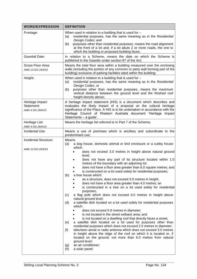
Stirling Local Planning Scheme No. 3 Page No. 134
WORD/EXPRESSION DEFINITION
Frontage: When used in relation to a building that is used for – (a) residential purposes, has the same meaning as in the Residential
Design Codes; and (b) purposes other than residential purposes, means the road alignment
at the front of a lot and, if a lot abuts 2 or more roads, the one to which the building or proposed building faces;
Gazettal Date: In relation to a Scheme, means the date on which the Scheme is published in the Gazette under section 87 of the Act;
Gross Floor Area:
AMD 13 GG 24/3/15
Means the total floor area within a building measured over the enclosing walls (including the portion of any common or party wall forming part of the building) exclusive of parking facilities sited within the building;
Height:
When used in relation to a building that is used for – (a) residential purposes, has the same meaning as in the Residential
Design Codes, or (b) purposes other than residential purposes, means the maximum
vertical distance between the ground level and the finished roof height directly above;
Heritage Impact Statement:
AMD 4 GG 26/4/13
A heritage impact statement (HIS) is a document which describes and evaluates the likely impact of a proposal on the cultural heritage significance of the Place. A HIS is to be undertaken in accordance with the Heritage Council of Western Australia document ‘Heritage Impact Statements – a guide’.
Heritage List:
AMD 4 GG 26/4/13
Means the heritage list referred to in Part 7 of the Scheme;
Incidental Use: Means a use of premises which is ancillary and subordinate to the predominant use;
Incidental Structure:
AMD 13 GG 24/3/15
Means: (a) a dog house, domestic animal or bird enclosure or a cubby house
which:
• does not exceed 3.0 metres in height above natural ground level;
• does not have any part of its structure located within 1.0 metres of the boundary with an adjoining lot;
• does not have a floor area greater than 6.0 square metres; and
• is constructed on a lot used solely for residential purposes; (b) a tree house which:
• as a structure, does not exceed 3.0 metres in height;
• does not have a floor area greater than 4.0 metres; an
• is constructed in a tree on a lot used solely for residential purposes;
(c) a flag pole which does not exceed 6.0 metres in height above natural ground level;
(d) a satellite dish located on a lot used solely for residential purposes which:
• does not exceed 0.9 metres in diameter;
• is not located in the street setback area; and
• is not located on a dwelling roof that directly faces a street; (e) a satellite dish located on a lot used for purposes other than
residential purposes which does not exceed 2.0 metres in diameter; (f) television aerial or radio antenna which does not exceed 3.0 metres
in height above the ridge of the roof on which it is located or, if located on the ground, not more than 6.0 metres from natural ground level;
(g) an air conditioner; (h) a solar panel;
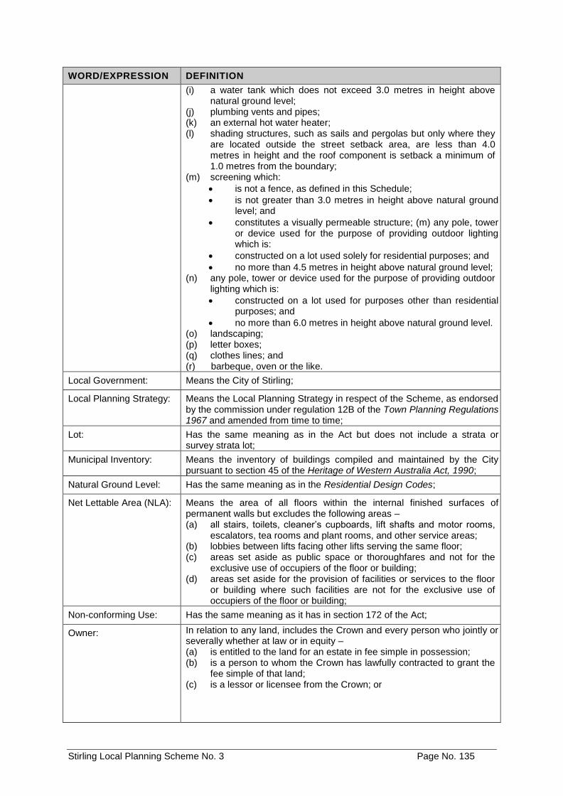
Stirling Local Planning Scheme No. 3 Page No. 135
WORD/EXPRESSION DEFINITION
(i) a water tank which does not exceed 3.0 metres in height above natural ground level;
(j) plumbing vents and pipes; (k) an external hot water heater; (l) shading structures, such as sails and pergolas but only where they
are located outside the street setback area, are less than 4.0 metres in height and the roof component is setback a minimum of 1.0 metres from the boundary;
(m) screening which:
• is not a fence, as defined in this Schedule;
• is not greater than 3.0 metres in height above natural ground level; and
• constitutes a visually permeable structure; (m) any pole, tower or device used for the purpose of providing outdoor lighting which is:
• constructed on a lot used solely for residential purposes; and
• no more than 4.5 metres in height above natural ground level; (n) any pole, tower or device used for the purpose of providing outdoor
lighting which is:
• constructed on a lot used for purposes other than residential purposes; and
• no more than 6.0 metres in height above natural ground level. (o) landscaping; (p) letter boxes; (q) clothes lines; and (r) barbeque, oven or the like.
Local Government: Means the City of Stirling;
Local Planning Strategy: Means the Local Planning Strategy in respect of the Scheme, as endorsed by the commission under regulation 12B of the Town Planning Regulations 1967 and amended from time to time;
Lot: Has the same meaning as in the Act but does not include a strata or survey strata lot;
Municipal Inventory: Means the inventory of buildings compiled and maintained by the City pursuant to section 45 of the Heritage of Western Australia Act, 1990;
Natural Ground Level: Has the same meaning as in the Residential Design Codes;
Net Lettable Area (NLA): Means the area of all floors within the internal finished surfaces of permanent walls but excludes the following areas – (a) all stairs, toilets, cleaner’s cupboards, lift shafts and motor rooms,
escalators, tea rooms and plant rooms, and other service areas; (b) lobbies between lifts facing other lifts serving the same floor; (c) areas set aside as public space or thoroughfares and not for the
exclusive use of occupiers of the floor or building; (d) areas set aside for the provision of facilities or services to the floor
or building where such facilities are not for the exclusive use of occupiers of the floor or building;
Non-conforming Use: Has the same meaning as it has in section 172 of the Act;
Owner: In relation to any land, includes the Crown and every person who jointly or severally whether at law or in equity – (a) is entitled to the land for an estate in fee simple in possession; (b) is a person to whom the Crown has lawfully contracted to grant the
fee simple of that land; (c) is a lessor or licensee from the Crown; or
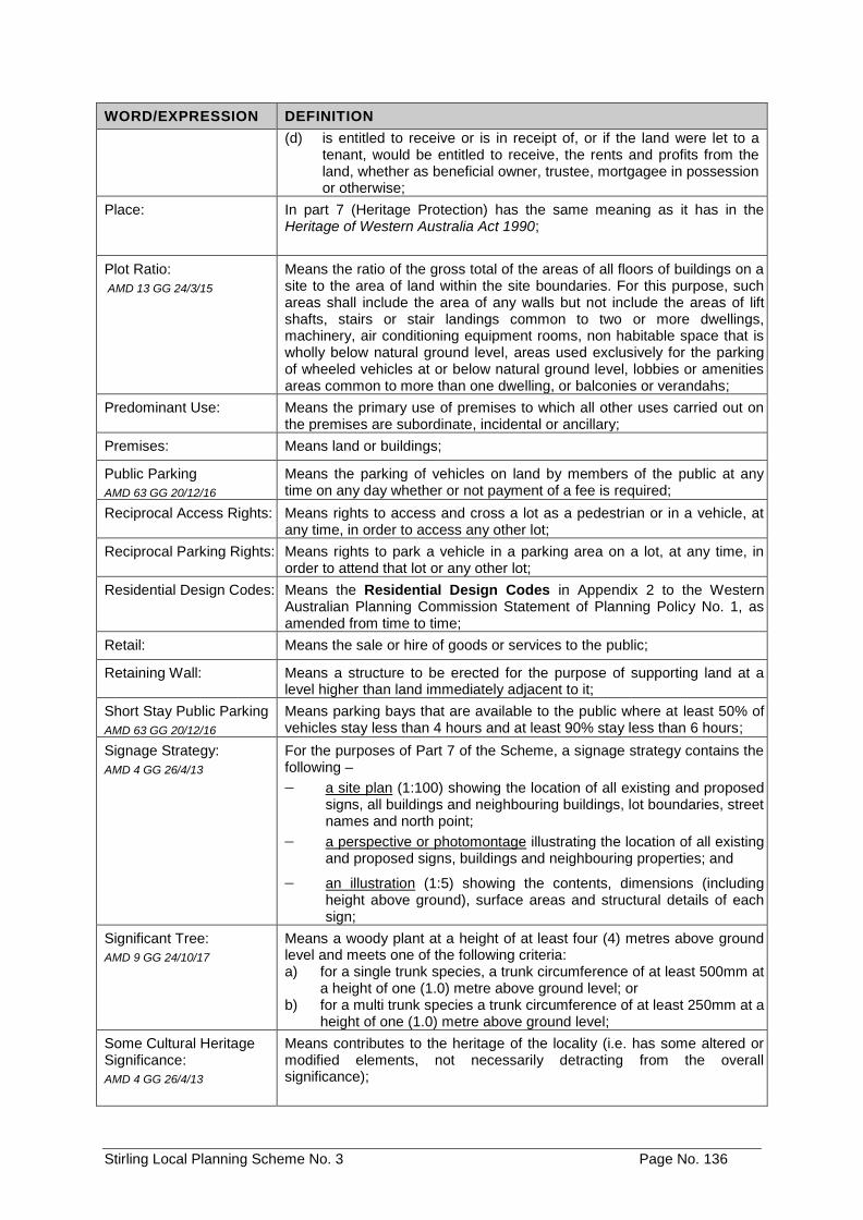
Stirling Local Planning Scheme No. 3 Page No. 136
WORD/EXPRESSION DEFINITION
(d) is entitled to receive or is in receipt of, or if the land were let to a tenant, would be entitled to receive, the rents and profits from the land, whether as beneficial owner, trustee, mortgagee in possession or otherwise;
Place: In part 7 (Heritage Protection) has the same meaning as it has in the Heritage of Western Australia Act 1990;
Plot Ratio:
AMD 13 GG 24/3/15
Means the ratio of the gross total of the areas of all floors of buildings on a site to the area of land within the site boundaries. For this purpose, such areas shall include the area of any walls but not include the areas of lift shafts, stairs or stair landings common to two or more dwellings, machinery, air conditioning equipment rooms, non habitable space that is wholly below natural ground level, areas used exclusively for the parking of wheeled vehicles at or below natural ground level, lobbies or amenities areas common to more than one dwelling, or balconies or verandahs;
Predominant Use: Means the primary use of premises to which all other uses carried out on the premises are subordinate, incidental or ancillary;
Premises: Means land or buildings;
Public Parking
AMD 63 GG 20/12/16
Means the parking of vehicles on land by members of the public at any time on any day whether or not payment of a fee is required;
Reciprocal Access Rights: Means rights to access and cross a lot as a pedestrian or in a vehicle, at any time, in order to access any other lot;
Reciprocal Parking Rights: Means rights to park a vehicle in a parking area on a lot, at any time, in order to attend that lot or any other lot;
Residential Design Codes: Means the Residential Design Codes in Appendix 2 to the Western Australian Planning Commission Statement of Planning Policy No. 1, as amended from time to time;
Retail: Means the sale or hire of goods or services to the public;
Retaining Wall: Means a structure to be erected for the purpose of supporting land at a level higher than land immediately adjacent to it;
Short Stay Public Parking
AMD 63 GG 20/12/16
Means parking bays that are available to the public where at least 50% of vehicles stay less than 4 hours and at least 90% stay less than 6 hours;
Signage Strategy:
AMD 4 GG 26/4/13
For the purposes of Part 7 of the Scheme, a signage strategy contains the following –
a site plan (1:100) showing the location of all existing and proposed signs, all buildings and neighbouring buildings, lot boundaries, street names and north point;
a perspective or photomontage illustrating the location of all existing and proposed signs, buildings and neighbouring properties; and
an illustration (1:5) showing the contents, dimensions (including height above ground), surface areas and structural details of each sign;
Significant Tree:
AMD 9 GG 24/10/17
Means a woody plant at a height of at least four (4) metres above ground level and meets one of the following criteria: a) for a single trunk species, a trunk circumference of at least 500mm at
a height of one (1.0) metre above ground level; or b) for a multi trunk species a trunk circumference of at least 250mm at a
height of one (1.0) metre above ground level;
Some Cultural Heritage Significance:
AMD 4 GG 26/4/13
Means contributes to the heritage of the locality (i.e. has some altered or modified elements, not necessarily detracting from the overall significance);
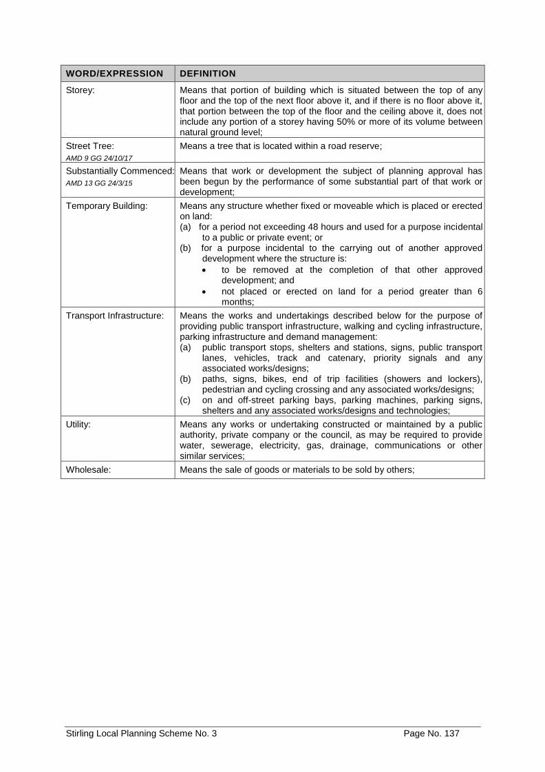
Stirling Local Planning Scheme No. 3 Page No. 137
WORD/EXPRESSION DEFINITION
Storey: Means that portion of building which is situated between the top of any floor and the top of the next floor above it, and if there is no floor above it, that portion between the top of the floor and the ceiling above it, does not include any portion of a storey having 50% or more of its volume between natural ground level;
Street Tree:
AMD 9 GG 24/10/17
Means a tree that is located within a road reserve;
Substantially Commenced:
AMD 13 GG 24/3/15
Means that work or development the subject of planning approval has been begun by the performance of some substantial part of that work or development;
Temporary Building: Means any structure whether fixed or moveable which is placed or erected on land: (a) for a period not exceeding 48 hours and used for a purpose incidental
to a public or private event; or (b) for a purpose incidental to the carrying out of another approved
development where the structure is:
• to be removed at the completion of that other approved development; and
• not placed or erected on land for a period greater than 6 months;
Transport Infrastructure: Means the works and undertakings described below for the purpose of providing public transport infrastructure, walking and cycling infrastructure, parking infrastructure and demand management: (a) public transport stops, shelters and stations, signs, public transport
lanes, vehicles, track and catenary, priority signals and any associated works/designs;
(b) paths, signs, bikes, end of trip facilities (showers and lockers), pedestrian and cycling crossing and any associated works/designs;
(c) on and off-street parking bays, parking machines, parking signs, shelters and any associated works/designs and technologies;
Utility: Means any works or undertaking constructed or maintained by a public authority, private company or the council, as may be required to provide water, sewerage, electricity, gas, drainage, communications or other similar services;
Wholesale: Means the sale of goods or materials to be sold by others;
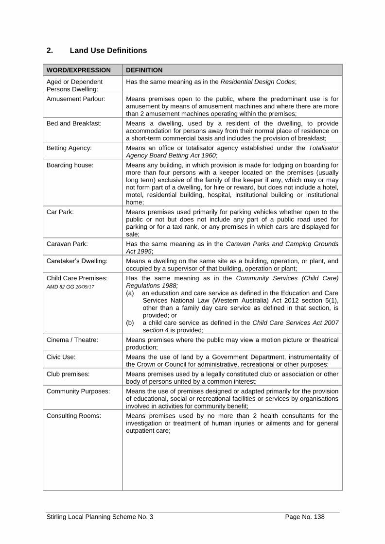
Stirling Local Planning Scheme No. 3 Page No. 138
2. Land Use Definitions
WORD/EXPRESSION DEFINITION
Aged or Dependent Persons Dwelling:
Has the same meaning as in the Residential Design Codes;
Amusement Parlour: Means premises open to the public, where the predominant use is for amusement by means of amusement machines and where there are more than 2 amusement machines operating within the premises;
Bed and Breakfast: Means a dwelling, used by a resident of the dwelling, to provide accommodation for persons away from their normal place of residence on a short-term commercial basis and includes the provision of breakfast;
Betting Agency: Means an office or totalisator agency established under the Totalisator Agency Board Betting Act 1960;
Boarding house: Means any building, in which provision is made for lodging on boarding for more than four persons with a keeper located on the premises (usually long term) exclusive of the family of the keeper if any, which may or may not form part of a dwelling, for hire or reward, but does not include a hotel, motel, residential building, hospital, institutional building or institutional home;
Car Park: Means premises used primarily for parking vehicles whether open to the public or not but does not include any part of a public road used for parking or for a taxi rank, or any premises in which cars are displayed for sale;
Caravan Park: Has the same meaning as in the Caravan Parks and Camping Grounds Act 1995;
Caretaker’s Dwelling: Means a dwelling on the same site as a building, operation, or plant, and occupied by a supervisor of that building, operation or plant;
Child Care Premises:
AMD 82 GG 26/09/17
Has the same meaning as in the Community Services (Child Care) Regulations 1988; (a) an education and care service as defined in the Education and Care
Services National Law (Western Australia) Act 2012 section 5(1), other than a family day care service as defined in that section, is provided; or
(b) a child care service as defined in the Child Care Services Act 2007 section 4 is provided;
Cinema / Theatre: Means premises where the public may view a motion picture or theatrical production;
Civic Use: Means the use of land by a Government Department, instrumentality of the Crown or Council for administrative, recreational or other purposes;
Club premises: Means premises used by a legally constituted club or association or other body of persons united by a common interest;
Community Purposes: Means the use of premises designed or adapted primarily for the provision of educational, social or recreational facilities or services by organisations involved in activities for community benefit;
Consulting Rooms: Means premises used by no more than 2 health consultants for the investigation or treatment of human injuries or ailments and for general outpatient care;
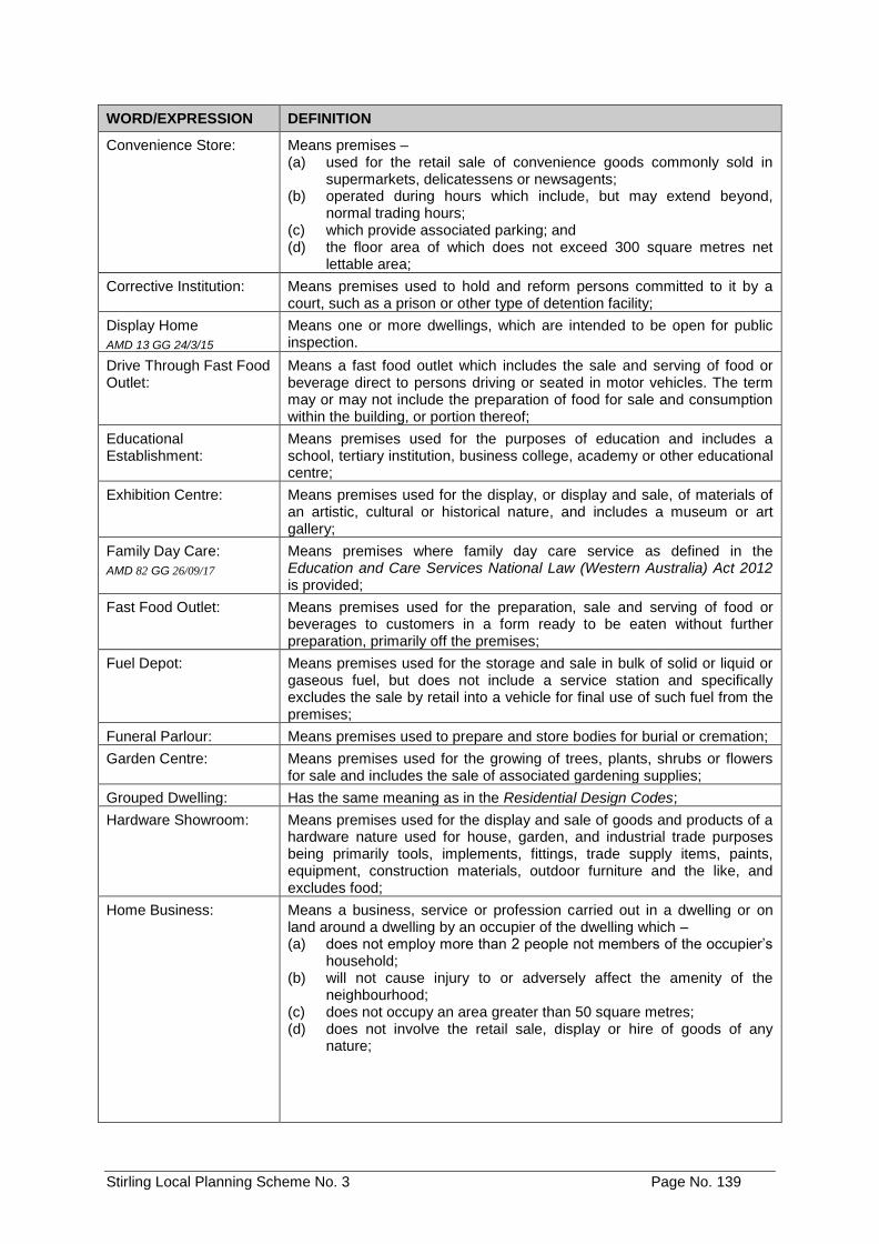
Stirling Local Planning Scheme No. 3 Page No. 139
WORD/EXPRESSION DEFINITION
Convenience Store: Means premises – (a) used for the retail sale of convenience goods commonly sold in
supermarkets, delicatessens or newsagents; (b) operated during hours which include, but may extend beyond,
normal trading hours; (c) which provide associated parking; and (d) the floor area of which does not exceed 300 square metres net
lettable area;
Corrective Institution: Means premises used to hold and reform persons committed to it by a court, such as a prison or other type of detention facility;
Display Home
AMD 13 GG 24/3/15
Means one or more dwellings, which are intended to be open for public inspection.
Drive Through Fast Food Outlet:
Means a fast food outlet which includes the sale and serving of food or beverage direct to persons driving or seated in motor vehicles. The term may or may not include the preparation of food for sale and consumption within the building, or portion thereof;
Educational Establishment:
Means premises used for the purposes of education and includes a school, tertiary institution, business college, academy or other educational centre;
Exhibition Centre: Means premises used for the display, or display and sale, of materials of an artistic, cultural or historical nature, and includes a museum or art gallery;
Family Day Care:
AMD 82 GG 26/09/17
Means premises where family day care service as defined in the Education and Care Services National Law (Western Australia) Act 2012 is provided;
Fast Food Outlet: Means premises used for the preparation, sale and serving of food or beverages to customers in a form ready to be eaten without further preparation, primarily off the premises;
Fuel Depot: Means premises used for the storage and sale in bulk of solid or liquid or gaseous fuel, but does not include a service station and specifically excludes the sale by retail into a vehicle for final use of such fuel from the premises;
Funeral Parlour: Means premises used to prepare and store bodies for burial or cremation;
Garden Centre: Means premises used for the growing of trees, plants, shrubs or flowers for sale and includes the sale of associated gardening supplies;
Grouped Dwelling: Has the same meaning as in the Residential Design Codes;
Hardware Showroom: Means premises used for the display and sale of goods and products of a hardware nature used for house, garden, and industrial trade purposes being primarily tools, implements, fittings, trade supply items, paints, equipment, construction materials, outdoor furniture and the like, and excludes food;
Home Business: Means a business, service or profession carried out in a dwelling or on land around a dwelling by an occupier of the dwelling which – (a) does not employ more than 2 people not members of the occupier’s
household; (b) will not cause injury to or adversely affect the amenity of the
neighbourhood; (c) does not occupy an area greater than 50 square metres; (d) does not involve the retail sale, display or hire of goods of any
nature;
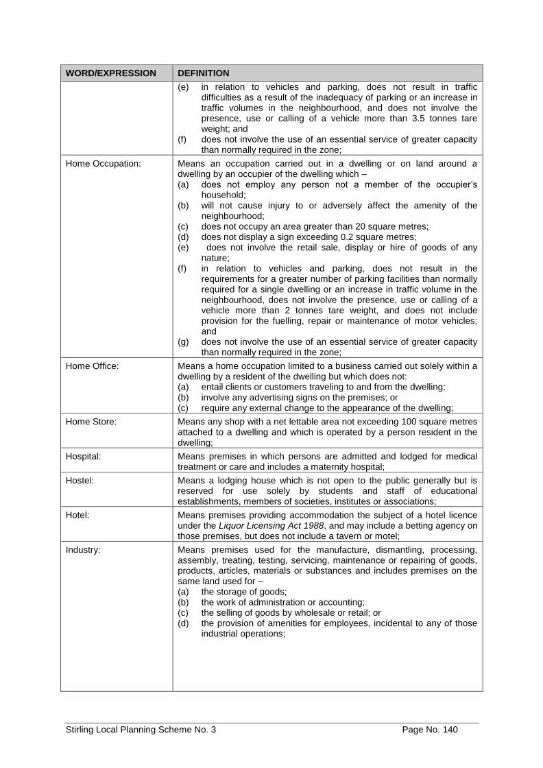
Stirling Local Planning Scheme No. 3 Page No. 140
WORD/EXPRESSION DEFINITION
(e) in relation to vehicles and parking, does not result in traffic difficulties as a result of the inadequacy of parking or an increase in traffic volumes in the neighbourhood, and does not involve the presence, use or calling of a vehicle more than 3.5 tonnes tare weight; and
(f) does not involve the use of an essential service of greater capacity than normally required in the zone;
Home Occupation: Means an occupation carried out in a dwelling or on land around a dwelling by an occupier of the dwelling which – (a) does not employ any person not a member of the occupier’s
household; (b) will not cause injury to or adversely affect the amenity of the
neighbourhood; (c) does not occupy an area greater than 20 square metres; (d) does not display a sign exceeding 0.2 square metres; (e) does not involve the retail sale, display or hire of goods of any
nature; (f) in relation to vehicles and parking, does not result in the
requirements for a greater number of parking facilities than normally required for a single dwelling or an increase in traffic volume in the neighbourhood, does not involve the presence, use or calling of a vehicle more than 2 tonnes tare weight, and does not include provision for the fuelling, repair or maintenance of motor vehicles; and
(g) does not involve the use of an essential service of greater capacity than normally required in the zone;
Home Office: Means a home occupation limited to a business carried out solely within a dwelling by a resident of the dwelling but which does not: (a) entail clients or customers traveling to and from the dwelling; (b) involve any advertising signs on the premises; or (c) require any external change to the appearance of the dwelling;
Home Store: Means any shop with a net lettable area not exceeding 100 square metres attached to a dwelling and which is operated by a person resident in the dwelling;
Hospital: Means premises in which persons are admitted and lodged for medical treatment or care and includes a maternity hospital;
Hostel: Means a lodging house which is not open to the public generally but is reserved for use solely by students and staff of educational establishments, members of societies, institutes or associations;
Hotel: Means premises providing accommodation the subject of a hotel licence under the Liquor Licensing Act 1988, and may include a betting agency on those premises, but does not include a tavern or motel;
Industry: Means premises used for the manufacture, dismantling, processing, assembly, treating, testing, servicing, maintenance or repairing of goods, products, articles, materials or substances and includes premises on the same land used for – (a) the storage of goods; (b) the work of administration or accounting; (c) the selling of goods by wholesale or retail; or (d) the provision of amenities for employees, incidental to any of those
industrial operations;
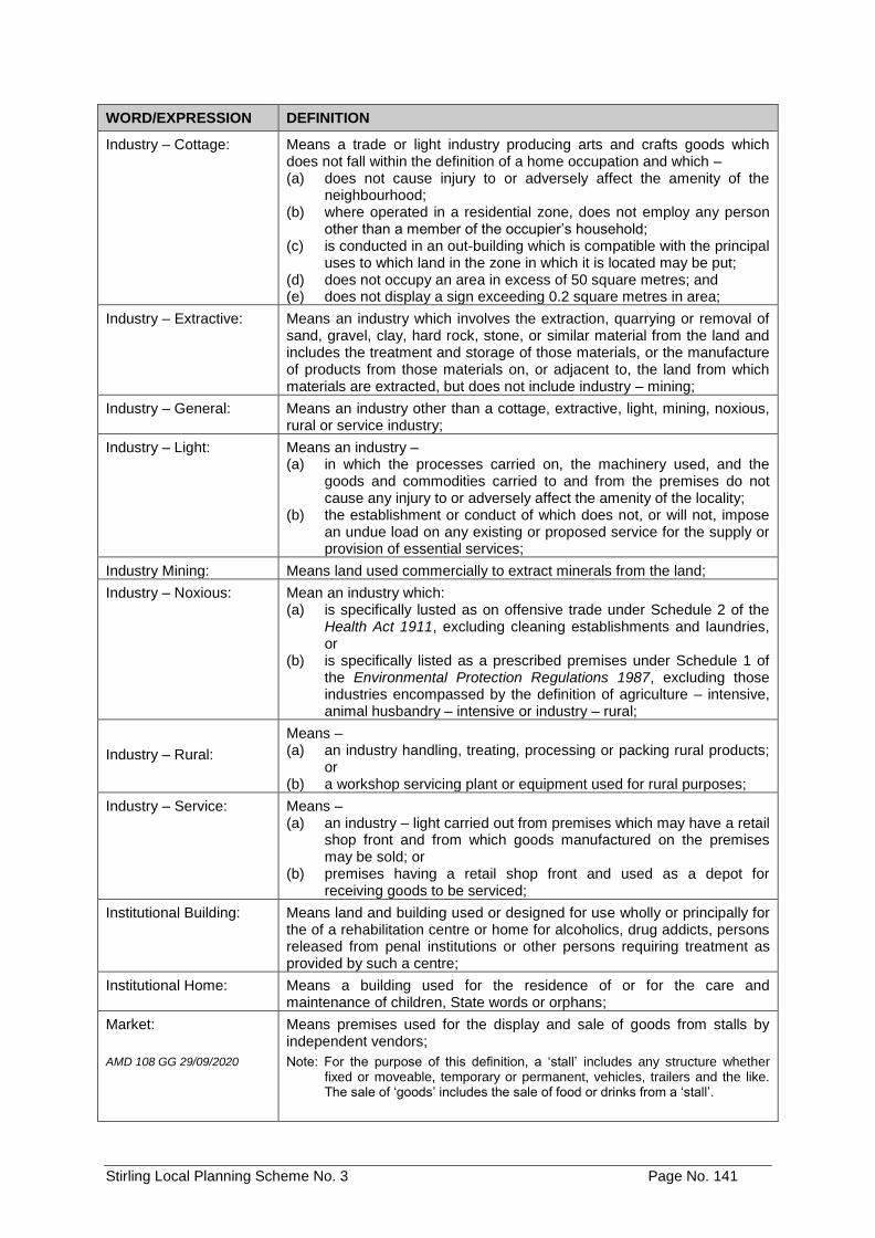
Stirling Local Planning Scheme No. 3 Page No. 141
WORD/EXPRESSION DEFINITION
Industry – Cottage: Means a trade or light industry producing arts and crafts goods which does not fall within the definition of a home occupation and which – (a) does not cause injury to or adversely affect the amenity of the
neighbourhood; (b) where operated in a residential zone, does not employ any person
other than a member of the occupier’s household; (c) is conducted in an out-building which is compatible with the principal
uses to which land in the zone in which it is located may be put; (d) does not occupy an area in excess of 50 square metres; and (e) does not display a sign exceeding 0.2 square metres in area;
Industry – Extractive: Means an industry which involves the extraction, quarrying or removal of sand, gravel, clay, hard rock, stone, or similar material from the land and includes the treatment and storage of those materials, or the manufacture of products from those materials on, or adjacent to, the land from which materials are extracted, but does not include industry – mining;
Industry – General: Means an industry other than a cottage, extractive, light, mining, noxious, rural or service industry;
Industry – Light: Means an industry – (a) in which the processes carried on, the machinery used, and the
goods and commodities carried to and from the premises do not cause any injury to or adversely affect the amenity of the locality;
(b) the establishment or conduct of which does not, or will not, impose an undue load on any existing or proposed service for the supply or provision of essential services;
Industry Mining: Means land used commercially to extract minerals from the land;
Industry – Noxious: Mean an industry which: (a) is specifically lusted as on offensive trade under Schedule 2 of the
Health Act 1911, excluding cleaning establishments and laundries, or
(b) is specifically listed as a prescribed premises under Schedule 1 of the Environmental Protection Regulations 1987, excluding those industries encompassed by the definition of agriculture – intensive, animal husbandry – intensive or industry – rural;
Industry – Rural:
Means – (a) an industry handling, treating, processing or packing rural products;
or (b) a workshop servicing plant or equipment used for rural purposes;
Industry – Service: Means – (a) an industry – light carried out from premises which may have a retail
shop front and from which goods manufactured on the premises may be sold; or
(b) premises having a retail shop front and used as a depot for receiving goods to be serviced;
Institutional Building: Means land and building used or designed for use wholly or principally for the of a rehabilitation centre or home for alcoholics, drug addicts, persons released from penal institutions or other persons requiring treatment as provided by such a centre;
Institutional Home: Means a building used for the residence of or for the care and maintenance of children, State words or orphans;
Market:
AMD 108 GG 29/09/2020
Means premises used for the display and sale of goods from stalls by independent vendors;
Note: For the purpose of this definition, a ‘stall’ includes any structure whether fixed or moveable, temporary or permanent, vehicles, trailers and the like. The sale of ‘goods’ includes the sale of food or drinks from a ‘stall’.
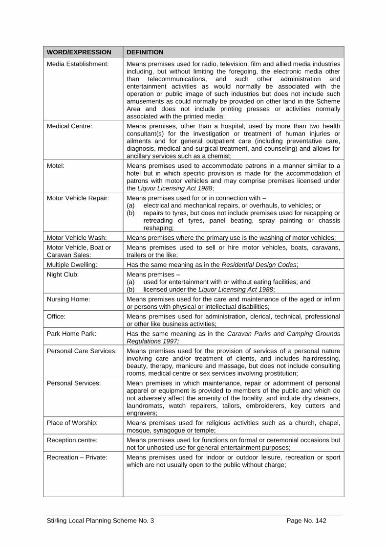
Stirling Local Planning Scheme No. 3 Page No. 142
WORD/EXPRESSION DEFINITION
Media Establishment: Means premises used for radio, television, film and allied media industries including, but without limiting the foregoing, the electronic media other than telecommunications, and such other administration and entertainment activities as would normally be associated with the operation or public image of such industries but does not include such amusements as could normally be provided on other land in the Scheme Area and does not include printing presses or activities normally associated with the printed media;
Medical Centre: Means premises, other than a hospital, used by more than two health consultant(s) for the investigation or treatment of human injuries or ailments and for general outpatient care (including preventative care, diagnosis, medical and surgical treatment, and counseling) and allows for ancillary services such as a chemist;
Motel: Means premises used to accommodate patrons in a manner similar to a hotel but in which specific provision is made for the accommodation of patrons with motor vehicles and may comprise premises licensed under the Liquor Licensing Act 1988;
Motor Vehicle Repair: Means premises used for or in connection with – (a) electrical and mechanical repairs, or overhauls, to vehicles; or (b) repairs to tyres, but does not include premises used for recapping or
retreading of tyres, panel beating, spray painting or chassis reshaping;
Motor Vehicle Wash: Means premises where the primary use is the washing of motor vehicles;
Motor Vehicle, Boat or Caravan Sales:
Means premises used to sell or hire motor vehicles, boats, caravans, trailers or the like;
Multiple Dwelling: Has the same meaning as in the Residential Design Codes;
Night Club: Means premises – (a) used for entertainment with or without eating facilities; and (b) licensed under the Liquor Licensing Act 1988;
Nursing Home: Means premises used for the care and maintenance of the aged or infirm or persons with physical or intellectual disabilities;
Office: Means premises used for administration, clerical, technical, professional or other like business activities;
Park Home Park: Has the same meaning as in the Caravan Parks and Camping Grounds Regulations 1997;
Personal Care Services: Means premises used for the provision of services of a personal nature involving care and/or treatment of clients, and includes hairdressing, beauty, therapy, manicure and massage, but does not include consulting rooms, medical centre or sex services involving prostitution;
Personal Services: Mean premises in which maintenance, repair or adornment of personal apparel or equipment is provided to members of the public and which do not adversely affect the amenity of the locality, and include dry cleaners, laundromats, watch repairers, tailors, embroiderers, key cutters and engravers;
Place of Worship: Means premises used for religious activities such as a church, chapel, mosque, synagogue or temple;
Reception centre: Means premises used for functions on formal or ceremonial occasions but not for unhosted use for general entertainment purposes;
Recreation – Private: Means premises used for indoor or outdoor leisure, recreation or sport which are not usually open to the public without charge;
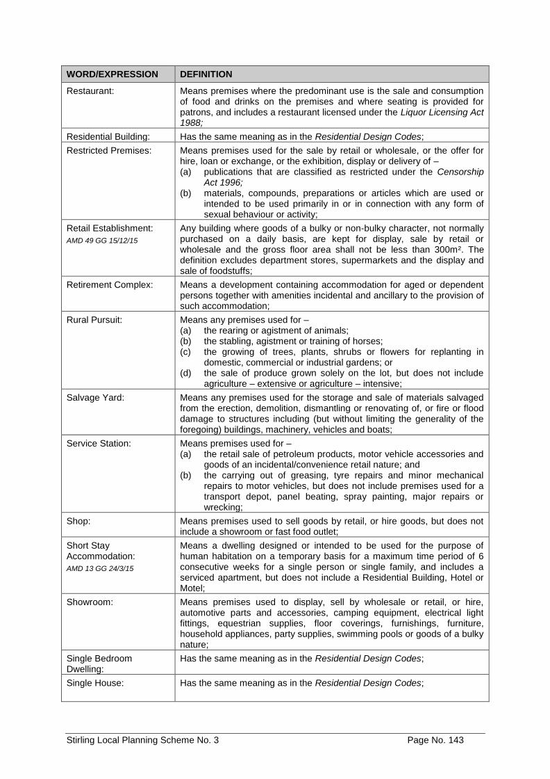
Stirling Local Planning Scheme No. 3 Page No. 143
WORD/EXPRESSION DEFINITION
Restaurant: Means premises where the predominant use is the sale and consumption of food and drinks on the premises and where seating is provided for patrons, and includes a restaurant licensed under the Liquor Licensing Act 1988;
Residential Building: Has the same meaning as in the Residential Design Codes;
Restricted Premises: Means premises used for the sale by retail or wholesale, or the offer for hire, loan or exchange, or the exhibition, display or delivery of – (a) publications that are classified as restricted under the Censorship
Act 1996; (b) materials, compounds, preparations or articles which are used or
intended to be used primarily in or in connection with any form of sexual behaviour or activity;
Retail Establishment:
AMD 49 GG 15/12/15
Any building where goods of a bulky or non-bulky character, not normally purchased on a daily basis, are kept for display, sale by retail or wholesale and the gross floor area shall not be less than 300m². The definition excludes department stores, supermarkets and the display and sale of foodstuffs;
Retirement Complex: Means a development containing accommodation for aged or dependent persons together with amenities incidental and ancillary to the provision of such accommodation;
Rural Pursuit: Means any premises used for – (a) the rearing or agistment of animals; (b) the stabling, agistment or training of horses; (c) the growing of trees, plants, shrubs or flowers for replanting in
domestic, commercial or industrial gardens; or (d) the sale of produce grown solely on the lot, but does not include
agriculture – extensive or agriculture – intensive;
Salvage Yard: Means any premises used for the storage and sale of materials salvaged from the erection, demolition, dismantling or renovating of, or fire or flood damage to structures including (but without limiting the generality of the foregoing) buildings, machinery, vehicles and boats;
Service Station: Means premises used for – (a) the retail sale of petroleum products, motor vehicle accessories and
goods of an incidental/convenience retail nature; and (b) the carrying out of greasing, tyre repairs and minor mechanical
repairs to motor vehicles, but does not include premises used for a transport depot, panel beating, spray painting, major repairs or wrecking;
Shop: Means premises used to sell goods by retail, or hire goods, but does not include a showroom or fast food outlet;
Short Stay Accommodation:
AMD 13 GG 24/3/15
Means a dwelling designed or intended to be used for the purpose of human habitation on a temporary basis for a maximum time period of 6 consecutive weeks for a single person or single family, and includes a serviced apartment, but does not include a Residential Building, Hotel or Motel;
Showroom: Means premises used to display, sell by wholesale or retail, or hire, automotive parts and accessories, camping equipment, electrical light fittings, equestrian supplies, floor coverings, furnishings, furniture, household appliances, party supplies, swimming pools or goods of a bulky nature;
Single Bedroom Dwelling:
Has the same meaning as in the Residential Design Codes;
Single House: Has the same meaning as in the Residential Design Codes;
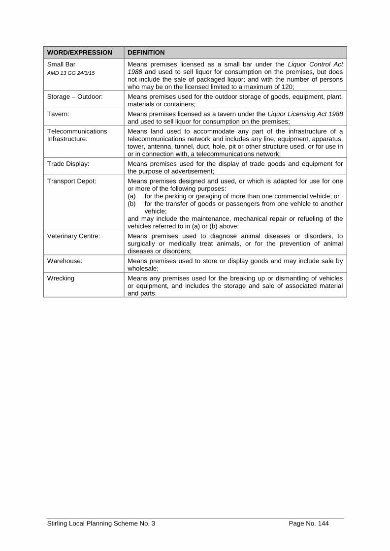
Stirling Local Planning Scheme No. 3 Page No. 144
WORD/EXPRESSION DEFINITION
Small Bar
AMD 13 GG 24/3/15
Means premises licensed as a small bar under the Liquor Control Act 1988 and used to sell liquor for consumption on the premises, but does not include the sale of packaged liquor; and with the number of persons who may be on the licensed limited to a maximum of 120;
Storage – Outdoor: Means premises used for the outdoor storage of goods, equipment, plant, materials or containers;
Tavern: Means premises licensed as a tavern under the Liquor Licensing Act 1988 and used to sell liquor for consumption on the premises;
Telecommunications Infrastructure:
Means land used to accommodate any part of the infrastructure of a telecommunications network and includes any line, equipment, apparatus, tower, antenna, tunnel, duct, hole, pit or other structure used, or for use in or in connection with, a telecommunications network;
Trade Display: Means premises used for the display of trade goods and equipment for the purpose of advertisement;
Transport Depot: Means premises designed and used, or which is adapted for use for one or more of the following purposes: (a) for the parking or garaging of more than one commercial vehicle; or (b) for the transfer of goods or passengers from one vehicle to another
vehicle; and may include the maintenance, mechanical repair or refueling of the vehicles referred to in (a) or (b) above;
Veterinary Centre: Means premises used to diagnose animal diseases or disorders, to surgically or medically treat animals, or for the prevention of animal diseases or disorders;
Warehouse: Means premises used to store or display goods and may include sale by wholesale;
Wrecking Means any premises used for the breaking up or dismantling of vehicles or equipment, and includes the storage and sale of associated material and parts.
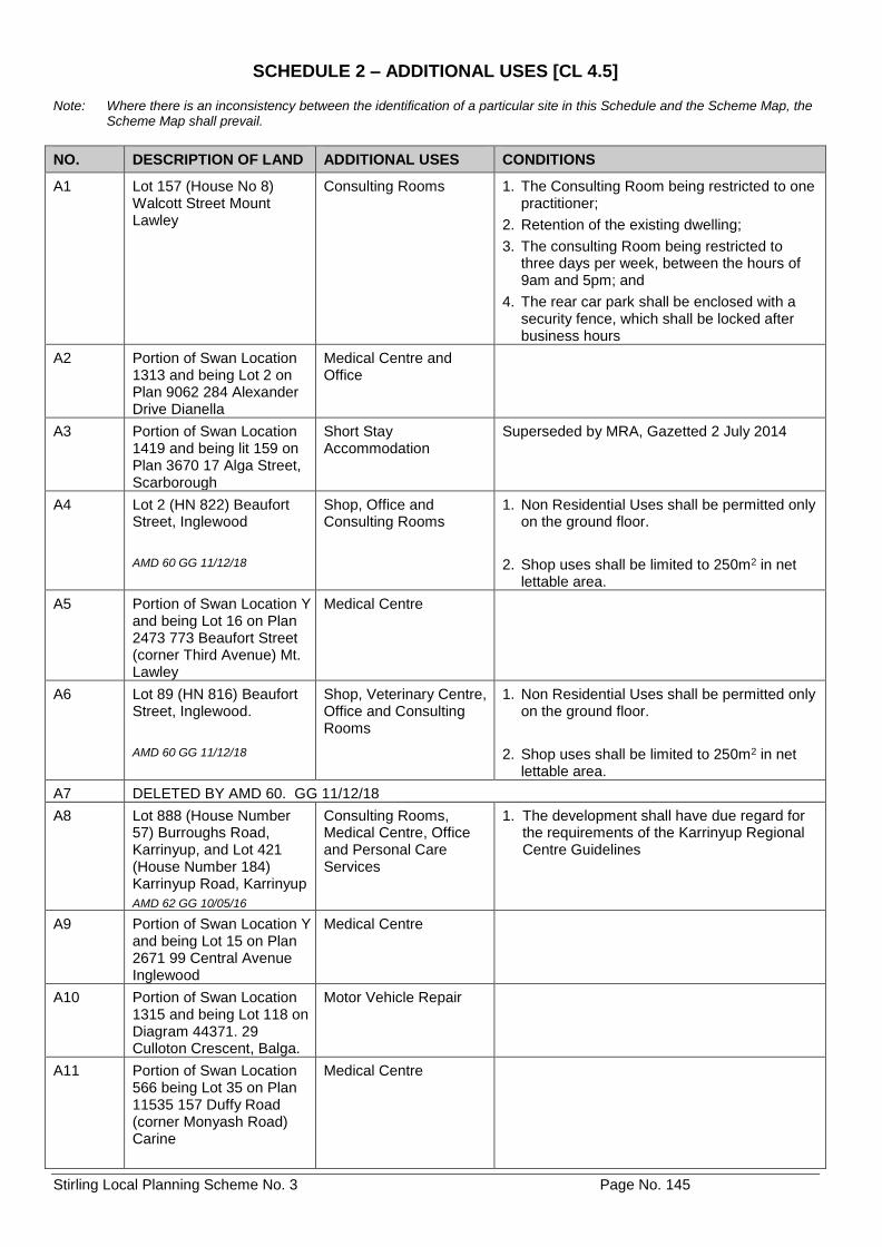
Stirling Local Planning Scheme No. 3 Page No. 145
SCHEDULE 2 – ADDITIONAL USES [CL 4.5] Note: Where there is an inconsistency between the identification of a particular site in this Schedule and the Scheme Map, the
Scheme Map shall prevail.
NO. DESCRIPTION OF LAND ADDITIONAL USES CONDITIONS
A1 Lot 157 (House No 8) Walcott Street Mount Lawley
Consulting Rooms 1. The Consulting Room being restricted to one practitioner;
2. Retention of the existing dwelling;
3. The consulting Room being restricted to three days per week, between the hours of 9am and 5pm; and
4. The rear car park shall be enclosed with a security fence, which shall be locked after business hours
A2 Portion of Swan Location 1313 and being Lot 2 on Plan 9062 284 Alexander Drive Dianella
Medical Centre and Office
A3 Portion of Swan Location 1419 and being lit 159 on Plan 3670 17 Alga Street, Scarborough
Short Stay Accommodation
Superseded by MRA, Gazetted 2 July 2014
A4 Lot 2 (HN 822) Beaufort Street, Inglewood
AMD 60 GG 11/12/18
Shop, Office and Consulting Rooms
1. Non Residential Uses shall be permitted only on the ground floor.
2. Shop uses shall be limited to 250m2 in net lettable area.
A5 Portion of Swan Location Y and being Lot 16 on Plan 2473 773 Beaufort Street (corner Third Avenue) Mt. Lawley
Medical Centre
A6 Lot 89 (HN 816) Beaufort Street, Inglewood.
AMD 60 GG 11/12/18
Shop, Veterinary Centre, Office and Consulting Rooms
1. Non Residential Uses shall be permitted only on the ground floor.
2. Shop uses shall be limited to 250m2 in net lettable area.
A7 DELETED BY AMD 60. GG 11/12/18
A8 Lot 888 (House Number 57) Burroughs Road, Karrinyup, and Lot 421 (House Number 184) Karrinyup Road, Karrinyup
AMD 62 GG 10/05/16
Consulting Rooms, Medical Centre, Office and Personal Care Services
1. The development shall have due regard for the requirements of the Karrinyup Regional Centre Guidelines
A9 Portion of Swan Location Y and being Lot 15 on Plan 2671 99 Central Avenue Inglewood
Medical Centre
A10 Portion of Swan Location 1315 and being Lot 118 on Diagram 44371. 29 Culloton Crescent, Balga.
Motor Vehicle Repair
A11 Portion of Swan Location 566 being Lot 35 on Plan 11535 157 Duffy Road (corner Monyash Road) Carine
Medical Centre
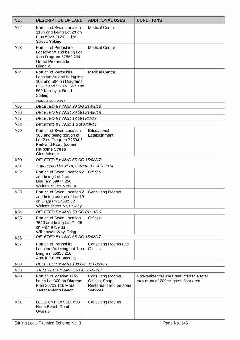
Stirling Local Planning Scheme No. 3 Page No. 146
NO. DESCRIPTION OF LAND ADDITIONAL USES CONDITIONS
A12 Portion of Swan Location 1106 and being Lot 29 on Plan 5023.212 Flinders Street, Yokine.
Medical Centre
A13 Portion of Perthshire Location W and being Lot 4 on Diagram 87589 294 Grand Promenade Dianella
Medical Centre
A14 Portion of Perthshire Location Au and being lots 103 and 504 on Diagrams 63517 and 55169. 567 and 569 Karrinyup Road Stirling
AMD 13 GG 24/3/15
Medical Centre
A15 DELETED BY AMD 39 GG 21/08/18
A16 DELETED BY AMD 39 GG 21/08/18
A17 DELETED BY AMD 18 GG 8/2/13
A18 DELETED BY AMD 1 GG 2/09/14
A19 Portion of Swan Location 968 and being portion of Lot 2 on Diagram 72594 5 Parkland Road (corner Harborne Street) Glendalough
Educational Establishment
A20 DELETED BY AMD 65 GG 15/08/17
A21 Superseded by MRA, Gazetted 2 July 2014
A22 Portion of Swan Location Z and being Lot 4 on Diagram 59974 256 Walcott Street Menora
Offices
A23 Portion of Swan Location Z and being portion of Lot 19 on Diagram 14632 52 Walcott Street Mt. Lawley
Consulting Rooms
A24 DELETED BY AMD 58 GG 01/11/16
A25 Portion of Swan Location 7529 and being Lot Pt. 25 on Plan 9759 31 Williamson Way, Trigg
Offices
A26 DELETED BY AMD 65 GG 15/08/17
A27 Portion of Perthshire Location Au being Lot 1 on Diagram 56336 210 Amelia Street Balcatta
Consulting Rooms and Offices
A28 DELETED BY AMD 109 GG 31/08/2021
A29 DELETED BY AMD 65 GG 15/08/17
A30 Portion of location 1152 being Lot 300 on Diagram Plan 25709 116 Flora Terrace North Beach
Consulting Rooms, Offices, Shop, Restaurant and personal Services
Non-residential uses restricted to a total maximum of 200m2 gross floor area.
A31 Lot 10 on Plan 9310 698 North Beach Road, Gwelup
Consulting Rooms
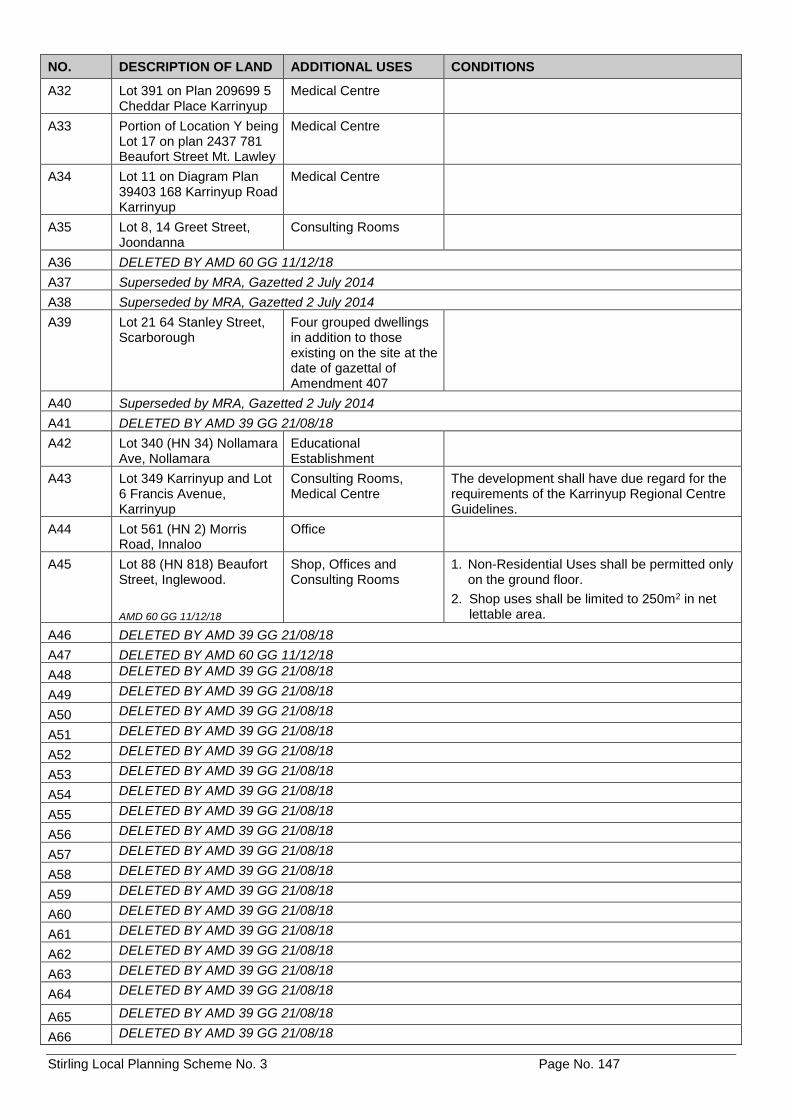
Stirling Local Planning Scheme No. 3 Page No. 147
NO. DESCRIPTION OF LAND ADDITIONAL USES CONDITIONS
A32 Lot 391 on Plan 209699 5 Cheddar Place Karrinyup
Medical Centre
A33 Portion of Location Y being Lot 17 on plan 2437 781 Beaufort Street Mt. Lawley
Medical Centre
A34 Lot 11 on Diagram Plan 39403 168 Karrinyup Road Karrinyup
Medical Centre
A35 Lot 8, 14 Greet Street, Joondanna
Consulting Rooms
A36 DELETED BY AMD 60 GG 11/12/18
A37 Superseded by MRA, Gazetted 2 July 2014
A38 Superseded by MRA, Gazetted 2 July 2014
A39 Lot 21 64 Stanley Street, Scarborough
Four grouped dwellings in addition to those existing on the site at the date of gazettal of Amendment 407
A40 Superseded by MRA, Gazetted 2 July 2014
A41 DELETED BY AMD 39 GG 21/08/18
A42 Lot 340 (HN 34) Nollamara Ave, Nollamara
Educational Establishment
A43 Lot 349 Karrinyup and Lot 6 Francis Avenue, Karrinyup
Consulting Rooms, Medical Centre
The development shall have due regard for the requirements of the Karrinyup Regional Centre Guidelines.
A44 Lot 561 (HN 2) Morris Road, Innaloo
Office
A45 Lot 88 (HN 818) Beaufort Street, Inglewood.
AMD 60 GG 11/12/18
Shop, Offices and Consulting Rooms
1. Non-Residential Uses shall be permitted only on the ground floor.
2. Shop uses shall be limited to 250m2 in net lettable area.
A46 DELETED BY AMD 39 GG 21/08/18
A47 DELETED BY AMD 60 GG 11/12/18
A48 DELETED BY AMD 39 GG 21/08/18
A49 DELETED BY AMD 39 GG 21/08/18
A50 DELETED BY AMD 39 GG 21/08/18
A51 DELETED BY AMD 39 GG 21/08/18
A52 DELETED BY AMD 39 GG 21/08/18
A53 DELETED BY AMD 39 GG 21/08/18
A54 DELETED BY AMD 39 GG 21/08/18
A55 DELETED BY AMD 39 GG 21/08/18
A56 DELETED BY AMD 39 GG 21/08/18
A57 DELETED BY AMD 39 GG 21/08/18
A58 DELETED BY AMD 39 GG 21/08/18
A59 DELETED BY AMD 39 GG 21/08/18
A60 DELETED BY AMD 39 GG 21/08/18
A61 DELETED BY AMD 39 GG 21/08/18
A62 DELETED BY AMD 39 GG 21/08/18
A63 DELETED BY AMD 39 GG 21/08/18
A64 DELETED BY AMD 39 GG 21/08/18
A65 DELETED BY AMD 39 GG 21/08/18
A66 DELETED BY AMD 39 GG 21/08/18
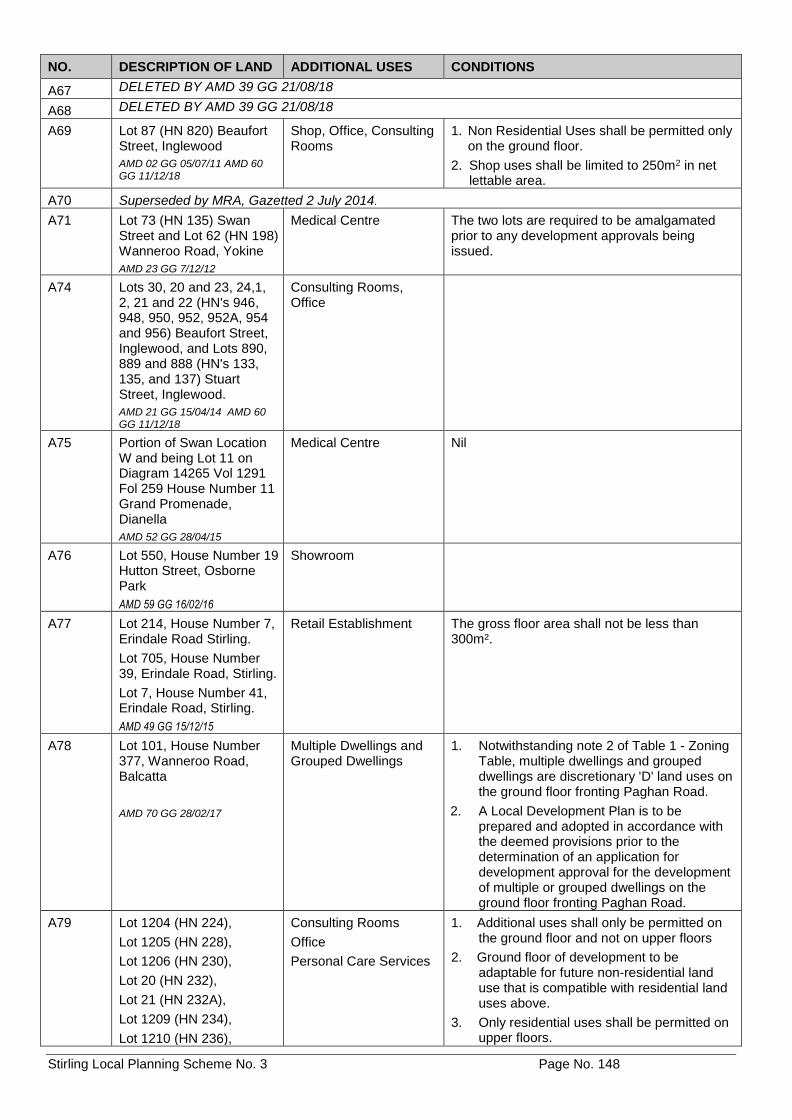
Stirling Local Planning Scheme No. 3 Page No. 148
NO. DESCRIPTION OF LAND ADDITIONAL USES CONDITIONS
A67 DELETED BY AMD 39 GG 21/08/18
A68 DELETED BY AMD 39 GG 21/08/18
A69 Lot 87 (HN 820) Beaufort Street, Inglewood
AMD 02 GG 05/07/11 AMD 60 GG 11/12/18
Shop, Office, Consulting Rooms
1. Non Residential Uses shall be permitted only on the ground floor.
2. Shop uses shall be limited to 250m2 in net lettable area.
A70 Superseded by MRA, Gazetted 2 July 2014.
A71 Lot 73 (HN 135) Swan Street and Lot 62 (HN 198) Wanneroo Road, Yokine
AMD 23 GG 7/12/12
Medical Centre The two lots are required to be amalgamated prior to any development approvals being issued.
A74 Lots 30, 20 and 23, 24,1, 2, 21 and 22 (HN's 946, 948, 950, 952, 952A, 954 and 956) Beaufort Street, Inglewood, and Lots 890, 889 and 888 (HN's 133, 135, and 137) Stuart Street, Inglewood.
AMD 21 GG 15/04/14 AMD 60 GG 11/12/18
Consulting Rooms, Office
A75 Portion of Swan Location W and being Lot 11 on Diagram 14265 Vol 1291 Fol 259 House Number 11 Grand Promenade, Dianella
AMD 52 GG 28/04/15
Medical Centre Nil
A76 Lot 550, House Number 19 Hutton Street, Osborne Park
AMD 59 GG 16/02/16
Showroom
A77 Lot 214, House Number 7, Erindale Road Stirling.
Lot 705, House Number 39, Erindale Road, Stirling.
Lot 7, House Number 41, Erindale Road, Stirling.
AMD 49 GG 15/12/15
Retail Establishment The gross floor area shall not be less than 300m².
A78 Lot 101, House Number 377, Wanneroo Road, Balcatta
AMD 70 GG 28/02/17
Multiple Dwellings and Grouped Dwellings
1. Notwithstanding note 2 of Table 1 - Zoning Table, multiple dwellings and grouped dwellings are discretionary 'D' land uses on the ground floor fronting Paghan Road.
2. A Local Development Plan is to be prepared and adopted in accordance with the deemed provisions prior to the determination of an application for development approval for the development of multiple or grouped dwellings on the ground floor fronting Paghan Road.
A79 Lot 1204 (HN 224),
Lot 1205 (HN 228),
Lot 1206 (HN 230),
Lot 20 (HN 232),
Lot 21 (HN 232A),
Lot 1209 (HN 234),
Lot 1210 (HN 236),
Consulting Rooms
Office
Personal Care Services
1. Additional uses shall only be permitted on the ground floor and not on upper floors
2. Ground floor of development to be adaptable for future non-residential land use that is compatible with residential land uses above.
3. Only residential uses shall be permitted on upper floors.
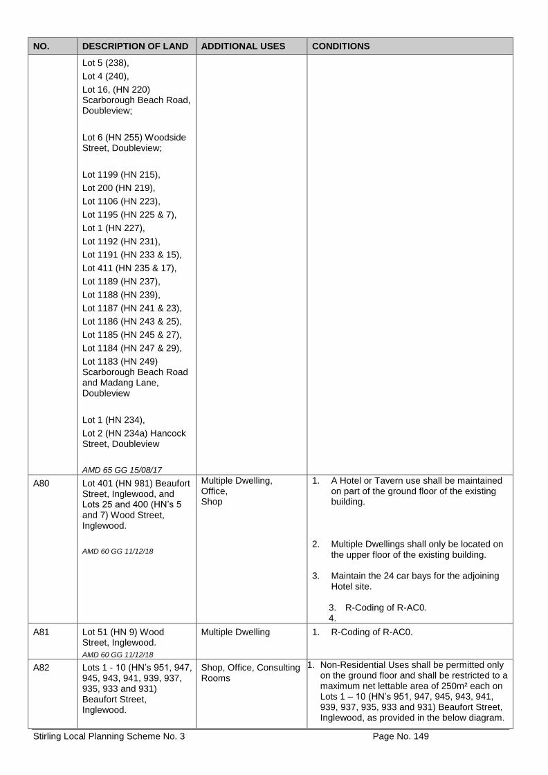
Stirling Local Planning Scheme No. 3 Page No. 149
NO. DESCRIPTION OF LAND ADDITIONAL USES CONDITIONS
Lot 5 (238),
Lot 4 (240),
Lot 16, (HN 220) Scarborough Beach Road, Doubleview;
Lot 6 (HN 255) Woodside Street, Doubleview;
Lot 1199 (HN 215),
Lot 200 (HN 219),
Lot 1106 (HN 223),
Lot 1195 (HN 225 & 7),
Lot 1 (HN 227),
Lot 1192 (HN 231),
Lot 1191 (HN 233 & 15),
Lot 411 (HN 235 & 17),
Lot 1189 (HN 237),
Lot 1188 (HN 239),
Lot 1187 (HN 241 & 23),
Lot 1186 (HN 243 & 25),
Lot 1185 (HN 245 & 27),
Lot 1184 (HN 247 & 29),
Lot 1183 (HN 249) Scarborough Beach Road and Madang Lane, Doubleview
Lot 1 (HN 234),
Lot 2 (HN 234a) Hancock Street, Doubleview
AMD 65 GG 15/08/17
A80 Lot 401 (HN 981) Beaufort Street, Inglewood, and Lots 25 and 400 (HN’s 5 and 7) Wood Street, Inglewood.
AMD 60 GG 11/12/18
Multiple Dwelling, Office, Shop
1. A Hotel or Tavern use shall be maintained on part of the ground floor of the existing building.
2. Multiple Dwellings shall only be located on the upper floor of the existing building.
3. Maintain the 24 car bays for the adjoining
Hotel site.
3. R-Coding of R-AC0. 4.
A81 Lot 51 (HN 9) Wood Street, Inglewood.
AMD 60 GG 11/12/18
Multiple Dwelling 1. R-Coding of R-AC0.
A82 Lots 1 - 10 (HN’s 951, 947, 945, 943, 941, 939, 937, 935, 933 and 931) Beaufort Street, Inglewood.
Shop, Office, Consulting Rooms
1. Non-Residential Uses shall be permitted only on the ground floor and shall be restricted to a maximum net lettable area of 250m² each on Lots 1 – 10 (HN’s 951, 947, 945, 943, 941, 939, 937, 935, 933 and 931) Beaufort Street, Inglewood, as provided in the below diagram.
Stirling Local Planning Scheme No. 3 Page No. 150
NO. DESCRIPTION OF LAND ADDITIONAL USES CONDITIONS
AMD 60 GG 11/12/18
A83 Lot 500 (HN 803) Beaufort Street, Mount Lawley (South-east of Wenberi Lane).
AMD 60 GG 11/12/18
Multiple Dwelling, Office 1. A Hotel or Tavern use shall be maintained on part of the ground floor of the existing building.
2. Multiple Dwellings shall only be located on
the upper floor of the existing building.
3. R-Coding of R-AC0.
A84 Lot 500 (HN 803) Beaufort Street, Mount Lawley (North-west of Wenberi Lane). AMD 60 GG 11/12/18
Multiple Dwelling 1. Maintain the 51 car bays for the adjoining Hotel site.
2. New buildings are to be set back to match
the setbacks of the adjoining residential dwelling.
3. R-Coding of R-AC0.
A85 Lots 118 and 117 (HN 734 and 736) Beaufort Street, Mount Lawley. AMD 60 GG 11/12/18
Club Premises, Consulting Rooms, Education Establishment, Recreation Private, Restaurant and Convenience Store
A86 Lot 90 (HN 812) Beaufort Street, Mount Lawley. AMD 60 GG 11/12/18
Service Station
A87
A87
Lot 123 (HN 731) Beaufort Street, Mount Lawley. AMD 60 GG 11/12/18
Lot 123 (HN 731) Beaufort Street, Mount Lawley. (Cont’d)
Club Premises, Educational Establishment, Office, Reception Centre, Restaurant
1. Development shall be in accordance with the following zones:
a) Mixed Use Area:
The area is located between the Beaufort Street boundary of Lot 123 and the Residential Area.
b) Residential Area:
The area is located between the St Patrick’s Church and the adjoining Lot 7 (House Number 67), First Avenue, Mount Lawley. It comprises an area 15 metres wide, measured along the First Avenue Street frontage. The resulting area is 906m2 (60.4 metres x 15 metres).
2. Conditions applicable to the Mixed-Use
Area: a) Additional uses shall be restricted to the
Mixed-Use Area only.
b) Additional uses located between the
Stirling Local Planning Scheme No. 3 Page No. 151
NO. DESCRIPTION OF LAND ADDITIONAL USES CONDITIONS
A87
AMD 60 GG 11/12/18
Lot 123 (HN 731) Beaufort Street, Mount Lawley. (Cont’d)
35-metre setback from the Beaufort Street boundary and the residential area shall be incidental to the predominant use of Place of Worship.
c) Buildings shall be designed and located such that the church is not obscured from Beaufort Street.
d) Notwithstanding clauses 6.6.6 (a) and
(b) buildings located between the Beaufort Street boundary of Lot 123 and the 35-metre setback from the Beaufort Street boundary shall not exceed a maximum height equal to the finished floor level of the Waurena House (St Patrick’s Church Rectory).
e) A roof-top terrace or community space
with a minimum dimension of not less than 15m x 15m shall be located on the Beaufort Street frontage.
f) Buildings fronting Beaufort Street shall
have active street frontages with pedestrian entrances located at the finished pavement level of Beaufort Street.
g) Buildings shall have a minimum street
setback of 3.0 metres.
h) Development shall be in accordance with this Schedule and the Beaufort Street Local Development Plan.
3. Conditions applicable to the Residential Area:
a) Multiple dwellings shall not be permitted b) Notwithstanding clauses 6.6.6 (a) and
(b) buildings shall not exceed 2 storeys in height.
c) Buildings shall be set back a minimum
of 4 metres from the common boundary with Lot 7 (House Number 67), First Avenue, Mount Lawley.
d) A 1.0 metre wide landscaped strip shall
be provided on Lot 123, Mount Lawley, along the common boundary with Lot 7 (House Number 67), First Avenue, Mount Lawley.
e) Vehicular access shall be via a
driveway, minimum 3 metres wide, located adjacent and parallel to the landscape strip along the common boundary with Lot 7 (House Number 67), First Avenue, Mount Lawley.
Stirling Local Planning Scheme No. 3 Page No. 152
NO. DESCRIPTION OF LAND ADDITIONAL USES CONDITIONS
AMD 60 GG 11/12/18 f) Development shall be in accordance
with this Schedule and Part 7 of Local Planning Policy 3.1 Character Retention Guidelines Mount Lawley, Menora and Inglewood.
g) The provisions of clause 6.6.5(a) shall not apply to the residential area.
4. A 1.5 metre wide landscaped strip shall be
provided on Lot 123, Mount Lawley, along the common boundary with Lots 1 and 2, Mount Lawley.
5. Access from Beaufort Street shall be
limited to one vehicular access point in the existing location adjacent to Lot 1 (House Number 727), Beaufort Street, Mount Lawley.
A88 Lot 5, House Number 1, Smith Street, Karrinyup
AMD 74 GG 28/11/17
Consulting Rooms
Medical Centre
Office and Personal Care
The development shall have due regards for the requirements of the Karrinyup Regional Centre Guidelines.
A89 Lots 23, 24, 35, 36, 5, 28, 39 and 2 Cleveland Street, Dianella
Lots 3,6, 14-20, and 38, Harold Street, Dianella
AMD 80 GG 16/10/18
Consulting Rooms 'D' use Industry-Light 'D' use Industry-Service 'D' use Office 'D' use Personal Care Service 'D' use Personal Services 'D' use
Recreation-Private 'D' use
1. Additional Uses shall only be permitted on the ground floor fronting a road reserve.
2. Additional Uses shall be limited to a
maximum plot ratio area of 250m2 per tenancy.
A90 Lot 81, House Number 10, Sanderling Street Stirling
AMD 81 GG 27/06/17
All Use Classes in Table 1 - Zoning Table designated 'P', 'D' or 'A' within the Local Centre zone
1. A minimum 15m setback to any parking bays from the front lot boundary.
2. Notwithstanding Condition 2 of Table 1 -
Zoning Table, multiple dwellings and grouped dwellings are permitted on the ground floor fronting the road reserve.
A93
Lot 387 House Number 66, Francis Avenue, Karrinyup
AMD 88 GG 14/08/18
Consulting Rooms 1. Development shall respect the residential character of grouped dwellings on the eastern side of Francis Avenue. Development shall have the appearance of a residential building, and shall comply with the requirements of the R-Codes and the City's Local Planning Policy relating to:
i. Street setbacks.
ii. Lot boundary setback; and
iii. Residential building height. 2. Development shall include features such
as windows, entry points, fencing and balconies that are common to the area.
A94 Part Lot 9002 (House Number 139) Balcatta Road, Balcatta.
Educational Establishment ‘D’ use
1. The additional use shall be limited to establishments that provide education or training relating to activities consistent with the objectives of the Industry zone (cl.

Stirling Local Planning Scheme No. 3 Page No. 153
NO. DESCRIPTION OF LAND ADDITIONAL USES CONDITIONS
AMD 117 GG 31/08/2021
4.2.6).
Stirling Local Planning Scheme No. 3 Page No. 154
SCHEDULE 3 – RESTRICTED USES [CL 4.6]
Note: Where there is an inconsistency between the identification of a particular site in this Schedule and the Scheme Map, the
Scheme Map shall prevail.
NO. DESCRIPTION OF LAND RESTRICTED USE CONDITIONS
RU1 Servite College Special Control Area
Lot 301, 139 Cape Street Lot 302, 143 Cape Street Lot 1102, 143 Cape Street Lot 10, 148 Cape Street Lot 44, 151 Cape Street Lot 27, 155 Cape Street Lot 32, 162 Cape Street Lot 34, 113 Stoneham Street Lot 46, 12 Myers Street Lot 1, 14 Myers Street Lot 17, 10 Morgans Street Lot 18, 12 Morgans Street Lot 19, 14 Morgans Street Lot 21, 18 Morgans Street Lot 23, 22 Morgans Street
AMD 104 GG 27/08/19;AMD 116 GG 2/2/2021
Car Park Caretakers Dwelling Child Care Premises Community Purpose Educational Establishment Office Recreation-Private Shop
All uses other than Educational Establishment are only permissible when developed as incidental to that use.
Stirling Local Planning Scheme No. 3 Page No. 155
SCHEDULE 4 – SPECIAL USE ZONES [CL 4.7.1]
AMD 72 GG 20/12/16
Note: Where there is an inconsistency between the identification of a particular site in this Schedule and the Scheme Map, the
Scheme Map shall prevail.
NO. DESCRIPTION OF LAND SPECIAL USE ZONE CONDITIONS
S1 DELETED BY AMD 73 GG 01/11/16
S2 Lot 99 (HN 33) Blythe Avenue, Yokine and Lots 1-6 on Survey Strata Plan 51396.
Uses as per the Local Centre zone
Development of the site is to be in accordance with a Concept Plan adopted by the City to guide the future development and use of the site.
S3 Lots 502, 503 and 50 (HN’s 467 & 477) North Beach Road, Gwelup
Caravan Park and Civic Use
1. The use shall cease by 6 February 2029.
2. The north-south road as indicated on the adopted Concept Plan (an extension of Water Crescent Gardens as indicated on Plan 1) is to be constructed to the City’s satisfaction, excised from the property and transferred to Council free of cost, all at the owners cost upon cease of the additional use within a maximum of 20 years from the date of gazettal or upon the date of change of ownership of the land, whichever is the sooner.
S4 DELETED BY AMD 41 GG 26/05/2015
S5 DELETED BY AMD 24 GG 24/10/14
S6 DELETED BY AMD 24 GG 24/10/14
S7 DELETED BY AMD 3 GG 06/07/12
S8 DELETED BY AMD 3 GG 06/07/12
S9N Portion of Location 1110 being Lot 13 on Diagram 67549 27 Dianella Drive Dianella (Note: North portion of site)
Media Establishment
S9S Portion of Location 1110 being Lot 13 on Diagram 67549 27 Dianella Drive Dianella (Note: South portion of site)
Media Establishment
S10 DELETED BY AMD 41 26/05/2015
S11 DELETED BY AMD 11 GG 2/11/12
S12 DELETED BY AMD 13 GG 24/3/15
S13 Lot 1, House Number 59, Gribble Road, Gwelup
Uses as per Residential Zone
Residential Density shall not exceed R30.
Subdivision is to be in accordance with a subdivision concept plan, adopted by the Council, which improves road connectivity to the locality and addresses the nature of surrounding development.
S14 DELETED BY AMD 1 2/09/14
S15 DELETED BY AMD 39 GG 21/08/18
S16 DELETED BY AMD 39 GG 21/08/18
S17 DELETED BY AMD 39 GG 21/08/18
Stirling Local Planning Scheme No. 3 Page No. 156
NO. DESCRIPTION OF LAND SPECIAL USE ZONE CONDITIONS
S18 DELETED BY AMD 39 GG 21/08/18
S19 DELETED BY AMD 39 GG 21/08/18
S20 DELETED BY AMD 39 GG 21/08/18
S21 DELETED BY AMD 39 GG 21/08/18
S22 DELETED BY AMD 1 2/09/14
S23 Lot 1, House Number 2, Walter Road, Inglewood
AMD 16 GG 27/04/12
Residential R60 Development shall be in the form of a Landmark Building, generally in accordance with the submitted Concept Plans (ref: SK 04 Rev B), to the satisfaction of the City.
S26 Lot 1, House Number 275, Wanneroo Road, Balcatta and Lot 306, House Number 281, Wanneroo Road, Balcatta
AMD 17 GG 18/05/12
Medical Centre and Convenience Store
1. That Lot 1 and Lot 306 be amalgamated to the satisfaction of the City prior to planning approval for the development or use of the site being issued.
2. That the southernmost crossover
to Lot 1 from Wanneroo Road is removed and the verge reinstated as part of the planning application for the development or use of the site being issued.
S27
Lot 510, House Number 31, Blythe Avenue, Yokine
AMD 14 GG 18/05/12
Local Centre and Residential R80
Development shall be in accordance with a Detailed Area Plan which addresses the following requirements to the satisfaction of the City - a. active, non-residential uses at
ground floor level; b. residential uses above ground
floor level; c. street setbacks aligned to those
of adjoining Lots 99 and 10 Blythe Avenue;
d. building heights, materials and architectural style to complement development on adjoining Lots 99 and 10 Blythe Avenue;
e. a continuous shaded walkway along the front of the development which integrates with the walkway on the adjoining Lots 99 and 10 Blythe Avenue;
f. landscaping of all areas of open
space including the street verges along Blythe and Hayes Avenues; and
g. suitable arrangements being made with the City of Stirling for the upgrading and sealing of the service road and car park area running parallel to Blythe Avenue where it abuts Lot 510 Blythe Avenue, at the applicant’s cost.
Stirling Local Planning Scheme No. 3 Page No. 157
NO. DESCRIPTION OF LAND SPECIAL USE ZONE CONDITIONS
S29 Lot 201, House Number 19 Gribble Road, Gwelup.
AMD 8 GG 19/11/13
Uses as per Residential Zone
Residential density shall not exceed R30. Subdivision is to be in accordance with a subdivision concept plan, adopted by Council, which improves road connectivity to the locality and addresses the nature of surrounding development.
S30 DELETED BY AMD 60 GG 11/12/18
S32
Lot 7, House Number 31 Gribble Road, Gwellup
AMD 72 GG 20/12/16
Uses as per Residential Zone
Residential density shall not exceed R30. Subdivision is to be in accordance with a subdivision concept plan, adopted by Council, which improves road connectivity to the locality and addresses the nature of surrounding development.
Stirling Local Planning Scheme No. 3 Page No. 158
SCHEDULE 5 – FORM OF APPLICATION FOR PLANNING APPROVAL [CL 9.1.1]
Owner Details
Name:
Address: Postcode:
Phone: (work):
(home):
(mobile):
Fax: E-Mail:
Contact person:
Signature: Date:
Signature: Date:
The signature of the owner(s) is required on all applications. This application will not proceed without the signature.
Applicant Details
Name:
Address: Postcode:
Phone: (work):
(home):
(mobile):
Fax: E-Mail:
Contact person for correspondence:
Signature: Date:
Property Details
Lot No: House/Street No: Location No:
Diagram or Plan No:
Certificate of Title Vol. No: Folio:
Diagram or Plan No:
Certificate of Title Vol. No: Folio:
Title encumbrances (e.g. easements, restrictive covenants):
Street name: Suburb:
Nearest street intersection:
Existing Building/Land Use:
Description of proposed Development and/or Use:
Nature of any existing buildings and/or use:
Approximate Cost of proposed Development:
Estimated time of completion:
OFFICE USE ONLY
Acceptance Officer’s initials: Date received:
Local Government Reference No:
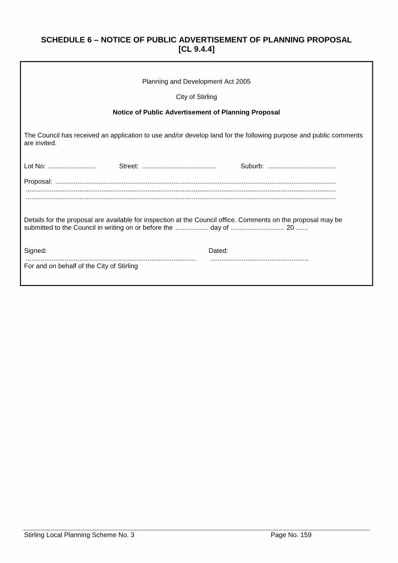
Stirling Local Planning Scheme No. 3 Page No. 159
SCHEDULE 6 – NOTICE OF PUBLIC ADVERTISEMENT OF PLANNING PROPOSAL [CL 9.4.4]
Planning and Development Act 2005
City of Stirling
Notice of Public Advertisement of Planning Proposal
The Council has received an application to use and/or develop land for the following purpose and public comments are invited. Lot No: .......................... Street: ........................................ Suburb: ..................................... Proposal: ........................................................................................................................................................ ........................................................................................................................................................................ ........................................................................................................................................................................ Details for the proposal are available for inspection at the Council office. Comments on the proposal may be submitted to the Council in writing on or before the .................. day of ............................. 20 ....... Signed: Dated: ............................................................................................ ..................................................... For and on behalf of the City of Stirling
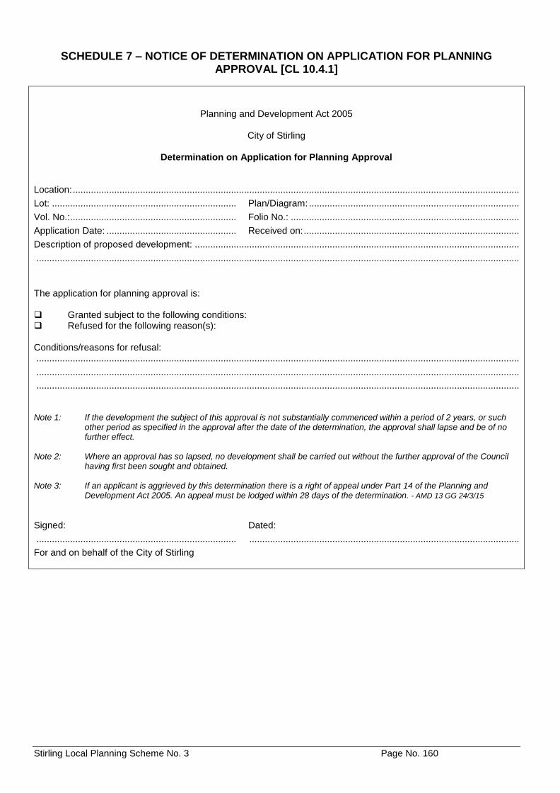
Stirling Local Planning Scheme No. 3 Page No. 160
SCHEDULE 7 – NOTICE OF DETERMINATION ON APPLICATION FOR PLANNING APPROVAL [CL 10.4.1]
Planning and Development Act 2005
City of Stirling
Determination on Application for Planning Approval
Location: ............................................................................................................................................................................
Lot: ....................................................................... Plan/Diagram: .................................................................................
Vol. No.: ................................................................ Folio No.: ........................................................................................
Application Date: .................................................. Received on: ...................................................................................
Description of proposed development: .............................................................................................................................
..........................................................................................................................................................................................
The application for planning approval is: Granted subject to the following conditions: Refused for the following reason(s): Conditions/reasons for refusal: ..........................................................................................................................................................................................
..........................................................................................................................................................................................
.......................................................................................................................................................................................... Note 1: If the development the subject of this approval is not substantially commenced within a period of 2 years, or such
other period as specified in the approval after the date of the determination, the approval shall lapse and be of no further effect.
Note 2: Where an approval has so lapsed, no development shall be carried out without the further approval of the Council
having first been sought and obtained. Note 3: If an applicant is aggrieved by this determination there is a right of appeal under Part 14 of the Planning and
Development Act 2005. An appeal must be lodged within 28 days of the determination. - AMD 13 GG 24/3/15
Signed: Dated:
............................................................................. ........................................................................................................
For and on behalf of the City of Stirling
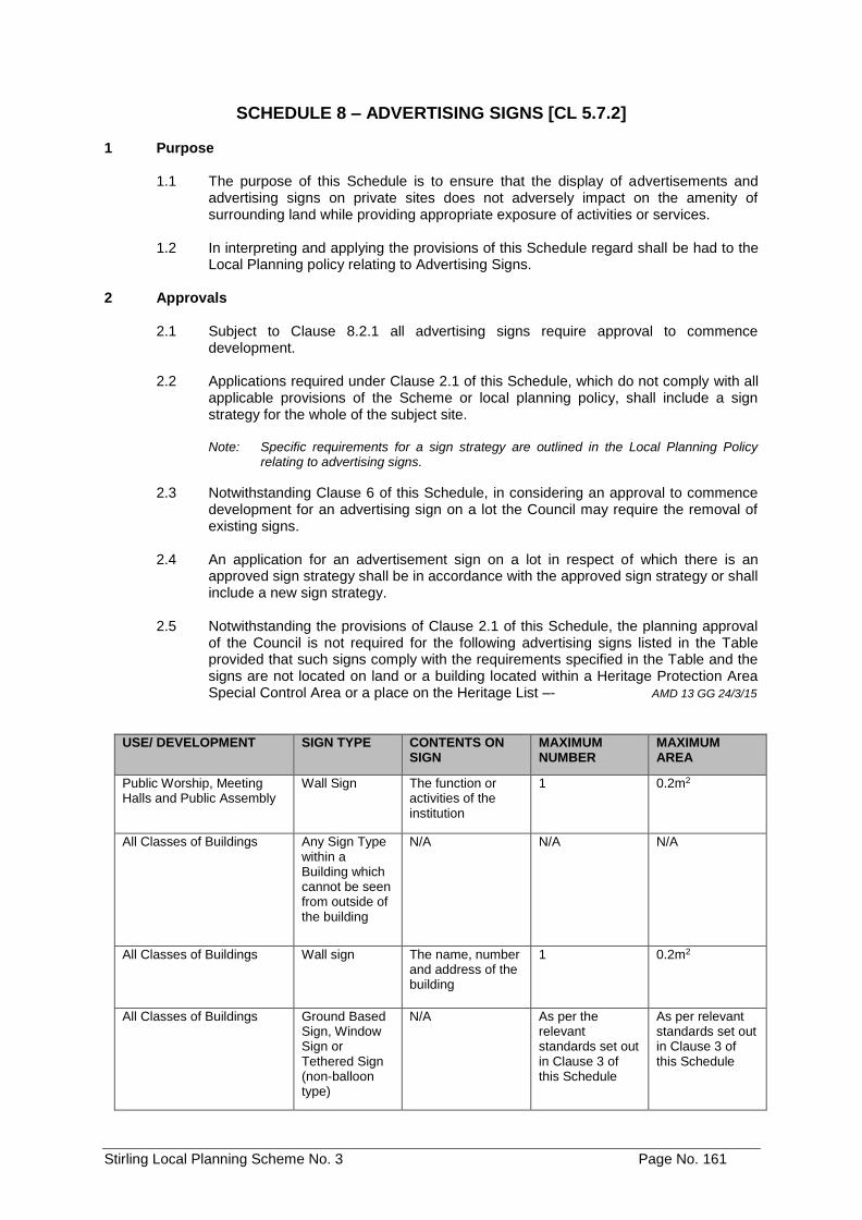
Stirling Local Planning Scheme No. 3 Page No. 161
SCHEDULE 8 – ADVERTISING SIGNS [CL 5.7.2]
1 Purpose
1.1 The purpose of this Schedule is to ensure that the display of advertisements and advertising signs on private sites does not adversely impact on the amenity of surrounding land while providing appropriate exposure of activities or services.
1.2 In interpreting and applying the provisions of this Schedule regard shall be had to the
Local Planning policy relating to Advertising Signs. 2 Approvals
2.1 Subject to Clause 8.2.1 all advertising signs require approval to commence development.
2.2 Applications required under Clause 2.1 of this Schedule, which do not comply with all
applicable provisions of the Scheme or local planning policy, shall include a sign strategy for the whole of the subject site.
Note: Specific requirements for a sign strategy are outlined in the Local Planning Policy
relating to advertising signs.
2.3 Notwithstanding Clause 6 of this Schedule, in considering an approval to commence development for an advertising sign on a lot the Council may require the removal of existing signs.
2.4 An application for an advertisement sign on a lot in respect of which there is an
approved sign strategy shall be in accordance with the approved sign strategy or shall include a new sign strategy.
2.5 Notwithstanding the provisions of Clause 2.1 of this Schedule, the planning approval
of the Council is not required for the following advertising signs listed in the Table provided that such signs comply with the requirements specified in the Table and the signs are not located on land or a building located within a Heritage Protection Area Special Control Area or a place on the Heritage List –- AMD 13 GG 24/3/15
USE/ DEVELOPMENT SIGN TYPE CONTENTS ON SIGN
MAXIMUM NUMBER
MAXIMUM AREA
Public Worship, Meeting Halls and Public Assembly
Wall Sign The function or activities of the institution
1 0.2m2
All Classes of Buildings Any Sign Type within a Building which cannot be seen from outside of the building
N/A N/A N/A
All Classes of Buildings Wall sign The name, number and address of the building
1 0.2m2
All Classes of Buildings Ground Based Sign, Window Sign or Tethered Sign (non-balloon type)
N/A As per the relevant standards set out in Clause 3 of this Schedule
As per relevant standards set out in Clause 3 of this Schedule
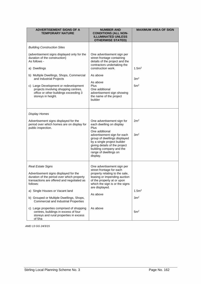
Stirling Local Planning Scheme No. 3 Page No. 162
ADVERTISEMENT SIGNS OF A
TEMPORARY NATURE NUMBER AND
CONDITIONS (ALL NON-ILLUMINATED UNLESS OTHERWISE STATED)
MAXIMUM AREA OF SIGN
Building Construction Sites (advertisement signs displayed only for the duration of the construction) As follows - a) Dwellings b) Multiple Dwellings, Shops, Commercial
and Industrial Projects c) Large Development or redevelopment
projects involving shopping centres, office or other buildings exceeding 3 storeys in height.
One advertisement sign per street frontage containing details of the project and the contractors undertaking the construction work. As above As above Plus One additional advertisement sign showing the name of the project builder
1.5m2 3m2 5m2
Display Homes Advertisement signs displayed for the period over which homes are on display for public inspection.
One advertisement sign for each dwelling on display Plus One additional advertisement sign for each group of dwellings displayed by a single project builder giving details of the project building company and the range of dwellings on display.
2m2 3m2
Real Estate Signs Advertisement signs displayed for the duration of the period over which property transactions are offered and negotiated as follows: a) Single Houses or Vacant land b) Grouped or Multiple Dwellings, Shops,
Commercial and Industrial Properties c) Large properties comprised of shopping
centres, buildings in excess of four storeys and rural properties in excess of 5ha
One advertisement sign per street frontage for each property relating to the sale, leasing or impending auction of the property at or upon which the sign is or the signs are displayed. As above As above
1.5m2 3m2 5m2
AMD 13 GG 24/3/15
Stirling Local Planning Scheme No. 3 Page No. 163
3 Advertising Sign Definitions
Definitions for advertising signs are contained within Schedule 1 of the Scheme. 4 Sign Zoning Table
4.1 Subject to the provisions of the Scheme, the Advertising Sign Zoning Table prescribes the advertising sign types which may be permitted (P) in each zone. The applicability is determined by cross reference between the list of “Sign Types” on the left-hand side of the Table and the list of “Zones” on the top of the Table.
4.2 Where a lot has a non-conforming use in accordance with the provisions of the
Scheme, the Sign Zoning Table does not apply in order to prescribe the advertising sign types which may be permitted. The Council shall determine in each case which sign is permitted or not permitted.
4.3 If a person proposes to erect any sign of a type that is not specifically listed In the
Advertising Sign Zoning Table and cannot reasonably be determined as falling within one of the listed advertising sign definitions, the Council may determine the advertising sign -
a) Is consistent with the objectives of the particular zone and is permitted; b) Is not consistent with the objectives of the particular zone and is not
permitted;
Advertising Sign Zoning Table
ZONE
SIGN TYPE
Bu
sin
ess
Civ
ic
Develo
pm
en
t
Are
a3
Dis
tric
t C
en
tre
Ho
tel
Ind
us
try
Lo
ca
l C
en
tre
Mix
ed
Bu
sin
es
s
Mix
ed
Us
e
Pri
vate
In
sti
tuti
on
s
Reg
ion
al
Ce
ntr
e
Re
sid
en
tia
l
Se
rvic
e S
tati
on
Sp
ecia
l B
each
Develo
pm
en
t
Sp
ec
ial
Us
e
Community Service P P P P P P P P P P P P P P P
Construction Site / Development / Real Estate
P P P P P P P P P P P P P P P
Created Roof P X X P P P P P P X P X P P P
Display Home P X X P X X P X P X P P X P X
Ground Based P P X P P P P P P P P P P P P
Hoarding P P X P P P P P P X P X P X P
Monolith P P X P P P P P X X P X P P P
Panel P X X P P P P P P X P P P P P
Portable Variable Message AMD 68 GG 01/11/16
X X X X X P5 X X X X X X X X X
Product Display X X X X X P X X X X X X X X X
Projecting P P X P P P P P P P P X P X P
Pylon P P X P P P1 P P X X P X P X P
Roof X X X X X X X X X X X X X X X
Tethered P2 X X P2 P2 X P2 P2 X X P2 X P2 P2 P2
Wall P P X P P P P P P P P P P P P
Window P P X P P P P P P P P X P P P
Stirling Local Planning Scheme No. 3 Page No. 164
Conditions: AMD 84 GG 16/7/19
1. Pylon signs are not permitted in the Herdsman Precinct. 2. Blimps, bunting, kites and lighter than air devices are not permitted in any zones. 3. Permissibility determined with reference to appropriate adopted Structure Plan, or, in
the case of the Stirling City Centre Special Control Area, by having reference to Clause 6.11.20. Where there is no adopted Activity Centre Plan for a particular area, all Advertising signs are not permitted.
4. Portable Variable Message signs erected by or on behalf of the City on 'Reserves' or 'No Zone' land should principally be used for the purpose of: - AMD 68 GG 01/11/16 i. Roadwork notification/road safety; ii. Changed traffic conditions associated with events; or iii. Notifications relating to community safety.
5. Portable variable message signs are not permitted in the industry zone where they are visible from roads reserved as Primary or Other Regional Roads under the Metropolitan Region Scheme. AMD 68 GG 01/11/16
5 Standards The Location, size and number of advertising signs which may be permitted on a site is
specified in the Council’s Local Planning Policy. 6 Existing Advertising Signs
6.1 Non-Conforming Signs:
Advertising signs which:
a) were lawfully erected, placed or displayed prior to the approval of this Schedule; or
b) may be erected, placed or displayed pursuant to a licence or other approval granted by the council prior to the gazettal date of this Schedule;
(Hereinafter in this Clause referred to as ‘existing advertising signs’) may, except as otherwise provided in the Scheme, continue to be displayed or to be erected in accordance with the appropriate licence or approval.
7 Discontinuance
7.1 Notwithstanding the provisions of Clause 6, where an existing advertising sign at, or at any time after, the coming into force of the Scheme, is, in the opinion of the Council, in conflict with the amenity of the locality, the Council may by written notice (giving clear reasons) require the advertiser to remove, relocate, repair, adapt or otherwise modify the advertising sign.
8 Maintenance of Advertising Signs
8.1 Where, in the opinion of the Council, an advertising sign as deteriorated to a point where it is in conflict with the aims of the Scheme or it ceases to be effective for the purpose for which it was erected or displayed, the Council may be written notice require the advertiser to -
a) repair, repaint or otherwise restore the advertising sign to a standard specified
by the Council in the notice; or
b) remove the advertising sign.
Stirling Local Planning Scheme No. 3 Page No. 165
9 Removal of Advertising Signs
9.1 An employee of the City may remove an advertising sign erected, placed or displayed contrary to the Scheme.
9.2 The City may serve on the owner or occupier of any premises on which an advertising
sign is erected, placed or displayed contrary to the Scheme, the Council may by written notice (giving clear reason) require the advertiser to remove the advertising sign within such time as may be specified in the notice and if the notice is complied with, an employee of the City may remove the advertising sign, the subject of the notice.
9.3 An employee of the City may remove any advertising sign which, in the opinion of that
employee, is dangerous to persons or vehicles.
9.4 The City may dispose of any advertising sign removed under this clause without being liable in damages or otherwise.
9.5 The City may recover in a Court of competent jurisdiction:
a) the costs of removing an advertising sign under clause 9.1, disposing of that
advertising sign under clause 9.4 and any works required to reinstate the building, from the person responsible for erecting, placing or displaying the advertising sign;
b) the costs of removing an advertising sign under clause 9.2 and disposing of that advertising sign under clause 9.4, from the owner or occupier served with the notice; and
c) the costs of removing an advertising sign under clause 9.3 and disposing of that advertising sign under clause 9.4, from the owner or occupier of the premises on which the advertising sign was erected, placed or displayed or from the person responsible for erecting, placing or displaying the advertising sign.
10 Notices
10.1 For the purpose of Clauses 7.1, 8.1 and 9.2 any notice is to be served on the advertiser and is to specify -
a) the advertising sign the subject of the notice;
b) full details of the action or alternative courses of action to be taken by the
advertiser to comply with the notice; and
c) the period, being not less than 60 days from the date of the Council’s determination, within which the action specified is to be completed by the advertiser.
10.2 Any person upon whom a notice is served pursuant to this Schedule may, within a
period of 60 days from the date of the notice, appeal in accordance with Part 14 of the Act. Where any such appeal is lodged, the effect of the notice shall be suspended until the decision to uphold, quash or vary the notice is known and shall thereafter have effect according to that decision.
10.3 Any person fails to comply with the requirements of a notice served pursuant to this
Schedule commits an offence and is liable to the penalties prescribed in section 214 of the Act.
Stirling Local Planning Scheme No. 3 Page No. 166
10.4 If a person whom a notice has been served under this Schedule fails to comply with the requirements of the notice the Council may by its servants or agents enter upon the land on which the advertising sign the subject of the notice is situated and carry out the requirements of the notice.
10.5 The Council may recover the costs of anything it does under Clause 10.4 of this
Schedule as a debt from the person who failed to comply with the notice.
Stirling Local Planning Scheme No. 3 Page No. 167
11 Additional Information for Advertisements [Cl 9.1.2] Note: to be completed in addition to the Application for Planning Approval form
1. Description of property upon which advertisement is to be displayed including full details of its proposed position within that property:
...........................................................................................................................................................................
...........................................................................................................................................................................
2. Details of proposed sign:
(a) Type of structure on which advertisement is to be erected (i.e. freestanding, wall mounted, other): ....
................................................................................................................................................................
(b) Height: ........................... Width: ............................ Depth: ..............................
(c) Colours to be used: .................................................................................................................................
(d) Height above ground level -
• (to top of the advertisement): .....................................................................................................
• (to underside): ............................................................................................................................
(e) Materials to be used: ...............................................................................................................................
................................................................................................................................................................
Illuminated: Yes / No
If yes, state weather steady, moving, flashing, alternating, digital, animated or scintillating and state intensity of light source:
................................................................................................................................................................
................................................................................................................................................................
3. Period of time for which advertisement is required: ...........................................................................................
...........................................................................................................................................................................
4. Details of signs (if any) to be removed if this application is approved:
...........................................................................................................................................................................
...........................................................................................................................................................................
Note: This application should be supported by a photograph or photographs of the premises showing superimposed thereon the proposed position for the advertisement and those advertisements to be removed detailed in 4 above.
Signature of advertiser(s): .........................................................................................................................
(if different from land owners)
Date: .........................................................................................................................
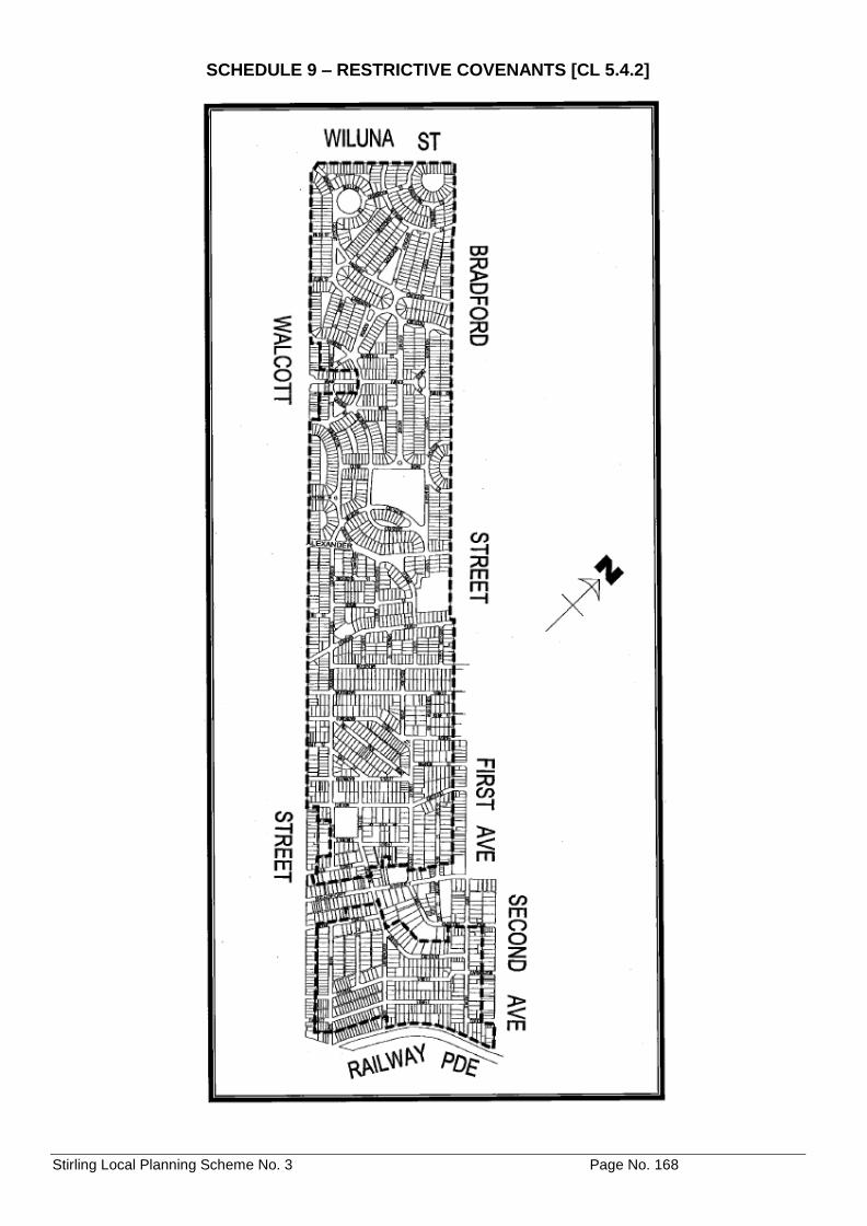
Stirling Local Planning Scheme No. 3 Page No. 168
SCHEDULE 9 – RESTRICTIVE COVENANTS [CL 5.4.2]
Stirling Local Planning Scheme No. 3 Page No. 169
SCHEDULE 10 – DEVELOPMENT (STRUCTURE PLAN) AREAS [CL 6A] Note: The following table details areas where structure plans have either been adopted by Council and the Commission or are
required as per Clause 6A. The boundaries of these Development Areas are shown on the Scheme Map, with the exception of ‘Careniup Swamp’ which is shown as a ‘Special Control Area’ (refer clause 6.2).
Name of Structure Plan/Activity Centre Plan
Purpose Requirements
Careniup Swamp, Gwelup To facilitate development and protect wetland.
As per clause 6.2.
East Roselea, Balcatta
AMD 83 GG 14/08/18
To facilitate development within the East Roselea Balcatta Structure Plan Area of a variety of medium to high density residential lots, public open space and a Neighbourhood Centre in the south-western corner of the Structure Plan area.
1. A Structure Plan prepared and approved pursuant to Schedule 2 Part 4 of the deemed provisions of the Planning and Development (Local Planning Schemes) Regulations 2015 shall apply to the Structure Plan Area to guide subdivision and/or development.
2. Development of the Neighbourhood
Centre must comply with the following requirements: - a. A minimum of 50% of the
Karrinyup Road frontage of Lot 150, House Number 732, shall contain buildings with active frontages.
b. Development fronting Grindleford Drive and new road frontages must promote pedestrian activation and good places and spaces by: - i. Sleeving of any larger scale
retail (supermarket) use with smaller retail or commercial tenancies, dwellings, or any other permitted uses that incorporate active facades to adjacent streets.
ii. Buildings which address streets provide weather protection to adjacent pedestrian footpaths through the provision of awnings to ground floor commercial uses and avoid blank walls facing the street in order to promote activity and encourage passive surveillance.
iii. Loading docks, service yards, storage areas and services for the buildings not being visible from any street other than accessways.
iv. On-site car parking must be sleeved with buildings, or located above, below or within buildings, so as to
Stirling Local Planning Scheme No. 3 Page No. 170
Name of Structure Plan/Activity Centre Plan
Purpose Requirements
East Roselea, Balcatta
(Cont’d)
AMD 83 GG 14/08/18
not be visible from any adjacent street. On street car parking must be provided, by the applicant to the satisfaction of the City, within the road reserve of any street abutting the Neighbourhood Centre site, with the exception of Karrinyup Road.
c. The Neighbourhood Centre must
not exceed a maximum retail gross floor area of 5,000m2 which may include a supermarket up to a maximum gross leasable area of 4,000m2. Notwithstanding this, an increase to a maximum retail gross floor area of 6,000m2 may be permitted subject to the submission of a Retail Sustainability Assessment report as part of a structure plan, which demonstrates to the satisfaction of the Council that the likely impact on other centres is acceptable and the urban design provides for a mixture of tenancy sizes that support the development of a centre developed along traditional centre design principles.
d. Notwithstanding the above,
variations to the provisions of sub-clauses 2b. i, ii, iii and iv, may be considered where development, in the opinion of Council: - i. Creates a vibrant and active
neighbourhood centre.
ii. Creates development with main street frontages.
iii. Provides a high level of pedestrian amenity through the provision of interactive frontages and weather protection; and
iv. Promotes a high quality built form which enables safety and security through passive surveillance.
Edith Cowan University, Churchlands.
To facilitate development of a variety of residential densities.
As per adopted Structure Plan.
Herb Graham, Mirrabooka DELETED BY AMD 29 GG 16/09/14
Roselea, Stirling To facilitate development of low to medium density residential lots.
As per adopted Structure Plan.
Princeton, Stirling To facilitate development of low to medium density residential lots.
As per adopted Structure Plan.
Stirling Local Planning Scheme No. 3 Page No. 171
Name of Structure Plan/Activity Centre Plan
Purpose Requirements
Carine TAFE, Carine To facilitate the development of: 1. Aged or Dependent Persons
Dwelling
2. A Nursing Home
3. Ancillary facilities and services associated with Aged or Dependent Persons dwelling and the Nursing Home.
4. A range of residential densities to facilitate of a broad mix and type of housing.
5. Mixed use development with a range of commercial uses and child care
1. As per Clause 6A.
2. A minimum 10% affordable housing is to be provided. The Structure Plan is to specify measures for achieving this.
3. Future subdivision and development must ensure that the existing vegetation continues to contribute to local biodiversity and local landscape characteristics of the area and provides an attractive setting for the redevelopment of the site.
Mirrabooka Town Centre AMD 29 GG 16/09/14
AMD 85 GG 12/06/18
As per Clause 6.8.1 'Objectives' of the Mirrabooka Town Centre Special Control Area.
As per Clause 6.8 and the Activity Centre Plan.
Channel Nine Site, Dianella
AMD 24 GG 24/10/14
1. To implement the objectives of the Dianella Media Zones Precinct Plan.
2. To facilitate a mix of lot and housing
types that meet the minimum 30 dwelling units per hectare and accommodate a diverse range of demographics.
3. To facilitate built form which
maximises views, appropriately addresses public open space where applicable, provides an attractive and distinctive streetscape, and responds to the varying topography of the site.
4. To articulate in detail the objectives
for Detailed Area Plans and identify the lots that will require the preparation of a Detailed Area Plan.
5. To provide a minimum of 10%
public open space for active (informal) and passive recreation and an eco-corridor to facilitate kangaroo movement between bushland to the north and south of the site.
6. To provide a robust and permeable
street network. 7. To provide an open space link for
kangaroo movement. 8. To ensure compliance with the
1. As per adopted Structure Plan. 2. A range of housing types and densities
to be provided within the Structure Plan generally in accordance with the Media Zones Precinct Plan that achieves a minimum yield of 108 dwellings and the dwelling target of 30 units per hectare to the satisfaction of the City.
3. The adopted Structure Plan shall provide detailed guidance in regard to built form outcomes. Building height shall be limited to a maximum of 3 storeys.
4. Detailed Area Plans shall be required
for lots with a density in excess of R30 in accordance with the Dianella Media Zones Precinct Plan.
5. A minimum 10% of public open space
to be provided in accordance with the Dianella Media Zones Precinct Plan.
6. Traffic calming devices to be provided
at the applicant’s cost along Gay Street and the internal subdivision road given that kangaroos will need to move across these roads via the public open space/Kangaroo Corridor, to the satisfaction of the City.
7. The Kangaroo Corridor, identified as
public open space on the adopted Structure Plan, shall be revegetated at the applicant’s cost to the satisfaction of the City.
Stirling Local Planning Scheme No. 3 Page No. 172
Name of Structure Plan/Activity Centre Plan
Purpose Requirements
Channel Nine Site, Dianella (Cont’d)
AMD 24 GG 24/10/14
Western Australian Planning Commission’s policy ‘State Planning Policy 3.7 Planning for Bushfire Risk Management’, and ‘Planning for Bushfire Risk Management Guidelines’, including any requirements for buildings in bushfire prone areas to be constructed in accordance with AS3959.
8. The Structure Plan is to comply with
the Western Australian Planning Commission’s policy ‘State Planning Policy 3.7 Planning for Bushfire Risk Management’, and ‘Planning for Bushfire Risk Management Guidelines’, including any requirements for building in bushfire prone areas to be constructed in accordance with AS3959. The Structure Plan is to include the following annotation:
‘Residential lots within a bushfire prone area will be required to include a notification under section 70A Transfer of Land Act 1893 on the certificate of title giving notice of the bushfire hazard and any restrictions and/or protective measures required to be maintained at the landowner’s cost.’
Stirling City Centre, Stirling / Innaloo AMD 1 GG 02/09/14
AMD 84 GG 16/7/19
To facilitate development within the Stirling City Centre Activity Centre Plan Area in a manner consistent with the objectives in clause 6.11.1.
As per Clause 6.11 and the Stirling City Centre Activity Centre Plan.
Network Ten and Department of Housing sites, Dianella AMD 41 GG 26/05/15
1. To optimise the residential density in recognition of the proposed light rail network along Dianella Drive;
2. To implement the objectives of the Dianella Media Zones Precinct Plan;
3. To facilitate a mix of lot and housing product that meets the minimum 30 dwelling units per hectare;
4. To provide sufficient public open space for active (informal) recreation and an open space link between the bushland to the north and south of the site; and
5. To provide a robust and permeable street network.
6. To ensure compliance with the
Western Australian Planning Commission’s policy ‘State Planning Policy 3.7 Planning for Bushfire Risk Management,’ and ‘Planning for Bushfire Risk Management Guidelines’.
7. To ensure compliance with the
Western Australian Planning Commission’s policy ‘State Planning Policy 5.4 Road and Rail Transport Noise and Freight
As per clause 6A and the adopted structure plan. The Structure Plan is to comply with the Western Australian Planning Commission’s policy ‘State Planning Policy 3.7 Planning for Bushfire Risk Management, and ‘Planning for Bushfire Risk Management Guidelines’, including any requirements for buildings in bushfire prone areas to be constructed in accordance with AS3959. An annotation is to be included on the Structure Plan stating: ‘Residential lots within a bushfire prone area will be required to include a notification under section 70A Transfer of Land Act 1893 on the certificate of title giving notice of the bushfire hazard and/or protective measures required to be maintained at the landowner’s cost.’ The Structure Plan is to comply with the Western Australian Planning Commission’s policy ‘State Planning Policy 5.4 Road and Rail Transport Noise and Freight Considerations in Land Use Planning’, including noise attenuation barriers, build design and construction techniques.
Stirling Local Planning Scheme No. 3 Page No. 173
Name of Structure Plan/Activity Centre Plan
Purpose Requirements
Considerations in Land Use Planning’.
Atlas Site, Mirrabooka AMD 42 GG 15/12/15
To facilitate the development of a range of:
• Light/service industrial uses; and
• Mixed business use
As per Clause 6A
Lot 201 Harkins Street and Lot 94 Arkana Road, Westminster. AMD 64 GG 17/01/17
1. To provide a range of residential densities with a broad mix of housing types to accommodate a diverse range of demographics such as Aged or Dependent Persons Dwellings.
2. To facilitate a range of appropriately located non-residential uses.
A structure plan prepared and approved pursuant to Part 4 of the deemed provision shall apply to the structure plan area to guide subdivision and/or development.
Herdsman Glendalough Structure Plan AMD 39 GG 21/08/18
To facilitate development within the Herdsman Glendalough Structure Plan Area in a manner consistent with the objectives in Clause 6.4.1.
As per Clause 6.4 and the Herdsman Glendalough Structure Plan
Stirling Local Planning Scheme No. 3 Page No. 174
SCHEDULE 11 – DEVELOPMENT CONTRIBUTION AREAS [CL 6B] Note: The following table details the areas in which infrastructure contributions are require, the infrastructure to which
developer contributions relate and the basis upon which developer contributions will be determined.
No. Description of Land
Infrastructure to which cost sharing arrangements relate
Cost sharing arrangement
1 All land within the Special Beach Development Zone
• Infrastructure headworks and overheads;
• Preliminaries;
• Demolition and earthworks;
• Temporary roadworks, access and management;
• Roadworks;
• Pedestrian and cycle paving and edges;
• Steps;
• Walls;
• Stormwater drainage;
• CCTV security system and reticulation;
• Lighting and electrical;
• Structures (note – not all items costed/included);
• Facilities;
• Signage (excluding road signage);
• Furniture;
• Mains water and plumbing fixtures;
• Irrigation;
• Soil preparation;
• Planting;
• Grass;
• Public art;
• Sinking Scarborough Beach Road West;
• Interim and Abortive works;
• Maintenance and contingencies; and
• Fees.
1. Development Contribution A development contribution in accordance with this Part shall be required in respect of any development with a plot ratio (excluding 0.5:1 of ground level commercial plot ratio floor space), as determined by the City, of more than 1.5.
2. Estimate of infrastructure Costs The City’s initial estimate of the Infrastructure Costs is set out by reference to the development works referred to in the Design Guidelines adopted for this zone.
3. Calculation of Development Contribution The development contribution for each development shall be calculated as follows:-
Where:-
“Site additional plot ratio area” is the area of the lot on which the development is proposed, multiplied by the amount of the plot ratio of the development above 1.5 (excluding 0.5:1 of ground level commercial plot ratio floor);
“Total additional plot ratio area” is the total area of land within the Special Branch Development zone excluding roads and reserved lands (75,950m2), multiplied by the maximum available plot ratio above 15 (excluding 0.5:1 of ground level commercial plot ratio floor space);
4. Payment of Development Costs Payment is required in accordance with clause 6B.14 of the scheme.
5. Staging Staging of the Infrastructure Works are to be in accordance with the adopted Scarborough Beach Urban Design Masterplan.
2 All land within the Main Street Special Control Area
AMD 5 66 15/12/15
• Road Works
• Landscaping
• Paving
• Furniture
• Irrigation
1. Development Contribution In accordance with the adopted implementation Strategy for this area.
2. Payment of Development Costs 2.1 Unless an agreement is entered into under clause
6B.14.2, the owner must pay the cost contribution within 60 days of the event which under clause 6B.13.2 gave rise to the liability to pay the cost contribution or at such other time as is specified by a condition of development approval issued by the City for the commencement of development.
2.2 Payment is required in accordance with clause 6B.14
of the Scheme and in addition: (a) interest shall be paid on any cost contribution
which is due at the maximum rate of interest prescribed for the purpose of section 6.13 of the Local Government Act 1995.
(b) interest shall be paid from the date an owner becomes liable for a cost contribution to the date on which the cost contribution, or unpaid portion of the cost contribution (as the case may be) is paid.”
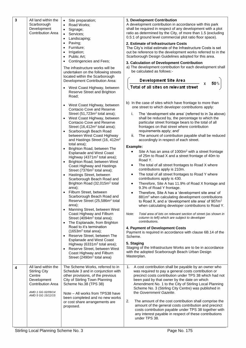
Stirling Local Planning Scheme No. 3 Page No. 175
3 All land within the Scarborough Development Contribution Area
• Site preparation;
• Road Works;
• Signage;
• Services;
• Landscaping;
• Paving;
• Furniture;
• Irrigation;
• Public Art;
• Contingencies and Fees;
The infrastructure works will be undertaken on the following streets located within the Scarborough Development Contribution Area:
• West Coast Highway, between Reserve Street and Brighton Road;
• West Coast Highway, between Contacio Cove and Reserve Street (51,723m2 total area);
• West Coast Highway, between Contacio Cove and Reserve Street (16,412m2 total area);
• Scarborough Beach Road between West Coast Highway and Hastings Street (16, 412m2 total area);
• Brighton Road, between The Esplanade and West Coast Highway (4371m2 total area);
• Brighton Road, between West Coast Highway and Hastings Street (7376m2 total area);
• Hastings Street, between Scarborough Beach Road and Brighton Road (32,015m2 total area);
• Filburn Street, between Scarborough Beach Road and Reserve Street (25,586m2 total area);
• Manning Street, between West Coast Highway and Filburn Street (4094m2 total area);
• The Esplanade, from Brighton Road to it’s termination (1653m2 total area);
• Reserve Street, between The Esplanade and West Coast Highway (6331m2 total area);
• Reserve Street, between West Coast Highway and Filburn Street (2490m2 total area)
1. Development Contribution A development contribution in accordance with this park shall be required in respect of any development with a plot ratio as determined by the City, of more than 1.5 (excluding 0.5:1 of ground level commercial plot ratio floor space).
2. Estimate of Infrastructure Costs The City’s initial estimate of the Infrastructure Costs is set out be reference to the development works referred to in the Scarborough Design Guidelines adopted for this area.
3. Calculation of Development Contribution a) The development contribution for each development shall be calculated as follows:-
b) In the case of sites which have frontage to more than one street to which developer contributions apply:
i. The ‘development site area’ (referred to in 3a above) shall be reduced by, the percentage to which the particular street frontage bears to the total of all frontages on that street where contribution requirements apply; and’
ii. The amount of contribution payable shall be reduced accordingly in respect of each street.
Example:
• Site A has an area of 1000m2 with a street frontage of 25m to Road X and a street frontage of 40m to Road Y.
• The total of all street frontages to Road X where contributions apply is 210m.
• The total of all street frontages to Road Y where contributions apply is 430.
• Therefore, Site A has 11.9% of Road X frontage and 9.3% of Road Y frontage.
• Therefore, Site A has a ‘development site area’ of 881m2 when calculating development contributions to Road X, and a ‘development site area’ of 907m2 when calculating developer contributions to Road Y.
Note: Total area of lots on relevant section of street (as shown in
column to left) which are subject to developer contributions.
4. Payment of Development Costs Payment is required in accordance with clause 6B.14 of the Scheme.
5. Staging Staging of the Infrastructure Works are to be in accordance with the adopted Scarborough Beach Urban Design Masterplan.
4
All land within the Stirling City Centre Development Contribution Area AMD 1 GG 02/09/14 AMD 5 GG 15/12/15
The Scheme Works, referred to in Schedule 3 and in conjunction with other provisions, of the previous City of Stirling Town Planning Scheme No.38 (TPS 38)
Note – All works from TPS38 have been completed and no new works or cost share arrangements are proposed.
1. A cost contribution shall be payable by an owner who was required to pay a general costs contribution or precinct costs contribution under TPS 38 which had not been paid by that owner by the date on which Amendment No. 1 to the City of Stirling Local Planning Scheme No. 3 (Stirling City Centre) was published in the Government Gazette.
2. The amount of the cost contribution shall comprise the amount of the general costs contribution and precinct costs contribution payable under TPS 38 together with any interest payable in respect of these contributions under TPS 38.
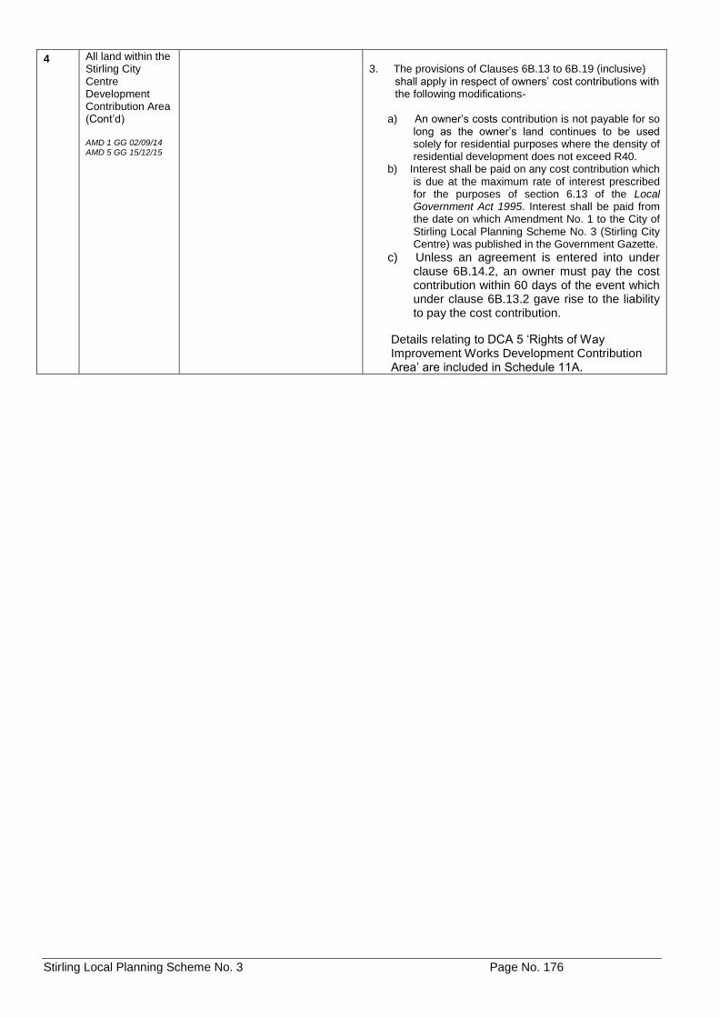
Stirling Local Planning Scheme No. 3 Page No. 176
4 All land within the Stirling City Centre Development Contribution Area (Cont’d) AMD 1 GG 02/09/14 AMD 5 GG 15/12/15
3. The provisions of Clauses 6B.13 to 6B.19 (inclusive)
shall apply in respect of owners’ cost contributions with the following modifications-
a) An owner’s costs contribution is not payable for so
long as the owner’s land continues to be used solely for residential purposes where the density of residential development does not exceed R40.
b) Interest shall be paid on any cost contribution which is due at the maximum rate of interest prescribed for the purposes of section 6.13 of the Local Government Act 1995. Interest shall be paid from the date on which Amendment No. 1 to the City of Stirling Local Planning Scheme No. 3 (Stirling City Centre) was published in the Government Gazette.
c) Unless an agreement is entered into under clause 6B.14.2, an owner must pay the cost contribution within 60 days of the event which under clause 6B.13.2 gave rise to the liability to pay the cost contribution.
Details relating to DCA 5 ‘Rights of Way Improvement Works Development Contribution Area’ are included in Schedule 11A.
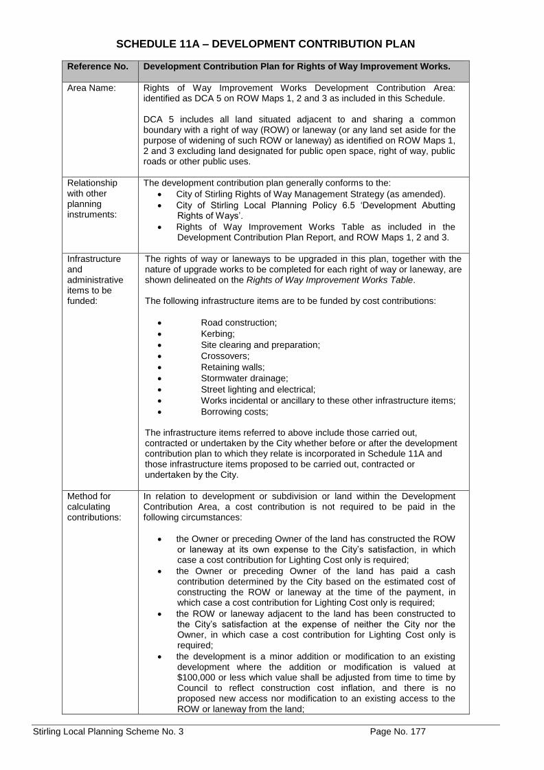
Stirling Local Planning Scheme No. 3 Page No. 177
SCHEDULE 11A – DEVELOPMENT CONTRIBUTION PLAN
Reference No. Development Contribution Plan for Rights of Way Improvement Works.
Area Name: Rights of Way Improvement Works Development Contribution Area: identified as DCA 5 on ROW Maps 1, 2 and 3 as included in this Schedule. DCA 5 includes all land situated adjacent to and sharing a common boundary with a right of way (ROW) or laneway (or any land set aside for the purpose of widening of such ROW or laneway) as identified on ROW Maps 1, 2 and 3 excluding land designated for public open space, right of way, public roads or other public uses.
Relationship with other planning instruments:
The development contribution plan generally conforms to the:
• City of Stirling Rights of Way Management Strategy (as amended).
• City of Stirling Local Planning Policy 6.5 ‘Development Abutting Rights of Ways’.
• Rights of Way Improvement Works Table as included in the Development Contribution Plan Report, and ROW Maps 1, 2 and 3.
Infrastructure and administrative items to be funded:
The rights of way or laneways to be upgraded in this plan, together with the nature of upgrade works to be completed for each right of way or laneway, are shown delineated on the Rights of Way Improvement Works Table. The following infrastructure items are to be funded by cost contributions:
• Road construction;
• Kerbing;
• Site clearing and preparation;
• Crossovers;
• Retaining walls;
• Stormwater drainage;
• Street lighting and electrical;
• Works incidental or ancillary to these other infrastructure items;
• Borrowing costs;
The infrastructure items referred to above include those carried out, contracted or undertaken by the City whether before or after the development contribution plan to which they relate is incorporated in Schedule 11A and those infrastructure items proposed to be carried out, contracted or undertaken by the City.
Method for calculating contributions:
In relation to development or subdivision or land within the Development Contribution Area, a cost contribution is not required to be paid in the following circumstances:
• the Owner or preceding Owner of the land has constructed the ROW or laneway at its own expense to the City’s satisfaction, in which case a cost contribution for Lighting Cost only is required;
• the Owner or preceding Owner of the land has paid a cash contribution determined by the City based on the estimated cost of constructing the ROW or laneway at the time of the payment, in which case a cost contribution for Lighting Cost only is required;
• the ROW or laneway adjacent to the land has been constructed to the City’s satisfaction at the expense of neither the City nor the Owner, in which case a cost contribution for Lighting Cost only is required;
• the development is a minor addition or modification to an existing development where the addition or modification is valued at $100,000 or less which value shall be adjusted from time to time by Council to reflect construction cost inflation, and there is no proposed new access nor modification to an existing access to the ROW or laneway from the land;
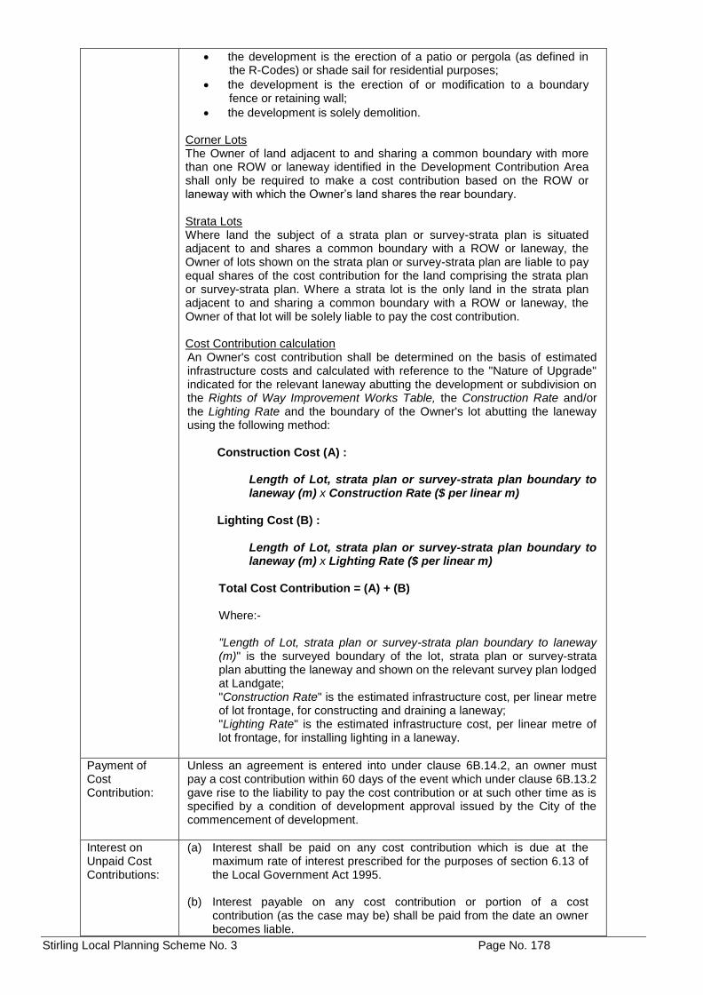
Stirling Local Planning Scheme No. 3 Page No. 178
• the development is the erection of a patio or pergola (as defined in the R-Codes) or shade sail for residential purposes;
• the development is the erection of or modification to a boundary fence or retaining wall;
• the development is solely demolition. Corner Lots The Owner of land adjacent to and sharing a common boundary with more than one ROW or laneway identified in the Development Contribution Area shall only be required to make a cost contribution based on the ROW or laneway with which the Owner’s land shares the rear boundary. Strata Lots Where land the subject of a strata plan or survey-strata plan is situated adjacent to and shares a common boundary with a ROW or laneway, the Owner of lots shown on the strata plan or survey-strata plan are liable to pay equal shares of the cost contribution for the land comprising the strata plan or survey-strata plan. Where a strata lot is the only land in the strata plan adjacent to and sharing a common boundary with a ROW or laneway, the Owner of that lot will be solely liable to pay the cost contribution. Cost Contribution calculation An Owner's cost contribution shall be determined on the basis of estimated infrastructure costs and calculated with reference to the "Nature of Upgrade" indicated for the relevant laneway abutting the development or subdivision on the Rights of Way Improvement Works Table, the Construction Rate and/or the Lighting Rate and the boundary of the Owner's lot abutting the laneway using the following method:
Construction Cost (A) :
Length of Lot, strata plan or survey-strata plan boundary to laneway (m) x Construction Rate ($ per linear m)
Lighting Cost (B) :
Length of Lot, strata plan or survey-strata plan boundary to laneway (m) x Lighting Rate ($ per linear m)
Total Cost Contribution = (A) + (B) Where:- "Length of Lot, strata plan or survey-strata plan boundary to laneway (m)" is the surveyed boundary of the lot, strata plan or survey-strata plan abutting the laneway and shown on the relevant survey plan lodged at Landgate; "Construction Rate" is the estimated infrastructure cost, per linear metre of lot frontage, for constructing and draining a laneway; "Lighting Rate" is the estimated infrastructure cost, per linear metre of lot frontage, for installing lighting in a laneway.
Payment of Cost Contribution:
Unless an agreement is entered into under clause 6B.14.2, an owner must pay a cost contribution within 60 days of the event which under clause 6B.13.2 gave rise to the liability to pay the cost contribution or at such other time as is specified by a condition of development approval issued by the City of the commencement of development.
Interest on Unpaid Cost Contributions:
(a) Interest shall be paid on any cost contribution which is due at the maximum rate of interest prescribed for the purposes of section 6.13 of the Local Government Act 1995.
(b) Interest payable on any cost contribution or portion of a cost
contribution (as the case may be) shall be paid from the date an owner becomes liable.
Stirling Local Planning Scheme No. 3 Page No. 179
Period of operation:
20 years from the date of gazettal.
Priority and timing:
In accordance with the adopted Rights of Way Management Strategy and the laneway upgrade works program determined by the City.
Review process:
The Development Contribution Plan will be reviewed when considered appropriate, but at a time that is no longer than 5 years after the date of gazettal of this amendment. The estimated infrastructure costs shown in the cost apportionment schedule will be reviewed at least annually in accordance with clause 6B.11 of LPS No. 3.
Stirling Local Planning Scheme No. 3 Page No. 180
AMD 89 GG 27/02/18
Stirling Local Planning Scheme No. 3 Page No. 181
Stirling Local Planning Scheme No. 3 Page No. 182
SCHEDULE 12 – ADDITIONAL SITE AND DEVELOPMENT REQUIREMENTS
No. Description of Land Requirement
AR1 No. 7 and 9 Field Street and Reserve 38780, Mount Lawley AMD 101 GG 02/07/19
1. Prior to development, a local development plan shall be prepared and approved which sets out:
(a) vehicular access arrangements from Masel
Land and /or Memorial Lane; and (b) a tree protection area for the eastern portion of
the land. 2. Development is to generally be in accordance with
an approved Local Development Plan.
AR2 Lot 601, House Number 2B, Rawlins Street, Glendalough AMD 106 GG 23/07/19
1. Prior to development, a Local Development Plan shall be prepared and approved which sets out: (a) Building Height
Maximum building heights are to be in accordance with the Local Development Plan, but no greater than 3 storeys. (b) Pedestrian Connectivity The redevelopment of the site shall provide a footpath network that links the site to the wider community, including the shared dual use pedestrian and bicycle path to the east of the site.
2. Development is to be generally in accordance with an approved Local Development Plan.