Embed Size (px)
Citation preview

City of Seward, NETuesday, July 7, 2015
Regular Session
Item G9
CONSIDERATION OF A PLAN FOR STORM WATER RUNOFF AND SANITARY SEWER IMPROVEMENTS FOR ST. JOHN'S NEW DAYCARE CENTER TO BE LOCATED AT HILLCREST DR AND COLUMBIA AVE - John HughesConsideration of financial participation in the relocation of sanitary sewer line and improvements
Consideration of financial participation in the relocation storm sewer and consideration of constructing a new storm sewer line
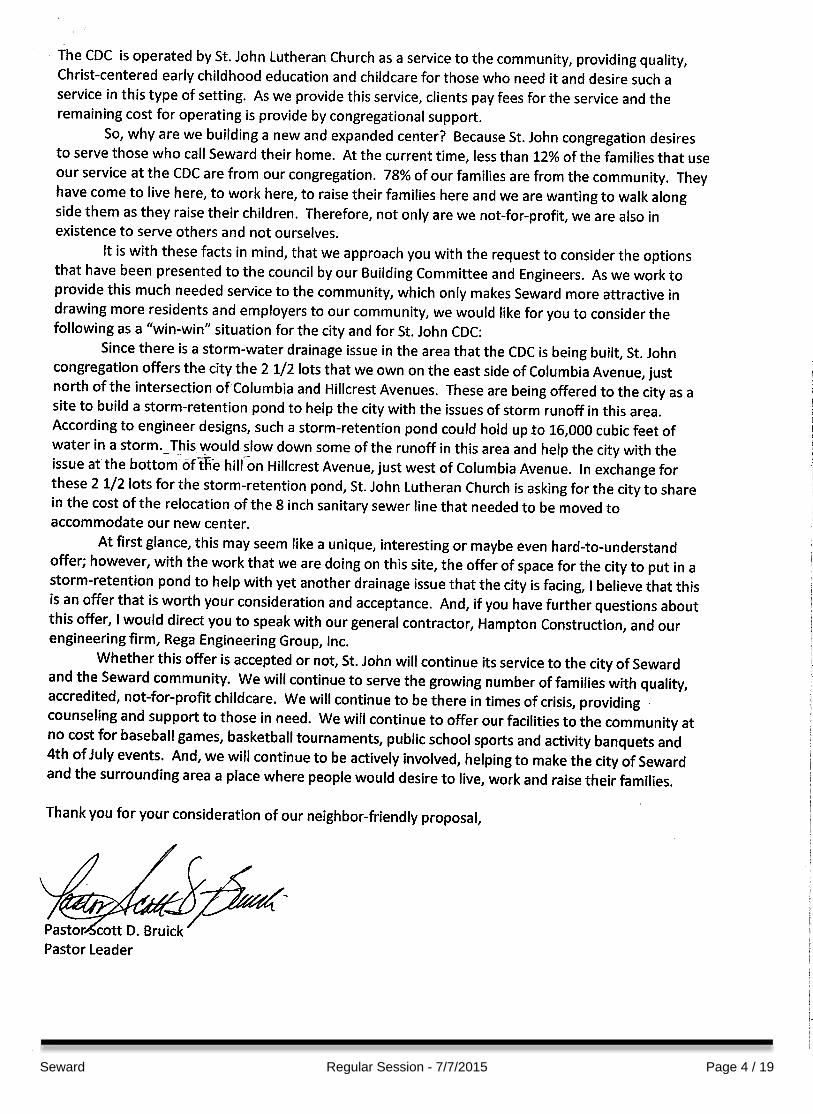
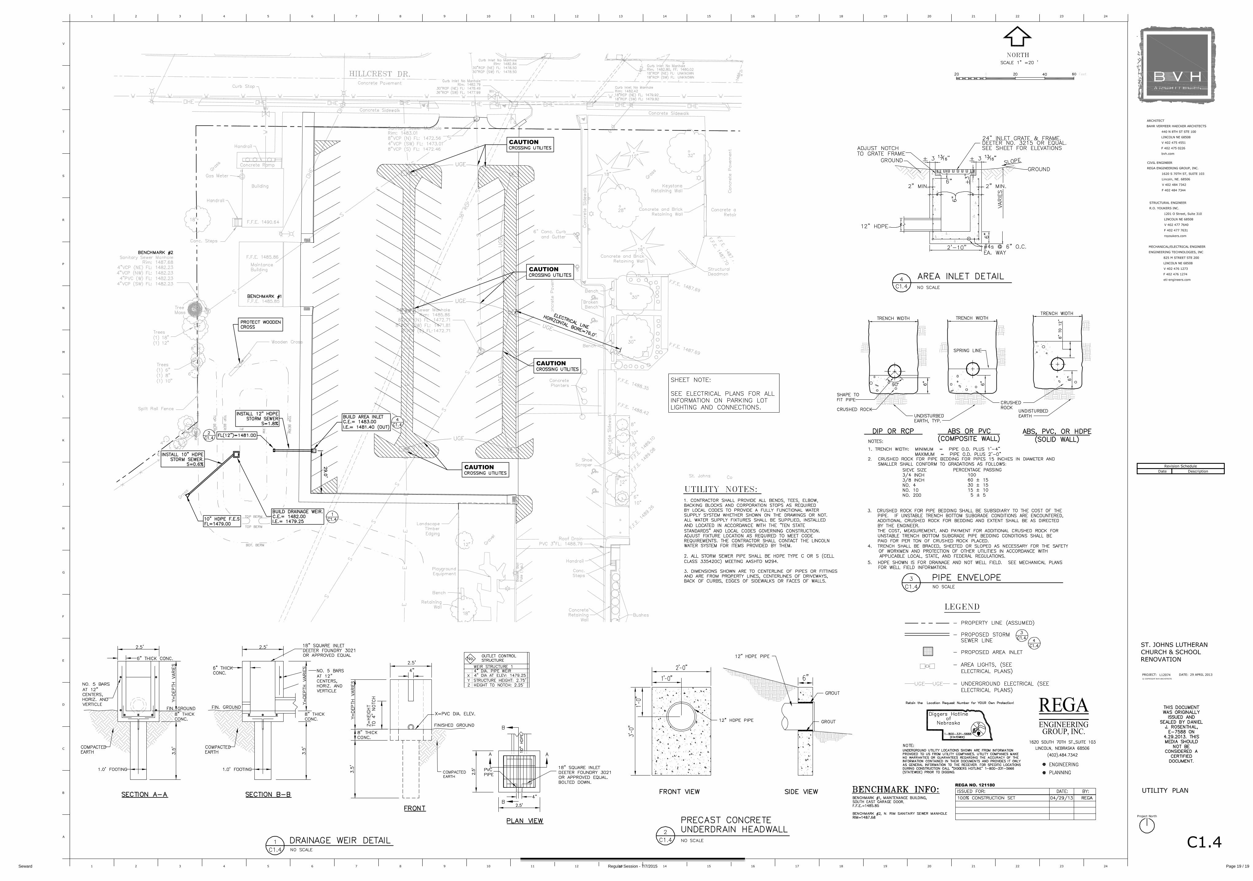
Administrative Report: St. John's Church is constructing a new Child Development Center on the property to the north of St. John Church/School located at the intersection of Columbia Ave. and Hillcrest Drive.
They are proposing relocating a current storm drain and a sanitary sewer line that cuts across the property and have reviewed the storm drainage system in this area and are proposing a new line be constructed.
They are requesting the City consider participating in the financial aspects of relocating and constructing the infrastructure.
St. John's Church first presented the request at the June 2, 2015 City Council meeting. Council directed staff to provide recommendations on financial participation in the project.
Seward Regular Session - 7/7/2015 Page 1 / 19

At the 6/16/15 meeting, Council tabled the request until additional information was obtained on the condition of the waste lines. This information will be presented at the meeting.
Following the presentation and discussion, Council to determine appropriate action.
Staff Contact:
Seward Regular Session - 7/7/2015 Page 2 / 19

Seward Regular Session - 7/7/2015 Page 3 / 19
Seward Regular Session - 7/7/2015 Page 4 / 19

Seward Regular Session - 7/7/2015 Page 5 / 19
1
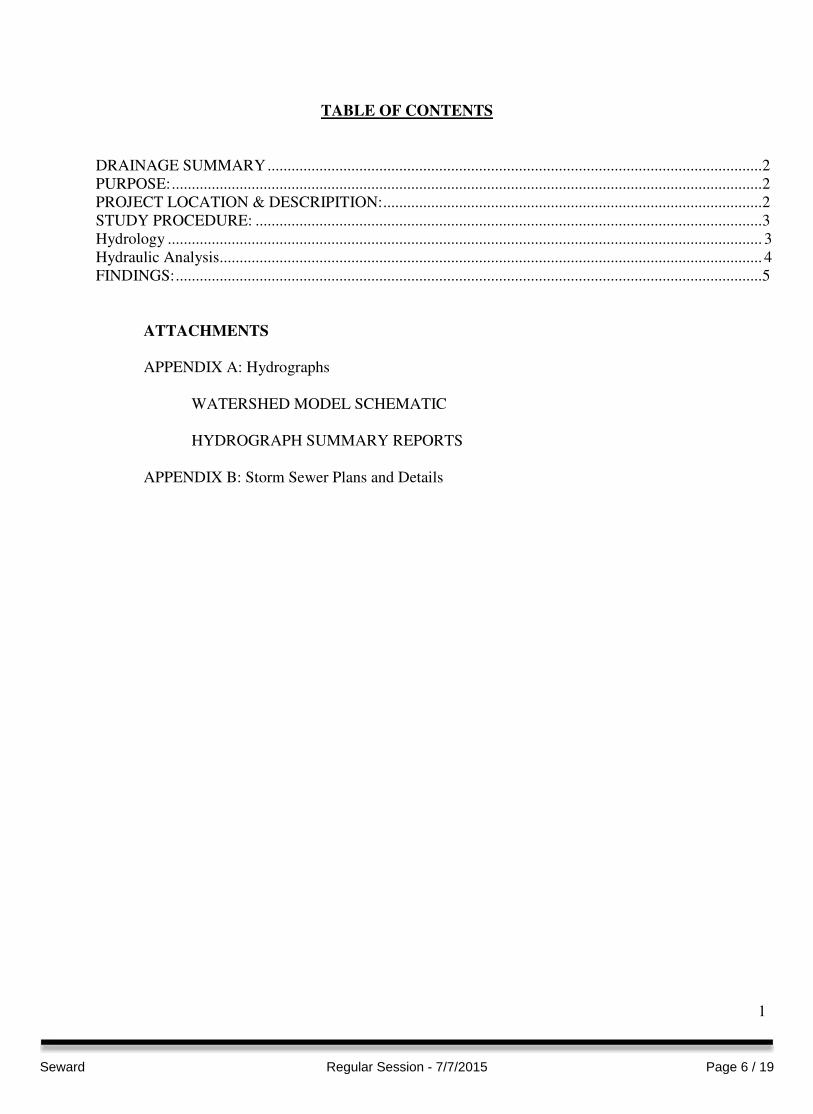
TABLE OF CONTENTS
DRAINAGE SUMMARY ............................................................................................................................ 2
PURPOSE: .................................................................................................................................................... 2
PROJECT LOCATION & DESCRIPITION: ............................................................................................... 2
STUDY PROCEDURE: ............................................................................................................................... 3
Hydrology ..................................................................................................................................................... 3
Hydraulic Analysis........................................................................................................................................ 4
FINDINGS: ................................................................................................................................................... 5
ATTACHMENTS
APPENDIX A: Hydrographs
WATERSHED MODEL SCHEMATIC
HYDROGRAPH SUMMARY REPORTS
APPENDIX B: Storm Sewer Plans and Details
Seward Regular Session - 7/7/2015 Page 6 / 19

2
DRAINAGE SUMMARY
ST. JOHN’S CDC
SEWARD, NE
PURPOSE:
The primary objective of this study was to create a formal report solidifying the calculations used
for design of the detention cell and mitigation of the Child Development Center (CDC) site and
church parking lot.
PROJECT LOCATION & DESCRIPITION:
St. John’s Lutheran church is located at the intersection of Hillcrest Drive and N. Columbia Ave.
in Seward, Nebraska. In preparation for the future child development center, a detention basin
has been designed as part of the parking lot paving project west of the existing church. The
location of the proposed child development center is located north of the church as shown
Figure 1: Pre-development conditions for St. John’s CDC. The current gravel parking lot is
bordered by the existing church on the east, Hillcrest Drive on the north, and residential housing
on the south and west. Post development parking lot plans can be found in Appendix B.
Figure 1: Pre-development conditions for St. John’s CDC
Seward Regular Session - 7/7/2015 Page 7 / 19
3
STUDY PROCEDURE:
Hydrology
A hydrologic analysis was performed using Hydrographs by Hydraflow to determine the impacts
of the proposed drainage on post-construction conditions. The SCS Method was used to model
storm events and estimate hydrologic conditions for this study. This method relates runoff rates
to precipitation depths, land use and topography. The peak runoff rate is determined by an
empirical equation that relates the quantity of runoff from a given area to a total rainfall falling at
a uniform rate on the same area.
Inputs required for the SCS method include:
• Drainage area (acres)
• Curve number
• Time of concentration
• Storm distribution
SCS curve numbers, used for predicting peak runoff, are based on the various land uses and soil
types as determined by the National Cooperative Soil Survey published by the United States
Department of Agriculture Natural Resources Conservation Service. In the case of multiple land
uses, a weighted average is calculated. Curve numbers for this project ranged from 74 for good
conditioned grass with slow to moderate infiltration rates to 98 for hard surfaces (concrete/roof).
The sub basin area, land use, hydrologic soil group, curve number and time of concentration for
each sub-basin were calculated
Time of concentration was calculated using the TR-55 method, which takes into account the
average basin slope and hydraulic length for each subarea. The hydraulic length is the distance
required from the most remote point in the drainage area to the catchment point.
A type II rainfall distribution, which has a storm duration of 24 hours, was used to model the 2-
10-100 year storm events. Due to the close proximity of the project to Lincoln, the design
rainfall intensity rates were estimated from Technical Paper No. 40 by the Weather Bureau, as
shown in Table 1: City of Lincoln, NE 24-hour design rainfall.
Table 1: City of Lincoln, NE 24-hour design rainfall
Frequency 24-hr Rainfall (in.)
2-year 3.00
10-year 4.69
100-year 6.68
Pre-development drainage areas were determined for both the proposed CDC Site and the
proposed parking lot. Three pre-development drainage areas were found on the both CDC site
and west of the existing church. The increase in runoff for post-development conditions was
calculated and modeled based on the proposed CDC site layout plan. A detention cell was
designed southwest of the proposed parking lot to capture and slowly release the difference in
pre and post development flows on the CDC Site.
Seward Regular Session - 7/7/2015 Page 8 / 19
4
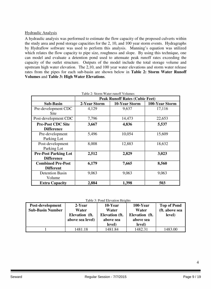
Hydraulic Analysis
A hydraulic analysis was performed to estimate the flow capacity of the proposed culverts within
the study area and pond storage capacities for the 2, 10, and 100 year storm events. Hydragraphs
by Hydraflow software was used to perform this analysis. Manning’s equation was utilized
which relates the flow capacity to pipe size, roughness and slope. By using this technique, one
can model and evaluate a detention pond used to attenuate peak runoff rates exceeding the
capacity of the outlet structure. Outputs of the model include the total storage volume and
upstream high water elevation. The 2,10, and 100 year water elevations and storm water release
rates from the pipes for each sub-basin are shown below in Table 2: Storm Water Runoff
Volumes and Table 3: High Water Elevations.
Table 2: Storm Water runoff Volumes
Peak Runoff Rates (Cubic Feet)
Sub-Basin 2-Year Storm 10-Year Storm 100-Year Storm
Pre-development CDC
Site
4,129 9,637 17,116
Post-development CDC 7,796 14,473 22,653
Pre-Post CDC Site
Difference
3,667 4,836 5,537
Pre-development
Parking Lot
5,496 10,054 15,609
Post-development
Parking Lot
8,008 12,883 18,632
Pre-Post Parking Lot
Difference
2,512 2,829 3,023
Combined Pre-Post
Different
6,179 7,665 8,560
Detention Basin
Volume
9,063 9,063 9,063
Extra Capacity 2,884 1,398 503
Table 3: Pond Elevation Heights
Post-development
Sub-Basin Number
2-Year
Water
Elevation (ft.
above sea level)
10-Year
Water
Elevation (ft.
above sea
level)
100-Year
Water
Elevation (ft.
above sea
level)
Top of Pond
(ft. above sea
level)
1 1481.18 1481.84 1482.31 1483.00
Seward Regular Session - 7/7/2015 Page 9 / 19
5
FINDINGS:
The primary objective of this study was to create a detention basin to mitigate the additional
runoff of the proposed child development center to at or below the pre-development levels for
the 2, 10 and 100-year storm events. Results in Table 2 show the volume of the detention basin
has additional capacity than the pre-post development difference. It should be noted that with
the slight reduction in the building footprint that resulted in the additional capacity shown in
Table 2.
Seward Regular Session - 7/7/2015 Page 10 / 19

APPENDIX A
HYDROGRAPHS
Seward Regular Session - 7/7/2015 Page 11 / 19

1 2 3 4 5 6 7 8 9
10
11
1
Watershed Model SchematicHydraflow Hydrographs Extension for AutoCAD® Civil 3D® 2015 by Autodesk, Inc. v10.4
Project: 121180 Pre-Post Storm Runoff 01_04_13.gpw Thursday, 07 / 2 / 2015
Hyd. Origin Description
Legend
1 SCS Runoff Pre-Development Area 1
2 SCS Runoff Pre-Development Area 2
3 SCS Runoff Pre-Development Area 3
4 SCS Runoff Post-Development Area 1 (North Side)
5 SCS Runoff Pre-Development Area 4
6 SCS Runoff Pre-Development Area 5
7 SCS Runoff Pre-Development Area 6
8 SCS Runoff Parking Lot Area Pre-Development (Gravel)
9 SCS Runoff Parking Lot Area Post-Development (Concrete)
10 Combine Combined North Pre-Development Area
11 Reservoir <no description>
Seward Regular Session - 7/7/2015 Page 12 / 19

Hydrograph Return Period Recap
2
Hyd. Hydrograph Inflow Peak Outflow (cfs) Hydrograph
No. type hyd(s) Description
(origin) 1-yr 2-yr 3-yr 5-yr 10-yr 25-yr 50-yr 100-yr
1 SCS Runoff ------ ------- 1.401 ------- 2.424 3.326 4.183 5.001 5.900 Pre-Development Area 1
2 SCS Runoff ------ ------- 0.061 ------- 0.105 0.143 0.179 0.214 0.252 Pre-Development Area 2
3 SCS Runoff ------ ------- 0.369 ------- 0.631 0.860 1.077 1.286 1.515 Pre-Development Area 3
4 SCS Runoff ------ ------- 3.816 ------- 5.503 6.886 8.121 9.262 10.49 Post-Development Area 1 (North Side
5 SCS Runoff ------ ------- 3.408 ------- 5.300 6.899 8.349 9.700 11.16 Pre-Development Area 4
6 SCS Runoff ------ ------- 1.143 ------- 1.613 1.996 2.337 2.652 2.990 Pre-Development Area 5
7 SCS Runoff ------ ------- 0.955 ------- 1.266 1.518 1.743 1.951 2.176 Pre-Development Area 6
8 SCS Runoff ------ ------- 2.676 ------- 3.816 4.749 5.580 6.347 7.171 Parking Lot Area Pre-Development (
9 SCS Runoff ------ ------- 3.436 ------- 4.526 5.414 6.208 6.942 7.734 Parking Lot Area Post-Development (
10 Combine 1, 2, 3, ------- 1.789 ------- 3.135 4.325 5.435 6.488 7.644 Combined North Pre-Development Ar
11 Reservoir 9 ------- 0.523 ------- 0.595 0.823 1.241 2.073 3.066 <no description>
Proj. file: 121180 Pre-Post Storm Runoff 01_04_13.gpw Thursday, 07 / 2 / 2015
Hydraflow Hydrographs Extension for AutoCAD® Civil 3D® 2015 by Autodesk, Inc. v10.4
Seward Regular Session - 7/7/2015 Page 13 / 19

Hydrograph Summary Report
3
Hyd. Hydrograph Peak Time Time to Hyd. Inflow Maximum Total Hydrograph
No. type flow interval Peak volume hyd(s) elevation strge used Description
(origin) (cfs) (min) (min) (cuft) (ft) (cuft)
1 SCS Runoff 1.401 2 720 3,264 ------ ------ ------ Pre-Development Area 1
2 SCS Runoff 0.061 2 718 124 ------ ------ ------ Pre-Development Area 2
3 SCS Runoff 0.369 2 718 742 ------ ------ ------ Pre-Development Area 3
4 SCS Runoff 3.816 2 716 7,796 ------ ------ ------ Post-Development Area 1 (North Side
5 SCS Runoff 3.408 2 720 7,809 ------ ------ ------ Pre-Development Area 4
6 SCS Runoff 1.143 2 716 2,363 ------ ------ ------ Pre-Development Area 5
7 SCS Runoff 0.955 2 716 2,171 ------ ------ ------ Pre-Development Area 6
8 SCS Runoff 2.676 2 716 5,496 ------ ------ ------ Parking Lot Area Pre-Development (
9 SCS Runoff 3.436 2 716 8,008 ------ ------ ------ Parking Lot Area Post-Development (
10 Combine 1.789 2 718 4,129 1, 2, 3, ------ ------ Combined North Pre-Development Ar
11 Reservoir 0.523 2 726 8,003 9 1481.18 2,827 <no description>
121180 Pre-Post Storm Runoff 01_04_13.gpwReturn Period: 2 Year Thursday, 07 / 2 / 2015
Hydraflow Hydrographs Extension for AutoCAD® Civil 3D® 2015 by Autodesk, Inc. v10.4
Seward Regular Session - 7/7/2015 Page 14 / 19

Hydrograph Summary Report
4
Hyd. Hydrograph Peak Time Time to Hyd. Inflow Maximum Total Hydrograph
No. type flow interval Peak volume hyd(s) elevation strge used Description
(origin) (cfs) (min) (min) (cuft) (ft) (cuft)
1 SCS Runoff 3.326 2 720 7,617 ------ ------ ------ Pre-Development Area 1
2 SCS Runoff 0.143 2 718 289 ------ ------ ------ Pre-Development Area 2
3 SCS Runoff 0.860 2 718 1,731 ------ ------ ------ Pre-Development Area 3
4 SCS Runoff 6.886 2 716 14,473 ------ ------ ------ Post-Development Area 1 (North Side
5 SCS Runoff 6.899 2 718 15,875 ------ ------ ------ Pre-Development Area 4
6 SCS Runoff 1.996 2 716 4,262 ------ ------ ------ Pre-Development Area 5
7 SCS Runoff 1.518 2 716 3,543 ------ ------ ------ Pre-Development Area 6
8 SCS Runoff 4.749 2 716 10,054 ------ ------ ------ Parking Lot Area Pre-Development (
9 SCS Runoff 5.414 2 716 12,883 ------ ------ ------ Parking Lot Area Post-Development (
10 Combine 4.325 2 718 9,637 1, 2, 3, ------ ------ Combined North Pre-Development Ar
11 Reservoir 0.823 2 726 12,879 9 1481.84 4,718 <no description>
121180 Pre-Post Storm Runoff 01_04_13.gpwReturn Period: 10 Year Thursday, 07 / 2 / 2015
Hydraflow Hydrographs Extension for AutoCAD® Civil 3D® 2015 by Autodesk, Inc. v10.4
Seward Regular Session - 7/7/2015 Page 15 / 19

Hydrograph Summary Report
5
Hyd. Hydrograph Peak Time Time to Hyd. Inflow Maximum Total Hydrograph
No. type flow interval Peak volume hyd(s) elevation strge used Description
(origin) (cfs) (min) (min) (cuft) (ft) (cuft)
1 SCS Runoff 5.900 2 718 13,528 ------ ------ ------ Pre-Development Area 1
2 SCS Runoff 0.252 2 716 512 ------ ------ ------ Pre-Development Area 2
3 SCS Runoff 1.515 2 716 3,075 ------ ------ ------ Pre-Development Area 3
4 SCS Runoff 10.49 2 716 22,653 ------ ------ ------ Post-Development Area 1 (North Side
5 SCS Runoff 11.16 2 718 26,145 ------ ------ ------ Pre-Development Area 4
6 SCS Runoff 2.990 2 716 6,563 ------ ------ ------ Pre-Development Area 5
7 SCS Runoff 2.176 2 716 5,164 ------ ------ ------ Pre-Development Area 6
8 SCS Runoff 7.171 2 716 15,609 ------ ------ ------ Parking Lot Area Pre-Development (
9 SCS Runoff 7.734 2 716 18,632 ------ ------ ------ Parking Lot Area Post-Development (
10 Combine 7.644 2 718 17,116 1, 2, 3, ------ ------ Combined North Pre-Development Ar
11 Reservoir 3.066 2 722 18,628 9 1482.31 6,356 <no description>
121180 Pre-Post Storm Runoff 01_04_13.gpwReturn Period: 100 Year Thursday, 07 / 2 / 2015
Hydraflow Hydrographs Extension for AutoCAD® Civil 3D® 2015 by Autodesk, Inc. v10.4
Seward Regular Session - 7/7/2015 Page 16 / 19

1
APPENDIX B
PLANS AND DETAILS
Seward Regular Session - 7/7/2015 Page 17 / 19

Seward Regular Session - 7/7/2015 Page 18 / 19
Seward Regular Session - 7/7/2015 Page 19 / 19