Embed Size (px)
Citation preview
City of Santa Ana General Plan
Scenic Corridors Element 1982
City of Santa Ana Planning Division
Adopted
September 20, 1982 (Reformatted January 2010)
This document includes revisions to the Scenic Corridors Element adopted by Santa Ana City Council December 31, 2019 (GPA 2018-04).

Acknowledgments
CITY COUNCIL
Gordon Bricken, Mayor Robert W. Luxembourger, Vice Mayor John Acosta Alfred C. Serrato Patricia A. McGuigan J. Ogden Markel Daniel Griset
PLANNING COMMISSION
Harold Gosse Roy Uno Robert Carrillo Rita Corpin Wally Bartelt Fred Munoz Wilson Hart
ADMINISTRATION AND STAFF
A. J. Wilson, City Manager Rex Swanson, Assistant City Manager for
Developmental Services Phil Freeland, Director of Planning and
Development Services David Gunderman, Chief of Planning Project
Director, GPRP Robert Balen, Project Coordinator David Ream, Director of Redevelopment Hank Cunningham, Program Manager,
Economic Development Samuel Johnson, Director of Public Works Robert Eichblatt, Assistant City Engineer Dave Grosse, Director of Transportation John Robinson, Senior Transportation Planner Richard Lay, Assistant City Attorney
CONSULTANTS
THE ARROYO GROUP Planners, Architects and Associated Disciplines
Larry, B. Morrison, AICP, AIA, Principal-in-Charge
Patric B. Dawe, AIA, Managing Principal P. Patrick Mann, Planning Principal James Goddell, Consulting Principal Aron W. Clemens, Planner Cliff Catlin, Graphic Designer Annie Smith, Graphics Patricia Guerrero, Word Processing POD, INC. Environmental Planning
Ron Izumita, Principal Doug Campbell, Project Manager Gary Bye, Project Planner Debra Asher, Project Planner PBQ&D, INC. Transportation Planning
Michael Scheider, Vice President Rober Goedhart, Senior Associate James Douglas, Transportation Planner ECONOMICS RESEARCH ASSOCIATES Economists
David A. Wilcox, Principal Geraldine Kennedy, Associate MELVIN GREEN & ASSOCIATES, INC. Seismic Safety
..

CITY OF SANTA ANA GENERAL PLAN i
Table of Contents
Scenic Corridors Element Summary ................................................................................................. 1 Planning Context ................................................................................... 6
Historical.......................................................................................... 6 Regional ........................................................................................... 6
Planning Process .................................................................................... 7 Policy Plan .............................................................................................. 8
Introduction ..................................................................................... 8 Planning Factors ............................................................................. 9 Plan Components ............................................................................ 9
Goals, Objectives, Policies and Programs ........................................... 10 Goals............................................................................................... 10 Objectives ....................................................................................... 10 Policies ........................................................................................... 11 Programs ........................................................................................ 11
Exhibits Exhibit 1 Framework Concept............................................................................... 3 Exhibit 2 Regional Context .................................................................................... 5 Exhibit 3 Planning Process .................................................................................... 8 Exhibit 4 Scenic Corridors Plan .......................................................................... 13

SCENIC CORRIDORS ELEMENT
ii CITY OF SANTA ANA GENERAL PLAN
This page intentionally left blank.
CITY OF SANTA ANA GENERAL PLAN 1
Scenic Corridors Element
SUMMARY
The new City of Santa Ana General Plan was developed through an extensive process of public participation involving citizens, elected and appointed City officials and City Staff.
The General Plan has been developed to conform to state law and to meet local planning needs through the year 2000. Periodic updates of the new General Plan are anticipated.
The General Plan builds upon Santa Ana’s historical assets including the City’s heritage as the governmental and financial center of Orange County and the buildings, districts and streetscapes which reflect this heritage.
The General Plan anticipates two major potentials that can shape Santa Ana over the next several decades. The plan anticipates and maximizes the probability of the Countywide rapid transit system to be located in Santa Ana and encourages mixed use development and preservation m corridors and centers relating to this new access and visibility.
The General Plan has three major sections: the Framework Plan, Policy Plan, and Environmental Impact Report.
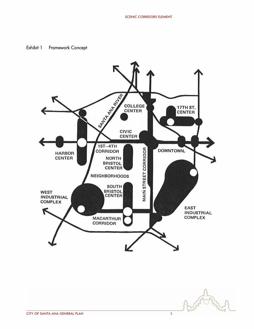
1. The Framework Plan describes Santa Ana’s overall planning strategy and program. This strategy reorganizes the City’s land use and urban design structure to take maximum advantage of:
the economic development advantages offered by Santa Ana’s historic regional location and functions
an improved multi-modal transportation system including:
– Countywide rapid transit access to Santa Ana – improved local transit – improved auto access to major activity centers – a new Amtrak station – a downtown multi-modal transportation and bus center
SCENIC CORRIDORS ELEMENT
2 CITY OF SANTA ANA GENERAL PLAN
– a downtown shuttle system – new pedestrian connections within and between land use districts
and to public transportation facilities.
The Framework Plan provides an overview of the City’s implementation program which includes:
continuing involvement of the community in developing the detailed implementation plans that will be developed for subareas of the Framework Plan
efficient processing of development and rehabilitation proposals by means of a Development Review Team
a carefully coordinated development program to foster and assist private investment through:
– land assembly – coordinated provision of public improvements – Specific Plans – citizen participation coordination – low interest loans and grants – project promotion
2. The Policy Plan spells out the:
goals and objectives which underlie the Framework Plan
greater detail regarding implementation policies and programs supporting the Framework Plan.
Together, the Framework Plan and Policy Plan envision a new image for Santa Ana consisting of:
increased economic activity to provide jobs and maintain a solid financial base for city services
improvement of Santa Ana’s housing stock for a full range of income groups and lifestyles
the finest multi-modal transportation system in Orange County
a new physical environment consisting of:
– preserved and enhanced viable Neighborhoods – District Centers combining new shopping facilities with
recreational, cultural, education, employment and special housing types
– improvement of Santa Ana’s major Industrial Districts – Mixed Use Corridors with a range of uses similar to the District
Centers but with more facilities related to regional transit and auto access.
SCENIC CORRIDORS ELEMENT
CITY OF SANTA ANA GENERAL PLAN 3
Exhibit 1 Framework Concept

SCENIC CORRIDORS ELEMENT
4 CITY OF SANTA ANA GENERAL PLAN
This page intentionally left blank.
SCENIC CORRIDORS ELEMENT
CITY OF SANTA ANA GENERAL PLAN 5
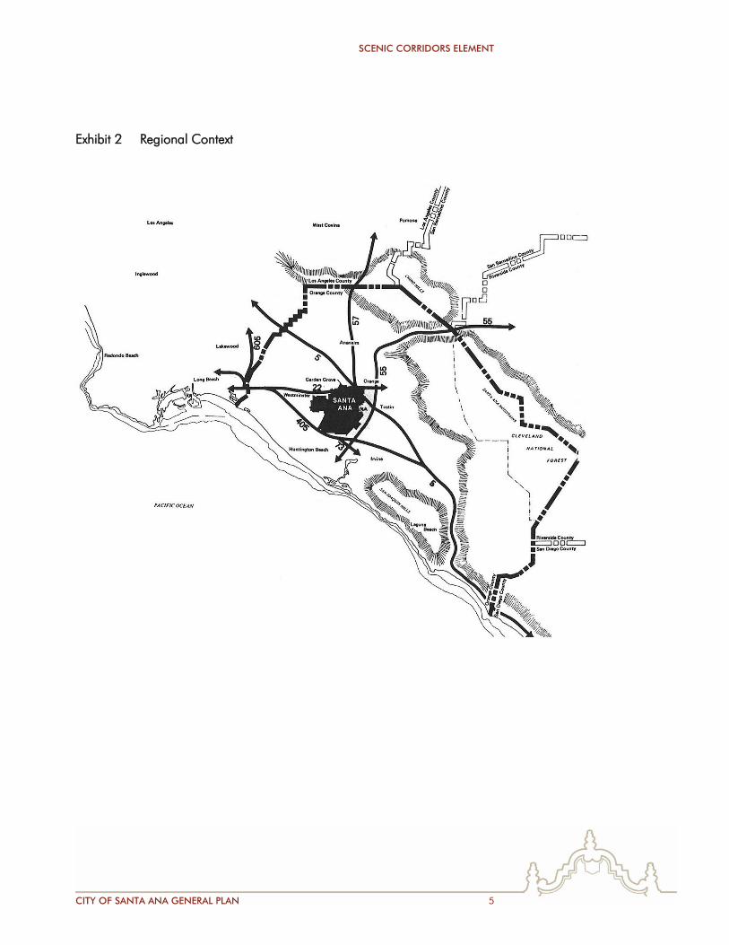
Exhibit 2 Regional Context
SCENIC CORRIDORS ELEMENT
6 CITY OF SANTA ANA GENERAL PLAN
3. The Environmental Impact Report contains:
an analysis of the impacts of implementation of the General Plan
an evaluation of alternative strategies and
mitigation means to insure compatibility of the proposed plans and policies.
PLANNING CONTEXT
HISTORICAL
Santa Ana’s rich history provides a legacy for community planning and revitalization in the 1980’s. Santa Ana was founded in 1869 by William Spurgeon. The original town, laid out by Mr. Spurgeon, consisted of 24 blocks. The town served as a shopping center and post office for surrounding agricultural areas.
In 1878 the Southern Pacific Railroad arrived and the Santa Fe Railroad followed in 1886. This encouraged development of the City. In 1889 the County seat was located in Santa Ana and this further stimulated the development of businesses, stores, financial institutions and hotels serving the metropolitan population. Citrus and walnut farms were still plentiful and buying and selling land became the number one enterprise. The First to 17th Street area was subdivided during the building boom of the 1880’s. Many of the structures in downtown and the surrounding bungalow homes were built in the early 1900’s and 1920’s.
The City is retaining and building upon its important governmental, retailing and employment roles in the County and the rich architectural and streetscapes heritage associated with the City’s history.
REGIONAL
Santa Ana is geographically central to the developable land within Orange County. The City has excellent relationships to freeways, rail services via Amtrak and air transportation at the John Wayne Airport. Because of Santa Ana’s geographic centrality and functional importance to the County, the Orange County Transit District is planning major fixed rail transit corridors in the Main Street and Pacific Electric right-of-ways. These regional transportation improvements, combined with improvements to freeway access points and local streets, provide Santa Ana with abundant development opportunities for the 1980’s.
SCENIC CORRIDORS ELEMENT
CITY OF SANTA ANA GENERAL PLAN 7
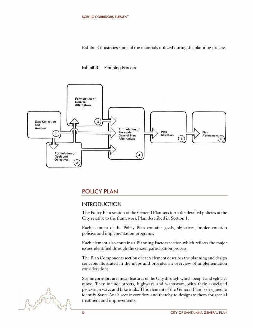
PLANNING PROCESS
The Planning Process used in creating the Santa Ana General Plan is summarized in Exhibit 3 and related photographs. The process involved:
a 150-person Citizen Advisory Committee (CAC) to which all citizens applying were appointed by the City Council
the Planning Commissioners who served as chairpersons of five CAC subcommittees: Land Use and Urban Design, Circulation, Housing, Economic Development and Environmental Factors
the City Council who participated in goal setting and policy making workshops
the public-at-large who participated in a series of Town Forums and Public Hearings
City Staff who worked with The Arroyo Group (TAG) in conducting the planning process and who evaluated the program as it evolved.
The six key steps in the planning process were:
1. Data Collection and Analysis. The data base for the previous General Plan was outdated and up-to-date census data was not available. Emphasis was placed on community definition of problems and opportunities through CAC and Staff Steering Committee workshops and mapping. TAG subcontractors also gathered key data in areas such as market demand, traffic, seismic, etc. This data was summarized and analyzed in a separate Problems and Opportunities Report.
2. Formulation of Goals and Objectives. Initial goals and objectives were developed through workshops, with the CAC and City staff. Several cycles of refinement were done by TAG based on input from the Planning Commission, City Council, CAC and staff.
3. Formulation of Subarea Alternatives. Santa Ana has a large number of fixed elements such as streets and land uses. Therefore, subarea plans were developed to provide alternative land use patterns in different parts of the City. Each subarea plan was related to an urban design framework previously approved by the CAC, Planning Commission and City staff.
4. Formulation of Areawide General Plan Alternatives. Areawide General Plan alternatives focused on different combinations of subarea plans.
5. Plan Selection Plan. Selection was done through a series of meetings with the CAC, Planning Commission and City staff.
6. Plan Refinement. Plan refinement was accomplished by staff review of a Preliminary Draft, and CAC, Planning Commission and Public-at-Large comments on a Public Hearing Draft.
SCENIC CORRIDORS ELEMENT
8 CITY OF SANTA ANA GENERAL PLAN
Exhibit 3 illustrates some of the materials utilized during the planning process.
Exhibit 3 Planning Process
POLICY PLAN
INTRODUCTION
The Policy Plan section of the General Plan sets forth the detailed policies of the City relative to the framework Plan described in Section 1.
Each element of the Policy Plan contains goals, objectives, implementation policies and implementation programs.
Each element also contains a Planning Factors section which reflects the major issues identified through the citizen participation process.
The Plan Components section of each element describes the planning and design concepts illustrated in the maps and provides an overview of implementation considerations.
Scenic corridors are linear features of the City through which people and vehicles move. They include streets, highways and waterways, with their associated pedestrian ways and bike trails. This element of the General Plan is designed to identify Santa Ana’s scenic corridors and thereby to designate them for special treatment and improvements.
SCENIC CORRIDORS ELEMENT
CITY OF SANTA ANA GENERAL PLAN 9
PLANNING FACTORS
No County-designated scenic highways run through Santa Ana. However, a number of major transportation system and open space systems, such as the freeways, the Santa Ana River, Santiago Creek and Harbor Boulevard are of regional significance in that many residents of the County form their image of Santa Ana from their travels along these corridors.
Enhancement of that image will accrue to the several levels of treatment possible within scenic corridors, from paving, lighting and signage design, to careful treatment of land use relationships and natural and man-made features visible from within the corridors.
PLAN COMPONENTS
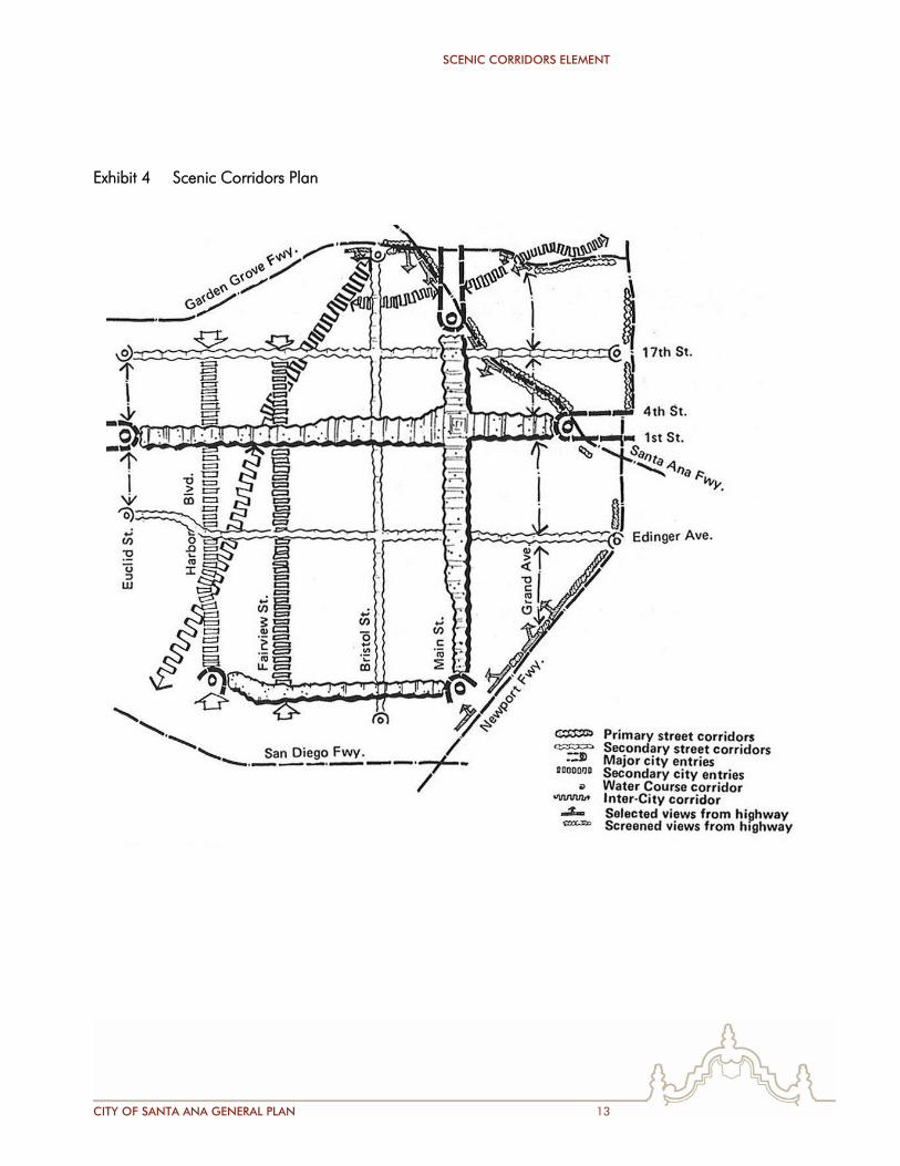
The foundation of the Scenic Corridors plan is the series of Mixed Use Corridors which underlies the entire General Plan. As will be seen on the map, Exhibit 4, the primary street corridors are First/ Fourth Streets, Main-Broadway, and MacArthur Boulevard. These primary corridors are significant transportation and activity features of the City, and are accessible from all freeways. At the edges of the City, these primary corridors form major City entry points, where strong statements of Santa Ana identity can and should be made.
Secondary corridors provide “stitching” to link neighborhoods, District Centers and Mixed Use Corridors together. Their continuity is interrupted by the primary corridors; these intersection points should be used to give the traveler a sense of entering major activity centers.
Harbor Boulevard, the traditional north-south link from the ocean to inland destinations, and Fairview Street, now proposed as a major, limited-access thoroughfare, are designated as inter-city corridors in recognition of their functions as major image-makers for the City.
The Newport, Santa Ana and Garden Grove Freeways are high-speed scenic corridors operating at a regional scale. They influence Santa Ana’s image. Therefore, the plan calls for two types of high-speed corridor treatment: buffer edges to screen unsightly or unnecessary views from the freeways; and landscaped edges designed to promote selected views into the City.
Additional regional corridors are the Santa Ana River and Santiago Creek, which are part of the County Open Space network and which are specifically addressed in the Open Space element.
A series of specific visual and aesthetic improvements are recommended for the Scenic Corridors. Phasing priority should be given to the primary Mixed Use corridors and/or to corridors in which near-term development is expected to take place.
SCENIC CORRIDORS ELEMENT
10 CITY OF SANTA ANA GENERAL PLAN
GOALS, OBJECTIVES, POLICIES AND PROGRAMS
GOALS
Goal 1
Improve the public image and expand the functional utility of the City’s linear transportation and open space corridors.
Goal 2
Use scenic corridors to provide identity, form, and an orientation framework for the City.
Goal 3
Conserve and enhance the existing scenic, functional and historic qualities of all streets and linear corridors.
OBJECTIVES
1.1 Improve and develop the public portions of streetscapes in a comprehensive manner.
1.2 Support development of flood control channels and waterways with aesthetic and recreational features.
1.3 Encourage improvement and maintenance of private properties along scenic corridors.
2.1 Provide scenic linkages between the Downtown/Civic Center and adjacent neighborhoods.
2.2 Provide scenic linkages between key historic sites, circulation elements and recreation areas.
2.3 Enhance the attractiveness of neighborhoods, neighborhood edges, and other Framework Plan components.
2.4 Integrate key circulation elements, open space areas, recreation features, historic sites and public facilities into the fabric of the scenic corridors.
3.1 Apply the goals and objectives of the Conservation and Open Space elements to achieve pertinent goals within scenic corridors.
SCENIC CORRIDORS ELEMENT
CITY OF SANTA ANA GENERAL PLAN 11
POLICIES
Ensure that development within scenic corridors takes place at a scale and is designed to that aesthetic features are consistent with the function of scenic corridors as part of the Framework Plan.
Ensure that development in the Downtown/Civic Center area and adjacent neighborhoods is planned so as to reinforce or create scenic linkages.
Ensure that development surrounding key historic sites, recreation and open space areas and circulation corridors is planned so as to reinforce or create scenic linkages in these areas.
Integrate bicycle and pedestrian trails in scenic corridors where possible.
Utilize the Capital Improvements Program to systematically upgrade the visual appeal of the City’s streetscapes.
PROGRAMS
Adopt Scenic Corridor Design Guidelines to govern all aspects of streetscape aesthetics at the specific plan approval stage.
Screen unsightly uses which can be viewed from scenic corridors.
Prohibit additional obtrusive land uses in the corridors.
Enforce anti-litter ordinances within the corridors.
Prohibit billboards and obtrusive neon and flashing signs within scenic corridors.
Ensure that the size, height, quantity and type of on-premises signs are not obtrusive to views within and from the corridors.
Require undergrounding of new and relocated utilities.
Institute graffiti removal and prevention programs within the corridors.
Promote unique, image-enhancing freeway landscaping where highways pass through the City by providing continuing input to Caltrans landscape planning activities.
Selectively landscape freeway corridor edges to screen undesirable scenes while promoting views of identifiable City features.
Ensure that landscaping at freeway interchanges which correspond to major City entry points is more visually significant than is the case with other interchanges.
SCENIC CORRIDORS ELEMENT
12 CITY OF SANTA ANA GENERAL PLAN
At major entry points to the City, install distinctive identity features such as entry monuments, directional information, City name, landscape statement, traffic lights, special street lighting and minor architectural elements.
At minor entry points to the City, install identity statements of a less dramatic visual nature than those at major entry points.
Include bicycle and pedestrian trail improvements for Scenic Corridors in the Capital Improvements Program.
Coordinate with County on integrated bicycle-equestrian trail on Santa Ana River.
Create a Master Plan for City’s medians.
Assign phasing priorities to streetscape improvement programs for Scenic Corridors.
Investigate means by which private property owners and the public-at-large can contribute to Scenic Corridor improvement programs.
Identify unique scenic features of neighborhood streets which should be preserved and enhanced.
SCENIC CORRIDORS ELEMENT
CITY OF SANTA ANA GENERAL PLAN 13
Exhibit 4 Scenic Corridors Plan

SCENIC CORRIDORS ELEMENT
14 CITY OF SANTA ANA GENERAL PLAN
This page intentionally left blank.