Embed Size (px)
Citation preview
City of Pickering
Whitevale Master Drainage Plan – Municipal Class Environmental Assessment Report
Prepared by: AECOM 300 – 300 Town Centre Boulevard 905 477 8400 tel Markham, ON, Canada L3R 5Z6 905 477 1456 fax www.aecom.com Project Number: 60187125 Date: March, 2013
Environment
City of Pickering
Whitevale Master Drainage Plan – Municipal Class Environmental Assessment Report
City of Pickering Whitevale Master Drainage Plan – Municipal
Class Environmental Assessment Report
AECOM: 2012-01-06 © 2009-2012 AECOM Canada Ltd. All Rights Reserved. 04ra_2013-03-22_Whitevalemdp-MCEA Final Rpt_60187125.Docx
Statement of Qualifications and Limitations The attached Report (the “Report”) has been prepared by AECOM Canada Ltd. (“Consultant”) for the benefit of the client (“Client”) in accordance with the agreement between Consultant and Client, including the scope of work detailed therein (the “Agreement”). The information, data, recommendations and conclusions contained in the Report (collectively, the “Information”):
is subject to the scope, schedule, and other constraints and limitations in the Agreement and the qualifications contained in the Report (the “Limitations”);
represents Consultant’s professional judgement in light of the Limitations and industry standards for the preparation of similar reports;
may be based on information provided to Consultant which has not been independently verified; has not been updated since the date of issuance of the Report and its accuracy is limited to the time period and
circumstances in which it was collected, processed, made or issued; must be read as a whole and sections thereof should not be read out of such context; was prepared for the specific purposes described in the Report and the Agreement; and in the case of subsurface, environmental or geotechnical conditions, may be based on limited testing and on the
assumption that such conditions are uniform and not variable either geographically or over time. Consultant shall be entitled to rely upon the accuracy and completeness of information that was provided to it and has no obligation to update such information. Consultant accepts no responsibility for any events or circumstances that may have occurred since the date on which the Report was prepared and, in the case of subsurface, environmental or geotechnical conditions, is not responsible for any variability in such conditions, geographically or over time. Consultant agrees that the Report represents its professional judgement as described above and that the Information has been prepared for the specific purpose and use described in the Report and the Agreement, but Consultant makes no other representations, or any guarantees or warranties whatsoever, whether express or implied, with respect to the Report, the Information or any part thereof. Without in any way limiting the generality of the foregoing, any estimates or opinions regarding probable construction costs or construction schedule provided by Consultant represent Consultant’s professional judgement in light of its experience and the knowledge and information available to it at the time of preparation. Since Consultant has no control over market or economic conditions, prices for construction labour, equipment or materials or bidding procedures, Consultant, its directors, officers and employees are not able to, nor do they, make any representations, warranties or guarantees whatsoever, whether express or implied, with respect to such estimates or opinions, or their variance from actual construction costs or schedules, and accept no responsibility for any loss or damage arising from or in any way related thereto. Persons relying on such estimates or opinions do so at their own risk. Except (1) as agreed to in writing by Consultant and Client; (2) as required by-law; or (3) to the extent used by governmental reviewing agencies for the purpose of obtaining permits or approvals, the Report and the Information may be used and relied upon only by Client. Consultant accepts no responsibility, and denies any liability whatsoever, to parties other than Client who may obtain access to the Report or the Information for any injury, loss or damage suffered by such parties arising from their use of, reliance upon, or decisions or actions based on the Report or any of the Information (“improper use of the Report”), except to the extent those parties have obtained the prior written consent of Consultant to use and rely upon the Report and the Information. Any injury, loss or damages arising from improper use of the Report shall be borne by the party making such use. This Statement of Qualifications and Limitations is attached to and forms part of the Report and any use of the Report is subject to the terms hereof.
AECOM 300 – 300 Town Centre Boulevard 905 477 8400 tel Markham, ON, Canada L3R 5Z6 905 477 1456 fax www.aecom.com
04ra_2013-03-22_Whitevalemdp-MCEA Final Rpt_60187125.Docx
March 22, 2013 Ms. Marilee Gadzovski, M.Sc.(Eng.), P.Eng. Senior Water Resources & Environmental Engineer Engineering Services Division Community Services Department City of Pickering Pickering Civic Complex One The Esplanade Pickering, ON L1V 6K7 Dear Ms. Gadzovski: Project No: 60187125 Regarding: Whitevale Master Drainage Plan – Municipal Class Environmental Assessment
Report AECOM is pleased to submit five (5) copies of the Whitevale Master Drainage Plan - Municipal Class Environmental Assessment Report. We would like to thank the City of Pickering for their assistance throughout the study. We would also like to acknowledge the valuable input received from the Whitevale Storm Water Committee and other interested members of the public. Should you have any questions or require further information please do not hesitate to contact the undersigned. Sincerely, AECOM Canada Ltd.
Glenn A Farmer Senior Environmental Technologist [email protected]
GAF:mm Encl.
City of Pickering Whitevale Master Drainage Plan – Municipal
Class Environmental Assessment Report
04ra_2013-03-22_Whitevalemdp-MCEA Final Rpt_60187125.Docx
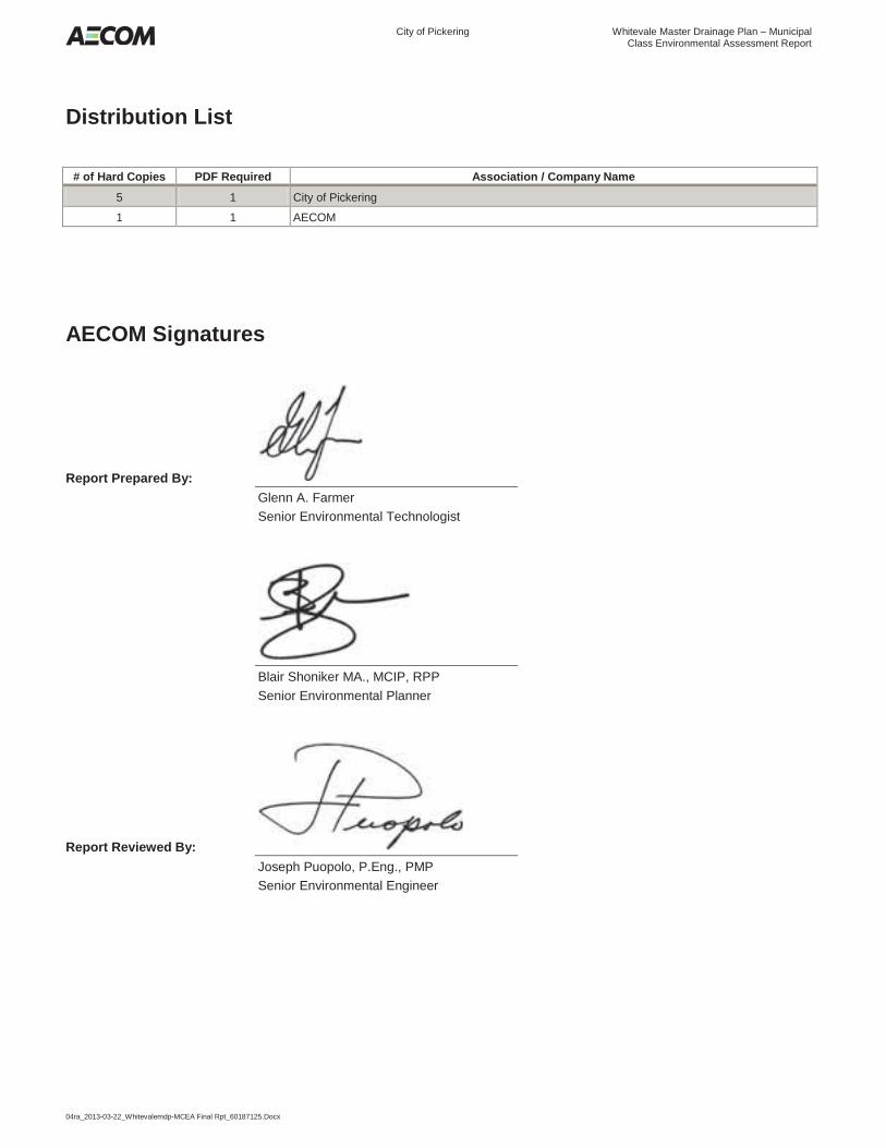
Distribution List
# of Hard Copies PDF Required Association / Company Name
5 1 City of Pickering
1 1 AECOM
AECOM Signatures
Report Prepared By:
Glenn A. Farmer Senior Environmental Technologist
Blair Shoniker MA., MCIP, RPP Senior Environmental Planner
Report Reviewed By:
Joseph Puopolo, P.Eng., PMP Senior Environmental Engineer
City of Pickering Whitevale Master Drainage Plan – Municipal
Class Environmental Assessment Report
04ra_2013-03-22_Whitevalemdp-MCEA Final Rpt_60187125.Docx i
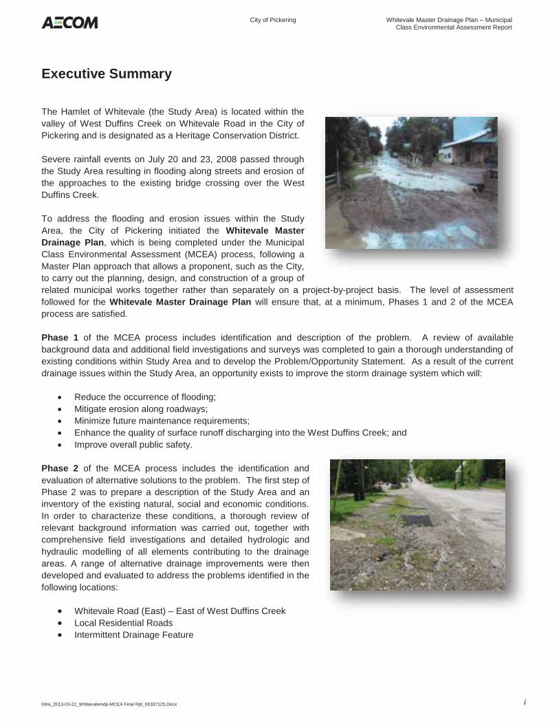
Executive Summary The Hamlet of Whitevale (the Study Area) is located within the valley of West Duffins Creek on Whitevale Road in the City of Pickering and is designated as a Heritage Conservation District. Severe rainfall events on July 20 and 23, 2008 passed through the Study Area resulting in flooding along streets and erosion of the approaches to the existing bridge crossing over the West Duffins Creek. To address the flooding and erosion issues within the Study Area, the City of Pickering initiated the Whitevale Master Drainage Plan, which is being completed under the Municipal Class Environmental Assessment (MCEA) process, following a Master Plan approach that allows a proponent, such as the City, to carry out the planning, design, and construction of a group of related municipal works together rather than separately on a project-by-project basis. The level of assessment followed for the Whitevale Master Drainage Plan will ensure that, at a minimum, Phases 1 and 2 of the MCEA process are satisfied. Phase 1 of the MCEA process includes identification and description of the problem. A review of available background data and additional field investigations and surveys was completed to gain a thorough understanding of existing conditions within Study Area and to develop the Problem/Opportunity Statement. As a result of the current drainage issues within the Study Area, an opportunity exists to improve the storm drainage system which will:
Reduce the occurrence of flooding; Mitigate erosion along roadways; Minimize future maintenance requirements; Enhance the quality of surface runoff discharging into the West Duffins Creek; and Improve overall public safety.
Phase 2 of the MCEA process includes the identification and evaluation of alternative solutions to the problem. The first step of Phase 2 was to prepare a description of the Study Area and an inventory of the existing natural, social and economic conditions. In order to characterize these conditions, a thorough review of relevant background information was carried out, together with comprehensive field investigations and detailed hydrologic and hydraulic modelling of all elements contributing to the drainage areas. A range of alternative drainage improvements were then developed and evaluated to address the problems identified in the following locations:
Whitevale Road (East) – East of West Duffins Creek Local Residential Roads Intermittent Drainage Feature
City of Pickering Whitevale Master Drainage Plan – Municipal
Class Environmental Assessment Report
04ra_2013-03-22_Whitevalemdp-MCEA Final Rpt_60187125.Docx ii
It should be noted that although the ‘Do Nothing’ alternative does not address the issues described in the Problem/Opportunity Statement, the EA Act requires its consideration in all Municipal Class EAs as a means of providing a benchmark for evaluating the other alternatives. The alternative solutions were comparatively evaluated according to a descriptive or qualitative assessment based on the appropriate criteria developed within the categories of Technical, Natural Environment, Social Environment, Cultural Environment and Financial representing the broad definition of the environment described in the Ontario Environmental Assessment Act (OEAA). Following public and agency engagement the recommended Master Drainage Plan was determined. This Plan consists of a combination of improvement measures to address flooding, erosion and water quality issues that will ensure adequate protection for the local residents within the Study Area. The elements of the Master Drainage Plan and the associated MCEA schedules include the following:
Whitevale Road (East) - Alternative # 2 Rural Reconstruction Schedule A+; Local Residential Roads – Alternative # 2 Local Road Improvements Schedule A; Intermittent Drainage Feature – Alternative # 5 Storm Flow Diversion to Whitevale Road Storm Sewer
Schedule A+; and Additional Surface Drainage and Erosion Improvements at Whitevale Road (West) and North Road
Schedule A. As part of implementing this project, mitigation and monitoring measures have been recommended to ensure protection and enhancement of natural environment, social environment and cultural environment features. Also additional considerations associated with project implementation have been identified as follows:
Permits & Approvals; Additional Studies; Construction Phasing & Integration; Weather Conditions; Detailed Design Considerations; and Additional Public Consultation
The Whitevale Master Drainage Plan has been completed to satisfy the requirements of the Ministry of the Environment (MOE) Municipal Class Environmental Assessment process, including public and regulatory agency consultation. Public consultation included notifications (Notice of Commencement and Notice of Completion), two Public Information Centres (PICs), and two Citizen Liaison Committee Meetings. All of the preferred solutions identified as elements of the Master Plan fall within Schedule A/A+ undertakings and can therefore proceed directly to detailed design and / or construction. For projects identified as Schedule A+, public notification is required prior to implementation.
City of Pickering Whitevale Master Drainage Plan – Municipal
Class Environmental Assessment Report
04ra_2013-03-22_Whitevalemdp-MCEA Final Rpt_60187125.Docx
Table of Contents Statement of Qualifications and Limitations Letter of Transmittal Distribution List Executive Summary
page
1. Introduction .................................................................................................................................. 1 1.1 Background .......................................................................................................................................... 1 1.2 Overview of the Municipal Class Environmental Assessment (MCEA) Planning Process ................. 1
1.2.1 Project Classifications............................................................................................................. 3 1.2.2 Master Plan Process............................................................................................................... 3 1.2.3 Public and Agency Consultation ............................................................................................. 6
2. Phase 1 – Identification & Description of the Problem .............................................................. 7 2.1 Definition of the Master Plan Study Area............................................................................................. 7 2.2 Identification of the Problem ................................................................................................................ 7 2.3 Problem/Opportunity Statement .......................................................................................................... 7
3. Phase 2 – Identification & Evaluation of Alternative Solutions to the Problem ....................... 8 3.1 General ................................................................................................................................................ 8 3.2 Description of the Study Area .............................................................................................................. 8 3.3 Summary of Available Background Information .................................................................................. 8
3.3.1 Background Data Collection and Review ............................................................................... 8 3.3.2 Field Investigations ................................................................................................................. 9
3.4 Study Area Physical Characteristics .................................................................................................. 10 3.4.1 Climate .................................................................................................................................. 10 3.4.2 Surficial Soils ........................................................................................................................ 10 3.4.3 Land Use .............................................................................................................................. 10 3.4.4 Archaeological & Heritage Resources .................................................................................. 10 3.4.5 Environmental Features & Natural Hazards ......................................................................... 11
3.4.5.1 Environmental Features ..................................................................................... 11 3.4.5.2 Natural Hazards.................................................................................................. 12
3.4.6 Surface Drainage .................................................................................................................. 12 3.5 Existing Storm Drainage Capacity Assessment ................................................................................ 12
3.5.1 Study Area Peak Flow Estimates ......................................................................................... 13 3.5.2 Intermittent Drainage Feature Hydraulic Capacity Assessment ........................................... 13 3.5.3 Whitevale Road Storm Drainage Capacity Assessment ...................................................... 15
3.5.3.1 Field Survey & CCTV Visual Inspection ............................................................. 15 3.5.3.2 Sewer Design Capacity ...................................................................................... 15 3.5.3.3 Hydraulic Grade Line (HGL) Assessment .......................................................... 15
4. Identification and Description of Alternative Solutions .......................................................... 17 4.1.1 Whitevale Road (East) .......................................................................................................... 17
4.1.1.1 Alternative #1 - Do Nothing ................................................................................ 17 4.1.1.2 Alternative #2 – Rural Reconstruction ................................................................ 17 4.1.1.3 Alternative #3 – Urban Reconstruction .............................................................. 17
4.1.2 Local Residential Roads ....................................................................................................... 17 4.1.2.1 Alternative #1 - Do nothing ................................................................................. 18
City of Pickering Whitevale Master Drainage Plan – Municipal
Class Environmental Assessment Report
04ra_2013-03-22_Whitevalemdp-MCEA Final Rpt_60187125.Docx
4.1.2.2 Alternative #2 – Local Road Improvements ....................................................... 18 4.1.2.3 Alternative #3 – Rural Reconstruction ................................................................ 18 4.1.2.4 Alternative #4 – Urban Reconstruction .............................................................. 18
4.1.3 Intermittent Drainage Feature ............................................................................................... 18 4.1.3.1 Alternative #1 - Do nothing ................................................................................. 18 4.1.3.2 Alternative #2 – Downstream Channel Improvements ....................................... 18 4.1.3.3 Alternative #3 – Upstream Storage Pond ........................................................... 18 4.1.3.4 Alternative #4 – Storm Flow By-Pass Sewer ..................................................... 19 4.1.3.5 Alternative #5 – Storm Flow Diversion to Whitevale Road Storm Sewer........... 19
4.2 Evaluation of Alternative Solutions .................................................................................................... 19 4.2.1 Description of the Evaluation Methodology .......................................................................... 19 4.2.2 Application of the Evaluation Methodology .......................................................................... 19 4.2.3 Components of the Selected Alternative Solution ................................................................ 20
5. Public Consultation ................................................................................................................... 23 5.1 Public and Agency Consultation during Phase 1 .............................................................................. 23
5.1.1 Notification of Project Commencement and Invitation for Comments .................................. 23 5.1.2 Comments Received and Their Consideration in the Project .............................................. 23 5.1.3 Notification of Public Information Centre (PIC) #1 ................................................................ 23 5.1.4 Public Information Centre (PIC) #1 ....................................................................................... 23 5.1.5 Comments Received During PIC #1 and Their Consideration in the Project ....................... 24 5.1.6 Notification of Public Information Centre (PIC) #2 ................................................................ 25 5.1.7 Public Information Centre (PIC) #2 ....................................................................................... 25 5.1.8 Comments Received During PIC #2 and Their Consideration in the Project ....................... 26 5.1.9 Citizen Liaison Committee Meetings .................................................................................... 27
5.1.9.1 Citizen Liaison Committee Meeting #1 ............................................................... 27 5.1.9.2 Citizen Liaison Committee Meeting #2 ............................................................... 27
6. Description, Implementation and Monitoring of the Master Drainage Plan ........................... 28 6.1 Elements of the Master Plan ............................................................................................................. 28
6.1.1 Whitevale Road (East) - Alternative # 2 Rural Reconstruction............................................. 28 6.1.2 Local Residential Roads – Alternative # 2 Local Road Improvements ................................ 28 6.1.3 Intermittent Drainage Feature – Alternative # 5 Storm Flow Diversion to Whitevale
Road Storm Sewer ............................................................................................................... 28 6.1.4 Additional Surface Drainage & Erosion Improvements ........................................................ 28
6.1.4.1 Whitevale Road (West) ...................................................................................... 29 6.1.4.2 North Road ......................................................................................................... 29
6.2 Implementation Considerations ......................................................................................................... 29 6.2.1 Estimated Master Plan Component Costs ........................................................................... 29 6.2.2 Summary of the Potential Effects and Recommended Mitigation Measures ....................... 30 6.2.3 Notification of Project Completion ........................................................................................ 30
6.3 Timeframe for Implementation ........................................................................................................... 32
7. Summary .................................................................................................................................... 33
City of Pickering Whitevale Master Drainage Plan – Municipal
Class Environmental Assessment Report
04ra_2013-03-22_Whitevalemdp-MCEA Final Rpt_60187125.Docx
List of Figures
Figure 1. Study Area .................................................................................................................................................. 2 Figure 2. Overview of the Municipal Class EA Process ............................................................................................ 5 Figure 3. Existing Surficial Soils ...........................................................................................................Back of Report Figure 4. Existing Land Use .................................................................................................................Back of Report Figure 5. Existing Environmental Features & Natural Hazards ............................................................Back of Report Figure 6. Existing Drainage Infrastructure ............................................................................................Back of Report Figure 7. Existing Surface Drainage Conditions ..................................................................................Back of Report Figure 8. Existing Surface Drainage Conditions North .........................................................................Back of Report Figure 9. Existing Condition 100-Year Floodplain Delineation .............................................................Back of Report Figure 10. Whitevale Road (East) Storm Sewer Drainage System........................................................Back of Report Figure 11. Whitevale Road (West) Storm Sewer Drainage System.......................................................Back of Report List of Tables
Table 4-1: Components of the Preferred Solution ..................................................................................................... 21 Table 5-1: Comments and Responses PIC #1 .......................................................................................................... 24 Table 5-2: Comments and Responses PIC #2 .......................................................................................................... 26 Table 6-1: Summary of Estimated Master Plan Component Costs........................................................................... 29 Table 6-2: Mitigation and Monitoring Measures ........................................................................................................ 31 Appendices
Appendix A. Background Data Sources Appendix B. Field Investigations Appendix C. Stage 1 Archaeology Report Appendix D. Hydrologic Information Appendix E. Hydraulic Information Appendix F. Alternatives Evaluation & Preferred Solutions Appendix G. Public Consultation
City of Pickering Whitevale Master Drainage Plan – Municipal
Class Environmental Assessment Report
04ra_2013-03-22_Whitevalemdp-MCEA Final Rpt_60187125.Docx 1
1. Introduction 1.1 Background
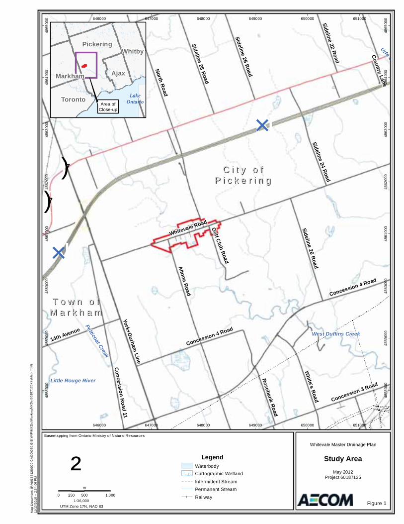
The Hamlet of Whitevale (the Study Area) is located within the valley of West Duffins Creek on Whitevale Road in the City of Pickering and is designated as a Heritage Conservation District (refer to Figure 1). In July 2008, severe rainfall events (July 20 and 23, 2008) that passed through the Study Area resulted in flooding along streets and erosion of the approaches to the existing bridge crossing over the West Duffins Creek. Following this event, the City of Pickering retained AECOM Canada Ltd. to carry out an emergency inspection of the bridge which confirmed significant erosion damage along the approach embankments caused by surface runoff from the surrounding lands as well as damage/blockage of the existing storm sewer outfall adjacent to the bridge crossing. In addition, significant quantities of sand and gravel had been deposited into the watercourse as a result of flooding and erosion along local roads. In order to address the existing flooding and erosion issues within the Study Area, the City of Pickering initiated the Whitevale Master Drainage Plan, which is being completed under the Municipal Class Environmental Assessment (MCEA) process. Specific objectives of this Study are to:
Collect available background data and carry out additional field investigations and site surveys in order to gain a thorough understanding of existing conditions within Study Area;
Develop and evaluate a range of alternative drainage improvements, including source, conveyance and end-of-pipe measures, structural works, management practices and policies that can be applied to address identified problems;
Identify additional stormwater retrofit measures that can be incorporated into the existing development to address both stormwater quality treatment and flow control;
Ensure that all solutions achieve adequate protection for the local residents within the Study Area; and,
Satisfy the requirements of the Ministry of the Environment (MOE) Municipal Class Environmental Assessment process, including public and regulatory agency consultation.
1.2 Overview of the Municipal Class Environmental Assessment (MCEA) Planning Process
As required under the Ontario Environmental Assessment Act (OEAA), the Study followed the MCEA planning process, as prescribed by the Municipal Engineers Association (MEA) Class EA document - October, 2000 as amended in 2007 & 2011. The MCEA process allows the City to satisfy the requirements of the EA Act for municipal infrastructure without having to either undertake an Individual EA or request a specific exemption for the project. Municipal projects addressed by the MCEA may be implemented without further approval under the OEAA, provided that the approved MCEA planning process is carried out. The stated purpose of the OEEA is to provide for the betterment of the people of the whole or any part of Ontario by providing for the protection, conservation and wise management in Ontario of the environment, where the broad environment includes the natural, social, cultural, built, and economic environments. The provisions of the OEEA require municipalities to carry out an environmental assessment for public works projects, including those undertaken for municipal roads, water and wastewater systems, and transit ventures that are subject to the MCEA. As described in the MEA Class EA document, this process is a five phased decision-making framework for the planning and design of municipal infrastructure.
C i t y o fC i t y o fP i c k e r i n gP i c k e r i n g
T o w n o fT o w n o fM a r k h a mM a r k h a m
Petticoat Creek
Urfe C
()7
()7
Whitevale Road
North Road
Altona Road
York+Durham Line
Concession R
oad 11
White's Road Concession 3 Road
14th Avenue
Sideline 32 Road
Sideline 26 Road
Sideline 28 Road
Rosebank Road
Concession 7 Road
Sideline 24 Road
Concession 4 Road
Golf Club Road
Sideline 22 Road
Country Lane
Sideline 26 Road
Concession 4 Road
N×
N×
West Duffins Creek
Little Rouge River
646000
646000
647000
647000
648000
648000
649000
649000
650000
650000
651000
651000
4858
000
4858
000
4859
000
4859
000
4860
000
4860
000
4861
000
4861
000
4862
000
4862
000
4863
000
4863
000
4864
000
4864
000
4865
000
4865
000
UTM Zone 17N, NAD 83
Basemapping from Ontario Ministry of Natural Resources
Study Area
Figure 1
May 2012Project 60187125
Whitevale Master Drainage Plan
0 500 1,000250
m
1:36,000
Map
Doc
umen
t: (P
:\601
8712
5\00
0-C
AD
D\0
50 G
IS W
IP\M
XD
s\W
orki
ngM
XD
s\60
1871
25K
eyM
ap.m
xd)
11/1
0/20
10 --
2:5
4:06
PM
LegendWaterbodyCartographic Wetland
Intermittent StreamPermanent StreamRailway
LakeOntarioArea of
Close-up
Pickering
Toronto
Ajax
Whitby
Markham
²
City of Pickering Whitevale Master Drainage Plan – Municipal
Class Environmental Assessment Report
04ra_2013-03-22_Whitevalemdp-MCEA Final Rpt_60187125.Docx 3
The key principles of the MCEA process include:
Consultation with affected parties upon commencement, and throughout the process, of the project; Consideration of a reasonable range of alternatives, including both the functionally different “alternatives
to” and the “alternative methods” of implementing the preferred solution; Identification and consideration of the effects of each alternative solution and/or method on all aspects of
the environment (i.e., natural, cultural, social, economic, etc.); Systematic evaluation of all alternative solutions and/or methods in terms of the advantages and
disadvantages associated with each to determine the net environmental effects; and Provision of clear and complete documentation of the planning process followed, to ensure transparency
and traceability of the decision-making process followed for the project.
1.2.1 Project Classifications
The MEA Class EA document classifies projects into four separate categories depending on the potential environmental effects and significance: Schedule A, A+, B, and C undertakings. The level of review associated with each category to satisfy the MCEA requirements, and thereby achieve compliance with the EA Act, is described below.
Schedule A/A+ ..... This category includes projects that are limited in scale, have minimal environmental impacts and include a number of municipal maintenance and operational activities. These undertakings are approved and may proceed directly to Phase 5 for implementation without completing the other phases. As part of the 2007 amendments to the MCEA process, the Schedule A+ classification was introduced to supplement the requirements of Schedule A undertakings, which includes projects that are pre-approved; however, the public must be notified prior to project implementation (i.e., Phase 5).
Schedule B........... These projects have the potential for some adverse environmental effects and, therefore, the municipality is required to undertake a screening process (i.e., Phases 1 and 2) involving mandatory contact with directly affected public and relevant agencies to ensure that they are aware of the project and that their concerns are addressed. In addition, it is required that a document must be prepared and submitted for review by the public and review agencies for these undertakings. If there are no outstanding concerns, the municipality may proceed to Phase 5 for implementation.
Schedule C........... Projects included under this classification have the potential for significant environmental effects and must proceed under the full planning and documentation procedures specified in the MEA Class EA document (i.e., Phases 1 to 4). An Environmental Study Report must be prepared and submitted for review by the public and relevant agencies for these undertakings. If there are no outstanding concerns, the municipality may proceed to Phase 5 for implementation.
1.2.2 Master Plan Process
The MEA Class EA document includes a Master Plan process that allows a proponent, such as the City, to carry out the planning, design, and construction of a group of related municipal works together rather than separately on a project-by-project basis, thus providing the following benefits:
The rationale for the individual projects is better defined; The infrastructure alternatives are more broadly established;
City of Pickering Whitevale Master Drainage Plan – Municipal
Class Environmental Assessment Report
04ra_2013-03-22_Whitevalemdp-MCEA Final Rpt_60187125.Docx 4
The extent of potential effects are better understood; The ability to integrate land use planning; and The ability to assess decisions from a variety of perspectives.
The Master Planning process differs from project specific undertakings in several aspects, and facilitates long range planning that enables the municipality to identify opportunities and proactively develop strategies for addressing any associated issues. This approach generally yields a series of individual activities, projects, and programs, together with a phased implementation plan that covers an extended time period. Accordingly, the works may be implemented separately as individual projects but, collectively, they form part of the overall management system embodied in the Master Plan. An outcome of the Master Planning process is the identification of individual projects as Schedule A, A+, B, or C undertakings, based on their level of complexity and potential effects on the environment. The level of assessment followed for the Whitevale Master Drainage Plan will ensure that, at a minimum, Phases 1 and 2 of the MCEA process are satisfied. The resulting storm drainage improvement strategy will consider a reasonable range of alternatives to address deficiencies in the drainage system and identify potential solutions to reduce the risk of flooding of roadways and properties, reduce surface erosion and, where possible, enhance the quality of stormwater runoff discharged into the West Duffins Creek. The Study is being undertaken in accordance with Approach #2, as described in Appendix 4 of the MEA Class EA document. This approach involves the preparation of a Master Plan document at the conclusion of Phases 1 and 2 of the MCEA process where the level of investigation, consultation and documentation are sufficient to fulfill the requirements for Schedule B projects. Any Schedule C undertakings identified in the Master Plan document will require the completion of Phases 3 and 4 of the MCEA prior to the implementation of the proposed works. An overview of the MCEA process is shown on Figure 2, which provided the framework for the current Study, and the following provides a description of the phases that will be completed for the Whitevale Master Drainage Plan. Phase 1: Identify the Problem / Opportunity
This phase involves not only identifying the problem/opportunity, but also describing it in sufficient detail to lead to a clear problem/opportunity statement. As part of describing the problem/opportunity, input from review agencies and the public can be solicited.
Phase 2: Identify and Evaluate Alternative Solutions to the Problem / Opportunity
This phase involves the following six steps:
Prepare a general inventory of the existing natural, social and economic environments in which the project is to occur;
Identify all reasonable alternative solutions to the problem / opportunity; Identify the net positive and negative effects of each alternative solution including mitigating
measures; Evaluate the alternative solutions; Consult with review agencies and the public to solicit comment and input; and Select or confirm the recommended solution(s).

City of Pickering Whitevale Master Drainage Plan – Municipal
Class Environmental Assessment Report
04ra_2013-03-22_Whitevalemdp-MCEA Final Rpt_60187125.Docx 5
Figure 2. Overview of the Municipal Class EA Process
PHASE 1 Identify & Describe the Problem
PHASE 3 Identify Alternative Design
Concepts, Potential Environmental Effects and the Preferred Concept
PHASE 4 Prepare Environmental Study
Report Documenting Phases 1 - 3
PHASE 2 Evaluate Alternative Solutions & Establish the Preferred Solution
Schedule ‘C’
Project Schedule
‘B’ Project
Schedule ‘A’, ‘B’ & ‘C’ Projects
Opportunity Part II Order
Discretionary Review Agency / Public
Consultation
30 CALENDAR DAY PUBLIC REVIEW PERIOD
PHASE 1 Identify & Describe the Problem
Schedule A/A+ Project
PHASE 3 Identify Alternative Design
Concepts, Potential Environmental Effects and the Preferred Concept
PHASE 4 Prepare Environmental Study
Report Documenting Phases 1 - 3
IMPLEMENTATION OF THE PROJECTS THAT MAKE UP THE MASTER PLAN
PHASE 2 Evaluate Alternative Solutions & Establish the Preferred Solution
Schedule C
Project
File Master Plan Document
Schedule B
Project
Schedule A, A+, B & C
for
Discretionary Review Agency / Public
Consultation
Mandatory Review Agency / Public
Consultation
Public Information Forum # 2
March 11, 2010
Public Information Forum # 1 May 20, 2009
Discretionary Review Agency / Public
Consultation
Note: The MCEA process followed for the current study is highlighted in blue.
City of Pickering Whitevale Master Drainage Plan – Municipal
Class Environmental Assessment Report
04ra_2013-03-22_Whitevalemdp-MCEA Final Rpt_60187125.Docx 6
Following completion of Phase 2, documentation of the initial two phases must be prepared and placed on public record for a period of at least 30 calendar days to provide review agencies and the public with an opportunity to review these materials. During this review period, concerned individuals have an opportunity to request a Part II Order under the OEAA for proposed works identified as either Schedule B or C undertakings before the project may proceed to implementation. A Part II Order requires that an Individual EA be carried out, documented, and submitted to the Minister of the Environment for review and approval. The decision on whether the project should be subject to a Part II Order rests with the Minister. In addition, the Minister may deny the Part II Order, but attach a condition to the denial requiring the proponent to undertake the Project as a Schedule C rather than a Schedule B under the MCEA process. Once the public review period has expired and there are no outstanding Part II Order requests (for Schedule B and C projects), the municipality may proceed to the final phase of the planning and design process. Phase 5: Complete Contract Drawings and Documents and Proceed to Construct, Operate, and Monitor the
Project
This phase involves completing contract drawings and tender documents, incorporating the recommended solution and mitigating measures identified during the previous phases of the process. Once contracts are awarded, construction can take place and the project is implemented. Any monitoring programs identified during the MCEA process shall be undertaken to ensure that the environmental provisions and commitments made during the process are fulfilled and effective.
1.2.3 Public and Agency Consultation
As required under the MCEA process, consultation with the public and government review agencies is necessary throughout the project. The purpose of the consultation process is to inform stakeholders of the project details and give all interested parties an opportunity to provide input or comments related to the undertaking. A description of the consultation activities carried out during Phases 1 and 2 of the Whitevale Master Drainage Plan are presented in Section 2 and 5 of the report.
City of Pickering Whitevale Master Drainage Plan – Municipal
Class Environmental Assessment Report
04ra_2013-03-22_Whitevalemdp-MCEA Final Rpt_60187125.Docx 7
2. Phase 1 – Identification & Description of the Problem 2.1 Definition of the Master Plan Study Area
The area under consideration for this Study is the Hamlet of Whitevale (the Study Area), located within the valley of West Duffins Creek on Whitevale Road in the City of Pickering and is designated as a Heritage Conservation District. The Study Area comprises a total area of 37.3 ha (Figure 1). For the purpose of the hydrologic analyses and related investigations undertaken as part of the existing conditions assessment, the Study Area has been expanded to include the catchment areas that contribute to the West Duffins Creek within the Study Area, as shown on subsequent report figures. The hydrologic Study Area covers an area of approximately 95 ha, which is dominated by a mixture of agricultural lands, forested valley land and large residential properties that have not changed significantly in character since the late 19th century.
2.2 Identification of the Problem
In July 2008, severe rainfall events (July 20th and 23rd) that passed through the Study Area resulted in flooding along streets, several properties and erosion of the approaches to the historic Whitevale bridge crossing over the West Duffins Creek. The City of Pickering retained AECOM Canada Ltd. to carry out an emergency inspection of the bridge that confirmed significant erosion damage along the approach embankments caused by surface runoff from the surrounding lands as well as damage/blockage of the existing culvert adjacent to the bridge crossing. In addition, significant quantities of sand and gravel had been deposited into the watercourse as a result of erosion of local roadside shoulders. Excess runoff generated from the surrounding lands also resulted in localized flooding and subsequent damage to private property.
2.3 Problem/Opportunity Statement
As a result of the current drainage issues within the Study Area, an opportunity exists to improve the storm drainage system which will:
Reduce the occurrence of flooding; Mitigate erosion along roadways; Minimize future maintenance requirements; Enhance the quality of surface runoff discharging into the West Duffins Creek; and Improve overall public safety
City of Pickering Whitevale Master Drainage Plan – Municipal
Class Environmental Assessment Report
04ra_2013-03-22_Whitevalemdp-MCEA Final Rpt_60187125.Docx 8
3. Phase 2 – Identification & Evaluation of Alternative Solutions to the Problem
3.1 General
Given that the Study is following the MCEA process for a Master Plan (Approach # 2) and there was the potential that the plan would consist of a variety of Schedule A, B and C undertakings, the first step of Phase 2 was to prepare a description of the Study Area and an inventory of the existing natural, social and economic conditions. In order to characterize these conditions, a thorough review of relevant background information was carried out, together with comprehensive field investigations and detailed hydrologic and hydraulic modelling of all elements contributing to the drainage areas.
3.2 Description of the Study Area
Following the identification of the problem and opportunities established for the Study, an assessment of existing environmental conditions was undertaken. The purpose of this step in the MCEA process is to establish an inventory of the natural, social and economic environments within the Study Area, which are to be considered when determining the potential effects that could result from the implementation of each of the alternative solutions. The existing conditions assessment included a comprehensive review of available background information, together with the results of specific field investigations to fill any data gaps identified. A summary of the secondary source information reviewed and the field reconnaissance carried out is provided below.
3.3 Summary of Available Background Information
3.3.1 Background Data Collection and Review
In order to characterize existing Study Area conditions, available background data was collected from various sources including the City of Pickering, Toronto and Region Conservation Authority (TRCA) and other government agencies as well as local residents. Key background data sources utilized as part of the existing conditions characterization included the following:
Background Study Reports including: Whitevale Report (Operations & Emergency Service, City of Pickering, July 2008); Summary of Whitevale Drainage issues and mapping (Whitevale Stormwater Committee,
September 2008); Previous road re-construction and major repair information as well as Operations &
Maintenance reports carried out within the Study Area from the City of Pickering; City of Pickering Stormwater Management Guidelines; Environment Canada’s Climate Normals (1971-2000) as well as local rainfall data (i.e., July,
2008); City of Pickering Official Plan; Hamlet of Whitevale Heritage Conservation District Study – Background Report (1989), District
Plan and District Guide (1990); and, Other watershed/subwatershed studies and stormwater management reports completed within
or adjacent to the Study Area (e.g., Duffins & Carruther’s Creek Watershed Report, Seaton MESP (draft), local road improvement studies and Class EAs - Whitevale Road Bridge, etc.);

City of Pickering Whitevale Master Drainage Plan – Municipal
Class Environmental Assessment Report
04ra_2013-03-22_Whitevalemdp-MCEA Final Rpt_60187125.Docx 9
Available Mapping, Modelling & GIS Data: Existing floodplain mapping, FVS/FVR locations, documented erosion sites and hydraulic
modelling available from TRCA (i.e., HEC-RAS model for Duffins Creek Watershed); Natural heritage features (i.e., wetlands, terrestrial, vegetation and aquatic biology) and
information available from TRCA’s Regional Monitoring Network (RMN); Topographic mapping (digital DEM), 2008 orthophotography, Teranet property fabric and survey
monument data from the City of Pickering; Recreational use information including existing and planned trail networks and linkages from the
City of Pickering and TRCA; and Soil Survey of Ontario County Soils (Olding, A.B., R.E. Wicklund and N.R. Richards., 1956).
A complete list of background data sources is also included in Appendix A.
3.3.2 Field Investigations
Following the collection, review, and compilation of the above-noted background documentation, a number of field investigations were carried out to verify background information and fill any identified data gaps. Primary activities included the following:
Field observations and verification relating to existing land uses, drainage patterns, topographic boundaries, existing storm drainage deficiencies, areas of surface erosion (i.e., swales, sewers, roads, culvert inlet/outlets etc.) and identification of notable vegetation located within road allowances;
Preparation of a detailed photo log (May 2011) depicting existing drainage system components;
Geodetic survey to confirm the location, type, size, elevation and general condition of the existing storm drainage system on Whitevale Road (February 2011) including;
ditch inlets; catch basins; manholes; storm sewer sizes and inverts; and Road and ditch cross-sections (including local roads).
Geodetic survey of the existing intermittent drainage feature extending from North Road to Mill Street (February 2011) including:
low flow channel dimensions; channel cross-sections; culvert crossing details; and location and elevation of adjacent structures.
CCTV inspection of approximately 400 m of existing storm sewer system on Whitevale Road (October 2011).
Stage 1 archaeological assessment (May 2011) Additional field photos, survey data and CCTV inspection details are included in Appendix A.
City of Pickering Whitevale Master Drainage Plan – Municipal
Class Environmental Assessment Report
04ra_2013-03-22_Whitevalemdp-MCEA Final Rpt_60187125.Docx 10
3.4 Study Area Physical Characteristics
3.4.1 Climate
Meteorological data obtained from the nearest long-term climate stations (Greenwood MTRCA & Toronto) confirm a total average annual precipitation of just over 800 mm, with approximately 130 cm comprising snow and just over 700 mm falling as rain. Average monthly air temperature ranges from approximately -4 C in January to over 22 C in July.
3.4.2 Surficial Soils
The Study Area is situated within a large till plain area associated with the South Slope physiographic region (Chapman & Putman). Surficial soils within the upland portions of the Study Area (refer to Figure 3) are comprised of soils from the Woburn and Milliken series (Soil Survey of Ontario County Soils, Report 23 of the Ontario Soil Survey). These loam type soils originate from medium textured tills and are typically found in areas with moderate to gentle slopes. The soils are suitable for growing a wide variety of crops including hays and grains. The internal/external drainage characteristics for the Woburn and Milliken soil series ranges from well drained to imperfectly drained with equivalent Hydrologic Soil Group (HSG) ratings of B and BC respectively (Chart H2-6A, MTC Drainage Manual – Volume 3 1985). Surficial soils found within the valley land area associated with West Duffins Creek are classified as Bottomland. This soil series is comprised of alluvial deposits that vary in texture and maintain an equivalent HSG value of BC.
3.4.3 Land Use
The Study Area (i.e., Hamlet of Whitevale) is designated as a Rural Hamlet in the City of Pickering Official Plan and is bisected in an east–west direction by Whitevale Road (i.e., 5th Concession Road beyond the Hamlet boundary) which comprises a paved, two lane local road (refer to Figure 4). Whitevale Road maintains a rural cross-section through a majority of the Study Area and maintains a pavement width ranging from 5.5 m to 7 m and right-of-way (ROW) width of 20 m. Notable north-south roads extending from Whitevale Road include Altona Road at the west limit of the Study Area and North Road to the east. Smaller local roads within the Study Area (i.e., Mill, Gladstone, Churchwin, Factory and Byron Streets) are unpaved and maintain a rural cross-section with travelled widths ranging from 4 m to 6 m and ROW widths ranging from 10 m to 15 m. An assessment of existing land use and impervious cover within the Study Area was completed using available high-resolution orthophotography (2008) with additional verification during subsequent site visits in January and May of 2011. As shown on Figure 4, a majority of the impervious cover within the Study Area is associated with existing rural residential land uses adjacent to Whitevale Road both east and west of the West Duffins Creek valley. The West Duffins Creek bisects the Study Area and consists primarily of forested cover associated with the valley lands. Land uses within the larger hydrologic Study Area surrounding the Hamlet are considered rural in nature and include agricultural uses (i.e., east of North Road and west of Altona Road) and open pasture / regeneration areas (i.e., west of North Road and Golf Club Road).
3.4.4 Archaeological & Heritage Resources
A Stage 1 archaeological assessment was undertaken for Study Area as part of the Whitevale Master Drainage Plan by Advance Archaeology. A copy of this report is provided as Appendix C to this report. The archaeological Study Area was scoped to include only the property located within existing road allowances within the Study Area (i.e., Hamlet of Whitevale) due to property access constraints.
City of Pickering Whitevale Master Drainage Plan – Municipal
Class Environmental Assessment Report
04ra_2013-03-22_Whitevalemdp-MCEA Final Rpt_60187125.Docx 11
Available background data was obtained from the Ontario Ministry of Tourism and Culture’s archaeological site database which revealed no known archaeological sites within the current Study Area boundaries as described above. However, there are nineteen (19) recorded sites within a 1 km radius which include:
Two (2) known sites and a possible third location within the boundaries of the Hamlet (beyond existing road allowances);
Five (5) sites within 500 m of the Hamlet boundary; and,
Twelve (12) additional sites between 500 m and 1 km including seven (7) findspots of single artifacts, three (3) larger aboriginal sites and two (2) Euro Canadian homesteads.
A field investigation (windshield and foot) was carried out May 2011 to verify existing conditions. Results revealed that a majority of the Study Area has been previously disturbed through the following activities:
Sewer, sidewalk road and driveway construction and repair; Placement of fill for road approaches associated with the Whitevale bridge; and Landscaping, planting/removal of trees along boulevards.
Accordingly, most of the Study Area is deemed to have a low archaeological potential. Notwithstanding, there are several small areas within the Study Area that remain undisturbed (i.e., within existing road allowances and / or boulevards) which could have moderate to high archaeological potential given the presence of existing documented sites in the immediate vicinity, proximity to a historic watercourse of significance and fact that the Hamlet of Whitevale is designated Heritage Conservation District. Approximately eleven (11) local areas have been identified that will require a Stage 2 archaeological investigation (test pit method) should a selected storm drainage solution(s) be proposed within or in close proximity to the sites. Locations are identified in Appendix B and include:
Six (6) – along Whitevale Road One (1) – SE corner Whitevale Road and Factory Street One (1) – NE corner Whitevale Road and Gladstone One (1) – Gladstone Street Two (2) – Churchwin Street
3.4.5 Environmental Features & Natural Hazards
3.4.5.1 Environmental Features
Existing environmental feature mapping within and adjacent to the Study Area was obtained from available background data including TRCA databases and mapping, City of Pickering OP schedules and additional field reconnaissance. As shown on Figure 5, the most predominant environmental feature within the Study Area is the existing Whitevale Corridor. The Whitevale Corridor is designated as an Environmentally Sensitive Area (ESA) and generally comprises the West Duffins Creek corridor, through the central portion of the Hamlet. TRCA’s targeted Terrestrial Natural Heritage System (TNHS) has also been delineated on Figure 5 and includes existing environmental features as well as potential restoration areas (e.g., wetlands, succession, forest, etc.). The targeted TNHS extends beyond the existing ESA boundary and includes open space areas within residential properties located south of Whitevale Road on both the east and west sides of West Duffins Creek. However, no significant environmental features of TNHS boundaries are noted within the northeast quadrant of the Study Area.
City of Pickering Whitevale Master Drainage Plan – Municipal
Class Environmental Assessment Report
04ra_2013-03-22_Whitevalemdp-MCEA Final Rpt_60187125.Docx 12
Additional field reconnaissance was also completed to identify notable vegetation (i.e., trees etc.) within the Study Area road allowances. Figure 5 confirms approximately twenty-five (25) to thirty (30) medium to large diameter trees located along Whitevale Road, five (5) to six (6) along the east side of North Road, including a potential Butternut tree located north of Churchwin Street. Significant areas of vegetation were also noted along portions of Whitevale Road, Mill Street and Churchwin Street. Several of these locations on Whitevale Road (refer to Figure 5) also include steep side slopes that will require additional consideration when evaluating potential storm drainage solutions.
3.4.5.2 Natural Hazards
Available flood line and regulation mapping was obtained from TRCA and has been included on Figure 5. The extent of existing flooding confirms that two (2) structures, located immediately east of West Duffins Creek, would be subject to flooding under the Regulatory Storm Event (Hurricane Hazel). A number of additional properties along both the east and west side of West Duffins Creek are also located within TRCA’s regulation limit. There are no additional natural hazards identified within the remaining Study Area, beyond the West Duffins Creek valley.
3.4.6 Surface Drainage
Surface drainage within the Study Area is generally conveyed in an east and west direction towards West Duffins Creek through a network of intermittent swales and roadside ditches and culverts and is discharged to West Duffins Creek at a number of minor outlet locations along West Duffins Creek. Storm runoff from local side streets and adjacent properties generally outlet to Whitevale Road which comprises a paved two-lane rural road cross-section with sections of roadside ditches and cross culverts as well as sections of storm sewer and ditch inlets that ultimately outlet into West Duffins Creek near the existing bridge crossing (refer to Figure 6). Some segments of Whitevale Road comprise ill-defined ditches with little or no capacity to convey surface runoff, and in some cases have been altered by private property owners from the original design and function. Other sections of road edge and road base material along Whitevale Road also appear to be cracking and eroding, as a result of significant runoff and excessive velocities. In addition to the existing minor system drainage system on Whitevale Road, storm runoff from the lands to the north and northeast are intercepted by an existing intermittent drainage features that originates along North Road and extends through the rear of several properties, crossing North Road, Churchwin, Gladstone and Mill Street prior to discharging northwest of the Study Area into West Duffins Creek near the former Whitevale Dam. Development in the Hamlet of Whitevale subwatershed within the City of Pickering (City) occurred prior to the adoption of current stormwater management (SWM) practices. The limited incorporation of effective SWM measures, whether lot level, conveyance or end-of-pipe controls, has contributed to localized flooding, surface erosion and impaired water quality.
3.5 Existing Storm Drainage Capacity Assessment
In order to confirm the hydrologic and hydraulic capacity of the existing storm drainage system within the Study Area, additional detailed analyses were undertaken to:
Determine return period peak flows at key locations within the Study Area; Confirm the hydraulic capacity of the intermittent drainage feature including culvert crossings, determine
the extent of existing flooding and identify existing flood susceptible structures; and Confirm the hydraulic capacity (i.e., full flow and Hydraulic Grade Line – HGL) of the existing storm sewer system located along the east and west portions of Whitevale Road.
City of Pickering Whitevale Master Drainage Plan – Municipal
Class Environmental Assessment Report
04ra_2013-03-22_Whitevalemdp-MCEA Final Rpt_60187125.Docx 13
3.5.1 Study Area Peak Flow Estimates
A single event hydrologic model was prepared using the Visual OTTHYMO (VO2) software program in order to calculate return period peak flow estimates at key locations within the Study Area for input to the hydraulic capacity assessment. Twenty-one (21) separate catchments were delineated (refer to Figure 7 and Figure 8) using the DEM mapping provided by the City, as well as information obtained by field investigations. Hydrologic model input parameters were determined for each catchment using available background information, including topography, surficial soils mapping, and orthophotography, which were verified through additional field investigations. Model parameters included drainage area, impervious ratio, SCS Curve Number (CN), Initial Abstractions (Ia) and Time to Peak (Tp). A summary of input parameters by catchment is presented in Table D-1 located in Appendix D. 2-year to 100-year design event rainfall information (IDF curves) as well as the AES 1 hour and 12 hours storm distributions were obtained from the City’s SWM guidelines and a sensitivity assessment completed in order to identify the most applicable design rainfall for the hydrologic analysis. Using the above-noted input parameters, together with local rainfall event data, peak flows estimates for the 2 to 100-year storm events were simulated in VisualOTTHYMO and have been tabulated in Table D-2 in Appendix D. In addition to the above, an assessment of the July 23, 2008 storm event was also carried out. Rainfall data was obtained from four (4) local rain gauges located in close proximity to the Study Area (refer to Figure D-3 located in Appendix D). A representative rainfall surface was created, through the use of an inverse distance weighting technique in order to incorporate the spatial variability of precipitation occurring within the Study Area. Table D-3 and Table D-4 located in Appendix D include a summary of station data and approximate distance of the source gauge from the Study Area centroid and rainfall intensities. In addition, total 3 day and 5 day antecedent rainfall amounts were noted in order to adjust CN and Ia values to represent appropriate soil moisture conditions prior to the storm event. The resultant composite rainfall intensities for the July 23, 2008 storm event were plotted along with the City’s IDF curves for comparison (see Figure D-4 and Figure D-5 in Appendix D). Initial results suggested that the July 2008 event was below the 2-year design storm values. However, a subsequent assessment of radar images provided by the City of Pickering indicated that the July 2008 event was an extremely localized storm system, with higher rainfall intensities focused over the Study Area and not any of the surrounding rain gauge stations. Notwithstanding, the July 23, 2008 storm event was simulated in VisualOTTHYMO and peak flows at key locations have also been included in Table D-2 in Appendix D. A review of the model results for the above analyses indicates a maximum 100-year peak flow at the outlet of the intermittent drainage feature of approximately 1.5 m3/s (Flow Point D – Mill Street) and 1.1 m3/s and 1.2 m3/s for the east and west storm drainage outlets located on Whitevale Road (Flow Points E and F respectively). The corresponding 100-year flows generated for the July 23, 2008 storm event are lower than the 2-year return peak flows. In light of the extent of flooding experienced during the July 23, 2008 storm event, it is concluded that the Study Area was subjected to a localized storm cell or “micro-burst” which was not captured by the surrounding rain gauge network. As a result, an accurate comparison of the historic storm to return period flow estimates cannot be readily made. Further hydrologic modelling information, including VO2 model schematic and summary output data are included in Appendix D.
3.5.2 Intermittent Drainage Feature Hydraulic Capacity Assessment
One dimensional water surface profiling was carried out using the US Army Corps of Engineers HEC-RAS software program in order to establish flood levels at key locations along the existing drainage feature, confirm the hydraulic capacity of associated culvert crossings located at Mill, Gladstone, Churchwin Streets and North Road, and to identify existing risks to flooding.
City of Pickering Whitevale Master Drainage Plan – Municipal
Class Environmental Assessment Report
04ra_2013-03-22_Whitevalemdp-MCEA Final Rpt_60187125.Docx 14
Detailed topographic data provided by the City, supplemented with field survey data at selected locations, was used to determine cross-section geometry and applicable reach lengths and are depicted on Figure 9. Four culvert crossings, as noted above, were incorporated into the hydraulic model using size, length and invert elevation information obtained from detailed field survey. Low flow characteristics and Manning’s roughness coefficients were established through field survey, site observations and photo logs. 2 to 100-year peak flow estimates, obtained from the hydrologic analysis, were input at key locations and starting boundary conditions were confirmed through a review of adjacent floodplain mapping and HEC-RAS modelling completed for West Duffins Creek (TRCA). Resultant 2 to 100-year water levels are summarized in Appendix E. Figure 9 illustrates the extent of the 100-year floodplain associated with the intermittent drainage feature. As can be noted, the floodplain is relatively narrow (i.e., 2 m to 10 m) given the steep channel slope, with a majority of cross-sections at critical depth. Average velocities range from approximately 1.0 m/s to 1.5 m/s for the 2-year and 100-year storms respectively with a maximum over 2.0 m/s at several locations. The relatively high velocities may be contributing to localized erosion in areas lacking stable channel vegetation/lining and can be directly attributed to the relatively steep channel slope. A summary of existing culvert capacities from the HEC-RAS output data are provided in Table E2-1 in Appendix E. A further confirmation of maximum culvert crossing capacities was also carried out using Bentley Systems Culvert Master program. Results of the hydraulic analysis and culvert capacity assessment are provided in Table E2-2 in Appendix E and indicate the following:
The North Road culvert has a maximum capacity prior to overtopping of only a 5-year flow which is less than the minimum service capacity according to MTO for a local road (i.e., 10-year);
The capacity of the 500 mm diameter CMP culvert at North Road may have been further reduced during the July 2008 storm event due to the condition of the inlet observed during field inspection in 2011 (i.e., partially crushed). However, the culvert was replaced with a new 500 mm diameter CMP in 2012;
A review of topographic information, field reconnaissance and discussion with local residents confirm that a majority of the spill at North Road above a 5-year storm would flow south and west along Churchwin Street back into the existing drainage feature;
The Churchwin Street crossing is sufficient to convey up to the 50-year peak flow without overtopping and exceeds the minimum service capacity according to MTO (i.e., 10-year);
The new crossing located at Gladstone Street maintains sufficient capacity to convey all peak flows up to and including the 100-year and exceeds the minimum service capacity according to MTO;
The Mill Street culvert crossing conveys up to the 100-year peak flow without overtopping at the crossing. However, the existing low elevation along the east (upstream) ditch results in the spill of flood flows south along Mill Street above a 2-year peak flow;
Based on photo records, eyewitness account and review of hydraulic modelling results, it is assumed that the July 23, 2008 flood event spilled out of the existing channel upstream of Mill Street (refer to Figure 9), causing additional downstream flooding and surface erosion. Further, the previous capacity constraints at Gladstone Street may have also contributed to downstream flooding during the July 23, 2008 event; and
Photo records confirm flooding from the Mill Street spill area to Whitevale Road. A noted on Figure 9, a review of minimum structure elevations indicates that two ancillary structures (i.e., garden sheds) located upstream of Mill Street would be subject to flooding under the existing 100-year event. Other structures are located beyond the current floodplain delineation.
City of Pickering Whitevale Master Drainage Plan – Municipal
Class Environmental Assessment Report
04ra_2013-03-22_Whitevalemdp-MCEA Final Rpt_60187125.Docx 15
Detailed HEC-RAS information including profile and cross-section plots, summary output and culvert assessment tables are included in Appendix E for additional reference.
3.5.3 Whitevale Road Storm Drainage Capacity Assessment
3.5.3.1 Field Survey & CCTV Visual Inspection
Detailed field survey was completed to confirm existing storm sewer dimensions including size, material, diameter, length and invert elevations and top of manhole elevations. A detailed plan and profile of the existing storm sewer is included in Appendix E. Additional cross-section survey was completed along Whitevale Road to obtain the ROW cross-section geometry in order to confirm major system capacity. Additional cross-sections were also obtained for local roads within the Study Area including Mill, Churchwin and Gladstone Streets as well as North Road and Golf Club Road. Cross-section plots are also included in Appendix E. A detailed CCTV inspection was carried out by Veolia Environmental Services in October 2011 to confirm the existing condition of the storm sewer system. A detailed review of the inspection reports and videos was undertaken and an existing condition table prepared (refer to Table B-1 in Appendix B.
3.5.3.2 Sewer Design Capacity
A storm capacity assessment was completed for the east and west segments of Whitevale Road within the Study Area. Available data was obtained from detailed field survey of the storm drainage network, CCTV site inspection completed by Veolia Environmental Services as well as field investigations and photo logs contained in Appendix B. Catchment areas and runoff coefficients were obtained from the hydrologic modelling in order to determine the applicable system schematic (refer to Figures 10 and 11) and input to a detailed storm sewer design spreadsheet (refer to Table E3-1 in Appendix E). The Rational method was utilized to calculate incremental and cumulative 2-year to 100-year peak flows contributing to each pipe segment. Return period flows were compared to the full flow capacity calculated for each pipe segment with the following observations:
Peak flows calculated using the Rational Method were compared to the VisualOTTHYMO model results at Flow Points E and F and are shown to match closely;
The storm sewer along the western portion of Whitevale Road maintains a full flow capacity equivalent to the 25-year peak flow with the upstream pipe segment (i.e., 100) able to convey the 100-year peak flow without surcharging;
The full flow capacity associated with the storm sewer along the east side of Whitevale Road ranges from a 2-year up to the 100-year storm event; and
The pipe segment between North Road and Gladstone Street (i.e., 205) as well as the final pipe segment to the outlet (i.e., 214) can only convey the 2-year peak flow prior to surcharging which is below the City’s current criteria for a local storm sewer system.
3.5.3.3 Hydraulic Grade Line (HGL) Assessment
A detailed hydraulic grade line assessment was also completed for the east and west storm sewer systems on Whitevale Road in order to confirm the maximum capacity prior to surcharging above existing ground. Detailed pipe information was obtained from the above sewer capacity assessment. A detailed spreadsheet was prepared for each return period event and free outlet conditions were assumed (i.e., pipe obvert) as a starting water
City of Pickering Whitevale Master Drainage Plan – Municipal
Class Environmental Assessment Report
04ra_2013-03-22_Whitevalemdp-MCEA Final Rpt_60187125.Docx 16
level. Results for all events have been summarized in Appendix E (Tables E3-2 to E3-7) and presented graphically on a sewer plan and profile drawing (refer to Figure E3-1) included in Appendix E. Results confirm the following:
The storm sewer located on Whitevale Road west of West Duffins Creek surcharges above ground during storm events equal to or greater than the 50-year storm;
The storm sewer located on Whitevale Road east of West Duffins Creek begins to surcharge above ground during events equal to or greater than the 25-year storm (i.e., Pipe Segment 205);
Three (3) pipe segments (i.e., 201, 202 and 213) will surcharge above ground during events equal to or greater than the 50-year storm and;
Four pipe segments (i.e., 207, 209, 2011 and 214) will surcharge during events greater than the 50-year storm event.
It should be noted that the above assessment assumes 100 % capture of all surface runoff. An additional visual assessment of each ditch inlet and catch basin was completed to confirm blockages and / or improper grading. Each location has been colour coded on a sewer plan and profile drawing (refer to Figure E3-1) located in Appendix E. Results indicate that a number of the inlets along the lower portion of the west storm sewer are blocked or completely buried. A number of inlets located upstream of Gladstone Street and downstream of Mill Street on the east storm sewer do not maintain proper grading and therefore excess drainage will bypass the inlet causing surface flooding along the south side of Whitevale Road as noted during the July 2008 flooding event.
City of Pickering Whitevale Master Drainage Plan – Municipal
Class Environmental Assessment Report
04ra_2013-03-22_Whitevalemdp-MCEA Final Rpt_60187125.Docx 17
4. Identification and Description of Alternative Solutions In response to the issues identified in the Problem/Opportunity Statement, a wide range of improvement alternatives were identified for further evaluation. Given that the Problem/Opportunity Statement identifies various issues related to stormwater quantity and quality, alternative solutions were developed and evaluated for the following components:
Whitevale Road (East) – East of West Duffins Creek Local Residential Roads Intermittent Drainage Feature
The solutions are centred around flooding, erosion and water quality considerations. Accordingly, the alternatives identified for the purpose of addressing each of these issues are described in the corresponding sections below. It should be noted that, although the ‘Do Nothing’ alternative does not address the issues described in the Problem/Opportunity Statement, the EA Act requires its consideration in all Municipal Class EAs as a means of providing a benchmark for evaluating the other alternatives.
4.1.1 Whitevale Road (East)
The alternative drainage solutions developed for Whitevale Road (East) extend from east of West Duffins Creek to the eastern extent of the Study Area and comprise the following.
4.1.1.1 Alternative #1 - Do Nothing
This alternative relates to the status quo, which is to undertake regular maintenance of the existing road and storm drainage system.
4.1.1.2 Alternative #2 – Rural Reconstruction
This alternative involves replacing the existing road with a new paved rural cross-section and grass ditches similar to the current road width (refer to Figure F-1 in Appendix F). Further, the road profile would be adjusted to establish proper drainage and minimize flooding of adjacent properties. A new storm sewer would also be constructed, with properly spaced ditch inlets to prevent surface flooding and erosion.
4.1.1.3 Alternative #3 – Urban Reconstruction
This alternative involves replacing the existing road with a new paved urban cross-section with a curb and gutter, similar to the current road width (refer to Figure F-2 in Appendix F). Further, the road profile would be adjusted to establish proper drainage and minimize flooding of adjacent properties. A new storm sewer would also be constructed, with properly spaced catchbasins to prevent surface flooding and erosion.
4.1.2 Local Residential Roads
The alternative solutions developed for the Local Residential Roads pertains to the unpaved cross roads to Whitevale Road, including Mill Street, Gladstone Street, Churchwin Street and Byron Road. Alternative drainage solutions include the following.
City of Pickering Whitevale Master Drainage Plan – Municipal
Class Environmental Assessment Report
04ra_2013-03-22_Whitevalemdp-MCEA Final Rpt_60187125.Docx 18
4.1.2.1 Alternative #1 - Do nothing
This alternative relates to the status quo, which is to undertake regular maintenance of the existing road and storm drainage system.
4.1.2.2 Alternative #2 – Local Road Improvements
This alternative maintains the existing unpaved rural cross-section and involves carrying out localized grading works (i.e., profile, road crown, ditches, etc.) to re-establish proper drainage and minimize flooding of adjacent properties. Regular maintenance would also be required for this alternative.
4.1.2.3 Alternative #3 – Rural Reconstruction
This alternative involves replacing the existing road with a new paved rural cross-section and grass ditches, similar to the current road width (refer to Figure F-3 in Appendix F). Further, the road profile would be adjusted to establish proper drainage and minimize flooding of adjacent properties.
4.1.2.4 Alternative #4 – Urban Reconstruction
This alternative involves replacing the existing road with a new paved urban cross-section with a curb and gutter, similar to the current road width (refer to Figure F-4 in Appendix F). Further, the road profile would be adjusted to establish proper drainage and minimize flooding of adjacent properties. A new storm sewer would also be constructed, with properly spaced catchbasins to prevent surface flooding and erosion.
4.1.3 Intermittent Drainage Feature
The alternative solutions developed for the Intermittent Drainage Feature are focused to the north of Whitevale Road and east of West Duffins Creek to North Road. The area of analysis and all of the alternatives listed below are illustrated on Figure F-5 included in Appendix F.
4.1.3.1 Alternative #1 - Do nothing
This alternative relates to the status quo, which is to undertake regular maintenance and inspection at culvert crossings. Further, there is the potential for the future Seaton development to divert a portion of the upstream catchment area away from the intermittent drainage feature.
4.1.3.2 Alternative #2 – Downstream Channel Improvements
This alternative requires lowering and re-grading of the existing drainage feature starting east of Mill Street, replacing the culvert beneath Mill Street and extending the lowered drainage feature west, to a new outlet directly into West Duffins Creek.
4.1.3.3 Alternative #3 – Upstream Storage Pond
This alternative requires the installation of a new culvert crossing on North Road, the construction of a flood control storage pond west of North Road and replacing the existing culvert crossing at North Road to convey the remaining runoff from the local drainage area.

City of Pickering Whitevale Master Drainage Plan – Municipal
Class Environmental Assessment Report
04ra_2013-03-22_Whitevalemdp-MCEA Final Rpt_60187125.Docx 19
4.1.3.4 Alternative #4 – Storm Flow By-Pass Sewer
This alternative involves the construction of a storm sewer by-pass to convey a portion of the flood flows, contributing from the drainage catchment located north of the Study Area directly to West Duffins Creek. The existing culvert crossing at North Road would also be replaced in order to convey low flows to the existing drainage feature.
4.1.3.5 Alternative #5 – Storm Flow Diversion to Whitevale Road Storm Sewer
This alternative includes minor re-grading of the roadside ditch on the east side of North Road to accommodate a portion of the flood flows from the drainage catchment located north of the Study Area, to Whitevale Road. New driveway culverts and a new storm inlet to the Whitevale Road storm sewer would be constructed and the proposed Whitevale Road storm sewer would be increased to accommodate the additional peak flows from North Road. Similar to Alternative #4, the existing culvert crossing at North Road would be replaced in order to convey low flows to the drainage feature.
4.2 Evaluation of Alternative Solutions
4.2.1 Description of the Evaluation Methodology
The alternative solutions were comparatively evaluated according to a descriptive or qualitative assessment based on the appropriate criteria developed within the following categories of consideration representing the broad definition of the environment described in the OEAA:
Technical .......................... having regard for the technical suitability/longevity, and other engineering aspects of the alternative solution.
Natural Environment ....... having regard for protecting the natural and physical components of the environment (i.e., air, land, water and biota) including natural and/or environmentally sensitive areas.
Social Environment ......... having regard for residents, businesses, community character, social cohesion and community features.
Cultural Environment ...... having regard for historical/archaeological remains, and cultural / built heritage resources.
Financial ........................... having regard for the capital and future operations & maintenance costs of the alternative solution.
Within each category, project-specific evaluation criteria were developed based on a review of the MEA Class EA document, the existing conditions of the Study Area, the alternative solutions being considered, and the Problem/ Opportunity statement. 4.2.2 Application of the Evaluation Methodology
Once developed, the criteria established for each of the above-noted assessment categories were used to comparatively evaluate the alternative solutions and identify a recommended solution for each through a “net effects analysis” consisting of the following steps:
City of Pickering Whitevale Master Drainage Plan – Municipal
Class Environmental Assessment Report
04ra_2013-03-22_Whitevalemdp-MCEA Final Rpt_60187125.Docx 20
i) Apply the appropriate evaluation criteria to each of the alternative solutions to identify the potential effects on the environment.
ii) Identify reasonable mitigative measures available to avoid or minimize any potential negative environmental effects on the environment.
iii) Apply the mitigative measures to identify the net positive or negative effects on the environment. iv) Identify the relative advantages and disadvantages for each alternative solution based on the net
environmental effects. A summary of the results of applying the preceding evaluation methodology to each of the alternative solution components that have been identified to address flooding, erosion and water quality issues in the Study Area, is presented in Tables F-1, F-2 and F-3 located in Appendix F.
4.2.3 Components of the Selected Alternative Solution
A summary of the components of the Preferred Solution, their ranking and their applicable Municipal Class EA Project Schedule is provided in Table 4-1.
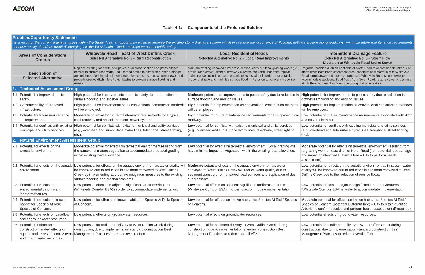
City of Pickering Whitevale Master Drainage Plan – Municipal
Class Environmental Assessment Report
04ra_2013-03-22_Whitevalemdp-MCEA Final Rpt_60187125.Docx 21
Table 4-1: Components of the Preferred Solution
Problem/Opportunity Statement: As a result of the current drainage issues within the Study Area, an opportunity exists to improve the existing storm drainage system which will reduce the occurrence of flooding, mitigate erosion along roadways, minimize future maintenance requirements, enhance quality of surface runoff discharging into the West Duffins Creek and improve overall public safety.
Areas of Consideration/ Criteria
Whitevale Road – East of West Duffins Creek Selected Alternative No. 2 - Rural Reconstruction
Local Residential Roads Selected Alternative No. 2 – Local Road Improvements
Intermittent Drainage Feature Selected Alternative No. 5 – Storm Flow
Diversion to Whitevale Road Storm Sewer
Description of Selected Alternative
Replace existing road with new paved rural cross-section and grass ditches (similar to current road width), adjust road profile to establish proper drainage and minimize flooding of adjacent properties, construct a new storm sewer and properly spaced ditch inlets / catchbasins to prevent surface flooding and erosion.
Maintain existing unpaved rural cross-section, carry out local grading works (i.e., profile, road crown, ditches, driveway culverts, etc.) and undertake regular maintenance, including use of organic topical sealant in order to re-establish proper drainage and minimize surface flooding / erosion to adjacent properties.
Regrade roadside ditch on east side of North Road to accommodate infrequent storm flows from north catchment area, construct new storm inlet to Whitevale Road storm sewer and over-size proposed Whitevale Road storm sewer to accommodate additional flood flows from North Road, restore culvert crossing at North Road to direct low flows to existing drainage feature.
1. Technical Assessment Group 1.1 Potential for improved public
safety. High potential for improvements to public safety due to reduction in surface flooding and erosion issues.
Moderate potential for improvements to public safety due to reduction in surface flooding and erosion issues.
High potential for improvements to public safety due to reduction in downstream flooding and erosion issues.
1.2 Constructability of proposed infrastructure.
High potential for implementation as conventional construction methods will be employed.
High potential for implementation as conventional construction methods will be employed.
High potential for implementation as conventional construction methods will be employed.
1.3 Potential for future maintenance requirements.
Moderate potential for future maintenance requirements for a typical rural roadway and associated storm sewer system.
High potential for future maintenance requirements for an unpaved rural roadway.
Low potential for future maintenance requirements associated with ditch and culvert clean-out.
1.4 Potential for conflicts with existing municipal and utility services.
High potential for conflicts with existing municipal and utility services (e.g., overhead and sub-surface hydro lines, telephone, street lighting, etc.).
Low potential for conflicts with existing municipal and utility services (e.g., overhead and sub-surface hydro lines, telephone, street lighting, etc.).
Low potential for conflicts with existing municipal and utility services (e.g., overhead and sub-surface hydro lines, telephone, street lighting, etc.).
2. Natural Environment Assessment Group 2.1 Potential for effects on the
terrestrial environment. Moderate potential for effects on terrestrial environment resulting from the removal of mature vegetation to accommodate proposed grading within existing road allowance.
Low potential for effects on terrestrial environment. Local grading will have minimal impact on vegetation within the existing road allowance.
Moderate potential for effects on terrestrial environment resulting from re-grading work on east ditch of North Road (i.e., potential root damage and impact to identified Butternut tree – City to perform health assessment)
2.2 Potential for effects on the aquatic environment.
Low potential for effects on the aquatic environment as water quality will be improved due to reduction in sediment conveyed to West Duffins Creek by implementing appropriate mitigation measures to the existing surface flooding and erosion problems.
Moderate potential effects on the aquatic environment as water conveyed to West Duffins Creek will reduce water quality due to sediment transport from unpaved road surfaces and application of dust suppressants.
Low potential for effects on the aquatic environment as in-stream water quality will be improved due to reduction in sediment conveyed to West Duffins Creek due to the reduction of erosive flows.
2.3 Potential for effects on environmentally significant landform/features.
Low potential effects on adjacent significant landforms/features (Whitevale Corridor ESA) in order to accommodate implementation.
Low potential effects on adjacent significant landforms/features (Whitevale Corridor ESA) in order to accommodate implementation.
Low potential effects on adjacent significant landforms/features (Whitevale Corridor ESA) in order to accommodate implementation.
2.4 Potential for effects on known habitat for Species At Risk/ Species of Concern.
Low potential for effects on known habitat for Species At Risk/ Species of Concern.
Low potential for effects on known habitat for Species At Risk/ Species of Concern.
Moderate potential for effects on known habitat for Species At Risk/ Species of Concern (potential Butternut tree) – City to retain qualified Arborist to confirm species and perform health assessment (if required).
2.5 Potential for effects on baseflow and/or groundwater resources.
Low potential effects on groundwater resources. Low potential effects on groundwater resources. Low potential effects on groundwater resources.
2.6 Potential for short-term construction related effects on aquatic and terrestrial ecosystems and groundwater resources.
Low potential for sediment delivery to West Duffins Creek during construction, due to implementation standard construction Best Management Practices to reduce overall effect.
Low potential for sediment delivery to West Duffins Creek during construction, due to implementation standard construction Best Management Practices to reduce overall effect.
Low potential for sediment delivery to West Duffins Creek during construction, due to implementation standard construction Best Management Practices to reduce overall effect.
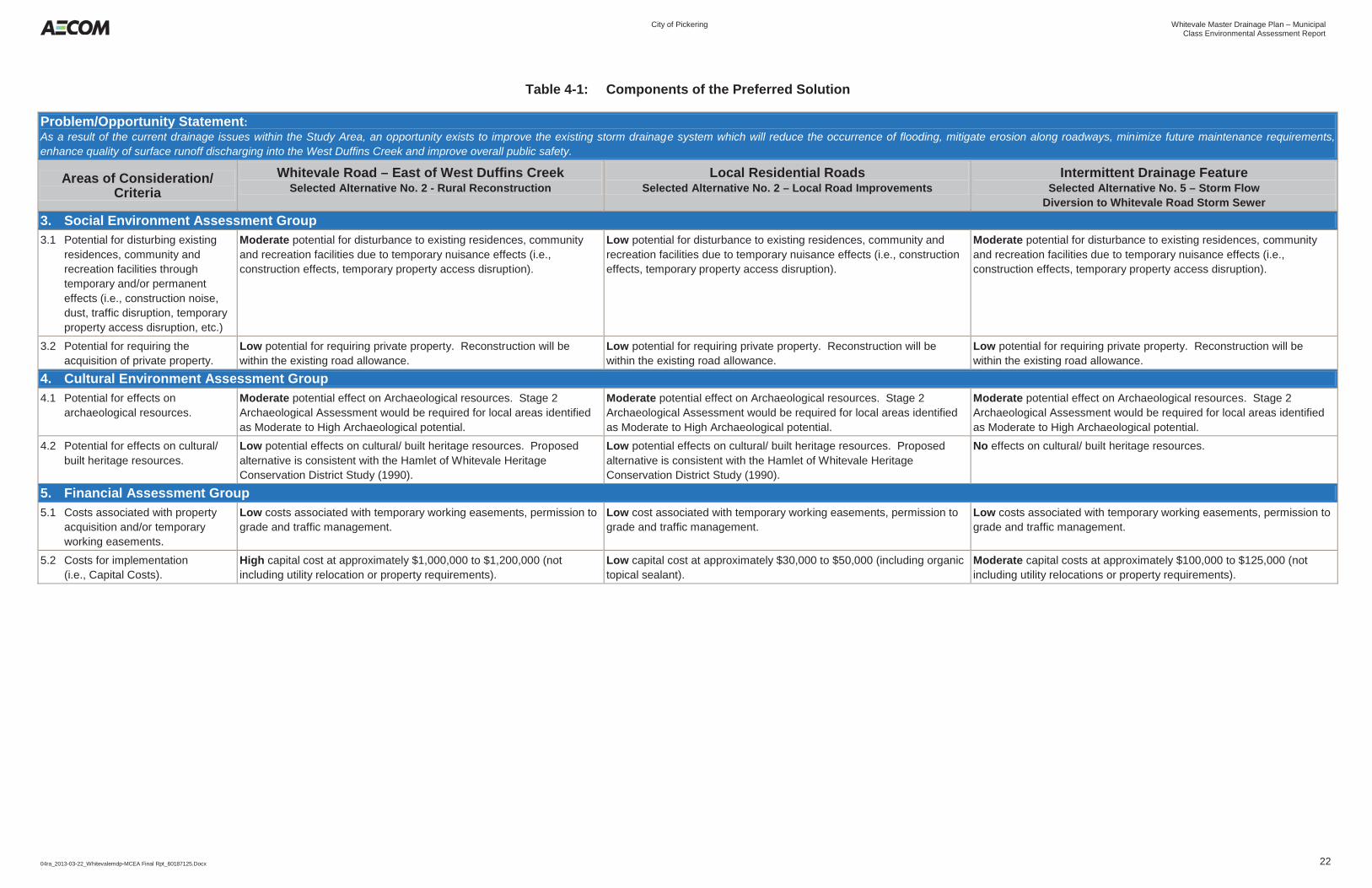
City of Pickering Whitevale Master Drainage Plan – Municipal
Class Environmental Assessment Report
04ra_2013-03-22_Whitevalemdp-MCEA Final Rpt_60187125.Docx 22
Table 4-1: Components of the Preferred Solution
Problem/Opportunity Statement: As a result of the current drainage issues within the Study Area, an opportunity exists to improve the existing storm drainage system which will reduce the occurrence of flooding, mitigate erosion along roadways, minimize future maintenance requirements, enhance quality of surface runoff discharging into the West Duffins Creek and improve overall public safety.
Areas of Consideration/ Criteria
Whitevale Road – East of West Duffins Creek Selected Alternative No. 2 - Rural Reconstruction
Local Residential Roads Selected Alternative No. 2 – Local Road Improvements
Intermittent Drainage Feature Selected Alternative No. 5 – Storm Flow
Diversion to Whitevale Road Storm Sewer 3. Social Environment Assessment Group 3.1 Potential for disturbing existing
residences, community and recreation facilities through temporary and/or permanent effects (i.e., construction noise, dust, traffic disruption, temporary property access disruption, etc.)
Moderate potential for disturbance to existing residences, community and recreation facilities due to temporary nuisance effects (i.e., construction effects, temporary property access disruption).
Low potential for disturbance to existing residences, community and recreation facilities due to temporary nuisance effects (i.e., construction effects, temporary property access disruption).
Moderate potential for disturbance to existing residences, community and recreation facilities due to temporary nuisance effects (i.e., construction effects, temporary property access disruption).
3.2 Potential for requiring the acquisition of private property.
Low potential for requiring private property. Reconstruction will be within the existing road allowance.
Low potential for requiring private property. Reconstruction will be within the existing road allowance.
Low potential for requiring private property. Reconstruction will be within the existing road allowance.
4. Cultural Environment Assessment Group 4.1 Potential for effects on
archaeological resources. Moderate potential effect on Archaeological resources. Stage 2 Archaeological Assessment would be required for local areas identified as Moderate to High Archaeological potential.
Moderate potential effect on Archaeological resources. Stage 2 Archaeological Assessment would be required for local areas identified as Moderate to High Archaeological potential.
Moderate potential effect on Archaeological resources. Stage 2 Archaeological Assessment would be required for local areas identified as Moderate to High Archaeological potential.
4.2 Potential for effects on cultural/ built heritage resources.
Low potential effects on cultural/ built heritage resources. Proposed alternative is consistent with the Hamlet of Whitevale Heritage Conservation District Study (1990).
Low potential effects on cultural/ built heritage resources. Proposed alternative is consistent with the Hamlet of Whitevale Heritage Conservation District Study (1990).
No effects on cultural/ built heritage resources.
5. Financial Assessment Group 5.1 Costs associated with property
acquisition and/or temporary working easements.
Low costs associated with temporary working easements, permission to grade and traffic management.
Low cost associated with temporary working easements, permission to grade and traffic management.
Low costs associated with temporary working easements, permission to grade and traffic management.
5.2 Costs for implementation (i.e., Capital Costs).
High capital cost at approximately $1,000,000 to $1,200,000 (not including utility relocation or property requirements).
Low capital cost at approximately $30,000 to $50,000 (including organic topical sealant).
Moderate capital costs at approximately $100,000 to $125,000 (not including utility relocations or property requirements).

City of Pickering Whitevale Master Drainage Plan – Municipal
Class Environmental Assessment Report
04ra_2013-03-22_Whitevalemdp-MCEA Final Rpt_60187125.Docx 23
5. Public Consultation 5.1 Public and Agency Consultation during Phase 1
5.1.1 Notification of Project Commencement and Invitation for Comments
Although the Municipal Class EA process does not require a mandatory point of contact during Phase 1, a Notice of Commencement was issued as both a letter and a newspaper advertisement. As a result, all relevant review agencies, area property owners, and the public were notified of the project being initiated, the problem and opportunity being addressed, and given the opportunity to provide comments. Notification was provided through the following means:
By advertisement in the local newspapers on January 12, 2011; and By letter mailed directly to review agencies and property owners on January 14, 2011.
Refer to Appendix G for copies of the preceding notification materials and a contact list of relevant review agencies and stakeholders. This information is provided in accordance with the standards prescribed by the MEA Class EA document, which outlines the guidelines for establishing contact with appropriate review agencies in relation to the nature of the project.
5.1.2 Comments Received and Their Consideration in the Project
The majority of comments received following circulation of the Notice of Commencement were from review agencies, including MOE, MNR, IO, MTCS and TRCA. Their comments were fairly generic in nature, providing high-level expectations on what the Class EA study should include. One stakeholder group (Friends of the Seaton Trail) provided comments after the Notice of Commencement, requesting clarification on the Master Plan approach. The Mississaugas of Scugog Island, Curve Lake First Nation and Chippewas of Rama also provided a response to the Notice of Commencement requesting that they be updated and kept informed as the Class EA continues. A summary of their comments and the Project Team’s responses may be found in Appendix G.
5.1.3 Notification of Public Information Centre (PIC) #1
Notification of PIC #1 was provided through direct mailings on August 27, 2012 to those stakeholders and review agencies contained in the Study’s contact database, as well as to all residents of Whitevale and First Nations. The Notice was also posted on the Study’s website < http://www.pickering.ca/en/cityhall/WhitevaleMDP.asp> and through newspaper advertisements within the local newspaper on August 24, 2012. Copies of the Letters and newspaper advertisements are contained in Appendix G.
5.1.4 Public Information Centre (PIC) #1
PIC #1 was held on Wednesday September 9, 2012 at the Claremont Community Centre Hall (4941 Old Brock Road, Pickering). The PIC ran from 6:30 p.m. to 8:30 p.m. and followed an informal “drop-in” format with display boards. Attendees were also given the opportunity to ask questions and have an open discussion with the City and the Consulting Team.
City of Pickering Whitevale Master Drainage Plan – Municipal
Class Environmental Assessment Report
04ra_2013-03-22_Whitevalemdp-MCEA Final Rpt_60187125.Docx 24
The following information was presented at the PIC on display boards arranged around the room. Information presented on the display boards included:
The Study Background Overview of the Master Plan Class EA process being followed Description of the Study Area The Problem and Opportunity Statement Description of the Existing Conditions in the Study Area (Land Uses, Cultural Heritage, Natural
Environment, Drainage Infrastructure, Surface Drainage Conditions, Peak Flow and Drainage Capacity Assessment, and Storm Sewer Capacity)
Identification and Description of Alternative Solutions List of Evaluation Criteria Description of the Next Steps in the Process Project Contact information
Copies of the PIC #1 display boards are contained in Appendix G. Attendance consisted of approximately 18 people (those that provided their contact details on the sign-in sheet). The attendees were mostly local residents, with only a few individuals coming from outside the Study Area. Attendees were encouraged to submit written input on comment sheets provided as they entered. All individuals who signed in with their contact information have been added to the project contact database. These database was also used during the remaining phases of the Study to contact/inform interested public and stakeholders with regard to Study updates and future events (i.e., PIC # 2, Notice of Completion, etc.). The attendees were greeted at the door by the Consulting Team and City officials. During the PIC, the public reviewed the boards and were able to ask questions and have discussions with members of the Project Team.
5.1.5 Comments Received During PIC #1 and Their Consideration in the Project
Comments from attendees at PIC #1 were collected through comment sheets, as well as discussions held during the PIC itself. Table 5-1 summarizes the comments and responses from PIC #1.
Table 5-1: Comments and Responses PIC #1
Comment Response
Poorly attended, should have been held in Whitevale. Comment noted. The Project Team will look at other venues in Whitevale for the next Public Meeting
Keeping the heritage look is important to the community Criteria around Built Heritage will be included in the comparative evaluation. Further, the Heritage District Plan for Whitevale will be reviewed during development of alternative solutions.
Like the idea of a storage pond to the north of North Road. I do not like the alternative of an “urban” streetscape
Comment noted. We will evaluate this alternative, along with others as the Study progresses.
The profile suggested for the road sections has no relevance to the hamlet topography. It is a cookie cutter approach for an urban location. This is a rural heritage roadway. Special attention must be made to preserve:
1. Mature native trees 2. Present access to existing houses 3. A natural look and feel of classic materials 4. Natural slopes, curves and hills that have been integral for years 5. Natural drainage should determine the design
Typical cross-section(s) of various solutions (both rural and urban) were presented for illustrative purposes. Heritage and rural character is an evaluation criteria and will be factored into the overall comparative evaluation, along with topography and other evaluation criteria (i.e., effects on natural environment, property, etc.).
City of Pickering Whitevale Master Drainage Plan – Municipal
Class Environmental Assessment Report
04ra_2013-03-22_Whitevalemdp-MCEA Final Rpt_60187125.Docx 25
Comment Response
Unsure of how exactly the suggested dam (pond) would work. But the location seems good to create a downhill diversion to the Mill Race. Except to breech the ridge immediately to the west of the present ditch, it could be made into a broad open swale that makes its way down to the Mill Race.
The purpose of the temporary storage is to attenuate peak flows in order to minimize downstream flooding.
It is totally inappropriate to offer modern urban streetscape type surface treatments as options for how the village might look after the drainage work is completed. This is a heritage designated village, an authentic pioneer village - Pickering’s most unique and most intact. What would be Pickering’s response of a similar treatment for Pickering Museum Village?
The MEA Class EA provides for the proponent to look at a reasonable range of alternatives in order to complete a comparative evaluation and arrive at the optimal solution. This includes the “Do Nothing” alternative, which is mandatory under the Class EA process, in order to show “base case” or “status-quo”. With respect to this study, a full range of alternatives were developed including an Urban cross-section (curb and gutter) for Whitevale and local roads. We will utilize the evaluation criteria (including consideration for Heritage features, property, cost, effects on natural environment, etc.) to comparatively evaluate the alternatives and determine the trade-offs between each of the alternatives.
All original concrete sidewalks should be retained exactly as located. Renew badly fractured squares with matching concrete where merited. Besides accelerating runoff, the smooth impermeable surface of asphalt is not an acceptable heritage treatment for drainage swales and sidewalks.
This will be considered at the Detailed Design stage (Phase 5). Further detail will be developed once the Master Plan moves to Stage 5, Detailed Design and Implementation.
A complete listing of the comments received and the responses provided are contained in Appendix G.
5.1.6 Notification of Public Information Centre (PIC) #2
Notification of PIC #2 was provided through direct mailings on November 6, 2012 to those stakeholders and review agencies contained in the Study’s contact database, as well as to all residents of Whitevale and First Nations. The Notice was also posted on the Study’s website < http://www.pickering.ca/en/cityhall/WhitevaleMDP.asp> and through newspaper advertisements within the local newspapers on October 31, 2012. Copies of the Letters and newspaper advertisements are contained in Appendix G.
5.1.7 Public Information Centre (PIC) #2
PIC #2 was held on Wednesday November 14, 2012 at the Whitevale Community Centre (405 Whitevale Road, Pickering). The PIC ran from 6:30 p.m. to 8:30 p.m. and followed an informal “drop-in” format with display boards. Attendees were also given the opportunity to ask questions and have an open discussion with the City and the Consulting Team. The following information was presented at the PIC on display boards arranged around the room. Information presented on the display boards included:
The Study Background Overview of the Master Plan Class EA process being followed Description of the Study Area The Problem and Opportunity Statement Description of the Existing Conditions in the Study Area (Land Uses, Cultural Heritage, Natural
Environment, Drainage Infrastructure, Surface Drainage Conditions, Peak Flow and Drainage Capacity Assessment, and Storm Sewer Capacity)
City of Pickering Whitevale Master Drainage Plan – Municipal
Class Environmental Assessment Report
04ra_2013-03-22_Whitevalemdp-MCEA Final Rpt_60187125.Docx 26
Identification and Description of Alternative Solutions Evaluation Methodology Components of the Preferred Solution Additional Recommendations Potential Effects and Mitigation Description of the Next Steps in the Process Project Contact information
Copies of the display boards are contained in Appendix G. The PIC was well attended with 29 people providing their names on the sign-in sheet. The attendees were mostly local residents, with only a few individuals coming from outside the Study Area. Elected representatives were also present. Attendees were encouraged to submit written input on comment sheets provided as they entered. All individuals who signed in with their contact information have been added to the project contact database. These database was used during the remaining phases of the Study to contact/inform interested public and stakeholders with regard to Study updates and future events (i.e., Notice of Completion). The attendees were greeted at the door by the Consulting Team and City officials. During the PIC, the public reviewed the boards and were able to ask questions and have discussions with members of the Project Team.
5.1.8 Comments Received During PIC #2 and Their Consideration in the Project
Comments from attendees at the PIC were collected through comment sheets, as well as discussions held during the PIC itself. Table 5-2 summarizes the comments and responses from PIC #2.
Table 5-2: Comments and Responses PIC #2
Comment Response Well done, well-staffed with knowledgeable personnel. Good location Comments noted. Further consideration should be given to the organic binder on the roads which looks promising to stabilize the road surface
Organic binder and other environmentally friendly topical surface treatments have been recommended for consideration on unpaved road surfaces.
I like the alternative 3 for intermittent drainage. I would like to see ORC/TRCA co-operation to reduce cost (land acquisition) and contribute to the area regeneration (former gravel pit) (prefer). I like the selections for the other areas, in particular, resurfacing/regarding of existing roads.
Although Alternative #3 addresses the problem/opportunity statement, it was not selected based on high property acquisition costs and capital cost.
I do not understand why the option of diverting more than half the runoff (NE) from perimeter of village is reject – presumably because the city is intent upon tearing up the Main Street and make it like a city street. A diversion seems like such a common sense, no brainer. I cannot imagine why except for the reason mentioned. I am listening.
The comparative evaluation of the alternative solutions looked at a variety of criteria, including technical, financial, and environmental. The comparative evaluation showed that the diversion option, although capable of implementation from a technical stand-point, was not as optimal as other solutions put forward, from an overall evaluation perspective.
The solutions that require urban and sewer systems do not reflect the rural quality of the village and should be avoided.
Heritage and rural character is an evaluation criteria and will be factored into the overall comparative evaluation.
As the storm of 2008 was regarded as a 100 years storm and unlikely to happen again in more than a couple of generations, please consider the “do nothing and ongoing maintenance” solution, but lowering of the roadway where needed also.
The Do Nothing includes ongoing maintenance and will be considered in the evaluation of alternatives.
A complete listing of the comments received and the responses provided are contained in Appendix G.
City of Pickering Whitevale Master Drainage Plan – Municipal
Class Environmental Assessment Report
04ra_2013-03-22_Whitevalemdp-MCEA Final Rpt_60187125.Docx 27
5.1.9 Citizen Liaison Committee Meetings
As part of the enhanced consultation for this Class EA, a Citizen Liaison Committee was formed. Two Kitchen Table meetings were held to present material directly to the members of the Committee. The purpose of the Whitevale Citizens’ Drainage Committee is to provide input and advice to the Project Management Team as they relate to the direction of the Whitevale Master Drainage Plan. The stated objectives of the Committee are:
To serve as a communications vehicle that identifies study progress, a schedule of activities and future actions.
To serve as an instrument to exchange ideas and issues relative to the Whitevale Master Drainage Plan. To allow citizen representatives to provide input into the study process during key milestones.
Membership of the Committee is made up of individuals from the community and Whitevale and District Residents Association, along with representatives from the City of Pickering and AECOM. While not required under the Class EA process, the Committee Meetings were beneficial for all parties to gather and share information, as well as allow for the Committee members to act as a sounding board for all other residents in the area.
5.1.9.1 Citizen Liaison Committee Meeting #1
The first Whitevale Citizens’ Drainage Committee meeting was held to discuss the area existing conditions, and potential opportunities and constraints as they relate to the Whitevale Master Drainage Plan. Included in the discussion was an overview of a preliminary list of alternatives that could address drainage and stormwater management within the Study Area. A copy of the Agenda and Minutes from Committee Meeting #1 are provided in Appendix G.
5.1.9.2 Citizen Liaison Committee Meeting #2
The second Whitevale Citizens’ Drainage Committee meeting was held to discuss an overview of the alternatives assessment and the preferred alternative(s). Discussion on next steps in the Class EA process also took place. A copy of the Agenda and Minutes from Committee Meeting #1 are provided in Appendix G. The committee provided a breakdown of their comments on the recommended solution (Alternative #2 – Rural Reconstruction) which highlighted the following:
Match existing pavement width What standard of Road will be used as traffic through the Hamlet is a concern. Further to the above, how will traffic calming measures be incorporated Will there be any effects on residential wells How will trees be preserved during construction What will be done with sidewalks Will the Heritage Advisory Committee have an opportunity to review
With respect to the above comments, the Project Team provided responses to these comments during Public Open House #2 and within the final version of the Master Plan document. A copy of the Agenda, Minutes and comments from Committee Meeting #2 are provided in Appendix G.

City of Pickering Whitevale Master Drainage Plan – Municipal
Class Environmental Assessment Report
04ra_2013-03-22_Whitevalemdp-MCEA Final Rpt_60187125.Docx 28
6. Description, Implementation and Monitoring of the Master Drainage Plan
The recommended Master Drainage Plan for the Study Area consists of a combination of improvement measures to address flooding, erosion and water quality issues. This section outlines the elements of the Master Drainage Plan and the process for their implementation.
6.1 Elements of the Master Plan
The elements of the Master Plan include the measures selected as described in Section 5 as well as a list of additional recommendations. These elements are summarized below and the corresponding MEA Class EA Schedule, if applicable, is also included.
6.1.1 Whitevale Road (East) - Alternative # 2 Rural Reconstruction
This alternative will replace the existing road with a new paved rural cross-section and grass ditches, similar to the current road width. Further, the road profile will be adjusted to establish proper drainage and minimize flooding of adjacent properties. A new storm sewer will also be constructed, with properly spaced ditch inlets to prevent surface flooding and erosion. The MEA Class EA document classifies these works as Schedule A+ undertakings. Additional details and recommendations associated with the preferred solution are described on Figure F-6 in Appendix F.
6.1.2 Local Residential Roads – Alternative # 2 Local Road Improvements
This alternative will maintain the existing unpaved rural cross-section and will carry out local grading works (i.e., profile, road crown, ditches, etc.) to re-establish proper drainage and minimize flooding of adjacent properties. Regular maintenance will also be required for this alternative. The MEA Class EA document classifies these works as Schedule A undertakings. Additional details and recommendations associated with the preferred solution are described on Figure F-7 in Appendix F.
6.1.3 Intermittent Drainage Feature – Alternative # 5 Storm Flow Diversion to Whitevale Road Storm Sewer
The selected alternative will include minor re-grading the roadside ditch on the east side of North Road to accommodate a portion of the flood flows from the catchment area to the north of the Study Area. New driveway culverts and a new storm inlet to the Whitevale Road storm sewer will be constructed and the proposed Whitevale Road storm sewer (refer to Section 6.1.1) will be increased in size to accommodate the additional peak flows from North Road. The existing culvert crossing at North Road will also be replaced in order to convey low flows to the existing drainage feature. The MEA Class EA document classifies these works as Schedule A+ undertakings. Additional details and recommendations associated with the preferred solution are also included on Figure F-7 in Appendix F.
6.1.4 Additional Surface Drainage & Erosion Improvements
In addition to the preferred solution, a number of additional minor recommendations are proposed to further improve the drainage system deficiencies observed within the Study Area. Recommendations are made for two additional areas; Whitevale Road (West); and North Road which are both considered Schedule A undertakings.
City of Pickering Whitevale Master Drainage Plan – Municipal
Class Environmental Assessment Report
04ra_2013-03-22_Whitevalemdp-MCEA Final Rpt_60187125.Docx 29
6.1.4.1 Whitevale Road (West)
Additional details and recommendations associated with proposed drainage and erosion improvements for Whitevale Road, extending west of West Duffins Creek, are included on Figure F-8 in Appendix F and include the following:
Re-surface asphalt road surface in order to reduce erosion and sediment discharging to West Duffins Creek
Carry out minor re-grading along north roadside ditch in order to re-establish proper drainage and reduce erosion of the granular shoulder
Re-instate misaligned segment of storm sewer near outfall Replace the damaged storm sewer outfall with new structure & construct additional outlet enhancements
(e.g., outlet pool) in order to improve storm runoff quality and reduce erosion within the valley Remove debris blockages identified at several manhole / ditch inlet locations
6.1.4.2 North Road
Additional details and recommendations associated with proposed drainage and erosion improvements for North Road, extending from Whitevale Road to north of Churchwin Street , are included on Figure F-7 in Appendix F and include the following:
Re-surface asphalt road surface in order to reduce erosion and sediment discharging to the Whitevale Road storm sewer system
Carry out minor re-grading along west roadside ditch in order to re-establish proper drainage and install / replace several driveway culverts to facilitate property access
6.2 Implementation Considerations
6.2.1 Estimated Master Plan Component Costs
The estimated project costs determined for each component of the Master Drainage Plan are summarized in Table 6-1 along with additional comments.
Table 6-1: Summary of Estimated Master Plan Component Costs
Master Plan Component Project Cost Estimate ($) Comments
Whitevale Road (East) $1,000,000 to $1,200,000 Excludes utility relocations, property acquisition and / or temporary easements, water and sanitary servicing
Local Residential Roads $30,000 to $50,000 Excludes utility relocations, property acquisition and / or temporary easements, water and sanitary servicing
Includes application of organic topical sealant Intermittent Drainage Feature $100,000 to $125,000 Excludes utility relocations, property acquisition and / or temporary
easements, water and sanitary servicing Includes increase in storm sewer size on Whitevale Road (East)
Whitevale Road (West) $50,000 to $75,000 Excludes utility relocations, property acquisition and / or temporary easements, water and sanitary servicing
North Road $30,000 to $50,000 Excludes utility relocations, property acquisition and / or temporary easements, water and sanitary servicing
Notes: 1. Project costs include construction, engineering design and 15% contingency.
City of Pickering Whitevale Master Drainage Plan – Municipal
Class Environmental Assessment Report
04ra_2013-03-22_Whitevalemdp-MCEA Final Rpt_60187125.Docx 30
6.2.2 Summary of the Potential Effects and Recommended Mitigation Measures
As part of implementing this project, monitoring and maintenance will be conducted during construction to ensure that:
individual mitigating measures are providing the expected control and / or protection continuously throughout the construction period;
the mitigating measures are adequate to minimize or eliminate adverse effects; additional mitigating measures are provided if required to address any unanticipated environmental
adverse effects which arise during construction, and; adequate information is available for the assessment of the mitigation measures.
Environmental monitoring will also be required for all construction projects to ensure that recommended mitigation measures are properly installed and maintained and that established protocols are followed. Regular site visits and inspections are to be carried out by qualified personnel. Monitoring should be initiated prior to project start-up and continue until construction is completed and all disturbed areas are stabilized. All deficiencies are to be recorded regularly and corrective actions required immediately. The mitigation and monitoring measures to avoid, minimize or negate the potential adverse effects associated with implementing the recommended solutions are presented in Table 6-2 below.
6.2.3 Notification of Project Completion
Following the preparation of the Municipal Class Environmental Assessment report, the final step of the MEA Class EA process involves issuing a “Notice of Project Completion” to review agencies and the public and filing of the MCEA document for review for a period of 30 calendar days. Following the end of the review period, the City of Pickering may proceed with implementing the Schedule A/A+ elements as outlined in Section 6.1 and proceed to Phase 5 of the MEA Class EA process to complete the contract drawings and tender documents, and then proceed to construction. The notice informs stakeholders and the general public of the project’s completion, including the preferred solutions. Appendix G contains a copy of the letter and advertisement.
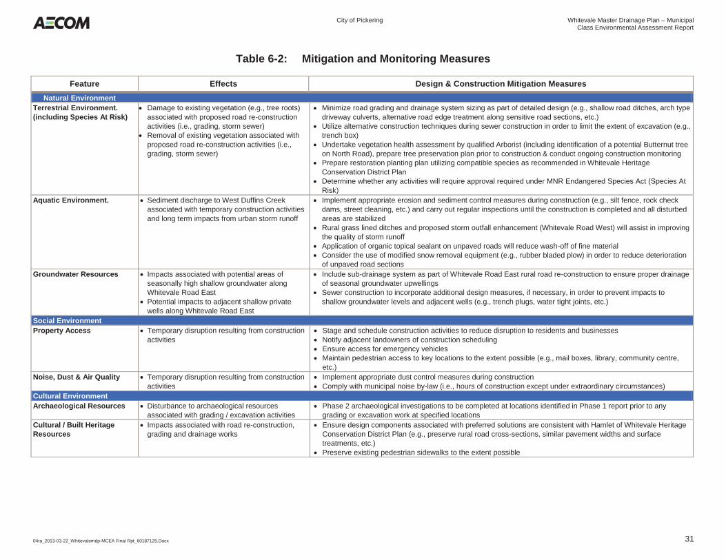
City of Pickering Whitevale Master Drainage Plan – Municipal
Class Environmental Assessment Report
04ra_2013-03-22_Whitevalemdp-MCEA Final Rpt_60187125.Docx 31
Table 6-2: Mitigation and Monitoring Measures
Feature Effects Design & Construction Mitigation Measures Natural Environment
Terrestrial Environment. (including Species At Risk)
Damage to existing vegetation (e.g., tree roots) associated with proposed road re-construction activities (i.e., grading, storm sewer)
Removal of existing vegetation associated with proposed road re-construction activities (i.e., grading, storm sewer)
Minimize road grading and drainage system sizing as part of detailed design (e.g., shallow road ditches, arch type driveway culverts, alternative road edge treatment along sensitive road sections, etc.)
Utilize alternative construction techniques during sewer construction in order to limit the extent of excavation (e.g., trench box)
Undertake vegetation health assessment by qualified Arborist (including identification of a potential Butternut tree on North Road), prepare tree preservation plan prior to construction & conduct ongoing construction monitoring
Prepare restoration planting plan utilizing compatible species as recommended in Whitevale Heritage Conservation District Plan
Determine whether any activities will require approval required under MNR Endangered Species Act (Species At Risk)
Aquatic Environment. Sediment discharge to West Duffins Creek associated with temporary construction activities and long term impacts from urban storm runoff
Implement appropriate erosion and sediment control measures during construction (e.g., silt fence, rock check dams, street cleaning, etc.) and carry out regular inspections until the construction is completed and all disturbed areas are stabilized
Rural grass lined ditches and proposed storm outfall enhancement (Whitevale Road West) will assist in improving the quality of storm runoff
Application of organic topical sealant on unpaved roads will reduce wash-off of fine material Consider the use of modified snow removal equipment (e.g., rubber bladed plow) in order to reduce deterioration
of unpaved road sections Groundwater Resources Impacts associated with potential areas of
seasonally high shallow groundwater along Whitevale Road East
Potential impacts to adjacent shallow private wells along Whitevale Road East
Include sub-drainage system as part of Whitevale Road East rural road re-construction to ensure proper drainage of seasonal groundwater upwellings
Sewer construction to incorporate additional design measures, if necessary, in order to prevent impacts to shallow groundwater levels and adjacent wells (e.g., trench plugs, water tight joints, etc.)
Social Environment Property Access Temporary disruption resulting from construction
activities Stage and schedule construction activities to reduce disruption to residents and businesses Notify adjacent landowners of construction scheduling Ensure access for emergency vehicles Maintain pedestrian access to key locations to the extent possible (e.g., mail boxes, library, community centre,
etc.) Noise, Dust & Air Quality Temporary disruption resulting from construction
activities Implement appropriate dust control measures during construction Comply with municipal noise by-law (i.e., hours of construction except under extraordinary circumstances)
Cultural Environment Archaeological Resources Disturbance to archaeological resources
associated with grading / excavation activities Phase 2 archaeological investigations to be completed at locations identified in Phase 1 report prior to any
grading or excavation work at specified locations Cultural / Built Heritage Resources
Impacts associated with road re-construction, grading and drainage works
Ensure design components associated with preferred solutions are consistent with Hamlet of Whitevale Heritage Conservation District Plan (e.g., preserve rural road cross-sections, similar pavement widths and surface treatments, etc.)
Preserve existing pedestrian sidewalks to the extent possible

City of Pickering Whitevale Master Drainage Plan – Municipal
Class Environmental Assessment Report
04ra_2013-03-22_Whitevalemdp-MCEA Final Rpt_60187125.Docx 32
6.3 Timeframe for Implementation
As noted in Section 6.1, all of the preferred solutions identified as elements of the Master Plan fall within Schedule A/A+ undertakings and can therefore proceed directly to detailed design and / or construction. Schedule A+ projects will require additional public notification prior to implementation. The following provides additional considerations associated with project implementation:
Permits & Approvals – Ensure regulatory agency permits and/or approvals are obtained prior to construction. This may be applicable to specific projects or elements of proposed works (i.e., works within TRCA regulated area including Whitevale Road East & West, Ministry of Culture & Sport Letter of Concurrence for Stage 1 Archaeological Assessment, etc.);
Additional Studies – Ensure additional studies are completed (i.e., Stage 2 Archaeology Assessment) prior to excavation or grade near identified areas of concern;
Construction Phasing & Integration – Co-ordinate construction activities that are integrated (i.e., intersection with local roads, diversion of storm flows to Whitevale Road and Whitevale Road storm sewer construction etc. in order to avoid adverse impacts;
Weather Conditions – Schedule works according to appropriate weather conditions (i.e., application of organic topical sealant, paving, drainage works etc. during dry weather conditions);
Detailed Design Considerations – Ensure additional design elements outside the scope of the current study are considered during the detailed design phase for Whitevale Road (East) and other areas including traffic management, conformance to the Heritage District Plan (i.e., sidewalks, restoration, etc.); and
Additional Public Consultation – Consider additional points of contact with select members of the public (i.e., Whitevale Stormwater Committee) during detailed design for Whitevale Road (East) to ensure local concerns are considered.
City of Pickering Whitevale Master Drainage Plan – Municipal
Class Environmental Assessment Report
04ra_2013-03-22_Whitevalemdp-MCEA Final Rpt_60187125.Docx 33
7. Summary In accordance with the MEA Class EA process, the City of Pickering has completed Phases 1 & 2 of the planning and design process as documented in this Municipal Class Environmental Assessment Report. Phase I of the MCEA confirmed surface drainage and erosion deficiencies within the Study Area through an existing conditions assessment comprising extensive field investigations, surveys and hydrologic and hydraulic analyses and comments received from the public and other stakeholders. This information was compiled and reviewed in order to develop a Problem and Opportunity statement that guided Phase 2 of the MCEA process. A set of alternative solutions were developed for key drainage components within the Study Area, following a MCEA Master Plan approach including:
Whitevale Road (East); Local Residential Roads; and Intermittent Drainage Feature.
A comparative evaluation of alternatives was carried out using a set of criteria and indicators representing the broad definition of the environment, as described in the EA Act, in order to determine the preferred solutions. Additional recommendations were also identified at other locations within the Study Area to augment the Master Plan. The selected solutions, along with supporting documentation, was presented at two Public Information Centres for comment and circulated for stakeholder comments. Input received through the Public Consultation process was generally in support of the proposed solutions. Potential environmental effects associated with the preferred set of solutions were also identified and specific mitigation measures were developed. To ensure the effectiveness of these mitigation measures, monitoring and maintenance recommendations were provided for construction. Based on the potential effects identified it was concluded that the recommended measures would be effective in avoiding or minimizing the adverse effects and that no significant adverse residual or “net” environmental effects on the project area environment are expected to occur. All of components of the Master Plan are categorized as either Schedule A or A+ undertakings and accordingly, can proceed directly to final design and / or construction. Schedule A+ projects will require additional public notification prior to implementation.

03rb_2013-03-01_App Tps_60187125.Docx
Figures

Milliken LoamWoburn Loam
Milliken LoamBottom Land
Bottom Land
Woburn Loam
Woburn Loam
Woburn Loam
Milliken LoamPeel Clay Loam
Woburn Loam
Bottom Land
Milliken Loam
Peel Clay Loam
Legend
Hydrologic Soil Group
Figure 3
Existing Surficial Soils
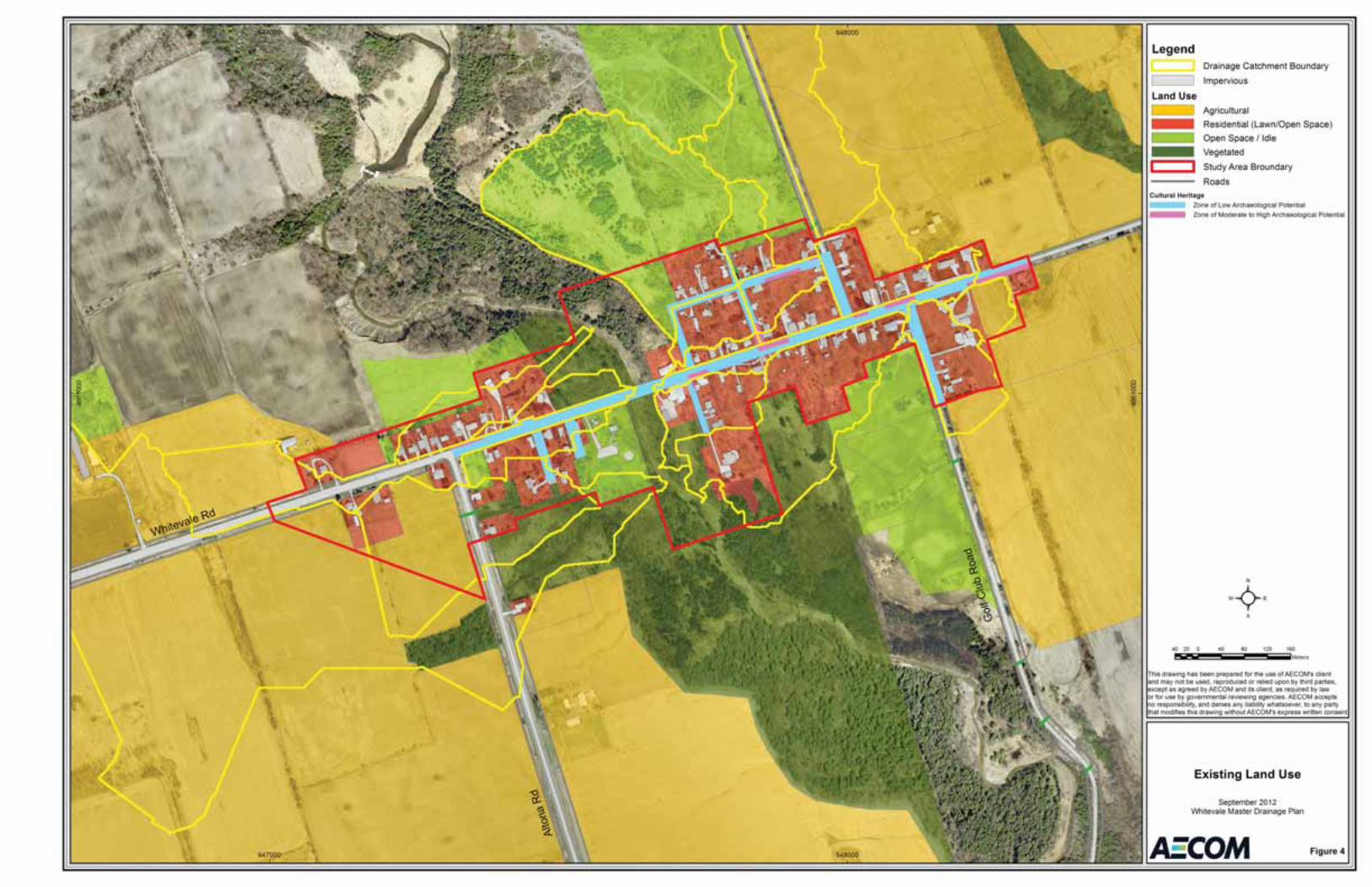
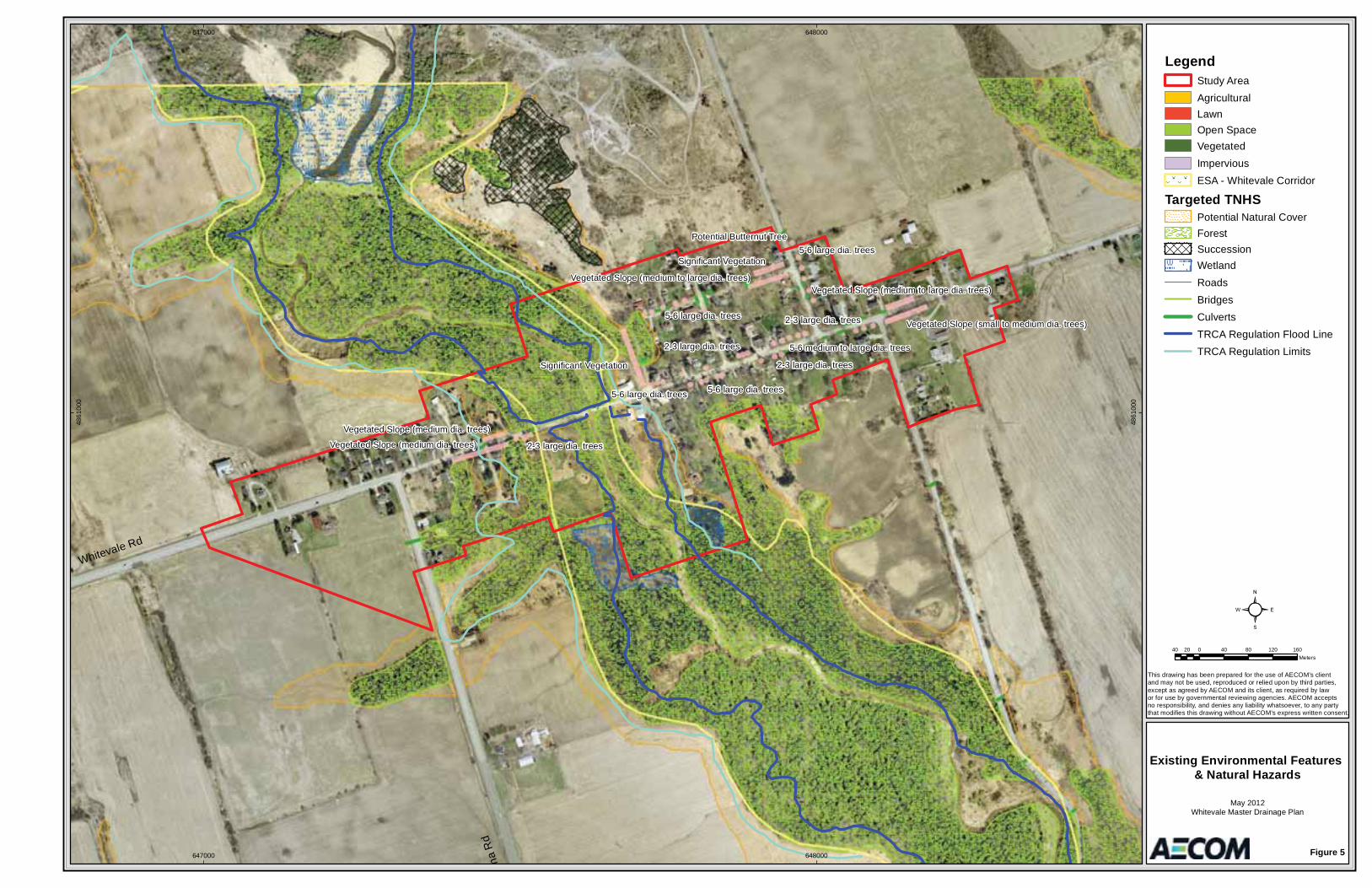
Whitevale Rd
ona
Rd
Significant Vegetation
Vegetated Slope (medium dia. trees)
Significant Vegetation
Vegetated Slope (small to medium dia. trees)
Vegetated Slope (medium to large dia. trees)Vegetated Slope (medium to large dia. trees)
Vegetated Slope (medium dia. trees)
5-6 large dia. trees
2-3 large dia. trees
2-3 large dia. trees
5-6 large dia. trees
5-6 large dia. trees
2-3 large dia. trees
2-3 large dia. trees
5-6 large dia. trees
Potential Butternut Tree
5-6 medium to large dia. trees
647000
647000
648000
648000
4861
000
4861
000
LegendStudy AreaAgriculturalLawnOpen SpaceVegetatedImperviousESA - Whitevale Corridor
Targeted TNHSPotential Natural CoverForestSuccessionWetlandRoadsBridgesCulvertsTRCA Regulation Flood LineTRCA Regulation Limits
Figure 5
Existing Environmental Features & Natural Hazards
May 2012Whitevale Master Drainage Plan
This drawing has been prepared for the use of AECOM’s client and may not be used, reproduced or relied upon by third parties,except as agreed by AECOM and its client, as required by law or for use by governmental reviewing agencies. AECOM accepts no responsibility, and denies any liability whatsoever, to any partythat modifies this drawing without AECOM’s express written consent.
40 0 40 80 120 16020Meters
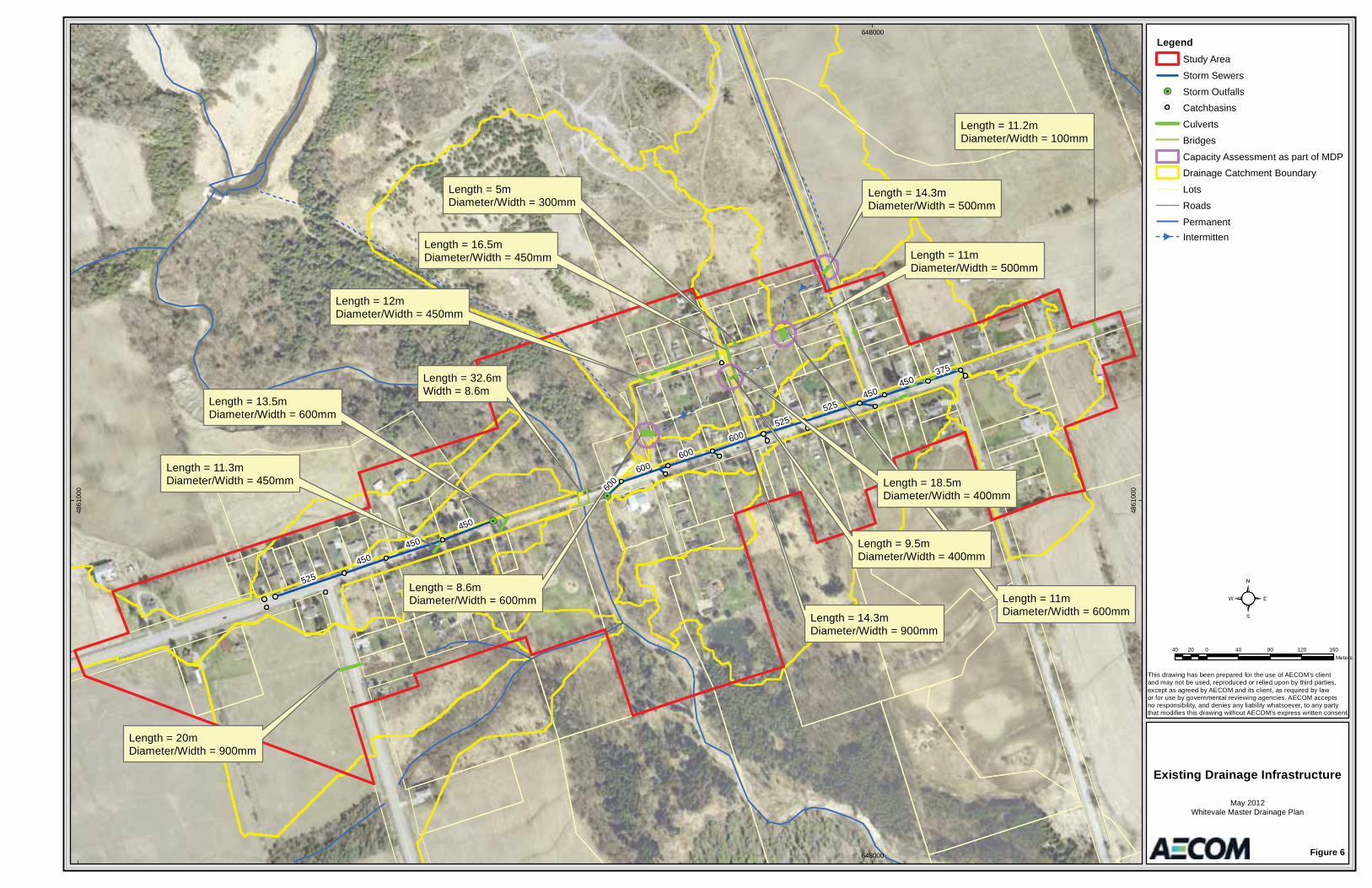
Length = 20mDiameter/Width = 900mm
Length = 11.2mDiameter/Width = 100mm
Length = 12mDiameter/Width = 450mm
Length = 11mDiameter/Width = 500mm
Length = 11mDiameter/Width = 600mm
Length = 5mDiameter/Width = 300mm
Length = 16.5mDiameter/Width = 450mm
Length = 18.5mDiameter/Width = 400mm
Length = 9.5mDiameter/Width = 400mm
Length = 14.3mDiameter/Width = 500mm
Length = 13.5mDiameter/Width = 600mm
Length = 11.3mDiameter/Width = 450mm
Length = 14.3mDiameter/Width = 900mm
Length = 8.6mDiameter/Width = 600mm
Length = 32.6mWidth = 8.6m
525
450
375
600
450
600
600525
450
525
450
450
600
648000
648000
4861
000
4861
000
LegendStudy Area
Storm Sewers
Storm Outfalls
Catchbasins
Culverts
Bridges
Capacity Assessment as part of MDP
Drainage Catchment Boundary
Lots
Roads
PermanentIntermitten
Figure 6
Existing Drainage Infrastructure
May 2012Whitevale Master Drainage Plan
This drawing has been prepared for the use of AECOM’s client and may not be used, reproduced or relied upon by third parties,except as agreed by AECOM and its client, as required by law or for use by governmental reviewing agencies. AECOM accepts no responsibility, and denies any liability whatsoever, to any partythat modifies this drawing without AECOM’s express written consent.
40 0 40 80 120 16020Meters
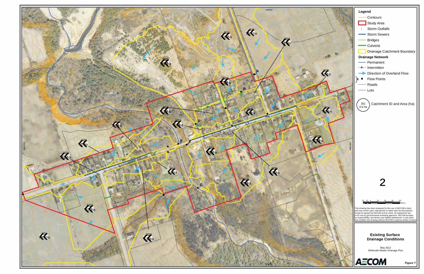
!.
!.
¬«3016.6 ha
¬«9019.8 ha
¬«5026.7 ha
¬«6016.5 ha
¬«7012.3 ha¬«101
2 ha
¬«4011.8 ha
¬«3031.2 ha
¬«3041.2 ha
¬«2022.2 ha
¬«3061.4 ha
¬«2031.1 ha
¬«3021 ha
¬«3070.4 ha
¬«3082.9 ha
¬«2040.9 ha
¬«2031.1 ha
¬«8010.8 ha¬«305
0.7 ha
¬«50129.9 ha
¬«30913.4 ha
")A
")B
")C
")D
")E")F
")G
648000
648000
4861
000
4861
000
LegendContoursStudy Area
!. Storm OutfallsStorm SewersBridgesCulvertsDrainage Catchment Boundary
Drainage NetworkPermanentIntermittenDirection of Overland FlowFlow PointsRoadsLots
Figure 7
Existing Surface Drainage Conditions
May 2012Whitevale Master Drainage Plan
This drawing has been prepared for the use of AECOM's client and may not be used, reproduced or relied upon by third parties,except as agreed by AECOM and its client, as required by law or for use by governmental reviewing agencies. AECOM accepts no responsibility, and denies any liability whatsoever, to any partythat modifies this drawing without AECOM's express written consent.
²30 0 30 60 90 12015
Meters
")A
3016.6 ha
Catchment ID and Area (ha)
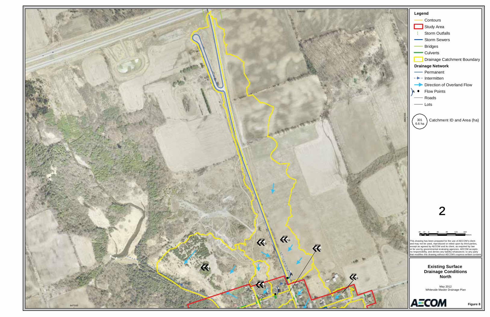
¬«3016.6 ha
¬«9019.8 ha
¬«3031.2 ha
¬«304
¬«3021 ha
¬«3082.9 ha
¬«801
¬«
¬«30913.4 ha
")A
")B
647000
647000
648000
648000
4862
000
4862
000
LegendContoursStudy Area
!. Storm OutfallsStorm SewersBridgesCulvertsDrainage Catchment Boundary
Drainage NetworkPermanentIntermittenDirection of Overland FlowFlow PointsRoadsLots
Figure 8
Existing Surface Drainage Conditions
North
May 2012Whitevale Master Drainage Plan
This drawing has been prepared for the use of AECOM's client and may not be used, reproduced or relied upon by third parties,except as agreed by AECOM and its client, as required by law or for use by governmental reviewing agencies. AECOM accepts no responsibility, and denies any liability whatsoever, to any partythat modifies this drawing without AECOM's express written consent.
²40 0 40 80 120 16020
Meters
")A
3016.6 ha
Catchment ID and Area (ha)

193.03 m
185.62 m
184.89 m
186.79 m
178.53 m
180.59 m
181.29 m176.12 m
175.83 m
1901
601
701
900
2001
1501
1101
1601
1201
800
1700
1000
1800
2100
200
300
500
100
400
188
189
187
190
191
192
186
185
184
193
183
182
194
195
181
180
179
178
177
176
175
174
196
197
198
173
199
172
200
171
201
170
202
169
203
168
204
167166
165
205206
207
186196
178184
189
173
176
201
190
187
202
174 176
184174
173
195
187
198
190
180
183
189
195
196
193
180
174
184
184
194
190
197
Whitevale Road
North R
oad
1300
1400
648000
648000Figure 9
Existing Conditions100 Year Flood Plain Delineation
May 2012Whitevale Master Drainage Plan
This drawing has been prepared for the use of AECOM’s client and may not be used, reproduced or relied upon by third parties,except as agreed by AECOM and its client, as required by law or for use by governmental reviewing agencies. AECOM accepts no responsibility, and denies any liability whatsoever, to any partythat modifies this drawing without AECOM’s express written consent.
8 0 8 16 24 324Meters
Mill Street
Churchwin Street
Gladstone Street
701
174.83 m
1601190.15 m
1201184.32 m
2001197.10 m
Approximate Path of Flooding - July 23, 2008
Approximate Path of Flooding - July 23, 2008
Legend
Culverts
BridgesSurface DrainageFeature
HEC-RAS Cross Section
ContoursSurveyed StructureElevation
Hydraulic Structure Location & ID Number
Direction of SpillApproximate Limit of Existing 100 Year Flood Plain
701
174.83 m
193.03 m
Study Limit
HEC-RAS Cross Section Location
100
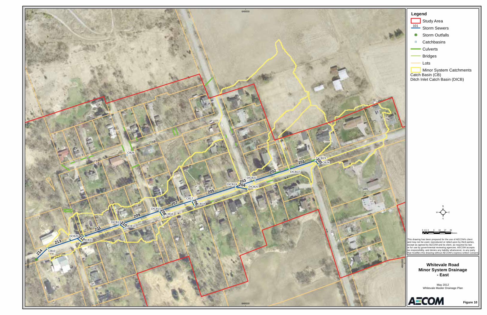
CB26
CB17
CB10
DCB25
DICB22
DICB23DICB24
DICB20
DICB18
DICB19
DICB21
DICB16
DICB15
DICB13DICB14
DICB11
205
209
213
211
202
207
201
203
214
200
204
210
208
206
212
648000
648000
4861
000
4861
000
LegendStudy Area
Storm Sewers
Storm Outfalls
Catchbasins
Culverts
Bridges
Lots
Minor System Catchments
Figure 10
Whitevale RoadMinor System Drainage
- East
May 2012Whitevale Master Drainage Plan
This drawing has been prepared for the use of AECOM’s client and may not be used, reproduced or relied upon by third parties,except as agreed by AECOM and its client, as required by law or for use by governmental reviewing agencies. AECOM accepts no responsibility, and denies any liability whatsoever, to any partythat modifies this drawing without AECOM’s express written consent.
9 0 9 18 27 364.5Meters
101
Catch Basin (CB)Ditch Inlet Catch Basin (DICB)
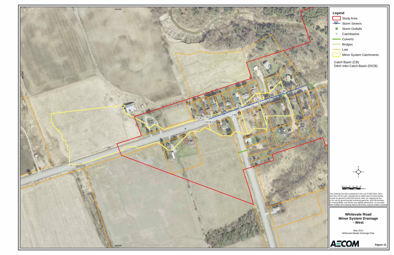
CB8
CB9
CB7
CB5CB3
DICB1DICB2
100
102
103
101
647000
647000
4861
000
4861
000
LegendStudy Area
Storm Sewers
Storm Outfalls
Catchbasins
Culverts
Bridges
Lots
Minor System Catchments
Figure 11
Whitevale RoadMinor System Drainage
- West
May 2012Whitevale Master Drainage Plan
This drawing has been prepared for the use of AECOM’s client and may not be used, reproduced or relied upon by third parties,except as agreed by AECOM and its client, as required by law or for use by governmental reviewing agencies. AECOM accepts no responsibility, and denies any liability whatsoever, to any partythat modifies this drawing without AECOM’s express written consent.
10 0 10 20 30 405Meters
101
Catch Basin (CB)Ditch Inlet Catch Basin (DICB)

03rb_2013-03-01_App Tps_60187125.Docx
Appendix A Background Data Sources (TBC)
TABLE A 1WHITEVALE MASTER DRAINAGE PLANBACKGROUND DATA SOURCES
Version: 1.0Project No.: 6018125
Date: Mar-13Design: GAF/OC
1 City of Pickering Engineering Standards City of Pickering Various DesignStandards
2 Office Consolidation of the Pickering Official Plan City of Pickering February 2010 (Edition 6)
PolicyDocument
3 Stormwater Management Design Guidelines City of Pickering - Engineering & Public Works 2012 Guideline Document
4 Municipal Class Environmental Assessment (MCEA) Municipal Engineers Association (MEA) October 2002 (as amended in 2007 &
Guideline Document
5 Adaptive Management of Stream Corridors in Ontario - Section G Supporting Documents - G.5 Common Law Aspects of Watercourse Management for
Ontario Ministry of Natural Resources (MNR) 2001 Guideline Document
6 Rivers and Stream Systems: Flooding Hazard Limit Ontario Ministry of Natural Resources (MNR) 2002 Guideline Document
7 Ontario Environmental Assessment Act (OEAA) Ontario Ministry of the Environment (MOE) R.S.O. 1990, amended 2010
Act
8 Stormwater Management Planning and Design Manual Ontario Ministry of the Environment (MOE) March 2003 Guideline Document
9 Drainage Management Manual Ontario Ministry of Transportation (MTO) 1995 - 1997 Guideline Document
Policies, Acts, Guidelines and Design Standards
Item Title Author Date Type
10 Highway Drainage Design Standards Ontario Ministry of Transportation (MTO) January 2008 Guideline Document
11 The Hamlet of Whitevale Heritage Conservation District Study - District Plan & Guide
Unterman McPhail Heritage Resource Consultants, David Cuming and Associates, Wendy Shearer Landscape Architects Limited
June, 1990 Guideline Document
12 Stage 1 Archaeological Assessment for the Whitevale Master Drainage Plan Advance Archaeology June 7, 2011 Report
13 CulvertMaster V3.2 & FlowMaster V8 Bentley Systems Inc. Various Software
14 Digital Elevation Model (DEM) and Aerial Photography City of Pickering Various Mapping
15 Whitevale Report July 2008 City of Pickering - Operations & Emergency Services July 2008 Report
16 VisualOTTHYMO Version 2.2.4 Clarifica Inc. 2007 Software
17Fact Sheet - Top 10 Common Law Drainage Problems Between Rural Neighbors
Ontario Ministry of Agriculture and Rural Affairs (OMAFRA) April, 1998 Article
18 Project File Report - Whitevale Bridge Replacement Schedule "B" Municipal Class Environmental Assessment
SRM Associates December 21, 2011 Report
19Master Environmental Servicing Plan (Phase 2 Report) for the Seaton Community
The Sernas Group December, 2011 Report
20 GIS data, historical rainfall information and Duffins Creek Floodline Map Sheet 31
Toronto and Region Conservation Various Mapping
21 HEC-RAS River Analysis System Version 4.0.0 U.S. Army Corps of Engineers Hydrologic Engineer Center March, 2008 Software
22 The Hamlet of Whitevale Heritage Conservation District Study - Background Report
Unterman McPhail Heritage Resource Consultants, David Cuming and Associates, Wendy Shearer Landscape Architects Limited
August, 1989 Report
23AECOM CCTV Inspection Reports Contract: 60187125 DVD:1 Whitevale Road Pickering
Veolia Environmental Services October 21 & 24, 2001
Report
24 Summary of Whitevale Drainage Issues Whitevale Storm Water Committee September 30, 2008 Letter
Reports, Letters, Mapping & Miscellaneous
1

03rb_2013-03-01_App Tps_60187125.Docx
Appendix B Field Investigations
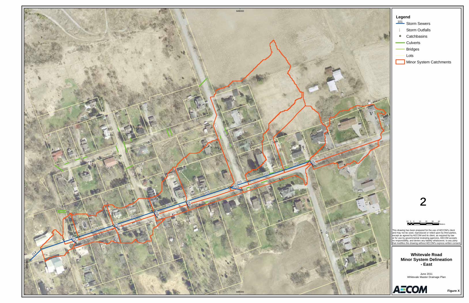
!.
205
209
213
211
202
207
201
203
214
200
204
210
208
206
212
648000
648000
4861
000
4861
000
LegendStorm Sewers
!. Storm OutfallsCatchbasins
Culverts
Bridges
Lots
Minor System Catchments
Figure X
Whitevale RoadMinor System Delineation
- East
June 2011Whitevale Master Drainage Plan
This drawing has been prepared for the use of AECOM's client and may not be used, reproduced or relied upon by third parties,except as agreed by AECOM and its client, as required by law or for use by governmental reviewing agencies. AECOM accepts no responsibility, and denies any liability whatsoever, to any partythat modifies this drawing without AECOM's express written consent.
²10 0 10 20 30 405
Meters
101
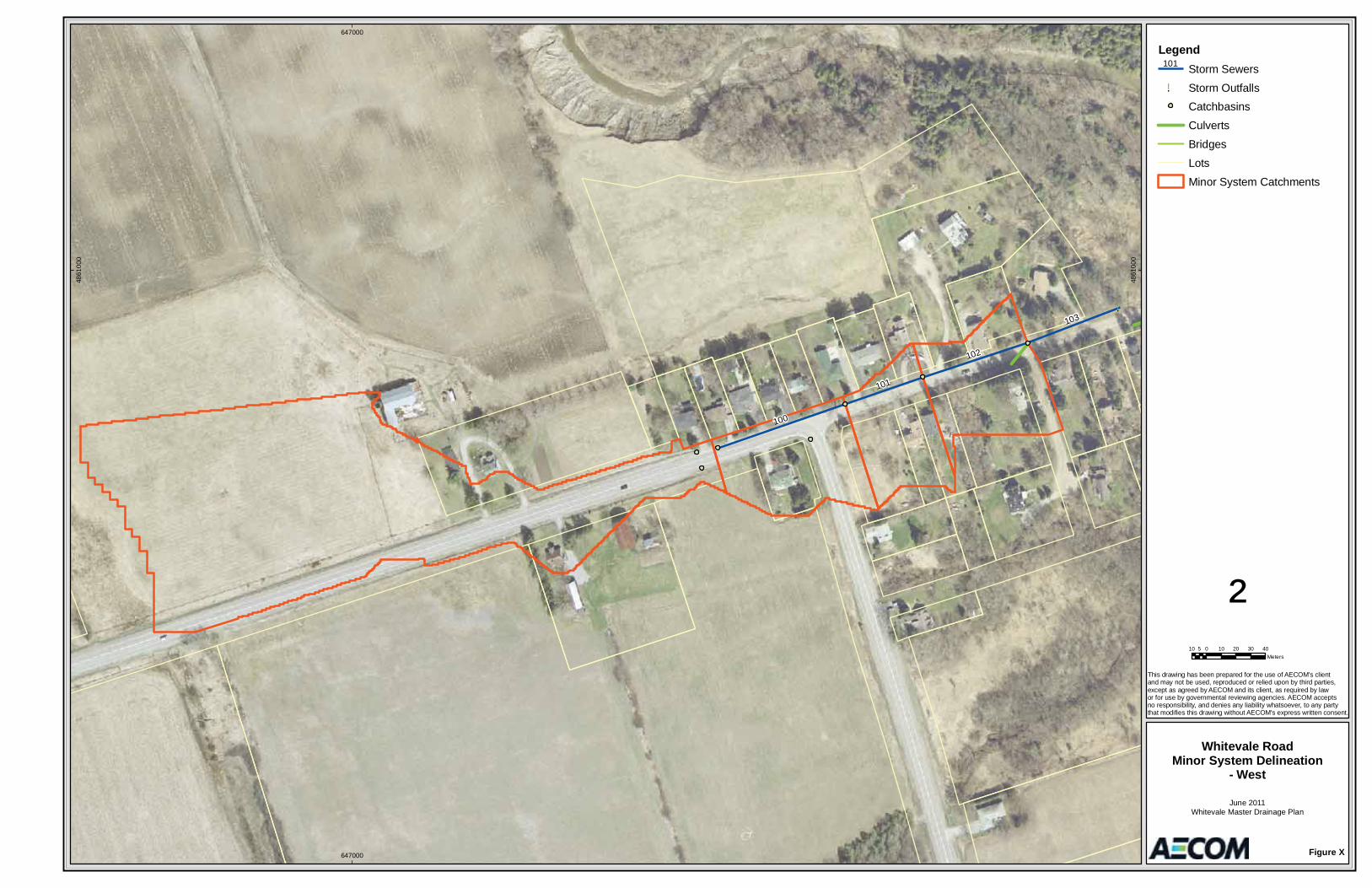
!.
100
102
103
101
647000
647000
4861
000
4861
000
LegendStorm Sewers
!. Storm OutfallsCatchbasins
Culverts
Bridges
Lots
Minor System Catchments
Figure X
Whitevale RoadMinor System Delineation
- West
June 2011Whitevale Master Drainage Plan
This drawing has been prepared for the use of AECOM's client and may not be used, reproduced or relied upon by third parties,except as agreed by AECOM and its client, as required by law or for use by governmental reviewing agencies. AECOM accepts no responsibility, and denies any liability whatsoever, to any partythat modifies this drawing without AECOM's express written consent.
²10 0 10 20 30 405
Meters
101
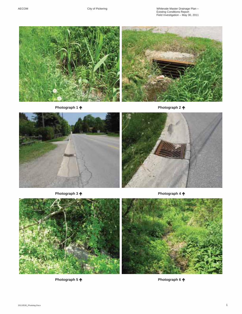
AECOM City of Pickering Whitevale Master Drainage Plan – Existing Conditions Report Field Investigation – May 30, 2011
20110530_Photolog.Docx 1
Photograph 1 Photograph 2
Photograph 3 Photograph 4
Photograph 5 Photograph 6
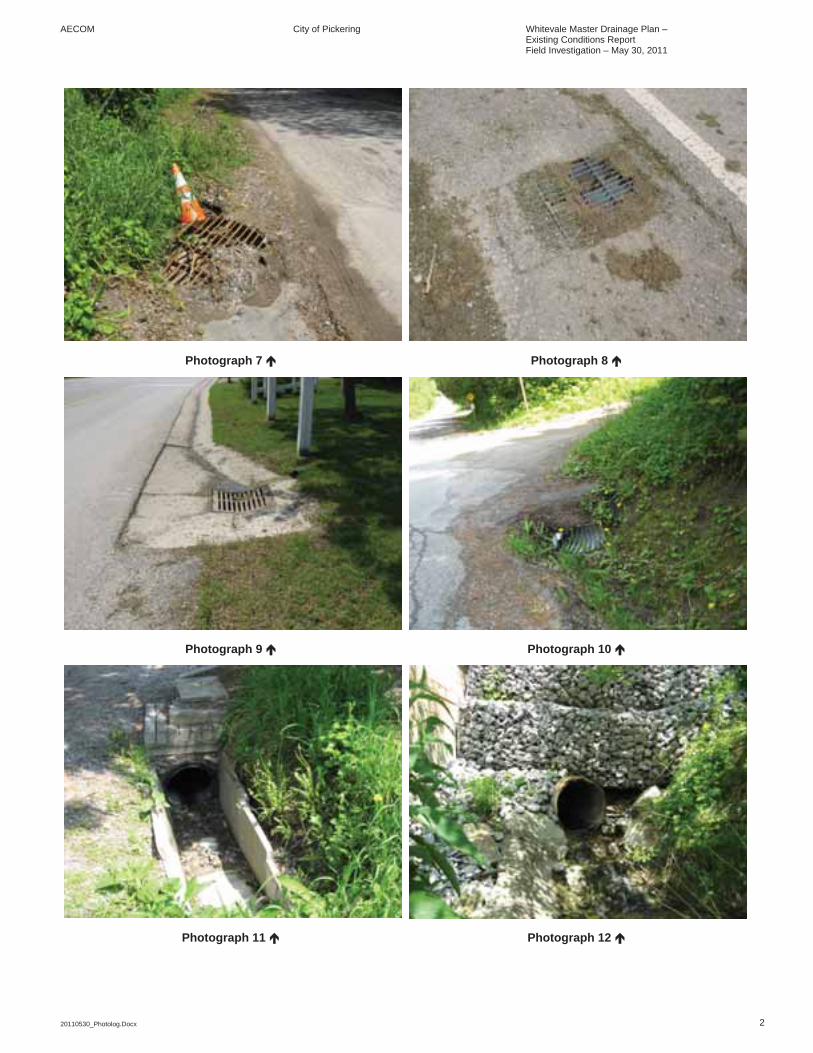
AECOM City of Pickering Whitevale Master Drainage Plan – Existing Conditions Report Field Investigation – May 30, 2011
20110530_Photolog.Docx 2
Photograph 7 Photograph 8
Photograph 9 Photograph 10
Photograph 11 Photograph 12
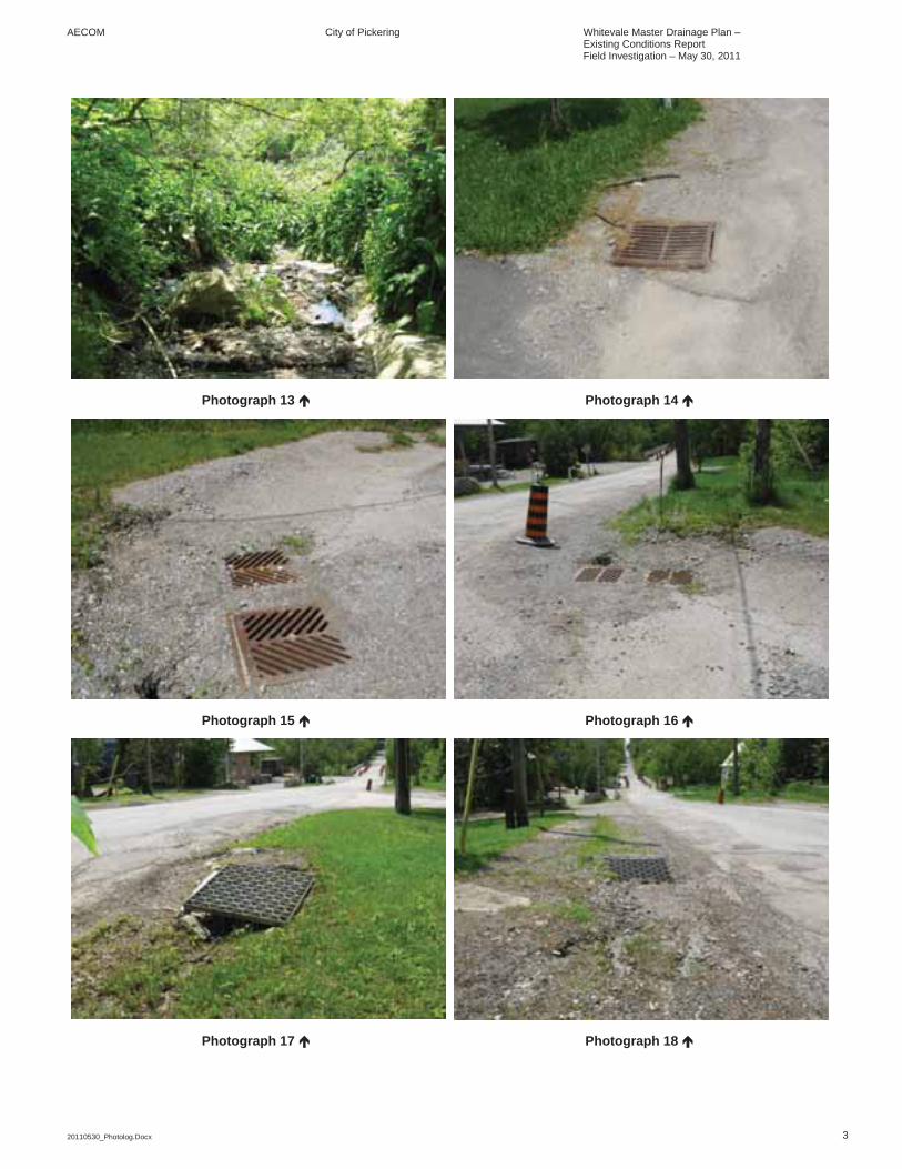
AECOM City of Pickering Whitevale Master Drainage Plan – Existing Conditions Report Field Investigation – May 30, 2011
20110530_Photolog.Docx 3
Photograph 13 Photograph 14
Photograph 15 Photograph 16
Photograph 17 Photograph 18
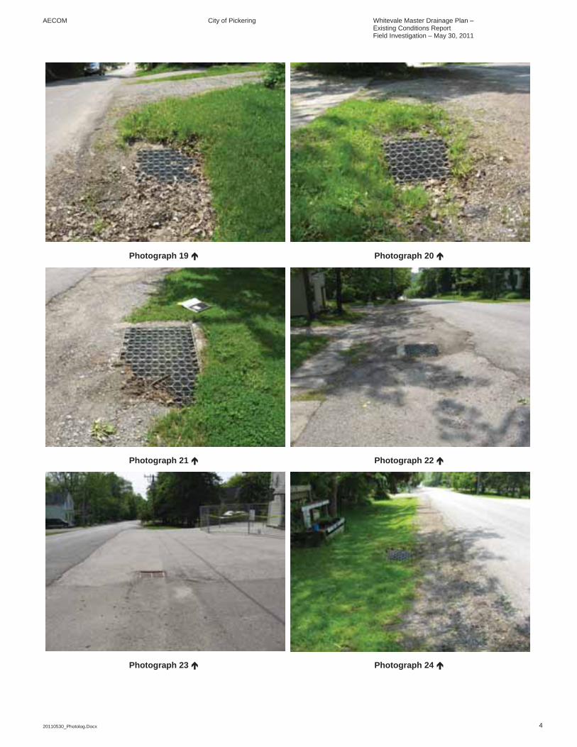
AECOM City of Pickering Whitevale Master Drainage Plan – Existing Conditions Report Field Investigation – May 30, 2011
20110530_Photolog.Docx 4
Photograph 19 Photograph 20
Photograph 21 Photograph 22
Photograph 23 Photograph 24
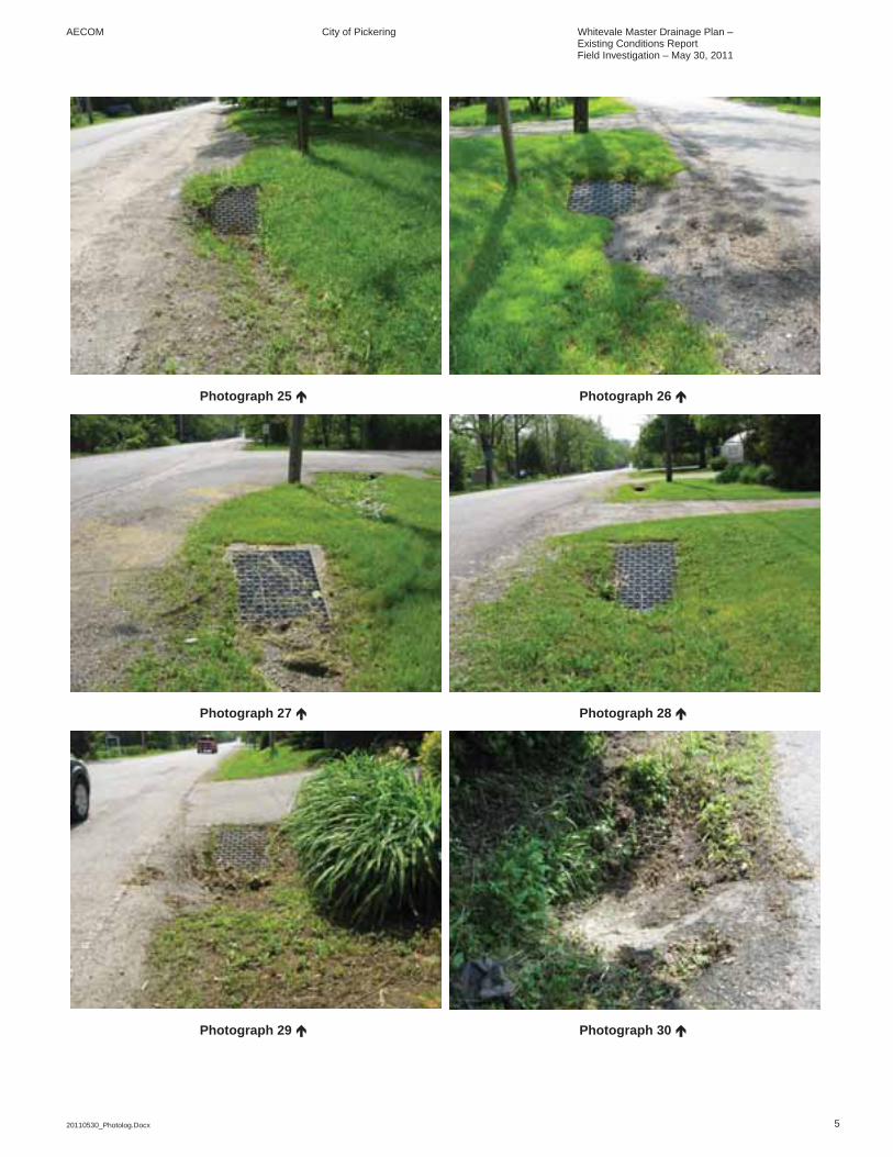
AECOM City of Pickering Whitevale Master Drainage Plan – Existing Conditions Report Field Investigation – May 30, 2011
20110530_Photolog.Docx 5
Photograph 25 Photograph 26
Photograph 27 Photograph 28
Photograph 29 Photograph 30
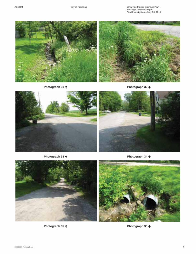
AECOM City of Pickering Whitevale Master Drainage Plan – Existing Conditions Report Field Investigation – May 30, 2011
20110530_Photolog.Docx 6
Photograph 31 Photograph 32
Photograph 33 Photograph 34
Photograph 35 Photograph 36
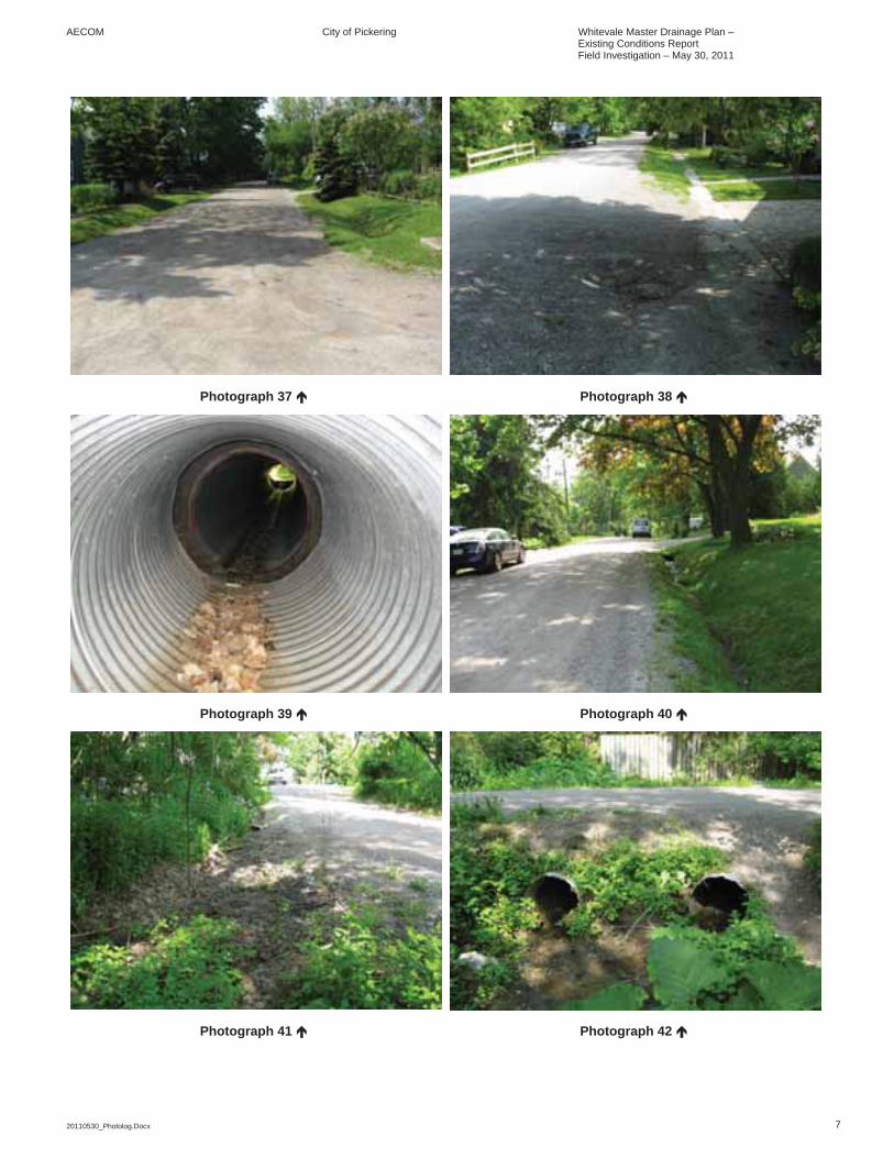
AECOM City of Pickering Whitevale Master Drainage Plan – Existing Conditions Report Field Investigation – May 30, 2011
20110530_Photolog.Docx 7
Photograph 37 Photograph 38
Photograph 39 Photograph 40
Photograph 41 Photograph 42
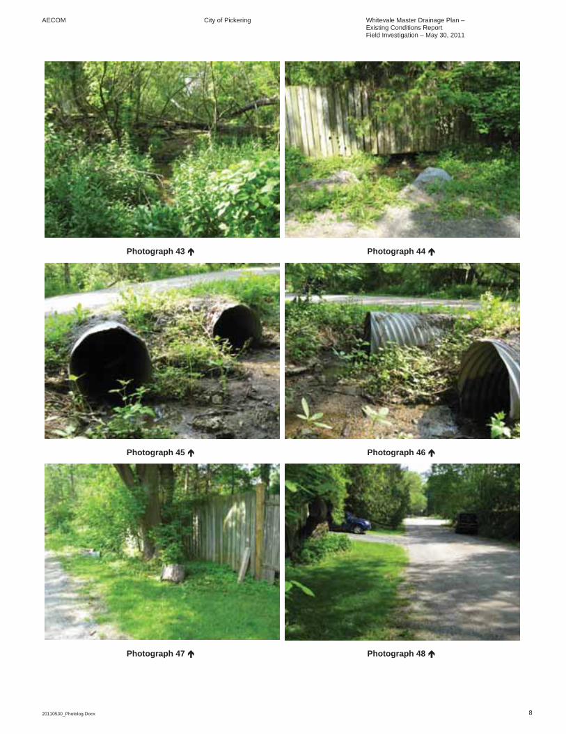
AECOM City of Pickering Whitevale Master Drainage Plan – Existing Conditions Report Field Investigation – May 30, 2011
20110530_Photolog.Docx 8
Photograph 43 Photograph 44
Photograph 45 Photograph 46
Photograph 47 Photograph 48
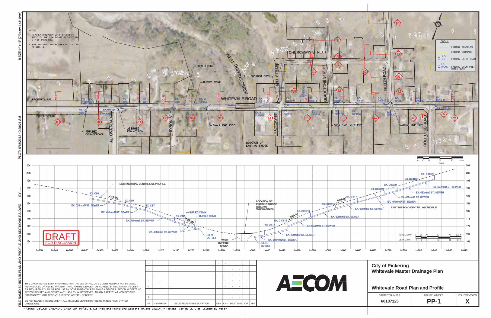
I/R YY/MM/DD ISSUE/REVISION DESCRIPTION DRN ENGDES IDR APP
FIGURE NUMBERPROJECT NUMBER ISSUE/REVISION
CHK
THIS DRAWING HAS BEEN PREPARED FOR THE USE OF AECOM'S CLIENT AND MAY NOT BE USED,REPRODUCED OR RELIED UPON BY THIRD PARTIES, EXCEPT AS AGREED BY AECOM AND ITS CLIENT,AS REQUIRED BY LAW OR FOR USE BY GOVERNMENTAL REVIEWING AGENCIES. AECOM ACCEPTS NORESPONSIBILITY, AND DENIES ANY LIABILITY WHATSOEVER, TO ANY PARTY THAT MODIFIES THISDRAWING WITHOUT AECOM'S EXPRESS WRITTEN CONSENT.
DO NOT SCALE THIS DOCUMENT. ALL MEASUREMENTS MUST BE OBTAINED FROM STATEDDIMENSIONS.
.. .......
.. .......
.. .......
.. .......
.. .......
.. .......
.. ..A
XPP-160187125
Whitevale Road Plan and Profile
Whitevale Master Drainage PlanCity of Pickering
60HORZ:1 : 3000 15 30 90 120 m0
601 : 3000
15 30 90 120 m0
12VERT 1 : 600 3 6 18 24 m0
FOR DISCUSSIONDRAFT

I/R YY/MM/DD ISSUE/REVISION DESCRIPTION DRN ENGDES IDR APP
FIGURE NUMBERPROJECT NUMBER ISSUE/REVISION
CHK
THIS DRAWING HAS BEEN PREPARED FOR THE USE OF AECOM'S CLIENT AND MAY NOT BE USED,REPRODUCED OR RELIED UPON BY THIRD PARTIES, EXCEPT AS AGREED BY AECOM AND ITS CLIENT,AS REQUIRED BY LAW OR FOR USE BY GOVERNMENTAL REVIEWING AGENCIES. AECOM ACCEPTS NORESPONSIBILITY, AND DENIES ANY LIABILITY WHATSOEVER, TO ANY PARTY THAT MODIFIES THISDRAWING WITHOUT AECOM'S EXPRESS WRITTEN CONSENT.
DO NOT SCALE THIS DOCUMENT. ALL MEASUREMENTS MUST BE OBTAINED FROM STATEDDIMENSIONS.
.. .......
.. .......
.. .......
.. .......
.. .......
.. .......
.. ......A
XSEC-0160187125
SECTIONS 'A' AND 'B'WHITEVALE ROAD - Whitevale Master Drainage PlanCity of Pickering
FOR DISCUSSIONDRAFT

I/R YY/MM/DD ISSUE/REVISION DESCRIPTION DRN ENGDES IDR APP
FIGURE NUMBERPROJECT NUMBER ISSUE/REVISION
CHK
THIS DRAWING HAS BEEN PREPARED FOR THE USE OF AECOM'S CLIENT AND MAY NOT BE USED,REPRODUCED OR RELIED UPON BY THIRD PARTIES, EXCEPT AS AGREED BY AECOM AND ITS CLIENT,AS REQUIRED BY LAW OR FOR USE BY GOVERNMENTAL REVIEWING AGENCIES. AECOM ACCEPTS NORESPONSIBILITY, AND DENIES ANY LIABILITY WHATSOEVER, TO ANY PARTY THAT MODIFIES THISDRAWING WITHOUT AECOM'S EXPRESS WRITTEN CONSENT.
DO NOT SCALE THIS DOCUMENT. ALL MEASUREMENTS MUST BE OBTAINED FROM STATEDDIMENSIONS.
.. .......
.. .......
.. .......
.. .......
.. .......
.. .......
.. ......A
XSEC-0260187125
SECTIONS 'C' AND 'D'WHITEVALE ROAD - Whitevale Master Drainage PlanCity of Pickering
FOR DISCUSSIONDRAFT

I/R YY/MM/DD ISSUE/REVISION DESCRIPTION DRN ENGDES IDR APP
FIGURE NUMBERPROJECT NUMBER ISSUE/REVISION
CHK
THIS DRAWING HAS BEEN PREPARED FOR THE USE OF AECOM'S CLIENT AND MAY NOT BE USED,REPRODUCED OR RELIED UPON BY THIRD PARTIES, EXCEPT AS AGREED BY AECOM AND ITS CLIENT,AS REQUIRED BY LAW OR FOR USE BY GOVERNMENTAL REVIEWING AGENCIES. AECOM ACCEPTS NORESPONSIBILITY, AND DENIES ANY LIABILITY WHATSOEVER, TO ANY PARTY THAT MODIFIES THISDRAWING WITHOUT AECOM'S EXPRESS WRITTEN CONSENT.
DO NOT SCALE THIS DOCUMENT. ALL MEASUREMENTS MUST BE OBTAINED FROM STATEDDIMENSIONS.
.. .......
.. .......
.. .......
.. .......
.. .......
.. .......
.. ......A
XSEC-0360187125
SECTIONS 'E' AND 'F'WHITEVALE ROAD - Whitevale Master Drainage PlanCity of Pickering
FOR DISCUSSIONDRAFT

I/R YY/MM/DD ISSUE/REVISION DESCRIPTION DRN ENGDES IDR APP
FIGURE NUMBERPROJECT NUMBER ISSUE/REVISION
CHK
THIS DRAWING HAS BEEN PREPARED FOR THE USE OF AECOM'S CLIENT AND MAY NOT BE USED,REPRODUCED OR RELIED UPON BY THIRD PARTIES, EXCEPT AS AGREED BY AECOM AND ITS CLIENT,AS REQUIRED BY LAW OR FOR USE BY GOVERNMENTAL REVIEWING AGENCIES. AECOM ACCEPTS NORESPONSIBILITY, AND DENIES ANY LIABILITY WHATSOEVER, TO ANY PARTY THAT MODIFIES THISDRAWING WITHOUT AECOM'S EXPRESS WRITTEN CONSENT.
DO NOT SCALE THIS DOCUMENT. ALL MEASUREMENTS MUST BE OBTAINED FROM STATEDDIMENSIONS.
.. .......
.. .......
.. .......
.. .......
.. .......
.. .......
.. ......A
XSEC-0460187125
SECTIONS 'G' AND 'H'WHITEVALE ROAD - Whitevale Master Drainage PlanCity of Pickering
FOR DISCUSSIONDRAFT
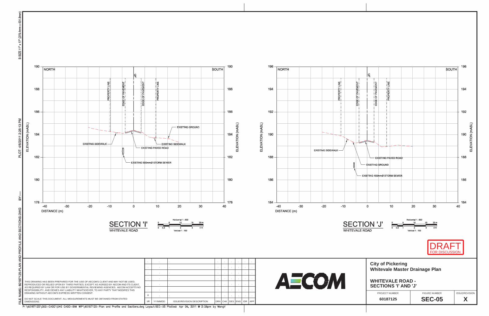
I/R YY/MM/DD ISSUE/REVISION DESCRIPTION DRN ENGDES IDR APP
FIGURE NUMBERPROJECT NUMBER ISSUE/REVISION
CHK
THIS DRAWING HAS BEEN PREPARED FOR THE USE OF AECOM'S CLIENT AND MAY NOT BE USED,REPRODUCED OR RELIED UPON BY THIRD PARTIES, EXCEPT AS AGREED BY AECOM AND ITS CLIENT,AS REQUIRED BY LAW OR FOR USE BY GOVERNMENTAL REVIEWING AGENCIES. AECOM ACCEPTS NORESPONSIBILITY, AND DENIES ANY LIABILITY WHATSOEVER, TO ANY PARTY THAT MODIFIES THISDRAWING WITHOUT AECOM'S EXPRESS WRITTEN CONSENT.
DO NOT SCALE THIS DOCUMENT. ALL MEASUREMENTS MUST BE OBTAINED FROM STATEDDIMENSIONS.
.. .......
.. .......
.. .......
.. .......
.. .......
.. .......
.. ......A
XSEC-0560187125
SECTIONS 'I' AND 'J'WHITEVALE ROAD - Whitevale Master Drainage PlanCity of Pickering
FOR DISCUSSIONDRAFT
I/R YY/MM/DD ISSUE/REVISION DESCRIPTION DRN ENGDES IDR APP
FIGURE NUMBERPROJECT NUMBER ISSUE/REVISION
CHK
THIS DRAWING HAS BEEN PREPARED FOR THE USE OF AECOM'S CLIENT AND MAY NOT BE USED,REPRODUCED OR RELIED UPON BY THIRD PARTIES, EXCEPT AS AGREED BY AECOM AND ITS CLIENT,AS REQUIRED BY LAW OR FOR USE BY GOVERNMENTAL REVIEWING AGENCIES. AECOM ACCEPTS NORESPONSIBILITY, AND DENIES ANY LIABILITY WHATSOEVER, TO ANY PARTY THAT MODIFIES THISDRAWING WITHOUT AECOM'S EXPRESS WRITTEN CONSENT.
DO NOT SCALE THIS DOCUMENT. ALL MEASUREMENTS MUST BE OBTAINED FROM STATEDDIMENSIONS.
.. .......
.. .......
.. .......
.. .......
.. .......
.. .......
.. ......A
XSEC-0660187125
SECTIONS 'K' AND 'L'WHITEVALE ROAD - Whitevale Master Drainage PlanCity of Pickering
FOR DISCUSSIONDRAFT

I/R YY/MM/DD ISSUE/REVISION DESCRIPTION DRN ENGDES IDR APP
FIGURE NUMBERPROJECT NUMBER ISSUE/REVISION
CHK
THIS DRAWING HAS BEEN PREPARED FOR THE USE OF AECOM'S CLIENT AND MAY NOT BE USED,REPRODUCED OR RELIED UPON BY THIRD PARTIES, EXCEPT AS AGREED BY AECOM AND ITS CLIENT,AS REQUIRED BY LAW OR FOR USE BY GOVERNMENTAL REVIEWING AGENCIES. AECOM ACCEPTS NORESPONSIBILITY, AND DENIES ANY LIABILITY WHATSOEVER, TO ANY PARTY THAT MODIFIES THISDRAWING WITHOUT AECOM'S EXPRESS WRITTEN CONSENT.
DO NOT SCALE THIS DOCUMENT. ALL MEASUREMENTS MUST BE OBTAINED FROM STATEDDIMENSIONS.
.. .......
.. .......
.. .......
.. .......
.. .......
.. .......
.. ......A
XSEC-0760187125
SECTIONS 'M' AND 'N'NORTH ROAD - Whitevale Master Drainage PlanCity of Pickering
FOR DISCUSSIONDRAFT
I/R YY/MM/DD ISSUE/REVISION DESCRIPTION DRN ENGDES IDR APP
FIGURE NUMBERPROJECT NUMBER ISSUE/REVISION
CHK
THIS DRAWING HAS BEEN PREPARED FOR THE USE OF AECOM'S CLIENT AND MAY NOT BE USED,REPRODUCED OR RELIED UPON BY THIRD PARTIES, EXCEPT AS AGREED BY AECOM AND ITS CLIENT,AS REQUIRED BY LAW OR FOR USE BY GOVERNMENTAL REVIEWING AGENCIES. AECOM ACCEPTS NORESPONSIBILITY, AND DENIES ANY LIABILITY WHATSOEVER, TO ANY PARTY THAT MODIFIES THISDRAWING WITHOUT AECOM'S EXPRESS WRITTEN CONSENT.
DO NOT SCALE THIS DOCUMENT. ALL MEASUREMENTS MUST BE OBTAINED FROM STATEDDIMENSIONS.
.. .......
.. .......
.. .......
.. .......
.. .......
.. .......
.. ......A
XSEC-0860187125
SECTIONS 'O' AND 'P'NORTH ROAD - Whitevale Master Drainage PlanCity of Pickering
FOR DISCUSSIONDRAFT

I/R YY/MM/DD ISSUE/REVISION DESCRIPTION DRN ENGDES IDR APP
FIGURE NUMBERPROJECT NUMBER ISSUE/REVISION
CHK
THIS DRAWING HAS BEEN PREPARED FOR THE USE OF AECOM'S CLIENT AND MAY NOT BE USED,REPRODUCED OR RELIED UPON BY THIRD PARTIES, EXCEPT AS AGREED BY AECOM AND ITS CLIENT,AS REQUIRED BY LAW OR FOR USE BY GOVERNMENTAL REVIEWING AGENCIES. AECOM ACCEPTS NORESPONSIBILITY, AND DENIES ANY LIABILITY WHATSOEVER, TO ANY PARTY THAT MODIFIES THISDRAWING WITHOUT AECOM'S EXPRESS WRITTEN CONSENT.
DO NOT SCALE THIS DOCUMENT. ALL MEASUREMENTS MUST BE OBTAINED FROM STATEDDIMENSIONS.
.. .......
.. .......
.. .......
.. .......
.. .......
.. .......
.. ......A
XSEC-0960187125
SECTIONS 'Q' AND 'R'GLADSTONE STREET - Whitevale Master Drainage PlanCity of Pickering
FOR DISCUSSIONDRAFT

I/R YY/MM/DD ISSUE/REVISION DESCRIPTION DRN ENGDES IDR APP
FIGURE NUMBERPROJECT NUMBER ISSUE/REVISION
CHK
THIS DRAWING HAS BEEN PREPARED FOR THE USE OF AECOM'S CLIENT AND MAY NOT BE USED,REPRODUCED OR RELIED UPON BY THIRD PARTIES, EXCEPT AS AGREED BY AECOM AND ITS CLIENT,AS REQUIRED BY LAW OR FOR USE BY GOVERNMENTAL REVIEWING AGENCIES. AECOM ACCEPTS NORESPONSIBILITY, AND DENIES ANY LIABILITY WHATSOEVER, TO ANY PARTY THAT MODIFIES THISDRAWING WITHOUT AECOM'S EXPRESS WRITTEN CONSENT.
DO NOT SCALE THIS DOCUMENT. ALL MEASUREMENTS MUST BE OBTAINED FROM STATEDDIMENSIONS.
.. .......
.. .......
.. .......
.. .......
.. .......
.. .......
.. ......A
XSEC-1060187125
SECTIONS 'S' AND 'T'GLADSTONE STREET - Whitevale Master Drainage PlanCity of Pickering
FOR DISCUSSIONDRAFT
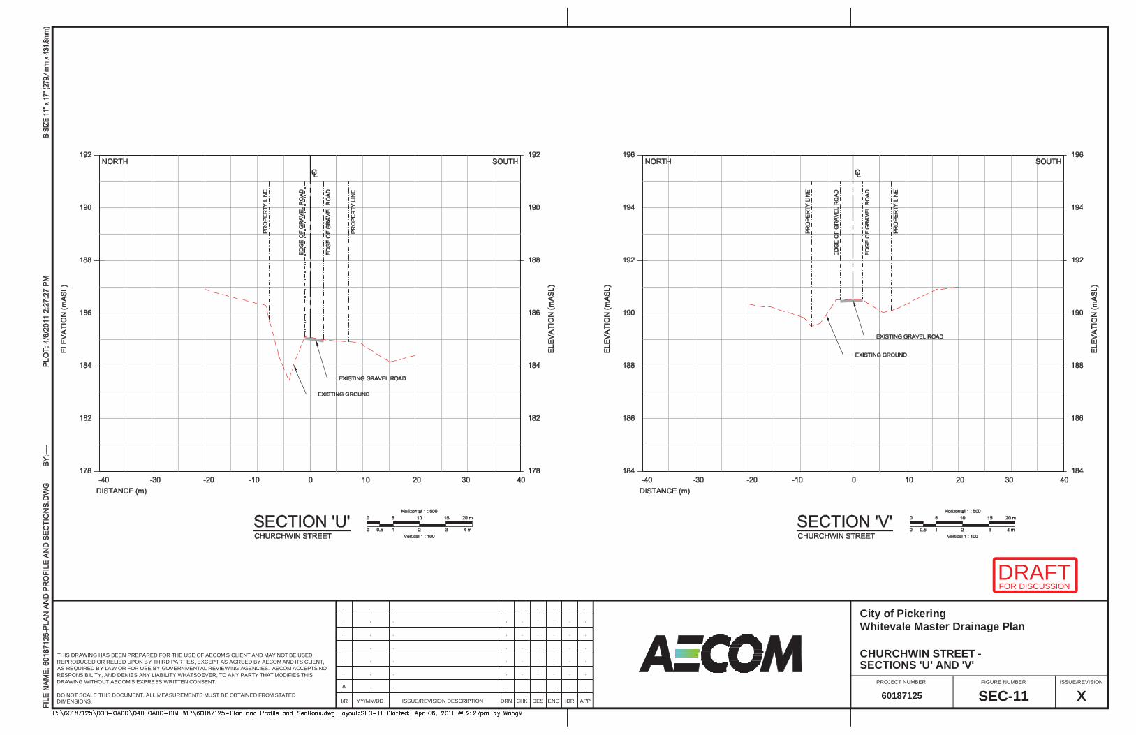
I/R YY/MM/DD ISSUE/REVISION DESCRIPTION DRN ENGDES IDR APP
FIGURE NUMBERPROJECT NUMBER ISSUE/REVISION
CHK
THIS DRAWING HAS BEEN PREPARED FOR THE USE OF AECOM'S CLIENT AND MAY NOT BE USED,REPRODUCED OR RELIED UPON BY THIRD PARTIES, EXCEPT AS AGREED BY AECOM AND ITS CLIENT,AS REQUIRED BY LAW OR FOR USE BY GOVERNMENTAL REVIEWING AGENCIES. AECOM ACCEPTS NORESPONSIBILITY, AND DENIES ANY LIABILITY WHATSOEVER, TO ANY PARTY THAT MODIFIES THISDRAWING WITHOUT AECOM'S EXPRESS WRITTEN CONSENT.
DO NOT SCALE THIS DOCUMENT. ALL MEASUREMENTS MUST BE OBTAINED FROM STATEDDIMENSIONS.
.. .......
.. .......
.. .......
.. .......
.. .......
.. .......
.. ......A
XSEC-1160187125
SECTIONS 'U' AND 'V'CHURCHWIN STREET - Whitevale Master Drainage PlanCity of Pickering
FOR DISCUSSIONDRAFT
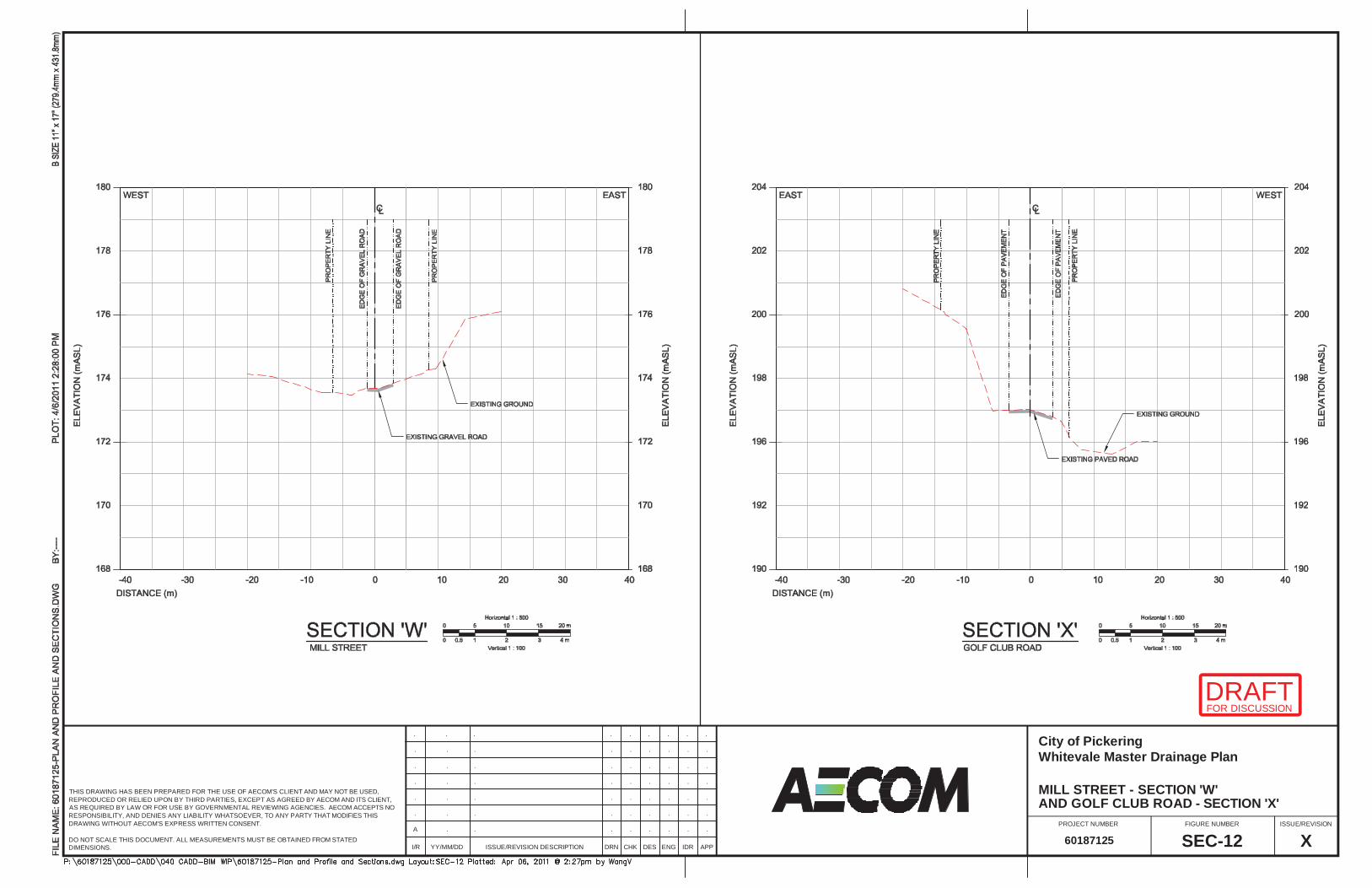
I/R YY/MM/DD ISSUE/REVISION DESCRIPTION DRN ENGDES IDR APP
FIGURE NUMBERPROJECT NUMBER ISSUE/REVISION
CHK
THIS DRAWING HAS BEEN PREPARED FOR THE USE OF AECOM'S CLIENT AND MAY NOT BE USED,REPRODUCED OR RELIED UPON BY THIRD PARTIES, EXCEPT AS AGREED BY AECOM AND ITS CLIENT,AS REQUIRED BY LAW OR FOR USE BY GOVERNMENTAL REVIEWING AGENCIES. AECOM ACCEPTS NORESPONSIBILITY, AND DENIES ANY LIABILITY WHATSOEVER, TO ANY PARTY THAT MODIFIES THISDRAWING WITHOUT AECOM'S EXPRESS WRITTEN CONSENT.
DO NOT SCALE THIS DOCUMENT. ALL MEASUREMENTS MUST BE OBTAINED FROM STATEDDIMENSIONS.
.. .......
.. .......
.. .......
.. .......
.. .......
.. .......
.. ......A
XSEC-1260187125
AND GOLF CLUB ROAD - SECTION 'X'MILL STREET - SECTION 'W' Whitevale Master Drainage PlanCity of Pickering
FOR DISCUSSIONDRAFT
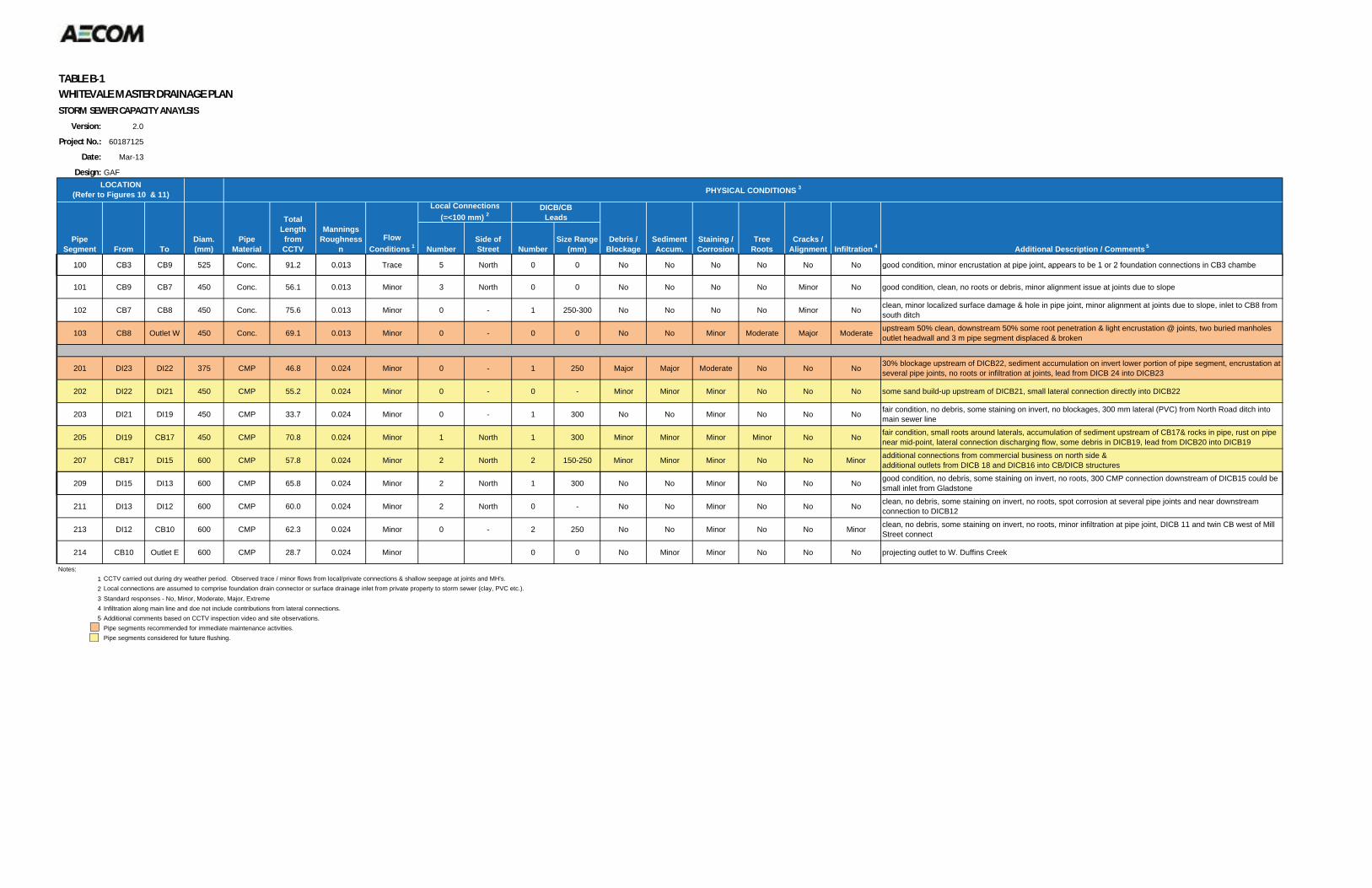
TABLE B 1WHITEVALE MASTER DRAINAGE PLANSTORM SEWER CAPACITY ANAYLSIS
Version: 2.0
Project No.: 60187125
Date: Mar-13
Design: GAF
100 CB3 CB9 525 Conc. 91.2 0.013 Trace 5 North 0 0 No No No No No No good condition, minor encrustation at pipe joint, appears to be 1 or 2 foundation connections in CB3 chamber
Debris / Blockage
SedimentAccum.
Diam.(mm)
Local Connections(=<100 mm) 2
NumberSide ofStreet
DICB/CBLeads
NumberSize Range
(mm)Staining / Corrosion
Cracks / Alignment
TreeRoots Infiltration 4
LOCATION(Refer to Figures 10 & 11)
PipeSegment From To
PHYSICAL CONDITIONS 3
PipeMaterial
ManningsRoughness
n Additional Description / Comments 5
TotalLengthfromCCTV
FlowConditions 1
100 CB3 CB9 525 Conc. 91.2 0.013 Trace 5 North 0 0 No No No No No No good condition, minor encrustation at pipe joint, appears to be 1 or 2 foundation connections in CB3 chamber
101 CB9 CB7 450 Conc. 56.1 0.013 Minor 3 North 0 0 No No No No Minor No good condition, clean, no roots or debris, minor alignment issue at joints due to slope
102 CB7 CB8 450 Conc. 75.6 0.013 Minor 0 - 1 250-300 No No No No Minor No clean, minor localized surface damage & hole in pipe joint, minor alignment at joints due to slope, inlet to CB8 from south ditch
103 CB8 Outlet W 450 Conc. 69.1 0.013 Minor 0 - 0 0 No No Minor Moderate Major Moderate upstream 50% clean, downstream 50% some root penetration & light encrustation @ joints, two buried manholes outlet headwall and 3 m pipe segment displaced & broken
201 DI23 DI22 375 CMP 46.8 0.024 Minor 0 - 1 250 Major Major Moderate No No No 30% blockage upstream of DICB22, sediment accumulation on invert lower portion of pipe segment, encrustation at several pipe joints, no roots or infiltration at joints, lead from DICB 24 into DICB23
202 DI22 DI21 450 CMP 55.2 0.024 Minor 0 - 0 - Minor Minor Minor No No No some sand build-up upstream of DICB21, small lateral connection directly into DICB22
203 DI21 DI19 450 CMP 33.7 0.024 Minor 0 - 1 300 No No Minor No No No fair condition, no debris, some staining on invert, no blockages, 300 mm lateral (PVC) from North Road ditch into main sewer line
205 DI19 CB17 450 CMP 70.8 0.024 Minor 1 North 1 300 Minor Minor Minor Minor No No fair condition, small roots around laterals, accumulation of sediment upstream of CB17& rocks in pipe, rust on pipe near mid-point, lateral connection discharging flow, some debris in DICB19, lead from DICB20 into DICB19
207 CB17 DI15 600 CMP 57.8 0.024 Minor 2 North 2 150-250 Minor Minor Minor No No Minor additional connections from commercial business on north side & additional outlets from DICB 18 and DICB16 into CB/DICB structures
d diti d b i t i i i t t 300 CMP ti d t f DICB15 ld b209 DI15 DI13 600 CMP 65.8 0.024 Minor 2 North 1 300 No No Minor No No No good condition, no debris, some staining on invert, no roots, 300 CMP connection downstream of DICB15 could besmall inlet from Gladstone
211 DI13 DI12 600 CMP 60.0 0.024 Minor 2 North 0 - No No Minor No No No clean, no debris, some staining on invert, no roots, spot corrosion at several pipe joints and near downstream connection to DICB12
213 DI12 CB10 600 CMP 62.3 0.024 Minor 0 - 2 250 No No Minor No No Minor clean, no debris, some staining on invert, no roots, minor infiltration at pipe joint, DICB 11 and twin CB west of Mill Street connect
214 CB10 Outlet E 600 CMP 28.7 0.024 Minor 0 0 No Minor Minor No No No projecting outlet to W. Duffins Creek
Notes:1 CCTV carried out during dry weather period. Observed trace / minor flows from local/private connections & shallow seepage at joints and MH's.2 Local connections are assumed to comprise foundation drain connector or surface drainage inlet from private property to storm sewer (clay, PVC etc.).3 Standard responses - No, Minor, Moderate, Major, Extreme4 Infiltration along main line and doe not include contributions from lateral connections.5 Additional comments based on CCTV inspection video and site observations.
Pipe segments recommended for immediate maintenance activities.Pipe segments considered for future flushing.
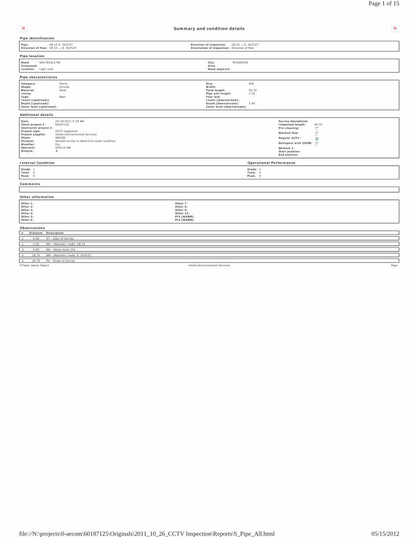
Summary and condition details
Pipe identification
Pipe: CB 10 E. OUTLETDirection of flow: CB 10 E. OUTLET
Direction of inspection: CB 10 E. OUTLETOrientation of inspection: Direction of flow
Pipe location
Road: WHITEVALE RDCrossroad: Location: Light road
City: PICKERINGArea: Road segment:
Pipe characteristics
Category: StormShape: CircularMaterial: SteelLining: Type: MainInvert (upstream): Depth (upstream): Cover level (upstream):
Size: 600Width: Total length: 28.70Pipe unit length: 2.10Year laid: Invert (downstream): Depth (downstream): 3.40Cover level (downstream):
Additional details
Date: 24/10/2011 9:29 AMClient project #: 60187125Contractor project #: Project type: CCTV InspectionProject supplier: Veolia Environmental ServicesClient: AECOMPurpose: Sample survey to determine asset conditionWeather: DryOperator: VEOLIA AMAnalyst: JL
Survey Abandoned: Inspected length: 28.70Pre-cleaning:
Blocked flow:
Regular CCTV:
Reinspect with ZOOM:
Medium #: Start position: End position:
Internal Condition Operational Performance
Grade: 1Total: 0Peak: 0
Grade: 1Total: 0Peak: 0
Comments
Other information
Other 1: Other 2: Other 3: Other 4: Other 5: Other 6:
Other 7: Other 8: Other 9: Other 10: PI5 (MAMR): PI6 (MAMR):
Observations# Distance Description
1 0.00 ST - Start of Survey
2 0.00 MH - Manhole / node, CB 10
3 0.00 WL - Water level, 5%
4 28.70 MH - Manhole / node, E. OUTLET
5 28.70 FH - Finish of SurveyCTSpec Sewer Report Veolia Environmental Services Page
Page 1 of 15
05/15/2012file://N:\projects\0-aecom\60187125\Originals\2011_10_26_CCTV Inspection\Reports\S_Pipe_All.html
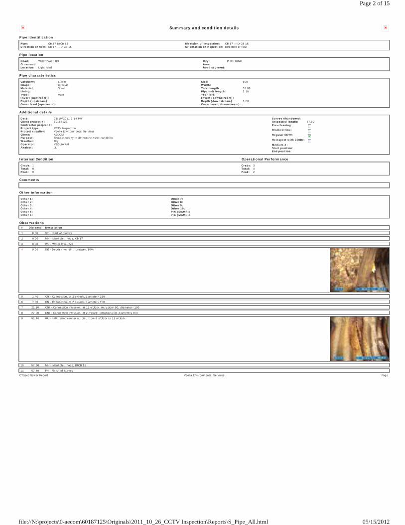
Summary and condition details
Pipe identification
Pipe: CB 17 DICB 15Direction of flow: CB 17 DICB 15
Direction of inspection: CB 17 DICB 15Orientation of inspection: Direction of flow
Pipe location
Road: WHITEVALE RDCrossroad: Location: Light road
City: PICKERINGArea: Road segment:
Pipe characteristics
Category: StormShape: CircularMaterial: SteelLining: Type: MainInvert (upstream): Depth (upstream): Cover level (upstream):
Size: 600Width: Total length: 57.80Pipe unit length: 2.10Year laid: Invert (downstream): Depth (downstream): 3.00Cover level (downstream):
Additional details
Date: 21/10/2011 2:34 PMClient project #: 60187125Contractor project #: Project type: CCTV InspectionProject supplier: Veolia Environmental ServicesClient: AECOMPurpose: Sample survey to determine asset conditionWeather: DryOperator: VEOLIA AMAnalyst: JL
Survey Abandoned: Inspected length: 57.80Pre-cleaning:
Blocked flow:
Regular CCTV:
Reinspect with ZOOM:
Medium #: Start position: End position:
Internal Condition Operational Performance
Grade: 1Total: 0Peak: 0
Grade: 3Total: 4Peak: 2
Comments
Other information
Other 1: Other 2: Other 3: Other 4: Other 5: Other 6:
Other 7: Other 8: Other 9: Other 10: PI5 (MAMR): PI6 (MAMR):
Observations# Distance Description
1 0.00 ST - Start of Survey
2 0.00 MH - Manhole / node, CB 17
3 0.00 WL - Water level, 5%
4 0.00 DE - Debris (non-silt / grease), 10%
5 1.40 CN - Connection, at 2 o'clock, diameter=250
6 7.00 CN - Connection, at 2 o'clock, diameter=150
7 21.30 CNI - Connection intrusion, at 12 o'clock, intrusion=50, diameter=100
8 22.00 CNI - Connection intrusion, at 2 o'clock, intrusion=50, diameter=100
9 51.40 IRJ - Infiltration runner at joint, from 6 o'clock to 11 o'clock
10 57.80 MH - Manhole / node, DICB 15
11 57.80 FH - Finish of SurveyCTSpec Sewer Report Veolia Environmental Services Page
Page 2 of 15
05/15/2012file://N:\projects\0-aecom\60187125\Originals\2011_10_26_CCTV Inspection\Reports\S_Pipe_All.html
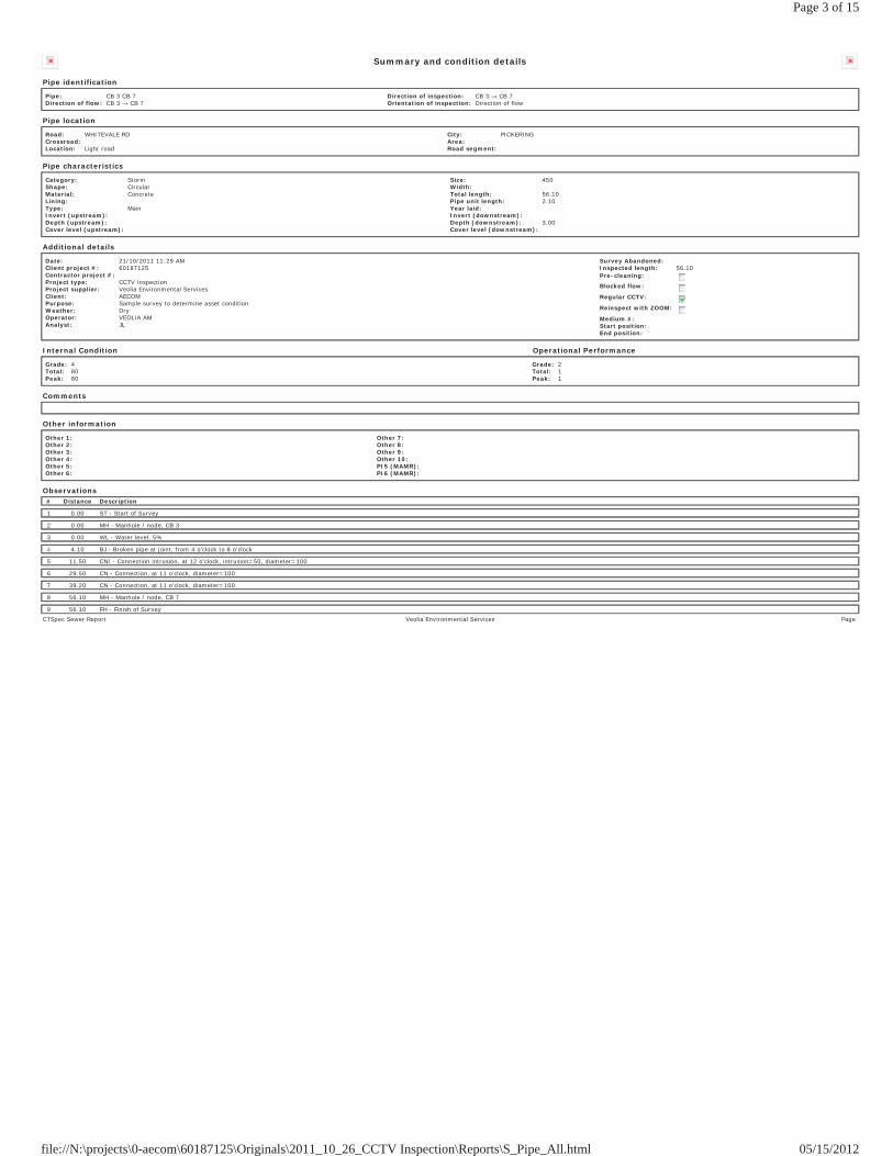
Summary and condition details
Pipe identification
Pipe: CB 3 CB 7Direction of flow: CB 3 CB 7
Direction of inspection: CB 3 CB 7Orientation of inspection: Direction of flow
Pipe location
Road: WHITEVALE RDCrossroad: Location: Light road
City: PICKERINGArea: Road segment:
Pipe characteristics
Category: StormShape: CircularMaterial: ConcreteLining: Type: MainInvert (upstream): Depth (upstream): Cover level (upstream):
Size: 450Width: Total length: 56.10Pipe unit length: 2.10Year laid: Invert (downstream): Depth (downstream): 3.00Cover level (downstream):
Additional details
Date: 21/10/2011 11:29 AMClient project #: 60187125Contractor project #: Project type: CCTV InspectionProject supplier: Veolia Environmental ServicesClient: AECOMPurpose: Sample survey to determine asset conditionWeather: DryOperator: VEOLIA AMAnalyst: JL
Survey Abandoned: Inspected length: 56.10Pre-cleaning:
Blocked flow:
Regular CCTV:
Reinspect with ZOOM:
Medium #: Start position: End position:
Internal Condition Operational Performance
Grade: 4Total: 80Peak: 80
Grade: 2Total: 1Peak: 1
Comments
Other information
Other 1: Other 2: Other 3: Other 4: Other 5: Other 6:
Other 7: Other 8: Other 9: Other 10: PI5 (MAMR): PI6 (MAMR):
Observations# Distance Description
1 0.00 ST - Start of Survey
2 0.00 MH - Manhole / node, CB 3
3 0.00 WL - Water level, 5%
4 4.10 BJ - Broken pipe at joint, from 4 o'clock to 8 o'clock
5 11.50 CNI - Connection intrusion, at 12 o'clock, intrusion=50, diameter=100
6 29.50 CN - Connection, at 11 o'clock, diameter=100
7 39.20 CN - Connection, at 11 o'clock, diameter=100
8 56.10 MH - Manhole / node, CB 7
9 56.10 FH - Finish of SurveyCTSpec Sewer Report Veolia Environmental Services Page
Page 3 of 15
05/15/2012file://N:\projects\0-aecom\60187125\Originals\2011_10_26_CCTV Inspection\Reports\S_Pipe_All.html
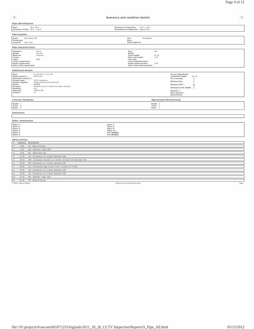
Summary and condition details
Pipe identification
Pipe: CB 3 CB 9Direction of flow: CB 3 CB 9
Direction of inspection: CB 9 CB 3Orientation of inspection: Against flow
Pipe location
Road: WHITEVALE RDCrossroad: Location: Light road
City: PICKERINGArea: Road segment:
Pipe characteristics
Category: StormShape: CircularMaterial: ConcreteLining: Type: MainInvert (upstream): Depth (upstream): Cover level (upstream):
Size: 525Width: Total length: 91.20Pipe unit length: 2.10Year laid: Invert (downstream): Depth (downstream): 3.00Cover level (downstream):
Additional details
Date: 21/10/2011 11:03 AMClient project #: 60187125Contractor project #: Project type: CCTV InspectionProject supplier: Veolia Environmental ServicesClient: AECOMPurpose: Sample survey to determine asset conditionWeather: DryOperator: VEOLIA AMAnalyst: JL
Survey Abandoned: Inspected length: 91.20Pre-cleaning:
Blocked flow:
Regular CCTV:
Reinspect with ZOOM:
Medium #: Start position: End position:
Internal Condition Operational Performance
Grade: 1Total: 0Peak: 0
Grade: 2Total: 2Peak: 1
Comments
Other information
Other 1: Other 2: Other 3: Other 4: Other 5: Other 6:
Other 7: Other 8: Other 9: Other 10: PI5 (MAMR): PI6 (MAMR):
Observations# Distance Description
1 0.00 ST - Start of Survey
2 0.00 MH - Manhole / node, CB 9
3 0.00 WL - Water level, 5%
4 27.60 CN - Connection, at 2 o'clock, diameter=100
5 45.50 CNI - Connection intrusion, at 2 o'clock, intrusion=30, diameter=100
6 63.00 CN - Connection, at 1 o'clock, diameter=100
7 66.80 ELJ - Encrustation light at joint, from 7 o'clock to 5 o'clock
8 75.40 CN - Connection, at 2 o'clock, diameter=100
9 75.50 CN - Connection, at 1 o'clock, diameter=100
10 91.20 MH - Manhole / node, CB 3
11 91.20 FH - Finish of SurveyCTSpec Sewer Report Veolia Environmental Services Page
Page 4 of 15
05/15/2012file://N:\projects\0-aecom\60187125\Originals\2011_10_26_CCTV Inspection\Reports\S_Pipe_All.html
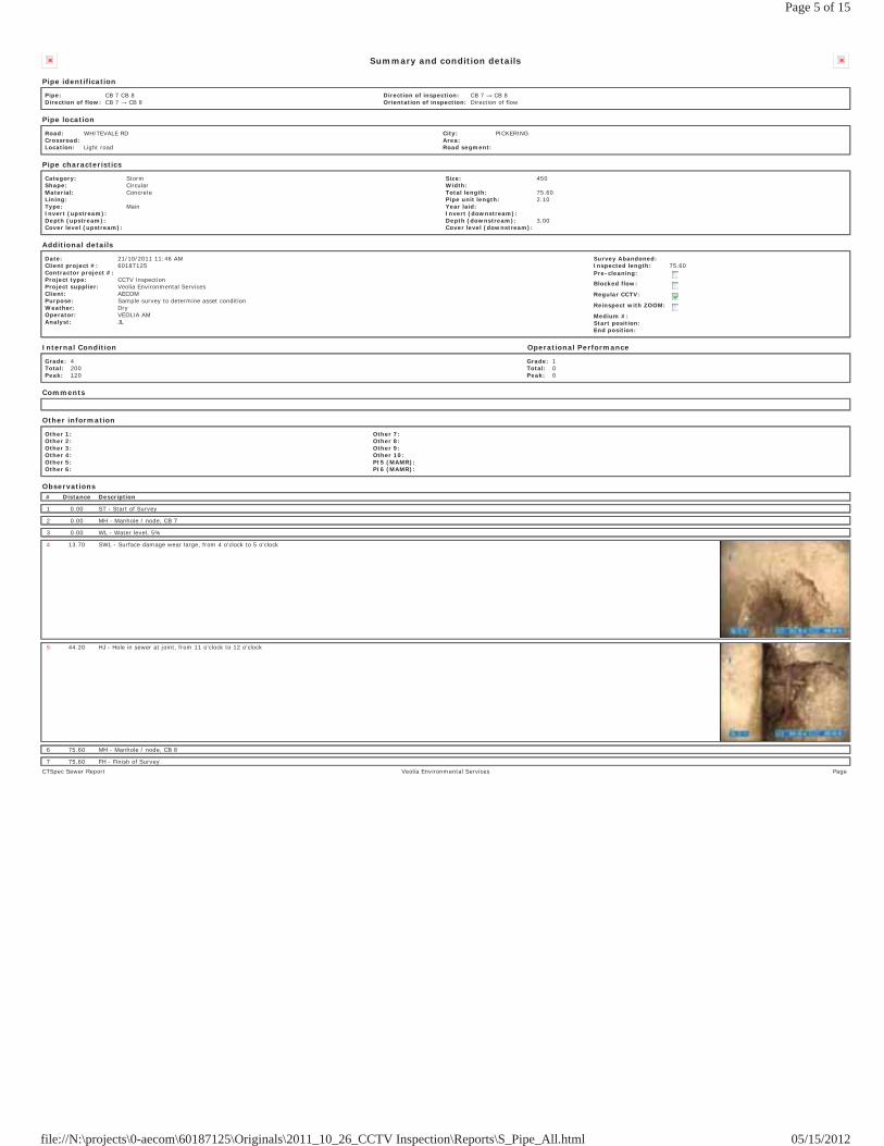
Summary and condition details
Pipe identification
Pipe: CB 7 CB 8Direction of flow: CB 7 CB 8
Direction of inspection: CB 7 CB 8Orientation of inspection: Direction of flow
Pipe location
Road: WHITEVALE RDCrossroad: Location: Light road
City: PICKERINGArea: Road segment:
Pipe characteristics
Category: StormShape: CircularMaterial: ConcreteLining: Type: MainInvert (upstream): Depth (upstream): Cover level (upstream):
Size: 450Width: Total length: 75.60Pipe unit length: 2.10Year laid: Invert (downstream): Depth (downstream): 3.00Cover level (downstream):
Additional details
Date: 21/10/2011 11:46 AMClient project #: 60187125Contractor project #: Project type: CCTV InspectionProject supplier: Veolia Environmental ServicesClient: AECOMPurpose: Sample survey to determine asset conditionWeather: DryOperator: VEOLIA AMAnalyst: JL
Survey Abandoned: Inspected length: 75.60Pre-cleaning:
Blocked flow:
Regular CCTV:
Reinspect with ZOOM:
Medium #: Start position: End position:
Internal Condition Operational Performance
Grade: 4Total: 200Peak: 120
Grade: 1Total: 0Peak: 0
Comments
Other information
Other 1: Other 2: Other 3: Other 4: Other 5: Other 6:
Other 7: Other 8: Other 9: Other 10: PI5 (MAMR): PI6 (MAMR):
Observations# Distance Description
1 0.00 ST - Start of Survey
2 0.00 MH - Manhole / node, CB 7
3 0.00 WL - Water level, 5%
4 13.70 SWL - Surface damage wear large, from 4 o'clock to 5 o'clock
5 44.20 HJ - Hole in sewer at joint, from 11 o'clock to 12 o'clock
6 75.60 MH - Manhole / node, CB 8
7 75.60 FH - Finish of SurveyCTSpec Sewer Report Veolia Environmental Services Page
Page 5 of 15
05/15/2012file://N:\projects\0-aecom\60187125\Originals\2011_10_26_CCTV Inspection\Reports\S_Pipe_All.html
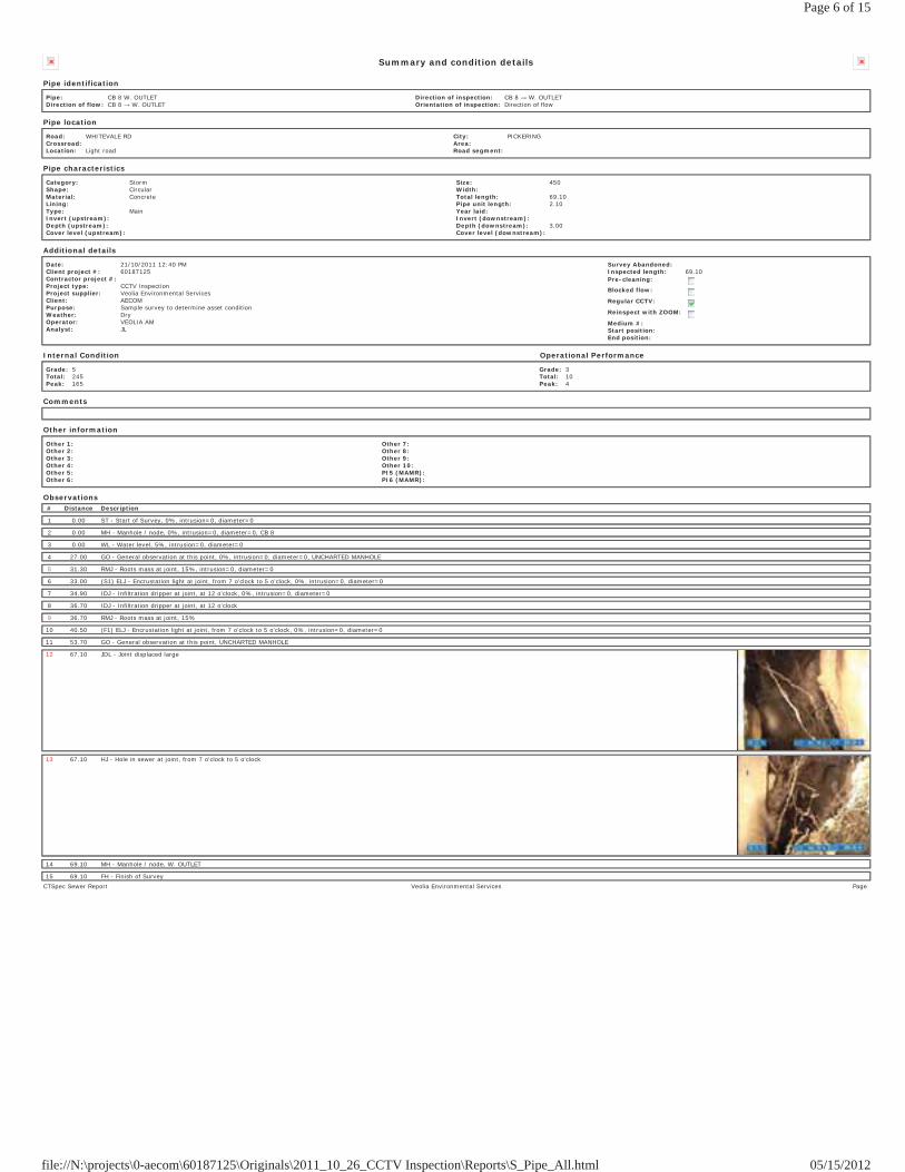
Summary and condition details
Pipe identification
Pipe: CB 8 W. OUTLETDirection of flow: CB 8 W. OUTLET
Direction of inspection: CB 8 W. OUTLETOrientation of inspection: Direction of flow
Pipe location
Road: WHITEVALE RDCrossroad: Location: Light road
City: PICKERINGArea: Road segment:
Pipe characteristics
Category: StormShape: CircularMaterial: ConcreteLining: Type: MainInvert (upstream): Depth (upstream): Cover level (upstream):
Size: 450Width: Total length: 69.10Pipe unit length: 2.10Year laid: Invert (downstream): Depth (downstream): 3.00Cover level (downstream):
Additional details
Date: 21/10/2011 12:40 PMClient project #: 60187125Contractor project #: Project type: CCTV InspectionProject supplier: Veolia Environmental ServicesClient: AECOMPurpose: Sample survey to determine asset conditionWeather: DryOperator: VEOLIA AMAnalyst: JL
Survey Abandoned: Inspected length: 69.10Pre-cleaning:
Blocked flow:
Regular CCTV:
Reinspect with ZOOM:
Medium #: Start position: End position:
Internal Condition Operational Performance
Grade: 5Total: 245Peak: 165
Grade: 3Total: 10Peak: 4
Comments
Other information
Other 1: Other 2: Other 3: Other 4: Other 5: Other 6:
Other 7: Other 8: Other 9: Other 10: PI5 (MAMR): PI6 (MAMR):
Observations# Distance Description
1 0.00 ST - Start of Survey, 0%, intrusion=0, diameter=0
2 0.00 MH - Manhole / node, 0%, intrusion=0, diameter=0, CB 8
3 0.00 WL - Water level, 5%, intrusion=0, diameter=0
4 27.00 GO - General observation at this point, 0%, intrusion=0, diameter=0, UNCHARTED MANHOLE
5 31.30 RMJ - Roots mass at joint, 15%, intrusion=0, diameter=0
6 33.00 (S1) ELJ - Encrustation light at joint, from 7 o'clock to 5 o'clock, 0%, intrusion=0, diameter=0
7 34.90 IDJ - Infiltration dripper at joint, at 12 o'clock, 0%, intrusion=0, diameter=0
8 36.70 IDJ - Infiltration dripper at joint, at 12 o'clock
9 36.70 RMJ - Roots mass at joint, 15%
10 40.50 (F1) ELJ - Encrustation light at joint, from 7 o'clock to 5 o'clock, 0%, intrusion=0, diameter=0
11 53.70 GO - General observation at this point, UNCHARTED MANHOLE
12 67.10 JDL - Joint displaced large
13 67.10 HJ - Hole in sewer at joint, from 7 o'clock to 5 o'clock
14 69.10 MH - Manhole / node, W. OUTLET
15 69.10 FH - Finish of SurveyCTSpec Sewer Report Veolia Environmental Services Page
Page 6 of 15
05/15/2012file://N:\projects\0-aecom\60187125\Originals\2011_10_26_CCTV Inspection\Reports\S_Pipe_All.html
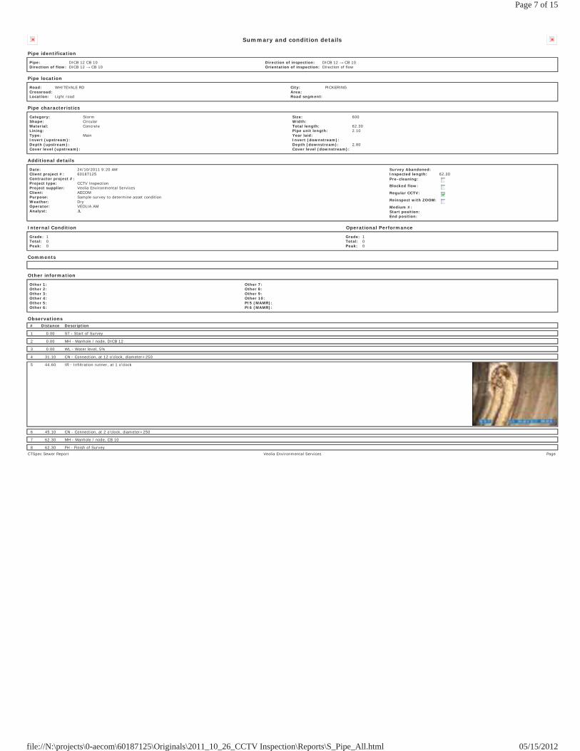
Summary and condition details
Pipe identification
Pipe: DICB 12 CB 10Direction of flow: DICB 12 CB 10
Direction of inspection: DICB 12 CB 10Orientation of inspection: Direction of flow
Pipe location
Road: WHITEVALE RDCrossroad: Location: Light road
City: PICKERINGArea: Road segment:
Pipe characteristics
Category: StormShape: CircularMaterial: ConcreteLining: Type: MainInvert (upstream): Depth (upstream): Cover level (upstream):
Size: 600Width: Total length: 62.30Pipe unit length: 2.10Year laid: Invert (downstream): Depth (downstream): 2.80Cover level (downstream):
Additional details
Date: 24/10/2011 9:20 AMClient project #: 60187125Contractor project #: Project type: CCTV InspectionProject supplier: Veolia Environmental ServicesClient: AECOMPurpose: Sample survey to determine asset conditionWeather: DryOperator: VEOLIA AMAnalyst: JL
Survey Abandoned: Inspected length: 62.30Pre-cleaning:
Blocked flow:
Regular CCTV:
Reinspect with ZOOM:
Medium #: Start position: End position:
Internal Condition Operational Performance
Grade: 1Total: 0Peak: 0
Grade: 1Total: 0Peak: 0
Comments
Other information
Other 1: Other 2: Other 3: Other 4: Other 5: Other 6:
Other 7: Other 8: Other 9: Other 10: PI5 (MAMR): PI6 (MAMR):
Observations# Distance Description
1 0.00 ST - Start of Survey
2 0.00 MH - Manhole / node, DICB 12
3 0.00 WL - Water level, 5%
4 31.10 CN - Connection, at 12 o'clock, diameter=250
5 44.60 IR - Infiltration runner, at 1 o'clock
6 45.10 CN - Connection, at 2 o'clock, diameter=250
7 62.30 MH - Manhole / node, CB 10
8 62.30 FH - Finish of SurveyCTSpec Sewer Report Veolia Environmental Services Page
Page 7 of 15
05/15/2012file://N:\projects\0-aecom\60187125\Originals\2011_10_26_CCTV Inspection\Reports\S_Pipe_All.html
Summary and condition details
Pipe identification
Pipe: DICB 13 DICB 12Direction of flow: DICB 13 DICB 12
Direction of inspection: DICB 13 DICB 12Orientation of inspection: Direction of flow
Pipe location
Road: WHITEVALE RDCrossroad: Location: Light road
City: PICKERINGArea: Road segment:
Pipe characteristics
Category: StormShape: CircularMaterial: SteelLining: Type: MainInvert (upstream): Depth (upstream): Cover level (upstream):
Size: 600Width: Total length: 60.00Pipe unit length: 2.10Year laid: Invert (downstream): Depth (downstream): 3.40Cover level (downstream):
Additional details
Date: 21/10/2011 2:00 PMClient project #: 60187125Contractor project #: Project type: CCTV InspectionProject supplier: Veolia Environmental ServicesClient: AECOMPurpose: Sample survey to determine asset conditionWeather: DryOperator: VEOLIA AMAnalyst: JL
Survey Abandoned: Inspected length: 60.00Pre-cleaning:
Blocked flow:
Regular CCTV:
Reinspect with ZOOM:
Medium #: Start position: End position:
Internal Condition Operational Performance
Grade: 1Total: 0Peak: 0
Grade: 1Total: 0Peak: 0
Comments
Other information
Other 1: Other 2: Other 3: Other 4: Other 5: Other 6:
Other 7: Other 8: Other 9: Other 10: PI5 (MAMR): PI6 (MAMR):
Observations# Distance Description
1 0.00 ST - Start of Survey
2 0.00 MH - Manhole / node, DICB 13
3 0.00 WL - Water level, 5%
4 36.20 CN - Connection, at 1 o'clock, diameter=100
5 54.40 CN - Connection, at 1 o'clock, diameter=100
6 60.00 MH - Manhole / node, DICB 12
7 60.00 FH - Finish of SurveyCTSpec Sewer Report Veolia Environmental Services Page
Page 8 of 15
05/15/2012file://N:\projects\0-aecom\60187125\Originals\2011_10_26_CCTV Inspection\Reports\S_Pipe_All.html

Summary and condition details
Pipe identification
Pipe: DICB 15 DICB 13Direction of flow: DICB 15 DICB 13
Direction of inspection: DICB 13 DICB 15Orientation of inspection: Against flow
Pipe location
Road: WHITEVALE RDCrossroad: Location: Light road
City: PICKERINGArea: Road segment:
Pipe characteristics
Category: StormShape: CircularMaterial: SteelLining: Type: MainInvert (upstream): Depth (upstream): Cover level (upstream):
Size: 600Width: Total length: 65.80Pipe unit length: 2.10Year laid: Invert (downstream): Depth (downstream): 3.40Cover level (downstream):
Additional details
Date: 21/10/2011 2:13 PMClient project #: 60187125Contractor project #: Project type: CCTV InspectionProject supplier: Veolia Environmental ServicesClient: AECOMPurpose: Sample survey to determine asset conditionWeather: DryOperator: VEOLIA AMAnalyst: JL
Survey Abandoned: Inspected length: 65.80Pre-cleaning:
Blocked flow:
Regular CCTV:
Reinspect with ZOOM:
Medium #: Start position: End position:
Internal Condition Operational Performance
Grade: 1Total: 0Peak: 0
Grade: 1Total: 0Peak: 0
Comments
Other information
Other 1: Other 2: Other 3: Other 4: Other 5: Other 6:
Other 7: Other 8: Other 9: Other 10: PI5 (MAMR): PI6 (MAMR):
Observations# Distance Description
1 0.00 ST - Start of Survey
2 0.00 MH - Manhole / node, DICB 13
3 0.00 WL - Water level, 5%
4 26.50 CN - Connection, at 11 o'clock, diameter=100
5 58.10 CN - Connection, at 9 o'clock, diameter=300
6 62.60 CN - Connection, at 11 o'clock, diameter=100
7 65.80 MH - Manhole / node, DICB 15
8 65.80 FH - Finish of SurveyCTSpec Sewer Report Veolia Environmental Services Page
Page 9 of 15
05/15/2012file://N:\projects\0-aecom\60187125\Originals\2011_10_26_CCTV Inspection\Reports\S_Pipe_All.html
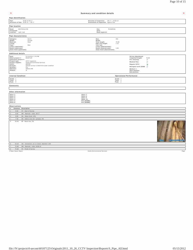
Summary and condition details
Pipe identification
Pipe: DICB 19 CB 17Direction of flow: DICB 19 CB 17
Direction of inspection: CB 17 DICB 19Orientation of inspection: Against flow
Pipe location
Road: WHITEVALE RDCrossroad: Location: Light road
City: PICKERINGArea: Road segment:
Pipe characteristics
Category: StormShape: CircularMaterial: SteelLining: Type: MainInvert (upstream): Depth (upstream): Cover level (upstream):
Size: 450Width: Total length: 70.80Pipe unit length: 2.10Year laid: Invert (downstream): Depth (downstream): 3.00Cover level (downstream):
Additional details
Date: 21/10/2011 2:45 PMClient project #: 60187125Contractor project #: Project type: CCTV InspectionProject supplier: Veolia Environmental ServicesClient: AECOMPurpose: Sample survey to determine asset conditionWeather: DryOperator: VEOLIA AMAnalyst: JL
Survey Abandoned: Inspected length: 70.80Pre-cleaning:
Blocked flow:
Regular CCTV:
Reinspect with ZOOM:
Medium #: Start position: End position:
Internal Condition Operational Performance
Grade: 1Total: 0Peak: 0
Grade: 3Total: 3Peak: 2
Comments
Other information
Other 1: Other 2: Other 3: Other 4: Other 5: Other 6:
Other 7: Other 8: Other 9: Other 10: PI5 (MAMR): PI6 (MAMR):
Observations# Distance Description
1 0.00 ST - Start of Survey
2 0.00 MH - Manhole / node, CB 17
3 0.00 WL - Water level, 10%
4 7.40 DE - Debris (non-silt / grease), 5%
5 34.00 RF - Roots fine, 5%
6 34.20 CN - Connection, at 11 o'clock, diameter=100
7 70.80 MH - Manhole / node, DICB 19
8 70.80 FH - Finish of SurveyCTSpec Sewer Report Veolia Environmental Services Page
Page 10 of 15
05/15/2012file://N:\projects\0-aecom\60187125\Originals\2011_10_26_CCTV Inspection\Reports\S_Pipe_All.html
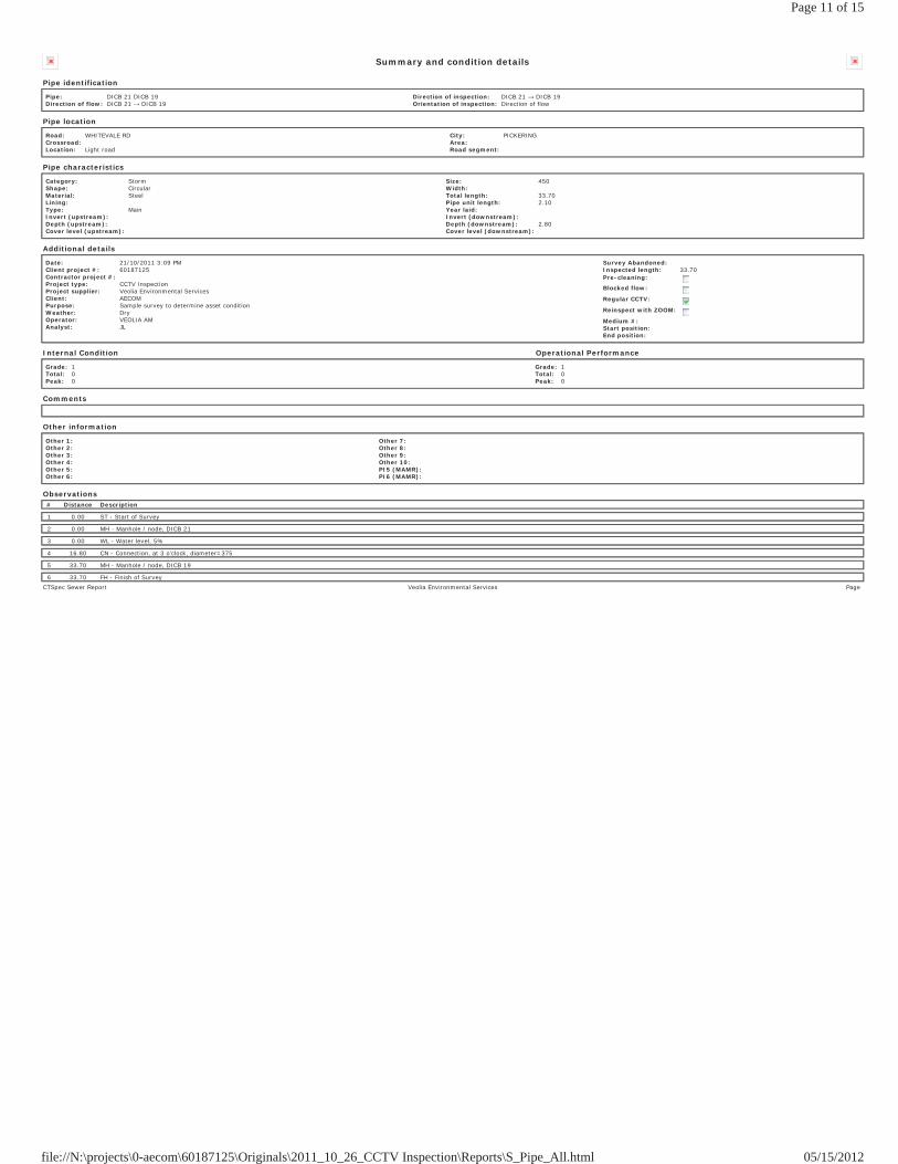
Summary and condition details
Pipe identification
Pipe: DICB 21 DICB 19Direction of flow: DICB 21 DICB 19
Direction of inspection: DICB 21 DICB 19Orientation of inspection: Direction of flow
Pipe location
Road: WHITEVALE RDCrossroad: Location: Light road
City: PICKERINGArea: Road segment:
Pipe characteristics
Category: StormShape: CircularMaterial: SteelLining: Type: MainInvert (upstream): Depth (upstream): Cover level (upstream):
Size: 450Width: Total length: 33.70Pipe unit length: 2.10Year laid: Invert (downstream): Depth (downstream): 2.80Cover level (downstream):
Additional details
Date: 21/10/2011 3:09 PMClient project #: 60187125Contractor project #: Project type: CCTV InspectionProject supplier: Veolia Environmental ServicesClient: AECOMPurpose: Sample survey to determine asset conditionWeather: DryOperator: VEOLIA AMAnalyst: JL
Survey Abandoned: Inspected length: 33.70Pre-cleaning:
Blocked flow:
Regular CCTV:
Reinspect with ZOOM:
Medium #: Start position: End position:
Internal Condition Operational Performance
Grade: 1Total: 0Peak: 0
Grade: 1Total: 0Peak: 0
Comments
Other information
Other 1: Other 2: Other 3: Other 4: Other 5: Other 6:
Other 7: Other 8: Other 9: Other 10: PI5 (MAMR): PI6 (MAMR):
Observations# Distance Description
1 0.00 ST - Start of Survey
2 0.00 MH - Manhole / node, DICB 21
3 0.00 WL - Water level, 5%
4 16.80 CN - Connection, at 3 o'clock, diameter=375
5 33.70 MH - Manhole / node, DICB 19
6 33.70 FH - Finish of SurveyCTSpec Sewer Report Veolia Environmental Services Page
Page 11 of 15
05/15/2012file://N:\projects\0-aecom\60187125\Originals\2011_10_26_CCTV Inspection\Reports\S_Pipe_All.html
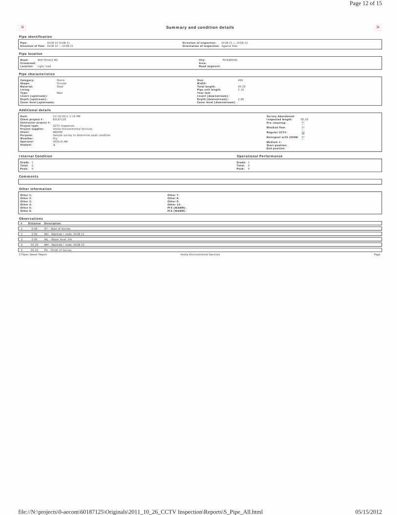
Summary and condition details
Pipe identification
Pipe: DICB 22 DICB 21Direction of flow: DICB 22 DICB 21
Direction of inspection: DICB 21 DICB 22Orientation of inspection: Against flow
Pipe location
Road: WHITEVALE RDCrossroad: Location: Light road
City: PICKERINGArea: Road segment:
Pipe characteristics
Category: StormShape: CircularMaterial: SteelLining: Type: MainInvert (upstream): Depth (upstream): Cover level (upstream):
Size: 450Width: Total length: 55.20Pipe unit length: 2.10Year laid: Invert (downstream): Depth (downstream): 2.80Cover level (downstream):
Additional details
Date: 21/10/2011 3:18 PMClient project #: 60187125Contractor project #: Project type: CCTV InspectionProject supplier: Veolia Environmental ServicesClient: AECOMPurpose: Sample survey to determine asset conditionWeather: DryOperator: VEOLIA AMAnalyst: JL
Survey Abandoned: Inspected length: 55.20Pre-cleaning:
Blocked flow:
Regular CCTV:
Reinspect with ZOOM:
Medium #: Start position: End position:
Internal Condition Operational Performance
Grade: 1Total: 0Peak: 0
Grade: 1Total: 0Peak: 0
Comments
Other information
Other 1: Other 2: Other 3: Other 4: Other 5: Other 6:
Other 7: Other 8: Other 9: Other 10: PI5 (MAMR): PI6 (MAMR):
Observations# Distance Description
1 0.00 ST - Start of Survey
2 0.00 MH - Manhole / node, DICB 21
3 0.00 WL - Water level, 5%
4 55.20 MH - Manhole / node, DICB 22
5 55.20 FH - Finish of SurveyCTSpec Sewer Report Veolia Environmental Services Page
Page 12 of 15
05/15/2012file://N:\projects\0-aecom\60187125\Originals\2011_10_26_CCTV Inspection\Reports\S_Pipe_All.html
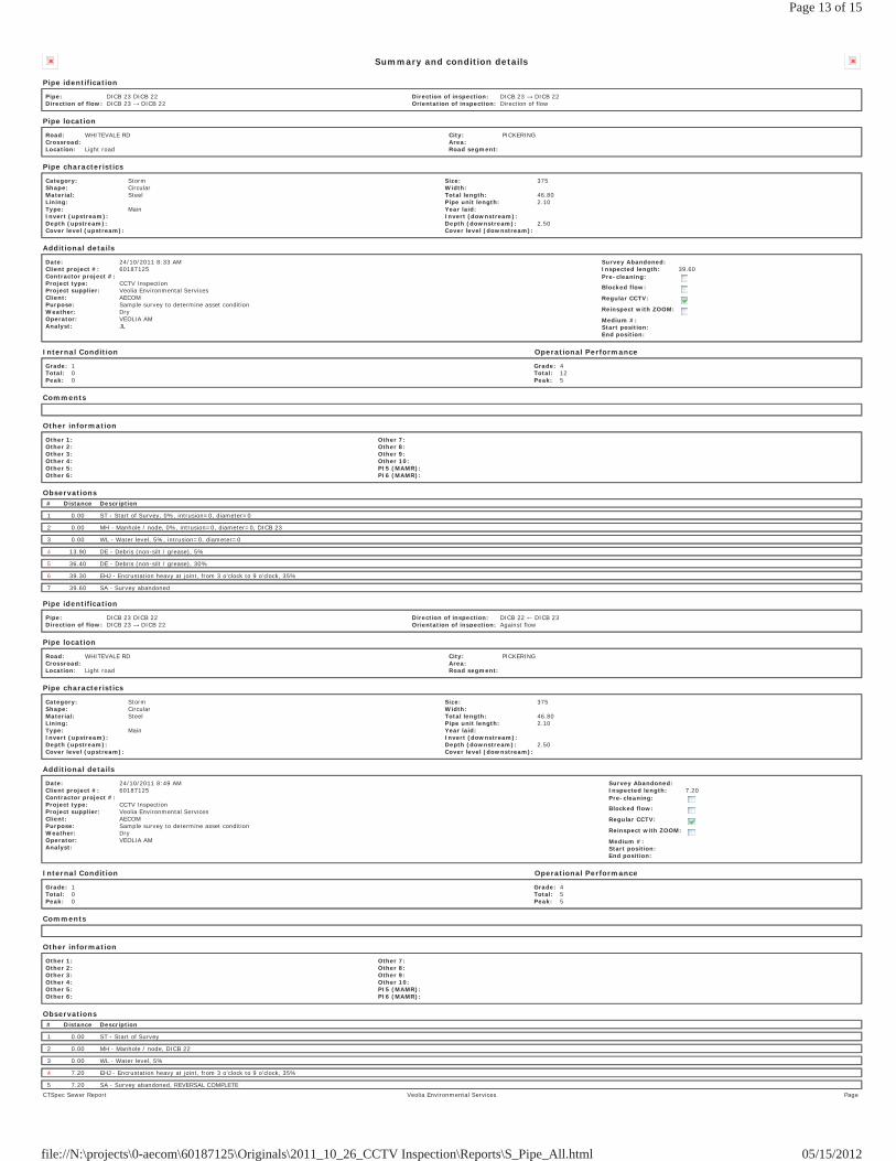
Summary and condition details
Pipe identification
Pipe: DICB 23 DICB 22Direction of flow: DICB 23 DICB 22
Direction of inspection: DICB 23 DICB 22Orientation of inspection: Direction of flow
Pipe location
Road: WHITEVALE RDCrossroad: Location: Light road
City: PICKERINGArea: Road segment:
Pipe characteristics
Category: StormShape: CircularMaterial: SteelLining: Type: MainInvert (upstream): Depth (upstream): Cover level (upstream):
Size: 375Width: Total length: 46.80Pipe unit length: 2.10Year laid: Invert (downstream): Depth (downstream): 2.50Cover level (downstream):
Additional details
Date: 24/10/2011 8:33 AMClient project #: 60187125Contractor project #: Project type: CCTV InspectionProject supplier: Veolia Environmental ServicesClient: AECOMPurpose: Sample survey to determine asset conditionWeather: DryOperator: VEOLIA AMAnalyst: JL
Survey Abandoned: Inspected length: 39.60Pre-cleaning:
Blocked flow:
Regular CCTV:
Reinspect with ZOOM:
Medium #: Start position: End position:
Internal Condition Operational Performance
Grade: 1Total: 0Peak: 0
Grade: 4Total: 12Peak: 5
Comments
Other information
Other 1: Other 2: Other 3: Other 4: Other 5: Other 6:
Other 7: Other 8: Other 9: Other 10: PI5 (MAMR): PI6 (MAMR):
Observations# Distance Description
1 0.00 ST - Start of Survey, 0%, intrusion=0, diameter=0
2 0.00 MH - Manhole / node, 0%, intrusion=0, diameter=0, DICB 23
3 0.00 WL - Water level, 5%, intrusion=0, diameter=0
4 13.90 DE - Debris (non-silt / grease), 5%
5 36.40 DE - Debris (non-silt / grease), 30%
6 39.30 EHJ - Encrustation heavy at joint, from 3 o'clock to 9 o'clock, 35%
7 39.60 SA - Survey abandoned
Pipe identification
Pipe: DICB 23 DICB 22Direction of flow: DICB 23 DICB 22
Direction of inspection: DICB 22 DICB 23Orientation of inspection: Against flow
Pipe location
Road: WHITEVALE RDCrossroad: Location: Light road
City: PICKERINGArea: Road segment:
Pipe characteristics
Category: StormShape: CircularMaterial: SteelLining: Type: MainInvert (upstream): Depth (upstream): Cover level (upstream):
Size: 375Width: Total length: 46.80Pipe unit length: 2.10Year laid: Invert (downstream): Depth (downstream): 2.50Cover level (downstream):
Additional details
Date: 24/10/2011 8:49 AMClient project #: 60187125Contractor project #: Project type: CCTV InspectionProject supplier: Veolia Environmental ServicesClient: AECOMPurpose: Sample survey to determine asset conditionWeather: DryOperator: VEOLIA AMAnalyst:
Survey Abandoned: Inspected length: 7.20Pre-cleaning:
Blocked flow:
Regular CCTV:
Reinspect with ZOOM:
Medium #: Start position: End position:
Internal Condition Operational Performance
Grade: 1Total: 0Peak: 0
Grade: 4Total: 5Peak: 5
Comments
Other information
Other 1: Other 2: Other 3: Other 4: Other 5: Other 6:
Other 7: Other 8: Other 9: Other 10: PI5 (MAMR): PI6 (MAMR):
Observations# Distance Description
1 0.00 ST - Start of Survey
2 0.00 MH - Manhole / node, DICB 22
3 0.00 WL - Water level, 5%
4 7.20 EHJ - Encrustation heavy at joint, from 3 o'clock to 9 o'clock, 35%
5 7.20 SA - Survey abandoned, REVERSAL COMPLETECTSpec Sewer Report Veolia Environmental Services Page
Page 13 of 15
05/15/2012file://N:\projects\0-aecom\60187125\Originals\2011_10_26_CCTV Inspection\Reports\S_Pipe_All.html

Summary and condition details
Pipe identification
Pipe: DICB 23 DICB 22Direction of flow: DICB 23 DICB 22
Direction of inspection: DICB 23 DICB 22Orientation of inspection: Direction of flow
Pipe location
Road: WHITEVALE RDCrossroad: Location: Light road
City: PICKERINGArea: Road segment:
Pipe characteristics
Category: StormShape: CircularMaterial: SteelLining: Type: MainInvert (upstream): Depth (upstream): Cover level (upstream):
Size: 375Width: Total length: 46.80Pipe unit length: 2.10Year laid: Invert (downstream): Depth (downstream): 2.50Cover level (downstream):
Additional details
Date: 24/10/2011 8:33 AMClient project #: 60187125Contractor project #: Project type: CCTV InspectionProject supplier: Veolia Environmental ServicesClient: AECOMPurpose: Sample survey to determine asset conditionWeather: DryOperator: VEOLIA AMAnalyst: JL
Survey Abandoned: Inspected length: 39.60Pre-cleaning:
Blocked flow:
Regular CCTV:
Reinspect with ZOOM:
Medium #: Start position: End position:
Internal Condition Operational Performance
Grade: 1Total: 0Peak: 0
Grade: 4Total: 12Peak: 5
Comments
Other information
Other 1: Other 2: Other 3: Other 4: Other 5: Other 6:
Other 7: Other 8: Other 9: Other 10: PI5 (MAMR): PI6 (MAMR):
Observations# Distance Description
1 0.00 ST - Start of Survey, 0%, intrusion=0, diameter=0
2 0.00 MH - Manhole / node, 0%, intrusion=0, diameter=0, DICB 23
3 0.00 WL - Water level, 5%, intrusion=0, diameter=0
4 13.90 DE - Debris (non-silt / grease), 5%
5 36.40 DE - Debris (non-silt / grease), 30%
6 39.30 EHJ - Encrustation heavy at joint, from 3 o'clock to 9 o'clock, 35%
7 39.60 SA - Survey abandoned
Pipe identification
Pipe: DICB 23 DICB 22Direction of flow: DICB 23 DICB 22
Direction of inspection: DICB 22 DICB 23Orientation of inspection: Against flow
Pipe location
Road: WHITEVALE RDCrossroad: Location: Light road
City: PICKERINGArea: Road segment:
Pipe characteristics
Category: StormShape: CircularMaterial: SteelLining: Type: MainInvert (upstream): Depth (upstream): Cover level (upstream):
Size: 375Width: Total length: 46.80Pipe unit length: 2.10Year laid: Invert (downstream): Depth (downstream): 2.50Cover level (downstream):
Additional details
Date: 24/10/2011 8:49 AMClient project #: 60187125Contractor project #: Project type: CCTV InspectionProject supplier: Veolia Environmental ServicesClient: AECOMPurpose: Sample survey to determine asset conditionWeather: DryOperator: VEOLIA AMAnalyst:
Survey Abandoned: Inspected length: 7.20Pre-cleaning:
Blocked flow:
Regular CCTV:
Reinspect with ZOOM:
Medium #: Start position: End position:
Internal Condition Operational Performance
Grade: 1Total: 0Peak: 0
Grade: 4Total: 5Peak: 5
Comments
Other information
Other 1: Other 2: Other 3: Other 4: Other 5: Other 6:
Other 7: Other 8: Other 9: Other 10: PI5 (MAMR): PI6 (MAMR):
Observations# Distance Description
1 0.00 ST - Start of Survey
2 0.00 MH - Manhole / node, DICB 22
3 0.00 WL - Water level, 5%
4 7.20 EHJ - Encrustation heavy at joint, from 3 o'clock to 9 o'clock, 35%
5 7.20 SA - Survey abandoned, REVERSAL COMPLETECTSpec Sewer Report Veolia Environmental Services Page
Page 14 of 15
05/15/2012file://N:\projects\0-aecom\60187125\Originals\2011_10_26_CCTV Inspection\Reports\S_Pipe_All.html

Page 15 of 15
05/15/2012file://N:\projects\0-aecom\60187125\Originals\2011_10_26_CCTV Inspection\Reports\S_Pipe_All.html

03rb_2013-03-01_App Tps_60187125.Docx
Appendix C Stage 1 Archaeological Assessment
STAGE 1 ARCHAEOLOGICAL ASSESSMENT
FOR THE WHITEVALE MASTER DRAINAGE PLAN, ROAD ALLOWANCES FOR PART OF WHITEVALE ROAD, NORTH ROAD, GOLF COURSE ROAD and ALL OF MILL STREET, CHURCHWIN STREET,
GLADSTONE STREET, BYRON STREET, MUTUAL STREET, and FACTORY STREET in the
HAMLET OF WHITEVALE, GEOGRAPHIC TOWNSHIP OF PICKERING, COUNTY OF ONTARIO,
NOW IN THE CITY OF PICKERING, REGIONAL MUNICIPALITY OF DURHAM
Original Report Prepared by:
Advance Archaeology
P.O. Box 493, Port Hope, ON
L1A 3Z4 (905) 342-3250
Licensed to: Donna Morrison, M.A.
License #: P-121 PIF #: P121-093-2011
June 7, 2011
Whitevale Master Drainage Plan Stage 1 Archaeological Assessment Advance Archaeology
i
EXECUTIVE SUMMARY A Stage 1 archaeological assessment of the road allowances within the Hamlet of
Whitevale, in the City of Pickering, was conducted by Advance Archaeology in May and June of 2011 as part of the Whitevale Master Drainage Plan. The subject property includes the existing roads and road platforms as well as any adjacent drainage ditches, culverts, banks, driveways, parking areas, lawns, boulevards, and sidewalks that are within the existing road allowances or right-of-ways.
This assessment determined that the vast majority of the subject property has very low
archaeological potential due to previous extensive disturbance of the original soil layers caused during the construction and upgrading of Whitevale’s roads and drainage systems. However, there are some small sections of potentially undisturbed lands with moderate-to-high archaeological potential, which are located on some of the lawn and boulevard areas adjacent to the road or street shoulders. These zones were determined to have moderate to high potential because they appear to be relatively undisturbed and are adjacent to one of a number of significant 19th-century transportation corridors in Whitevale (particularly Whitevale Road), and they are topographically suitable for past settlement or use by Euro-Canadian and Aboriginal groups. In fact, the entire Hamlet of Whitevale is a designated Heritage Conservation District with a well-documented and intensive history of Euro-Canadian settlement, and with numerous historic residential, commercial, and industrial uses of the lands fronting on the roadways of the subject property. Furthermore, there are 19 known archaeological sites registered within a radius of 1 km, including two sites within the hamlet boundaries that are close to the road allowances, so there is the potential for further archaeological resources to be discovered in those areas. A Stage 2 archaeological assessment is therefore recommended for those portions of the subject property with moderate to high archaeological potential, while the remainder of the subject lands would be exempt from further assessment.
Whitevale Master Drainage Plan Stage 1 Archaeological Assessment Advance Archaeology
i
Table of Contents
1.0 DEVELOPMENT CONTEXT…………………………….…………………….. 1 2.0 HISTORICAL CONTEXT……………………………….……………………... 3
2.1 Historical Information and Settlement History…………………………….. 3 2.2 Present Land Use of Subject Property……………..…………………….... 3
3.0 ARCHAEOLOGICAL CONTEXT…………………………….………………. 7 3.1 Known Archaeological Sites in the Vicinity….…………….…………….. 7 3.2 Existing Conditions on the Subject Property……………………………… 7
4.0 ANALYSIS AND CONCLUSIONS…………………………………………….. 11 5.0 RECOMMENDATIONS………………………………………………………… 13 6.0 REFERENCES…………………………………………………………………… 14
List of Figures Figure 1: Location of the Hamlet of Whitevale in Southern Ontario…………………….. 1 Figure 2: Aerial Photograph Showing Location of Subject Property…………………….. 2 Figure 3: 1877 Historic Atlas Map Showing Subject Property in Blue (after Beers & Co.) 4 Figure 4: 1877 View to Northeast of East Whitevale (Beers & Co.)…………………..… 5 Figure 5: Historic Photograph of Whitevale Road, Looking West from East Side of
Bridge……………………………………………………………………… 5 Figure 6: Aerial View of Subject Property Showing Zones of Archaeological Potential… 12
List of Plates Plate 1: View to East of Whitevale Road, West of West Duffins Creek …………………. 6 Plate 2: View to East of Whitevale Road, East of West Duffins Creek…………………... 6 Plate 3: View to Southwest of Whitevale Road (Bridge Over West Duffins Creek in Background………………………………………………………………………. 8 Plate 4: View to North of North Road and Adjacent Drainage Ditch…….………………. 9 Plate 5: View to East of Churchwin Street from North End of Mill Street……………….. 9 Plate 6: View to North of North End of Gladstone Street………………………………… 10 Plate 7: View to South of Factory Street, Taken from Whitevale Road………………….. 10
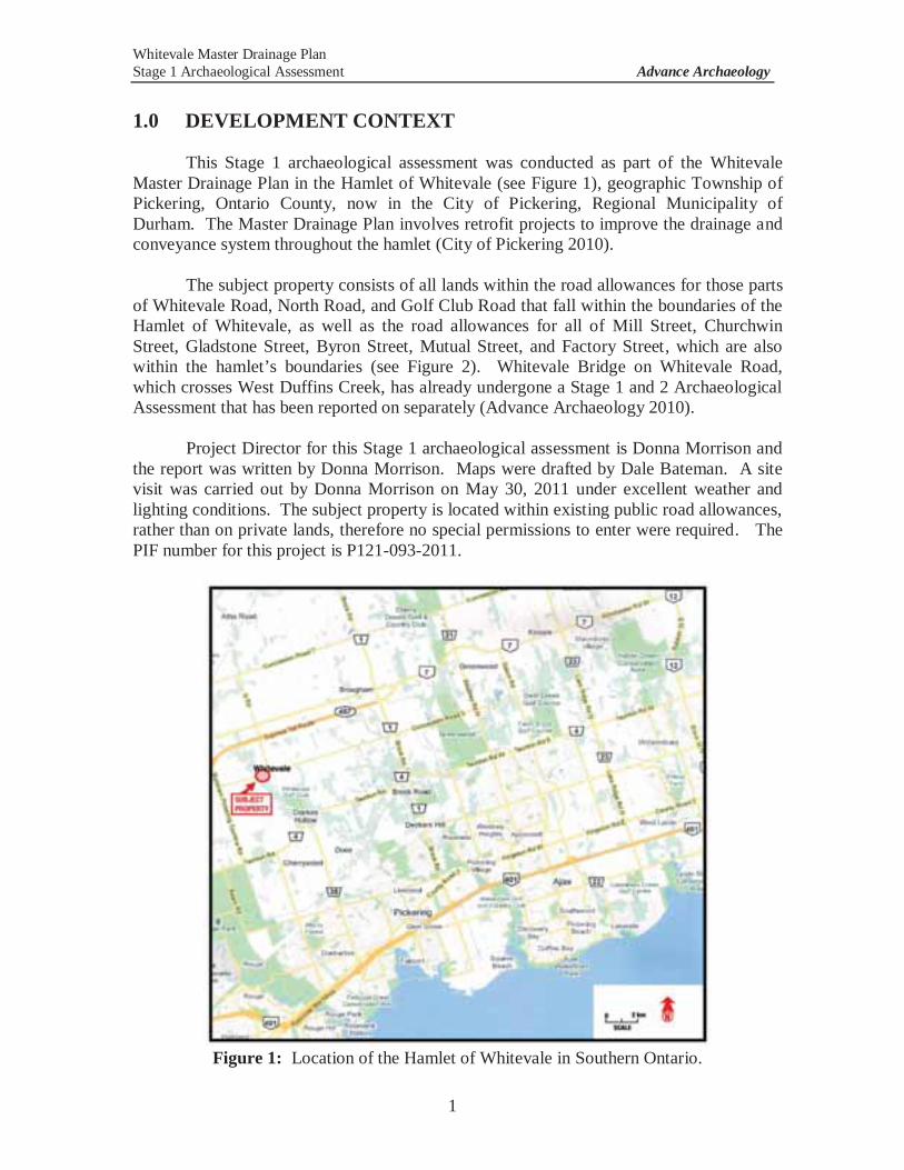
Whitevale Master Drainage Plan Stage 1 Archaeological Assessment Advance Archaeology
1
1.0 DEVELOPMENT CONTEXT
This Stage 1 archaeological assessment was conducted as part of the Whitevale Master Drainage Plan in the Hamlet of Whitevale (see Figure 1), geographic Township of Pickering, Ontario County, now in the City of Pickering, Regional Municipality of Durham. The Master Drainage Plan involves retrofit projects to improve the drainage and conveyance system throughout the hamlet (City of Pickering 2010).
The subject property consists of all lands within the road allowances for those parts
of Whitevale Road, North Road, and Golf Club Road that fall within the boundaries of the Hamlet of Whitevale, as well as the road allowances for all of Mill Street, Churchwin Street, Gladstone Street, Byron Street, Mutual Street, and Factory Street, which are also within the hamlet’s boundaries (see Figure 2). Whitevale Bridge on Whitevale Road, which crosses West Duffins Creek, has already undergone a Stage 1 and 2 Archaeological Assessment that has been reported on separately (Advance Archaeology 2010).
Project Director for this Stage 1 archaeological assessment is Donna Morrison and the report was written by Donna Morrison. Maps were drafted by Dale Bateman. A site visit was carried out by Donna Morrison on May 30, 2011 under excellent weather and lighting conditions. The subject property is located within existing public road allowances, rather than on private lands, therefore no special permissions to enter were required. The PIF number for this project is P121-093-2011.
Figure 1: Location of the Hamlet of Whitevale in Southern Ontario.
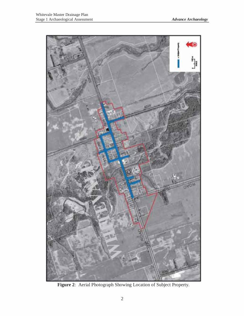
Whitevale Master Drainage Plan Stage 1 Archaeological Assessment Advance Archaeology
2
Figure 2: Aerial Photograph Showing Location of Subject Property.
Whitevale Master Drainage Plan Stage 1 Archaeological Assessment Advance Archaeology
3
2.0 HISTORICAL CONTEXT 2.1 Historical Information and Settlement History
The subject property includes the lands within the existing road allowances for those parts of Whitevale Road, North Road, and Golf Club Road that lie within the boundaries of the Hamlet of Whitevale, as well as the road allowances for all of Mill Street, Churchwin Street, Gladstone Street, Byron Street, Mutual Street, and Factory Street, which are also within the hamlet’s boundaries. There are no private lands included in the subject property. The village plan for Whitevale that is shown in the 1877 Beers & Co. historical atlas map (see Figure 3, below) shows the roads and streets of the subject property, although “Main Street” is now called Whitevale Road and some of the other streets shown no longer exist or were never built (e.g., River Street, Centre Street).
The Hamlet of Whitevale is located in the geographic Township of Pickering,
which was originally part of Ontario County before it became part of the Regional Municipality of Durham, and Ontario County was originally part of York County (the East Riding), one of the 19 counties proclaimed by Lieutenant Governor Simcoe in 1792. Principal immigration and settlement in this region took place between the War of 1812 and the 1837 Rebellion. Ontario County was officially separated on January 12, 1854 (Beers and Co. 1877).
Settlement in the Whitevale area expanded rapidly in the first half of the 1800s.
The village was established around 1820 and was originally named Majorville, but was renamed Whitevale after Truman White took over the village’s saw mill and built a grist mill, a cooperage, a planing factory, and a woolen mill in the 1850s and 1860s. The village became an important industrial centre and had numerous other services such as a post office, stores, and a wagon shop. The 1877 Beers & Company historical atlas map for the Township of Pickering contains the village plan for Whitevale and other illustrations showing the locations of these buildings, many of which were built near the creek and bridge (see Figure 4). Although these drawings do not show any structures directly on the subject property, a number of large buildings, such as mills and factories, are shown on the adjacent or nearby lots (also see Figure 5).
In summary, there are no known houses, churches, cemeteries, schoolhouses, tollhouses, mills or other similar features or buildings shown on the subject property on the 1877 maps. The bridge on Whitevale Road, in its current form, was built in 1929 after a heavy flood completely washed out the existing bridge. Parts of it have been repaired or replaced at least twice since 1929, but most notably following flooding caused by 1954’s Hurricane Hazel (Advance Archaeology 2010).
2.2 Present Land Use
The subject property currently consists of the existing roads and streets of the Hamlet of Whitevale, as well as any adjacent drainage ditches, culverts, banks, parking areas, driveways, lawns, boulevards, and sidewalks within the road allowances (see Plates 1 to 7). Whitevale Bridge has been assessed separately (Advance Archaeology 2010).
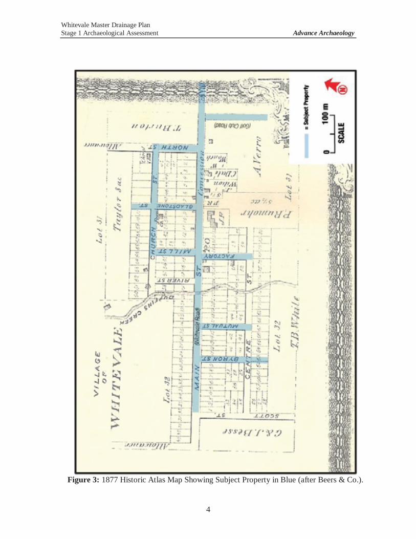
Whitevale Master Drainage Plan Stage 1 Archaeological Assessment Advance Archaeology
4
Figure 3: 1877 Historic Atlas Map Showing Subject Property in Blue (after Beers & Co.).

Whitevale Master Drainage Plan Stage 1 Archaeological Assessment Advance Archaeology
5
Figure 4: 1877 View to Northeast of East Whitevale (Beers & Co.).
Figure 5: Historic Photograph of Whitevale Road, Looking West from East Side of
Bridge. Note Factory Street Intersection and Industrial Building on Left. (Ajax-Pickering Digital Archives).
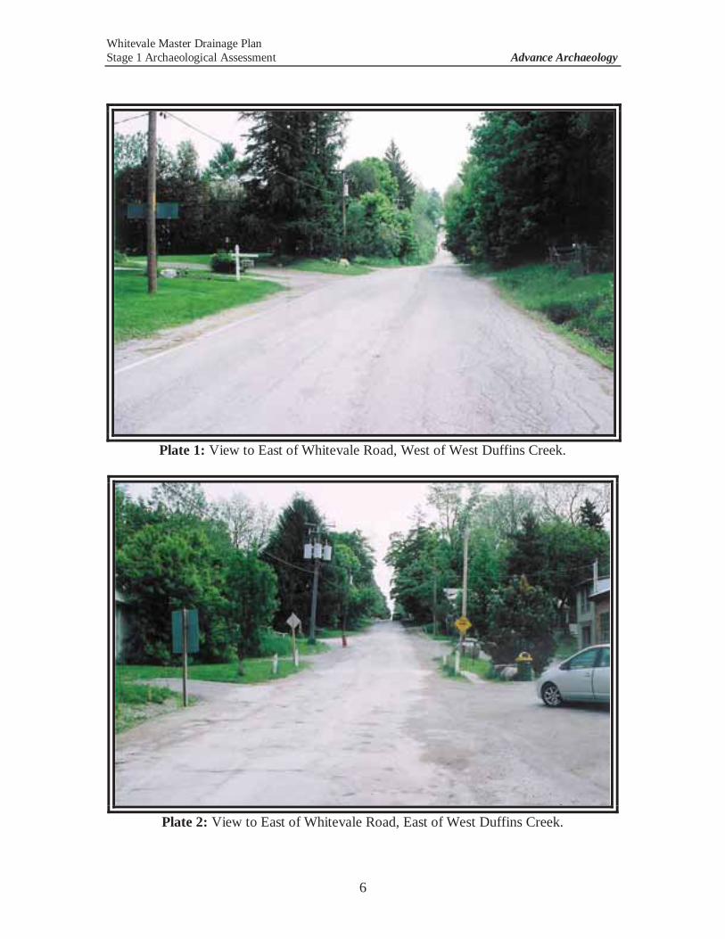
Whitevale Master Drainage Plan Stage 1 Archaeological Assessment Advance Archaeology
6
Plate 1: View to East of Whitevale Road, West of West Duffins Creek.
Plate 2: View to East of Whitevale Road, East of West Duffins Creek.
Whitevale Master Drainage Plan Stage 1 Archaeological Assessment Advance Archaeology
7
3.0 ARCHAEOLOGICAL CONTEXT 3.1 Known Archaeological Sites in the Vicinity
A search of the Ontario Ministry of Tourism and Culture’s archaeological sites database was carried out by Ministry Data Coordinator, Robert von Bitter, on May 30, 2011. The results of this database search indicate that there are no known archaeological sites registered on the subject property. However, there are 19 archaeological sites registered within a 1km radius of the subject property. Within the boundaries of the Hamlet of Whitevale, there are 2 known sites, including a possible Archaic-period aboriginal campsite immediately north of the United Church and a mid-19th-century Euro-Canadian homestead site at the southeastern corner of Whitevale. Five more sites are within 500m of the subject property, including three 19th-century Euro-Canadian homesteads, a Late Archaic-period findspot (where a single projectile point/arrowhead was found in a field), and a burial of unknown age and cultural affiliation. Twelve additional sites are located between 500m and 1km of the subject property, including 7 findspots of single aboriginal artifacts, 3 larger aboriginal sites (an Iroquoian campsite, a Middle Archaic cabin site, and a Middle Iroquoian cabin site), and 2 Euro-Canadian homesteads. While the number of nearby sites is relatively high, none of the registered sites are located directly on the subject property.
3.2 Existing Conditions on the Subject Property The subject property is located in the South Slope physiographic region of
southern Ontario (Chapman and Putnam 1984; Ontario Dept. of Mines and Northern Affairs Map #2226). The South Slope lies between Lake Ontario and the Oak Ridges Moraine, and is just north of the near-shore lakebed of glacial Lake Iroquois, which formed about 12,600 B.P. and was drained by about 11,500 B.P., in the Ontario basin. It extends from the Niagara Escarpment to the Trent River, a distance of roughly 940 miles. The central portion of the South Slope in the Regional Municipality of Durham is drumlinized, and streams (such as West Duffins Creek, which crosses the subject property) flow directly down the slope. A succession of valleys and gullies has been created by these streams.
The South Slope lies across limestones of the Verulam and Lindsay formations,
the grey shales of the Georgian Bay formation, and the reddish shales of the Queenston formation. East of Oshawa, the till is highly calcareous and the cultivated soils often contain free lime carbonates on the surface. There are few stones in the till, which consists of lacustrine clay and silt reworked by the glacier (Chapman and Putnam 1984).
Locally, the subject property is situated within a large, broad Drumlinized Till
Plain zone that stretches for many kilometres north of the glacial Lake Iroquois strandline in this region.
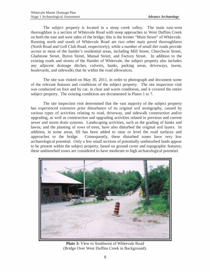
Whitevale Master Drainage Plan Stage 1 Archaeological Assessment Advance Archaeology
8
The subject property is located in a steep creek valley. The main east-west
thoroughfare is a section of Whitevale Road with steep approaches to West Duffins Creek on both the east and west sides of the bridge; this is the former “Main Street” of Whitevale. Running north and south of Whitevale Road are two other main paved thoroughfares (North Road and Golf Club Road, respectively), while a number of small dirt roads provide access to most of the hamlet’s residential areas, including Mill Street, Churchwin Street, Gladstone Street, Byron Street, Mutual Street, and Factory Street. In addition to the existing roads and streets of the Hamlet of Whitevale, the subject property also includes any adjacent drainage ditches, culverts, banks, parking areas, driveways, lawns, boulevards, and sidewalks that lie within the road allowances.
The site was visited on May 30, 2011, in order to photograph and document some
of the relevant features and conditions of the subject property. The site inspection visit was conducted on foot and by car, in clear and warm conditions, and it covered the entire subject property. The existing conditions are documented in Plates 1 to 7.
The site inspection visit determined that the vast majority of the subject property
has experienced extensive prior disturbance of its original soil stratigraphy, caused by various types of activities relating to road, driveway, and sidewalk construction and/or upgrading, as well as construction and upgrading activities related to previous and current sewer and storm drain systems. Landscaping activities, such as the grading of banks and lawns, and the planting of rows of trees, have also disturbed the original soil layers. In addition, in some areas, fill has been added to raise or level the road surfaces and approaches to the bridge. Consequently, these disturbed zones have very low archaeological potential. Only a few small sections of potentially undisturbed lands appear to be present within the subject property, based on ground cover and topographic features; these undisturbed zones are considered to have moderate to high archaeological potential.
Plate 3: View to Southwest of Whitevale Road
(Bridge Over West Duffins Creek in Background).
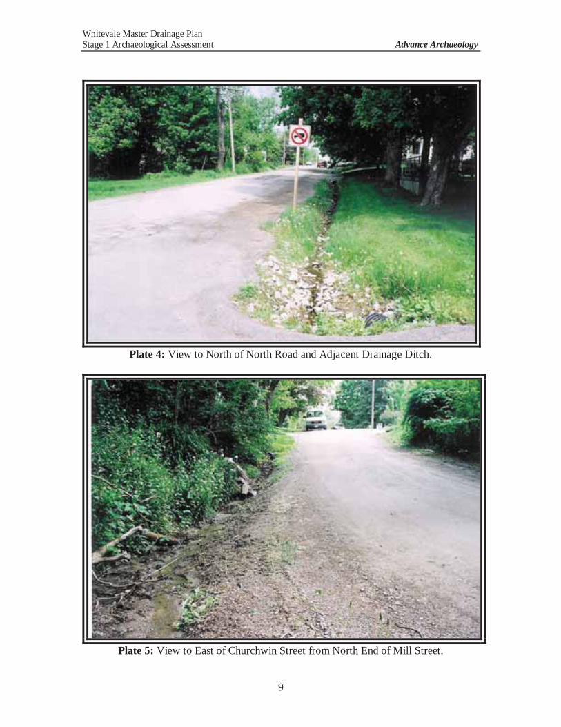
Whitevale Master Drainage Plan Stage 1 Archaeological Assessment Advance Archaeology
9
Plate 4: View to North of North Road and Adjacent Drainage Ditch.
Plate 5: View to East of Churchwin Street from North End of Mill Street.
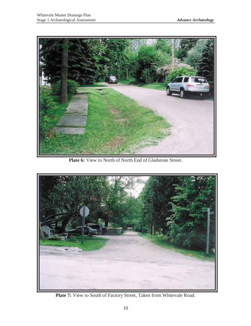
Whitevale Master Drainage Plan Stage 1 Archaeological Assessment Advance Archaeology
10
Plate 6: View to North of North End of Gladstone Street.
Plate 7: View to South of Factory Street, Taken from Whitevale Road.
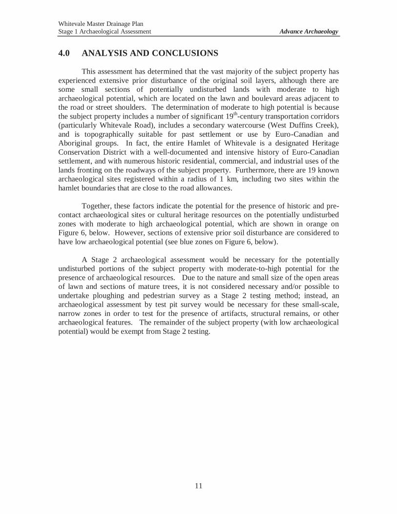
Whitevale Master Drainage Plan Stage 1 Archaeological Assessment Advance Archaeology
11
4.0 ANALYSIS AND CONCLUSIONS
This assessment has determined that the vast majority of the subject property has experienced extensive prior disturbance of the original soil layers, although there are some small sections of potentially undisturbed lands with moderate to high archaeological potential, which are located on the lawn and boulevard areas adjacent to the road or street shoulders. The determination of moderate to high potential is because the subject property includes a number of significant 19th-century transportation corridors (particularly Whitevale Road), includes a secondary watercourse (West Duffins Creek), and is topographically suitable for past settlement or use by Euro-Canadian and Aboriginal groups. In fact, the entire Hamlet of Whitevale is a designated Heritage Conservation District with a well-documented and intensive history of Euro-Canadian settlement, and with numerous historic residential, commercial, and industrial uses of the lands fronting on the roadways of the subject property. Furthermore, there are 19 known archaeological sites registered within a radius of 1 km, including two sites within the hamlet boundaries that are close to the road allowances.
Together, these factors indicate the potential for the presence of historic and pre-
contact archaeological sites or cultural heritage resources on the potentially undisturbed zones with moderate to high archaeological potential, which are shown in orange on Figure 6, below. However, sections of extensive prior soil disturbance are considered to have low archaeological potential (see blue zones on Figure 6, below).
A Stage 2 archaeological assessment would be necessary for the potentially
undisturbed portions of the subject property with moderate-to-high potential for the presence of archaeological resources. Due to the nature and small size of the open areas of lawn and sections of mature trees, it is not considered necessary and/or possible to undertake ploughing and pedestrian survey as a Stage 2 testing method; instead, an archaeological assessment by test pit survey would be necessary for these small-scale, narrow zones in order to test for the presence of artifacts, structural remains, or other archaeological features. The remainder of the subject property (with low archaeological potential) would be exempt from Stage 2 testing.
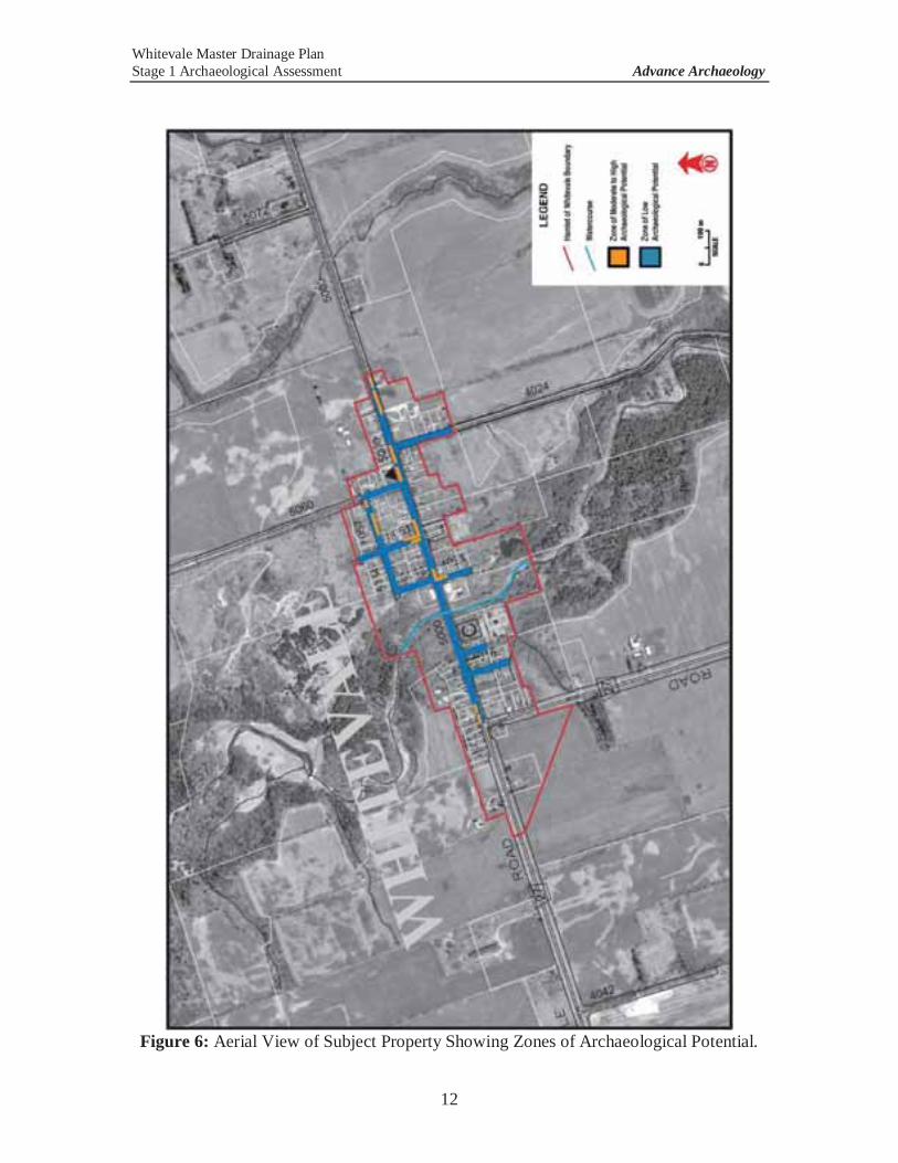
Whitevale Master Drainage Plan Stage 1 Archaeological Assessment Advance Archaeology
12
Figure 6: Aerial View of Subject Property Showing Zones of Archaeological Potential.
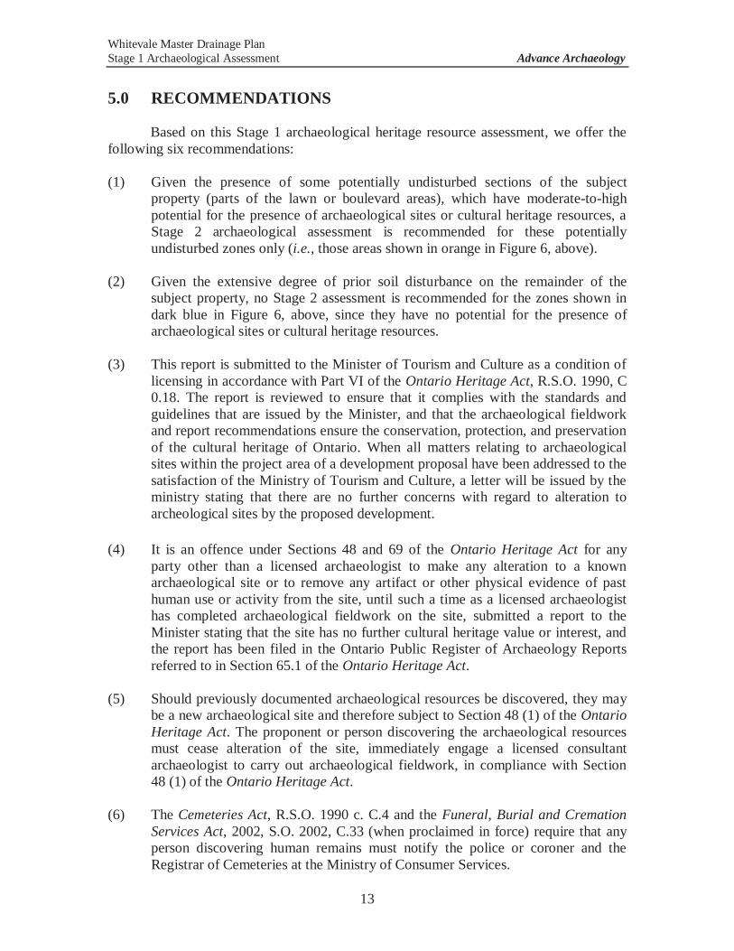
Whitevale Master Drainage Plan Stage 1 Archaeological Assessment Advance Archaeology
13
5.0 RECOMMENDATIONS
Based on this Stage 1 archaeological heritage resource assessment, we offer the
following six recommendations:
(1) Given the presence of some potentially undisturbed sections of the subject property (parts of the lawn or boulevard areas), which have moderate-to-high potential for the presence of archaeological sites or cultural heritage resources, a Stage 2 archaeological assessment is recommended for these potentially undisturbed zones only (i.e., those areas shown in orange in Figure 6, above).
(2) Given the extensive degree of prior soil disturbance on the remainder of the subject property, no Stage 2 assessment is recommended for the zones shown in dark blue in Figure 6, above, since they have no potential for the presence of archaeological sites or cultural heritage resources.
(3) This report is submitted to the Minister of Tourism and Culture as a condition of
licensing in accordance with Part VI of the Ontario Heritage Act, R.S.O. 1990, C 0.18. The report is reviewed to ensure that it complies with the standards and guidelines that are issued by the Minister, and that the archaeological fieldwork and report recommendations ensure the conservation, protection, and preservation of the cultural heritage of Ontario. When all matters relating to archaeological sites within the project area of a development proposal have been addressed to the satisfaction of the Ministry of Tourism and Culture, a letter will be issued by the ministry stating that there are no further concerns with regard to alteration to archeological sites by the proposed development.
(4) It is an offence under Sections 48 and 69 of the Ontario Heritage Act for any
party other than a licensed archaeologist to make any alteration to a known archaeological site or to remove any artifact or other physical evidence of past human use or activity from the site, until such a time as a licensed archaeologist has completed archaeological fieldwork on the site, submitted a report to the Minister stating that the site has no further cultural heritage value or interest, and the report has been filed in the Ontario Public Register of Archaeology Reports referred to in Section 65.1 of the Ontario Heritage Act.
(5) Should previously documented archaeological resources be discovered, they may
be a new archaeological site and therefore subject to Section 48 (1) of the Ontario Heritage Act. The proponent or person discovering the archaeological resources must cease alteration of the site, immediately engage a licensed consultant archaeologist to carry out archaeological fieldwork, in compliance with Section 48 (1) of the Ontario Heritage Act.
(6) The Cemeteries Act, R.S.O. 1990 c. C.4 and the Funeral, Burial and Cremation
Services Act, 2002, S.O. 2002, C.33 (when proclaimed in force) require that any person discovering human remains must notify the police or coroner and the Registrar of Cemeteries at the Ministry of Consumer Services.
Whitevale Master Drainage Plan Stage 1 Archaeological Assessment Advance Archaeology
14
6.0 REFERENCES Advance Archaeology 2010 Stage 1 and 2 Archaeological Assessment for the Whitevale Bridge
Upgrade Project, on the Road Allowance for Whitevale Road and Part of Lot 32, Concessions 4 and 5 of Geographic Former Township of Pickering, County of Ontario, Now in the City of Pickering, Regional Municipality of Durham. Report submitted to OMTC on December 10, 2010. PIF #: P121-087-2010.
Beers, J. H. and Company 1877 The Illustrated Historical Atlas of the County of Ontario. Toronto. Bray Heritage 2010 Seaton Neighbourhood Planning: Whitevale Road Heritage Corridor
Review. Report submitted to the City of Pickering. May 2010. Chapman, L.J. and D. F. Putnam. 1984 The Physiography of Southern Ontario. Third Edition. Ontario Geological
Survey Special Volume 2. City of Pickering 2010 Request for Proposal: Consulting Services for Whitevale Master Drainage Plan, No. RFP-9-2010. Pickering. July 2010. Ontario Department of Mines and Northern Affairs, and Ontario Research Foundation 1984 Map # 2226: Physiography of the South Central Portion of Southern Ontario. Ontario Heritage Act (RSO 1990) Ontario Ministry of Natural Resources 1984 Ontario Geological Survey Map P.2715: Physiography of Southern
Ontario. Toronto. Ontario Ministry of Tourism and Culture (OMTC) 2011 Standards and Guidelines for Consultant Archaeologists. Queen’s Printer
for Ontario. Toronto.

03rb_2013-03-01_App Tps_60187125.Docx
Appendix D Hydrologic Information
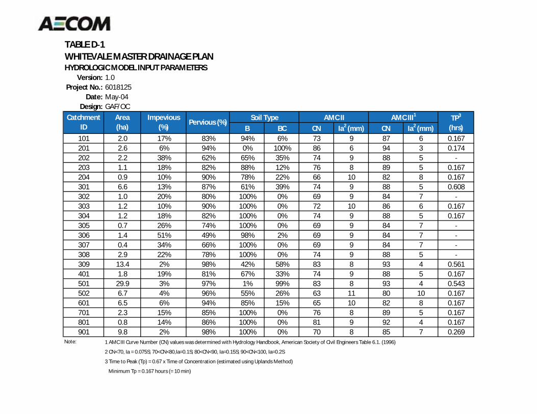
TABLE D 1WHITEVALE MASTER DRAINAGE PLANHYDROLOGIC MODEL INPUT PARAMETERS
Version: 1.0Project No.: 6018125
Date: May 04Design: GAF/OC
B BC CN Ia2 (mm) CN Ia2 (mm)101 2.0 17% 83% 94% 6% 73 9 87 6 0.167201 2.6 6% 94% 0% 100% 86 6 94 3 0.174202 2.2 38% 62% 65% 35% 74 9 88 5203 1.1 18% 82% 88% 12% 76 8 89 5 0.167204 0.9 10% 90% 78% 22% 66 10 82 8 0.167301 6.6 13% 87% 61% 39% 74 9 88 5 0.608302 1.0 20% 80% 100% 0% 69 9 84 7303 1.2 10% 90% 100% 0% 72 10 86 6 0.167304 1.2 18% 82% 100% 0% 74 9 88 5 0.167305 0.7 26% 74% 100% 0% 69 9 84 7
CatchmentID
Area(ha)
Impevious(%)
Pervious (%) TP3
(hrs)AMC II AMC III1Soil Type
306 1.4 51% 49% 98% 2% 69 9 84 7307 0.4 34% 66% 100% 0% 69 9 84 7308 2.9 22% 78% 100% 0% 74 9 88 5309 13.4 2% 98% 42% 58% 83 8 93 4 0.561401 1.8 19% 81% 67% 33% 74 9 88 5 0.167501 29.9 3% 97% 1% 99% 83 8 93 4 0.543502 6.7 4% 96% 55% 26% 63 11 80 10 0.167601 6.5 6% 94% 85% 15% 65 10 82 8 0.167701 2.3 15% 85% 100% 0% 76 8 89 5 0.167801 0.8 14% 86% 100% 0% 81 9 92 4 0.167901 9.8 2% 98% 100% 0% 70 8 85 7 0.269
Note: 1 AMC III Curve Number (CN) values was determined with Hydrology Handbook, American Society of Civil Engineers Table 6.1. (1996)
2 CN<70, Ia = 0.075S; 70<CN<80,Ia=0.1S; 80<CN<90, Ia=0.15S; 90<CN<100, Ia=0.2S
3 Time to Peak (Tp) = 0.67 x Time of Concentration (estimated using Uplands Method)
Minimum Tp = 0.167 hours (= 10 min)
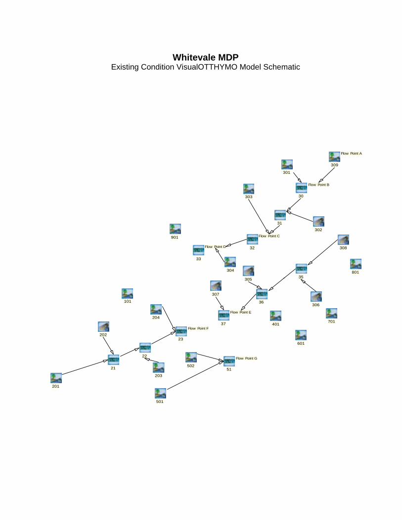
303
301
304
31
302
308
901
801
305 35
309
Flow Point A
30
Flow Point B
33
Flow Point D 32
Flow Point C
201
401
501
601
22
36
20223
Flow Point F
203
204
306101
21
37
Flow Point E
50251
Flow Point G
701
305 35
307
Whitevale MDPExisting Condition VisualOTTHYMO Model Schematic
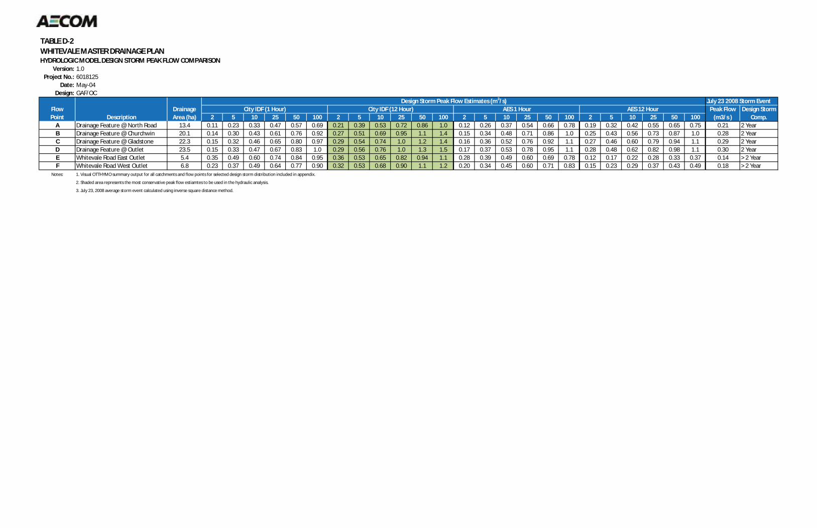
TABLE D 2WHITEVALE MASTER DRAINAGE PLANHYDROLOGIC MODEL DESIGN STORM PEAK FLOW COMPARISON
Version: 1.0Project No.: 6018125
Date: May 04Design: GAF/OC
July 23 2008 Storm Event
2 5 10 25 50 100 2 5 10 25 50 100 2 5 10 25 50 100 2 5 10 25 50 100A Drainage Feature @ North Road 13.4 0.11 0.23 0.33 0.47 0.57 0.69 0.21 0.39 0.53 0.72 0.86 1.0 0.12 0.26 0.37 0.54 0.66 0.78 0.19 0.32 0.42 0.55 0.65 0.75 0.21 2 YearB Drainage Feature @ Churchwin 20.1 0.14 0.30 0.43 0.61 0.76 0.92 0.27 0.51 0.69 0.95 1.1 1.4 0.15 0.34 0.48 0.71 0.86 1.0 0.25 0.43 0.56 0.73 0.87 1.0 0.28 2 YearC Drainage Feature @ Gladstone 22.3 0.15 0.32 0.46 0.65 0.80 0.97 0.29 0.54 0.74 1.0 1.2 1.4 0.16 0.36 0.52 0.76 0.92 1.1 0.27 0.46 0.60 0.79 0.94 1.1 0.29 2 YearD Drainage Feature @ Outlet 23.5 0.15 0.33 0.47 0.67 0.83 1.0 0.29 0.56 0.76 1.0 1.3 1.5 0.17 0.37 0.53 0.78 0.95 1.1 0.28 0.48 0.62 0.82 0.98 1.1 0.30 2 YearE Whitevale Road East Outlet 5.4 0.35 0.49 0.60 0.74 0.84 0.95 0.36 0.53 0.65 0.82 0.94 1.1 0.28 0.39 0.49 0.60 0.69 0.78 0.12 0.17 0.22 0.28 0.33 0.37 0.14 > 2 YearF Whitevale Road West Outlet 6.8 0.23 0.37 0.49 0.64 0.77 0.90 0.32 0.53 0.68 0.90 1.1 1.2 0.20 0.34 0.45 0.60 0.71 0.83 0.15 0.23 0.29 0.37 0.43 0.49 0.18 > 2 Year
Notes: 1. Visual OTTHYMO summary output for all catchments and flow points for selected design storm distribution included in appendix.
2. Shaded area represents the most conservative peak flow estiamtes to be used in the hydraulic analysis.
3. July 23, 2008 average storm event calculated using inverse square distance method.
FlowPoint
City IDF (12 Hour) AES 1 Hour AES 12 HourCity IDF (1 Hour) Peak Flow(m3/s )
Design StormComp.
Design Storm Peak Flow Estimates (m3/s)DrainageArea (ha)Description
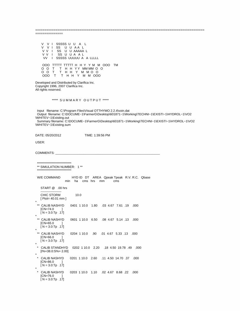
===========================================================================================================
V V I SSSSS U U A L V V I SS U U A A L V V I SS U U AAAAA L V V I SS U U A A L VV I SSSSS UUUUU A A LLLLL OOO TTTTT TTTTT H H Y Y M M OOO TM O O T T H H Y Y MM MM O O O O T T H H Y M M O O OOO T T H H Y M M OOO
Developed and Distributed by Clarifica Inc. Copyright 1996, 2007 Clarifica Inc.All rights reserved. ***** S U M M A R Y O U T P U T *****
Input filename: C:\Program Files\Visual OTTHYMO 2.2.4\voin.dat Output filename: C:\DOCUME~1\FarmerG\Desktop\601871~1\Working\TECHNI~1\EXISTI~1\HYDROL~1\VO2\WHITEV~1\Existing.out Summary filename: C:\DOCUME~1\FarmerG\Desktop\601871~1\Working\TECHNI~1\EXISTI~1\HYDROL~1\VO2\WHITEV~1\Existing.sum
DATE: 05/20/2012 TIME: 1:39:56 PM
USER:
COMMENTS: ____________________________________________________________
**************************** ** SIMULATION NUMBER: 1 ** **************************** W/E COMMAND HYD ID DT AREA Qpeak Tpeak R.V. R.C. Qbase min ha cms hrs mm cms
START @ .00 hrs -------------------- CHIC STORM 10.0 [ Ptot= 40.01 mm ]* ** CALIB NASHYD 0401 1 10.0 1.80 .03 4.67 7.61 .19 .000 [CN=74.0 ] [ N = 3.0:Tp .17]* ** CALIB NASHYD 0601 1 10.0 6.50 .08 4.67 5.14 .13 .000 [CN=65.0 ] [ N = 3.0:Tp .17]* ** CALIB NASHYD 0204 1 10.0 .90 .01 4.67 5.33 .13 .000 [CN=66.0 ] [ N = 3.0:Tp .17]* * CALIB STANDHYD 0202 1 10.0 2.20 .18 4.50 19.78 .49 .000 [I%=38.0:S%= 2.00]* * CALIB NASHYD 0201 1 10.0 2.60 .11 4.50 14.70 .37 .000 [CN=86.0 ] [ N = 3.0:Tp .17]* * CALIB NASHYD 0203 1 10.0 1.10 .02 4.67 8.68 .22 .000 [CN=76.0 ] [ N = 3.0:Tp .17]
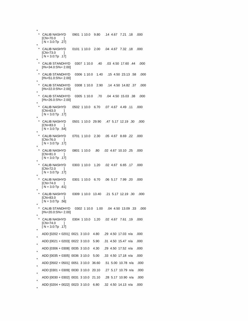
* * CALIB NASHYD 0901 1 10.0 9.80 .14 4.67 7.21 .18 .000 [CN=70.0 ] [ N = 3.0:Tp .27]* * CALIB NASHYD 0101 1 10.0 2.00 .04 4.67 7.32 .18 .000 [CN=73.0 ] [ N = 3.0:Tp .17]* * CALIB STANDHYD 0307 1 10.0 .40 .03 4.50 17.60 .44 .000 [I%=34.0:S%= 2.00]* * CALIB STANDHYD 0306 1 10.0 1.40 .15 4.50 23.13 .58 .000 [I%=51.0:S%= 2.00]* * CALIB STANDHYD 0308 1 10.0 2.90 .14 4.50 14.82 .37 .000 [I%=22.0:S%= 2.00]* * CALIB STANDHYD 0305 1 10.0 .70 .04 4.50 15.03 .38 .000 [I%=26.0:S%= 2.00]* * CALIB NASHYD 0502 1 10.0 6.70 .07 4.67 4.49 .11 .000 [CN=63.0 ] [ N = 3.0:Tp .17]* * CALIB NASHYD 0501 1 10.0 29.90 .47 5.17 12.19 .30 .000 [CN=83.0 ] [ N = 3.0:Tp .54]* * CALIB NASHYD 0701 1 10.0 2.30 .05 4.67 8.69 .22 .000 [CN=76.0 ] [ N = 3.0:Tp .17]* * CALIB NASHYD 0801 1 10.0 .80 .02 4.67 10.10 .25 .000 [CN=81.0 ] [ N = 3.0:Tp .17]* * CALIB NASHYD 0303 1 10.0 1.20 .02 4.67 6.65 .17 .000 [CN=72.0 ] [ N = 3.0:Tp .17]* * CALIB NASHYD 0301 1 10.0 6.70 .06 5.17 7.99 .20 .000 [CN=74.0 ] [ N = 3.0:Tp .61]* * CALIB NASHYD 0309 1 10.0 13.40 .21 5.17 12.19 .30 .000 [CN=83.0 ] [ N = 3.0:Tp .56]* * CALIB STANDHYD 0302 1 10.0 1.00 .04 4.50 13.09 .33 .000 [I%=20.0:S%= 2.00]* * CALIB NASHYD 0304 1 10.0 1.20 .02 4.67 7.61 .19 .000 [CN=74.0 ] [ N = 3.0:Tp .17]* ADD [0202 + 0201] 0021 3 10.0 4.80 .29 4.50 17.03 n/a .000* ADD [0021 + 0203] 0022 3 10.0 5.90 .31 4.50 15.47 n/a .000* ADD [0306 + 0308] 0035 3 10.0 4.30 .29 4.50 17.52 n/a .000* ADD [0035 + 0305] 0036 3 10.0 5.00 .33 4.50 17.18 n/a .000* ADD [0502 + 0501] 0051 3 10.0 36.60 .51 5.00 10.78 n/a .000* ADD [0301 + 0309] 0030 3 10.0 20.10 .27 5.17 10.79 n/a .000* ADD [0030 + 0302] 0031 3 10.0 21.10 .28 5.17 10.90 n/a .000* ADD [0204 + 0022] 0023 3 10.0 6.80 .32 4.50 14.13 n/a .000*
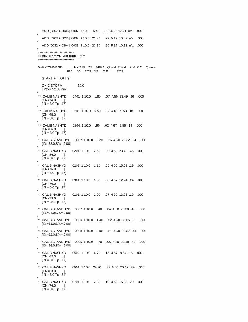
ADD [0307 + 0036] 0037 3 10.0 5.40 .36 4.50 17.21 n/a .000* ADD [0303 + 0031] 0032 3 10.0 22.30 .29 5.17 10.67 n/a .000* ADD [0032 + 0304] 0033 3 10.0 23.50 .29 5.17 10.51 n/a .000* **************************** ** SIMULATION NUMBER: 2 ** **************************** W/E COMMAND HYD ID DT AREA Qpeak Tpeak R.V. R.C. Qbase min ha cms hrs mm cms
START @ .00 hrs -------------------- CHIC STORM 10.0 [ Ptot= 52.38 mm ]* ** CALIB NASHYD 0401 1 10.0 1.80 .07 4.50 13.49 .26 .000 [CN=74.0 ] [ N = 3.0:Tp .17]* ** CALIB NASHYD 0601 1 10.0 6.50 .17 4.67 9.53 .18 .000 [CN=65.0 ] [ N = 3.0:Tp .17]* ** CALIB NASHYD 0204 1 10.0 .90 .02 4.67 9.86 .19 .000 [CN=66.0 ] [ N = 3.0:Tp .17]* * CALIB STANDHYD 0202 1 10.0 2.20 .26 4.50 28.32 .54 .000 [I%=38.0:S%= 2.00]* * CALIB NASHYD 0201 1 10.0 2.60 .20 4.50 23.48 .45 .000 [CN=86.0 ] [ N = 3.0:Tp .17]* * CALIB NASHYD 0203 1 10.0 1.10 .05 4.50 15.03 .29 .000 [CN=76.0 ] [ N = 3.0:Tp .17]* * CALIB NASHYD 0901 1 10.0 9.80 .28 4.67 12.74 .24 .000 [CN=70.0 ] [ N = 3.0:Tp .27]* * CALIB NASHYD 0101 1 10.0 2.00 .07 4.50 13.03 .25 .000 [CN=73.0 ] [ N = 3.0:Tp .17]* * CALIB STANDHYD 0307 1 10.0 .40 .04 4.50 25.33 .48 .000 [I%=34.0:S%= 2.00]* * CALIB STANDHYD 0306 1 10.0 1.40 .22 4.50 32.05 .61 .000 [I%=51.0:S%= 2.00]* * CALIB STANDHYD 0308 1 10.0 2.90 .21 4.50 22.37 .43 .000 [I%=22.0:S%= 2.00]* * CALIB STANDHYD 0305 1 10.0 .70 .06 4.50 22.18 .42 .000 [I%=26.0:S%= 2.00]* * CALIB NASHYD 0502 1 10.0 6.70 .15 4.67 8.54 .16 .000 [CN=63.0 ] [ N = 3.0:Tp .17]* * CALIB NASHYD 0501 1 10.0 29.90 .89 5.00 20.42 .39 .000 [CN=83.0 ] [ N = 3.0:Tp .54]* * CALIB NASHYD 0701 1 10.0 2.30 .10 4.50 15.03 .29 .000 [CN=76.0 ] [ N = 3.0:Tp .17]
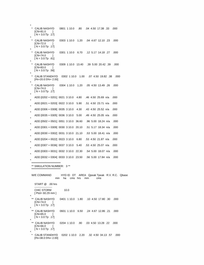
* * CALIB NASHYD 0801 1 10.0 .80 .04 4.50 17.38 .33 .000 [CN=81.0 ] [ N = 3.0:Tp .17]* * CALIB NASHYD 0303 1 10.0 1.20 .04 4.67 12.10 .23 .000 [CN=72.0 ] [ N = 3.0:Tp .17]* * CALIB NASHYD 0301 1 10.0 6.70 .12 5.17 14.18 .27 .000 [CN=74.0 ] [ N = 3.0:Tp .61]* * CALIB NASHYD 0309 1 10.0 13.40 .39 5.00 20.42 .39 .000 [CN=83.0 ] [ N = 3.0:Tp .56]* * CALIB STANDHYD 0302 1 10.0 1.00 .07 4.50 19.82 .38 .000 [I%=20.0:S%= 2.00]* * CALIB NASHYD 0304 1 10.0 1.20 .05 4.50 13.49 .26 .000 [CN=74.0 ] [ N = 3.0:Tp .17]* ADD [0202 + 0201] 0021 3 10.0 4.80 .46 4.50 25.69 n/a .000* ADD [0021 + 0203] 0022 3 10.0 5.90 .51 4.50 23.71 n/a .000* ADD [0306 + 0308] 0035 3 10.0 4.30 .43 4.50 25.52 n/a .000* ADD [0035 + 0305] 0036 3 10.0 5.00 .49 4.50 25.05 n/a .000* ADD [0502 + 0501] 0051 3 10.0 36.60 .96 5.00 18.24 n/a .000* ADD [0301 + 0309] 0030 3 10.0 20.10 .51 5.17 18.34 n/a .000* ADD [0030 + 0302] 0031 3 10.0 21.10 .53 5.00 18.41 n/a .000* ADD [0204 + 0022] 0023 3 10.0 6.80 .53 4.50 21.87 n/a .000* ADD [0307 + 0036] 0037 3 10.0 5.40 .53 4.50 25.07 n/a .000* ADD [0303 + 0031] 0032 3 10.0 22.30 .54 5.00 18.07 n/a .000* ADD [0032 + 0304] 0033 3 10.0 23.50 .56 5.00 17.84 n/a .000* **************************** ** SIMULATION NUMBER: 3 ** **************************** W/E COMMAND HYD ID DT AREA Qpeak Tpeak R.V. R.C. Qbase min ha cms hrs mm cms
START @ .00 hrs -------------------- CHIC STORM 10.0 [ Ptot= 60.29 mm ]* ** CALIB NASHYD 0401 1 10.0 1.80 .10 4.50 17.80 .30 .000 [CN=74.0 ] [ N = 3.0:Tp .17]* ** CALIB NASHYD 0601 1 10.0 6.50 .24 4.67 12.86 .21 .000 [CN=65.0 ] [ N = 3.0:Tp .17]* ** CALIB NASHYD 0204 1 10.0 .90 .03 4.50 13.28 .22 .000 [CN=66.0 ] [ N = 3.0:Tp .17]* * CALIB STANDHYD 0202 1 10.0 2.20 .32 4.50 34.13 .57 .000 [I%=38.0:S%= 2.00]
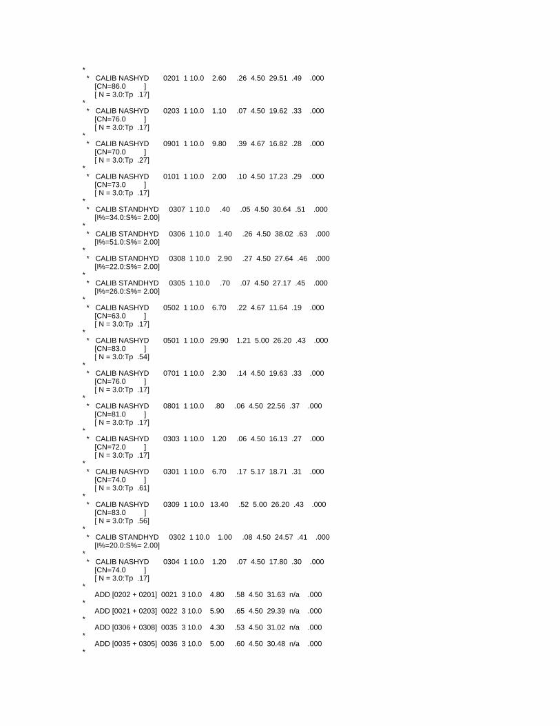
* * CALIB NASHYD 0201 1 10.0 2.60 .26 4.50 29.51 .49 .000 [CN=86.0 ] [ N = 3.0:Tp .17]* * CALIB NASHYD 0203 1 10.0 1.10 .07 4.50 19.62 .33 .000 [CN=76.0 ] [ N = 3.0:Tp .17]* * CALIB NASHYD 0901 1 10.0 9.80 .39 4.67 16.82 .28 .000 [CN=70.0 ] [ N = 3.0:Tp .27]* * CALIB NASHYD 0101 1 10.0 2.00 .10 4.50 17.23 .29 .000 [CN=73.0 ] [ N = 3.0:Tp .17]* * CALIB STANDHYD 0307 1 10.0 .40 .05 4.50 30.64 .51 .000 [I%=34.0:S%= 2.00]* * CALIB STANDHYD 0306 1 10.0 1.40 .26 4.50 38.02 .63 .000 [I%=51.0:S%= 2.00]* * CALIB STANDHYD 0308 1 10.0 2.90 .27 4.50 27.64 .46 .000 [I%=22.0:S%= 2.00]* * CALIB STANDHYD 0305 1 10.0 .70 .07 4.50 27.17 .45 .000 [I%=26.0:S%= 2.00]* * CALIB NASHYD 0502 1 10.0 6.70 .22 4.67 11.64 .19 .000 [CN=63.0 ] [ N = 3.0:Tp .17]* * CALIB NASHYD 0501 1 10.0 29.90 1.21 5.00 26.20 .43 .000 [CN=83.0 ] [ N = 3.0:Tp .54]* * CALIB NASHYD 0701 1 10.0 2.30 .14 4.50 19.63 .33 .000 [CN=76.0 ] [ N = 3.0:Tp .17]* * CALIB NASHYD 0801 1 10.0 .80 .06 4.50 22.56 .37 .000 [CN=81.0 ] [ N = 3.0:Tp .17]* * CALIB NASHYD 0303 1 10.0 1.20 .06 4.50 16.13 .27 .000 [CN=72.0 ] [ N = 3.0:Tp .17]* * CALIB NASHYD 0301 1 10.0 6.70 .17 5.17 18.71 .31 .000 [CN=74.0 ] [ N = 3.0:Tp .61]* * CALIB NASHYD 0309 1 10.0 13.40 .52 5.00 26.20 .43 .000 [CN=83.0 ] [ N = 3.0:Tp .56]* * CALIB STANDHYD 0302 1 10.0 1.00 .08 4.50 24.57 .41 .000 [I%=20.0:S%= 2.00]* * CALIB NASHYD 0304 1 10.0 1.20 .07 4.50 17.80 .30 .000 [CN=74.0 ] [ N = 3.0:Tp .17]* ADD [0202 + 0201] 0021 3 10.0 4.80 .58 4.50 31.63 n/a .000* ADD [0021 + 0203] 0022 3 10.0 5.90 .65 4.50 29.39 n/a .000* ADD [0306 + 0308] 0035 3 10.0 4.30 .53 4.50 31.02 n/a .000* ADD [0035 + 0305] 0036 3 10.0 5.00 .60 4.50 30.48 n/a .000*
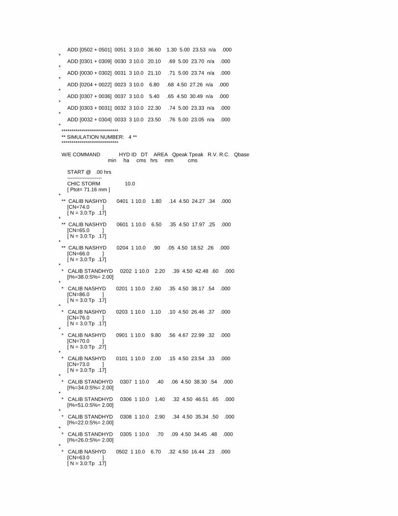
ADD [0502 + 0501] 0051 3 10.0 36.60 1.30 5.00 23.53 n/a .000* ADD [0301 + 0309] 0030 3 10.0 20.10 .69 5.00 23.70 n/a .000* ADD [0030 + 0302] 0031 3 10.0 21.10 .71 5.00 23.74 n/a .000* ADD [0204 + 0022] 0023 3 10.0 6.80 .68 4.50 27.26 n/a .000* ADD [0307 + 0036] 0037 3 10.0 5.40 .65 4.50 30.49 n/a .000* ADD [0303 + 0031] 0032 3 10.0 22.30 .74 5.00 23.33 n/a .000* ADD [0032 + 0304] 0033 3 10.0 23.50 .76 5.00 23.05 n/a .000* **************************** ** SIMULATION NUMBER: 4 ** **************************** W/E COMMAND HYD ID DT AREA Qpeak Tpeak R.V. R.C. Qbase min ha cms hrs mm cms
START @ .00 hrs -------------------- CHIC STORM 10.0 [ Ptot= 71.16 mm ]* ** CALIB NASHYD 0401 1 10.0 1.80 .14 4.50 24.27 .34 .000 [CN=74.0 ] [ N = 3.0:Tp .17]* ** CALIB NASHYD 0601 1 10.0 6.50 .35 4.50 17.97 .25 .000 [CN=65.0 ] [ N = 3.0:Tp .17]* ** CALIB NASHYD 0204 1 10.0 .90 .05 4.50 18.52 .26 .000 [CN=66.0 ] [ N = 3.0:Tp .17]* * CALIB STANDHYD 0202 1 10.0 2.20 .39 4.50 42.48 .60 .000 [I%=38.0:S%= 2.00]* * CALIB NASHYD 0201 1 10.0 2.60 .35 4.50 38.17 .54 .000 [CN=86.0 ] [ N = 3.0:Tp .17]* * CALIB NASHYD 0203 1 10.0 1.10 .10 4.50 26.46 .37 .000 [CN=76.0 ] [ N = 3.0:Tp .17]* * CALIB NASHYD 0901 1 10.0 9.80 .56 4.67 22.99 .32 .000 [CN=70.0 ] [ N = 3.0:Tp .27]* * CALIB NASHYD 0101 1 10.0 2.00 .15 4.50 23.54 .33 .000 [CN=73.0 ] [ N = 3.0:Tp .17]* * CALIB STANDHYD 0307 1 10.0 .40 .06 4.50 38.30 .54 .000 [I%=34.0:S%= 2.00]* * CALIB STANDHYD 0306 1 10.0 1.40 .32 4.50 46.51 .65 .000 [I%=51.0:S%= 2.00]* * CALIB STANDHYD 0308 1 10.0 2.90 .34 4.50 35.34 .50 .000 [I%=22.0:S%= 2.00]* * CALIB STANDHYD 0305 1 10.0 .70 .09 4.50 34.45 .48 .000 [I%=26.0:S%= 2.00]* * CALIB NASHYD 0502 1 10.0 6.70 .32 4.50 16.44 .23 .000 [CN=63.0 ] [ N = 3.0:Tp .17]
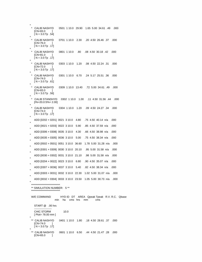
* * CALIB NASHYD 0501 1 10.0 29.90 1.65 5.00 34.61 .49 .000 [CN=83.0 ] [ N = 3.0:Tp .54]* * CALIB NASHYD 0701 1 10.0 2.30 .20 4.50 26.46 .37 .000 [CN=76.0 ] [ N = 3.0:Tp .17]* * CALIB NASHYD 0801 1 10.0 .80 .08 4.50 30.18 .42 .000 [CN=81.0 ] [ N = 3.0:Tp .17]* * CALIB NASHYD 0303 1 10.0 1.20 .08 4.50 22.24 .31 .000 [CN=72.0 ] [ N = 3.0:Tp .17]* * CALIB NASHYD 0301 1 10.0 6.70 .24 5.17 25.51 .36 .000 [CN=74.0 ] [ N = 3.0:Tp .61]* * CALIB NASHYD 0309 1 10.0 13.40 .72 5.00 34.61 .49 .000 [CN=83.0 ] [ N = 3.0:Tp .56]* * CALIB STANDHYD 0302 1 10.0 1.00 .11 4.50 31.56 .44 .000 [I%=20.0:S%= 2.00]* * CALIB NASHYD 0304 1 10.0 1.20 .09 4.50 24.27 .34 .000 [CN=74.0 ] [ N = 3.0:Tp .17]* ADD [0202 + 0201] 0021 3 10.0 4.80 .75 4.50 40.14 n/a .000* ADD [0021 + 0203] 0022 3 10.0 5.90 .85 4.50 37.59 n/a .000* ADD [0306 + 0308] 0035 3 10.0 4.30 .66 4.50 38.98 n/a .000* ADD [0035 + 0305] 0036 3 10.0 5.00 .75 4.50 38.34 n/a .000* ADD [0502 + 0501] 0051 3 10.0 36.60 1.78 5.00 31.28 n/a .000* ADD [0301 + 0309] 0030 3 10.0 20.10 .95 5.00 31.58 n/a .000* ADD [0030 + 0302] 0031 3 10.0 21.10 .98 5.00 31.58 n/a .000* ADD [0204 + 0022] 0023 3 10.0 6.80 .90 4.50 35.07 n/a .000* ADD [0307 + 0036] 0037 3 10.0 5.40 .82 4.50 38.34 n/a .000* ADD [0303 + 0031] 0032 3 10.0 22.30 1.02 5.00 31.07 n/a .000* ADD [0032 + 0304] 0033 3 10.0 23.50 1.05 5.00 30.73 n/a .000* **************************** ** SIMULATION NUMBER: 5 ** **************************** W/E COMMAND HYD ID DT AREA Qpeak Tpeak R.V. R.C. Qbase min ha cms hrs mm cms
START @ .00 hrs -------------------- CHIC STORM 10.0 [ Ptot= 78.00 mm ]* ** CALIB NASHYD 0401 1 10.0 1.80 .18 4.50 28.61 .37 .000 [CN=74.0 ] [ N = 3.0:Tp .17]* ** CALIB NASHYD 0601 1 10.0 6.50 .44 4.50 21.47 .28 .000 [CN=65.0 ]
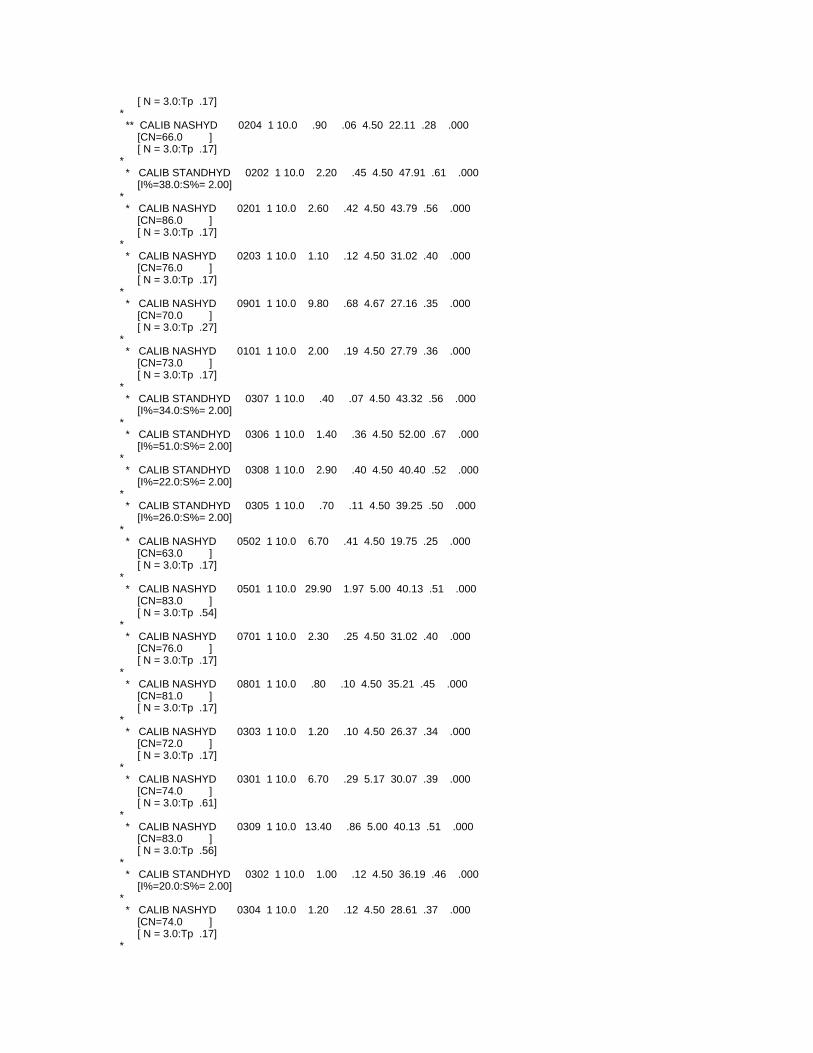
[ N = 3.0:Tp .17]* ** CALIB NASHYD 0204 1 10.0 .90 .06 4.50 22.11 .28 .000 [CN=66.0 ] [ N = 3.0:Tp .17]* * CALIB STANDHYD 0202 1 10.0 2.20 .45 4.50 47.91 .61 .000 [I%=38.0:S%= 2.00]* * CALIB NASHYD 0201 1 10.0 2.60 .42 4.50 43.79 .56 .000 [CN=86.0 ] [ N = 3.0:Tp .17]* * CALIB NASHYD 0203 1 10.0 1.10 .12 4.50 31.02 .40 .000 [CN=76.0 ] [ N = 3.0:Tp .17]* * CALIB NASHYD 0901 1 10.0 9.80 .68 4.67 27.16 .35 .000 [CN=70.0 ] [ N = 3.0:Tp .27]* * CALIB NASHYD 0101 1 10.0 2.00 .19 4.50 27.79 .36 .000 [CN=73.0 ] [ N = 3.0:Tp .17]* * CALIB STANDHYD 0307 1 10.0 .40 .07 4.50 43.32 .56 .000 [I%=34.0:S%= 2.00]* * CALIB STANDHYD 0306 1 10.0 1.40 .36 4.50 52.00 .67 .000 [I%=51.0:S%= 2.00]* * CALIB STANDHYD 0308 1 10.0 2.90 .40 4.50 40.40 .52 .000 [I%=22.0:S%= 2.00]* * CALIB STANDHYD 0305 1 10.0 .70 .11 4.50 39.25 .50 .000 [I%=26.0:S%= 2.00]* * CALIB NASHYD 0502 1 10.0 6.70 .41 4.50 19.75 .25 .000 [CN=63.0 ] [ N = 3.0:Tp .17]* * CALIB NASHYD 0501 1 10.0 29.90 1.97 5.00 40.13 .51 .000 [CN=83.0 ] [ N = 3.0:Tp .54]* * CALIB NASHYD 0701 1 10.0 2.30 .25 4.50 31.02 .40 .000 [CN=76.0 ] [ N = 3.0:Tp .17]* * CALIB NASHYD 0801 1 10.0 .80 .10 4.50 35.21 .45 .000 [CN=81.0 ] [ N = 3.0:Tp .17]* * CALIB NASHYD 0303 1 10.0 1.20 .10 4.50 26.37 .34 .000 [CN=72.0 ] [ N = 3.0:Tp .17]* * CALIB NASHYD 0301 1 10.0 6.70 .29 5.17 30.07 .39 .000 [CN=74.0 ] [ N = 3.0:Tp .61]* * CALIB NASHYD 0309 1 10.0 13.40 .86 5.00 40.13 .51 .000 [CN=83.0 ] [ N = 3.0:Tp .56]* * CALIB STANDHYD 0302 1 10.0 1.00 .12 4.50 36.19 .46 .000 [I%=20.0:S%= 2.00]* * CALIB NASHYD 0304 1 10.0 1.20 .12 4.50 28.61 .37 .000 [CN=74.0 ] [ N = 3.0:Tp .17]*
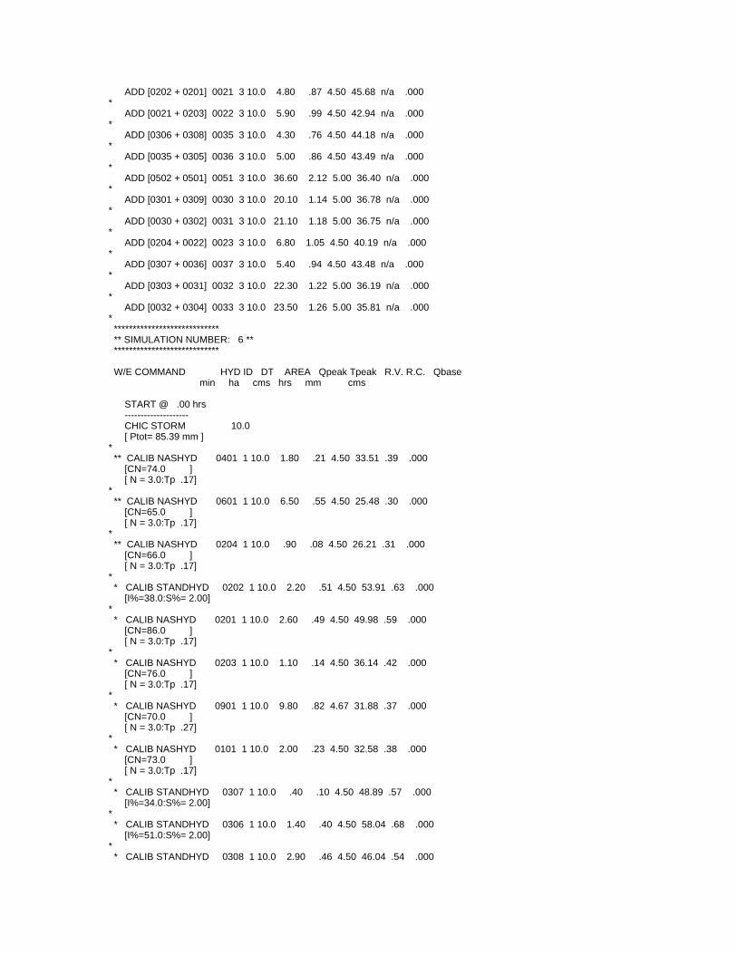
ADD [0202 + 0201] 0021 3 10.0 4.80 .87 4.50 45.68 n/a .000* ADD [0021 + 0203] 0022 3 10.0 5.90 .99 4.50 42.94 n/a .000* ADD [0306 + 0308] 0035 3 10.0 4.30 .76 4.50 44.18 n/a .000* ADD [0035 + 0305] 0036 3 10.0 5.00 .86 4.50 43.49 n/a .000* ADD [0502 + 0501] 0051 3 10.0 36.60 2.12 5.00 36.40 n/a .000* ADD [0301 + 0309] 0030 3 10.0 20.10 1.14 5.00 36.78 n/a .000* ADD [0030 + 0302] 0031 3 10.0 21.10 1.18 5.00 36.75 n/a .000* ADD [0204 + 0022] 0023 3 10.0 6.80 1.05 4.50 40.19 n/a .000* ADD [0307 + 0036] 0037 3 10.0 5.40 .94 4.50 43.48 n/a .000* ADD [0303 + 0031] 0032 3 10.0 22.30 1.22 5.00 36.19 n/a .000* ADD [0032 + 0304] 0033 3 10.0 23.50 1.26 5.00 35.81 n/a .000* **************************** ** SIMULATION NUMBER: 6 ** **************************** W/E COMMAND HYD ID DT AREA Qpeak Tpeak R.V. R.C. Qbase min ha cms hrs mm cms
START @ .00 hrs -------------------- CHIC STORM 10.0 [ Ptot= 85.39 mm ]* ** CALIB NASHYD 0401 1 10.0 1.80 .21 4.50 33.51 .39 .000 [CN=74.0 ] [ N = 3.0:Tp .17]* ** CALIB NASHYD 0601 1 10.0 6.50 .55 4.50 25.48 .30 .000 [CN=65.0 ] [ N = 3.0:Tp .17]* ** CALIB NASHYD 0204 1 10.0 .90 .08 4.50 26.21 .31 .000 [CN=66.0 ] [ N = 3.0:Tp .17]* * CALIB STANDHYD 0202 1 10.0 2.20 .51 4.50 53.91 .63 .000 [I%=38.0:S%= 2.00]* * CALIB NASHYD 0201 1 10.0 2.60 .49 4.50 49.98 .59 .000 [CN=86.0 ] [ N = 3.0:Tp .17]* * CALIB NASHYD 0203 1 10.0 1.10 .14 4.50 36.14 .42 .000 [CN=76.0 ] [ N = 3.0:Tp .17]* * CALIB NASHYD 0901 1 10.0 9.80 .82 4.67 31.88 .37 .000 [CN=70.0 ] [ N = 3.0:Tp .27]* * CALIB NASHYD 0101 1 10.0 2.00 .23 4.50 32.58 .38 .000 [CN=73.0 ] [ N = 3.0:Tp .17]* * CALIB STANDHYD 0307 1 10.0 .40 .10 4.50 48.89 .57 .000 [I%=34.0:S%= 2.00]* * CALIB STANDHYD 0306 1 10.0 1.40 .40 4.50 58.04 .68 .000 [I%=51.0:S%= 2.00]* * CALIB STANDHYD 0308 1 10.0 2.90 .46 4.50 46.04 .54 .000
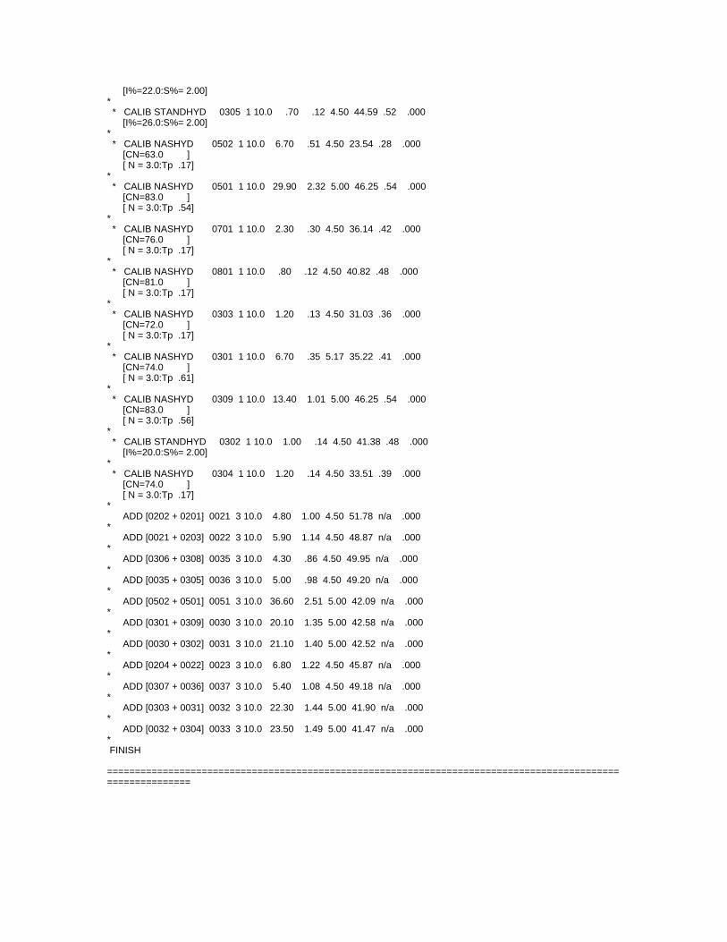
[I%=22.0:S%= 2.00]* * CALIB STANDHYD 0305 1 10.0 .70 .12 4.50 44.59 .52 .000 [I%=26.0:S%= 2.00]* * CALIB NASHYD 0502 1 10.0 6.70 .51 4.50 23.54 .28 .000 [CN=63.0 ] [ N = 3.0:Tp .17]* * CALIB NASHYD 0501 1 10.0 29.90 2.32 5.00 46.25 .54 .000 [CN=83.0 ] [ N = 3.0:Tp .54]* * CALIB NASHYD 0701 1 10.0 2.30 .30 4.50 36.14 .42 .000 [CN=76.0 ] [ N = 3.0:Tp .17]* * CALIB NASHYD 0801 1 10.0 .80 .12 4.50 40.82 .48 .000 [CN=81.0 ] [ N = 3.0:Tp .17]* * CALIB NASHYD 0303 1 10.0 1.20 .13 4.50 31.03 .36 .000 [CN=72.0 ] [ N = 3.0:Tp .17]* * CALIB NASHYD 0301 1 10.0 6.70 .35 5.17 35.22 .41 .000 [CN=74.0 ] [ N = 3.0:Tp .61]* * CALIB NASHYD 0309 1 10.0 13.40 1.01 5.00 46.25 .54 .000 [CN=83.0 ] [ N = 3.0:Tp .56]* * CALIB STANDHYD 0302 1 10.0 1.00 .14 4.50 41.38 .48 .000 [I%=20.0:S%= 2.00]* * CALIB NASHYD 0304 1 10.0 1.20 .14 4.50 33.51 .39 .000 [CN=74.0 ] [ N = 3.0:Tp .17]* ADD [0202 + 0201] 0021 3 10.0 4.80 1.00 4.50 51.78 n/a .000* ADD [0021 + 0203] 0022 3 10.0 5.90 1.14 4.50 48.87 n/a .000* ADD [0306 + 0308] 0035 3 10.0 4.30 .86 4.50 49.95 n/a .000* ADD [0035 + 0305] 0036 3 10.0 5.00 .98 4.50 49.20 n/a .000* ADD [0502 + 0501] 0051 3 10.0 36.60 2.51 5.00 42.09 n/a .000* ADD [0301 + 0309] 0030 3 10.0 20.10 1.35 5.00 42.58 n/a .000* ADD [0030 + 0302] 0031 3 10.0 21.10 1.40 5.00 42.52 n/a .000* ADD [0204 + 0022] 0023 3 10.0 6.80 1.22 4.50 45.87 n/a .000* ADD [0307 + 0036] 0037 3 10.0 5.40 1.08 4.50 49.18 n/a .000* ADD [0303 + 0031] 0032 3 10.0 22.30 1.44 5.00 41.90 n/a .000* ADD [0032 + 0304] 0033 3 10.0 23.50 1.49 5.00 41.47 n/a .000* FINISH ===========================================================================================================
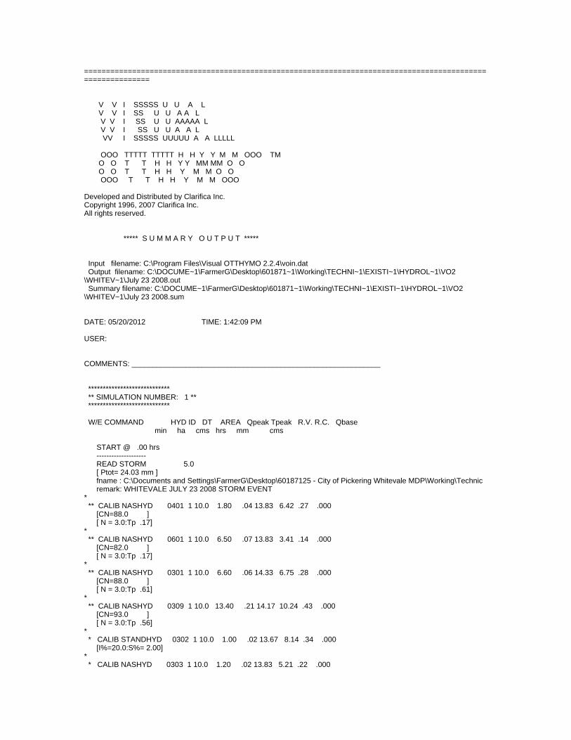
===========================================================================================================
V V I SSSSS U U A L V V I SS U U A A L V V I SS U U AAAAA L V V I SS U U A A L VV I SSSSS UUUUU A A LLLLL OOO TTTTT TTTTT H H Y Y M M OOO TM O O T T H H Y Y MM MM O O O O T T H H Y M M O O OOO T T H H Y M M OOO
Developed and Distributed by Clarifica Inc. Copyright 1996, 2007 Clarifica Inc.All rights reserved. ***** S U M M A R Y O U T P U T *****
Input filename: C:\Program Files\Visual OTTHYMO 2.2.4\voin.dat Output filename: C:\DOCUME~1\FarmerG\Desktop\601871~1\Working\TECHNI~1\EXISTI~1\HYDROL~1\VO2\WHITEV~1\July 23 2008.out Summary filename: C:\DOCUME~1\FarmerG\Desktop\601871~1\Working\TECHNI~1\EXISTI~1\HYDROL~1\VO2\WHITEV~1\July 23 2008.sum
DATE: 05/20/2012 TIME: 1:42:09 PM
USER:
COMMENTS: ____________________________________________________________
**************************** ** SIMULATION NUMBER: 1 ** **************************** W/E COMMAND HYD ID DT AREA Qpeak Tpeak R.V. R.C. Qbase min ha cms hrs mm cms
START @ .00 hrs -------------------- READ STORM 5.0 [ Ptot= 24.03 mm ] fname : C:\Documents and Settings\FarmerG\Desktop\60187125 - City of Pickering Whitevale MDP\Working\Technic remark: WHITEVALE JULY 23 2008 STORM EVENT * ** CALIB NASHYD 0401 1 10.0 1.80 .04 13.83 6.42 .27 .000 [CN=88.0 ] [ N = 3.0:Tp .17]* ** CALIB NASHYD 0601 1 10.0 6.50 .07 13.83 3.41 .14 .000 [CN=82.0 ] [ N = 3.0:Tp .17]* ** CALIB NASHYD 0301 1 10.0 6.60 .06 14.33 6.75 .28 .000 [CN=88.0 ] [ N = 3.0:Tp .61]* ** CALIB NASHYD 0309 1 10.0 13.40 .21 14.17 10.24 .43 .000 [CN=93.0 ] [ N = 3.0:Tp .56]* * CALIB STANDHYD 0302 1 10.0 1.00 .02 13.67 8.14 .34 .000 [I%=20.0:S%= 2.00]* * CALIB NASHYD 0303 1 10.0 1.20 .02 13.83 5.21 .22 .000
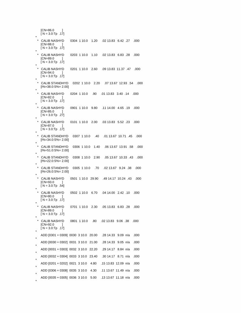
[CN=86.0 ] [ N = 3.0:Tp .17]* * CALIB NASHYD 0304 1 10.0 1.20 .02 13.83 6.42 .27 .000 [CN=88.0 ] [ N = 3.0:Tp .17]* * CALIB NASHYD 0203 1 10.0 1.10 .02 13.83 6.83 .28 .000 [CN=89.0 ] [ N = 3.0:Tp .17]* * CALIB NASHYD 0201 1 10.0 2.60 .09 13.83 11.37 .47 .000 [CN=94.0 ] [ N = 3.0:Tp .17]* * CALIB STANDHYD 0202 1 10.0 2.20 .07 13.67 12.93 .54 .000 [I%=38.0:S%= 2.00]* * CALIB NASHYD 0204 1 10.0 .90 .01 13.83 3.40 .14 .000 [CN=82.0 ] [ N = 3.0:Tp .17]* * CALIB NASHYD 0901 1 10.0 9.80 .11 14.00 4.65 .19 .000 [CN=85.0 ] [ N = 3.0:Tp .27]* * CALIB NASHYD 0101 1 10.0 2.00 .03 13.83 5.52 .23 .000 [CN=87.0 ] [ N = 3.0:Tp .17]* * CALIB STANDHYD 0307 1 10.0 .40 .01 13.67 10.71 .45 .000 [I%=34.0:S%= 2.00]* * CALIB STANDHYD 0306 1 10.0 1.40 .06 13.67 13.91 .58 .000 [I%=51.0:S%= 2.00]* * CALIB STANDHYD 0308 1 10.0 2.90 .05 13.67 10.33 .43 .000 [I%=22.0:S%= 2.00]* * CALIB STANDHYD 0305 1 10.0 .70 .02 13.67 9.24 .38 .000 [I%=26.0:S%= 2.00]* * CALIB NASHYD 0501 1 10.0 29.90 .49 14.17 10.24 .43 .000 [CN=93.0 ] [ N = 3.0:Tp .54]* * CALIB NASHYD 0502 1 10.0 6.70 .04 14.00 2.42 .10 .000 [CN=80.0 ] [ N = 3.0:Tp .17]* * CALIB NASHYD 0701 1 10.0 2.30 .05 13.83 6.83 .28 .000 [CN=89.0 ] [ N = 3.0:Tp .17]* * CALIB NASHYD 0801 1 10.0 .80 .02 13.83 9.06 .38 .000 [CN=92.0 ] [ N = 3.0:Tp .17]* ADD [0301 + 0309] 0030 3 10.0 20.00 .28 14.33 9.09 n/a .000* ADD [0030 + 0302] 0031 3 10.0 21.00 .28 14.33 9.05 n/a .000* ADD [0031 + 0303] 0032 3 10.0 22.20 .29 14.17 8.84 n/a .000* ADD [0032 + 0304] 0033 3 10.0 23.40 .30 14.17 8.71 n/a .000* ADD [0201 + 0202] 0021 3 10.0 4.80 .15 13.83 12.09 n/a .000* ADD [0306 + 0308] 0035 3 10.0 4.30 .11 13.67 11.49 n/a .000* ADD [0035 + 0305] 0036 3 10.0 5.00 .13 13.67 11.18 n/a .000*

ADD [0501 + 0502] 0051 3 10.0 36.60 .52 14.17 8.81 n/a .000* ADD [0203 + 0021] 0022 3 10.0 5.90 .17 13.83 11.11 n/a .000* ADD [0307 + 0036] 0037 3 10.0 5.40 .14 13.67 11.14 n/a .000* ADD [0022 + 0204] 0023 3 10.0 6.80 .18 13.83 10.09 n/a .000* FINISH ===========================================================================================================
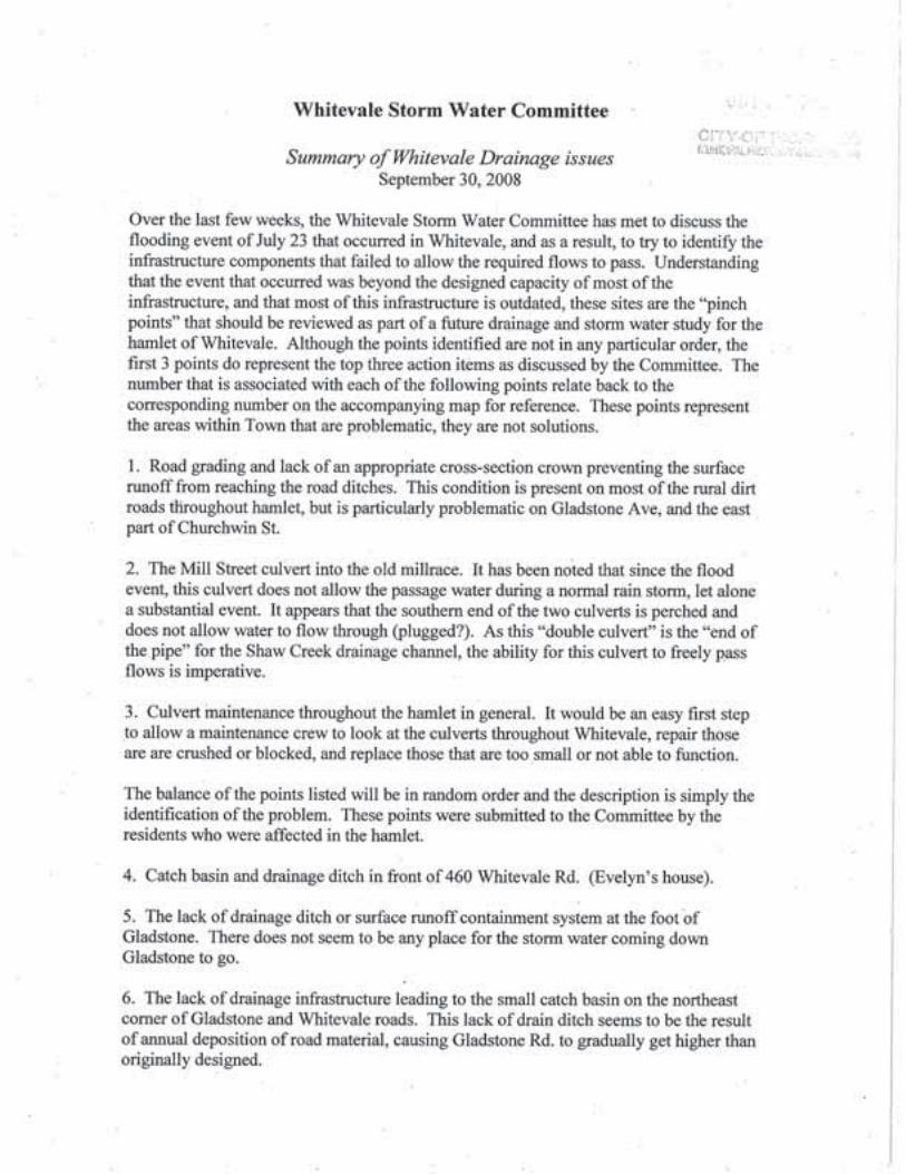
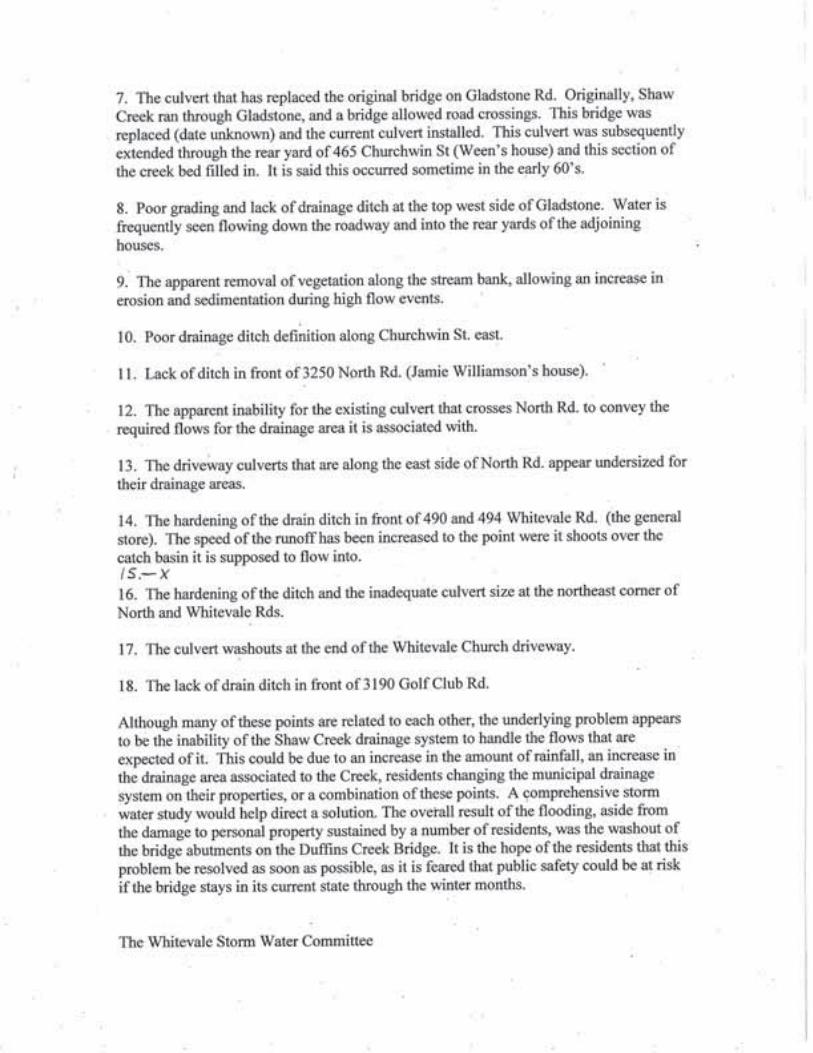
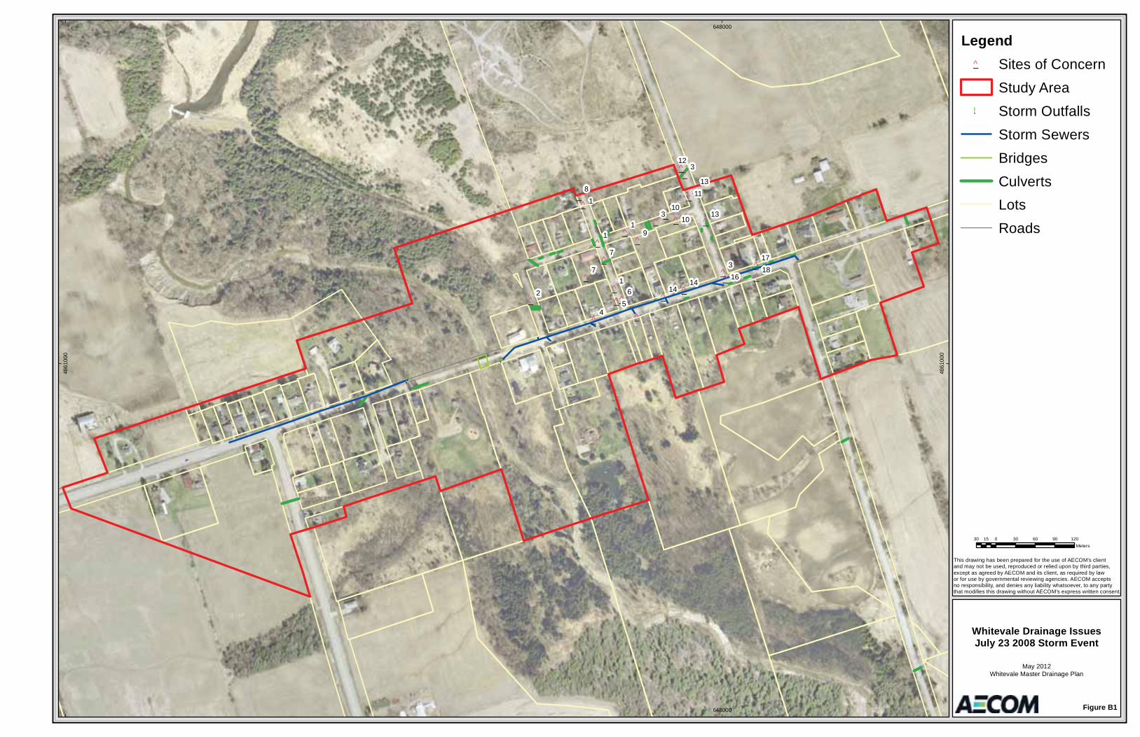
!.
!.
_̂
_̂
_̂
_̂
_̂
_̂_̂
_̂
_̂
_̂ _̂
_̂
_̂
_̂
_̂
_̂
_̂
_̂
_̂
_̂
_̂_̂
_̂
_̂
_̂
_̂
_̂
3
81
3
9
31
7
1
6
7
54
12
13
12
11
10
17
1310
1816
1414
648000
648000
4861
000
4861
000
Legend_̂ Sites of Concern
Study Area!. Storm Outfalls
Storm SewersBridgesCulvertsLotsRoads
Figure B1
Whitevale Drainage IssuesJuly 23 2008 Storm Event
May 2012Whitevale Master Drainage Plan
This drawing has been prepared for the use of AECOM’s client and may not be used, reproduced or relied upon by third parties,except as agreed by AECOM and its client, as required by law or for use by governmental reviewing agencies. AECOM accepts no responsibility, and denies any liability whatsoever, to any partythat modifies this drawing without AECOM’s express written consent.
�30 0 30 60 90 12015
Meters
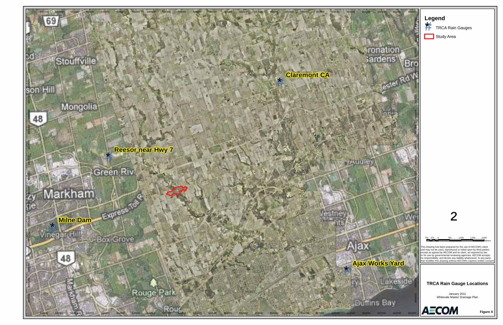
#*
#*
#*
#*Milne Dam
Claremont CA
Ajax Works Yard
Reesor near Hwy 7
639000
639000
640000
640000
641000
641000
642000
642000
643000
643000
644000
644000
645000
645000
646000
646000
647000
647000
648000
648000
649000
649000
650000
650000
651000
651000
652000
652000
653000
653000
654000
654000
655000
655000
656000
656000
657000
657000
658000
658000
659000
659000
660000
660000
661000
661000
662000
662000
663000
663000
4854
000
4854
000
4855
000
4855
000
4856
000
4856
000
4857
000
4857
000
4858
000
4858
000
4859
000
4859
000
4860
000
4860
000
4861
000
4861
000
4862
000
4862
000
4863
000
4863
000
4864
000
4864
000
4865
000
4865
000
4866
000
4866
000
4867
000
4867
000
4868
000
4868
000
4869
000
4869
000
4870
000
4870
000
4871
000
4871
000
4872
000
4872
000 Legend
#* TRCA Rain Gauges
Study Area
Figure X
TRCA Rain Gauge Locations
January 2011Whitevale Master Drainage Plan
This drawing has been prepared for the use of AECOM's client and may not be used, reproduced or relied upon by third parties,except as agreed by AECOM and its client, as required by law or for use by governmental reviewing agencies. AECOM accepts no responsibility, and denies any liability whatsoever, to any partythat modifies this drawing without AECOM's express written consent.
²750 0 750 1,500 2,250 3,000375
Meters
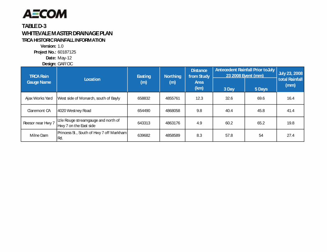
TABLE D 3WHITEVALE MASTER DRAINAGE PLANTRCA HISTORIC RAINFALL INFORMATION
Version: 1.0Project No.: 60187125
Date: May 12Design: GAF/OC
3 Day 5 Days
Ajax Works Yard West side of Monarch, south of Bayly 658832 4855761 12.3 32.6 69.6 16.4
Claremont CA 4020 Westney Road 654490 4868058 9.8 40.4 45.8 41.4
Reesor near Hwy 7Ltle Rouge streamgauge and north ofHwy 7 on the East side
643313 4863176 4.9 60.2 65.2 19.8
Milne DamPrincess St., South of Hwy 7 off MarkhamRd.
639682 4858589 8.3 57.8 54 27.4
July 23, 2008total Rainfall
(mm)
Easting(m)
LocationTRCA Rain
Gauge Name
Antecedent Rainfall Prior toJuly23 2008 Event (mm)
Distancefrom Study
Area(km)
Northing(m)
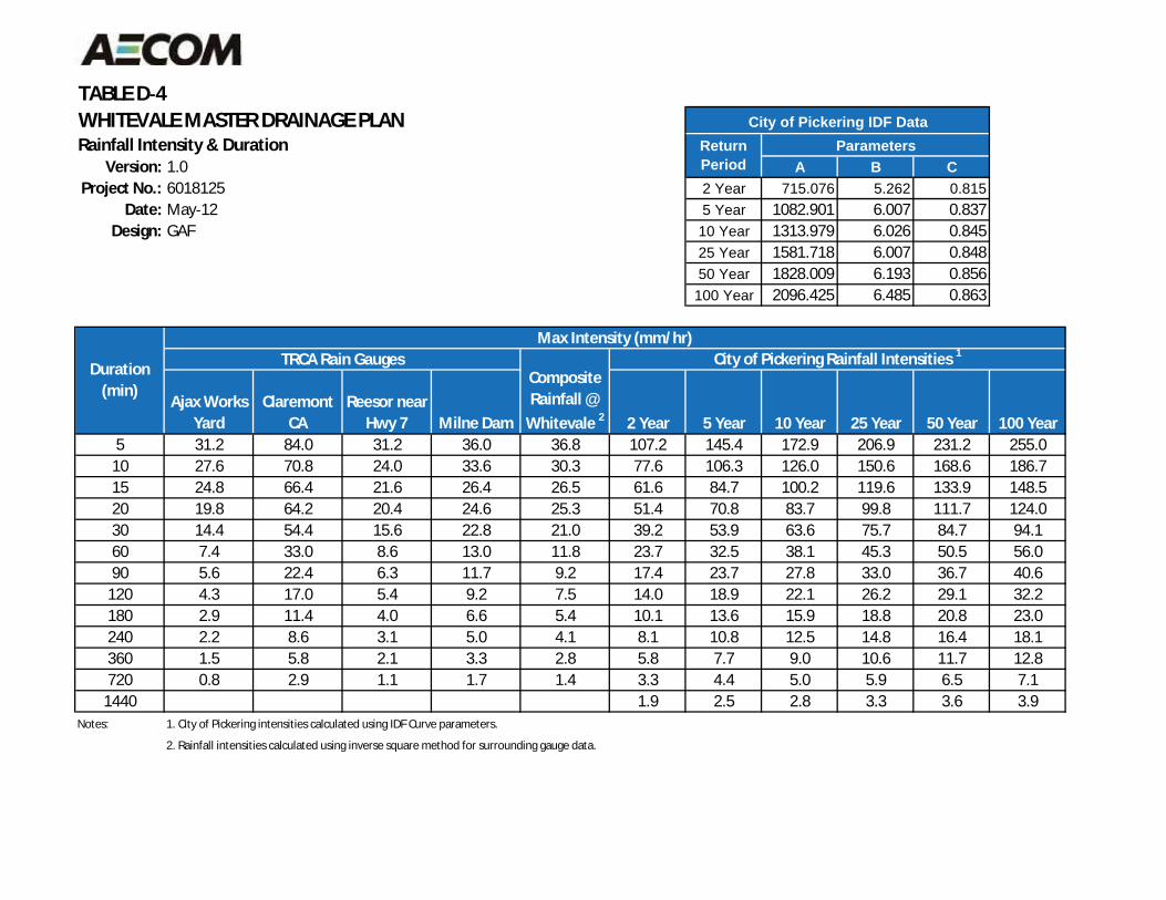
TABLE D 4WHITEVALE MASTER DRAINAGE PLANRainfall Intensity & Duration
Version: 1.0 A B CProject No.: 6018125 2 Year 715.076 5.262 0.815
Date: May 12 5 Year 1082.901 6.007 0.837Design: GAF 10 Year 1313.979 6.026 0.845
25 Year 1581.718 6.007 0.84850 Year 1828.009 6.193 0.856100 Year 2096.425 6.485 0.863
Ajax WorksYard
ClaremontCA
Reesor nearHwy 7 Milne Dam 2 Year 5 Year 10 Year 25 Year 50 Year 100 Year
5 31.2 84.0 31.2 36.0 36.8 107.2 145.4 172.9 206.9 231.2 255.010 27.6 70.8 24.0 33.6 30.3 77.6 106.3 126.0 150.6 168.6 186.715 24.8 66.4 21.6 26.4 26.5 61.6 84.7 100.2 119.6 133.9 148.520 19.8 64.2 20.4 24.6 25.3 51.4 70.8 83.7 99.8 111.7 124.030 14.4 54.4 15.6 22.8 21.0 39.2 53.9 63.6 75.7 84.7 94.160 7.4 33.0 8.6 13.0 11.8 23.7 32.5 38.1 45.3 50.5 56.090 5.6 22.4 6.3 11.7 9.2 17.4 23.7 27.8 33.0 36.7 40.6120 4.3 17.0 5.4 9.2 7.5 14.0 18.9 22.1 26.2 29.1 32.2180 2.9 11.4 4.0 6.6 5.4 10.1 13.6 15.9 18.8 20.8 23.0240 2.2 8.6 3.1 5.0 4.1 8.1 10.8 12.5 14.8 16.4 18.1360 1.5 5.8 2.1 3.3 2.8 5.8 7.7 9.0 10.6 11.7 12.8720 0.8 2.9 1.1 1.7 1.4 3.3 4.4 5.0 5.9 6.5 7.11440 1.9 2.5 2.8 3.3 3.6 3.9
Notes: 1. City of Pickering intensities calculated using IDF Curve parameters.
2. Rainfall intensities calculated using inverse square method for surrounding gauge data.
City of Pickering IDF DataReturnPeriod
Parameters
Duration(min)
TRCA Rain Gauges City of Pickering Rainfall Intensities 1Max Intensity (mm/hr)
CompositeRainfall @Whitevale 2
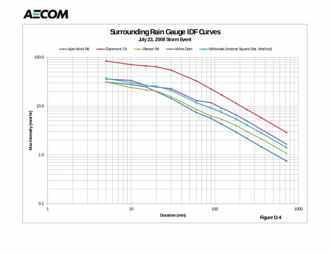
Surrounding Rain Gauge IDF CurvesJuly 23, 2008 Storm Event
Ajax Work Rd Claremont CA Reesor Rd Milne Dam Whitevale (Inverse Square Dist. Method)
100.0
10.0
)In
tens
ity(m
m/h
r)
1.0
Max
I
0.11 10 100 1000
Duration (min) Figure D 4
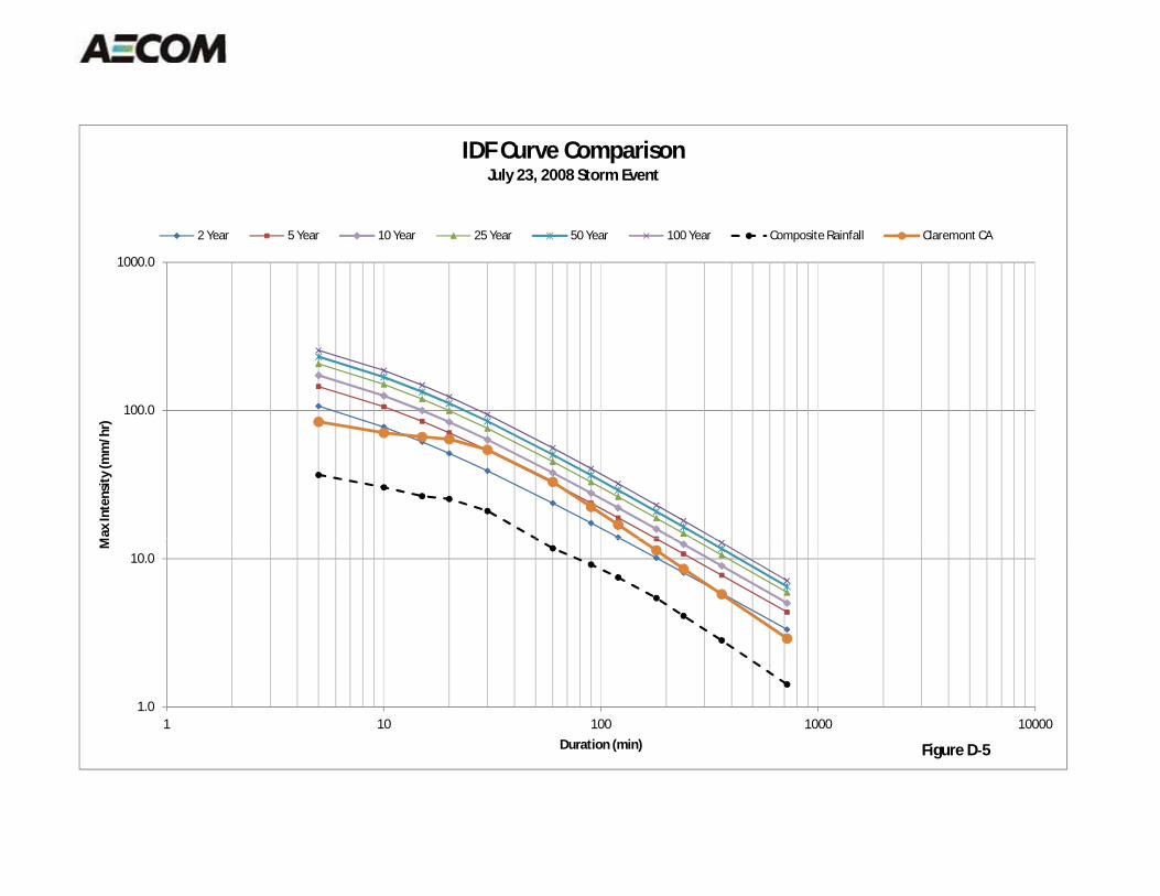
100.0
1000.0
Max
Inte
nsity
(mm
/hr)
IDF Curve ComparisonJuly 23, 2008 Storm Event
2 Year 5 Year 10 Year 25 Year 50 Year 100 Year Composite Rainfall Claremont CA
1.0
10.0
1 10 100 1000 10000
M
Duration (min) Figure D 5
03rb_2013-03-01_App Tps_60187125.Docx
Appendix E Hydraulic Information
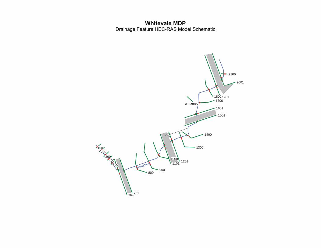
unnamed
2100
2001
190118001700
1601
1501
1400
1300
12011101
1000
900800
701601
500400
300200
100
unname d
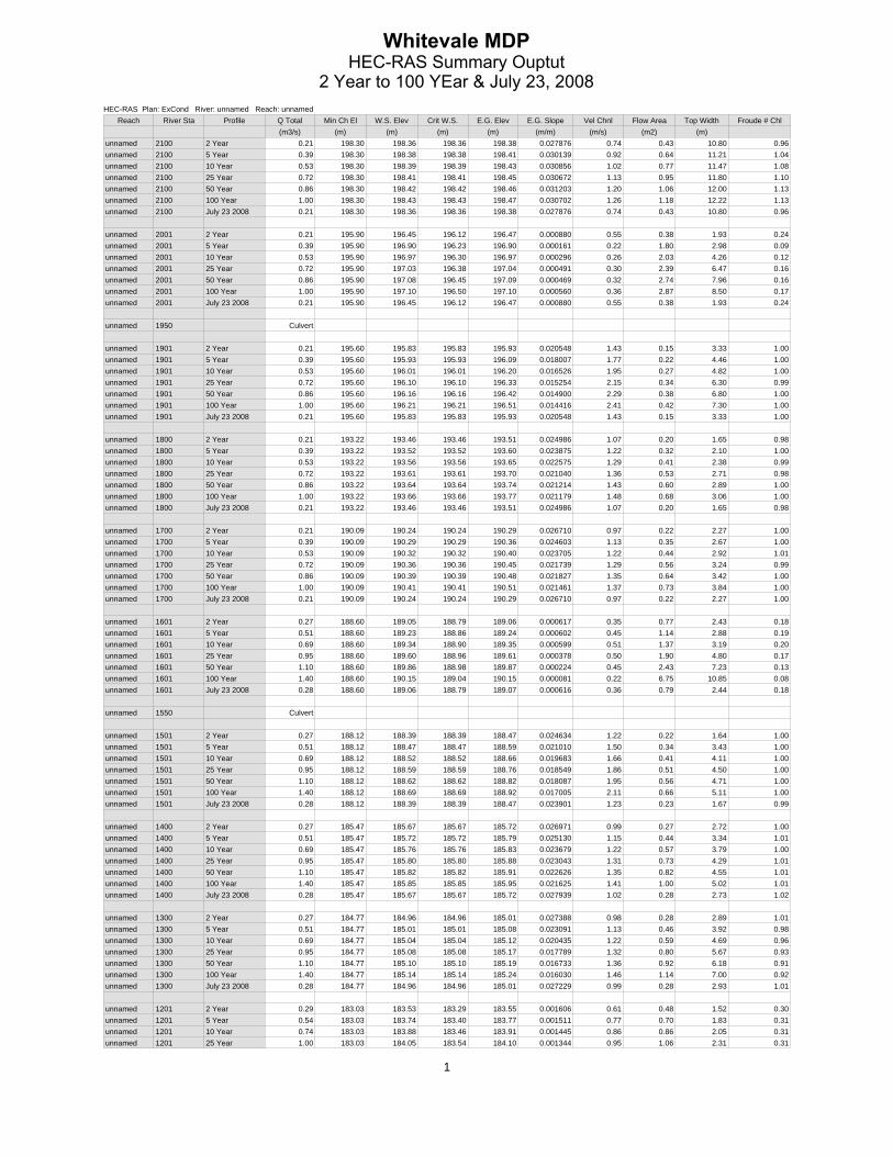
HEC-RAS Plan: ExCond River: unnamed Reach: unnamedReach River Sta Profile Q Total Min Ch El W.S. Elev Crit W.S. E.G. Elev E.G. Slope Vel Chnl Flow Area Top Width Froude # Chl
(m3/s) (m) (m) (m) (m) (m/m) (m/s) (m2) (m) unnamed 2100 2 Year 0.21 198.30 198.36 198.36 198.38 0.027876 0.74 0.43 10.80 0.96unnamed 2100 5 Year 0.39 198.30 198.38 198.38 198.41 0.030139 0.92 0.64 11.21 1.04unnamed 2100 10 Year 0.53 198.30 198.39 198.39 198.43 0.030856 1.02 0.77 11.47 1.08unnamed 2100 25 Year 0.72 198.30 198.41 198.41 198.45 0.030672 1.13 0.95 11.80 1.10unnamed 2100 50 Year 0.86 198.30 198.42 198.42 198.46 0.031203 1.20 1.06 12.00 1.13unnamed 2100 100 Year 1.00 198.30 198.43 198.43 198.47 0.030702 1.26 1.18 12.22 1.13unnamed 2100 July 23 2008 0.21 198.30 198.36 198.36 198.38 0.027876 0.74 0.43 10.80 0.96
unnamed 2001 2 Year 0.21 195.90 196.45 196.12 196.47 0.000880 0.55 0.38 1.93 0.24unnamed 2001 5 Year 0.39 195.90 196.90 196.23 196.90 0.000161 0.22 1.80 2.98 0.09unnamed 2001 10 Year 0.53 195.90 196.97 196.30 196.97 0.000296 0.26 2.03 4.26 0.12unnamed 2001 25 Year 0.72 195.90 197.03 196.38 197.04 0.000491 0.30 2.39 6.47 0.16unnamed 2001 50 Year 0.86 195.90 197.08 196.45 197.09 0.000469 0.32 2.74 7.96 0.16unnamed 2001 100 Year 1.00 195.90 197.10 196.50 197.10 0.000560 0.36 2.87 8.50 0.17unnamed 2001 July 23 2008 0.21 195.90 196.45 196.12 196.47 0.000880 0.55 0.38 1.93 0.24
unnamed 1950 Culvert
unnamed 1901 2 Year 0.21 195.60 195.83 195.83 195.93 0.020548 1.43 0.15 3.33 1.00unnamed 1901 5 Year 0.39 195.60 195.93 195.93 196.09 0.018007 1.77 0.22 4.46 1.00unnamed 1901 10 Year 0.53 195.60 196.01 196.01 196.20 0.016526 1.95 0.27 4.82 1.00unnamed 1901 25 Year 0.72 195.60 196.10 196.10 196.33 0.015254 2.15 0.34 6.30 0.99unnamed 1901 50 Year 0.86 195.60 196.16 196.16 196.42 0.014900 2.29 0.38 6.80 1.00unnamed 1901 100 Year 1.00 195.60 196.21 196.21 196.51 0.014416 2.41 0.42 7.30 1.00unnamed 1901 July 23 2008 0.21 195.60 195.83 195.83 195.93 0.020548 1.43 0.15 3.33 1.00
unnamed 1800 2 Year 0.21 193.22 193.46 193.46 193.51 0.024986 1.07 0.20 1.65 0.98unnamed 1800 5 Year 0.39 193.22 193.52 193.52 193.60 0.023875 1.22 0.32 2.10 1.00unnamed 1800 10 Year 0.53 193.22 193.56 193.56 193.65 0.022575 1.29 0.41 2.38 0.99unnamed 1800 25 Year 0.72 193.22 193.61 193.61 193.70 0.021040 1.36 0.53 2.71 0.98unnamed 1800 50 Year 0.86 193.22 193.64 193.64 193.74 0.021214 1.43 0.60 2.89 1.00unnamed 1800 100 Year 1.00 193.22 193.66 193.66 193.77 0.021179 1.48 0.68 3.06 1.00unnamed 1800 July 23 2008 0.21 193.22 193.46 193.46 193.51 0.024986 1.07 0.20 1.65 0.98
unnamed 1700 2 Year 0.21 190.09 190.24 190.24 190.29 0.026710 0.97 0.22 2.27 1.00unnamed 1700 5 Year 0.39 190.09 190.29 190.29 190.36 0.024603 1.13 0.35 2.67 1.00unnamed 1700 10 Year 0.53 190.09 190.32 190.32 190.40 0.023705 1.22 0.44 2.92 1.01unnamed 1700 25 Year 0.72 190.09 190.36 190.36 190.45 0.021739 1.29 0.56 3.24 0.99unnamed 1700 50 Year 0.86 190.09 190.39 190.39 190.48 0.021827 1.35 0.64 3.42 1.00unnamed 1700 100 Year 1.00 190.09 190.41 190.41 190.51 0.021461 1.37 0.73 3.84 1.00unnamed 1700 July 23 2008 0.21 190.09 190.24 190.24 190.29 0.026710 0.97 0.22 2.27 1.00
unnamed 1601 2 Year 0.27 188.60 189.05 188.79 189.06 0.000617 0.35 0.77 2.43 0.18unnamed 1601 5 Year 0.51 188.60 189.23 188.86 189.24 0.000602 0.45 1.14 2.88 0.19unnamed 1601 10 Year 0.69 188.60 189.34 188.90 189.35 0.000599 0.51 1.37 3.19 0.20unnamed 1601 25 Year 0.95 188.60 189.60 188.96 189.61 0.000378 0.50 1.90 4.80 0.17unnamed 1601 50 Year 1.10 188.60 189.86 188.98 189.87 0.000224 0.45 2.43 7.23 0.13unnamed 1601 100 Year 1.40 188.60 190.15 189.04 190.15 0.000081 0.22 6.75 10.85 0.08unnamed 1601 July 23 2008 0.28 188.60 189.06 188.79 189.07 0.000616 0.36 0.79 2.44 0.18
unnamed 1550 Culvert
unnamed 1501 2 Year 0.27 188.12 188.39 188.39 188.47 0.024634 1.22 0.22 1.64 1.00unnamed 1501 5 Year 0.51 188.12 188.47 188.47 188.59 0.021010 1.50 0.34 3.43 1.00unnamed 1501 10 Year 0.69 188.12 188.52 188.52 188.66 0.019683 1.66 0.41 4.11 1.00unnamed 1501 25 Year 0.95 188.12 188.59 188.59 188.76 0.018549 1.86 0.51 4.50 1.00unnamed 1501 50 Year 1.10 188.12 188.62 188.62 188.82 0.018087 1.95 0.56 4.71 1.00unnamed 1501 100 Year 1.40 188.12 188.69 188.69 188.92 0.017005 2.11 0.66 5.11 1.00unnamed 1501 July 23 2008 0.28 188.12 188.39 188.39 188.47 0.023901 1.23 0.23 1.67 0.99
unnamed 1400 2 Year 0.27 185.47 185.67 185.67 185.72 0.026971 0.99 0.27 2.72 1.00unnamed 1400 5 Year 0.51 185.47 185.72 185.72 185.79 0.025130 1.15 0.44 3.34 1.01unnamed 1400 10 Year 0.69 185.47 185.76 185.76 185.83 0.023679 1.22 0.57 3.79 1.00unnamed 1400 25 Year 0.95 185.47 185.80 185.80 185.88 0.023043 1.31 0.73 4.29 1.01unnamed 1400 50 Year 1.10 185.47 185.82 185.82 185.91 0.022626 1.35 0.82 4.55 1.01unnamed 1400 100 Year 1.40 185.47 185.85 185.85 185.95 0.021625 1.41 1.00 5.02 1.01unnamed 1400 July 23 2008 0.28 185.47 185.67 185.67 185.72 0.027939 1.02 0.28 2.73 1.02
unnamed 1300 2 Year 0.27 184.77 184.96 184.96 185.01 0.027388 0.98 0.28 2.89 1.01unnamed 1300 5 Year 0.51 184.77 185.01 185.01 185.08 0.023091 1.13 0.46 3.92 0.98unnamed 1300 10 Year 0.69 184.77 185.04 185.04 185.12 0.020435 1.22 0.59 4.69 0.96unnamed 1300 25 Year 0.95 184.77 185.08 185.08 185.17 0.017789 1.32 0.80 5.67 0.93unnamed 1300 50 Year 1.10 184.77 185.10 185.10 185.19 0.016733 1.36 0.92 6.18 0.91unnamed 1300 100 Year 1.40 184.77 185.14 185.14 185.24 0.016030 1.46 1.14 7.00 0.92unnamed 1300 July 23 2008 0.28 184.77 184.96 184.96 185.01 0.027229 0.99 0.28 2.93 1.01
unnamed 1201 2 Year 0.29 183.03 183.53 183.29 183.55 0.001606 0.61 0.48 1.52 0.30unnamed 1201 5 Year 0.54 183.03 183.74 183.40 183.77 0.001511 0.77 0.70 1.83 0.31unnamed 1201 10 Year 0.74 183.03 183.88 183.46 183.91 0.001445 0.86 0.86 2.05 0.31unnamed 1201 25 Year 1.00 183.03 184.05 183.54 184.10 0.001344 0.95 1.06 2.31 0.31
1

HEC-RAS Plan: ExCond River: unnamed Reach: unnamed (Continued)Reach River Sta Profile Q Total Min Ch El W.S. Elev Crit W.S. E.G. Elev E.G. Slope Vel Chnl Flow Area Top Width Froude # Chl
(m3/s) (m) (m) (m) (m) (m/m) (m/s) (m2) (m) unnamed 1201 50 Year 1.20 183.03 184.18 183.60 184.23 0.001253 1.00 1.20 2.85 0.31unnamed 1201 100 Year 1.40 183.03 184.32 183.65 184.37 0.001150 1.03 1.35 3.43 0.30unnamed 1201 July 23 2008 0.29 183.03 183.53 183.29 183.55 0.001606 0.61 0.48 1.52 0.30
unnamed 1150 Culvert
unnamed 1101 2 Year 0.29 182.51 182.75 182.75 182.84 0.020907 1.36 0.21 3.48 0.99unnamed 1101 5 Year 0.54 182.51 182.84 182.84 182.99 0.018761 1.68 0.32 4.88 1.00unnamed 1101 10 Year 0.74 182.51 182.91 182.91 183.09 0.017408 1.87 0.40 6.02 1.00unnamed 1101 25 Year 1.00 182.51 182.99 182.99 183.20 0.016353 2.07 0.48 7.86 1.00unnamed 1101 50 Year 1.20 182.51 183.05 183.05 183.29 0.015425 2.18 0.55 9.23 1.00unnamed 1101 100 Year 1.40 182.51 183.10 183.10 183.37 0.014928 2.30 0.61 10.47 1.00unnamed 1101 July 23 2008 0.29 182.51 182.75 182.75 182.84 0.020907 1.36 0.21 3.48 0.99
unnamed 1000 2 Year 0.29 180.42 180.61 180.61 180.66 0.027236 0.99 0.29 3.03 1.01unnamed 1000 5 Year 0.54 180.42 180.67 180.67 180.73 0.025100 1.12 0.48 3.88 1.01unnamed 1000 10 Year 0.74 180.42 180.70 180.70 180.77 0.023316 1.19 0.62 4.42 1.00unnamed 1000 25 Year 1.00 180.42 180.73 180.73 180.82 0.021642 1.31 0.77 4.91 1.00unnamed 1000 50 Year 1.20 180.42 180.76 180.76 180.85 0.020283 1.38 0.89 5.28 0.99unnamed 1000 100 Year 1.40 180.42 180.78 180.78 180.88 0.018957 1.43 1.02 5.64 0.97unnamed 1000 July 23 2008 0.29 180.42 180.61 180.61 180.66 0.027236 0.99 0.29 3.03 1.01
unnamed 900 2 Year 0.29 178.32 178.55 178.55 178.61 0.025816 1.09 0.27 2.27 1.01unnamed 900 5 Year 0.54 178.32 178.62 178.62 178.69 0.023859 1.23 0.44 2.91 1.01unnamed 900 10 Year 0.74 178.32 178.66 178.66 178.74 0.022911 1.31 0.56 3.30 1.01unnamed 900 25 Year 1.00 178.32 178.70 178.70 178.80 0.021977 1.39 0.72 3.72 1.01unnamed 900 50 Year 1.20 178.32 178.73 178.73 178.84 0.021498 1.45 0.83 4.00 1.01unnamed 900 100 Year 1.40 178.32 178.76 178.76 178.87 0.021008 1.49 0.94 4.25 1.01unnamed 900 July 23 2008 0.29 178.32 178.55 178.55 178.61 0.025816 1.09 0.27 2.27 1.01
unnamed 800 2 Year 0.29 176.36 176.64 176.64 176.71 0.025539 1.19 0.24 1.74 1.02unnamed 800 5 Year 0.54 176.36 176.72 176.72 176.81 0.022881 1.33 0.40 2.25 1.00unnamed 800 10 Year 0.74 176.36 176.77 176.77 176.87 0.022434 1.43 0.52 2.54 1.01unnamed 800 25 Year 1.00 176.36 176.82 176.82 176.94 0.021978 1.53 0.65 2.85 1.02unnamed 800 50 Year 1.20 176.36 176.87 176.87 176.98 0.021293 1.47 0.81 3.72 1.00unnamed 800 100 Year 1.40 176.36 176.91 176.91 177.01 0.021209 1.46 0.96 4.46 1.00unnamed 800 July 23 2008 0.29 176.36 176.64 176.64 176.71 0.025539 1.19 0.24 1.74 1.02
unnamed 701 2 Year 0.29 174.00 174.83 174.83 174.83 0.000000 0.01 31.29 57.22 0.00unnamed 701 5 Year 0.56 174.00 174.83 174.83 174.83 0.000002 0.02 31.29 57.22 0.01unnamed 701 10 Year 0.76 174.00 174.83 174.83 174.83 0.000003 0.03 31.29 57.22 0.01unnamed 701 25 Year 1.00 174.00 174.83 174.83 174.83 0.000006 0.04 31.29 57.22 0.02unnamed 701 50 Year 1.30 174.00 174.83 174.83 174.83 0.000010 0.06 31.29 57.22 0.02unnamed 701 100 Year 1.50 174.00 174.83 174.83 174.83 0.000013 0.07 31.29 57.22 0.03unnamed 701 July 23 2008 0.30 174.00 174.83 174.83 174.83 0.000001 0.01 31.29 57.22 0.01
unnamed 650 Culvert
unnamed 601 2 Year 0.29 173.48 173.68 173.63 173.70 0.007928 0.76 0.38 63.76 0.60unnamed 601 5 Year 0.56 173.48 173.73 173.69 173.79 0.012007 1.12 0.50 64.26 0.77unnamed 601 10 Year 0.76 173.48 173.76 173.73 173.85 0.013009 1.29 0.59 64.62 0.83unnamed 601 25 Year 1.00 173.48 173.80 173.78 173.91 0.014915 1.50 0.66 64.95 0.90unnamed 601 50 Year 1.30 173.48 173.84 173.83 173.99 0.016247 1.71 0.76 65.34 0.96unnamed 601 100 Year 1.50 173.48 173.86 173.86 174.03 0.017014 1.84 0.82 65.58 1.00unnamed 601 July 23 2008 0.30 173.48 173.68 173.63 173.71 0.008052 0.77 0.39 63.79 0.61
unnamed 500 2 Year 0.29 173.17 173.33 173.33 173.39 0.025500 1.08 0.27 2.30 1.01unnamed 500 5 Year 0.56 173.17 173.42 173.48 0.014697 1.06 0.53 3.03 0.81unnamed 500 10 Year 0.76 173.17 173.48 173.54 0.012073 1.07 0.71 3.45 0.76unnamed 500 25 Year 1.00 173.17 173.53 173.60 0.009879 1.13 0.90 4.04 0.71unnamed 500 50 Year 1.30 173.17 173.58 173.66 0.008713 1.20 1.13 4.64 0.69unnamed 500 100 Year 1.50 173.17 173.61 173.69 0.008318 1.25 1.28 4.99 0.68unnamed 500 July 23 2008 0.30 173.17 173.33 173.33 173.39 0.025284 1.09 0.28 2.33 1.00
unnamed 400 2 Year 0.29 172.94 173.34 173.34 0.000611 0.29 1.00 4.00 0.18unnamed 400 5 Year 0.56 172.94 173.43 173.44 0.000829 0.41 1.42 4.96 0.22unnamed 400 10 Year 0.76 172.94 173.48 173.49 0.000957 0.49 1.69 5.49 0.24unnamed 400 25 Year 1.00 172.94 173.53 173.55 0.001091 0.56 1.99 6.02 0.26unnamed 400 50 Year 1.30 172.94 173.59 173.61 0.001233 0.64 2.33 6.58 0.28unnamed 400 100 Year 1.50 172.94 173.62 173.64 0.001322 0.69 2.54 6.90 0.29unnamed 400 July 23 2008 0.30 172.94 173.34 173.34 0.000622 0.30 1.02 4.04 0.18
unnamed 300 2 Year 0.29 172.97 173.32 173.33 0.001352 0.47 0.78 4.19 0.27unnamed 300 5 Year 0.56 172.97 173.41 173.42 0.001840 0.65 1.19 5.21 0.33unnamed 300 10 Year 0.76 172.97 173.45 173.48 0.002095 0.75 1.45 5.78 0.36unnamed 300 25 Year 1.00 172.97 173.50 173.53 0.002346 0.85 1.74 6.34 0.39unnamed 300 50 Year 1.30 172.97 173.55 173.58 0.002591 0.95 2.07 6.94 0.41unnamed 300 100 Year 1.50 172.97 173.58 173.62 0.002743 1.01 2.28 7.28 0.43unnamed 300 July 23 2008 0.30 172.97 173.32 173.33 0.001379 0.48 0.80 4.23 0.27
2
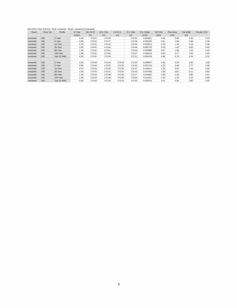
HEC-RAS Plan: ExCond River: unnamed Reach: unnamed (Continued)Reach River Sta Profile Q Total Min Ch El W.S. Elev Crit W.S. E.G. Elev E.G. Slope Vel Chnl Flow Area Top Width Froude # Chl
(m3/s) (m) (m) (m) (m) (m/m) (m/s) (m2) (m) unnamed 200 2 Year 0.29 173.01 173.29 173.31 0.001951 0.46 0.69 4.30 0.31unnamed 200 5 Year 0.56 173.01 173.37 173.39 0.002320 0.61 1.08 5.48 0.36unnamed 200 10 Year 0.76 173.01 173.42 173.44 0.002513 0.70 1.34 6.14 0.38unnamed 200 25 Year 1.00 173.01 173.46 173.49 0.002710 0.78 1.62 6.82 0.40unnamed 200 50 Year 1.30 173.01 173.51 173.54 0.002889 0.87 1.96 7.54 0.42unnamed 200 100 Year 1.50 173.01 173.54 173.57 0.003010 0.93 2.17 7.93 0.44unnamed 200 July 23 2008 0.30 173.01 173.30 173.31 0.001978 0.46 0.70 4.34 0.31
unnamed 100 2 Year 0.29 173.04 173.19 173.19 173.24 0.025947 1.00 0.29 2.82 1.00unnamed 100 5 Year 0.56 173.04 173.25 173.25 173.32 0.021719 1.20 0.48 3.77 0.98unnamed 100 10 Year 0.76 173.04 173.29 173.29 173.37 0.019017 1.29 0.63 4.43 0.95unnamed 100 25 Year 1.00 173.04 173.32 173.32 173.42 0.017033 1.38 0.81 5.11 0.92unnamed 100 50 Year 1.30 173.04 173.36 173.36 173.47 0.015652 1.48 1.03 5.85 0.91unnamed 100 100 Year 1.50 173.04 173.39 173.39 173.50 0.014941 1.53 1.18 6.29 0.90unnamed 100 July 23 2008 0.30 173.04 173.19 173.19 173.25 0.025873 1.01 0.30 2.85 1.00
3
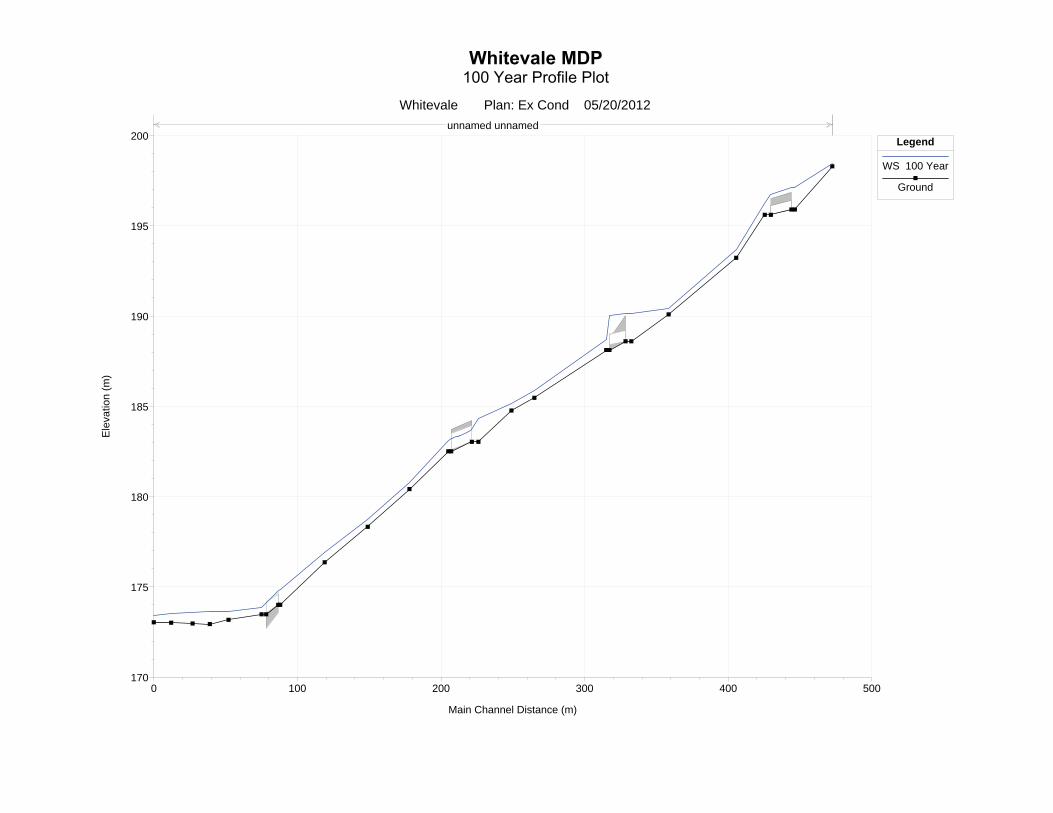
0 100 200 300 400 500170
175
180
185
190
195
200
Whitevale Plan: Ex Cond 05/20/2012
Main Channel Distance (m)
Ele
vatio
n (m
)
Legend
WS 100 Year
Ground
unnamed unnamed
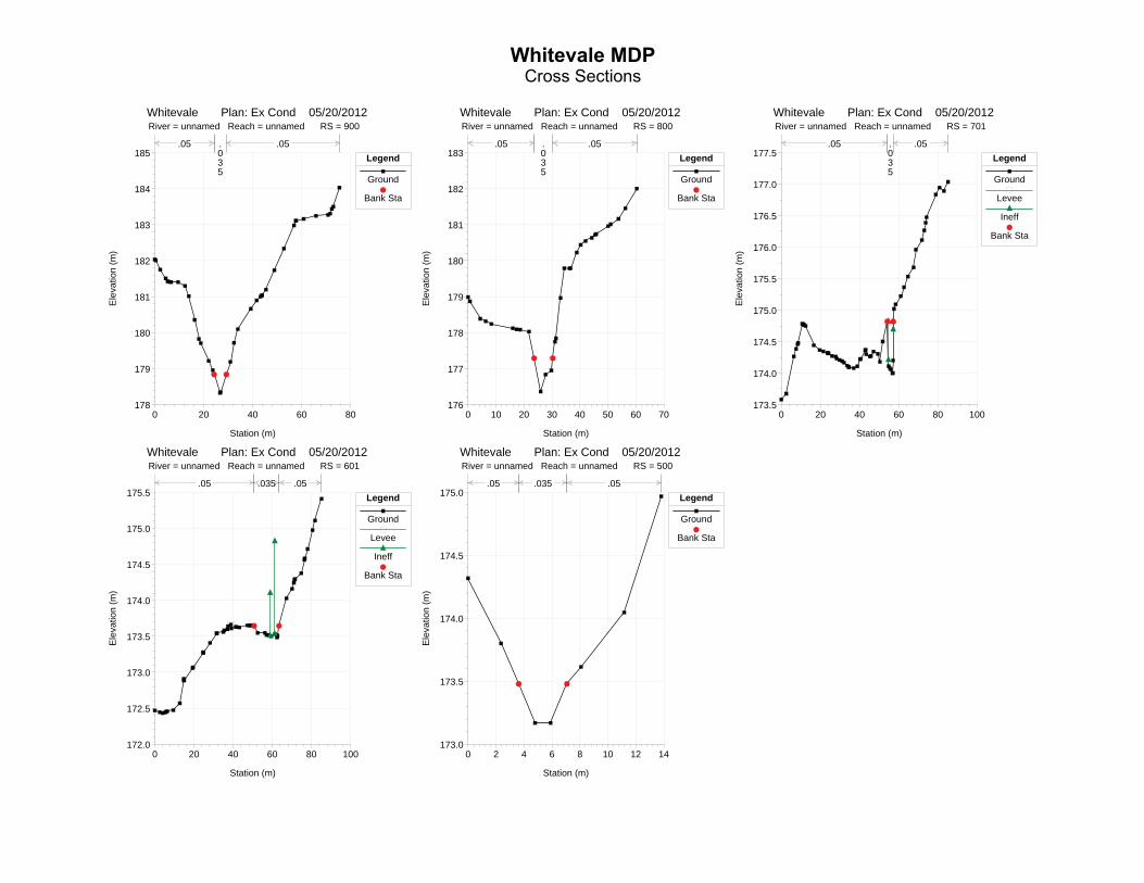
0 20 40 60 80178
179
180
181
182
183
184
185
Whitevale Plan: Ex Cond 05/20/2012 River = unnamed Reach = unnamed RS = 900
Station (m)
Ele
vatio
n (m
)
Legend
Ground
Bank Sta
.05 .035
.05
0 10 20 30 40 50 60 70176
177
178
179
180
181
182
183
Whitevale Plan: Ex Cond 05/20/2012 River = unnamed Reach = unnamed RS = 800
Station (m)E
leva
tion
(m)
Legend
Ground
Bank Sta
.05 .035
.05
0 20 40 60 80 100173.5
174.0
174.5
175.0
175.5
176.0
176.5
177.0
177.5
Whitevale Plan: Ex Cond 05/20/2012 River = unnamed Reach = unnamed RS = 701
Station (m)
Ele
vatio
n (m
)
Legend
Ground
Levee
Ineff
Bank Sta
.05 .035
.05
0 20 40 60 80 100172.0
172.5
173.0
173.5
174.0
174.5
175.0
175.5
Whitevale Plan: Ex Cond 05/20/2012 River = unnamed Reach = unnamed RS = 601
Station (m)
Ele
vatio
n (m
)
Legend
Ground
Levee
Ineff
Bank Sta
.05 .035 .05
0 2 4 6 8 10 12 14173.0
173.5
174.0
174.5
175.0
Whitevale Plan: Ex Cond 05/20/2012 River = unnamed Reach = unnamed RS = 500
Station (m)
Ele
vatio
n (m
)
Legend
Ground
Bank Sta
.05 .035 .05
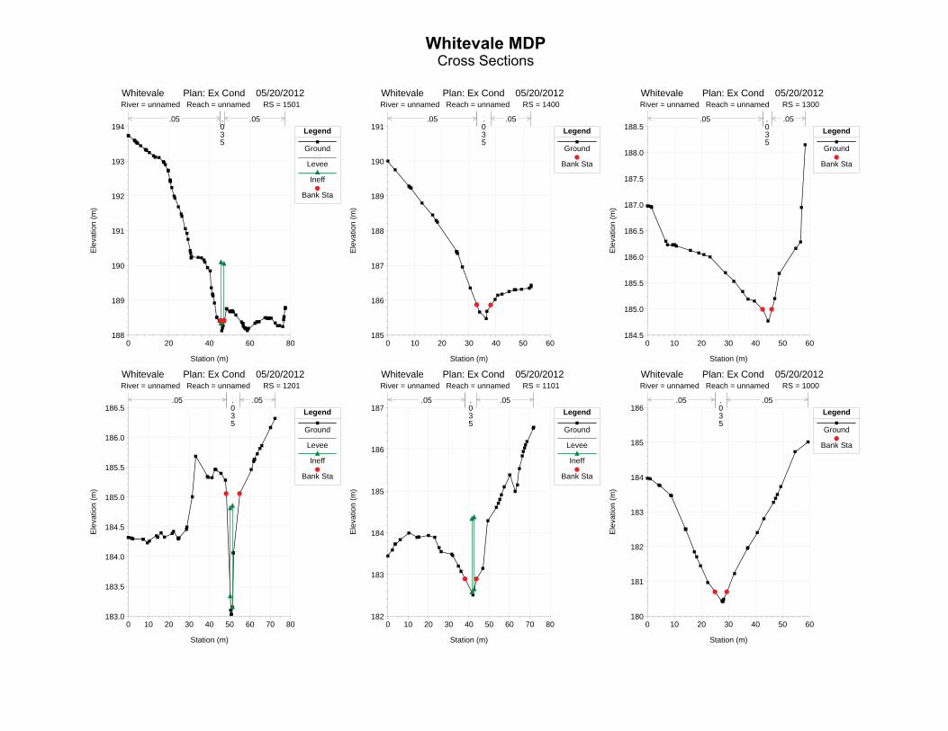
0 20 40 60 80188
189
190
191
192
193
194
Whitevale Plan: Ex Cond 05/20/2012 River = unnamed Reach = unnamed RS = 1501
Station (m)
Ele
vatio
n (m
)
Legend
Ground
Levee
Ineff
Bank Sta
.05 .035
.05
0 10 20 30 40 50 60185
186
187
188
189
190
191
Whitevale Plan: Ex Cond 05/20/2012 River = unnamed Reach = unnamed RS = 1400
Station (m)E
leva
tion
(m)
Legend
Ground
Bank Sta
.05 .035
.05
0 10 20 30 40 50 60184.5
185.0
185.5
186.0
186.5
187.0
187.5
188.0
188.5
Whitevale Plan: Ex Cond 05/20/2012 River = unnamed Reach = unnamed RS = 1300
Station (m)
Ele
vatio
n (m
)
Legend
Ground
Bank Sta
.05 .035
.05
0 10 20 30 40 50 60 70 80183.0
183.5
184.0
184.5
185.0
185.5
186.0
186.5
Whitevale Plan: Ex Cond 05/20/2012 River = unnamed Reach = unnamed RS = 1201
Station (m)
Ele
vatio
n (m
)
Legend
Ground
Levee
Ineff
Bank Sta
.05 .035
.05
0 10 20 30 40 50 60 70 80182
183
184
185
186
187
Whitevale Plan: Ex Cond 05/20/2012 River = unnamed Reach = unnamed RS = 1101
Station (m)
Ele
vatio
n (m
)
Legend
Ground
Levee
Ineff
Bank Sta
.05 .035
.05
0 10 20 30 40 50 60180
181
182
183
184
185
186
Whitevale Plan: Ex Cond 05/20/2012 River = unnamed Reach = unnamed RS = 1000
Station (m)
Ele
vatio
n (m
)
Legend
Ground
Bank Sta
.05 .035
.05
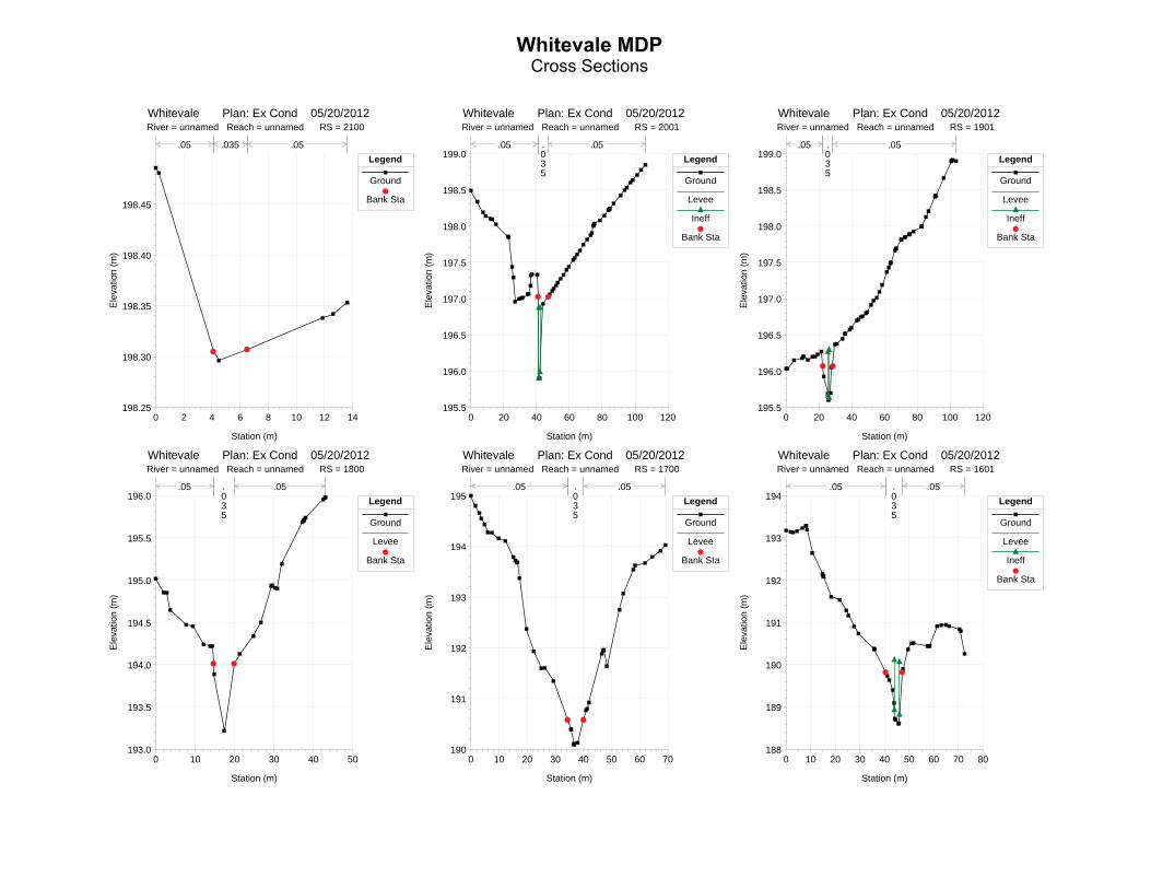
0 2 4 6 8 10 12 14198.25
198.30
198.35
198.40
198.45
Whitevale Plan: Ex Cond 05/20/2012 River = unnamed Reach = unnamed RS = 2100
Station (m)
Ele
vatio
n (m
)
Legend
Ground
Bank Sta
.05 .035 .05
0 20 40 60 80 100 120195.5
196.0
196.5
197.0
197.5
198.0
198.5
199.0
Whitevale Plan: Ex Cond 05/20/2012 River = unnamed Reach = unnamed RS = 2001
Station (m)E
leva
tion
(m)
Legend
Ground
Levee
Ineff
Bank Sta
.05 .035
.05
0 20 40 60 80 100 120195.5
196.0
196.5
197.0
197.5
198.0
198.5
199.0
Whitevale Plan: Ex Cond 05/20/2012 River = unnamed Reach = unnamed RS = 1901
Station (m)
Ele
vatio
n (m
)
Legend
Ground
Levee
Ineff
Bank Sta
.05 .035
.05
0 10 20 30 40 50193.0
193.5
194.0
194.5
195.0
195.5
196.0
Whitevale Plan: Ex Cond 05/20/2012 River = unnamed Reach = unnamed RS = 1800
Station (m)
Ele
vatio
n (m
)
Legend
Ground
Levee
Bank Sta
.05 .035
.05
0 10 20 30 40 50 60 70190
191
192
193
194
195
Whitevale Plan: Ex Cond 05/20/2012 River = unnamed Reach = unnamed RS = 1700
Station (m)
Ele
vatio
n (m
)
Legend
Ground
Levee
Bank Sta
.05 .035
.05
0 10 20 30 40 50 60 70 80188
189
190
191
192
193
194
Whitevale Plan: Ex Cond 05/20/2012 River = unnamed Reach = unnamed RS = 1601
Station (m)
Ele
vatio
n (m
)
Legend
Ground
Levee
Ineff
Bank Sta
.05 .035
.05

40 50 60 70172
173
174
175
176
177
178RS=650 Upstream (Culvert)
Ele
vatio
n (m
)Legend
Ground
Levee
Ineff
Bank Sta
40 50 60 70172
173
174
175
176
177
178RS=650 Downstream (Culvert)
Station (m)
Ele
vatio
n (m
)
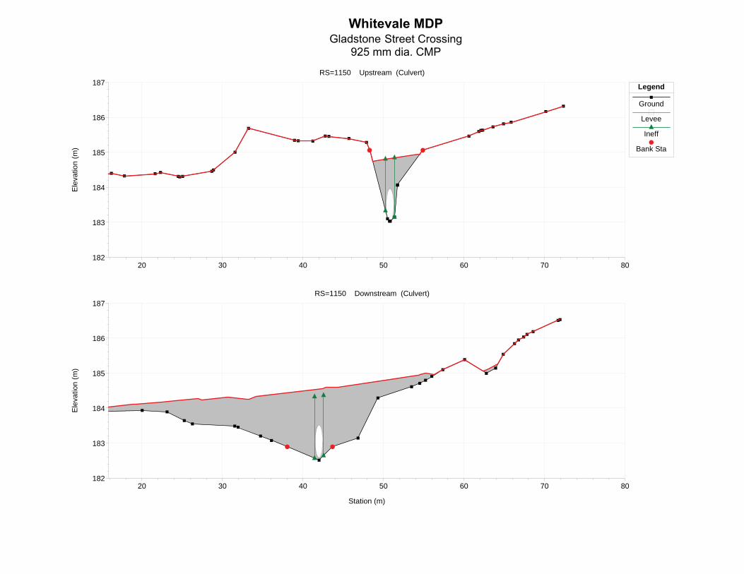
20 30 40 50 60 70 80182
183
184
185
186
187RS=1150 Upstream (Culvert)
Ele
vatio
n (m
)Legend
Ground
Levee
Ineff
Bank Sta
20 30 40 50 60 70 80182
183
184
185
186
187RS=1150 Downstream (Culvert)
Station (m)
Ele
vatio
n (m
)

30 35 40 45 50 55
188
189
190
191
192
193
RS=1550 Upstream (Culvert)E
leva
tion
(m)
Legend
Ground
Levee
Ineff
Bank Sta
30 35 40 45 50 55
188
189
190
191
192
193
RS=1550 Downstream (Culvert)
Station (m)
Ele
vatio
n (m
)
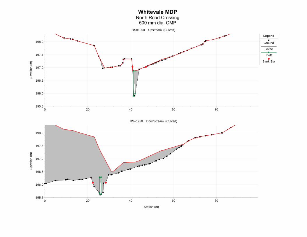
0 20 40 60 80195.5
196.0
196.5
197.0
197.5
198.0
RS=1950 Upstream (Culvert)E
leva
tion
(m)
Legend
Ground
Levee
Ineff
Bank Sta
0 20 40 60 80195.5
196.0
196.5
197.0
197.5
198.0
RS=1950 Downstream (Culvert)
Station (m)
Ele
vatio
n (m
)
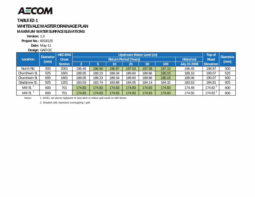
TABLE E2 1WHITEVALE MASTER DRAINAGE PLANMAXIMUM WATER SURFACE ELEVATIONS
Version: 1.0Project No.: 6018125
Date: May 11Design: GAF/OC
Historical2 5 10 25 50 100 July 23 2008
North Rd. 500 2001 196.45 196.90 196.97 197.03 197.08 197.10 196.45 196.87 500Churchwin St. 525 1601 189.05 189.23 189.34 189.60 189.86 190.15 189.16 190.07 525Churchwin St. 600 1601 189.05 189.23 189.34 189.60 189.86 190.15 189.06 190.07 600Gladstone St. 925 1201 183.53 183.74 183.88 184.05 184.14 184.32 183.53 184.81 925
Mill St. 1 600 701 174.83 174.83 174.83 174.83 174.83 174.83 174.49 174.82 1 600Mill St. 1 600 701 174.83 174.83 174.83 174.83 174.83 174.83 174.50 174.82 1 600
Notes: 1. WSEL set above highpoint of east ditch to reflect spill south on Mill Street.
2. Shaded cells represent overtopping / spill.
Upstream Water Level (m)Location
Top ofRoad
Elevation
Diameter(mm)
Diameter(mm) Return Period (Years)
HEC RASCross
Section
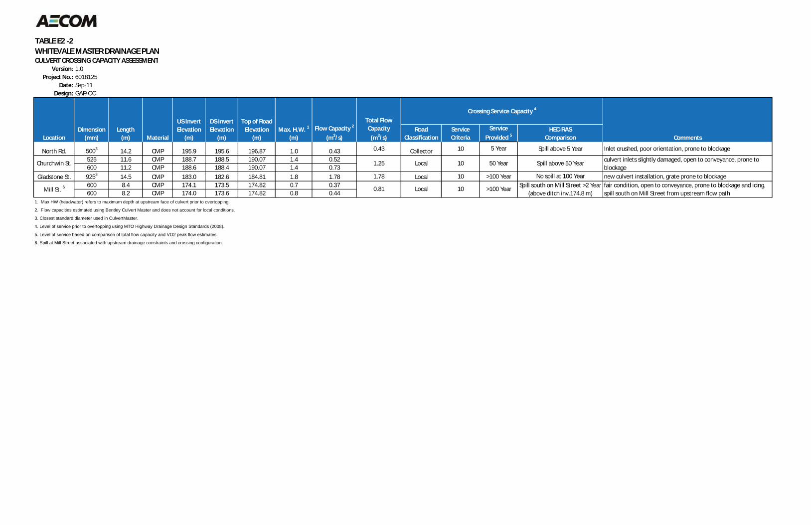
TABLE E2 2WHITEVALE MASTER DRAINAGE PLANCULVERT CROSSING CAPACITY ASSESSMENT
Version: 1.0Project No.: 6018125
Date: Sep 11Design: GAF/OC
RoadClassification
ServiceCriteria
ServiceProvided 5
HEC RASComparison
North Rd. 5003 14.2 CMP 195.9 195.6 196.87 1.0 0.43 0.43 Collector 10 Spill above 5 Year Inlet crushed, poor orientation, prone to blockage
525 11.6 CMP 188.7 188.5 190.07 1.4 0.52600 11.2 CMP 188.6 188.4 190.07 1.4 0.73
Gladstone St. 9253 14.5 CMP 183.0 182.6 184.81 1.8 1.78 1.78 Local 10 >100 Year new culvert installation, grate prone to blockage600 8.4 CMP 174.1 173.5 174.82 0.7 0.37600 8.2 CMP 174.0 173.6 174.82 0.8 0.44
1. Max HW (headwater) refers to maximum depth at upstream face of culvert prior to overtopping.
2. Flow capacities estimated using Bentley Culvert Master and does not account for local conditions.
3. Closest standard diameter used in CulvertMaster.
4. Level of service prior to overtopping using MTO Highway Drainage Design Standards (2008).
5. Level of service based on comparison of total flow capacity and VO2 peak flow estimates.
6. Spill at Mill Street associated with upstream drainage constraints and crossing configuration.
10
1.25
0.81
culvert inlets slightly damaged, open to conveyance, prone toblockage
fair condition, open to conveyance, prone to blockage and icing,spill south on Mill Street from upstream flow path
>100 Year Spill south on Mill Street >2 Year(above ditch inv.174.8 m)
No spill at 100 Year
Local
Total FlowCapacity(m3/s) Comments
50 Year
5 Year
Spill above 50 Year
Crossing Service Capacity 4
Local 10
Mill St. 6
Churchwin St.
Top of RoadElevation
(m)Max. H.W. 1
(m)Flow Capacity 2
(m3/s)
DS InvertElevation
(m)LocationDimension
(mm)Length
(m) Material
US InvertElevation
(m)
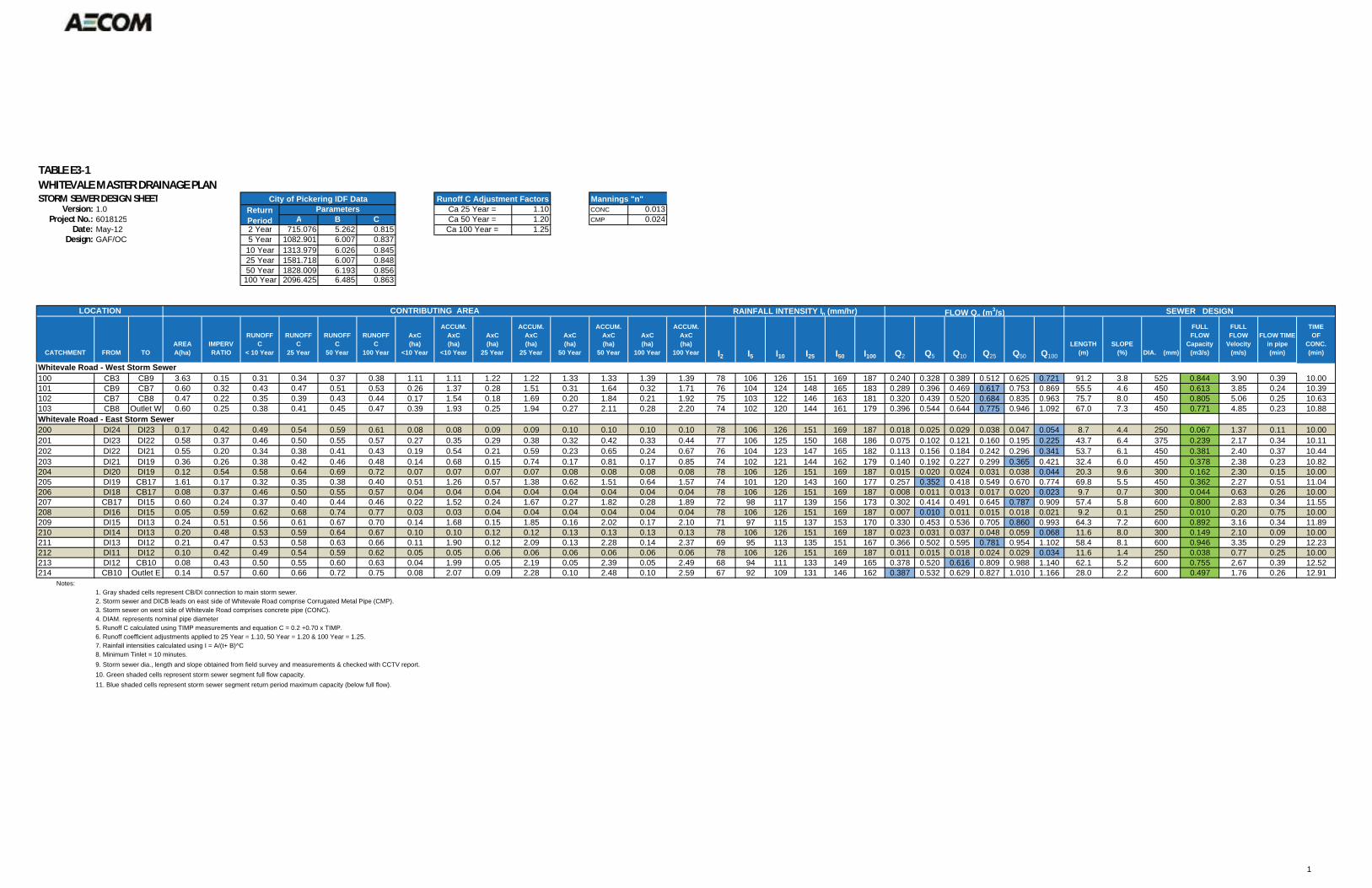
TABLE E3 1WHITEVALE MASTER DRAINAGE PLANSTORM SEWER DESIGN SHEET Mannings "n"
Version: 1.0 1.10 CONC 0.013Project No.: 6018125 A B C 1.20 CMP 0.024
Date: May-12 2 Year 715.076 5.262 0.815 1.25Design: GAF/OC 5 Year 1082.901 6.007 0.837
10 Year 1313.979 6.026 0.84525 Year 1581.718 6.007 0.84850 Year 1828.009 6.193 0.856100 Year 2096.425 6.485 0.863
CATCHMENT FROM TOAREAA(ha)
IMPERVRATIO
RUNOFFC
< 10 Year
RUNOFFC
25 Year
RUNOFFC
50 Year
RUNOFFC
100 Year
AxC(ha)
<10 Year
ACCUM.AxC(ha)
<10 Year
AxC(ha)
25 Year
ACCUM.AxC(ha)
25 Year
AxC(ha)
50 Year
ACCUM.AxC(ha)
50 Year
AxC(ha)
100 Year
ACCUM.AxC(ha)
100 Year I2 I5 I10 I25 I50 I100 Q2 Q5 Q10 Q25 Q50 Q100
LENGTH(m)
SLOPE(%) DIA. (mm)
FULLFLOW
Capacity(m3/s)
FULLFLOW
Velocity(m/s)
FLOW TIME in pipe (min)
TIMEOF
CONC.(min)
Whitevale Road - West Storm Sewer100 CB3 CB9 3.63 0.15 0.31 0.34 0.37 0.38 1.11 1.11 1.22 1.22 1.33 1.33 1.39 1.39 78 106 126 151 169 187 0.240 0.328 0.389 0.512 0.625 0.721 91.2 3.8 525 0.844 3.90 0.39 10.00101 CB9 CB7 0.60 0.32 0.43 0.47 0.51 0.53 0.26 1.37 0.28 1.51 0.31 1.64 0.32 1.71 76 104 124 148 165 183 0.289 0.396 0.469 0.617 0.753 0.869 55.5 4.6 450 0.613 3.85 0.24 10.39102 CB7 CB8 0.47 0.22 0.35 0.39 0.43 0.44 0.17 1.54 0.18 1.69 0.20 1.84 0.21 1.92 75 103 122 146 163 181 0.320 0.439 0.520 0.684 0.835 0.963 75.7 8.0 450 0.805 5.06 0.25 10.63103 CB8 Outlet W 0.60 0.25 0.38 0.41 0.45 0.47 0.39 1.93 0.25 1.94 0.27 2.11 0.28 2.20 74 102 120 144 161 179 0.396 0.544 0.644 0.775 0.946 1.092 67.0 7.3 450 0.771 4.85 0.23 10.88Whitevale Road - East Storm Sewer200 DI24 DI23 0.17 0.42 0.49 0.54 0.59 0.61 0.08 0.08 0.09 0.09 0.10 0.10 0.10 0.10 78 106 126 151 169 187 0.018 0.025 0.029 0.038 0.047 0.054 8.7 4.4 250 0.067 1.37 0.11 10.00201 DI23 DI22 0.58 0.37 0.46 0.50 0.55 0.57 0.27 0.35 0.29 0.38 0.32 0.42 0.33 0.44 77 106 125 150 168 186 0.075 0.102 0.121 0.160 0.195 0.225 43.7 6.4 375 0.239 2.17 0.34 10.11202 DI22 DI21 0.55 0.20 0.34 0.38 0.41 0.43 0.19 0.54 0.21 0.59 0.23 0.65 0.24 0.67 76 104 123 147 165 182 0.113 0.156 0.184 0.242 0.296 0.341 53.7 6.1 450 0.381 2.40 0.37 10.44203 DI21 DI19 0.36 0.26 0.38 0.42 0.46 0.48 0.14 0.68 0.15 0.74 0.17 0.81 0.17 0.85 74 102 121 144 162 179 0.140 0.192 0.227 0.299 0.365 0.421 32.4 6.0 450 0.378 2.38 0.23 10.82204 DI20 DI19 0.12 0.54 0.58 0.64 0.69 0.72 0.07 0.07 0.07 0.07 0.08 0.08 0.08 0.08 78 106 126 151 169 187 0.015 0.020 0.024 0.031 0.038 0.044 20.3 9.6 300 0.162 2.30 0.15 10.00205 DI19 CB17 1.61 0.17 0.32 0.35 0.38 0.40 0.51 1.26 0.57 1.38 0.62 1.51 0.64 1.57 74 101 120 143 160 177 0.257 0.352 0.418 0.549 0.670 0.774 69.8 5.5 450 0.362 2.27 0.51 11.04206 DI18 CB17 0.08 0.37 0.46 0.50 0.55 0.57 0.04 0.04 0.04 0.04 0.04 0.04 0.04 0.04 78 106 126 151 169 187 0.008 0.011 0.013 0.017 0.020 0.023 9.7 0.7 300 0.044 0.63 0.26 10.00207 CB17 DI15 0.60 0.24 0.37 0.40 0.44 0.46 0.22 1.52 0.24 1.67 0.27 1.82 0.28 1.89 72 98 117 139 156 173 0.302 0.414 0.491 0.645 0.787 0.909 57.4 5.8 600 0.800 2.83 0.34 11.55208 DI16 DI15 0.05 0.59 0.62 0.68 0.74 0.77 0.03 0.03 0.04 0.04 0.04 0.04 0.04 0.04 78 106 126 151 169 187 0.007 0.010 0.011 0.015 0.018 0.021 9.2 0.1 250 0.010 0.20 0.75 10.00209 DI15 DI13 0.24 0.51 0.56 0.61 0.67 0.70 0.14 1.68 0.15 1.85 0.16 2.02 0.17 2.10 71 97 115 137 153 170 0.330 0.453 0.536 0.705 0.860 0.993 64.3 7.2 600 0.892 3.16 0.34 11.89210 DI14 DI13 0.20 0.48 0.53 0.59 0.64 0.67 0.10 0.10 0.12 0.12 0.13 0.13 0.13 0.13 78 106 126 151 169 187 0.023 0.031 0.037 0.048 0.059 0.068 11.6 8.0 300 0.149 2.10 0.09 10.00211 DI13 DI12 0.21 0.47 0.53 0.58 0.63 0.66 0.11 1.90 0.12 2.09 0.13 2.28 0.14 2.37 69 95 113 135 151 167 0.366 0.502 0.595 0.781 0.954 1.102 58.4 8.1 600 0.946 3.35 0.29 12.23212 DI11 DI12 0.10 0.42 0.49 0.54 0.59 0.62 0.05 0.05 0.06 0.06 0.06 0.06 0.06 0.06 78 106 126 151 169 187 0.011 0.015 0.018 0.024 0.029 0.034 11.6 1.4 250 0.038 0.77 0.25 10.00213 DI12 CB10 0.08 0.43 0.50 0.55 0.60 0.63 0.04 1.99 0.05 2.19 0.05 2.39 0.05 2.49 68 94 111 133 149 165 0.378 0.520 0.616 0.809 0.988 1.140 62.1 5.2 600 0.755 2.67 0.39 12.52214 CB10 Outlet E 0.14 0.57 0.60 0.66 0.72 0.75 0.08 2.07 0.09 2.28 0.10 2.48 0.10 2.59 67 92 109 131 146 162 0.387 0.532 0.629 0.827 1.010 1.166 28.0 2.2 600 0.497 1.76 0.26 12.91
Notes:1. Gray shaded cells represent CB/DI connection to main storm sewer.2. Storm sewer and DICB leads on east side of Whitevale Road comprise Corrugated Metal Pipe (CMP).3. Storm sewer on west side of Whitevale Road comprises concrete pipe (CONC).4. DIAM. represents nominal pipe diameter5. Runoff C calculated using TIMP measurements and equation C = 0.2 +0.70 x TIMP.6. Runoff coefficient adjustments applied to 25 Year = 1.10, 50 Year = 1.20 & 100 Year = 1.25.7. Rainfall intensities calculated using I = A/(t+ B)^C8. Minimum Tinlet = 10 minutes.9. Storm sewer dia., length and slope obtained from field survey and measurements & checked with CCTV report.10. Green shaded cells represent storm sewer segment full flow capacity.11. Blue shaded cells represent storm sewer segment return period maximum capacity (below full flow).
LOCATION SEWER DESIGNCONTRIBUTING AREA RAINFALL INTENSITY In (mm/hr) FLOW Qn (m3/s)
Ca 100 Year =
City of Pickering IDF DataParametersReturn
Period
Runoff C Adjustment FactorsCa 25 Year = Ca 50 Year =
1

I/R YY/MM/DD ISSUE/REVISION DESCRIPTION DRN ENGDES IDR APP
FIGURE NUMBERPROJECT NUMBER ISSUE/REVISION
CHK
THIS DRAWING HAS BEEN PREPARED FOR THE USE OF AECOM'S CLIENT AND MAY NOT BE USED,REPRODUCED OR RELIED UPON BY THIRD PARTIES, EXCEPT AS AGREED BY AECOM AND ITS CLIENT,AS REQUIRED BY LAW OR FOR USE BY GOVERNMENTAL REVIEWING AGENCIES. AECOM ACCEPTS NORESPONSIBILITY, AND DENIES ANY LIABILITY WHATSOEVER, TO ANY PARTY THAT MODIFIES THISDRAWING WITHOUT AECOM'S EXPRESS WRITTEN CONSENT.
DO NOT SCALE THIS DOCUMENT. ALL MEASUREMENTS MUST BE OBTAINED FROM STATEDDIMENSIONS.
.. .......
.. .......
.. .......
.. .......
.. .......
.. .......
.. ..A
XPP-160187125
Whitevale Road Plan and Profile
Whitevale Master Drainage PlanCity of Pickering
60HORZ:1 : 3000 15 30 90 120 m0
601 : 3000
15 30 90 120 m0
12VERT 1 : 600 3 6 18 24 m0
FOR DISCUSSIONDRAFT

TABLE E3 2WHITEVALE MASTER DRAINAGE PLANSTORM SEWER HYDRAULIC GRADE LINE ASSESSMENT
Version: 1.0
Project No.: 6018125Date: May-12
Design: GAF/OC
Event (yrs) = 2 Starting W.L.1 at Outlet W [m]= 169.69 n= 0.013 conc.n= 0.024 cmp
Starting W.L.1 At Outlet E [m] = 166.65U/S D/S GRND U/S HGL U/S UP LOW CALC FULL FULL HGL WATER CRITICAL D/S D/S D/S
SEWER FROM TO LENGTH DIA INVERT INVERT MH US SLOPE Q FULL FLOW HGL Above OBV-HGL GRND - HGL ACT. DIA OBVERT OBVERT SLOPE VEL CAP. Q/Qf D/Df SLOPE DEPTH DEPTH Yc HGL Obv-HGL Surch?(m) (mm) (m) (m) (m) (%) (l/s) (L/s) (m) Grnd? (m) (m) (mm) (m) (m) (L/s) (L/s) (m) (m) (m) (m)
100 CB3 CB9 91 525 186.37 182.86 188.03 3.8 880 240 186.56 no 0.35 1.47 533 186.90 183.39 3.8% 3.9 880 0.272 0.348 0.0029 0.19 0.000 183.05 0.35 no101 CB9 CB7 55 450 182.73 180.17 184.39 4.6 639 289 182.94 no 0.24 1.44 457 183.19 180.63 4.6% 3.9 639 0.452 0.470 0.0094 0.21 0.000 180.38 0.24 no102 CB7 CB8 76 450 180.17 174.14 181.90 8.0 840 320 180.37 no 0.26 1.54 457 180.63 174.60 8.0% 5.1 840 0.381 0.428 0.0116 0.20 0.000 174.36 0.23 no103 CB8 Outlet W 67 450 174.14 169.24 176.44 7.3 804 396 174.36 no 0.23 2.08 457 174.60 169.70 7.3% 4.9 804 0.493 0.492 0.0178 0.22 0.000 169.69 0.01 no
Outlet W 169.24 169.24 169.69 WL at Outlet W 169.69
200 DI24 DI23 9 250 197.37 196.99 198.62 4.4 70 18 197.46 no 0.17 1.16 254 197.62 197.24 4.4% 1.4 70 0.256 0.342 0.0029 0.09 0.000 197.08 0.17 no201 DI23 DI22 44 375 196.50 193.72 198.80 6.4 250 75 196.64 no 0.24 2.16 381 196.88 194.10 6.4% 2.2 250 0.299 0.370 0.0057 0.14 0.000 193.86 0.24 no202 DI22 DI21 54 450 193.65 190.38 195.76 6.1 397 113 193.81 no 0.29 1.94 457 194.11 190.84 6.1% 2.4 397 0.285 0.360 0.0050 0.16 0.000 190.57 0.27 no
DI21 190.38 192.51 190.57 WL at DI21 190.57
204 DI20 DI19 20 300 190.39 188.44 191.59 9.6 169 15 190.45 no 0.25 1.14 305 190.69 188.74 9.6% 2.3 169 0.086 0.192 0.0007 0.06 0.000 188.52 0.23 noDI19 188.44 190.28 188.52 WL at DI19 188.52
203 DI21 DI19 32 450 190.38 188.44 192.51 6.0 394 140 190.57 no 0.27 1.95 457 190.84 188.90 6.0% 2.4 394 0.354 0.410 0.0075 0.19 0.000 188.63 0.27 noDI19 188.44 190.28 188.63 WL at DI19 188.52
206 DI18 CB17 10 300 184.70 184.63 186.10 0.7 46 8 184.78 no 0.22 1.32 305 185.00 184.93 0.7% 0.6 46 0.167 0.272 0.0002 0.08 0.000 184.71 0.22 noCB17 184.63 186.33 184.71 WL at CB17 184.58
205 DI19 CB17 70 450 188.24 184.41 190.28 5.5 377 257 188.52 no 0.18 1.77 457 188.70 184.87 5.5% 2.3 377 0.681 0.602 0.0254 0.28 0.000 184.69 0.18 noCB17 184.41 186.33 184.69 WL at CB17 184.58
208 DI16 DI15 9 250 181.49 181.48 183.00 0.1 10 7 181.64 no 0.10 1.36 254 181.74 181.73 0.1% 0.2 10 0.662 0.588 0.0004 0.15 0.000 181.63 0.10 noDI15 181.48 183.05 181.63 WL at DI15 181.18
207 CB17 DI15 57 600 184.33 181.01 186.33 5.8 835 302 184.58 no 0.36 1.75 610 184.94 181.62 5.8% 2.9 835 0.361 0.416 0.0076 0.25 0.000 181.26 0.36 noDI15 181.01 183.05 181.26 WL at DI15 181.18
210 DI14 DI13 12 300 178.17 177.24 179.59 8.0 155 23 178.25 no 0.23 1.34 305 178.47 177.54 8.0% 2.1 155 0.146 0.255 0.0017 0.08 0.000 177.32 0.23 noDI13 177.24 179.09 177.32 WL at DI13 176.61
209 DI15 DI13 64 600 180.93 176.30 183.05 7.2 931 330 181.18 no 0.36 1.87 610 181.54 176.91 7.2% 3.2 931 0.354 0.410 0.0090 0.25 0.000 176.61 0.30 noDI13 176.30 179.09 176.61 WL at DI13 176.61
212 DI11 DI12 12 250 171.78 171.62 173.20 1.4 40 11 171.87 no 0.16 1.33 254 172.03 171.87 1.4% 0.8 40 0.283 0.355 0.0011 0.09 0.000 171.71 0.16 noDI12 171.62 174.09 171.71 WL at DI12 170.20
211 DI13 DI12 58 600 176.35 171.62 179.09 8.1 987 366 176.61 no 0.35 2.48 610 176.96 172.23 8.1% 3.4 987 0.370 0.422 0.0111 0.26 0.000 171.88 0.35 no213 DI12 CB10 62 600 169.90 166.70 174.09 5.2 788 378 170.20 no 0.31 3.90 610 170.51 167.31 5.2% 2.7 788 0.480 0.484 0.0119 0.30 0.000 167.06 0.25 no214 CB10 Outlet E 28 600 166.67 166.05 169.32 2.2 519 387 167.06 no 0.22 2.27 610 167.28 166.65 2.2% 1.8 519 0.746 0.637 0.0124 0.39 0.000 166.43 0.22 no
Outlet E 166.05 166.05 166.65 WL at Outlet E 166.65Notes:1. Assumes starting WSEL at obvert of outfall.2. Full flow capacity based on actual pipe diameter.3. Gray tone represents CB/DICB leads to storm sewer.4. Full flow capacity based on actual pipe diameter.
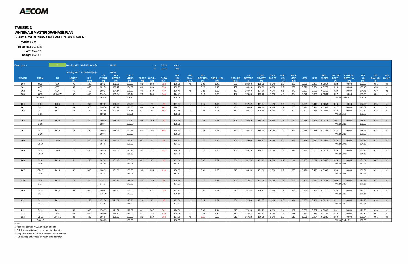
TABLE E3 3WHITEVALE MASTER DRAINAGE PLANSTORM SEWER HYDRAULIC GRADE LINE ASSESSMENT
Version: 1.0
Project No.: 6018125Date: May-12
Design: GAF/OC
Event (yrs) = 5 Starting W.L.1 at Outlet W [m]= 169.69 n= 0.013 conc.n= 0.024 cmp
Starting W.L.1 At Outlet E [m] = 166.65U/S D/S GRND U/S HGL U/S UP LOW CALC FULL FULL HGL WATER CRITICAL D/S D/S D/S
SEWER FROM TO LENGTH DIA INVERT INVERT MH US SLOPE Q FULL FLOW HGL Above OBV-HGL GRND - HGL ACT. DIA OBVERT OBVERT SLOPE VEL CAP. Q/Qf D/Df SLOPE DEPTH DEPTH Yc HGL Obv-HGL Surch?(m) (mm) (m) (m) (m) (%) (l/s) (L/s) (m) Grnd? (m) (m) (mm) (m) (m) (L/s) (L/s) (m) (m) (m) (m)
100 CB3 CB9 91 525 186.37 182.86 188.03 3.8 880 328 186.60 no 0.31 1.43 533 186.90 183.39 3.8% 3.9 880 0.373 0.422 0.0054 0.23 0.000 183.09 0.31 no101 CB9 CB7 55 450 182.73 180.17 184.39 4.6 639 396 182.99 no 0.20 1.40 457 183.19 180.63 4.6% 3.9 639 0.620 0.564 0.0177 0.26 0.000 180.43 0.20 no102 CB7 CB8 76 450 180.17 174.14 181.90 8.0 840 439 180.40 no 0.22 1.50 457 180.63 174.60 8.0% 5.1 840 0.523 0.508 0.0218 0.23 0.000 174.41 0.18 no103 CB8 Outlet W 67 450 174.14 169.24 176.44 7.3 804 544 174.41 no 0.18 2.03 457 174.60 169.70 7.3% 4.9 804 0.676 0.600 0.0334 0.27 0.000 169.69 0.01 no
Outlet W 169.24 169.24 169.69 WL at Outlet W 169.69
200 DI24 DI23 9 250 197.37 196.99 198.62 4.4 70 25 197.47 no 0.15 1.14 254 197.62 197.24 4.4% 1.4 70 0.351 0.410 0.0054 0.10 0.000 197.09 0.15 no201 DI23 DI22 44 375 196.50 193.72 198.80 6.4 250 102 196.67 no 0.21 2.13 381 196.88 194.10 6.4% 2.2 250 0.410 0.444 0.0107 0.17 0.000 193.89 0.21 no202 DI22 DI21 54 450 193.65 190.38 195.76 6.1 397 156 193.85 no 0.26 1.91 457 194.11 190.84 6.1% 2.4 397 0.391 0.434 0.0093 0.20 0.000 190.60 0.23 no
DI21 190.38 192.51 190.60 WL at DI21 190.60
204 DI20 DI19 20 300 190.39 188.44 191.59 9.6 169 20 190.46 no 0.24 1.13 305 190.69 188.74 9.6% 2.3 169 0.118 0.225 0.0013 0.07 0.000 188.59 0.16 noDI19 188.44 190.28 188.59 WL at DI19 188.59
203 DI21 DI19 32 450 190.38 188.44 192.51 6.0 394 192 190.60 no 0.23 1.91 457 190.84 188.90 6.0% 2.4 394 0.486 0.488 0.0142 0.22 0.000 188.66 0.23 noDI19 188.44 190.28 188.66 WL at DI19 188.59
206 DI18 CB17 10 300 184.70 184.63 186.10 0.7 46 11 184.80 no 0.21 1.30 305 185.00 184.93 0.7% 0.6 46 0.229 0.320 0.0004 0.10 0.000 184.73 0.21 noCB17 184.63 186.33 184.73 WL at CB17 184.63
205 DI19 CB17 70 450 188.24 184.41 190.28 5.5 377 352 188.59 no 0.11 1.70 457 188.70 184.87 5.5% 2.3 377 0.934 0.755 0.0479 0.35 0.000 184.76 0.11 noCB17 184.41 186.33 184.76 WL at CB17 184.63
208 DI16 DI15 9 250 181.49 181.48 183.00 0.1 10 10 181.68 no 0.07 1.32 254 181.74 181.73 0.1% 0.2 10 0.907 0.742 0.0008 0.19 0.000 181.67 0.07 noDI15 181.48 183.05 181.67 WL at DI15 181.23
207 CB17 DI15 57 600 184.33 181.01 186.33 5.8 835 414 184.63 no 0.31 1.70 610 184.94 181.62 5.8% 2.9 835 0.496 0.496 0.0142 0.30 0.000 181.31 0.31 noDI15 181.01 183.05 181.31 WL at DI15 181.23
210 DI14 DI13 12 300 178.17 177.24 179.59 8.0 155 31 178.26 no 0.21 1.33 305 178.47 177.54 8.0% 2.1 155 0.200 0.296 0.0032 0.09 0.000 177.33 0.21 noDI13 177.24 179.09 177.33 WL at DI13 176.66
209 DI15 DI13 64 600 180.93 176.30 183.05 7.2 931 453 181.23 no 0.31 1.82 610 181.54 176.91 7.2% 3.2 931 0.486 0.488 0.0170 0.30 0.000 176.66 0.25 noDI13 176.30 179.09 176.66 WL at DI13 176.66
212 DI11 DI12 12 250 171.78 171.62 173.20 1.4 40 15 171.89 no 0.14 1.31 254 172.03 171.87 1.4% 0.8 40 0.387 0.431 0.0021 0.11 0.000 171.73 0.14 noDI12 171.62 174.09 171.73 WL at DI12 170.26
211 DI13 DI12 58 600 176.35 171.62 179.09 8.1 987 502 176.66 no 0.30 2.44 610 176.96 172.23 8.1% 3.4 987 0.509 0.502 0.0209 0.31 0.000 171.93 0.30 no213 DI12 CB10 62 600 169.90 166.70 174.09 5.2 788 520 170.26 no 0.25 3.84 610 170.51 167.31 5.2% 2.7 788 0.660 0.584 0.0224 0.36 0.000 167.30 0.01 no214 CB10 Outlet E 28 600 166.67 166.05 169.32 2.2 519 532 167.30 no -0.02 2.02 610 167.28 166.65 2.2% 1.8 519 1.025 0.984 0.0235 0.60 0.000 166.64 0.01 no
Outlet E 166.05 166.05 166.65 WL at Outlet E 166.65Notes:1. Assumes starting WSEL at obvert of outfall.2. Full flow capacity based on actual pipe diameter.3. Gray tone represents CB/DICB leads to storm sewer.4. Full flow capacity based on actual pipe diameter.

TABLE E3 4WHITEVALE MASTER DRAINAGE PLANSTORM SEWER HYDRAULIC GRADE LINE ASSESSMENT
Version: 1.0
Project No.: 6018125Date: May-12
Design: GAF/OC
Event (yrs) = 10 Starting W.L.1 at Outlet W [m]= 169.69 n= 0.013 conc.n= 0.024 cmp
Starting W.L.1 At Outlet E [m] = 166.65U/S D/S GRND U/S HGL U/S UP LOW CALC FULL FULL HGL WATER CRITICAL D/S D/S D/S
SEWER FROM TO LENGTH DIA INVERT INVERT MH US SLOPE Q FULL FLOW HGL Above OBV-HGL GRND - HGL ACT. DIA OBVERT OBVERT SLOPE VEL CAP. Q/Qf D/Df SLOPE DEPTH DEPTH Yc HGL Obv-HGL Surch?(m) (mm) (m) (m) (m) (%) (l/s) (L/s) (m) Grnd? (m) (m) (mm) (m) (m) (L/s) (L/s) (m) (m) (m) (m)
100 CB3 CB9 91 525 186.37 182.86 188.03 3.8 880 389 186.62 no 0.29 1.41 533 186.90 183.39 3.8% 3.9 880 0.442 0.462 0.0075 0.25 0.000 183.11 0.29 no101 CB9 CB7 55 450 182.73 180.17 184.39 4.6 639 469 183.02 no 0.17 1.37 457 183.19 180.63 4.6% 3.9 639 0.735 0.628 0.0249 0.29 0.000 180.46 0.17 no102 CB7 CB8 76 450 180.17 174.14 181.90 8.0 840 520 180.43 no 0.20 1.47 457 180.63 174.60 8.0% 5.1 840 0.620 0.564 0.0306 0.26 0.000 174.45 0.15 no103 CB8 Outlet W 67 450 174.14 169.24 176.44 7.3 804 644 174.45 no 0.15 2.00 457 174.60 169.70 7.3% 4.9 804 0.801 0.670 0.0469 0.31 0.000 169.69 0.01 no
Outlet W 169.24 169.24 169.69 WL at Outlet W 169.69
200 DI24 DI23 9 250 197.37 196.99 198.62 4.4 70 29 197.48 no 0.14 1.13 254 197.62 197.24 4.4% 1.4 70 0.416 0.446 0.0076 0.11 0.000 197.10 0.14 no201 DI23 DI22 44 375 196.50 193.72 198.80 6.4 250 121 196.69 no 0.20 2.11 381 196.88 194.10 6.4% 2.2 250 0.486 0.488 0.0150 0.19 0.000 193.91 0.20 no202 DI22 DI21 54 450 193.65 190.38 195.76 6.1 397 184 193.87 no 0.24 1.89 457 194.11 190.84 6.1% 2.4 397 0.464 0.474 0.0131 0.22 0.000 190.63 0.21 no
DI21 190.38 192.51 190.63 WL at DI21 190.63
204 DI20 DI19 20 300 190.39 188.44 191.59 9.6 169 24 190.47 no 0.23 1.12 305 190.69 188.74 9.6% 2.3 169 0.140 0.250 0.0019 0.08 0.000 189.60 -0.85 yesDI19 188.44 190.28 189.60 WL at DI19 189.60
203 DI21 DI19 32 450 190.38 188.44 192.51 6.0 394 227 190.63 no 0.21 1.89 457 190.84 188.90 6.0% 2.4 394 0.576 0.540 0.0199 0.25 0.000 189.60 -0.70 yesDI19 188.44 190.28 189.60 WL at DI19 189.60
206 DI18 CB17 10 300 184.70 184.63 186.10 0.7 46 13 184.81 no 0.20 1.29 305 185.00 184.93 0.7% 0.6 46 0.271 0.348 0.0005 0.11 0.000 184.74 0.20 noCB17 184.63 186.33 184.74 WL at CB17 184.66
205 DI19 CB17 70 450 188.24 184.41 190.28 5.5 377 418 189.60 no -0.90 0.69 457 188.70 184.87 5.5% 2.3 377 1.107 0.0672 0.00 0.493 184.90 -0.04 yesCB17 184.41 186.33 184.87 WL at CB17 184.66
208 DI16 DI15 9 250 181.49 181.48 183.00 0.1 10 11 181.74 no 0.00 1.26 254 181.74 181.73 0.1% 0.2 10 1.076 0.0011 0.00 0.082 181.73 0.00 yesDI15 181.48 183.05 181.73 WL at DI15 181.26
207 CB17 DI15 57 600 184.33 181.01 186.33 5.8 835 491 184.66 no 0.28 1.67 610 184.94 181.62 5.8% 2.9 835 0.588 0.546 0.0200 0.33 0.000 181.34 0.28 noDI15 181.01 183.05 181.34 WL at DI15 181.26
210 DI14 DI13 12 300 178.17 177.24 179.59 8.0 155 37 178.27 no 0.20 1.32 305 178.47 177.54 8.0% 2.1 155 0.237 0.328 0.0045 0.10 0.000 177.34 0.20 noDI13 177.24 179.09 177.34 WL at DI13 176.69
209 DI15 DI13 64 600 180.93 176.30 183.05 7.2 931 536 181.26 no 0.28 1.79 610 181.54 176.91 7.2% 3.2 931 0.576 0.540 0.0239 0.33 0.000 176.69 0.22 noDI13 176.30 179.09 176.69 WL at DI13 176.69
212 DI11 DI12 12 250 171.78 171.62 173.20 1.4 40 18 171.90 no 0.13 1.30 254 172.03 171.87 1.4% 0.8 40 0.459 0.472 0.0029 0.12 0.000 171.74 0.13 noDI12 171.62 174.09 171.74 WL at DI12 170.30
211 DI13 DI12 58 600 176.35 171.62 179.09 8.1 987 595 176.69 no 0.27 2.40 610 176.96 172.23 8.1% 3.4 987 0.602 0.555 0.0294 0.34 0.000 171.96 0.27 no213 DI12 CB10 62 600 169.90 166.70 174.09 5.2 788 616 170.30 no 0.21 3.79 610 170.51 167.31 5.2% 2.7 788 0.781 0.654 0.0315 0.40 0.000 167.51 -0.20 yes214 CB10 Outlet E 28 600 166.67 166.05 169.32 2.2 519 629 167.51 no -0.23 1.81 610 167.28 166.65 2.2% 1.8 519 1.213 0.0329 0.00 0.544 166.59 0.07 no
Outlet E 166.05 166.05 166.65 WL at Outlet E 166.65Notes:1. Assumes starting WSEL at obvert of outfall.2. Full flow capacity based on actual pipe diameter.3. Gray tone represents CB/DICB leads to storm sewer.4. Full flow capacity based on actual pipe diameter.
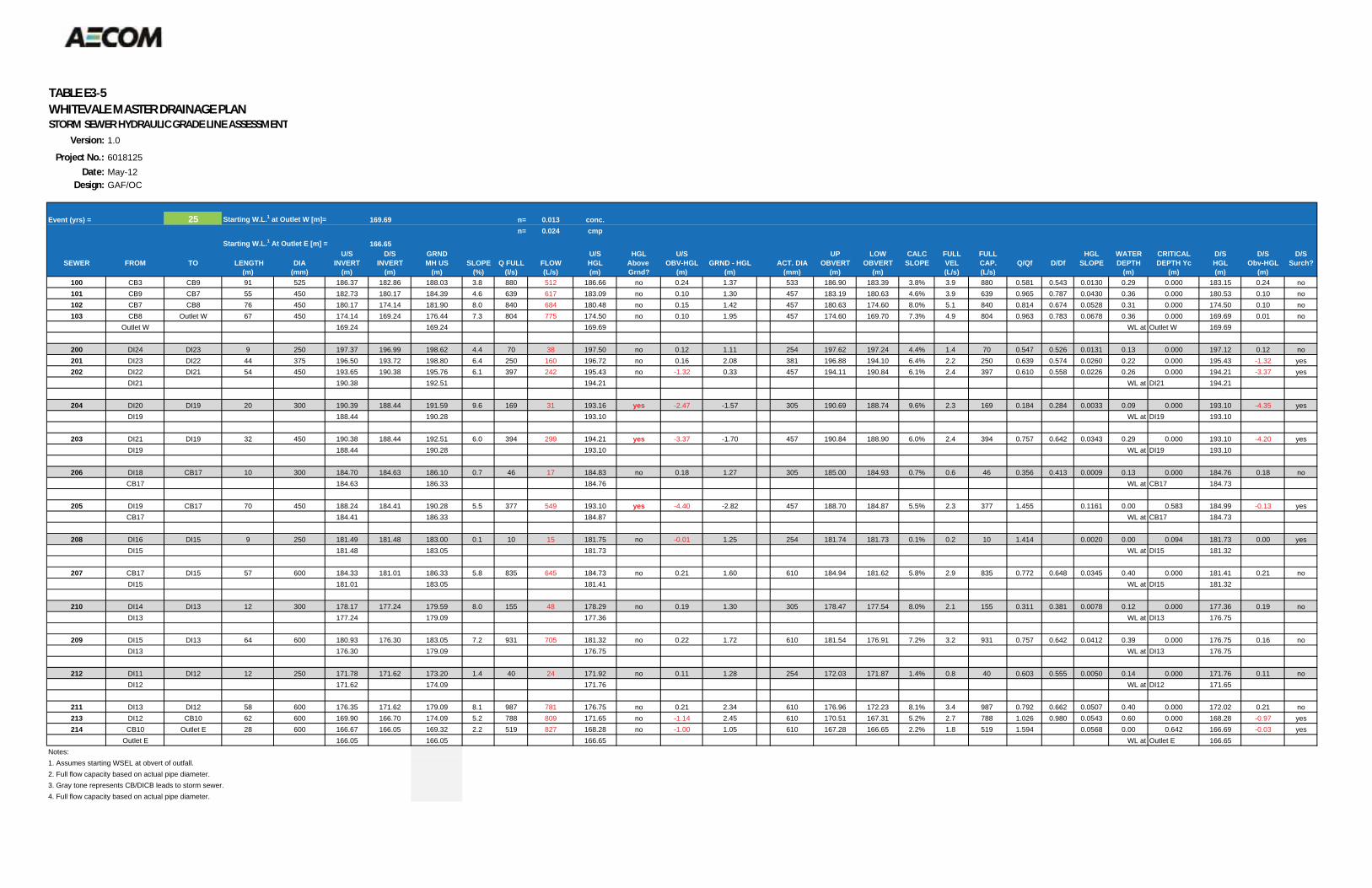
TABLE E3 5WHITEVALE MASTER DRAINAGE PLANSTORM SEWER HYDRAULIC GRADE LINE ASSESSMENT
Version: 1.0
Project No.: 6018125Date: May-12
Design: GAF/OC
Event (yrs) = 25 Starting W.L.1 at Outlet W [m]= 169.69 n= 0.013 conc.n= 0.024 cmp
Starting W.L.1 At Outlet E [m] = 166.65U/S D/S GRND U/S HGL U/S UP LOW CALC FULL FULL HGL WATER CRITICAL D/S D/S D/S
SEWER FROM TO LENGTH DIA INVERT INVERT MH US SLOPE Q FULL FLOW HGL Above OBV-HGL GRND - HGL ACT. DIA OBVERT OBVERT SLOPE VEL CAP. Q/Qf D/Df SLOPE DEPTH DEPTH Yc HGL Obv-HGL Surch?(m) (mm) (m) (m) (m) (%) (l/s) (L/s) (m) Grnd? (m) (m) (mm) (m) (m) (L/s) (L/s) (m) (m) (m) (m)
100 CB3 CB9 91 525 186.37 182.86 188.03 3.8 880 512 186.66 no 0.24 1.37 533 186.90 183.39 3.8% 3.9 880 0.581 0.543 0.0130 0.29 0.000 183.15 0.24 no101 CB9 CB7 55 450 182.73 180.17 184.39 4.6 639 617 183.09 no 0.10 1.30 457 183.19 180.63 4.6% 3.9 639 0.965 0.787 0.0430 0.36 0.000 180.53 0.10 no102 CB7 CB8 76 450 180.17 174.14 181.90 8.0 840 684 180.48 no 0.15 1.42 457 180.63 174.60 8.0% 5.1 840 0.814 0.674 0.0528 0.31 0.000 174.50 0.10 no103 CB8 Outlet W 67 450 174.14 169.24 176.44 7.3 804 775 174.50 no 0.10 1.95 457 174.60 169.70 7.3% 4.9 804 0.963 0.783 0.0678 0.36 0.000 169.69 0.01 no
Outlet W 169.24 169.24 169.69 WL at Outlet W 169.69
200 DI24 DI23 9 250 197.37 196.99 198.62 4.4 70 38 197.50 no 0.12 1.11 254 197.62 197.24 4.4% 1.4 70 0.547 0.526 0.0131 0.13 0.000 197.12 0.12 no201 DI23 DI22 44 375 196.50 193.72 198.80 6.4 250 160 196.72 no 0.16 2.08 381 196.88 194.10 6.4% 2.2 250 0.639 0.574 0.0260 0.22 0.000 195.43 -1.32 yes202 DI22 DI21 54 450 193.65 190.38 195.76 6.1 397 242 195.43 no -1.32 0.33 457 194.11 190.84 6.1% 2.4 397 0.610 0.558 0.0226 0.26 0.000 194.21 -3.37 yes
DI21 190.38 192.51 194.21 WL at DI21 194.21
204 DI20 DI19 20 300 190.39 188.44 191.59 9.6 169 31 193.16 yes -2.47 -1.57 305 190.69 188.74 9.6% 2.3 169 0.184 0.284 0.0033 0.09 0.000 193.10 -4.35 yesDI19 188.44 190.28 193.10 WL at DI19 193.10
203 DI21 DI19 32 450 190.38 188.44 192.51 6.0 394 299 194.21 yes -3.37 -1.70 457 190.84 188.90 6.0% 2.4 394 0.757 0.642 0.0343 0.29 0.000 193.10 -4.20 yesDI19 188.44 190.28 193.10 WL at DI19 193.10
206 DI18 CB17 10 300 184.70 184.63 186.10 0.7 46 17 184.83 no 0.18 1.27 305 185.00 184.93 0.7% 0.6 46 0.356 0.413 0.0009 0.13 0.000 184.76 0.18 noCB17 184.63 186.33 184.76 WL at CB17 184.73
205 DI19 CB17 70 450 188.24 184.41 190.28 5.5 377 549 193.10 yes -4.40 -2.82 457 188.70 184.87 5.5% 2.3 377 1.455 0.1161 0.00 0.583 184.99 -0.13 yesCB17 184.41 186.33 184.87 WL at CB17 184.73
208 DI16 DI15 9 250 181.49 181.48 183.00 0.1 10 15 181.75 no -0.01 1.25 254 181.74 181.73 0.1% 0.2 10 1.414 0.0020 0.00 0.094 181.73 0.00 yesDI15 181.48 183.05 181.73 WL at DI15 181.32
207 CB17 DI15 57 600 184.33 181.01 186.33 5.8 835 645 184.73 no 0.21 1.60 610 184.94 181.62 5.8% 2.9 835 0.772 0.648 0.0345 0.40 0.000 181.41 0.21 noDI15 181.01 183.05 181.41 WL at DI15 181.32
210 DI14 DI13 12 300 178.17 177.24 179.59 8.0 155 48 178.29 no 0.19 1.30 305 178.47 177.54 8.0% 2.1 155 0.311 0.381 0.0078 0.12 0.000 177.36 0.19 noDI13 177.24 179.09 177.36 WL at DI13 176.75
209 DI15 DI13 64 600 180.93 176.30 183.05 7.2 931 705 181.32 no 0.22 1.72 610 181.54 176.91 7.2% 3.2 931 0.757 0.642 0.0412 0.39 0.000 176.75 0.16 noDI13 176.30 179.09 176.75 WL at DI13 176.75
212 DI11 DI12 12 250 171.78 171.62 173.20 1.4 40 24 171.92 no 0.11 1.28 254 172.03 171.87 1.4% 0.8 40 0.603 0.555 0.0050 0.14 0.000 171.76 0.11 noDI12 171.62 174.09 171.76 WL at DI12 171.65
211 DI13 DI12 58 600 176.35 171.62 179.09 8.1 987 781 176.75 no 0.21 2.34 610 176.96 172.23 8.1% 3.4 987 0.792 0.662 0.0507 0.40 0.000 172.02 0.21 no213 DI12 CB10 62 600 169.90 166.70 174.09 5.2 788 809 171.65 no -1.14 2.45 610 170.51 167.31 5.2% 2.7 788 1.026 0.980 0.0543 0.60 0.000 168.28 -0.97 yes214 CB10 Outlet E 28 600 166.67 166.05 169.32 2.2 519 827 168.28 no -1.00 1.05 610 167.28 166.65 2.2% 1.8 519 1.594 0.0568 0.00 0.642 166.69 -0.03 yes
Outlet E 166.05 166.05 166.65 WL at Outlet E 166.65Notes:1. Assumes starting WSEL at obvert of outfall.2. Full flow capacity based on actual pipe diameter.3. Gray tone represents CB/DICB leads to storm sewer.4. Full flow capacity based on actual pipe diameter.
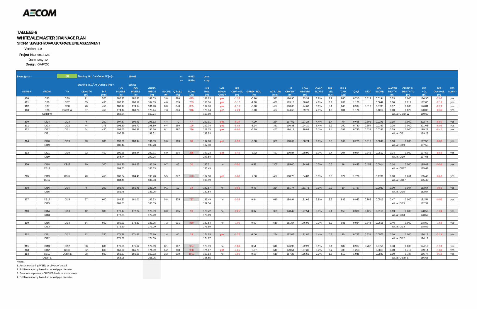
TABLE E3 6WHITEVALE MASTER DRAINAGE PLANSTORM SEWER HYDRAULIC GRADE LINE ASSESSMENT
Version: 1.0
Project No.: 6018125Date: May-12
Design: GAF/OC
Event (yrs) = 50 Starting W.L.1 at Outlet W [m]= 169.69 n= 0.013 conc.n= 0.024 cmp
Starting W.L.1 At Outlet E [m] = 166.65U/S D/S GRND U/S HGL U/S UP LOW CALC FULL FULL HGL WATER CRITICAL D/S D/S D/S
SEWER FROM TO LENGTH DIA INVERT INVERT MH US SLOPE Q FULL FLOW HGL Above OBV-HGL GRND - HGL ACT. DIA OBVERT OBVERT SLOPE VEL CAP. Q/Qf D/Df SLOPE DEPTH DEPTH Yc HGL Obv-HGL Surch?(m) (mm) (m) (m) (m) (%) (l/s) (L/s) (m) Grnd? (m) (m) (mm) (m) (m) (L/s) (L/s) (m) (m) (m) (m)
100 CB3 CB9 91 525 186.37 182.86 188.03 3.8 880 625 188.13 yes -1.23 -0.10 533 186.90 183.39 3.8% 3.9 880 0.710 0.613 0.0194 0.33 0.000 186.36 -2.97 yes101 CB9 CB7 55 450 182.73 180.17 184.39 4.6 639 753 186.36 yes -3.17 -1.98 457 183.19 180.63 4.6% 3.9 639 1.179 0.0642 0.00 0.712 182.80 -2.18 yes102 CB7 CB8 76 450 180.17 174.14 181.90 8.0 840 835 182.80 yes -2.18 -0.90 457 180.63 174.60 8.0% 5.1 840 0.994 0.810 0.0788 0.37 0.000 176.84 -2.24 yes103 CB8 Outlet W 67 450 174.14 169.24 176.44 7.3 804 946 176.84 yes -2.24 -0.40 457 174.60 169.70 7.3% 4.9 804 1.176 0.1012 0.00 0.822 170.06 -0.36 yes
Outlet W 169.24 169.24 169.69 WL at Outlet W 169.69
200 DI24 DI23 9 250 197.37 196.99 198.62 4.4 70 47 202.91 yes -5.29 -4.29 254 197.62 197.24 4.4% 1.4 70 0.668 0.592 0.0195 0.15 0.000 202.74 -5.50 yes201 DI23 DI22 44 375 196.50 193.72 198.80 6.4 250 195 202.74 yes -5.86 -3.94 381 196.88 194.10 6.4% 2.2 250 0.780 0.654 0.0387 0.25 0.000 201.05 -6.95 yes202 DI22 DI21 54 450 193.65 190.38 195.76 6.1 397 296 201.05 yes -6.94 -5.29 457 194.11 190.84 6.1% 2.4 397 0.745 0.634 0.0337 0.29 0.000 199.23 -8.40 yes
DI21 190.38 192.51 199.23 WL at DI21 199.23
204 DI20 DI19 20 300 190.39 188.44 191.59 9.6 169 38 197.68 yes -6.98 -6.08 305 190.69 188.74 9.6% 2.3 169 0.225 0.316 0.0049 0.10 0.000 197.58 -8.83 yesDI19 188.44 190.28 197.58 WL at DI19 197.58
203 DI21 DI19 32 450 190.38 188.44 192.51 6.0 394 365 199.23 yes -8.40 -6.72 457 190.84 188.90 6.0% 2.4 394 0.924 0.748 0.0512 0.34 0.000 197.58 -8.68 yesDI19 188.44 190.28 197.58 WL at DI19 197.58
206 DI18 CB17 10 300 184.70 184.63 186.10 0.7 46 20 185.51 no -0.50 0.59 305 185.00 184.93 0.7% 0.6 46 0.435 0.458 0.0014 0.14 0.000 185.49 -0.56 yesCB17 184.63 186.33 185.49 WL at CB17 185.49
205 DI19 CB17 70 450 188.24 184.41 190.28 5.5 377 670 197.58 yes -8.88 -7.30 457 188.70 184.87 5.5% 2.3 377 1.776 0.1731 0.00 0.661 185.49 -0.63 yesCB17 184.41 186.33 185.49 WL at CB17 185.49
208 DI16 DI15 9 250 181.49 181.48 183.00 0.1 10 18 182.57 no -0.82 0.43 254 181.74 181.73 0.1% 0.2 10 1.727 0.0029 0.00 0.104 182.54 -0.81 yesDI15 181.48 183.05 182.54 WL at DI15 182.54
207 CB17 DI15 57 600 184.33 181.01 186.33 5.8 835 787 185.49 no -0.55 0.84 610 184.94 181.62 5.8% 2.9 835 0.943 0.765 0.0515 0.47 0.000 182.54 -0.92 yesDI15 181.01 183.05 182.54 WL at DI15 182.54
210 DI14 DI13 12 300 178.17 177.24 179.59 8.0 155 59 178.72 no -0.25 0.87 305 178.47 177.54 8.0% 2.1 155 0.380 0.425 0.0116 0.13 0.000 178.59 -1.04 yesDI13 177.24 179.09 178.59 WL at DI13 178.59
209 DI15 DI13 64 600 180.93 176.30 183.05 7.2 931 860 182.54 no -1.00 0.50 610 181.54 176.91 7.2% 3.2 931 0.924 0.748 0.0615 0.46 0.000 178.59 -1.68 yesDI13 176.30 179.09 178.59 WL at DI13 178.59
212 DI11 DI12 12 250 171.78 171.62 173.20 1.4 40 29 174.25 yes -2.22 -1.06 254 172.03 171.87 1.4% 0.8 40 0.737 0.631 0.0075 0.16 0.000 174.17 -2.29 yesDI12 171.62 174.09 174.17 WL at DI12 174.17
211 DI13 DI12 58 600 176.35 171.62 179.09 8.1 987 954 178.59 no -1.63 0.51 610 176.96 172.23 8.1% 3.4 987 0.967 0.787 0.0756 0.48 0.000 174.17 -1.94 yes213 DI12 CB10 62 600 169.90 166.70 174.09 5.2 788 988 174.17 yes -3.66 -0.07 610 170.51 167.31 5.2% 2.7 788 1.253 0.0810 0.00 0.717 169.14 -1.83 yes214 CB10 Outlet E 28 600 166.67 166.05 169.32 2.2 519 1010 169.14 no -1.86 0.18 610 167.28 166.65 2.2% 1.8 519 1.946 0.0847 0.00 0.727 166.77 -0.12 yes
Outlet E 166.05 166.05 166.65 WL at Outlet E 166.65Notes:1. Assumes starting WSEL at obvert of outfall.2. Full flow capacity based on actual pipe diameter.3. Gray tone represents CB/DICB leads to storm sewer.4. Full flow capacity based on actual pipe diameter.
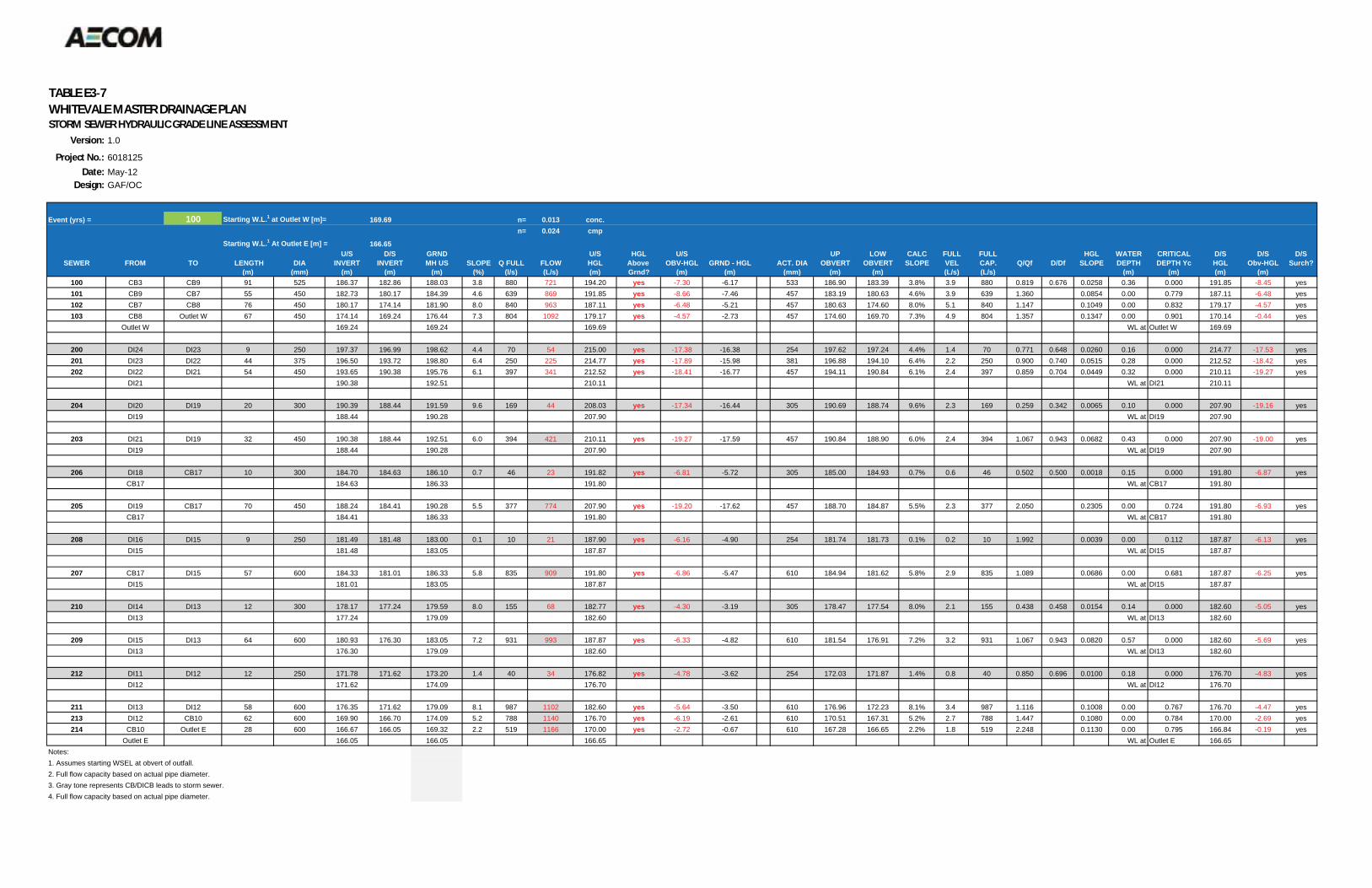
TABLE E3 7WHITEVALE MASTER DRAINAGE PLANSTORM SEWER HYDRAULIC GRADE LINE ASSESSMENT
Version: 1.0
Project No.: 6018125Date: May-12
Design: GAF/OC
Event (yrs) = 100 Starting W.L.1 at Outlet W [m]= 169.69 n= 0.013 conc.n= 0.024 cmp
Starting W.L.1 At Outlet E [m] = 166.65U/S D/S GRND U/S HGL U/S UP LOW CALC FULL FULL HGL WATER CRITICAL D/S D/S D/S
SEWER FROM TO LENGTH DIA INVERT INVERT MH US SLOPE Q FULL FLOW HGL Above OBV-HGL GRND - HGL ACT. DIA OBVERT OBVERT SLOPE VEL CAP. Q/Qf D/Df SLOPE DEPTH DEPTH Yc HGL Obv-HGL Surch?(m) (mm) (m) (m) (m) (%) (l/s) (L/s) (m) Grnd? (m) (m) (mm) (m) (m) (L/s) (L/s) (m) (m) (m) (m)
100 CB3 CB9 91 525 186.37 182.86 188.03 3.8 880 721 194.20 yes -7.30 -6.17 533 186.90 183.39 3.8% 3.9 880 0.819 0.676 0.0258 0.36 0.000 191.85 -8.45 yes101 CB9 CB7 55 450 182.73 180.17 184.39 4.6 639 869 191.85 yes -8.66 -7.46 457 183.19 180.63 4.6% 3.9 639 1.360 0.0854 0.00 0.779 187.11 -6.48 yes102 CB7 CB8 76 450 180.17 174.14 181.90 8.0 840 963 187.11 yes -6.48 -5.21 457 180.63 174.60 8.0% 5.1 840 1.147 0.1049 0.00 0.832 179.17 -4.57 yes103 CB8 Outlet W 67 450 174.14 169.24 176.44 7.3 804 1092 179.17 yes -4.57 -2.73 457 174.60 169.70 7.3% 4.9 804 1.357 0.1347 0.00 0.901 170.14 -0.44 yes
Outlet W 169.24 169.24 169.69 WL at Outlet W 169.69
200 DI24 DI23 9 250 197.37 196.99 198.62 4.4 70 54 215.00 yes -17.38 -16.38 254 197.62 197.24 4.4% 1.4 70 0.771 0.648 0.0260 0.16 0.000 214.77 -17.53 yes201 DI23 DI22 44 375 196.50 193.72 198.80 6.4 250 225 214.77 yes -17.89 -15.98 381 196.88 194.10 6.4% 2.2 250 0.900 0.740 0.0515 0.28 0.000 212.52 -18.42 yes202 DI22 DI21 54 450 193.65 190.38 195.76 6.1 397 341 212.52 yes -18.41 -16.77 457 194.11 190.84 6.1% 2.4 397 0.859 0.704 0.0449 0.32 0.000 210.11 -19.27 yes
DI21 190.38 192.51 210.11 WL at DI21 210.11
204 DI20 DI19 20 300 190.39 188.44 191.59 9.6 169 44 208.03 yes -17.34 -16.44 305 190.69 188.74 9.6% 2.3 169 0.259 0.342 0.0065 0.10 0.000 207.90 -19.16 yesDI19 188.44 190.28 207.90 WL at DI19 207.90
203 DI21 DI19 32 450 190.38 188.44 192.51 6.0 394 421 210.11 yes -19.27 -17.59 457 190.84 188.90 6.0% 2.4 394 1.067 0.943 0.0682 0.43 0.000 207.90 -19.00 yesDI19 188.44 190.28 207.90 WL at DI19 207.90
206 DI18 CB17 10 300 184.70 184.63 186.10 0.7 46 23 191.82 yes -6.81 -5.72 305 185.00 184.93 0.7% 0.6 46 0.502 0.500 0.0018 0.15 0.000 191.80 -6.87 yesCB17 184.63 186.33 191.80 WL at CB17 191.80
205 DI19 CB17 70 450 188.24 184.41 190.28 5.5 377 774 207.90 yes -19.20 -17.62 457 188.70 184.87 5.5% 2.3 377 2.050 0.2305 0.00 0.724 191.80 -6.93 yesCB17 184.41 186.33 191.80 WL at CB17 191.80
208 DI16 DI15 9 250 181.49 181.48 183.00 0.1 10 21 187.90 yes -6.16 -4.90 254 181.74 181.73 0.1% 0.2 10 1.992 0.0039 0.00 0.112 187.87 -6.13 yesDI15 181.48 183.05 187.87 WL at DI15 187.87
207 CB17 DI15 57 600 184.33 181.01 186.33 5.8 835 909 191.80 yes -6.86 -5.47 610 184.94 181.62 5.8% 2.9 835 1.089 0.0686 0.00 0.681 187.87 -6.25 yesDI15 181.01 183.05 187.87 WL at DI15 187.87
210 DI14 DI13 12 300 178.17 177.24 179.59 8.0 155 68 182.77 yes -4.30 -3.19 305 178.47 177.54 8.0% 2.1 155 0.438 0.458 0.0154 0.14 0.000 182.60 -5.05 yesDI13 177.24 179.09 182.60 WL at DI13 182.60
209 DI15 DI13 64 600 180.93 176.30 183.05 7.2 931 993 187.87 yes -6.33 -4.82 610 181.54 176.91 7.2% 3.2 931 1.067 0.943 0.0820 0.57 0.000 182.60 -5.69 yesDI13 176.30 179.09 182.60 WL at DI13 182.60
212 DI11 DI12 12 250 171.78 171.62 173.20 1.4 40 34 176.82 yes -4.78 -3.62 254 172.03 171.87 1.4% 0.8 40 0.850 0.696 0.0100 0.18 0.000 176.70 -4.83 yesDI12 171.62 174.09 176.70 WL at DI12 176.70
211 DI13 DI12 58 600 176.35 171.62 179.09 8.1 987 1102 182.60 yes -5.64 -3.50 610 176.96 172.23 8.1% 3.4 987 1.116 0.1008 0.00 0.767 176.70 -4.47 yes213 DI12 CB10 62 600 169.90 166.70 174.09 5.2 788 1140 176.70 yes -6.19 -2.61 610 170.51 167.31 5.2% 2.7 788 1.447 0.1080 0.00 0.784 170.00 -2.69 yes214 CB10 Outlet E 28 600 166.67 166.05 169.32 2.2 519 1166 170.00 yes -2.72 -0.67 610 167.28 166.65 2.2% 1.8 519 2.248 0.1130 0.00 0.795 166.84 -0.19 yes
Outlet E 166.05 166.05 166.65 WL at Outlet E 166.65Notes:1. Assumes starting WSEL at obvert of outfall.2. Full flow capacity based on actual pipe diameter.3. Gray tone represents CB/DICB leads to storm sewer.4. Full flow capacity based on actual pipe diameter.

04rb_2013-03-22_App Tps_60187125.Docx
Appendix F Alternatives Evaluation & Preferred Solutions
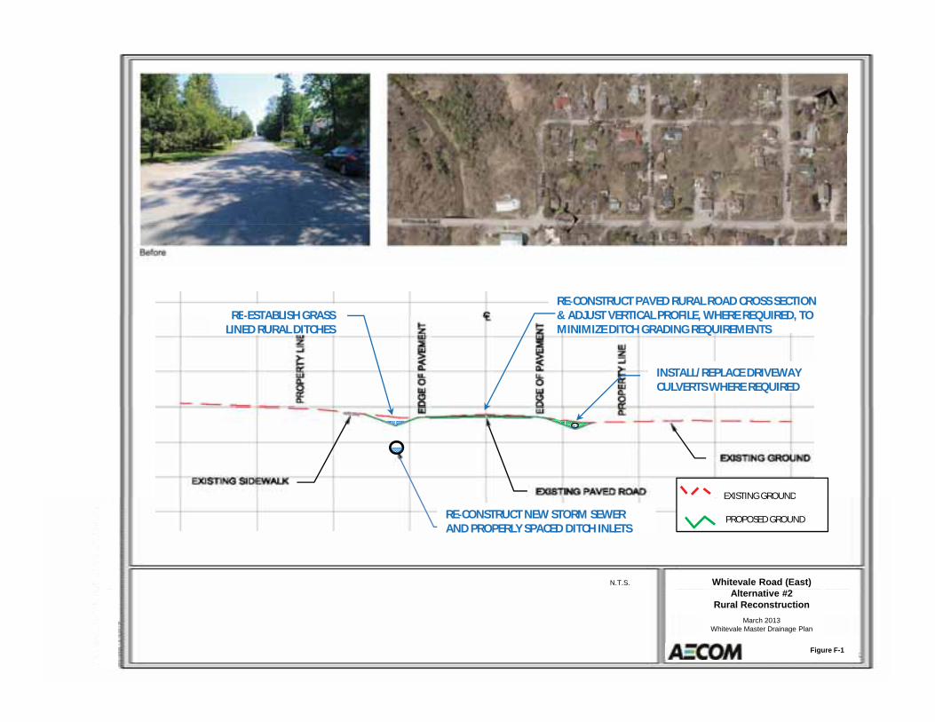
RE ESTABLISH GRASSRE CONSTRUCT PAVED RURAL ROAD CROSS SECTION& ADJUST VERTICAL PROFILE WHERE REQUIRED TO
INSTALL/REPLACE DRIVEWAYCULVERTS WHERE REQUIRED
RE ESTABLISH GRASSLINED RURAL DITCHES
& ADJUST VERTICAL PROFILE, WHERE REQUIRED, TOMINIMIZE DITCH GRADING REQUIREMENTS
EXISTING GROUND
Whitevale Road (East)N.T.S.
RE CONSTRUCT NEW STORM SEWERAND PROPERLY SPACED DITCH INLETS
EXISTING GROUND
PROPOSED GROUND
Alternative #2Rural Reconstruction
March 2013Whitevale Master Drainage Plan
Figure F-1
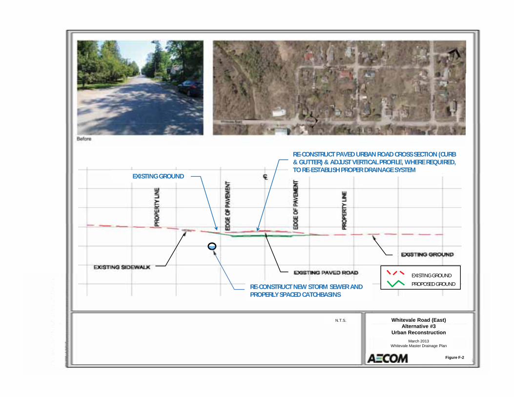
RE CONSTRUCT PAVED URBAN ROAD CROSS SECTION (CURB& GUTTER) & ADJUST VERTICAL PROFILE, WHERE REQUIRED,TO RE ESTABLISH PROPER DRAINAGE SYSTEM
EXISTING GROUND
Whitevale Road (East)N.T.S.
RE CONSTRUCT NEW STORM SEWER ANDPROPERLY SPACED CATCHBASINS
EXISTING GROUND
PROPOSED GROUND
Alternative #3Urban Reconstruction
March 2013Whitevale Master Drainage Plan
Figure F-2
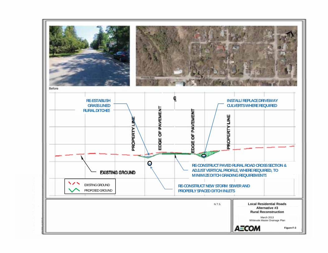
INSTALL/REPLACE DRIVEWAYCULVERTS WHERE REQUIRED
RE ESTABLISHGRASS LINED
RURAL DITCHESRURAL DITCHES
RE CONSTRUCT PAVED RURAL ROAD CROSS SECTION &ADJUST VERTICAL PROFILE, WHERE REQUIRED, TOMINIMIZE DITCH GRADING REQUIREMENTS
Local Residential RoadsN.T.S.
MINIMIZE DITCH GRADING REQUIREMENTS
RE CONSTRUCT NEW STORM SEWER ANDPROPERLY SPACED DITCH INLETS
EXISTING GROUND
PROPOSED GROUND
Alternative #3Rural Reconstruction
March 2013Whitevale Master Drainage Plan
Figure F-3
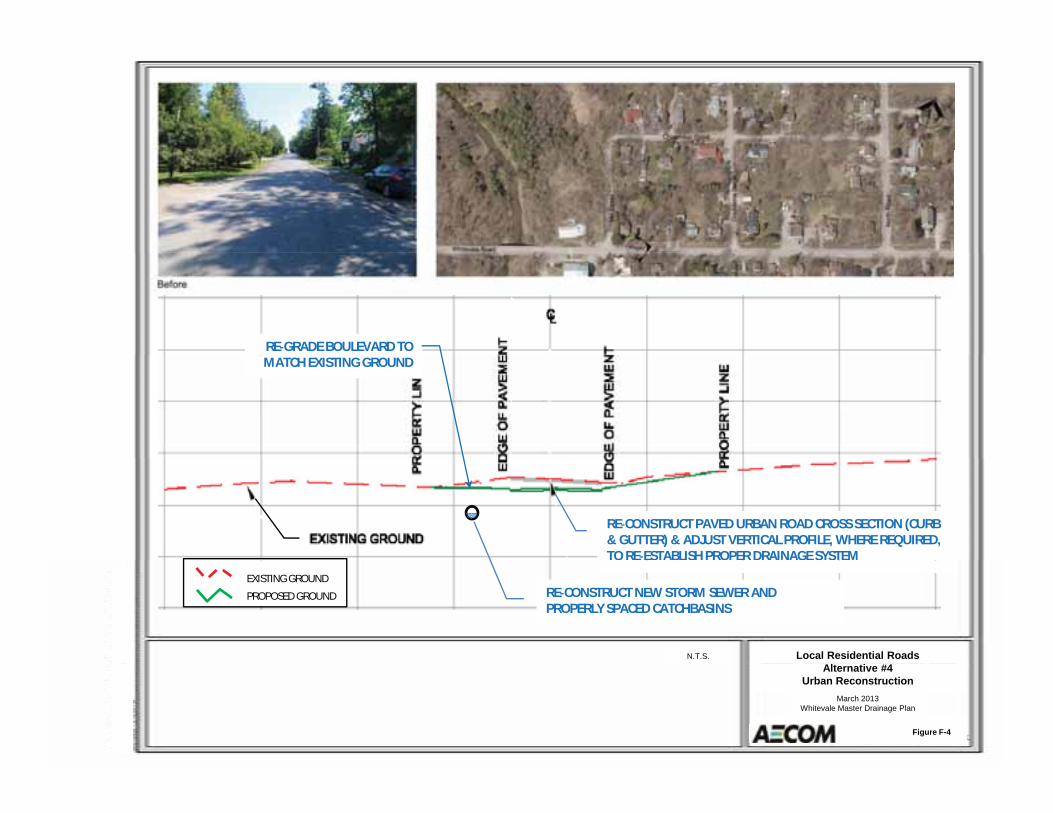
RE GRADE BOULEVARD TOMATCH EXISTING GROUND
RE CONSTRUCT PAVED URBAN ROAD CROSS SECTION (CURB& GUTTER) & ADJUST VERTICAL PROFILE, WHERE REQUIRED,TO RE ESTABLISH PROPER DRAINAGE SYSTEM
Local Residential RoadsN.T.S.
RE CONSTRUCT NEW STORM SEWER ANDPROPERLY SPACED CATCHBASINS
EXISTING GROUND
PROPOSED GROUND
Alternative #4Urban Reconstruction
March 2013Whitevale Master Drainage Plan
Figure F-4
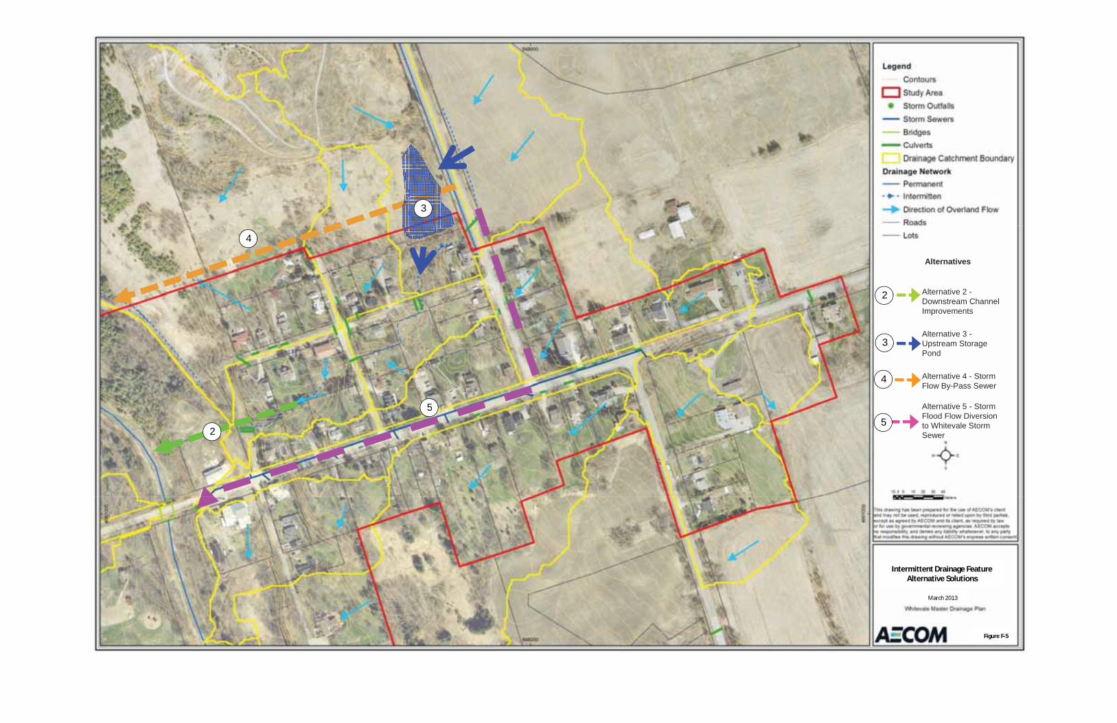
3
Alternatives
4
Alternative 2 -Downstream Channel Improvements
2
Alternative 3 -Upstream Storage Pond
3
Alternative 4 - Storm Flow By-Pass Sewer
Alternative 5 Storm
4
5 Alternative 5 - StormFlood Flow Diversion to Whitevale Storm Sewer
52
5
Intermittent Drainage FeatureAlternative Solutions
March 2013
Figure F 5
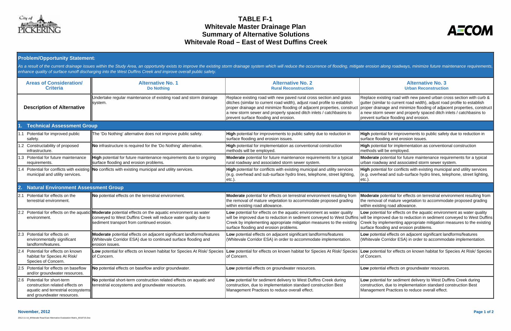
TABLE F-1 Whitevale Master Drainage Plan
Summary of Alternative Solutions Whitevale Road – East of West Duffins Creek
November, 2012 Page 1 of 22012-11-14_Whitevale Road East Alternative Evalutation Matrix_6018715.Doc
Problem/Opportunity Statement:As a result of the current drainage issues within the Study Area, an opportunity exists to improve the existing storm drainage system which will reduce the occurrence of flooding, mitigate erosion along roadways, minimize future maintenance requirements,enhance quality of surface runoff discharging into the West Duffins Creek and improve overall public safety.
Areas of Consideration/ Criteria
Alternative No. 1Do Nothing
Alternative No. 2Rural Reconstruction
Alternative No. 3Urban Reconstruction
Description of Alternative
Undertake regular maintenance of existing road and storm drainage system.
Replace existing road with new paved rural cross section and grass ditches (similar to current road width), adjust road profile to establish proper drainage and minimize flooding of adjacent properties, construct a new storm sewer and properly spaced ditch inlets / catchbasins to prevent surface flooding and erosion.
Replace existing road with new paved urban cross section with curb & gutter (similar to current road width), adjust road profile to establish proper drainage and minimize flooding of adjacent properties, construct a new storm sewer and properly spaced ditch inlets / catchbasins to prevent surface flooding and erosion.
1. Technical Assessment Group 1.1 Potential for improved public
safety. The ‘Do Nothing’ alternative does not improve public safety. High potential for improvements to public safety due to reduction in
surface flooding and erosion issues. High potential for improvements to public safety due to reduction in surface flooding and erosion issues.
1.2 Constructability of proposed infrastructure.
No infrastructure is required for the ‘Do Nothing’ alternative. High potential for implementation as conventional construction methods will be employed.
High potential for implementation as conventional construction methods will be employed.
1.3 Potential for future maintenance requirements.
High potential for future maintenance requirements due to ongoing surface flooding and erosion problems.
Moderate potential for future maintenance requirements for a typical rural roadway and associated storm sewer system.
Moderate potential for future maintenance requirements for a typical urban roadway and associated storm sewer system.
1.4 Potential for conflicts with existing municipal and utility services.
No conflicts with existing municipal and utility services. High potential for conflicts with existing municipal and utility services (e.g. overhead and sub-surface hydro lines, telephone, street lighting, etc.).
High potential for conflicts with existing municipal and utility services (e.g. overhead and sub-surface hydro lines, telephone, street lighting, etc.).
2. Natural Environment Assessment Group 2.1 Potential for effects on the
terrestrial environment. No potential effects on the terrestrial environment. Moderate potential for effects on terrestrial environment resulting from
the removal of mature vegetation to accommodate proposed grading within existing road allowance.
Moderate potential for effects on terrestrial environment resulting from the removal of mature vegetation to accommodate proposed grading within existing road allowance.
2.2 Potential for effects on the aquatic environment.
Moderate potential effects on the aquatic environment as water conveyed to West Duffins Creek will reduce water quality due to sediment transport from continued erosion.
Low potential for effects on the aquatic environment as water quality will be improved due to reduction in sediment conveyed to West Duffins Creek by implementing appropriate mitigation measures to the existing surface flooding and erosion problems.
Low potential for effects on the aquatic environment as water quality will be improved due to reduction in sediment conveyed to West Duffins Creek by implementing appropriate mitigation measures to the existing surface flooding and erosion problems.
2.3 Potential for effects on environmentally significant landform/features.
Moderate potential effects on adjacent significant landforms/features (Whitevale Corridor ESA) due to continued surface flooding and erosion issues.
Low potential effects on adjacent significant landforms/features (Whitevale Corridor ESA) in order to accommodate implementation.
Low potential effects on adjacent significant landforms/features (Whitevale Corridor ESA) in order to accommodate implementation.
2.4 Potential for effects on known habitat for Species At Risk/ Species of Concern.
Low potential for effects on known habitat for Species At Risk/ Species of Concern.
Low potential for effects on known habitat for Species At Risk/ Species of Concern.
Low potential for effects on known habitat for Species At Risk/ Species of Concern.
2.5 Potential for effects on baseflow and/or groundwater resources.
No potential effects on baseflow and/or groundwater. Low potential effects on groundwater resources. Low potential effects on groundwater resources.
2.6 Potential for short-term construction related effects on aquatic and terrestrial ecosystems and groundwater resources.
No potential short-term construction related effects on aquatic and terrestrial ecosystems and groundwater resources.
Low potential for sediment delivery to West Duffins Creek during construction, due to implementation standard construction Best Management Practices to reduce overall effect.
Low potential for sediment delivery to West Duffins Creek during construction, due to implementation standard construction Best Management Practices to reduce overall effect.
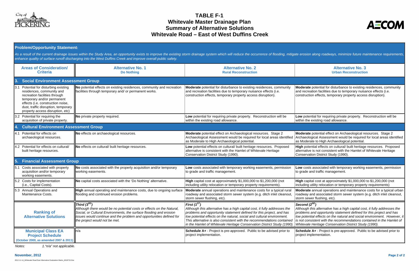
TABLE F-1 Whitevale Master Drainage Plan
Summary of Alternative Solutions Whitevale Road – East of West Duffins Creek
November, 2012 Page 2 of 22012-11-14_Whitevale Road East Alternative Evalutation Matrix_6018715.Doc
Problem/Opportunity Statement:As a result of the current drainage issues within the Study Area, an opportunity exists to improve the existing storm drainage system which will reduce the occurrence of flooding, mitigate erosion along roadways, minimize future maintenance requirements,enhance quality of surface runoff discharging into the West Duffins Creek and improve overall public safety.
Areas of Consideration/ Criteria
Alternative No. 1Do Nothing
Alternative No. 2Rural Reconstruction
Alternative No. 3Urban Reconstruction
3. Social Environment Assessment Group 3.1 Potential for disturbing existing
residences, community and recreation facilities through temporary and/or permanent effects (i.e. construction noise, dust, traffic disruption, temporary property access disruption, etc)
No potential effects on existing residences, community and recreation facilities through temporary and/ or permanent works.
Moderate potential for disturbance to existing residences, community and recreation facilities due to temporary nuisance effects (i.e. construction effects, temporary property access disruption).
Moderate potential for disturbance to existing residences, community and recreation facilities due to temporary nuisance effects (i.e. construction effects, temporary property access disruption).
3.2 Potential for requiring the acquisition of private property.
No private property required. Low potential for requiring private property. Reconstruction will be within the existing road allowance.
Low potential for requiring private property. Reconstruction will be within the existing road allowance.
4. Cultural Environment Assessment Group 4.1 Potential for effects on
archaeological resources. No effects on archaeological resources. Moderate potential effect on Archaeological resources. Stage 2
Archaeological Assessment would be required for local areas identified as Moderate to High Archaeological potential.
Moderate potential effect on Archaeological resources. Stage 2 Archaeological Assessment would be required for local areas identified as Moderate to High Archaeological potential.
4.2 Potential for effects on cultural/ built heritage resources.
No effects on cultural/ built heritage resources. Low potential effects on cultural/ built heritage resources. Proposed alternative is consistent with the Hamlet of Whitevale Heritage Conservation District Study (1990).
High potential effects on cultural/ built heritage resources. Proposed alternative is not consistent with the Hamlet of Whitevale Heritage Conservation District Study (1990).
5. Financial Assessment Group 5.1 Costs associated with property
acquisition and/or temporary working easements.
No costs associated with the property acquisition and/or temporary working easements.
Low costs associated with temporary working easements, permission to grade and traffic management.
Low costs associated with temporary working easements, permission to grade and traffic management.
5.2 Costs for implementation (i.e., Capital Costs).
No capital costs associated with the ‘Do Nothing’ alternative. High capital cost at approximately $1,000,000 to $1,200,000 (not including utility relocation or temporary property requirements).
High capital cost at approximately $1,000,000 to $1,200,000 (not including utility relocation or temporary property requirements)
5.3 Annual Operations and Maintenance Costs.
High annual operating and maintenance costs, due to ongoing surface flooding and continued erosion problems.
Moderate annual operations and maintenance costs for a typical rural roadway and associated storm sewer system (e.g. ditch inlet cleanout, storm sewer flushing, etc).
Moderate annual operations and maintenance costs for a typical urban roadway and associated storm sewer system (e.g. ditch inlet cleanout, storm sewer flushing, etc).
Ranking of Alternative Solutions
Third (3RD)Although there would be no potential costs or effects on the Natural, Social, or Cultural Environments, the surface flooding and erosion issues would continue and the problem and opportunities defined for the project would not be met.
First (1ST)Although this alternative has a high capital cost, it fully addresses the problems and opportunity statement defined for this project, and has low potential effects on the natural, social and cultural environment. This alternative is also consistent with the recommendations contained in the Hamlet of Whitevale Heritage Conservation District Study (1990).
Second (2ND)Although this alternative has a high capital cost, it fully addresses the problems and opportunity statement defined for this project and has low potential effects on the natural and social environment. However, it is not consistent with the recommendations contained in the Hamlet of Whitevale Heritage Conservation District Study (1990).
Municipal Class EA Project Schedule
(October 2000, as amended 2007 & 2011)
n/a Schedule A+ - Project is pre-approved. Public to be advised prior to project implementation.
Schedule A+ - Project is pre-approved. Public to be advised prior to project implementation.
Notes: 1.“n/a” not applicable.
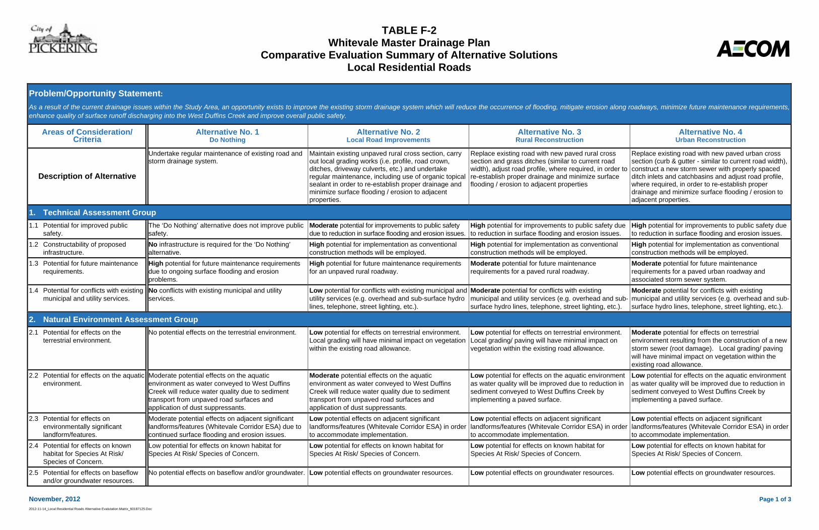
TABLE F-2 Whitevale Master Drainage Plan
Comparative Evaluation Summary of Alternative Solutions Local Residential Roads
November, 2012 Page 1 of 32012-11-14_Local Residential Roads Alternative Evalutation Matrix_60187125.Doc
Problem/Opportunity Statement:As a result of the current drainage issues within the Study Area, an opportunity exists to improve the existing storm drainage system which will reduce the occurrence of flooding, mitigate erosion along roadways, minimize future maintenance requirements,enhance quality of surface runoff discharging into the West Duffins Creek and improve overall public safety.
Areas of Consideration/ Criteria
Alternative No. 1Do Nothing
Alternative No. 2Local Road Improvements
Alternative No. 3Rural Reconstruction
Alternative No. 4Urban Reconstruction
Description of Alternative
Undertake regular maintenance of existing road and storm drainage system.
Maintain existing unpaved rural cross section, carry out local grading works (i.e. profile, road crown, ditches, driveway culverts, etc.) and undertake regular maintenance, including use of organic topical sealant in order to re-establish proper drainage and minimize surface flooding / erosion to adjacent properties.
Replace existing road with new paved rural cross section and grass ditches (similar to current road width), adjust road profile, where required, in order to re-establish proper drainage and minimize surface flooding / erosion to adjacent properties
Replace existing road with new paved urban cross section (curb & gutter - similar to current road width), construct a new storm sewer with properly spaced ditch inlets and catchbasins and adjust road profile, where required, in order to re-establish proper drainage and minimize surface flooding / erosion to adjacent properties.
1. Technical Assessment Group 1.1 Potential for improved public
safety. The ‘Do Nothing’ alternative does not improve public safety.
Moderate potential for improvements to public safety due to reduction in surface flooding and erosion issues.
High potential for improvements to public safety due to reduction in surface flooding and erosion issues.
High potential for improvements to public safety due to reduction in surface flooding and erosion issues.
1.2 Constructability of proposed infrastructure.
No infrastructure is required for the ‘Do Nothing’ alternative.
High potential for implementation as conventional construction methods will be employed.
High potential for implementation as conventional construction methods will be employed.
High potential for implementation as conventional construction methods will be employed.
1.3 Potential for future maintenance requirements.
High potential for future maintenance requirements due to ongoing surface flooding and erosion problems.
High potential for future maintenance requirements for an unpaved rural roadway.
Moderate potential for future maintenance requirements for a paved rural roadway.
Moderate potential for future maintenance requirements for a paved urban roadway and associated storm sewer system.
1.4 Potential for conflicts with existing municipal and utility services.
No conflicts with existing municipal and utility services.
Low potential for conflicts with existing municipal and utility services (e.g. overhead and sub-surface hydro lines, telephone, street lighting, etc.).
Moderate potential for conflicts with existing municipal and utility services (e.g. overhead and sub-surface hydro lines, telephone, street lighting, etc.).
Moderate potential for conflicts with existing municipal and utility services (e.g. overhead and sub-surface hydro lines, telephone, street lighting, etc.).
2. Natural Environment Assessment Group 2.1 Potential for effects on the
terrestrial environment. No potential effects on the terrestrial environment. Low potential for effects on terrestrial environment.
Local grading will have minimal impact on vegetation within the existing road allowance.
Low potential for effects on terrestrial environment. Local grading/ paving will have minimal impact on vegetation within the existing road allowance.
Moderate potential for effects on terrestrial environment resulting from the construction of a new storm sewer (root damage). Local grading/ paving will have minimal impact on vegetation within the existing road allowance.
2.2 Potential for effects on the aquatic environment.
Moderate potential effects on the aquatic environment as water conveyed to West Duffins Creek will reduce water quality due to sediment transport from unpaved road surfaces and application of dust suppressants.
Moderate potential effects on the aquatic environment as water conveyed to West Duffins Creek will reduce water quality due to sediment transport from unpaved road surfaces and application of dust suppressants.
Low potential for effects on the aquatic environment as water quality will be improved due to reduction in sediment conveyed to West Duffins Creek by implementing a paved surface.
Low potential for effects on the aquatic environment as water quality will be improved due to reduction in sediment conveyed to West Duffins Creek by implementing a paved surface.
2.3 Potential for effects on environmentally significant landform/features.
Moderate potential effects on adjacent significant landforms/features (Whitevale Corridor ESA) due to continued surface flooding and erosion issues.
Low potential effects on adjacent significant landforms/features (Whitevale Corridor ESA) in order to accommodate implementation.
Low potential effects on adjacent significant landforms/features (Whitevale Corridor ESA) in order to accommodate implementation.
Low potential effects on adjacent significant landforms/features (Whitevale Corridor ESA) in order to accommodate implementation.
2.4 Potential for effects on known habitat for Species At Risk/ Species of Concern.
Low potential for effects on known habitat for Species At Risk/ Species of Concern.
Low potential for effects on known habitat for Species At Risk/ Species of Concern.
Low potential for effects on known habitat for Species At Risk/ Species of Concern.
Low potential for effects on known habitat for Species At Risk/ Species of Concern.
2.5 Potential for effects on baseflow and/or groundwater resources.
No potential effects on baseflow and/or groundwater. Low potential effects on groundwater resources. Low potential effects on groundwater resources. Low potential effects on groundwater resources.
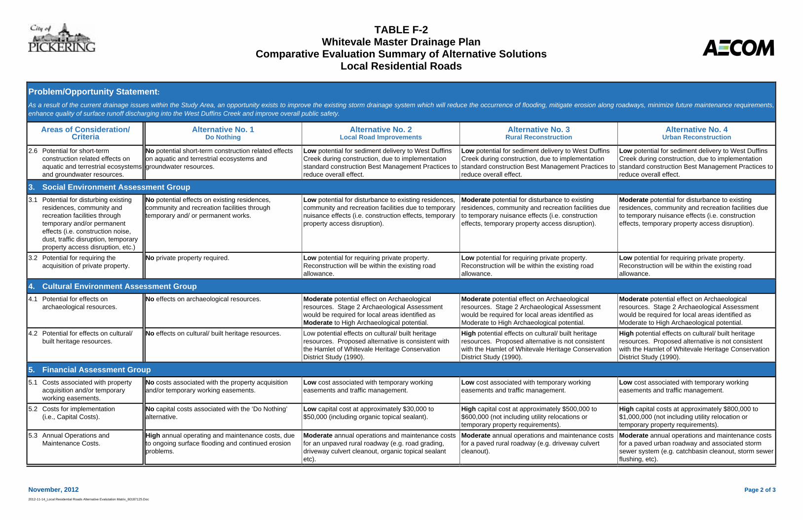
TABLE F-2 Whitevale Master Drainage Plan
Comparative Evaluation Summary of Alternative Solutions Local Residential Roads
November, 2012 Page 2 of 32012-11-14_Local Residential Roads Alternative Evalutation Matrix_60187125.Doc
Problem/Opportunity Statement:As a result of the current drainage issues within the Study Area, an opportunity exists to improve the existing storm drainage system which will reduce the occurrence of flooding, mitigate erosion along roadways, minimize future maintenance requirements,enhance quality of surface runoff discharging into the West Duffins Creek and improve overall public safety.
Areas of Consideration/ Criteria
Alternative No. 1Do Nothing
Alternative No. 2Local Road Improvements
Alternative No. 3Rural Reconstruction
Alternative No. 4Urban Reconstruction
2.6 Potential for short-term construction related effects on aquatic and terrestrial ecosystems and groundwater resources.
No potential short-term construction related effects on aquatic and terrestrial ecosystems and groundwater resources.
Low potential for sediment delivery to West Duffins Creek during construction, due to implementation standard construction Best Management Practices to reduce overall effect.
Low potential for sediment delivery to West Duffins Creek during construction, due to implementation standard construction Best Management Practices to reduce overall effect.
Low potential for sediment delivery to West Duffins Creek during construction, due to implementation standard construction Best Management Practices to reduce overall effect.
3. Social Environment Assessment Group 3.1 Potential for disturbing existing
residences, community and recreation facilities through temporary and/or permanent effects (i.e. construction noise, dust, traffic disruption, temporary property access disruption, etc.)
No potential effects on existing residences, community and recreation facilities through temporary and/ or permanent works.
Low potential for disturbance to existing residences, community and recreation facilities due to temporary nuisance effects (i.e. construction effects, temporary property access disruption).
Moderate potential for disturbance to existing residences, community and recreation facilities due to temporary nuisance effects (i.e. construction effects, temporary property access disruption).
Moderate potential for disturbance to existing residences, community and recreation facilities due to temporary nuisance effects (i.e. construction effects, temporary property access disruption).
3.2 Potential for requiring the acquisition of private property.
No private property required. Low potential for requiring private property. Reconstruction will be within the existing road allowance.
Low potential for requiring private property. Reconstruction will be within the existing road allowance.
Low potential for requiring private property. Reconstruction will be within the existing road allowance.
4. Cultural Environment Assessment Group 4.1 Potential for effects on
archaeological resources. No effects on archaeological resources. Moderate potential effect on Archaeological
resources. Stage 2 Archaeological Assessment would be required for local areas identified as Moderate to High Archaeological potential.
Moderate potential effect on Archaeological resources. Stage 2 Archaeological Assessment would be required for local areas identified as Moderate to High Archaeological potential.
Moderate potential effect on Archaeological resources. Stage 2 Archaeological Assessment would be required for local areas identified as Moderate to High Archaeological potential.
4.2 Potential for effects on cultural/ built heritage resources.
No effects on cultural/ built heritage resources. Low potential effects on cultural/ built heritage resources. Proposed alternative is consistent with the Hamlet of Whitevale Heritage Conservation District Study (1990).
High potential effects on cultural/ built heritage resources. Proposed alternative is not consistent with the Hamlet of Whitevale Heritage Conservation District Study (1990).
High potential effects on cultural/ built heritage resources. Proposed alternative is not consistent with the Hamlet of Whitevale Heritage Conservation District Study (1990).
5. Financial Assessment Group 5.1 Costs associated with property
acquisition and/or temporary working easements.
No costs associated with the property acquisition and/or temporary working easements.
Low cost associated with temporary working easements and traffic management.
Low cost associated with temporary working easements and traffic management.
Low cost associated with temporary working easements and traffic management.
5.2 Costs for implementation (i.e., Capital Costs).
No capital costs associated with the ‘Do Nothing’ alternative.
Low capital cost at approximately $30,000 to $50,000 (including organic topical sealant).
High capital cost at approximately $500,000 to $600,000 (not including utility relocations or temporary property requirements).
High capital costs at approximately $800,000 to $1,000,000 (not including utility relocation or temporary property requirements).
5.3 Annual Operations and Maintenance Costs.
High annual operating and maintenance costs, due to ongoing surface flooding and continued erosion problems.
Moderate annual operations and maintenance costs for an unpaved rural roadway (e.g. road grading, driveway culvert cleanout, organic topical sealant etc).
Moderate annual operations and maintenance costs for a paved rural roadway (e.g. driveway culvert cleanout).
Moderate annual operations and maintenance costs for a paved urban roadway and associated storm sewer system (e.g. catchbasin cleanout, storm sewer flushing, etc).
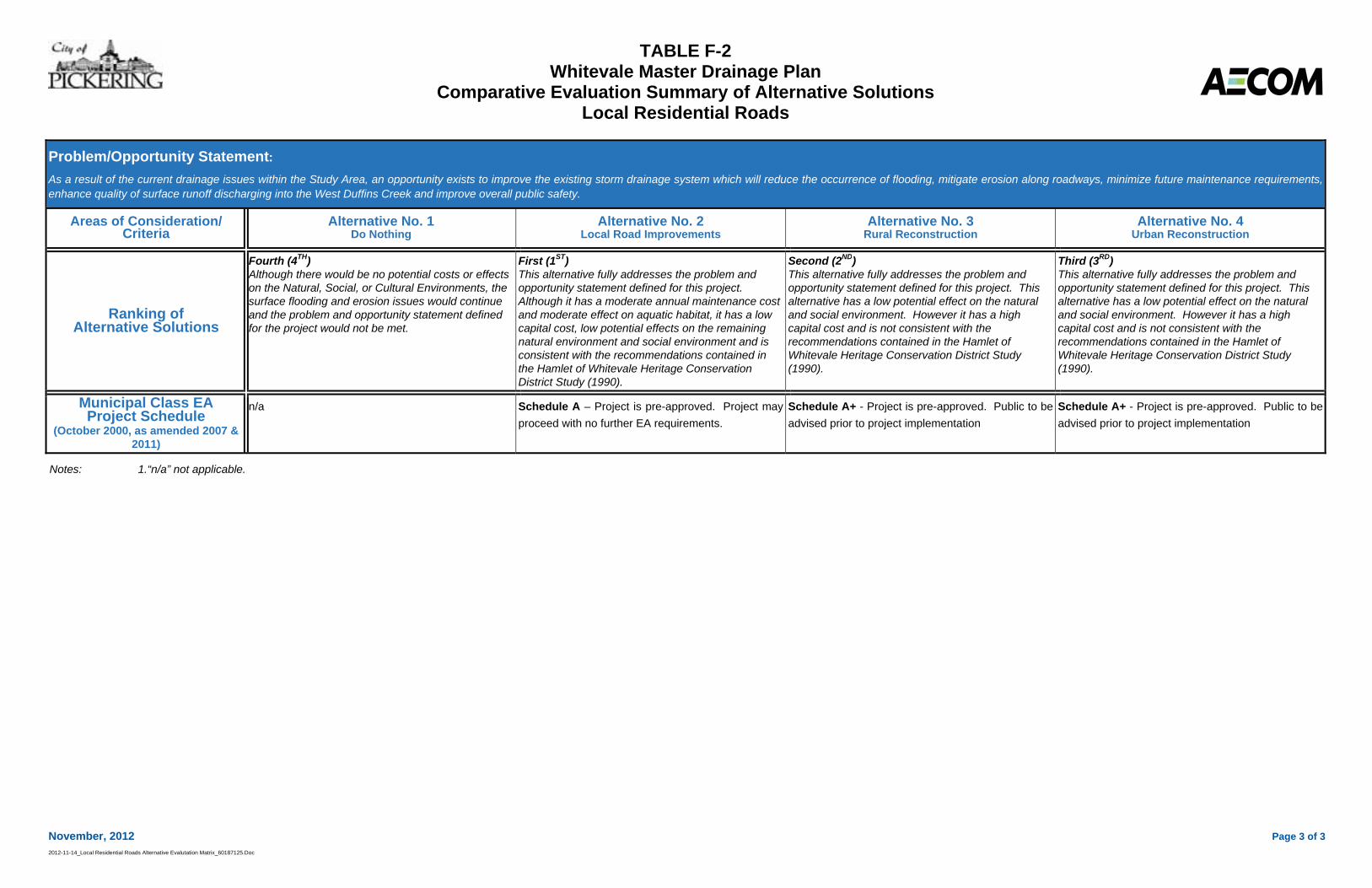
TABLE F-2 Whitevale Master Drainage Plan
Comparative Evaluation Summary of Alternative Solutions Local Residential Roads
November, 2012 Page 3 of 32012-11-14_Local Residential Roads Alternative Evalutation Matrix_60187125.Doc
Problem/Opportunity Statement:As a result of the current drainage issues within the Study Area, an opportunity exists to improve the existing storm drainage system which will reduce the occurrence of flooding, mitigate erosion along roadways, minimize future maintenance requirements,enhance quality of surface runoff discharging into the West Duffins Creek and improve overall public safety.
Areas of Consideration/ Criteria
Alternative No. 1Do Nothing
Alternative No. 2Local Road Improvements
Alternative No. 3Rural Reconstruction
Alternative No. 4Urban Reconstruction
Ranking of Alternative Solutions
Fourth (4TH)Although there would be no potential costs or effects on the Natural, Social, or Cultural Environments, the surface flooding and erosion issues would continue and the problem and opportunity statement defined for the project would not be met.
First (1ST)This alternative fully addresses the problem and opportunity statement defined for this project. Although it has a moderate annual maintenance cost and moderate effect on aquatic habitat, it has a low capital cost, low potential effects on the remaining natural environment and social environment and is consistent with the recommendations contained in the Hamlet of Whitevale Heritage Conservation District Study (1990).
Second (2ND)This alternative fully addresses the problem and opportunity statement defined for this project. This alternative has a low potential effect on the natural and social environment. However it has a high capital cost and is not consistent with the recommendations contained in the Hamlet of Whitevale Heritage Conservation District Study (1990).
Third (3RD)This alternative fully addresses the problem and opportunity statement defined for this project. This alternative has a low potential effect on the natural and social environment. However it has a high capital cost and is not consistent with the recommendations contained in the Hamlet of Whitevale Heritage Conservation District Study (1990).
Municipal Class EA Project Schedule
(October 2000, as amended 2007 & 2011)
n/a Schedule A – Project is pre-approved. Project may proceed with no further EA requirements.
Schedule A+ - Project is pre-approved. Public to be advised prior to project implementation
Schedule A+ - Project is pre-approved. Public to be advised prior to project implementation
Notes: 1.“n/a” not applicable.
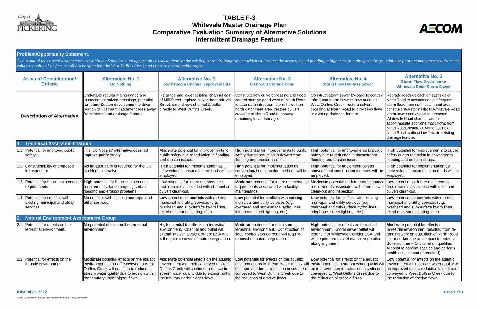
TABLE F-3 Whitevale Master Drainage Plan
Comparative Evaluation Summary of Alternative Solutions Intermittent Drainage Feature
November, 2012 Page 1 of 3 2013-03-20_Intermittent Drainage Feature Alternative Evalutation Matrix_60187125.Doc
Problem/Opportunity Statement: As a result of the current drainage issues within the Study Area, an opportunity exists to improve the existing storm drainage system which will reduce the occurrence of flooding, mitigate erosion along roadways, minimize future maintenance requirements, enhance quality of surface runoff discharging into the West Duffins Creek and improve overall public safety.
Areas of Consideration/ Criteria
Alternative No. 1 Do Nothing
Alternative No. 2 Downstream Channel Improvements
Alternative No. 3 Upstream Storage Pond
Alternative No. 4 Storm Flow By-Pass Sewer
Alternative No. 5 Storm Flow Diversion to
Whitevale Road Storm Sewer
Description of Alternative
Undertake regular maintenance and inspection at culvert crossings, potential for future Seaton development to divert portion of upstream catchment area away from intermittent drainage feature.
Re-grade and lower existing channel east of Mill Street, replace culvert beneath Mill Street, extend new channel & outlet directly to West Duffins Creek.
Construct new culvert crossing and flood control storage pond west of North Road to attenuate infrequent storm flows from north catchment area, restore culvert crossing at North Road to convey remaining local drainage.
Construct storm sewer by-pass to convey infrequent storm flows to new outlet at West Duffins Creek, restore culvert crossing at North Road to direct low flows to existing drainage feature.
Regrade roadside ditch on east side of North Road to accommodate infrequent storm flows from north catchment area, construct new storm inlet to Whitevale Road storm sewer and over-size proposed Whitevale Road storm sewer to accommodate additional flood flows from North Road, restore culvert crossing at North Road to direct low flows to existing drainage feature.
1. Technical Assessment Group 1.1 Potential for improved public
safety. The ‘Do Nothing’ alternative does not improve public safety.
Moderate potential for improvements to public safety due to reduction in flooding and erosion issues.
High potential for improvements to public safety due to reduction in downstream flooding and erosion issues.
High potential for improvements to public safety due to reduction in downstream flooding and erosion issues.
High potential for improvements to public safety due to reduction in downstream flooding and erosion issues.
1.2 Constructability of proposed infrastructure.
No infrastructure is required for the ‘Do Nothing’ alternative.
High potential for implementation as conventional construction methods will be employed.
High potential for implementation as conventional construction methods will be employed.
High potential for implementation as conventional construction methods will be employed.
High potential for implementation as conventional construction methods will be employed.
1.3 Potential for future maintenance requirements.
High potential for future maintenance requirements due to ongoing surface flooding and erosion problems.
Low potential for future maintenance requirements associated with channel and culvert clean-out.
Moderate potential for future maintenance requirements associated with facility maintenance.
Moderate potential for future maintenance requirements associated with storm sewer clean-out and inspection.
Low potential for future maintenance requirements associated with ditch and culvert clean-out.
1.4 Potential for conflicts with existing municipal and utility services.
No conflicts with existing municipal and utility services.
Low potential for conflicts with existing municipal and utility services (e.g. overhead and sub-surface hydro lines, telephone, street lighting, etc.).
Low potential for conflicts with existing municipal and utility services (e.g. overhead and sub-surface hydro lines, telephone, street lighting, etc.).
Low potential for conflicts with existing municipal and utility services (e.g. overhead and sub-surface hydro lines, telephone, street lighting, etc.).
Low potential for conflicts with existing municipal and utility services (e.g. overhead and sub-surface hydro lines, telephone, street lighting, etc.).
2. Natural Environment Assessment Group 2.1 Potential for effects on the
terrestrial environment. No potential effects on the terrestrial environment.
High potential for effects on terrestrial environment. Channel and outlet will extend into Whitevale Corridor ESA and will require removal of mature vegetation.
Moderate potential for effects on terrestrial environment. Construction of flood control storage pond will require removal of mature vegetation.
High potential for effects on terrestrial environment. Storm sewer outlet will extend into Whitevale Corridor ESA and will require removal of mature vegetation along alignment.
Moderate potential for effects on terrestrial environment resulting from re-grading work on east ditch of North Road i.e., root damage and impact to potential Butternut tree – City to retain qualified Arborist to confirm species and perform health assessment (if required)
2.2 Potential for effects on the aquatic environment.
Moderate potential effects on the aquatic environment as runoff conveyed to West Duffins Creek will continue to reduce in-stream water quality due to erosion within the tributary under higher flows.
Moderate potential effects on the aquatic environment as runoff conveyed to West Duffins Creek will continue to reduce in-stream water quality due to erosion within the tributary under higher flows.
Low potential for effects on the aquatic environment as in-stream water quality will be improved due to reduction in sediment conveyed to West Duffins Creek due to the reduction of erosive flows.
Low potential for effects on the aquatic environment as in-stream water quality will be improved due to reduction in sediment conveyed to West Duffins Creek due to the reduction of erosive flows.
Low potential for effects on the aquatic environment as in-stream water quality will be improved due to reduction in sediment conveyed to West Duffins Creek due to the reduction of erosive flows.
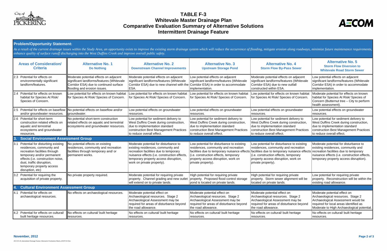
TABLE F-3 Whitevale Master Drainage Plan
Comparative Evaluation Summary of Alternative Solutions Intermittent Drainage Feature
November, 2012 Page 2 of 3 2013-03-20_Intermittent Drainage Feature Alternative Evalutation Matrix_60187125.Doc
Problem/Opportunity Statement: As a result of the current drainage issues within the Study Area, an opportunity exists to improve the existing storm drainage system which will reduce the occurrence of flooding, mitigate erosion along roadways, minimize future maintenance requirements, enhance quality of surface runoff discharging into the West Duffins Creek and improve overall public safety.
Areas of Consideration/ Criteria
Alternative No. 1 Do Nothing
Alternative No. 2 Downstream Channel Improvements
Alternative No. 3 Upstream Storage Pond
Alternative No. 4 Storm Flow By-Pass Sewer
Alternative No. 5 Storm Flow Diversion to
Whitevale Road Storm Sewer
2.3 Potential for effects on environmentally significant landform/features.
Moderate potential effects on adjacent significant landforms/features (Whitevale Corridor ESA) due to continued surface flooding and erosion issues.
Moderate potential effects on adjacent significant landforms/features (Whitevale Corridor ESA) due to new channel with the ESA.
Low potential effects on adjacent significant landforms/features (Whitevale Corridor ESA) in order to accommodate implementation.
Moderate potential effects on adjacent significant landforms/features (Whitevale Corridor ESA) due to new outfall constructed within ESA.
Low potential effects on adjacent significant landforms/features (Whitevale Corridor ESA) in order to accommodate implementation.
2.4 Potential for effects on known habitat for Species At Risk/ Species of Concern.
Low potential for effects on known habitat for Species At Risk/ Species of Concern.
Low potential for effects on known habitat for Species At Risk/ Species of Concern.
Low potential for effects on known habitat for Species At Risk/ Species of Concern.
Low potential for effects on known habitat for Species At Risk/ Species of Concern.
Moderate potential for effects on known habitat for Species At Risk/ Species of Concern (Butternut tree – City to perform health assessment).
2.5 Potential for effects on baseflow and/or groundwater resources.
No potential effects on baseflow and/or groundwater.
Low potential effects on groundwater resources.
Low potential effects on groundwater resources.
Low potential effects on groundwater resources.
Low potential effects on groundwater resources.
2.6 Potential for short-term construction related effects on aquatic and terrestrial ecosystems and groundwater resources.
No potential short-term construction related effects on aquatic and terrestrial ecosystems and groundwater resources.
Low potential for sediment delivery to West Duffins Creek during construction, due to implementation standard construction Best Management Practices to reduce overall effect.
Low potential for sediment delivery to West Duffins Creek during construction, due to implementation standard construction Best Management Practices to reduce overall effect.
Low potential for sediment delivery to West Duffins Creek during construction, due to implementation standard construction Best Management Practices to reduce overall effect.
Low potential for sediment delivery to West Duffins Creek during construction, due to implementation standard construction Best Management Practices to reduce overall effect.
3. Social Environment Assessment Group 3.1 Potential for disturbing existing
residences, community and recreation facilities through temporary and/or permanent effects (i.e. construction noise, dust, traffic disruption, temporary property access disruption, etc)
No potential effects on existing residences, community and recreation facilities through temporary and/ or permanent works.
Moderate potential for disturbance to existing residences, community and recreation facilities due to temporary nuisance effects (i.e. construction effects, temporary property access disruption, work on private property).
Low potential for disturbance to existing residences, community and recreation facilities due to temporary nuisance effects (i.e. construction effects, temporary property access disruption, work on private property).
Low potential for disturbance to existing residences, community and recreation facilities due to temporary nuisance effects (i.e. construction effects, temporary property access disruption, work on private property).
Moderate potential for disturbance to existing residences, community and recreation facilities due to temporary nuisance effects (i.e. construction effects, temporary property access disruption).
3.2 Potential for requiring the acquisition of private property.
No private property required. Moderate potential for requiring private property. Channel grading and new outlet will extend on to private lands.
High potential for requiring private property. Proposed flood control storage pond is located on private lands.
High potential for requiring private property. Storm sewer alignment will be located on private lands.
Low potential for requiring private property. Reconstruction will be within the existing road allowance.
4. Cultural Environment Assessment Group 4.1 Potential for effects on
archaeological resources. No effects on archaeological resources. Moderate potential effect on
Archaeological resources. Stage 2 Archaeological Assessment may be required for areas of disturbance beyond the road allowance.
Moderate potential effect on Archaeological resources. Stage 2 Archaeological Assessment may be required for areas of disturbance beyond the road allowance.
Moderate potential effect on Archaeological resources. Stage 2 Archaeological Assessment may be required for areas of disturbance beyond the road allowance.
Moderate potential effect on Archaeological resources. Stage 2 Archaeological Assessment would be required for local areas identified as Moderate to High Archaeological potential.
4.2 Potential for effects on cultural/ built heritage resources.
No effects on cultural/ built heritage resources.
No effects on cultural/ built heritage resources.
No effects on cultural/ built heritage resources.
No effects on cultural/ built heritage resources.
No effects on cultural/ built heritage resources.
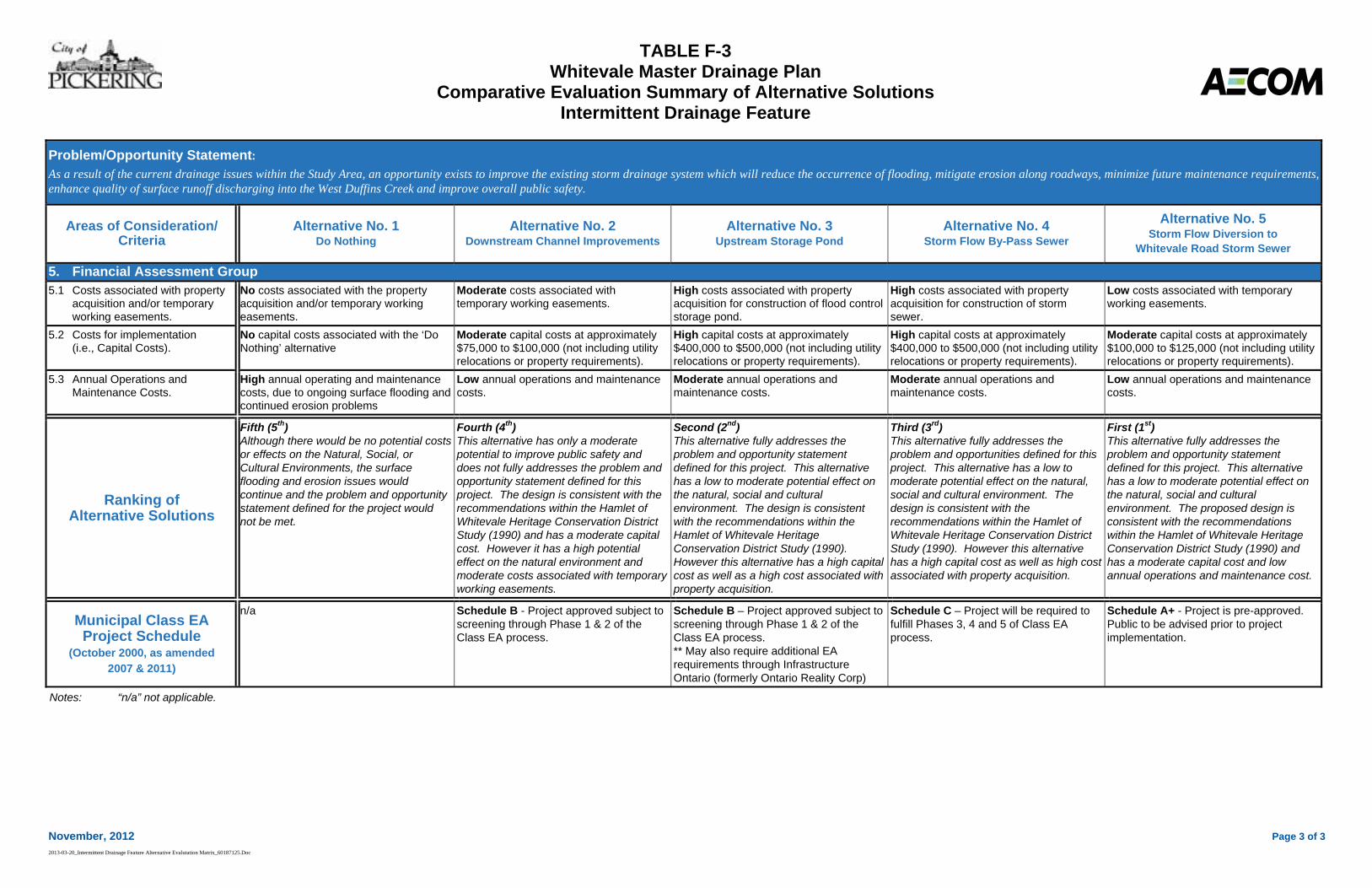
TABLE F-3 Whitevale Master Drainage Plan
Comparative Evaluation Summary of Alternative Solutions Intermittent Drainage Feature
November, 2012 Page 3 of 3 2013-03-20_Intermittent Drainage Feature Alternative Evalutation Matrix_60187125.Doc
Problem/Opportunity Statement: As a result of the current drainage issues within the Study Area, an opportunity exists to improve the existing storm drainage system which will reduce the occurrence of flooding, mitigate erosion along roadways, minimize future maintenance requirements, enhance quality of surface runoff discharging into the West Duffins Creek and improve overall public safety.
Areas of Consideration/ Criteria
Alternative No. 1 Do Nothing
Alternative No. 2 Downstream Channel Improvements
Alternative No. 3 Upstream Storage Pond
Alternative No. 4 Storm Flow By-Pass Sewer
Alternative No. 5 Storm Flow Diversion to
Whitevale Road Storm Sewer
5. Financial Assessment Group 5.1 Costs associated with property
acquisition and/or temporary working easements.
No costs associated with the property acquisition and/or temporary working easements.
Moderate costs associated with temporary working easements.
High costs associated with property acquisition for construction of flood control storage pond.
High costs associated with property acquisition for construction of storm sewer.
Low costs associated with temporary working easements.
5.2 Costs for implementation (i.e., Capital Costs).
No capital costs associated with the ‘Do Nothing’ alternative
Moderate capital costs at approximately $75,000 to $100,000 (not including utility relocations or property requirements).
High capital costs at approximately $400,000 to $500,000 (not including utility relocations or property requirements).
High capital costs at approximately $400,000 to $500,000 (not including utility relocations or property requirements).
Moderate capital costs at approximately $100,000 to $125,000 (not including utility relocations or property requirements).
5.3 Annual Operations and Maintenance Costs.
High annual operating and maintenance costs, due to ongoing surface flooding and continued erosion problems
Low annual operations and maintenance costs.
Moderate annual operations and maintenance costs.
Moderate annual operations and maintenance costs.
Low annual operations and maintenance costs.
Ranking of Alternative Solutions
Fifth (5th) Although there would be no potential costs or effects on the Natural, Social, or Cultural Environments, the surface flooding and erosion issues would continue and the problem and opportunity statement defined for the project would not be met.
Fourth (4th) This alternative has only a moderate potential to improve public safety and does not fully addresses the problem and opportunity statement defined for this project. The design is consistent with the recommendations within the Hamlet of Whitevale Heritage Conservation District Study (1990) and has a moderate capital cost. However it has a high potential effect on the natural environment and moderate costs associated with temporary working easements.
Second (2nd) This alternative fully addresses the problem and opportunity statement defined for this project. This alternative has a low to moderate potential effect on the natural, social and cultural environment. The design is consistent with the recommendations within the Hamlet of Whitevale Heritage Conservation District Study (1990). However this alternative has a high capital cost as well as a high cost associated with property acquisition.
Third (3rd) This alternative fully addresses the problem and opportunities defined for this project. This alternative has a low to moderate potential effect on the natural, social and cultural environment. The design is consistent with the recommendations within the Hamlet of Whitevale Heritage Conservation District Study (1990). However this alternative has a high capital cost as well as high cost associated with property acquisition.
First (1st) This alternative fully addresses the problem and opportunity statement defined for this project. This alternative has a low to moderate potential effect on the natural, social and cultural environment. The proposed design is consistent with the recommendations within the Hamlet of Whitevale Heritage Conservation District Study (1990) and has a moderate capital cost and low annual operations and maintenance cost.
Municipal Class EA Project Schedule
(October 2000, as amended 2007 & 2011)
n/a Schedule B - Project approved subject to screening through Phase 1 & 2 of the Class EA process.
Schedule B – Project approved subject to screening through Phase 1 & 2 of the Class EA process. ** May also require additional EA requirements through Infrastructure Ontario (formerly Ontario Reality Corp)
Schedule C – Project will be required to fulfill Phases 3, 4 and 5 of Class EA process.
Schedule A+ - Project is pre-approved. Public to be advised prior to project implementation.
Notes: “n/a” not applicable.
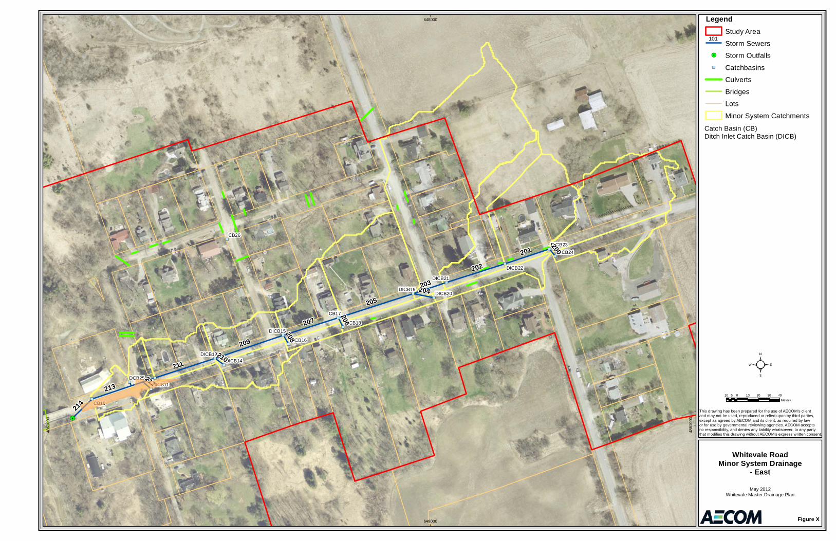
CB26
CB17
CB10
DCB25
DICB22
DICB23DICB24
DICB20
DICB18
DICB19
DICB21
DICB16
DICB13
DICB15
DICB14
DICB11
205
209
213
211
202
207
201
203
214
200204
210
208
206
212
648000
648000
4861
000
4861
000
LegendStudy Area
Storm Sewers
Storm Outfalls
Catchbasins
Culverts
Bridges
Lots
Minor System Catchments
Figure X
Whitevale RoadMinor System Drainage
- East
May 2012Whitevale Master Drainage Plan
This drawing has been prepared for the use of AECOM’s client and may not be used, reproduced or relied upon by third parties,except as agreed by AECOM and its client, as required by law or for use by governmental reviewing agencies. AECOM accepts no responsibility, and denies any liability whatsoever, to any partythat modifies this drawing without AECOM’s express written consent.
10 0 10 20 30 405Meters
101
Catch Basin (CB)Ditch Inlet Catch Basin (DICB)
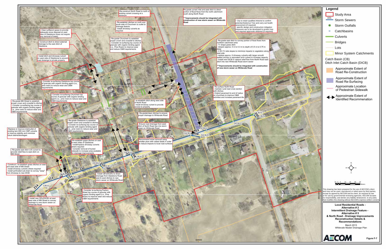
- City to retain qualified Arborist to confirm potential Butternut Tree and carry out health assessment (if required)- specific design and construction mitigation measures are to be developed to protect tree and required approvals obtained (if required)
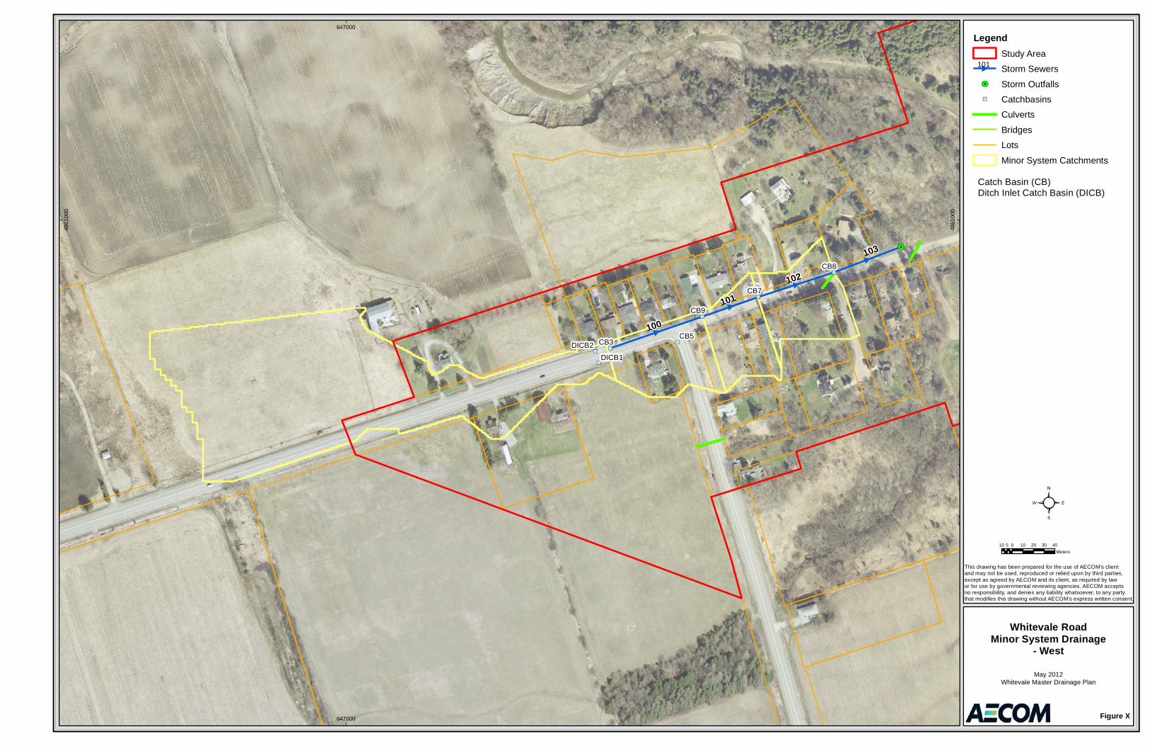
CB8
CB5
CB9
CB7
CB3
DICB1DICB2
100
102
103
101
647000
647000
4861
000
4861
000
LegendStudy Area
Storm Sewers
Storm Outfalls
Catchbasins
Culverts
Bridges
Lots
Minor System Catchments
Figure X
Whitevale RoadMinor System Drainage
- West
May 2012Whitevale Master Drainage Plan
This drawing has been prepared for the use of AECOM’s client and may not be used, reproduced or relied upon by third parties,except as agreed by AECOM and its client, as required by law or for use by governmental reviewing agencies. AECOM accepts no responsibility, and denies any liability whatsoever, to any partythat modifies this drawing without AECOM’s express written consent.
10 0 10 20 30 405Meters
101
Catch Basin (CB)Ditch Inlet Catch Basin (DICB)

03rb_2013-03-01_App Tps_60187125.Docx
Appendix G Public Consultation
Whitevale Drainage Master Plan Class EA Preliminary Contact List
No. Stakeholder Contact Name Title Address Phone E-mail
Provincial, Federal and Municipal Agencies
1 Ministry of Environment (MOE) [email protected] 14th Floor, 2 St. Clair Ave. West Toronto ON M4V 1L5
2 Ministry of the Environment (MOE) Central Region Office
Greg Sones Director (Acting) 5775 Yonge Street, 8th Floor North York ON M2M 4J1
416-326-1825 [email protected]
3 Ministry of Natural Resources (MNR) Steve Strong District Planner – Aurora District 50 Bloomington Rd W Aurora ON L4G 3G8
905-713-7366 [email protected]
4 Ministry of Culture (MCL) Paula Kulpa Heritage Planner (Acting) Suite 1700 401 Bay Street Toronto, ON M7A 0A7
416-314-7137 [email protected]
5 Ministry of Aboriginal Affairs (MAA) David Pickles Team Lead Consultation Unit
9th Flr, 160 Bloor St E Toronto ON M7A 2E6
(416) 326-4754 [email protected]
6 Ministry of Municipal Affairs and Housing (MMAH) Central Municipal Service Office
Victor Doyle Manager Community Planning and Development
2nd Floor, 777 Bay Street Toronto ON M5G 2E5
(416) 585-6109 [email protected]
7 Ontario Realty Corporation (ORC) Lisa Myslicki Environmental Coordinator 1 Dundas Street West, Suite 2000, Toronto, Ontario M5G 2L5
(416) 212-3768 [email protected]
8 Hydro One Networks Inc. (HONI) Leslie Koch Transmission Lines Sustainment Manager
483 Bay Street, TCT15-A11, North Tower, Toronto ON M5G 2P5
416 345-6275 [email protected]
9 Ontario Provincial Police (OPP) Michael Burger Facilities, Emergency Management & Security Branch,
17th Floor, 25 Grosvenor Street Toronto ON M7A 1Y6
(416) 314-1016 [email protected]
10 Canadian Environmental Assessment Agency (CEAA)
Louise Knox Regional Director Ontario Region
55 St-Clair Avenue East, Room 907 Toronto, Ontario M4T 1M2
(416) 952-1575 [email protected]
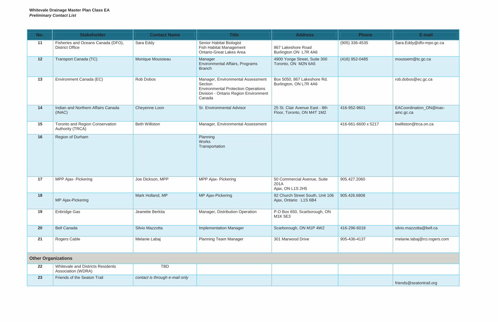
Whitevale Drainage Master Plan Class EA Preliminary Contact List
No. Stakeholder Contact Name Title Address Phone E-mail 11 Fisheries and Oceans Canada (DFO),
District Office Sara Eddy Senior Habitat Biologist
Fish Habitat Management Ontario-Great Lakes Area
867 Lakeshore Road Burlington ON L7R 4A6
(905) 336-4535 [email protected]
12 Transport Canada (TC) Monique Mousseau Manager Environmental Affairs, Programs Branch
4900 Yonge Street, Suite 300 Toronto, ON M2N 6A5
(416) 952-0485 [email protected]
13 Environment Canada (EC) Rob Dobos Manager, Environmental Assessment Section Environmental Protection Operations Division - Ontario Region Environment Canada
Box 5050, 867 Lakeshore Rd. Burlington, ON L7R 4A6
14 Indian and Northern Affairs Canada (INAC)
Cheyenne Loon Sr. Environmental Advisor 25 St. Clair Avenue East - 8th Floor, Toronto, ON M4T 1M2
416-952-9601 [email protected]
15 Toronto and Region Conservation Authority (TRCA)
Beth Williston Manager, Environmental Assessment 416-661-6600 x 5217 [email protected]
16 Region of Durham Planning Works Transportation
17 MPP Ajax- Pickering Joe Dickson, MPP MPP Ajax- Pickering 50 Commercial Avenue, Suite 201A Ajax, ON L1S 2H5
905.427.2060
18 MP Ajax-Pickering
Mark Holland, MP MP Ajax-Pickering 92 Church Street South, Unit 106 Ajax, Ontario L1S 6B4
905.426.6808
19 Enbridge Gas Jeanette Berkita Manager, Distribution Operation P.O Box 650, Scarborough, ON M1K 5E3
20 Bell Canada Silvio Mazzotta Implementation Manager Scarborough, ON M1P 4W2 416-296-6018 [email protected]
21 Rogers Cable Melanie Labaj Planning Team Manager 301 Marwood Drive 905-436-4137 [email protected]
Other Organizations
22 Whitevale and Districts Residents Association (WDRA)
TBD
23 Friends of the Seaton Trail contact is through e-mail only [email protected]
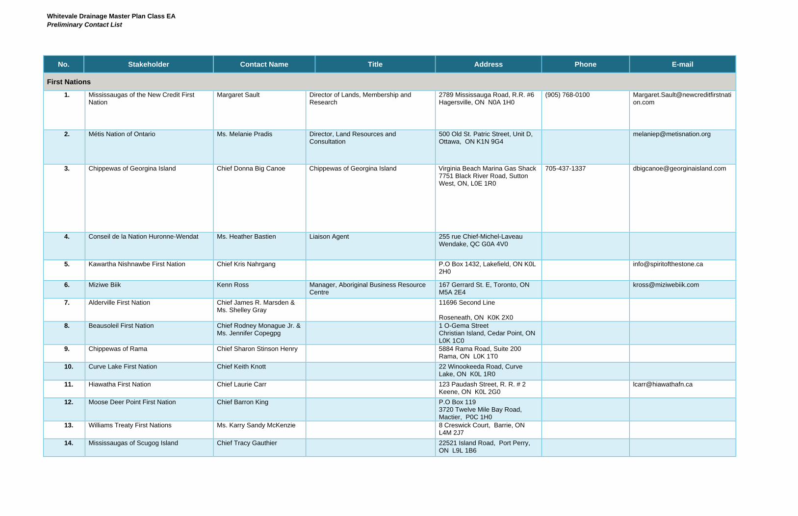
Whitevale Drainage Master Plan Class EA Preliminary Contact List
No. Stakeholder Contact Name Title Address Phone E-mail
First Nations
1. Mississaugas of the New Credit First Nation
Margaret Sault Director of Lands, Membership and Research
2789 Mississauga Road, R.R. #6 Hagersville, ON N0A 1H0
(905) 768-0100 [email protected]
2. Métis Nation of Ontario Ms. Melanie Pradis Director, Land Resources and Consultation
500 Old St. Patric Street, Unit D, Ottawa, ON K1N 9G4
3. Chippewas of Georgina Island Chief Donna Big Canoe Chippewas of Georgina Island Virginia Beach Marina Gas Shack 7751 Black River Road, Sutton West, ON, L0E 1R0
705-437-1337 [email protected]
4. Conseil de la Nation Huronne-Wendat Ms. Heather Bastien Liaison Agent 255 rue Chief-Michel-Laveau Wendake, QC G0A 4V0
5. Kawartha Nishnawbe First Nation Chief Kris Nahrgang P.O Box 1432, Lakefield, ON K0L 2H0
6. Miziwe Biik Kenn Ross Manager, Aboriginal Business Resource Centre
167 Gerrard St. E, Toronto, ON M5A 2E4
7. Alderville First Nation Chief James R. Marsden & Ms. Shelley Gray
11696 Second Line
Roseneath, ON K0K 2X0 8. Beausoleil First Nation Chief Rodney Monague Jr. &
Ms. Jennifer Copegpg 1 O-Gema Street Christian Island, Cedar Point, ON L0K 1C0
9. Chippewas of Rama Chief Sharon Stinson Henry 5884 Rama Road, Suite 200 Rama, ON L0K 1T0
10. Curve Lake First Nation Chief Keith Knott 22 Winookeeda Road, Curve Lake, ON K0L 1R0
11. Hiawatha First Nation Chief Laurie Carr 123 Paudash Street, R. R. # 2 Keene, ON K0L 2G0
12. Moose Deer Point First Nation Chief Barron King P.O Box 119 3720 Twelve Mile Bay Road, Mactier, P0C 1H0
13. Williams Treaty First Nations Ms. Karry Sandy McKenzie 8 Creswick Court, Barrie, ON L4M 2J7
14. Mississaugas of Scugog Island Chief Tracy Gauthier 22521 Island Road, Port Perry, ON L9L 1B6
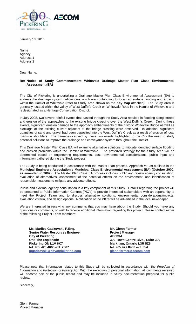
January 13, 2010
Name Agency Address 1 Address 2
Dear Name:
Re: Notice of Study Commencement Whitevale Drainage Master Plan Class Environmental Assessment (EA)
The City of Pickering is undertaking a Drainage Master Plan Class Environmental Assessment (EA) to address the drainage system deficiencies which are contributing to localized surface flooding and erosion within the Hamlet of Whitevale (refer to Study Area shown on the Key Map attached). The Study Area is generally located within the valley of West Duffin’s Creek on Whitevale Road in the Hamlet of Whitevale and is designated as a Heritage Conservation District.
In July 2008, two severe rainfall events that passed through the Study Area resulted in flooding along streets and erosion of the approaches to the existing bridge crossing over the West Duffin’s Creek. During these events, significant erosion damage to the approach embankments of the historic Whitevale Bridge as well as blockage of the existing culvert adjacent to the bridge crossing were observed. In addition, significant quantities of sand and gravel had been deposited into the West Duffin’s Creek as a result of erosion of local roadside shoulders. The damages caused by these two events highlighted to the City the need to study potential solutions to improve the drainage and conveyance system throughout the Hamlet.
This Drainage Master Plan Class EA will examine alternative solutions to mitigate identified surface flooding and erosion problems within the Hamlet of Whitevale. The preferred strategy for the Study Area will be determined based on engineering requirements, cost, environmental considerations, public input and information gathered during the Study process.
The Study is being conducted in accordance with the Master Plan process, Approach #2, as outlined in the Municipal Engineers Association’s Municipal Class Environmental Assessment (EA) (October 2000, as amended in 2007). The Master Plan Class EA process includes public and review agency consultation, evaluation of alternatives, assessment of the potential effects on the environment, and identification of reasonable measures to mitigate any adverse effects.
Public and external agency consultation is a key component of this Study. Details regarding the project will be presented at Public Information Centres (PIC’s) to provide interested stakeholders with an opportunity to meet the Project Team and to discuss alternative solutions, environmental considerations/impacts, evaluation criteria, and design options. Notification of the PIC’s will be advertised in the local newspaper.
We are interested in receiving any comments that you may have about the Study. Should you have any questions or comments, or wish to receive additional information regarding this project, please contact either of the following Project Team members:
Ms. Marilee Gadzovski, P.Eng. Senior Water Resources Engineer City of Pickering One The Esplanade Pickering ON L1V 6K7 tel: 905.420.4660 ext. 2067 [email protected]
Mr. Glenn Farmer Project Manager AECOM 300 Town Centre Blvd., Suite 300 Markham, Ontario L3R 5Z6 tel: 905.477.8400 ext. 354 [email protected]
Please note that information related to this Study will be collected in accordance with the Freedom of Information and Protection of Privacy Act. With the exception of personal information, all comments received will become part of the public record and may be included in Study documentation prepared for public review.
Sincerely,
Glenn Farmer Project Manager
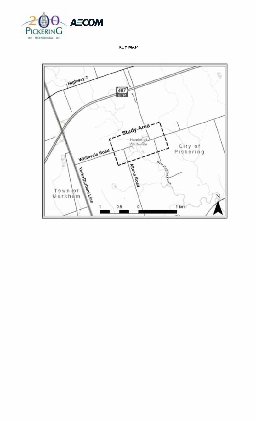
KEY MAP

Notice of Study Commencement Whitevale Drainage Master Plan
Class Environmental Assessment (EA) The City of Pickering is undertaking a Drainage Master Plan Class Environmental Assessment (EA) to address the drainage system deficiencies which are contributing to localized surface flooding and erosion within the Hamlet of Whitevale (refer to Study Area shown on the Key Map below). The Study Area is generally located within the valley of West Duffin’s Creek on Whitevale Road in the Hamlet of Whitevale and is designated as a Heritage Conservation District.
KEY MAP
In July 2008, two severe rainfall events that passed through the Study Area resulted in flooding along streets and erosion of the approaches to the existing bridge crossing over the West Duffin’s Creek. During these events, significant erosion damage to the approach embankments of the historic Whitevale Bridge as well as blockage of the existing culvert adjacent to the bridge crossing were observed. In addition, significant quantities of sand and gravel had been deposited into the West Duffin’s Creek as a result of erosion of local roadside shoulders. The damages caused by these two events highlighted to the City the need to implement potential solutions to improve the drainage and conveyance system throughout the Hamlet.
This Drainage Master Plan Class EA will examine alternative solutions to mitigate identified surface flooding and erosion problems within the Hamlet of Whitevale and will also assess opportunities to provide additional stormwater management treatment of surface runoff through the use of Low Impact Development measures. The preferred strategy for the Study Area will be determined based on engineering requirements, environmental considerations, public input and information gathered during the Study process.
The Study is being conducted in accordance with the Master Plan process as outlined in the Municipal Engineers Association’s Municipal Class Environmental Assessment (EA) (October 2000, as amended in 2007). The Master Plan Class EA process includes public and review agency consultation, evaluation of alternatives, assessment of the potential effects on the environment, and identification of reasonable measures to mitigate any adverse effects.
Public and external agency consultation is a key component of this Study. Details regarding the project will be presented at Public Information Centres (PIC’s) to provide interested stakeholders with an opportunity to meet the Project Team and to discuss alternative solutions, environmental considerations/impacts, evaluation criteria, and design options. Notification of the PIC’s will be advertised in the local newspaper and posted on the City’s website: www.cityofpickering.com.
We are interested in receiving any comments that you may have about the Study. Should you have any questions or comments, or wish to receive additional information regarding this project, please contact either of the following Project Team members:
Ms. Marilee Gadzovski, P.Eng. Stormwater & Environmental Engineer City of Pickering One The Esplanade Pickering ON L1V 6K7 tel: 905.420.4660 ext. 2067 fax: 905.420.4650 [email protected]
Mr. Glenn Farmer Project Manager AECOM 300 Town Centre Blvd., Suite 300 Markham, Ontario L3R 5Z6 tel: 905.477.8400 ext. 354 fax: 905.477.1456 [email protected]
Please note that information related to this Study will be collected in accordance with the Freedom of Information and Protection of Privacy Act. With the exception of personal information, all comments received will become part of the public record and may be included in Study documentation prepared for public review.
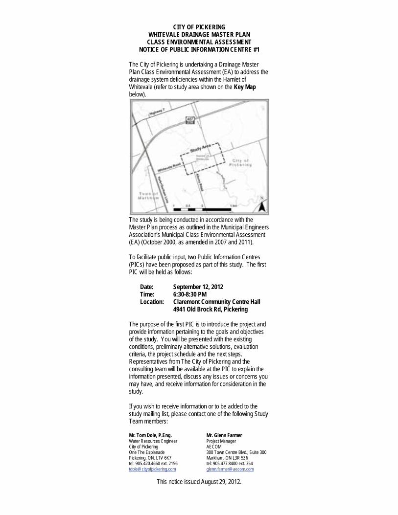
CITY OF PICKERING WHITEVALE DRAINAGE MASTER PLAN CLASS ENVIRONMENTAL ASSESSMENT
NOTICE OF PUBLIC INFORMATION CENTRE #1
The City of Pickering is undertaking a Drainage Master Plan Class Environmental Assessment (EA) to address the drainage system deficiencies within the Hamlet of Whitevale (refer to study area shown on the Key Mapbelow).
The study is being conducted in accordance with the Master Plan process as outlined in the Municipal Engineers Association’s Municipal Class Environmental Assessment (EA) (October 2000, as amended in 2007 and 2011).
To facilitate public input, two Public Information Centres (PICs) have been proposed as part of this study. The first PIC will be held as follows:
Date: September 12, 2012Time: 6:30-8:30 PMLocation: Claremont Community Centre Hall
4941 Old Brock Rd, Pickering
The purpose of the first PIC is to introduce the project and provide information pertaining to the goals and objectives of the study. You will be presented with the existing conditions, preliminary alternative solutions, evaluation criteria, the project schedule and the next steps. Representatives from The City of Pickering and the consulting team will be available at the PIC to explain the information presented, discuss any issues or concerns you may have, and receive information for consideration in the study.
If you wish to receive information or to be added to the study mailing list, please contact one of the following Study Team members:
Mr. Tom Dole, P.Eng. Mr. Glenn Farmer Water Resources Engineer Project Manager City of Pickering AECOM One The Esplanade 300 Town Centre Blvd., Suite 300 Pickering, ON, L1V 6K7 Markham, ON L3R 5Z6 tel: 905.420.4660 ext. 2156 tel: 905.477.8400 ext. 354 [email protected] [email protected]
This notice issued August 29, 2012.
August 27, 2012 1155886 Ontario Inc. 425 Whitevale Road Whitevale, ON L0H 1M0 Dear Sir/Madam: Regarding: Notice of Public Information Centre # 1
Whitevale Drainage Master Plan Class Environmental Assessment (EA) The City of Pickering is undertaking a Drainage Master Plan Class Environmental Assessment (EA) to address the drainage system deficiencies within the Hamlet of Whitevale (refer to Study Area shown on the Key Map attached). The study is being conducted in accordance with the Master Plan process as outlined in the Municipal Engineers Association’s Municipal Class Environmental Assessment (EA) (October 2000, as amended in 2007 and 2011). To facilitate public input, two Public Information Centres (PICs) have been proposed as part of this study. The first PIC will be held as follows:
Date: ................ Wednesday, September 12, 2012 Time: ............... 6:30 to 8:30 p.m. Location: ......... Claremont Community Centre Hall,
4941 Old Brock Road, Pickering The purpose of the first PIC is to introduce the project and provide information pertaining to the goals and objectives of the study. You will be presented with the existing conditions, preliminary alternative solutions, evaluation criteria, the project schedule and the next steps. Representatives from The City of Pickering and the consulting team will be available at the PIC to explain the information presented, discuss any issues or concerns you may have, and receive information for consideration in the study. If you wish to receive information or to be added to the study mailing list, please contact one of the following Study Team members:
Mr. Tom Dole, P.Eng. Water Resources Engineer City of Pickering One The Esplanade Pickering, ON L1V 6K7 Tel: ..... 905.420.4660 ext. 2156 Email: . [email protected]
Mr. Glenn Farmer Project Manager AECOM 300 Town Centre Blvd., Suite 300 Markham, ON L3R 5Z6 Tel: .......... 905.477.8400 ext. 354 Email: ...... [email protected]
Please note that information related to this study will be collected in accordance with the Freedom of Information and Protection of Privacy Act. With the exception of personal information, all comments received will become part of the public record and may be included in study documentation prepared for public review. Sincerely,
`
Glenn Farmer Project Manager AECOM Canada Ltd.
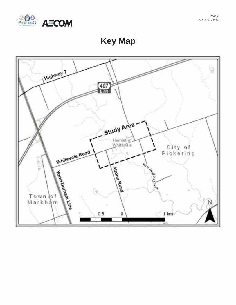
Page 2 August 27, 2012
Key Map

Whitevale Master Drainage Plan Whitevale Master Drainage Plan Class EA
Whitevale Master Drainage Plan Class Environmental Assessment Public Information Centre #1
• Please sign-in on the sheet provided. Then feel free to walk around and view the display boards
• If you have any questions, our staff will be pleased to discuss them with you
• Comment sheets are also provided for those who wish to provide written comments
• Please place your completed sheets in the Comment Box or take them with you and mail/fax to one of the Study contacts
1 9/12/2012
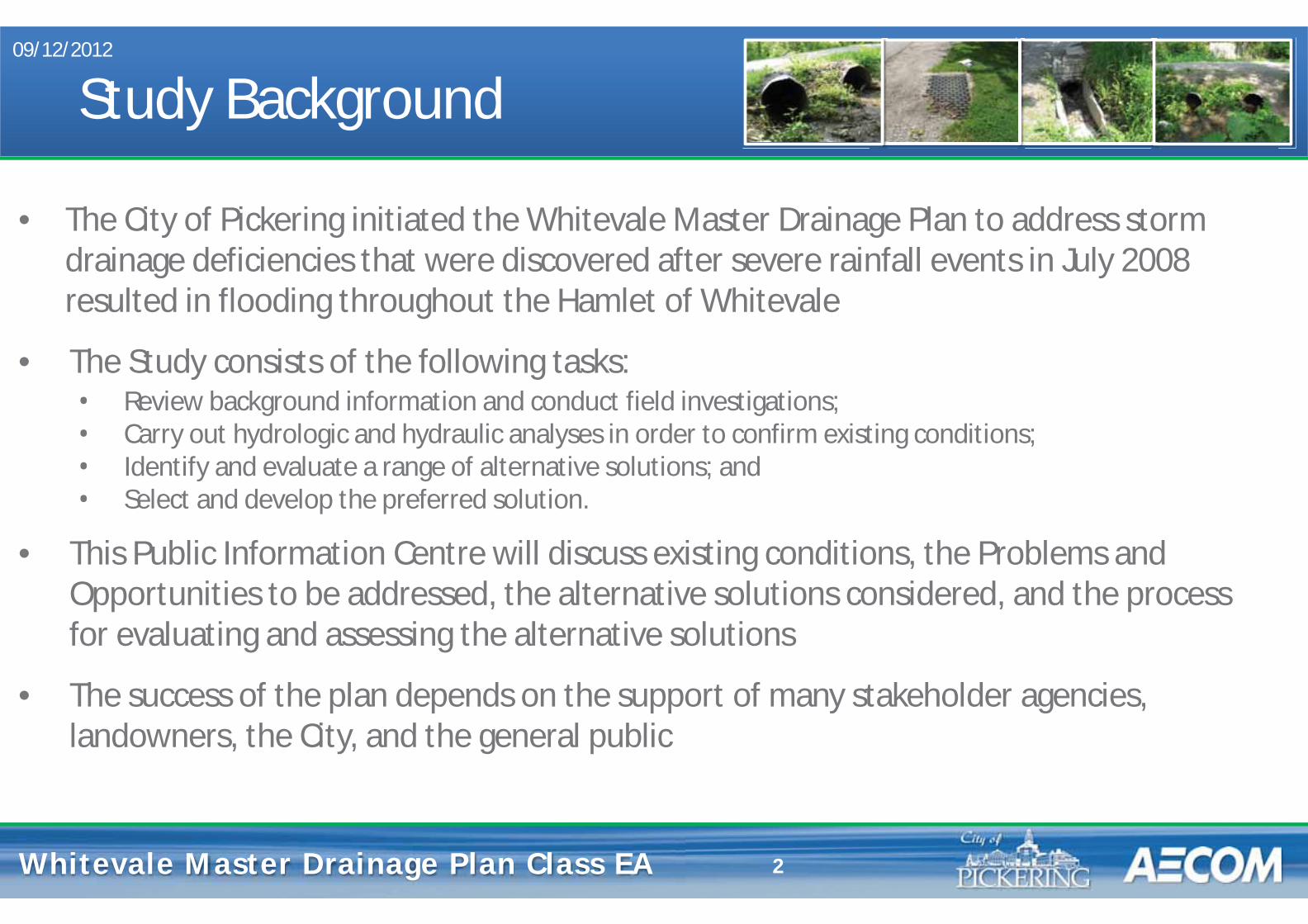
Whitevale Master Drainage Plan Whitevale Master Drainage Plan Class EA
Study Background
• The City of Pickering initiated the Whitevale Master Drainage Plan to address storm drainage deficiencies that were discovered after severe rainfall events in July 2008 resulted in flooding throughout the Hamlet of Whitevale
• The Study consists of the following tasks: • Review background information and conduct field investigations; • Carry out hydrologic and hydraulic analyses in order to confirm existing conditions; • Identify and evaluate a range of alternative solutions; and • Select and develop the preferred solution.
• This Public Information Centre will discuss existing conditions, the Problems and Opportunities to be addressed, the alternative solutions considered, and the process for evaluating and assessing the alternative solutions
• The success of the plan depends on the support of many stakeholder agencies, landowners, the City, and the general public
09/12/2012
2
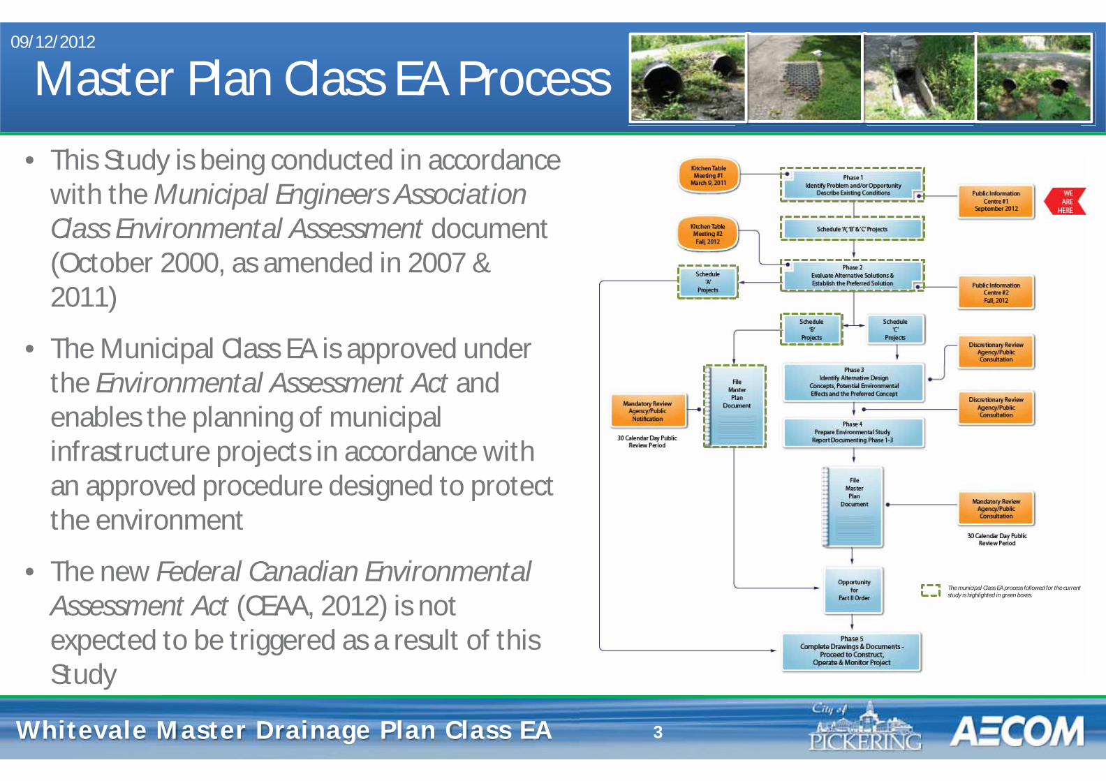
Whitevale Master Drainage Plan Whitevale Master Drainage Plan Class EA
Master Plan Class EA Process • This Study is being conducted in accordance
with the Municipal Engineers Association Class Environmental Assessment document (October 2000, as amended in 2007 & 2011)
• The Municipal Class EA is approved under the Environmental Assessment Act and enables the planning of municipal infrastructure projects in accordance with an approved procedure designed to protect the environment
• The new Federal Canadian Environmental Assessment Act (CEAA, 2012) is not expected to be triggered as a result of this Study
09/12/2012
3
The municipal Class EA process followed for the current study is highlighted in green boxes.

Whitevale Master Drainage Plan Whitevale Master Drainage Plan Class EA
Study Area • The Study Area consists of the Hamlet of
Whitevale • Located within the valley of West Duffins
Creek on Whitevale Road in the City of Pickering
• Designated as a Heritage Conservation District
• Total area of approximately 37 ha • Existing conditions peak flow and
capacity assessment also considered the catchment areas that contribute to the West Duffins Creek within the Study Area
09/12/2012
4

Whitevale Master Drainage Plan Whitevale Master Drainage Plan Class EA
Problem & Opportunity Statement
Severe rainfall events in July 2008 within the Study Area resulted in flooding along streets and several properties, and erosion of the approaches to the historic Whitevale bridge crossing over West Duffins Creek causing:
• significant damage along the approach embankments; • damage/blockage of the existing storm sewer outfall next to the bridge crossing; • significant quantities of sand and gravel deposited into the watercourse; and • localized flooding due to excess runoff from surrounding lands and damage to private property.
As a result of the current drainage issues within the Study Area, an opportunity exists to improve the storm drainage system which will:
• reduce the occurrence of flooding; • mitigate erosion along roadways; • minimize future maintenance requirements; • enhance the quality of surface runoff discharging into the West Duffins Creek; and • improve overall public safety
09/12/2012
5

Whitevale Master Drainage Plan Whitevale Master Drainage Plan Class EA 6
Existing Conditions: Land Use and Cultural Heritage 09/12/2012
• Existing land uses within the Study Area and immediate vicinity include agricultural, forest, open space and residential
• Hamlet of Whitevale designated a Heritage Conservation District
• Stage 1 Archaeological Assessment completed for Study Area in 2011 revealed:
o no recorded archaeological sites within the Study Area boundary; o19 recorded sites within a 1 km radius of the Study Area;
o a low archaeological potential within a majority of the Study Area (i.e., within road allowances); and
o 11 locations (i.e., within road allowances) with medium to high archaeological potential that will require a Stage 2 archaeological investigation should disturbance be proposed.
Impervious Areas
Forest / Vegetated
(i.e., within road allowances)
Study Area Boundary

Whitevale Master Drainage Plan Whitevale Master Drainage Plan Class EA 7
Existing Conditions: Natural Environment 09/12/2012
• Whitevale Corridor located through the central portion of the Study Area and is designated an Environmentally Sensitive Area (ESA) • Toronto & Region Conservation(TRCA’s) Targeted Terrestrial Natural Heritage System (TNHS) identifies additional areas of restoration • Additional 2011 field observations (i.e., within road allowances) confirm a number of locations with notable vegetation (i.e., mature trees) as well as local areas with steep slopes
Notable Vegetation (within road allowance)
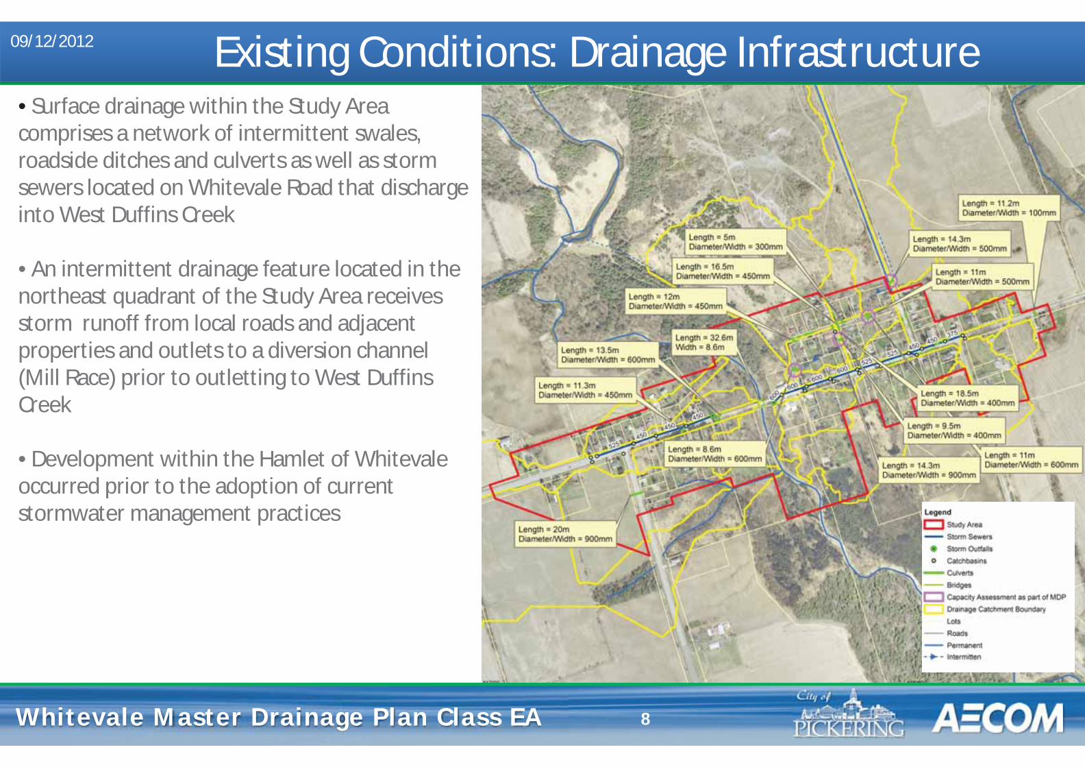
Whitevale Master Drainage Plan Whitevale Master Drainage Plan Class EA 8
Existing Conditions: Drainage Infrastructure 09/12/2012
• Surface drainage within the Study Area comprises a network of intermittent swales, roadside ditches and culverts as well as storm sewers located on Whitevale Road that discharge into West Duffins Creek • An intermittent drainage feature located in the northeast quadrant of the Study Area receives storm runoff from local roads and adjacent properties and outlets to a diversion channel (Mill Race) prior to outletting to West Duffins Creek • Development within the Hamlet of Whitevale occurred prior to the adoption of current stormwater management practices

Whitevale Master Drainage Plan Whitevale Master Drainage Plan Class EA 9
Existing Conditions: Peak Flow Assessment 09/12/2012
• A peak flow assessment was carried out for the existing Study Area including contributing external drainage areas • Storm event rainfall was determined in accordance with the City of Pickering’s Stormwater Management Design Guidelines • Radar data obtained for July 23, 2008 confirmed that the Study Area was subject to a severe storm event that was not recorded at adjacent rain gauge stations • Peak flows were calculated at key locations within the Study Area and used as input to the capacity assessment undertaken for the storm drainage system

Whitevale Master Drainage Plan Whitevale Master Drainage Plan Class EA 10
Existing Conditions: Drainage Capacity Assessment 09/12/2012
• Inventory and field survey of the storm drainage system and adjacent structures within the Study Area was completed in 2011 • Narrow 100-year flood plain exists along the intermittent drainage feature due to the steep slope • Two ancillary structures are subject to flooding under the 100-year flow • New Gladstone Road culvert crossing is sufficient to convey the 100-year flow without overtopping • North Road culvert is in poor condition and overtops above a 5-year flow with spill to the south • Spill upstream of Mill Street above a 2-year flow is directed towards Whitevale Road due to existing road and ditch grades
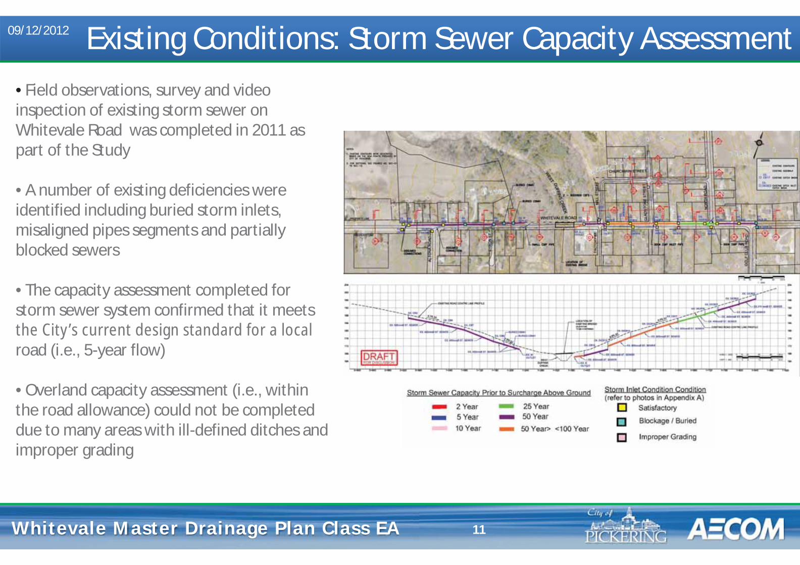
Whitevale Master Drainage Plan Whitevale Master Drainage Plan Class EA 11
• Field observations, survey and video inspection of existing storm sewer on Whitevale Road was completed in 2011 as part of the Study
• A number of existing deficiencies were identified including buried storm inlets, misaligned pipes segments and partially blocked sewers • The capacity assessment completed for storm sewer system confirmed that it meets the City’s current design standard for a local road (i.e., 5-year flow) • Overland capacity assessment (i.e., within the road allowance) could not be completed due to many areas with ill-defined ditches and improper grading
Existing Conditions: Storm Sewer Capacity Assessment 09/12/2012
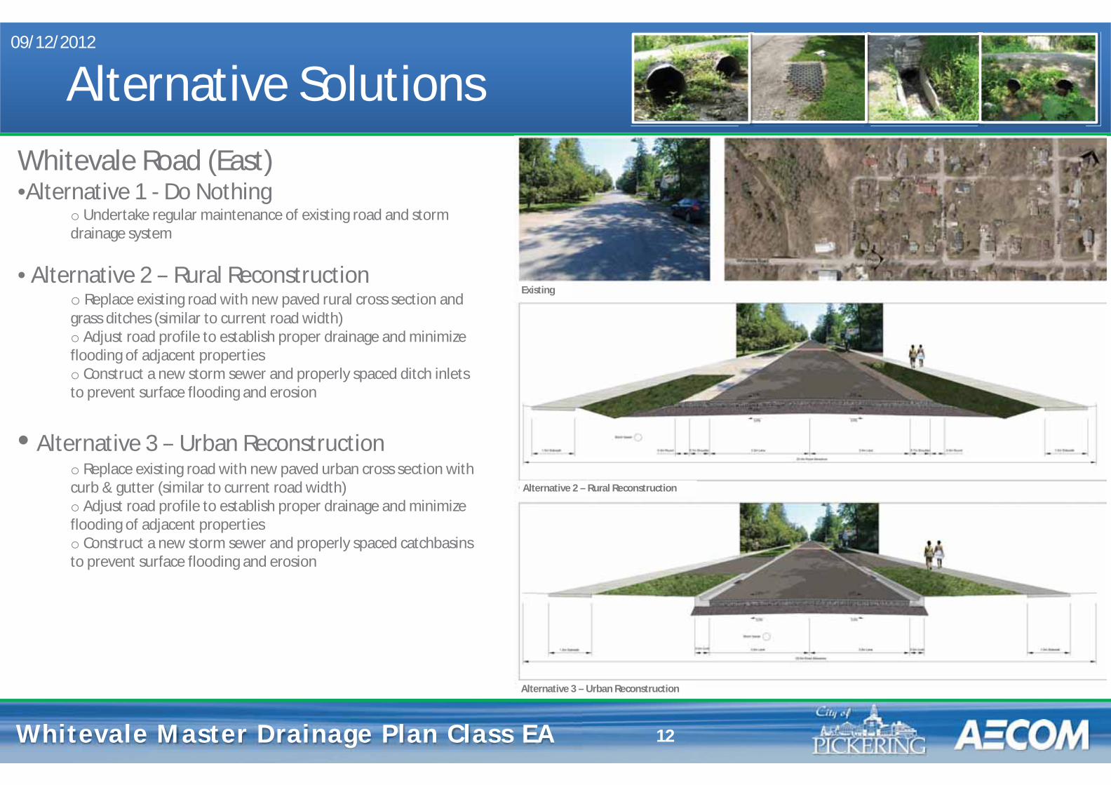
Whitevale Master Drainage Plan Whitevale Master Drainage Plan Class EA
Alternative Solutions 09/12/2012
12
Whitevale Road (East) •Alternative 1 - Do Nothing
o Undertake regular maintenance of existing road and storm drainage system
• Alternative 2 – Rural Reconstruction o Replace existing road with new paved rural cross section and grass ditches (similar to current road width) o Adjust road profile to establish proper drainage and minimize flooding of adjacent properties o Construct a new storm sewer and properly spaced ditch inlets to prevent surface flooding and erosion
• Alternative 3 – Urban Reconstruction o Replace existing road with new paved urban cross section with curb & gutter (similar to current road width) o Adjust road profile to establish proper drainage and minimize flooding of adjacent properties o Construct a new storm sewer and properly spaced catchbasins to prevent surface flooding and erosion
Existing
Alternative 2 – Rural Reconstruction
Alternative 3 – Urban Reconstruction
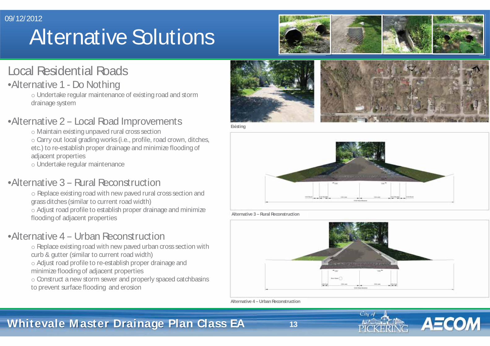
Whitevale Master Drainage Plan Whitevale Master Drainage Plan Class EA
Alternative Solutions 09/12/2012
13
Local Residential Roads •Alternative 1 - Do Nothing
o Undertake regular maintenance of existing road and storm drainage system
•Alternative 2 – Local Road Improvements o Maintain existing unpaved rural cross section o Carry out local grading works (i.e., profile, road crown, ditches, etc.) to re-establish proper drainage and minimize flooding of adjacent properties o Undertake regular maintenance
•Alternative 3 – Rural Reconstruction o Replace existing road with new paved rural cross section and grass ditches (similar to current road width) o Adjust road profile to establish proper drainage and minimize flooding of adjacent properties
•Alternative 4 – Urban Reconstruction o Replace existing road with new paved urban cross section with curb & gutter (similar to current road width) o Adjust road profile to re-establish proper drainage and minimize flooding of adjacent properties o Construct a new storm sewer and properly spaced catchbasins to prevent surface flooding and erosion
Alternative 3 – Rural Reconstruction
Alternative 4 – Urban Reconstruction
Existing
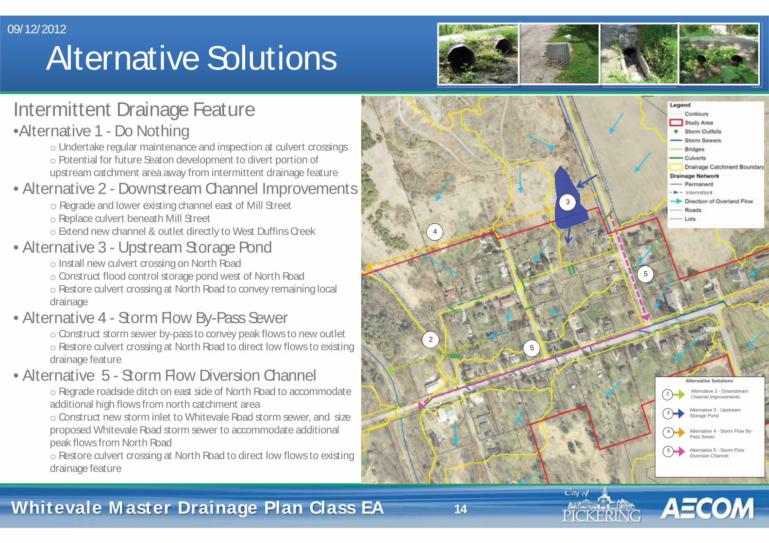
Whitevale Master Drainage Plan Whitevale Master Drainage Plan Class EA
Alternative Solutions 09/12/2012
14
Intermittent Drainage Feature •Alternative 1 - Do Nothing
o Undertake regular maintenance and inspection at culvert crossings o Potential for future Seaton development to divert portion of upstream catchment area away from intermittent drainage feature
• Alternative 2 - Downstream Channel Improvements o Regrade and lower existing channel east of Mill Street o Replace culvert beneath Mill Street o Extend new channel & outlet directly to West Duffins Creek
• Alternative 3 - Upstream Storage Pond o Install new culvert crossing on North Road o Construct flood control storage pond west of North Road o Restore culvert crossing at North Road to convey remaining local drainage
• Alternative 4 - Storm Flow By-Pass Sewer o Construct storm sewer by-pass to convey peak flows to new outlet o Restore culvert crossing at North Road to direct low flows to existing drainage feature
• Alternative 5 - Storm Flow Diversion Channel o Regrade roadside ditch on east side of North Road to accommodate additional high flows from north catchment area o Construct new storm inlet to Whitevale Road storm sewer, and size proposed Whitevale Road storm sewer to accommodate additional peak flows from North Road o Restore culvert crossing at North Road to direct low flows to existing drainage feature
At`
Alternative 2 - Downstream Channel Improvements
Alternative 3 - Upstream Storage Pond
Alternative 4 - Storm Flow By-Pass Sewer
Alternative 5 - Storm Flow Diversion Channel
Alternative Solutions
2
3
4
5
2
3
4
5
5
Intermittent
Whitevale Master Drainage Plan Whitevale Master Drainage Plan Class EA
Evaluation Criteria Technical Assessment Group
Potential for improved public safety
Constructability of proposed infrastructure
Potential for future maintenance requirements
Potential for conflicts with existing municipal and utility services
Natural Environment Assessment Group
Potential for effects on the terrestrial environment Potential for effects on the aquatic environment Potential for effects on environmentally significant landform/features
Potential for effects on known habitat for Species of Concern
Potential for effects on baseflow and/or groundwater resources
Potential for short-term construction related effects on aquatic and terrestrial ecosystems and groundwater resources
Social Environment Assessment Group
Potential for disturbing existing residences, community and recreation facilities through temporary and/or permanent effects (i.e. construction noise, dust, traffic disruption, property access disruption, etc) Potential for requiring the acquisition of private property or easements
Cultural Environment Assessment Group
Potential for effects on archaeological resources Potential for effects on cultural/heritage resources
Financial Assessment Group
Costs associated with property acquisition and/or temporary working easements Costs for implementation (i.e., capital costs)
09/12/2012
15
Whitevale Master Drainage Plan Whitevale Master Drainage Plan Class EA
Next Steps
• Comments from this Public Information Centre will be considered along with those received from review agencies
• A second Public Information Centre will be held to discuss the evaluation of Alternative Solutions and Selection of the Preferred Solutions, and present the draft Master Plan document
• A Master Plan document summarizing the study will be prepared and filed for 30 calendar days for agency and public review
• Review agencies and the public will be notified of completion of the study at the appropriate time in order to review the Master Plan document
9/12/2012
16

Whitevale Master Drainage Plan Whitevale Master Drainage Plan Class EA
Study Contacts 9/12/2012
17
Mr. Tom Dole, P.Eng. Mr. Glenn Farmer Water Resources Engineer Project Manager City of Pickering AECOM One The Esplanade 300 Town Centre Blvd., Suite 300 Pickering, ON, L1V 6K7 Markham, ON L3R 5Z6 tel: 905.420.4660 ext. 2156 tel: 905.477.8400 ext. 354 [email protected] [email protected]
• Should you have any questions or concerns, please feel free to contact either of the Study contacts listed below:

COMMENT FORM Public Information Centre #1
Whitevale Drainage Master Plan Class Environmental Assessment September 12, 2012: Claremont Community Centre Hall
We are interested in hearing any comments you may have associated with this Master Plan Class Environmental Assessment project. Please consider the following questions in providing your comments on the study/project:
1. Please provide any general comments regarding this Public Information Centre
2. Do you have any comments, concerns or recommendation regarding the proposed Alternative Solutions?
3. Are you in agreement with the proposed Evaluation Criteria? If not, what would you change? Are there additional criteria that you would like the City of Pickering to consider for this study?
Comments and information regarding this project are being collected to assist The City of Pickering in meeting the requirements of the Environmental Assessment Act. This material will be maintained on file for use during the project and may be included in project documentation. Information collected will be used in accordance with the Freedom of Information and Privacy Act. With the exception of personal information, all comments will become part of the public record.
Please submit your written comments before leaving the Public Information Forum. If you require more time to comment, please mail/fax in the comment sheet to:
Mr. Tom Dole, P.Eng. Water Resources Engineer City of Pickering One The Esplanade Pickering, ON L1V 6K7 Tel: 905.420.4660 ext. 2156 Email: [email protected]
Mr. Glenn Farmer Project Manager AECOM 300 Town Centre Blvd., Suite 300 Markham, ON L3R 5Z6 Tel: 905.477.8400 ext. 354 Email: [email protected]
PLEASE CLEARLY PRINT YOUR NAME AND CONTACT INFORMATION BELOW:
First Name: Street:
Last Name: City / Town:
Telephone: Postal Code:
Fax: E-mail:
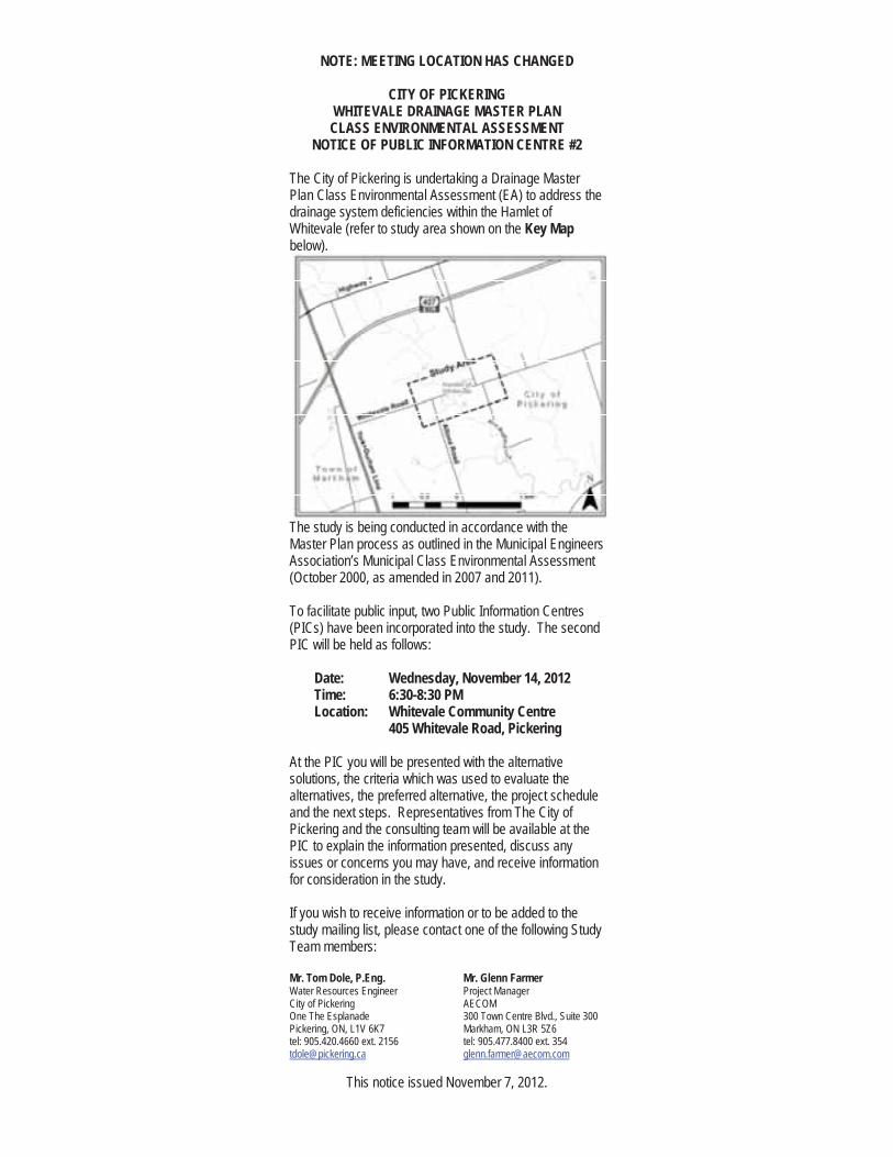
NOTE: MEETING LOCATION HAS CHANGED
CITY OF PICKERING WHITEVALE DRAINAGE MASTER PLAN CLASS ENVIRONMENTAL ASSESSMENT
NOTICE OF PUBLIC INFORMATION CENTRE #2
The City of Pickering is undertaking a Drainage Master Plan Class Environmental Assessment (EA) to address the drainage system deficiencies within the Hamlet of Whitevale (refer to study area shown on the Key Mapbelow).
The study is being conducted in accordance with the Master Plan process as outlined in the Municipal Engineers Association’s Municipal Class Environmental Assessment (October 2000, as amended in 2007 and 2011).
To facilitate public input, two Public Information Centres (PICs) have been incorporated into the study. The second PIC will be held as follows:
Date: Wednesday, November 14, 2012Time: 6:30-8:30 PMLocation: Whitevale Community Centre
405 Whitevale Road, Pickering
At the PIC you will be presented with the alternative solutions, the criteria which was used to evaluate the alternatives, the preferred alternative, the project schedule and the next steps. Representatives from The City of Pickering and the consulting team will be available at the PIC to explain the information presented, discuss any issues or concerns you may have, and receive information for consideration in the study.
If you wish to receive information or to be added to the study mailing list, please contact one of the following Study Team members:
Mr. Tom Dole, P.Eng. Mr. Glenn Farmer Water Resources Engineer Project Manager City of Pickering AECOM One The Esplanade 300 Town Centre Blvd., Suite 300 Pickering, ON, L1V 6K7 Markham, ON L3R 5Z6 tel: 905.420.4660 ext. 2156 tel: 905.477.8400 ext. 354 [email protected] [email protected]
This notice issued November 7, 2012.
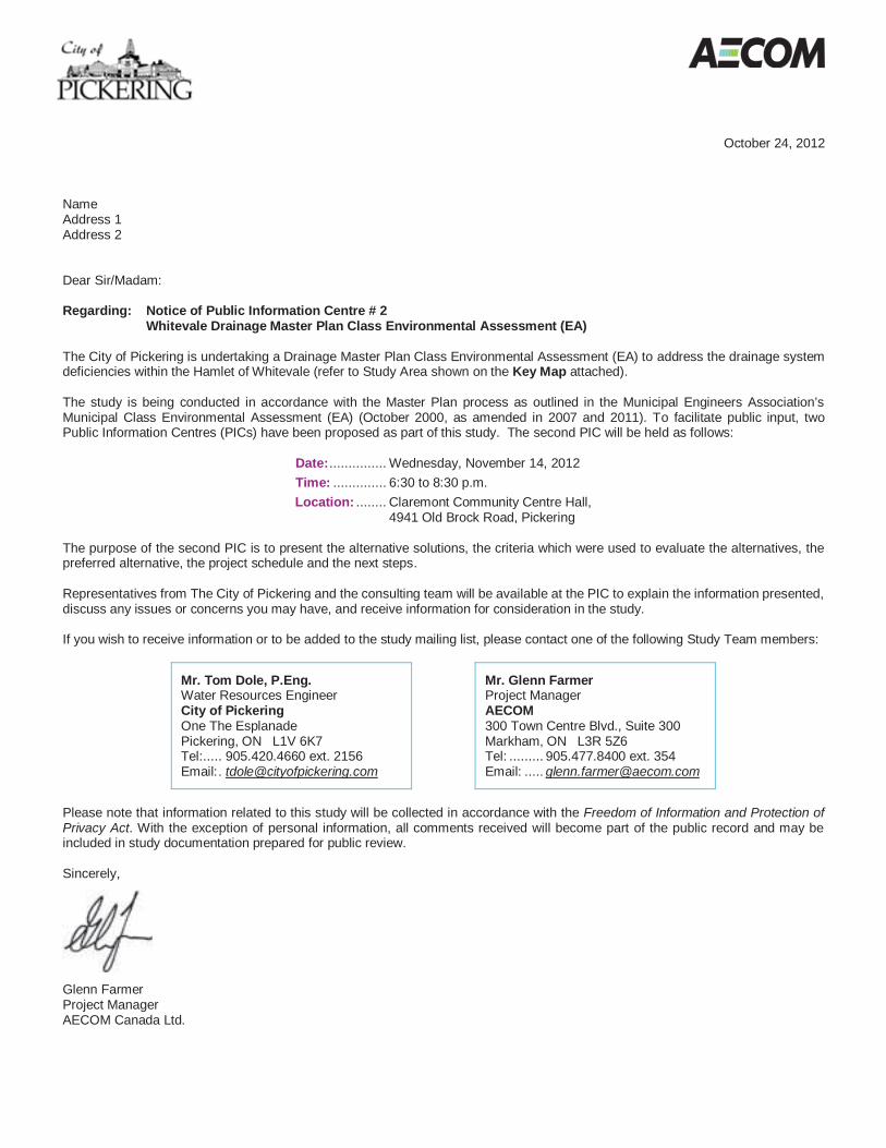
October 24, 2012 Name Address 1 Address 2 Dear Sir/Madam: Regarding: Notice of Public Information Centre # 2
Whitevale Drainage Master Plan Class Environmental Assessment (EA) The City of Pickering is undertaking a Drainage Master Plan Class Environmental Assessment (EA) to address the drainage system deficiencies within the Hamlet of Whitevale (refer to Study Area shown on the Key Map attached). The study is being conducted in accordance with the Master Plan process as outlined in the Municipal Engineers Association’s Municipal Class Environmental Assessment (EA) (October 2000, as amended in 2007 and 2011). To facilitate public input, two Public Information Centres (PICs) have been proposed as part of this study. The second PIC will be held as follows:
Date: ............... Wednesday, November 14, 2012 Time: .............. 6:30 to 8:30 p.m. Location: ........ Claremont Community Centre Hall,
4941 Old Brock Road, Pickering The purpose of the second PIC is to present the alternative solutions, the criteria which were used to evaluate the alternatives, the preferred alternative, the project schedule and the next steps. Representatives from The City of Pickering and the consulting team will be available at the PIC to explain the information presented, discuss any issues or concerns you may have, and receive information for consideration in the study. If you wish to receive information or to be added to the study mailing list, please contact one of the following Study Team members:
Mr. Tom Dole, P.Eng. Water Resources Engineer City of Pickering One The Esplanade Pickering, ON L1V 6K7 Tel:..... 905.420.4660 ext. 2156 Email: . [email protected]
Mr. Glenn Farmer Project Manager AECOM 300 Town Centre Blvd., Suite 300 Markham, ON L3R 5Z6 Tel: ......... 905.477.8400 ext. 354 Email: ..... [email protected]
Please note that information related to this study will be collected in accordance with the Freedom of Information and Protection of Privacy Act. With the exception of personal information, all comments received will become part of the public record and may be included in study documentation prepared for public review. Sincerely,
Glenn Farmer Project Manager AECOM Canada Ltd.
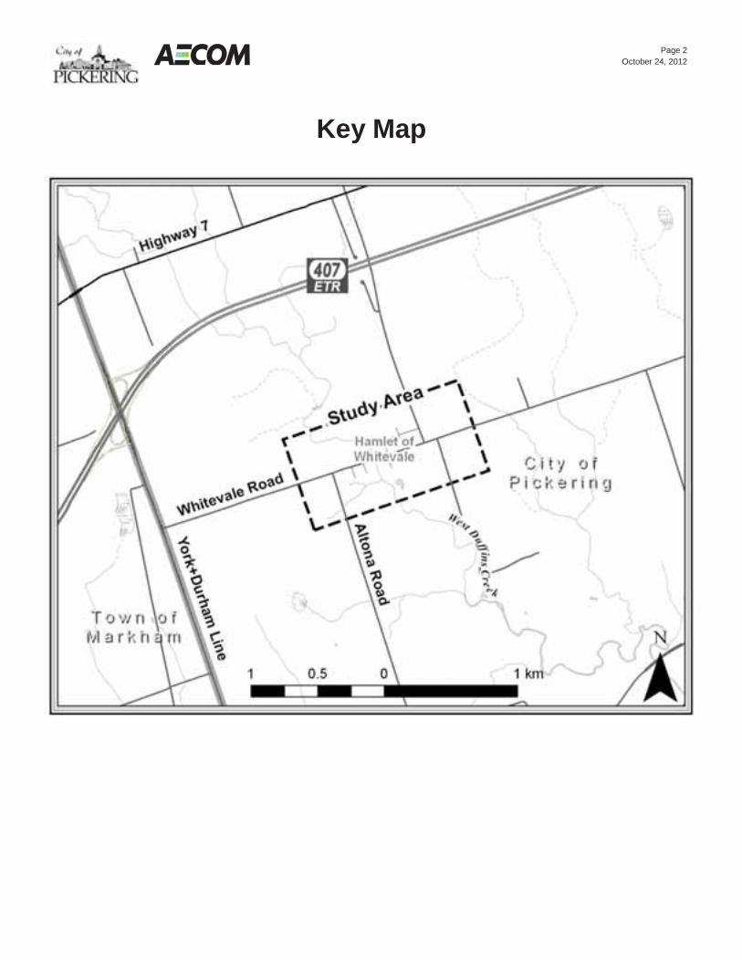
Page 2
October 24, 2012
Key Map

Whitevale Master Drainage Plan Whitevale Master Drainage Plan Class EA
Whitevale Master Drainage Plan Class Environmental Assessment Public Information Centre #2
• Please sign-in on the sheet provided. Then feel free to walk around and view the display boards
• If you have any questions, our staff will be pleased to discuss them with you
• Comment sheets are also provided for those who wish to provide written comments
• Please place your completed sheets in the Comment Box or take them with you and mail/fax to one of the Study contacts
1 11/14/2012
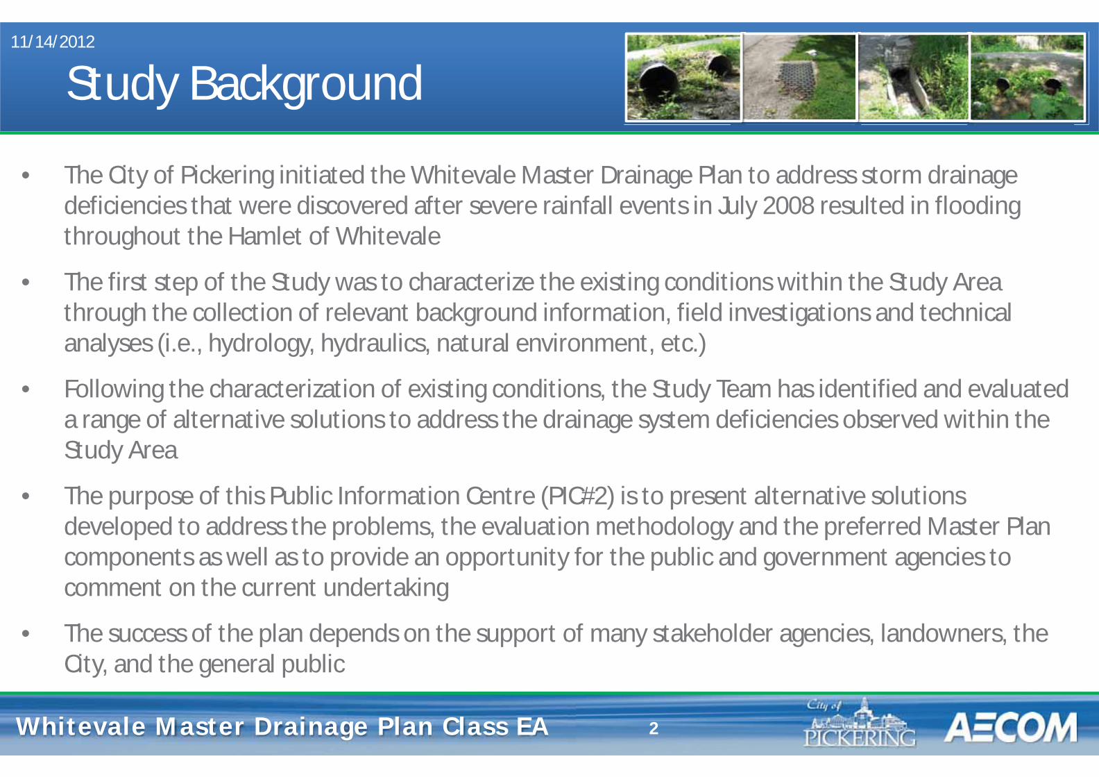
Whitevale Master Drainage Plan Whitevale Master Drainage Plan Class EA
Study Background
• The City of Pickering initiated the Whitevale Master Drainage Plan to address storm drainage deficiencies that were discovered after severe rainfall events in July 2008 resulted in flooding throughout the Hamlet of Whitevale
• The first step of the Study was to characterize the existing conditions within the Study Area through the collection of relevant background information, field investigations and technical analyses (i.e., hydrology, hydraulics, natural environment, etc.)
• Following the characterization of existing conditions, the Study Team has identified and evaluated a range of alternative solutions to address the drainage system deficiencies observed within the Study Area
• The purpose of this Public Information Centre (PIC#2) is to present alternative solutions developed to address the problems, the evaluation methodology and the preferred Master Plan components as well as to provide an opportunity for the public and government agencies to comment on the current undertaking
• The success of the plan depends on the support of many stakeholder agencies, landowners, the City, and the general public
11/14/2012
2
Whitevale Master Drainage Plan Whitevale Master Drainage Plan Class EA
Master Plan Class EA Process
• This Study is being conducted as a Master Plan in accordance with the Municipal Engineers Association Class Environmental Assessment document (October 2000, as amended in 2007 & 2011)
• The Municipal Class EA is approved under the Environmental Assessment Act and enables the planning of municipal infrastructure projects in accordance with an approved procedure designed to protect the environment
• The new Federal Canadian Environmental Assessment Act (CEAA, 2012) is not expected to be triggered as a result of this Study
11/14/2012
3
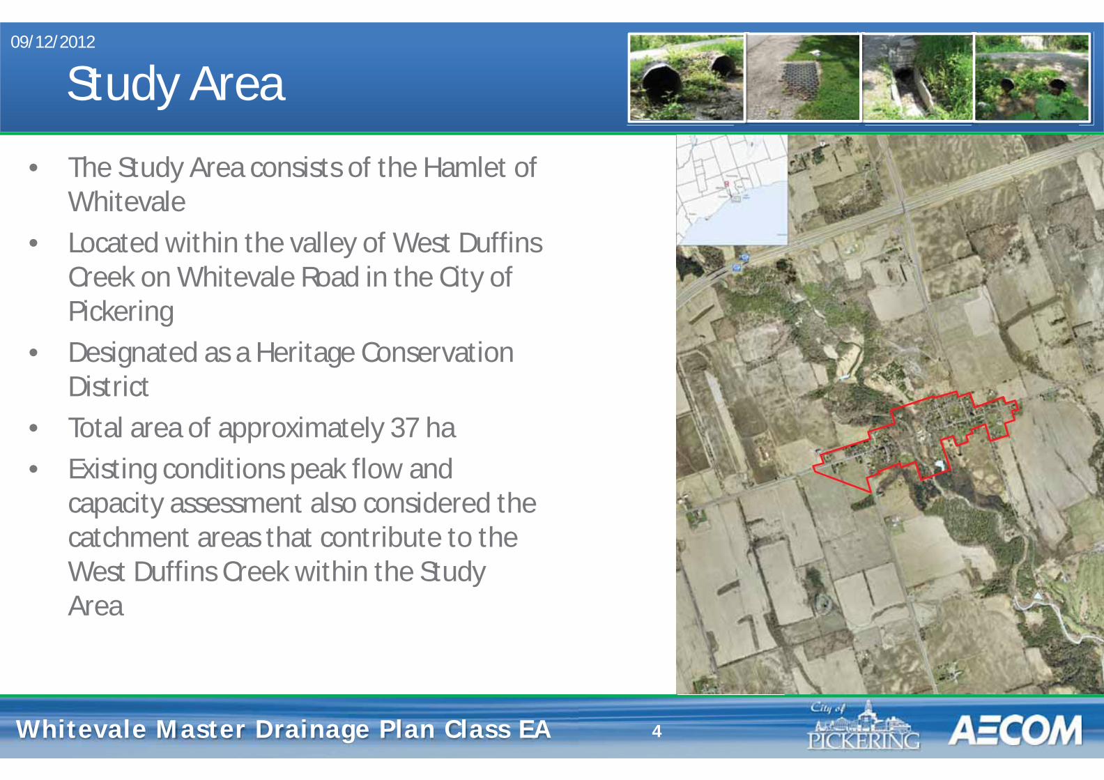
Whitevale Master Drainage Plan Whitevale Master Drainage Plan Class EA
Study Area • The Study Area consists of the Hamlet of
Whitevale • Located within the valley of West Duffins
Creek on Whitevale Road in the City of Pickering
• Designated as a Heritage Conservation District
• Total area of approximately 37 ha • Existing conditions peak flow and
capacity assessment also considered the catchment areas that contribute to the West Duffins Creek within the Study Area
09/12/2012
4
Whitevale Master Drainage Plan Whitevale Master Drainage Plan Class EA
Problem & Opportunity Statement
Severe rainfall events in July 2008 within the Study Area resulted in flooding along streets and several properties, and erosion of the approaches to the historic Whitevale bridge crossing over West Duffins Creek causing:
• significant damage along the approach embankments; • damage/blockage of the existing storm sewer outfall next to the bridge crossing; • significant quantities of sand and gravel deposited into the watercourse; and • localized flooding due to excess runoff from surrounding lands and damage to private property.
As a result of the current drainage issues within the Study Area, an opportunity exists to improve the storm drainage system which will:
• reduce the occurrence of flooding; • mitigate erosion along roadways; • minimize future maintenance requirements; • enhance the quality of surface runoff discharging into the West Duffins Creek; and • improve overall public safety
09/12/2012
5
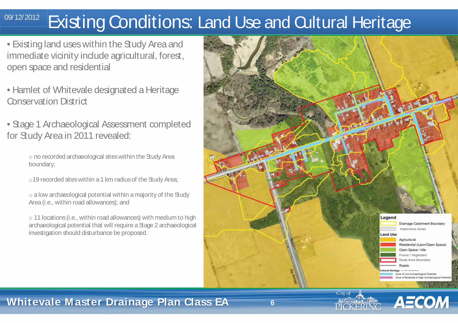
Whitevale Master Drainage Plan Whitevale Master Drainage Plan Class EA 6
Existing Conditions: Land Use and Cultural Heritage 09/12/2012
• Existing land uses within the Study Area and immediate vicinity include agricultural, forest, open space and residential
• Hamlet of Whitevale designated a Heritage Conservation District
• Stage 1 Archaeological Assessment completed for Study Area in 2011 revealed:
o no recorded archaeological sites within the Study Area boundary; o19 recorded sites within a 1 km radius of the Study Area;
o a low archaeological potential within a majority of the Study Area (i.e., within road allowances); and
o 11 locations (i.e., within road allowances) with medium to high archaeological potential that will require a Stage 2 archaeological investigation should disturbance be proposed.
Impervious Areas
Forest / Vegetated
(i.e., within road allowances)
Study Area Boundary
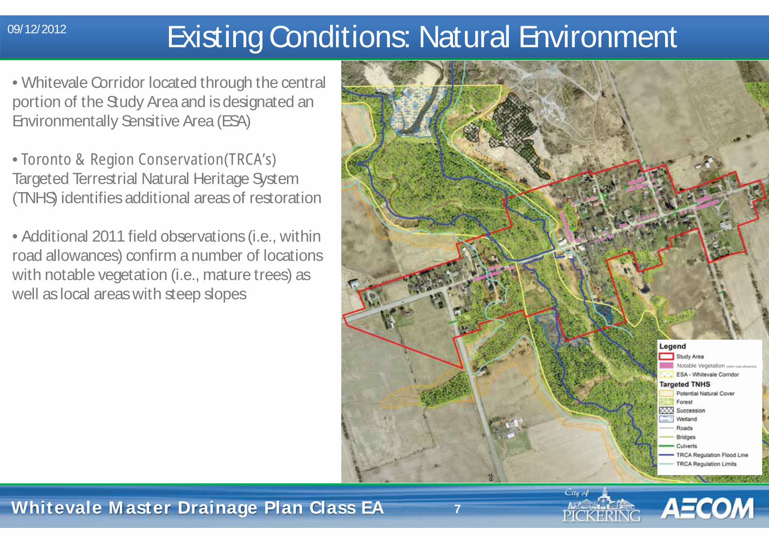
Whitevale Master Drainage Plan Whitevale Master Drainage Plan Class EA 7
Existing Conditions: Natural Environment 09/12/2012
• Whitevale Corridor located through the central portion of the Study Area and is designated an Environmentally Sensitive Area (ESA) • Toronto & Region Conservation(TRCA’s) Targeted Terrestrial Natural Heritage System (TNHS) identifies additional areas of restoration • Additional 2011 field observations (i.e., within road allowances) confirm a number of locations with notable vegetation (i.e., mature trees) as well as local areas with steep slopes
Notable Vegetation (within road allowance)

Whitevale Master Drainage Plan Whitevale Master Drainage Plan Class EA 8
Existing Conditions: Drainage Infrastructure 09/12/2012
• Surface drainage within the Study Area comprises a network of intermittent swales, roadside ditches and culverts as well as storm sewers located on Whitevale Road that discharge into West Duffins Creek • An intermittent drainage feature located in the northeast quadrant of the Study Area receives storm runoff from local roads and adjacent properties and outlets to a diversion channel (Mill Race) prior to outletting to West Duffins Creek • Development within the Hamlet of Whitevale occurred prior to the adoption of current stormwater management practices
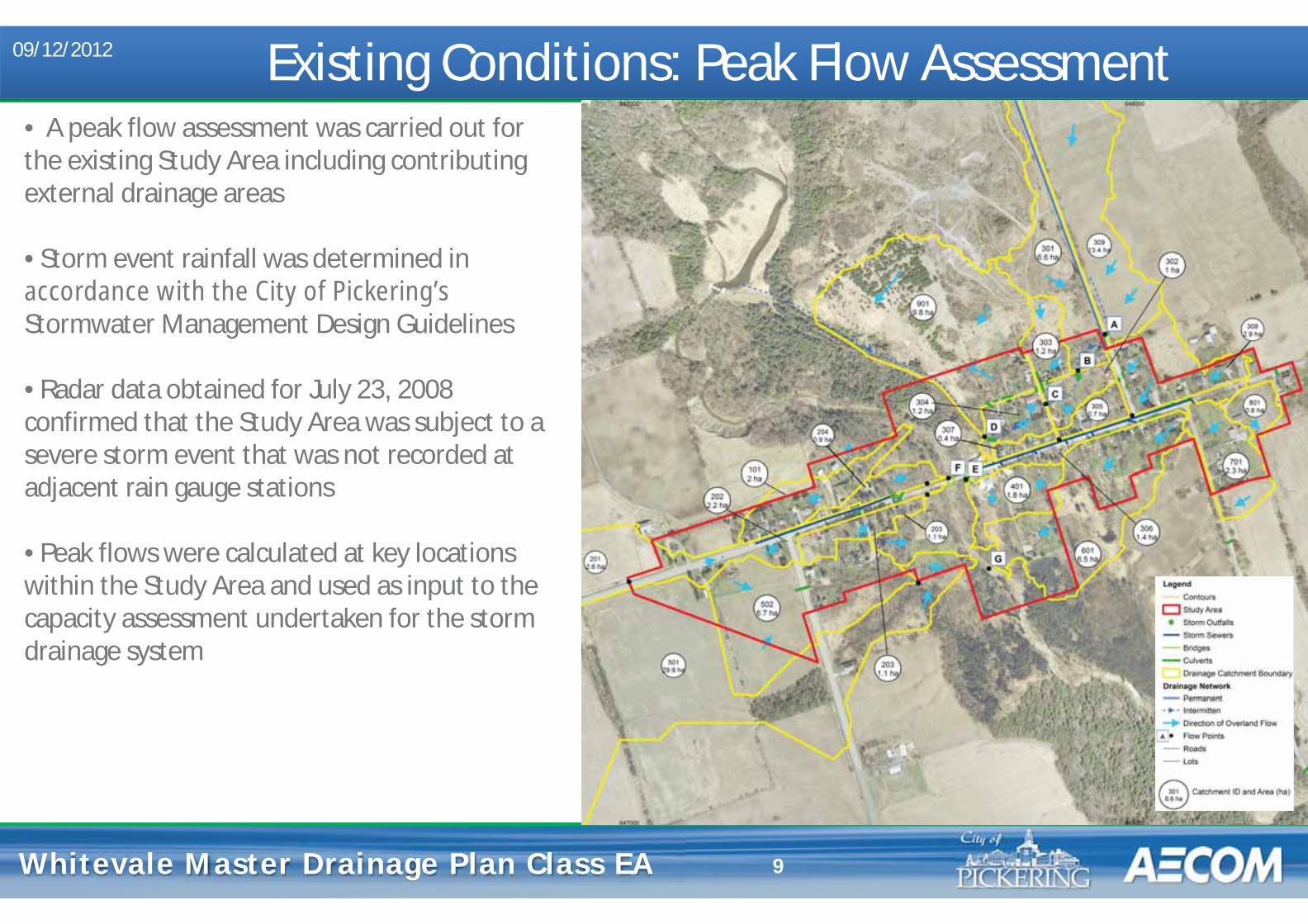
Whitevale Master Drainage Plan Whitevale Master Drainage Plan Class EA 9
Existing Conditions: Peak Flow Assessment 09/12/2012
• A peak flow assessment was carried out for the existing Study Area including contributing external drainage areas • Storm event rainfall was determined in accordance with the City of Pickering’s Stormwater Management Design Guidelines • Radar data obtained for July 23, 2008 confirmed that the Study Area was subject to a severe storm event that was not recorded at adjacent rain gauge stations • Peak flows were calculated at key locations within the Study Area and used as input to the capacity assessment undertaken for the storm drainage system
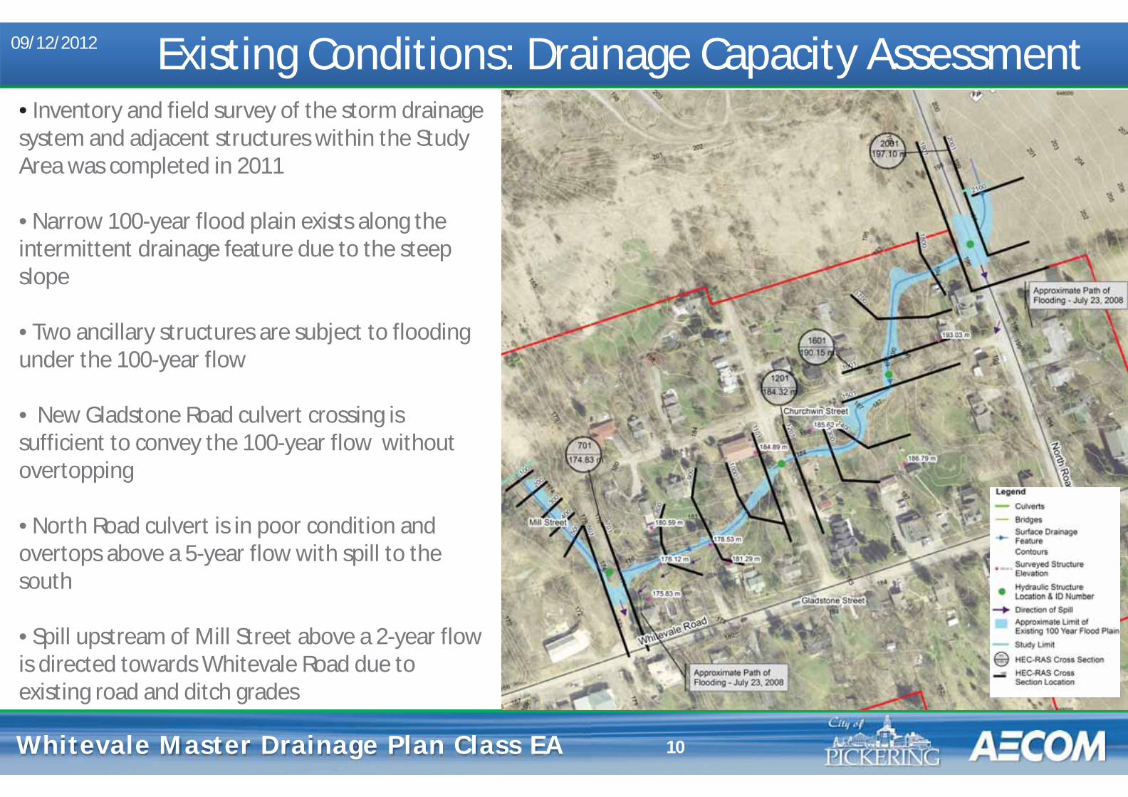
Whitevale Master Drainage Plan Whitevale Master Drainage Plan Class EA 10
Existing Conditions: Drainage Capacity Assessment 09/12/2012
• Inventory and field survey of the storm drainage system and adjacent structures within the Study Area was completed in 2011 • Narrow 100-year flood plain exists along the intermittent drainage feature due to the steep slope • Two ancillary structures are subject to flooding under the 100-year flow • New Gladstone Road culvert crossing is sufficient to convey the 100-year flow without overtopping • North Road culvert is in poor condition and overtops above a 5-year flow with spill to the south • Spill upstream of Mill Street above a 2-year flow is directed towards Whitevale Road due to existing road and ditch grades

Whitevale Master Drainage Plan Whitevale Master Drainage Plan Class EA 11
• Field observations, survey and video inspection of existing storm sewer on Whitevale Road was completed in 2011 as part of the Study
• A number of existing deficiencies were identified including buried storm inlets, misaligned pipes segments and partially blocked sewers • The capacity assessment completed for storm sewer system confirmed that it meets the City’s current design standard for a local road (i.e., 5-year flow) • Overland capacity assessment (i.e., within the road allowance) could not be completed due to many areas with ill-defined ditches and improper grading
Existing Conditions: Storm Sewer Capacity Assessment 09/12/2012
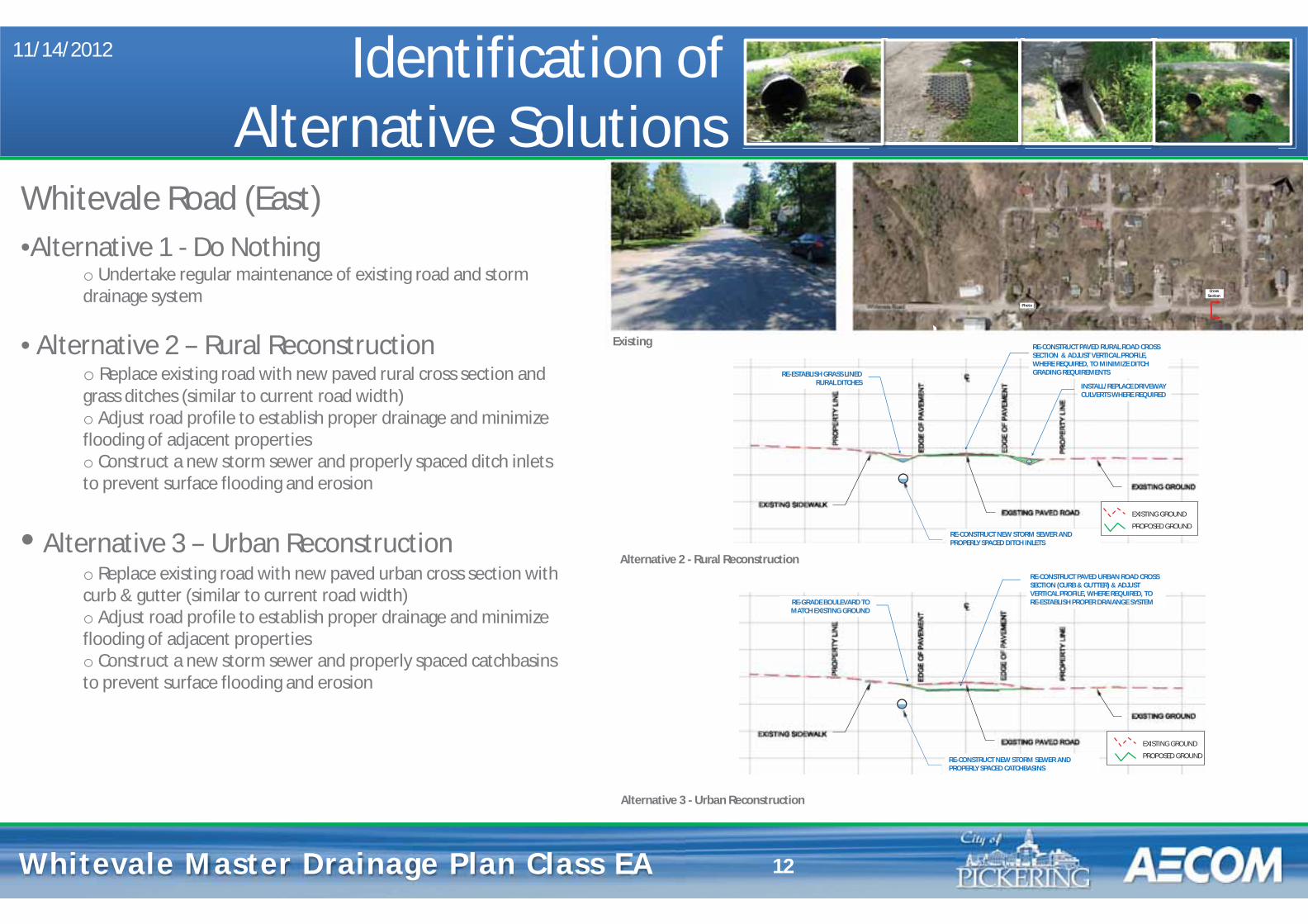
Whitevale Master Drainage Plan Whitevale Master Drainage Plan Class EA
Identification of Alternative Solutions
11/14/2012
12
Whitevale Road (East) •Alternative 1 - Do Nothing
o Undertake regular maintenance of existing road and storm drainage system
• Alternative 2 – Rural Reconstruction o Replace existing road with new paved rural cross section and grass ditches (similar to current road width) o Adjust road profile to establish proper drainage and minimize flooding of adjacent properties o Construct a new storm sewer and properly spaced ditch inlets to prevent surface flooding and erosion
• Alternative 3 – Urban Reconstruction o Replace existing road with new paved urban cross section with curb & gutter (similar to current road width) o Adjust road profile to establish proper drainage and minimize flooding of adjacent properties o Construct a new storm sewer and properly spaced catchbasins to prevent surface flooding and erosion
Alternative 3 - Urban Reconstruction
Photo
Cross Section
Alternative 2 - Rural Reconstruction
Existing
INSTALL/REPLACE DRIVEWAY CULVERTS WHERE REQUIRED
RE-CONSTRUCT NEW STORM SEWER AND PROPERLY SPACED DITCH INLETS
RE-ESTABLISH GRASS LINED RURAL DITCHES
RE-CONSTRUCT PAVED RURAL ROAD CROSS SECTION & ADJUST VERTICAL PROFILE, WHERE REQUIRED, TO MINIMIZE DITCH GRADING REQUIREMENTS
EXISTING GROUND
PROPOSED GROUND
RE-GRADE BOULEVARD TO MATCH EXISTING GROUND
RE-CONSTRUCT NEW STORM SEWER AND PROPERLY SPACED CATCHBASINS
RE-CONSTRUCT PAVED URBAN ROAD CROSS SECTION (CURB & GUTTER) & ADJUST VERTICAL PROFILE, WHERE REQUIRED, TO RE-ESTABLISH PROPER DRAIANGE SYSTEM
EXISTING GROUND
PROPOSED GROUND
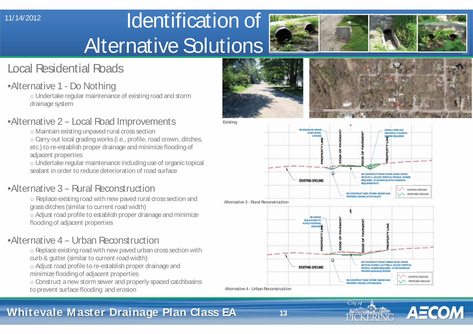
Whitevale Master Drainage Plan Whitevale Master Drainage Plan Class EA
INSTALL/REPLACE DRIVEWAY CULVERTS WHERE REQUIRED
RE-ESTABLISH GRASS LINED RURAL
DITCHES
RE-CONSTRUCT PAVED RURAL ROAD CROSS SECTION & ADJUST VERTICAL PROFILE, WHERE REQUIRED, TO MINIMIZE DITCH GRADING REQUIREMENTS
RE-CONSTRUCT NEW STORM SEWER AND PROPERLY SPACED DITCH INLETS
11/14/2012
13
Local Residential Roads •Alternative 1 - Do Nothing
o Undertake regular maintenance of existing road and storm drainage system
•Alternative 2 – Local Road Improvements o Maintain existing unpaved rural cross section o Carry out local grading works (i.e., profile, road crown, ditches, etc.) to re-establish proper drainage and minimize flooding of adjacent properties o Undertake regular maintenance including use of organic topical sealant in order to reduce deterioration of road surface
•Alternative 3 – Rural Reconstruction o Replace existing road with new paved rural cross section and grass ditches (similar to current road width) o Adjust road profile to establish proper drainage and minimize flooding of adjacent properties
•Alternative 4 – Urban Reconstruction o Replace existing road with new paved urban cross section with curb & gutter (similar to current road width) o Adjust road profile to re-establish proper drainage and minimize flooding of adjacent properties o Construct a new storm sewer and properly spaced catchbasins to prevent surface flooding and erosion
Existing
Identification of Alternative Solutions
Alternative 4 - Urban Reconstruction
Alternative 3 - Rural Reconstruction
Photo
Cross Section
RE-GRADE BOULEVARD TO
MATCH EXISTING GROUND
RE-CONSTRUCT PAVED URBAN ROAD CROSS SECTION (CURB & GUTTER) & ADJUST VERTICAL PROFILE, WHERE REQUIRED, TO RE-ESTABLISH PROPER DRAINAGE SYSTEM
RE-CONSTRUCT NEW STORM SEWER AND PROPERLY SPACED CATCHBASINS
EXISTING GROUND
PROPOSED GROUND
EXISTING GROUND
PROPOSED GROUND
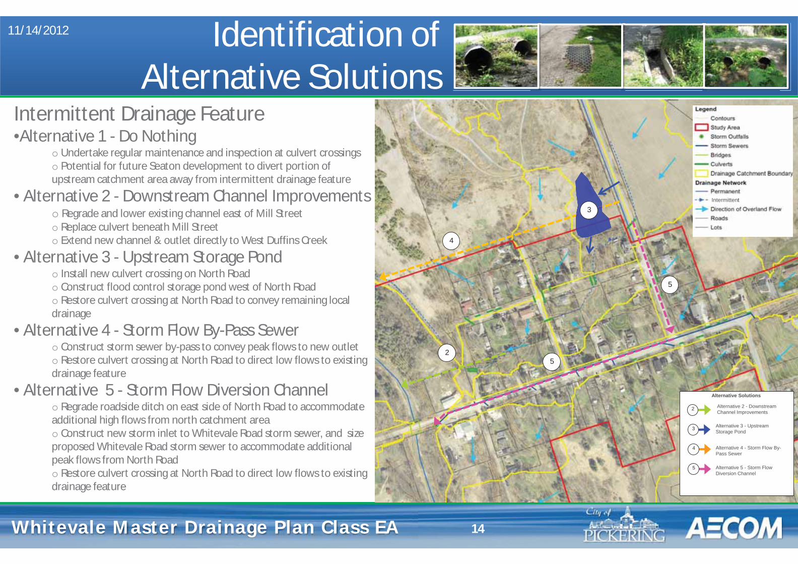
Whitevale Master Drainage Plan Whitevale Master Drainage Plan Class EA
11/14/2012
14
Intermittent Drainage Feature •Alternative 1 - Do Nothing
o Undertake regular maintenance and inspection at culvert crossings o Potential for future Seaton development to divert portion of upstream catchment area away from intermittent drainage feature
• Alternative 2 - Downstream Channel Improvements o Regrade and lower existing channel east of Mill Street o Replace culvert beneath Mill Street o Extend new channel & outlet directly to West Duffins Creek
• Alternative 3 - Upstream Storage Pond o Install new culvert crossing on North Road o Construct flood control storage pond west of North Road o Restore culvert crossing at North Road to convey remaining local drainage
• Alternative 4 - Storm Flow By-Pass Sewer o Construct storm sewer by-pass to convey peak flows to new outlet o Restore culvert crossing at North Road to direct low flows to existing drainage feature
• Alternative 5 - Storm Flow Diversion Channel o Regrade roadside ditch on east side of North Road to accommodate additional high flows from north catchment area o Construct new storm inlet to Whitevale Road storm sewer, and size proposed Whitevale Road storm sewer to accommodate additional peak flows from North Road o Restore culvert crossing at North Road to direct low flows to existing drainage feature
At`
Alternative 2 - Downstream Channel Improvements
Alternative 3 - Upstream Storage Pond
Alternative 4 - Storm Flow By-Pass Sewer
Alternative 5 - Storm Flow Diversion Channel
Alternative Solutions
2
3
4
5
2
3
4
5
5
Intermittent
Identification of Alternative Solutions
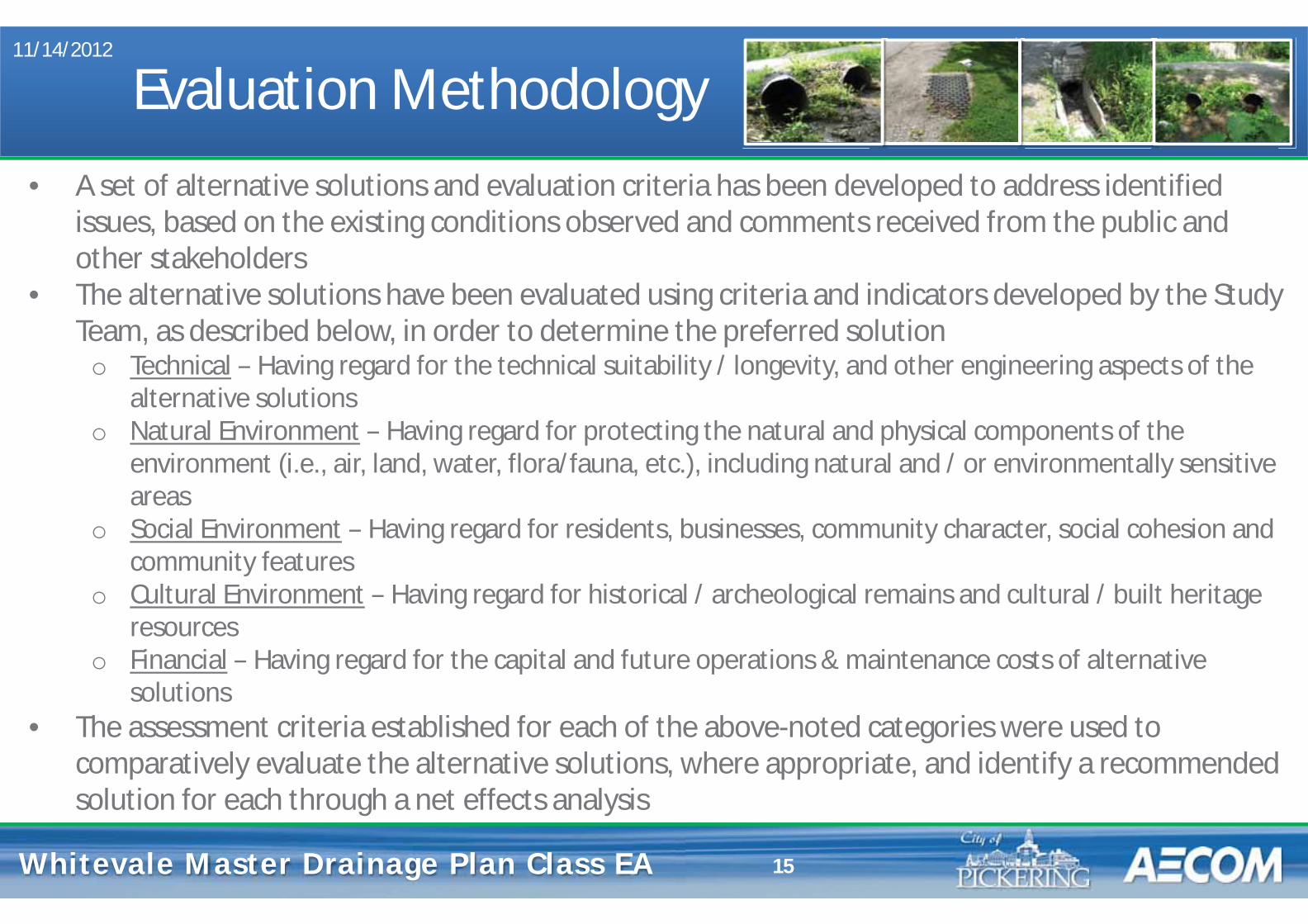
Whitevale Master Drainage Plan Whitevale Master Drainage Plan Class EA
Evaluation Methodology 11/14/2012
15
• A set of alternative solutions and evaluation criteria has been developed to address identified issues, based on the existing conditions observed and comments received from the public and other stakeholders
• The alternative solutions have been evaluated using criteria and indicators developed by the Study Team, as described below, in order to determine the preferred solution
o Technical – Having regard for the technical suitability / longevity, and other engineering aspects of the alternative solutions
o Natural Environment – Having regard for protecting the natural and physical components of the environment (i.e., air, land, water, flora/fauna, etc.), including natural and / or environmentally sensitive areas
o Social Environment – Having regard for residents, businesses, community character, social cohesion and community features
o Cultural Environment – Having regard for historical / archeological remains and cultural / built heritage resources
o Financial – Having regard for the capital and future operations & maintenance costs of alternative solutions
• The assessment criteria established for each of the above-noted categories were used to comparatively evaluate the alternative solutions, where appropriate, and identify a recommended solution for each through a net effects analysis
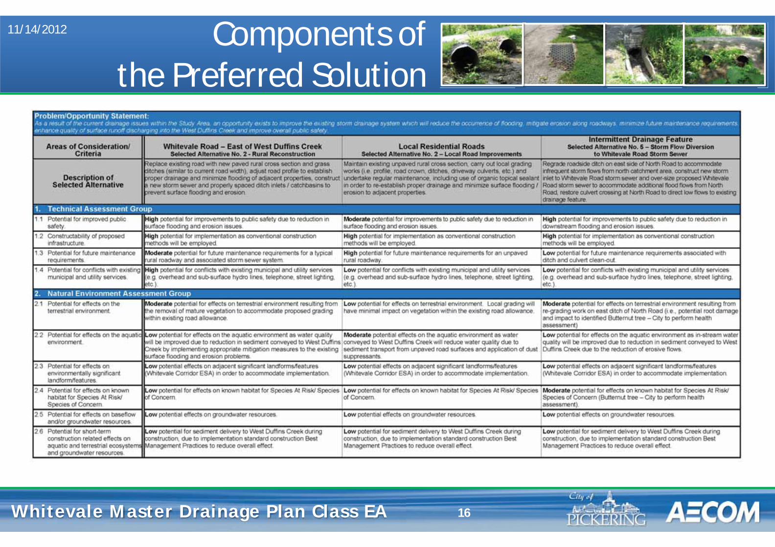
Whitevale Master Drainage Plan Whitevale Master Drainage Plan Class EA
Components of the Preferred Solution
11/14/2012
16
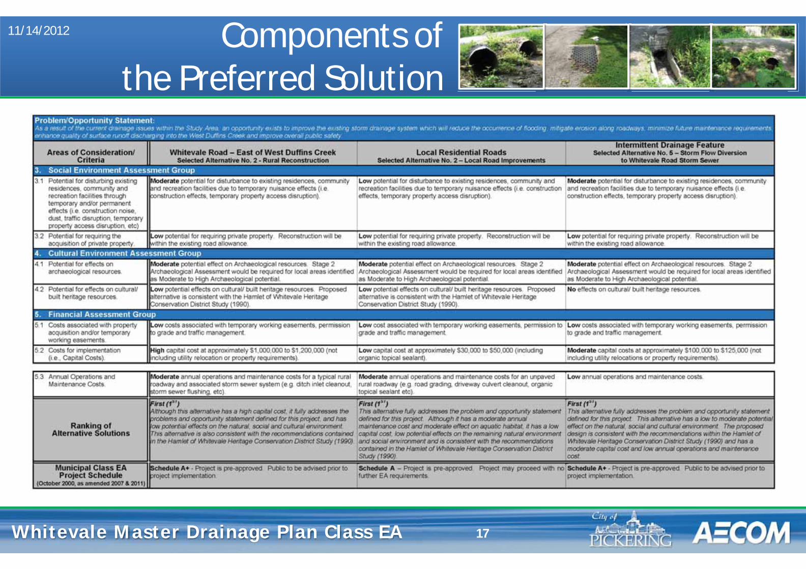
Whitevale Master Drainage Plan Whitevale Master Drainage Plan Class EA 17
Components of the Preferred Solution
11/14/2012
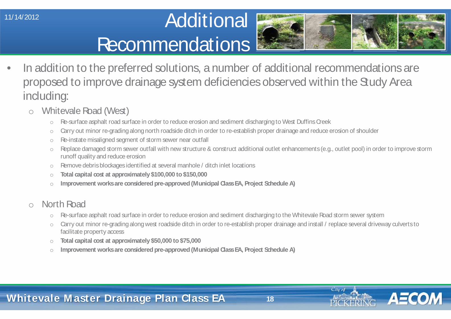
Whitevale Master Drainage Plan Whitevale Master Drainage Plan Class EA
Additional Recommendations
11/14/2012
18
• In addition to the preferred solutions, a number of additional recommendations are proposed to improve drainage system deficiencies observed within the Study Area including:
o Whitevale Road (West) o Re-surface asphalt road surface in order to reduce erosion and sediment discharging to West Duffins Creek o Carry out minor re-grading along north roadside ditch in order to re-establish proper drainage and reduce erosion of shoulder o Re-instate misaligned segment of storm sewer near outfall o Replace damaged storm sewer outfall with new structure & construct additional outlet enhancements (e.g., outlet pool) in order to improve storm
runoff quality and reduce erosion o Remove debris blockages identified at several manhole / ditch inlet locationso Total capital cost at approximately $100,000 to $150,000 o Improvement works are considered pre-approved (Municipal Class EA, Project Schedule A)
o North Road o Re-surface asphalt road surface in order to reduce erosion and sediment discharging to the Whitevale Road storm sewer system o Carry out minor re-grading along west roadside ditch in order to re-establish proper drainage and install / replace several driveway culverts to
facilitate property access o Total capital cost at approximately $50,000 to $75,000 o Improvement works are considered pre-approved (Municipal Class EA, Project Schedule A)
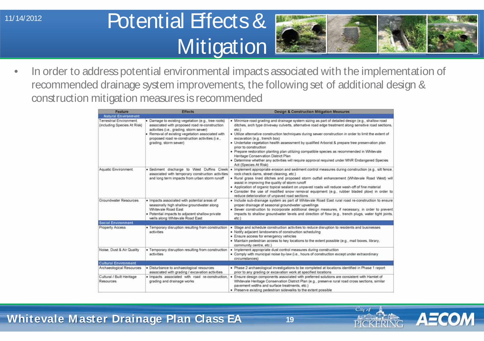
Whitevale Master Drainage Plan Whitevale Master Drainage Plan Class EA
Potential Effects & Mitigation
11/14/2012
19
• In order to address potential environmental impacts associated with the implementation of recommended drainage system improvements, the following set of additional design & construction mitigation measures is recommended
Whitevale Master Drainage Plan Whitevale Master Drainage Plan Class EA
Next Steps
• In order to confirm the preferred solution, comments from this PIC will be considered along with those received from public agencies. Please provide your comments on a comment sheet and place it in the Comment Box, or send it to us by fax or email by November 30, 2012
• A Master Plan document summarizing the Study will be prepared and filed for 30 calendar days for agency and public review in early 2013
• Review agencies and the public will be notified of completion of the Study at the appropriate time in order to review the Master Plan document
• At the end of the 30-day review period, the City of Pickering may proceed with implementing Schedule A/A+ elements as outlined in the Master Plan
11/14/2012
20

Whitevale Master Drainage Plan Whitevale Master Drainage Plan Class EA
Study Contacts 11/14/2012
21
Mr. Tom Dole, P.Eng. Mr. Glenn Farmer Water Resources Engineer Project Manager City of Pickering AECOM One The Esplanade 300 Town Centre Blvd., Suite 300 Pickering, ON, L1V 6K7 Markham, ON L3R 5Z6 tel: 905.420.4660 ext. 2156 tel: 905.477.8400 ext. 354 [email protected] [email protected]
• Should you have any questions or concerns, please feel free to contact either of the Study contacts listed below:

COMMENT FORM Public Information Centre #2
Whitevale Drainage Master Plan Class Environmental Assessment November 14, 2012: Whitevale Community Centre
We are interested in hearing any comments you may have associated with this Master Plan Class Environmental Assessment project. Please consider the following questions in providing your comments on the study/project:
1. Please provide any general comments regarding this Public Information Centre
2. Do you have any comments, concerns or recommendation regarding the Selected Solutions?
3. Are you in agreement with the overall recommendations of the Study? If not, what would you change? Are there additional concerns that you would like the City of Pickering to consider for this Study?
Comments and information regarding this project are being collected to assist The City of Pickering in meeting the requirements of the Environmental Assessment Act. This material will be maintained on file for use during the project and may be included in project documentation. Information collected will be used in accordance with the Freedom of Information and Privacy Act. With the exception of personal information, all comments will become part of the public record.
Please submit your written comments before leaving the Public Information Centre. If you require more time to comment, please mail/fax in the comment sheet to:
Mr. Tom Dole, P.Eng. Water Resources Engineer City of Pickering One The Esplanade Pickering, ON L1V 6K7 Tel: 905.420.4660 ext. 2156 Email: [email protected]
Mr. Glenn Farmer Project Manager AECOM 300 Town Centre Blvd., Suite 300 Markham, ON L3R 5Z6 Tel: 905.477.8400 ext. 354 Email: [email protected]
PLEASE CLEARLY PRINT YOUR NAME AND CONTACT INFORMATION BELOW:
First Name: Street:
Last Name: City / Town:
Telephone: Postal Code:
Fax: E-mail:
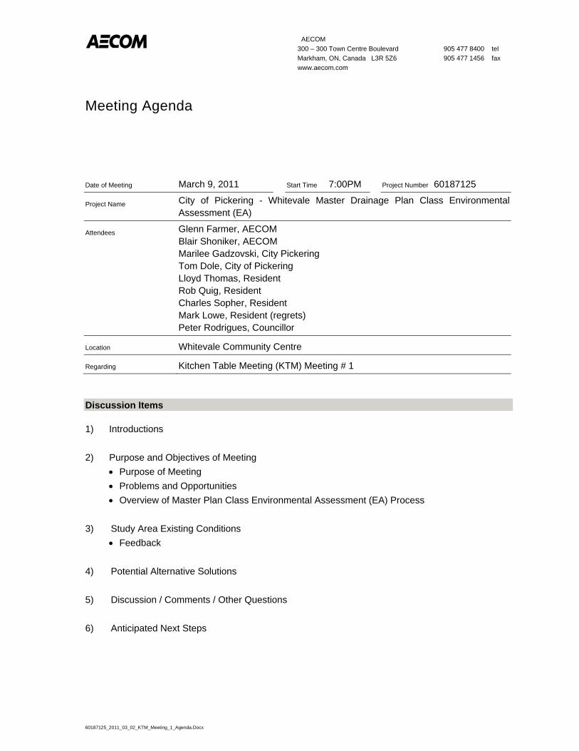
AECOM 300 – 300 Town Centre Boulevard 905 477 8400 tel Markham, ON, Canada L3R 5Z6 905 477 1456 fax www.aecom.com
Meeting Agenda
60187125_2011_03_02_KTM_Meeting_1_Agenda.Docx
Date of Meeting March 9, 2011 Start Time 7:00PM Project Number 60187125
Project Name City of Pickering - Whitevale Master Drainage Plan Class Environmental Assessment (EA)
Attendees Glenn Farmer, AECOM Blair Shoniker, AECOM Marilee Gadzovski, City Pickering Tom Dole, City of Pickering Lloyd Thomas, Resident Rob Quig, Resident Charles Sopher, Resident Mark Lowe, Resident (regrets) Peter Rodrigues, Councillor
Location Whitevale Community Centre
Regarding Kitchen Table Meeting (KTM) Meeting # 1
Discussion Items
1) Introductions
2) Purpose and Objectives of Meeting Purpose of Meeting Problems and Opportunities Overview of Master Plan Class Environmental Assessment (EA) Process
3) Study Area Existing Conditions Feedback
4) Potential Alternative Solutions
5) Discussion / Comments / Other Questions
6) Anticipated Next Steps
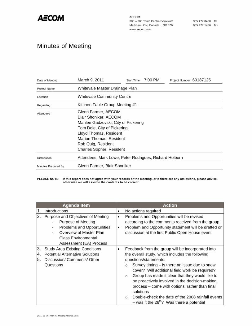
AECOM300 – 300 Town Centre Boulevard 905 477 8400 tel Markham, ON, Canada L3R 5Z6 905 477 1456 fax www.aecom.com
Minutes of Meeting
2011_03_16_KTM # 1 Meeting Minutes.Docx
Date of Meeting March 9, 2011 Start Time 7:00 PM Project Number 60187125
Project Name Whitevale Master Drainage Plan
Location Whitevale Community Centre
Regarding Kitchen Table Group Meeting #1
Attendees Glenn Farmer, AECOM Blair Shoniker, AECOM Marilee Gadzovski, City of Pickering Tom Dole, City of Pickering Lloyd Thomas, Resident Marion Thomas, Resident Rob Quig, Resident Charles Sopher, Resident
Distribution Attendees, Mark Lowe, Peter Rodrigues, Richard Holborn
Minutes Prepared By Glenn Farmer, Blair Shoniker
PLEASE NOTE: If this report does not agree with your records of the meeting, or if there are any omissions, please advise, otherwise we will assume the contents to be correct.
Agenda Item Action1. Introductions No actions required 2. Purpose and Objectives of Meeting
- Purpose of Meeting - Problems and Opportunities - Overview of Master Plan
Class Environmental Assessment (EA) Process
Problems and Opportunities will be revised according to the comments received from the group
Problem and Opportunity statement will be drafted or discussion at the first Public Open House event
3. Study Area Existing Conditions 4. Potential Alternative Solutions 5. Discussion/ Comments/ Other
Questions
Feedback from the group will be incorporated into the overall study, which includes the following questions/statements: o Survey timing – is there an issue due to snow
cover? Will additional field work be required? o Group has made it clear that they would like to
be proactively involved in the decision-making process – come with options, rather than final solutions
o Double-check the date of the 2008 rainfall events – was it the 26th? Was there a potential
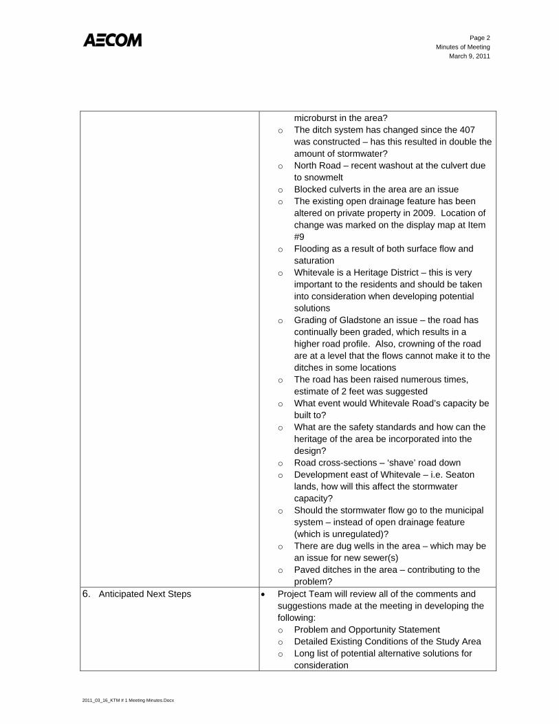
Page 2Minutes of Meeting
March 9, 2011
2011_03_16_KTM # 1 Meeting Minutes.Docx
microburst in the area? o The ditch system has changed since the 407
was constructed – has this resulted in double the amount of stormwater?
o North Road – recent washout at the culvert due to snowmelt
o Blocked culverts in the area are an issue o The existing open drainage feature has been
altered on private property in 2009. Location of change was marked on the display map at Item #9
o Flooding as a result of both surface flow and saturation
o Whitevale is a Heritage District – this is very important to the residents and should be taken into consideration when developing potential solutions
o Grading of Gladstone an issue – the road has continually been graded, which results in a higher road profile. Also, crowning of the road are at a level that the flows cannot make it to the ditches in some locations
o The road has been raised numerous times, estimate of 2 feet was suggested
o What event would Whitevale Road’s capacity be built to?
o What are the safety standards and how can the heritage of the area be incorporated into the design?
o Road cross-sections – ‘shave’ road down o Development east of Whitevale – i.e. Seaton
lands, how will this affect the stormwater capacity?
o Should the stormwater flow go to the municipal system – instead of open drainage feature (which is unregulated)?
o There are dug wells in the area – which may be an issue for new sewer(s)
o Paved ditches in the area – contributing to the problem?
6. Anticipated Next Steps Project Team will review all of the comments and suggestions made at the meeting in developing the following:o Problem and Opportunity Statement o Detailed Existing Conditions of the Study Area o Long list of potential alternative solutions for
consideration

Page 3Minutes of Meeting
March 9, 2011
2011_03_16_KTM # 1 Meeting Minutes.Docx
Plan on holding the first Public Open House event in May/June – still to be determined
Minutes will be circulated to all attendees for comments/edits
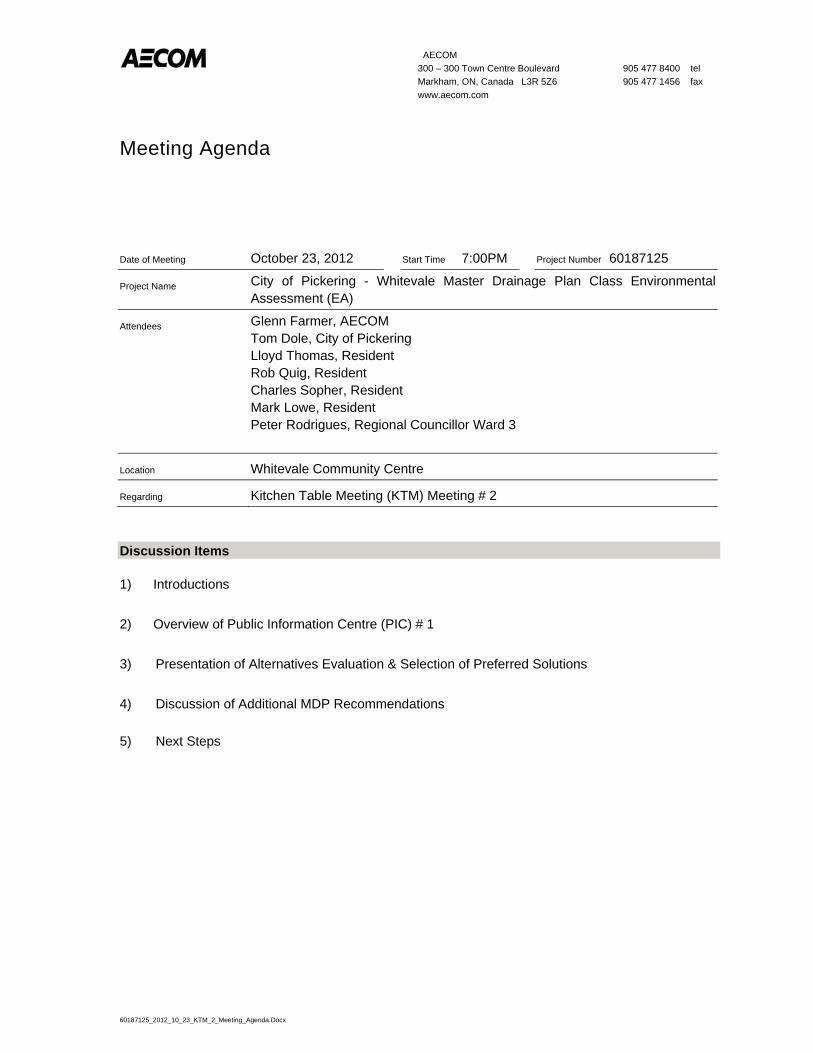
AECOM 300 – 300 Town Centre Boulevard 905 477 8400 tel Markham, ON, Canada L3R 5Z6 905 477 1456 fax www.aecom.com
Meeting Agenda
60187125_2012_10_23_KTM_2_Meeting_Agenda.Docx
Date of Meeting October 23, 2012 Start Time 7:00PM Project Number 60187125
Project Name City of Pickering - Whitevale Master Drainage Plan Class Environmental Assessment (EA)
Attendees Glenn Farmer, AECOM Tom Dole, City of Pickering Lloyd Thomas, Resident Rob Quig, Resident Charles Sopher, Resident Mark Lowe, Resident Peter Rodrigues, Regional Councillor Ward 3
Location Whitevale Community Centre
Regarding Kitchen Table Meeting (KTM) Meeting # 2
Discussion Items
1) Introductions
2) Overview of Public Information Centre (PIC) # 1
3) Presentation of Alternatives Evaluation & Selection of Preferred Solutions
4) Discussion of Additional MDP Recommendations
5) Next Steps
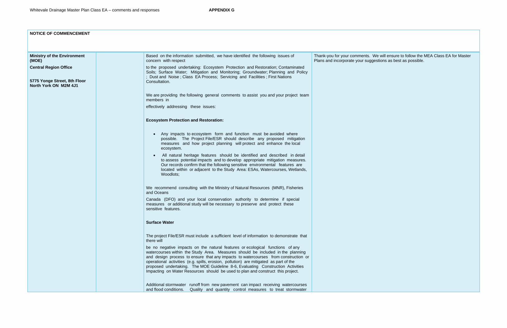
Whitevale Drainage Master Plan Class EA – comments and responses APPENDIX G
NOTICE OF COMMENCEMENT
Ministry of the Environment (MOE)Central Region Office
5775 Yonge Street, 8th Floor North York ON M2M 4J1
Based on the information submitted, we have identified the following issues of concern with respect to the proposed undertaking: Ecosystem Protection and Restoration; Contaminated Soils; Surface Water; Mitigation and Monitoring; Groundwater; Planning and Policy ; Dust and Noise ; Class EA Process; Servicing and Facilities ; First Nations Consultation.
We are providing the following general comments to assist you and your project team members in effectively addressing these issues:
Ecosystem Protection and Restoration:
Any impacts to ecosystem form and function must be avoided where possible. The Project File/ESR should describe any proposed mitigation measures and how project planning will protect and enhance the local ecosystem.
All natural heritage features should be identified and described in detail to assess potential impacts and to develop appropriate mitigation measures. Our records confirm that the following sensitive environmental features are located within or adjacent to the Study Area: ESAs, Watercourses, Wetlands, Woodlots;
We recommend consulting with the Ministry of Natural Resources (MNR), Fisheries and Oceans Canada (DFO) and your local conservation authority to determine if special measures or additional study will be necessary to preserve and protect these sensitive features.
Surface Water
The project File/ESR must include a sufficient level of information to demonstrate that there will be no negative impacts on the natural features or ecological functions of any watercourses within the Study Area. Measures should be included in the planning and design process to ensure that any impacts to watercourses from construction or operational activities (e.g. spills, erosion, pollution) are mitigated as part of the proposed undertaking. The MOE Guideline 8-6, Evaluating Construction Activities Impacting on Water Resources should be used to plan and construct this project.
Additional stormwater runoff from new pavement can impact receiving watercourses and flood conditions. Quality and quantity control measures to treat stormwater
Thank-you for your comments. We will ensure to follow the MEA Class EA for Master Plans and incorporate your suggestions as best as possible.
Whitevale Drainage Master Plan Class EA – comments and responses APPENDIX G
runoff should be considered for all new impervious areas and, where possible, existing surfaces. MOE'sStormwater Management Planning and Design Manual (2003) should be referenced in the Project File/ESR and utilized when designing stormwater control methods. We recommend that a Stormwater Management Plan should be prepared as part of the Class EA process that includes:
Strategies to address potential water quantity and erosion impacts related to stormwater draining into streams or other sensitive environmental features, and to ensure thatadequate (enhanced) water quality is maintained:
Watershed information, drainage conditions, and other relevant background information
Future drainage conditions, stormwater management options, information on erosion
and sediment control during construction, and other details of the proposed works
Information on maintenance and monitoring commitments
Groundwater
The status of, and potential impacts to any well water supplies should be addressed. If the project involves groundwater takings or changes to drainage patterns, the quantity and quality of groundwater may be affected due to drawdown effects or the redirection of existing contamination flows. In addition, project activities may infringe on existing wells such that they must be reconstructed or sealed and abandoned. Appropriate information to define existing groundwater conditions should be included in the Project File/ESR.
If the potential construction or decommissioning of water wells is identified as an issue, the Project File/ESR should refer to Ontario Regulation 903, Wells, under the Ontario Water Resources Act.
Potential impacts to groundwater- dependent natural features should be addressed. Any changes to groundwater flow or quality from groundwater taking may interfere with the ecological processes of streams, wetlands or other surficial features. In addition, discharging contaminated or high volumes of groundwater to these features may have direct impacts on their function. Any potential effects should be identified, and appropriate

Whitevale Drainage Master Plan Class EA – comments and responses APPENDIX G
mitigation measures should be recommended. The level of detail required will be dependent on the significance of the potential impacts.
Any potential approval requirements for groundwater taking or discharge should be identified in the Project File / ESR. In particular, a Permit to Take Water (PTTW) under the Ontario Water Resources Actwill be required for any water takings that exceed 50,000 Iitres per day. A PTTW application must be accompanied by an assessment of potential effects as noted above, and may require a higher level of detail than what is provided in the Project File/ESR. Please note that when significant long-term water taking is proposed, the maximum rate identified in the Project File/ESR must notbe exceeded in any subsequent PTTW applications. For more information on the application and approval process, we suggest you refer to the MaE Permit to Take Water Manual (April 2005).
Dust and Noise
Dust and noise control measures should be addressed and included in the construction plans to ensure that nearby residential and other sensitive land uses within the Study Area are not adversely affected during construction activities. If dust suppressants are proposed to be used. we recommend the use of non-chloride based compounds to protect water quality.
Servicing and Facilities
Any facility that releases emissions to the atmosphere, dischargescontaminants to ground or surface water, provides potable water supplies, or stores, transports or disposes of waste must have a Certificate of Approval before it can operate lawfully. Please consult with the Environmental Assessment and Approvals Branch to determine whether a new or amended Certificate of Approval will be required for any proposed infrastructure.
We recommend referring to MOE's "D-Series" guidelines - Land Use Compatibility to ensure that all applicable Ministry procedures are followed in planning for any infrastructure or facilities related to wastewater, pipelines, landfills or industrial uses.
Contaminated Soils
Since the removal or movement of soils may be required, appropriate tests to determine contaminant levels from previous land uses or dumping should be undertaken. If the soils are contaminated, you must determine how and where they are to be disposed of, consistent with Part XV. 1 of the Environmental Protection Act (EPA) and Ontario Regulation 153/04, Records of
Site Condition, which details the new requirements related to site assessment and clean up. We recommend contacting the MaE York Durham District Office in
Whitevale Drainage Master Plan Class EA – comments and responses APPENDIX G
Ajax for further consultation if contaminated sites are present.
The location of any underground storage tanks should be included in the Project File/ESR. Measures should be identified to ensure the integrity of these tanks and to ensure an appropriate response in the event of a spill. The MaE Spills Action Centre must be contacted in such an event.
Any current or historical waste disposal sites should be identified in the Project File/ESR. The status of these sites should be determined to confirm whether approval pursuant to Section 46 of the Environmental Protection Act may be required for land uses on former disposal sites.
The Project File/ESR should identify any underground transmission lines in the Study Area. The owners should be consulted to avoid impacts to this infrastructure, including potential spills.
Mitigation and Monitoring
Design and construction reports and plans should be based on a best management approach that centres on the prevention of impacts, protection of the existing environment, and opportunities for rehabilitation and enhancement of any impacted areas.
All waste generated during construction must be disposed of in accordance with MOE requirements.
Contractors must be made aware of all environmental considerations so that all environmental standards and commitments for both construction and operation are met. Mitigation measures should be clearly referenced in the Project File/ESR and regularly monitored during the construction stage of the project. In addition, we encourage proponents to conduct post-construction monitoring to ensure all mitigation measures have been effective and are functioning properly. The proponent's construction and post-construction monitoring plans should be documented in the Project File/ESR.
Planning and Policy
The Greenbelt Plan contains policies that protect the Greenbelt's agricultural land base and the ecological features and functions occurring on this landscape. Since part of the Study Area iswithin the Greenbelt planning area, the Project File/ESR should demonstrate how the project adheres to the relevant sections of the Greenbelt Plan, including Section 42.1

Whitevale Drainage Master Plan Class EA – comments and responses APPENDIX G
- General Infrastructure Policies. A description of measures that prevent and minimize potential impacts should also be included. You may wish to consider consulting with the Ministry of Municipal Affairs & Housing in this matter.
The 2005 Provincial Policy Statement contains policies that protect Ontario's Natural Heritage. Applicable policies should be referenced in the Project File/ESR, and the proponent should demonstrate how this proposed project is consistent with these policies. You may wish to consider consulting with the Ministry of Municipal Affairs & Housing in this matter.
The Places to Grow Plan contains policies which guide decisions on a range of issues such as Infrastructure planning and land-use planning to ensure that stronger and more prosperous communities are built in the Greater Golden Horseshoe. TheProject File/ESR should demonstrate how this project adheres to the relevant policies of the Places to Grow Plan, including Section 3, which contain policies for Infrastructure to Support Growth.
Class EA Process
The Notice of Study Commencement document indicates that this Study is being conducted in accordance with Approach #2 of the Master Plan process. The Project File/ESR should also clearly indicate the selected approach for conducting the plan, in particular by identifying whether the levels of assessment, consultation and documentation are sufficient to fulfill the requirements for Schedule B or C projects. Please note that any Schedule B or C projects identified in the plan would be subject to Part II Order Requests under the Environmental Assessment Act, although the plan itself would not be.
The Project File/ESR should provide clear and complete documentation of the planning process in order to allow traceability of decision-making. It must also demonstrate how the consultation provisions of the Class EA have been fulfilled, including documentation of all public consultation efforts undertaken during the planning process. Additionally, it should identify all concerns that were raised and how they have been addressed throughout the planning process. The Class EA also directs proponents to include copies of comments submitted on the project by interested stakeholders, and the proponent's responses to these comments.
Whitevale Drainage Master Plan Class EA – comments and responses APPENDIX G
The Class EA requires the consideration of the effects of each alternative on all aspects of the environment. The Project File/ESR should include a level of detail (e.g. hydrogeological investigations, terrestrial and aquatic assessments) such that all potential impacts can be identified and appropriate mitigation measures can be developed. Any supporting studies conducted during the Class EA process should be referenced and included as part of the Project File/ESR.
Please include in the Project File/ESR a list of all subsequent permits or other approvals that may be required for the implementation of the preferred alternative, including Permits to Take Water, Certificates of Approval or other ministerial approvals, approval under the Canadian Environmental Assessment Act (CEAA), and conservation authority permits.
Please note that MOE guidelines and other information related to the issues noted above are available at www.ene.gov.on.ca under the publications link. We encourage the proponent to review all the available guides and to reference any relevant information in the Project File/ESR.
First Nations Consultation
Please note that as part of the required stakeholder and agency consultation, proponents are advised to contact the Ministry of Aboriginal Affairs and the Department of Indian and Northern Affairs to determine potentially affected Aboriginal peoples in the project area. Please refer to the website http://www.ene.gov.on.ca/en/eaab/aboriginal-resources.php for a list of appropriate government contacts.
Once identified, you are advised to provide notification directly to the Aboriginal peoples who may be affected by the project and provide them with an opportunity to participate in any planned public consultation sessions and comment on the project.
We recommend a draft copy of the Project File/ESR be circulated to this office prior to the filing of the final draft, allowing approximately 3D-days review time
Whitevale Drainage Master Plan Class EA – comments and responses APPENDIX G
for the ministry's technical reviewers to provide comments. Please also forward our office the Notice of Completion and Project File/ESR when completed.
Ministry of Natural Resources (MNR)
50 Bloomington Rd W Aurora ON L4G 3G8
The MNR has reviewed the mapping for the subject EA. Please note that the MNR will defer comment on the subject EA to the Conservation Authority: however, the MNR should be contacted if the proposal is expected to have any impacts (direct or indirect) on the habitat of any species at risk.
The Master Plan Report has determined that the preferred solutions put forward are not anticipated to have an impact on Species At Risk (SAR).
Ministry of Tourism and CulturePrograms and Services Branch Culture Services Unit 400 University Avenue, 4th Floor Toronto, ON M7A 2R9
Ministry of Tourism and Culture (MTC) has an interest in the conservation of cultural heritage resources. MTC would therefore be interested in remaining on the circulation list and being informed of the project as it proceeds through the EA Process.
Archaeology: The subject property of this EA is considered to have archaeological potential based on provincial archaeological criteria for the following reasons:
within 250 meters of a known site
within 300 meters of a primary water source (lakeshore, river, large creek)
within 200 meters of a secondary water source (stream, spring, marsh, swamp)
non-aboriginal settlement
An archaeological assessment by an archaeologist licensed under the Ontario Heritage Act will benecessary for this project including temporary roads/detours or work areas prior to the selection of preferred alternatives.
Furthermore, should the drainage works identified in the preferred alternatives include the dredging or other alteration of a natural watercourse, an additional Marine Archaeological Assessment will be necessary.
The assessment reports must conform to the Ministry of Tourism and Culture’s Standards and Guidelines for Consultant Archaeologists (2010). The licensed archaeologist will forward all completed archaeological assessment reports to the Ministry of Tourism and Culture for review by an Archaeology Review Officer.
Built Heritage and Cultural Heritage Landscapes: In addition, since this undertaking includes the Hamlet of Whitevale, a Heritage Conservation District designated under Part V of the Ontario Heritage Act, aHeritage Impact Assessment (HIA) will be necessary for this project. The Heritage Impact Assessment is a tool to help identify the cultural heritage value of any individual
A Stage 1 Archaeological Assessment has been completed and submitted to MTCS. Based on the Stage 1 results, the recommended elements of the Master Plan will not have an effect on Archaeological or Cultural Heritage features. Specific locations have been identified that that would require a Stage 2 Archaeological Assessment should the Detailed Design and Implementation plans disturb these areas.
Whitevale Drainage Master Plan Class EA – comments and responses APPENDIX G
built heritage resources or cultural heritage landscapes that are located within or near the project area. Additionally, the report provides recommendations on how to avoid, limit or mitigate impacts to these resources. Generally an HIA includes:
1. Historical research, site analysis and evaluation 2. Identification of the significance and heritage attributes of the property 3. Description of the proposed development / site alteration 4. Measurement of impacts 5. Consideration of alternatives, mitigation and conservation methods 6. Implementation and monitoring schedules 7. Summary statement and conservation recommendations
Please send one hard copy and one digital copy of the HIA to the Ministry for review by a Heritage Planner. The Heritage Impact Assessment should also be forwarded to the local municipality for their review and comment; and should also be available, upon request, to local heritage organizations with an interest in the project. The report and its recommendations should be considered as part of the overall EA.
Ministry of Aboriginal Affairs (MAA)
9th Flr, 160 Bloor St E Toronto ON M7A 2E6
As a member of the GRT, MMA identifies First Nations and Metis communities who may have the following interests:
- Reserves; - Land claims or claims in litigation against Ontario; - Existing or asserted Aboriginal or treaty rights, such as harvesting rights; or - An interest in your project’s potential environmental impacts.
MMA is not the approval or regulatory authority for your project, and receives very limited information about projects in the early stages of their development. In circumstances where a Crown-approved project may negatively impact a claimed Aboriginal or treaty right, the Crown may have a duty to consult the Aboriginal community advancing the claim. The Crown often delegates procedural aspects of its duty to consult to proponents. Please note that the information in this letter should not be relied on as advise about whether the Crown owes a duty to consult in respect of your project, or what consultation may be appropriate. Should you have any questions about your consultation obligations, please contact the appropriate ministry.
You should be aware that many First Nations and Metis communities either have or assert rights to hunt and fish in their traditional territories. For First Nations, these territories typically include lands and waters outside of their reserves.
In some instances, project work may impact aboriginal archaeological resources. If any Aboriginal archaeological resources could be impacted, you should contact the regulating or approving Ministry to inquire about whether any additional Aboriginal communities should be contacted. Aboriginal communities with interest in archaeological resources may include communities who are not presently located in the vicinity of the proposed project.
Federal contact is: Mr. Marc-Andre Millaire, Litigation Management and Resolutions Branch, INAC, 10 Wellington Street, Gatineau, QC K1A 0H4
Thank-you for the information. We will continue to inform you as the project progresses.
Whitevale Drainage Master Plan Class EA – comments and responses APPENDIX G
Tel 819-994-1947. Additional details about your project or changes to it suggest impacts beyond what you have provided to date may necessitate further consideration of which Aboriginal communities may be affected by or interested in your undertaking. If you think that further consideration may be required, please bring your inquiry to whatever government body oversees the regulatory process for your project. The information upon which the above comments are based is subject to change. First Nations and Metis communities can make claims at any time, and other developments can occur that could result in additional communities being affected by or interested in your undertaking.
Infrastructure Ontario 1 Dundas Street West, Suite 2000, Toronto, Ontario M5G 2L5
ORC is responsible for managing real property that is owned by the Ministry of Energy and Infrastructure (MEI). Our preliminary review of your notice and supporting information indicates that ORC-managed property is directly in the study area. As a result, your proposal may have the potential to impact this property and/or the activities of tenants present on ORC-managed lands. Attached please find a map that identifies these properties to assist you in identifying and avoiding potential impacts onORC-managed lands.
Potential Negative Impacts to ORC Tenants and Lands:
General Impacts Negative environmental impacts associated with the project design and construction, such as the potential for dewatering, dust, noise and vibration impacts, and impacts to natural heritage features/habitat and functions, should be avoided and/or appropriately mitigated in accordance with applicable regulations best practices and Ministry of Natural Resources (MNR) and Ministry of the Environment (MOE) standards. Avoidance and mitigation options that characterize baseline conditions and quantify the potential impacts should be present as part of the EA project file. Details of appropriate mitigation,contingency plans and triggers for implementing contingency plans should also be present.
Impacts to Landholdings Negative impacts to land holdings, such as the taking of developable parcels of ORC managed land or fragmentation of utility or transportation corridors, should be avoided. If the potential for such impacts is present as part of this undertaking, you should contact the undersigned to discuss these issues at the earliest possible stage of your study.
If takings are suggested as part of any alternative these should be appropriately mapped and quantified within EA report documentation. In addition, details of appropriate mitigation and or next steps related to compensation for any required takings should be present. ORC requests circulation of the draft EA report prior to finalization if potential impacts to ORC-managed lands are present as part of this study.
Heritage Management Process & Class Environmental Assessment (EA) Process
Based on the recommended elements of the Master Plan, we believe the undertaking(s) will not trigger a Class EA under the MEI process.
Whitevale Drainage Master Plan Class EA – comments and responses APPENDIX G
Should the proposed activities impact cultural heritage features, on ORC managed lands, a request to examine cultural heritage issues which can include the cultural landscape, archaeology and places of sacred and secular value could be required. The OntarioRealty Corporation Heritage Management Process should be used for identifying andconserving heritage properties in the provincial portfolio (this document can be downloaded from the Heritage section of our website: ttp://www.ontariorealty.ca/What-We-Do/Heritage.htm). Through this process, ORC identifies, communicates and conserves the values of its heritage places. In addition, the Class EA ensures that ORC considers the potential effects of proposed undertakings on the environment, including cultural heritage.
Potential Triggers Related to MEI’s Class EA
The ORC is required to follow the MEI Class Environmental Assessment Process forRealty Activities Not Related to Electricity Projects (MEI Class EA). The MEI Class EA applies to a wide range of realty and planning activities including leasing or letting, planning approvals, dispostion, granting of easements, demolition and property maintenance/repair. For details on the ORC Class EA please visit the Environment and Heritage page of our website found at http://www.ontariorealty.ca/AssetFactory.aspx?did=2240
If the MEI Class EA is triggered, and deferral to another ministry’s or agency’s Class EA or individual EA is requested, the alternative EA will be subject to a critical review prior to approval for any signoff of a deferral by the proponent. The alternative EA needs to fulfill the minimum criteria of the MEI Class EA. When evaluating an alternative EA there must be explicit reference to the corresponding undertaking in the MEI Class EA (e.g., if the proponent identifies the need to acquire land owned by MEI, then “acquisition of MEI-owned land”, or similar statement, must be referenced in the EA document). Furthermore, sufficient levels of consultation with MEI’s/ORC’s specific stakeholders, such as the Ontario Ministry of Natural Resources, must be documented with the relevant information corresponding to MEI’s/ORC’s undertaking and the associated maps. In addition to archaeological and heritage reports, a Phase I Environmental Site Assessment (ESA), on ORC lands should also be incorporated into the alternative EA study. Deficiencies in any of these requirements could result in an inability to defer to the alternative EA study and require completing MEI’s Class EA prior to commencement of the proposed undertaking.
In summary, the purchase of MEI-owned/ORC-managed lands or disposal of rights and responsibilities (e.g. easement) for ORC-managed lands triggers the application of the MEI Class EA. If any of these realty activities affecting ORC-managed lands are being proposed as part of any alternative, please contact the Sales and Marketing
Whitevale Drainage Master Plan Class EA – comments and responses APPENDIX G
Group through ORC’s main line (Phone: 416-327-3937, Toll Free: 1-877-863-9672), and contact the undersigned at your earliest convenience to discuss next steps.
Specific Comments
If an EA for this project is currently being undertaken and the undertaking directly affects all or in part any ORC-managed property, please send the undersigned a copy of the DRAFT EA report and allow sufficient time (minimum of 30 calendar days) for comments and discussion prior to finalizing the report to ensure that all MEI Class EA requirements can be met through the EA study.
Letter received September 10, 2012:
Thank you for circulating Infrastructure Ontario (formerly the Ontario Realty Corporation) on your Notice. Infrastructure Ontario (IO) is the strategic manager of the provincial government's real property with a mandate of maintaining and optimizing value of the portfolio, while ensuring real estate decisions reflect public policy objectives of the government. As you may be aware, IO is responsible for managing real property that is owned by Her Majesty the Queen in Right of Ontario as represented by the Minister of Infrastructure (MOI). There is a potential that IO manages lands that fall within your study area. As a result, your proposal may impact IO managed properties and/or the activities of tenants present on IO-managed lands. In order to determine if IO property is within your study area, IO requires that the proponent of the project conduct a title search by reviewing parcel register(s) for adjoining lands, to determine the extent of ownership by MOI or it’s predecessors (listed below) ownership. Please contact IO if any ownership of provincial government lands are known to occur within your study area and are proposed to be impacted. IO is obligated to complete due diligence for any realty activity on IO managed lands and this should be incorporated into all project timelines. IO managed lands can include within the title but is not limited to variations of the following: Her Majesty the Queen/King, OLC, ORC, Public Works, Hydro One, PIR, MGS, MBS, MOI, MTO, MNR and MEI*. Please ensure that a copy of your notice is also sent to the ministry/agency on title. As an example, if the study area includes a Provincial Park, then MNR is to also to be circulated notices related to your project.
Potential Negative Impacts to IO Tenants and Lands General Impacts Negative environmental impacts associated with the project design and construction, such as the potential for dewatering, dust, noise and vibration impacts, and impacts to natural heritage features/habitat and functions, should be avoided and/or appropriately mitigated in accordance with applicable regulations best practices and Ministry of Natural Resources (MNR) and Ministry of the Environment (MOE) standards. Avoidance and mitigation options that characterize baseline conditions and quantify the potential impacts should be present as part of the EA project file. Details of appropriate mitigation, contingency plans and triggers for implementing contingency plans should also be present.
Whitevale Drainage Master Plan Class EA – comments and responses APPENDIX G
Impacts to Land holdings Negative impacts to land holdings, such as the taking of developable parcels of IO managed land or fragmentation of utility or transportation corridors, should be avoided. If the potential for such impacts is present as part of this undertaking, you should contact the undersigned to discuss these issues at the earliest possible stage of your study. If takings are suggested as part of any alternative these should be appropriately mapped and quantified within EA report documentation. In addition, details of appropriate mitigation and or next steps related to compensation for any required takings should be present. IO requests circulation of the draft EA report prior to finalization if potential impacts to IO-managed lands are present as part of this study.
Heritage Management Process & Class Environmental Assessment (EA) Process Should the proposed activities impact cultural heritage features on IO managed lands, a request to examine cultural heritage issues which can include the cultural landscape, archaeology and places of sacred and secular value could be required. The IO (formerly Ontario Realty Corporation) Heritage Management Process should be used for identifying and conserving heritage properties in the provincial portfolio (this document can be downloaded from the Heritage section of our website: http://www.ontariorealty.ca/What-We-Do/Heritage.htm). Through this process, IO identifies, communicates and conserves the values of its heritage places. In addition, the Class EA ensures that IO considers the potential effects of proposed undertakings on the environment, including cultural heritage.
Potential Triggers Related to MOI’s Class EA The IO is required to follow the MOI Class Environmental Assessment Process for RealtyActivities Not Related to Electricity Projects (MOI Class EA). The MOI Class EA applies to a wide range of realty and planning activities including leasing or letting, planning approvals, dispostion, granting of easements, demolition and property maintenance/repair. For details on the IO Class EA please visit the Environment and Heritage page of our website found at http://www.infrastructureontario.ca/What-We-Do/Buildings/Realty-Services/Environmental-Management/Class-EAs/ Please note that completion of any EA process does not necessarily provide an approval for IO’s EA process unless the alternative EA incorporates IO’s applicable Class EA requirements. If the MOI Class EA is triggered, and deferral to another ministry’s or agency’s Class EA or individual EA is requested, the alternative EA will be subject to a critical review prior to approval for any signoff of a deferral by the proponent. The alternative EA needs to fulfill the minimum criteria of the MOI Class EA. When evaluating an alternative EA there must be explicit reference to the corresponding undertaking in the MOI Class EA (e.g., if the proponent identifies the need to acquire land owned by MOI, then “acquisition of MOI-owned land”, or similar statement, must be referenced in the EA document). Furthermore, sufficient levels of consultation with MOI’s/IO’s specific stakeholders, such as the MNR, must be documented with the relevant information corresponding to MOI’s/IO’s undertaking and the associated maps. In addition to archaeological and heritage reports, a Phase I Environmental Site Assessment (ESA), on IO lands should also be incorporated into the alternative EA study. Deficiencies in any of these requirements could result in an inability to defer to the alternative EA study and require completing MOI’s Class EA prior to commencement of the proposed undertaking.
In summary, the purchase of MOI-owned/IO-managed lands or disposal of rights and
Whitevale Drainage Master Plan Class EA – comments and responses APPENDIX G
responsibilities (e.g. easement) for IO-managed lands triggers the application of the MOI Class EA. If any of these realty activities affecting IO-managed lands are being proposed as part of any alternative, please contact the Sales and Marketing Group through IO’s main line (Phone: 416-327-3937, Toll Free: 1-877-863-9672), and contact the undersigned at your earliest convenience to discuss next steps.
Specific Comments If an EA for this project is currently being undertaken and only if the undertaking directly affects all or in part any IO-managed property, please send the undersigned a copy of the DRAFT EA report and allow sufficient time (minimum of 30 calendar days) for comments and discussion prior to finalizing the report to ensure that all MOI Class EA requirements can be met through the EA study. Please remove IO from your circulation list, with respect to this project, if there are no IO managed lands in the study area. In addition, in the future, please send only electronic copies of notices for any projects impacting IO managed lands to: [email protected]
Hydro One Networks Inc. (HONI)483 Bay Street, TCT15-A11, North Tower, Toronto ON M5G 2P5
In our initial review, we can confirm that there are no Hydro One Transmission Facilities in the subject area.
Please be advised that this is only a preliminary assessment based on current information. No further consultation with Hydro One Networks Inc. is required if no changes are made to the current information.
If you have any further questions or concerns, please feel free to contact me.
-ack.
Transport Canada (TC)Ontario RegionEnvironment & Engineering (PHE)4900 Yonge Street, Suite 300 Toronto, ON M2N 6A5
We have reviewed the information, and note the following:
Transport Canada is responsible for the administration of the Navigable Waters Protection Act (NWPA), which prohibits the construction or placement of any “works” in navigable waters without first obtaining approval. If any of the related project undertakings cross or affect a potentially navigable waterway, the proponent should prepare and submit an application in accordance with the requirements as outlined in the attached Application Guide. Any questions about the NWPA application process should be directed to the Navigable Waters Protection Program at 1-866-821-6631 or [email protected].
Transport Canada is also responsible for the administration of the Railway Safety Act toensure the safe operation of railways. The Act addresses the construction and alteration of railway works, the operation and maintenance of railway equipment and certain non-railway operations affecting railway safety. Pursuant to the Notice of Railway Works Regulations, the project proponent will be required to give notice of the proposed project to the following: the railway whose line is to be crossed, the municipality in which the crossing works are to be located and the authority having responsibility for the road in question. An approval may be required for certain railway works that depart from engineering standards set under the regulations or where an objection has been filed against the work.
The Recommended elements of Master Plan will not trigger the Navigation Protection Act, as tributaries in the study are not designated under the new Federal Act.
Whitevale Drainage Master Plan Class EA – comments and responses APPENDIX G
The Act and Regulations are available at the following Internet sites:
Railway Safety Act: http://www.tc.gc.ca/acts-regulations/acts/1985s4-32/menu.htm
Notice of Railway Works Regulations: http://laws.justice.gc.ca/en/SOR-91-103/
Any questions about the Railway Safety Act and the Notice of Railway Works Regulations should be directed to Scott Lee, Acting Manager of Engineering, at (416) 973-5525 or [email protected].
Please note that certain approvals under the Navigable Waters Protection Act and theRailway Safety Act trigger the requirement for a federal environmental assessment under the Canadian Environmental Assessment Act (CEAA). The proponent may therefore wish to consider incorporating CEAA requirements into the project.
Transport Canada is responsible for the administration of the Navigable Waters Protection Act (NWPA), which prohibits the construction or placement of any “works” in navigable waters without first obtaining approval. If any of the related project undertakings cross or affect a potentially navigable waterway, the proponent should prepare and submit an application in accordance with the requirements as outlined in the attached Application Guide and Form. Any questions about the NWPA application process should be directed to the Navigable Waters Protection Program at (519) 383-1863 or [email protected].
Please review the Minor Works and Waters (Navigable Waters Protection Act) Order, established to outline the specific standards and criteria under which Transport Canada considers a work as a minor and does not require an application under the NWPA. It is the responsibility of the applicant, prior to submitting an application to the Navigable Waters Protection Program for review, to assess whether their work meets the criteria, as described, and, therefore, falls within one of the excluded classes. An application will only be required if it is determined that the work cannot meet the criteria established for that particular “class” of excluded work.
Transport Canada is also responsible for inspecting and auditing federally regulated railway companies that are subject to the Railway Safety Act. Transport Canada also regulates some provincial shortlines from the Province of Ontario that are part of an Agreement between the Federal Government and the Province of Ontario. The Railway Safety Act, with related regulations and rules, provides the legislative and regulatory framework for safe railway operations in Canada. The rail safety program develops, implements and promotes safety policy, regulations, standards and research, and in the case of railway grade crossings, subsidizes safety improvements. A list of all the Rail Safety legislations (the Act, Regulations, Rules, Guidelines, Policies and Standards) that applies to the federally regulated railways, can be found here:
http://www.tc.gc.ca/eng/railsafety/legislation.htm
The Act also addresses the construction and alteration of railway works, the operation and maintenance of railway equipment and certain non-railway operations that may affect the safety of federally regulated railways. If a proposed railway work is of a
Whitevale Drainage Master Plan Class EA – comments and responses APPENDIX G
prescribed kind, pursuant to the Notice of Railway Works Regulations, the proponent shall not undertake the work unless it has first given notice of the work in accordance with the regulation. More information related to railway works is available at the following internet sites:
• Railway Safety Act: http://www.tc.gc.ca/acts-regulations/acts/1985s4-32/menu.htm • Notice of Railway Works Regulations: http://laws.justice.gc.ca/en/SOR-91-103/ • Standards Respecting Pipeline Crossings Under Railways: http://www.tc.gc.ca/eng/railsafety/standards-tce10-236.htm • Guideline on Requesting Approval to Undertake Certain Railway Works: http://www.tc.gc.ca/eng/railsafety/guideline-283.htm
General inquiries about the Rail Safety Program can be directed to [email protected] or by calling 613-998-2985.
Please address future correspondence to the Environment and Engineering group to the undersigned address:
Thank you, Environmental Coordinator, Transport Canada - Ontario Region (PHE)
4900 Yonge Street, North York, ON M2N 6A5 [email protected]
Toronto and Region Conservation Authority (TRCA)5 Shoreham Drive Downsview, ON M3N 1S4
Due to the scale of this Master Plan application the Schedule B review fee will be $5,200.
Staff has initiated a preliminary review of the project and has identified the following Areas of Interest:
Regulated Areas: Regulation Limit, Crest of Slope, Regulatory Flood Plain, Watercourses; TRCA Program and Policy Areas: Aquatic Species and Habitat , Aquifers and Hydrogeological Features, ESAs, Habitat Implementation Plans, Terrestrial natural Heritage Strategy, Terrestrial Species and Habitat. Provincial Program Areas: Greenbelt
Selection of Alternatives:
In consideration of TRCA’s Valley and Stream Corridor Management Program, Ont. Reg. 166/06 and TRCA’s other programs and policies, staff requires that the preferred alternative meets the following criteria:
1. Prevents the risk associated with flooding, erosion or slope instability 2. Protects and rehabilitates existing landforms, features and functions 3. Provides for aquatic, terrestrial and human access 4. Minimize water/energy consumption and pollution
The Recommended elements of the Master Plan are in conformance with the Valley and Stream Corridor Management Program, (Ont. Reg. 166/06). Further, we will forward on all relevant information as the study progresses.
Whitevale Drainage Master Plan Class EA – comments and responses APPENDIX G
5. Addresses TRCA property and heritage resource concerns
TRCA Review Prior to selecting the preferred alternative solution, please arrange a meeting to discuss issues that relate to our program and policy concerns.
Please provide the following submission to expedite TRCA review:
Notice of Public meetings and display material and handouts
Two had copies of any background reports or phased reports
Four hard copies of the Draft Master Plan and one hard and one digital copy of the Final Master Plan.
Enbridge Gas Distribution Inc.
Distrubution Planning
4th Floor
500 Consumers Rd
North York, ON.
M2J 1P8
Thank you for your letter informing us of your future planned work. Enbridge has buried plant in numerous locations throughout your planned work area. Currently the scope of your project is too general to determine if a conflict exists. During the engineering design of your project please send us copies of your plans per normal procedure so we may review.
We will continue to notify you during the Detailed Design phase of the Class EA (Phase 5).
Mississaugas of Scugog Island
22521 Island Road Port Perry, ON L9L 1B6
Requested to be kept informed of the project as it progresses (Correspondence from Murray Maracle, Sept 5, 2012).
We will keep you informed as the study progresses.
Curve Lake First Nation
22 Winookeeda Road Curve Lake, ON K0L 1R0
RE: Notice of PIC #1, Whitevale Drainage Master Plan Class EA We would like to acknowledge receipt of your correspondence, which we received on 8/30/2012 regarding the above noted project.
As you may be aware, the area in which your project is proposed is situated within the Traditional Territory of Curve Lake First Nation. Our First Nation’s Territory is incorporated within the Williams Treaty Territory and is the subject of a claim under Canada’s Specific Claims Policy. We strongy suggest that you provide Karry Sandy-Mackenzie, Williams Treaty First Nation Claims Coordinator, 8 Creswick Court, Barrie, ON l4M 2S7, with a copy of your proposal as your obligation to consult to also extend to the other First Nations of the Williams Treaty.
Although we have not conducted exhaustive research nor have we resources to do so, Curve Lake First Nation Council is not currently aware of any issues that would cause concern with respect to our Traditional, Aboriginal and Treaty rights.
Please note that we have particular concern for the remains of our ancestors. Should excavation unearth bones, remains or other such evidence of a native burial site or any Archaeological findings, we must be notified without delay, In the case of a burial site,
We will keep you informed as the study progresses.
Whitevale Drainage Master Plan Class EA – comments and responses APPENDIX G
Council reminds you of your obligations under the Cemeteries Act to notify the nearest First Nation Government affinity to the interred person. As I am sure you are aware, the regulations further state that the representative is needed before the remains and associated artifacts can be removed. Should such a find occur, we request that you contact our First Nation immediately. Curve Lake First Nation also has available, trained Archaeological Liaisons who are able to actively participate in the archaeological assessment process as a member of a field crew, the cost of which will be borne by the proponent.
If any new, undisclosed or unforeseen issues should arise, that the potential for anticipated negative environmental impacts or anticipated impact on our Treaty and Aboriginal rights we require that we be notified regarding these as well.
Thank you for recognizing the importance of consultation and respecting your duty to consult obligations as determined by the Supreme Court of Canada.
Should you have further questions or if you wish to hire a liaison for the project, please feel free to contact Melissa Dokis or Krista Coppaway at 705-657-8445x222 or [email protected].
Chippewas of Rama
5884 Rama Road, Suite 200 Rama, ON L0K 1T0
Re: Notice of Public Information Centre #1, Whitevale Drainage Master Plan Class Environmental Assessment (EA) As a member of the Williams Treaties First Nations, Rama First Nation acknowledges receipt on your letter of August 27, 2012, which was received on September 4, 2012.
A copy of your letter has been forwarded to Karry Sandy-Mackenzie, Barrister & Solicitor, Coordinator for Williams Treaties First Nations for further review and response directly to you. Please direct all future correspondence and inquiries, with a copy to Rama First Nation, to Ms. Sandy-McKenzie at 8 Creswick Court, Barrie, ON L4M2J7 or her email address at [email protected]. Her telephone number is (705) 792-5087.
We appreciate your taking the time to share this important information with us.
We will keep you informed as the study progresses.
Friends of the Seaton Trail
contact is through e-mail only [email protected]
574 Monarch Ave. Ajax, Ontario, Canada L1S 2G8
I am the chairman of the Friends of the Seaton Trail steering committee.
Thanks for the information. Can you forward what approach # 2 is The Study is being conducted in accordance with the Master Plan process, Approach #2, as outlined in the Municipal Engineers Association’s Municipal Class Environmental Assessment (EA) (October 2000, as amended in 2007).
Some of the Friends do not live locally and hence relay on the Friends of Seaton website for their information about the trail. Do you have a date/location in mind for these Public Information Centres (PIC’s)?
Information was provided with respect to Approach #2 under MEA Class EA document. In addition, PIC Information was also sent on and the group was added to our mailing list
Whitevale Drainage Master Plan Class EA – comments and responses APPENDIX G
PIC#1
Whitevale and Districts Residents Association (WDRA)
489 Whitevale Road, Whitevale, ON L0H 1M0
General Comment: Poorly attended, should have been held in Whitevale. Good charts, explained problem Comment of Alternative Solutions: Would love to see the profile of the Whitevale Road lowered. Keeping the heritage look is important to the community. Avoiding curbs
Comment noted.
Consideration will be given to the profile during the development of alternative solutions.
The Heritage District Plan for Whitevale will be reviewed during development of alternative solutions.
Resident #1 General Comment: Interesting and informative but “intermittent” stream on property to east of 479 Churchwin is incorrectly plotted on many of your boards Comment of Alternative Solutions: I particularly like the idea of a storage pond to the north of North Road. I do not like the alternative of an “urban” streetscape Comment on Evaluation Criteria: Yes I do not see the need for further evaluation
The intermittent alignment shown does not reflect the alterations made by the individual property owner and will be altered before the final report Comment noted.
Resident #2
General Comment: Would have been more appropriate to have the PIC in Whitevale as it effects [sic] the hamlet residents more than in Claremont - ? What were you thinking?? Comments about Alternative Solutions: The profile suggested for the road sections has no relevance to the hamlet topography. It is a cookie cutter approach for an urban location. This is a rural heritage roadway. Special attention must be made to preserve:
1. Mature native trees 2. Present access to existing houses 3. A natural look and feel of classic materials 4. Natural slopes, curves and hills that have been integral for years 5. Natural drainage should determine the design
Do not force the water to do things it does not want to do. (Sketches attached to Comment Form that suggest to install gutters on north and south side of road that drains water below the road, and lower road)
Comment acknowledged.
Typical cross-section(s) of various solutions (both rural and urban) were presented for illustrative purposes. Heritage and rural character is an evaluation criteria and will be factored into the overall comparative evaluation, along with topography and other evaluation criteria (i.e. effects on natural environment, property, etc).
Comment acknowledged.
Resident #3
General Comment:Regarding the north east quadrant of the village: - Intercepting as much run-off water as possible before reaching the outskirts of the village should reduce overall storm effects including flooding of Shaw Creek.
a) We are unsure of how exactly the suggested dam (pond) would work. But the location seems good to create a downhill diversion to the Mill Race. Except to breech the ridge immediately to the west of the present ditch, it could be made into a broad open swale that makes its way down to the Mill Race.
The purpose of the temporary storage is to attenuate peak flows in order to minimize downstream flooding.
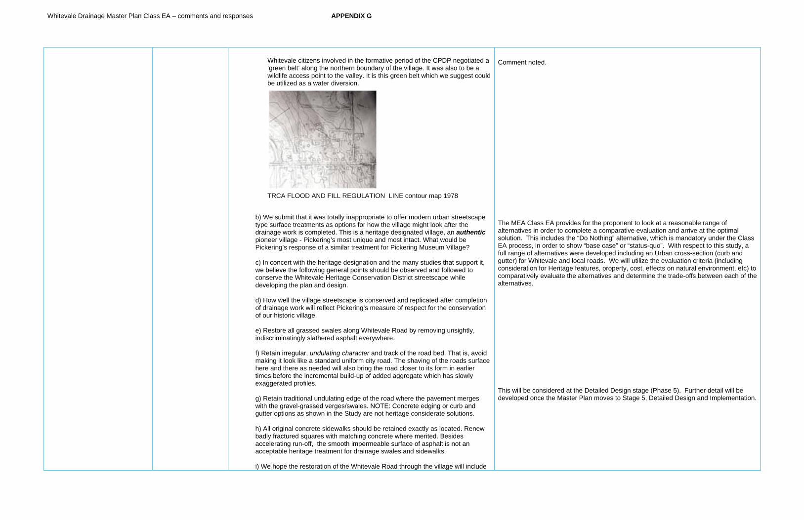
Whitevale Drainage Master Plan Class EA – comments and responses APPENDIX G
Whitevale citizens involved in the formative period of the CPDP negotiated a ‘green belt’ along the northern boundary of the village. It was also to be a wildlife access point to the valley. It is this green belt which we suggest could be utilized as a water diversion.
TRCA FLOOD AND FILL REGULATION LINE contour map 1978
b) We submit that it was totally inappropriate to offer modern urban streetscape type surface treatments as options for how the village might look after the drainage work is completed. This is a heritage designated village, an authenticpioneer village - Pickering’s most unique and most intact. What would be Pickering’s response of a similar treatment for Pickering Museum Village?
c) In concert with the heritage designation and the many studies that support it, we believe the following general points should be observed and followed to conserve the Whitevale Heritage Conservation District streetscape while developing the plan and design.
d) How well the village streetscape is conserved and replicated after completion of drainage work will reflect Pickering’s measure of respect for the conservation of our historic village.
e) Restore all grassed swales along Whitevale Road by removing unsightly, indiscriminatingly slathered asphalt everywhere.
f) Retain irregular, undulating character and track of the road bed. That is, avoid making it look like a standard uniform city road. The shaving of the roads surface here and there as needed will also bring the road closer to its form in earlier times before the incremental build-up of added aggregate which has slowly exaggerated profiles.
g) Retain traditional undulating edge of the road where the pavement merges with the gravel-grassed verges/swales. NOTE: Concrete edging or curb and gutter options as shown in the Study are not heritage considerate solutions.
h) All original concrete sidewalks should be retained exactly as located. Renew badly fractured squares with matching concrete where merited. Besides accelerating run-off, the smooth impermeable surface of asphalt is not an acceptable heritage treatment for drainage swales and sidewalks.
i) We hope the restoration of the Whitevale Road through the village will include
Comment noted.
The MEA Class EA provides for the proponent to look at a reasonable range of alternatives in order to complete a comparative evaluation and arrive at the optimal solution. This includes the “Do Nothing” alternative, which is mandatory under the Class EA process, in order to show “base case” or “status-quo”. With respect to this study, a full range of alternatives were developed including an Urban cross-section (curb and gutter) for Whitevale and local roads. We will utilize the evaluation criteria (including consideration for Heritage features, property, cost, effects on natural environment, etc) to comparatively evaluate the alternatives and determine the trade-offs between each of the alternatives.
This will be considered at the Detailed Design stage (Phase 5). Further detail will be developed once the Master Plan moves to Stage 5, Detailed Design and Implementation.
Whitevale Drainage Master Plan Class EA – comments and responses APPENDIX G
interplanting of tradition sugar maple trees where gaps exist due to trees that died of old age or were killed by the asphalt paving of grassed lined drainage swales – as happened in front of the Whitevale Craftworks!
j) Retain traditional narrow road width. The original width of the gravel and later paved roadway should be retained. The recent Indiscriminate slathering of asphalt onto the shoulders should be removed and grass verges restored.
Comments on Alternative Solutions:GENERAL: For the finished appearance of the Whitevale Road through the village after completion of drainage work, the AECOM Drainage Study presentation features options AS IS and several urban cityscapes so-called ‘Alternative Solutions’. ‘As is’ is to conserve. That is the only appropriate interpretation of the Whitevale Heritage Conservation District. The inclusion of modern, city streetscape options demonstrates the contempt the City holds for historic Whitevale.
Surely the provisions of Part V of the Ontario Heritage Act and numerous physical and cultural studies by knowledgeable experts should be the guide to what options are permitted on the table. We feel strongly the ‘as is’ option is the only option which honours and respects Whitevale’s unique streetscape which is frequently referenced in various physical, cultural and landscape studies. See References below:-
Comments on Evaluation Criteria:In front of technical, social, cost considerations, we believe the proposed criteria for evaluation should be - to conserve the character of the original streetscape, approximately as it is now. The present appearance, with some exceptions already mentioned, together with reference to the following named studies should be guides to how the finished main street should appear. In our interpretation of the Act and supporting studies, this does not include concrete edged paved road, or, curbs and gutters or asphalted drainage swales.
The side streets should remain unpaved. During all of the nearly fifty years we have called Whitevale home, Gladstone and Churchwin Streets continue to be wonderful, protected village road playgrounds, as they have been regarded for many generations before.
References GUIDE: Whitevale Heritage Conservation District - Town of Pickering THE DISTRICT PLAN Hamlet of Whitevale Heritage Conservation Study by
Unterman McPhail COMPLEXITIES OF SETTLEMENT in Pickering, Markham (etc) By Michelle
Grunwald. ONTARIO HERITAGE ACT, Part V, revised 2008 SEATON LANDS Cultural Heritage Assessment by Unterman McPhail SEATON The Form of its History, by John van Nostrand Cultural Landscape Assessment Central Pickering: Seaton Lands. by Wendy
Shearer
Comments on Recommendations:The following comments are concerned with two stretches of the road – The road
This will be considered at the Detailed Design stage (Phase 5). Further detail will be developed once the Master Plan moves to Stage 5, Detailed Design and Implementation.
The MEA Class EA provides for the proponent to look at a reasonable range of alternatives in order to complete a comparative evaluation and arrive at the optimal solution. This includes the “Do Nothing” alternative, which is mandatory under the Class EA process, in order to show “base case” or “status-quo”. With respect to this study, a full range of alternatives were developed including an Urban cross-section (curb and gutter) for Whitevale and local roads. We will utilize the evaluation criteria (including consideration for Heritage features, property, cost, effects on natural environment, etc) to comparatively evaluate the alternatives and determine the trade-offs between each of the alternatives.
We will utilize the evaluation criteria (including consideration for Heritage features, property, cost, effects on natural environment, etc) to comparatively evaluate the alternatives and determine the trade-offs between each of the alternatives.

Whitevale Drainage Master Plan Class EA – comments and responses APPENDIX G
fronting at 455 Whitevale Road, our home, and the other fronting property at 485 Whitevale Road, the Whitevale Craftworks.
455 WHITEVALE ROAD As seen today, the main features and general appearance of the Whitevale Road east of the bridge were established about 1911. At least, that is the date formed into a sidewalk square close to our driveway. The present cut was probably not the first attempt to soften the ridge that once stretched across the line of the road.
The depth, breadth and length of the cut must have been a major project it its day considering that it was largely accomplished by manual labour aided by teams of horses and drag boards. The sidewalk opposite, and all along the north side, when still a board-walk sidewalk, is probably close to the original grade elevation before work on the cut began.
We have purposefully left the screen of trees and shrubs largely untouched believing its mat of roots important to hold the soil in place. Since 1911, one hundred years and counting, it seems to have worked well - so far so good. Therefore, we hope and trust the municipality will not plan any change to the cut except a pruning and perhaps a judicious culling guided by advice of the City arborist.
The sidewalk in the cut on the south side has broken up due to salt spray and the freeze-thaw action on water saturation concrete. We assume the restoration will include the replacement of fractured concrete squares which should be renewed only where necessary. As much of the original concrete should be retained for ongoing service.
485 WHITEVALE ROAD Since 1911 and for the first 60 odd years as a gravel road, the 5th Concession Road was graded bi-annually and with periodic spot work as required. There used to be two memorable craters that would form in the road several times a year at the same places. They formed where water, perhaps springs, came close to the surface. At times they could be axial breaking. One always formed in front of the present day Craftworks property. The other cater was located further up the road, some 40 or 50 feet further east. Both of these received frequent attention. The remedy was to fill-in and add a (another) topping of aggregate and grade.
Over many decades of this practise the road bed rose incrementally. Immediately in front of the Craftworks shop the crown of the road must be close to 2 feet above the sidewalk making it difficult, if not dangerous for customers to access our shop and an impossible place to park.
At the time of completing the rehabilitation of the derelict `Hamlin House` (485 Whitevale Road) and its grand opening in fall of 1976, the municipality promised to fix the unsafe situation. Eventually, many years later, a crew arrived and paved the swale in front of the Craftworks. That had two consequences: in wet or icy conditions, the steep slope between the road and the sidewalk was made treacherous for customers. The other consequence - our beautiful maple withered and died within a few years. The impermeability of the asphalt starved the tree roots of water and nutrients. Today, the tree is gone, all that remains is the condition of risk to public safety.
Other Comments:THE ROADWAY: The traditional narrower width of the roadway should be retained as part of Whitevale`s streetscape character. In spite of the speed humps, speeding continues to threaten life
Information noted.
Information acknowledged.
Whitevale Drainage Master Plan Class EA – comments and responses APPENDIX G
and limb. Anything that slows traffic is good for public safety and peace of mind. Psychologically, the narrowness of the roadway (or any apparent constriction) causes people to drive more slowly. For a similar psychological reason, we have encouraged the planting of red flowers on the bridge during the summer driving season of idiots.
SWALES:The traditional grassed swales should be retained and restored wherever asphalt has been slathered. Some ten years ago, the Municipality paved the entire grassed swale from the western boundary of 494 Whitevale Road all the way to North Road. Not only is it unsightly and dysfunctional, it is a wholly inappropriate treatment of the village streetscape. On occasion, the smooth impermeable surface of the asphalted swale turns it into a water chute. The water’s volume and velocity overshoots the drain and washes across the road diagonally, down onto our property and into the basement at 485 Whitevale Road - the Whitevale Craftworks property. We sincerely hope that grassed swales can be restored and continue to serve to carry water to the next drain.
SIDEWALKS:Just downhill from our drive at 455 Whitevale Road, just past the jog in the sidewalk alignment there is date, ‘1911’ scribed into the once wet concrete. It is possible that all the sidewalks in the village may have been poured in or about the same year. We suggest the original sidewalk elevation(s), as they are today, should be a guide to where and how much to shave off elevated road surfaces because of aggregate added over many decades of gravel road maintenance.
In keeping with the heritage aspect of the village, the sidewalks should be retained as is. However we feel strongly that only concrete squares which are badly cracked or broken-up should be replaced with new matching concrete squares - not asphalt.
As mentioned previously, the sidewalks are the best indicator of the elevation of the so-called original road. The exception is the cut at 455/460 Whitevale Road where, on the north side, the location of the original wooden sidewalk was replaced with concrete but its original elevation remained unchanged. On the south side, we speculate there was a sidewalk that came close to our front door, but because of the planned cut and the nonconforming siting of our home, the steepness of the intended cut, the old sidewalk was demolished and replaced by a new one at the lower elevation – beside the new road after the cut was made.
TREESWe warmly encourage a planting program to replace the traditional colourful maple trees which used to line the Whitevale Road in perfusion. Many have died from root smothering asphalt and old age.
Thank you for the opportunity to comment.
Regarding a correction to our comments about the WHITEVALE DRAINAGE STUDY sent to you earlier today
In error I mentioned in our comments the date 1911, as the year the concrete sidewalk (adjacent to our property in the cut) was poured. That was incorrect.
This morning I began clearing away some of the debris (mostly gravel) that has covered our sidewalk since the flood of several years ago – this is a several inch thick mess I
This type of detail will be decided at the next Public Information Centre. Traffic calming is outside of the scope of this study, but should be considered as part of Detailed Design
Comment noted, this will be determined at the next Public Information Centre
Comment noted

Whitevale Drainage Master Plan Class EA – comments and responses APPENDIX G
guess the City considers my problem to clean up.
The correct date is 1909. Under this date are the initials H U J, except, upon closer examination the U revealed itself to be a large horseshoe embedded in the concrete.
Comments noted.
Resident #4 General Comment: Whitevale should stick with its small hamlet character. Good forum Comment of Alternative Solutions: Upgrade and maintain but not [too] much Comment on Evaluation Criteria: The facts are known now. Make the needed improvements, but small
Comments noted.
Resident #5 General Comment: This Public Information Centre should have been held in Whitevale. There are many people here without a car and no people in wheelchairs. Your argument about accessibility does not hold up in that the City of Pickering uses the Centre for Elections and their Summer Camp. I feel disenfranchised by a process that makes me drive to Claremont to obtain information about Whitevale. Comment of Alternative Solutions: Quite frankly I am extremely disappointed in the alternatives proposed. After 4 years time we get a suburban solution to a rural issue. The alternatives, other than number 1, all ignore the “Whitevale Heritage District Plan” 1990. The alternatives ignore the fact that these heritage homes are located close and in one case on the road allowance. I am requesting that you go back to the drawing board and produce a plan with narrow lanes, no roll-overs or curbs and where necessary narrow sidewalks that match the current ones, as suggested in the Whitevale Heritage District Plan. If you can do this with as little disruption to tree roots as possible, it would be appreciated. I support the lowering of the profile of the road as I believe it would improve the drainage. Comment on Evaluation Criteria: NO - I would suggest that you adhere to section 5.7 in the “Whitevale Heritage Conservation District” “A Guide” and section 3.4 “Landscape Conservation and Enhancement” Part II of the Whitevale Heritage District Plan. If you do this you could probably create an alternative that I could support.
Comment noted. We will look at a location in Whitevale for the next PIC.
The MEA Class EA provides for the proponent to look at a reasonable range of alternatives in order to complete a comparative evaluation and arrive at the optimal solution. This includes the “Do Nothing” alternative, which is mandatory under the Class EA process, in order to show “base case” or “status-quo”. With respect to this study, a full range of alternatives were developed including an Urban cross-section (curb and gutter) for Whitevale and local roads. We will utilize the evaluation criteria (including consideration for Heritage features, property, cost, effects on natural environment, etc) to comparatively evaluate the alternatives and determine the trade-offs between each of the alternatives.
The Heritage District Plan for Whitevale will be reviewed during development of alternative solutions.
Resident #6 1) PLEASE PROVIDE ANY GENERAL COMMENT REGARDING THE PUBLIC INFORMATION CENTRE. This public information centre SHOULD have been held in Whitevale. The low attendance numbers were as a result of the distance required to for Whitevale residents to attend – NOT lack of interest or concern. For residents to get home from work, prepare / eat dinner and then travel ~15 km (one-way) to attend this session would be challenging for many. I recognize the importance of accessibility, but in this instance, perhaps you could have polled residents to determine if this would have been an issue. Please take this into consideration for any futures PICs
2) DO YOU HAVE ANY COMMENTS, CONCERNS OR RECOMMENDATIONS REGARDING THE PROPOSED ALTERNATIVE SOLUTIONS? There was not enough information on the alternative solutions to really understand what they would mean and what impact they would have in terms of: 1) Overall visual change to the village 2) estimated length of time the construction would take and what type of disruption this would be to residents and their way of life (e.g. road closures, detours, dirt/dust etc)
Comment noted. We will look at a location in Whitevale for the next PIC.
Comments acknowledged. We will provide further detail on the alternative solutions as well as the comparative evaluation results, along with proposed mitigation measures and net effects at the next PIC.
Whitevale Drainage Master Plan Class EA – comments and responses APPENDIX G
3) what would be the overall improvement to the overall drainage concerns 4) what is the financial impact? – what are the cost variances between the various alternatives? 5) what do the alternatives actually mean (e.g. Increasing the size of the ditch on the east side of North Rd. Does this refer to the existing ditches in front of the homes or is this referring to the area north of the last house? The existing ditch in front of the houses is incredibly large and I can’t imagine these being any larger. North of the last house there are no ditches and this is an area for improvement.) I would need a more detailed description of the alternatives to provide appropriate response.
Without an understanding of these types of impacts, it is challenging to provide meaningful input into this process. If further details on the above could be provide it could help residents to be able to provide more insightful input.
ARE YOU IN AGREEMENT WITH THE PROPOSED EVALUATION CRITERIA? IF NOT, WHAT WOULD YOU CHANGE? ARE THERE ADDITIONAL CRITERIA THAT YOU WOULD LIKE TO CITY OF PICKERING TO CONSIDER FOR THIS STUDY? Any alternative that is to be seriously considered MUST take into consideration the Heritage Designation of the Hamlet. This criteria should be weighted more heavily than the others. Given that, there should be NO curbs, sidewalks or roads wider than what is currently found in the hamlet.
The Heritage District Plan for Whitevale will be reviewed during development of alternative solutions.
PIC#2
Resident #7General Comment: Well done, well staffed with knowledgeable personnel. Good location Selected Solutions: I like the alternative 3 for intermittent drainage. I would like to see ORC/TRCA cooperation to reduce cost (land acquisition) and contribute to the area regeneration (former gravel pit) (prefer). I like the selections for the other areas, in particular, resurfacing/regarding of existing roads. Overall recommendations: Clarification: succession? TRCA regulation limit.
Topographical maps for area north of Whitevale would be interesting to see.
Comment acknowledged Although Alternative #3 addresses the problem/opportunity statement, it was not selected based on high property acquisition costs and capital cost.
The area identified as “succession” on the Natural Environment figure refers to a habitat that has undergone change from one species to another. The TRCA Regulation Limit applies to the area that TRCA regulates under O.Reg. 166/06 and would require a permit for any alteration within these limits
Topographical maps may be obtained from the City or other government sources (MNR).
Resident #8
General Comment: Thank you for relocating the session to the Whitevale Community Centre Comment of Alternative Solution: Thank you for listening to the resident’s feedback. The recommended solution looks good. Comment on Evaluation : Yes, further consideration should be given to the organic binder on the roads which looks promising to stabilize the road surface.
Comment acknowledged.
Organic binder and other environmentally friendly topical surface treatments have been recommended for consideration on unpaved road surfaces.
Whitevale Drainage Master Plan Class EA – comments and responses APPENDIX G
Resident #9 General Comments: Sensible to hold what matters to Whitevale IN Whitevale Comments of Alternative Solutions: Replace existing paved roads to Rural standard. Sideroads not paved to be kept as a rural standard I believe both are level 2 as per your info boards
Comment on Evaluation Criteria: I agree that storm drainage and culverts need improving – but keep the rural appearance – in general
Comments acknowledged.
Resident #10 I do not understand why the option of diverting more than half the run-off (NE) from perimeter of village is reject – presumably because the city is intent upon tearing up the Main Street and make it like a city street. A diversion seems like such a common sense, no brainer. I cannot imagine why except for the reason mentioned. I am listening.
The comparative evaluation of the alternative solutions looked at a variety of criteria, including technical, financial, and environmental. The comparative evaluation showed that the diversion option, although capable of implementation from a technical stand-point, was not as optimal as other solutions put forward, from an overall evaluation perspective.
Resident #11 Updated Comments of Alternative Solutions: The solutions that require urban and sewer systems do not reflect the rural quality of the village and should be avoided. Comment on Evaluation Criteria As the storm of 2008 was regarded as a 100 years storm and unlikely to happen again in more than a couple of generations, please consider the “do nothing and on-going maintenance” solution, but lowering of the roadway where needed also.
Heritage and rural character is an evaluation criteria and will be factored into the overall comparative evaluation.
The Do Nothing includes on-going maintenance and will be considered in the evaluation of alternatives.