Embed Size (px)
Citation preview
MARYLAND PARK LAKE DISTRICT
SECTION 7.5 - PLANNING SUB-DISTRICT POLICIES
CITY OF MARYLAND HEIGHTS

MARYLAND HEIGHTS COMPREHENSIVE PLAN - ADOPTED MAY 24, 2016 Page 7.5.3
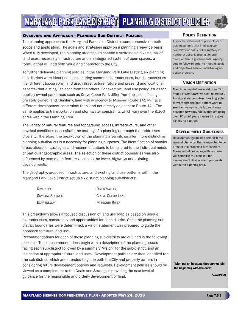
The planning approach to the Maryland Park Lake District is comprehensive in both
scope and application. The goals and strategies apply on a planning area-wide basis.
When fully developed, the planning area should contain a sustainable diverse mix of
land uses, necessary infrastructure and an integrated system of open spaces, a
formula that will add both value and character to the City.
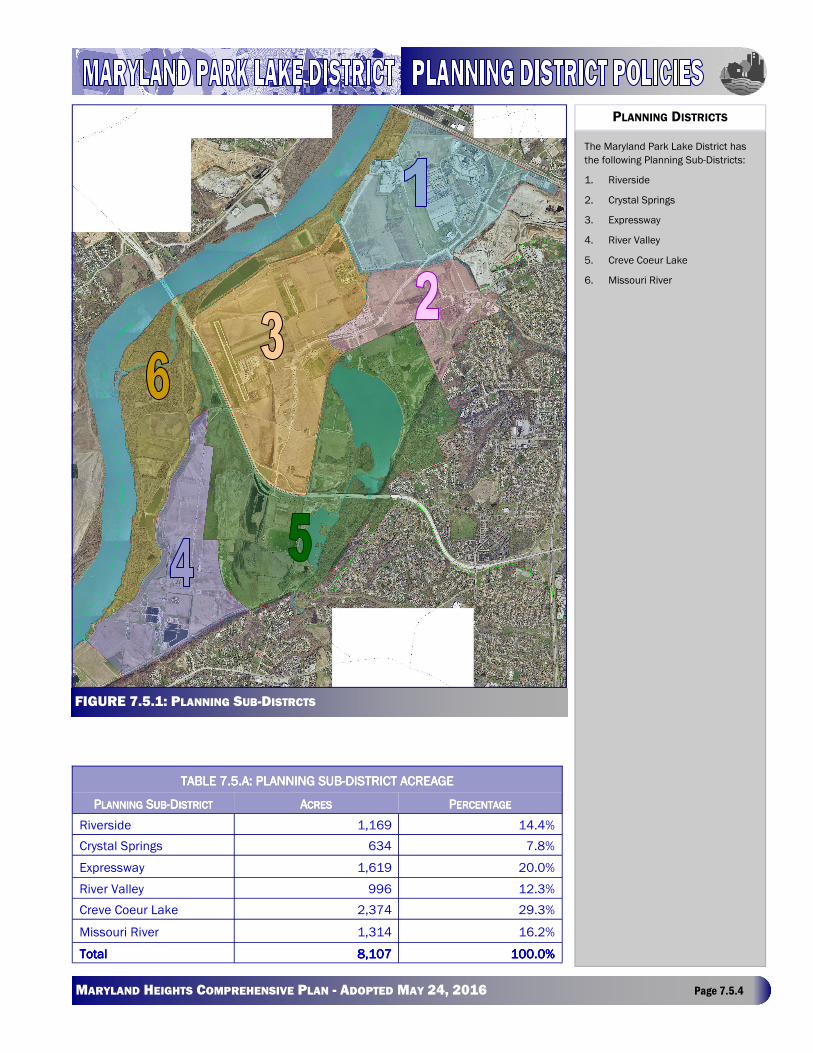
To further delineate planning policies in the Maryland Park Lake District, six planning
sub-districts were identified; each sharing common characteristics, but characteristics
(i.e. different topography, land use, infrastructure [future and present] and locational
aspects) that distinguish each from the others. For example, land use policy issues for
publicly owned park areas such as Creve Coeur Park differ from the issues facing
privately owned land. Similarly, land with adjacency to Missouri Route 141 will face
different development constraints than land not directly adjacent to Route 141. The
same applies to transportation and stormwater constraints which vary over the 8,100
acres within the Planning Area.
The variety of natural features and topography, access, infrastructure, and other
physical conditions necessitate the crafting of a planning approach that addresses
diversity. Therefore, the breakdown of the planning area into smaller, more distinctive
planning sub-districts is a necessity for planning purposes. The identification of smaller
areas allows for strategies and recommendations to be tailored to the individual needs
of particular geographic areas. The selection of these district boundaries was also
influenced by man-made features, such as the levee, highways and existing
developments.
The geography, proposed infrastructure, and existing land use patterns within the
Maryland Park Lake District set up six distinct planning sub-districts:
This breakdown allows a focused discussion of land use policies based on unique
characteristics, constraints and opportunities for each district. Once the planning sub-
district boundaries were determined, a vision statement was prepared to guide the
approach to future land use.
Recommendations for each of these planning sub-districts are outlined in the following
sections. These recommendations begin with a description of the planning issues
facing each sub-district followed by a summary “vision” for the sub-district, and an
indication of appropriate future land uses. Development policies are then identified for
the sub-district, which are intended to guide both the City and property owners in
considering future development options and requests. Development policies should be
viewed as a complement to the Goals and Strategies providing the next level of
guidance for the responsible and orderly development of land.
A specific statement of principle or of
guiding actions that implies clear
commitment but is not regulatory in
nature. A policy is also a general
direction that a governmental agency
sets to follow in order to meet its goals
and objectives before undertaking an
action program.
POLICY DEFINITION
VISION DEFINITION
The dictionary defines a vision as “'An
Image of the future we seek to create”.
A vision statement describes in graphic
terms where the goal-setters want to
see themselves in the future. It may
describe how they see events unfolding
over 10 or 20 years if everything goes
exactly as planned.
DEVELOPMENT GUIDELINES
Development guidelines establish the
general character that is expected to be
present in a proposed development.
These guidelines along with land use
will establish the baseline for
evaluation of development proposals
within the planning area.
“Men perish because they cannot join “Men perish because they cannot join “Men perish because they cannot join “Men perish because they cannot join
the beginning with the end.”the beginning with the end.”the beginning with the end.”the beginning with the end.”
---- AAAALCAMAEONLCAMAEONLCAMAEONLCAMAEON
OVERVIEW AND APPROACH - PLANNING SUB-DISTRICT POLICIES
RIVERSIDE RIVER VALLEY
CRYSTAL SPRINGS CREVE COEUR LAKE
EXPRESSWAY MISSOURI RIVER
MARYLAND HEIGHTS COMPREHENSIVE PLAN - ADOPTED MAY 24, 2016 Page 7.5.4
The Maryland Park Lake District has
the following Planning Sub-Districts:
1. Riverside
2. Crystal Springs
3. Expressway
4. River Valley
5. Creve Coeur Lake
6. Missouri River
PLANNING DISTRICTS
TABLE 7.5.A: PLANNING SUBTABLE 7.5.A: PLANNING SUBTABLE 7.5.A: PLANNING SUBTABLE 7.5.A: PLANNING SUB----DISTRICT ACREAGEDISTRICT ACREAGEDISTRICT ACREAGEDISTRICT ACREAGE
PPPPLANNINGLANNINGLANNINGLANNING SSSSUBUBUBUB----DDDDISTRICTISTRICTISTRICTISTRICT AAAACRESCRESCRESCRES PPPPERCENTAGEERCENTAGEERCENTAGEERCENTAGE
Riverside 1,169 14.4%
Crystal Springs 634 7.8%
Expressway 1,619 20.0%
River Valley 996 12.3%
Creve Coeur Lake 2,374 29.3%
Missouri River 1,314 16.2%
TotalTotalTotalTotal 8,1078,1078,1078,107 100.0%100.0%100.0%100.0%
FIGURE 7.5.1: PLANNING SUB-DISTRCTS
MARYLAND HEIGHTS COMPREHENSIVE PLAN - ADOPTED MAY 24, 2016 Page 7.5.5
While ensuring both an economically productive pattern of development for the City
and providing increased value to land owners is important, it is also critical that the
City require that the Maryland Park Lake District area develop in such a way that it
enhances both the regional image of the City and the needs of the overall community.
This plan presents recommendations designed to add both value and character to the
planning area. Development proposals in the form of rezoning petitions will be
expected to address the following general questions regarding its impacts:
• Does the development improve Maryland Heights’ image?
• Does the development provide a needed amenity to the community?
• Does the development adhere to the goals and strategies established in the plan?
• Does the development contribute to the financial well being and stability of the
City?
• Does the developments design add character to the area and the City?
The first component that furthers development quality is “quality begets quality”; high
quality development sets a tone that attracts additional high quality development. In
fact, the historical development approach taken in Riverport Business Park is a
positive precedent for the City to follow. While it is desirable for the remaining portion
of the Maryland Park Lake District to develop with at least the same base quality as
Riverport in office and distribution areas, it is envisioned that improved standards,
planning of infrastructure improvements and inclusion of amenities will attract even
higher quality development, in which architecture, landscape and urban design are
fully integrated across developments and the planning area.
“Quality” is a difficult concept to define, especially when it relates to real estate
development. Quality and character are often thought of as subjective ideas that on
the surface appear difficult to quantify and seem intangible. However, the fact that
subjective concepts cannot always be quantified does not mean that fair, reasonable,
effective standards cannot be established. It is well demonstrated that design
standards related to land use, public facilities, site planning, building configuration,
materials and orientation, landscaping, pedestrian facilities, signage, lighting, and
other aspects of public and private development can be established and development
character can achieve a certain level of “quality”. At the same time, these standards
must be administered efficiently and consistently without creating uncertainty and
undue delay in the development review process.
However, the responsibility for quality does not solely rest within the private sector. It is
equally important that the City apply the same high standards for the public realm as
those to which private development is held. The way in which streets are designed,
development is integrated with public pedestrian facilities and open spaces and public
properties are maintained and operated are critical to community character.
“Streetscape” standards are particularly important: street landscaping, lighting, traffic
control devices, signage, the location of utility lines and other public infrastructure can
be designed to achieve an overall aesthetic image, in addition to serving functional
The approach of systems thinking is
fundamentally different from that of
traditional forms of analysis. Tradition-
al analysis focuses on the separation
of the individual pieces of what is
being studied; in fact, the word
"analysis" actually comes from the root
meaning "to break into constituent
parts." Systems’ thinking, in contrast,
focuses on how the thing being stud-
ied interacts with the other constitu-
ents of the system—a set of elements
that interact to produce behavior—of
which it is a part. This means that
instead of isolating smaller and small-
er parts of the system being studied,
systems thinking works by expanding
its view to take into account larger and
larger numbers of interactions as an
issue is being studied. This results in
sometimes strikingly different conclu-
sions than those generated by tradi-
tional forms of analysis, especially
when what is being studied is dynami-
cally complex or has a great deal of
feedback from other sources, internal
or external.
SYSTEMS THINKING DEVELOPMENT QUALITY
MARYLAND HEIGHTS COMPREHENSIVE PLAN - ADOPTED MAY 24, 2016 Page 7.5.6
purposes.
When considering the future character of this area, it is important to recognize that there is substantial public investment
in the area that has begun to establish an image. The City has already made a substantial investment in the area by
spending approximately $46 million on regional transportation improvements and committing an additional $15+ million
to future regional transportation improvements. Specifically, Creve Coeur Park, Hollywood Casino, Riverport Business Park
and others have created a regional identity for this area as a venue for entertainment, hospitality and recreation. This
image should be preserved, emphasized and capitalized upon even as large-scale development is encouraged. Future
development should complement and expand on this theme.
There are a number of general policies that are applicable to any developable site within the Maryland Park Lake District
regardless of what planning district the site is located within. These policies work with the Maryland Park Lake District
Future Land Use Map, and are applicable across the five planning sub-districts that support development.
DDDDETERMINATIONETERMINATIONETERMINATIONETERMINATION OFOFOFOF UUUUSESSESSESSES::::
• New development should incorporate a mix of uses combined with support and accessory uses as necessary. For
example, the Maryland Park Lake District should develop with office, office flex, office distribution, and retail uses,
and may also include some specific types of support, retail, personal services and/or multifamily residential.
• Appropriate land uses should be determined based on consideration of the overall Maryland Park Lake District,
and cannot be determined based solely upon isolated consideration of a specific site.
• All applicants will need to demonstrate compliance with this Plan and Future Land Use Map and then meet the
required developmental design guidelines prior to approval.
• Developments should be larger in scale than single small developments, should include assemblage of multiple
parcels, thereby benefiting from economy of scale and opportunities to integrate versus fragment.
CCCCONNECTIONSONNECTIONSONNECTIONSONNECTIONS::::
• Integrated connections to the regional stormwater system and either Missouri Route 141 or the River Valley
Parkway are a prerequisite in the consideration of development proposals.
• Where possible, all development must connect, or provide future provisions for the connection to the existing or
planned open space, park and trail system. Where this is not deemed possible, development proposals must
include an internal walkability plan.
RRRRESIDENTIALESIDENTIALESIDENTIALESIDENTIAL UUUUSESSESSESSES::::
• Single family detached residential development is only acceptable as provided herein.
• Multifamily residential development is a conditionally accepted land use wherever it is identified on the Future
Land Use Map except when integrated into mixed use development where it is encouraged.
RRRRETAILETAILETAILETAIL ANDANDANDAND MMMMIXEDIXEDIXEDIXED UUUUSESSESSESSES::::
• Where large scale retail is identified on the Maryland Park Lake District Future Land Use Map, it is considered a
conditionally acceptable use.
• Service retail is a conditionally acceptable use wherever it is identified on the Maryland Park Lake District Future
Land Use Map.
GENERAL DEVELOPMENT POLICIES
MARYLAND HEIGHTS COMPREHENSIVE PLAN - ADOPTED MAY 24, 2016 Page 7.5.7
• Mixed use development is an encouraged use wherever it is identified on the Maryland Park Lake District Future
Land Use Map. Retail, commercial and multifamily uses are permitted in a mixed use district, but any single use
should only comprise no more than 60-70% of the overall mix.
• Where the Future Land Use Map shows a mix of uses not labeled “mixed use”, such as office distribution/light
industrial, either of the uses identified in the mix are appropriate for development, based on its corresponding level
of encouragement.
LLLLOCATIONOCATIONOCATIONOCATION ANDANDANDAND LLLLOTOTOTOT SSSSIZEIZEIZEIZE::::
• Office flex and office distribution uses may be permitted in areas identified for light industrial uses.
• The allowable size of any use will be determined based on:
• Lot size
• Infrastructure (available or to be constructed)
• Size and scale of surrounding uses
• Character of development area
• Visual impact of the use on adjoining properties, developments and the public right-of-way.
PPPPUBLICUBLICUBLICUBLIC SSSSERVICESERVICESERVICESERVICES::::
• As development takes place within the Maryland Park Lake District, it will be necessary to provide public services
such as police, fire, and EMT. Developers will work with the City and public service providers to determine the
appropriate service area and locations for these uses based on individual and overall land use patterns.
TTTTRANSPORTATIONRANSPORTATIONRANSPORTATIONRANSPORTATION:
• Development will be required to complete a traffic impact study.
• Development must provide for the accommodation of required transportation improvements.
• Development must provide adequate levels of connectivity within the street network avoiding isolated clusters of
development.
• Development must provide a road system that is sustainable and easily maintained.
• Streets, both public and private, will be designed to provide for multi modal transportation options.
• Streets, both public and private, will be designed in a manner that create a sense of place and add character to
the public realm.
• New development will be consistent with transportation recommendations set forth in the Comprehensive Plan.
SSSSTORMWATERTORMWATERTORMWATERTORMWATER MANAGEMENTMANAGEMENTMANAGEMENTMANAGEMENT::::
• Stormwater management systems will be designed in a multi-functional and integrated manner.
• Stormwater management systems will be designed and utilized as a site amenity.
• Stormwater management systems will be designed in a manner that adds character and enhances the public
viewshed.
MARYLAND HEIGHTS COMPREHENSIVE PLAN - ADOPTED MAY 24, 2016 Page 7.5.8
PPPPUBLICUBLICUBLICUBLIC UUUUTILITIESTILITIESTILITIESTILITIES::::
• Adequate public utilities must be provided for proposed developments.
• Development proposals must consider the accommodation of public utility infrastructure.
This plan includes transportation and stormwater infrastructure planning recommendations. All three categories – land
use, transportation, and stormwater - are interrelated and must work together in a holistic manner.
Within this relationship, there are potential requirements and restrictions included in each component that will impact the
others. There are basic requirements, such as the design and construction of the River Valley Parkway and the design and
connection of the regional stormwater system, each of which has a relationship and an impact upon land use. An example
is the development of a certain square footage of office uses will require the construction of a number of supporting
roadways and potentially a segment of the River Valley Parkway with integrated stormwater and open space. In some
instances, the development would be contingent on the construction of the identified infrastructure improvements. For
example, the build-out of the regional retail and mixed use districts may be contingent on the construction of an
interchange at the River Valley Parkway and State Route 364.
Any development proposed in the Maryland Park Lake District must reflect the recommendations contained within this
plan for all three policy areas and accurately include site planning related to these triggers and restrictions. As
development moves from a “greenfield environment” to a suburban or urban density, the amount of required private
investment in providing infrastructure is expected to increase. This development will place higher demand upon the
requirements of those systems. The City will work with developers, land owners and community and public agencies to
establish timeframes and responsibilities for these improvements.
The remainder of this section will outline the future development recommendations and guidelines for each planning sub-
district. These guidelines form the basis for evaluating development proposals and establishing appropriate regulatory
standards.
STORMWATER, TRANSPORTATION AND LAND USE
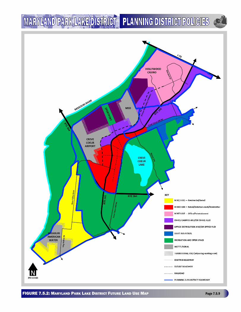
FIGURE Page 7.5.9
7.5.2: MARYLAND PARK LAKE DISTRICT FUTURE LAND USE MAP
MARYLAND HEIGHTS COMPREHENSIVE PLAN - ADOPTED MAY 24, 2016 Page 7.5.10
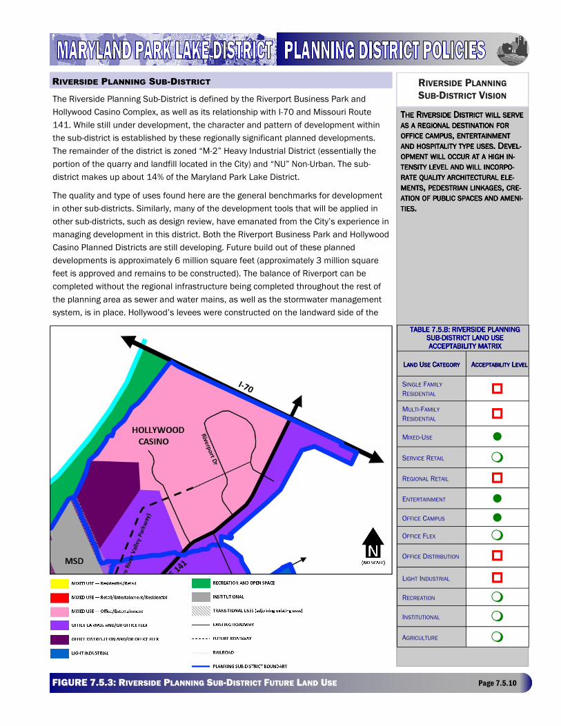
The Riverside Planning Sub-District is defined by the Riverport Business Park and
Hollywood Casino Complex, as well as its relationship with I-70 and Missouri Route
141. While still under development, the character and pattern of development within
the sub-district is established by these regionally significant planned developments.
The remainder of the district is zoned “M-2” Heavy Industrial District (essentially the
portion of the quarry and landfill located in the City) and “NU” Non-Urban. The sub-
district makes up about 14% of the Maryland Park Lake District.
The quality and type of uses found here are the general benchmarks for development
in other sub-districts. Similarly, many of the development tools that will be applied in
other sub-districts, such as design review, have emanated from the City’s experience in
managing development in this district. Both the Riverport Business Park and Hollywood
Casino Planned Districts are still developing. Future build out of these planned
developments is approximately 6 million square feet (approximately 3 million square
feet is approved and remains to be constructed). The balance of Riverport can be
completed without the regional infrastructure being completed throughout the rest of
the planning area as sewer and water mains, as well as the stormwater management
system, is in place. Hollywood’s levees were constructed on the landward side of the
TTTTHEHEHEHE RRRRIVERSIDEIVERSIDEIVERSIDEIVERSIDE DDDDISTRICTISTRICTISTRICTISTRICT WILLWILLWILLWILL SERVESERVESERVESERVE ASASASAS AAAA REGIONALREGIONALREGIONALREGIONAL DESTINATIONDESTINATIONDESTINATIONDESTINATION FORFORFORFOR OFFICEOFFICEOFFICEOFFICE CAMPUSCAMPUSCAMPUSCAMPUS, , , , ENTERTAINMENTENTERTAINMENTENTERTAINMENTENTERTAINMENT ANDANDANDAND HOSPITALITYHOSPITALITYHOSPITALITYHOSPITALITY TYPETYPETYPETYPE USESUSESUSESUSES. D. D. D. DEVEL-EVEL-EVEL-EVEL-
OPMENTOPMENTOPMENTOPMENT WILLWILLWILLWILL OCCUROCCUROCCUROCCUR ATATATAT AAAA HIGHHIGHHIGHHIGH IN-IN-IN-IN-
TENSITYTENSITYTENSITYTENSITY LEVELLEVELLEVELLEVEL ANDANDANDAND WILLWILLWILLWILL INCORPO-INCORPO-INCORPO-INCORPO-
RATERATERATERATE QUALITYQUALITYQUALITYQUALITY ARCHITECTURALARCHITECTURALARCHITECTURALARCHITECTURAL ELE-ELE-ELE-ELE-
MENTSMENTSMENTSMENTS, , , , PEDESTRIANPEDESTRIANPEDESTRIANPEDESTRIAN LINKAGESLINKAGESLINKAGESLINKAGES, , , , CRE-CRE-CRE-CRE-
AAAATTTTIIIIOOOONNNN OFOFOFOF PUBLICPUBLICPUBLICPUBLIC SPACESSPACESSPACESSPACES ANDANDANDAND AMENI-AMENI-AMENI-AMENI-
TIESTIESTIESTIES....
RIVERSIDE PLANNING
SUB-DISTRICT VISION
TABLE 7.5.B: RIVERSITABLE 7.5.B: RIVERSITABLE 7.5.B: RIVERSITABLE 7.5.B: RIVERSIDE PLANNING DE PLANNING DE PLANNING DE PLANNING SUBSUBSUBSUB----DISTRICT LAND USDISTRICT LAND USDISTRICT LAND USDISTRICT LAND USE E E E ACCEPTABILITY MATRIXACCEPTABILITY MATRIXACCEPTABILITY MATRIXACCEPTABILITY MATRIX
LLLLANDANDANDAND UUUUSESESESE CCCCATEGORYATEGORYATEGORYATEGORY AAAACCEPTABILITYCCEPTABILITYCCEPTABILITYCCEPTABILITY LLLLEVELEVELEVELEVEL
SINGLE FAMILY
RESIDENTIAL �
MULTI-FAMILY
RESIDENTIAL �
MIXED-USE �
SERVICE RETAIL �
REGIONAL RETAIL �
ENTERTAINMENT �
OFFICE CAMPUS �
OFFICE FLEX �
OFFICE DISTRIBUTION �
LIGHT INDUSTRIAL �
RECREATION �
INSTITUTIONAL �
AGRICULTURE �
RIVERSIDE PLANNING SUB-DISTRICT
FIGURE 7.5.3: RIVERSIDE PLANNING SUB-DISTRICT FUTURE LAND USE Page 7.5.10
MARYLAND HEIGHTS COMPREHENSIVE PLAN - ADOPTED MAY 24, 2016 Page 7.5.11
existing river levee system, around Hollywood’s property, and tie into the Riverport 500-year levee on the south side at Fee
Fee Creek. The interior levee was constructed to protect the Hollywood Casino property from both a Missouri River flood,
should the Howard Bend levee fail, and the interior flooding potential from Fee Fee and Creve Coeur Creeks. It should be
noted, however, that the regional stormwater conveyance system being planned by the Howard Bend Levee District will
place a flank levee along the creeks creating a large area of open space to be utilized within future developments.
Hollywood manages its internal stormwater from the drainage area defined by the present alignment of the levees.
Ample water supply is available form Missouri American Water Company to serve development. The MSD Missouri River
Treatment Plant, which serves a large area in addition to the Maryland Park Lake District, is at capacity. The expansion of
this facility is presently being designed. The sanitary sewer collection is in place for Riverport Business Park, no additional
constraints on development are assumed within either the Hollywood or Riverport developments.
The Fee Fee Creek corridor has importance as both a regional stormwater conveyance channel and as a linear open space
corridor. The improvements to this floodway will incorporate environmental and open space amenities. The planned
configuration of the stormwater conveyance system along the frontage of the Hollywood Casino Planned District may
preclude the future development of the lands east of the Expressway.
The Riverside Sub-District will serve as a regional destination for office campus, entertainment and hospitality type uses.
Development will occur at a high intensity level and will incorporate quality architectural elements, pedestrian linkages,
and the creation of public spaces and amenities.
As new development occurs in the Riverside sub-district, specific consideration will need to be given to the following
issues:
• Impacts of the MSD Missouri River Treatment Plant on development with respect to location, compatibility of uses,
long term expansion and noxious odors.
• Multi-modal connectivity of projects and uses through automobile, pedestrian, and bicycle routes.
• Potential future pedestrian movement on site and between developments.
• Appropriate design standards for entrance and gateway structures fronting Missouri Route 141.
• The Howard Bend Levee District establishing a funding mechanism for the provision of regional stormwater
conveyance along Fee Fee Creek and Creve Coeur Creek.
• Potential amphitheater redevelopment impacts on transportation and surrounding uses.
The sub-district functions not only as the northern gateway to the Maryland Park Lake District but as a primary gateway to
the City, therefore subsequent development within this area should follow the high standards of quality identified in this
plan. Because this sub-district is a major destination for both local and regional residents and tourists, uses within the sub
-district should provide easy integrated access. Sites should be designed with clear access points . These policies work
with and support the Future Land Use Map.
• In areas not zoned or within a planned district, appropriate land uses should be consistent with the Future Land Use
Plan and cannot be determined based solely upon consideration of a specific site.
RIVERSIDE DEVELOPMENT VISION
RIVERSIDE DEVELOPMENT CONSIDERATIONS
RIVERSIDE GENERAL POLICIES
MARYLAND HEIGHTS COMPREHENSIVE PLAN - ADOPTED MAY 24, 2016 Page 7.5.12
• Any development proposal will need to prove consistency with this plan prior to consideration, and meet the
requirements of the Maryland Heights Zoning Code and any applicable design guidelines prior to approval.
• The Future Land Use Map identifies the encouraged development pattern for this area. Other land uses (identified as
“Conditionally Acceptable”) may be considered provided that the land uses: demonstrate need and add value to the
area; are found to further the Goals and Strategies of this plan; are consistent with the guidance provided in this plan;
and any associated development issues can be mitigated.
• New development should incorporate hospitality and entertainment uses and a mix of uses currently established
within the Riverport and Hollywood Planned Districts. Some support and/or accessory uses may be necessary to
support the integrated development of the area.
• Office campus uses are appropriate and encouraged in this planning sub-district. Office campuses can extend the
corporate character established by Riverport and extend that into the Maryland Park Lake District along the Missouri
Route 141 and the future River Valley Parkway.
• The expansion of the Hollywood Casino Planned District as a mixed use entertainment and specialty retail district is
encouraged.
• Development must connect to, and be integrated within, the regional stormwater management system.
• Development must connect to Missouri Route 141 or future River Valley Parkway.
• All development must connect to existing parks and trail systems where practical. Walkability at the planned
development level is a priority.
• Multi-modal connections between planned developments and other districts are required.
• Developments in this area should utilize gateway type architectural elements.
RIVERSIDE SPECIFIC POLICIES
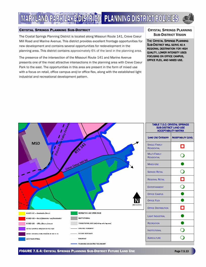
MARYLAND HEIGHTS COMPREHENSIVE PLAN - ADOPTED MAY 24, 2016 Page 7.5.13 FIGURE 7.5.4: CRYSTAL SPRINGS PLANNING SUB-DISTRICT FUTURE LAND USE Page 7.5.13
The Crystal Springs Planning District is located along Missouri Route 141, Creve Coeur
Mill Road and Marine Avenue. This district provides excellent frontage opportunities for
new development and contains several opportunities for redevelopment in the
planning area. This district contains approximately 6% of the land in the planning area.
The presence of the intersection of the Missouri Route 141 and Marine Avenue
presents one of the most attractive intersections in the planning area with Creve Coeur
Park to the east. The opportunities in this area are present in the form of mixed use
with a focus on retail, office campus and/or office flex, along with the established light
industrial and recreational development pattern.
TTTTHEHEHEHE CCCCRYSTALRYSTALRYSTALRYSTAL SSSSPRINGSPRINGSPRINGSPRINGS PPPPLANNINGLANNINGLANNINGLANNING SSSSUBUBUBUB----DDDDISTRICTISTRICTISTRICTISTRICT WILLWILLWILLWILL SERVESERVESERVESERVE ASASASAS AAAA REGIONALREGIONALREGIONALREGIONAL DESTINATIONDESTINATIONDESTINATIONDESTINATION FORFORFORFOR HIGHHIGHHIGHHIGH QUALITYQUALITYQUALITYQUALITY, , , , LOWERLOWERLOWERLOWER INTENSITYINTENSITYINTENSITYINTENSITY USESUSESUSESUSES FOCUSINGFOCUSINGFOCUSINGFOCUSING ONONONON OFFICEOFFICEOFFICEOFFICE CAMPUSCAMPUSCAMPUSCAMPUS, , , , OFFICEOFFICEOFFICEOFFICE FLEXFLEXFLEXFLEX, , , , ANDANDANDAND MIXEDMIXEDMIXEDMIXED USEUSEUSEUSE....
CRYSTAL SPRINGS PLANNING
SUB-DISTRICT VISION
CRYSTAL SPRINGS PLANNING SUB-DISTRICT
TABLE 7.5.C: CRYSTAL SPRINGS TABLE 7.5.C: CRYSTAL SPRINGS TABLE 7.5.C: CRYSTAL SPRINGS TABLE 7.5.C: CRYSTAL SPRINGS SUBSUBSUBSUB----DISTRICT LAND USDISTRICT LAND USDISTRICT LAND USDISTRICT LAND USE E E E ACCEPTABILITY MATRIXACCEPTABILITY MATRIXACCEPTABILITY MATRIXACCEPTABILITY MATRIX
LLLLANDANDANDAND UUUUSESESESE CCCCATEGORYATEGORYATEGORYATEGORY AAAACCEPTABILITYCCEPTABILITYCCEPTABILITYCCEPTABILITY LLLLEVELEVELEVELEVEL
SINGLE FAMILY
RESIDENTIAL �
MULTI-FAMILY
RESIDENTIAL �
MIXED-USE �
SERVICE RETAIL �
REGIONAL RETAIL �
ENTERTAINMENT �
OFFICE CAMPUS �
OFFICE FLEX �
OFFICE DISTRIBUTION �
LIGHT INDUSTRIAL �
RECREATION �
INSTITUTIONAL �
AGRICULTURE �
MARYLAND HEIGHTS COMPREHENSIVE PLAN - ADOPTED MAY 24, 2016 Page 7.5.14
The Crystal Springs Planning District should encourage diversity of design within a unified theme. Proposed development
plans should address building massing, orientation and materials; relationship of buildings to the public right-of way; mix
of uses; street level activity; integration of trails and open space; creation and protection of view sheds; vehicular parking,
access, and circulation; and others.
Currently, nine holes of the Crystal Springs Golf Course are in private ownership. In the future, should this land be sold for
other use(s), (this land area has limited access to the major transportation network) lower intensity type land uses would
be recommended, and multi-family residential uses would be discouraged, but not prohibited in this area. Areas closest to
Missouri Route 141 may be appropriate for service retail uses that support the multi-family residential uses or that directly
support park uses.
This district exhibits some constraints which must be examined prior to considering a development proposal, as critical
additions to existing stormwater and flood control infrastructure may change development patterns within the district:
The Howard Bend Levee District is constructing a series of flank levees and other flood control improvements along the
Creve Coeur and Fee Fee Creeks, which border the district along the north. This new internal flood control will allow a
portion of this district to be removed from its current flood plain designation. In addition, much of the regional stormwater
conveyance system runs through the district, impacting and dividing its land area. Although the net acreage available for
development is substantial, the district is effectively subdivided into separate developable areas, partially due to the
configuration of this conveyance system. This suggests the need to identify development “clusters,” creating a challenge
in integrating these development clusters as envisioned in the goals and strategies for this plan. Lastly, certain existing
land uses such as Crystal Springs Quarry Golf Course and the former auto salvage yard will influence future land uses, and
this existing development presents some constraints to development.
Interconnection between districts and development clusters should be created in the process of planning for infrastructure
through placement of sidewalks and street trees in greenways along arterial roads, designation of pedestrian and bike
trails, use of water conveyance channels and placement on levee rights-of-way. These features will encourage maximum
use of alternative forms of movement and will afford access to open space and recreational areas without having to utilize
the automobile.
• Appropriate land uses should be determined based on consideration of the overall Maryland Park Lake District, and
cannot be determined based solely upon consideration of a specific site.
• Any development proposal will need to prove consistency with this plan prior to consideration, and meet the
requirements of the Maryland Heights Zoning Code and any applicable design guidelines prior to approval.
• The Future Land Use Map identifies the encouraged development pattern for this area. Other land uses (identified as
“Conditionally Accepted”) may be considered provided that the land uses: demonstrate need and add value to the
CRYSTAL SPRINGS DEVELOPMENT VISION
CRYSTAL SPRINGS FUTURE LAND USE CHANGE
CRYSTAL SPRINGS PREDEVELOPMENT CONSIDERATIONS
CRYSTAL SPRINGS LINKAGES
CRYSTAL SPRINGS GENERAL DEVELOPMENT POLICIES
MARYLAND HEIGHTS COMPREHENSIVE PLAN — AMENDED JULY 12, 2011 Page 7.5.14
MARYLAND HEIGHTS COMPREHENSIVE PLAN - ADOPTED MAY 24, 2016 Page 7.5.15
area; are found to further the Goals and Strategies of this plan; are consistent with the guidance provided in this Plan;
and any associated development issues can be mitigated.
• Prior to development, adequate public facilities must be in place. It is the responsibility of the owner/developer to
provide such public facilities and to demonstrate that they will be available at time of occupancy.
• Development should include mixed use, office flex, and service retail type land uses.
• Light Industrial is a conditionally accepted use within the sub-district because of its potential adverse impacts on
adjoining properties. Each proposed light industrial use or development should be examined on its own merits.
• For Crystal Springs, light industrial buildings should have a typical gross floor area of 10,000-50,000 square feet.
• Outdoor storage may be acceptable as an incidental accessory use to light industrial development However, outdoor
storage as a principal use within this planning sub-district is unacceptable.
• All development must be integrated and connected to the regional stormwater management system.
• All development must connect either to Missouri Route 141 or Creve Coeur Mill Road.
• Public safety must be considered when adding at-grade roadway crossings over the existing rail line.
• Connectivity to the regional transportation network must be provided, particularly for any development proposals
related to the existing Crystal Springs Quarry Golf Course.
• All development must connect to existing parks and trail systems where practical. If these connections are not
practical, the future accommodations must be made.
• Multi-modal connections between planned developments and other districts are encouraged. A key theme should be
the creation of a pedestrian orientation for the area, while accommodating vehicular traffic in a safe and efficient
manner.
• Development fronting the public and private ROWs should be oriented to the ROW.
• Parking should be designed and integrated into the site so as not to be the dominant visible development feature
from the ROW.
• Provisions must be incorporated for the inclusion of mass transit when it becomes available.
• The City will encourage the private redevelopment of the 47 acre former auto salvage yard with higher valued land
uses supporting adjoining development.
CRYSTAL SPRINGS SPECIFIC DEVELOPMENT POLICIES
MARYLAND HEIGHTS COMPREHENSIVE PLAN — AMENDED JULY 12, 2011 Page 7.5.15
MARYLAND HEIGHTS COMPREHENSIVE PLAN - ADOPTED MAY 24, 2016 Page 7.5.16 FIGURE 7.5.5: EXPRESSWAY PLANNING SUB-DISTRICT FUTURE LAND USE Page 7.5.16
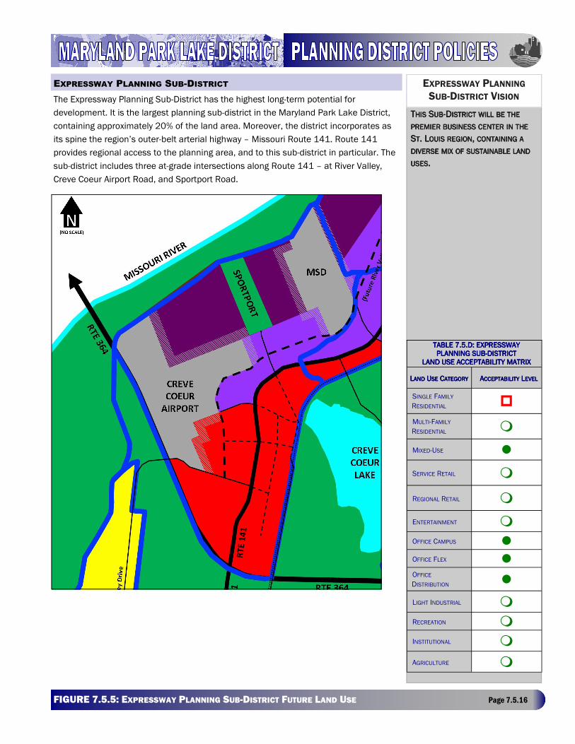
The Expressway Planning Sub-District has the highest long-term potential for
development. It is the largest planning sub-district in the Maryland Park Lake District,
containing approximately 20% of the land area. Moreover, the district incorporates as
its spine the region’s outer-belt arterial highway – Missouri Route 141. Route 141
provides regional access to the planning area, and to this sub-district in particular. The
sub-district includes three at-grade intersections along Route 141 – at River Valley,
Creve Coeur Airport Road, and Sportport Road.
EXPRESSWAY PLANNING
SUB-DISTRICT VISION
TTTTHISHISHISHIS SSSSUBUBUBUB----DDDDISTRICTISTRICTISTRICTISTRICT WILLWILLWILLWILL BEBEBEBE THETHETHETHE
PREMIERPREMIERPREMIERPREMIER BUSINESSBUSINESSBUSINESSBUSINESS CENTERCENTERCENTERCENTER ININININ THETHETHETHE
SSSSTTTT. L. L. L. LOUISOUISOUISOUIS REGIONREGIONREGIONREGION, , , , CONTAININGCONTAININGCONTAININGCONTAINING AAAA
DIVERSEDIVERSEDIVERSEDIVERSE MIXMIXMIXMIX OFOFOFOF SUSTAINABLESUSTAINABLESUSTAINABLESUSTAINABLE LANDLANDLANDLAND
USESUSESUSESUSES....
TABLE 7.5.D: EXPRESSTABLE 7.5.D: EXPRESSTABLE 7.5.D: EXPRESSTABLE 7.5.D: EXPRESSWAY WAY WAY WAY PLANNING SUBPLANNING SUBPLANNING SUBPLANNING SUB----DISTRICDISTRICDISTRICDISTRICTTTT
LAND USE ACCEPTABILILAND USE ACCEPTABILILAND USE ACCEPTABILILAND USE ACCEPTABILITY MATRIXTY MATRIXTY MATRIXTY MATRIX
LLLLANDANDANDAND UUUUSESESESE CCCCATEGORYATEGORYATEGORYATEGORY AAAACCEPTABILITYCCEPTABILITYCCEPTABILITYCCEPTABILITY LLLLEVELEVELEVELEVEL
SINGLE FAMILY
RESIDENTIAL �
MULTI-FAMILY
RESIDENTIAL �
MIXED-USE �
SERVICE RETAIL �
REGIONAL RETAIL �
ENTERTAINMENT �
OFFICE CAMPUS �
OFFICE FLEX � OFFICE
DISTRIBUTION �
LIGHT INDUSTRIAL �
RECREATION �
INSTITUTIONAL �
AGRICULTURE �
EXPRESSWAY PLANNING SUB-DISTRICT
RT
E 1
41
MARYLAND HEIGHTS COMPREHENSIVE PLAN - ADOPTED MAY 24, 2016 Page 7.5.17
The proposed regional stormwater conveyance system runs through the sub-district, integrated within the River Valley
Parkway. This future infrastructure will impact future development more than any other district. Although the net acreage
available for development is substantial, it is effectively subdivided into separate developable areas, due to the
anticipated configuration of these improvements. However, development will gain from this amenity as it effectively
reduces the quantity of needed on-site detention thereby leaving more net acreage available for development. Lastly,
certain existing land uses such as MSD’s treatment facility will influence future land uses, and such existing development
presents some constraints to development.
The Expressway Planning Sub-District will create an appearance that combines diversity of design within a unified theme.
Around the airport environs and northwest area, office and business services and office distribution centers are
envisioned to be the dominant land use pattern. Proposed development plans should address building massing,
orientation and materials; relationship of buildings to the public right-of way; mix of uses; street level activity; integration of
trails and open space; creation and protection of view sheds; vehicular parking, access, and circulation; and others.
Interconnection between districts and development clusters should be created in the process of planning for infrastructure
through placement of sidewalks and street trees in greenways along arterial roads, designation of pedestrian and bike
trails, use of water conveyance channels and placement on levee rights-of-way. These features will encourage maximum
use of alternative forms of movement and will afford access to open space areas without getting in the car and driving to
them.
As new development occurs in the Expressway Sub-District, specific consideration will need to be given to the following
issues:
• Potential for MSD property land swap with adjacent owner(s).
• Determining impact of Sportport on the hospitality industry and its subsequent role within the region and City and
potential redevelopment options.
• Potential for additional uses on airport property.
• Integration of impacts from the current airport use into overall planning process.
• Impacts of voluntary sale of airport by owners.
• Partnership with the Howard Bend Levee District and MSD regarding water quality and treatment issues.
• Connectivity of projects and uses through automobile, pedestrian, and bicycle routes.
• Potential future pedestrian movement on site, between developments and to adjacent recreational facilities.
• Appropriate design standards for gateway structures and structures fronting Missouri Route 141 and River Valley
Parkway.
• Integration and/or screening of adjacent uses.
EXPRESSWAY DEVELOPMENT VISION
EXPRESSWAY LINKAGES
EXPRESSWAY PREDEVELOPMENT CONSIDERATIONS
MARYLAND HEIGHTS COMPREHENSIVE PLAN - ADOPTED MAY 24, 2016 Page 7.5.18
• Appropriate land uses should be determined based on consideration of the overall Maryland Park Lake District, and
cannot be determined based solely upon consideration of a specific site.
• Any development proposal will need to prove consistency with this plan prior to consideration and meet the
requirements of the Maryland Heights Zoning Code and any applicable design guidelines prior to approval.
• The Future Land Use Map identifies the encouraged development pattern for this area. Other land uses (identified as
“Conditionally Encouraged”) may be considered provided that the land uses: demonstrate need and add value to the
area; are found to further the Goals and Strategies of this plan; are consistent with the guidance provided in this plan;
and any associated development issues can be mitigated.
• Prior to development, adequate public facilities must be in place. It is the responsibility of the owner/developer to
provide such public facilities and to demonstrate that they will be available at time of occupancy.
• The Missouri Route 141 corridor and the edges near Creve Coeur Park should include mixed use with an emphasis on
retail and entertainment with or without integrated residential uses.
• Office campus uses are highly encouraged in this sub-district.
• Development fronting on either or both of Missouri Route 141 and/or the future River Valley Parkway should be
oriented to the ROW; integrating “front door” finish as an important element of overall character of the district and the
Maryland Park Lake District.
• Parking should be designed and integrated into the site so as not to be the dominant visible development feature
from the ROW.
• Redevelopment of the Creve Coeur Airport should be examined in context of adjacent development.
• All development must be integrated and connected to the regional stormwater management system.
• All new development must connect to either Missouri Route 141 or the future River Valley Parkway.
• All development must provide connections to the parks and open space system.
• All development must provide multi-modal connections between planned developments and other adjacent districts.
• All development must create and include provisions for pedestrian orientation, while accommodating vehicular traffic
in an efficient manner.
EXPRESSWAY GENERAL DEVELOPMENT POLICIES
EXPRESSWAY SPECIFIC DEVELOPMENT POLICIES
MARYLAND HEIGHTS COMPREHENSIVE PLAN - ADOPTED MAY 24, 2016 Page 7.5.19 FIGURE 7.5.6: RIVER VALLEY PLANNING SUB-DISTRICT FUTURE LAND USE Page 7.5.19
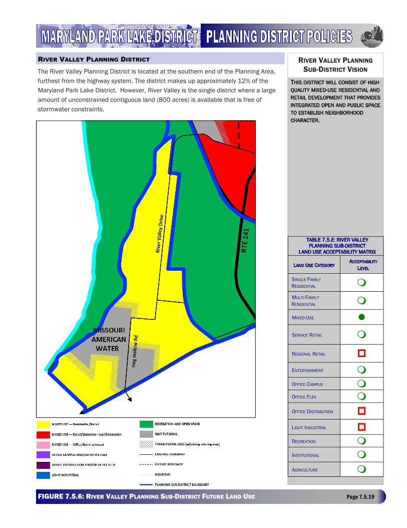
The River Valley Planning District is located at the southern end of the Planning Area,
furthest from the highway system. The district makes up approximately 12% of the
Maryland Park Lake District. However, River Valley is the single district where a large
amount of unconstrained contiguous land (800 acres) is available that is free of
stormwater constraints.
RIVER VALLEY PLANNING
SUB-DISTRICT VISION
TTTTHISHISHISHIS DISTRICTDISTRICTDISTRICTDISTRICT WILLWILLWILLWILL CONSISTCONSISTCONSISTCONSIST OFOFOFOF HIGHHIGHHIGHHIGH QUALITYQUALITYQUALITYQUALITY MIXEDMIXEDMIXEDMIXED----USEUSEUSEUSE RESIDENTIALRESIDENTIALRESIDENTIALRESIDENTIAL ANDANDANDAND RETAILRETAILRETAILRETAIL DEVELOPMENTDEVELOPMENTDEVELOPMENTDEVELOPMENT THATTHATTHATTHAT PROVIDESPROVIDESPROVIDESPROVIDES INTEGRATEDINTEGRATEDINTEGRATEDINTEGRATED OPENOPENOPENOPEN ANDANDANDAND PUBLICPUBLICPUBLICPUBLIC SPACESPACESPACESPACE TOTOTOTO ESTABLISHESTABLISHESTABLISHESTABLISH NEIGHBORHOODNEIGHBORHOODNEIGHBORHOODNEIGHBORHOOD CHARACTERCHARACTERCHARACTERCHARACTER....
TABLE 7.5.E: RIVER VTABLE 7.5.E: RIVER VTABLE 7.5.E: RIVER VTABLE 7.5.E: RIVER VALLEYALLEYALLEYALLEY PLANNING SUBPLANNING SUBPLANNING SUBPLANNING SUB----DISTRICDISTRICDISTRICDISTRICTTTT
LAND USE ACCEPTABILILAND USE ACCEPTABILILAND USE ACCEPTABILILAND USE ACCEPTABILITY MATRIXTY MATRIXTY MATRIXTY MATRIX
LLLLANDANDANDAND UUUUSESESESE CCCCATEGORYATEGORYATEGORYATEGORY AAAACCEPTABILITYCCEPTABILITYCCEPTABILITYCCEPTABILITY
LLLLEVELEVELEVELEVEL
SINGLE FAMILY
RESIDENTIAL �
MULTI-FAMILY
RESIDENTIAL �
MIXED-USE �
SERVICE RETAIL �
REGIONAL RETAIL �
ENTERTAINMENT �
OFFICE CAMPUS �
OFFICE FLEX �
OFFICE DISTRIBUTION �
LIGHT INDUSTRIAL �
RECREATION �
INSTITUTIONAL �
AGRICULTURE �
RIVER VALLEY PLANNING DISTRICT
MARYLAND HEIGHTS COMPREHENSIVE PLAN - ADOPTED MAY 24, 2016 Page 7.5.20
The primary constraint to development in this planning sub-district is access to the regional road network. River Valley
Drive is the single collector road in this district. Although it has the potential to connect to Missouri Route 364 in the
future, the connection has a substantial infrastructure cost and is unlikely to occur in the mid-term. Access and circulation
could also be improved by creating a Route 141/Water Works Road intersection, but this would also involve substantial
cost.
This sub-district will consist of high quality mixed-use residential and retail development that provides integrated open and
public space to establish neighborhood character. Open space areas will be integrated with stormwater management
providing connections to Creve Coeur Park.
As new development occurs in the River Valley Sub-District, specific consideration will need to be given to the following
issues:
• Providing a buffer to the Missouri American Water treatment plant.
• Incorporating service retail as an accessory use development.
• Connectivity of projects and uses through automobile, pedestrian, and bicycle routes.
• Connectivity to Creve Coeur Park and other recreational facilities.
• Appropriate design standards for entrance features and structures fronting River Valley Parkway.
• Integration and/or screening of adjacent uses.
• Appropriate land uses should be determined based on consideration of the overall Maryland Park Lake District, and
cannot be determined based solely upon consideration of a specific site.
• Any development proposal will need to prove consistency with this plan prior to consideration, and meet the
requirements of the Maryland Heights Zoning Code and any applicable design guidelines prior to approval.
• Dedication of future right-of-way required for the extension of Baxter Road.
• Land uses identified as “Conditionally Accepted” may be considered provided that the land uses: demonstrate need
and add value to the area; are found to further the Goals and Strategies of this plan; are consistent with the guidance
provided in this plan; and any associated development issues can be mitigated.
• Prior to development, adequate public facilities must be in place. It is the responsibility of the owner/developer to
provide such public facilities and to demonstrate that they will be available at time of occupancy.
• The River Valley District should create an appearance that combines diversity of design within a unified theme.
• Proposed development plans should address building massing, orientation and materials; relationship of buildings to
the public right-of way; mix of uses; street level activity; integration of trails and open space; creation and protection of
view sheds; vehicular parking, access, and circulation; and others.
• All new development must be integrated and connected to the regional stormwater system.
RIVER VALLEY DEVELOPMENT VISION
RIVER VALLEY PREDEVELOPMENT CONSIDERATIONS
RIVER VALLEY GENERAL DEVELOPMENT POLICIES
RIVER VALLEY SPECIFIC DEVELOPMENT POLICIES
MARYLAND HEIGHTS COMPREHENSIVE PLAN - ADOPTED MAY 24, 2016 Page 7.5.21
• All new development must be connected to the future River Valley Parkway.
• All development must provide for connections to the open space and parks system.
• All development must provide multi-modal connections between planned developments and other adjacent districts.
• All development must create pedestrian orientation, while accommodating vehicular traffic in an efficient manner.
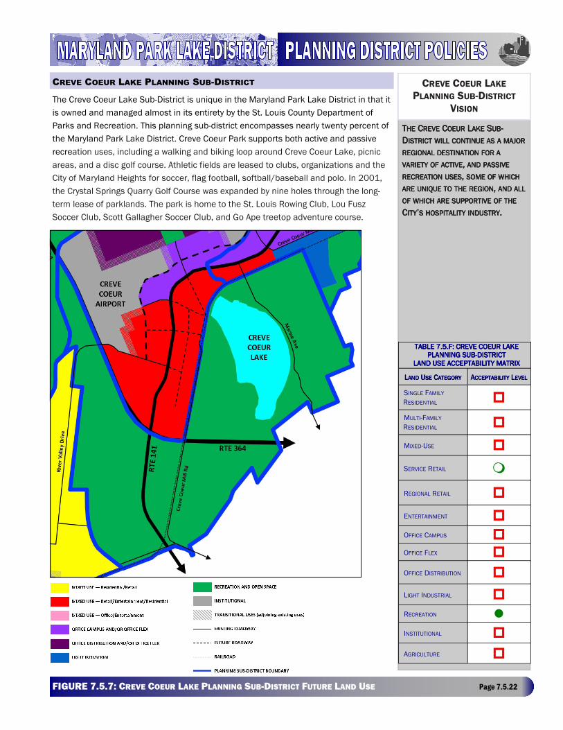
MARYLAND HEIGHTS COMPREHENSIVE PLAN - ADOPTED MAY 24, 2016 Page 7.5.22 FIGURE 7.5.7: CREVE COEUR LAKE PLANNING SUB-DISTRICT FUTURE LAND USE Page 7.5.22
The Creve Coeur Lake Sub-District is unique in the Maryland Park Lake District in that it
is owned and managed almost in its entirety by the St. Louis County Department of
Parks and Recreation. This planning sub-district encompasses nearly twenty percent of
the Maryland Park Lake District. Creve Coeur Park supports both active and passive
recreation uses, including a walking and biking loop around Creve Coeur Lake, picnic
areas, and a disc golf course. Athletic fields are leased to clubs, organizations and the
City of Maryland Heights for soccer, flag football, softball/baseball and polo. In 2001,
the Crystal Springs Quarry Golf Course was expanded by nine holes through the long-
term lease of parklands. The park is home to the St. Louis Rowing Club, Lou Fusz
Soccer Club, Scott Gallagher Soccer Club, and Go Ape treetop adventure course.
CREVE COEUR LAKE
PLANNING SUB-DISTRICT
VISION
TTTTHEHEHEHE CCCCREVEREVEREVEREVE CCCCOEUROEUROEUROEUR LLLLAKEAKEAKEAKE SSSSUBUBUBUB----
DDDDISTRICTISTRICTISTRICTISTRICT WILLWILLWILLWILL CONTINUECONTINUECONTINUECONTINUE ASASASAS AAAA MAJORMAJORMAJORMAJOR
REGIONALREGIONALREGIONALREGIONAL DESTINATIONDESTINATIONDESTINATIONDESTINATION FORFORFORFOR AAAA
VARIETYVARIETYVARIETYVARIETY OFOFOFOF ACTIVEACTIVEACTIVEACTIVE, , , , ANDANDANDAND PASSIVEPASSIVEPASSIVEPASSIVE
RECREATIONRECREATIONRECREATIONRECREATION USESUSESUSESUSES, , , , SOMESOMESOMESOME OFOFOFOF WHICHWHICHWHICHWHICH
AREAREAREARE UNIQUEUNIQUEUNIQUEUNIQUE TOTOTOTO THETHETHETHE REGIONREGIONREGIONREGION, , , , ANDANDANDAND ALLALLALLALL
OFOFOFOF WHICHWHICHWHICHWHICH AREAREAREARE SUPPORTIVESUPPORTIVESUPPORTIVESUPPORTIVE OFOFOFOF THETHETHETHE
CCCCITYITYITYITY’’’’SSSS HOSPITALITYHOSPITALITYHOSPITALITYHOSPITALITY INDUSTRYINDUSTRYINDUSTRYINDUSTRY....
TABLE 7.5.F: CREVE CTABLE 7.5.F: CREVE CTABLE 7.5.F: CREVE CTABLE 7.5.F: CREVE COEUR LAKE OEUR LAKE OEUR LAKE OEUR LAKE PLANNING SUBPLANNING SUBPLANNING SUBPLANNING SUB----DISTRICDISTRICDISTRICDISTRICTTTT
LAND USE ACCEPTABILILAND USE ACCEPTABILILAND USE ACCEPTABILILAND USE ACCEPTABILITY MATRIXTY MATRIXTY MATRIXTY MATRIX
LLLLANDANDANDAND UUUUSESESESE CCCCATEGORYATEGORYATEGORYATEGORY AAAACCEPTABILITYCCEPTABILITYCCEPTABILITYCCEPTABILITY LLLLEVELEVELEVELEVEL
SINGLE FAMILY
RESIDENTIAL �
MULTI-FAMILY
RESIDENTIAL �
MIXED-USE �
SERVICE RETAIL �
REGIONAL RETAIL �
ENTERTAINMENT �
OFFICE CAMPUS �
OFFICE FLEX �
OFFICE DISTRIBUTION �
LIGHT INDUSTRIAL �
RECREATION �
INSTITUTIONAL �
AGRICULTURE �
CREVE COEUR LAKE PLANNING SUB-DISTRICT
MARYLAND HEIGHTS COMPREHENSIVE PLAN - ADOPTED MAY 24, 2016 Page 7.5.23
St. Louis County Parks received approximately 1,100 acres of land as part of the mitigation from the construction of Route
364 (Page Avenue Extension) through the park. To manage this additional open space, the county prepared a master plan
and coordinated the rezoning of the park with the City to an “MXD” Mixed-Use District. The plan includes the continuation
of existing recreational uses and the expansion of athletic fields. The county plan also calls for more aggressive
recreational programming, including a skateboard park, which will provide a recreational resource unique to the region. As
presently understood, the county plan is consistent with the City’s recreation plans for the area.
The Creve Coeur Lake Sub-District incorporates a major portion of the regional stormwater management system, including
the lake itself, Little Creve Coeur Lake, Creve Coeur Creek, and extensive water storage lands. The eastern edge of the
district incorporates the bluffs and is one of the few points where the Maryland Park Lake District lies adjacent to a
residential area.
The Creve Coeur Lake Planning Sub-District will continue to function as a major regional destination for a variety of active,
and passive recreational uses, some of which are unique to the region, and all of which are supportive of the City’s
hospitality and entertainment industry.
The trail system will attract usage by office and commercial tenants from adjoining districts. Pedestrian and bicycle
linkages from adjoining districts should be encouraged as an enhancement to the overall quality of development and
marketability in the entire planning area. The development of these linkages should preclude the need to drive to the
Creve Coeur Lake Sub-District in order to use its trail system. Pedestrian and bicycle linkages should be achieved through
combinations of walking paths, separate bike trails, and on-street bicycle facilities. Designated on-street bicycle facilities
include bicycle lanes and bicycle routes.
The potential for support of the hospitality industry will be further strengthened with the establishment of linkages to the
Expressway Planning Sub-District and its regionally significant Sportport Soccer Complex.
• Appropriate land uses should be determined based on consideration of the overall Maryland Park Lake District, and
cannot be determined based solely upon consideration of a specific site.
• Any development proposal will need to prove consistency with this plan prior to consideration, and meet the
requirements of the Maryland Heights Zoning Code and any applicable design guidelines prior to approval.
• The Future Land Use Map identifies the encouraged development pattern for this area. Other land uses (identified as
“Conditionally Encouraged”) may be considered provided that the land uses: demonstrate need and add value to the
area; are found to further the Goals and Strategies of this plan; are consistent with the guidance provided in this plan;
and any associated development issues can be mitigated.
CREVE COEUR LAKE DEVELOPMENT VISION
CREVE COEUR LAKE LINKAGES
CREVE COEUR LAKE GENERAL DEVELOPMENT POLICIES
MARYLAND HEIGHTS COMPREHENSIVE PLAN - ADOPTED MAY 24, 2016 Page 7.5.24
• Prior to development, adequate public facilities must be in place. It is the responsibility of the owner/developer to
provide such public facilities and to demonstrate that they will be available at time of occupancy.
• Provide both physical and signage-based connections to adjacent districts. Uses and developments within and
adjacent to the district should be welcoming to visitors and designed to be compatible with the surrounding
environment.
• Encourage selective accessory commercial uses such as snack bars and restaurants, provided they are subordinate to
recreation and open space features.
• Encourage active and unique recreation facilities.
• Encourage and require adequate parking to support planned uses. Parking facilities should have a low environmental
and storm water impact, with alternatives to traditional paving, such as pervious surfaces encouraged. Peak traffic
demands related to special events should be managed, addressing the location of parking as well as ingress and
egress.
• All new development must be integrated and connected to the regional stormwater system.
• Multi-modal connections between other sub-districts are encouraged.
CREVE COEUR LAKE SPECIFIC DEVELOPMENT POLICIES
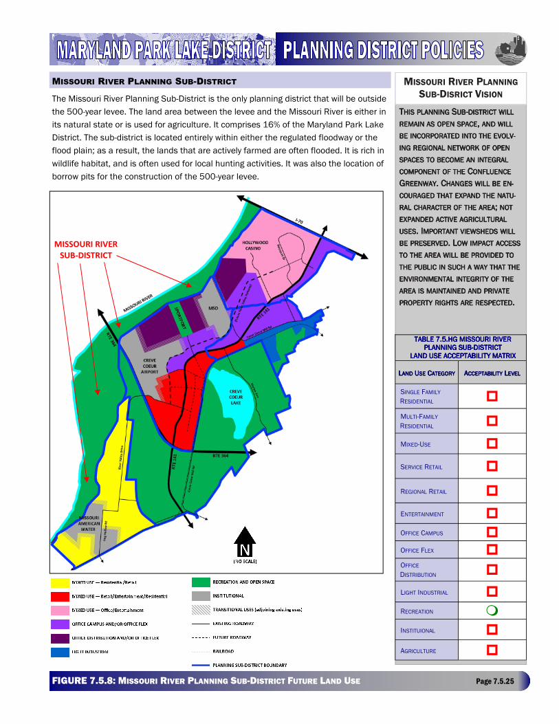
MARYLAND HEIGHTS COMPREHENSIVE PLAN - ADOPTED MAY 24, 2016 Page 7.5.25 FIGURE 7.5.8: MISSOURI RIVER PLANNING SUB-DISTRICT FUTURE LAND USE Page 7.5.25
The Missouri River Planning Sub-District is the only planning district that will be outside
the 500-year levee. The land area between the levee and the Missouri River is either in
its natural state or is used for agriculture. It comprises 16% of the Maryland Park Lake
District. The sub-district is located entirely within either the regulated floodway or the
flood plain; as a result, the lands that are actively farmed are often flooded. It is rich in
wildlife habitat, and is often used for local hunting activities. It was also the location of
borrow pits for the construction of the 500-year levee.
MISSOURI RIVER PLANNING
SUB-DISRICT VISION
TTTTHISHISHISHIS PLANNINGPLANNINGPLANNINGPLANNING SSSSUBUBUBUB----DISTRICTDISTRICTDISTRICTDISTRICT WILLWILLWILLWILL
REMAINREMAINREMAINREMAIN ASASASAS OPENOPENOPENOPEN SPACESPACESPACESPACE, , , , ANDANDANDAND WILLWILLWILLWILL
BEBEBEBE INCORPORATEDINCORPORATEDINCORPORATEDINCORPORATED INTOINTOINTOINTO THETHETHETHE EVOLV-EVOLV-EVOLV-EVOLV-
INGINGINGING REGIONALREGIONALREGIONALREGIONAL NETWORKNETWORKNETWORKNETWORK OFOFOFOF OPENOPENOPENOPEN
SPACESSPACESSPACESSPACES TOTOTOTO BECOMEBECOMEBECOMEBECOME ANANANAN INTEGRALINTEGRALINTEGRALINTEGRAL
COMPONENTCOMPONENTCOMPONENTCOMPONENT OFOFOFOF THETHETHETHE CCCCONFLUENCEONFLUENCEONFLUENCEONFLUENCE
GGGGREENWAYREENWAYREENWAYREENWAY. C. C. C. CHANGESHANGESHANGESHANGES WILLWILLWILLWILL BEBEBEBE EN-EN-EN-EN-
COURAGEDCOURAGEDCOURAGEDCOURAGED THATTHATTHATTHAT EXPANDEXPANDEXPANDEXPAND THETHETHETHE NATU-NATU-NATU-NATU-
RALRALRALRAL CHARACTERCHARACTERCHARACTERCHARACTER OFOFOFOF THETHETHETHE AREAAREAAREAAREA; ; ; ; NOTNOTNOTNOT
EXPANDEDEXPANDEDEXPANDEDEXPANDED ACTIVEACTIVEACTIVEACTIVE AGRICULTURALAGRICULTURALAGRICULTURALAGRICULTURAL
USESUSESUSESUSES. I. I. I. IMPORTANTMPORTANTMPORTANTMPORTANT VIEWSHEDSVIEWSHEDSVIEWSHEDSVIEWSHEDS WILLWILLWILLWILL
BEBEBEBE PRESERVEDPRESERVEDPRESERVEDPRESERVED. L. L. L. LOWOWOWOW IMPACTIMPACTIMPACTIMPACT ACCESSACCESSACCESSACCESS
TOTOTOTO THETHETHETHE AREAAREAAREAAREA WILLWILLWILLWILL BEBEBEBE PROVIDEDPROVIDEDPROVIDEDPROVIDED TOTOTOTO
THETHETHETHE PUBLICPUBLICPUBLICPUBLIC ININININ SUCHSUCHSUCHSUCH AAAA WAYWAYWAYWAY THATTHATTHATTHAT THETHETHETHE
ENVIRONMENTALENVIRONMENTALENVIRONMENTALENVIRONMENTAL INTEGRITYINTEGRITYINTEGRITYINTEGRITY OFOFOFOF THETHETHETHE
AREAAREAAREAAREA ISISISIS MAINTAINEDMAINTAINEDMAINTAINEDMAINTAINED ANDANDANDAND PRIVATEPRIVATEPRIVATEPRIVATE
PROPERTYPROPERTYPROPERTYPROPERTY RIGHTSRIGHTSRIGHTSRIGHTS AREAREAREARE RESPECTEDRESPECTEDRESPECTEDRESPECTED....
TABLE 7.5.HG MISSOURTABLE 7.5.HG MISSOURTABLE 7.5.HG MISSOURTABLE 7.5.HG MISSOURI RIVER I RIVER I RIVER I RIVER PLANNING SUBPLANNING SUBPLANNING SUBPLANNING SUB----DISTRICDISTRICDISTRICDISTRICTTTT
LAND USE ACCEPTABILILAND USE ACCEPTABILILAND USE ACCEPTABILILAND USE ACCEPTABILITY MATRIXTY MATRIXTY MATRIXTY MATRIX
LLLLANDANDANDAND UUUUSESESESE CCCCATEGORYATEGORYATEGORYATEGORY AAAACCEPTABILITYCCEPTABILITYCCEPTABILITYCCEPTABILITY LLLLEVELEVELEVELEVEL
SINGLE FAMILY
RESIDENTIAL �
MULTI-FAMILY
RESIDENTIAL �
MIXED-USE �
SERVICE RETAIL �
REGIONAL RETAIL �
ENTERTAINMENT �
OFFICE CAMPUS �
OFFICE FLEX � OFFICE
DISTRIBUTION �
LIGHT INDUSTRIAL �
RECREATION �
INSTITUIONAL �
AGRICULTURE �
MISSOURI RIVER PLANNING SUB-DISTRICT
MISSOURI RIVER
SUB-DISTRICT
MARYLAND HEIGHTS COMPREHENSIVE PLAN - ADOPTED MAY 24, 2016 Page 7.5.26
Although new development will not occur in the Missouri River Sub-District, specific consideration will still need to be given
to the following issues:
• Providing access to natural spaces.
• Potential locations for wetlands mitigation for other districts.
• Continuation of maintenance for agricultural users.
• Development of passive recreational uses.
MISSOURI RIVER DEVELOPMENT GUIDELINES