Embed Size (px)
Citation preview
City of Hidden Hills
Los Angeles River and Tributaries Metals Total Maximum Daily Load
Implementation Plan
Los Angeles River and Tributaries Metals
Total Maximum Daily Load
Implementation Plan
FFiinnaall PPllaann
Prepared for:
The City of Hidden Hills
Prepared By:
Environmental Services Division
Charles Abbott Associates, Inc.
2601 Airport Drive, Suite 110
Torrance, CA 90505
October 2010
Revision Notes:
First Draft Submitted- January 11, 2010
Comments from Regional Board Received- June 14, 2010
Final Plan Submitted – October 11, 2010
City of Hidden Hills LAR Metals TMDL Implementation Plan January 2010
Page i
Table of Contents
EXECUTIVE SUMMARY .......................................................................................................... 1
1 INTRODUCTION................................................................................................................. 3
1.1 Regulatory Background .................................................................................................. 3
1.2 Total Maximum Daily Load Numeric Targets ............................................................... 5
1.2.1 Dry Weather Numeric Targets ....................................................................................... 5
1.2.2 Wet Weather Numeric Targets ...................................................................................... 6
1.3 Waste Load Allocations .................................................................................................. 6
1.4 Participating Agencies .................................................................................................... 6
1.5 Monitoring Objectives .................................................................................................... 7
2 CITY & WATERSHED DESCRIPTION .......................................................................... 7
2.1 Los Angeles River – Reach Characteristics .................................................................... 8
2.2 City of Hidden Hills Characteristics ............................................................................. 11
2.2.1 Climate ...................................................................................................................... 12
2.2.2 Land Use ................................................................................................................... 12
2.2.3 Soils........................................................................................................................... 13
2.2.4 Watersheds ................................................................................................................ 14
2.2.5 Storm Drain System .................................................................................................. 15
3 MONITORING ................................................................................................................... 17
3.1 Ambient & Compliance (Effectiveness) Monitoring .................................................... 17
3.1.1 Ambient Monitoring ................................................................................................. 17
3.1.2 Effectiveness Monitoring .......................................................................................... 18
3.1.3 Special Studies & On-Going Science Developments ............................................... 18
3.2 Sampling & Compliance Monitoring............................................................................ 19
4 IMPLEMENTATION PLAN ............................................................................................ 20
4.1 Non-Structural BMPs.................................................................................................... 20
4.2 Structural BMPs ............................................................................................................ 21
4.3 Implementation Schedule .............................................................................................. 21
City of Hidden Hills LAR Metals TMDL Implementation Plan October 2010
Page ii
LIST OF TABLES
Table 1. Wet Weather Waste Load Allocations .............................................................................. 6 Table 2. Reach 6 Responsible Agencies' Land Areas ..................................................................... 8 Table 3. City of Hidden Hills Land Area ...................................................................................... 12
Table 4. City of Hidden Hills Land Use ....................................................................................... 12 Table 5. Soil Types Underlying the City of Hidden Hills ............................................................ 14
Table 6. Locations and Descriptions of the Reach 6 Tier I and Tier II Monitoring Locations .... 19
Table 7. LAR Metals TMDL Implementation Schedule. ............................................................. 22
LIST OF FIGURES
Figure 1. Reach 6 Impaired Water Bodies ...................................................................................... 5 Figure 2. City of Hidden Hills Location in the Los Angeles River Watershed .............................. 9 Figure 3. City of Hidden Hills Location ....................................................................................... 11
Figure 4. City of Hidden Hills Land Use Types ........................................................................... 13 Figure 5. City of Hidden Hills Soil Types .................................................................................... 14
Figure 6. City of Hidden Hills Watersheds and Flow Direction................................................... 15 Figure 7. City of Hidden Hills Storm Drain System ..................................................................... 16
APPENDICES
Appendix 1. Resolution No. 2007-014 and Basin Plan Amendment
Appendix 2. Sampling results for Reach 6 – Copper, Lead, and Selenium
City of Hidden Hills LAR Metals TMDL Implementation Plan January 2010
Page iii
ACRONYMS
BMPs Best Management Practices
BPA Basin Plan Amendment
Caltrans California Department of Transportation
cfs Cubic Feet per Second
Cd Cadmium
CMP Coordinated Monitoring Plan
CTR California Toxics Rule
Cu Copper
CWA Clean Water Act
GWR Ground Water
HHCA Hidden Hills Community Association
IP Implementation Plan
kg/day Kilogram(s) per day
LAs Load Allocations
LACDPW Los Angeles County, Department of Public Works
LACFCD Los Angeles County Flood Control District
LAR Los Angeles River
LAR Metals TMDL Los Angeles River and Tributaries Metals TMDL
LAR TC LA River Metals Technical Committee
LAR WMC Los Angeles River Watershed Management Committee
LARWQCB Los Angeles Regional Water Quality Control Board
mg/kg Milligram per Kilogram
mg/L Milligram per Liter
mgd Millions Gallons per Day
MS4 Municipal Separate Storm Sewer System
MTD Miscellaneous Transfer Drain
NGOs Non-Governmental Organizations
NPDES National Pollutant Discharge Elimination System
Pb Lead
PD Private Drain
POTWs Publicly Owned Treatment Works
RARE Rare, Threatened, or Endangered Species
Se Selenium
SWRCB California State Water Resources Control Board
TMDL Total Maximum Daily Load
µg/L Microgram per Liter
USEPA United States Environmental Protection Agency
WARM Warm Fresh Water Habitat
WET Wetland
WILD Wildlife Habitat
WLAs Waste Load Allocations
WMC Watershed Management Committee
Zn Zinc
City of Hidden Hills LAR Metals TMDL Implementation Plan January 2010
Page 1
EXECUTIVE SUMMARY This Implementation Plan (IP) was prepared in response to Resolution No. R2007-014 wherein the
California Water Quality Control Board, Los Angeles Region (LARWQCB), incorporated the Los
Angeles River and Tributaries Metals Total Maximum Daily Load (LAR Metals TMDL) into the Water
Quality Control Plan – Los Angeles Region. This IP will focus only on those measures the City of
Hidden Hills (City) will undertake to meet the requirements of the LAR Metals TMDL within its
jurisdictional boundary.
The LAR Metals TMDL sets forth dry and wet weather waste load allocations (WLAs) that 40 cities, as
well as the County of Los Angeles and Caltrans, must meet over time. The City is located in two
watersheds: the Malibu Creek Watershed and the Los Angeles River Watershed (Figure 5).
Approximately 1.57 of the City‟s 1.6 square miles of the City lies within the Los Angeles River
Watershed. This represents less than 1.5% of the land area in Reach 6 and is only 0.002% of the entire
Los Angeles River Watershed.
The City has participated fully in the development and submittal of the Coordinated Monitoring Plan
(CMP) required by the LAR Metals TMDL. The first LAR Metals TMDL CMP report was submitted to
the LARWQCB on September 14, 2009. This report detailed the results from the CMP for the period of
October 2008 to June 2009.
The City‟s review of the dry weather monitoring results for the relevant sampling period shows that for
Reach 6, copper, lead, and zinc are well under numeric targets. Selenium concentrations in Reach 6
remain higher than the dry weather numeric targets. However, as indicated in the LARWQCB LAR
Metals TMDL Staff Report of 2005 and the related Basin Plan Amendment (BPA), all parties believe that
the high selenium values are due to naturally occurring elements and geological deposits.
The City‟s review of the dry weather data demonstrate that the concentrations of the three primary metals
are now below the actual numeric targets set forth in the LAR Metals TMDL. Thus, the City assumes
that it, as well as the other responsible agencies of Reach 6, is fully compliant with the dry weather
WLAs. The City will continue to monitor the dry weather ambient monitoring data to determine whether
further actions will be required. The City‟s review of the available wet weather monitoring data from the
CMP shows that the White Oak location concentrations of copper and zinc may be higher than the
numeric targets. The Technical Committee for the CMP however found that the shut-off triggers for the
auto-samplers were set improperly and continued to collect sample results for several days after the two
wet weather events. This may have directly affected the validity of the wet weather results because the
sampling devices continued to collect samples hours, even days, after the end of the wet weather sampling
event. The Technical Committee reported this problem to the LARWQCB in October 2009 and indicated
that it will correct this fault. The Technical Committee believes that future sampling will be more
representative. The City will continue reviewing Reach 6 wet weather ambient monitoring data as it
becomes available to understand, monitor, and assess actual trends in copper and zinc concentrations
based upon the corrected sampling methodology.
The LAR Metals TMDL required that agencies submit drafts of proposed Implementation Plans to the
LARWQCB to ensure compliance with numeric limits. On June 14, 2010 the LARWQCB issued
comments and recommended changes to the City‟s initial, or draft, Implementation Plan. The primary
comments suggested that the City implement a sampling and monitoring program to first characterize and
verify that the City‟s discharges were in compliance with assigned WLAs. Additionally, the LARWQCB
requested that the IP include provisions to be revised where sampling and monitoring showed excedances
City of Hidden Hills LAR Metals TMDL Implementation Plan October 2010
Page 2
of the WLAs. Lastly, where excedances were found to be originating from the City, the IP was to be
revised to include a discussion of the reductions required from increased non-structural or structural Best
Management Practices (BMPs). The City is hereby submitting this IP in compliance with the LAR
Metals TMDL schedule and pursuant to comments of the LARWQCB letter dated June 14, 2010.
City of Hidden Hills LAR Metals TMDL Implementation Plan January 2010
Page 3
1 INTRODUCTION The City of Hidden Hills (City) Implementation Plan (“Plan” or “IP”) outlines the approach that the City
will take to attain the waste load allocations (WLAs) set forth in and in response to Resolution No.
R2007-014, titled the Amendment to the Water Quality Control Plan – Los Angeles Region to incorporate
the Los Angeles River and Tributaries Metals TMDL (LAR Metals TMDL) and adopted by the California
Regional Water Quality Control Board, Los Angeles Region (LARWQCB) on September 6, 2007 and as
effective October 29, 2008. While the goal is to protect water quality throughout the Los Angeles River
and its tributaries (LA River), this Plan will focus only on areas within the City as required by the LAR
Metals TMDL. This IP outlines the current and future tasks, including timelines, the City has and will
undertake to demonstrate how compliance will be achieved.
1.1 Regulatory Background Section 303(d) of the 1972 Federal Water Pollution Control Act (CWA) and its amendments require each
State to identify water bodies within its boundaries that do not meet the water quality objectives set forth
to protect the designated beneficial uses. The CWA also requires states to establish a priority ranking of
the water bodies on the 303(d) list and to establish Total Maximum Daily Loads (TMDLs) for such
waters.
The California State Water Resources Control Board (SWRCB) adopted 303(d) lists of impaired water
bodies in 1998, 2002, and 2006. Based on a number of critical assumptions, the state prioritized these
water bodies for development of TMDLs. A Consent Decree, signed on March 22, 1999, between Non-
Governmental Organizations (NGOs) and the United States Environmental Protection Agency (USEPA),
in consultation with the LARWQCB, were used to prioritize impaired water bodies, identify impairment-
causing constituents, and create a TMDL schedule for Los Angeles and Ventura Counties.
The LA River was prioritized as needing a TMDL to improve water quality to help attain the water
quality objectives for their designated beneficial uses. The LA River, and its various tributaries, are noted
as impaired at various points for cadmium (Cd), copper (Cu), lead (Pb), selenium (Se), and zinc (Zn).
The beneficial uses of the water bodies that are or could be impaired by these metals, as outlined by the
Water Quality Control Plan for the Los Angeles Region (Basin Plan), include wildlife habitat (WILD),
rare threatened or endangered species (RARE), warm freshwater habitat (WARM), wetlands (WET), and
groundwater recharge (GWR). Due to these impairments and the requirements of the March 22, 1999
Consent Decree, the LARWQCB developed the LAR Metals TMDL, in Resolution No. 2007-014, on
September 6, 2007 with an effective date of October 29, 20081 (Appendix 1). The LAR Metals TMDL
divides the LA River into six (6) segments or reaches (Reaches) that serve as boundaries for jurisdictional
groups comprised of various agencies (i.e. Cities, Los Angeles County, Caltrans). The LARWQCB
combined Reaches 4 and 5 into one group. Therefore, for LAR Metals TMDL compliance, there are five
(5) Jurisdictional Groups (Table 7-13.3 of the Basin Plan). The LARWQCB designated Reach 6
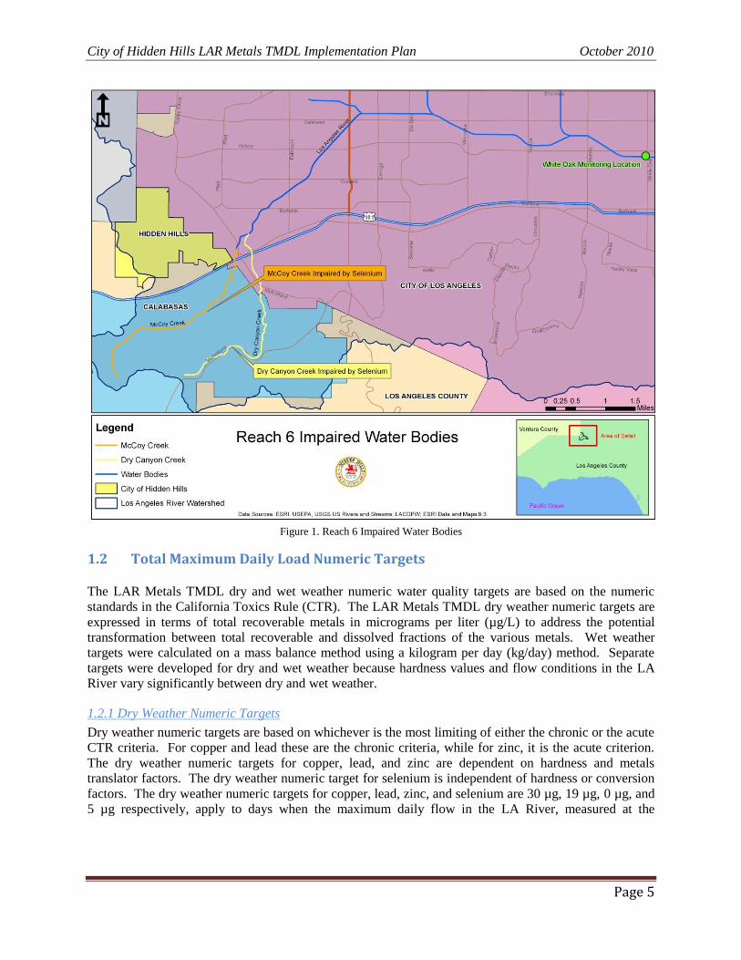
jurisdictional members to include the City of Calabasas, City of Los Angeles, County of Los Angeles, and
the City of Hidden Hills. Figure 1 shows the impaired water bodies located in Reach 6 and lists the
pollutants each is impaired by.
The LAR Metals TMDL was approved by the USEPA on December 22, 2005 and became effective
January 11, 2006. However due to challenges by some affected parties the LARWQCB on September 6,
1 Resolution, TMDL, and Basin Plan Amendments available at
http://www.waterboards.ca.gov/losangeles/water_issues/programs/tmdl/tmdl_list.shtml. Verified as of December 16,
2009.
City of Hidden Hills LAR Metals TMDL Implementation Plan October 2010
Page 4
2007, after rehearing and notice, readopted the LAR Metals TMDL with almost all elements of the
TMDL remaining the same to the previously adopted version. The revised and effective date of the LAR
Metals TMDL thus became October 29, 2008. The LAR Metals TMDL schedule is follows:2
The LAR Metals TMDL required responsible agencies to submit a Coordinated Monitoring Plan
(CMP) by April 11, 2007. Once approved by the LARWQCB Executive Officer, the responsible
agencies were to start the monitoring specified in the CMP within six (6) months.
If conducted, Special Studies results must be submitted by January 11, 2010.
A Draft Implementation Plan must be submitted by January 11, 2010.
A Final Implementation Plan must be submitted by July 11, 2010.
The LARWQCB will reconsider the LAR Metals TMDL on January 11, 2011.
Responsible jurisdictions and agencies are required to achieve conformance with the LAR Metals
TMDL according to the following schedules:
By January 11, 2012, the Municipal Separate Storm Sewer System (MS4) and Caltrans
National Pollution Discharge Elimination System (NPDES) permittees must demonstrate that
50% of the total drainage area served by the MS4 is effectively meeting the dry weather
WLAs and 25% of the total drainage area served by the MS4 is effectively meeting the wet
weather WLAs.
By January 11, 2020, the MS4 and Caltrans NPDES permittees must demonstrate that 75% of
the total drainage area served by the MS4 is effectively meeting the dry weather WLAs.
By January 11, 2024, the MS4 and Caltrans NPDES permittees must demonstrate that 100%
of the total drainage area served by the MS4 is effectively meeting the dry weather WLAs
and 50% of the total drainage area served by the MS4 is effectively meeting the wet weather
WLAs.
By January 11, 2028, the MS4 and Caltrans NPDES permittees shall demonstrate that 100%
of the total drainage area served by the MS4 is effectively meeting both the dry weather and
wet weather WLAs.
2 Adapted from Table 7-13.2 of LARWQCB Resolution No. 2007-014 (9/6/2007).
City of Hidden Hills LAR Metals TMDL Implementation Plan October 2010
Page 5
Figure 1. Reach 6 Impaired Water Bodies
1.2 Total Maximum Daily Load Numeric Targets The LAR Metals TMDL dry and wet weather numeric water quality targets are based on the numeric
standards in the California Toxics Rule (CTR). The LAR Metals TMDL dry weather numeric targets are
expressed in terms of total recoverable metals in micrograms per liter (µg/L) to address the potential
transformation between total recoverable and dissolved fractions of the various metals. Wet weather
targets were calculated on a mass balance method using a kilogram per day (kg/day) method. Separate
targets were developed for dry and wet weather because hardness values and flow conditions in the LA
River vary significantly between dry and wet weather.
1.2.1 Dry Weather Numeric Targets
Dry weather numeric targets are based on whichever is the most limiting of either the chronic or the acute
CTR criteria. For copper and lead these are the chronic criteria, while for zinc, it is the acute criterion.
The dry weather numeric targets for copper, lead, and zinc are dependent on hardness and metals
translator factors. The dry weather numeric target for selenium is independent of hardness or conversion
factors. The dry weather numeric targets for copper, lead, zinc, and selenium are 30 µg, 19 µg, 0 µg, and
5 µg respectively, apply to days when the maximum daily flow in the LA River, measured at the
City of Hidden Hills LAR Metals TMDL Implementation Plan October 2010
Page 6
Wardlow Road gauge station3 in Reach 1, is less than 500 cubic feet per second (cfs). Once flow
becomes greater than 500 cfs, wet weather targets apply.4
1.2.2 Wet Weather Numeric Targets
Wet weather numeric targets for copper, lead, and zinc are based on the acute CTR criteria and the 50th
percentile hardness values for storm water determined at the Wardlow gauge station. The conversion
factors for determining wet weather numeric targets from dry weather numeric targets are based on
regression analyses of dissolved metals to recoverable metals at the Wardlow gauge station. The wet
weather numeric target for selenium is not determined by hardness or conversion factors. The wet
weather numeric targets for copper, lead, zinc, and selenium are 17 µg, 62 µg, 159 µg, and 5 µg
respectively.
1.3 Waste Load Allocations Dry weather WLAs are based on loading capacities that were calculated by multiplying the reach-specific
numeric targets by the reach-specific critical flows. No dry weather loading capacities were calculated
for selenium in Reach 6. Instead, a concentration-based allocation was assigned to selenium in Reach 6.
The dry weather WLAs in Reach 6 for copper and lead are 0.53 kg/day and 0.33 kg/day respectively.
Wet weather WLAs are equal to the total loading capacity of the LA River minus the Load Allocations
(LAs) for open space and direct air deposition as well as the WLAs for Publicly Owned Treatment Works
(POTWs). The wet weather WLAs (as total recoverable metals) for cadmium, copper, lead, and zinc; in
all reaches and tributaries; are shown in Table 1.
Table 1. Wet Weather Waste Load Allocations
1.4 Participating Agencies The LAR Metals TMDL requires each Jurisdictional Group to create a LARWQCB approved
Implementation Plan to demonstrate how compliance will be achieved. The Jurisdictional Group for
Reach 6 has four (4) primary and responsible agencies, including: (1) County of Los Angeles; (2) City of
Los Angeles; (3) City of Calabasas; and (4) City of Hidden Hills. It was initially imagined, that the City
of Los Angeles would act as the lead agency for the creation of a reach-wide Implementation Plan.
However, after much discussion, it was concluded that each responsible agency would create individual
Implementation Plans provided approval from the LARWQCB. It is assumed that each responsible
3 The Wardlow gauge station is located in the City of Long Beach south of Wardlow Road and North of Willow
Street. The site receives approximately 98% of flow from the total watershed. 4 The 500 cfs represents the 90
th percentile of average daily flow at the Wardlow gauge station during the period
from 1998 to 2000.
Metal
Cadmium
Copper
Lead
Zinc
Waste Load Allocation (kg/day)
2.8 x 10 -9
x daily volume (L) -1.8
1.5 x 10 -8
x daily volume (L) -9.5
5.6 x 10 -8
x daily volume (L) -3.85
1.4 x 10 -7
x daily volume (L) -83
City of Hidden Hills LAR Metals TMDL Implementation Plan October 2010
Page 7
agency in Reach 6 has received written approval from the LARWQCB to create an individual
Implementation Plan.
The City has worked in conjunction with the City of Calabasas by sharing resources in order to complete
this IP in the most efficient and effective manner possible. The City believes that a coordinated approach
would be most effective because most metals, based on current scientific evidence, originate from areas
outside the City‟s jurisdictional boundaries (e.g., lead, copper, and zinc from major roadways and vehicle
traffic areas).5
1.5 Monitoring Objectives The LARWQCB set forth three monitoring objectives under the LAR Metals TMDL. The first objective
was to collect data on ambient conditions such as hardness, flow, and background pollutant
concentrations in the LA River to evaluate the uncertainties and assumptions made during development of
the LAR Metals TMDL. The second objective was to collect data to assess compliance with the WLAs.
The third objective was to collect data to evaluate potential management scenarios. To achieve these
objectives, the LARWQCB suggested utilizing:
1. Ambient monitoring;
2. Effectiveness monitoring; and
3. Special studies.
To achieve monitoring objectives 1 and 2, the Los Angeles River Watershed Management Committee
(LAR WMC) recommended the formation of a LAR Metals TMDL Technical Committee (LAR TC) to
create a CMP that would monitor the ambient conditions within the LA River, as well as provide for the
later required effectiveness monitoring. A CMP was developed and submitted by the required date (April
11, 2007) and water quality is currently being monitored at the locations specified in the CMP. The
CMP, as well as monitoring objective 3, will be discussed later in this IP.
2 CITY & WATERSHED DESCRIPTION
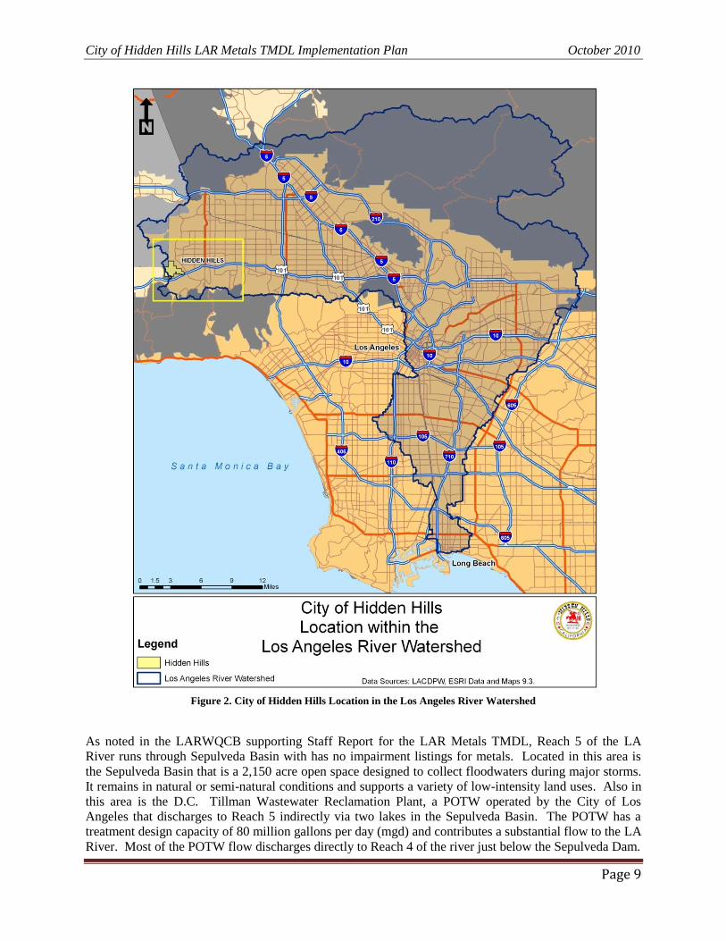
The LA River Watershed (LAR Watershed) covers an area of approximately 834 square miles (533,760 acres) and is located in the coastal plain of the Los Angeles Basin and includes the San Fernando Valley
and portions of the San Gabriel Valley. The LAR Watershed includes 40 cities and the unincorporated
areas of Los Angeles County. The boundaries are defined by the Santa Monica Mountains to the north
and west, the San Gabriel Mountains to the north and east, and the Los Angeles Coastal Plain to the south
(Figure 2). The LA River begins in Canoga Park at the confluence of Bell Creek and Arroyo Calabasas
and flows as an open channel for 55 miles from Canoga Park through the Cities of Burbank, Glendale,
Los Angeles, Vernon, Maywood, Commerce, Bell, Bell Gardens, Cudahy, South Gate, Lynwood,
Paramount, and Compton until it meets Queensway Bay located between the Port of Long Beach and the
City of Long Beach.
Due to shifting drainage flow paths, the natural hydrology of the LA River has been altered by
channelization and the construction of dams and flood control reservoirs and many of its tributaries are
lined with concrete for most or all of their lengths. However, there are two soft bottom segments of the
LA River – a 3.1 mile stretch that runs adjacent to the City of Los Angeles and the City of Glendale
known as the “Glendale Narrows” and a 2.4 mile stretch located in the Sepulveda Basin Recreational area
behind the Sepulveda Dam.
5 The City of Hidden Hills is entirely residential and is limited by gates from all non-resident vehicular traffic.
City of Hidden Hills LAR Metals TMDL Implementation Plan October 2010
Page 8
A complex network of storm drains and tributaries including Bell Creek, Calabasas Creek, Browns
Canyon Wash, Aliso Canyon Wash, Caballero Creek, Bull Creek, Tujunga Wash, Burbank Western
Channel, Verdugo Wash, Sycamore Wash, Arroyo Seco, Rio Hondo, and Compton Creek feeds the LA
River. It is also fed by natural flows and discharges from POTWs and other LARWQCB permitted
sources. At its terminus, the LA River discharges into an estuary at Willow Street in the City of Long
Beach where concrete is replaced by grouted riprap side slopes and an earth bottom.
2.1 Los Angeles River – Reach Characteristics Reach 6 of the LA River is geographically defined and considered as starting at the confluence of Arroyo
Calabasas (which drains the northeastern portion of the Santa Monica Mountains) and Bell Creek (which
drains the Simi Hills). McCoy Canyon Creek and Dry Canyon Creek are two tributaries to Arroyo
Calabasas that drain through the City of Calabasas. The river flows east from its origin along the
southern edge of the San Fernando Valley. The LA River also receives flow from Browns Canyon, Aliso
Canyon Wash (listed for selenium) and Bull Creek which drain the Santa Susana Mountains. The lower
portions of Arroyo Calabasas and Bell Creek are channelized. Browns Canyon, Aliso Creek, and Bull
Creek are completely channelized.
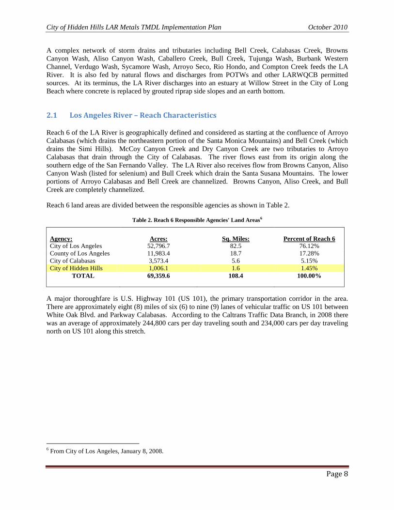
Reach 6 land areas are divided between the responsible agencies as shown in Table 2.
Table 2. Reach 6 Responsible Agencies' Land Areas6
Agency:
Acres:
Sq. Miles:
Percent of Reach 6
City of Los Angeles 52,796.7 82.5 76.12%
County of Los Angeles 11,983.4 18.7 17.28%
City of Calabasas 3,573.4 5.6 5.15%
City of Hidden Hills 1,006.1 1.6 1.45%
TOTAL 69,359.6 108.4 100.00%
A major thoroughfare is U.S. Highway 101 (US 101), the primary transportation corridor in the area.
There are approximately eight (8) miles of six (6) to nine (9) lanes of vehicular traffic on US 101 between
White Oak Blvd. and Parkway Calabasas. According to the Caltrans Traffic Data Branch, in 2008 there
was an average of approximately 244,800 cars per day traveling south and 234,000 cars per day traveling
north on US 101 along this stretch.
6 From City of Los Angeles, January 8, 2008.
City of Hidden Hills LAR Metals TMDL Implementation Plan October 2010
Page 9
Figure 2. City of Hidden Hills Location in the Los Angeles River Watershed
As noted in the LARWQCB supporting Staff Report for the LAR Metals TMDL, Reach 5 of the LA
River runs through Sepulveda Basin with has no impairment listings for metals. Located in this area is
the Sepulveda Basin that is a 2,150 acre open space designed to collect floodwaters during major storms.
It remains in natural or semi-natural conditions and supports a variety of low-intensity land uses. Also in
this area is the D.C. Tillman Wastewater Reclamation Plant, a POTW operated by the City of Los
Angeles that discharges to Reach 5 indirectly via two lakes in the Sepulveda Basin. The POTW has a
treatment design capacity of 80 million gallons per day (mgd) and contributes a substantial flow to the LA
River. Most of the POTW flow discharges directly to Reach 4 of the river just below the Sepulveda Dam.
City of Hidden Hills LAR Metals TMDL Implementation Plan October 2010
Page 10
Reach 4 of the Los Angeles River runs from Sepulveda Dam to Riverside Drive and collects flows from
Pacoima Wash and Tujunga Wash that drain portions of the Angeles National Forest in the San Gabriel
Mountains. The Pacoima Wash is channelized between Lopez Dam and the LA River. Tujunga Wash is
channelized for the ten (10) mile reach below Hansen Dam. Some of the discharge from Hansen Dam is
diverted to spreading grounds for groundwater recharge.
Reach 3 of the LA River, runs from Riverside Drive to Figueroa Street and has two major tributaries: the
Burbank Western Channel and the Verdugo Channel that drain the Verdugo Mountains. Both tributaries
are channelized. The Burbank Western Channel receives flow from the Burbank Water Reclamation
Plant, a POTW with a design capacity of 9 mgd. At the eastern end of the San Fernando Valley, the LA
River turns south around the Hollywood Hills and flows through Griffith Park and Elysian Park in an area
known as the Glendale Narrows. This area is fed by natural springs during periods of high groundwater.
The river is channelized with concrete sides. However, the river bottom in this area is unlined because
the water table is high and groundwater routinely discharges into the channel in varying volumes
depending on the height of the water table. The Los Angeles-Glendale Water Reclamation Plant,
operated by the City of Los Angeles, has a design capacity of 20 mgd and discharges to the LA River in
the Glendale Narrows.7
Reach 2 of the LA River runs from Figueroa Street to Carson Street. The first major tributary below the
Glendale Narrows is the Arroyo Seco, which drains areas of Pasadena and portions of the Angeles
National Forest in the San Gabriel Mountains. In wet periods, rising stream flows in the LA River above
Arroyo Seco have been related to the increase of rising groundwater. There is up to 3,000 acre-feet of
recharge from the Pollock Well Field area that adds to the rising groundwater.8
The next major tributary in Reach 2 is the Rio Hondo. The Rio Hondo and its tributaries drain a large
area in the eastern portion of the watershed. Flow in the Rio Hondo is managed by the Los Angeles
County Department of Public Works (LACDPW). At Whittier Narrows, flow from the Rio Hondo can be
diverted to the Rio Hondo Spreading Grounds. During dry weather, virtually all the water in the Rio
Hondo goes to groundwater recharge, so little or no flow exits the spreading grounds to Reach 1 of the
Rio Hondo. During storm events, Rio Hondo flow that is not used for spreading, reaches the LA River.
This flow is comprised of both storm water and treated wastewater effluent from the Whittier Narrows
Water Reclamation Plant. Reach 1 of the Rio Hondo is listed for copper, lead, and zinc. Monrovia
Canyon Creek is also listed for lead. This creek, located in the foothills of the San Gabriel Mountains in
the National Forest, is a tributary to Sawpit Creek which runs into Peck Lake and ultimately to Rio Hondo
Reach 2 above the spreading grounds.9
Reach 1 of the LA River, runs from Carson Street to the estuary. Compton Creek is the last large
tributary to the system before the river enters the estuary. The creek is channelized for most of its 8.5
mile length. The tidal portion of the LA River begins at Willow Street and runs approximately three
miles before joining with Queensway Bay located between the Port of Long Beach and the City of Long
Beach. In Reach 1, the channel has a soft bottom with concrete-lined sides. Sandbars accumulate in the
portion of the river where tidal influence is limited.10
During dry weather, most of the flow in the LA River is comprised of wastewater effluent from the
Tillman, Los Angeles-Glendale, and Burbank treatment plants. In the dry season, POTW mean monthly
discharges totaled 70% to 100% of the monthly average flow in the LA River. The median daily flow in
7 From Staff Report, Page 11. (Dated June 2, 2005).
8 Ibid. Page 12.
9 Ibid. Page 12.
10 Ibid. Page 12
City of Hidden Hills LAR Metals TMDL Implementation Plan October 2010
Page 11
the LA River is 94 mgd (145 cfs), based on flows measured at the LACDPW Wardlow station over a 12-
year period (October 1998 through December 2000). During wet weather, flow may increase by two to
three orders of magnitude due to storm water runoff. 11
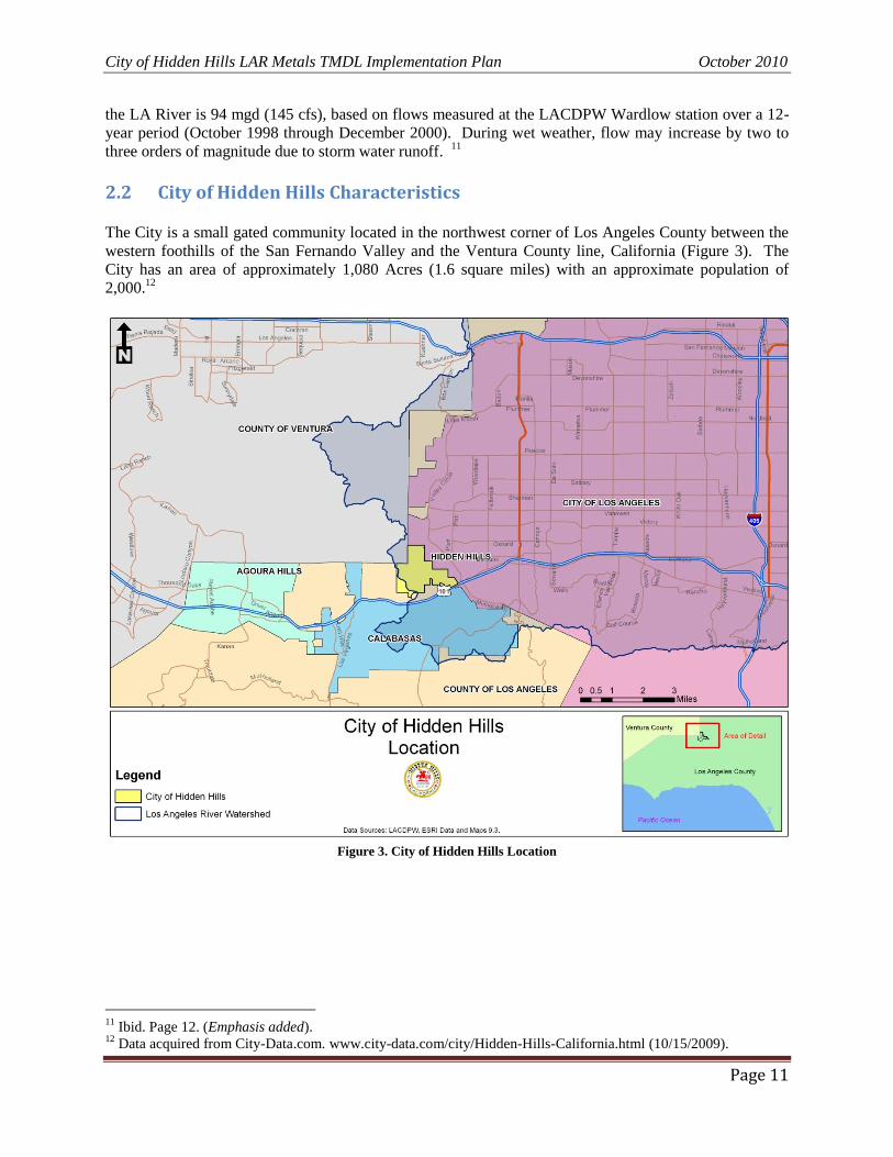
2.2 City of Hidden Hills Characteristics The City is a small gated community located in the northwest corner of Los Angeles County between the
western foothills of the San Fernando Valley and the Ventura County line, California (Figure 3). The
City has an area of approximately 1,080 Acres (1.6 square miles) with an approximate population of
2,000.12
Figure 3. City of Hidden Hills Location
11
Ibid. Page 12. (Emphasis added). 12
Data acquired from City-Data.com. www.city-data.com/city/Hidden-Hills-California.html (10/15/2009).
City of Hidden Hills LAR Metals TMDL Implementation Plan October 2010
Page 12
For purposes of the IP, the overall land area of the City in Reach 6 of the LA River, compared to other
responsible agencies, is shown in Table 3.
Table 3. City of Hidden Hills Land Area13
Agency: Acres: Sq. Miles: Percent of Reach 6
City of Los Angeles 52,796.7 82.5 76.12%
County of Los Angeles 11,983.4 18.7 17.28%
City of Calabasas 3,573.4 5.6 5.15%
City of Hidden Hills 1,006.1 1.6 1.45%
TOTAL 69,359.6 108.4 100.00%
2.2.1 Climate
The climate of the City is categorized as Mediterranean with hot, dry summers and cool, moist winters
with the majority of precipitation occurring between the months of November and April. The average
yearly low temperature is 47° F while the average yearly high temperature is 80° F. Total yearly
precipitation is approximately 18 inches with the highest monthly total occurring during February.14
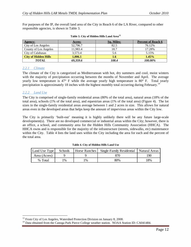
2.2.2 Land Use
The City is comprised of single-family residential areas (80% of the total area), natural areas (18% of the
total area), schools (1% of the total area), and equestrian areas (1% of the total area) (Figure 4). The lot
sizes in the single-family residential areas average between 1 and 2 acres in size. This allows for natural
areas even in the developed areas that helps keep the amount of impervious areas within the City low.
The City is primarily „built-out‟ meaning it is highly unlikely there will be any future large-scale
development(s). There are no developed commercial or industrial areas within the City; however, there is
an office, a school, and community area for the Hidden Hills Community Association (HHCA). The
HHCA owns and is responsible for the majority of the infrastructure (streets, sidewalks, etc) maintenance
within the City. Table 4 lists the land uses within the City including the area for each and the percent of
the total area.
Table 4. City of Hidden Hills Land Use
13
From City of Los Angeles, Watershed Protection Division on January 8, 2008. 14
Data obtained from the Canoga Park Pierce College weather station. NOAA Station ID: CA041484.
Land Use Type Schools Horse Ranches Single-Family Residential Natural Areas
Area (Acres) 9 9 870 190
% Total 1% 1% 80% 18%
City of Hidden Hills LAR Metals TMDL Implementation Plan October 2010
Page 13
Figure 4. City of Hidden Hills Land Use Types
2.2.3 Soils
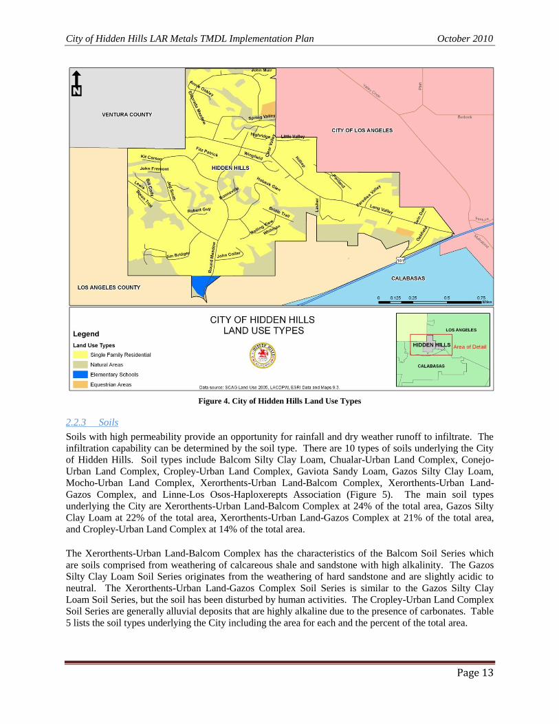
Soils with high permeability provide an opportunity for rainfall and dry weather runoff to infiltrate. The
infiltration capability can be determined by the soil type. There are 10 types of soils underlying the City
of Hidden Hills. Soil types include Balcom Silty Clay Loam, Chualar-Urban Land Complex, Conejo-
Urban Land Complex, Cropley-Urban Land Complex, Gaviota Sandy Loam, Gazos Silty Clay Loam,
Mocho-Urban Land Complex, Xerorthents-Urban Land-Balcom Complex, Xerorthents-Urban Land-
Gazos Complex, and Linne-Los Osos-Haploxerepts Association (Figure 5). The main soil types
underlying the City are Xerorthents-Urban Land-Balcom Complex at 24% of the total area, Gazos Silty
Clay Loam at 22% of the total area, Xerorthents-Urban Land-Gazos Complex at 21% of the total area,
and Cropley-Urban Land Complex at 14% of the total area.
The Xerorthents-Urban Land-Balcom Complex has the characteristics of the Balcom Soil Series which
are soils comprised from weathering of calcareous shale and sandstone with high alkalinity. The Gazos
Silty Clay Loam Soil Series originates from the weathering of hard sandstone and are slightly acidic to
neutral. The Xerorthents-Urban Land-Gazos Complex Soil Series is similar to the Gazos Silty Clay
Loam Soil Series, but the soil has been disturbed by human activities. The Cropley-Urban Land Complex
Soil Series are generally alluvial deposits that are highly alkaline due to the presence of carbonates. Table
5 lists the soil types underlying the City including the area for each and the percent of the total area.
City of Hidden Hills LAR Metals TMDL Implementation Plan October 2010
Page 14
Figure 5. City of Hidden Hills Soil Types
Table 5. Soil Types Underlying the City of Hidden Hills
2.2.4 Watersheds
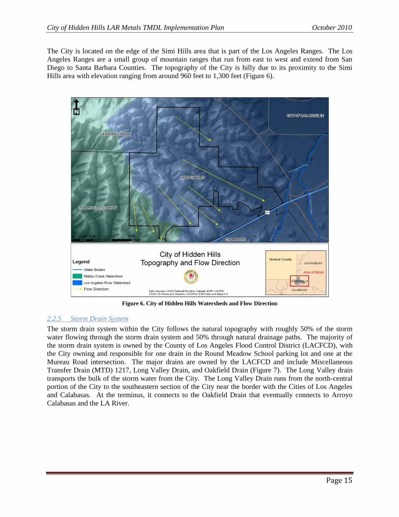
The City is located in two watersheds: the Malibu Creek Watershed and the LAR Watershed (Figure 6).
Roughly, 1.57 sq. miles of the City are within the LAR Watershed with the remainder, 1.9% of the City‟s
total area, located within the Malibu Creek Watershed. The area located in the LAR Watershed,
represents less than 1.5% of the land area in Reach 6, and only 0.00246% of the entire LAR Watershed.
Soil Classification Area (Acres) % Total
Balcom Silty Clay Loam 105.01 9.73%
Chualar-Urban Land Complex 0.63 0.06%
Conejo-Urban Land Complex 0.28 0.03%
Cropley-Urban Land Complex 156.44 14.49%
Gaviota Sandy Loam 34.25 3.17%
Gazos Silty Clay Loam 242.85 22.49%
Mocho-Urban Land Complex 15.89 1.47%
Xerorthents-Urban Land-Balcom Complex 261.73 24.24%
Xerorthents-Urban Land-Gazos Complex 231.03 21.40%
Linne-Los Osos-Haploxerepts Association 31.60 2.93%
City of Hidden Hills LAR Metals TMDL Implementation Plan October 2010
Page 15
The City is located on the edge of the Simi Hills area that is part of the Los Angeles Ranges. The Los
Angeles Ranges are a small group of mountain ranges that run from east to west and extend from San
Diego to Santa Barbara Counties. The topography of the City is hilly due to its proximity to the Simi
Hills area with elevation ranging from around 960 feet to 1,300 feet (Figure 6).
Figure 6. City of Hidden Hills Watersheds and Flow Direction
2.2.5 Storm Drain System
The storm drain system within the City follows the natural topography with roughly 50% of the storm
water flowing through the storm drain system and 50% through natural drainage paths. The majority of
the storm drain system is owned by the County of Los Angeles Flood Control District (LACFCD), with
the City owning and responsible for one drain in the Round Meadow School parking lot and one at the
Mureau Road intersection. The major drains are owned by the LACFCD and include Miscellaneous
Transfer Drain (MTD) 1217, Long Valley Drain, and Oakfield Drain (Figure 7). The Long Valley drain
transports the bulk of the storm water from the City. The Long Valley Drain runs from the north-central
portion of the City to the southeastern section of the City near the border with the Cities of Los Angeles
and Calabasas. At the terminus, it connects to the Oakfield Drain that eventually connects to Arroyo
Calabasas and the LA River.
City of Hidden Hills LAR Metals TMDL Implementation Plan January 2010
Page 16
Figure 7. City of Hidden Hills Storm Drain System
City of Hidden Hills LAR Metals TMDL Implementation Plan January 2010
Page 17
3 MONITORING The LAR Metals TMDL required the forty-two (42) responsible agencies to submit a CMP within 15
months of the effective date of the LAR Metals TMDL (by April 11, 2007). The CMP was developed by
an eleven (11) member technical committee (LAR TC) that included representatives from every
Jurisdictional Group in the watershed. The following agencies are currently members of the LAR TC:
Cities of Los Angeles, Hidden Hills, Burbank, Glendale, Pasadena, Irwindale, Downey, Signal Hill, and
Long Beach; the County of Los Angeles; and Caltrans. The City of Los Angeles and Los Angeles County
co-chair the TC. A similar Steering Committee, comprised of various City Managers and LARWQCB
Staff, was also convened to oversee the optional special studies and funding details.
The goal of the CMP is to collect ambient water quality data at key locations within the LA River as well
as provide for effectiveness monitoring when and where necessary. Ambient monitoring began in
October 2008 and will continue until January 11, 2012 when the LAR Metals TMDL will be reconsidered
by the LARWQCB. The first LAR Metals TMDL CMP report was submitted to the LARWQCB on
September 14, 2009 by the City of Los Angeles. This report detailed the results from the CMP for the
period of October 2008 to June 2009.
As discussed above in Sections 1.2 and 1.3, the responsible agencies in Reach 6 must monitor copper,
lead, zinc, and selenium during the first ambient monitoring phase. However, at the start of the
compliance time schedule of the LAR Metals TMDL, the City must only ensure that its own MS4
discharges do not exceed the LAR Metals TMDL numeric targets for lead, copper, and zinc established
for Reach 6. There is no specific compliance target for selenium once numeric compliance requirements
are in place.15
3.1 Ambient & Compliance (Effectiveness) Monitoring
3.1.1 Ambient Monitoring
Dry weather ambient monitoring for hardness as well as dissolved and total recoverable metals occurs
monthly at thirteen (13) locations within the LA River. All of the monitoring locations sample for
copper, lead, and zinc, and the White Oak monitoring location in Reach 6 sampling for selenium. The
monitoring results for the most recent CMP year, October 2008 through June 2009, show that Reach 6, as
measured at the White Oak Avenue site (LAR 1-1), is well under copper and lead numeric targets. See
Appendix 2. Selenium concentrations remain consistently high, however as indicated in the CMP
monitoring report, hardness at the White Oak Avenue site remains much higher than all other parts of the
LA River. For example, in October 2008, hardness in the various reaches was:
Reach 6 was 753 mg/l;
Reach 4, at Sepulveda Blvd., was 192 mg/l and 254 mg/l at Figueroa Street;
Reach 2 was 251 mg/l at the 710 Freeway; and in
Reach 1 was 199 mg/l at Wardlow Blvd.
As indicated in the LARWQCB Staff Report of 2005, including the Basin Plan Amendment (BPA), all
parties believe that the high selenium values are naturally occurring and due to geological deposits of
ocean shale.
15
See BPA page 4, “The sources of selenium appear to be related to natural levels of selenium in soils in the upper
watershed. Separate studies are underway to evaluate whether selenium levels represent a “natural condition” for
this watershed.” See also, BPA, Page 5, “No dry weather loading capacities are calculated for…selenium in Reach 6
or its tributaries.”, and Page 8, “Storm Water Dry-weather WLAs (total recoverable metals)”.
City of Hidden Hills LAR Metals TMDL Implementation Plan January 2010
Page 18
Ambient monitoring during the wet season occurs at five (5) of the monitoring locations that have auto-
samplers installed. The LAR Metals TMDL specifies a wet season sampling event as a storm event that
measures 500 cfs at the Wardlow monitoring station. Pursuant to agreements with LARWQCB staff, the
TC established wet weather auto-sampler triggers prorated to the Wardlow flow rate. Only one storm
event is sampled per month with a minimum of 72 hours required between storm events. All of the
monitoring locations sample for copper, lead, and zinc, but only the Wardlow monitoring location in
Reach 1 samples for cadmium. See Section 1.3 for assigned WLAs. During the last CMP monitoring
period only two storm events triggered wet weather monitoring (February and March 2009). However,
the LAR TC, after reviewing auto-sampler results for these two periods, found and reported that the auto-
sampler shut-off values were too high as the units continued sampling for several days after the storm.
The results for these two periods may not adequately represent actual in-stream copper, lead, and zinc
values.16
The City will continue to work with the LAR TC and LAR WMC to obtain consistent and
representative data sets for wet weather monitoring.
3.1.2 Effectiveness Monitoring
Effectiveness monitoring have not yet been initiated but will begin before the January 11, 2012 deadline
of the LAR Metals TMDL, which states that the Jurisdictional Group shall demonstrate that 50% of
Reach 6‟s total drainage area served by the storm drain system is effectively meeting the dry weather
WLAs and 25% is meeting the wet weather WLAs. Compliance with dry weather and wet weather
WLAs in Reach 6 will be shown by meeting the assigned WLAs based on the White Oak monitoring
results.
Effectiveness monitoring is structured as a three-tier system. The thirteen (13) ambient monitoring
locations are categorized as Tier I locations. If a Tier I location has two consecutive exceedances, then
monitoring begins at the upstream Tier II location. The three (3) Tier II locations are intended to reflect
the contribution of pollutants from tributaries to the LA River. If a Tier II location exhibits two
consecutive exceedances, then monitoring at Tier III locations will commence. The Tier III locations will
be used for a source tracking investigation in an attempt to identify the sources leading to the
exceedances. Tier III locations will be determined, when appropriate, during the effectiveness monitoring
program. Tier III locations are intra-jurisdictional and are intended to further refine the monitoring
process when and where it is deemed necessary. Table 6 provides the locations and descriptions of the
Tier I and Tier II monitoring locations in Reach 6.
3.1.3 Special Studies & On-Going Science Developments
The LAR Metals TMDL allows time to complete Special Studies that may be used to refine the estimated
loading capacities, LAs, or WLAs. The Special Studies are not required by the LAR Metals TMDL, but
may be initiated to help optimize implementation efforts (i.e. determine exact sources of pollutants if
exceedances occur). Currently there are no Special Studies under way in Reach 6. The City has
tentatively agreed, by Council Resolution, to assist in Jurisdiction-wide Special Studies.17
Over the last several years, the City of Calabasas has begun a monitoring program in Dry Canyon and
McCoy Creeks to determine the potential natural source(s) of selenium. The City of Calabasas will be
presenting their most recent findings related to these studies and investigations in their Implementation
Plan. An additional study that may help clarify the naturally occurring selenium concern is one proposed
by Dr. Barry Hibbs of California State University, Los Angeles. He has been investigating the hydrologic
16
Selenium is not monitored by the CMP during wet-weather storm events. 17
Initial proposed Special Studies include the study of aerial deposition of metals and site specific metals translator
values (e.g. specific water chemistry in Reach 6 and the affect on the assimilative capacity of metals).
City of Hidden Hills LAR Metals TMDL Implementation Plan January 2010
Page 19
models of selenium and nitrates in the Las Virgenes Creek and aquifer system. The City will work with
other Reach 6 jurisdictional members to facilitate, where possible, actual determination of these studies.
T
ier
I
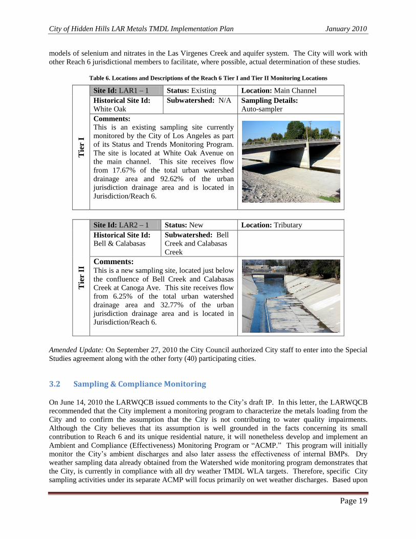
Site Id: LAR1 – 1 Status: Existing Location: Main Channel
Historical Site Id: White Oak
Subwatershed: N/A Sampling Details: Auto-sampler
Comments: This is an existing sampling site currently
monitored by the City of Los Angeles as part
of its Status and Trends Monitoring Program.
The site is located at White Oak Avenue on
the main channel. This site receives flow
from 17.67% of the total urban watershed
drainage area and 92.62% of the urban
jurisdiction drainage area and is located in
Jurisdiction/Reach 6.
Tie
r II
Site Id: LAR2 – 1 Status: New Location: Tributary
Historical Site Id: Bell & Calabasas
Subwatershed: Bell Creek and Calabasas
Creek
Comments: This is a new sampling site, located just below
the confluence of Bell Creek and Calabasas
Creek at Canoga Ave. This site receives flow
from 6.25% of the total urban watershed
drainage area and 32.77% of the urban
jurisdiction drainage area and is located in
Jurisdiction/Reach 6.
Amended Update: On September 27, 2010 the City Council authorized City staff to enter into the Special
Studies agreement along with the other forty (40) participating cities.
3.2 Sampling & Compliance Monitoring On June 14, 2010 the LARWQCB issued comments to the City‟s draft IP. In this letter, the LARWQCB
recommended that the City implement a monitoring program to characterize the metals loading from the
City and to confirm the assumption that the City is not contributing to water quality impairments.
Although the City believes that its assumption is well grounded in the facts concerning its small
contribution to Reach 6 and its unique residential nature, it will nonetheless develop and implement an
Ambient and Compliance (Effectiveness) Monitoring Program or “ACMP.” This program will initially
monitor the City‟s ambient discharges and also later assess the effectiveness of internal BMPs. Dry
weather sampling data already obtained from the Watershed wide monitoring program demonstrates that
the City, is currently in compliance with all dry weather TMDL WLA targets. Therefore, specific City
sampling activities under its separate ACMP will focus primarily on wet weather discharges. Based upon
Table 6. Locations and Descriptions of the Reach 6 Tier I and Tier II Monitoring Locations
City of Hidden Hills LAR Metals TMDL Implementation Plan January 2010
Page 20
data from the existing dry weather sampling, however, the City may elect to supplement intended wet
weather sampling with dry weather testing.
Some important factors that will be incorporated into the City‟s ACMP will include, but not limited to,
the following:
Discharge Monitoring Locations: The City has previously identified all storm water discharge
points for the Los Angeles watershed. In the initial field investigations, it was found that some
discharge points had consistent flow rates while others were only intermittently flowing or had no
flow. The ACMP will include provisions that identify the primary discharge locations, e.g., those
that will be monitored for compliance and effectiveness purposes. Additionally, each sampling
point will include a description of the percentage drainage area that it represents.
Source Identification & Tracking: The City will include the method and locations for wet
weather and/or dry weather sampling. Where sample results show excedances of the assigned
WLAs, the City will include source identification investigation procedures to assist in
determining where excedances of the WLAs may originate.
The City will submit its ACMP to the LARWQCB on or before June 1, 2011. This will provide the City
the necessary time to assess the current wet weather flow conditions, proposed sampling locations,
seasonal (wet and dry ) sampling schedules, and sampling and testing methods and procedures. The City
will therefore begin, and adjust where necessary, sampling methods before the January 11, 2012 TMDL
scheduled compliance deadline.
4 IMPLEMENTATION PLAN The City, based on current CMP monitoring data, will continue all actions to not further degrade or
impact local water quality. Based on the results of the City‟s proposed ACMP, where monitoring results
indicates non-compliance with the WLAs, the City will revise this IP to include corrective measures, with
respective compliance schedules. This approach is consistent with the City‟s belief that due to its current
land use, it is not contributing the current wet weather copper excedances within the watershed or LA
River.
4.1 Non-Structural BMPs Non-structural BMPs are measures that aim to improve storm water quality without the use of engineered
chemical or mechanical treatment systems. Possible non-structural BMPs that can be implemented are
usually categorized as either source controls or transport controls. Source control non-structural BMPs
are intended to decrease the amount of a pollutant generated that then may be discharged into a water
body. Transport control non-structural BMPs are intended to limit or prevent the pollutant from reaching
the receiving water body.
The City currently employs the following non-structural (institutional) source control and transport
control BMPs to prevent the impairment of receiving water bodies:
Bi-weekly street sweeping;
Planning and development reviews to encourage infiltration and minimize runoff;
Routine catch basin clean out;
Public Education and Outreach;
City of Hidden Hills LAR Metals TMDL Implementation Plan January 2010
Page 21
Water Use Restrictions and Enforcement;
Adequate Legal Authority to enforce NPDES regulations; and
Enhanced Trash and litter removal.
Where ambient and effectiveness monitoring show excedances of WLAs, the City will investigate
additional measures and techniques to ensure compliance with the requirements of the LAR Metals
TMDL.
4.2 Structural BMPs Structural BMPs are designed, engineered, and built to improve storm water quality. As indicated above,
the City currently discharges through LACFCD owned natural and constructed storm water conveyances.
Where possible, the City attempts to maintain storm water conveyances in their natural setting. This is
done because natural streams and water bodies allow dry and wet weather flows to infiltrate, which
provides for natural absorption of total and dissolved metals. It is believed that much of the listed
impairments of the lower reaches of the LA River are not originating from the City or Reach 6. Rather,
they appear to originate from areas with highly active industrial areas and large transportation corridors,
such as Interstates I-110, I-405, I-710, and I-10.
The City has reviewed several potential structural BMPs in relation to an overall strategy to address any
potential future violation, where one might occur. These include BMPs such as infiltration trenches or
basins, vegetated swales, filter strips, detention ponds, constructed wetlands, catch basin inserts, etc. As
noted above, some of the City‟s flows already travel through such natural conveyances. The use of any
structural BMPs by the City will depend on the local conditions where the BMP will be implemented, and
the level of the constituent metal to receiving water limits.
As found in the LARWQCB‟s June 14, 2010 comment letter, the City will, where monitoring results
show excedances of WLAs, revise this IP to include an assessment of structural BMPs, with an estimate
of the required reduction capabilities, necessary to meet assigned WLAs. Where such a course of action
is necessary, the City will notify the LARWQCB with a Supplemental Report to this Implementation
Plan.
4.3 Implementation Schedule Table 5 lists the Compliance Milestones as set forth in the implementation schedule by the LAR Metals
TMDL. The City intends to fully comply with this implementation schedule by implementing measures
in an iterative manner to make certain the Compliance Milestones are achieved. This iterative approach
includes Current Tasks, Short-Term Tasks, and Long-Term Tasks.
Current Tasks
The City will continue to review the dry and wet weather ambient monitoring data of the jurisdiction wide
CMP to assess the trends of the pollutant concentrations at the White Oak Monitoring Station.
Concurrently, the City will begin development of the ACMP.
Short-Term Tasks – Compliance Milestone 1
The City will continue all efforts to prevent any discharges that might impair current levels of water
quality. The City, in addition to establishing its ACMP, will monitor and review all dry and wet weather
jurisdiction wide CMP monitoring data. Once implemented, the City will review all ACMP monitoring
City of Hidden Hills LAR Metals TMDL Implementation Plan January 2010
Page 22
data to determine whether further actions will be required. Based on the jurisdictional CMP sampling
results, and what is expected from the ACMP, the City does not believe that it will be required to take
further actions to meet dry or wet weather WLA actions.
Long-Term Tasks – Compliance Milestones 2, 3, and 4
As a long term task, the City will use the results of CMP and ACMP sampling results to determine further
actions, where or if necessary. Where results indicate that City discharges are causing or contributing to
excedances of WLAs, the City will submit a revised IP to the LARWQCB outlining steps, actions, and
additional BMPs that will be implemented. The City will work with other Reach and watershed members
to coordinate further actions to reduce, minimize, and eliminate those sources causing the excedances. As
a party to the proposed Special Studies, the City will assist in developing further data to ensure
compliance.
Table 7. LAR Metals TMDL Implementation Schedule.
Compliance Milestone Date Action
1 January 11, 2012
Each Jurisdictional Group shall demonstrate that 50% of the group's total drainage
area served by the storm drain system is effectively meeting the dry-weather waste
load allocations and 25% of the group's total drainage area served by the storm
drain system is effectively meeting the wet-weather waste load allocations.
2 January 11, 2020
Each Jurisdictional Group shall demonstrate that 75% of the group's total drainage
area served by the storm drain system is effectively meeting the dry-weather
WLAs.
3 January 11, 2024
Each Jurisdictional Group shall demonstrate that 100% of the group's total drainage
area served by the storm drain system is effectively meeting the dry-weather WLAs
and 50% of the group's total drainage area served by the storm drain system is
effectively meeting the wet-weather WLAs.
4 January 11, 2028
Each Jurisdictional Group shall demonstrate that 100% of the group's total drainage
area served by the storm drain system is effectively meeting both the dry-weather
and wet-weather WLAs.

APPENDICES

Appendix 1. Resolution No. 2007-014 and Basin Plan Amendment
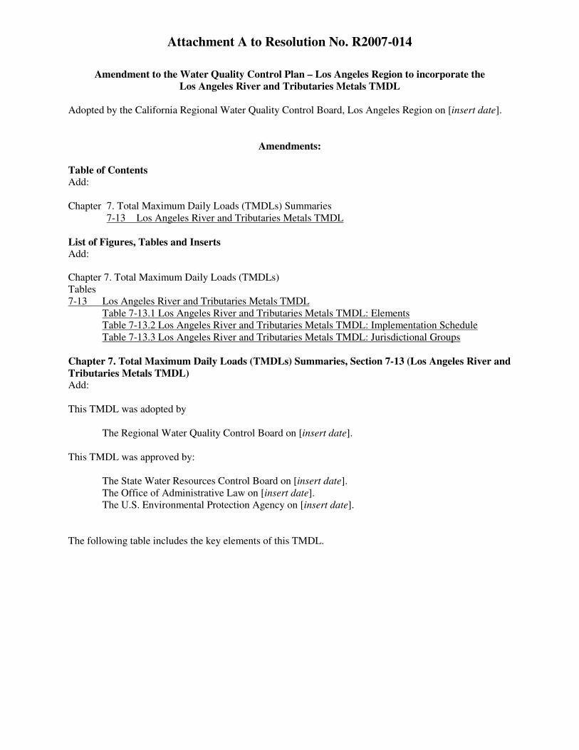
Attachment A to Resolution No. R2007-014
Amendment to the Water Quality Control Plan – Los Angeles Region to incorporate the Los Angeles River and Tributaries Metals TMDL
Adopted by the California Regional Water Quality Control Board, Los Angeles Region on [insert date].
Amendments: Table of Contents Add: Chapter 7. Total Maximum Daily Loads (TMDLs) Summaries
7-13 Los Angeles River and Tributaries Metals TMDL List of Figures, Tables and Inserts Add:
Chapter 7. Total Maximum Daily Loads (TMDLs) Tables 7-13 Los Angeles River and Tributaries Metals TMDL
Table 7-13.1 Los Angeles River and Tributaries Metals TMDL: Elements Table 7-13.2 Los Angeles River and Tributaries Metals TMDL: Implementation Schedule Table 7-13.3 Los Angeles River and Tributaries Metals TMDL: Jurisdictional Groups
Chapter 7. Total Maximum Daily Loads (TMDLs) Summaries, Section 7-13 (Los Angeles River and Tributaries Metals TMDL) Add: This TMDL was adopted by
The Regional Water Quality Control Board on [insert date]. This TMDL was approved by:
The State Water Resources Control Board on [insert date]. The Office of Administrative Law on [insert date]. The U.S. Environmental Protection Agency on [insert date].
The following table includes the key elements of this TMDL.
2
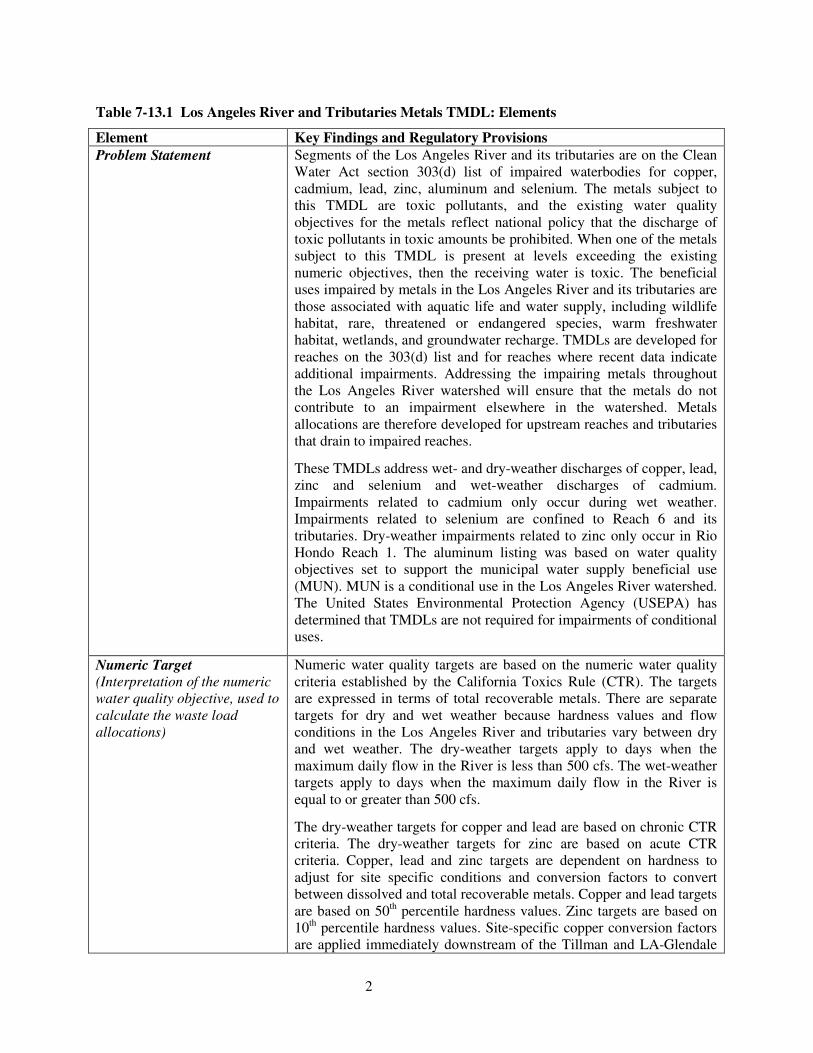
Table 7-13.1 Los Angeles River and Tributaries Metals TMDL: Elements
Element Key Findings and Regulatory Provisions Problem Statement Segments of the Los Angeles River and its tributaries are on the Clean
Water Act section 303(d) list of impaired waterbodies for copper, cadmium, lead, zinc, aluminum and selenium. The metals subject to this TMDL are toxic pollutants, and the existing water quality objectives for the metals reflect national policy that the discharge of toxic pollutants in toxic amounts be prohibited. When one of the metals subject to this TMDL is present at levels exceeding the existing numeric objectives, then the receiving water is toxic. The beneficial uses impaired by metals in the Los Angeles River and its tributaries are those associated with aquatic life and water supply, including wildlife habitat, rare, threatened or endangered species, warm freshwater habitat, wetlands, and groundwater recharge. TMDLs are developed for reaches on the 303(d) list and for reaches where recent data indicate additional impairments. Addressing the impairing metals throughout the Los Angeles River watershed will ensure that the metals do not contribute to an impairment elsewhere in the watershed. Metals allocations are therefore developed for upstream reaches and tributaries that drain to impaired reaches.
These TMDLs address wet- and dry-weather discharges of copper, lead, zinc and selenium and wet-weather discharges of cadmium. Impairments related to cadmium only occur during wet weather. Impairments related to selenium are confined to Reach 6 and its tributaries. Dry-weather impairments related to zinc only occur in Rio Hondo Reach 1. The aluminum listing was based on water quality objectives set to support the municipal water supply beneficial use (MUN). MUN is a conditional use in the Los Angeles River watershed. The United States Environmental Protection Agency (USEPA) has determined that TMDLs are not required for impairments of conditional uses.
Numeric Target (Interpretation of the numeric water quality objective, used to calculate the waste load allocations)
Numeric water quality targets are based on the numeric water quality criteria established by the California Toxics Rule (CTR). The targets are expressed in terms of total recoverable metals. There are separate targets for dry and wet weather because hardness values and flow conditions in the Los Angeles River and tributaries vary between dry and wet weather. The dry-weather targets apply to days when the maximum daily flow in the River is less than 500 cfs. The wet-weather targets apply to days when the maximum daily flow in the River is equal to or greater than 500 cfs.
The dry-weather targets for copper and lead are based on chronic CTR criteria. The dry-weather targets for zinc are based on acute CTR criteria. Copper, lead and zinc targets are dependent on hardness to adjust for site specific conditions and conversion factors to convert between dissolved and total recoverable metals. Copper and lead targets are based on 50th percentile hardness values. Zinc targets are based on 10th percentile hardness values. Site-specific copper conversion factors are applied immediately downstream of the Tillman and LA-Glendale
3
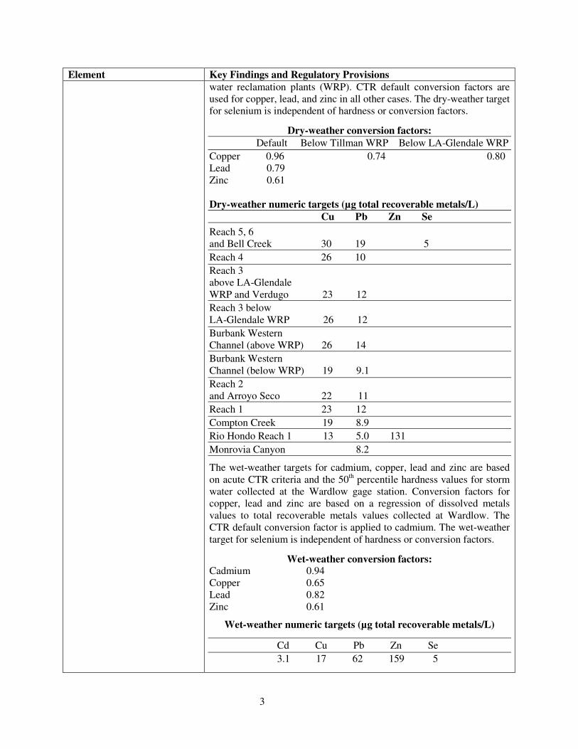
Element Key Findings and Regulatory Provisions water reclamation plants (WRP). CTR default conversion factors are used for copper, lead, and zinc in all other cases. The dry-weather target for selenium is independent of hardness or conversion factors.
Dry-weather conversion factors: Default Below Tillman WRP Below LA-Glendale WRP Copper 0.96 0.74 0.80 Lead 0.79 Zinc 0.61 Dry-weather numeric targets (µg total recoverable metals/L) Cu Pb Zn Se Reach 5, 6 and Bell Creek 30 19 5 Reach 4 26 10 Reach 3 above LA-Glendale WRP and Verdugo 23 12 Reach 3 below LA-Glendale WRP 26 12 Burbank Western Channel (above WRP) 26 14 Burbank Western Channel (below WRP) 19 9.1 Reach 2 and Arroyo Seco 22 11 Reach 1 23 12 Compton Creek 19 8.9 Rio Hondo Reach 1 13 5.0 131 Monrovia Canyon 8.2
The wet-weather targets for cadmium, copper, lead and zinc are based on acute CTR criteria and the 50th percentile hardness values for storm water collected at the Wardlow gage station. Conversion factors for copper, lead and zinc are based on a regression of dissolved metals values to total recoverable metals values collected at Wardlow. The CTR default conversion factor is applied to cadmium. The wet-weather target for selenium is independent of hardness or conversion factors.
Wet-weather conversion factors: Cadmium 0.94 Copper 0.65 Lead 0.82 Zinc 0.61
Wet-weather numeric targets (µg total recoverable metals/L)
Cd Cu Pb Zn Se 3.1 17 62 159 5
4
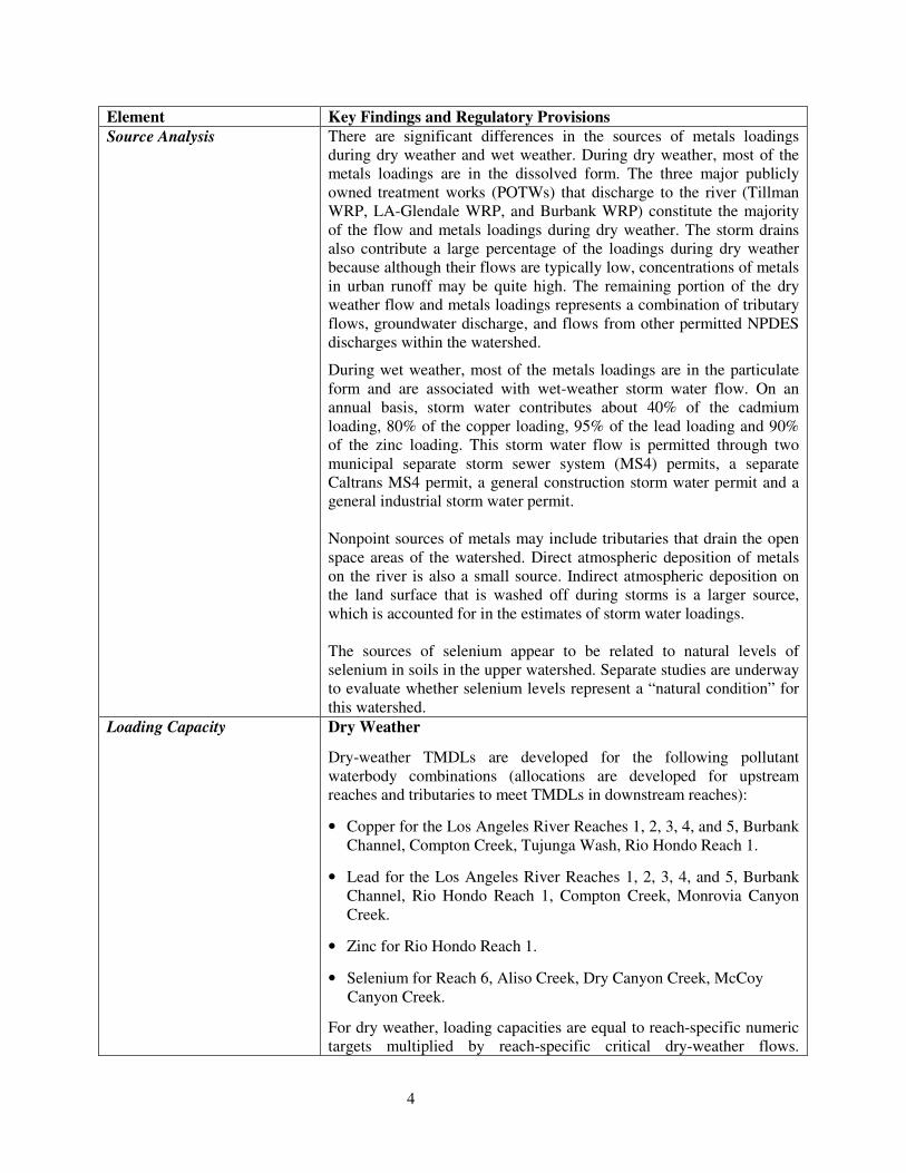
Element Key Findings and Regulatory Provisions Source Analysis There are significant differences in the sources of metals loadings
during dry weather and wet weather. During dry weather, most of the metals loadings are in the dissolved form. The three major publicly owned treatment works (POTWs) that discharge to the river (Tillman WRP, LA-Glendale WRP, and Burbank WRP) constitute the majority of the flow and metals loadings during dry weather. The storm drains also contribute a large percentage of the loadings during dry weather because although their flows are typically low, concentrations of metals in urban runoff may be quite high. The remaining portion of the dry weather flow and metals loadings represents a combination of tributary flows, groundwater discharge, and flows from other permitted NPDES discharges within the watershed.
During wet weather, most of the metals loadings are in the particulate form and are associated with wet-weather storm water flow. On an annual basis, storm water contributes about 40% of the cadmium loading, 80% of the copper loading, 95% of the lead loading and 90% of the zinc loading. This storm water flow is permitted through two municipal separate storm sewer system (MS4) permits, a separate Caltrans MS4 permit, a general construction storm water permit and a general industrial storm water permit. Nonpoint sources of metals may include tributaries that drain the open space areas of the watershed. Direct atmospheric deposition of metals on the river is also a small source. Indirect atmospheric deposition on the land surface that is washed off during storms is a larger source, which is accounted for in the estimates of storm water loadings. The sources of selenium appear to be related to natural levels of selenium in soils in the upper watershed. Separate studies are underway to evaluate whether selenium levels represent a “natural condition” for this watershed.
Loading Capacity Dry Weather
Dry-weather TMDLs are developed for the following pollutant waterbody combinations (allocations are developed for upstream reaches and tributaries to meet TMDLs in downstream reaches):
• Copper for the Los Angeles River Reaches 1, 2, 3, 4, and 5, Burbank Channel, Compton Creek, Tujunga Wash, Rio Hondo Reach 1.
• Lead for the Los Angeles River Reaches 1, 2, 3, 4, and 5, Burbank Channel, Rio Hondo Reach 1, Compton Creek, Monrovia Canyon Creek.
• Zinc for Rio Hondo Reach 1.
• Selenium for Reach 6, Aliso Creek, Dry Canyon Creek, McCoy Canyon Creek.
For dry weather, loading capacities are equal to reach-specific numeric targets multiplied by reach-specific critical dry-weather flows.
5
Element Key Findings and Regulatory Provisions Summing the critical flows for each reach and tributary, the critical flow for the entire river is 203 cfs, which is equal to the combined design flow of the three POTWs (169 cfs) plus the median flow from the storm drains and tributaries (34 cfs). The median storm drain and tributary flow is equal to the median flow at Wardlow (145 cfs) minus the existing median POTW flow (111 cfs). The dry-weather loading capacities for each impaired reach include the critical flows for upstream reaches. The dry-weather loading capacity for Reach 5 includes flows from Reach 6 and Bell Creek, the dry-weather loading capacity for Reach 3 includes flows from Verdugo Wash, and the dry-weather loading capacity for Reach 2 includes flows from Arroyo Seco.
Dry-weather loading capacity (total recoverable metals)
Critical Cu Pb Zn Flow (cfs) (kg/day) (kg/day) (kg/day)
LA River Reach 5 8.74 0.65 0.39 LA River Reach 4 129.13 8.1 3.2 LA River Reach 3 39.14 2.3 1.01 LA River Reach 2 4.44 0.16 0.084 LA River Reach 1 2.58 0.14 0.075 Tujunga Wash 0.15 0.007 0.0035 Burbank Channel 17.3 0.80 0.39 Rio Hondo Reach 1 0.50 0.015 0.0061 0.16 Compton Creek 0.90 0.041 0.020 No dry-weather loading capacities are calculated for lead in Monrovia Canyon Creek or selenium in Reach 6 or its tributaries. Concentration-based allocations are assigned for these metals in these reaches. Wet Weather
Wet-weather TMDLs are calculated for cadmium, copper, lead, and zinc in Reach 1. Allocations are developed for all upstream reaches and tributaries to meet these TMDLs.
Wet-weather loading capacities are calculated by multiplying daily storm volumes by the wet-weather numeric target for each metal. The resulting curves identify the load allowance for a given flow.
Wet-weather loading capacity (total recoverable metals)
Metal Load Duration Curve (kg/day) Cadmium Daily storm volume x 3.1 µg/L Copper Daily storm volume x 17 µg/L Lead Daily storm volume x 62 µg/L Zinc Daily storm volume x 159 µg/L
Load Allocations (for nonpoint sources)
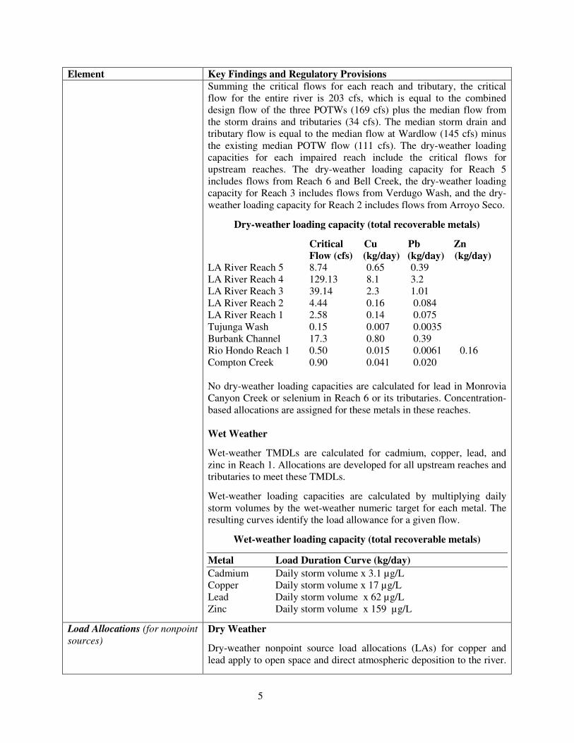
Dry Weather
Dry-weather nonpoint source load allocations (LAs) for copper and lead apply to open space and direct atmospheric deposition to the river.
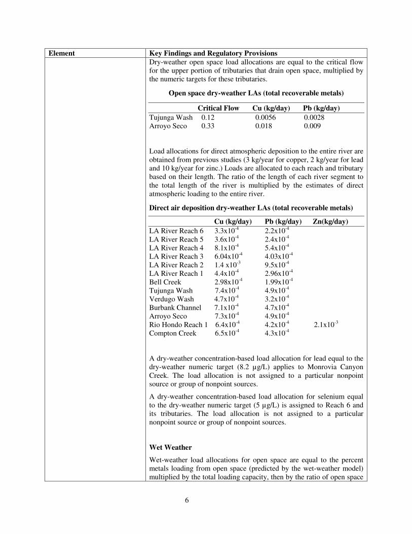
6
Element Key Findings and Regulatory Provisions Dry-weather open space load allocations are equal to the critical flow for the upper portion of tributaries that drain open space, multiplied by the numeric targets for these tributaries.
Open space dry-weather LAs (total recoverable metals)
Critical Flow Cu (kg/day) Pb (kg/day) Tujunga Wash 0.12 0.0056 0.0028 Arroyo Seco 0.33 0.018 0.009
Load allocations for direct atmospheric deposition to the entire river are obtained from previous studies (3 kg/year for copper, 2 kg/year for lead and 10 kg/year for zinc.) Loads are allocated to each reach and tributary based on their length. The ratio of the length of each river segment to the total length of the river is multiplied by the estimates of direct atmospheric loading to the entire river.
Direct air deposition dry-weather LAs (total recoverable metals)
Cu (kg/day) Pb (kg/day) Zn(kg/day) LA River Reach 6 3.3x10⁻⁴ 2.2x10⁻⁴ LA River Reach 5 3.6x10⁻⁴ 2.4x10⁻⁴ LA River Reach 4 8.1x10⁻⁴ 5.4x10⁻⁴ LA River Reach 3 6.04x10⁻⁴ 4.03x10⁻⁴ LA River Reach 2 1.4 x10⁻³ 9.5x10⁻⁴ LA River Reach 1 4.4x10⁻⁴ 2.96x10⁻⁴ Bell Creek 2.98x10⁻⁴ 1.99x10⁻⁴ Tujunga Wash 7.4x10⁻⁴ 4.9x10⁻⁴ Verdugo Wash 4.7x10⁻⁴ 3.2x10⁻⁴ Burbank Channel 7.1x10⁻⁴ 4.7x10⁻⁴
Arroyo Seco 7.3x10⁻⁴ 4.9x10⁻⁴ Rio Hondo Reach 1 6.4x10⁻⁴ 4.2x10⁻⁴ 2.1x10⁻³ Compton Creek 6.5x10⁻⁴ 4.3x10⁻⁴
A dry-weather concentration-based load allocation for lead equal to the dry-weather numeric target (8.2 µg/L) applies to Monrovia Canyon Creek. The load allocation is not assigned to a particular nonpoint source or group of nonpoint sources.
A dry-weather concentration-based load allocation for selenium equal to the dry-weather numeric target (5 µg/L) is assigned to Reach 6 and its tributaries. The load allocation is not assigned to a particular nonpoint source or group of nonpoint sources.
Wet Weather
Wet-weather load allocations for open space are equal to the percent metals loading from open space (predicted by the wet-weather model) multiplied by the total loading capacity, then by the ratio of open space
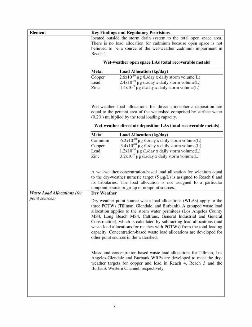
7
Element Key Findings and Regulatory Provisions located outside the storm drain system to the total open space area. There is no load allocation for cadmium because open space is not believed to be a source of the wet-weather cadmium impairment in Reach 1.
Wet-weather open space LAs (total recoverable metals)
Metal Load Allocation (kg/day) Copper 2.6x10⁻¹⁰ µg /L/day x daily storm volume(L) Lead 2.4x10⁻¹⁰ µg /L/day x daily storm volume(L) Zinc 1.4x10⁻⁹ µg /L/day x daily storm volume(L)
Wet-weather load allocations for direct atmospheric deposition are equal to the percent area of the watershed comprised by surface water (0.2%) multiplied by the total loading capacity.
Wet-weather direct air deposition LAs (total recoverable metals)
Metal Load Allocation (kg/day) Cadmium 6.2x10⁻¹⁰ µg /L/day x daily storm volume(L) Copper 3.4x10⁻¹⁰ µg /L/day x daily storm volume(L) Lead 1.2x10⁻¹⁰ µg /L/day x daily storm volume(L) Zinc 3.2x10⁻⁹ µg /L/day x daily storm volume(L) A wet-weather concentration-based load allocation for selenium equal to the dry-weather numeric target (5 µg/L) is assigned to Reach 6 and its tributaries. The load allocation is not assigned to a particular nonpoint source or group of nonpoint sources.
Waste Load Allocations (for point sources)
Dry Weather
Dry-weather point source waste load allocations (WLAs) apply to the three POTWs (Tillman, Glendale, and Burbank). A grouped waste load allocation applies to the storm water permitees (Los Angeles County MS4, Long Beach MS4, Caltrans, General Industrial and General Construction), which is calculated by subtracting load allocations (and waste load allocations for reaches with POTWs) from the total loading capacity. Concentration-based waste load allocations are developed for other point sources in the watershed.
Mass- and concentration-based waste load allocations for Tillman, Los Angeles-Glendale and Burbank WRPs are developed to meet the dry-weather targets for copper and lead in Reach 4, Reach 3 and the Burbank Western Channel, respectively.
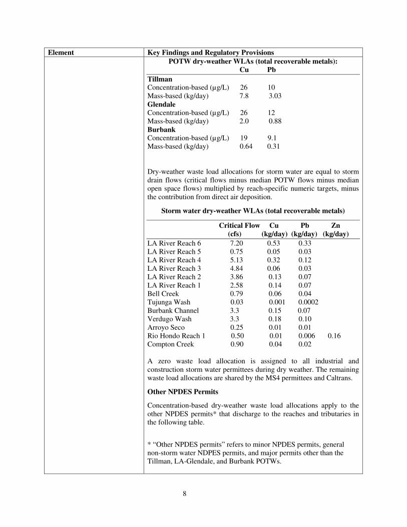
8
Element Key Findings and Regulatory Provisions POTW dry-weather WLAs (total recoverable metals):
Cu Pb Tillman Concentration-based (µg/L) 26 10 Mass-based (kg/day) 7.8 3.03 Glendale Concentration-based (µg/L) 26 12 Mass-based (kg/day) 2.0 0.88 Burbank Concentration-based (µg/L) 19 9.1 Mass-based (kg/day) 0.64 0.31 Dry-weather waste load allocations for storm water are equal to storm drain flows (critical flows minus median POTW flows minus median open space flows) multiplied by reach-specific numeric targets, minus the contribution from direct air deposition.
Storm water dry-weather WLAs (total recoverable metals)
Critical Flow Cu Pb Zn (cfs) (kg/day) (kg/day) (kg/day) LA River Reach 6 7.20 0.53 0.33 LA River Reach 5 0.75 0.05 0.03 LA River Reach 4 5.13 0.32 0.12 LA River Reach 3 4.84 0.06 0.03 LA River Reach 2 3.86 0.13 0.07 LA River Reach 1 2.58 0.14 0.07 Bell Creek 0.79 0.06 0.04 Tujunga Wash 0.03 0.001 0.0002 Burbank Channel 3.3 0.15 0.07 Verdugo Wash 3.3 0.18 0.10 Arroyo Seco 0.25 0.01 0.01 Rio Hondo Reach 1 0.50 0.01 0.006 0.16 Compton Creek 0.90 0.04 0.02 A zero waste load allocation is assigned to all industrial and construction storm water permittees during dry weather. The remaining waste load allocations are shared by the MS4 permittees and Caltrans.
Other NPDES Permits
Concentration-based dry-weather waste load allocations apply to the other NPDES permits* that discharge to the reaches and tributaries in the following table.
* “Other NPDES permits” refers to minor NPDES permits, general non-storm water NDPES permits, and major permits other than the Tillman, LA-Glendale, and Burbank POTWs.
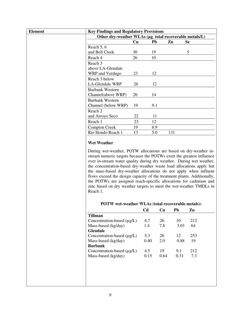
9
Element Key Findings and Regulatory Provisions Other dry-weather WLAs (µg total recoverable metals/L)
Cu Pb Zn Se Reach 5, 6 and Bell Creek 30 19 5 Reach 4 26 10 Reach 3 above LA-Glendale WRP and Verdugo 23 12 Reach 3 below LA-Glendale WRP 26 12 Burbank Western Channel(above WRP) 26 14 Burbank Western Channel (below WRP) 19 9.1 Reach 2 and Arroyo Seco 22 11 Reach 1 23 12 Compton Creek 19 8.9 Rio Hondo Reach 1 13 5.0 131 Wet Weather
During wet-weather, POTW allocations are based on dry-weather in-stream numeric targets because the POTWs exert the greatest influence over in-stream water quality during dry weather. During wet weather, the concentration-based dry-weather waste load allocations apply but the mass-based dry-weather allocations do not apply when influent flows exceed the design capacity of the treatment plants. Additionally, the POTWs are assigned reach-specific allocations for cadmium and zinc based on dry weather targets to meet the wet-weather TMDLs in Reach 1.
POTW wet-weather WLAs (total recoverable metals): Cd Cu Pb Zn Tillman Concentration-based (µg/L) 4.7 26 10 212 Mass-based (kg/day) 1.4 7.8 3.03 64 Glendale Concentration-based (µg/L) 5.3 26 12 253 Mass-based (kg/day) 0.40 2.0 0.88 19 Burbank Concentration-based (µg/L) 4.5 19 9.1 212 Mass-based (kg/day) 0.15 0.64 0.31 7.3
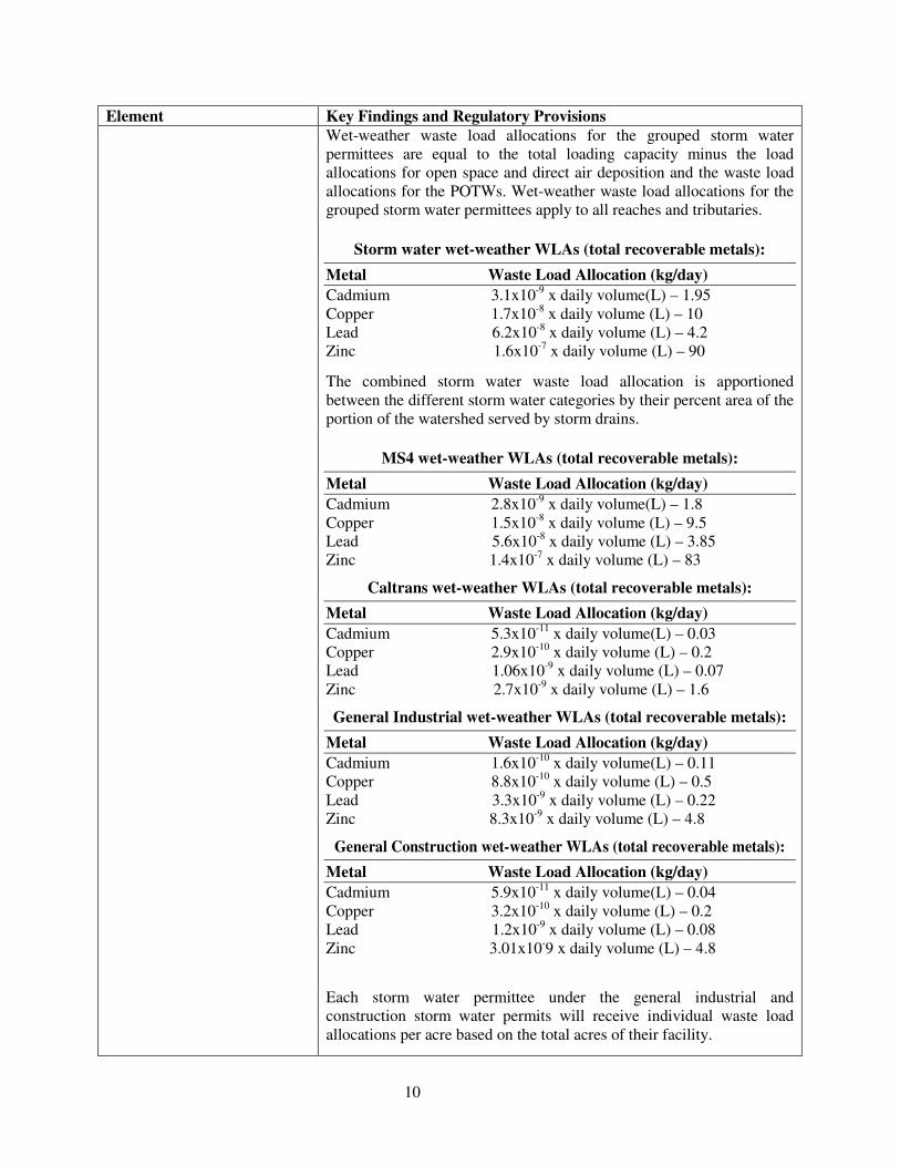
10
Element Key Findings and Regulatory Provisions Wet-weather waste load allocations for the grouped storm water permittees are equal to the total loading capacity minus the load allocations for open space and direct air deposition and the waste load allocations for the POTWs. Wet-weather waste load allocations for the grouped storm water permittees apply to all reaches and tributaries.
Storm water wet-weather WLAs (total recoverable metals): Metal Waste Load Allocation (kg/day) Cadmium 3.1x10⁻⁹ x daily volume(L) – 1.95 Copper 1.7x10⁻⁸ x daily volume (L) – 10 Lead 6.2x10⁻⁸ x daily volume (L) – 4.2 Zinc 1.6x10⁻⁷ x daily volume (L) – 90
The combined storm water waste load allocation is apportioned between the different storm water categories by their percent area of the portion of the watershed served by storm drains.
MS4 wet-weather WLAs (total recoverable metals): Metal Waste Load Allocation (kg/day) Cadmium 2.8x10⁻⁹ x daily volume(L) – 1.8 Copper 1.5x10⁻⁸ x daily volume (L) – 9.5 Lead 5.6x10⁻⁸ x daily volume (L) – 3.85 Zinc 1.4x10⁻⁷ x daily volume (L) – 83
Caltrans wet-weather WLAs (total recoverable metals): Metal Waste Load Allocation (kg/day) Cadmium 5.3x10⁻¹¹ x daily volume(L) – 0.03 Copper 2.9x10⁻¹⁰ x daily volume (L) – 0.2 Lead 1.06x10⁻⁹ x daily volume (L) – 0.07 Zinc 2.7x10⁻⁹ x daily volume (L) – 1.6
General Industrial wet-weather WLAs (total recoverable metals): Metal Waste Load Allocation (kg/day) Cadmium 1.6x10⁻¹⁰ x daily volume(L) – 0.11 Copper 8.8x10⁻¹⁰ x daily volume (L) – 0.5 Lead 3.3x10⁻⁹ x daily volume (L) – 0.22 Zinc 8.3x10⁻⁹ x daily volume (L) – 4.8
General Construction wet-weather WLAs (total recoverable metals): Metal Waste Load Allocation (kg/day) Cadmium 5.9x10⁻¹¹ x daily volume(L) – 0.04 Copper 3.2x10⁻¹⁰ x daily volume (L) – 0.2 Lead 1.2x10⁻⁹ x daily volume (L) – 0.08 Zinc 3.01x10⁻⁹ x daily volume (L) – 4.8
Each storm water permittee under the general industrial and construction storm water permits will receive individual waste load allocations per acre based on the total acres of their facility.
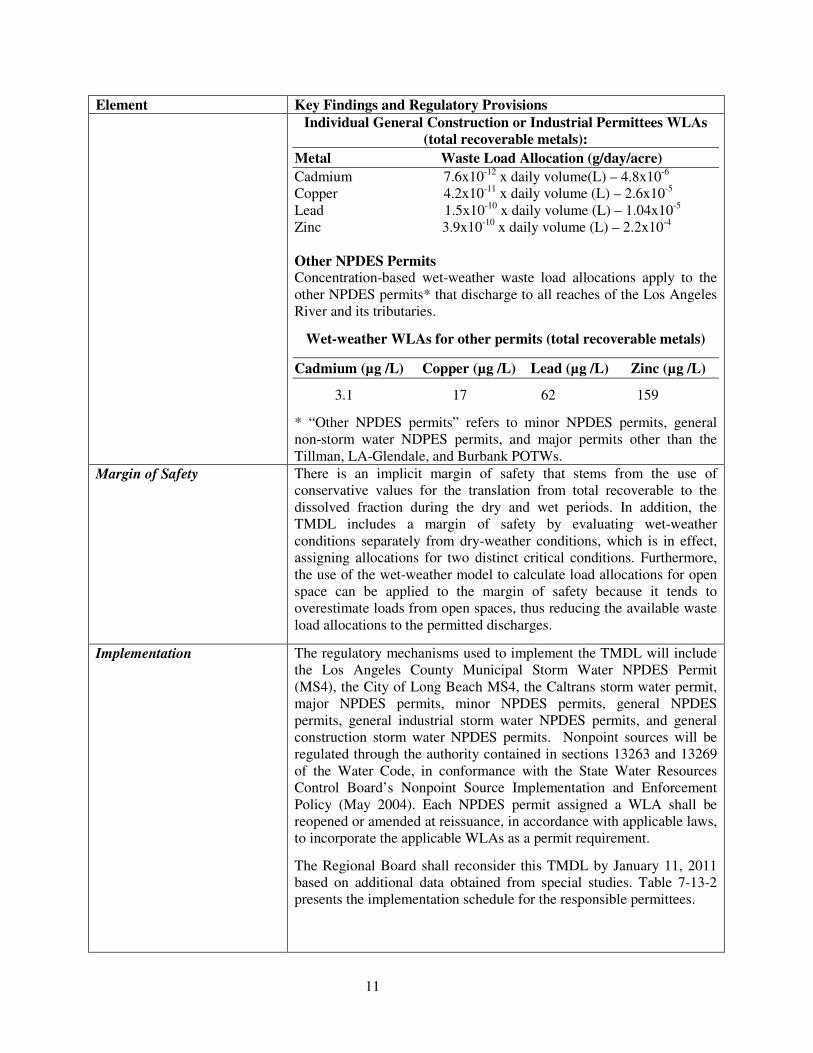
11
Element Key Findings and Regulatory Provisions Individual General Construction or Industrial Permittees WLAs
(total recoverable metals): Metal Waste Load Allocation (g/day/acre) Cadmium 7.6x10⁻¹² x daily volume(L) – 4.8x10⁻⁶ Copper 4.2x10⁻¹¹ x daily volume (L) – 2.6x10⁻⁵ Lead 1.5x10⁻¹⁰ x daily volume (L) – 1.04x10⁻⁵ Zinc 3.9x10⁻¹⁰ x daily volume (L) – 2.2x10⁻⁴ Other NPDES Permits Concentration-based wet-weather waste load allocations apply to the other NPDES permits* that discharge to all reaches of the Los Angeles River and its tributaries.
Wet-weather WLAs for other permits (total recoverable metals)
Cadmium (µg /L) Copper (µg /L) Lead (µg /L) Zinc (µg /L)
3.1 17 62 159
* “Other NPDES permits” refers to minor NPDES permits, general non-storm water NDPES permits, and major permits other than the Tillman, LA-Glendale, and Burbank POTWs.
Margin of Safety There is an implicit margin of safety that stems from the use of conservative values for the translation from total recoverable to the dissolved fraction during the dry and wet periods. In addition, the TMDL includes a margin of safety by evaluating wet-weather conditions separately from dry-weather conditions, which is in effect, assigning allocations for two distinct critical conditions. Furthermore, the use of the wet-weather model to calculate load allocations for open space can be applied to the margin of safety because it tends to overestimate loads from open spaces, thus reducing the available waste load allocations to the permitted discharges.
Implementation The regulatory mechanisms used to implement the TMDL will include the Los Angeles County Municipal Storm Water NPDES Permit (MS4), the City of Long Beach MS4, the Caltrans storm water permit, major NPDES permits, minor NPDES permits, general NPDES permits, general industrial storm water NPDES permits, and general construction storm water NPDES permits. Nonpoint sources will be regulated through the authority contained in sections 13263 and 13269 of the Water Code, in conformance with the State Water Resources Control Board’s Nonpoint Source Implementation and Enforcement Policy (May 2004). Each NPDES permit assigned a WLA shall be reopened or amended at reissuance, in accordance with applicable laws, to incorporate the applicable WLAs as a permit requirement.
The Regional Board shall reconsider this TMDL by January 11, 2011 based on additional data obtained from special studies. Table 7-13-2 presents the implementation schedule for the responsible permittees.
12
Element Key Findings and Regulatory Provisions Non storm water NPDES permits (including POTWs, other major, minor, and general permits):
Permit writers may translate applicable waste load allocations into effluent limits for the major, minor and general NPDES permits by applying the effluent limitation procedures in Section 1.4 of the State Water Resources Control Board’s Policy for Implementation of Toxics Standards for Inland Surface Waters, Enclosed Bays, and Estuaries of California (2000) or other applicable engineering practices authorized under federal regulations. Compliance schedules may be established in individual NPDES permits, allowing up to 5 years within a permit cycle to achieve compliance. Compliance schedules may not be established in general NPDES permits. A discharger that can not comply immediately with effluent limitations specified to implement waste load allocations will be required to apply for an individual permit in order to demonstrate the need for a compliance schedule.
If a POTW demonstrates that advanced treatment (necessitating long design and construction timeframes) will be required to meet final waste load allocations, the Regional Board will consider extending the implementation schedule to allow the POTW up to January 11, 2016 to achieve compliance with the final WLAs.
Permittees that hold individual NPDES permits and solely discharge storm water may be allowed (at Regional Board discretion) compliance schedules up to January 11, 2016 to achieve compliance with final WLAs.
General industrial storm water permits:
The Regional Board will develop a watershed-specific general industrial storm water permit to incorporate waste load allocations.
Dry-weather implementation
Non-storm water flows authorized by Order No. 97-03 DWQ, or any successor order, are exempt from the dry-weather waste load allocation equal to zero. Instead, these authorized non-storm water flows shall meet the reach-specific concentration-based waste load allocations assigned to the “other NPDES permits”. The dry-weather waste load allocation equal to zero applies to unauthorized non-storm water flows, which are prohibited by Order No. 97-03 DWQ.
It is anticipated that the dry-weather waste load allocations will be implemented by requiring improved best management practices (BMPs) to eliminate the discharge of non-storm water flows. However, permit writers must provide adequate justification and documentation to demonstrate that specified BMPs are expected to result in attainment of the numeric waste load allocations.
13
Element Key Findings and Regulatory Provisions Wet-weather implementation
General industrial storm water permittees are allowed interim wet-weather concentration-based waste load allocations based on benchmarks contained in EPA’s Storm Water Multi-sector General Permit for Industrial Activities. The interim waste load allocations apply to all industry sectors and apply until no later than January 11, 2016.
Interim wet-weather WLAs for general industrial storm water permittees (total recoverable metals)*
Cd (µg/L) Cu(µg/L) Pb(µg/L) Zn(µg/L) 15.9 63.6 81.6 117
*Based on USEPA benchmarks for industrial storm water sector
Until January 11, 2011, interim waste load allocations will not be interpreted as enforceable permit conditions. If monitoring demonstrates that interim waste load allocations are being exceeded, the permittee shall evaluate existing and potential BMPs, including structural BMPs, and implement any necessary BMP improvements. It is anticipated that monitoring results and any necessary BMP improvements would occur as part of an annual reporting process. After January 11, 2011, interim waste load allocations shall be translated into enforceable permit conditions. Compliance with permit conditions may be demonstrated through the installation, maintenance, and monitoring of Regional Board-approved BMPs. If this method of compliance is chosen, permit writers must provide adequate justification and documentation to demonstrate that BMPs are expected to result in attainment of interim waste load allocations.
The general industrial storm water permits shall achieve final wet-weather waste load allocations no later than January 11, 2016, which shall be expressed as NPDES water quality-based effluent limitations. Effluent limitations may be expressed as permit conditions, such as the installation, maintenance, and monitoring of Regional Board-approved BMPs if adequate justification and documentation demonstrate that BMPs are expected to result in attainment of waste load allocations.
General construction storm water permits:
Waste load allocations will be incorporated into the State Board general permit upon renewal or into a watershed-specific general permit developed by the Regional Board.
Dry-weather implementation
Non-storm water flows authorized by the General Permit for Storm Water Discharges Associated with Construction Activity (Water Quality Order No. 99-08 DWQ), or any successor order, are exempt from the dry-weather waste load allocation equal to zero as long as they comply with the provisions of sections C.3.and A.9 of the Order No. 99-08 DWQ, which state that these authorized non-storm discharges
14
Element Key Findings and Regulatory Provisions shall be (1) infeasible to eliminate (2) comply with BMPs as described in the Storm Water Pollution Prevention Plan prepared by the permittee, and (3) not cause or contribute to a violation of water quality standards, or comparable provisions in any successor order. Unauthorized non-storm water flows are already prohibited by Order No. 99-08 DWQ.
Wet-weather implementation
By January 11, 2013, the construction industry will submit the results of BMP effectiveness studies to determine BMPs that will achieve compliance with the final waste load allocations assigned to construction storm water permittees. Regional Board staff will bring the recommended BMPs before the Regional Board for consideration by January 11, 2014. General construction storm water permittees will be considered in compliance with final waste load allocations if they implement these Regional Board approved BMPs. All permittees must implement the approved BMPs by January 11, 2015. If no effectiveness studies are conducted and no BMPs are approved by the Regional Board by January 11, 2014, each general construction storm water permit holder will be subject to site-specific BMPs and monitoring requirements to demonstrate compliance with final waste load allocations.
MS4 and Caltrans permits
Applicable CTR limits are being met most of the time during dry weather, with episodic exceedances. Due to the expense of obtaining accurate flow measurements required for calculating loads, concentration-based permit limits may apply during dry weather. These concentration-based limits would be equal to dry-weather reach-specific numeric targets.
Each municipality and permittee will be required to meet the storm water waste load allocations shared by the two MS4s and Caltrans permittees at the designated TMDL effectiveness monitoring points. A phased implementation approach, using a combination of non-structural and structural BMPs may be used to achieve compliance with the waste load allocations. The administrative record and the fact sheets for the MS4 and Caltrans storm water permits must provide reasonable assurance that the BMPs selected will be sufficient to implement the waste load allocations.
The implementation schedule for the MS4 and Caltrans permittees consists of a phased approach. The watershed is divided into five jurisdictional groups based on the subwatersheds of the tributaries that drain to each reach of the river, as presented in Table 7-13-3. Each jurisdictional group shall achieve compliance in prescribed percentages of its subwatershed(s), with total compliance to be achieved within 22 years. Jurisdictional groups can be reorganized or subdivided upon approval by the Executive Officer.
15
Element Key Findings and Regulatory Provisions Seasonal Variations and Critical Conditions
Seasonal variations are addressed by developing separate waste load allocations for dry weather and wet weather.
For dry weather, critical flows for each reach are established from the long-term flow records (1988-2000) generated by stream gages located throughout the watershed and in selected reaches. The median dry-weather urban runoff plus the combined design capacity of the three major POTWs is selected as the critical flow since most of the flow is from effluent which results in a relatively stable dry-weather flow condition. In areas where there are no flow records, an area-weighted approach is used to assign flows to these reaches.
Wet-weather allocations are developed using the load-duration curve concept. The total wet-weather waste load allocation for wet weather varies by storm. Given this variability in storm water flows, no justification was found for selecting a particular sized storm as the critical condition.
Compliance Monitoring and Special Studies
Effective monitoring will be necessary to assess the condition of the Los Angeles River and its tributaries and to assess the on-going effectiveness of efforts by dischargers to reduce metals loading to the Los Angeles River. Special studies may also be appropriate to provide further information about new data, new or alternative sources, and revised scientific assumptions. Below the Regional Board identifies the various goals of monitoring efforts and studies. The programs, reports, and studies will be developed in response to subsequent orders issued by the Executive Officer.
Ambient Monitoring
An ambient monitoring program is necessary to assess water quality throughout the Los Angeles River and its tributaries and the progress being made to remove the metals impairments. The MS4 and Caltrans storm water NPDES permittees in each jurisdictional group are jointly responsible for implementing the ambient monitoring program. The responsible agencies shall sample for total recoverable metals, dissolved metals, including cadmium and zinc, and hardness once per month at each ambient monitoring location at least until the TMDL is re-considered at year 5. The reported detection limits shall be below the hardness adjusted CTR criteria. Eight ambient monitoring points currently exist in the Los Angeles River and its tributaries as part of the City of Los Angeles Watershed Monitoring Program. These monitoring points could be used to assess water quality.
16
Element Key Findings and Regulatory Provisions Ambient Monitoring Points Reaches and Tributaries White Oak LA River 6, Aliso Creek, McCoy Creek, Bell Creek Avenue Sepulveda LA River 5, Bull Creek Boulevard Tujunga LA River 4, Tujunga Wash Avenue Colorado LA River 3, Burbank Western Channel, Verdugo Wash Boulevard Figueroa LA River 3, Arroyo Seco Street Washington LA River 2 Boulevard Rosecrans LA River 2, Rio Hondo (gage just above Rio Hondo) Avenue Willow LA River 1, Compton Creek (gage at Wardlow) Street
TMDL Effectiveness Monitoring
The MS4 and Caltrans storm water NPDES permittees in each jurisdictional group are jointly responsible for assessing progress in reducing pollutant loads to achieve the TMDL. Each jurisdictional group is required to submit for approval by the Executive Officer a coordinated monitoring plan that will demonstrate the effectiveness of the phased implementation schedule for this TMDL (See Table 7-13.2), which requires attainment of the applicable waste load allocations in prescribed percentages of each subwatershed over a 22-year period. The monitoring locations specified for the ambient monitoring program may be used as effectiveness monitoring locations.
The MS4 and Caltrans storm water NPDES permittees will be found to be effectively meeting dry-weather waste load allocations if the in-stream pollutant concentration or load at the first downstream monitoring location is equal to or less than the corresponding concentration- or load-based waste load allocation. Alternatively, effectiveness of the TMDL may be assessed at the storm drain outlet based on the waste load allocation for the receiving water. For storm drains that discharge to other storm drains, the waste load allocation will be based on the waste load allocation for the ultimate receiving water for that storm drain system. The MS4 and Caltrans storm water NPDES permittees will be found to be effectively meeting wet-weather waste load allocations if the loading at the downstream monitoring location is equal to or less then the wet-weather waste load allocation.
The general industrial storm water permit shall contain a model monitoring and reporting program to evaluate BMP effectiveness. A permittee enrolled under the general permit shall have the choice of conducting individual monitoring based on the model program or participating in a group monitoring effort. MS4 permittees are
17
Element Key Findings and Regulatory Provisions encouraged to take the lead in group monitoring efforts for industrial facilities within their jurisdiction because compliance with waste load allocations by these facilities will in many cases translate to reductions in metals loads to the MS4 system.
The Tillman, LA-Glendale, and Burbank POTWs, and the remaining permitted discharges in the watershed will have effluent monitoring requirements to ensure compliance with waste load allocations.
Special Studies
The implementation schedule (see Table 7-13.2) allows time for special studies that may serve to refine the estimate of loading capacity, waste load and/or load allocations, and other studies that may serve to optimize implementation efforts. The Regional Board will re-consider the TMDL by January 11, 2011 in light of the findings of these studies. Studies may include:
• Refined flow estimates for the Los Angeles River mainstem and tributaries where there presently are no flow gages and for improved gaging of low-flow conditions.
• Water quality measurements, including a better assessment of hardness, water chemistry data (e.g., total suspended solids and organic carbon) that may refine the use of metals partitioning coefficients.
• Effects studies designed to evaluate site-specific toxic effects of metals on the Los Angeles River and its tributaries.
• Source studies designed to characterize loadings from background or natural sources
• Review of water quality modeling assumptions including the relationship between metals and total suspended solids as expressed in the potency factors and buildup and washoff and transport coefficients.
• Evaluation of aerial deposition and sources of aerial deposition.
• POTWs that are unable to demonstrate compliance with final waste load allocations must conduct source reduction audits by January 11, 2008.
• POTWs that will be requesting the Regional Board to extend their implementation schedule to allow for the installation of advanced treatment must prepare work plans, with time schedules to allow for the installation advanced treatment. The work plan must be submitted January 11, 2010.
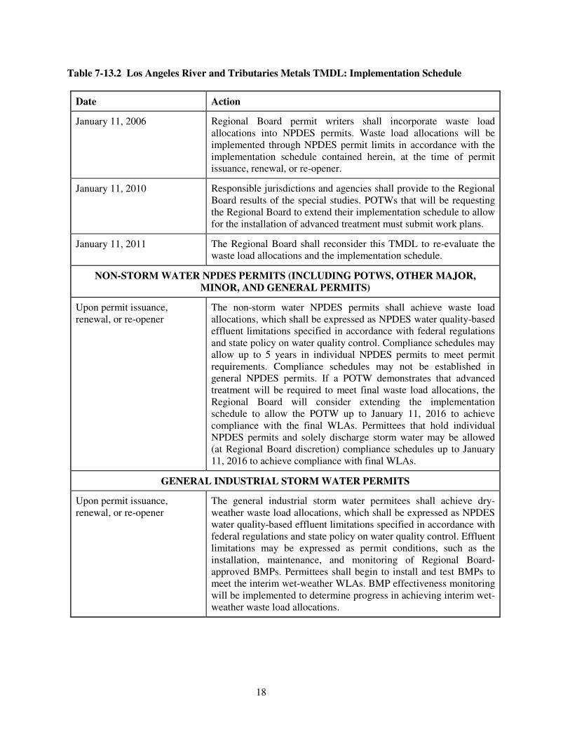
18
Table 7-13.2 Los Angeles River and Tributaries Metals TMDL: Implementation Schedule
Date Action
January 11, 2006 Regional Board permit writers shall incorporate waste load allocations into NPDES permits. Waste load allocations will be implemented through NPDES permit limits in accordance with the implementation schedule contained herein, at the time of permit issuance, renewal, or re-opener.
January 11, 2010 Responsible jurisdictions and agencies shall provide to the Regional Board results of the special studies. POTWs that will be requesting the Regional Board to extend their implementation schedule to allow for the installation of advanced treatment must submit work plans.
January 11, 2011 The Regional Board shall reconsider this TMDL to re-evaluate the waste load allocations and the implementation schedule.
NON-STORM WATER NPDES PERMITS (INCLUDING POTWS, OTHER MAJOR, MINOR, AND GENERAL PERMITS)
Upon permit issuance, renewal, or re-opener
The non-storm water NPDES permits shall achieve waste load allocations, which shall be expressed as NPDES water quality-based effluent limitations specified in accordance with federal regulations and state policy on water quality control. Compliance schedules may allow up to 5 years in individual NPDES permits to meet permit requirements. Compliance schedules may not be established in general NPDES permits. If a POTW demonstrates that advanced treatment will be required to meet final waste load allocations, the Regional Board will consider extending the implementation schedule to allow the POTW up to January 11, 2016 to achieve compliance with the final WLAs. Permittees that hold individual NPDES permits and solely discharge storm water may be allowed (at Regional Board discretion) compliance schedules up to January 11, 2016 to achieve compliance with final WLAs.
GENERAL INDUSTRIAL STORM WATER PERMITS
Upon permit issuance, renewal, or re-opener
The general industrial storm water permitees shall achieve dry-weather waste load allocations, which shall be expressed as NPDES water quality-based effluent limitations specified in accordance with federal regulations and state policy on water quality control. Effluent limitations may be expressed as permit conditions, such as the installation, maintenance, and monitoring of Regional Board-approved BMPs. Permittees shall begin to install and test BMPs to meet the interim wet-weather WLAs. BMP effectiveness monitoring will be implemented to determine progress in achieving interim wet-weather waste load allocations.
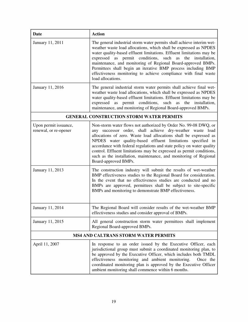
19
Date Action
January 11, 2011 The general industrial storm water permits shall achieve interim wet-weather waste load allocations, which shall be expressed as NPDES water quality-based effluent limitations. Effluent limitations may be expressed as permit conditions, such as the installation, maintenance, and monitoring of Regional Board-approved BMPs. Permittees shall begin an iterative BMP process including BMP effectiveness monitoring to achieve compliance with final waste load allocations.
January 11, 2016 The general industrial storm water permits shall achieve final wet-weather waste load allocations, which shall be expressed as NPDES water quality-based effluent limitations. Effluent limitations may be expressed as permit conditions, such as the installation, maintenance, and monitoring of Regional Board-approved BMPs.
GENERAL CONSTRUCTION STORM WATER PERMITS
Upon permit issuance, renewal, or re-opener
Non-storm water flows not authorized by Order No. 99-08 DWQ, or any successor order, shall achieve dry-weather waste load allocations of zero. Waste load allocations shall be expressed as NPDES water quality-based effluent limitations specified in accordance with federal regulations and state policy on water quality control. Effluent limitations may be expressed as permit conditions, such as the installation, maintenance, and monitoring of Regional Board-approved BMPs.
January 11, 2013 The construction industry will submit the results of wet-weather BMP effectiveness studies to the Regional Board for consideration. In the event that no effectiveness studies are conducted and no BMPs are approved, permittees shall be subject to site-specific BMPs and monitoring to demonstrate BMP effectiveness.
January 11, 2014 The Regional Board will consider results of the wet-weather BMP effectiveness studies and consider approval of BMPs.
January 11, 2015 All general construction storm water permittees shall implement Regional Board-approved BMPs.
MS4 AND CALTRANS STORM WATER PERMITS
April 11, 2007 In response to an order issued by the Executive Officer, each jurisdictional group must submit a coordinated monitoring plan, to be approved by the Executive Officer, which includes both TMDL effectiveness monitoring and ambient monitoring. Once the coordinated monitoring plan is approved by the Executive Officer ambient monitoring shall commence within 6 months.
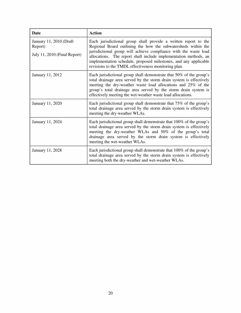
20
Date Action
January 11, 2010 (Draft Report)
July 11, 2010 (Final Report)
Each jurisdictional group shall provide a written report to the Regional Board outlining the how the subwatersheds within the jurisdictional group will achieve compliance with the waste load allocations. The report shall include implementation methods, an implementation schedule, proposed milestones, and any applicable revisions to the TMDL effectiveness monitoring plan.
January 11, 2012 Each jurisdictional group shall demonstrate that 50% of the group’s total drainage area served by the storm drain system is effectively meeting the dry-weather waste load allocations and 25% of the group’s total drainage area served by the storm drain system is effectively meeting the wet-weather waste load allocations.
January 11, 2020 Each jurisdictional group shall demonstrate that 75% of the group’s total drainage area served by the storm drain system is effectively meeting the dry-weather WLAs.
January 11, 2024 Each jurisdictional group shall demonstrate that 100% of the group’s total drainage area served by the storm drain system is effectively meeting the dry-weather WLAs and 50% of the group’s total drainage area served by the storm drain system is effectively meeting the wet-weather WLAs.
January 11, 2028 Each jurisdictional group shall demonstrate that 100% of the group’s total drainage area served by the storm drain system is effectively meeting both the dry-weather and wet-weather WLAs.
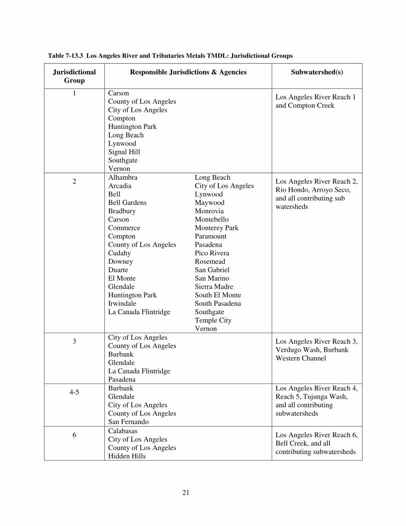
21
Table 7-13.3 Los Angeles River and Tributaries Metals TMDL: Jurisdictional Groups
Jurisdictional Group
Responsible Jurisdictions & Agencies Subwatershed(s)
1 Carson County of Los Angeles City of Los Angeles Compton Huntington Park Long Beach Lynwood Signal Hill Southgate Vernon
Los Angeles River Reach 1 and Compton Creek
2 Alhambra Arcadia Bell Bell Gardens Bradbury Carson Commerce Compton County of Los Angeles Cudahy Downey Duarte El Monte Glendale Huntington Park Irwindale La Canada Flintridge
Long Beach City of Los Angeles Lynwood Maywood Monrovia Montebello Monterey Park Paramount Pasadena Pico Rivera Rosemead San Gabriel San Marino Sierra Madre South El Monte South Pasadena Southgate Temple City Vernon
Los Angeles River Reach 2, Rio Hondo, Arroyo Seco, and all contributing sub watersheds
3 City of Los Angeles County of Los Angeles Burbank Glendale La Canada Flintridge Pasadena
Los Angeles River Reach 3, Verdugo Wash, Burbank Western Channel
4-5 Burbank Glendale City of Los Angeles County of Los Angeles San Fernando
Los Angeles River Reach 4, Reach 5, Tujunga Wash, and all contributing subwatersheds
6 Calabasas City of Los Angeles County of Los Angeles Hidden Hills
Los Angeles River Reach 6, Bell Creek, and all contributing subwatersheds

Appendix 2. Sampling results for Reach 6 – Copper, Lead, Selenium
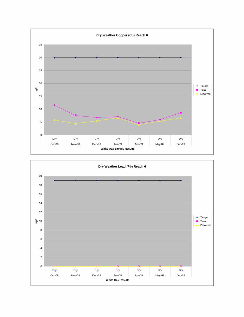
Dry Weather Copper (Cu) Reach 6
0
5
10
15
20
25
30
35
Dry Dry Dry Dry Dry Dry Dry
Oct-08 Nov-08 Dec-08 Jan-09 Apr-09 May-09 Jun-09
White Oak Sample Results
ug
/l
Target
Total
Disolved
Dry Weather Lead (Pb) Reach 6
0
2
4
6
8
10
12
14
16
18
20
Dry Dry Dry Dry Dry Dry Dry
Oct-08 Nov-08 Dec-08 Jan-09 Apr-09 May-09 Jun-09
White Oak Results
ug
/l
Target
Total
Disolved


![la Ronge-Wollaston Belts Base Metals Project: Geo!]e Hills ......- 85 - la Ronge-Wollaston Belts Base Metals Project: Geo!]e Hills, Johnson and Kaz Lakes and Geikie River Areas by](https://img.pdfslide.us/doc/110x75/60cc042c2ee93205654ada78/la-ronge-wollaston-belts-base-metals-project-geoe-hills-85-la-ronge-wollaston.jpg)