Embed Size (px)
Citation preview
SECTION 5.12: TRAFFIC AND TRANSPORTATION
IS061411043744SAC/420246/112100004 5.12-1
5.12 Traffic and Transportation 5.12.1 Introduction The Hidden Hills Solar Electric Generating System (HHSEGS) will be located on privately owned land in Inyo County, California, adjacent to the Nevada border. It will comprise two solar fields and associated facilities: the northern solar plant (Solar Plant 1) and the southern solar plant (Solar Plant 2). Each solar plant will generate 270 megawatts (MW) gross (250 MW net), for a total net output of 500 MW. Solar Plant 1 will occupy approximately 1,483 acres (or 2.3 square miles), and Solar Plant 2 will occupy approximately 1,510 acres (or 2.4 square miles). A 103-acre common area will be established on the southeastern corner of the site to accommodate an administration, warehouse, and maintenance complex, and an onsite switchyard. A temporary construction laydown and parking area on the west side of the site will occupy approximately 180 acres.
Each solar plant will use heliostats—elevated mirrors guided by a tracking system mounted on a pylon—to focus the sun’s rays on a solar receiver steam generator (SRSG) atop a tower near the center of each solar field. The solar power tower technology for the HHSEGS project design incorporates an important technology advancement, the 750-foot-tall solar power tower. One principle advantage of the HHSEGS solar power tower design is that it results in more efficient land use and greater power generation. The new, higher, 750-foot solar power tower allows the heliostat rows to be placed closer together, with the mirrors at a steeper angle. This substantially reduces mirror shading and allows more heliostats to be placed per acre. More megawatts can be generated per acre and the design is more efficient overall.
In each solar plant, one Rankine-cycle steam turbine will receive steam from the SRSG (or solar boiler) to generate electricity. The solar field and power generation equipment will start each morning after sunrise and, unless augmented, will shut down when insolation drops below the level required to keep the turbine online. Each solar plant will include a natural-gas-fired auxiliary boiler, used to augment the solar operation when solar energy diminishes or during transient cloudy conditions, as well as a startup boiler, used during the morning startup cycle, and a nighttime preservation boiler, used to maintain system temperatures overnight. On an annual basis heat input from natural gas will be limited by fuel use and other conditions to less than 10 percent of the heat input from the sun.
To save water in the site’s desert environment, each solar plant will use a dry-cooling condenser. Cooling will be provided by air-cooled condensers, supplemented by a partial dry-cooling system for auxiliary equipment cooling. Raw water will be drawn daily from onsite wells located in each power block and at the administration complex. Groundwater will be treated in an onsite treatment system for use as boiler make-up water and to wash the heliostats.
Two distinct transmission options are being considered because of a unique situation concerning Valley Electric Association (VEA). Under the first option, the project would interconnect via a 230-kilovolt (kV) transmission line to a new VEA-owned substation
SECTION 5.12: TRAFFIC AND TRANSPORTATION
5.12-2 IS061411043744SAC/420246/112100004
(Tap Substation) at the intersection of Tecopa Road1
A 12- to 16-inch-diameter natural gas pipeline will be required for the project. It will exit the HHSEGS site at the California-Nevada border and travel on the Nevada side southeast along the state line, then northeast along Tecopa Road until it crosses under SR 160. From this location a 36-inch line will turn southeast and continue approximately 26 miles, following the proposed Eldorado Option transmission line corridor, to intersect with the Kern River Gas Transmission (KRGT) pipeline. A tap station will be constructed at that point to connect it to the KRGT line. The total length of the natural gas pipeline will be approximately 35.3 miles.
and Nevada State Route (SR) 160 (the Tecopa/SR 160 Option). The other option is a 500-kV transmission line that interconnects to the electric grid at the Eldorado Substation (the Eldorado Option), in Boulder City, Nevada.
The transmission and natural gas pipeline alignments will be located in Nevada, primarily on federal land managed by the U.S. Bureau of Land Management (BLM), except for small segments of the transmission line (both options) in the vicinity of the Eldorado Substation, which is located within the city limits of Boulder City, Nevada. A detailed environmental impact analysis of the transmission and natural gas pipeline alignments will be prepared by BLM.
This section is organized as follows: Section 5.12.2 describes the Traffic and Transportation laws, ordinances, regulations, and standards (LORS) that may apply to the project. A discussion of the affected environment is included in Section 5.12.3. The environmental analysis to determine potential impacts and potential cumulative impacts on traffic and transportation as a result of project construction and operation are provided in Sections 5.12.4 and 5.12.5, respectively. Mitigation measures proposed for the project are provided in Section 5.12.6. Agencies and agency contacts are included in Section 5.12.7. Permits and schedules and the references cited in the preparation of this section are listed in Sections 5.12.8 and 5.12.9, respectively.
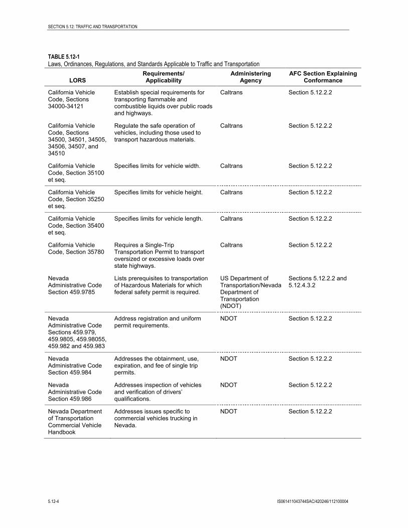
5.12.2 Laws, Ordinances, Regulations, and Standards Table 5.12-1 lists the federal, state, and local LORS that apply to traffic and transportation. Additional information concerning these LORS is presented below. Because the project’s transportation impacts affect both California and Nevada, local LORS for both Inyo County, California, and Clark and Nye counties, Nevada, are outlined.
TABLE 5.12-1 Laws, Ordinances, Regulations, and Standards Applicable to Traffic and Transportation
LORS Requirements/ Applicability
Administering Agency
AFC Section Explaining Conformance
Federal
49 CFR 171-177 Govern the transportation of hazardous materials, including the marking of the transportation vehicles.
U.S. Department of Transportation and California Department of Transportation (Caltrans)
Section 5.12.2.1
1 The road is also called Tecopa Highway and Old Spanish Trail Highway. The names are generally used interchangeably.
SECTION 5.12: TRAFFIC AND TRANSPORTATION
IS061411043744SAC/420246/112100004 5.12-3
TABLE 5.12-1 Laws, Ordinances, Regulations, and Standards Applicable to Traffic and Transportation
LORS Requirements/ Applicability
Administering Agency
AFC Section Explaining Conformance
49 CFR 350-399 and Appendices A-G
Address safety considerations for the transport of goods, materials, and substances over public highways.
U.S. Department of Transportation and Caltrans
Sections 5.12.2.1 and 5.12.4.3.2
49 CFR 397.9 Establishes criteria and regulations for the safe transportation of hazardous materials.
U.S. Department of Transportation and Caltrans
Section 5.12.2.1
14 CFR 77.13(2)(i) Requires applicants to notify Federal Aviation Administration (FAA) of construction, within 20,000 feet of an airport, of greater height than an imaginary surface as defined by the FAA.
U.S. Department of Transportation and Federal Aviation Administration
Section 5.12.2.1
14 CFR 77.17 Requires applicant for construction within 20,000 feet of an airport to submit Form 7460-1 to the FAA.
U.S. Department of Transportation and Federal Aviation Administration
Section 5.12.2.1
14 CFR 77.21, 77.23, and 77.25
Outline the obstruction standards that the FAA uses to determine whether an air navigation conflict exists for structures within 3 nautical miles of an airport.
U.S. Department of Transportation and Federal Aviation Administration
Section 5.12.2.1
State
California Vehicle Code, Sections 13369, 15275, and 15278
Address the licensing of drivers and classifications of licenses required to operate particular types of vehicles, including certificates permitting the operation of vehicles transporting hazardous materials.
Caltrans Section 5.12.2.2
California Vehicle Code, Sections 25160 et seq.
Address the safe transport of hazardous materials.
Caltrans Section 5.12.2.2
California Vehicle Code, Sections 2500-2505
Authorize the issuance of licenses by the Commissioner of the California Highway Patrol (CHP) to transport hazardous materials, including explosives.
Caltrans Section 5.12.2.2
California Vehicle Code, Section 31303
Requires transporters of hazardous materials to use the shortest route possible.
Caltrans Sections 5.12.2.2 and 5.12.4.3.2
California Vehicle Code, Sections 31600-31620
Regulate the transportation of explosive materials.
Caltrans Section 5.12.2.2
California Vehicle Code, Sections 32100-32109
Requires transporters of inhalation hazardous materials or explosive materials to obtain a Hazardous Materials Transportation License.
Caltrans Sections 5.12.2.2 and 5.12.4.3.2
SECTION 5.12: TRAFFIC AND TRANSPORTATION
5.12-4 IS061411043744SAC/420246/112100004
TABLE 5.12-1 Laws, Ordinances, Regulations, and Standards Applicable to Traffic and Transportation
LORS Requirements/ Applicability
Administering Agency
AFC Section Explaining Conformance
California Vehicle Code, Sections 34000-34121
Establish special requirements for transporting flammable and combustible liquids over public roads and highways.
Caltrans Section 5.12.2.2
California Vehicle Code, Sections 34500, 34501, 34505, 34506, 34507, and 34510
Regulate the safe operation of vehicles, including those used to transport hazardous materials.
Caltrans Section 5.12.2.2
California Vehicle Code, Section 35100 et seq.
Specifies limits for vehicle width. Caltrans Section 5.12.2.2
California Vehicle Code, Section 35250 et seq.
Specifies limits for vehicle height. Caltrans Section 5.12.2.2
California Vehicle Code, Section 35400 et seq.
Specifies limits for vehicle length. Caltrans Section 5.12.2.2
California Vehicle Code, Section 35780
Requires a Single-Trip Transportation Permit to transport oversized or excessive loads over state highways.
Caltrans Section 5.12.2.2
Nevada Administrative Code Section 459.9785
Lists prerequisites to transportation of Hazardous Materials for which federal safety permit is required.
US Department of Transportation/Nevada Department of Transportation (NDOT)
Sections 5.12.2.2 and 5.12.4.3.2
Nevada Administrative Code Sections 459.979, 459.9805, 459.98055, 459.982 and 459.983
Address registration and uniform permit requirements.
NDOT Section 5.12.2.2
Nevada Administrative Code Section 459.984
Addresses the obtainment, use, expiration, and fee of single trip permits.
NDOT Section 5.12.2.2
Nevada Administrative Code Section 459.986
Addresses inspection of vehicles and verification of drivers’ qualifications.
NDOT Section 5.12.2.2
Nevada Department of Transportation Commercial Vehicle Handbook
Addresses issues specific to commercial vehicles trucking in Nevada.
NDOT Section 5.12.2.2
SECTION 5.12: TRAFFIC AND TRANSPORTATION
IS061411043744SAC/420246/112100004 5.12-5
TABLE 5.12-1 Laws, Ordinances, Regulations, and Standards Applicable to Traffic and Transportation
LORS Requirements/ Applicability
Administering Agency
AFC Section Explaining Conformance
Local
The County of Inyo General Plan: Circulation Element
The plan sets forth goals, policies, and implementation measures that address 8 circulation topic areas in the County.
Inyo County Sections 5.12.2.3 and 5.12.4.2
Inyo County Code 12: Roads and Parks
Addresses permitting issues for oversize/overweight vehicles.
Inyo County Section 5.12.2.3
Clark County General Plan: Transportation Element
Provides information to the public on future transportation needs in the context of projected growth and development in the County.
Clark County Section 5.12.2.3
Clark County Code sections 15.30.060 and 15.30.070
Address the certificate requirements upon transportation of hazardous materials and applicable service charges.
Clark County Sections 5.12.2.3 and 5.12.4.3.2
Clark County Code sections 15.30.080
Addresses the timeframe for removal of a shipment of hazardous materials from carrier’s property.
Clark County Section 5.12.2.3
Clark County Code section 15.30.090
Addresses the eligible routes for hazardous material transportation.
Clark County Sections 5.12.2.3 and 5.12.4.3.2
Clark County Code sections 14.46.070 and 14.46.030
Addresses the permitting of overwide or commercial vehicles and designates truck routes.
Clark County Section 5.12.2.3
Nye County Comprehensive Plan: Section 2.8 Transportation and Streets and Highways Plans
The plan sets forth goals, objectives and policies that address transportation issues in the County.
Nye County Section 5.12.2.3
Nye County Code Title 8, Chapter 8.24
Addresses the permitting for importation and disposal of hazardous waste.
Nye County Section 5.12.2.3
Nye County Code Title 12, Chapter 12.08
Addresses permitting requirements and restrictions for construction within a public road.
Nye County Section 5.12.2.3
Nye County Code Title 20, Chapter 20.28
Addresses designated truck routes. Nye County Section 5.12.2.3
5.12.2.1 Federal LORS • Title 49, Code of Federal Regulations (CFR), Sections 171-177, govern the transportation of
hazardous materials, the types of materials defined as hazardous, and the marking of the transportation vehicles. The project will conform to this law by requiring that persons
SECTION 5.12: TRAFFIC AND TRANSPORTATION
5.12-6 IS061411043744SAC/420246/112100004
shipping hazardous materials to and from the project site use the required markings on their transportation vehicles.
• Title 49 CFR, Sections 350-399, and Appendices A-G, Federal Motor Carrier Safety Regulations, address safety considerations for the transport of goods, materials, and substances over public highways. The project will comply with all standards for the transportation of goods, materials, and substances over public highways.
• Title 49 CFR, Section 397.9, the Hazardous Materials Transportation Act of 1974, directs the United States Department of Transportation to establish criteria and regulations for the safe transportation of hazardous materials. The project will comply with all standards for the transportation of hazardous materials.
• Title 14, CFR, Section 77.13(2)(i), requires an applicant to notify the Federal Aviation Administration (FAA) of the construction of structures within 20,000 feet of the nearest point of the nearest runway of an airport with at least one runway longer than 3,200 feet. No airport meets these criteria in the HHSEGS’s vicinity; therefore, no further action is required by the Applicant.
• Title 14, CFR, Section 77.17, requires an applicant to submit a Notice of Proposed Construction or Alteration (FAA Form No. 7460-1) to the FAA for construction within 20,000 feet of the nearest runway of an airport with at least one runway longer than 3,200 feet. No airport meets these criteria in the HHSEGS’s vicinity; therefore, no further action is required by the Applicant.
• Title 14, CFR, Sections 77.21, 77.23, and 77.25, outline the criteria used by the FAA to determine whether an obstruction will create an air navigation conflict. The project will comply with this requirement by filing FAA Form 7460-1 to allow FAA to determine if any of the structures will create an air navigation conflict.
5.12.2.2 State LORS • California Vehicle Code, Sections 13369, 15275, and 15278, address the licensing of
drivers and classifications of licenses required to operate particular types of vehicles. In addition, certificates permitting the operation of vehicles transporting hazardous materials are addressed. HHSEGS will conform to this law by requiring shippers to obtain required licenses and certificates.
• California Vehicle Code, Sections 25160 et seq., address the safe transport of hazardous materials. The Project will comply with safety requirements.
• California Vehicle Code, Sections 2500-2505, authorize the issuance of licenses by the Commissioner of the CHP to transport hazardous materials, including explosives. HHSEGS will comply with licensing requirements.
• California Vehicle Code, Section 31303, requires that hazardous materials be transported on the state or interstate highway that offers the shortest overall transit time possible. HHSEGS will conform to this law by requiring shippers of hazardous materials to use the shortest route feasible to and from the project site.
SECTION 5.12: TRAFFIC AND TRANSPORTATION
IS061411043744SAC/420246/112100004 5.12-7
• California Vehicle Code, Sections 31600-31620 regulate the transportation of explosive materials. HHSEGS will comply with these regulations.
• California Vehicle Code, Sections 32100-32109, establish special requirements for the transportation of substances presenting inhalation hazards and poisonous gases. California Vehicle Code, Section 32105 requires that shippers of inhalation hazardous or explosive materials contact the CHP and apply for a Hazardous Material Transportation License. HHSEGS will conform to this law by requiring shippers of these types of material to obtain the Hazardous Material Transportation License.
• California Vehicle Code, Sections 34000-34121, establish special requirements for transporting flammable and combustible liquids over public roads and highways. HHSEGS will comply with these requirements.
• California Vehicle Code, Sections 34500, 34501, 34501.2, 34501.3, 34501.4, 34501.10, 34505.5-7, 34506, 34507.5, and 34510-11, regulate the safe operation of vehicles, including those used to transport hazardous materials. HHSEGS will comply with these regulations.
• California Vehicle Code, Sections 35100-35559, specify limits for vehicle width, height, length, and gross weight. Specifically, Section 35550 states: “The gross weight imposed upon the highway by the wheels on any one axle of a vehicle shall not exceed 20,000 pounds and the gross weight upon any one wheel, or wheels, supporting one end of an axle, and resting upon the roadway, shall not exceed 10,500 pounds.” HHSEGS will comply with these requirements by limiting vehicle sizes and gross weights to the specified limits or by obtaining a Single-Trip Transportation Permit for oversized or excessive loads over state highways, as described in the next paragraph.
• California Vehicle Code, Section 35780, requires a Single-Trip Transportation Permit to transport oversized or excessive loads over state highways. The permit can be acquired through Caltrans. This law is enforced by the CHP. The Project will conform to this law by requiring that shippers obtain a Single-Trip Transportation Permit for oversized loads for each vehicle.
• Nevada Administrative Code Section 459.9785 addresses the seven prerequisites to transportation of hazardous materials for which federal safety permit required. The project will comply with these requirements.
• Nevada Administrative Code Sections 459.979, 459.9805, 459.98055, 459.982 and 459.983 address registration and uniform permit requirements. Except as otherwise provided in Nevada Administrative Code 459.980 and 459.984, any person who transports hazardous materials in a vehicle upon a public highway in the State shall register with and obtain a uniform permit. The project will comply with these requirements.
• Nevada Administrative Code Section 459.984 addresses the obtainment, use, expiration, and fee of single trip permits. The single-trip permit can be obtained in lieu of the uniform permit from any authorized vendor before or at the time of entry into Nevada. Single trip permits cannot be used to transport hazardous material set forth in 49 C.F.R. paragraph 385.403. The project will comply with these requirements.
SECTION 5.12: TRAFFIC AND TRANSPORTATION
5.12-8 IS061411043744SAC/420246/112100004
• Nevada Administrative Code Section 459.986 presents the rules regarding the inspection of vehicles and verification of drivers’ qualifications. The project will comply with these requirements.
• NDOT requires truckers who have not declared Nevada under the International Registration Plan, who rarely make trips to Nevada, who do not register their vehicles because of infrequent use, or who need to temporarily increase the declared gross weight from the registered weight to obtain a temporary trip permit for a fee. The project will comply with these requirements.
• NDOT specifies the height, width, length, and weight limitations. If a shipment exceeds these, an Over dimensional Permit is required for a fee. The project will comply with these requirements.
5.12.2.3 Local LORS • Inyo County’s Circulation Element of the General Plan discusses and analyzes the
movement of people and goods throughout and around the county. The General Plan sets forth goals, policies, and implementation measures that address eight circulation topic areas in the County. In particular, Policy RH-1.4 of the General Plan’s “Goals and Policies” states: “Maintain a minimum level of service (LOS) ‘C’ on all roadways in the County. For highways within the County, LOS ‘C’ should be maintained except where roadways expansions or reconfigurations will adversely impact the small community character and economic viability of designated Central Business Districts.”As discussed below, the project will comply with these Goals and Policy statements.
• The County of Inyo requires a permit before operating any oversize and/or overweight vehicles within the County. The project will comply with requirements by obtaining the permit from the County before operating any oversize and/or overweight vehicles within the County.
• Clark County’s Transportation Element of the General Plan is intended to provide information to the public on future transportation needs in the context of projected growth and development. Policy T-5.3 of the Transportation Element states that LOS D should be the design objective for non-residential, local, collector and arterial streets. The project will comply with these requirements.
• Clark County Code Chapter 15.30 requires a certificate from the fire chief allowing transportation of hazardous materials upon the highways, streets and roads or railways within the unincorporated towns and other unincorporated areas of Clark County. Upon final approval, a service charge will be collected. The project will comply with these requirements.
• Clark County Code Chapter 15.30 requires the consignee of each shipment of hazardous materials to remove the shipment from the carrier’s property within 48 hours after notice of arrival has been sent or given. If not so removed, the carrier shall immediately notify the fire chief. The project will comply with these requirements.
• Clark County Code Chapter 15.30 has additional regulations regarding the routes chosen for hazardous materials transportation. Those portions of public highways and streets within the unincorporated towns of Paradise, Winchester, Spring Valley, Sunrise
SECTION 5.12: TRAFFIC AND TRANSPORTATION
IS061411043744SAC/420246/112100004 5.12-9
Manor, and East Las Vegas are not eligible unless there is a point of origin, destination or handling within those unincorporated towns. However, the use of major thoroughfares is acceptable. The project will comply with these requirements.
• Clark County Code Chapter 14.46 prohibits the operation or movement of any overwide commercial vehicle or special mobile equipment over any public road, highway or alley within the unincorporated area of Clark County that is maintained by Clark County, except upon designated truck routes, within the unincorporated areas of Clark County without first obtaining a special permit. A list of designated truck routes is also provided for use by commercial vehicles. The project will comply with these requirements.
• Nye County’s Transportation and Streets and Highways Plans contained within the County Comprehensive Plan sets forth goals, objectives and policies that address transportation issues in the County. The project will comply with the goals, objectives and policies identified in this document.
• Nye County Code, Title 8, Chapter 8.24 addresses the permitting for importation and disposal of hazardous waste. The project will comply with these requirements.
• Nye County Code, Title 12, Chapter 12.08 addresses permitting requirements and restrictions for construction within a public road. The project will comply with these requirements by obtaining an encroachment from the Public Works Department before beginning construction work within County maintained road right-of-way.
• Nye County Code, Title 20, Chapter 20.28 addresses designated truck routes. The project will comply with these requirements.
5.12.3 Affected Environment HHSEGS will be located in southern California’s Mojave Desert in Inyo County adjacent to the California−Nevada border. The project site is located in a rural area and is currently undeveloped and unoccupied. This area is primarily served by State Route (SR) 160 and local streets. Although the project is located in California, it is anticipated that the majority of the employees and construction workers will be based in Nevada.
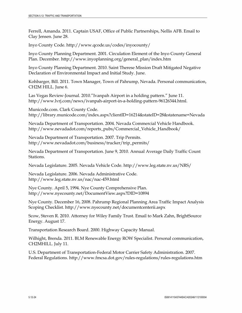
5.12.3.1 Surrounding Roadway Network The primary regional transportation corridors within the study area include Interstate 15 (I-15), SR 160, and SR 127. The local circulation system near the project site consists of Tecopa Road (also known as Old Spanish Trail Highway). The surrounding regional and local roadway networks are shown in Figures 5.12-1 and 5.12-2. The local roadway characteristics are generally rural in nature, with limited access control. A description of the study roadways follows.
Interstate 15 is located to the southeast of the project area and crosses into Nevada approximately 37 miles southeast of the project site. I-15 is the fourth-longest north-south interstate highway in the U.S, traveling through the states of California, Nevada, Arizona, Utah, Idaho, and Montana. I-15 is a long-haul route for North American commerce. I-15 provides an important regional connection between the greater Los Angeles area and Las Vegas, while also facilitating tourism access to Las Vegas. Regionally, I-15 is
SECTION 5.12: TRAFFIC AND TRANSPORTATION
5.12-10 IS061411043744SAC/420246/112100004
experiencing more commuter traffic due to the growth in the Mojave Desert communities of Hesperia and Barstow.
State Route 160 is an east-west highway that connects the southern Las Vegas Valley to U.S. Route 95 northwest of Las Vegas via the Pahrump Valley. The highway is known as Blue Diamond Road within the Las Vegas area and the Pahrump Valley Highway for the remainder of the route. Near the project site, SR 160 is a divided highway with two lanes in each direction, shoulders, and a Class II bike lane. The intersection at SR 160/Tecopa Road is a T-intersection, with stop-control on Tecopa Road. A separate westbound left turn lane is provided on SR 160.
State Route 127 (Death Valley Road) is two-lane highway, and the closest major facility to the project site that feeds into I-15 to the south. SR 127 begins at I-15 in the community of Baker, California, and continues northwest along the eastern edge of Silver Lake and portions of Death Valley National Park. SR 127 intersects Tecopa Road approximately 50 miles north of I-15. North of Tecopa Road, SR 127 continues along the eastern edge of Death Valley, and eventually ends at the California-Nevada border, where SR 373 begins.
Tecopa Road (also known as Old Spanish Trail Highway) is a two-lane north-south arterial approximately 39 miles long connecting SR 127 to the south and SR 160 to the north. Tecopa Road borders the site on the southeast and will be used by all project construction and operations traffic to access the facility. The majority of the project traffic will travel through the Tecopa Road/SR 160 intersection to access the regional road network.
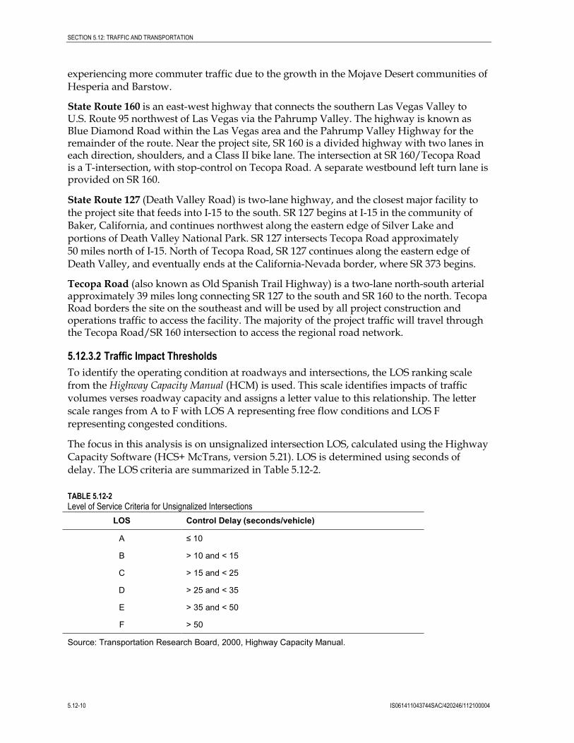
5.12.3.2 Traffic Impact Thresholds To identify the operating condition at roadways and intersections, the LOS ranking scale from the Highway Capacity Manual (HCM) is used. This scale identifies impacts of traffic volumes verses roadway capacity and assigns a letter value to this relationship. The letter scale ranges from A to F with LOS A representing free flow conditions and LOS F representing congested conditions.
The focus in this analysis is on unsignalized intersection LOS, calculated using the Highway Capacity Software (HCS+ McTrans, version 5.21). LOS is determined using seconds of delay. The LOS criteria are summarized in Table 5.12-2.
TABLE 5.12-2 Level of Service Criteria for Unsignalized Intersections
LOS Control Delay (seconds/vehicle)
A ≤ 10
B > 10 and < 15
C > 15 and < 25
D > 25 and < 35
E > 35 and < 50
F > 50
Source: Transportation Research Board, 2000, Highway Capacity Manual.
SECTION 5.12: TRAFFIC AND TRANSPORTATION
IS061411043744SAC/420246/112100004 5.12-11
As previously stated in the LORS, the Inyo County’s Circulation Element of the General Plan states that a minimum LOS C should be maintained on all roadways within the county. The Transportation Element of the Clark County General Plan states that LOS D should be the design objective for non-residential, local, collector and arterial streets. Nye County requires that mitigation measures be analyzed if an intersection is operating at LOS D or below.
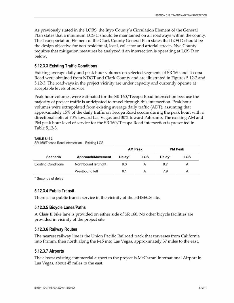
5.12.3.3 Existing Traffic Conditions Existing average daily and peak hour volumes on selected segments of SR 160 and Tecopa Road were obtained from NDOT and Clark County and are illustrated in Figures 5.12-2 and 5.12-3. The roadways in the project vicinity are under capacity and currently operate at acceptable levels of service.
Peak hour volumes were estimated for the SR 160/Tecopa Road intersection because the majority of project traffic is anticipated to travel through this intersection. Peak hour volumes were extrapolated from existing average daily traffic (ADT), assuming that approximately 15% of the daily traffic on Tecopa Road occurs during the peak hour, with a directional split of 70% toward Las Vegas and 30% toward Pahrump. The existing AM and PM peak hour level of service for the SR 160/Tecopa Road intersection is presented in Table 5.12-3.
TABLE 5.12-3 SR 160/Tecopa Road Intersection – Existing LOS
Scenario Approach/Movement
AM Peak PM Peak
Delay* LOS Delay* LOS
Existing Conditions Northbound left/right 9.3 A 9.7 A
Westbound left 8.1 A 7.9 A
* Seconds of delay
5.12.3.4 Public Transit There is no public transit service in the vicinity of the HHSEGS site.
5.12.3.5 Bicycle Lanes/Paths A Class II bike lane is provided on either side of SR 160. No other bicycle facilities are provided in vicinity of the project site.
5.12.3.6 Railway Routes The nearest railway line is the Union Pacific Railroad track that traverses from California into Primm, then north along the I-15 into Las Vegas, approximately 37 miles to the east.
5.12.3.7 Airports The closest existing commercial airport to the project is McCarran International Airport in Las Vegas, about 45 miles to the east.
SECTION 5.12: TRAFFIC AND TRANSPORTATION
5.12-12 IS061411043744SAC/420246/112100004
A new supplemental commercial airport (also referred to as the Ivanpah Airport) was proposed by Clark County in Ivanpah Valley, near Jean, Nevada, about 65 miles southeast of the project (Clark County, 2006). The Ivanpah Airport has been put on hold indefinitely due to lower passenger levels and planned improvements at McCarran International Airport (Las Vegas Review Journal, 2010).
A former private airstrip (Hidden Hills Airport, Airport Code L57) located on SR 16 in Nevada just to the east the Project site has been formally abandoned by the FAA (Scow, 2010). There are two near-by military facilities: Nellis AFB and Edwards AFB. Both bases have indicated that the project will not affect military use of air space (Ferrell, 2011).
5.12.3.8 Public Safety NDOT actively monitors traffic operations and accident histories on SR 160.
5.12.3.9 Other Planned Projects Planned construction projects within 20 miles of the HHSEGS include the following descriptions in Sections 5.12.3.9.1 through 5.12.3.9.3. A map of the project locations is provided in Figure 5.6-3.
5.12.3.9.1 Pahrump Valley General Aviation Airport The Pahrump Valley General Aviation Airport is proposed to be located approximately 10 miles northwest of the HHSEGS site in Nye County on BLM land. The airport would primarily serve small aircraft of less than 12,500 pounds, with wingspans of 49 feet or less. The 2008 Pahrump Valley Airport Master Plan outlines an initial phase of development that would last 3 years and include the design and construction of essential airport facilities such as the runway, taxiway, parking apron, access roads, airplane hangars, and fuel tanks. Additional phases of construction are scheduled to last through 2025. An Environmental Impact Statement (EIS) is being prepared for the airport. The EIS is anticipated to be completed in January 2014 (Kohbarger, 2011).
To ensure that the project would not adversely affect the Pahrump Valley General Aviation Airport, the Applicant hired Capitol Airspace Group (2010) to perform an Obstacle Evaluation Study. The report concluded that development of power towers of less than 1,000 feet above the ground surface would not likely result in a hazard determination, for any airport, assuming the FAA determined that there is no electromagnetic interference with communications, navigation, or surveillance systems (see Appendix 5.12A). The report concluded:
Capitol Airspace was able to determine that the planned airport is yet to be approved by the FAA and that no plans for instrument procedures have been submitted. Therefore, the FAA will not likely consider Pahrump Airport in its review of planned solar towers within the study area. Further, even if the FAA considered the Pahrump airport in their review, it is not likely that they would find that proposed towers would limit the airport from obtaining instrument approach or departure procedures. Therefore, Capitol Airspace has determined that it is highly likely that a solar tower of 1,000 feet or fewer would receive a favorable determination of no hazard by the FAA.
SECTION 5.12: TRAFFIC AND TRANSPORTATION
IS061411043744SAC/420246/112100004 5.12-13
5.12.3.9.2 St. Therese Mission St. Therese Mission, a commercial facility, will be located at 881 E. Old Spanish Trail Highway (Tecopa Road), approximately 0.5 mile southeast of the HHSEGS. The 17.5-acre site will consist of a chapel, a meditation garden, columbarium buildings for the storage of cremation remains, a visitor’s center, restaurant, outdoor garden, and an onsite caretaker home. A Notice of Determination for the Conditional Use Permit was filed on June 23, 2010. Construction has started on the mission. Once completed, the project developer estimates that as many as 1,200 visitors per month could visit the mission (Inyo County Planning Department, 2010).
5.12.3.9.3 Element Power Solar Project Element Power filed a ROW application with the BLM Las Vegas Field Office on September 9, 2010, for the development of a photovoltaic project approximately 6 miles north of HHSEGS. This ROW covers 2,560 acres of BLM-managed land. Recently, BLM requested additional information from Element Power Solar Project to complete its application. Once the application is deemed complete by BLM, the National Environmental Policy Act (NEPA) process will begin (Wilhight, 2011).
5.12.4 Environmental Analysis The impact of the project is measured by the potential change in the traffic operations of surrounding intersections and roadways, as well as changes to air traffic patterns, public safety, emergency access, parking, and alternative transportation. Traffic generated by HHSEGS is added to the existing volumes and the resulting impacts are assessed. Traffic associated with the project after the 29-month construction period is expected to be minimal. Therefore, this assessment focuses on the project traffic under a worst-case peak construction period.
5.12.4.1 Significance Criteria Impacts of the project on transportation and circulation will be considered significant if the following criteria are met:
1. Cause an increase in traffic that is substantial in relation to the existing traffic load and capacity of the street system.
2. Exceed, either individually or cumulatively, a LOS standard established by Inyo, Clark and Nye counties.
3. Result in a change in air traffic patterns, including either an increase in traffic levels or a change in location that results in substantial safety risks.
4. Substantially increase hazards due to a design feature or incompatible uses.
5. Result in inadequate emergency access.
6. Result in inadequate parking capacity.
7. Conflict with adopted policies, plans, or programs supporting alternative transportation.
SECTION 5.12: TRAFFIC AND TRANSPORTATION
5.12-14 IS061411043744SAC/420246/112100004
5.12.4.2 Summary of Construction Phase Impacts A summary of the construction-phase impacts by significance criteria is provided below.
1. Cause an increase in traffic that is substantial in relation to the existing traffic load and capacity of the street system.
Short-term Impact. Construction of the project is anticipated to occur over a 29-month period, with a peak construction onsite workforce of 1,033 employees during Month 14. HHSEGS would result in temporary, short-term increases in local traffic as a result of construction-related workforce traffic (employee travel to and from the site), heavy equipment delivery (e.g., cranes and bulldozers), and material deliveries (e.g., solar components, gravel, and concrete). Based on the following analysis, during the peak construction month, the project is projected to add 2,744 daily trips, with 907 trips occurring during the morning peak hour and 907 trips occurring during the afternoon peak hour.
2. Exceed, either individually or cumulatively, a LOS standard established by Inyo and Clark counties.
Short-term Impact. As noted above, HHSEGS construction would result in temporary, short-term increases in local traffic as a result of construction-related workforce traffic, heavy equipment delivery, and material deliveries. With the construction-added traffic, the SR 160/Tecopa Road intersection will operate at LOS F during the PM peak hour, which exceeds Inyo and Clark County’s LOS threshold of C and D, respectively. However implementation of the proposed mitigation measures described in Section 5.12.6.1 would reduce these impacts to less than significant. The intersection operation would return to LOS A once project construction is complete.
3. Result in a change in air traffic patterns, including either an increase in traffic levels or a change in location that results in substantial safety risks.
No impact. McCarran International Airport, approximately 45 miles to the east, is the nearest existing commercial airport to the project site. Given this distance, HHSEGS would not affect the air traffic patterns at the airport.
Modeling of the project by Capital Airspace (2010) in relation to the proposed Pahrump Valley General Aviation Airport determined that the project would have minimal impact and would not affect aviation should that airport be built. See Appendix 5.12A.
4. Substantially increase hazards due to a design feature or incompatible uses.
No Impact. Construction-related traffic is not expected to cause impacts to safety because it will not be routed through residential areas. Therefore, HHSEGS would result in a finding of no impact under this criterion.
5. Result in inadequate emergency access.
No Impact. Construction of the project site will not affect emergency access to any other property. The project will have a primary access route from Tecopa Road along the east side of the project into the common area. In addition, alternative access will be provided from Tecopa Road along the west side of the project to the asphalt road that runs between Solar
SECTION 5.12: TRAFFIC AND TRANSPORTATION
IS061411043744SAC/420246/112100004 5.12-15
Plants 1 and 2 and leads to the power blocks of each plant. Since the project has more than one access, there would be no impact under this criterion.
6. Result in inadequate parking capacity.
No Impact. Sufficient parking will be provided onsite to meet the anticipated parking needs of the project. Areas to be used for parking at the project site are within the common area, the temporary construction area, and unused areas within the heliostat fields. No additional trips will be generated to reach the construction site from the parking lots. The project will not result in impacts to parking capacity.
7. Conflict with adopted policies, plans, or programs supporting alternative transportation.
No Impact. Due to the remoteness of the site, no alternative forms of transportation (other than carpooling) are available to the construction workforce. Therefore, HHSEGS will not conflict with adopted policies, plans, or programs supporting alternative transportation.
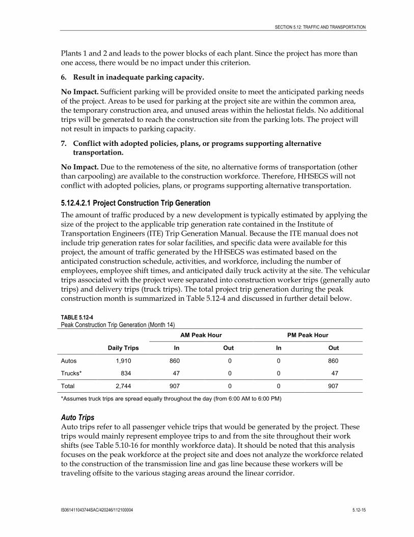
5.12.4.2.1 Project Construction Trip Generation The amount of traffic produced by a new development is typically estimated by applying the size of the project to the applicable trip generation rate contained in the Institute of Transportation Engineers (ITE) Trip Generation Manual. Because the ITE manual does not include trip generation rates for solar facilities, and specific data were available for this project, the amount of traffic generated by the HHSEGS was estimated based on the anticipated construction schedule, activities, and workforce, including the number of employees, employee shift times, and anticipated daily truck activity at the site. The vehicular trips associated with the project were separated into construction worker trips (generally auto trips) and delivery trips (truck trips). The total project trip generation during the peak construction month is summarized in Table 5.12-4 and discussed in further detail below.
TABLE 5.12-4 Peak Construction Trip Generation (Month 14)
Daily Trips
AM Peak Hour PM Peak Hour
In Out In Out
Autos 1,910 860 0 0 860
Trucks* 834 47 0 0 47
Total 2,744 907 0 0 907
*Assumes truck trips are spread equally throughout the day (from 6:00 AM to 6:00 PM)
Auto Trips Auto trips refer to all passenger vehicle trips that would be generated by the project. These trips would mainly represent employee trips to and from the site throughout their work shifts (see Table 5.10-16 for monthly workforce data). It should be noted that this analysis focuses on the peak workforce at the project site and does not analyze the workforce related to the construction of the transmission line and gas line because these workers will be traveling offsite to the various staging areas around the linear corridor.
SECTION 5.12: TRAFFIC AND TRANSPORTATION
5.12-16 IS061411043744SAC/420246/112100004
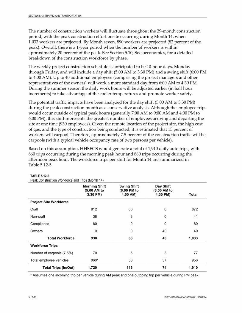
The number of construction workers will fluctuate throughout the 29-month construction period, with the peak construction effort onsite occurring during Month 14, when 1,033 workers are projected. By Month seven, 890 workers are projected (82 percent of the peak). Overall, there is a 1-year period when the number of workers is within approximately 20 percent of the peak. See Section 5.10, Socioeconomics, for a detailed breakdown of the construction workforce by phase.
The weekly project construction schedule is anticipated to be 10-hour days, Monday through Friday, and will include a day shift (5:00 AM to 3:30 PM) and a swing shift (6:00 PM to 4:00 AM). Up to 40 additional employees (comprising the project managers and other representatives of the owners) will work a more standard day from 6:00 AM to 4:30 PM. During the summer season the daily work hours will be adjusted earlier (in half hour increments) to take advantage of the cooler temperatures and promote worker safety.
The potential traffic impacts have been analyzed for the day shift (5:00 AM to 3:30 PM) during the peak construction month as a conservative analysis. Although the employee trips would occur outside of typical peak hours (generally 7:00 AM to 9:00 AM and 4:00 PM to 6:00 PM), this shift represents the greatest number of employees arriving and departing the site at one time (930 employees). Given the remote location of the project site, the high cost of gas, and the type of construction being conducted, it is estimated that 15 percent of workers will carpool. Therefore, approximately 7.5 percent of the construction traffic will be carpools (with a typical vehicle occupancy rate of two persons per vehicle).
Based on this assumption, HHSEGS would generate a total of 1,910 daily auto trips, with 860 trips occurring during the morning peak hour and 860 trips occurring during the afternoon peak hour. The workforce trips per shift for Month 14 are summarized in Table 5.12-5.
TABLE 5.12-5 Peak Construction Workforce and Trips (Month 14)
Morning Shift (5:00 AM to
3:30 PM)
Swing Shift (6:00 PM to
4:00 AM)
Day Shift (6:00 AM to
4:30 PM) Total
Project Site Workforce
Craft 812 60 0 872
Non-craft 38 3 0 41
Compliance 80 0 0 80
Owners 0 0 40 40
Total Workforce 930 63 40 1,033
Workforce Trips
Number of carpools (7.5%) 70 5 3 77
Total employee vehicles 860* 58 37 956
Total Trips (In/Out) 1,720 116 74 1,910
* Assumes one incoming trip per vehicle during AM peak and one outgoing trip per vehicle during PM peak
SECTION 5.12: TRAFFIC AND TRANSPORTATION
IS061411043744SAC/420246/112100004 5.12-17
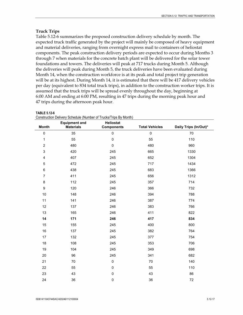
Truck Trips Table 5.12-6 summarizes the proposed construction delivery schedule by month. The expected truck traffic generated by the project will mainly be composed of heavy equipment and material deliveries, ranging from overnight express mail to containers of heliostat components. The peak construction delivery periods are expected to occur during Months 3 through 7 when materials for the concrete batch plant will be delivered for the solar tower foundations and towers. The deliveries will peak at 717 trucks during Month 5. Although the deliveries will peak during Month 5, the truck deliveries have been evaluated during Month 14, when the construction workforce is at its peak and total project trip generation will be at its highest. During Month 14, it is estimated that there will be 417 delivery vehicles per day (equivalent to 834 total truck trips), in addition to the construction worker trips. It is assumed that the truck trips will be spread evenly throughout the day, beginning at 6:00 AM and ending at 6:00 PM, resulting in 47 trips during the morning peak hour and 47 trips during the afternoon peak hour.
TABLE 5.12-6 Construction Delivery Schedule (Number of Trucks/Trips By Month)
Month Equipment and
Materials Heliostat
Components Total Vehicles Daily Trips (In/Out)*
0 35 0 0 70
1 55 0 55 110
2 480 0 480 960
3 420 245 665 1330
4 407 245 652 1304
5 472 245 717 1434
6 438 245 683 1366
7 411 245 656 1312
8 112 245 357 714
9 120 246 366 732
10 148 246 394 788
11 141 246 387 774
12 137 246 383 766
13 165 246 411 822
14 171 246 417 834 15 155 245 400 800
16 137 245 382 764
17 132 245 377 754
18 108 245 353 706
19 104 245 349 698
20 96 245 341 682
21 70 0 70 140
22 55 0 55 110
23 43 0 43 86
24 36 0 36 72
SECTION 5.12: TRAFFIC AND TRANSPORTATION
5.12-18 IS061411043744SAC/420246/112100004
TABLE 5.12-6 Construction Delivery Schedule (Number of Trucks/Trips By Month)
Month Equipment and
Materials Heliostat
Components Total Vehicles Daily Trips (In/Out)*
25 28 0 28 56
26 28 0 28 56
27 10 0 10 20
28 0 0 0 0
29 0 0 0 0
* Assumes one incoming trip and one outgoing trip per vehicle
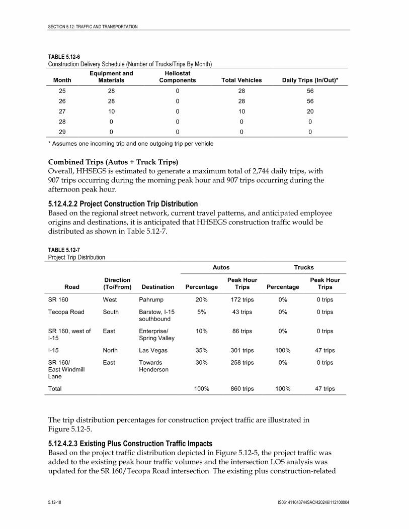
Combined Trips (Autos + Truck Trips) Overall, HHSEGS is estimated to generate a maximum total of 2,744 daily trips, with 907 trips occurring during the morning peak hour and 907 trips occurring during the afternoon peak hour.
5.12.4.2.2 Project Construction Trip Distribution Based on the regional street network, current travel patterns, and anticipated employee origins and destinations, it is anticipated that HHSEGS construction traffic would be distributed as shown in Table 5.12-7.
TABLE 5.12-7 Project Trip Distribution
Road Direction (To/From) Destination
Autos Trucks
Percentage Peak Hour
Trips Percentage Peak Hour
Trips
SR 160 West Pahrump 20% 172 trips 0% 0 trips
Tecopa Road South Barstow, I-15 southbound
5% 43 trips 0% 0 trips
SR 160, west of I-15
East Enterprise/ Spring Valley
10% 86 trips 0% 0 trips
I-15 North Las Vegas 35% 301 trips 100% 47 trips
SR 160/ East Windmill Lane
East Towards Henderson
30% 258 trips 0% 0 trips
Total 100% 860 trips 100% 47 trips
The trip distribution percentages for construction project traffic are illustrated in Figure 5.12-5.
5.12.4.2.3 Existing Plus Construction Traffic Impacts Based on the project traffic distribution depicted in Figure 5.12-5, the project traffic was added to the existing peak hour traffic volumes and the intersection LOS analysis was updated for the SR 160/Tecopa Road intersection. The existing plus construction-related
SECTION 5.12: TRAFFIC AND TRANSPORTATION
IS061411043744SAC/420246/112100004 5.12-19
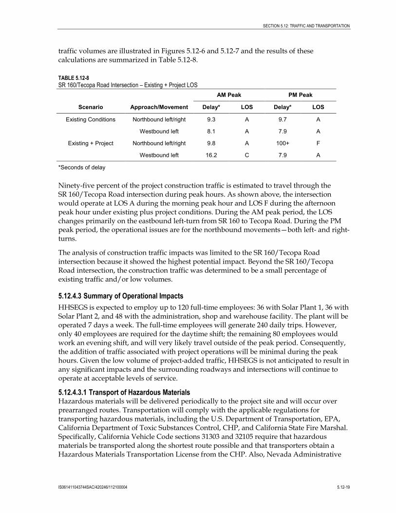
traffic volumes are illustrated in Figures 5.12-6 and 5.12-7 and the results of these calculations are summarized in Table 5.12-8.
TABLE 5.12-8 SR 160/Tecopa Road Intersection – Existing + Project LOS
Scenario Approach/Movement
AM Peak PM Peak
Delay* LOS Delay* LOS
Existing Conditions Northbound left/right 9.3 A 9.7 A
Westbound left 8.1 A 7.9 A
Existing + Project Northbound left/right 9.8 A 100+ F
Westbound left 16.2 C 7.9 A
*Seconds of delay
Ninety-five percent of the project construction traffic is estimated to travel through the SR 160/Tecopa Road intersection during peak hours. As shown above, the intersection would operate at LOS A during the morning peak hour and LOS F during the afternoon peak hour under existing plus project conditions. During the AM peak period, the LOS changes primarily on the eastbound left-turn from SR 160 to Tecopa Road. During the PM peak period, the operational issues are for the northbound movements—both left- and right-turns.
The analysis of construction traffic impacts was limited to the SR 160/Tecopa Road intersection because it showed the highest potential impact. Beyond the SR 160/Tecopa Road intersection, the construction traffic was determined to be a small percentage of existing traffic and/or low volumes.
5.12.4.3 Summary of Operational Impacts HHSEGS is expected to employ up to 120 full-time employees: 36 with Solar Plant 1, 36 with Solar Plant 2, and 48 with the administration, shop and warehouse facility. The plant will be operated 7 days a week. The full-time employees will generate 240 daily trips. However, only 40 employees are required for the daytime shift; the remaining 80 employees would work an evening shift, and will very likely travel outside of the peak period. Consequently, the addition of traffic associated with project operations will be minimal during the peak hours. Given the low volume of project-added traffic, HHSEGS is not anticipated to result in any significant impacts and the surrounding roadways and intersections will continue to operate at acceptable levels of service.
5.12.4.3.1 Transport of Hazardous Materials Hazardous materials will be delivered periodically to the project site and will occur over prearranged routes. Transportation will comply with the applicable regulations for transporting hazardous materials, including the U.S. Department of Transportation, EPA, California Department of Toxic Substances Control, CHP, and California State Fire Marshal. Specifically, California Vehicle Code sections 31303 and 32105 require that hazardous materials be transported along the shortest route possible and that transporters obtain a Hazardous Materials Transportation License from the CHP. Also, Nevada Administrative
SECTION 5.12: TRAFFIC AND TRANSPORTATION
5.12-20 IS061411043744SAC/420246/112100004
Code 459.9785 requires the transporter to hold a uniform permit and a safety permit issued by the Federal Motor Carrier Safety Administration of the United States Department of Transportation and to certify that it has a satisfactory security program as required by 49 CFR 385.407(b), including a written route plan that meets the requirements of 49 CFR 397.101. If the use of routes within Clark or Nye counties is needed, their respective codes specify the permitting requirements, as noted in Section 5.12.2.3.
Traffic impacts related to the transport of hazardous materials to the HHSEGS site will be less than significant.
5.12.5 Cumulative Effects Section 5.12.3.8 identifies the following projects that are reasonably foreseeable: Pahrump Valley General Aviation Airport, St. Therese Mission, and Element Power Solar Project. Cumulative traffic impacts could occur if construction and/or operation of these projects resulted in a significant number of trips through the SR 160/Tecopa Road intersection during the HHSEGS peak construction period.
It is unlikely that construction or visitor traffic to the St. Therese Mission would be significant enough to result in a cumulative impact. Mission construction began in early May 2011 and should be completed prior to the start of HHSEGS construction (anticipated to commence third quarter 2012). During operations, visitors to the Mission would likely travel through the SR 160/Tecopa Road intersection. Per the developer’s estimate, it is estimated that about 1,200 visitors per month (or approximately 40 per day) would visit the facility and visits would likely occur outside of peak hours. Impacts from the construction of the Pahrump Valley General Aviation Airport and the Element Power Solar Project cannot be determined because a definitive construction schedule is unknown at this time.
Because the two projects would require detailed NEPA analysis and adequate mitigation measures, it is reasonable to assume that they would also include mitigation measures to reduce any cumulative traffic impacts to a less-than-significant level. As discussed in the following subsection, HHSEGS will include a Transportation Management Plan (TMP) to address potential traffic impacts and identify strategies to minimize those impacts. As part of the TMP, the project will be required to coordinate traffic flows with other major projects through the SR 160/Tecopa Road intersection. Cumulative traffic impacts would be further reduced with the implementation of TMP strategies.
5.12.6 Mitigation Measures 5.12.6.1 Construction Impacts The surrounding roadways and intersections operate well below capacity given the remote and rural nature of the area, and the existing low daily volumes on these roadways. Construction of the project will add traffic to local roadways for a short period of time, and in particular the SR 160/Tecopa Road intersection. During the peak construction period, it is anticipated that the intersection will operate at LOS A during AM peak hours and at LOS F during PM peak hours (a potentially significant impact). To mitigate the temporary increase in traffic, a TMP will be developed to monitor the range of potential transportation impacts, and specifically the impacts on the SR 160/Tecopa Road intersection during the PM peak hour. The TMP will be developed and implemented prior to construction. The specific TMP
SECTION 5.12: TRAFFIC AND TRANSPORTATION
IS061411043744SAC/420246/112100004 5.12-21
elements will be identified once the specifics of the selected construction contractor’s schedule are known. The following TMP elements will be implemented as needed to reduce impacts to a less-than-significant level:
• Traffic Monitoring Program. Traffic operations at the SR 160/Tecopa Road intersection will be visually monitored by the Applicant’s representative once per week, during the afternoon peak hour during peak construction months. Because the construction workforce will increase gradually over the 29-month construction period, with a peak workforce occurring during Month 14, traffic conditions will be observed as the workforce increases over time, and adjustments will be made as needed.
• Rideshare Program. If the traffic monitoring program identifies LOS E or F conditions (delays over 35 seconds for an extended period), a structured and comprehensive rideshare program will be implemented to reduce the number of trips to the site during the PM peak period. This analysis assumes 7.5% of the construction traffic will be carpools. However, given the high cost of gas and the remote location of the site, this number could be significantly higher with a structured rideshare program in place. The rideshare program should target a 30% carpool rate to maintain LOS D at the intersection. As part of the rideshare program, employees will be encouraged to take advantage of the existing Club Ride Program sponsored by the Regional Transportation Commission of Southern Nevada. Club Ride offers a free ridematching service that matches individuals who live and work in proximity to one another and have a similar work schedule. The program also assists in forming vanpools when demand is met.
• Staggered Work Shifts. If LOS E or F conditions occur at the intersection even with ridesharing, additional work shifts may need to be staggered so workers leave the site over a longer period of time (instead of all at once), thus reducing the potential for queues at the intersection.
• Physical Improvements. If LOS E or F conditions occur, even with ridesharing and staggered shifts, temporary physical improvements to the intersection may be required and may include installation of a separate northbound right-turn lane.
• Traffic Control Plan. Where project construction will require the use of traffic control (signage, flaggers, lead vehicles, etc.), a detailed traffic control plan will be prepared prior to construction for review and approval by the CEC, NDOT, Inyo, Clark and Nye counties, and prepared in accordance with the Manual of Uniform Traffic Control Devices (MUTCD) and the California Supplement of the MUTCD. Project ingress and egress routes shall be designated, and project-related vehicle traffic outside these routes shall not be allowed. Nearby intersections will be evaluated to determine whether large trucks could complete turning maneuvers through the intersections.
With the implementation of appropriate TMP measures, the potential project impacts will be less-than-significant.
5.12.6.2 Operational Impacts The operations-related and maintenance-related traffic associated with the project is minimal. Consequently, no operations-related mitigation measures are required.
SECTION 5.12: TRAFFIC AND TRANSPORTATION
5.12-22 IS061411043744SAC/420246/112100004
5.12.7 Involved Agencies and Agency Contacts Table 5.12-9 lists the agency contacts related to traffic and transportation.
TABLE 5.12-9 Agency Contacts for Traffic and Transportation
Issue Agency Contact
FAA Form 7460-1 Federal Aviation Administration Southwest Regional Office Obstruction Evaluation Service, AJR-32 2601 Meacham Boulevard Fort Worth, TX 76137-0520
(310) 725-6557 (California) [email protected]
(718) 553-4546 (Nevada) [email protected]
Single-Trip Transportation Permit for Oversized Loads
Caltrans South Region Transportation Permits Office 655 West 2nd St. San Bernardino, California 92404-1400
(909) 383-4637
Hazardous Material Transportation License
California Highway Patrol Accounting Section (HM Licensing Program) P.O. Box 942902 Sacramento, CA 94298-2902
(916) 327-5039 Email form available at: http://www.chp.ca.gov/prog/email.cgi
Transportation Permits Inyo County P.O. Box Q Independence, CA 93526
(760) 878-0201 No email address available.
Transportation Permits Clark County Public Works
(702) 455-6100 [email protected]
Encroachment Permit Nye County Public Works 250 N. Hwy 160 #2 Pahrump, NV 89060
(775) 751-6855 Fax: (775) 751-6556
Transportation Permits Nevada Department of Transportation 1263 South Stewart Street Room 102 Carson City, NV 89712
(775) 888-7410 Fax: (702) 888-7103 No email address available.
Safety Permits Federal Motor Carrier Safety Administration California Field Office 1325 J Street, Suite 1540 Sacramento, CA 95814
(916) 930-2760 Fax: (916) 930-2770 Email contact depends on the nature of the hazardous material hauled.
Federal Motor Carrier Safety Administration Nevada Field Office 705 North Plaza Street, Suite 204 Carson City, NV 89701
(775) 687 5335 Fax: (775) 687-8353 Email contact depends on the nature of the hazardous material hauled.
SECTION 5.12: TRAFFIC AND TRANSPORTATION
IS061411043744SAC/420246/112100004 5.12-23
5.12.8 Permits Required and Permit Schedule Table 5.12-10 presents the permits required for construction of the project, as well as the schedule for obtaining the permits. HHSEGS will comply with these requirements.
TABLE 5.12-10 Permits Required and Permit Schedule for Traffic and Transportation
Permit Agency Contact Schedule
FAA Form 7460-1 FAA At least 30 days before the earlier of the following dates: (1) the date of the proposed construction or alteration, or (2) the date an application for a construction permit is to be filed
Caltrans single-trip transportation permit to transport oversized or excessive loads over state highway
Caltrans 4-hour processing time.
Hazardous Material Safety Permit Federal Motor Carrier Safety Administration
Depends on the nature of the hazardous material hauled.
NDOT oversize permit NDOT 2 hours processing time for single trip; 2 to 3 weeks for annual permit.
Inyo County transportation permit Inyo County Public Works Department
Between 1 hour and 2 weeks.
Clark County transportation permit Clark County Transportation Division
Usually a week or less.
Nye County encroachment permit Nye County Public Works Department
Usually a week or less.
5.12.9 References California Department of Motor Vehicles. 2007. California Vehicle Code. http://www.dmv.ca.gov/pubs/vctop/vc/vc.htm.
California Legislative Counsel. California Streets and Highways Code. http://www.leginfo.ca.gov/.html/shc_table_of_contents.html
Clark County. 2006. Project Definition and Justification, Proposal to Construct and Operate a New Supplemental Commercial Service Airport in the Ivanpah Valley. August. http://www.mccarran.com/pdf/ivanpah%20Project%20Definition%20and%20Justification%20(2).pdf
Clark County. December 3, 2008. Clark County Transportation Element. http://www.clarkcountynv.gov/depts/comprehensive_planning/land_use/Pages/default.aspx
Capitol Airspace Group. 2010. Hidden Hills Solar Project, Pahrump, Nevada, Obstacle Evaluation Study. August 16.
SECTION 5.12: TRAFFIC AND TRANSPORTATION
5.12-24 IS061411043744SAC/420246/112100004
Ferrell, Amanda. 2011. Captain USAF, Office of Public Partnerships, Nellis AFB. Email to Clay Jensen. June 28.
Inyo County Code. http://www.qcode.us/codes/inyocounty/
Inyo County Planning Department. 2001. Circulation Element of the Inyo County General Plan. December. http://www.inyoplanning.org/general_plan/index.htm
Inyo County Planning Department. 2010. Saint Therese Mission Draft Mitigated Negative Declaration of Environmental Impact and Initial Study. June.
Kohbarger, Bill. 2011. Town Manager, Town of Pahrump, Nevada. Personal communication, CH2M HILL. June 6.
Las Vegas Review-Journal. 2010.”Ivanpah Airport in a holding pattern.” June 11. http://www.lvrj.com/news/ivanpah-airport-in-a-holding-pattern-96126344.html.
Municode.com. Clark County Code. http://library.municode.com/index.aspx?clientID=16214&stateID=28&statename=Nevada
Nevada Department of Transportation. 2004. Nevada Commercial Vehicle Handbook. http://www.nevadadot.com/reports_pubs/Commercial_Vehicle_Handbook/
Nevada Department of Transportation. 2007. Trip Permits. http://www.nevadadot.com/business/trucker/trip_permits/
Nevada Department of Transportation. June 9, 2010. Annual Average Daily Traffic Count Stations.
Nevada Legislature. 2005. Nevada Vehicle Code. http://www.leg.state.nv.us/NRS/
Nevada Legislature. 2006. Nevada Administrative Code. http://www.leg.state.nv.us/nac/nac-459.html
Nye County. April 5, 1994. Nye County Comprehensive Plan. http://www.nyecounty.net/DocumentView.aspx?DID=10894
Nye County. December 16, 2008. Pahrump Regional Planning Area Traffic Impact Analysis Scoping Checklist. http://www.nyecounty.net/documentcenterii.aspx
Scow, Steven R. 2010. Attorney for Wiley Family Trust. Email to Mark Zahn, BrightSource Energy. August 17.
Transportation Research Board. 2000. Highway Capacity Manual.
Wilhight, Brenda. 2011. BLM Renewable Energy ROW Specialist. Personal communication, CH2MHILL. July 11.
U.S. Department of Transportation-Federal Motor Carrier Safety Administration. 2007. Federal Regulations. http://www.fmcsa.dot.gov/rules-regulations/rules-regulations.htm
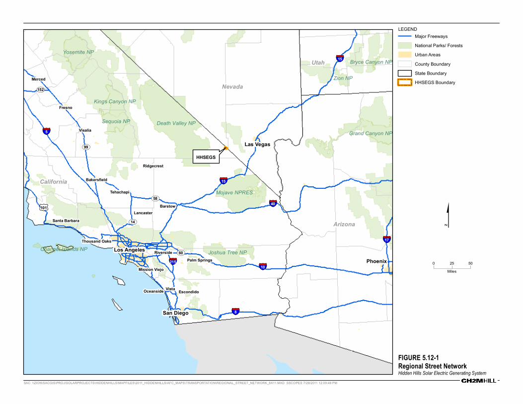
FIGURE 5.12-1Regional Street NetworkHidden Hills Solar Electric Generating System
HHSEGSUV99
§̈¦15
Los AngelesPhoenix
San Diego
Las Vegas
Fresno
Riverside
Bakersfield
Mission ViejoPalm Springs
Santa Barbara
Visalia
EscondidoVistaOceanside
Merced
Thousand Oaks
Lancaster
Ridgecrest
Barstow
Tehachapi
§̈¦40
§̈¦15
§̈¦10
§̈¦8
§̈¦5
§̈¦17
§̈¦215
£¤101
UV14
UV58
UV152
UV60
Death Valley NP
Mojave NPRES
Grand Canyon NP
Yosemite NP
Joshua Tree NP
Sequoia NP
Kings Canyon NP
Zion NP
Channel Islands NP
Bryce Canyon NP
California
Arizona
Nevada
Utah
0 5025Miles
LEGENDMajor FreewaysNational Parks/ ForestsUrban AreasCounty BoundaryState BoundaryHHSEGS Boundary
$
SAC \\ZION\SACGIS\PROJ\SOLARPROJECTS\HIDDENHILLS\MAPFILES\2011_HIDDENHILLS\AFC_MAPS\TRANSPORTATION\REGIONAL_STREET_NETWORK_8X11.MXD SSCOPES 7/28/2011 12:09:48 PM
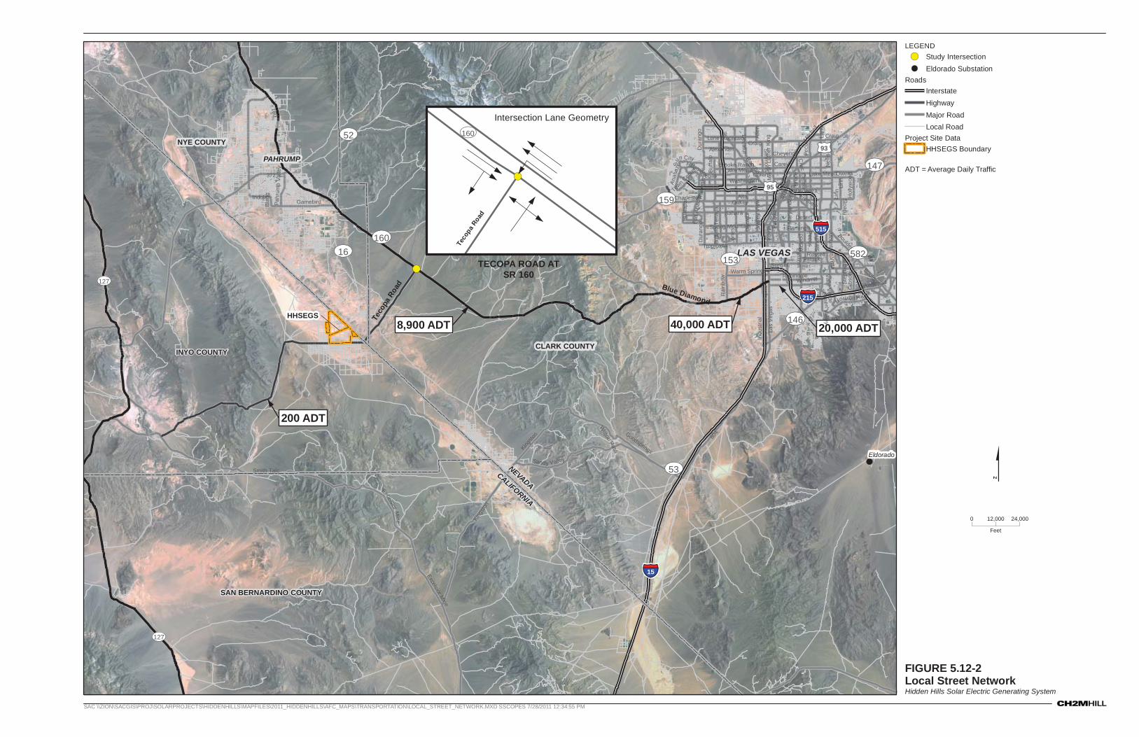
FIGURE 5.12-2Local Street NetworkHidden Hills Solar Electric Generating System
SAC \\ZION\SACGIS\PROJ\SOLARPROJECTS\HIDDENHILLS\MAPFILES\2011_HIDDENHILLS\AFC_MAPS\TRANSPORTATION\LOCAL_STREET_NETWORK.MXD SSCOPES 7/28/2011 12:34:55 PM
ADT = Average Daily Traffic
!(
!(
HHSEGS
CALIFORNIA
NEVADA
PAHRUMP
LAS VEGAS
200 ADT
8,900 ADT 40,000 ADT 20,000 ADT
UV127
UV127
§̈¦15
§̈¦515
§̈¦215
£¤95
£¤93
UV160
UV52
UV53
UV16
UV159
UV146
UV582
UV157
UV153
UV147
Excelsior Mine
Boulder
Rai
nbow
Teco
pa R
oad Blue Diamond
Kingsto
n 604
Sahara
Craig
Nel
lis
Ann
Eastern
King
ston
Lam
b
Charleston
Indu
stria
l
Alta
Excelsior Mine
Tropicana
Flamingo
Carey
Boulder
CheyenneRancho
OwensWashington
Oakey
372
Peco
s
Vegas
Russell
Warm Springs
Kyle Canyon
Sunset
Sandy Valley
Bonanza
Dur
ango
158
Las
Veg
as
Mai
n
Gamebird
Gib
son
Sand
hill
Lose
eM
aryl
and
Mcl
eod
Ram
part
Tena
ya
Bruc
e
Para
dise
Buffa
lo
Desert Inn
Decatur
Valle
y V
iew
Windmill
Gree n V
a lley
Spring Mountain
Robindale Valle Verde
Step
hani
e
Horizon Ridge
Fremont
Lone Mountain
Lake Mead
Jone
s
Simm
ons
Alle
n
Mar
tin L
uthe
r Kin
g
Linn
9Th
Alexander
Patrick
Smith Talc
Goodsprings
Ana
sazi
Kova
l
Smoke Ranch
Hua
lapa
iIndole
Mountain V
ista
Hol
lyw
ood
Pahr
ump
Valle
y
Sloan
Fort
Apa
che
Blag
g
Civic C
en ter
Hillpointe
Sun City
13Th
Coran
Cas
ino
Cen
ter
Town C
enter
Wilson Pass
Mitche
ll
Linn
Lake Mead
Pec os
160
Buffa
lo
Craig
Dur
ango
Dec
atur
Lake Mead
CLARK COUNTY
NYE COUNTY
INYO COUNTY
SAN BERNARDINO COUNTY
Eldorado
0 24,00012,000
Feet
LEGEND!( Study Intersection
!( Eldorado SubstationRoads
InterstateHighwayMajor RoadLocal Road
Project Site DataHHSEGS Boundary
$
TECOPA ROAD ATSR 160
!(
Intersection Lane Geometry
UV160
Teco
pa R
oad
FIGURE 5.12-3Existing (2009) Peak Hour Intersection VolumesHidden Hills Solar Electric Generating System
!(
HHSEGS
TECOPA ROAD ATSR 160
UV160
UV16
Teco
pa R
oad
CLARK COUNTY
NYE COUNTY
INYO COUNTY
0 10,0005,000
Feet
LEGEND
!( Study Intersection
RoadsHighway
Major Road
Local Road
Project DataHHSEGS Boundary
$
SAC \\ZION\SACGIS\PROJ\SOLARPROJECTS\HIDDENHILLS\MAPFILES\2011_HIDDENHILLS\AFC_MAPS\TRANSPORTATION\REGIONAL_STREET_NETWORK_8X11.MXD SSCOPES 7/28/2011 12:59:03 PM
!(140 (485)9 (21)
21(9)
0(2)
(258) 348(0) 2 UV160
Teco
pa R
oad
Peak Hour Turning MovementsX ( X )
* PM Peak Hour Volume Shown in ( )
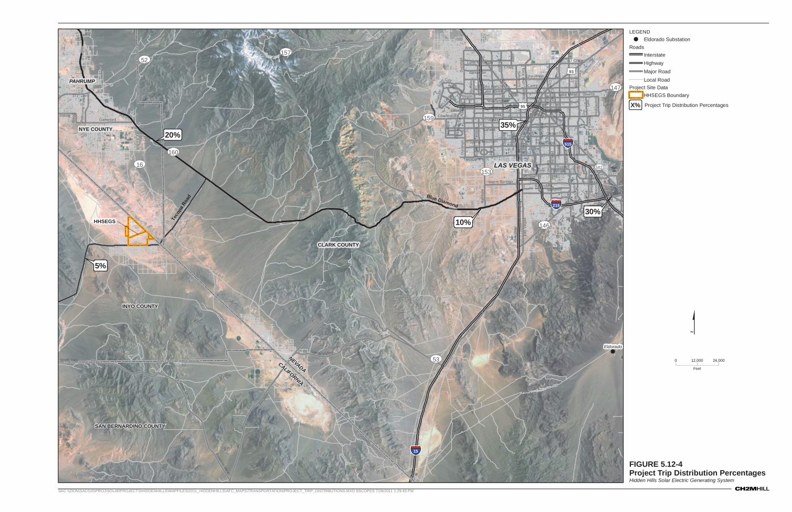
FIGURE 5.12-4Project Trip Distribution PercentagesHidden Hills Solar Electric Generating System
SAC \\ZION\SACGIS\PROJ\SOLARPROJECTS\HIDDENHILLS\MAPFILES\2011_HIDDENHILLS\AFC_MAPS\TRANSPORTATION\PROJECT_TRIP_DISTRIBUTIONS.MXD SSCOPES 7/28/2011 1:29:45 PM
!(
HHSEGS
CALIFORNIA
NEVADA
PAHRUMP
LAS VEGAS
§̈¦15
§̈¦515
§̈¦215
£¤95
£¤93
UV160
UV52
UV53
UV16
UV159
UV146
UV582
UV157
UV153
UV147
Excelsior Mine
Boulder
Rai
nbow
Teco
pa R
oad Blue Diamond
Kingsto
n 604
Sahara
Craig
Nel
lis
Ann
Eastern
King
ston
Lam
b
Charleston
Indu
stria
l
Alta
Excelsior Mine
Tropicana
Flamingo
Carey
Boulder
Cheyenne
Rancho
Owens
Washington
Oakey
372
Pec
os
Vegas
Russell
Warm Springs
Kyle Canyon
Sunset
Sandy V alley
Bonanza
Dur
ango
158
Las
Veg
as
Mai
n
Gamebird
Gib
son
San
dhill
Lose
eM
aryl
and
Mcl
eod
Ram
part
Tena
ya
Bru
ce
Par
adis
e
Buf
falo
Desert Inn
Decatur
Val
ley
Vie
w
Windmill
Green V
alle y
Spring Mountain
Robindale
Valle Verde
Ste
phan
ie
Horizon Ridge
Fremont
Lone Mountain
Lake Mead
Jone
s
Sim
mons
Alle
n
Mar
tin L
uthe
r K
ing
Linn
9Th
Alexander
Patrick
Smith Talc
Goodsprings
Ana
sazi
Kov
al
Smoke Ranch
Hua
lapa
i
Indole
Mountain V
ista
Hol
lyw
ood
Pahr
ump
Val
ley
Sloan
Fort
Apa
che
Bla
gg
Civi c C
ent er
Hillpo inte
Sun
City
13Th
Coran
Cas
ino
Cen
ter
Town C
enter
Wilson Pass
Mitche
ll
Linn
Lake Mead
Pecos
160
Buf
falo
Craig
Dur
ango
Dec
atur
Lake Mead
20%
5%
10%30%
35%
CLARK COUNTY
NYE COUNTY
INYO COUNTY
SAN BERNARDINO COUNTY
Eldorado
0 24,00012,000
Feet
LEGEND!( Eldorado Substation
RoadsInterstateHighwayMajor RoadLocal Road
Project Site DataHHSEGS Boundary
$
X% Project Trip Distribution Percentages

FIGURE 5.12-5Existing + Construction Project AM Peak Hour Intersection VolumesHidden Hills Solar Electric Generating System
!(
HHSEGS
TECOPA ROAD ATSR 160
UV160
UV16
Teco
pa R
oad
CLARK COUNTY
NYE COUNTY
INYO COUNTY
0 10,0005,000
Feet
LEGEND
!( Study Intersection
RoadsHighway
Major Road
Local Road
Project DataHHSEGS Boundary
$
SAC \\ZION\SACGIS\PROJ\SOLARPROJECTS\HIDDENHILLS\MAPFILES\2011_HIDDENHILLS\AFC_MAPS\TRANSPORTATION\INTERSECTIONVOLUMES_PEAKAM_8X11.MXD SSCOPES 7/28/2011 1:20:29 PM
!( 140701
210
348174 UV160
Teco
pa R
oad
Peak Hour Turning MovementsX

FIGURE 5.12-6Existing + Construction Project PM Peak Hour Intersection VolumesHidden Hills Solar Electric Generating System
!(
HHSEGS
TECOPA ROAD ATSR 160
UV160
UV16
Teco
pa R
oad
CLARK COUNTY
NYE COUNTY
INYO COUNTY
0 10,0005,000
Feet
LEGEND
!( Study Intersection
RoadsHighway
Major Road
Local Road
Project DataHHSEGS Boundary
$
SAC \\ZION\SACGIS\PROJ\SOLARPROJECTS\HIDDENHILLS\MAPFILES\2011_HIDDENHILLS\AFC_MAPS\TRANSPORTATION\INTERSECTIONVOLUMES_PEAKAM_8X11.MXD SSCOPES 7/28/2011 1:24:43 PM
!( 48521
701
174
2580 UV160
Teco
pa R
oad
Peak Hour Turning MovementsX