Embed Size (px)
Citation preview

HAL Id: hal-01191856https://hal.archives-ouvertes.fr/hal-01191856
Submitted on 7 Sep 2015
HAL is a multi-disciplinary open accessarchive for the deposit and dissemination of sci-entific research documents, whether they are pub-lished or not. The documents may come fromteaching and research institutions in France orabroad, or from public or private research centers.
L’archive ouverte pluridisciplinaire HAL, estdestinée au dépôt et à la diffusion de documentsscientifiques de niveau recherche, publiés ou non,émanant des établissements d’enseignement et derecherche français ou étrangers, des laboratoirespublics ou privés.
Circulation in the Mediterranean SeaClaude Millot, Isabelle Taupier-Letage
To cite this version:Claude Millot, Isabelle Taupier-Letage. Circulation in the Mediterranean Sea: Updated descriptionand schemas of the circulation of the water masses in the whole Mediterranean Sea.. A. Saliot. TheMediterranean Sea, The Mediterranean Sea (5-K), Springer, pp.29-66, 2005, Handbook of Environ-mental Chemistry, 9783540314929 • 9783540250180. �10.1007/b107143�. �hal-01191856�
1
CIRCULATION IN THE MEDITERRANEAN SEA CLAUDE MILLOT AND ISABELLE TAUPIER‐LETAGE
Antenne du Laboratoire d’Océanographie et de Biogéochimie
Université de la Méditerranée et Centre National de la Recherche Scientifique (UMR 6535)
BP 330, F83505 La Seyne/mer
isabelle.taupierletage@univamu.fr Hdb Env Chem Vol. 5, Part K (2005): 29–66 DOI 10.1007/b107143
Contents 1. Introduction 1.1. The overall functioning 1.2. The problems about the circulation 2. The data sets 2.1. The remotely sensed data sets 2.2. The in situ data sets 3. The circulation of the surface water 3.1. AW in the western basin 3.2. AW in the eastern basin 4. The circulation of the intermediate and deep waters 4.1. LIW 4.2. AeDW, AdDW, TDW and WMDW 5. Discussion 5.1. The dynamical phenomena 5.2. Some implications for environmental chemistry 6. Conclusion
Abstract
The overall functioning of the Mediterranean Sea, which transforms Atlantic Water (AW) into Mediterranean Waters (MWs), has been comprehended for a while, and the process of dense water formation, which leads AW to sink offshore in specific northern zones of the western and the eastern basins, has been studied in the world ocean. However, the circulation of the various waters from/to the basins openings to/from the zones of sinking is still debated in the western basin, while a similar debate is only being initiated in the eastern one. The differences between the circulation schemas published up to now can be large and they have already been commented in papers recently published. To provide a coherent introductory chapter, only the authors' analysis is presented hereafter.
Overall, and due to the Coriolis effect, all waters (AW and MWs) that circulate at basin scale tend to follow, in the counterclockwise sense, the isobaths at their own level. Hence they tend to describe, in both the western and the eastern basins, quasi
C. Millot I. Taupier‐Letage
2
permanent gyres a few 10s km thick and a few 1000s km long along the continental slope. This simple schema is complicated by the fact that the southern parts of both gyres described by AW are markedly unstable, the AW inflow being hence identified with the so‐called Algerian Current and Libyo‐Egyptian Current and generating specific systems over the whole depth. Indeed, these currents (100‐200 m deep) meander and generate, a few times per year, anticyclonic eddies that can reach diameters of 100‐200 km (and even more), propagate downstream (i.e. eastward) at speeds up to a few km/day, and sometimes extend down to the bottom (2‐3000 m). Hence, these eddies follow the deeper isobaths, separate from their parent current where these isobaths diverge from the upper continental slope, and drift for years (up to 3 at least) in the central part of the basins, possibly coming back shoreward where they interact with their parent current, sometimes in a dramatic way. These eddies entrain AW and MWs from the peripheral part of the basins towards their central part, together with eddies induced by the wind in the eastern basin only and having similar characteristics. In both basins, the northern parts of the gyres display specific features linking them to the zones of AW sinking, hence being identified (more easily in the western basin than in the eastern one due to the topography) with the so‐called Northern Currents. In addition to these circulation features, and because the various openings are only a few 100s m deep, the deeper MWs must be uplifted before outflowing. This is achieved permanently and more or less everywhere through continuous mixing with less dense waters and uplifting by newly formed denser waters. This is also achieved when and where intense mixing with other waters (cascading from sills or sinking) and sucking upward straits occur.
Keywords: Mediterranean Sea, western and eastern basins, water masses, general circulation, mesoscale
Abbreviations ADCP: Acoustic Doppler Current Profiler AW: Atlantic Water AdDW: Adriatic Deep Water AeDW: Aegean Deep Water AVHRR: Advanced Very High Resolution Radiometer CTD: Conductivity (to compute Salinity) Temperature Depth (actually Pressure) probe LIW: Levantine Intermediate Water MWs: Mediterranean Waters NOAA: National Oceanic and Atmospheric Administration POEM: Physical Oceanography of the Eastern Mediterranean SST: Sea Surface Temperature TDW: Tyrrhenian Dense water WMDW: Western Mediterranean Deep Water XBT: EXpendable BathyThermograph probe XCTD: EXpendable Conductivity Temperature Depth probe
Circulation in the Mediterranean
3
1. Introduction
1.1. The overall functioning
The semi‐enclosed Mediterranean Sea is characterised by evaporation exceeding
precipitation and river runoff (the specific case of the Black Sea will be addressed later).
[1], supported by [2], considered that this was a characteristic not only of both the
western and the eastern basins1, but also of the Japan Sea, and proposed a preliminary
analysis of the differences and ‐generally not agreed yet‐ similarities between these
three «medi‐terranean» seas. Hence, any reference to rotation specified hereafter is for
the northern hemisphere.
Would the Strait of Gibraltar be closed, the level of the sea would decrease by 0.5‐1
m.year‐1. The tendency for a difference in level between the sea and the Atlantic Ocean
leads the Atlantic Water (AW, http://ciesm.org/events/RT5‐WaterMassAcronyms.pdf )
encountered at the surface right west of Gibraltar to flow into the sea at a rate of ~1
Sverdrup (1 Sv = 106 m3s‐1). With respect to the geoïd, that is the surface of a theoretical
fluid at rest modified only by gravity, the level of the easternmost part of the sea is few
metres below that of the ocean. For the time being, inaccuracies in quantifying the
various parameters and natural variability do not allow a more precise estimation of
these quantities.
Typical values for AW at Gibraltar are T ~15‐16 °C, S ~36‐37 and ~26‐27
(densities of 1.026‐1.027). While progressing within the sea, the incoming AW is
continuously modified, firstly due to interactions with the atmosphere, but also due to
mixing with older AW remained at the surface and with the waters underneath. All along
its course, AW is seasonally warmed (up to 20‐28 °C in the mixed layer) or cooled (down
to ~13°C, or locally less) but, overall, its salt content increases (up to 38‐39) and it is
thus made denser (up to 28‐29). In fall, in the northern parts of both basins, AW is
markedly modified but it remains at the surface. In winter, cold and dry air masses
entrained by relatively brief episodes of strong northerly winds induce marked
evaporation (increase of salinity and loss of latent heat) and direct cooling (loss of
sensible heat) of AW, resulting in a dramatic increase of its density (above 29) that
1 The term "basin" is assigned exclusively to the two major parts of the Mediterranean Sea
C. Millot I. Taupier‐Letage
4
makes it sink. Sinking occurs in a series of specific zones, generally located in the
northern parts of the basins, according to two different processes.
A secondary process occurs on the shelves. It results from the fact that waters there
are markedly cooled because the reduced depth does not represent a large reservoir of
heat, i.e. of buoyancy, i.e. the shallower the depth the cooler the temperature can become
and the higher the density can become too. However, shelf waters are relatively fresh in
general (due to river runoff) so that they cannot get a density allowing them to sink
down to more than ~1000 m. Although such waters are identified wherever adequate
conditions are encountered, they represent relatively low amounts and, generally, they
are rapidly lost due to mixing induced by the relatively intense circulation alongslope.
Hence, we consider that their circulation is not markedly different from that of AW.
The major process (regarding the volumes involved) occurs offshore in some
subbasins2. Fundamentally, densified AW sinks and mixes with the denser waters
underneath, so that the mixture continuing to be densified will reach relatively high
densities. Details about this process that forms the largest amounts of dense waters are
given hereafter, especially in section 5. Now, depending on the subbasin, the mixture
will have specific characteristics, leading to a set of more or less dense Mediterranean
Waters (MWs) that will be thus qualified either as intermediate or deep. The Levantine
Intermediate Water (LIW, see section 4.1) is the warmest and saltiest intermediate
water, and the MW produced with the largest volume. Because of its characteristics and
amount, LIW is recognised more or less everywhere in the sea. Due to its relatively low
density, it is found just below AW and hence it mixes with AW as soon as AW starts
sinking. If the mixture of AW and LIW, evaporated and cooled more and more, reaches
densities larger than ~29, it can sink down to the bottom and form the deep waters
(see section 4.2). The overall formation rate of intermediate and deep MWs is estimated
to be ~90% of the AW inflow at Gibraltar (10% being evaporated), among which ~3/4
2 We assign the term "subbasin" to all parts of the western and eastern basins of the Mediterranean
Sea that are usually referred to as seas, basins or passages. For instance, the parts of the eastern basin commonly named Ionian Sea, Cretan Passage or Levantine Basin, being not basically different, will all be qualified as "subbasins". We omit the term subbasin when selfexplanatory.

Circulation in the Mediterranean
5
(resp. ~1/4) are formed in the eastern (resp. western) basin. These values lead to an
average residence time of 50‐100 years3.
1.2. The problems about the circulation
These intermediate and deep MWs then circulate and can still be identified more or
less far from their zone of origin. They continuously mix and, finally, outflow at Gibraltar
as a rather homogeneous water ("the" Mediterranean Water), which is colder (13.0‐13.5
°C), saltier (38.0‐38.5) and denser (28.0‐28.5) than AW there. Therefore, the
Mediterranean Sea is a machine that transforms AW present at the surface right west of
the Strait of Gibraltar into denser water that is recognised at 1000‐1200 m in most of the
northern Atlantic Ocean.
Apart from this well‐agreed overall functioning, the circulation of the various waters
from/to Gibraltar to/from the zones of sinking is still debated nowadays. There are
several reasons for that. First, oversimplified schemas, and even surface current “maps”
(i.e. schemas with wind effects and/or seasonal variability quantified, although based on
data sets markedly insufficient), have been published relatively early and trusted.
Second, different forcings can induce roughly similar circulation patterns, hence making
difficult any discrimination and the understanding of the actual processes. In a semi‐
enclosed basin for instance, winds blowing seawards, evaporation and dense water
formation all induce a counterclockwise circulation of the surface water. Third, although
a large amount of satellite information is available in the visible and infrared bands since
about three decades, it has generally been regarded as unreliable and representative of
the very superficial layer only; hence, it has not been widely used. Fourth, the
oceanic/marine domain is effectively much more variable (at mesoscale, some 10s to a
few 100s km) than initially expected, it is hostile for human activity (surface agitation,
lack of visibility, pressure, corrosion, etc.) and in situ work is relatively expensive. Last
but not least, although field oceanographers need modellers to solve equations and
check the hypotheses they put forward from the analysis of their data sets, most of the
3 As previously said and for the time being, inaccuracies in quantifying the various parameters and
natural variability do not allow a more precise estimation of these quantities.
C. Millot I. Taupier‐Letage
6
modellers rely more on their simulations (encompassing up to several annual/decadal
cycles!) than on the analysis of “such a low amount of in situ data”!
However, the debate about the major features of the circulation in the western basin
might about to become a debate of the past while, for the eastern basin, it is just being
initiated. Indeed, intensive experiments involving numerous and sophisticated
instrumentation, as well as theoretical and numerical studies, have been conducted in
the western basin since several decades because major labs were from the (northern)
riparian countries: overall features there were thus better described and known.
Moreover, some of the key‐hypotheses that had remained controversial for about two
decades have recently been fully validated by dedicated in situ measurements [3]. In the
eastern basin, intensive operations have only been initiated less than two decades ago,
mainly in the northern and central parts of the basin. In addition, most of these
operations were parts of the POEM programme, whose leaders have proposed a
circulation schema (e.g. [4, 5]) that ignores the previous ones (especially [6]) and
completely obliterates the southern part of the basin. Indeed, [6] argues for an
alongslope counterclockwise circulation due to the Coriolis effect around the whole
basin, while the POEM schema claims for major currents meandering across most of its
central part. Recently, both our data analysis [7] and numerical works done by other
teams (e.g. [8]) converged to support the analysis we made about 10 years ago [1, 2].
Our analysis is consistent with the one by [6], mainly adding information about the
mesoscale features, and is thus dramatically different from ‐if not opposed to‐ the POEM
one!
It is therefore impossible to present a view of the circulation synthesised from all
the published papers, would it have been the aim of such a handbook volume and
introductory chapter. Furthermore such a review has been recently done for both the
western basin [9] and the eastern one [7]. To provide the reader with a coherent
analysis (even though there is no consensus yet), the presentation hereafter is thus
restricted to the authors' analysis. Only the most recent or major references are
indicated, the reader being asked to refer to [9, easily accessible via Internet] and [7,
accessible via http://lobtln.chez.tiscali.fr/] for a more detailed and documented
presentation of the phenomena. The remotely sensed and in situ data sets used for this
Circulation in the Mediterranean
7
analysis are described in section 2. The circulation of AW is presented in section 3 and
that of MWs in section 4. Specific aspects of the circulation and consequences for
chemistry (and biology as well) are envisaged in a discussion section (5) and a
conclusion is drawn in section 6.
2. The data sets
Although the most recent numerical simulations now support the schematic
circulation schemas that are proposed hereafter, these schemas are mainly based on the
analysis of all the available data sets that, therefore, need to be briefly discussed first.
2.1. The remotely sensed data sets
Several physical parameters can be measured from space. The first one (in terms of
precedence, space and time intervals adequacy, availability and processing easiness,
usefulness) is the sea surface temperature (SST), since any body emits in the thermal
infrared, mainly at a specific wavelength that is related to the temperature of that body.
Images are also provided in the visible during daytime, the back‐scattered signal
(colour) being integrated over a layer up to a few 10s m thick in a way that depends on
the water transparency. The sea surface height is measured along the satellite track with
a nadir‐directed radar. The sea surface salinity starts being estimated (although too
roughly for circulation purposes yet) from the emission at a specific frequency. As done
worldwide (although not by all teams working on the Mediterranean Sea!), our team has
made an extensive use of satellite measurements in the thermal infrared for several
reasons.
The major reason is that, from a dynamical point of view, geophysical fluids are
mainly characterised by their density, which depends on temperature, salinity and
pressure (the latter having a negligible effect at the surface). In addition, although
temperature and salinity ranges vary separately in both time and space, their spatial
variations have to be related, at least on average. More specifically, temperature and

C. Millot I. Taupier‐Letage
8
salinity fronts (and gradients that are perpendicular to them) have to be parallel4, at
least locally and on average, not considering any spurious effect (see below).
Parallel temperature and salinity gradients can either have the same sense
(temperature and salinity thus compete and the density gradient can not be defined a
priori) or be opposed (thus clearly defining the sense of the density gradient). The
incoming AW is always fresher that the resident AW, but it is warmer (by a few °C) in
winter and cooler (by up to 10‐15°C) in summer. Therefore, SST gradients are
particularly informative about density gradients in winter. In spring and fall, the SST can
be locally and temporally homogeneous, hence uninformative. In summer, the
temperature of the very surface layer might not be representative of that of the mixed
layer (see below), which requires some know‐how for its analysis. Whatever, dealing
with dynamical features does not require considering absolute SST values as long as
salinity values (hence density ones) remain unknown. We personally pay attention to
even weak SST gradients that are significant (see below), and we infer circulation
features just focusing visually on the spatial SST distribution5 at a given time (plus from
time to time, obviously).
The second reason that makes infrared data valuable is their space and time
sampling interval, as collected for instance from the NOAA / AVHRR radiometers.
Images are collected by a scanner (pixel of about 1 km x 1 km), on both sides of the track
(swath of ~3000 km), a few times per day at mid latitudes, and in several frequency
bands (allowing computation of SST values with an accuracy of ~0.1 °C). A third reason
is that, being easily processed (since about three decades), products are now made
easily available by some receiving centres (e.g. http://eoweb.dlr.de).
4 Indeed, one can hardly imagine a temperature front (representative of a water changing in one
direction mainly) permanently crossing a salinity front (representative of the same water changing in another direction). Such crossing fronts, each schematised as an interface between two different waters at the surface for instance, would lead, on a temperaturesalinity schema, to four points defining a rectangle, thus having different densities while all being at the surface (not considering what would occur at the intersection)!
5 We thus usually represent SST data with a grey or colour table that is suitable (visually) to evidence the phenomena of interest; colour tables are thus advantageously different in winter and summer and, in fact, specific to each image.

Circulation in the Mediterranean
9
Problems due to warm spots, which develop during calm and sunny days at the very
near surface, are definitely avoided by considering nighttime images only. However, as
in the case of haze or dust clouds that can decrease the measured SST, these spurious
effects are generally detected easily because they have “non‐oceanographic” patterns. In
addition, patterns due to warm spots, haze and dust are rapidly changing from one
image to the other. The fact that the infrared signal is emitted by the very near surface is
generally not a problem, due to the frequent occurrence of waves that form the mixed
layer and its associated thermocline. Moreover, this signal often represents much more
than the temperature of the mixed layer since it is now demonstrated that, for instance,
an eddy 100‐200 km in diameter, seen from space for years, can extend down to the
bottom over several 1000s m. The only unavoidable problem is the occurrence of clouds
that completely mask the sea surface. Building composite (daily, weekly, monthly)
images reduces this problem and appears to be efficient for studying circulation features
since they vary markedly in space but slowly in time.
Inferring circulation from the visual analysis of infrared images (i.e. from indications
about the density gradients) obviously relies on theoretical bases. According to what is
known as geostrophy (most of the current is proportional to the horizontal pressure
gradient and perpendicular to it), this consists practically in assuming that (most of the)
surface currents are roughly parallel to those isotherms that do not change too much in
time. When isotherms are rapidly evolving, i.e. in some specific places such as at the
nose of a propagating jet, the current has a significant component perpendicular to the
isotherms. In any case, and as will be shown later, the visual analysis is very intuitive
and efficient, since it allows the preliminary analysis of phenomena from the lab, more
or less everywhere and all year long, thus helping in the definition of efficient in situ
sampling strategies.
2.2. The in situ data sets
Most of the available physical oceanography data sets are vertical profiles of
temperature and salinity now collected with ship‐handled CTDs, as well as XBTs and
XCTDs to a lesser extent. Although they are generally of the utmost quality (CTD sensors
can be calibrated easily), they are often made with a sampling interval too large (a few
C. Millot I. Taupier‐Letage
10
10s km) according to pre‐defined regular grids. This has led to misleading
interpolations, so that we personally position our CTD stations with a ~5‐km spacing
based on SST data received onboard in near real time (http://www.com.univ‐
mrs.fr/ELISA/). Another problem is that these data sets, generally available easily from
all data centres, have been pooled to compute average values, which can be totally
misleading about actual processes. For instance in the Algerian subbasin, LIW flows
along the continental slope (especially northward along that of Sardinia) while pieces of
it are occasionally pulled away and transported toward the central part of the subbasin
by mesoscale features passing by. Averaging all values available in the central subbasin
leads to smooth the large spatial and temporal variability of the temperature and
salinity fields, hence figuring spurious gradients that suggest a permanent seaward (i.e.
westward) flow of this water [3]. Autonomous CTDs that can be set on moorings allow
collecting time series of the hydrological parameters, possibly on the long term to derive
trends (http://ciesm.org/people/task.html).
Another large data set is provided by moored (eulerian) currentmeters that are the
only mean to get locally accurate statistics about the circulation. The largest
experiments now involve a few tens of currentmeters set on up to ~10 moorings for
periods up to 1‐2 years. Only few instruments are maintained in some specific places on
isolated moorings over years up to decades. Whatever, deploying open‐sea moorings
requires some experience as well as a relatively large amount of equipment and fittings.
In addition, moorings cannot be deployed for a long time on continental shelves due to
fishing activity, and setting them on the continental slope to get measurements up to the
near surface in these zones that are critical for the circulation is not easy. This is why
only ~200 point x year time series are available in the western basin, with 1/2‐1/3
coming from our group. Time series available in the eastern basin are ~ 10 times less,
nearly all having been collected in the northern part. Therefore, one must consider that
in situ direct measurements about the circulation are relatively few, especially in some
critical zones.
Another way to collect measurements about the circulation is to use free‐drifting
(lagrangian) currentmeters that are now localised worldwide with the ARGOS system
(embarked on the NOAA satellites). To measure surface currents, these currentmeters

Circulation in the Mediterranean
11
are floating buoys that are positioned several times per day and are equipped with a
drogue, to prevent them from slipping with respect to the water due to the wind drag.
To measure currents at intermediate depths, these currentmeters are floats, generally
ballasted to remain on some iso‐density surface or equipped with active devices, which
are positioned with respect to moored acoustic sources. To measure currents at greater
depths, ballasted floats are programmed to periodically (about once every week)
surface, remain there a few hours for being ARGOS‐positioned, and then sink again to
their specific depth (the distance between 2 positions being considered as the drifting
distance at depth). The advantage of these lagrangian currentmeters is that they
generally require reduced logistics and that they provide a very descriptive image of the
circulation. However, they are not adequate to provide significant statistics about the
currents in a given area.
Finally, ships of opportunity crossing the Mediterranean Sea can be, as the research
ships, equipped with profiling currentmeters (such as ADCPs) and/or a set of
autonomous sensors (mainly for temperature and salinity, hence forming an instrument
called thermosalinometer); they can also be used to launch expendable probes (such as
XBTs). Practically, they are used only from time to time during specific operations to
launch XBTs, none is equipped with an ADCP yet and, hopefully, one in the western basin
will be equipped this year with a thermosalinometer.
To conclude, the limited use that has been made of the remotely sensed data sets
and the difficulty to collect in situ ones have prevented, up to now, from getting a
consensus on the major features of the circulation. The analysis hereafter ‐although not
fully shared yet‐ aims at providing a consistent analysis of the available data sets, all
being considered as correct (i.e. only the interpretation of a data set can be questioned,
not the data set itself), and thus at getting a correct understanding of the circulation.
C. Millot I. Taupier‐Letage
12
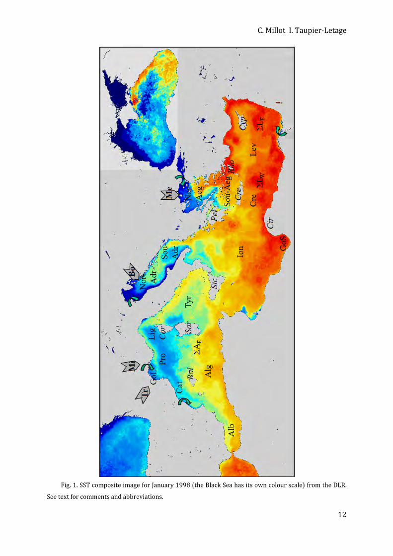
Fig. 1. SST composite image for January 1998 (the Black Sea has its own colour scale) from the DLR.
See text for comments and abbreviations.
Circulation in the Mediterranean
13
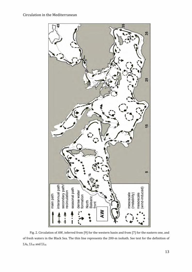
Fig. 2. Circulation of AW, inferred from [9] for the western basin and from [7] for the eastern one, and
of fresh waters in the Black Sea. The thin line represents the 200‐m isobath. See text for the definition of
AE, LW and LE.
C. Millot I. Taupier‐Letage
14
3. The circulation of the surface water
The monthly composite image of January 1998 (Fig. 1) gives an overview of the SST
in the Mediterranean Sea with the same colour table and without any cloud, which
allows describing the general circulation of AW in the whole sea. This image is
representative of the winter months for what concerns the SST values that range from
~18°C (red, eastern basin) to 15‐16 °C (orange‐yellow near Gibraltar) to ~13°C (light
blue, dense water formation zones of the Provençal (Pro) and Ligurian (Lig) subbasins)
to ~10°C or less (dark blue, the rivers outflows (green arrows) in the Adriatic (Adr), and
the Black Sea that has its own colour scale). It is also representative of all months and
years for what concerns most of the general circulation features of AW (100‐200 m) that
do not vary seasonally in a significant way. Although this image provides indications
about mesoscale features that have a large vertical extent (see below), it gives a blurred
vision of those that are fast moving.
Figure 2 schematises the AW circulation features, that is surface currents, described
in subsections 3.1 and 3.2. When possible, more precise terms will be used and defined
in due time. For instance, the AW circulation at basin scale describes alongslope
counterclockwise gyres that can bifurcate into veins or form branches. In the south of
each basin, parts of these gyres are markedly unstable and are identified as the Algerian
Current and as the Libyo‐Egyptian Current, respectively. These currents generate
mesoscale anticyclonic eddies (we clearly differentiate the terms gyres and eddies by
their generation processes and dynamical features) that sometimes follow specific
circuits and/or form specific systems. Note that “current” is also used for the vector that
represents the speed and direction of a water particle at a given time and place.
3.1 AW in the western basin
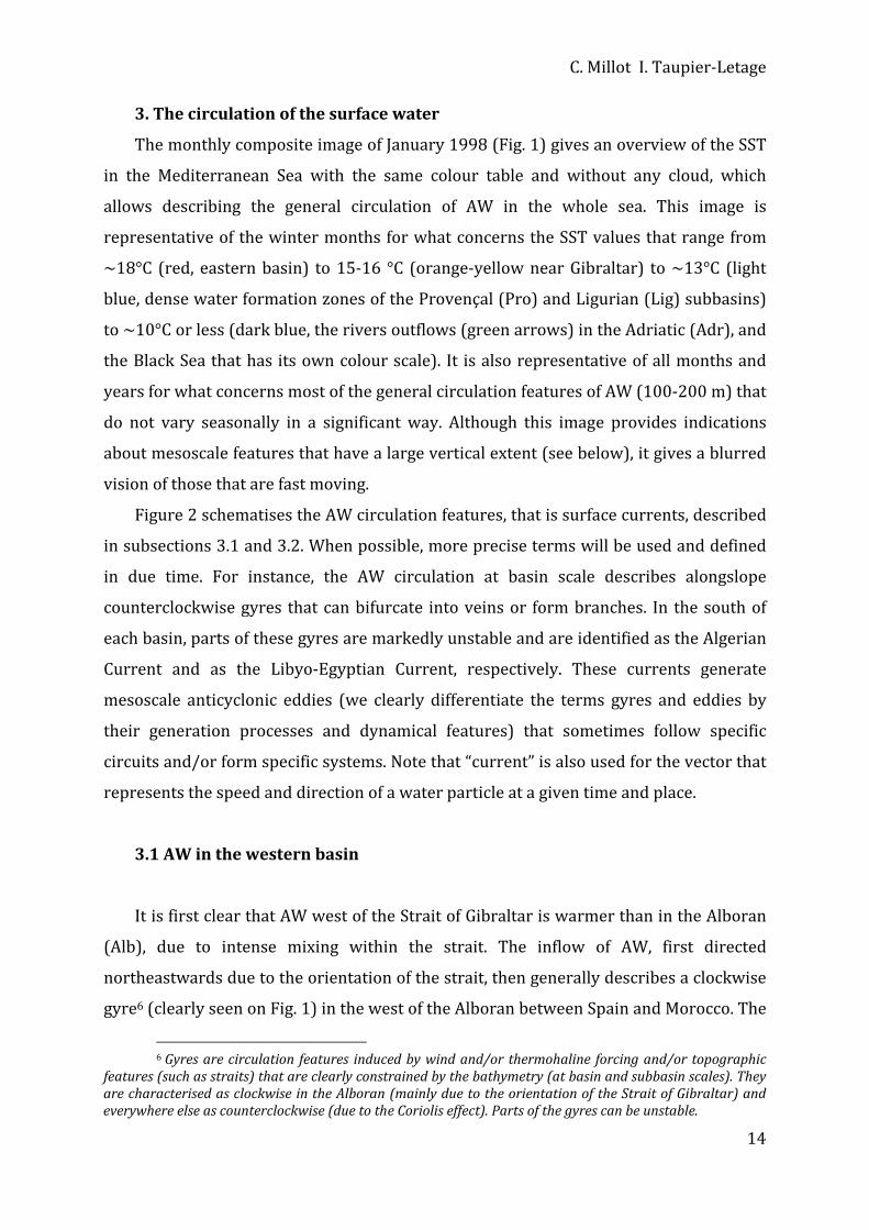
It is first clear that AW west of the Strait of Gibraltar is warmer than in the Alboran
(Alb), due to intense mixing within the strait. The inflow of AW, first directed
northeastwards due to the orientation of the strait, then generally describes a clockwise
gyre6 (clearly seen on Fig. 1) in the west of the Alboran between Spain and Morocco. The
6 Gyres are circulation features induced by wind and/or thermohaline forcing and/or topographic
features (such as straits) that are clearly constrained by the bathymetry (at basin and subbasin scales). They are characterised as clockwise in the Alboran (mainly due to the orientation of the Strait of Gibraltar) and everywhere else as counterclockwise (due to the Coriolis effect). Parts of the gyres can be unstable.
Circulation in the Mediterranean
15
inflow usually describes a second clockwise gyre in the east of the Alboran, between
Spain and Algeria, but it can also proceed more or less directly toward Algeria, or
describe a third more or less organised gyre. Out of the Alboran, the AW flow
restructures itself along the Algerian coast (generally near 0°), mainly due to the Coriolis
effect. There, the western basin gyre starts to be clearly identified and it displays
features that have justified the identification of an “Algerian Current” and of a specific
associated system [10].
When the current appears as relatively stable, it is a few 10s km wide and 100‐200
m thick, and it has maximum speeds of several 10s cm/s. However, the current is often
unstable. Most of the time, it remains alongslope and generates relatively small (up to
few 10s km in diameter, a few 100s m in depth) short‐lived (a few weeks/months)
eddies7 8. A few times per year, however, it generates a meander growing up to 50‐100
km in both amplitude and wavelength, hence embedding an anticyclonic eddy 50‐100
km in diameter (of AW only). [3] have definitively demonstrated that these surface
features induce an anticyclonic eddy 100‐200 km in diameter in the whole deeper layer
of MW (i.e. down to ~3000 m); since currents in this layer (several cm/s) can be similar
over the whole depth, they might be forced by a pressure effect. The whole feature
named "event" generally propagates downstream (eastwards) at a few km/day9 (it can
also remain stationary for weeks/months). One can note in Fig. 1 how large are the two
eddies (that are in fact events) present at that time and how efficient they are in
spreading AW seawards, in this case mainly towards the Balearic Islands (Bal); after the
westernmost eddy will have propagated more to the east, the Balearic Islands will no
longer be concerned by recent AW. Because events are too large and deep, the spreading
of the Tunisian and Sardinian shelves prevents them from continuing through the
Channel10 (south) of Sardinia (Sar), so that they drift seawards, guided by the
topography. They separate from their parent current, become "open‐sea eddies" and
7 Eddies are phenomena generated either by processes that destabilise alongslope currents (such as
the Algerian Current) or by the wind stress curl locally induced by orographic effects (as described later on). They are characterised as cyclonic / anticyclonic, not constrained by the bathymetry and can move.
8 Eddies are mesoscale (some 10s to a few 100s km) features that will be characterised as small (up to ~50 km), medium (50150 km) or large (150250 km).
9 Although km/day is a unit roughly equivalent to cm/s, it provides a more realistic quantification of propagation phenomena.
10 We consider that, among the major passages, only Gibraltar is sufficiently narrow to be considered as a strait, all the others being thus considered as channels (except minor narrow passages as e.g. Bonifacio and Messina).

C. Millot I. Taupier‐Letage
16
remain trapped in the Algerian. Most of these open‐sea eddies, which can have lifetimes
up to ~3 years [11], follow a counterclockwise circuit along the deeper isobaths in the
eastern Algerian [12]. By analogy with the notations proposed by [7] (see section 3.2),
this zone where eddies tend to be trapped and markedly interact can be named AE
(accumulation area of eddies in the eastern Algerian). Some eddies can propagate more
or less directly in the western Algerian [11, 13]. Others can reach diameters larger than
~250 km so that only 2 of them fill the Algerian, leading the whole Algerian Current to
spread seawards upstream for months [14]. Hence, mesoscale features induced by the
Algerian Current form an actual "system" and are often complex. To easily deal with
these features, the largest ones (events and open‐sea eddies) are called Algerian Eddies
(AEs) and numbered according to the year and order of apparition (the AEs seen in
Fig.1, i.e. in January 98, are 96‐1 and 97‐1). The markedly unstable character of the flow
of AW along most of the southern coasts, and the trapping of the induced mesoscale
features by the deep topography is a characteristic of all the medi‐terranean seas [1, see
section 3.2].
AW dispersed and amassed in the Algerian in such ways will spread towards the
Provençal and the Catalan, forming the North‐Balearic front in‐between. In summer, the
Catalan is relatively protected from the northwesterlies: it comes to be the warmest
subbasin of the western basin while a small anticyclonic eddy is often induced in its
northern part by the Pyrenees. Yearlong, AW is flowing along the western coast of
Corsica (Cor), hence forming the west‐Corsica vein11 of AW (that is relatively unstable
too [15]).
Part of the AW flow that has progressed through the Channel of Sardinia in its
southern part (the north‐Tunisia vein) continues alongslope, i.e. through the Channel of
Sicily into the eastern basin, hence feeding the eastern basin gyre. Another part (the
Tyrrhenian vein) continues flowing counterclockwise around the Tyrrhenian (Tyr)
along Sicily and the Italian peninsula before entering the Channel of Corsica. Then, it
joins the west‐Corsica vein so that the flow of AW reorganises itself again as the western
basin gyre. This gyre continues alongslope in the Ligurian, the Provençal and the
11 The term "vein" is used to figure a bifurcation of the gyre that follows then a specific route and/or
encounters a specific process, and can eventually join other veins downstream.

Circulation in the Mediterranean
17
Catalan, up to the Algerian and the entrance of the Alboran where it closes. Several
aspects of this gyre deserve to be commented:
‐ Although the wintertime dense water formation process drives the
functioning of the sea, the basin‐wide gyre of AW that is subsequently created does
not display a marked (i.e. easily evidenced) seasonality everywhere. The fact that no
marked seasonality of the Algerian Current system has been evidenced yet might be
due to the distance from the zones of dense water formation, which could attenuate
the signal, and/or to the narrowness of the Strait of Gibraltar, which could limit the
inflow and reduce seasonal variations there.
‐ Numerical models (e.g. [16]) consider that the bifurcation of the AW flow at
the entrance of the Channel of Sicily is driven by the channel topography. However,
one can also consider that surface waters in the north of the western basin are
denser ‐leading to a sea level lower‐ than in the south. Hence, AW in the south can
tend to flow northwards, obviously alongslope due to the Coriolis effect, hence
forming the Tyrrhenian vein whatever the topography of the Channel of Sicily.
‐ In the Ligurian, the Provençal and the Catalan, AW flows north of the zones
where it will finally mix with LIW (see below) and sink (to form the Western
Mediterranean Deep Water, WMDW), so that these zones are away from the coast (a
better description of the links between the various processes is provided in section
5.1.3). This is a characteristic of all medi‐terranean seas so that the generic name of
“Northern Current” was proposed [1], with the secondary aim to show that what
were called “Ligurian Current”, “Liguro‐Provençal Current” and “Catalan Current”,
were only parts of a unique entity and, more generally, of the western gyre. In
addition, fig.1 clearly shows that what is called the Northern Current can in fact be
identified continuously from the southern Tyrrhenian up to the Alboran.
‐ In the Ligurian and the Provençal, the Northern Current is characterised by
maximum speeds of several 10 cm/s in its core, a width of a few 10s km and a
thickness of a few 100s m. Since AW is denser there than in the south, the Northern
Current is narrower and deeper than the Algerian Current [15]. However, it displays

C. Millot I. Taupier‐Letage
18
a marked seasonal variability (due to the links with the dense water formation
process above mentioned), being more intense, narrower and deeper in winter [17].
The Northern Current does not develop marked instabilities in either the
Tyrrhenian or the Catalan while small eddies have been described west of Corsica
[12, 15]. In the Ligurian and the Provençal, it only develops, in winter mainly,
meanders that have never been observed to evolve into structured eddies [15, see
section 3.2]. Episodically, it can generate, at the border between the Ligurian and
the Provençal, a branch12 first evidenced by [18]. The zone where dense water forms
is characterised by mesoscale currents that are relatively weak in summer and
intense (a few 10s cm/s over the whole depth) in winter [19]. Dense water sinks
within small‐scale (a few km in diameter) plumes can be of ~10 cm/s (so that less
dense waters are uplifted), but the overall sinking speed is ~1 mm/s only [20].
Sinking water reaching the bottom can lead there (~2000 m) to horizontal currents
as large as several 10s cm/s [21].
‐ The Gulf of Lions itself is in fact a semi‐circular continental shelf so that
most of the Northern Current flows as a major vein along the upper part of the
continental slope, i.e. along its diameter [22]. When the Mistral (Mi) does not prevent
its upper part from following the coast and partly penetrating over the shelf, this
part tends to flow as a minor vein around the whole gulf (both veins join at the exit
of the gulf). In such a situation, the Northern Current combines with the natural
tendency (again due to the Coriolis effect) of any river outflow to be deflected on the
right, so that waters from the Rhône are entrained around the whole gulf. When the
Mistral and the Tramontane (Tr) blow, they mix and spread seawards the Rhône
waters (similar effects occur with westerly winds on the Ebro waters, as opposed to
the Bora/Pô interactions, see below). In the northern and northwestern parts of the
gulf, these winds induce 6 upwelling cells during stratified conditions [23] and, in
winter, shelf dense water formation (maybe occurring with a similarly
discontinuity). It must be emphasised that the canyons that cut the continental slope
do not “attract” dense water formed in the coastal zone: they only operate as
12 The term "branch" is used to figure a flow spreading seawards, ramifying as a tree branch, and
finally vanishing in the central part of a subbasin (contrary to a vein that follows the topography).

Circulation in the Mediterranean
19
“sediment traps”, allowing dense water entrained over the shelf whatever its
direction to be trapped and set in position to reach greater depths.
‐ Where AW closes its western gyre, i.e. along the Spanish coast near the border
between the Alboran and the Algerian, the (old) water that has skirted the whole
basin (and is thus markedly modified) encounters the water that has just flowed in.
Hence, large horizontal gradients occur there. When incoming AW forms a second
clockwise gyre in the eastern Alboran, it entrains older AW, roughly from Almeria,
Spain, to Oran, Algeria. Since the incoming flow is more intense, it forms the Almeria‐
Oran jet that is well delimited on its left‐hand side by the Almeria‐Oran front.
‐ The various islands and their associated shelves have significant effects. The
Algerian eddies blocked by the Sardinian and Tunisian converging shelves often
entrain AW southwards off western Sardinia (together with other anticyclonic
eddies [12] and with the northwesterlies‐induced drift), while AW released by the
eddies' decaying in the north is constrained to flow northwards off western Corsica.
The marked orography of both Sardinia and Corsica also protects most (the
remainder) of the Tyrrhenian, and reduces there the mixing and cooling by the
westerlies. In winter, the Balearic Islands first protect from the northwesterlies AW
entrained by the AEs, so that AW can progress northwards quite easily up to the
islands which somehow fix the position of the North Balearic front in the west [24];
they also lead part of the Northern Current to form a vein flowing north of them in
the Catalan.
‐ In addition, the marked orography of both Sardinia and Corsica creates a
funnelling effect for the westward winds that are the continuation of both the Mistral
and the Tramontane. In the western Tyrrhenian, just east of the Strait of Bonifacio
(between Sardinia and Corsica), such a specific wind field induces (due to the
Coriolis effect) a mesoscale dipole with an anticyclone in the south and a cyclone in
the north that have very different structures. The anticyclone (not clear in Fig. 1) is
composed of (warm) AW converging (depression of the interface between AW and
MW) and rotating as an isolated eddy. The cyclone (relatively large in Fig. 1) results
from AW diverging (uplifting of the interface) and forming in fact a ring that
surrounds a cool zone (of MW), which is the main feature seen in Fig. 1 and which
C. Millot I. Taupier‐Letage
20
has recently been hypothesised to be an occasional zone of dense water formation
[25]. These differences between the anticyclone and the cyclone induced east of
Bonifacio by the westerly winds are in fact representative of most of the differences
between the previous understanding(s) of the circulation in the eastern basin and
our own understanding (see section 5).
3.2 AW in the eastern basin
In the Channel of Sicily the circulation of AW is complex, due to the necessary
bifurcation between the western and the eastern basins, to the complexity of the
topography with numerous islands and banks, and to the large width of the channel. It
cannot be easily studied with SST images (Fig. 1 is not very explicit), due to the intense
mixing by the topography and the northwesterlies, to the upwelling these winds induce
off Sicily, and to the southward heading of the flow that rapidly warms. In addition, it
cannot be easily studied with in situ data because of the intense fishing activity and the
existence of half‐channel national economic waters. Therefore, AW within the channel
has been said to flow mainly either in the eastern side (as a Sicilian vein, e.g. [27]) or in
the western side (as a Tunisian vein, e.g. [28]).
At the exit of the channel, SST images suggest (although not clear on Fig. 1) that
three kinds of processes occur or have occurred, so that the eastern gyre at its beginning
is split into several components. One is a northeastward‐spreading branch that we
associate with interannual variability (it disappeared in early 1998), while it has been
qualified as a permanent meandering stream by e.g. [5]. The second is the generation of
mesoscale eddies that tend to drift in the central part of the Ionian. The third is a more
regular flow (the south‐Tunisia vein) that, for most of it, follows the edge of the Tunisian
shelf and, for a minor (and upper) part of it, follows the Tunisian coast (as in the Gulf of
Lions); both parts of this vein join off Libya, the Tunisian vein hence becoming a Libyan
vein. The term of vein(s) is justified by the fact that AW spread in the central part of the
Ionian (as a branch and/or eddies) will join it downstream to form the eastern gyre
stricto sensu. Note that the famous tourists places that are the Kerkennah and Djerba
Islands are among the coldest spots in winter, due to the very shallow shelf there
Circulation in the Mediterranean
21
(somewhere a few metres only). As first hypothesised by E. Salusti (pers. com.), these
shelf waters most probably tend to sink, as indicated for the Gulf of Lions and as it will
be shown for the northern parts of both the Aegean and the Adriatic. From ~15°E, the
Libyan vein continues alongslope eastwards and appears unstable, generating
mesoscale eddies that are smaller and less well organised than the Algerian ones and
that rapidly detach from the coast, due to the topography (isobaths spreading
seawards). These eddies, together with those created just at the channel exit that drift in
the central Ionian, form a complex eddy field in the whole southern Ionian. The Libyan
vein continues alongslope in the Gulf of Syrta (GoS) without developing large mesoscale
instabilities there (maybe due to a flow too reduced and/or to a topography too
shallow).
Since most of the eddies are trapped within the southern Ionian while only few of
them drift into the Cretan (Cre), it might be that they decay in the southern Ionian before
joining the Libyan vein, together wit the water spread in the interannual branch and
then released. The eastern gyre hence restructures itself along the northern Cirenaïca
(Cir), in the same way as the western gyre near 0° (the parallel with Alboran and
western Algeria, and more generally between the western and eastern basins, is detailed
in subsection 5.1). From northern Cirenaïca to the western part of the Nile delta, what
can be named the "Libyo‐Egyptian Current" (the counterpart of the Algerian Current)
generates well structured and energetic eddies that appear very similar to the Algerian
ones. These anticyclonic eddies can be large (150‐250 km), and they propagate
downstream not faster than ~3 km/day, i.e. generally slower than the Algerian eddies.
As already shown off Algeria, it is expected that the Libyo‐Egyptian eddies sometimes
extend down to the bottom and can be guided, at least for the largest and most energetic
ones, by the deep isobaths (~3000 m) associated with the Herodotus trough southeast
of Crete (see Fig. 4).
There, they can interact with Ierapetra, the anticyclonic eddy generated by the
Meltem13 (Me) southeast of Crete together with Pelops generated southwest of the
Peloponnese (Pel). Both eddies are clearly recognised in Fig. 1, Ierapetra having drifted
13 The Meltem is a northerly wind blowing almost continuously in summer, hence also named "the
Etesians".

C. Millot I. Taupier‐Letage
22
south from where it was created ~6 months earlier. We have shown that Ierapetra is
actually created every summer by the Meltem close to the southeastern tip of Crete. It
can then remain stationary for one year (being thus reinforced the year after), drift
southwards as far as the Libyo‐Egyptian continental slope (hence interacting with the
Libyo‐Egyptian Current), or drift westwards as far as the western tip of Crete. Hence,
Ierapetra can survive for years, successive Ierapetra’s can coexist, possibly merge, and
often interact with the Libyo‐Egyptian eddies. As evidenced from SST images, the
shadowing effect of Crete (high relief) on the Meltem is sensed as far as Africa. Hence,
the surface waters entrained southwards on both sides of Crete by this northerly wind
tend to flow backward in between and feed Ierapetra. The alongslope circulation of AW
can also feed Ierapetra from the south through the Libyo‐Egyptian eddies via a paddle‐
wheel effect (and from the northeast as well, see below).
We mainly hypothesise that the spreading seaward of the deep isobaths in the
western Levantine leads the (deep) Libyo‐Egyptian eddies to separate from their
(shallow) parent current that remains alongslope, and that the Herodotus trough traps
them. Such a trapping can also apply to Ierapetra. To emphasise the fact that the zone
corresponding to the Herodotus trough is characterised by the accumulation and
interaction, frequently resulting into merging, of eddies originated from outside the
zone, and not by some permanent gyre or eddy created there (previously named Mersa‐
Matruh), we name it LW (accumulation in the western Levantine).
Eddies that decay in the LW zone release AW that, at least partly, rejoins the
remainder of the alongslope Libyo‐Egyptian Current. Up to the Nile delta, the
restructured eastern basin gyre generates medium (50‐150 km) anticyclonic eddies that
are similar to, although smaller than, the Libyo‐Egyptian ones. From the Nile delta up to
the southern and central Middle East, instability processes only generate small (up to 50
km) eddies and mushroom‐like features that rapidly propagate downstream (up to 10
km/day). Such characteristics might be due to the shallower topography that prevents
larger and better‐organised features to develop. In any case, these features spread AW
seaward and feed what was known as the Shikmona zone that we name LE, for reasons
similar to those invoked earlier for LW and E (accumulation in the eastern
Levantine). When these features decay, the released AW re‐feeds, at least partly, the
Circulation in the Mediterranean
23
eastern basin gyre along the northern Middle East slope. Then, along the Turkish slope
up to Rhodes, the gyre (previously named Asia Minor Current there) mainly generates
sharp meanders, some of which can evolve into medium (50‐150 km) anticyclonic
eddies that propagate at up to ~3 km/day. Although a parallel will be made in section 5
with the Northern Current in the western basin, it has been stressed that the latter never
generates such eddies.
Then, the Rhodes Island divides the eastern basin gyre into a northwestern vein and
a southwestern one. The northwestern vein flows along the Turkish slope most of the
year, except maybe in summer when the Meltem blows against it, and penetrates into
the Aegean. There, the complex topography induces a second bifurcation with a sub‐vein
that continues into the Northern‐Aegean (Nor‐Aeg) and a sub‐vein that tends to skirt the
whole Southern‐Aegean (Sou‐Aeg). The former sub‐vein joins with the Black Sea outflow
and will be densified in winter, hence forming shelf water that will not reach large
densities, furthermore since the northward propagation of LIW is mostly prevented by
the complex topography (see below). The latter sub‐vein is associated with the dense
water formation process that involves AW and LIW (see below) to form the Aegean Deep
Water (AeDW). Although most of the AW exits the Aegean through the western Cretan
Arc (i.e. west of Crete), some of it flows north of Crete, as evidenced by medium‐sized
anticyclonic eddies propagating eastwards (i.e. downstream) before decaying. Then, AW
that has skirted the Southern‐Aegean in such a way feeds, through the passages between
the islands that constitute the eastern Cretan Arc, the southwestern vein that
continuously flows along the southern slope of these islands. In winter, the
southwestern vein is associated with the formation of LIW southwards of Rhodes, as is
the Northern Current with WMDW. In summer, when the Meltem prevents AW from
flowing markedly into the Aegean (and induces a marked upwelling zone off Turkey),
the southwestern vein constitutes most of the eastern basin gyre. It can be identified as
far as Crete, sometimes clearly feeding Ierapetra. But then, it is generally entrained in
LW and again around the eastern Levantine. Therefore, whatever the season and the
balance between the northwestern and southwestern veins, the eastern basin gyre is
generally not encountered along the southern slope of Crete, so that most AW
definitively exits the Levantine via the Aegean west of Crete.
C. Millot I. Taupier‐Letage
24
AW then skirts the Peloponnese. In summer, part of it forms the wind‐induced
Pelops that can later drift up to a few 100s km westwards. The remainder, and most AW
during the rest of the year, continues northwards in the northeastern Ionian where it re‐
constitutes the eastern gyre before bifurcating into a northern and a western veins at
the entrance of the Adriatic. The northern vein penetrates into the Adriatic and is partly
associated with the formation of the Adriatic Deep Water (AdDW, see below) in the
southern part of the subbasin (Sou‐Adr), while the remainder continues northwards and
mixes there (Nor‐Adr) with the Pô and other rivers runoffs. There are similarities
between the Aegean and the Adriatic, since less dense water is formed on the shelf in the
north and denser water is formed offshore in the south. There are differences between
the Bora effect on the Pô outflow (similar to the Meltem effect on the Nile outflow) and
that of the Meltem on the Black Sea outflow (similar to the Mistral and westerlies effects
on the Rhône and Ebro outflows), since the Bora pushes the Pô outflow towards the
coast, so that it remains well structured along most of the Italian peninsula. AW exiting
the Adriatic rejoins the westward vein that bypassed the Adriatic, both continuing along
the southern tip of the Italian peninsula and Sicily, before closing there the circuit of the
eastern basin gyre. The Maltese filament, formed by cold water upwelled off
southwestern Sicily, then separates the incoming AW from the older one. It can be
detected in the whole southern Ionian and can be considered as a tracer of the front that
is the counterpart of the Almeria‐Oran front.
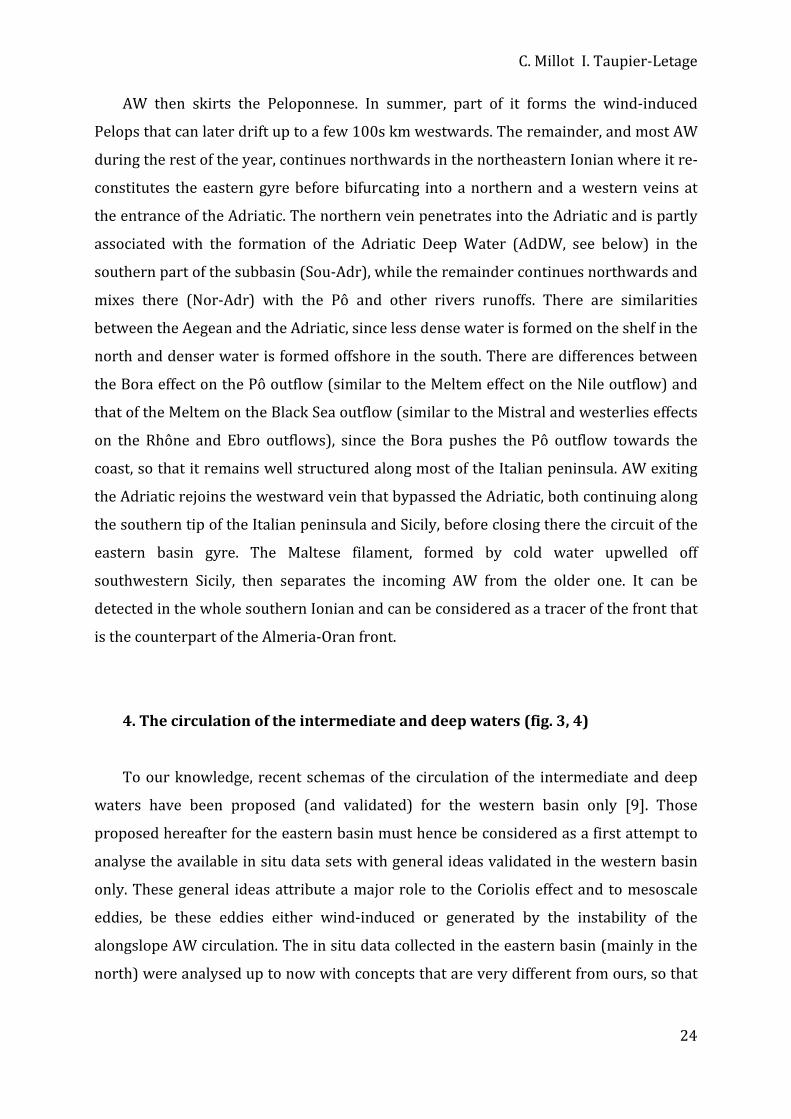
4. The circulation of the intermediate and deep waters (fig. 3, 4)
To our knowledge, recent schemas of the circulation of the intermediate and deep
waters have been proposed (and validated) for the western basin only [9]. Those
proposed hereafter for the eastern basin must hence be considered as a first attempt to
analyse the available in situ data sets with general ideas validated in the western basin
only. These general ideas attribute a major role to the Coriolis effect and to mesoscale
eddies, be these eddies either wind‐induced or generated by the instability of the
alongslope AW circulation. The in situ data collected in the eastern basin (mainly in the
north) were analysed up to now with concepts that are very different from ours, so that

Circulation in the Mediterranean
25
the analysis hereafter is not consistent with the previous ones14. Even though this
analysis describes features in the south of the eastern basin that cannot be supported by
data unavailable yet, so that these features are hypothetical, the present tense is used
and adverbs such as "probably" are mostly omitted for convenience. In addition, we
consider that the circulation of intermediate and deep waters necessarily displays a
seasonal variability more or less far away from the zones of formation; however, due to
the lack of data, this seasonal variability is not represented in the schemas.
Several places and processes of formation have been hypothesised for LIW,
including the interior of mesoscale anticyclonic eddies all year long in the southern
Levantine. However, it is formed mainly south‐southeast of Rhodes in the northern
Levantine, according to the offshore wintertime processes described in section 1 (see
also section 5). As already said, LIW is the MW produced with the largest volume. Since
it is the warmest and saltiest water formed in the whole sea, it can easily be tracked up
to Gibraltar just below AW. Other intermediate waters formed together with denser
waters, as e.g. in the Aegean (named Cretan Intermediate Water) or in the Liguro‐
Provençal (named Winter Intermediate Water), cannot be differentiated so easily from
waters above or below and they represent much lower amounts. We thus only discuss
hereafter (section 4.1) the circulation of LIW, i.e. the intermediate water produced in the
northern Levantine (Fig. 3).
Some deep waters might be occasionally produced in specific places. This was said
[29] for a water that reached ~2000 m in the northern Levantine where most of LIW
forms. This was also said [25] for water denser than TDW (see section 4.2) that could be
formed east of Bonifacio (cool zone in fig. 1) and could fill the deep Tyrrhenian (down to
~3500 m). However, we do not have enough data about these deep waters so that we
restrict ourselves to the discussion (section 4.2) of AeDW, AdDW, TDW and WMDW (Fig.
4).
14 In any case, there are a lot of discrepancies between these previous analyses too!

C. Millot I. Taupier‐Letage
26
4.1. LIW
LIW formed in the northern part of the Levantine flows, due to the Coriolis effect,
along the southern continental slope of the Cretan Arc islands, from Rhodes to Crete and
to the Peloponnese. Because the sills between these islands reach depths larger than the
100‐500 m LIW level, some LIW penetrates into the Southern‐Aegean where it mixes
with AW in winter to form AeDW (it hardly penetrates into the Northern‐Aegean, due to
the complex topography). However, the section of the openings does not allow the whole
volume of LIW to go through so that most LIW flows alongslope south of Crete. Ierapetra
and Pelops wind‐induced eddies entrain LIW where they form (i.e. close to the coast and
just above the continental slope where LIW flows) and then transport it seawards,
potentially over 100s km, releasing it away from the slope, in a process similar to the
one mentioned in section 2.2 for the entrainment of LIW from the slope of Sardinia by
the Algerian eddies passing by. The occurrence of LIW within such eddies when in the
southern Levantine might have been misinterpreted as a formation of LIW within
offshore eddies. Note that the Libyo‐Egyptians eddies (counterparts of the Algerian
eddies) are in a position too far south to allow them to entrain newly formed LIW. Part
of the LIW that continues circulating along the northeastern slope in the Ionian
penetrates into the Southern‐Adriatic where it mixes with AW in winter to form AdDW.
The remainder bypasses the Southern‐Adriatic and continues alongslope as far as the
Channel of Sicily, where most of it (sill at ~400 m) outflows into the western basin.
However, any part of LIW that has bypassed the entrance of the channel and is still
associated with an alongslope pressure gradient will continue alongslope around most
of the eastern basin. In other words, waters are generally not “attracted” by the
openings and they do not “feel” them; they circulate alongslope, as long as they are
forced to do so by an alongslope pressure gradient, and hence they can “miss” the
openings.
Within the Channel of Sicily, LIW flows along the Sicilian slope and then skirts Sicily.
This path, initially suggested by [30], is now generally agreed and supported by
theoretical analyses

Circulation in the Mediterranean
27
Fig. 3. Circulation of LIW extrapolated from [9] for the western basin. The thin line represents the 500‐m
isobath.

C. Millot I. Taupier‐Letage
28
(e.g. [31]). Then, LIW mainly circulates around the Tyrrhenian, roughly at 200‐600 m. A
vein flows out through the Channel of Corsica (sill at ~400 m) while the remainder
continues and flows out through the Channel of Sardinia. When this vein enters the
Algerian, part of it can be entrained seawards by Algerian eddies passing by and then be
released in the central subbasin. The remainder of the vein continues alongslope along
western Sardinia and Corsica, joins with the vein issued from the Channel of Corsica, and
then participates with AW in the wintertime formation of WMDW in the Ligurian and
the Provençal. The still‐recognisable LIW continues along the Spanish slope and most of
it outflows through the Strait of Gibraltar (sill at ~300 m), where it can still be
recognised along the Spanish slope, while the remainder that bypassed the opening then
progresses alongslope off Africa (as discussed for the entrance of the Channel of Sicily).
Therefore, LIW appears to play a major role in the functioning of the Mediterranean
Sea. First, because it is the warmest and saltiest MW formed with the largest amount.
Second, because it mainly flows along the northern continental slopes of both basins just
below AW, thus being involved there in the offshore formation of all deep MWs (AeDW,
AdDW, WMDW). Because the immersion of LIW allows it to flow rather easily through
the major openings, its path is almost one‐way, from the northern Levantine to the
Channel of Sicily and the Strait of Gibraltar. However, the parts of LIW that have
bypassed either the Channel of Sicily or the Strait of Gibraltar continue flowing
alongslope around the basins. In addition, being involved into wintertime processes all
along its path, one expects that LIW displays everywhere an increasingly complex
seasonal variability (see also section 4.2).
4.2. AeDW, AdDW, TDW and WMDW
AW is warmer and saltier in the Aegean than in the Adriatic since northerlies are
less cold (the Adriatic is surrounded by the Alps) and it just starts to be diluted (by the
Black Sea mainly; it will be more and more diluted by rivers outflows). Moreover, LIW is
warmer and saltier in the Aegean than in the Adriatic since it is closer to its formation
zone and hence has undergone less mixing. Therefore, AeDW is saltier and warmer than
AdDW. However, both waters have roughly similar densities. Up to the eighties, and
nowadays as well, AdDW was denser than AeDW while, during what has been called “the
Circulation in the Mediterranean
29
Fig. 4. Circulation of AeDW, AdDW, TDW and WMDW extrapolated from [9] for the Western Basin. The thin lines represent the 1000‐m and 2750‐m isobaths

C. Millot I. Taupier‐Letage
30
transient” (see [32], for a review), the reverse occurred. These two deep waters first
accumulate in the troughs (1000‐1500 m) over which they are formed (in the Southern‐
Aegean and Southern‐Adriatic, resp.) before outflowing through the various openings.
From there, they cascade in the northern Levantine, northern Cretan and northern
Ionian, down to depths where the density they got due to mixing is that of the resident
waters. Then they circulate alongslope, due to the Coriolis effect, as long as they are
forced by an alongslope pressure gradient, hence tending to describe a counterclockwise
basin‐wide gyre. Note that these cascadings of AeDW and AdDW occur from sills at
~1000 m that are markedly below the LIW mean level (the LIW gyre is not disturbed by
these outflows).
Two sources of deep waters, located in two relatively enclosed and shallow
subbasins (the Aegean and the Adriatic), thus compete to fill the greatest depths of the
eastern basin (4000‐5000 m) that must hence be considered as a trap for the densest
waters. However, since these deep waters are produced every winter, their upper (i.e.
less dense) part must outflow through the Channel of Sicily. Deep water that initially
cascaded down to a given level will reach upper levels (years or decades later) only after
having mixed all over the basin with the waters above or after having been uplifted by
denser waters, whatever their origin. It is generally assumed that the deeper the level
the weaker the stratification and the circulation, which is verified only on average and
away from the zones of dense water formation due to a long‐lasting mixing. However,
the densest waters formed in any of these zones, even during short periods and in small
amounts, can reach the bottom, hence being prevented from intense mixing with
surrounding waters and circulating significantly to find their equilibrium level; these
bottom waters [33] have hydrological characteristics that vary interannually.
The upper part of AeDW and/or AdDW that outflows through the Channel of Sicily is
located in the deeper part of the channel, mainly on the Tunisian side. As suggested by
[30] and demonstrated later by [31], this results from differences in density and amount
between these deep waters and LIW. Whatever, the AeDW/AdDW outflow is much
denser than the waters residing in the Tyrrhenian, so that it permanently cascades down
to depths of 1900‐2000 m [34], mixing itself and with the resident waters before

Circulation in the Mediterranean
31
skirting the Tyrrhenian, hence initiating a basin‐wide gyre, and entering the Channel of
Sardinia (sill at ~2000 m) close to Sardinia. The flow from the Tyrrhenian to the
Algerian (Tyrrhenian Dense15 Water, TDW), although being partially composed of
waters having entered the Tyrrhenian from the Algerian (see below), is thus mainly
composed of waters from the eastern basin. The origin(s) of the waters found in the
deep Tyrrhenian (2000‐3500 m) is/are still debated since none of those hypothesised
up to now (the Algerian subbasin, the eastern basin or the zone east of Bonifacio) has
been supported by definitive data sets. From the Channel of Sardinia, either TDW is
entrained seawards (as LIW) by Algerian eddies passing by or it continues alongslope
towards the Ligurian and the Provençal. WMDW being formed there over relatively
great depths (2000‐2500 m), then mixes or flows together with TDW as a continuation
of the basin‐wide gyre in the Catalan, the Alboran and the Algerian.
WMDW describes a basin‐wide gyre that is strongly dependent on its density and on
the topography. Where depths are as large as 2700‐2900 m, which occurs only in the
western and eastern parts of the Algerian (not considering the Tyrrhenian), the densest
WMDW is trapped, thus possibly describing two sub‐gyres that have recently been
evidenced there [36, 3]. These sub‐gyres are generally associated with speeds of several
cm/s that can be locally larger due to the topography since annual means of ~10 cm/s
were measured at ~2700 m off Algeria [3]. Note that a link probably exists between the
counter‐clockwise circuit followed by the Algerian eddies in the eastern Algerian mainly
[12] and this deep topography. For depths of 2000‐2700 m, the Channel of Sardinia
traps the less dense WMDW in the western part of the basin, thus forcing it to skirt the
whole Algerian before possibly flowing back into the Ligurian and the Provençal. At
depths shallower than ~2000 m, WMDW preferably exits the Algerian through the
Channel of Sardinia into the Tyrrhenian, possibly together with TDW that has skirted the
whole western basin.
In the southern Tyrrhenian, and at less than ~2000 m, these western waters will
possibly, and maybe intensively, mix with, and/or be uplifted by, those cascading
15 The term dense is used instead of deep to specify that i) this water is not the deepest one found in
the Tyrrhenian and/or that ii) it is not essentially formed by a classical offshore wintertime formation process such as the one hypothesised in the east of the Strait of Bonifacio.
C. Millot I. Taupier‐Letage
32
permanently from the Channel of Sicily, hence having one more possibility than the deep
eastern waters to reach shallower levels (the latter only having the possibility to mix
over the whole basin and be uplifted by recently formed denser waters). In addition,
[35] have hypothesised that waters can be sucked by a Bernoulli effect at the Strait of
Gibraltar (sill at ~300 m) from depths down to ~700 m, a process that probably does
not occur at the wider Channel of Sicily. Therefore, both the cascading from the Channel
of Sicily and the sucking from the Strait of Gibraltar account for a conveyor belt in the
western basin (not considering the deepest part of the Tyrrhenian) shorter and more
intense than in the eastern basin. Whatever, the densest waters are found on the deeper
and left‐hand (Moroccan) side of the Strait of Gibraltar while LIW is found on right‐hand
(Spanish) side, probably for reasons similar to those invoked for the Channel of Sicily.
5. Discussion
Most of the physical oceanographers see more differences than similitudes between
the two basins of the Mediterranean Sea. Because we believe in the contrary since more
than one decade [1] and think that specifying the similitudes (and differences!) can lead
to a better understanding of the phenomena in both basins, we focus our discussion on
this point.
Before that, we think instructive to specify what are, according to us, the reasons
that led to overviews of the circulation in the sea so different and, more especially, to
views of the circulation in the eastern basin so different, with AW said to mainly cross
[e.g. 4, 5] or skirt [6, 7] that basin. The main reason, we believe, is that although we use
average remotely sensed (e.g. Fig. 1) and in situ (e.g. [3]) data as most of our colleagues,
we take care of visually analysing individual satellite images (day after day if not track
after track, e.g. [7]), of locating CTD stations only few km apart based on images received
onboard in near real time (e.g. [3]), and of simultaneously collecting current time series
as numerous (up to 30‐40) and long (up to ~1 year) as possible (e.g. [3, 17, 37]).

Circulation in the Mediterranean
33
Just looking at one single (good and representative) image evidences, for instance,
the fact that important dynamical processes are occurring in the south of the basins,
which has motivated our former interest for the Algerian subbasin, now motivates our
interest for the southwestern Levantine ... and explains how surprised we have been not
to see any information specified along most of the African coast in the eastern basin by
e.g. [4] and [5]. In addition, looking at series of daily images allows following
continuously mesoscale phenomena over years (which is not possible with e.g.
altimetric data) and analysing small‐scale features (e.g. shear eddies, filaments,
gradients), which gives us a "specific‐although‐maybe‐subjective feeling" that can hardly
be achieved with the analysis of CTD data and/or numerical simulations. To better
explain the other disagreements that exist about the eastern basin, let us specify our
personal understanding of these mesoscale phenomena.
For us, a mesoscale anticyclone (be it wind‐induced, as Ierapetra and Pelops, or
generated by the instability of an alongslope current of AW, as the Libyo‐Egyptian
eddies) is basically an isolated rotating piece of (warm) AW "floating" on MW and able
to move, interact up to merge with others and finally decay, hence releasing the piece of
AW. Such an anticyclonic eddy of AW can create an associate anticyclonic eddy of MW as
in the Algerian (via pressure, we believe) and possibly over the whole depth [3], making
it sensitive to the deep topography (not felt by the 100‐200‐m deep alongslope
circulation of AW). On the contrary, a mesoscale zone cooler than the surroundings and
induced by the wind is nothing else that MW (or denser/cooler AW) locally reaching the
surface, potentially associated with AW flowing cyclonically (due to the Coriolis effect
and geostrophic adjustment) more or less all around it as a ring (as is generally thought
for e.g. what is called the "western Cretan eddy") or, more probably, along its coastal
side mainly (what we believe is a characteristic of what is called the "Rhodes gyre").
Whatever, we do not consider such cool zones as isolated pieces of any kind of water
able to move, although they can have specific dynamics (as where dense water is
formed), so that such zones are neither eddies nor gyres (as we defined them). In
addition, note that these cool zones are associated with an upwelling just when they are
created, in relation with the uplifting of the interface between AW and MWs. Then, they
are just more and more homogenised, and surface water there is densified, possibly up
to sinking in late winter (see section 5.1.3), so that the average speed there is
C. Millot I. Taupier‐Letage
34
downwards; these nutrients‐enriched zones start to be productive (spring blooms) as
soon as stratification takes place, thus allowing light to be available for a sufficient
period of time. Other cyclonic features such as the eddies induced by the instability of a
current [10, 26] or by the shear on its edge [14] are in fact small (up to a few 10s km)
and short‐lived (up to a few weeks). Therefore, instead of considering that the
variability at mesoscale is due to alternated cyclones and anticyclones (as commonly
done up to now by e.g. analyses of altimetric data), we consider that the mesoscale eddy
field is mainly composed of anticyclones that are often juxtaposed (hence roughly twice
as large as defined according to altimetry!).
5.1. The dynamical phenomena
Although the western and eastern basins are different, they display marked
similarities, not only at basin scale (5.1.1) but also at subbasin scale (5.1.2). After having
analysed the offshore dense water formation process (5.1.3), it appears that there might
be another way to consider the functioning of the sea (5.1.4). In any case, the Coriolis
effect and the mesoscale variability are basic mechanisms that also allow explaining the
circulation in the Black Sea (5.1.5). However, observing the circulation is complicated
everywhere by the occurrence of other types of currents (5.1.6).
5.1.1. Similarities and differences at basin scale
First, both basins act as machines that essentially salt and additionally cool (i.e.
densify) AW to form several types of MWs. The alongslope counterclockwise circulation
of AW describes two basin‐wide gyres. Parts of both gyres are markedly unstable in the
south, leading to specific current systems, while they are more stable in the north where
AW sinks in winter, mainly offshore. MWs formed in both basins must outflow over
relatively shallow sills.
However, the two basins are different with respect to AW, mainly because they are
located in series, i.e. one after the other. The western basin is a transitory domain for
most (~3/4) of the AW, including some AW first entrained in the western gyre without

Circulation in the Mediterranean
35
sinking that can then enter the eastern basin, while the eastern basin is a definite cul‐de‐
sac for that AW. The two basins are also different with respect to MWs because the
eastern MWs that must exit the basin can be only the shallowest ones (a few 100s m), so
that the densest can be trapped for a long time. On the contrary, most of the dense
western MWs (down to ~2000 m) continuously mix and/or are uplifted by the eastern
MWs that cascade from the Channel of Sicily, both having to exit the western basin at
Gibraltar. Therefore, the deep (down to ~2000 m at least) circulation is more intense in
the western basin than in the eastern one.
5.1.2. Similarities and differences at subbasin scale
In this subsection, we consider the eastern basin without the Aegean and Adriatic
subbasins.
The basin entrance (i.e. before a relatively structured basin‐wide gyre forms) can be
considered as narrower in the west (the Strait of Gibraltar and the Alboran,) than in the
east (the Channel of Sicily and the Ionian). Hence, constrain of the AW inflow is more
intense at the western entrance and leads to circulation features in the Alboran that,
although complex, are simpler than in the Ionian. However, although the Alboran and
the Ionian are very different in shape and size, they are paralleled because they are i)
located upstream from where the basin‐wide gyres start to be structured (even if
unstable), i.e. off western Algeria and Cirenaïca and ii) not concerned by the dense water
formation process that occurs offshore in the north.
Then, we see marked similarities between the Algerian and the Cretan + western
Levantine. Indeed, the AW flow, rather well defined alongslope in the western parts of
these subbasins, then creates specific current systems (the Algerian and the Libyo‐
Egyptian) that generate large (up to 150‐250 km) long living (several months/years)
deep (several 1000s m, sometimes down to the bottom) anticyclonic eddies that first
propagate (at a few km/day) downstream (i.e. eastward). Probably because these eddies
are deep and tend to be guided by the deepest isobaths, while their thinner parent
current flows along the upper part of the continental slope, they generally follow a
circuit in the eastern Algerian (where the deeper part can accommodate several eddies)
C. Millot I. Taupier‐Letage
36
and accumulate up to merging over the Herodotus trough (which width is hardly larger
than a typical eddy diameter). Together with not so deep eddies that might be entrained
southwestwards by the ‐effect (variation of the Coriolis effect with the latitude) and
non‐linearities [14], they possibly come back towards the southern coast and interact
with their parent current.
The similarity between the Tyrrhenian and the eastern Levantine is motivated by
the fact that the circulation in these far eastern zones is clearly alongslope. It is relatively
stable in the Tyrrhenian and only slightly unstable in the eastern Levantine (as
compared to the Cretan + western Levantine). Most of both subbasins are protected
from the westerly/northerly winds, either by the Sardinia and Corsica orography and/or
by the distance from the windy areas, so that offshore waters are relatively light (not too
cooled) and unmixed there.
We see a marked similarity between the Northern Current in the Ligurian, the
Provençal and the Catalan, and what was named the Asia Minor Current (and its
prolongation as far as Crete at least), even though the former only meanders while the
latter can generate medium anticyclonic eddies. Another major similarity is obviously
the zone of formation of WMDW in the western basin and that of LIW in the eastern one.
These overall similarities between the western and eastern gyres and their
stability/instability characteristics are hidden mainly by the complexity of the northern
coastlines in the eastern basin that prevents from having, as in the western basin, an
eastern basin‐wide Northern Current (that would flow continuously alongslope from
Middle East to Sicily). These similarities are also hidden by the fact that Algerian eddies
are prevented from exiting the Algerian basin by Sardinia and Corsica, so that the
northward spreading of AW they induce has a major importance in the western basin: a
significant amount of AW is maintained close to the zone where WMDW forms, which
leads to the North Balearic Front and then to a significant vein of AW west of Corsica.
Comparatively, AW first spread northward by the Libyo‐Egyptian eddies is not forced to
accumulate there and not maintained close to the zone where LIW forms, so that it can
be entrained southward by the Etesians and then re‐feed the basin‐wide gyre (without
forming any front and vein west of Cyprus). Therefore, although the latitudinal extent of

Circulation in the Mediterranean
37
the Algerian, the Provençal and the Ligurian is larger than that of the Levantine, the
studies of the major processes occurring in the south (generation of mesoscale eddies)
and in the north (dense water formation and associated circulation) can be more easily
decoupled in the eastern basin than in the western one
There might also be similarities for MWs at subbasin scale. Circulation can be
intense at greater depths in both the western and the eastern basins where dense
waters recently produced spread, even away from the zones where they were formed.
Significant time series have not been collected in all subbasins yet but yearly means of
several cm/s might not be exceptional values. The deepest parts of both basins (3000‐
3500 m in the Tyrrhenian, 4000‐5000 m in the Ionian and the Levantine) are certainly
the quietest (as demonstrated by the occurrence of brine lakes in the east). Densest
waters in these subbasins stagnate there for a long time, until they are either mixed
through diffusion (permanent but moderate) or uplifted by denser water (occasional but
efficient).
Finally, let us comment on the similarities and differences of the dipoles induced by
orography and wind funnelling that essentially consist in an actual anticyclonic eddy (of
AW) associated with a cool zone (of MW or denser AW). The northwesterlies blowing
through the Gulf of Lions (between the Pyrenees and the Alps) generate a small eddy (in
the Catalan) and a large cool zone (in the Provençal and the Ligurian where WMDW
forms). The westerlies blowing through the Strait of the Bonifacio (between Sardinia
and Corsica) generate a small eddy (northeast of Sardinia) and a limited although
permanent cool zone (where dense water formation has been hypothesised). The
northerlies blowing through the channel west of Crete (between the Peloponnese and
Crete) generate a large eddy (Pelops) and a limited cool zone (often named incorrectly
"western Cretan eddy"). These northerlies blowing through the channel east of Crete
(between Crete and Turkey) generate a large eddy (Ierapetra) and a large cool zone (in
the northern levantine where LIW forms). The differences between the basins (zones in
the east less cool than in the west, eddies in the east larger and more long‐lived than in
the west) and within the basins (zones known as major places for dense water
formation or not) must not hide the similarities between these wind‐induced
phenomena.
C. Millot I. Taupier‐Letage
38
5.1.3. The offshore dense water formation process
Let us now discuss the links we make between the zones where AW sinks and the
currents in the northern parts of the basins that surround these zones “just north” of
them. Let us imagine the theoretical case of a basin originally filled with a unique
homogeneous water mass. When winter comes, northerly winds cool and evaporate this
original water mainly off the northern coasts. Indeed, air masses becoming warmer and
wetter while transported over the sea become less and less efficient leeward for dense
water formation. The water being made denser mainly in the north of the basin tends to
sink there, a process named convection (not downwelling although opposed to
upwelling), and the surrounding (still original) water tends to fill the gap. However,
because of the Coriolis effect and as for a meteorological low‐pressure system, this
original water flows counterclockwise around the gap for some time (at least one year
according to [38]). Now, because of the asymmetry induced by winds blowing from the
coast, the surrounding flow of original (less dense) water is always narrower, more
intense and hence deeper in the coastal zone, “just north” of the zone of dense water
formation. This latter zone being always less stratified will be, in our theoretical case, a
preferential zone for dense water formation during the next winter … and the following
ones as well! Practically, original water can be considered as the water encountered
before winter in most of the basin, i.e. as AW per se. Since actual AW is continuously
stratified, stratification will be maintained in the northern currents, even where
meteorological conditions are the most severe.
5.1.4. Another way to consider the Mediterranean Sea
Instead of separating the Mediterranean Sea into two basins usually thought as
having more differences than similarities, let us consider the sea as a three‐level
association of machines that, although being different in size and efficiency, are
fundamentally similar. The third level could be formed by both the Aegean and the
Adriatic (AA), the second level by the Levantine, the Cretan and the Ionian, i.e. the
remainder of the eastern basin (EB), the first level by the whole western basin (WB).
Each machine:
Circulation in the Mediterranean
39
‐ receives AW from the preceding level: from EB for AA, from WB for EB, from
the Atlantic Ocean for WB,
‐ is characterised by an overall propagation of AW as an alongslope
counterclockwise gyre,
‐ is such that the AW gyre is markedly unstable in the south with mesoscale
anticyclonic eddies propagating downstream (eastwards): off Crete only (nothing
adequate for the Adriatic) for AA, off eastern Libya and western Egypt for EB, off
Algeria for WB,
‐ receives intermediate and/or dense waters from outside: LIW for AA, AeDW
and AdDW for EB, the outflow from the Channel of Sicily for WB,
‐ forms its own dense water according to offshore processes: AeDW and AdDW
for AA, LIW for EB, WMDW for WB,
‐ forms less dense waters over continental shelves: in the northern parts of AA,
in the Gulf of Lions for WB (nothing adequate for EB, not considering the shelf off
southern Tunisia),
‐ is such that AW surrounds the offshore zone of dense water formation just
north of it: in the north of the Southern‐Aegean and of the Southern‐Adriatic for AA,
in the north of the Levantine for EB, in the north of the Ligurian and the Provençal
for WB,
‐ has topography (a more or less large trough or pit) so that densest waters
must flow over a sill before cascading at lower levels: the Cretan and Otranto sills for
AA, the Sicily sill for EB, the Gibraltar sill (probably after the Sardinia sill) for WB.
This analysis of the functioning of the sea could be used for analytical computations
or simple numerical simulations.
5.1.5. Circulation in the Black Sea
To illustrate the fact indicated in the introduction that different forcings induce a
roughly similar alongslope counterclockwise circulation, let us consider the case of the
Black Sea. There, precipitation and river runoff exceed evaporation so that surface water
outflows through the Bosphorus and the Dardanelles while deep waters are
schematically at rest, not considering the slight inflow of MW from the Northern Aegean
(e.g. [39]). It is now clearly demonstrated, from both remotely sensed (see Fig. 1) and in

C. Millot I. Taupier‐Letage
40
situ data sets, that fresh waters mainly issued from the surrounding terrestrial areas
circulate all around the sea and form an unstable current that generates mainly
mesoscale anticyclonic eddies (e.g. [40]).
5.1.6. Other types of currents
In addition to the currents associated with the circulation features described in this
paper, be they associated with the major/named currents, gyres, veins, branches or
mesoscale eddies, other types of currents must be considered, in particular for
environmental purposes. First, oscillatory currents do not entrain any significant
circulation of water particles and dissolved compounds, but significantly contribute to
mixing and, in any case, complicate the in situ observation. Well‐known tidal currents
must be considered in most of the major passages (e.g. the Strait of Gibraltar, the
Channel of Sicily), in some minor ones (e.g. the Strait of Messina) as well as in all coastal
ponds outlets where they can reach a few m/s. Except in some very specific zones where
these tidal currents are associated with few‐metre sea‐level oscillations (e.g. the
Northern‐Adriatic) and/or several 10s‐m internal waves (e.g. the Strait of Gibraltar),
they can be neglected since they are a few mm/s only (but still measurable, [41]). This is
not the case for the less‐known inertial currents that oscillate at the Coriolis frequency
(~17h, resp. ~24h, in the far north, resp. south, of the sea) and are mainly induced by
gusts of wind under stratified conditions. Although inertial currents reach maxima of a
few 10s cm/s only, they can be encountered more or less in all seasons, everywhere and
at greatest depths, even in almost homogeneous waters [42]. In addition, they markedly
vary in time and space, both on the horizontal and the vertical, and can be associated
with several 10s‐m internal waves. Finally, large (several 10s to 100s m) vertical
oscillations with periods of a few hours can be encountered in the zones of dense water
formation. Contrary to the dissolved compounds that strictly follow the water particles
and are submitted to the phenomena described up to now, floating compounds (e.g. oil
released by tankers) are more directly submitted to the wind drag effect. The induced
drift, not mentioned up to now since not thought important from a circulation point of
view, is generally estimated to be some percents of the wind speed, roughly downwind
(slightly on the right).

Circulation in the Mediterranean
41
5.2. Some implications for environmental chemistry
At large scale, an object theoretically able to keep the density that AW has before
sinking (and not beaching!) will follow the circulation schema described in fig. 2 and will
never escape from the Mediterranean Sea. On the contrary, any dissolved compound will
follow one or the other of the circulation schemas in fig. 2, 3 and 4, and will finally
escape from the sea. In general, it can be considered that the lower the depth within
MWs the lower the residence time. Just dividing the volume of the sea by the outflow
gives an average residence time for a dissolved compound of 50‐100 years. However,
the actual residence time at any given level ranges from less than a few hours/days to
more than several centuries!
Any compound introduced into the sea by rivers will be preferentially transported,
without any wind or marine current, along the coast on the right hand side, as a direct
consequence of the Coriolis effect on the river plume (as for other waters). This
tendency will be increased by winds blowing shoreward and decreased by winds
blowing seaward (not considering the Coriolis effect on the drift current that induces a
small component on the right). The overall circulation of AW as a gyre generally
increases this tendency, as long as indentations of the coastline (in fact of the upper
continental slope) are sufficiently large (several 10s km, i.e. gulfs) for allowing the
Coriolis effect to be efficient in maintaining the circulation along the topography. When
indentations are small (few‐km, i.e. bays), the Coriolis effect cannot maintain the overall
circulation along the topography; most of the circulation bypasses the bay where only
part of the circulation can loop (e.g. [43]).
However, this overall circulation is not directly sensed everywhere in the coastal
zone (up to a few km wide). This is because a basin‐wide gyre has a width (a few to
several 10s km) and a thickness (a few 100s m) that make it following the largest
topographic features only. Its core (maximum speeds of several 10 cm/s) is always
located a few 10s km seawards at least, and it can influence the circulation in the coastal
zone through its inner (i.e. right‐hand) edge only (e.g. [17]). Natural turbulence on the
edges of any major current and interaction of the current itself with smaller topographic
features will make the circulation in the coastal zone relatively complex. In this respect,
C. Millot I. Taupier‐Letage
42
the turbulent character of the actual alongslope currents, i.e. the turbulent diffusion they
induce, facilitates the seaward spreading of compounds originated in the coastal zone.
Therefore, the gyre of AW does not act as a barrier for on‐offshore exchanges (which
would be the case for laminar currents).
Once coastal compounds have entered the gyre (of AW or MWs, i.e. whatever the
depth), they can be entrained either mainly alongslope (over 100s km) if in the northern
part of the basin (where currents are relatively stable) or in any direction if in the
southern one. More specifically, a compound released from Algeria for instance is
entrained, most of the time and hence on average, eastwards. However, an anticyclonic
eddy located just offshore can entrain it westwards. It can also be entrained directly
northwards, when a large eddy located just downstream strongly interacts with the
Algerian Current itself and makes it leaving the coast at right angle [14]. Finally, it can be
constrained along the coast when an anticyclonic eddy is located just upstream and
induces a current impinging the coast southwards (this situation is temporary since the
compound will sooner or later be entrained either westwards or eastwards).
Direct links are often made between Saharan dusts transported over the sea by
southerly winds, as seen on visible satellite images, and their input into the sea itself.
However, it might not be trivial to note that compounds originated from atmospheric
sources have to enter the sea! Indeed, dust are seen from space mainly in the absence of
clouds, and hence precipitations; therefore, only a part of that dust will directly reach
the sea, the remainder falling elsewhere, i.e. on land, before being transported later on
into the sea by rivers. It might be (we believe!) that most of the Saharan dust is
transported directly into the sea by rainy, hence cloudy meteorological events during
which dust cannot be seen. Note that the circulation modifies a spatially homogeneous
sowing of dust just slightly (due to stratification and vertical currents), while it distorts a
patchy sowing (due to the heterogeneity of the current field).
When dealing with suspended particles, or chemical compounds associated in
aggregates, one must keep in mind the dramatic difference between the intensity of the
horizontal currents (a few to several tens of cm/s) within gyres and mesoscale eddies,
and that of mean falling speeds (of the order of the mm/s). Any suspended particle
Circulation in the Mediterranean
43
found alongslope (where more or less permanent circulation occurs) could thus have
been introduced at the surface of the sea 10s or 100s km upstream. In the central part of
the basins, the origin is generally even more uncertain.
6. Conclusion
Climatic conditions are such that the two basins of the semi‐enclosed Mediterranean
Sea are characterised by an excess of evaporation over precipitation and river runoff.
Just because the level of the sea is thus decreased, water is coming in from the Atlantic to
compensate for the deficit; the fact that AW is coming in at the surface only needs the
comments hereafter to be understood. Due to these climatic conditions, the incoming
surface water is essentially made saltier, hence denser, all along its course within the
sea. In winter cool (and dry) air masses transported by northerly winds blowing
strongly in a few specific zones make surface water denser and denser. This water is
finally densified so much that it sinks in these specific zones. Because it has been
continuously transformed, due to the climatic conditions and the mixing with
surrounding waters, this surface water sinks with characteristics that depend on the
zone and are relatively typical, leading to a set of more or less dense Mediterranean
waters. These waters then circulate in the different subbasins, and mix more or less up
to a certain amount before outflowing through the Strait of Gibraltar (mixing is
completed during the outflow and consecutive sinking). Fundamentally, the sea is thus a
machine that transforms Atlantic surface water encountered right west of Gibraltar into
denser (essentially saltier and additionally colder) water that is recognised at 1000‐
2000 m in most of the northern Atlantic Ocean.
Apart from this well agreed functioning, the circulation of the various waters
from/to the Strait of Gibraltar and the Channel of Sicily to/from the zones of sinking, is
more and more agreed on in the western basin and starts to be debated (this will last for
a while!) in the eastern basin. Since the differences between the circulation schemas
published up to now have already been commented for both basins [30, 9, 7], and since
this introductory chapter must provide a coherent ‐although not fully agreed on‐
analysis, the presentation was restricted to the authors' analysis.
C. Millot I. Taupier‐Letage
44
Due to the Coriolis effect, which deflects to the right in the northern hemisphere any
movement having relatively large space and time scales, all waters that are forced to
circulate at basin scale (at all depths!) tend to follow, in the counterclockwise sense, the
isobaths corresponding to their own level. Simply considering that waters hence form
basin‐wide gyres a few tens of km wide following mainly the continental slope at all
depths provides a relatively simple overall circulation schema.
For the flow of surface water, this schema is complicated first at the entrance of the
basins, mainly due to the complexity of the topography that extends its influence more
or less far downstream (the Alboran and the Ionian, resp.). Then, the flow tends to
structure itself as a basin‐wide gyre (off western Algeria and off Cirenaïca, resp.).
However, it is much less dense than the water below, hence markedly unstable, so that
southern portions of the gyres have received specific names (the Algerian Current and
the Libyo‐Egyptian Current, resp.). These currents are unstable all year long and, a few
times per year, they generate especially large (up to 250 km) anticyclonic eddies that
propagate downstream (at up to a few km/day) and can extend down to the bottom (2‐
3000 m). Hence, these eddies follow the deeper isobaths, thus being led by topographic
features (the Tunisian and Sardinian shelves, the Herodotus trough, resp.) to separate
from their parent current. They can drift for years (up to 3 at least) in the central part of
the basins, and be more or less trapped by the deep topography. Together with not so
deep eddies that might be entrained southwestwards by the ‐effect (variation of the
Coriolis effect with the latitude) and non‐linearities, they possibly interact with their
parent current. Other large mesoscale eddies are induced by some wind regimes,
especially in the eastern basin. Together they tend to export AW seawards and they
entrain both intermediate and deeper waters away from the continental slopes. Hence,
the middle and southern parts of both basins (off Algeria, off eastern Libya and western
Egypt, resp.) display similar characteristics resulting from similar processes.
Downstream from these specific zones characterised by intense mesoscale
variability, the flow of surface water restructures itself as a basin‐wide gyre. In the
southeastern, eastern and northeastern parts of the basins, both gyres are characterized
by a mesoscale activity that is reduced in the western basin and still significant, although
Circulation in the Mediterranean
45
of smaller scale, in the eastern basin. In the northern part of both basins (and in the
southern part of the Aegean and in the Adriatic), the gyres are closely linked to the
offshore zones of dense water formation that they partly surround. Although the term of
Northern Current was proposed for both basins [1], it is more easily identified in the
western basin (from southern Italy to France and southern Spain) than in the eastern
basin (due to a more complex topography and a seasonality of the wind regime more
marked there). However, the portion of the eastern gyre formerly named Asia Minor
Current can be considered as the counterpart of the Northern Current for the western
gyre, although more unstable (up to generating medium scale eddies). In any case, the
northern parts of both basins display (we believe!) similar characteristics resulting from
similar processes too.
Therefore, and although the actual circulation in the whole Mediterranean Sea is
relatively complex, it can be thought as mainly resulting from a fundamental driving
mechanism, the water deficit, and two major phenomena, the Coriolis effect and the
mesoscale variability (be it induced by the instability of alongslope currents or by the
wind). Whatever the validity of our analysis about the similarities and differences
between the different parts of the sea, the circulation schemas we propose are
consistent with i) our original hypotheses [1, 2], ii) all available data sets and iii) the
most recent numerical simulations.
Acknowledgements.
This overall analysis is based on a series of works done in collaboration with many
colleagues that are all warmly thanked and intimately associated. We would also like to
thank all the crews and organisms that have made possible the collection of what starts
to be a significant amount of data sets, collected either in situ (mainly thanks to the
CNRS, the "Centre National de la recherche Scientifique", and IFREMER, the "Institut
Français pour la Recherche et l'Exploitation de la Mer") remotely sensed (mainly thanks
to the SATMOS/CMS, the "Centre de Météorologie Spatiale" of Météo‐France, and the
DLR, the "Deutsches Zentrum für Luft‐ und Raumfahrt").
C. Millot I. Taupier‐Letage
46
References
1. Millot C., 1992. Are there major differences between the largest Mediterranean
seas? A preliminary investigation. Bulletin de l'Institut Océanographique,
Monaco, 11, 3‐25.
2. Le Vourch J., C. Millot, N. Castagné, P. Le Borgne and J.P. Olry, 1992. Atlas of
Thermal Fronts of the Mediterranean Sea Derived From Satellite Imagery.
Mémoires de l'Institut Océanographique, Monaco, 16, 146p.
3. Millot C. and I. Taupier‐Letage, 2004. Additional evidence of LIW entrainment
across the Algerian Basin by mesoscale eddies and not by a permanent
westward‐flowing vein. Prog. Oceanogr., in press
4. Robinson, A.R., and M. Golnaraghi, 1993. Circulation and dynamics of the Eastern
Mediterranean Sea; quasi‐synoptic data‐driven simulations. Deep Sea Res., 40 (6),
1207‐1246.
5. Malanotte‐Rizzoli, P., Manca, B.B., Ribera d'Alcala, M., Theocharis, A., Bergamasco,
A., Bregant, D., Budillon, G., Civitarese, G., Georgopoulos, D., Michelato, A.,
Sansone, E., Scarazzato, P., and Souvermezoglou, E., 1997. A synthesis of the
Ionian Sea hydrography, circulation and water mass pathways during POEM‐
Phase I. Prog. Oceanogr., 39, 153 ‐204.
6. Nielsen, J.N., 1912. Hydrography of the Mediterranean and adjacent waters. Rep.
Dan. Oceanogr. Exp. Medit., 1, 77‐192.
7. Hamad N., C. Millot and I. Taupier‐Letage, 2004. The surface circulation in the
eastern basin of the Mediterranean Sea as inferred from infrared images. Prog.
Oceanogr., in press.
8. Alhammoud B., K. Béranger, L. Mortier, M. Crépon, an I. Dekeyser, 2004. Surface
circulation of the Levantine Basin: comparison of model results with
observations, Prog. Oceanogr., in press.
9. Millot C., 1999. Circulation in the Western Mediterranean sea. J. Mar. Sys., 20, 1‐4,
423‐442.
10. Millot C., 1985. Some features of the Algerian Current. J. Geophys. Res., 90, C4,
7169‐7176.
11. Puillat I., I. Taupier‐Letage and C. Millot. Algerian eddies lifetimes can near 3
years, 2002. J. Mar. Sys., 31, 4, 245‐259.
Circulation in the Mediterranean
47
12. Fuda J.‐L., C. Millot, I. Taupier‐Letage, U. Send and J.M. Bocognano, 2000. XBT
monitoring of a meridian section across the Western Mediterranean Sea. Deep‐
Sea Res., I 47, 2191‐2218.
13. Ruiz S., J. Font, M.Emelianov, J. Isern‐Fontanet, C. Millot and I. Taupier‐Letage,
2002. Deep structure of an open sea eddy in the Algerian Basin. J. Mar. Sys., 33‐
34, 179‐195.
14. Taupier‐Letage I. and C. Millot, 1988. Surface circulation in the Algerian Basin
during 1984. Oceanol. Acta, sp. n° 9, 119‐131.
15. Millot C., 1991. Mesoscale and seasonal variabilities of the circulation in the
western Mediterranean. Dyn. Atm. Oceans, 15, 179‐214.
16. Béranger K., L. Mortier and M. Crépon, 2004. Seasonal variability of transports
through the Gibraltar, Sicily and Corsica straits from a high resolution
Mediterranean model, Prog. Oceanogr., in press.
17. Albérola C., C. Millot and J. Font, 1995. On the seasonal and mesoscale variabilities
of the Northern Current during the PRIMO‐0 experiment in the western
Mediterranean Sea. Oceanol. Acta, 18, 2, 163‐192.
18. Wald L., 1985. Apport de la télédétection spatiale en infrarouge proche et moyen
à la connaissance du milieu marin: relations entre le champ de températures et le
champ de courant, observations de l'état de surface et mesures de la vitesse du
vent, la dynamique de la couche superficielle en Mer Ligure. Thèse de Doctorat
d'Etat, Université de Toulon et du Var, France.
19. Taupier‐Letage I. and C. Millot, 1986. General hydrodynamical features in the
Ligurian Sea inferred from the DYOME experiment. Oceanol. Acta, 9, 2, 119‐131.
20. Schott F. and K. Leaman, 1991. Observations with moored acoustic Doppler
current profilers in the convection regime in the Golfe du Lion. J. Phys. Oceanogr.,
21, 558‐574.
21. Millot C. and A. Monaco, 1984. Deep intense currents and sedimentary transport
in the northwestern Mediterranean Sea. Geo‐Marine Letters, 4, 1, 13‐17.
22. Millot C., 1990. The Gulf of Lions' hydrodynamics. Continental Shelf Res., 10, 9‐11,
885‐894.
23. Millot C., 1979. Wind induced upwellings in the Gulf of Lions. Oceanol. Acta, 2, 3,
261‐274.

C. Millot I. Taupier‐Letage
48
24. Lopez‐Garcia M. J., C. Millot, J. Font and E. Garcia‐Ladona, 1994. Surface
circulation variability in the Balearic Basin. J. Geophys. Res., 99, C2, 3285‐3296.
25. Fuda J.‐L. , G. Etiope, C. Millot, P. Favali, M. Calcara, G. Smriglio and E. Boschi,
2002. Warming, salting and origin of the Tyrrhenian Deep Water. Geophys. Res.
Letters, 29(18), 1886, doi:10.1029/2001GL014072, 2002.
26. Salas J., C. Millot, J. Font and E. García‐Ladona, 2002. Analysis of mesoscale
phenomena in the Algerian Basin observed with drifting buoys and infrared
images. Deep‐Sea Res., 49, 2, 245‐266.
27. Lermusiaux P. F. J. and A. R. Robinson, 2001. Features of dominant mesoscale
variability, circulation patterns and dynamics in the Strait of Sicily. Deep Sea Res.,
48, 9, 1953‐1997
28. Pierini, S., and A. Rubino, 2001. Modelling the oceanic circulation in the area of
the strait of Sicily: the remotely forced dynamics. J. Phys. Oceanogr., 31 (6), 1397‐
1412.
29. Ovchinnikov I., Y. Popov and I. Gertman, 1990. Investigation of the formation of
deep waters in the eastern Mediterranean sea during the 36th cruise of the R/V
Ya. Oceanology, 30, 6, 769‐771
30. Millot C., 1987. Circulation in the Western Mediterranean. Oceanol. Acta, 10, 2,
143‐149.
31. Astraldi M., G.‐P. Gasparini, L. Gervasio and E. Salusti, 2001. Dense water
dynamics along the Strait of Sicily (Mediterranean Sea). J. Phys. Oceanogr., 31, 12,
3457‐3475.
32. Klein B., W. Roether, B. Manca, D. Bregant, V. Beitzel, V. Kovacevic and A.
Lucchetta, 1999. The large deep water transient in the Eastern Mediterranean.
Deep‐Sea Res., 46, 371‐414.
33. Lacombe H., P. Tchernia and L. Gamberoni, 1985. Variable bottom water in the
Western Mediterranean basin. Prog. Oceanogr. 14, 319‐338.
34. Sparnocchia, S., G. P. Gasparini, M. Astraldi, M. Borghini, and P. Pistek, 1999.
Dynamics and mixing of the Eastern Mediterranean outflow in the Tyrrhenian
Basin, J. Mar. Syst., 20, 301–317.
35. Kinder, T., Parrilla, G., 1987. Yes, some of the Mediterranean outflow does come
from great depths. J. Geophys. Res. 92, 2901–2906.

Circulation in the Mediterranean
49
36. Testor P. and J.‐C. Gascard, 2004. Large scale flow separation and mesoscale eddy
formation in the Algerian Basin, Prog. Oceanogr., in press.
37. Millot C., I. Taupier‐Letage and M. Benzohra, 1997. Circulation off Algeria inferred
from the Médiprod‐5 current meters. Deep‐Sea Res., 44, 9‐10, 1467‐1495.
38. Crépon, M., Boukthir, M., Barnier, B., Aikman III, F., 1989. Horizontal ocean
circulation forced by deep water formation: Part I. An analytical study. J. Phys.
Oceanogr. 19, 1781–1792.
39. Ozsoy E., D. Rank and I. Salihoglu, 2002. Pycnocline and deep mixing in the Black
Sea: stable isotope and transient tracer measurements. Estuarine, Coastal and
Shelf Sci., 54, 3, 621‐629.
40. Ginzburg A., A. Kostianoy, N. Nezlin, D. Soloviev and S. Stanichny, 2002.
Anticyclonic eddies in the northwestern Black Sea. J. Mar. Sys., 32, 91‐106.
41. Albérola, C., Rousseau, S., Millot, C., Astraldi, M., Garcia‐Lafuente, J.J., Gasparini,
G.P., Send, U., Vangriesheim, A.,1995. Tidal currents in the Western
Mediterranean Sea. Oceanol. Acta 18 2 , 273–284.
42. van Haren H. and C. Millot, 2004. Rectilinear and circular inertial motions in the
Western Mediterranean Sea. Oceanol. Acta, in press.
43. Albérola C. and C. Millot, 2003. Circulation in the French Mediterranean coastal
zone near Marseilles : the influence of the wind and the Northern Current. Cont.
Shelf Res., 23, 6, 587‐610.


![arXiv:1807.01232v2 [cs.CV] 25 Sep 2018 · Unclassified 1138. km 95.4 km 1750.8 km 164.5 km 3148.7 km Total 3685.0 km 425.3 km 3536.9 km 1029.5 km 8676.6 km 2.5 Challenge 3 - Las](https://img.pdfslide.us/doc/110x75/5f107f837e708231d44967c4/arxiv180701232v2-cscv-25-sep-2018-unclassiied-1138-km-954-km-17508-km.jpg)


![Multiscale variability in the Balearic Sea: An …digital.csic.es/bitstream/10261/99806/1/Mason-JGR-2013-v...1999; Millot and Taupier-Letage, 2005]. Indeed, in com-parison with these](https://img.pdfslide.us/doc/110x75/5e7d79a66746b75dc157d354/multiscale-variability-in-the-balearic-sea-an-1999-millot-and-taupier-letage.jpg)