Embed Size (px)
Citation preview
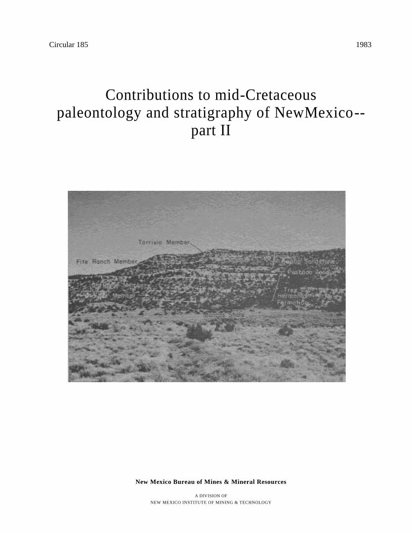
Circular 185 1983
Contributions to mid-Cretaceous paleontology and stratigraphy of NewMexico--
part II
New Mexico Bureau of Mines & Mineral Resources
A DIVISION OF
NEW MEXICO INSTITUTE OF MINING & TECHNOLOGY
Circular 185
New Mexico Bureau of Mines & Mineral Resources
A DIVISION OF
NEW MEXICO INSTITUTE OF MINING & TECHNOLOGY
Contributions to mid-Cretaceous paleontology and stratigraphy of New Mexico—
part II
compiled by Stephen C. Hook, Getty Oil Company, Houston, TX
COVER—Pescado Creek section, control point 33, sec. 32, T. 11 N., R. 17 W., McKinley County, New Mexico
SOCORRO 1983
Preface
This circular is the second in a series that contains short papers on the paleontology and stratigraphy of the mid-Cretaceous (Albian, Cenomanian, and Turonian) of New Mexico and surrounding areas. The first circular, Circular 180, contained three papers that dealt primarily with pa-leontologic aspects of the mid-Cretaceous of New Mexico. This circular contains three papers that are concerned pri-marily with stratigraphic aspects of the mid-Cretaceous of west-central New Mexico. A third circular is presently in the planning stages.
This series was initiated in 1981 under the guidance of Frank E. Kottlowski, Director of the New Mexico Bureau of Mines and Mineral Resources, and is a reflection of the potential economic importance of the rocks of mid-Creta-ceous age in New Mexico. These rocks contain not only nonmarine coal-bearing sequences but also marine organic-rich shale sequences that could serve as hydrocarbon source rocks.
The first three papers in this circular are the direct result of a combined effort by the New Mexico Bureau of Mines and Mineral Resources and the U.S. Geological Survey to evaluate the coal resource potential of and to map several 7 1/2-min quadrangles in west-central New Mexico. The no-menclature and correlation of middle Cenomanian through early Coniacian rocks in west-central New Mexico has long been a subject of controversy and confusion. Although some aspects of the nomenclature advocated in these first three papers, particularly the use of the Tres Hermanos Formation, remain controversial, the correlations have been substanti-ated by the detailed mapping efforts of personnel from the New Mexico Bureau of Mines and Mineral Resources and the U.S. Geological Survey in both the Acoma and Zuni Basins.
In addition, during the week of October 16-21, 1978, the New Mexico Bureau of Mines and Mineral Resources sponsored a field conference on Cretaceous stratigraphy in the Carthage coal field and in the Acoma, Zuni, and southern San Juan Basins. Participants included W. A. Cobban, A. R. Kirk, E. R. Landis, M. N. Machette, M. E. MacLachlan, C. H. Maxwell, S. L. Moore, and J. F. Robertson from the U.S. Geological Survey; C. M. Molenaar, then with Shell Oil Company; and G. L. Massingill, B. Robinson, D. E. Tabet, and me from the New Mexico Bureau of Mines and Mineral Resources. Although no consensus was reached on either correlation or nomenclature during that week, the trip allowed all the participants to view the field relationships of the rocks and laid the foundation for an informal meeting of the U.S. Geological Survey Geologic Names Committee on January 10, 1979. The nomenclature for the Cretaceous rocks in the Carthage coal field, Acoma, Zuni, and southern San Juan Basins was discussed at this meeting by many of
the participants in the earlier field conference. The major point of contention at this meeting was use of the term Tres Hermanos Sandstone because of a vague definition and con-fusion surrounding its use since 1900. Of the two options available—revision or abandonment—the Geologic Names Committee felt that revision was the better course of action because the name would most likely be retained and used by other geologists even if formally abandoned by the U.S. Geological Survey.
At that time only Bill Cobban and I were working on the revision of the Tres Hermanos Sandstone. Later in 1979, C. M. Molenaar agreed to work with us on the paper despite his objections to the name "Tres Hermanos." The paper was considerably strengthened by the addition of Molenaar's measured sections and interpretations of depositional en-vironments. It was a rare privilege for me to have worked with both Bill Cobban and "K" Molenaar on this paper.
Molenaar's paper in this circular on the Gallup Sandstone is an important contribution to mid-Cretaceous stratigraphy of New Mexico because it formally defines the extent of the Gallup Sandstone, establishes a principal reference section for the formation, and corrects some errors in previous regional correlations. The need for a paper• of this scope has been evident since February 2, 1978, when the Geologic Names Committee met in a formal session to consider the redefinition of the Gallup Sandstone. A group from the Ura-nium and Thorium Branch, which had been engaged for several years in detailed mapping in the San Juan Basin, proposed removal of the Torrivio Member from the Gallup Sandstone and classifying it as the Torrivio Bed of the Dilco Member of the Crevasse Canyon Formation. The Geologic Names Committee recommended (partial list) that 1) the Torrivio Member be retained as the top of the Gallup Sand-stone and 2) for the time being, until better information is available, the lowest level of the base of the Gallup remain as presently recognized by the U.S. Geological Survey. Molenaar's paper formalizes both of these recommendations by establishing a principal reference section for the Gallup and by showing in regional cross sections that the Gallup Sandstone is separated from the underlying Tres Hermanos Formation (previously called the Atarque Member of the Gallup Sandstone) by a significant transgressive shale unit.
The third paper in this set of interrelated stratigraphic papers is by McLellan and others and establishes the strat-igraphic nomenclature for the upper part of the Cretaceous sequence in the southern Zuni Basin. Together the three papers provide the detailed stratigraphic framework that has been developed in the course of mapping in the Zuni and Acoma Basins.
The fourth paper by W. A. Cobban and me is the first in this series to discuss mid-Cretaceous stratigraphy and pa-
iii

i v
leontology outside the borders of New Mexico. Bill and I first went to Gold Hill in Jeff Davis County, Texas, because of published reports indicating that two ammonites that were stratigraphically and temporally well separated in New Mexico occurred in the same bed at Gold Hill. Either the biostratigraphic relationships we had established in New Mexico were in error, or an unconformity was present in the sequence in Texas. Our examination of the outcrop revealed that a significant middle Turonian unconformity had jux-taposed the two faunas in a single bed composed of worn, phosphatized, encrusted internal molds of ammonites. This work was done in cooperation with the Bureau of Economic Geology, Austin, Texas.
The field work that resulted in these papers was completed while I was employed at the New Mexico Bureau of Mines and Mineral Resources from 1976 to 1981. I thank Frank E. Kottlowski for his guidance and continued support. The excellent typing, drafting, and editing also were supplied by the New Mexico Bureau of Mines and Mineral Resources.
Houston, Texas Stephen C. Hook
February 28, 1983 Getty Oil Company,
Exploration and Production Research Center
A contribution to Project Mid-Cretaceous Events

STRATIGRAPHY AND REVISION OF NOMENCLATURE
OF UPPER CENOMANIAN TO TURONIAN
(UPPER CRETACEOUS) ROCKS
OF WEST-CENTRAL NEW MEXICO by S. C. Hook, Getty Oil Company, Exploration and Production Research Center, Houston, Texas, and
C. M. Molenaar and W. A. Cobban, U.S. Geological Survey, Denver, Colorado
Abstract
The mid-Cretaceous Tres Hermanos Sandstone of Herrick (1900), later changed to the Tres
Hermanos Sandstone Member of the Mancos Shale by Lee (1912), is raised in stratigraphic
rank to the Tres Hermanos Formation. The Tres Hermanos Formation is a northeastward-
directed elastic wedge of nearshore marine and nonmarine rocks that was deposited in west-
central New Mexico during early and late Turonian time. This wedge, which ranges in
thickness from 200 to 300 ft (61-91 m), except near its seaward extent where it grades into the
Mancos Shale, conformably overlies the Rio Salado Tongue (new name) of the Mancos Shale
and is conformably to disconformably overlain by the D-Cross or Pescado Tongue of the
Mancos Shale. The Tres Hermanos Formation is subdivided into three members: the lower,
regressive marine Atarque Sandstone Member (revised to member rank in west-central New
Mexico); the medial, generally nonmarine Carthage Member (new name); and the upper,
transgressive marine Fite Ranch Sandstone Member (new name). The outcrop belt of the Tres
Hermanos Formation along the Rio Salado in Tps. 2 and 3 N., Rs. 5 and 6 W., Socorro County,
is designated as the type area for the formation. A principal reference section for the Tres
Hermanos is established in this report at Carthage in southeast Socorro County; other refer ence
sections for it are established in the type area in northwest Socorro County and along Pescado
Creek in southern McKinley County. The D-Cross and Pescado Tongues of the Mancos Shale
represent a significant transgressive episode that separates the Tres Hermanos from the younger
Gallup Sandstone. Consequently, the Tres Hermanos Formation, previously referred to as the
Atarque Member of the Gallup Sandstone or as the lower Gallup, is removed from the Gallup.
The Rio Salado Tongue of the Mancos Shale is defined as that part of the Mancos Shale
separating the underlying Twowells Tongue of the Dakota Sandstone from the overlying Tres
Hermanos Formation (or Atarque Sandstone to the southwest where the Tres Hermanos
terminology is not used). In west-central New Mexico, the Rio Salado Tongue ranges in
thickness from about 200 to 300 ft (6191 m) and consists of a lower calcareous shale and
limestone unit and an upper noncalcareous clay-shale unit that intertongues with or grades into
the overlying Tres Hermanos Formation. Within the lower unit, the Bridge Creek Limestone
has been identified and given the stratigraphic rank of beds. The contacts of the Rio Salado
Tongue with both the overlying and underlying rock units are conformable.
Introduction
Recent biostratigraphic and stratigraphic work on mid-Cretaceous rocks of west-central New Mexico by Hook and Cobban (1979, 1980, 1981a) and Cobban and Hook (1979a, 1979b) has indicated a need for revision of mid-Cretaceous stratigraphic nomenclature and correlation. This paper is part of a much larger project on the stratigraphy, biostratigraphy, environments of deposition, and correlation of mid-Cretaceous rocks in west New Mexico. In this paper we are revising the Tres Hermanos Sandstone of Herrick (1900), based on our interpretation of Herrick's description, and expanding it into a more encompassing unit called the Tres Hermanos Formation. Further, we subdivide the formation into three members and, by means of two cross sections, show the relationships between the Tres Hermanos For-mation and overlying and underlying formations in west-
central New Mexico. Reference sections for the Tres Her-manos Formation are established in the type area in the Rio Salado valley 40 mi (65 km) northwest of Socorro, at Car-thage, and in the Zuni Basin along Pescado Creek (fig. 1). In addition, the shale tongue lying between the Tres Her-manos Formation and the Twowells Tongue of the Dakota Sandstone is herein named the Rio Salado Tongue of the Mancos Shale; its type section is in the Rio Salado valley, within the type area of the Tres Hermanos Formation.
Because the emphasis of this report is on the Tres Hermanos Formation, and the definition of the Rio Salado Tongue is based on recognition of the overlying Tres Hermanos, the Tres Hermanos Formation will be discussed first.
Since the name Tres Hermanos Sandstone was introduced in the geologic literature of New Mexico (Herrick, 1900;
7
Herrick and Johnson, 1900), the term has been applied to virtually every sandstone unit low in the Mancos Shale (table 1). For example, in the Mount Taylor area 50 mi (80 km) west of Albuquerque (fig. 1), the name Tres Hermanos Sandstone has been applied to all three prominent sandstone units (now correctly identified as the Twowells, Paguate, and Cubero Tongues of the Dakota Sandstone) in the lower 350 ft (107 m) of the Mancos Shale (Hunt, 1936, p. 40).
Herrick (1900, p. 341) originally applied the name Tres Hermanos Sandstone to " . . a band of sandstone with enormous concretions . . ." just east of Tres Hermanos Peaks, three basaltic necks in the Rio Salado valley, 40 mi (65 km) northwest of Socorro. According to Herrick's (1900, p. 341) written description of Cretaceous geology in the Rio Salado valley, the band of sandstone with enormous concretions
was the second sandstone above the base of the Mancos Shale. Herrick, who did not recognize the intertonguing and age relationships of the Dakota Sandstone and Mancos Shale (Landis and others, 1973), erroneously believed that the sequence of Cretaceous sandstones and shales exposed in the Rio Salado valley was identical to the sequence he had studied in the Rio Puerco valley west of Albuquerque. Con-sequently, he misapplied the name Tres Hermanos Sandstone to the second sandstone above the Dakota Sandstone in the Rio Puerco valley. Later, Lee (1912), referring to the sandstone in the Rio Puerco area and areas to the northeast, designated the unit as the Tres Hermanos Sandstone Member of the Mancos Shale. Subsequent work by Dane and others (1971) and Landis and others (1973) has shown that this sandstone in the Rio Puerco valley is the Paguate Tongue

12
of the Dakota Sandstone and is stratigraphically lower than
Herrick's Tres Hermanos Sandstone in its type area, the Rio
Salado valley.
Confusion surrounding the identity of Herrick's Tres Her-
manos Sandstone in the Rio Salado valley has been almost
as great as in the Rio Puerco valley. Winchester (1920) was
unsure whether the term Tres Hermanos should be applied to
the first or second sandstone above the Dakota in the Rio
Salado area near Puertecito. Pike (1947, p. 66) applied the
name Tres Hermanos Sandstone to the first sandstone above
the Dakota (now correctly assigned to the Twowells Tongue
of the Dakota) in the D Cross Mountain area, 12 mi (19 km)
west of the area of Herrick's Tres Hermanos, but noted that
the Tres Hermanos could occur as one or more massive
sandstones near the base of the Mancos Shale. Pike (1947, p.
32), however, correctly identified the type locality of the
Tres Hermanos as " . . probably a mile east of Tres Her-
manos Buttes, three volcanic necks in Alamosa Creek [Rio
Salado] valley . . . ," but he failed to use this information in
correctly identifying the Tres Hermanos elsewhere.
Pike's miscorrelation of the Twowells, which he had
named in the Zuni Basin to the northwest, with the Tres
Hermanos was accepted by later workers in the area frbm D
Cross Mountain to Puertecito in west-central New Mexico
(Tonking, 1957; Givens, 1957; Dane and others, 1957; Dane,
1959). The pioneering work of Dane and others (1971, p.
B19) on intertonguing of the Dakota Sandstone and Mancos
Shale led to the realization that ". . . the sandstone to which
Herrick (1900, p. 341) originally applied the name Tres
Hermanos is a sandstone 150 to 200 ft stratigraphically above
the sandstone identified as Tres Hermanos (correctly
Twowells) of the Rio Salado valley. This higher sandstone
crops out about 1 mile east of Tres Hermanos Buttes (Peaks),
. . . where it is a 'band of sandstone with enormous con-
cretions' as required by Herrick's (1900) description." Dane
and others (1971, p. B20) restricted the name Tres Hermanos
to this higher sandstone, but failed to describe the strati-
graphic and geographic limits of the unit.
Even though the correct identity of the Tres Hermanos
Sandstone Member has been in the literature for 12 yrs, the
Twowells Tongue is still often incorrectly identified as the
Tres Hermanos Sandstone Member (see table 1). This mis-
correlation is due in part to an inadequate definition and to
a lack of type and reference sections.
In the Zuni Basin south of Gallup, correlative strata of
what we are calling the Tres Hermanos Formation have been
either miscorrelated or included in an expanded definition of
the Gallup Sandstone and called lower part of Gallup
Member of the Mesaverde Formation (or Group) or Atarque
Member of the Mesaverde Formation (Pike, 1947; Dane,
1959; Dane and others, 1957; Molenaar, 1973, 1974).
Although we, the authors, are all in substantial agreement
on the correlations and stratigraphic relationships portrayed
on sheet 1 (in back pocket), we are in disagreement on the
nomenclature used. Two of us (Hook and Cobban) believe
that the name "Tres Hermanos" is an intrinsic part of Cre-
taceous nomenclature of New Mexico and should be pre-
served by a revision that sets specific stratigraphic and
geographic boundaries on the formation and is in compliance
with the American Code of Stratigraphic Nomenclature.
Molenaar, on the other hand, thinks that it would be best to
apply a new name and abandon the term Tres Hermanos
because of the 83 yrs of confusion surrounding its use and
the vagueness of the original definition.
An informal meeting of the U.S. Geological Survey's
Geologic Names Committee was held on January 10, 1979, to
discuss Cretaceous stratigraphic nomenclature to be used in
west-central New Mexico. The consensus of those attending
the meeting was that "Tres Hermanos" would be retained by
geologists, even though its first usage was vague, and would
probably be used by other workers even if abandoned by the
U.S. Geological Survey. Therefore, the revision of the Tres
Hermanos is both appropriate and desirable.
ACKNOWLEDGMENTS—In a work of the regional scope of
this one, it is impossible not to owe a large debt of gratitude
to many individuals and organizations. The New Mexico
Bureau of Mines and Mineral Resources provided field sup-
port for all of us at one time or another and the drafting and
editorial help necessary to publish this paper. The paper
benefitted from discussions with our colleagues Frank Kott-
lowski, Orin Anderson, and Sam Thompson III of the New
Mexico Bureau of Mines and Mineral Resources and E. R.
Landis, M. E. MacLachlan, C. H. Maxwell, and S. L. Moore
of the U.S. Geological Survey, Denver; C. H. Maxwell, E.
R. Landis, Orin Anderson, and M. E. MacLachlan critically
reviewed the paper. We thank the Zuni Tribe and Alamo
Band of Navajos for permission to work on Indian land and
the numerous ranchers and individuals who allowed us on
private land, particularly Mr. and Mrs. Dean Fite of San
Antonio, New Mexico.
We also thank Shell Oil Company for permission to pub-
lish many sections that Molenaar measured while with Shell.
The reconnaissance geologic map of the Puertecito area was
begun by Hook and George Bachman, then with the U.S.
Geological Survey, in 1977, and finished by Hook and Gary
Massingill, then with the New Mexico Bureau of Mines and
Mineral Resources. Finally, we owe a profound debt of
gratitude to the work of C. L. Herrick, W. S. Pike, Jr., and C.
H. Dane, all of whom helped lay the foundation for this
paper.
Scope of Tres Hermanos Formation
In placing a stratigraphic top on the Tres Hermanos, Hook
and Cobban (1979, fig. 5) and Cobban and Hook (1979a, fig.
3A; 1979b) had to interpret Herrick's description of the type
area in light of the stratigraphic framework and concepts of
1900. At that time, Cretaceous rocks were thought to have
been deposited as continuous sheets and, therefore, could be
correlated like so many layers in a cake.
Herrick's concept of Cretaceous stratigraphy (Herrick and
Johnson, 1900, p. 13-15) was based upon extensive work in the
Rio Puerco valley, west of Albuquerque, where:
No single exposure affords an opportunity to measure the thickness of the Cretaceous in our region but the sequence has been pretty well made out. At the bottom is a well-defined bed of granular sandstone . . . [that] attains a thickness of from 25 to 50 feet. . . . The basal sandstone is followed by a series of dark, sometimes lignitic shales with a thickness of over forty feet which near the top contain bands of flags or sandstone impregnated with iron. Usually one of these layers at least is fossiliferous and has been termed the Gasteropod zone. . . . About ten feet of flags follow the dark shales, which are followed by about 75 to 100 feet of yellowish gray shales passing upward
into yellow sandstone about 75 feet thick. In the lower layers of sandstone or in the upper sandy part of the shale below it are frequently developed large concretions often with a cement of iron. These concretions may be over four feet in diameter and often become conspicuous objects in the landscape. They have been found at so many places in the same place in the series that we have come to attach considerable importance to them as a means of identifying horizons. . . . At the top of this Tres Hermanos sandstone is a rather constant band of pinkish sandstone. . . . Above the sandstone is a large series of very friable sandy shales which are everywhere so readily eroded as to leave their thickness somewhat obscure. They are broken by small layers of ferruginous sandstone which are somewhat fos-siliferous affording for the most part broken fragments. In the neighborhood of (sometimes above but oftener below) this series of sandstone layers is a very widely distributed and conspicuous zone of concretions characterized by an abundance of calcite crystals and the occurrence of a plentiful fauna. These calcareous and septarian concretions often abound in large ammonite shells and large species of Pinna and Baculites which weather out in a very good state of preservation. . . . Above the cephalopod zone and the sandy shales overlying it is another large band of dark and yellow earthy shales at least 100 feet thick capped by a massive sandstone perhaps 50 to 75 feet thick. This we have called the Punta de la Mesa sandstone. . . . The Punta de la Mesa sandstone is undoubtedly of Fox Hills age though it has been very incompletely studied. . . . (Emphasis is ours, not Herrick and Johnson's.)
In terms of present-day nomenclature, 1) "The well-de-fined bed of granular sandstone" is the main body of the Dakota Sandstone; 2) the "dark, sometimes lignitic shales" are part of the Oak Canyon Member of the Dakota Sand-stone; 3) the "Gasteropod zone" contains a Thatcher fauna (Cobban, 1977, p. 5) and is laterally equivalent to the upper part of the Oak Canyon Member of the Dakota Sandstone; 4) the overlying dark and yellowish-gray shales are laterally equivalent to the Cubero Tongue of the Dakota Sandstone and the Clay Mesa Tongue of the Mancos Shale; 5) the "sandstone with large concretions" is the Paguate Tongue of the Dakota Sandstone; 6) the "friable sandy shales" unit is a tongue of Mancos Shale that is equivalent to the White-water Arroyo Tongue of the Mancos Shale and the Twowells Tongue of the Dakota Sandstone; 7) the "cephalopod zone" and "series of sandstone layers" are laterally equivalent to the Semilla Sandstone Member of the Mancos Shale; 8) the "large band of dark and yellow earthy shales" is a tongue of Mancos Shale in part equivalent to the D-Cross Tongue; and 9) the "Punta de la Mesa sandstone" is the Gallup Sandstone.
The key correlatable units in Herrick's stratigraphic framework were 1) the "Gasteropod zone," 2) a sandstone with huge concretions (the Tres Hermanos sandstone), 3) the "cephalopod zone," and 4) the Punta de la Mesa sand-stone (which he thought was equivalent to the Fox Hills sandstone to the north). Herrick's (1900) trip through west-ern Socorro and Valencia Counties during December 1899 served to convince him that his main Cretaceous units could be recognized as far south as the Rio Salado valley. Herrick (1900, p. 341) explicitly stated that
East of Tres Hermanos . . . The same sequence is observed at this place as near Albuquerque. . . . The Dakota sandstone appears to be absent and the so-called gasteropod zone is within a hundred feet of the bottom, with fossils of Fort Benton age, followed by a band of sandstone with enormous concretions. After a series of soft shales the zone of cephalopods appears and then the Fox Hills sandstone with their large marine assemblage. . . . (Our emphasis.)
Based on Herrick's (1900) description of his journey up Alamosa Creek (Rio Salado) and his sketch map (Herrick, 1900, pl. IX), the "Tres Hermanos" are the Tres Hermanos Peaks shown in sec. 26, T. 3 N., R. 7 W., on the Table Mountain 7
1/2-min quadrangle. Herrick's description of
geology "east of Tres Hermanos" exactly matches the geol-ogy in the west half of the Puertecito 7
1/2-min quadrangle
(fig. 2), where Herrick's sketch map indicates he was. In the northwest portion of the Puertecito quadrangle (fig.
2), the dip slope of the Dakota is steep, tree covered, and breeched, allowing red alluvium from the Chinle Formation (Triassic) to mask the Mancos Shale. From a distance these
14
features combine to give the impression that the Dakota is absent and that the Mancos was deposited on the Chinle. The Twowells Tongue of the Dakota, the lowest sandstone unit intertongued with the Mancos Shale on the Puertecito quadrangle, is thin (less than 20 ft [6 m] thick) and generally unfossiliferous in Cottonwood Draw, prompting Herrick to describe it as the "so-called gasteropod zone." However, the oyster Pycnodonte newberryi (Stanton), a fossil of Fort Benton age, occurs in great numbers in calcareous shales at the base of the overlying Rio Salado Tongue of the Mancos Shale. The basal sandstone of the Tres Hermanos is well exposed above the Twowells and contains numerous, large, fossiliferous, sandstone concretions.
Rocks above this basal sandstone crop out in the area south of present-day Alamocita Creek (as shown on the Puertecito 7 1/2-min quadrangle), where Herrick's sketch map also indicates he traversed. The D-Cross Tongue is the only unit containing numerous fossiliferous, ammonite-bearing concretions that Herrick could have correlated with his "cephalopod zone." Herrick's Punta de la Mesa sandstone is the Gallup Sandstone of this report.
Accordingly, Hook and Cobban (1979, fig. 5) and Cobban and Hook (1979a, fig. 3A) placed the upper boundary of the Tres Hermanos at the base of the shale containing the "Cephalopod zone" (the base of the D-Cross Tongue of the Mancos Shale) and the base of the Tres Hermanos at the base of the sandstone containing huge concretions. The Tres
Hermanos as defined above is in accord with both Herrick's stratigraphic concepts and his rather vague definition. As such, the Tres Hermanos can be recognized and mapped over a wide area of west-central New Mexico (fig. 1). The geographic limits are discussed later in this report.
That Herrick intended to name a lithologic unit the Tres Hermanos Sandstone is evident from both of his papers dealing with Cretaceous stratigraphy. In Herrick (1900, p. 338), the name "Tres Hermanos sandstone" was applied to a "massive sandstone with large concretions" and in Herrick and Johnson (1900, p. 14), it was also applied to a sandstone with large concretions.
Herrick himself contributed to a great deal of the con-fusion surrounding the Tres Hermanos when he (mis)correlated the Tres Hermanos of the Rio Salado valley with the Paguate Tongue of the Dakota Sandstone in the Rio Puerco valley. This miscorrelation, however, was clearly the result of prevailing stratigraphic concepts in which the intertonguing relationships of Upper Cretaceous strata were not recognized.
The Tres Hermanos Formation, as revised herein, is a heterogeneous lithostratigraphic unit that contains marine sandstones and shales as well as nonmarine sandstones, shales, and coals. Accordingly, the word sandstone is de-leted from its name because of its monolithic connotation and is replaced with the term "formation."
Tres Hermanos Formation
The Tres Hermanos Formation as here revised is a sand-stone and shale unit containing minor coal beds. It is a regressive-transgressive wedge of nearshore marine and nonmarine deposits of late early to late Turonian (mid-Cre-taceous) age. This clastic wedge separates the lower or mid-dle part of the Mancos Shale in west-central New Mexico into two parts with the Rio Salado Tongue (new name) below and the D-Cross or Pescado Tongue above (figs. 3, 4; sheet 1, in back pocket).
The Tres Hermanos Formation consists of a basal re-gressive marine sandstone unit, a medial marginal marine to nonmarine shale and sandstone unit, and an upper trans-gressive marine sandstone unit. Together, these three units make a distinctive, mappable package that can be recognized (and mapped) over a wide area of west-central and southern New Mexico. Figs. 3 and 4 show the outcrop control and distribution and facies trends of the Tres Hermanos in west-central New Mexico. The southwest or landward limit of the Tres Hermanos is, by definition, at the landward pinch-out of the D-Cross and Pescado Tongues (fig. 3; sheet 1A, in back pocket). The seaward limit of the Tres Hermanos is the northeast extent of the sandstone units at the base and top of the formation (fig. 1). Unlike most regressive-transgressive cycles in which the basal regressive sandstone unit merges with the upper transgressive sandstone (if developed), the upper and lower sandstone units of the Tres Hermanos remain separated and become thinner in a seaward direction as the medial nonmarine unit grades directly into marine Mancos Shale. Because the lower and upper sandstone units thin seaward, they do not crop out in all exposures, making it difficult to determine precisely the seaward
pinchout of the Tres Hermanos (sheet 1—A, in back pocket; fig. 3).
The three-part division of the Tres Hermanos is present in most areas where the formation is exposed, but in some areas the upper sandstone unit is thin or locally missing. Also, the marginal marine and nonmarine shales and sand-stones of the medial unit grade into marine shale around the northern and eastern extents of the Tres Hermanos. This tripartite division of the Tres Hermanos naturally lends itself to subdivision into three members, which we are naming in ascending order: the Atarque Sandstone Member (revised); the Carthage Member (new name); and the Fite Ranch Sandstone Member (new name).
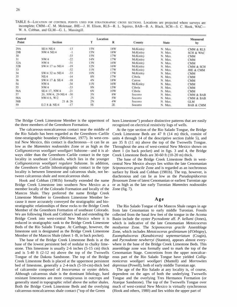
We are designating the outcrop belt of the Tres Hermanos Formation in Tps. 2 and 3 N. and Rs. 5 and 6 W., Socorro County, as the type area of the Tres Hermanos Formation. In addition, we are establishing a principal reference section for the Tres Hermanos in the Carthage area in secs. 8 and 17, T. 5 S., R. 2 E., Socorro County (table 2), and reference sections in the type area in sec. 6, T. 2 N., R. 5 W., Socorro County (table 3), and along Pescado Creek in sec. 5, T. 10 N., R. 17 W., McKinley County (table 4).
Throughout the area of west-central New Mexico shown on sheet 1A and B (in back pocket) and figs. 3 and 4, the Tres Hermanos ranges from 200 to 300 ft (61-91 m) in thickness, except where it grades into the Mancos Shale at its seaward extent. Specific depositional environments of the three members are discussed in a later section of this paper. The Tres Hermanos conformably overlies the Rio Salado Tongue of the Mancos Shale and is conformably to disconformably overlain by the D-Cross Tongue of the Man-

cos Shale in the eastern part of west-central New Mexico
and by the Pescado Tongue of the Mancos Shale in the
western part of west-central New Mexico.
At the principal reference section (sheet 1B, control point
59, in back pocket; table 2), the Tres Hermanos Formation
is exceptionally well exposed (figs. 5 and 6) and easily
accessible. The formation is 277 ft (84 m) thick and consists
of 1) a lower 86-ft (26-m)-thick, regressive coastal-barrier
sandstone unit (Atarque Sandstone Member); 2) a medial
116-ft (35-m)-thick nonmarine shale and sandstone unit
(Carthage Member); and 3) an upper 75-ft (23-m)-thick
marine sandstone unit (Fite Ranch Sandstone Member).
The Tres Hermanos Formation has been referred to by
other informal or obsolete formal names by previous work-
ers. Pike (1947, p. 35) referred to this interval as the lower
part of the Gallup Member of the Mesaverde Formation in
the area of Nutria and Pescado Creeks, 30 mi (48 km) south of
Gallup, New Mexico. (The Gallup was later raised in rank to
a formation of the Mesaverde Group by Beaumont and
others, 1956.) Farther south, Pike named the Horsehead
Tongue of the Mancos Shale, which he thought was below
the marine Pescado Tongue. The sandstones and carbona-
ceous shales below the Horsehead were called the Atarque
Member of the Mesaverde (Pike, 1947, p. 35). Molenaar
(1973, p. 94) concluded that what Pike had called the Horse-
head Tongue was either some nonmarine, paludal shale in
the Atarque or the marine Pescado Tongue. None of Pike's
measured sections includes both the Pescado and Horsehead
Tongues, and fossils (Inoceramus dimidius) collected by Pike
from his Horsehead Tongue in his measured section 43 are
now known to be confined to the Pescado Tongue. Because
of this miscorrelation by Pike, Molenaar (1973, p.

94) suggested that the name Horsehead Tongue be dropped
and that the name Atarque Member be applied to the lower
part of the Gallup Sandstone of the Mesaverde Formation of
Pike (1947). Molenaar then informally referred to the interval
we are calling Tres Hermanos Formation as lower Gallup or
Atarque Member on his regional correlation sections
(Molenaar, 1973, 1974).
We concur with Molenaar's (1973) suggestion that the
Horsehead Tongue of the Mancos Shale be abandoned as a
formal stratigraphic unit. In addition, however, we rec-
ommend removing the lower Gallup or Atarque Member of
previous workers from the Gallup and including these strata
in the Tres Hermanos Formation because 1) these rocks were
deposited during an earlier regressive-transgressive cycle
than the cycle during which the Gallup Sandstone of the type
area was deposited, 2) they are separated from the upper
Gallup or Gallup of the type area by a significant
transgressive tongue of Mancos Shale (the Pescado Tongue),
and 3) they correlate with the Tres Hermanos Formation of
the type area of the Rio Salado valley 80 mi (129 km) to the
southeast. Consequently, Gallup nomenclature is now
restricted to sandstones overlying or intertonguing with the
D-Cross and Pescado Tongues of the Mancos Shale (sheet 1,
in back pocket; see Molenaar, this volume).


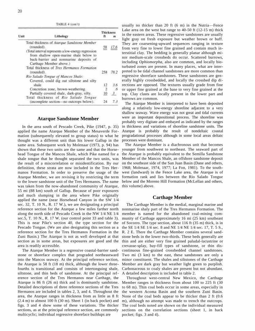
Atarque Sandstone Member
In the area south of Pescado Creek, Pike (1947, p. 35)
applied the name Atarque Member of the Mesaverde For-
mation (subsequently elevated to group status) to what he
thought was a different unit than his lower Gallup in the
same area. Subsequent work by Molenaar (1973, p. 94) has
shown that these two units are the same and that the Horse-
head Tongue of the Mancos Shale, which Pike named for a
shale tongue that he thought separated the two units, was
the result of a miscorrelation or misidentification. By our
definition, these strata are now included in the Tres Her-
manos Formation. In order to preserve the usage of the
Atarque Member, we are revising it by restricting the term
to the lower sandstone unit of the Tres Hermanos. The name
was taken from the now-abandoned community of Atarque,
55 mi (88 km) south of Gallup. Because of poor exposures
and much slumping in the area where Pike originally
applied the name (near Horsehead Canyon in the SW 1/4
sec. 32, T. 10 N., R. 17 W.), we are designating a principal
reference section for the Atarque a few miles farther north
along the north side of Pescado Creek in the NW 1/4 NE 1/4
sec.5, T. 10 N., R. 17 W. (our control point 33 and table 3).
This is near Pike's section 40, the type section for the
Pescado Tongue. (We are also designating this section as a
reference section for the Tres Hermanos Formation in the
Zuni Basin.) The Atarque is not as well developed at that
section as in some areas, but exposures are good and the
area is readily accessible.
The Atarque Member is a regressive coastal-barrier sand-
stone or shoreface complex that prograded northeastward
into the Mancos seaway. At the principal reference section,
the Atarque is 58 ft (18 m) thick, although the lower three-
fourths is transitional and consists of intertonguing shale,
siltstone, and thin beds of sandstone. At the principal ref-
erence section of the Tres Hermanos near Carthage, the
Atarque is 86 ft (26 m) thick and is dominantly sandstone.
Detailed descriptions of three reference sections of the Tres
Hermanos are included in tables 2, 3, and 4. Throughout the
area, the Atarque ranges in thickness from as little as 8 ft
(2.4 m) to almost 100 ft (30 m). Sheet 1 (in back pocket) and
figs. 3 and 4 show some of these variations. The thicker
sections, as at the principal reference section, are commonly
multicyclic; individual regressive shoreface buildups are
usually no thicker than 20 ft (6 m) in the Nutria—Fence
Lake area on the west but range to 40-50 ft (12-15 m) thick
in the eastern areas. These regressive sandstones are usually
light gray on fresh exposure but weather brown or buff.
They are coarsening-upward sequences ranging in texture
from very fine to lower fine grained and contain much in-
terstitial clay. The bedding is generally planar although mi-
nor medium-scale crossbeds do occur. Scattered burrows,
including Ophiomorpha, also are common, and locally bio-
turbated zones are present. In many places, what are inter-
preted to be tidal channel sandstones are more common than
regressive shoreface sandstones. These sandstones are gen-
erally highly crossbedded, and locally the crossbed dip di-
rections are opposed. The textures usually grade from fine
or upper fine grained at the base to very fine grained at the
top. Clay clasts are locally present in the lower part and
burrows are common.
The Atarque Member is interpreted to have been deposited
along a relatively low-energy shoreline adjacent to a very
shallow seaway. Wave energy was not great and tidal currents
were an important depositional process. The shoreline was
probably very digitate and embayed as indicated by the ranges
in thickness and variations of shoreline sandstone units. The
Atarque is probably the result of nondeltaic coastal
progradational processes although in some local areas deltaic
processes were dominant.
The Atarque Member is a diachronous unit that becomes
younger from southwest to northeast. The seaward part of
the Atarque is probably equivalent to the Semilla Sandstone
Member of the Mancos Shale, an offshore sandstone deposit
on the southeast side of the San Juan Basin (Dane and others,
1968; Molenaar, 1974, 1977; La Fon, 1981). To the south-
west (landward) in the Fence Lake area, the Atarque is of
formation rank and lies between the Rio Salado Tongue
below and the Moreno Hill Formation (McLellan and others,
this volume) above.
Carthage Member
The Carthage Member is the medial, marginal marine and
nonmarine shaly part of the Tres Hermanos Formation. The
member is named for the abandoned coal-mining com-
munity of Carthage approximately 16 mi (25 km) southeast
of Socorro. The type section, about 116 ft (35 m) thick, is in
the SE 1/4 SE 1/4 sec. 8 and NE 1/4 NE 1/4 sec. 17, T. 5 S.,
R. 2 E. There the Carthage Member contains several sand-
stone beds in the lower two-thirds. These beds generally are
thin and are either very fine grained paludal-lacustrine or
crevasse-splay, bay-fill types of sandstone, or thin dis-
continuous fine-grained crossbedded channel sandstones.
Two mi (3 km) to the east, these sandstones are only a
minor constituent. The shales and siltstones of the Carthage
Member are dark gray but weather light green to purplish.
Carbonaceous to coaly shales are present but not abundant.
A detailed description is included in table 2.
Throughout west-central New Mexico, the Carthage
Member ranges in thickness from about 100 to 225 ft (30
to 68 m). Thin coal beds occur in some areas, especially in
the western Acoma Basin and the southern Zuni Basin.
None of the coal beds appear to be thicker than 2 ft (0.6
m), although no attempt was made to trench the outcrops.
The coal beds noted are shown on the individual measured
sections on the correlation sections (sheet 1, in back
pocket; figs. 3 and 4).

Distributary or fluvial channel sandstones are common in the western part of the area south of Pescado Creek but are less common and thinner east of Acoma Basin. These sandstones are lenticular, and individual channel sandstones are usually less than 25 ft (7.5 m) in thickness. Most sandstones are fine grained; locally they coarsen to lower medium grained. Interstitial clay is common. The fluvial channel sandstones are shown on the individual control points on the correlation sections (sheet 1; figs. 3 and 4).
The Carthage Member does not thin uniformly toward its seaward limit as is the case with most Upper Cretaceous nonmarine wedges. Instead, the nonmarine paludal shales grade directly into marine shales of the Mancos as shown on the correlation sections (sheet 1; figs. 3 and 4). A few thin sandstone beds are common in this transitional zone. The underlying and overlying coastal marine sandstone units (Atarque and Fite Ranch Sandstone Members) do not con-verge to form the classic regressive-transgressive wedge.
Deposition of the Carthage Member is interpreted to have been on a broad, very low relief coastal or delta plain. The Atarque shoreline to the northeast was probably highly em-bayed, and in many places the marginal marine bay deposits merge with the paludal marsh deposits. At the seaward margins, where the nonmarine muds grade directly into open marine muds of the Mancos, the seaway must have been very shallow and, as a result of very low wave energy combined with a probably low sand content of the few distributaries, shoreface or beach sands were not deposited. This type of shoreline transition is not common in most of the Upper Cretaceous sequences in the Western Interior seaway.
Fite Ranch Sandstone Member
The name Fite Ranch Sandstone Member is herein applied to the upper sandstone unit of the Tres Hermanos Formation.The member is named for Fite Ranch, which is approximately 1 mi (1.6 km) south of the abandoned coal mining community of Carthage. The type section is in the NE 1/4 NE'/4 sec. 17, T. 5 S., R. 2 E. A detailed description of the type section is given in table 2. The Fite Ranch Member is a well-developed coastal-barrier sandstone 75 ft (23 m) thick at the type section, but it is much thinner in most other areas and is locally absent (sheet 1A and B, in back pocket; figs. 3 and 4). The sandstones are light gray but weather light to medium brown and generally consist of a coarsening-upward sequence ranging from very fine grained at the base to lower fine grained at the top. Upper fine to medium grains commonly occur either at the contact with, or scattered in, the basal foot (30 cm) of the overlying transgressive D-Cross or Pescado Tongue of the Mancos Shale. Interstitial clay is common but not as prevalent as in the Atarque Member. Planar bedding predominates but is generally obscured by burrowing and bioturbation.
The Fite Ranch Sandstone Member is a coastal-barrier sandstone associated with the overlying transgressive D-Cross or Pescado Tongue of the Mancos Shale. At the type section and a few other areas in the southeast Acoma Basin and farther east, the Fite Ranch is thick and has a gradational base with a 10-15-ft (3-4.5-m)-thick section of locally fos-siliferous silty shales or very fine grained sandstone resting on the Carthage Member. The oyster Lopha bellaplicata (Shumard) in this basal zone in some areas indicates a nor-mal marine environment, which suggests that the top of the
2 1
Carthage Member or base of the Fite Ranch Sandstone Member at those areas represents a transgression followed by an offlap or regression during which the major part of the Fite Ranch was deposited. In areas farther west, sandstone of the Fite Ranch overlies nonmarine coaly or carbonaceous shale deposits with a sharp contact. In those areas the unit generally is thin, commonly 10-15 ft (3-4.5 m) thick or less. These sequences are interpreted to represent a barrier complex that transgressed its back-barrier lagoonal or coal-swamp deposits. This type of transgression has been described in Holocene deposits of the Atlantic and Gulf Coasts (Kraft and John, 1979). A more detailed study of the Fite Ranch Sandstone Member is necessary to decipher its complex depositional history more precisely.
Near its seaward limit, the Fite Ranch Member becomes thinner and probably discontinuous. Because the underlying nonmarine Carthage Member grades to marine Mancos Shale and also contains thin sandy zones at the transition, recognition of the Fite Ranch is difficult and use of the term is probably unwarranted in those areas.
Age
The Tres Hermanos Formation ranges in age from late early to early late Turonian in west-central and southern New Mexico. The oldest fossils collected from the basal part of the Atarque Sandstone Member have come from the Love Ranch area, 20 mi (32 km) northeast of Las Cruces, and include Mammites nodosoides (Schluter) of late early Turonian age (fig. 7). The youngest fossils from the Atarque have come from the Paradise Canyon area, 7 mi (11 km) southwest of Acoma Pueblo, near the pinchout point of the Tres Hermanos, and include Collignoniceras woollgari reg-ulare (Haas)? and Spathites chispaensis Powell, which are indicative of an early middle Turonian age. To the west, Spathites puercoensis (Herrick and Johnson), indicative of the Prionocyclus hyatti Zone of late middle Turonian age, was collected from the base of the undifferentiated Tres Hermanos Formation in the Black Creek valley, approxi-mately 10 mi (16 km) south of Window Rock, Arizona.
The age of the normally nonmarine Carthage Member is usually based on the ages of overlying and underlying mem-bers of the Tres Hermanos. On this basis, the Carthage Member ranges in age from late early to late Turonian. However, the marine oyster Lopha bellaplicata (Shumard) has been collected from the upper part of the Carthage Member in the Jornada del Muerto coal field (Tabet, 1979, p. 14). The marine shale from which this collection was made is associated with the overlying Fite Ranch—D-Cross transgression. Lopha bellaplicata occurs in the Prionocyclus hyatti Zone and in the basal part of the overlying Prionocyclus macombi Zone and, therefore, has an age range of late middle to earliest late Turonian.
The Fite Ranch Sandstone Member is diachronous and becomes younger to the south. However, in the area of west-central New Mexico that includes the Acoma Basin, Car-thage, Oscura, and Truth or Consequences, the top of the Fite Ranch appears to be virtually synchronous. In those areas the ammonite Coilopoceras inflatum Cobban and Hook occurs either in the upper few feet of the member or in the basal few feet of the overlying D-Cross Tongue of the Man-cos Shale. Other fossils often occurring with C. inflatum include Prionocyclus macombi Meek (late form), Lopha lugubris (Conrad), and Inoceramus dimidius White. The

oldest fossils collected from the Fite Ranch Member have come from the base of the member at Carthage and include Prionocyclus macombi (early form), Coilopoceras colleti Hyatt, and Lopha bellaplicata novamexicanum Kauffman of earliest late Turonian age. The youngest fossils from the Fite Ranch Member are two specimens of Scaphites whitfieldi Cobban from the Love Ranch area northeast of Las Cruces.
The fossil assemblage found in the upper part of the Fite Ranch Member in the Acoma Basin, and at Carthage, Truth or Consequences, and Oscura, 47 mi (76 km) southeast of Carthage, is identical to that found in the basal part of the Juana Lopez Member of the Mancos Shale (Dane and others, 1966; Hook and Cobban, 1980). A strong time correlation between the two units is indicated.
Disconformity
A disconformable contact between the Tres Hermanos Formation and the overlying D-Cross or Pescado Tongue of
the Mancos Shale is suggested by 1) the presence of worn, phosphatized internal molds of fossils and 2) the absence of faunal zones. Evidence for this disconformity is limited so far to only four outcrops.
At Carthage (sheet 1—B, control point 59, in back pocket) the oyster Lopha sannionis (White) occurs at the top of the Fite Ranch Sandstone Member in association with Prionocyclus macombi Meek (late form) and Coilopoceras inflatum Cobban and Hook. Prionocyclus novimexicanus (Marcou) occurs in concretions in the D-Cross Tongue approximately 10 ft (3 m) above the top of the Fite Ranch Member. These occurrences indicate that the entire Prionocyclus wyomingensis Zone is missing at Carthage because L. sannionis is now known to range no lower than the base of the Prionocyclus novimexicanus Zone (Hook and Cobban, 1981a). Further evidence of erosion and nondeposition in that area is indicated by phosphatized bivalve molds recovered from the top of the Fite Ranch Member.
On the Sevilleta Grant, 25 mi (40 km) north of Carthage, worn, phosphatized internal molds of bivalves, gastropods, and ammonite chambers occur at the top of the Fite Ranch Member in association with nonphosphatized Lopha bel-laplicata. Hook and Cobban (1981b) have interpreted a similar occurrence of phosphatized, worn molds in the Bridge Creek Limestone Member of the Colorado Formation in southwest New Mexico as representing an erosional episode in which prefossilized molds were eroded out of soft sediment, concentrated as a lag deposit on the seafloor, and then phosphatized at the sediment-water interface. Lopha lugubris (Conrad), Scaphites warreni Meek and Hayden, and Prionocyclus wyomingensis Meek occur in thin calcarenite beds of Juana Lopez aspect approximately 5 ft (1.5 m) above the phosphatized molds on the Sevilleta Grant. This 5-ft (1.5-m)-thick interval must then represent much of the time associated with the Prionocyclus macombi Zone and is condensed relative to the type and reference sections of the Juana Lopez Member of the Mancos Shale. At both the type and reference sections of the Juana Lopez Member, the part of the Prionocyclus macombi Zone above the last occurrence of Lopha bellaplicata is represented by more than 100 ft (30 m) of section (Dane and others, 1966; Hook and Cobban, 1980).
Similarly, the occurrence of Lopha lugubris in the same bed with Lopha bellaplicata at the top of the Tres Hermanos Formation in the Zuni Basin (sheet 1—A, control point 32A, in back pocket) and along the Defiance monocline in Arizona also is suggestive of a disconformable relationship.
Characteristic fauna
The most diverse molluscan fauna in the Tres Hermanos Formation occurs in brown-weathering, calcareous sand-stone concretions in nearshore, marine sandstones in the basal part of the Atarque Sandstone Member. The non-cephalopod portion of this fauna was apparently facies con-trolled and has been collected from sandstone concretions in the Atarque Member throughout the Acoma and Zuni Basins, at Carthage and the Jornada del Muerto coal field, and on the Sevilleta Grant.
This fauna is so abundant, diverse, and well preserved in these concretions that we have come to regard it as the characteristic fauna of the Tres Hermanos Formation (fig. 8).
The noncephalopod portion of this fauna collected from the Atarque Sandstone Member consists of the following 22

23
Landward equivalents
The Tres Hermanos terminology is no longer applicable southwest of the landward pinchout of the Pescado and D-Cross Tongues. The Pescado Tongue pinches out in the area between Fence Lake and Atarque (sheet 1–A, in back pocket, and fig. 3, between control points 35 and 36). We recommend that the basal regressive, marine sandstone—which farther north is the Atarque Sandstone Member of the Tres Hermanos Formation—be called the Atarque Sandstone, a unit of formational rank, southwest of this pinchout point. The nonmarine rocks above the Atarque Sandstone have been named the Moreno Hill Formation by McLellan and others (this volume). Strata of the Moreno Hill Formation are laterally equivalent to the Carthage and Fite Ranch Members of the Tres Hermanos Formation, the Pescado Tongue of the Mancos Shale, the Gallup Sandstone, and the lower part of the Crevasse Canyon Formation (sheet 1–A, in back pocket, and fig. 3; Molenaar, 1973, and this volume).
At our measured section at Moreno Hill (sheet 1, control point 36, in back pocket), which is 1.6 mi (2.6 km) southeast of the type section of the Moreno Hill Formation (McLellan and others, this volume), the Atarque Sandstone is 79 ft (24 m) thick and the Moreno Hill Formation is 622 ft (190 m) thick. The Moreno Hill Formation consists of nonmarine shales and fluvial channel sandstones and contains coal beds as much as 3 ft (1 m) thick in the lower part. The fluvial sandstone unit in the upper 200 ft (61 m) of our measured section is coarser grained than those below and may be equivalent to the Torrivio Member of the Gallup Sandstone (sheet 1–A, in back pocket, and fig. 3; Molenaar, 1973, and this volume).
In areas where the marine shale of the Pescado or D-Cross Tongue pinches out or grades laterally into shoreface sandstone or nonmarine rocks, the stratigraphic nomenclature for the sequence is arbitrary and could be either Atarque Sandstone, Tres Hermanos Formation, or Gallup Sandstone. The terminology for the intertonguing lithologies in these transitional areas, which are probably small, should be cho-sen by the geologist investigating the area.
Mappability
The Tres Hermanos Formation, as herein revised, has previously been mapped as the middle sandstone member of the Mancos Shale by Wilpolt and Wanek (1951) in eastern Socorro County and as the Tres Hermanos Sandstone Mem-ber of the Mancos Shale by Tabet (1979) in the Jornada del Muerto coal field. The Tres Hermanos Formation (as herein revised) has been mapped by personnel from the U.S. Geo-logical Survey in the northern Acoma Basin (S. L. Moore, personal communication, 1981) and by personnel from the New Mexico Bureau of Mines and Mineral Resources in the southern Acoma Basin (Osburn, 1982, 1983). South of the pinchout point of the Pescado Tongue of the Mancos Shale in the southern Zuni Basin, the Atarque Sandstone has been mapped by personnel from the U.S. Geological Survey (McLellan and others, personal communication, 1981) and by personnel from the New Mexico Bureau of Mines and Mineral Resources (Anderson, 1981).
Geographic limits in New Mexico
The Tres Hermanos can be recognized and mapped over a wide area of west-central and southern New Mexico ex-

24
tending from the Love Ranch area northeast of Las Cruces
on the south, to Oscura on the east, to Putney Mesa (Mesa
Negra) in the northern Acoma Basin, and to the Upper
Nutria area of the northern Zuni Basin (sheet 1—A, in back
pocket, and fig. 3, control point 32A). South of the
pinchout point of the Pescado and D-Cross Tongues of the
Mancos Shale, the Tres Hermanos Formation is not
recognized and the Atarque Sandstone and Moreno Hill
Formation are the stratigraphic names applied. The Pescado
Tongue pinches out in surface sections (sheet 1 A, in back
pocket, and fig. 3, between control points 35 and 36), and
the D-Cross Tongue pinches out in the subsurface far south
of the Acoma Basin (fig. 1).
Correlation
The correlations shown on sheet 1 (in back pocket) and figs.
3 and 4 are based on a combination of physical and
biostratigraphic factors. These diagrams portray the detailed
physical relationships of strata from the Dakota Sandstone
through the Gallup Sandstone.
Although the correlation of Tres Hermanos Sandstone with
the Twowells Tongue of the Dakota Sandstone was shown to
be a case of mistaken identity (Dane and others, 1971), the
correlation of the Tres Hermanos Formation with the Gallup
Sandstone was the result of several factors. Not the least of
these factors is the vertical proximity of the Tres Hermanos
to the Gallup in the Zuni Basin, where as little as 50 ft (15
m) of Pescado Tongue separate the two units in some areas.
As a result, the Tres Hermanos was either correlated with or
included in an expanded definition of the Gallup Sandstone
(Molenaar, 1973, 1974). However, our stratigraphic studies
have shown that the Pescado and D-
Cross Tongues of the Mancos Shale represent a transgressive
event of regional significance that warrants separating the Tres
Hermanos Formation from the Gallup Sandstone.
One of the more difficult aspects of the biostratigraphic
work was to find age-diagnostic fossils in the Pescado
Tongue that could be used to correlate the Pescado Tongue
with the Mancos Shale in the Gallup, New Mexico, area and
with the D-Cross Tongue in the Acoma Basin. A collection
of Inoceramus dimidius White (Hook and Cobban, 1980, fig.
7) from the middle of the Pescado Tongue in the NE 1/4 NE
1/4 sec. 11, T. 10 N., R. 17 W., 3.6 mi (5.8 km) east-
southeast of the type section of the Pescado Tongue, proved
to be the key to the correlation. Inoceramus dimidius is
characteristically found in the lower and upper (but not
uppermost) parts of the Juana Lopez Member of the Mancos.
The Gallup Sandstone at its type locality near Gallup is
stratigraphically above the top of the Juana Lopez Member
and, hence, above the uppermost occurrence of Inoceramus
dimidius (sheet 1A, control points 29A and 29B, in back
pocket). The top of the Tres Hermanos Formation in its type
area, on the other hand, is temporally equivalent to the base
of the Juana Lopez. There, thin calcarenite beds of Juana
Lopez aspect that contain Inoceramus dimidius occur
stratigraphically above the Tres Hermanos (sheet 1—A,
control point 58A, in back pocket).
The Tres Hermanos Formation, therefore, was deposited
during an earlier regressive-transgressive cycle than the Gallup
Sandstone and is separated from the Gallup by the Pescado
Tongue in the Zuni Basin and by the D-Cross Tongue in the
Acoma Basin. Every subsequent age-diagnostic fossil
collection made from either the Pescado or D-Cross Tongue
has verified the age difference between the Tres Hermanos and
Gallup and has helped substantiate our correlations.
Rio Salado Tongue of Mancos Shale
The shale tongue between the Twowells Tongue of the
Dakota Sandstone and the Tres Hermanos Formation (or
Atarque Sandstone) is herein named the Rio Salado Tongue
of the Mancos Shale. The Mancos Shale of west-central
New Mexico above the Twowells Tongue and below the
Gallup Sandstone is divided into two parts by the Tres Her-
manos Formation. The upper part of the Mancos is called
the D-Cross Tongue in the Acoma Basin (Dane and others,
1957) and the Pescado Tongue in the Zuni Basin (Pike,
1947); the lower part was previously unnamed. The Rio
Salado Tongue is named for typical exposures along the Rio
Salado in northwest Socorro County. The type section of the
Rio Salado Tongue is in the NE 1/4 sec. 33, T. 3 N., R. 6
W., Socorro County (fig. 2), and is within the type area of
the Tres Hermanos Formation.
The Rio Salado Tongue ranges in thickness from 200 to
300 ft (61-91 m) and is coextensive with both the
underlying and overlying units. The contact with the
Twowells Tongue is conformable and sharp; the contact
with the Tres Hermanos Formation (or Atarque Sandstone)
is conformable and ranges from gradational to
intertonguing. The Rio Salado Tongue consists of a lower
unit of calcareous shale with thin interbeds of limestone and
an upper unit of non-calcareous clay shale with numerous
fossiliferous or septarian limestone concretions; the two
units are of subequal thickness.
At its type section (sheet 1—A, control point 58A, in back
pocket), the Rio Salado Tongue is 236 ft (72 m) thick (table
5). The lower calcareous shale and limestone unit is 126 ft
(38 m) thick and the upper noncalcareous shale unit is 110 ft
(34 m) thick (table 5). The contact between these two units,
although not usually exposed, is sharp and often marked by a
pronounced color change in weathered outcrops. The lower
calcareous unit is lighter colored and contains many white-
weathering, thin bentonite beds. This unit weathers bluish
gray as opposed to the dark-gray to brownish weathered color
of the overlying unit. Table 6 shows the location of control
points used for stratigraphic cross sections shown in figs. 3
and 4 and on sheet 1 (in back pocket).
Bridge Creek Limestone Beds
The calcareous shale and limestone unit in the lower part
of the Rio Salado has in the past been referred to as the
Greenhorn Limestone or the Greenhorn Limestone Member
of the Mancos Shale (Rankin, 1944; Lamb, 1968, 1973;
McCubbin, 1969; Molenaar, 1973, 1974, 1977). Hook and
Cobban (1980, 1981b) have shown that this calcareous in-
terval is the lithologic and time equivalent of only the lower
part of the Bridge Creek Limestone Member of the Green-
horn Formation in the type locality in southeast Colorado.
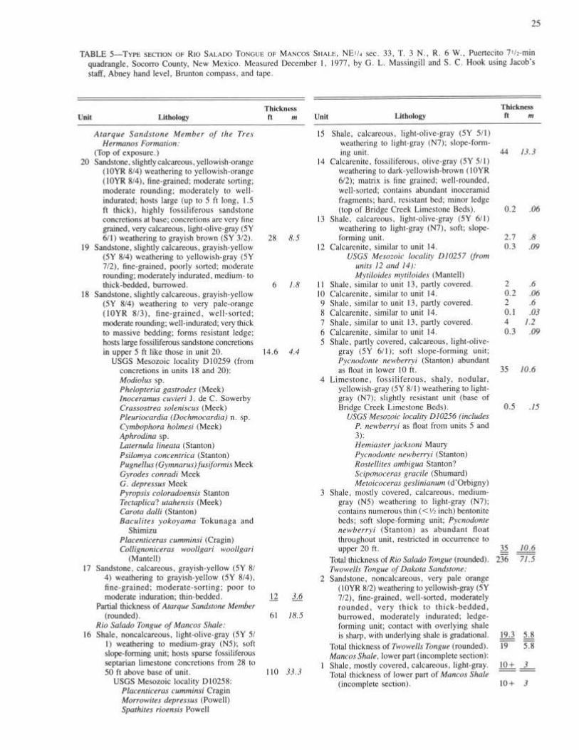
The Bridge Creek Limestone Member is the uppermost of the three members of the Greenhorn Formation.
The calcareous-noncalcareous contact near the middle of the Rio Salado has been regarded as the Greenhorn–Carlile time-stratigraphic boundary (Molenaar, 1977). In west-cen-tral New Mexico, this contact is diachronous—it can lie as low as the Mammites nodosoides Zone or as high as the Collignoniceras woollgari woollgari Subzone—and it is al-ways older than the Greenhorn–Carlile contact in the type locality in southeast Colorado, which lies in the younger Collignoniceras woollgari regulare Subzone. In addition, the Greenhorn–Carlile lithostratigraphic contact in the type locality is between limestone and calcareous shale, not be-tween calcareous shale and noncalcareous shale.
Hook and Cobban (1981b) formally extended the name Bridge Creek Limestone into southern New Mexico as a member locally of the Colorado Formation and locally of the Mancos Shale. They preferred the name Bridge Creek Limestone Member to Greenhorn Limestone Member be-cause it more accurately conveyed the stratigraphic and bio-stratigraphic relationships of these rocks to the Bridge Creek Member of the Greenhorn Formation of southeast Colorado. We are following Hook and Cobban's lead and extending the Bridge Creek into west-central New Mexico where it is reduced in stratigraphic rank to the Bridge Creek Limestone Beds of the Rio Salado Tongue. At Carthage, however, the limestone unit is designated as the Bridge Creek Limestone Member of the Mancos Shale (sheet 1–B, in back pocket).
The base of the Bridge Creek Limestone Beds is at the base of the lowest persistent bed of nodular to chalky lime-stone. This limestone is usually 2-6 inches (5-15 cm) thick and is 5-40 ft (2-12 m) above the top of the Twowells Tongue of the Dakota Sandstone. The top of the Bridge Creek Limestone Beds is placed at the uppermost persistent bed of limestone, generally a 2-4-inch (5-10-cm)-thick bed of calcarenite composed of Inoceramus or oyster debris. Although calcareous shale is the dominant lithology, hard resistant limestones are more conspicuous in outcrops and generally stand in topographic relief above the softer shales. Both the Bridge Creek Limestone Beds and the overlying calcareous-noncalcareous shale contact ("top of the Green
horn Limestone") produce distinctive patterns that are easily recognized on electrical resistivity logs of wells.
At the type section of the Rio Salado Tongue, the Bridge Creek Limestone Beds are 47 ft (14 m) thick, consist of units 4 through 14 of the descriptive section (table 5), and are 35 ft (11 m) above the top of the Twowells Tongue. Throughout the area of west-central New Mexico shown on sheet 1 (in back pocket) and in figs. 3 and 4, the Bridge Creek Limestone Beds are 30-60 ft (10-20 m) thick.
The base of the Bridge Creek Limestone Beds in west-central New Mexico always lies within the late Cenomanian Sciponoceras gracile Zone and is regarded as an isochronous surface by Hook and Cobban (1981b). The top, however, is diachronous and can lie as low as the Pseudaspidoceras flexuosum Zone of latest Cenomanian or earliest Turonian age or as high as the late early Turonian Mammites nodosoides Zone (fig. 7).
A g e
The Rio Salado Tongue of the Mancos Shale ranges in age from late Cenomanian to early middle Turonian. Fossils collected from the basal few feet of the tongue in the Acoma Basin include the oyster Pycnodonte aff. P. kellumi (Jones), which is indicative of the late Cenomanian Metoicoceras mosbyense Zone. The Sciponoceras gracile Assemblage Zone, which includes Metoicoceras geslinianum (d'Orbigny), Euomphaloceras (Kanabiceras) septemseriatum (Cragin), and Pycnodonte newberryi (Stanton), appears almost every-where in the base of the Bridge Creek Limestone Beds. This assemblage zone was formally used to mark the top of the Cenomanian Stage. Concretions from the upper noncalcar-eous part of the Rio Salado Tongue have yielded Collig-noniceras woollgari woollgari (Mantell) and Morrowites depressus (Powell), both of early middle Turonian age.
The age of the Rio Salado at any locality is, of course, dependent on the ages of both the underlying Twowells Tongue and the overlying Tres Hermanos Formation (or Atarque Sandstone). The top of the Twowells Tongue over much of west-central New Mexico is virtually synchronous (Hook and others, 1980) and lies within the upper part of
27
the Metoicoceras mosbyense Zone. However, near the Ari-zona border at Cottonwood Canyon, 32 mi (51 km) south-west of Fence Lake, the top of the Twowells contains the ammonite Pseudaspidoceras and is at least three faunal zones younger than the M. mosbyense Zone. The Atarque Sandstone at Cottonwood Canyon contains Morrowites subdepressus Cobban and Hook of Mammites nodosoides age, thus approximately bracketing the Rio Salado Tongue between the late early Turonian M. nodosoides Zone and the late Cenomanian Neocardioceras juddii Zone.
The top of the Rio Salado Tongue becomes younger north-east of Cottonwood Canyon because of the stratigraphic rise of the Atarque Sandstone (and Member) and ranges in age from late early Turonian to early middle Turonian. At Par-adise Canyon, 7 mi (11 km) southwest of Acoma Pueblo, the base of the Atarque Member lies in the early middle Turonian Collignoniceras woollgari regulare Subzone.
Discontinuity surfaces and disconformities
Hook and Cobban (1981b) documented paleontologically the existence of three discontinuity surfaces within rocks of the Bridge Creek Limestone Member of the Colorado Shale in the Cooke's Range. We have not yet been able to dem-onstrate them within the Bridge Creek Limestone Beds of the Rio Salado Tongue. However, we have collected oyster-and bryozoan-encrusted internal molds of Morrowites depressus (Powell) of Cobban and Hook (1983) from the upper part of the Rio Salado Tongue at Puertecito, D Cross Mountain, and Fence Lake. Some of these molds have been mineralized by iron; most have been broken or show evidence of erosion. Those from Fence Lake have a composition which differs from that of the surrounding concretion. In addition, at each locality the molds are concentrated into a single bed. Hook and Cobban (1981b) suggested that these molds of Morrowites depressus (Powell) may have been concentrated on a widespread, submarine erosion surface that extended at least from Capitan on the east to Fence Lake on the west.
Mappability
The Rio Salado Tongue of the Mancos Shale is present over much of west-central New Mexico wherever both the overlying Tres Hermanos Formation (or Atarque Sandstone) and the underlying Twowells Tongue of the Dakota Sand-stone are present. The Rio Salado Tongue has been mapped in most of the areas that the Tres Hermanos Formation has been mapped (see page 23, this report). S. L. Moore (per-sonal communication, 1981) has mapped it in the northern
Acoma Basin, Osburn (1982, 1983) in the southern Acoma Basin, and McLellan and others (personal communication, 1981) and Anderson (1981, 1982) in the southern Zuni Ba-sin.
East of Puertecito, the Twowells Tongue of the Dakota Sandstone pinches out into the Mancos Shale. Although both time and lithologic equivalents of the Rio Salado Tongue can be recognized from Riley to Carthage to Truth or Consequences, the Rio Salado Tongue cannot be differentiated out of this larger body of shale that extends from the top of the main body of the Dakota Sandstone to the base of the Tres Hermanos Formation. In those areas, strata equivalent to the Rio Salado are included within the undifferentiated Mancos Shale. However, individual limestones within the Bridge Creek Limestone Beds of the Rio Salado Tongue can be traced in continuous outcrop from Puertecito to Riley and correlated with equivalent beds at Carthage and Truth or Consequences.
Characteristic fauna
The Rio Salado Tongue of the Mancos Shale is almost exactly the same age as the entire Bridge Creek Limestone Member at the type locality of the Greenhorn Formation near Pueblo, Colorado, and is characterized by many of the same species of fossils. The easily recognizable oyster Pycnodonte newberryi (Stanton) occurs in great abundance in shales and limestones near the base of the tongue along with the ammonites Worthoceras gibbosum Moreman, Sciponoceras gracile (Shumard), and Euomphaloceras (Kanabiceras) septemseriatum (Cragin). Illustrations and descriptions of these species can be found in Cobban and Scott (1972) and Hook and Cobban (1977).
The middle part of the Rio Salado Tongue is characterized by the inoceramid Mytiloides mytiloides (Mantell), which occurs in great abundance, although generally fragmented, in the calcarenite beds at the top of the Bridge Creek Limestone Beds. Illustrations of this species can be found in Kauffman (1977, pl. 6, figs. 6 and 7).
Ammonites are the dominant group of mollusks that occur in concretions in the upper part of the Rio Salado Tongue. Cobban and Hook (1979a) listed 10 species of ammonites from this interval. Since then, several more have been iden-tified, including a new genus that occurs abundantly in the Fence Lake area; these will be described in another report. This fauna includes Mammites nodosoides (Schlüter), Mor-rowites depressus (Powell), Spathites rioensis Powell, and Collignoniceras woollgari woollgari (Mantell). Illustrations and descriptions of all these species can be found in Cobban and Hook (1979a, 1983).
References

PRINCIPAL REFERENCE SECTION AND
CORRELATION OF GALLUP SANDSTONE,
NORTHWESTERN NEW MEXICO by C. M. Molenaar, U.S. Geological Survey, Denver, Colorado
Abstract
Because a type section has never been designated for the Gallup Sandstone, a principal reference section is herein designated 2 mi (3 km) east of Gallup, New Mexico. At the principal reference section, the Gallup Sandstone is 332 ft (101 m) thick and consists of offshore marine sandstones and marine shale tongues in the lower part that grade up to shoreface or coastal shoreline sandstone in the middle part and to nonmarine carbonaceous shale and fluvial sand-stones in the upper part. The upper medium- to coarse-grained fluvial sandstone unit is called the Torrivio Member. The Gallup overlies and intertongues with the underlying Mancos Shale and is overlain, at least locally unconformably, by the upper Mancos Shale in areas of its northeastern extent. To the southwest of the San Juan Basin, the Gallup is overlain by the nonmarine Crevasse Canyon Formation. Strata below the Pescado or D-Cross Tongues of the Mancos in the Zuni and Acoma Basins and formerly referred to as lower part of Gallup by Pike (1947) and Atarque Member of Gallup by Molenaar (1973, 1974) are herein excluded from the Gallup and are now assigned to the newly defined Tres Hermanos Formation. Also recommended is that the name "Gallego Sandstone" of the southern Acoma Basin be abandoned, inasmuch as it is equivalent to the Gallup Sandstone. As defined, the Gallup Sandstone can be recognized over a wide area of northwest and south-central New Mexico.
Introduction The Gallup Sandstone (Upper Cretaceous) of northwest
New Mexico is a well-known regressive marine and non-marine sequence that was deposited during a regional regres-sion in late Turonian to early Coniacian time. The Gallup overlies and intertongues with the underlying Mancos Shale and is overlain, at least locally unconformably, by the lower part of the upper Mancos Shale in areas of its northeast extent. Southwest of the San Juan Basin, the Gallup is overlain by the nonmarine Crevasse Canyon Formation.
The name "Gallup Sandstone Member of the Mesaverde Formation" was first applied by Sears (1925, p. 17) to a mappable sequence of rocks near Gallup, New Mexico. Later, the Gallup nomenclature was extended throughout northwest and west-central New Mexico, and in 1956, Beaumont, Dane, and Sears raised the Gallup Sandstone from a member to a formation and the Mesaverde from a formation to a group.
The inclusion of the Gallup Sandstone, as well as the Crevasse Canyon Formation and older units in west-central New Mexico, in the Mesaverde Group is extending the term Mesaverde to much older rocks in areas far beyond the area where the Mesaverde was originally defined. At this time, I am excluding the Gallup, Crevasse Canyon, and older rocks from the Mesaverde Group. This problem, however, warrants further discussion with other workers in the area.
Because Sears did not designate a type section of the Gallup Sandstone (a not uncommon practice in those days) and because the Gallup nomenclature has been misapplied and miscorrelated in some areas, the purpose of this report is twofold—first, to designate and describe a principal ref-erence section for the Gallup, and second, to show the correlation of the Gallup in northwest New Mexico. The reference section is in the SE 1/4 NE 1/4 sec. 13, T. 15 N., R. 18 W. on the north side of Puerco Gap 2 mi (3 km) east of the city of Gallup (figs. 9 and 10). The Santa Fe Railroad line, US-66, and the Puerco River pass through this gap
just south of the reference section. The new highway cut of 1-40 is approximately 600-900 ft (180-275 m) north of the reference section. Six stratigraphic cross sections are in-cluded to show the internal variations and correlations of the Gallup Sandstone throughout the area (fig. 10).
This report is an interim progress report; a more extensive stratigraphic and biostratigraphic study of mid-Cretaceous strata throughout western New Mexico is planned.
Much of the field work on which this report is based was done while the writer was working for Shell Oil Company. The writer gratefully acknowledges Shell for permission to publish this material. J. E. Fassett and A. R. Kirk of the U.S. Geological Survey critically reviewed this report.
2 9


Principal reference section and definition of Gallup Sandstone
Sears (1925, p. 17) described the Gallup Sandstone as consisting of three massive sandstone beds interbedded with shale and coal and ranging from 180 to 250 ft (55 to 76 m) in thickness. In addition, he stated that the Gallup was well exposed along The Hogback east of Gallup. On a photograph taken by N. H. Darton in 1901, Sears (1925, pl. V) shows the Gallup Sandstone, with contacts annotated, as it is exposed at a gap in The Hogback 2 1/2 mi (4 km) northeast of Gallup (C S1/2 S1/2 sec. 1, T. 15 N., R. 18 W.). This photograph was used in subsequent reports to show the "type" area of the Gallup Sandstone (Sears and others, 1941, pl. 27—B; O'Sullivan and others, 1972, fig. 12).
The principal reference section of this report is 11/2 mi (2 1/2 km) south of Darton's photograph locality (fig. 9). The exposures are considered to be better, and more of the lower part of the section is exposed at the reference locality. This section was measured and described by the writer and R. L. Squires in 1968, and was included in a paper by Molenaar (1973, p. 101). Table 8 is a detailed lithologic description of the principal reference section. In addition, fig. 11 is a photograph and fig. 12 is a graphic representation of the section. Also shown are the relationships of the units Sears described. In his original description, Sears referred to three massive prominent sandstone beds that crop out on The Hogback as shown in Darton's photograph. The lower sand-stone bed is pink and, at the reference locality, is split by a 10-ft-thick silty shale tongue into two sandstone units. This shale tongue is not present in the area of Darton's photograph, possibly because of tectonic elimination or faulting along the steeply dipping monocline. The shale tongue is present again a short distance farther north. The medial sandstone bed referred to by Sears is buff or light gray and is the uppermost marine sandstone in the section. The upper sandstone bed is red or pink and is a coarse-grained nonmarine fluvial unit. This unit was named the Torrivio Sandstone Member of the Gallup by Molenaar (1973, p. 98; to be discussed).
An underlying sandstone bed was not included in the Gallup by Sears, probably because it is so poorly exposed in the immediate area and thus was difficult to map. How-ever, this sandstone bed is a prominent bed to the south and east of the Gallup area and is herein included in the Gallup. This bed already has been included in the Gallup in pub
lished U.S. Geological Survey quadrangle maps along the southern flank of the San Juan Basin where it has been referred to as a lower sandstone or tongue of Gallup (Kirk and others, 1978, p.32). In areas to the south and southeast of the type area, it is the first major sandstone unit above the widespread Pescado Tongue or D-Cross Tongue of the Mancos Shale of the Zuni and Acoma Basins, respectively, and is the basal sandstone of a major regressive cycle of deposition. Thus, it defines the base of the Gallup Sandstone in areas south and southeast of the San Juan Basin. From the outcrop belt east of Gallup to the northeastward pinchout or termination of the Gallup Sandstone in the San Juan Basin, the base of the Gallup is placed at the first prominent sandstone unit above the Juana Lopez Member of the Man-cos Shale. The Juana Lopez is a series of distinctive cal-carenite beds of early late Turonian age (figs. 13-17).
The top of the Gallup is retained as originally defined by Sears, which in the Gallup area is a prominent pink fluvial sandstone (Torrivio Member). In areas where this fluvial sandstone is not present, such as in the southeast San Juan Basin, Acoma Basin, and the Carthage area, the top of the Gallup is placed at the top of the highest regressive shoreface sandstone, which is usually a prominent, resistant, cliff-forming unit (figs. 14, 17, and 18).

34
As thus defined, the Gallup Sandstone comprises a se-quence of strata that can be recognized and mapped over a wide area (fig. 10). Where the map scale permits, the marine shale tongues that separate the sandstone beds in the lower part of the Gallup can be mapped as tongues of Mancos Shale. The nonmarine shale tongue in the upper part of the Gallup can be mapped as a tongue of the Crevasse Canyon Formation.
Torrivio Member of Gallup Sandstone
The Torrivio Sandstone Member of the Gallup Sandstone was proposed by Molenaar (1973) for the upper pink fluvial sandstone unit of the Gallup. Herein recommended is that it be known as the Torrivio Member (without the word "Sandstone"). It was named for exposures of the unit on and around Torrivio Mesa approximately 8 mi (13 km) west-southwest of Gallup. The type section is designated at the principal reference section of the Gallup, where its rela-tionships with the remainder of the Gallup and the overlying Dilco Coal Member of the Crevasse Canyon Formation are clearly shown either in the section or in the immediate area. The Torrivio is a medium- to coarse-grained, crossbedded fluvial sandstone unit that can be distinguished from other sandstone units above and below by its coarse-grained tex-ture. It consists of as many as three sandstone beds separated by interchannel carbonaceous shale, siltstone, fine-grained sandstone, and minor coal beds. In the Gallup area and south, the Torrivio is mostly red or pink, but along the south flank of the San Juan Basin and north of Todilto Park along the west side, it is generally buff or light gray. The total unit ranges in thickness from more than 100 ft (30 m) to a pinchout edge 48 mi (77 km) east of Gallup (fig. 14). It
pinches out between nonmarine beds of the Dilco Coal Member of the Crevasse Canyon Formation and nonmarine beds of the Gallup Sandstone. Where that occurs, the top of the Gallup arbitrarily drops down to the top marine sand-stone, and the nonmarine beds are mapped as Dilco (fig. 14).
Kirk and others (1978), who have mapped many of the 1:24,000-scale quadrangle maps along the southern flank of the San Juan Basin, suggested alternate ways in which the Gallup could be redefined. They thought it would be more reasonable to place the top of the Gallup at the top of the highest marine sandstone and to include the Torrivio and associated nonmarine rocks in the overlying Crevasse Can-yon Formation. Genetically, this assignment makes a more meaningful contact. Also, the top marine sandstone is a more consistent unit to map in the subsurface (fig. 16). However, the top of the Torrivio Member fits the criterion of mappability better in much of the outcrop area, especially in areas south and west of Gallup, where stratigraphic details of the marine section are more complex (figs. 14, 15, and 18). The top marine sandstone in some of those areas is difficult to differentiate without close inspection. Also, the top of the Torrivio has been used extensively in the past for the top of the Gallup. Both sides of the argument as to whether or not the Gallup Sandstone should be redefined have merits. To resolve these differences, a meeting attended by numerous interested participants was held in Denver, Colorado, on February 2, 1978, under the auspices of the Geologic Names Committee (GNC) of the U.S. Geological Survey. As a result of this meeting, the GNC recommended that the upper coarse-grained pink sandstone described by Sears (1925), the Torrivio Member of Molenaar (1973), be retained as the top of the Gallup Sandstone.

Correlations and relationships of underlying and overlying formations
Six stratigraphic cross sections show the internal corre-lations and facies of the Gallup Sandstone and adjacent strata in the San Juan, Acoma, and Zuni Basins (figs. 13-18). These sections are revisions or modifications from Molenaar (1973, 1974). Additional field work resulted in the correction of two previous miscorrelations; one on the section from Moreno Hill to the Gallup area (between control points 31 and 32A in fig. 13) and the other on the section from the western Acoma Basin to the southeastern San Juan Basin (between control points 53B and 61B in fig. 17). Inasmuch as these cross sections include new or revised stratigraphic terminology described in accompanying reports in this volume, brief definitions of these units follow.
To the south and southeast of Gallup, marine and non-
marine strata below the Pescado and D-Cross Tongues of the Mancos that were formerly referred to as lower Gallup or Atarque Member of the Gallup by Molenaar (1973, 1974) and lower part of Gallup or Atarque Member of the Mesa-verde Formation (subsequently raised to group status) by Pike (1947, p. 35) are now included in the Tres Hermanos Formation. In addition, the Tres Hermanos has been sub-divided into three members which, in ascending order, are Atarque Sandstone Member, Carthage Member, and Fite Ranch Sandstone Member, as shown on the cross sections (figs. 13, 17, and 18). See Hook, Molenaar, and Cobban (this volume) for details on the Tres Hermanos Formation.
In areas of west-central and southwest New Mexico where the Pescado and D-Cross Tongues have pinched out, the
35
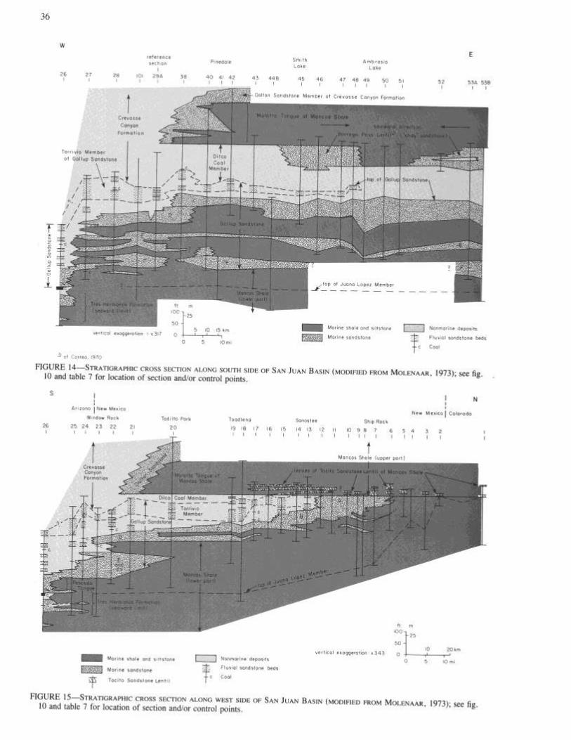
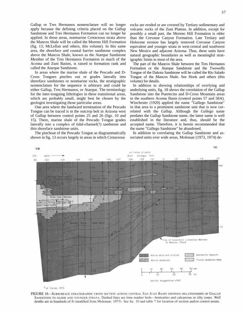
37
Gallup or Tres Hermanos nomenclature will no longer apply because the defining criteria placed on the Gallup Sandstone and Tres Hermanos Formation can no longer be applied. In those areas, nonmarine Cretaceous strata above the Mancos Shale will be called the Moreno Hill Formation (fig. 13; McLellan and others, this volume). In this same area, the shoreface and coastal barrier sandstone complex above the Mancos Shale, known as the Atarque Sandstone Member of the Tres Hermanos Formation in much of the Acoma and Zuni Basins, is raised to formation rank and called the Atarque Sandstone.
In areas where the marine shale of the Pescado and D-Cross Tongues pinches out or grades laterally into shoreface sandstones or nonmarine rocks, the stratigraphic nomenclature for the sequence is arbitrary and could be either Gallup, Tres Hermanos, or Atarque. The terminology for the inter-tonguing lithologies in these transitional areas, which are probably small, might best be chosen by the geologist investigating those particular areas.
One area where the landward termination of the Pescado Tongue can be traced is in the outcrop belt in Arizona west of Gallup between control points 25 and 26 (figs. 10 and 15). There, marine shale of the Pescado Tongue grades laterally into a complex of tidal-channel(?) sandstone and thin shoreface sandstone units.
The pinchout of the Pescado Tongue as diagrammatically shown in fig. 13 occurs largely in areas in which Cretaceous
rocks are eroded or are covered by Tertiary sedimentary and volcanic rocks of the Zuni Plateau. In addition, except for possibly a small part, the Moreno Hill Formation is older than the Crevasse Canyon Formation. Late Tertiary and Holocene erosion has largely removed Crevasse Canyon equivalent and younger strata in west-central and southwest New Mexico and adjacent Arizona. Thus, these units have natural geographic boundaries as well as meaningful strat-igraphic limits in most of the area.
The part of the Mancos Shale between the Tres Hermanos Formation or the Atarque Sandstone and the Twowells Tongue of the Dakota Sandstone will be called the Rio Salado Tongue of the Mancos Shale. See Hook and others (this volume) for details.
In addition to showing relationships of overlying and underlying units, fig. 18 shows the correlation of the Gallup Sandstone into the Puertecito and D-Cross Mountain areas in the southern Acoma Basin (control points 57 and 58A). Winchester (1920) applied the name "Gallego Sandstone" in that area to a prominent sandstone unit that is now cor-related with the Gallup. Although the Gallego name predates the Gallup Sandstone name, the latter name is well established in the literature and, thus, should be the accepted name. Therefore, it is herein recommended that the name "Gallego Sandstone" be abandoned.
In addition to correlating the Gallup Sandstone and as-sociated units over wide areas, Molenaar (1973, 1974) de-
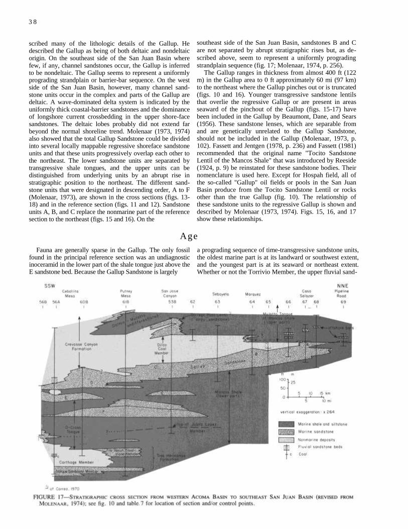
3 8
scribed many of the lithologic details of the Gallup. He described the Gallup as being of both deltaic and nondeltaic origin. On the southeast side of the San Juan Basin where few, if any, channel sandstones occur, the Gallup is inferred to be nondeltaic. The Gallup seems to represent a uniformly prograding strandplain or barrier-bar sequence. On the west side of the San Juan Basin, however, many channel sand-stone units occur in the complex and parts of the Gallup are deltaic. A wave-dominated delta system is indicated by the uniformly thick coastal-barrier sandstones and the dominance of longshore current crossbedding in the upper shore-face sandstones. The deltaic lobes probably did not extend far beyond the normal shoreline trend. Molenaar (1973, 1974) also showed that the total Gallup Sandstone could be divided into several locally mappable regressive shoreface sandstone units and that these units progressively overlap each other to the northeast. The lower sandstone units are separated by transgressive shale tongues, and the upper units can be distinguished from underlying units by an abrupt rise in stratigraphic position to the northeast. The different sand-stone units that were designated in descending order, A to F (Molenaar, 1973), are shown in the cross sections (figs. 13-18) and in the reference section (figs. 11 and 12). Sandstone units A, B, and C replace the nonmarine part of the reference section to the northeast (figs. 15 and 16). On the
southeast side of the San Juan Basin, sandstones B and C are not separated by abrupt stratigraphic rises but, as de-
scribed above, seem to represent a uniformly prograding strandplain sequence (fig. 17; Molenaar, 1974, p. 256).
The Gallup ranges in thickness from almost 400 ft (122 m) in the Gallup area to 0 ft approximately 60 mi (97 km) to the northeast where the Gallup pinches out or is truncated (figs. 10 and 16). Younger transgressive sandstone lentils that overlie the regressive Gallup or are present in areas seaward of the pinchout of the Gallup (figs. 15-17) have been included in the Gallup by Beaumont, Dane, and Sears (1956). These sandstone lenses, which are separable from and are genetically unrelated to the Gallup Sandstone, should not be included in the Gallup (Molenaar, 1973, p. 102). Fassett and Jentgen (1978, p. 236) and Fassett (1981) recommended that the original name "Tocito Sandstone Lentil of the Mancos Shale" that was introduced by Reeside (1924, p. 9) be reinstated for these sandstone bodies. Their nomenclature is used here. Except for Hospah field, all of the so-called "Gallup" oil fields or pools in the San Juan Basin produce from the Tocito Sandstone Lentil or rocks other than the true Gallup (fig. 10). The relationship of these sandstone units to the regressive Gallup is shown and described by Molenaar (1973, 1974). Figs. 15, 16, and 17 show these relationships.
Age
Fauna are generally sparse in the Gallup. The only fossil found in the principal reference section was an undiagnostic inoceramid in the lower part of the shale tongue just above the E sandstone bed. Because the Gallup Sandstone is largely
a prograding sequence of time-transgressive sandstone units, the oldest marine part is at its landward or southwest extent, and the youngest part is at its seaward or northeast extent. Whether or not the Torrivio Member, the upper fluvial sand-
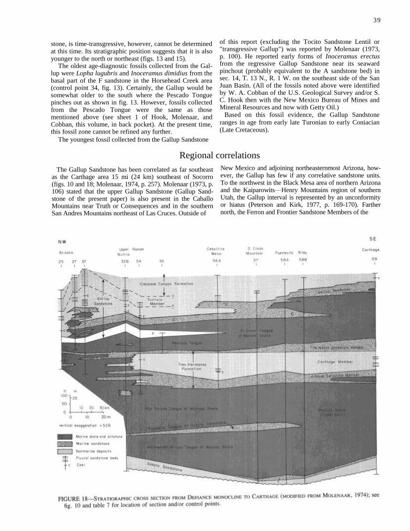
39
stone, is time-transgressive, however, cannot be determined at this time. Its stratigraphic position suggests that it is also younger to the north or northeast (figs. 13 and 15).
The oldest age-diagnostic fossils collected from the Gal-lup were Lopha lugubris and Inoceramus dimidius from the basal part of the F sandstone in the Horsehead Creek area (control point 34, fig. 13). Certainly, the Gallup would be somewhat older to the south where the Pescado Tongue pinches out as shown in fig. 13. However, fossils collected from the Pescado Tongue were the same as those mentioned above (see sheet 1 of Hook, Molenaar, and Cobban, this volume, in back pocket). At the present time, this fossil zone cannot be refined any further.
The youngest fossil collected from the Gallup Sandstone
of this report (excluding the Tocito Sandstone Lentil or "transgressive Gallup") was reported by Molenaar (1973, p. 100). He reported early forms of Inoceramus erectus from the regressive Gallup Sandstone near its seaward pinchout (probably equivalent to the A sandstone bed) in sec. 14, T. 13 N., R. 1 W. on the southeast side of the San Juan Basin. (All of the fossils noted above were identified by W. A. Cobban of the U.S. Geological Survey and/or S. C. Hook then with the New Mexico Bureau of Mines and Mineral Resources and now with Getty Oil.)
Based on this fossil evidence, the Gallup Sandstone ranges in age from early late Turonian to early Coniacian (Late Cretaceous).
Regional correlations
The Gallup Sandstone has been correlated as far southeast as the Carthage area 15 mi (24 km) southeast of Socorro (figs. 10 and 18; Molenaar, 1974, p. 257). Molenaar (1973, p. 106) stated that the upper Gallup Sandstone (Gallup Sand-stone of the present paper) is also present in the Caballo Mountains near Truth or Consequences and in the southern San Andres Mountains northeast of Las Cruces. Outside of
New Mexico and adjoining northeasternmost Arizona, how-ever, the Gallup has few if any correlative sandstone units. To the northwest in the Black Mesa area of northern Arizona and the Kaiparowits—Henry Mountains region of southern Utah, the Gallup interval is represented by an unconformity or hiatus (Peterson and Kirk, 1977, p. 169-170). Farther north, the Ferron and Frontier Sandstone Members of the

4 0
Mancos Shale of northeast Utah are overlain by a shale which in its basal part is Juana Lopez (early late Turonian) in age (Molenaar, 1975, p. 191). The lower part of this shale is probably equivalent to the Pescado or D-Cross Tongue. However, fauna of Coniacian Age occur approximately 100 ft (30 m) above the base of the shale, and no perceptible break in sedimentation in the intervening strata exists. Thus, the Gallup Sandstone probably was restricted in areal extent
to parts of New Mexico, northeast Arizona, and possibly southern Utah prior to Tertiary and Holocene erosion. The Gallup is a regressive clastic wedge derived from an active provenance in southern or southwest Arizona at a time when the land area bounding the west side of the Western Interior seaway farther north was generally subdued and was relatively inactive as a major source area (Molenaar, 1973, p. 106).
References
Beaumont, E. C., Dane, C. H., and Sears, J. D., 1956, Revised nomenclature of the
Mesaverde Group in San Juan Basin, New Mexico: American Association of
Petroleum Geologists, Bull., v. 40, no. 9, p. 2,149-2,162
Correa, A. C., 1970, Borrego Pass Lentil, a new member of the Crevasse Canyon
Formation, southern San Juan Basin, New Mexico: The Mountain Geologist, v. 7,
no. 2, p. 99-102
Fassett, J. E., 1981, Upper Cretaceous Tocito Sandstone Lentil of Mancos Shale, San
Juan Basin, New Mexico—Is there any oil left? [abs.]: American Association of
Petroleum Geologists, Bull., v. 65, no. 3, p. 559
Fassett, J. E., and Jentgen, R. W., 1978, Blanco Tocito, South, in Oil and gas fields of the Four Corners area: Four Corners Geological Society, p. 233-240
Kirk, A. R., Huffman, A. C., Jr., Zech, R. S., Robertson, J. F., and Jackson, T. J.,
1978, Review of the history of usage of the Gallup Sandstone and related units,
southern and western San Juan Basin, New Mexico: U.S. Geological Survey,
Open-file Rept. 78-1055, 51 p. Molenaar, C. M., 1973, Sedimentary facies and correlation of the Gallup Sandstone
and associated formations, northwestern New Mexico, in Cretaceous and Tertiary
rocks of the southern Colorado Plateau, J. E. Fassett, ed.: Four Corners Geological
Society, Mem., p. 85-110
, 1974, Correlation of the Gallup Sandstone and associated formations, Upper
Cretaceous, eastern San Juan and Acoma Basins, New Mexico: New Mexico
Geological Society, Guidebook 25th field conference, p. 251-258
________ , 1975, Some notes on Upper Cretaceous stratigraphy of the Paradox Basin:
Four Corners Geological Society, Guidebook 8th field conference, p. 191-192
O'Sullivan, R. B., Repenning, C. A., Beaumont, E. C., and Page, H. G., 1972,
Stratigraphy of the Cretaceous rocks and the Tertiary Ojo Alamo Sandstone, Navajo
and Hopi Indian Reservations, Arizona, New Mexico, and Utah: U.S. Geological
Survey, Prof. Paper 521-E, 65 p.
Peterson, Fred, and Kirk, A. R., 1977, Correlation of the Cretaceous rocks in the
San Juan, Black Mesa, Kaiparowits, and Henry Basins, southern Colorado Plateau:
New Mexico Geological Society, Guidebook 28th field conference, p. 185-192
Pike, W. S., Jr., 1947, Intertonguing marine and nonmarine Upper Cretaceous de-
posits of New Mexico, Arizona, and southwestern Colorado: Geological Society of
America, Mem. 24, 103 p.
Reeside, J. B., Jr., 1924, Upper Cretaceous and Tertiary formations of the western
part of the San Juan Basin, Colorado and New Mexico: U.S. Geological Survey,
Prof. Paper 134, p. 1-70
Sears, J. D., 1925, Geology and coal resources of the Gallup-Zuni Basin: U.S. Geological Survey, Bull. 767, 53 p.
Sears, J. D., Hunt, C. B., and Hendricks, T. A., 1941, Transgressive and regressive Cretaceous deposits in southern San Juan Basin, New Mexico: U.S. Geological Survey, Prof. Paper 193-F, p. 101-121
Winchester, D. E., 1920, Geology of the Alamosa Creek valley, Socorro County,
New Mexico, with a special reference to the occurrence of oil and gas: U.S.
Geological Survey, Bull. 716-A, 15 p.

4 1
MIDDLE TURONIAN AND YOUNGER CRETACEOUS
ROCKS, NORTHERN SALT LAKE COAL FIELD, CIBOLA
AND CATRON COUNTIES, NEW MEXICO by Marguerite McLellan, Laura Haschke, Laura Robinson, M. Deveraux Carter, and Antoinette Medlin,
U.S. Geological Survey, Denver, CO, and Reston, VA
Introduction
The Cretaceous rocks in the Salt Lake coal field of western
New Mexico that formerly were lumped as the Mesaverde
Group are revised to include, in ascending order, the Atarque
Sandstone (of formation rank in the Salt Lake coal field) and
the Moreno Hill Formation (new name). These names replace
previously used less definitive terminology. Recent geologic
mapping and stratigraphic and paleontological studies allow
local and regional understanding of the marginal marine
sandstone—the Atarque Sandstone—that Pike (1947) named
Atarque Member of the Mesaverde Formation for exposures
northeast of Atarque, and of the nonmarine coal-bearing
Moreno Hill Formation. This paper describes the stratigraphy
and lithology of these units which formerly were referred to
as the Mesaverde Group, undivided (Dane
and Bachman, 1965). These names will be applied to map
units in the Salt Lake coal field and adjoining areas.
Geologic study and mapping of the Moreno Hill, Fence
Lake SW, Fence Lake, and Rincon Hondo 7 1/2-min quad-
rangles, Cibola and Catron Counties, New Mexico (figs. 19
and 20), were done by the U.S. Geological Survey during
the summers of 1978, 1979, and 1980 (McLellan and
others, 1983; Landis and others, in preparation; McLellan,
Robinson, and Haschke, 1983; and McLellan, Haschke, and
Robinson, 1982). This work is part of a cooperative study
of eight 7 1/2-min quadrangles in the Zuni Basin and Salt
Lake coal field (fig. 19) being made by the New Mexico
Bureau of Mines and Mineral Resources and the U.S. Geo-
logical Survey.
The Atarque and Moreno Hill rocks in the Salt Lake coal
field previously had not been studied in detail.
Thirty-three stratigraphic sections of Cretaceous and Ter-
tiary rocks were measured and described on the south- and
east-facing cliffs of the Zuni Plateau and Santa Rita Mesa
in the Moreno Hill and Fence Lake SW quadrangles (fig.
20). Seven of these measured sections are shown as a west-
to-east cross section (fig. 21). Fossils were collected from
the lower parts of the sections and were identified by W. A.
Cobban, Norman F. Sohl, and G. Edward Lewis of the U.S.
Geological Survey.
Geologic setting
The area of most detailed stratigraphic study is approx-
imately 6 mi southwest of Fence Lake, New Mexico (fig. 19).
Rocks of Triassic through Quaternary age are present in the
area. The highest topographic features, the Zuni Plateau and
Santa Rita Mesa, which are about 7,500 ft (2,273 m) in
elevation, are covered by pinion and juniper trees and are
dissected by many canyons. Below approximately 6,900 ft
(2,091 m), the land supports sparse grass, cactus, sage brush,
and tumbleweed.
The stratigraphic units described in this paper are under-
lain by the Rio Salado Tongue (Hook and others, this vol-
ume) of the Mancos Shale of Late Cretaceous (late
Cenomanian to middle Turonian) age and are overlain un-
conformably by fluvial rocks of probable Miocene age. Only
200 ft (61 m) of Atarque and Moreno Hill remain below the
cemented Tertiary gravel of the Fence Lake Formation
(McLellan and others, 1982) in the westernmost section
(section A, figs. 20 and 21) measured in Moreno Hill quad-
rangle, in sec. 31, T. 5 N., R. 19 W. The Atarque and
Moreno Hill rocks dip less than 1° to the northeast and are
offset by a few faults.


Proposed stratigraphic names
A type section for the Moreno Hill Formation (section D, figs. 20 and 21) and a principal reference section for the Atarque Sandstone have been established at Moreno Hill, secs. 7 and 6, T. 4 N., R. 18 W., where 617 ft (187 m) of Atarque Sandstone and Moreno Hill Formation were measured. The lower 98 ft (30 m) of these rocks, belonging to the Atarque, consists of regressive, shallow-water-ma-rine, mostly flat-bedded sandstones, siltstones, and shale. Fossils were collected and identified from these rocks. The upper 519 ft (157 m), belonging to the Moreno Hill, is composed of fluvial crossbedded sandstones, siltstones, shales, carbonaceous shales, and thin coal beds. This measured section has close to the maximum amount of Atarque and Moreno Hill rocks exposed within the Moreno Hill quadrangle.
Rocks now named Atarque Sandstone and Moreno Hill Formation, previously referred to as Mesaverde in the Zuni—Salt Lake area, are similar in appearance to those known as Mesaverde in the Gallup area; however, they are much lower in the stratigraphic section and are older. Moreover, a much greater proportion of these rocks is of fluvial origin. In order to better describe the lithology and stratigraphic relations of these rocks, we are dividing them on the basis of origin and revising and naming them.
Atarque Sandstone
The lower 98 ft of measured section D, which is of shal-low-water-marine origin, is assigned to the Atarque Sand-stone. This name is a revision of the upper contact of the Atarque and a change of stratigraphic rank for the rocks that Pike (1947, p. 13, 35; pls. 11, 12) named the Atarque Member of the Mesaverde Formation. He applied the name to all rocks from the base of the lowest regressive sandstone of the Mesaverde to the base of what he called the marine-deposited Horsehead Tongue of the Mancos Shale in an area approximately 6-8 mi (10-13 km) northeast of the abandoned village of Atarque and 17-19 mi (27-30 km) northeast of our principal reference section. Later, Molenaar (1973, p. 94-96) used the name Atarque Member for all rocks from the base of the lowest regressive sandstone of the Mesaverde to the base of the gray marine-deposited Pescado Tongue of the Mancos Shale. These usages are more fully explained by Hook and others in this publication. Sandstones assigned to the Atarque represent a regressive marine sequence deposited northeastward in the Cretaceous seaway in the vicinity of the present-day Zuni and San Juan Basins, as well as in Acoma Basin, and near Carthage and Truth or Consequences.
As proposed by Hook and others (this volume), the Atar-que Member would be defined as the lower part of the Tres Hermanos Formation. The Tres Hermanos is bounded by the underlying marine Rio Salado Tongue of the Mancos Shale and the overlying marine-deposited Pescado Tongue of the Mancos Shale in Zuni Basin. The Pescado Tongue represents a marine transgression that did not extend as far south and west as the Fence Lake area (figs. 19 and 20), and consequently the Tres Hermanos Formation is not recognized in that area and farther southwestward. However, the marine sandstone sequence that forms the Atarque Member farther northeastward is readily distinguishable in the area of fig. 20. Consequently, the name Atarque Sandstone as a unit of formation rank is applied to these rocks, and a
principal reference section (D, fig. 21) is designated in sec. 7, T. 4 N., R. 18 W. (table 9).
The base of the Atarque Sandstone is at the base of the lowest very fine grained flat-bedded massive sandstone that is immediately above a transition zone of brownish-gray to light-olive-gray very slightly micaceous shale interbedded with thin yellowish-gray siltstones and silty sandstones in the upper Rio Salado Tongue of the Mancos Shale. The top of the Atarque is placed at the top of the uppermost flat-bedded to very low angle crossbedded sandstone, which is intensely burrowed in most places, and at the base of a dusky-brown carbonaceous shale. Along the Zuni Plateau—Santa Rita Mesa escarpment, the Atarque ranges from 25 ft to 120 ft (8 m-36 m) in thickness. Anderson (1981) reported thickness ranges of 25-55 ft (8-17 m) to the west in the Cantaralo Spring quadrangle.
The Atarque Sandstone was deposited as a series of coastal-barrier bars and it conformably overlies the brownish-gray shale of the marine Rio Salado Tongue of the Mancos Shale. The zone of transition between the two formations is one of very thin bedded yellowish-gray (5 Y 7/2) siltstones in-terbedded with yellowish-gray (5 Y 7/2) shale. The Atarque thickens in the Cerro Prieto and The Dyke quadrangles (Campbell, 1981) to the east by the addition of sandstone beds at the base and at the top. Eastward from the principal reference section, in the Fence Lake SW quadrangle, the marine sandstone beds dip into the subsurface so that the Atarque is not exposed east of T. 4 N., R. 18 W.
The east-west section (fig. 21) was prepared with the top of the uppermost fossiliferous zone as the datum. Fossils
4 4
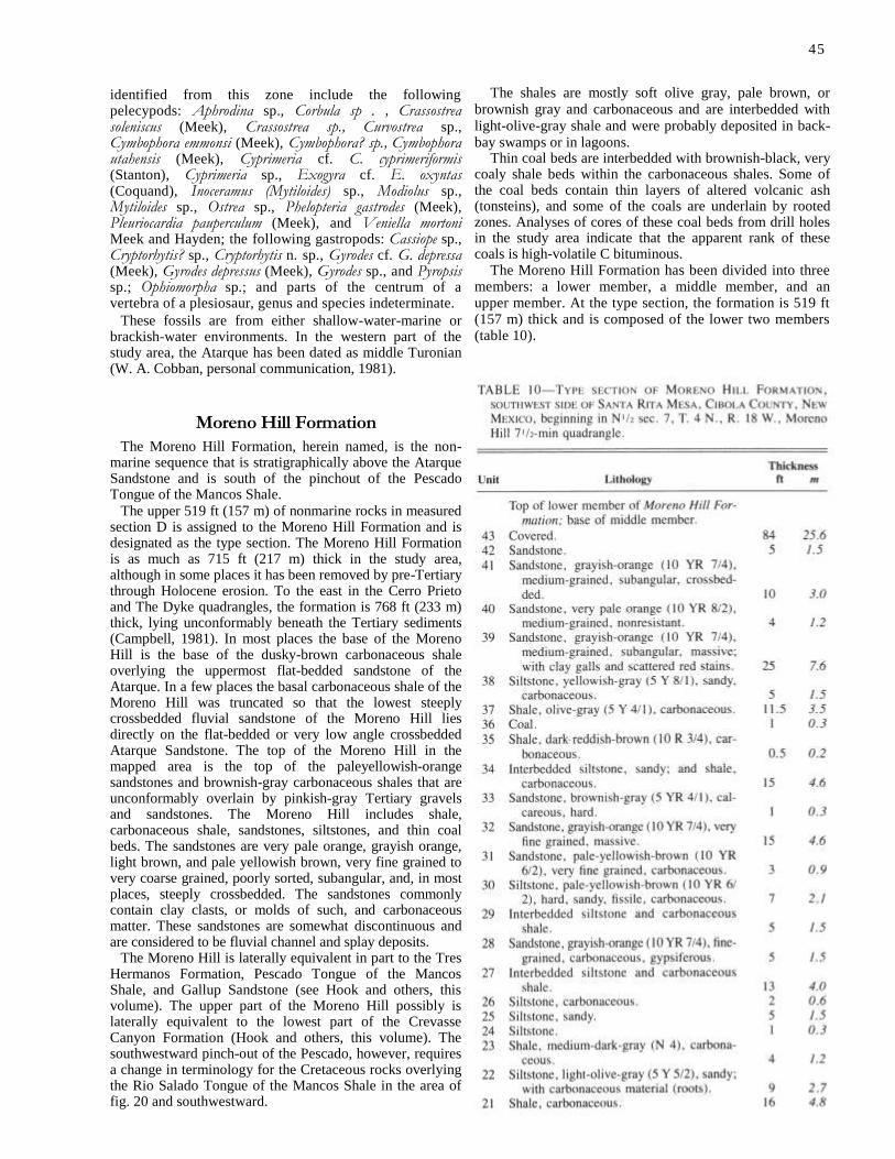
45
identified from this zone include the following pelecypods: Aphrodina sp., Corbula sp . , Crassostrea soleniscus (Meek), Crassostrea sp., Curvostrea sp., Cymbophora emmonsi (Meek), Cymbophora? sp., Cymbophora utahensis (Meek), Cyprimeria cf. C. cyprimeriformis (Stanton), Cyprimeria sp., Exogyra cf. E. oxyntas (Coquand), Inoceramus (Mytiloides) sp., Modiolus sp., Mytiloides sp., Ostrea sp., Phelopteria gastrodes (Meek), Pleuriocardia pauperculum (Meek), and Veniella mortoni Meek and Hayden; the following gastropods: Cassiope sp., Cryptorhytis? sp., Cryptorhytis n. sp., Gyrodes cf. G. depressa (Meek), Gyrodes depressus (Meek), Gyrodes sp., and Pyropsis sp.; Ophiomorpha sp.; and parts of the centrum of a vertebra of a plesiosaur, genus and species indeterminate.
These fossils are from either shallow-water-marine or brackish-water environments. In the western part of the study area, the Atarque has been dated as middle Turonian (W. A. Cobban, personal communication, 1981).
Moreno Hill Formation
The Moreno Hill Formation, herein named, is the non-marine sequence that is stratigraphically above the Atarque Sandstone and is south of the pinchout of the Pescado Tongue of the Mancos Shale.
The upper 519 ft (157 m) of nonmarine rocks in measured section D is assigned to the Moreno Hill Formation and is designated as the type section. The Moreno Hill Formation is as much as 715 ft (217 m) thick in the study area, although in some places it has been removed by pre-Tertiary through Holocene erosion. To the east in the Cerro Prieto and The Dyke quadrangles, the formation is 768 ft (233 m) thick, lying unconformably beneath the Tertiary sediments (Campbell, 1981). In most places the base of the Moreno Hill is the base of the dusky-brown carbonaceous shale overlying the uppermost flat-bedded sandstone of the Atarque. In a few places the basal carbonaceous shale of the Moreno Hill was truncated so that the lowest steeply crossbedded fluvial sandstone of the Moreno Hill lies directly on the flat-bedded or very low angle crossbedded Atarque Sandstone. The top of the Moreno Hill in the mapped area is the top of the paleyellowish-orange sandstones and brownish-gray carbonaceous shales that are unconformably overlain by pinkish-gray Tertiary gravels and sandstones. The Moreno Hill includes shale, carbonaceous shale, sandstones, siltstones, and thin coal beds. The sandstones are very pale orange, grayish orange, light brown, and pale yellowish brown, very fine grained to very coarse grained, poorly sorted, subangular, and, in most places, steeply crossbedded. The sandstones commonly contain clay clasts, or molds of such, and carbonaceous matter. These sandstones are somewhat discontinuous and are considered to be fluvial channel and splay deposits.
The Moreno Hill is laterally equivalent in part to the Tres Hermanos Formation, Pescado Tongue of the Mancos Shale, and Gallup Sandstone (see Hook and others, this volume). The upper part of the Moreno Hill possibly is laterally equivalent to the lowest part of the Crevasse Canyon Formation (Hook and others, this volume). The southwestward pinch-out of the Pescado, however, requires a change in terminology for the Cretaceous rocks overlying the Rio Salado Tongue of the Mancos Shale in the area of fig. 20 and southwestward.
The shales are mostly soft olive gray, pale brown, or brownish gray and carbonaceous and are interbedded with light-olive-gray shale and were probably deposited in back-bay swamps or in lagoons.
Thin coal beds are interbedded with brownish-black, very coaly shale beds within the carbonaceous shales. Some of the coal beds contain thin layers of altered volcanic ash (tonsteins), and some of the coals are underlain by rooted zones. Analyses of cores of these coal beds from drill holes in the study area indicate that the apparent rank of these coals is high-volatile C bituminous.
The Moreno Hill Formation has been divided into three members: a lower member, a middle member, and an upper member. At the type section, the formation is 519 ft (157 m) thick and is composed of the lower two members (table 10).

The lower member is predominantly carbonaceous shale with fluvial sandstones and minor coal beds. The carbo-naceous shales thin westward from the type section and in the west half of Moreno Hill quadrangle, fluvial sandstones are predominant. Farther westward, however, in the Can-taralo Spring quadrangle, shales and coaly beds make up most of the lower member (Anderson, 1981). Within 20 ft (6 m) of the base is a persistent coal bed that, where seen along the south side of Zuni Plateau and Santa Rita Mesa, is about 2.5 ft (.8 m) thick. Shaler (1907, p. 421), however, reported two coal beds of 3.5 and 4 ft (1 and 1.2 m) separated
by 6 ft (2 m) of shale within this zone in sec. 1 or 2, T. 4 N., R. 19 W. In some places erosion has scoured through this coal bed and through the carbonaceous shales in which it occurs, so that the lowest Moreno Hill sandstone lies immediately on the Atarque Sandstone. Eastward in Fence Lake SW quadrangle, conspicuous coal zones appear pro-gressively higher in the lower member. In the Cerro Prieto quadrangle, east of Fence Lake SW quadrangle, two coal horizons occur, the highest zone being about 20 ft (6 m) below the middle member and the lower outcropping zone occurring above the middle of the lower member (Campbell, 1981).
The middle member is composed of massive fluvial me-dium- to coarse-grained crossbedded arkosic sandstones. These sandstones contain zones of 0.25-inch spheroidal iron concretions that weather and give the sandstones a reddish appearance on some exposures. To the east, the middle member becomes thicker and its sandstones form the most prominent ledges on the slopes of Santa Rita Mesa. West of R. 18 W., this member has been truncated completely and the lower member is overlain by middle Tertiary rocks. At the type section, the middle member consists of 24 ft (7 m) of pale-yellowish-orange (10 YR 8/6), medium-grained, concretionary, crossbedded sandstone containing clay galls. To the east in eastern Fence Lake SW, Cerro Prieto, and The Dyke quadrangles, the member averages 60 ft (18 m) in thickness, ranging from 40 to 80 ft (12 to 24 m; Campbell, 1981).
The upper member consists mostly of carbonaceous shales, thin fluvial sandstones, siltstones, and thin coal beds. It crops out across the eastern three-fourths of Fence Lake SW quadrangle. The upper member is especially well exposed in measured section G (figs. 20 and 21), in the south half of sec. 13, T. 4 N., R. 19 W., which we are designating as a reference section. To the west it is truncated by erosion and overlain by middle Tertiary rocks. To the east it is approximately 360 ft (109 m) thick, lying unconformably beneath the middle Tertiary sediments (Campbell, 1981); to the southeast in the Tejana Mesa quadrangle, southeast of Fence Lake SW quadrangle, 712 ft (216 m) of the upper member occurs, lying unconformably beneath the Baca Formation (Eocene; Gretchen Roybal, personal communication, 1982).
Fence Lake Formation conglomerates and sandstones of middle Tertiary, probably Miocene, age (McLellan and others, 1982) unconformably overlie the Moreno Hill Formation in the area mapped by us. Both to the north and to the west, erosion prior to deposition of these beds cut deeply into the Moreno Hill rocks so that in the western part of the Moreno Hill quadrangle less than 40 ft (13 m) of Moreno Hill For-mation remains.
No fossils were found within the Moreno Hill Formation. All carbonaceous material was too broken or too worn to be identified. The lower member of the Moreno Hill is considered to be middle to late Turonian in age, inasmuch as it overlies the middle Turonian Atarque Sandstone.
References
Anderson, 0. J., 1981, Geologic map of the Cantaralo Spring quadrangle, Cibola
County, New Mexico: New Mexico Bureau of Mines and Mineral Resources,
Open-file Rept. 142
Campbell, F., 1981, Geology and coal resources of Cerro Prieto and The Dyke quadrangles: New Mexico Bureau of Mines and Mineral Resources, Open-file
Rept. 144, 44 p.
Dane, C. H., and Bachman, G. 0., 1965, Geologic map of New Mexico: U.S.
Geological Survey, 2 sheets, scale 1:500,000
Landis, E. R., McKay, E. J., Carter, M. D., and Medlin, A. L., 1983, Geologic map of the Fence Lake quadrangle, Cibola and Catron Counties, New Mexico:
U.S. Geological Survey, Miscellaneous Field Studies Map, in preparation
McLellan, M. W., Haschke, L. R., and Robinson, L. N., 1982, Geologic map of
the Rincon Hondo quadrangle, Cibola County, New Mexico: U.S. Geological
Survey, Miscellaneous Field Studies Map MF-1506
McLellan, M. W., Robinson, L. N., Haschke, L. R., Carter, M. D., and Medlin, A. L., 1982, Fence Lake Formation (Tertiary) of west-central New Mexico: New Mexico
Geology, v. 4, no. 4, p. 53-55
McLellan, M. W., Haschke, L. R., Robinson, L. N., and Landis, E. R., 1983, Geologic
map of the Moreno Hill quadrangle, Cibola and Catron Counties, New Mexico: U.S.
Geological Survey, Miscellaneous Field Studies Map MF-1509 McLellan, M. W.,
Robinson, L. N., and Haschke, L. R., 1983, Geologic map of the Fence Lake
quadrangle, Cibola County, New Mexico: U.S. Geological Survey, Miscellaneous
Field Studies Map, in press
Molenaar, C. M., 1973, Sedimentary facies and correlations of the Gallup Sandstone and associated formations, northwestern New Mexico, in Cretaceous and Tertiary
rocks of the southern Colorado Plateau: Four Corners Geological Society, Mem.,
p. 85-110
Pike, W. S., Jr., 1947, Intertonguing marine and nonmarine upper Cretaceous deposits
of New Mexico, Arizona, and southwestern Colorado: Geological Society of Amer-
ica, Mem. 24, 103 p. Shaler, M. K., 1907, A reconnaissance survey of the western part of the Durango—
Gallup coal field of Colorado and New Mexico: U.S. Geological Survey, Bull. 316, p. 376-426
Trumbull, J. V. A., 1959 (1960), Coal fields of the United States, sheet 1: U.S. Geological Survey, map, scale 1:5,000,000
4 7

MID-CRETACEOUS MOLLUSCAN SEQUENCE AT
GOLD HILL, JEFF DAVIS COUNTY, TEXAS,
WITH COMPARISON TO NEW MEXICO by Stephen C. Hook, Getty Oil Company, Exploration and Production Research Center, Houston, Texas,
and William A. Cobban, U.S. Geological Survey, Denver, Colorado
Abstract The lower 155 ft (47 m) of the Boquillas Limestone are well exposed and exceptionally
fossiliferous on Gold Hill in northern Jeff Davis County, Texas. Here, the Boquillas uncon-formably overlies the Buda Limestone and consists of two members: a lower, hard, flaggy limestone member, 55 ft (17 m) thick, and an upper shale and limestone member, 100 ft (30 m) thick. Molluscan fossils, chiefly inoceramids and ammonites, collected from these two members are of early Cenomanian to late Turonian age. Silicified fossils collected from the base of the
Boquillas are representative of the early Cenomanian zone of Forbesiceras brundrettei Young. Inoceramus arvanus Stephenson and I. rutherfordi Warren, which indicate the middle Cenomanian zone of Acanthoceras amphibolum Morrow, were collected from several beds of limestone that occur 6-12 ft (2-4 m) above the base. Inoceramus prefragilis Stephenson and Calycoceras cf. C. canitaurinum (Haas), of late Cenomanian age, were collected near the middle of the flaggy member. A questionable Nigericeras scotti Cobban, of early Turonian age, was collected near the top of this member. Poorly preserved ammonites that may be associated with Mytiloides mytiloides (Mantell) occur in the basal quarter of the upper member; an early Turonian age is indicated by this assemblage. Mammites nodosoides (Schluter) and Morrowites depressus (Powell), of late early Turonian age, are abundant in most of the upper half of this member. A nodular limestone bed 11 ft (3 m) below the top of Gold Hill contains Collignoniceras woollgari (Mantell) and Spathites rioensis Powell of middle Turonian age. This bed is overlain by phosphatized pebbles and cobbles that mark a significant middle Turonian disconformity. Prionocyclus hyatti (Stanton), of late middle Turonian age, occurs at this pebble level and through most of the overlying shale. Lopha lugubris (Conrad), of earliest late Turonian age, was found on top of Gold Hill.
Introduction
Upper Cretaceous rocks assigned to the Boquillas Lime-
stone by Brand and DeFord (1962) are well exposed on Gold
Hill, 5.3 mi (8.8 km) south, 32° east of the common corner of
Jeff Davis, Culberson, and Reeves Counties, Texas (fig. 22).
Gold Hill, also called Yellow Hill by the local ranchers, is a
relatively unvegetated, erosional remnant of Boquillas that
stands in sharp color contrast to the surrounding countryside
(fig. 23). The Boquillas Limestone, which is exposed on and
just below Gold Hill, is 155 ft (47 m)
thick and consists of two members: a lower, yellow-orange-
and salmon-weathering, thin-bedded, flaggy limestone
member, 55 ft (17 m) thick; and an upper, less resistant,
yellow-weathering shale and limestone member, 100 ft (30
m) thick, composed of interbedded calcareous shale and
limestone.
Megafossils, primarily mollusks, are abundant and gen-
erally well preserved. Megafossil collections were made
from 22 separate levels in a measured section (table 11).
4 8


These collections indicate an early Cenomanian to early Turonian age for the flaggy limestone member and an early to late Turonian age for the shale and limestone member (fig. 24). A significant middle Turonian disconformity lies in the upper part of the shale and limestone member. This disconformity is marked by a 3-6-inch-thick bed of phos-phatized pebbles and cobbles that contains faunal elements of two middle Turonian ammonite zones. The contact of the Boquillas with the underlying Buda Limestone also is disconformable.
Previous work
The Gold Hill outcrop may have been noted long ago by Adkins (1932, p. 431), who reported that
From the northern and eastern slopes of Gomez Peak, northern Jeff Davis County, Mr. A. H. Dunlap reports an Eagle Ford
section consisting of (a) about 250 to 300 feet of beds, the base in undulating contact with the Buda limestone; their lower half consists of hard, ringing, thin-bedded salmon colored Boquillas flagstone, their upper half of alternating flagstones and yellow shales which contain near the top Scaphites, Prionotropis, a three-foot ammonite, Inoceramus cf. labiatus and other fossils. . . .
Brand and DeFord (1962), who mapped the Kent quad-rangle, noted that the best exposure of the Boquillas on the quadrangle was at Gold Hill. They observed that the Bo-quillas Limestone was fossiliferous at Gold Hill, but that most of the fossils were poorly preserved. They repeated a list of ammonites described by Young (1958) from the base of the Boquillas at a locality approximately 9 mi (15 km) southeast of Gold Hill but listed none from Gold Hill itself.

52
Powell (1967, p. 313-319, figs. 2-5) reported on three large specimens of Morrowites depressus (Powell) that came from the Boquillas at Gold Hill, and he presented a section of the Boquillas measured at a locality approximately 1.5 mi (2.5 km) south of Gold Hill. A few fossils were listed from the measured section, but most were identified only to the genus. Only M. depressus was mentioned from Gold Hill.
ACKNOWLEDGMENTS—We thank Leonard Lethco of the
Lethco Ranch for permission to measure the stratigraphic section and collect fossils at Gold Hill. Robert E. Burkholder of the U.S. Geological Survey, Denver, Colorado, helped collect fossils and printed the outcrop photographs. M. E. MacLachlan and C. M. Molenaar, both of the U.S. Geo-logical Survey, Denver, critically reviewed this paper. The work that led to this paper was done in cooperation with the Texas Bureau of Economic Geology, Austin, Texas.
Faunal sequence
The oldest molluscan fauna at Gold Hill occurs sporad-ically at the base of the Boquillas Limestone, where pockets of silicified fossils seemed to have accumulated in depres-sions cut into the top of the Buda Limestone. The fossils are mostly small desmoceratid ammonites but include fragments of larger ammonites, bivalves, and gastropods. Young (1958) described the ammonites and illustrated one of the gastropods from the base of the Boquillas at a locality south-east of Gold Hill, where the fossils also are silicified. Among the ammonites at Young's locality is a species that Young described as Neopulchellia brundrettei. Young and Powell (1976, p. 25.15-25.24) later assigned this species to For-besiceras and designated a zone of F. brundrettei. A frag-ment of a large turrilitid ammonite described as Hypoturrilites n. sp. by Young (1958, p. 287, pl. 39, fig. 32, text fig. 1g) was later named H. youngi Clark (Clark, 1965, p. 52, pl. 19, fig. 6). Several very large specimens collected from Gold Hill reveal that this species attained whorl diameters of at least 110 mm. The rest of the species of ammonites described by Young, as well as the gastropod illustrated by him as Anchura sp., also occur at Gold Hill.
Hard, gray, limestone beds, 6-12 ft (2-4 m) above the base of Boquillas at Gold Hill, contain Inoceramus ruth-erfordi Warren in addition to I. arvanus and Ostrea beloiti. In New Mexico, Colorado, Kansas, Wyoming, and South Dakota, I. rutherfordi is restricted to the upper part of the middle Cenomanian zone of Acanthoceras amphibolum Morrow; whereas, I. arvanus is generally associated with the underlying subzone of A. alvaradoense Moreman. Os-trea beloiti had great geographic distribution during that time (Cobban and Hook, 1980, fig. 3).
Inoceramus prefragilis Stephenson is fairly abundant in the Boquillas approximately 17-33 ft (5-10 m) above the base at Gold Hill. A fragment of the ammonite Calycoceras cf. C. canitaurinum (Haas), found as float from this part of the formation, indicates the early late Cenomanian zone of Calycoceras canitaurinum (Haas).
Very poor impressions of ammonites in the upper part of the lower member of the Boquillas suggest some nearly smooth vascoceratid ammonite such as Nigericeras scotti Cobban (1971, p. 18, pl. 9, figs. 1-4; pl. 18, figs. 1-9; text figs. 15-17). In southeast Colorado, this ammonite occurs in the Greenhorn Formation just above beds that contain the Sciponoceras gracile fauna of late Cenomanian age. Nigericeras scotti has been assigned an early Turonian age by Cobban (1971, p. 18), Cobban and Hook (1980, fig. 1), and Hook and Cobban (1979, fig. 1; 1981, fig. 1).
Ammonites collected from most of the lower half of the shale and limestone member of the Boquillas at Gold Hill are poorly preserved. Fragments of a vascoceratid ammonite associated with Mytiloides aff. M. duplicostatus (Anderson)
occur in the basal quarter of this member. This association suggests an early Turonian stratigraphic level near that of bed 97 in the measured section of the Bridge Creek Lime-stone Member of the Greenhorn Formation near Pueblo, Colorado, where Vascoceras (Greenhornoceras) birchbyi Cobban and Scott occurs with M. aff. M. duplicostatus (Cobban and Scott, 1972, p. 23; M. aff. M. duplicostatus recorded as Inoceramus labiatus).
Mammites nodosoides (Schlüter), of latest early Turonian age, first appears at the top (unit 3) of the basal quarter of the shale and limestone member and persists upward through most of the member. The upper part of its range overlaps that of Morrowites depressus (Powell).
The occurrence of M. depressus in the upper part of the zone of Mammites nodosoides was noted at other localities in the Western Interior (Cobban and Hook, 1979, p. 6, 10). A thick bed of limestone (unit 17), which forms a conspic-uous ledge around the upper part of Gold Hill (fig. 25), contains Mytiloides subhercynicus (Seitz) and Kamerun-oceras turoniense (d'Orbigny) in addition to M. nodosoides.
A nodular bed of limestone (unit 19), about 11 ft (3 m) below the top of Gold Hill, contains the important ammo-nites Collignoniceras woollgari (Mantell) and Spathites rioensis Powell of earliest middle Turonian age.
Unit 20 consists of phosphatic nodules and fossils that mark a disconformity and hardground development on top of unit 19 (fig. 26). Fossils from unit 20 consist of worn, encrusted, phosphatized fragments of internal molds of Prionocyclus hyatti (Stanton), Collignoniceras woollgari woollgari, Morrowites depressus (Powell), and Neoptychites cf. N. cephalotus (Courtiller) that have been derived from older rocks. Most of the subzone of Collignoniceras woollgari woollgari and all of the overlying subzone of C.
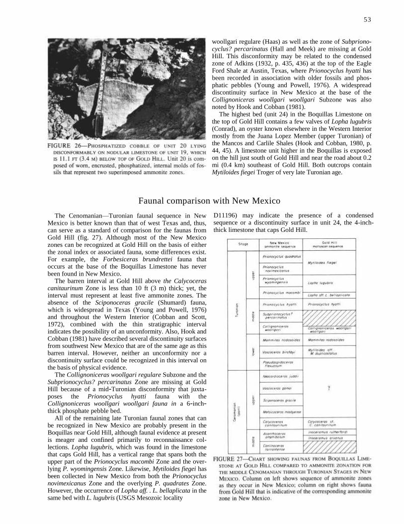
53
woollgari regulare (Haas) as well as the zone of Subpriono-cyclus? percarinatus (Hall and Meek) are missing at Gold Hill. This disconformity may be related to the condensed zone of Adkins (1932, p. 435, 436) at the top of the Eagle Ford Shale at Austin, Texas, where Prionocyclus hyatti has been recorded in association with older fossils and phos-phatic pebbles (Young and Powell, 1976). A widespread discontinuity surface in New Mexico at the base of the Collignoniceras woollgari woollgari Subzone was also noted by Hook and Cobban (1981).
The highest bed (unit 24) in the Boquillas Limestone on the top of Gold Hill contains a few valves of Lopha lugubris (Conrad), an oyster known elsewhere in the Western Interior mostly from the Juana Lopez Member (upper Turonian) of the Mancos and Carlile Shales (Hook and Cobban, 1980, p. 44, 45). A limestone unit higher in the Boquillas is exposed on the hill just south of Gold Hill and near the road about 0.2 mi (0.4 km) southeast of Gold Hill. Both outcrops contain Mytiloides fiegei Troger of very late Turonian age.
Faunal comparison with New Mexico
The Cenomanian—Turonian faunal sequence in New Mexico is better known than that of west Texas and, thus, can serve as a standard of comparison for the faunas from Gold Hill (fig. 27). Although most of the New Mexico zones can be recognized at Gold Hill on the basis of either the zonal index or associated fauna, some differences exist. For example, the Forbesiceras brundrettei fauna that occurs at the base of the Boquillas Limestone has never been found in New Mexico.
The barren interval at Gold Hill above the Calycoceras canitaurinum Zone is less than 10 ft (3 m) thick; yet, the interval must represent at least five ammonite zones. The absence of the Sciponoceras gracile (Shumard) fauna, which is widespread in Texas (Young and Powell, 1976) and throughout the Western Interior (Cobban and Scott, 1972), combined with the thin stratigraphic interval indicates the possibility of an unconformity. Also, Hook and Cobban (1981) have described several discontinuity surfaces from southwest New Mexico that are of the same age as this barren interval. However, neither an unconformity nor a discontinuity surface could be recognized in this interval on the basis of physical evidence.
The Collignoniceras woollgari regulare Subzone and the Subprionocyclus? percarinatus Zone are missing at Gold Hill because of a mid-Turonian disconformity that juxta-poses the Prionocyclus hyatti fauna with the Collignoniceras woollgari woollgari fauna in a 6-inch-thick phosphate pebble bed.
All of the remaining late Turonian faunal zones that can be recognized in New Mexico are probably present in the Boquillas near Gold Hill, although faunal evidence at present is meager and confined primarily to reconnaissance col-lections. Lopha lugubris, which was found in the limestone that caps Gold Hill, has a vertical range that spans both the upper part of the Prionocyclus macombi Zone and the over-lying P. wyomingensis Zone. Likewise, Mytiloides fiegei has been collected in New Mexico from both the Prionocyclus novimexicanus Zone and the overlying P. quadrates Zone. However, the occurrence of Lopha aff. . L. bellaplicata in the same bed with L. lugubris (USGS Mesozoic locality
D11196) may indicate the presence of a condensed sequence or a discontinuity surface in unit 24, the 4-inch-thick limestone that caps Gold Hill.

References
Adkins, W. S., 1932 [1933], The geology of Texas, Part 2—The Mesozoic systems in
Texas: University of Texas (Austin), Bureau of Economic Geology, Bull. 3232, v. 1, p. 239-518
Brand, J. P., and DeFord, R. K., 1962, Geology of eastern half of Kent quadrangle,
Culberson, Reeves, and Jeff Davis Counties, Texas: University of Texas (Austin),
Bureau of Economic Geology, Geologic Quadrangle Map 24, scale 1:63,360 Clark,
D. L., 1965, Heteromorph ammonoids from the Albian and Cenomanian of Texas
and adjacent areas: Geological Society of America, Mem. 95, 99 p., 24 pls. Cobban,
W. A., 1971, New and little-known ammonites from the Upper Cretaceous
(Cenomanian and Turonian) of the Western Interior of the United States: U.S.
Geological Survey, Prof. Paper 699, 24 p., 18 pls.
Cobban, W. A., and Hook, S. C., 1979 [1980], Collignoniceras woollgari woollgari
(Mantell) ammonite fauna from Upper Cretaceous of Western Interior, United
States: New Mexico Bureau of Mines and Mineral Resources, Mem. 37, 51 p., 12
pls.
, 1980, Occurrence of Ostrea beloiti Logan in Cenomanian rocks of trans- Pecos Texas: New Mexico Geological Society, Guidebook 31st field conference,
p. 169-172 Cobban, W. A., and Scott, G. R., 1972 [1973], Stratigraphy and ammonite fauna
of the Graneros Shale and Greenhorn Limestone near Pueblo, Colorado: U.S. Geological Survey, Prof. Paper 645, 108 p., 39 pls.
Hook, S. C., and Cobban, W. A., 1979, Prionocyclus novimexicanus (Marcou)—
common Upper Cretaceous guide fossil in New Mexico: New Mexico Bureau of
Mines and Mineral Resources, Annual Rept. 1977-78, p. 34-42
1980, Some guide fossils in Upper Cretaceous Juana Lopez Member of
Mancos and Carlile Shales, New Mexico: New Mexico Bureau of Mines and
Mineral Resources, Annual Rept. 1978-79, p. 38-49
, 1981, Late Greenhorn (mid-Cretaceous) discontinuity surfaces, southwest New Mexico: New Mexico Bureau of Mines and Mineral Resources, Circ. 181, p. 5-21, pls. 1-3
Powell, J. D., 1967, Mammitine ammonites in trans-Pecos Texas: Texas Journal of
Science, v. 19, no. 3, p. 311-322
Young, Keith, 1958, Cenomanian (Cretaceous) ammonites from trans-Pecos Texas:
Journal of Paleontology, v. 32, no. 2, p. 286-294, pls. 39-40
Young, Keith, and Powell, J. D., 1976 [1978], Late Albian-Turonian correlations in
Texas and Mexico: Annales du Museum d'Histoire Naturelle de Nice, v. 4, p.
25.1-25.36, 9 pls.
54
Contents of pocket
SHEET 1—Stratigraphic cross sections from (A) Moreno Hill to Gallup and (B) Upper
Nutria to Carthage.
Editor: Marla D. Adkins-Heljeson
Drafters: Teresa Mueller, Debra Vetterman
Type faces: Abstract in 9 pt. Times Roman, leaded one point
Text in 10 pt. Times Roman, leaded one point
References in 7 pt. Times Roman, leaded one point
Display heads in 24 pt. Times Roman
Presswork: Miehle Single Color Offset
Binding: Saddlestitched
Paper: Cover on 65 lb. Circa 83 miners gold
Text on 70 lb. white Matte
Ink: Cover—PMS 477
Text—Black
Quantity: 750


Hook
M
ID-C
RE
TA
CE
OU
S P
AL
EO
NT
OL
OG
Y A
ND
ST
RA
TIG
RA
PH
Y—
PA
RT
II N
ew
Mex
ico
Bu
reau
Min
es &
Min
era
l Reso
urc
es
Circ
ula
r 185