Embed Size (px)
Citation preview
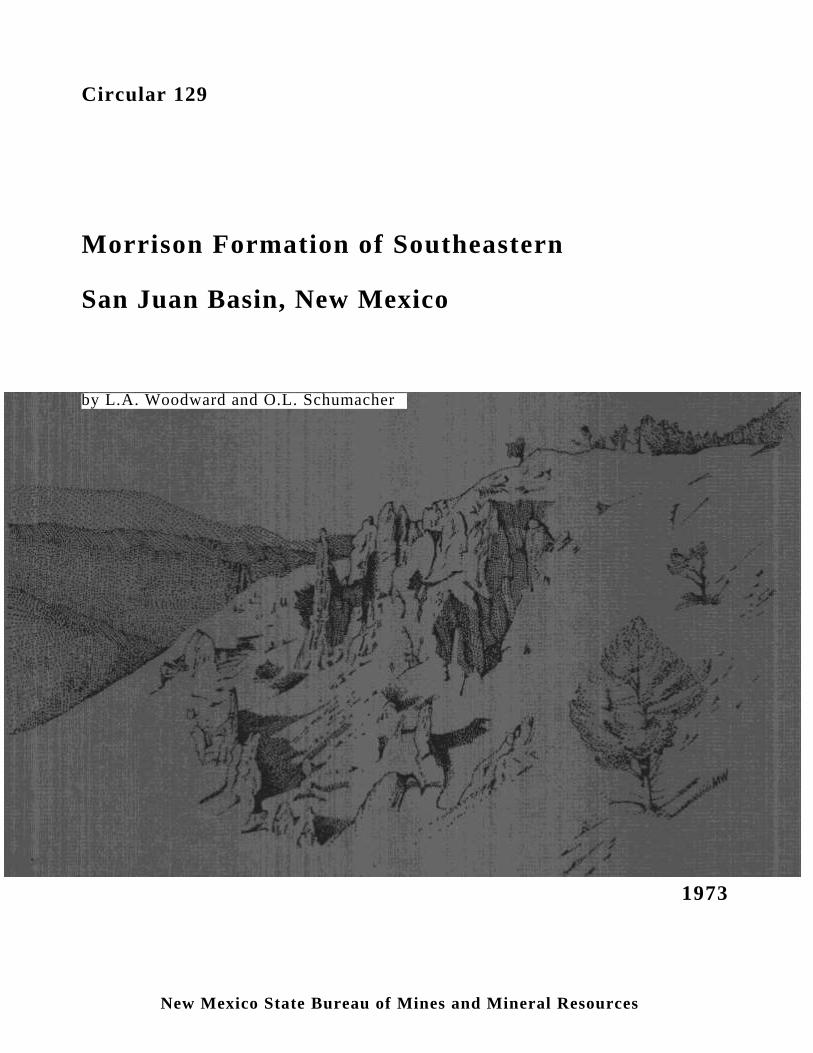
Circular 129
Morrison Formation of Southeastern
San Juan Basin, New Mexico
1973
by L.A. Woodward and O.L. Schumacher
New Mexico State Bureau of Mines and Mineral Resources
NEW MEXICO STATE BUREAU OF MINES AND MINERAL RESOURCES
Don H. Baker, Jr., Director
Full-time Staff DIANE ALLMENDINGER, Clerk-Typist
WILLIAM E. ARNOLD, Scientific Illustrator
BLAIR R. BENNER, Junior Metallurgist
ROBERT A. BIEBERMAN, Petroleum Geologist
LYNN A. BRANDVOLD, Chemist
CHARLES E. CHAPIN, Geologist
RICHARD R. CHAVEZ, Technician
E. JACK COATS, Bureau Info. Coordinator
JILL COLLIS, Secretary
Lois M. DEVLIN, Office Manager
JO DRAKE, Administrative Asst. & Sec'y.
ROUSSEAU H. FLOWER, Senior Paleontologist
ROY W. FOSTER, Petroleum Geologist
WILLIAM L. HAWKS, Materials Engineer
ROBERT W. KELLEY, Editor & Geologist
FRANK E. KOTTLOWSKI, Ass't. Dir. & Sr. Geol.
THOMAS M. PLOYS, Research Extractive Met.
JACQUES R. RENAULT, Geologist
RONALD J. ROMAN, Chief Research Metallurgist
JOHN W. SHOMAKER, Geologist
JACKIE H. SMITH, Laboratory Assistant
KARL VONDER LINDEN, Mng. Eng., Env. Geol.
CHARLES W. WALKER, Geochemist-Mineralogist
ROBERT H. WEBER, Senior Geologist
SHIRLEY WHYTE, Clerk-Typist
MAX E. WILLARD, Economic Geologist
ROBERT WOOD, Draftsman I
JUARINE W. WOOLDRIDGE, Editorial Clerk
MICHAEL W. WOOLDRIDGE, Draftsman
Part-time Staff CORALS BRIERLEY, Ass't. Chemist, Biology
ROLAND F. DICKEY, Public Relations
RUFIE MONTOYA, Dup. Mach. Oper.
JOHN REICHE, Instrument Manager
ROGER ALLMENDINGER, Geologist
JIM BRUNING, Geologist
STUART FAITH, Geologist
MICHAEL JAWORSKI, Geologist
JAMES JENSEN, Geologist
Graduate Students WALTER VERNON KRAMER, Geologist
JESUS NÁJERA, Hydrogeologist
CRAIG OLSON, Metallurgist
TERRY SEIMERS, Geologist
DON SIMON, Geologist
Plus more than 28 undergraduate assistants
New Mexico Tech Staff Advisors
GALE BILLINGS, Geoscience ALLAN R. SANFORD, Geophysics
PAIGE W. CHRISTIANSEN, Historian-Mining FRANK B. TITUS, Hydrology

New Mexico State Bureau of Mines and Mineral Resources
Circular 129
MORRISON FORMATION OF SOUTHEASTERN
SAN JUAN BASIN, NEW MEXICO
by Lee A. Woodward and
Otto L. Schumacher
University of New Mexico
Socorro 1973
New Mexico State Bureau of Mines and Mineral Resources
Don H. Baker, Jr., Director
A Division of
New Mexico Institute of Mining and Technology
Stirling A. Colgate, President
BOARD OF REGENTS
Ex Officio
Bruce King, Governor of New Mexico
Leonard DeLayo, Superintendent of Public Instruction
Appointed
William G. Abbott, Chairman, 1967-1973, Hobbs
George A. Cowan, 1972-1975, Los Alamos
Dave Rice, 1972-1977, Carlsbad
Steve Torres, 1967-1973, Socorro
James R. Woods, 1971-1977, Socorro
Published by Authority of State of New Mexico, NMSA 1953 Sec. 63-1-4 Printed
by NMIMT Photo Laboratory, January 1973
Available from New Mexico State Bureau of Mines, Socorro, NM 87801 Price $1.00 Deposited in public libraries
Abstract
Exposures of the Morrison Formation (Jurassic) between Cuchillo
Arroyo and Cuba, New Mexico include all the strata above the Todilto
Formation (Jurassic) and below the Dakota Formation (Cretaceous). Four
members recognized in the southern part of the area are, in ascending order: a
lower member composed of reddish-brown and maroon-brown mudstone and
gray, very fine-grained sandstone; the Westwater Canyon Member composed
of cliff-forming, feldspathic sandstone; the Brushy Basin Member composed
of red and green mudstone and sandstone interbeds; and, the upper member
composed of whitish, kaolinitic sandstone, and minor amounts of green
mudstone. In the northern part of the area only three members are present: the
lower member, the Brushy Basin Member, and the upper member.
The lower member contains beds correlative with the Summerville
Formation and the Recapture Member of the Morrison Formation of the
Laguna area. The Westwater Canyon Member is sandstone in the south but
grades northward into mudstone similar to that in the Brushy Basin Member.
The upper member correlates with the Jackpile sandstone (Jackpile ore-
bearing bed) of the Laguna area on the basis of lithologic similarity and strat-
igraphic position.
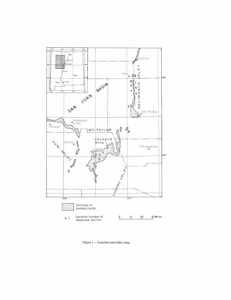
Introduction
Since the discovery in the 1950s of large reserves of
uranium in the Morrison Formation (Jurassic) near Grants,
New Mexico (Melancon, 1963) the stratigraphy of this
formation throughout northwestern New Mexico has
continued to receive much attention. Numerous studies of
the Morrison have been made in the vicinity of Ambrosia
Lake, Grants, and Laguna (fig. 1), resulting in the definition
of several formal members. The presence of large amounts
of uranium in the northeast-trending Jackpile sandstone
(Jackpile ore-bearing bed), the uppermost unit of the
Morrison Formation near Laguna (Moench and Schlee,
1967), has lead to exploration along this trend toward the
area of this report.
The lower members of the Morrison recognized near
Grants have been traced northeastward to the vicinity of
Cuchillo Arroyo (fig. 1, location 2) by Freeman and Hilpert
(1956). However, from Cuchillo Arroyo northward toward
Cuba (fig. 1) sudden changes in facies make correlation of
units within the Morrison uncertain (Swift, 1956). The
present report presents stratigraphic and lithologic details
and suggests correlations between Cuchillo Arroyo and
Cuba. Although the Morrison in this area apparently lacks
commercial deposits of uranium, the data presented here are of
considerable interest in regional stratigraphic analyses.
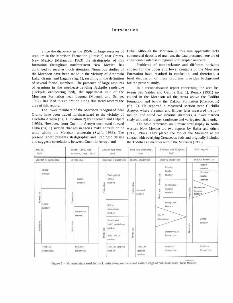
Problems of nomenclature and different horizons
chosen for the upper and lower contacts of the Morrison
Formation have resulted in confusion, and therefore, a
brief discussion of these problems provides background
for the present study.
In a reconnaissance report concerning the area be-
tween San Ysidro and Gallina (fig. 1), Renick (1931) in-
cluded in the Morrison all the strata above the Todilto
Formation and below the Dakota Formation (Cretaceous)
(fig. 2). He reported a measured section near Cuchillo
Arroyo, where Freeman and Hilpert later measured the for-
mation, and noted two informal members, a lower maroon
shaly unit and an upper sandstone and variegated shale unit.
The basic references on Jurassic stratigraphy in north-
western New Mexico are two reports by Baker and others
(1936, 1947). They placed the top of the Morrison at the
contact with overlying Cretaceous beds and originally included
the Todilto as a member within the Morrison (1936),
but later (1947) placed the base of the Morrison directly above
the Todilto (fig. 2).
Wood and Northrop (1946), on their reconnaissance map
of the Nacimiento uplift and adjacent areas, considered the
Todilto a member of the Morrison Formation, but showed the
Todilto as a separate unit, and did not indicate any
subdivisions within that part of the Morrison above the Todilto
Member (fig. 2).
In the area of the Lucero uplift, Kelley and Wood
(1946) considered the Morrison to include the Todilto as a
member and to extend upward to the base of the Dakota(?)
Formation (fig. 2). In addition to the Todilto, they also
recognized several informal members in the Morrison.
Harshbarger and others (1951), in discussing the
Jurassic rocks near Thoreau, placed the base of the Morrison
higher than Baker and others (1947), noting the Summerville
Formation above the Todilto and below the Morrison. The
Summerville has its type section in southeastern Utah
(Gilluly and Reeside, 1928; Baker and others, 1936), and
this. unit as described near Thoreau appears to correlate with
the buff shale member of the Morrison reported by Kelley
and Wood (1946) in the Lucero uplift. Harshbarger
and others (1951) divided their restricted Morrison For-
mation into four members: in ascending• order, the Bluff,
the Recapture, Westwater Canyon, and Brushy Basin.
These members also have their type sections in south-
eastern Utah (Baker and others, 1936; Gregory, 1938).
In the Grants area, Craig and others (1955) used the
same nomenclature (fig. 2) as used by Harshbarger and
others near Thoreau, but considered the Bluff to be a sep-
arate formation. Freeman and Hilpert (1956) then extended
the nomenclature used by Craig and others eastward to
Laguna and northeastward to Cuchilla Arroyo (figs. 1 and
2, location 2). At the latter locality, however, the Bluff
Sandstone is missing and the Recapture Member of the
Morrison Formation rests directly on the Summerville
Formation (Freeman and Hilpert, 1956).
Eight complete sections and one partial section
(location 4) of the Morrison Formation were measured.
Descriptive terms for bedding and grain size are the same,
respectively, as used by McKee and Weir (1953) and
Wentworth (1922).
Richard Ruetschilling and Ruben Martinez assisted in
measuring several of the sections.
2
Stratigraphy
In the southern part of the area studied, four mem-
bers of the Morrison Formation are recognized. To the
north, near Cuba, only three members are recognized be-
cause of a facies change within the Westwater Canyon
Member.
The lower member consists of reddish-brown and
maroon-brown mudstones with gray, very fine-grained sand-
stone interbeds. Above the lower member is the Westwater
Canyon Member which is mostly cliff-forming sandstone in
the southern part of the area; toward the north, this member
changes to brick-red mudstone with subordinate sandstone
interbeds; near Cuba the Westwater Canyon cannot be
recognized. The Recapture Member is composed mostly of
green and brick-red mudstone with subordinate intercalated
sandstones. It overlies the Westwater Canyon in the southern
part of the area, and overlies the lower member in the
northern part of the area. The upper member consists mainly
of sandstone with subordinate green shale. Locally, green
shale occurs at the top of the unit, just below the overlying
Dakota Formation (Cretaceous).
Lower Member
The lower member of the Morrison 'Formation is
composed of 325 to 440 feet of approximately equal
amounts of reddish-brown and maroon-brown mudstone and
gray, very fine to fine-grained sandstone, with minor
amounts of green mudstone. Locally thin beds of gray,
elastic limestone are present. This member forms a saddle
or slope beneath the cliff-forming sandstone of the over-
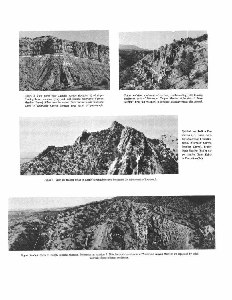
lying Westwater Canyon Member (fig. 3).
Bedding is rarely seen within the mudstone or sand-
stone intervals. These intervals mostly range from 1 to 6
feet thick, but locally the sandstone intervals may be up to
10 feet thick. The mudstone is easily eroded and the sand-
stones are friable, forming slopes or low, rounded ledges.
The lower member rests concordantly on the Todilto
Formation (Jurassic) and interfingers with the overlying
Westwater Canyon Member. At most localities the lower
member is poorly exposed, being covered by soil in a strike
valley bounded by resistant ridges of gypsum and sandstone.
Near Cuchillo Arroyo (location 2) the mudstone in the
lower part of this member is pale reddish-brown and
probably correlates with the Summerville Formation (Free-
man and Hilpert, 1956); to the north, however, the mud-
stones in this member are more uniformly darker, being
maroon brown. Separating the Summerville and the Recap-
ture is made difficult by this northward change in color.
in combination with poor exposures at most localities;
therefore, they are both included in the lower member of the
Morrison Formation of this report.
Westwater Canyon Member
This unit consists principally of cliff-forming sand-
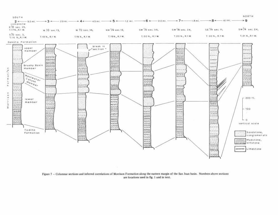
stone in the southern part of the area (figs. 3, 4); these
sandstone beds grade into brick-red and green mudstone
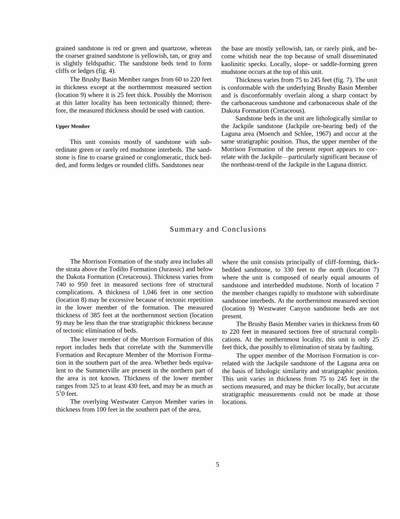
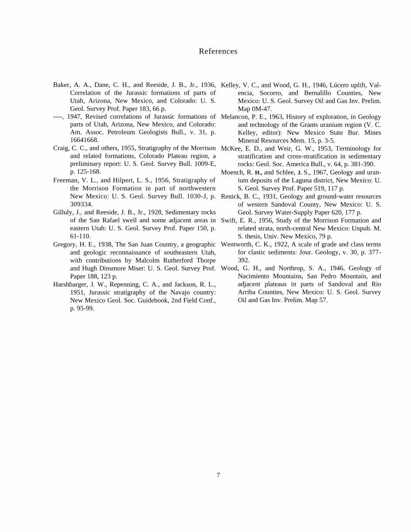
toward the north (figs. 5 and 6). This facies change takes place
by thinning of the sandstone intervals and thickening of the
intercalated mudstone intervals northward (fig. 7).
The sandstone is mostly thick-bedded, slightly feld-
spathic to arkosic, fine to very coarse grained and locally
conglomeratic, and yellowish to tan or pink. Within the
sandstones in the southern part of the area are discontinuous
mudstone layers and lenses (fig. 3). Scour and fill structure
is characteristic of most of the sandstone beds, and, to the
north, the beds become noticeably lenticular (fig. 5).
Conglomeratic lenses up to 1 foot thick contain pebbles up
to 1 inch in diameter, and are found throughout this
member. Thin beds of gray, elastic limestone occur locally
in the mudstone intervals.
The Westwater Canyon Member interfingers with the
underlying member. In the southern part of the area the top
of the Westwater Canyon Member is readily placed at the
top of the highest, thick, cliff-forming sandstone. North-
ward, though, the top of the Westwater Canyon Member is
difficult to locate because the overlying Recapture Member
is very similar to the red and green mudstone, with sub-
ordinate sandstone interbeds characteristic of the northern
facies of the Westwater Canyon Member.
This unit ranges in thickness from about 100 feet in
the south to about 320 feet toward the north (locations 6 and
7) and appears to be absent at the northernmost measured
section (location 9).
Brushy Basin Member
This unit consists of brick-red and green mudstone with
subordinate sandstone interbeds and minor amounts of gray,
elastic limestone.
The mudstone mostly forms slopes or a saddle (figs. 4
and 5) although, locally, this unit may be siliceous, hard,
and resistant to erosion. Sandstone interbeds are generally 1
to 2 feet thick and range from very fine to coarse grained.
Local conglomeratic lenses up to 1 foot thick contain
pebbles up to 1/2 inch in diameter. Most of the very fine
3
grained sandstone is red or green and quartzose, whereas
the coarser grained sandstone is yellowish, tan, or gray and
is slightly feldspathic. The sandstone beds tend to form
cliffs or ledges (fig. 4).
The Brushy Basin Member ranges from 60 to 220 feet
in thickness except at the northernmost measured section
(location 9) where it is 25 feet thick. Possibly the Morrison
at this latter locality has been tectonically thinned; there-
fore, the measured thickness should be used with caution.
Upper Member
This unit consists mostly of sandstone with sub-
ordinate green or rarely red mudstone interbeds. The sand-
stone is fine to coarse grained or conglomeratic, thick bed-
ded, and forms ledges or rounded cliffs. Sandstones near
the base are mostly yellowish, tan, or rarely pink, and be-
come whitish near the top because of small disseminated
kaolinitic specks. Locally, slope- or saddle-forming green
mudstone occurs at the top of this unit.
Thickness varies from 75 to 245 feet (fig. 7). The unit
is conformable with the underlying Brushy Basin Member
and is disconformably overlain along a sharp contact by
the carbonaceous sandstone and carbonaceous shale of the
Dakota Formation (Cretaceous).
Sandstone beds in the unit are lithologically similar to
the Jackpile sandstone (Jackpile ore-bearing bed) of the
Laguna area (Moench and Schlee, 1967) and occur at the
same stratigraphic position. Thus, the upper member of the
Morrison Formation of the present report appears to cor-
relate with the Jackpile—particularly significant because of
the northeast-trend of the Jackpile in the Laguna district.
Summary and Conclusions
The Morrison Formation of the study area includes all
the strata above the Todilto Formation (Jurassic) and below
the Dakota Formation (Cretaceous). Thickness varies from
740 to 950 feet in measured sections free of structural
complications. A thickness of 1,046 feet in one section
(location 8) may be excessive because of tectonic repetition
in the lower member of the formation. The measured
thickness of 385 feet at the northernmost section (location
9) may be less than the true stratigraphic thickness because
of tectonic elimination of beds.
The lower member of the Morrison Formation of this
report includes beds that correlate with the Summerville
Formation and Recapture Member of the Morrison Forma-
tion in the southern part of the area. Whether beds equiva-
lent to the Summerville are present in the northern part of
the area is not known. Thickness of the lower member
ranges from 325 to at least 430 feet, and may be as much as
510 feet.
The overlying Westwater Canyon Member varies in
thickness from 100 feet in the southern part of the area,
where the unit consists principally of cliff-forming, thick-
bedded sandstone, to 330 feet to the north (location 7)
where the unit is composed of nearly equal amounts of
sandstone and interbedded mudstone. North of location 7
the member changes rapidly to mudstone with subordinate
sandstone interbeds. At the northernmost measured section
(location 9) Westwater Canyon sandstone beds are not
present.
The Brushy Basin Member varies in thickness from 60
to 220 feet in measured sections free of structural compli-
cations. At the northernmost locality, this unit is only 25
feet thick, due possibly to elimination of strata by faulting.
The upper member of the Morrison Formation is cor-
related with the Jackpile sandstone of the Laguna area on
the basis of lithologic similarity and stratigraphic position.
This unit varies in thickness from 75 to 245 feet in the
sections measured, and may be thicker locally, but accurate
stratigraphic measurements could not be made at those
locations.
5
References
Baker, A. A., Dane, C. H., and Reeside, J. B., Jr., 1936,
Correlation of the Jurassic formations of parts of
Utah, Arizona, New Mexico, and Colorado: U. S.
Geol. Survey Prof. Paper 183, 66 p.
----, 1947, Revised correlations of Jurassic formations of
parts of Utah, Arizona, New Mexico, and Colorado:
Am. Assoc. Petroleum Geologists Bull., v. 31, p.
16641668.
Craig, C. C., and others, 1955, Stratigraphy of the Morrison
and related formations, Colorado Plateau region, a
preliminary report: U. S. Geol. Survey Bull. 1009-E,
p. 125-168.
Freeman, V. L., and Hilpert, L. S., 1956, Stratigraphy of
the Morrison Formation in part of northwestern
New Mexico: U. S. Geol. Survey Bull. 1030-J, p.
309334.
Gilluly, J., and Reeside, J. B., Jr., 1928, Sedimentary rocks
of the San Rafael swell and some adjacent areas in
eastern Utah: U. S. Geol. Survey Prof. Paper 150, p.
61-110.
Gregory, H. E., 1938, The San Juan Country, a geographic
and geologic reconnaissance of southeastern Utah,
with contributions by Malcolm Rutherford Thorpe
and Hugh Dinsmore Miser: U. S. Geol. Survey Prof.
Paper 188, 123 p.
Harshbarger, J. W., Repenning, C. A., and Jackson, R. L.,
1951, Jurassic stratigraphy of the Navajo country:
New Mexico Geol. Soc. Guidebook, 2nd Field Conf.,
p. 95-99.
Kelley, V. C., and Wood, G. H., 1946, Lúcero uplift, Val-
encia, Socorro, and Bernalillo Counties, New
Mexico: U. S. Geol. Survey Oil and Gas Inv. Prelim.
Map 0M-47.
Melancon, P. E., 1963, History of exploration, in Geology
and technology of the Grants uranium region (V. C.
Kelley, editor): New Mexico State Bur. Mines
Mineral Resources Mem. 15, p. 3-5.
McKee, E. D., and Weir, G. W., 1953, Terminology for
stratification and cross-stratification in sedimentary
rocks: Geol. Soc. America Bull., v. 64, p. 381-390.
Moench, R. H., and Schlee, J. S., 1967, Geology and uran-
ium deposits of the Laguna district, New Mexico: U.
S. Geol. Survey Prof. Paper 519, 117 p.
Renick, B. C., 1931, Geology and ground-water resources
of western Sandoval County, New Mexico: U. S.
Geol. Survey Water-Supply Paper 620, 177 p.
Swift, E. R., 1956, Study of the Morrison Formation and
related strata, north-central New Mexico: Unpub. M.
S. thesis, Univ. New Mexico, 79 p.
Wentworth, C. K., 1922, A scale of grade and class terms
for clastic sediments: Jour. Geology, v. 30, p. 377-
392.
Wood, G. H., and Northrop, S. A., 1946, Geology of
Nacimiento Mountains, San Pedro Mountain, and
adjacent plateaus in parts of Sandoval and Rio
Arriba Counties, New Mexico: U. S. Geol. Survey
Oil and Gas Inv. Prelim. Map 57.
7
Wo
od
wa
rd a
nd
Sch
um
ach
er
MO
RR
ISO
N F
OR
MA
TIO
N S
AN
JU
AN
BA
SIN
N
ew M
exic
o S
tate
Bu
reau
of
Min
es
Cir
cula
r 12
9