Embed Size (px)
Citation preview
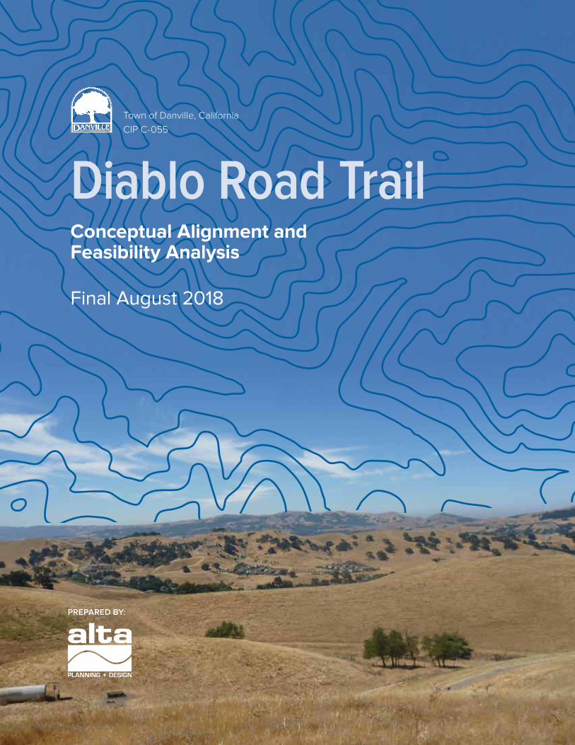
Diablo Road TrailConceptual Alignment and Feasibility Analysis
Final August 2018
Town of Danville, California
CIP C-055
PREPARED BY:

Table ofContents
Table of Contents
INTRODUCTION . . . . . . . . . . . . . . . . . . . . . . . . . . . . . . . . . . . . . . . . . . . . . . . . . . . . . . 1
Plan Context/Guiding Principles . . . . . . . . . . . . . . . . . . . . . . . . . . . . . . . . . . . . . . . . . . . . .3
Project Benefits . . . . . . . . . . . . . . . . . . . . . . . . . . . . . . . . . . . . . . . . . . . . . . . . . . . . . . . . . . .6
Planning Process . . . . . . . . . . . . . . . . . . . . . . . . . . . . . . . . . . . . . . . . . . . . . . . . . . . . . . . . . . 7
Project Considerations . . . . . . . . . . . . . . . . . . . . . . . . . . . . . . . . . . . . . . . . . . . . . . . . . . . . .8
ALIGNMENT CONCEPTS . . . . . . . . . . . . . . . . . . . . . . . . . . . . . . . . . . . . . . . . . . . . . . 11
Alignment Concepts . . . . . . . . . . . . . . . . . . . . . . . . . . . . . . . . . . . . . . . . . . . . . . . . . . . . . . .11
Road Crossing Options . . . . . . . . . . . . . . . . . . . . . . . . . . . . . . . . . . . . . . . . . . . . . . . . . . . 14
Drainage Crossing Options . . . . . . . . . . . . . . . . . . . . . . . . . . . . . . . . . . . . . . . . . . . . . . . . 18
Hill Alignment Options . . . . . . . . . . . . . . . . . . . . . . . . . . . . . . . . . . . . . . . . . . . . . . . . . . . 22
IMPLEMENTATION . . . . . . . . . . . . . . . . . . . . . . . . . . . . . . . . . . . . . . . . . . . . . . . . . . 29
ACKNOWLEDGMENTS . . . . . . . . . . . . . . . . . . . . . . . . . . . . . . . . . . . . . . . . . . . . . . 35

Introduction
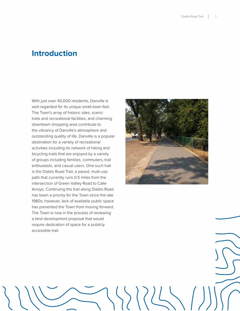
Diablo Road Trail 1
With just over 40,000 residents, Danville is
well-regarded for its unique small-town feel .
The Town’s array of historic sites, scenic
trails and recreational facilities, and charming
downtown shopping area contribute to
the vibrancy of Danville’s atmosphere and
outstanding quality of life . Danville is a popular
destination for a variety of recreational
activities including its network of hiking and
bicycling trails that are enjoyed by a variety
of groups including families, commuters, trail
enthusiasts, and casual users . One such trail
is the Diablo Road Trail, a paved, multi-use
path that currently runs 0 .5 miles from the
intersection of Green Valley Road to Calle
Arroyo . Continuing the trail along Diablo Road
has been a priority for the Town since the late
1980s; however, lack of available public space
has prevented the Town from moving forward .
The Town is now in the process of reviewing
a land development proposal that would
require dedication of space for a publicly
accessible trail .
Introduction
2 Danville, California
Figure 1: Vicinity Map
Danville Blvd
Gate Rd
Stone Valley Rd
Crow Canyon Rd
Tassajara Camino
Blackhawk Rd
Livorna Rd
Rudgear Rd
Sycamore Valley Rd
El Cerro Blvd
South Gate Rd
Hartz Ave
Dougherty Rd
Gree
n Va
lley
Rd
Deerwood Rd
Rossmoor Pkwy
San Ramon Valley Blvd
Northgate Rd
LAS TRAMPAS REGIONAL WILDERNESS
MOUNT DIABLO STATE PARK
DANVILLE
Diablo Rd
¥680
Existing Diablo Road Trail
Trail Study Corridor
The purpose of this study is to explore
potential alignments through this property
for an off-street trail and complete this gap
in the Town’s comprehensive trail network .
The Diablo Road Trail project would ultimately
provide a contiguous 8 to 10-foot wide, off-
street, paved multi-use trail facility for all user
groups including pedestrians and bicyclists,
and would link the Diablo Road/Green Valley
Road corridor to the west to Blackhawk Road/
Mt . Diablo Park south access to the east . The
Diablo Road corridor is a preferred route to
Mt . Diablo State Park, a popular recreational
bicyclist destination well-known throughout
the Bay Area . At just 4 miles from Downtown
Danville, residents and visitors can enjoy
traveling along bicycle lanes and off-road trails
on a nearly continuous path between Mount
Diablo and Danville’s shops and restaurants,
Iron Horse Trail, and Las Trampas Regional
Diablo Road Trail 3
Wilderness .
Plan Context/Guiding Principles
Danville’s 2030 General Plan, adopted in
2013, sets a long-range vision for the Town
and guides development decisions affecting
change over a 15 to 20 year period . The
General Plan recognizes bicycling as a
“healthy, environmentally sustainable mode
of travel” and that “expanding Danville’s
bicycle network has been a priority for more
than two decades .”1 General Plan policies
provide explicit support for trail improvements,
including:
Policy 12.07 - Close gaps in the Town’s
bicycle and pedestrian trail system in
order to create a more fully connected,
1 Town of Danville, CA, Danville 2030 General Plan, Chapter 4: Mobility, 4-10 .
logical, comprehensive system of facilities
for non-motorized transportation.
Policy 17.14 - Enhance Danville’s trail
system by closing gaps in the existing
system, providing adequate access
points, and extending trails to achieve
better connectivity to all areas of the
town. Furthermore, the General Plan
specifically supports the construction
of a “bike/walkway along Diablo Road
from Green Valley Road to Mt. Diablo
Scenic Boulevard” as a consistent
recommendation with the 2009
Countywide Bicycle and Pedestrian Plan.2
Interest in developing a trail connection
parallel to Diablo Road stretches as far back
2 Town of Danville, CA, Danville 2030 General Plan, Chapter 4: Mobility, 4-22 .
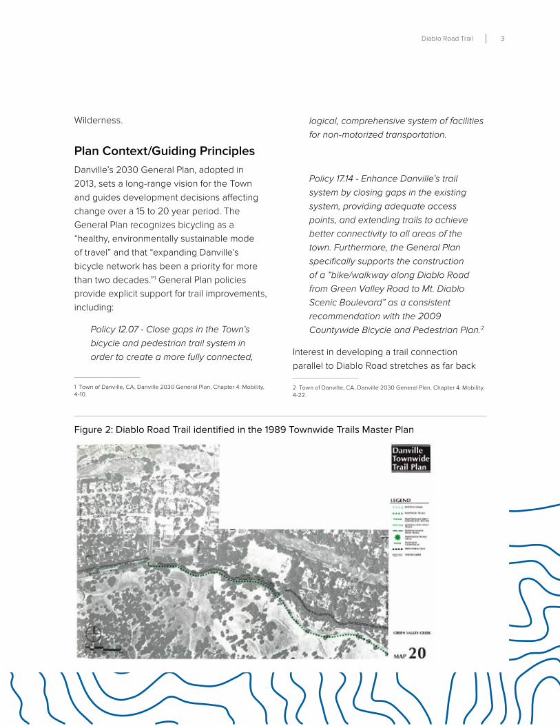
Figure 2: Diablo Road Trail identified in the 1989 Townwide Trails Master Plan
4 Danville, California
1989 when Danville adopted its Townwide
Trails Master Plan . The Plan proposed a trail
alongside Green Valley Creek and Diablo
Road from Clydsedale Drive to 400 feet west
of Ave Nueva .
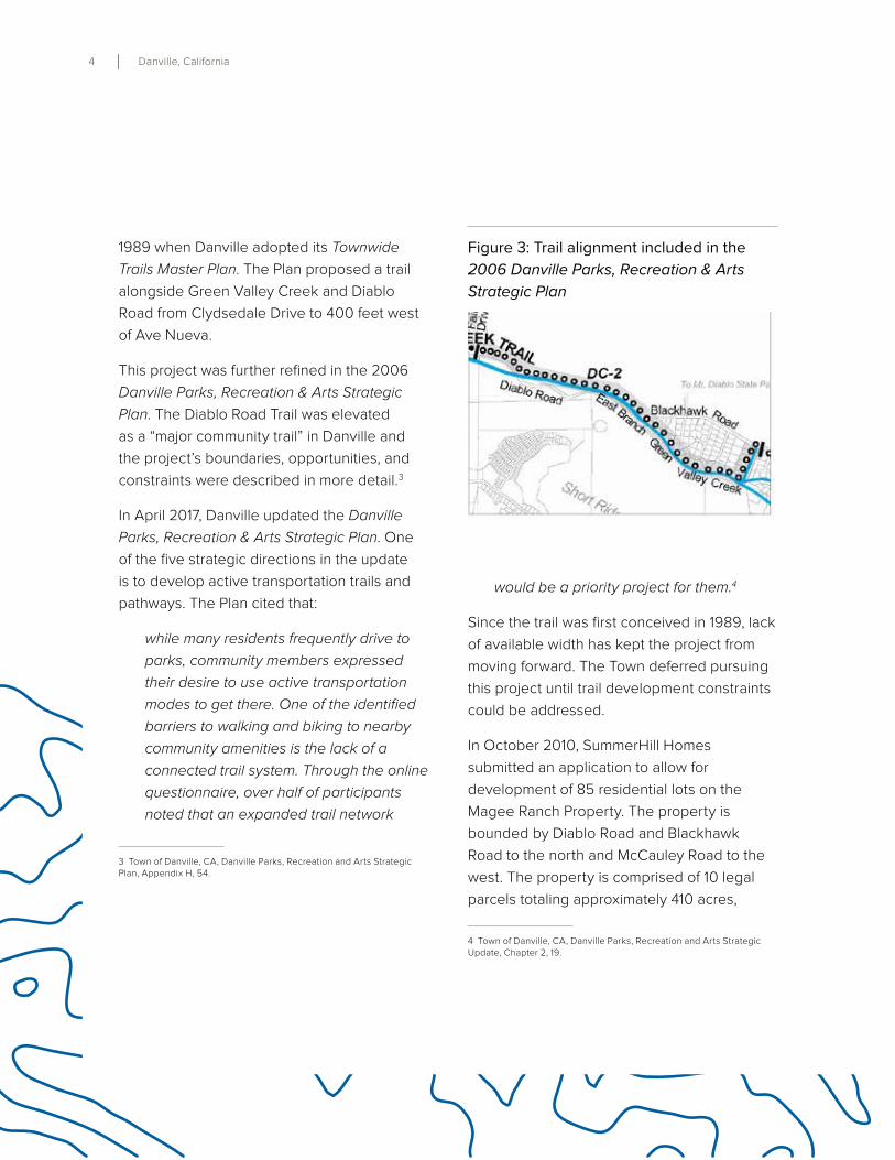
This project was further refined in the 2006
Danville Parks, Recreation & Arts Strategic
Plan . The Diablo Road Trail was elevated
as a “major community trail” in Danville and
the project’s boundaries, opportunities, and
constraints were described in more detail .3
In April 2017, Danville updated the Danville
Parks, Recreation & Arts Strategic Plan . One
of the five strategic directions in the update
is to develop active transportation trails and
pathways . The Plan cited that:
while many residents frequently drive to
parks, community members expressed
their desire to use active transportation
modes to get there. One of the identified
barriers to walking and biking to nearby
community amenities is the lack of a
connected trail system. Through the online
questionnaire, over half of participants
noted that an expanded trail network
3 Town of Danville, CA, Danville Parks, Recreation and Arts Strategic Plan, Appendix H, 54 .
would be a priority project for them.4
Since the trail was first conceived in 1989, lack
of available width has kept the project from
moving forward . The Town deferred pursuing
this project until trail development constraints
could be addressed .
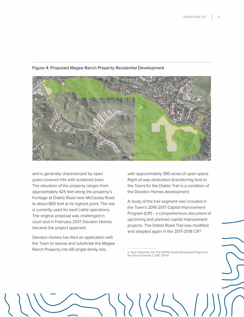
In October 2010, SummerHill Homes
submitted an application to allow for
development of 85 residential lots on the
Magee Ranch Property . The property is
bounded by Diablo Road and Blackhawk
Road to the north and McCauley Road to the
west . The property is comprised of 10 legal
parcels totaling approximately 410 acres,
4 Town of Danville, CA, Danville Parks, Recreation and Arts Strategic Update, Chapter 2, 19 .
Figure 3: Trail alignment included in the
2006 Danville Parks, Recreation & Arts
Strategic Plan
Diablo Road Trail 5
and is generally characterized by open
grass-covered hills with scattered trees .
The elevation of the property ranges from
approximately 425 feet along the property’s
frontage at Diablo Road near McCauley Road
to about 860 feet at its highest point . The site
is currently used for beef cattle operations .
The original proposal was challenged in
court and in February 2017, Davidon Homes
became the project applicant .
Davidon Homes has filed an application with
the Town to rezone and subdivide the Magee
Ranch Property into 69 single-family lots,
with approximately 380 acres of open space .
Right-of-way dedication (transferring land to
the Town) for the Diablo Trail is a condition of
the Davidon Homes development .
A study of the trail segment was included in
the Town’s 2016-2017 Capital Improvement
Program (CIP) - a comprehensive document of
upcoming and planned capital improvement
projects . The Diablo Road Trail was modified
and adopted again in the 2017-2018 CIP .5
5 Town of Danville, CA, The 2017/18 Capital Improvement Program for the Town of Danville, C-055, CIP 92
Figure 4: Proposed Magee Ranch Property Residential Development
6 Danville, California
Project Benefits
In addition to implementing adopted goals,
policies, and recommendations in the Danville
2030 General Plan, Danville Parks, Recreation
& Arts Strategic Plan, Countywide Bicycle and
Pedestrian Plan, and Townwide Trails Master
Plan, closing this gap will provide several key
benefits to Danville residents and visitors .
CONNECTIVITY
The Danville Diablo Road Trail can become
a viable transportation corridor by providing
new access to recreation, schools, jobs, retail,
and other services in the community .
HEALTH AND RECREATION
Trails create recreation opportunities that
promote healthy activities such as, walking,
running, bicycling, and skating . Benefits
include reducing obesity, controlling
cholesterol levels and diabetes, slowing bone
loss in aging populations, and reducing the
risk of certain cancers . Access to linear parks
such as trails and paths can also provide
mental health benefits that help to reduce
anxiety and depression .
ECONOMIC IMPACTS
Creating a major recreational resource like the
Danville Diablo Road Trail can provide access
to businesses and jobs, and contribute to a
sense of place for locals while also attracting
tourists that support the local economy .
Diablo Road Trail 7
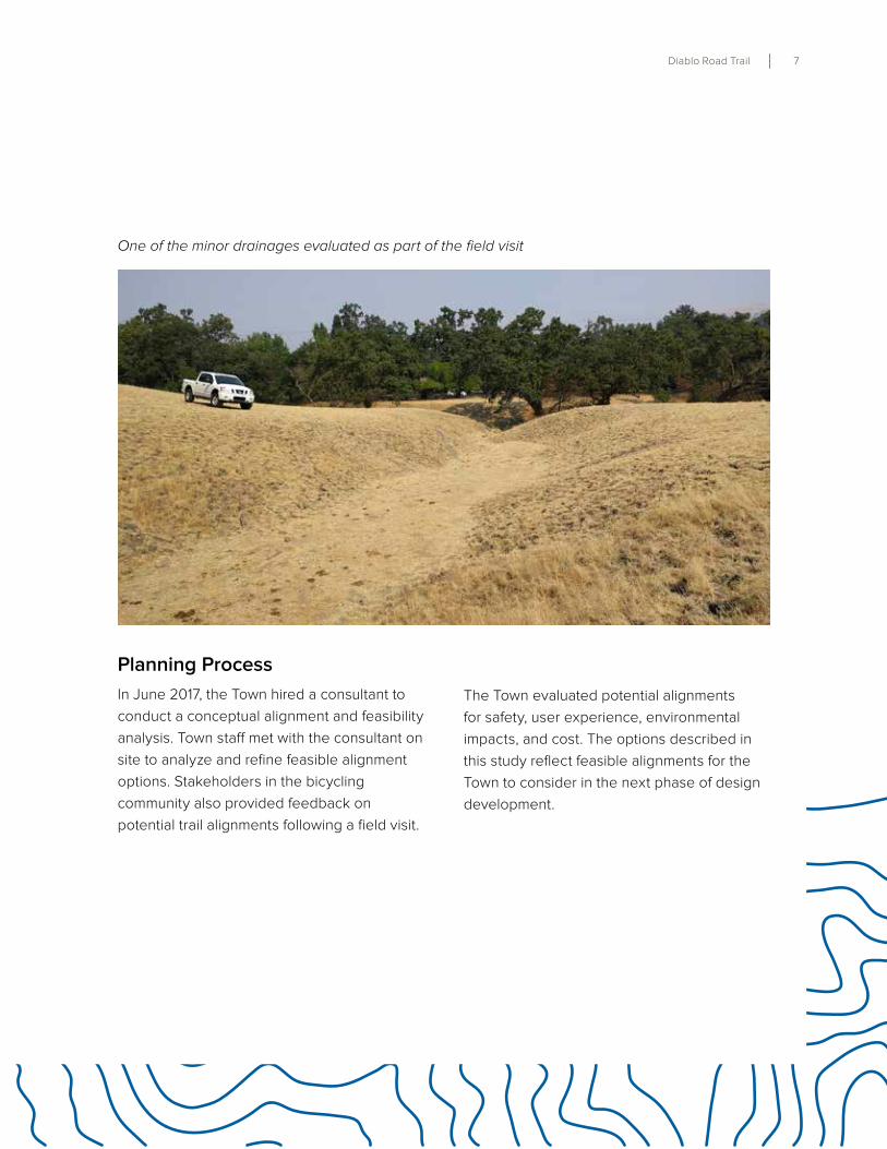
Planning Process
In June 2017, the Town hired a consultant to
conduct a conceptual alignment and feasibility
analysis . Town staff met with the consultant on
site to analyze and refine feasible alignment
options . Stakeholders in the bicycling
community also provided feedback on
potential trail alignments following a field visit .
The Town evaluated potential alignments
for safety, user experience, environmental
impacts, and cost . The options described in
this study reflect feasible alignments for the
Town to consider in the next phase of design
development .
One of the minor drainages evaluated as part of the field visit
8 Danville, California
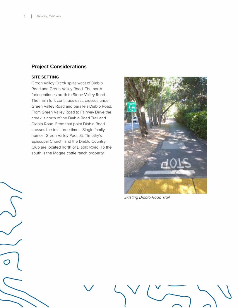
Existing Diablo Road Trail
Project Considerations
SITE SETTING
Green Valley Creek splits west of Diablo
Road and Green Valley Road . The north
fork continues north to Stone Valley Road .
The main fork continues east, crosses under
Green Valley Road and parallels Diablo Road .
From Green Valley Road to Fairway Drive the
creek is north of the Diablo Road Trail and
Diablo Road . From that point Diablo Road
crosses the trail three times . Single family
homes, Green Valley Pool, St . Timothy’s
Episcopal Church, and the Diablo Country
Club are located north of Diablo Road . To the
south is the Magee cattle ranch property .
Diablo Road Trail 9
ACCESS/CIRCULATION
Diablo Road Trail
The Town has installed five feet wide bicycle
lanes on El Cerro Boulevard and Diablo Road
from Danville Boulevard to Green Valley
Road/McCauley Road . The Diablo Lodge/Los
Cerros Connector Trail is accessible off of Hill
Road, 200 feet south of the Diablo Road and
Green Valley intersection . Heading east from
Green Valley Road, bicyclists and pedestrians
can use the multi-use Diablo Road Trail on
the north side of Diablo Road . This off-street
paved asphalt trail varies in width from 8 to
10 feet and runs 0 .5 miles to Calle Arroyo
where the road is 24 feet wide . In some
areas past Calle Arroyo, Diablo Road is as
narrow as 20 feet . Accommodating separated
bicycle facilities, sidewalks, or a multi-use
path will require either private property
acquisition on the north side of Diablo Road
or environmental impacts to the creek and
adjacent hillside . Previous studies have cited
the need for a connection off-street .
Figure 5: Alignment Overview Map
DANVILLE
MAGEE RANCH PROPERTY
MAGEE RANCHPROPERTY
UNINCORPORATEDCOUNTY
DIABLO RD
ALAMEDA DIABLO
CALLE ARROYO
AV
E N
UE
VA
LA CADENA
CASA NUESTRA
CLY
DE
SD
AL
E D
R
FAIR
WA
Y D
R
PRIVATE D
RIVE
EL
NID
O RD
Property Lines
Town Boundary
Existing Trail
Future Trail
EMERGENCY VEHICLE ACCESS ROAD
DIABLO RD
GREEN VALLEY CREEK
Alignment Concepts
Diablo Road Trail 11
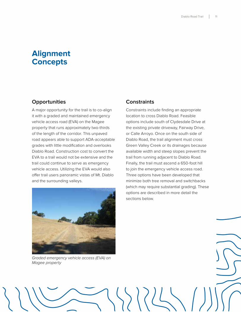
Opportunities
A major opportunity for the trail is to co-align
it with a graded and maintained emergency
vehicle access road (EVA) on the Magee
property that runs approximately two-thirds
of the length of the corridor . This unpaved
road appears able to support ADA-acceptable
grades with little modification and overlooks
Diablo Road . Construction cost to convert the
EVA to a trail would not be extensive and the
trail could continue to serve as emergency
vehicle access . Utilizing the EVA would also
offer trail users panoramic vistas of Mt . Diablo
and the surrounding valleys .
Alignment Concepts
Constraints
Constraints include finding an appropriate
location to cross Diablo Road . Feasible
options include south of Clydesdale Drive at
the existing private driveway, Fairway Drive,
or Calle Arroyo . Once on the south side of
Diablo Road, the trail alignment must cross
Green Valley Creek or its drainages because
available width and steep slopes prevent the
trail from running adjacent to Diablo Road .
Finally, the trail must ascend a 650-foot hill
to join the emergency vehicle access road .
Three options have been developed that
minimize both tree removal and switchbacks
(which may require substantial grading) . These
options are described in more detail the
sections below .
Graded emergency vehicle access (EVA) on Magee property
12 Danville, California
This page intentionally blank
Diablo Road Trail 13
Figure 6:
Detailed Alignment Options
23
CA
D
B
1
ALAMEDA DIABLO
CA
LLE
AR
RO
YO
CLY
DE
SD
ALE
DR
FA
IRW
AY
DR
PRIVATE D
RIVE
UTILITY ACCESS ROAD
DIABLO RD
Hill AlignmentOption 1
Street Crossing Option
Existing Trail
Hill AlignmentOption 2
Hill AlignmentOption 3
Drainage Crossing Option
1
14 Danville, California
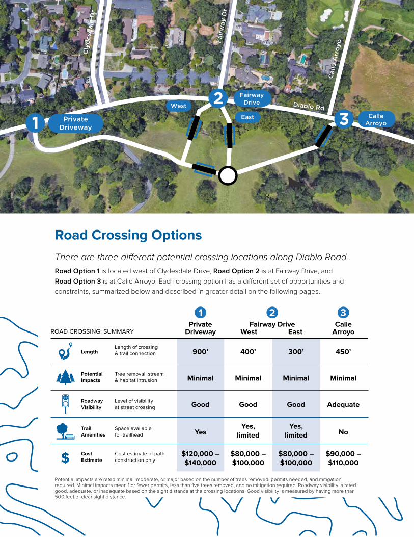
There are three different potential crossing locations along Diablo Road.
Road Option 1 is located west of Clydesdale Drive, Road Option 2 is at Fairway Drive, and
Road Option 3 is at Calle Arroyo . Each crossing option has a different set of opportunities and
constraints, summarized below and described in greater detail on the following pages .
Road Crossing Options
Diablo Rd
Cly
des
dal
e D
r
Fai
rway
Dr
Cal
le A
rro
yo
2 FairwayDriveWest
East CalleArroyo3Private
Driveway1
900’
Minimal
Good
Yes
$120,000 –$140,000
400’
Minimal
Good
Yes,limited
$80,000 –$100,000
300’
Minimal
Good
Yes,limited
$80,000 –$100,000
Length
Tree removal, stream& habitat intrusion
Length of crossing& trail connection
Level of visibilityat street crossing
Space availablefor trailhead
Cost estimate of pathconstruction only
450’
Minimal
Adequate
No
$90,000 –$110,000
Potential Impacts
TrailAmenities
CostEstimate
Roadway Visibility
PrivateDriveway
Fairway DriveEastWest
CalleArroyo
321
$
ROAD CROSSING: SUMMARY
Potential impacts are rated minimal, moderate, or major based on the number of trees removed, permits needed, and mitigation required . Minimal impacts mean 1 or fewer permits, less than five trees removed, and no mitigation required . Roadway visibility is rated good, adequate, or inadequate based on the sight distance at the crossing locations . Good visibility is measured by having more than 500 feet of clear sight distance .
Diablo Road Trail 15
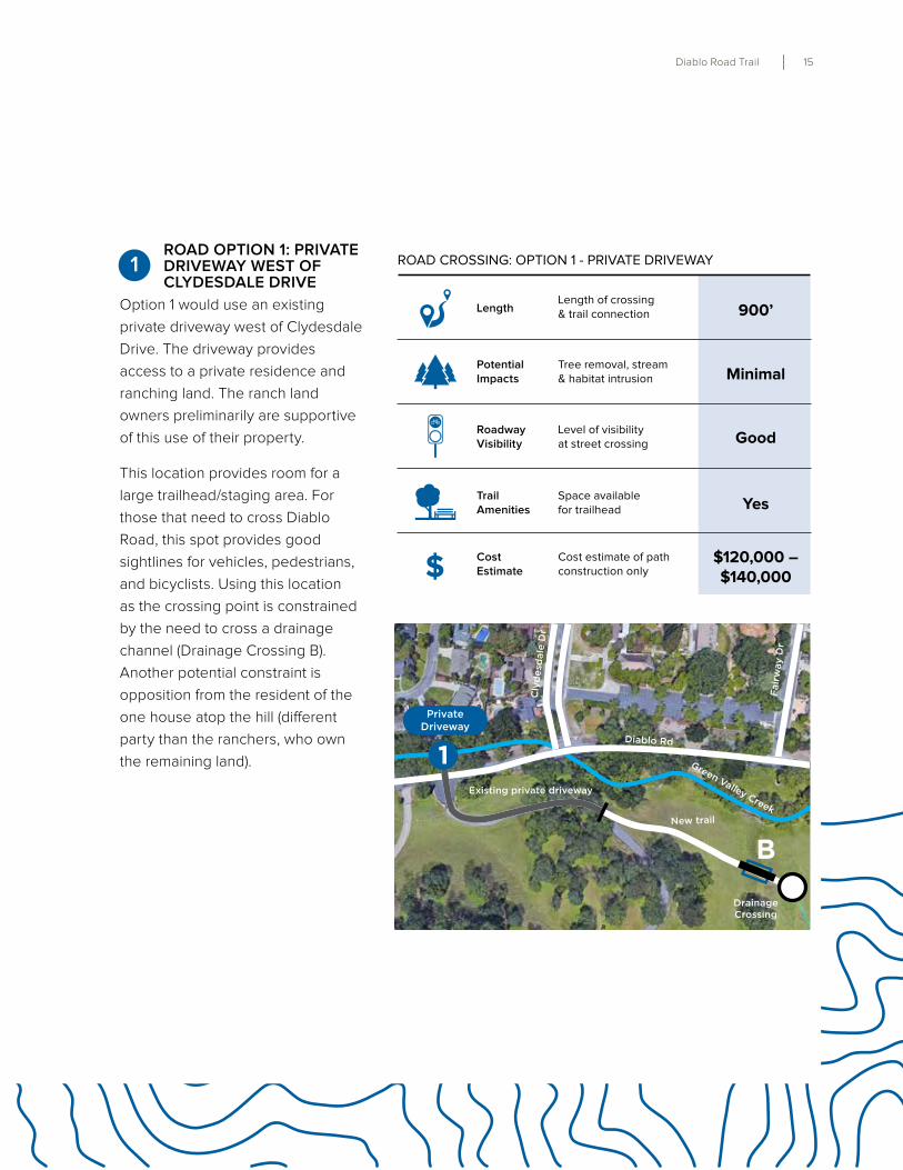
ROAD OPTION 1: PRIVATE DRIVEWAY WEST OF CLYDESDALE DRIVE
Option 1 would use an existing
private driveway west of Clydesdale
Drive . The driveway provides
access to a private residence and
ranching land . The ranch land
owners preliminarily are supportive
of this use of their property .
This location provides room for a
large trailhead/staging area . For
those that need to cross Diablo
Road, this spot provides good
sightlines for vehicles, pedestrians,
and bicyclists . Using this location
as the crossing point is constrained
by the need to cross a drainage
channel (Drainage Crossing B) .
Another potential constraint is
opposition from the resident of the
one house atop the hill (different
party than the ranchers, who own
the remaining land) .
Length
Tree removal, stream& habitat intrusion
Length of crossing& trail connection
Level of visibilityat street crossing
Space availablefor trailhead
Cost estimate of pathconstruction only
900’
Minimal
Good
Yes
$120,000 –$140,000
Potential Impacts
TrailAmenities
CostEstimate$
Roadway Visibility
ROAD CROSSING: OPTION 1 - PRIVATE DRIVEWAY
PrivateDriveway
1Diablo Rd
Existing private driveway
New trail
Green Valley Creek
Cly
des
dal
e D
r
Fair
way
Dr
DrainageCrossing
B
1
16 Danville, California
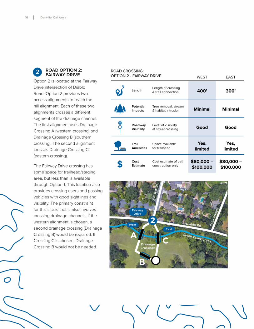
ROAD OPTION 2: FAIRWAY DRIVE
Option 2 is located at the Fairway
Drive intersection of Diablo
Road . Option 2 provides two
access alignments to reach the
hill alignment . Each of these two
alignments crosses a different
segment of the drainage channel .
The first alignment uses Drainage
Crossing A (western crossing) and
Drainage Crossing B (southern
crossing) . The second alignment
crosses Drainage Crossing C
(eastern crossing) .
The Fairway Drive crossing has
some space for trailhead/staging
area, but less than is available
through Option 1 . This location also
provides crossing users and passing
vehicles with good sightlines and
visibility . The primary constraint
for this site is that is also involves
crossing drainage channels; if the
western alignment is chosen, a
second drainage crossing (Drainage
Crossing B) would be required . If
Crossing C is chosen, Drainage
Crossing B would not be needed .
Length
Tree removal, stream& habitat intrusion
Length of crossing& trail connection
Level of visibilityat street crossing
Space availablefor trailhead
Cost estimate of pathconstruction only
400’
Minimal
Good
Yes,limited
$80,000 –$100,000
300’
Minimal
Good
Yes,limited
$80,000 –$100,000
Potential Impacts
TrailAmenities
CostEstimate$
Roadway Visibility
ROAD CROSSING:OPTION 2 - FAIRWAY DRIVE WEST EAST
Green Valley Creek
Diablo Rd
Cly
des
dal
e D
r
Fair
way
Dr
Cal
le A
rroy
o
2Fairway
Drive
WestEast
B
DrainageCrossings
A C
2
Diablo Road Trail 17
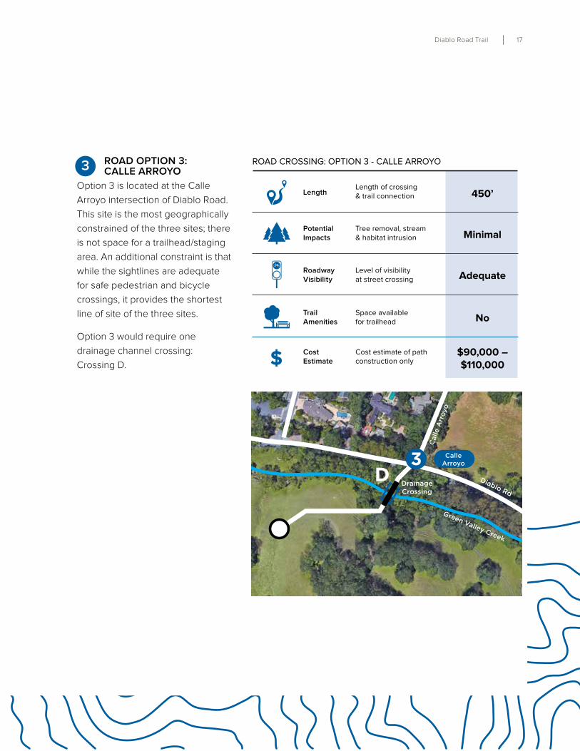
ROAD OPTION 3: CALLE ARROYO
Option 3 is located at the Calle
Arroyo intersection of Diablo Road .
This site is the most geographically
constrained of the three sites; there
is not space for a trailhead/staging
area . An additional constraint is that
while the sightlines are adequate
for safe pedestrian and bicycle
crossings, it provides the shortest
line of site of the three sites .
Option 3 would require one
drainage channel crossing:
Crossing D .
Green Valley Creek
Diablo Rd
Fair
way
Dr
Cal
le A
rroy
o
CalleArroyo
DrainageCrossing
3D
Length
Tree removal, stream& habitat intrusion
Length of crossing& trail connection
Level of visibilityat street crossing
Space availablefor trailhead
Cost estimate of pathconstruction only
450’
Minimal
Adequate
No
$90,000 –$110,000
Potential Impacts
TrailAmenities
CostEstimate$
Roadway Visibility
ROAD CROSSING: OPTION 3 - CALLE ARROYO3
18 Danville, California
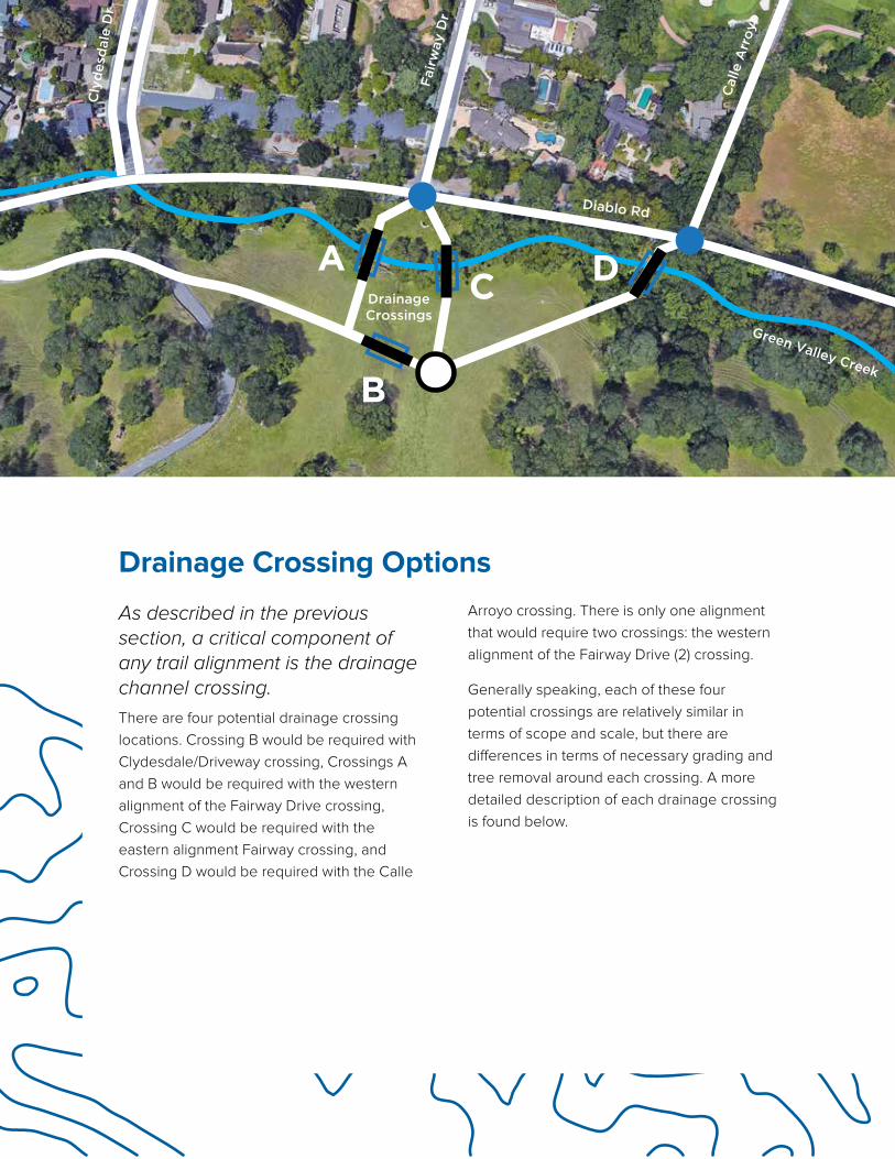
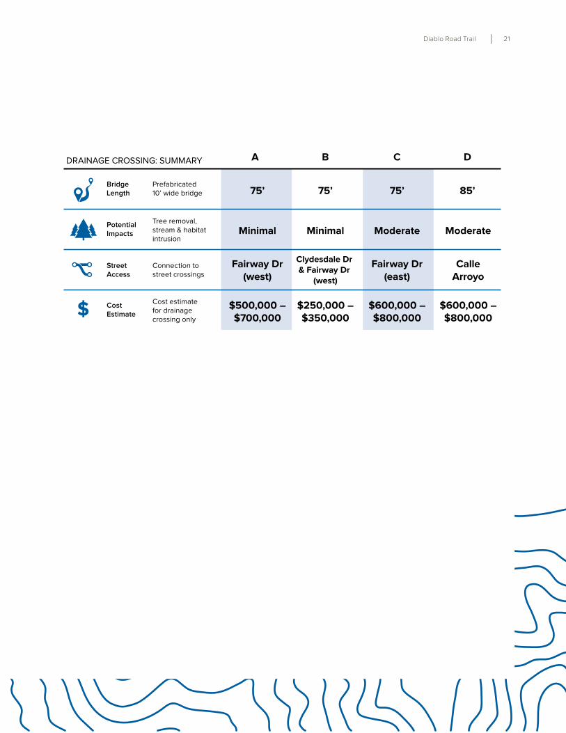
As described in the previous section, a critical component of any trail alignment is the drainage channel crossing.
There are four potential drainage crossing
locations . Crossing B would be required with
Clydesdale/Driveway crossing, Crossings A
and B would be required with the western
alignment of the Fairway Drive crossing,
Crossing C would be required with the
eastern alignment Fairway crossing, and
Crossing D would be required with the Calle
Drainage Crossing Options
Green Valley Creek
Diablo Rd
Cly
des
dal
e D
r
Fair
way
Dr
Cal
le A
rroy
o
B
DrainageCrossings
AC D
Arroyo crossing . There is only one alignment
that would require two crossings: the western
alignment of the Fairway Drive (2) crossing .
Generally speaking, each of these four
potential crossings are relatively similar in
terms of scope and scale, but there are
differences in terms of necessary grading and
tree removal around each crossing . A more
detailed description of each drainage crossing
is found below .
Diablo Road Trail 19
$
BridgeLength
Tree removal, stream& habitat intrusion
Prefabricated 10’ wide bridge
Connection to street crossings
Cost estimate fordrainage crossing only
75’
Minimal
Fairway Dr(west)
$500,000 –$700,000
Potential Impacts
CostEstimate
StreetAccess
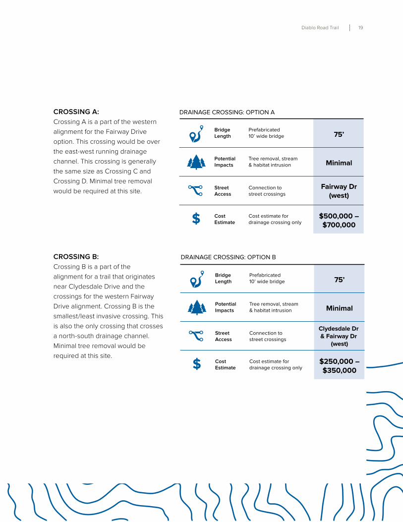
DRAINAGE CROSSING: OPTION A
$
BridgeLength
Tree removal, stream& habitat intrusion
Prefabricated 10’ wide bridge
Connection to street crossings
Cost estimate fordrainage crossing only
Potential Impacts
CostEstimate
StreetAccess
DRAINAGE CROSSING: OPTION B
75’
Minimal
Clydesdale Dr & Fairway Dr
(west)
$250,000 –$350,000
CROSSING A:
Crossing A is a part of the western
alignment for the Fairway Drive
option . This crossing would be over
the east-west running drainage
channel . This crossing is generally
the same size as Crossing C and
Crossing D . Minimal tree removal
would be required at this site .
CROSSING B:
Crossing B is a part of the
alignment for a trail that originates
near Clydesdale Drive and the
crossings for the western Fairway
Drive alignment . Crossing B is the
smallest/least invasive crossing . This
is also the only crossing that crosses
a north-south drainage channel .
Minimal tree removal would be
required at this site .
20 Danville, California
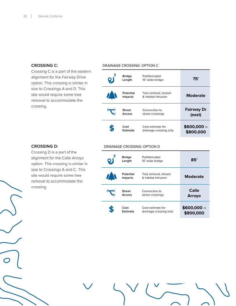
CROSSING C:
Crossing C is a part of the eastern
alignment for the Fairway Drive
option . This crossing is similar in
size to Crossings A and D . This
site would require some tree
removal to accommodate the
crossing .
$
BridgeLength
Tree removal, stream& habitat intrusion
Prefabricated 10’ wide bridge
Connection to street crossings
Cost estimate fordrainage crossing only
Potential Impacts
CostEstimate
StreetAccess
DRAINAGE CROSSING: OPTION C
75’
Moderate
Fairway Dr(east)
$600,000 –$800,000
$
BridgeLength
Tree removal, stream& habitat intrusion
Prefabricated 10’ wide bridge
Connection to street crossings
Cost estimate fordrainage crossing only
Potential Impacts
CostEstimate
StreetAccess
DRAINAGE CROSSING: OPTION D
85’
Moderate
CalleArroyo
$600,000 –$800,000
CROSSING D:
Crossing D is a part of the
alignment for the Calle Arroyo
option . This crossing is similar in
size to Crossings A and C . This
site would require some tree
removal to accommodate the
crossing .
Diablo Road Trail 21
$
BridgeLength
Tree removal, stream & habitatintrusion
Prefabricated 10’ wide bridge
Connection to street crossings
Cost estimatefor drainagecrossing only
Potential Impacts
CostEstimate
StreetAccess
75’
Minimal
Fairway Dr(west)
$500,000 –$700,000
DRAINAGE CROSSING: SUMMARY
75’
Minimal
Clydesdale Dr & Fairway Dr
(west)
$250,000 –$350,000
75’
Moderate
Fairway Dr(east)
$600,000 –$800,000
A B C D
85’
Moderate
CalleArroyo
$600,000 –$800,000
22 Danville, California
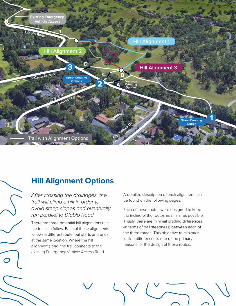
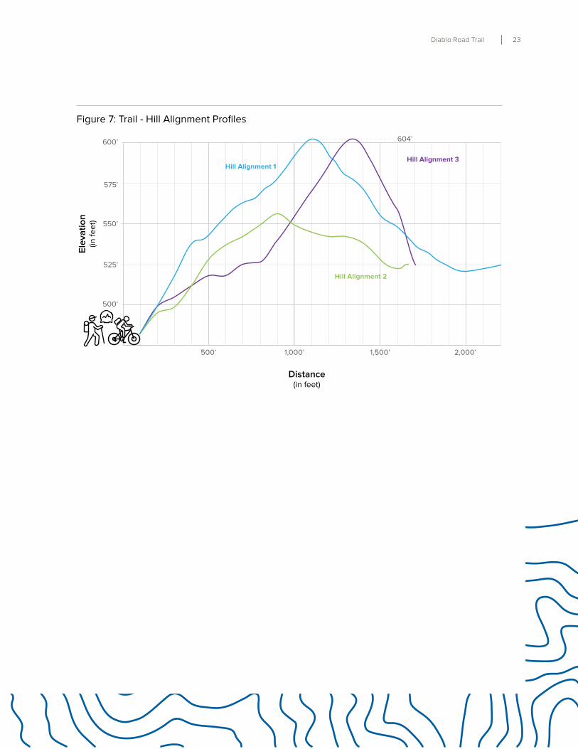
After crossing the drainages, the trail will climb a hill in order to avoid steep slopes and eventually run parallel to Diablo Road.
There are three potential hill alignments that
the trail can follow . Each of these alignments
follows a different route, but starts and ends
at the same location . Where the hill
alignments end, the trail connects to the
existing Emergency Vehicle Access Road .
A detailed description of each alignment can
be found on the following pages .
Each of these routes were designed to keep
the incline of the routes as similar as possible .
Thusly, there are minimal grading differences
(in terms of trail steepness) between each of
the three routes . This objective to minimize
incline differences is one of the primary
reasons for the design of these routes .
Hill Alignment Options
Clydesdale
Dr
Fairway Dr
Calle Arroyo
Diablo Road
3Street Crossing
Options
Street CrossingOption
DrainageCrossingOptions
A
BC
D
Hill Alignment 2Hill Alignment 2
Hill Alignment 1Hill Alignment 1
Hill Alignment 3Hill Alignment 3
2
1
Trail with Alignment Options
Existing Emergency Vehicle Access
Existing Emergency Vehicle Access
Diablo Road Trail 23
500’
525’
550’
575’
600’ 604’
500’ 1,000’ 1,500’ 2,000’
Trail Elevation Profiles
Ele
va
tio
n(in
fe
et)
Distance(in feet)
Hill Alignment 1
Hill Alignment 2
Hill Alignment 3
Figure 7: Trail - Hill Alignment Profiles
24 Danville, California
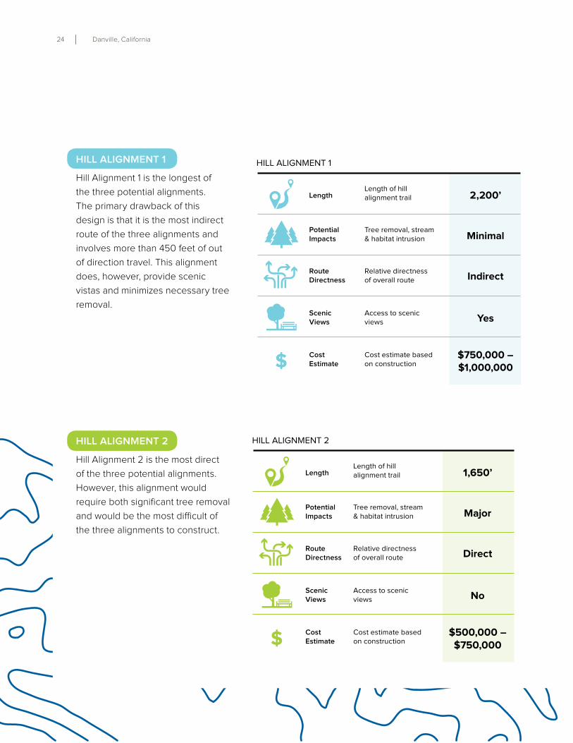
Length
Tree removal, stream& habitat intrusion
Length of hillalignment trail
Relative directnessof overall route
Access to scenicviews
Cost estimate based on construction
2,200’
Minimal
Indirect
Yes
$750,000 –$1,000,000
Potential Impacts
ScenicViews
CostEstimate$
RouteDirectness
HILL ALIGNMENT 1
HILL ALIGNMENT 2
Length
Tree removal, stream& habitat intrusion
Length of hillalignment trail
Relative directnessof overall route
Access to scenicviews
Cost estimate based on construction
Potential Impacts
ScenicViews
CostEstimate$
RouteDirectness
1,650’
Major
Direct
No
$500,000 –$750,000
HILL ALIGNMENT 1
Hill Alignment 1 is the longest of
the three potential alignments .
The primary drawback of this
design is that it is the most indirect
route of the three alignments and
involves more than 450 feet of out
of direction travel . This alignment
does, however, provide scenic
vistas and minimizes necessary tree
removal .
HILL ALIGNMENT 2
Hill Alignment 2 is the most direct
of the three potential alignments .
However, this alignment would
require both significant tree removal
and would be the most difficult of
the three alignments to construct .
Diablo Road Trail 25
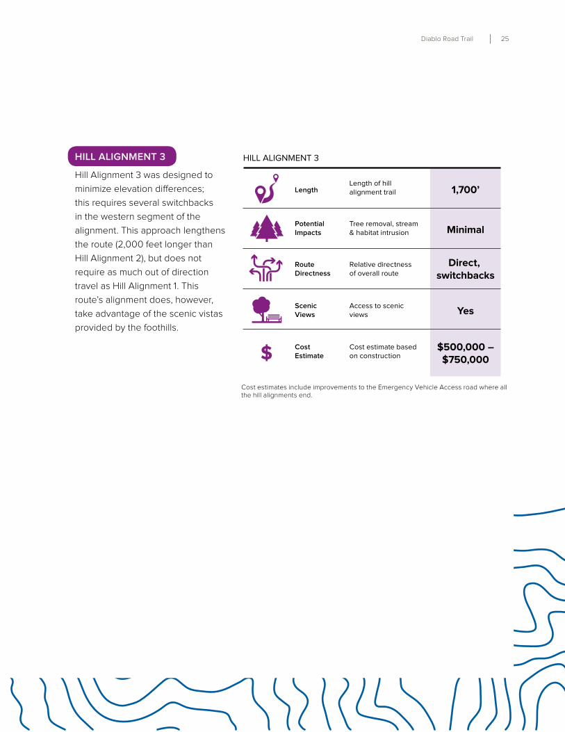
HILL ALIGNMENT 3
Length
Tree removal, stream& habitat intrusion
Length of hillalignment trail
Relative directnessof overall route
Access to scenicviews
Cost estimate based on construction
Potential Impacts
ScenicViews
CostEstimate$
RouteDirectness
1,700’
Minimal
Direct, switchbacks
Yes
$500,000 –$750,000
HILL ALIGNMENT 3
Hill Alignment 3 was designed to
minimize elevation differences;
this requires several switchbacks
in the western segment of the
alignment . This approach lengthens
the route (2,000 feet longer than
Hill Alignment 2), but does not
require as much out of direction
travel as Hill Alignment 1 . This
route’s alignment does, however,
take advantage of the scenic vistas
provided by the foothills .
Cost estimates include improvements to the Emergency Vehicle Access road where all the hill alignments end .
26 Danville, California
Alignment Summary Table
Road Crossing
Pages 16-19
Drainage Crossing
Pages 20-23
Hill Alignment
Pages 24-27
Emergency Vehicle Access
Cost Estimate
1
Private Driveway
+
B
+
1
+ R =
$1,570,000 - $1,940,000
B 2 $1,320,000 - $1,690,000
B 3 $1,320,000 - $1,690,000
2
Fairway Drive
+
A + B
+
1
+ R =
$2,030,000 - $2,600,000
A + B 2 $1,780,000 - $2,350,000
A + B 3 $1,780,000 - $2,350,000
C 1 $1,880,000 - $2,350,000
C 2 $1,630,000 - $2,100,000
C 3 $1,630,000 - $2,100,000
3
Calle Arroyo
+
D
+
1
+ R =
$1,890,000 - $2,360,000
D 2 $1,640,000 - $2,110,000
D 3 $1,640,000 - $2,110,000
This study summarizes various alternatives for
closing the gap in the existing Diablo Road
Trail . As shown in the maps and diagrams in
this report, there are three road crossings, four
drainage crossings, and three hill alignments
that are feasible to pursue .Each alternative
has both benefits and trade-offs and below
is a summary of the potential combinations to
help compare these options .
Alignment Summary
Diablo Road Trail 27
This page intentionally blank
Implementation
Diablo Road Trail 29
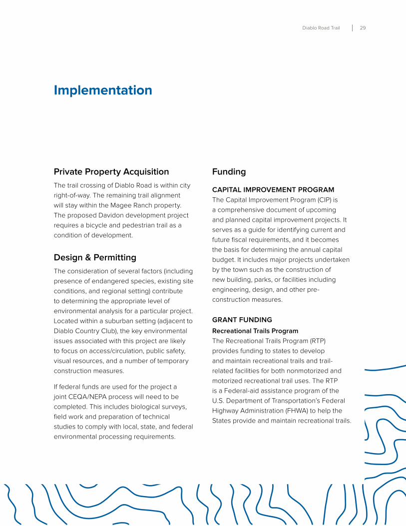
Private Property Acquisition
The trail crossing of Diablo Road is within city
right-of-way . The remaining trail alignment
will stay within the Magee Ranch property .
The proposed Davidon development project
requires a bicycle and pedestrian trail as a
condition of development .
Design & Permitting
The consideration of several factors (including
presence of endangered species, existing site
conditions, and regional setting) contribute
to determining the appropriate level of
environmental analysis for a particular project .
Located within a suburban setting (adjacent to
Diablo Country Club), the key environmental
issues associated with this project are likely
to focus on access/circulation, public safety,
visual resources, and a number of temporary
construction measures .
If federal funds are used for the project a
joint CEQA/NEPA process will need to be
completed . This includes biological surveys,
field work and preparation of technical
studies to comply with local, state, and federal
environmental processing requirements .
Implementation
Funding
CAPITAL IMPROVEMENT PROGRAM
The Capital Improvement Program (CIP) is
a comprehensive document of upcoming
and planned capital improvement projects . It
serves as a guide for identifying current and
future fiscal requirements, and it becomes
the basis for determining the annual capital
budget . It includes major projects undertaken
by the town such as the construction of
new building, parks, or facilities including
engineering, design, and other pre-
construction measures .
GRANT FUNDING
Recreational Trails Program
The Recreational Trails Program (RTP)
provides funding to states to develop
and maintain recreational trails and trail-
related facilities for both nonmotorized and
motorized recreational trail uses . The RTP
is a Federal-aid assistance program of the
U .S . Department of Transportation’s Federal
Highway Administration (FHWA) to help the
States provide and maintain recreational trails .
30 Danville, California
Eligible projects include:
• Trail maintenance and restoration
• Trailside and trailhead facilities
• Equipment for construction and
maintenance
• Construction of new recreational trails
• Acquisition of trail corridors
• Assessment of trail conditions
• Safety and environmental education
• Administration
Funding and Requirements:
• Applicants to the RTP are responsible for
obtaining a match of at least 12% of the total
project cost .
• Compliance with the National Environmental
Policy Act (NEPA)
• Completion of the National historic
Preservation Act
• Listing of the project on the State
Transportation Improvement Plan (STIP) or a
local Transportation Improvement Plan (TIP)
• Acquisition projects, applicants must obtain
an appraisal that conforms to the Uniform
Appraisal Standards for Federal Land
Acquisitions (UASFLA)
Active Transportation Program
In 2013, Governor Brown signed legislation
creating the Active Transportation Program
(ATP) . This program is a consolidation of the
federal Transportation Alternatives Program
(TAP), California’s Bicycle Transportation
Account (BTA), and federal and California Safe
Routes to School (SRTS) programs .
The ATP program goals include:
• Increase the proportion of trips
accomplished by biking and walking
• Increase safety and mobility for non-
motorized users
• Advance the active transportation efforts of
regional agencies to achieve greenhouse
gas reduction goals
• Enhance public health
• Ensure that disadvantaged communities
fully share in the benefits of the program
• Provide a broad spectrum of projects to
benefit many types of active transportation
users
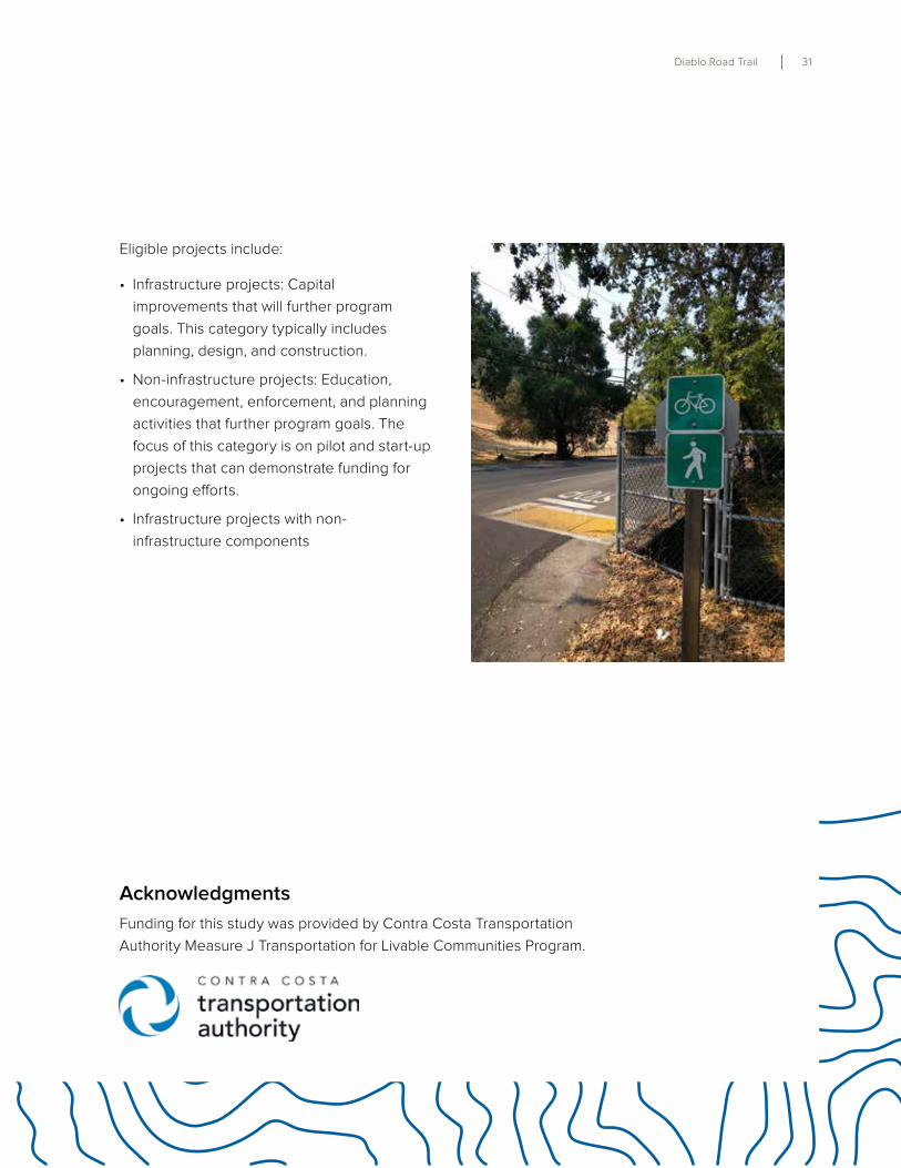
Diablo Road Trail 31
Eligible projects include:
• Infrastructure projects: Capital
improvements that will further program
goals . This category typically includes
planning, design, and construction .
• Non-infrastructure projects: Education,
encouragement, enforcement, and planning
activities that further program goals . The
focus of this category is on pilot and start-up
projects that can demonstrate funding for
ongoing efforts .
• Infrastructure projects with non-
infrastructure components
Funding for this study was provided by Contra Costa Transportation
Authority Measure J Transportation for Livable Communities Program .
Acknowledgments


![IELTS [Diablo]](https://img.pdfslide.us/doc/110x75/5536222c5503462c748b4913/ielts-diablo.jpg)