Embed Size (px)
Citation preview

CIAIM-05/2016 REPORT
Collision between Merchant Ship BALTIC BREEZE and Fishing Vessel MAR DE MARIN in the Ria of Vigo (Pontevedra) on 1April
2014, in which five crew members were killed
NOTICE
This report has been drafted by the Spanish Maritime and Incident Investigation Standing Commission (CIAIM - Comisión de Investigación de Accidentes e Incidentes Marítimos), under the provisos of Article 265 of the Consolidated Test of Spanish State Ports and Merchant Navy Act approved by Royal Legislative Decree 2/2011, dated 5 September and by Royal Decree 800/2011dated 10 June.
The sole objective of the CIAIM when investigating a marine accident and incident is the prevention of future marine accidents through the ascertainment of their causes and circumstances.
This report is not written with litigation in mind and shall be inadmissible in any judicial proceeding whose purpose, or one of its purposes is to attribute or apportion liability or blame.
The use of this document for a purpose other than the prevention of future accidents may lead to erroneous conclusions or misinterpretations.
Edita: Centro de Publicaciones Secretaría General Técnica Ministerio de Fomento © NIPO: 161-16-281-4
www.ciaim.es [email protected]
Tel: +34 91 597 71 41 Fax: +34 91 597 85 96

CIAIM-05/2016 REPORT
Collision between Merchant Ship BALTIC BREEZE and Fishing Vessel MAR DE MARIN in the Ria of Vigo (Pontevedra) on 1April 2014, in which five crew members were killed
Figura 1. BALTIC BREEZE Figura 2. MAR DE MARIN
Figura 3. Area of the Accident
1. SUMMARY
At 02:42 hours on 1April 2014, the merchant ship BALTIC BREEZE and the fishing vessel MAR DE MARIN collided while both vessels were navigating in the south lane of the Traffic Separation Scheme (TSS) of the Ria of Vigo (Pontevedra).
The collision caused a leak in the hull of the fishing vessel. As a result, the ship sank in a few minutes and five crew members were killed. Four crew members and a non-crew member were rescued. Minor damage was caused to the merchant ship’s bow bulb.
1.1. Investigation
The CIAIM was notified about the incident on 1 April 2014. On this day, the event was temporarily assigned as “very serious accident” and an investigation procedure was decided to be opened. The CIAIM plenary session confirmed the level assigned to the accident and the decision to open a safety investigation. This report was revised by the CIAIM at the meeting held on 16 March 2016 and, upon approval, issued on July 2016.
Page 2 of 27

CIAIM-05/2016 REPORT
Collision between Merchant Ship BALTIC BREEZE and Fishing Vessel MAR DE MARIN in the Ria of Vigo (Pontevedra) on 1April 2014, in which five crew members were killed
2. FACTUALINFORMATION
Table 1. Particulars of the Ship/Vessel
Name BALTIC BREEZE MAR DE MARIN
Flag / Port of Registry Singapur Spain
Identification IMO Number: 8312590 Port of Registry: Singapur Call sign: 9VEQ MMSI: 563374000
NIB (Spanish Ship Identification Number): 13584 Registration number: 3ª-VI-2-2364 Port of Registry: Marín Call Sign: EHPE MMSI: 224049960
Type Rol- on/roll-off Trawler (Bottom Trawling)
Main Particulars
Length overall: 164.01m Width: 28.01m Depth: 43.50m Gross Tonnage (GT): 29,979 Net Tonnage (NT): 9,364 Hull material: steel Propulsion: 8,054 kW diesel engine
Length overall: 27 m Width: 7.32 m Depth: 5.70 m Gross Tonnage (GT): 185 Net Tonnage (NT): 56 Hull material: steel Propulsion: 316.18 kW diesel engine
Ownership and Management
WALLENIUS LINES SINGAPORE PTE. LDT.
LOIRAMAR, S.L.
Shipbuilding details Built in 1983 in Onishicho Shinmachi (Japan) by KURUSHIMA DOCKYARD CO. LTD.
Built in 1989 in Marín (Pontevedra, Spain) by NAVAL DE MARIN, S.A.,
FACTORIA
Classification Society Lloyd’s Register (LR) Unclassified
Minimum Safe Manning Yes, compliant Yes, compliant
Table 2. Voyage Particulars
Port of Departure Djen-Djen (Algeria) Vigo (Spain)
Type of Voyage International Coastal
Cargo information Ballast condition Fishing gear
Ship Complement Captain, Chief Officer, Second Officer, two Third Officers, Deck cadet, Boatswain, four Able Seamen, Chief Engineer, First Engineer, Second Engineer, Third Engineer, Fourth Engineer, Electro-technical Officer, Electro-technical Officer Cadet,
Master, Chief Mate, Chief Engineer, Oiler, three Seafarers, Boatswain and Cook.
A biologist was also on board for scientific research purposes.
All of them were duly qualified and held appropriate certificates
Page 3 of 27

CIAIM-05/2016 REPORT
Collision between Merchant Ship BALTIC BREEZE and Fishing Vessel MAR DE MARIN in the Ria of Vigo (Pontevedra) on 1April 2014, in which five crew members were killed
two Mechanical Engineers, two for their work. Engine Room Ratings, Chief Cook and Steward.
All of them were duly qualified and held appropriate certificates for their work.
Documentation Statutory certificates were in Statutory certificates andforce authorization to fish in force and
a license for bottom trawling activities in the fishery of the Spanish Northeast Cantabric Sea
Table 3. Information on the Incident
Type of Accident Collision
Date and Time 1 April 2014 at 02:42 LT
Position 42º 09.6’ N 008º 53.7’ W
Vessel’s Operations and Voyage Segment
En route to anchorage area sailing in the Traffic Separation Scheme (TSS) of the Ria of Vigo
En route to fishery sailing in the Traffic Separation Scheme (TSS) south lane of the Ria of Vigo
Place on board Bulb and stem Starboard side
Ship damage Cracks in bulb and portside shell-plating deformation
Breach on cargo hold starboard side. Total loss due to sinking
Injuries/missing/fatalities None Five crew members killed and five injured ones due to hypothermia and bruises
Pollution Remains of sunken vessel and fuel spillage from tanks (2,360 l diesel oil and 200 l oil)
Other non-ship damage None
Other personal injuries None
Table 4. Marine and Weather Conditions
Wind SSE 22 to 23 knots (6 Beaufort)
Sea State Slight, WNW swell, 2.5 to 3 m significant wave height
Visibility Good (beyond 5 miles)
Tide Rising tide at Vigo Port: low tide at 23:28 LT on 31 March and high tide at 05:43 LT on 1 April, tidal coefficient 98
Page 4 of 27

CIAIM-05/2016 REPORT
Collision between Merchant Ship BALTIC BREEZE and Fishing Vessel MAR DE MARIN in the Ria of Vigo (Pontevedra) on 1April 2014, in which five crew members were killed
Table 5. Land-based Authority Participation and Emergency Service’s Response
Authorities SASEMAR (Spanish Maritime Salvage and Security Society), Coast Stations of the Maritime Mobile Service for Safety of Life at Sea, Guardia Civil Maritime and Air Services, Customs Surveillance Service, Galician Coast Guard Service, Galician 112 Emergency Service, Air Service of the Spanish National Police Corps
Rescue Means
SALVAMAR MIRACH vessel 1 HALCON vessel 2 CORVO MARIÑO vessel 3 SERRA DO BARBANZA vessel 4 MARIA PITA tugboat1 RIA DE VIGO tugboat1 HELIMER 203 helicopter1 PESCA UNO helicopter4 ANGEL 27 helicopter5 CUCO 03 helicopter6
Response quickness Immediate
Measures Vigo Rescue Coordination Centre (RCC Vigo) deployed its own air-sea rescue means and coordinated rescue operations with the aid of other government institutions’ means and private vessels in the area
Results obtained Five survivors rescued and four corpses of the five dead crew members recovered
1 Spanish Maritime Salvage and Security Society (SASEMAR) 2 Customs Surveillance Service 3 Guardia Civil Maritime Service 4 Galician Coast Guard Service 5 Spanish National Police Corps Air Service 6 Guardia Civil Air Service
Page 5 of 27

CIAIM-05/2016 REPORT
Collision between Merchant Ship BALTIC BREEZE and Fishing Vessel MAR DE MARIN in the Ria of Vigo (Pontevedra) on 1April 2014, in which five crew members were killed
3. DETAILEDDESCRIPTION
Events are described on the basis of available data, statements and reports. Times mentioned relate to Local Time (LT).
The courses of both BALTIC BREEZE and MAR DE MARIN (see figures 4 and 6) have been reproduced according to the information stored in the BALTIC BREEZE Voyage Data Recorder, the Automatic Identification System (AIS) data and the dynamic radar data graphs of RCC Vigo.
Figura 4. Overview of the Traffic Separation Scheme in the south lane of the Ria of Vigo and ship courses of the vessels involved in the collision
On 1 April 2014, at 01:38:05 LT, MAR DE MARIN Chief Mate informed VIGO TRÁFICO (Traffic Separation Scheme Control Centre in the Ria of Vigo) about their departure from Vigo Fishing Port heading for coast fisheries. Her Estimated Transit Time was 02:15 hours.
At 02:26:27 LT, BALTIC BREEZE Second Officer, officer in charge of Navigational Watch, advised VIGO TRÁFICO about their position at the landfall of TSS south lane. VIGO TRÁFICO provided him with instructions to anchor at the A11 anchor berth eastward Islas Cíes (Cíes Islands).
Page 6 of 27

CIAIM-05/2016 REPORT
Collision between Merchant Ship BALTIC BREEZE and Fishing Vessel MAR DE MARIN in the Ria of Vigo (Pontevedra) on 1April 2014, in which five crew members were killed
At 02:28:32 LT, the merchant ship’s captain, who had been in the navigation bridge since 01:47 LT, considered the voyage finished and took over navigational watch. The second officer disconnected the Heading Control System (autopilot) and the look-out man acted as helmsman to steer the ship in manual mode.
At 02:37:18 LT, the fishing vessel’s chief mate advised VIGO TRÁFICO about a merchant ship crossing ahead in the Traffic Separation Scheme. The operator at this control centre answered that the merchant ship was proceeding properly in the inbound lane, as displayed in the radar, and navigating in accordance with TSS regulations (see figure 6).
At 02:38:27 LT, the fishing vessel’s chief mate contacted again VIGO TRÁFICO to report her position, informing as well that “the merchant ship was sailing in «his own land»” and couldn’t be coming along the inbound lane”. Once again, the control centre operator contradicted this idea by stating that, according to the radar display, “BALTIC BREEZE” was properly navigating in the inbound lane while they were departing along the outbound lane.
At 02:38:57 LT, the merchant ship’s second officer advised the chief officer through the hand-held VHF radio to be ready since he was at the forward mooring station to drop the anchor.
At 02:39:02 LT, VIGO TRÁFICO operator requested information on the fishing vessel’s course, but no answer was provided. In a second attempt at 02:39:18 LT, the operator warned the chief mate that they were straying from the TSS and if they continued following that heading, they would certainly enter into the opposite inbound lane.
At 02:39:45 LT, the fishing vessel’s chief mate questioned the opinion of the control centre operator on their wrong heading andidentified the merchant ship as “BALTIC BREEZE”. The operator replied that theyshould alter course to starboard since theywere penetrating into the TSS separation zone and were just about to enter into the inbound lane.
At 02:39:54 LT, the merchant ship’s captainordered the second officer to exhibit lightsignals with the daylight signal lamp (seefigure 5) and the helmsman to set course085º.
At 02:40:15 LT, the fishing vessel’s chief mate called VIGO TRÁFICO and stated that they were in their lane, the merchant ship was ahead exhibiting light signals and therefore, they could not alter course to starboard further more. The control centre operator answered that if they were leaving, they had to sail in the outbound lane and they could not stay in that area.
At 02:40:40 LT, the fishing vessel’s chief mate called again VIGO TRÁFICO and insisted on their idea that they were between both inbound and outbound lanes and the merchant ship was in «his own land». The chief mate finally stated that “now we’ll cross in this way”.
Figura 5. Daylight Signal Light used on board BALTIC BREEZE
Page 7 of 27
CIAIM-05/2016 REPORT
Collision between Merchant Ship BALTIC BREEZE and Fishing Vessel MAR DE MARIN in the Ria of Vigo (Pontevedra) on 1April 2014, in which five crew members were killed
At 02:40:55 LT, VIGO TRÁFICO operator informed the fishing vessel’s chief mate that they were in the TSS separation zone and it should always be avoided. Later, the operator advised that they were navigating off the outbound lane. Then, the fishing vessel’s chief mate admitted that they were off their lane, and explained that their manoeuvre had been caused by the merchant ship crossing from the inbound lane. For this reason, they had altered course to south.
Figura 6. Detail of the course followed by the vessels involved in the collision
While the previous conversation was held, more precisely at 02:41:00 LT, the merchant ship’s captain began to produce sound signals with the whistle, while the second officer was still exhibiting light signals from the portside bridge wing to attract the attention of the fishing vessel.
At 02:41:20 LT, VIGO TRÁFICO operator expressed his bewilderment, and the one of his workmate on watch, to the fishing vessel’s chief mate because of their manoeuvre. The operator
Page 8 of 27

CIAIM-05/2016 REPORT
Collision between Merchant Ship BALTIC BREEZE and Fishing Vessel MAR DE MARIN in the Ria of Vigo (Pontevedra) on 1April 2014, in which five crew members were killed
insisted on the merchant ship being in the appropriate inbound lane and the fishing vessel following an adequate track until she had entered into the separation zone.
At 02:41:42 LT, the merchant ship’s captain ordered the helmsman to set course to 090º. Both captain and second officer went on sending sound and light signals to the fishing vessel. Simultaneously and until 02:41:56 LT, the fishing vessel’s chief mate and the control centre operator held an conversation in which the former assured that “I was sailing properly in the lane, of course I was, but if I come to see that ship sailing towards me, I’ll have no other choice than fleeing”. The operator replied again that they could not understand why he had interpreted the merchant ship’s was going towards them, since she was joining the lane with appropriate course.
At 02:42:00 LT, the Voyage Data Recorderregistered the captain using the engine order telegraph to stop the engine and a loud noise at 02:42:07 LT caused by the collisionbetween both vessels at latitude 42º 09.603’ N and longitude 008º 53.705’ W.
The merchant ship’s bulb hit the fishingvessel’s starboard side below water line like a battering ram. A leak was caused in the cargo hold and the fishing vessel was pushed until the merchant ship headway 7 decreased.
At 02:42:16 LT, the merchant ship’s captain informed on the incident to VIGO TRÁFICO.However, the operator initially understood his words as a warning of the fishing vessel’sclose proximity and answered that noproblem was expected since the fishing vessel was going to cross portside, as reported byher captain.
Figura 7. BALTIC BREEZE bow view (when the collision occurred the bulb was submerged)
The collision surprised the rest of the personnel on board the fishing vessel either sleeping or resting in their cabins. When getting up from their bunks they could already notice water on the floor. They went out to the passageway and headed for the ladder inside to climb up to the navigation bridge. Through the processing area door they could see a big amount of water coming in through the cargo hold hatch and raising its coaming.
At 02:42:50 LT the fishing vessel’s master sent a Distress Signal in the 156.525 MHz Digital Selective Call (DSC) 8 frequency (VHF channel 70) and made a Mayday call (“Mayday Mayday
7 Headway: ship’s sustained speed due to inertia, even if the engine has been stopped. 8 Digital Selective Call (DSC): technical system that uses digital codes and provides radio stations with the feasibility of contacting other station or group of stations and transmits information in compliance with
Page 9 of 27

CIAIM-05/2016 REPORT
Collision between Merchant Ship BALTIC BREEZE and Fishing Vessel MAR DE MARIN in the Ria of Vigo (Pontevedra) on 1April 2014, in which five crew members were killed
Mayday”) in the 156.800 MHz frequency (VHF channel 16) used in radio telephone systems. Both Maritime Rescue Coordination Centre Finisterre (RCC Finisterre) and Maritime Rescue Coordination Centre Lisboa (MRCC Lisboa) answered the call but no reply was received.
At 02:43:03 LT, the fishing vessel’s master sent out a second mayday (“Mayday Mayday Mayday”) through VHF channel 16, which the Marine Radio Communications Centre La Coruña (MCC La Coruña) answered through the VHF Coast Station in La Guardia, but no reply was obtained, either.
The fishing vessel’s crew members were aware of the danger and attempted to launch a life raft. However, after leaving the bridge, they could see the merchant ship’s bow above the fishing vessel and abandoned the idea. They went back inside and took the survival suits out of the locker where they were stored. Soon afterwards, water had flooded the vessel inside and reached half height of the ladder to the bridge. A blackout affected navigation equipment, radio installations and lighting system.
At 02:44:08 LT, the second operator on watch at the control centre tried unsuccessfully to establish communication with the fishing vessel through VHF channel 10. At 02:44:18 LT, the operator contacted the merchant ship another time whose captain informed again about the collision and the fishing vessel being underneath their bow. This fact was later confirmed by the chief officer from the forward mooring station.
At 02:45:30 LT, the fishing vessel had no electric power and navigation equipment, radio installations and lighting system had stopped working, being latitude 42º 09.610’ N and longitude 008º 53.382’ W the last location recorded. Afterwards, the vessel was heeling over portside and water was coming in through the portside door. Without having sufficient time to put on their survival suits properly, five crew men and the biologist managed to leave the bridge before it was completely flooded. Other three crew members had to go out diving and a fourth one remained inside the bridge unable to react.
At 02:46:00 LT, the merchant ship’s captain informed VIGO TRÁFICO that the fishing vessel was heeling and sinking and they had stopped the engine to provide aid to the crew members.
At 02:46:55 LT, the MCC La Coruña operator send a distress signal (“Medé relé Medé relé Medé relé”) so that immediate aid was provided to the fishing vessel.
MAR DE MARIN sunk by the stern and four crew members were drowned: chief mate, chief engineer, oiler and a seafarer. A fifth crew member who had managed to leave the bridge vanished without a trace. The five survivors: master, boatswain, a seafarer, cook and biologist could avoid the suction effect caused by the vessel sinking and went aboard one of the two life rafts, which was floating freely.
At 02:47:30 LT, the merchant ship’s chief officer informed the captain that the fishing vessel was sinking and three men were in a life raft, which was immediately reported to VIGO TRÁFICO.
applicable recommendations issued by the Radiocommunication Sector of the International Telecommunication Union (ITU-R).
Page 10 of 27

CIAIM-05/2016 REPORT
Collision between Merchant Ship BALTIC BREEZE and Fishing Vessel MAR DE MARIN in the Ria of Vigo (Pontevedra) on 1April 2014, in which five crew members were killed
The merchant ship’s captain ordered thesecond officer to switch on search lights and the chief mate to prepare and release therescue boat (see figure 8). The rescue team comprised third officer, fourth engineer and a rating, all of them wearing survival suits and flashlights.
At 02:48 LT, the RCC Vigo received a Cospas-Sarsat alert signal caused by the distress signal emitted by the fishing vessel radio beacon. SALVAMAR MIRACH vessel and HELIMER 203helicopter were requested. Other private and government institutions’ search and rescuemeans headed for the area of the incident to participate in the rescue operations.
The survivors aboard the life raft launched four flares to show their position. They were rescued at 03:12 LT by the vessel HALCON of the Customs Surveillance Service. Despite their hypothermia symptoms, the hope to find other survivors made the vessel continue searching until 05:13 LT.
At 03:29:30 LT, the merchant ship’s captain informed VIGO TRÁFICO that the rescue team had found an empty life raft.
At 03:39:18 LT, at the sight of the rescue means deployed, the merchant vessel was authorized to leave SAR operations. After recovering her rescue boat, she headed for the assigned A11 anchor berth where manoeuvring operations were completed at 05:00 LT.
Figura 8. BALTIC BREEZE rescue boat (foreground: box with survival suits and
flashlights)
Page 11 of 27

CIAIM-05/2016 REPORT
Collision between Merchant Ship BALTIC BREEZE and Fishing Vessel MAR DE MARIN in the Ria of Vigo (Pontevedra) on 1April 2014, in which five crew members were killed
4. ANALYSIS
4.1. VigoTrafficSeparationScheme
The purpose of ships’ routeing is to improve the safety of navigation in converging areas and in areas where the density of traffic is great or where freedom of movement of shipping is inhibited by restricted sea room, the existence of obstructions to navigation, limited depths or unfavourable meteorological conditions.
An inbound/outbound traffic separation scheme has been arranged in the Ria of Vigo to govern entry or departure operations in the ria along north and south lanes, which converge in a precautionary area inside this ria. In addition, the fairway between Islas Cíes (Cies Islands) and the coastline is considered as a “narrow channel” in accordance with Rule 9 of the International Regulations for Preventing Collisions at Sea (COLREG). The Spanish Maritime Administration adopted the system in 2004, in compliance with the provisions9 and guidelines10 of theInternational Maritime Organisation (IMO).
In order to make known its implementation, Group no. 23 of Notices to Mariners of the Hydrographic Institute of the Spanish Navy, dated 5 June 2004, informed about the release of a new issue of chart “416B. Ría de Vigo” on which the TSS was printed, and an amendment to Sailing Directions no. 2 Volume I – 1993, including the guidelines to enter and depart the Ria of Vigo, in accordance to which all merchant vessels and fishing vessels whose length is 20m or over are to proceed in the Traffic Separation Scheme of both north and south mouths and converging area, as well as to establish initial/final contact with VIGO TRÁFICO through VHF radiotelephone channels 10 and 16.
The Rescue Coordination Centre (RCC) Vigo is in charge of the surveillance of vessel traffic. In accordance with a cooperation agreement signed with both the Port Authority of Vigo and the Spanish Maritime Salvage and Security Society (Sociedad de Salvamento y Seguridad Marítima - SASEMAR), RCC Vigo is also committed to vessel traffic routeing, coordination and surveillance tasks iaw manuals, guidelines and recommendations11 of the International Association of Marine Aids to Navigation and Lighthouse Authorities (IALA) upon an international agreement.
Two operators are on watch at all times at this Rescue Control Centre.
9 SOLAS Regulation V/10; Resolution A.572(14) – General Provisions on Ship’s Routeing. 10 SOLAS Regulation V/12; Resolution A.857(20) – Guidelines for Vessel Traffic Services (VTS). 11 Vessel Traffic Services Manual, Guideline nº 1089 on Provision of Vessel Traffic Services (INS, TOS & NAS), Guidelines nº 1045 on Staffing Levels at VTS Centres, Recommendation V-119 on the Implementation of Vessel Traffic Services, Recommendation V-127 on Operational Procedures for Vessel Traffic Services, Recommendation V-128 on Operational and Technical Performance Requirements for VTS Equipment.
Page 12 of 27

CIAIM-05/2016 REPORT
Collision between Merchant Ship BALTIC BREEZE and Fishing Vessel MAR DE MARIN in the Ria of Vigo (Pontevedra) on 1April 2014, in which five crew members were killed
4.2. Bridge Navigational Watchkeeping Arrangement and aids for a fullappraisalofthesituationandoftheriskofcollision
The International Regulations for Preventing Collisions at Sea (COLREG), RULE 5 reads as follows: “Every vessel shall at all times maintain a proper look-out by sight and hearing as well as by all available means appropriate in the prevailing circumstances and conditions so as to make a full appraisal of the situation and of the risk of collision”.
Both the STCW Convention and Code12, as well as the corresponding STCW Convention for Fishing Vessel Personnel13 state that the composition of the watch shall be at all times adequate and appropriate to the prevailing circumstances and conditions, and shall take into account the need for maintaining a proper look-out in accordance with COLREG Rule 5, whose purpose shall be to make an appropriate appraisal of circumstances and the risk of collision, grounding or any other navigation hazard.
An Officer of the Watch, a second officer and a rating acting as look-out man were inside BALTIC BREEZE Navigation Bridge. The situation changed at 02:29 LT when the captain relieved of duty to the second officer in order to steer along the TSS and conduct the anchoring manoeuvre. The look-out man took over the helmsman task.
Only the second officer was responsible for MAR DE MARIN navigational watch. His experience was seven years on the same vessel.
Under favourable visibility conditions, the Officer of the Watch must maintain a proper look-out by sight and hearing in accordance with all the basic navigation principles and common sense. As well, all the available aid equipment and systems must be used to make full appraisal of the situation and ascertain the risk of collision. Equipment installed on board was:
BALTIC BREEZE Navigation Bridge: o two SOLAS approved radars, o a SOLAS approved Automatic Identification System (AIS) and o an Electronic Chart Display and Information System (ECDIS).
MAR DE MARIN Navigation Bridge: o two radars, one of them approved by SOLAS, o a SOLAS approved Automatic Identification System (AIS) and o an Electronic Chart System (ECS).
In order that a piece of equipment is approved by SOLAS, full compliance with the requirements of IMO resolutions and notices applicable to the international Convention for the Safety of Life at Sea (SOLAS) is requested.
12 Rule VIII/2 International Convention on Standard Training, Certification and Watchkeeping for Seafarers - STCW Convention, and Part 4 Section A-VIII/2 STCW Code for Professional Seafarers. 13 Rule 1, Chapter IV International Convention on Standard Training, Certification and Watchkeeping for Fishing Vessel Personnel (STCW-F).
Page 13 of 27
CIAIM-05/2016 REPORT
Collision between Merchant Ship BALTIC BREEZE and Fishing Vessel MAR DE MARIN in the Ria of Vigo (Pontevedra) on 1April 2014, in which five crew members were killed
Marine radars are provided with Automatic Radar Plotting Aid (ARPA) capability or any other electronic plotting aid for direct manual plotting 14 which can display on the screen the true and relative movement of a selected target by depicting vectors of calculated heading and speed, as well as current target distance and bearing and predicted distance to the closest point of approach in order to ascertain the risk of collision.
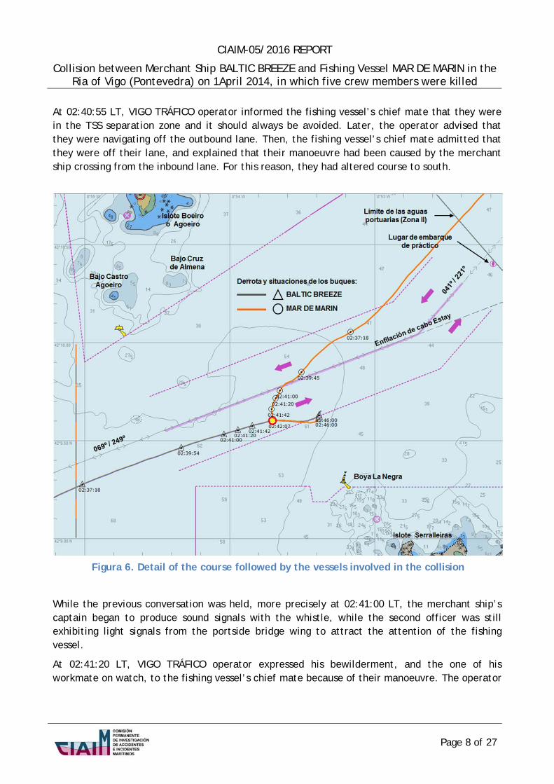
The Automatic Identification System (AIS) is used to exchange data in ship-to-ship and ship to land-based installations communications. The AIS is intended to identify vessels, support target tracking functions, simplify information exchange activities and provide additional information to prevent collisions.
The guidelines15 for the use of AISs on board set forth that data are to be sent independently and at different updating rates:
Table 6. IAS information sent by ships
Information items General reporting interval
Static: Maritime Mobile Service Identity (MMSI), Every 6 minutes or upon request (AIS call sign and name, IMO number, length and responds automatically without user action) beam, type of ship, location of position-fixing antenna.
Dynamic: Ship’s position with accuracy indication and integrity status, position time stamp in UTC, course over ground, speed over ground, heading, navigational status, rate of turn
Ship 0 - 14 knots, 10 seconds Ship 0 - 14 knots and changing course, 4 seconds […]
Voyage related: ship’s draught, hazardous Every 6 minutes or upon request (AIS cargo (type), destination and ETA responds automatically without user action)
14 SOLAS Regulation V/19.2, Resolution MSC.64(67) Annex 4.7 - Approval of new and amended operation standards, Articles 30.2 and 48 of Shipborne Maritime Radio Communications Regulations for Spanish Civil Vessels approved by Royal Decree 1185/2006, dated 16 October, Protocol of Torremolinos Chapter X, Rule 3.7 and Royal Decree 1032/1999, dated 18 June, Annex III Section A).9, that sets forth safety regulations for fishing vessels with a length of or over 24 meters. 15 SOLAS Regulation V/19.2 and Resolution A.917(22) – Guidelines for the onboard use of shipborne automatic identification systems (AIS) (Replaced by Resolution A.1106(29)).
Page 14 of 27

CIAIM-05/2016 REPORT
Collision between Merchant Ship BALTIC BREEZE and Fishing Vessel MAR DE MARIN in the Ria of Vigo (Pontevedra) on 1April 2014, in which five crew members were killed
Electronic navigational chart systems consist of electronic equipment with capability to display ships’ locations on a nautical chart image on a screen. If approved by SOLAS they are named Electronic Chart Display and Information System (ECDIS)16 and can be used to replace official paper nautical charts in order to plan and provide visual display of a ship’s course during the voyage. If not approved, they are named electronic chart system (ECS)17 and can only be used as an aid to navigation.
On board BALTIC BREEZE, it was used an Electronic Chart Display and Information System (ECDIS) and paper charts issued by the United Kingdom Hydrographic Office (UKHO).
On board MAR DE MARIN, it was used an electronic chart system (ECS) whose charts had not been issued or updated by an authorized hydrographic office. As well, there were paper charts issued by the Hydrographic Institute of the Spanish Navy (IHM), which were not used.
4.3. DiscussiononthemanoeuvreperformedbyMARDEMARIN
At 02:37:18 LT, the fishing vessel’s chief mate contacted VIGO TRÁFICO to inform that a merchant ship was crossing ahead in the Traffic Separation Scheme. At 02:38:27 LT, he informed that “the merchant ship was sailing in «his own land» and couldn’t be coming along the inbound lane”. The control centre disagreed twice with the chief mate (see figure 6).
Since 02:30:24 LT, the merchant ship had been sailing in manual mode to alter course to the inbound lane. Visibility conditions were good (beyond 5 miles). For this reason, her navigation lights should have been visible at first sight or, failing this, with binoculars.
Thus, the question to be answered is what reasons made the fishing vessel’s chief mate misunderstand completely the merchant’s ship manoeuvre.
The most likely reason for that behaviour is that an electronic chart system (ECS) was used onboard the MAR DE MARIN instead of the official paper nautical charts existing on board. The system charts had not been issued or updated by any authorised hydrographic service. Primarily, these charts only showed signal lights for entering the Ria of Vigo and a number of axial lines depicting the recommended two-way fairway, but not the TSS.
A depiction of TSS had been added afterwards, which would not faithfully represent the TSS published in Group no. 23 of Notices to Mariners of the Hydrographic Institute of the Spanish Navy. More precisely, a continuous line depicted the south lane from precautionary area to anchorage /notification point. In addition, the boundary of port waters (Zone II) did not match a line between Vicos Cape and Lameda Point (see figures 4, 6 and 9).
16 SOLAS Regulation V/19.2, Resolution A.817(19) – Performance Standards for Electronic Chart Display and Information Systems (ECDIS) and Resolution MSC.64(67) Annex 5 – Approval of new and amended performance standards. 17 FOM/2472/2006 Order (FOM - Ministry of Public Works and Transport), dated 20 July, which standardizes the use of shipborne electronic charts and electronic chart display and information systems.
Page 15 of 27

CIAIM-05/2016 REPORT
Collision between Merchant Ship BALTIC BREEZE and Fishing Vessel MAR DE MARIN in the Ria of Vigo (Pontevedra) on 1April 2014, in which five crew members were killed
Figura 9. Display of the Ria de Vigo Vessel Traffic Service by an electronic chart system equal to the MAR DE MARIN electronic chart system
Considering such navigation system, several minutes before the call to the control centre had been made at 02:37:18 LT, the merchant’s ship location would have been displayed on the TSS added depictions as if she was crossing it. However, the merchant ship was sailing off this TSS scheme and had started to manoeuvre long time before setting course to the inbound lane (see figure 6).
Based on the information available in the merchant ship’s voyage data recorder, it can be concluded that until 02:30 LT, the masthead lights on both masts as well as the starboard green light of the first mast had been visible from the fishing vessel. During the following three minutes, the lights observed would have been the two masthead lights in transit or almost in transit and two side lights. This would have been understood by the chief mate as both ships sailing in a “crossing” condition.
However, it seems that the chief mate did not check again the merchant ship’s location and heading, which would have let him notice her altering course to starboard. From 02:33 LT, the chief mate would have observed how the masthead lights were moving aside and the portside red light became visible. The navigation lights were visible in this arrangement until both ships collided.
In addition to a proper look-out by sight and hearing prescribed by COLREG Rule 5, Rule 7.b) establishes that proper use shall be made of radar equipment if installed and operational, including long-range scanning to obtain early warning of risk of collision and radar plotting or equivalent systematic observation of detected objects. Taking into account that the two radars the fishing vessel mounted were in operation when the crew members reached the navigation bridge after the collision and assuming that the chief mate had acquired the merchant ship’s
Page 16 of 27
CIAIM-05/2016 REPORT
Collision between Merchant Ship BALTIC BREEZE and Fishing Vessel MAR DE MARIN in the Ria of Vigo (Pontevedra) on 1April 2014, in which five crew members were killed
target with the tracking system of any of both radars, a vector showing the target heading would have been displayed in less than a minute.
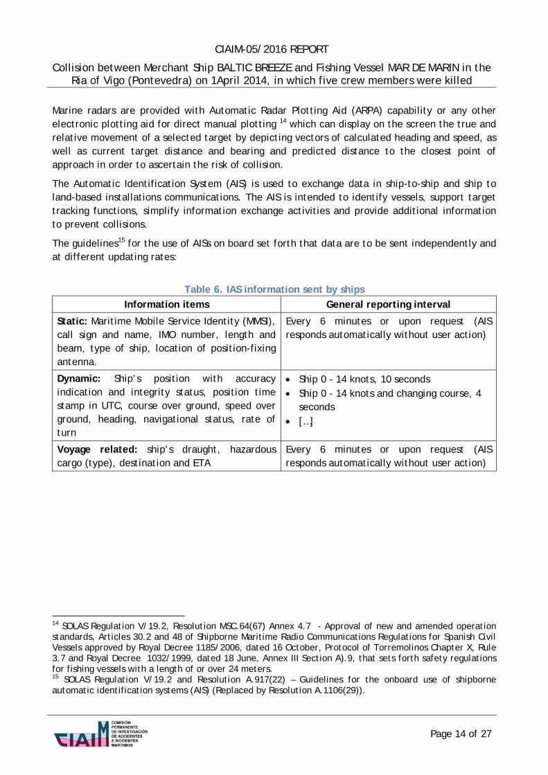
Figura 10. Layout obtained from the information displayed on BALTIC BREEZE radar18 and AIS screen at 02:37:18 LT
More specifically, when the chief mate contacted the control centre at 02:37:18 LT, the screen would have displayed MAR DE MARIN heading and speed over ground of 248º and 7.7 knot respectively and BALTIC BREEZE altering course to 083º to correct drifting (sea current effect) and leeway (wind effect), whose course and speed over ground were 066º and 12 knots respectively, without impeding or likelihood to impede passage. All this should have clarified any doubt on a «crossing» situation (see figure 10).
It is true that course alterations may affect tracking accuracy. However, this seems not to be the case, since courses had been gradually altered and no increase greater than 8 degrees had been applied.
The second available aid for the chief mate was the Automatic Identification System (AIS), whose proper operation has been proved, as both control centre and merchant vessel received information from this system. It also seems clear that the chief mate identified the merchant ship’s name on the AIS screen during the conversation held at 02:39:45 LT.
18 Information display on the screen: north at the top, 4 miles scale, off-centered, relative movement and true vectors for a 12 minute timescale.
Page 17 of 27

CIAIM-05/2016 REPORT
Collision between Merchant Ship BALTIC BREEZE and Fishing Vessel MAR DE MARIN in the Ria of Vigo (Pontevedra) on 1April 2014, in which five crew members were killed
In this case, every course alteration would immediately become evident on the AIS screen, since dynamic information on heading and speed over ground and well as on turn speed and direction was being updated every 12 seconds, but every 4 seconds if a change in the heading occurred (see figure 11 and table 6).
Figura 11. Target Depiction and Information displayed on an AIS screen equal to the one installed in MAR DE MARIN
Unexpectedly, the fishing vessel began to alter course to portside and penetrated the inbound lane. Neither the control centre operator’s continuous warning nor the caution signals sent by the merchant ship’s captain and second officer made him notice he was in error. Within a couple of minutes, the manoeuvre had led the fishing vessel to impede the merchant ship’s course and the collision occurred.
From all above described, it can be inferred that the first mistake the chief mate made was the use of a non-standardised navigation system and some nautical charts which had not been issued or updated by an authorised hydrographic system. As a result, the merchant ship was mistakenly located inside the Traffic Separation Scheme of the Ria of Vigo. It should be noted that this was not an occasional chief mate’s practice, since no official nautical chart was used on board to draw envisaged voyages or to lookout the vessel’s course.
A second mistake was decisive in the occurrence of the accident, since the merchant ship’s was understood to be proceeding with a fixed course and to be finally crossing ahead. The most likely causes for this error would be:
1. no efficient lookout was kept during watchkeeping. Therefore, the chief mate did not visually appreciated the merchant ship’s proceeding by observing her leading lights, which reveals that a lookout person is required to be appointed on board those vessels sailing in the TSS, and
Page 18 of 27

CIAIM-05/2016 REPORT
Collision between Merchant Ship BALTIC BREEZE and Fishing Vessel MAR DE MARIN in the Ria of Vigo (Pontevedra) on 1April 2014, in which five crew members were killed
2. he was not making appropriate use of either radar tracking system or AIS because of a
low risk perception or as a result of being familiar with the surrounding area, which can be linked to indulgence19, or unfamiliar with the use of such equipment as additional source of nautical information for the surveillance of other vessel movements and avoidance of collisions.
The chief mate had relieved the master from the navigational watch at 22:00 LT, so any significant contribution of weariness to the accident is uncertain. The toxicology report results reveal no alcohol or drug trace. Thus, it is not possible to ascertain any cause for a decrease in the chief mate’s capability to understand and admit his mistake despite the warning and caution signals received.
4.4. ThesinkingoftheMARDEMARIN
As a result of the impact on the fishing vessel’s starboard side, a leak was caused in the cargo hold. Before the crew members could react and leave their cabins, a massive water ingress to the processing and accommodation areas occurred through the 1,000 x 1,000 mm cargo hold hatch (see figure 13).
19 understood as an unconscious change in experienced workers’ behaviour affecting their actions due to experience gained by repeating certain actions or processes which involves a minimization of risk and surrounding alert signals.
Page 19 of 27

CIAIM-05/2016 REPORT
Collision between Merchant Ship BALTIC BREEZE and Fishing Vessel MAR DE MARIN in the Ria of Vigo (Pontevedra) on 1April 2014, in which five crew members were killed
Figura 12. MAR DE MARIN General Arrangement Drawing
Page 20 of 27

CIAIM-05/2016 REPORT
Collision between Merchant Ship BALTIC BREEZE and Fishing Vessel MAR DE MARIN in the Ria of Vigo (Pontevedra) on 1April 2014, in which five crew members were killed
In this sense, the reason for the water to raise the hatch cover and enter the processing area as stated by crew members could be that either the cover was closed but unlatched or the latches fastening the hatch cover to the coaming broke. This is not considered likely, since the bolts of the latches were made of low carbon steel, fitted stainless steel nuts and the hydrostatic pressure underneath the cover would not have been high at the early stages of the accident.
In addition, the tight door between processing area and accommodation spaces was open and no attempt was made to close it in the hastiness of the situation. Closing it would have preserved the vessel tightness.
Whether the cargo hold hatch cover and the two engine room doors were open or closed could not be confirmed. They should have been closed while sailing, exception made in case of operational reasons, to ensure the tightness of the main deck, which was also the freeboard deck.
All above favoured a quick flooding of the spaces inside the fishing vessel and a decrease in the buoyancy reserve, causing a shortening in the time crew members had to abandon the vessel, since she sunk by the stern in less than six minutes.
4.5. DiscussionontheBALTICBREEZEmanoeuvre
Since VIGO TRÁFICO had been notified of the merchant ship’s arrival at the south landfall at 02:27 LT, the ship had been proceeding to course 068º, which had been defined in her voyage plan to sail the first inbound section of the Traffic Separation Scheme (see figures 6 and 10).
Both merchant ship’s captain and second officer noticed the presence of the fishing vessel by sight as well as and on the two radars and AIS displays, the same as the chief officer at the bow mooring station. All of them were watchful at all times.
It is sought to ascertain the captain’s appraisal of the situation and of the risk of collision within this scenario, since he was responsible for steering from the landfall in the TSS south lane to the assigned location in the anchorage area.
In general, the passage of ships sailing in a TSS is not to be impeded, but they are fully obliged to comply with COLREG Rules on heading and proceeding (rules 8.f.iii) and 10.a).
Likewise, where one of the vessels is to keep out of the way, the other shall keep course and speed, i.e. «stand-on» vessel. The latter may however take action to avoid collision by her manoeuvre alone, as soon as it becomes apparent to her that the vessel required to keep out of the way is not taking appropriate action (COLREG Rule 17.a.ii). Any action shall be taken, if the circumstances of the case admit, be positive, made in ample time and with due regard to the observance of good seamanship, so any alteration of course and/or speed shall be large enough to be readily apparent to another vessel observing (COLREG Rule 8.a) and b))
At 02:39:54 LT, when the fishing vessel reached the separation zone, the merchant vessel’s captain ordered light signals to be exhibited as a warning of their presence and a slight alteration of course to starboard side (see figur6 6 and table 7).
Page 21 of 27

CIAIM-05/2016 REPORT
Collision between Merchant Ship BALTIC BREEZE and Fishing Vessel MAR DE MARIN in the Ria of Vigo (Pontevedra) on 1April 2014, in which five crew members were killed
Even though both vessels were in close-quarters, whose safe distance would not be permitted in open sea, no risk of collision was considered at first, since the fishing vessel went on navigating parallel to the aforementioned zone and according to the conversations held through VHF channel 10, there was some certainty of her being in touch with VIGO TRÁFICO.
However, the fishing vessel unexpectedly altered course to portside and started to cross the main traffic direction.
At 02:41:00 LT, the distance between both vessels was 0.36 miles. The captain’s reaction was to make sound signals (whistles) while the second officer was still exhibiting light signals (daylight signal lamp).
Figura 13. BALTIC BREEZE Bow and Portside View (blind sector from the captain’s position in the Navigation Bridge)
Finally, the captain could no longer see the fishing vessel, as the ship’s structure prevented her from being seen (see figure 13). At 02:41:00 LT, he ordered to stop the engine by means of the engine order telegraph. There was no sufficient time to notice the outcome of the transmitted stop command, since two minutes after the collision, the ship was still proceeding headway and pushing the fishing vessel with her bulb penetrating this vessel’s side.
Some alternative actions for BALTIC BREEZE to have avoided the collision are analysed below.
Should the action to avoid collision had been performed by only using the rudder (COLREG Rule 8.c), BALTIC BREEZE should have altered course to starboard more greatly (see figure 6 and
Page 22 of 27
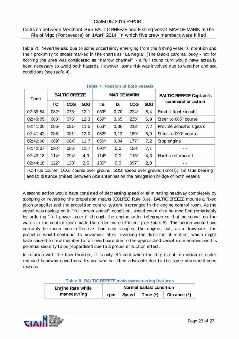
CIAIM-05/2016 REPORT
Collision between Merchant Ship BALTIC BREEZE and Fishing Vessel MAR DE MARIN in the Ria of Vigo (Pontevedra) on 1April 2014, in which five crew members were killed
table 7). Nevertheless, due to some uncertainty emerging from the fishing vessel’s intention and their proximity to shoals marked in the charts as “La Negra” (The Black) cardinal buoy - not for nothing the area was considered as “narrow channel” - a full round turn would have actually been necessary to avoid both hazards. However, some risk was involved due to weather and sea conditions (see table 4).
Table 7. Position of both vessels
BALTIC BREEZE MAR DE MARIN BALTIC BREEZE Captain’s Time
command or action TC COG SOG TB D. COG SOG
02:39:54 082º 075º 12,1 059º 0,70 224º 8,4 Exhibit light signals
02:40:05 083º 075º 12,3 059º 0,65 225º 6,9 Steer to 085º course
02:41:00 086º 081º 11,5 053º 0,36 213º 7,2 Provide acoustic signals
02:41:42 086º 081º 12,0 052º 0,13 189º 6,9 Steer to 090º course
02:42:00 089º 084º 11,7 050º 0,04 177º 7,2 Stop engine
02:42:07 092º 086º 11,7 092º 0,0 158º 7,1 - -
02:43:18 114º 094º 4,9 114º 0,0 116º 4,3 Hard to starboard
02:44:18 122º 120º 2,5 130º 0,0 097º 2,0 - -
TC: true course; COG: course over ground; SOG: speed over ground (knots); TB: true bearing and D: distance (miles) between AISs antennas on the navigation bridge of both vessels
A second action would have consisted of decreasing speed or eliminating headway completely by stopping or reversing the propulsion means (COLREG Rule 8.e). BALTIC BREEZE mounts a fixed pitch propeller and the propulsion control system is arranged in the engine control room. As the vessel was navigating in “full power ahead” condition, speed could only be modified remarkably by ordering “full power astern” through the engine order telegraph so that personnel on the watch in the control room made the order more efficient (see table 8). This action would have certainly be much more effective than only stopping the engine, but, as a drawback, the propeller would continue its movement after reversing the direction of motion, which might have caused a crew member to fall overboard due to the approached vessel’s dimensions and his personal security to be jeopardised due to a propeller suction effect.
In relation with the bow thruster, it is only efficient when the ship is not in motion or under reduced headway conditions. Its use was not then advisable due to the same aforementioned reasons.
Table 8. BALTIC BREEZE main manoeuvring features
Engine Rate while manoeuvring
Normal ballast condition
rpm Speed Time (*) Distance (*)
Page 23 of 27

CIAIM-05/2016 REPORT
Collision between Merchant Ship BALTIC BREEZE and Fishing Vessel MAR DE MARIN in the Ria of Vigo (Pontevedra) on 1April 2014, in which five crew members were killed
Full ahead 85 13.2 4.4 min. 0.607 miles
Half ahead 75 11.6 4.1 min. 0.439 miles
Slow ahead 65 10.1 3.8 min. 0.351 miles
Dead slow ahead 40 5.5 - - - -
rpm: revolutions per minute; speed: knots (*) to stop full power astern and minimum rudder action
In conclusion, the merchant ship’s captain kept both course and speed as “stand-on” vessel until it became evident that the fishing vessel action to give way did not meet COLREG regulations. Having not envisaged the fishing vessel’s manoeuvre as a navigation risk based on the fact of sailing in a Traffic Separation Scheme and within a Vessel Traffic Service area caused a delay in the captain’s decision to manoeuvre efficiently to avoid collision. Thus, circumstances were so difficult that he could not avoid the collision.
As inferred from the incident analysis, it was a complex situation. It seems then a bit adventurous any attempt to ascertain the manoeuvre the captain should have performed. Despite this, the only one which could have apparently been successful whenever the fishing vessel had kept her course would be hard to starboard to make a full round turn when the fishing vessel invaded the inbound lane at 02:40 LT. Any manoeuvre to avoid collision started afterwards would have faced a lack of sea room and sufficient time to be successful. In addition, no change should have been made without modifying the engine rate since the higher the ship’s speed the fastest the alteration of course to one or another side due to rudder action is and, as a result, a decrease in the time of response is produced.
Page 24 of 27

CIAIM-05/2016 REPORT
Collision between Merchant Ship BALTIC BREEZE and Fishing Vessel MAR DE MARIN in the Ria of Vigo (Pontevedra) on 1April 2014, in which five crew members were killed
4.6. DiscussiononVIGOTRÁFICOControlCenterResponse
The VTS guidelines establish that when a VTS is authorized to issue instructions20 to vessels, these instructions should be result-oriented only, leaving the details of execution, such as course to be steered or engine manoeuvres to be executed, to the master or pilot on board the vessel. Care should be taken that VTS operations do not encroach upon the master's responsibility for safe navigation, or disturb the traditional relationship between master and pilot.
It is true that the type of VTS provided by VIGO TRÁFICO has not been published21. However, “VIGO TRÁFICO control tasks” are specifically mentioned in the instructions for vessel entry and departure operations in the Ria de Vigo. From this, it can be inferred that it constitutes a Vessel Traffic Service in charge of the management of vessel traffic and planning of vessel motion to avoid hazardous situations.
As demonstrated by recorded communications between MAR DE MARIN and VIGO TRÁFICO, the control center operator made a serious effort in order that the chief mate followed his instructions and set course back to their lane, keeping the fishing vessel off the merchant ship’s course. As a result, irrespective of the fatal outcome, under no circumstances can the control centre operator be considered to have failed to fulfill their functions efficiently or somehow contributed to the accident.
20 Section 2.3.4 of Guidelines for Vessel Traffic Services approved by International Maritime Organization (IMO) Resolution A.857(20) and section 7.1.4 of Guideline no. 1089 on Provision of Vessel Traffic Services (INS, TOS & NAS) drafted by International Association of Marine Aids to Navigation and Lighthouse Authorities (IALA). 21 Section 2.2.3.8 of the Guidelines approved by Resolution A.857(20):
In operating a VTS the VTS authority should, in a timely manner, provide mariners with full details of the requirements to be met and the procedures to be followed in the VTS area. This information should include the categories of vessels required or expected to participate; radio frequencies to be used for reporting; areas of applicability; the times and geographical positions for submitting reports; the format and content of the required reports; the VTS authority responsible for the operation of the service; any information, advice or instructions to be provided to participating ships; and the types and level of services available. This information should be published in the appropriate nautical publications and in the "World VTS Guide".
The guide has been issued by the International Association of Marine Aids to Navigation and Lighthouse Authorities (IALA), the International Association of Ports and Harbors (IAPH) and the International Maritime Pilots' Association (IMPA). Information on any VTS can be obtained at (http://www.worldvtsguide.org/), as set forth in IMO MSC/Circ.586/Rev.1.
Page 25 of 27
CIAIM-05/2016 REPORT
Collision between Merchant Ship BALTIC BREEZE and Fishing Vessel MAR DE MARIN in the Ria of Vigo (Pontevedra) on 1April 2014, in which five crew members were killed
5. CONCLUSIONS
In accordance with the factual information and circumstances analysed in this accident, a human error by MAR DE MARIN chief mate, officer of the watch, is concluded to be the cause of the collision due to his wrong appraisal of the situation. This mistake led him to execute a manoeuvre that made the vessel invade the opposite lane of the Traffic Separation Scheme and impeded the course of BALTIC BREEZE.
Likewise, the following factors are to have contributed to the accident and its outcome:
Only the chief mate was in charge of navigational watch. The ownership company of the fishing vessel had not provided the master with procedures or guidelines to define a suitable team arrangement for watchkeeping purposes or the need of arranging a lookout service while navigating in a Traffic Separation Scheme and in the dark.
A wrong depiction of the Ria de Vigo TSS was displayed on the electronic charts the fishing vessel used. The ownership company of the fishing vessel had not provided the master with procedures or guidelines to plan or depict the vessel’s course during the voyage on official paper nautical charts or using an approved navigation system that included electronic nautical charts issued by an official hydrographic service.
The fishing vessel went to sea with doors and hatches unsuitably closed and latched. The ownership company of the fishing vessel had not provided the master with procedures or guidelines to ensure that the ship would set off with her water tight doors and hatches duly closed and latched and kept in that way until opening them was necessary for working purposes.
Page 26 of 27
CIAIM-05/2016 REPORT
Collision between Merchant Ship BALTIC BREEZE and Fishing Vessel MAR DE MARIN in the Ria of Vigo (Pontevedra) on 1April 2014, in which five crew members were killed
6. SAFETYRECOMMENDATIONS
To MAR DE MARIN ownership company and master:
1. To be aware of the requisite to arrange a watchkeeping service so as to be sufficient and adequate to the surrounding environment and maintain a proper look-out in accordance COLREG Rule 5 so that the officer of the watch can make full appraisal of the circumstances and of the risk of collision.
2. To be aware of the safety hazard to navigation when using a non-standard navigation system or electronic nautical charts not approved or updated by an authorized hydrographic service instead of official paper nautical charts in order to plan and depict the ship’s course during the voyage.
3. To be aware of the safety hazard to navigation when the officers of the watch are not familiar with radar and AIS tracking systems as additional source of information for a proper lookout of ship motions and avoidance of collision.
4. To be aware of the safety hazard to ships involved in not keeping water tight doors and hatches duly closed and latched unless required for fishing tasks or shipboard operations.
To the General Directorate of Merchant Marine, the Port Authority of Vigo and the Spanish Maritime Salvage and Security Society (SASEMAR):
5. To publish on their websites and in the “World VTS Guide” issued by IALA, IAPH and IMPA, detailed information on the requirements to be met and the procedures to be followed in the VTS area of Ria of Vigo so as to be available to mariners as far as possible and irrespective of their obligation to look up nautical publications.
Page 27 of 27