Embed Size (px)
Citation preview

Chronology of the Mesa Verde Region10,000 B.C. to the Present
Excerpted from Peoples of the Mesa Verde Region, by Crow Canyon Archaeological Center. For the complete version, see www.crowcanyon.org/peoplesmesaverde.
Copyright © 2011 by Crow Canyon Archaeological Center. All rights reserved

This material is based upon work assisted by a grant from the Department of the Interior, National Park Service. Any opinions, findings, and conclusions or recommendations expressed in this material are those of the author(s) and do not necessarily reflect the views of the Department of the Interior.
Formatting and printing was made possible by a grant from the National Park Service, Department of Interior, Historic Preservation Grants Division.
Cover art adapted from original illustration by Theresa Breznau of Living Earth Studios; courtesy of the Bureau of Land Management, Anasazi Heritage Center.
Content development was made possible in part by grants from the State Historical Fund (a program of History Colorado, the Colorado Historical Society); funding from the Qwest Foundation; and the generosity of the Denver Public Library in sharing its Western History Collection.

3
Introduction
N
Mexican Hat
Abajo Mountains
Carrizo Mountains
Bluf f
Aneth
o
dao
lo
C
r
i
R
re
v
New Mexico
Blandin g
Corte z
tonw
oo
dW
as
h
Monticello
Pagosa Springs
Shiprock
Mancos
ot
C un JS a
oMa n
i nu n t a
s
Dove Creek
Dolore s
Durango
Aztec
Farmington
UtahArizona
Colorado
Mesa Verde Region
Ignacio
TowaocUte Mountai n
aS
n
auJn
R i rev
hs
aW
elni
hC
Gr a n d
G u l c h
tn
eM
ez
um
aC
ro
ek
C.
s
Cr o
s
aw
J
C .
ec k
t
Ye ll o
cM E l
Cr.
om
M a n c o sR .
Pa
l at
R.
aL
R.
Amin
sa
R.a
rd
eiP
R
i oG r a n d e
Do
l or
es
R.
eMesa Verd
Elevation above 8000 feet
0
Kilometer s
0
Miles
30
People have lived in the Mesa Verde region of the American Southwest for thousands of years. For the vast majority of that time, the inhabitants were American Indians—hunters, foragers, and farmers who thrived in the canyon-and-mesa country of what today encompasses portions of southwestern Colorado, southeastern Utah, and northwestern New Mexico. Only in the last approximately 250 years have other people—mostly Europeans and Americans of European descent—moved into the area.
As defined here, the Mesa Verde archaeological region is an area of just under 10,000 square miles bounded by the Colorado, Piedra, and San Juan rivers. It is located within the larger physiographic region known as the Colorado Plateau, an immense area of geologic uplift encompassing much of western Colorado, eastern Utah, northern Arizona, and northwestern New Mexico.
The Mesa Verde region is a land of spectacular contrasts, where deep sandstone canyons dissect sage-covered plains, all against the distant backdrop of the San Juan Mountains, which are part of the Colorado Rocky Mountains. Cold, snowy winters give way to hot, dry summers, and periods of relatively abundant moisture are punctuated by sporadic—but sometimes prolonged—periods of drought. Living off the land has always been, and continues to be, a challenge, but one that people through the ages have met with extraordinary ingenuity and resilience.
The Mesa Verde archaeological region.
Ute Mountain overlooks the sage-covered plain near Cortez, Colorado.
Pinyon, juniper, and sagebrush dot a landscape deeply dissected by sandstone canyons.
(over)

4
From the arrival of Ice Age hunters to the introduction of agriculture and eventually the creation of modern cities and towns, the story of how people have adapted to, and flourished in, this rugged land is one of the most fascinating stories in human history. And it is a story that is still unfolding, as archaeologists continue to make discoveries that shed new light on the ancient past—and as the people who live in the region today continue to forge their own histories.

5
Paleoindian Period: 10,000 (or earlier) to 5500 B.C.Imagine a world of snow and ice, when glaciers covered large parts of North America and huge animals, now extinct, roamed the land. The time is the late Ice Age—also known as the Pleistocene—and humans have entered the North American continent for the first time.
Paleoindian hunters stalk and kill a mammoth during the late Ice Age. (Adapted from original illustration by Theresa Breznau of Living Earth Studios; courtesy of the Bureau of Land Management, Anasazi Heritage Center.)
Archaeologists call this earliest occupation of the Americas the Paleoindian period. Paleo means “ancient,” and the Paleoindian period refers to the time when small bands of nomadic hunters first entered North America and subsequently spread out across the landscape. Similarities among stone artifacts found from Canada to Mexico suggest that people moved relatively quickly to all corners of the continent and shared a cultural tradition across vast distances.
Exactly when and how humans first came to North America is a hotly debated topic. Many archaeologists believe that people walked from east Asia, through Siberia, to the Bering land bridge, also called Beringia. There it appears they lived in isolation for several thousand years, until about 14,000 B.C., when they crossed into Alaska and began spreading rapidly throughout North and South America.
How did people make the journey south? They may have simply walked along the Pacific coast, following an ancient shoreline that was exposed during the late Ice Age, when water levels were lower than they are today. It is also possible that people traveled by watercraft, staying close to shore and making camp along the way. Whether people traveled the coast by land or sea, it is likely that many of the earliest archaeological sites are now underwater, having been submerged as the glaciers melted and sea levels rose at the end of the Pleistocene.
Alternatively, or in addition, some people may have traveled south through what is called the “ice-free corridor,” an inland passage through the center of North America that was not covered by the late Ice Age glaciers.
(over)

6
North America
Siberia
South America
Chukchi Sea
Bering Land Bridge (Beringia)
Inland migration route through the “ice-free corridor”
Bering Sea
Paci�c coast migration route (on foot or by watercraft)
Paci�c Ocean
Few Paleoindian sites have been discovered in the Mesa Verde region, and those that are known are identified primarily on the basis of isolated projectile points. The relatively small number of known Paleoindian sites is due to the great antiquity of the sites, the nomadic lifestyle of the people, and the low population during this time.
Possible migration routes from Siberia to North America.
7
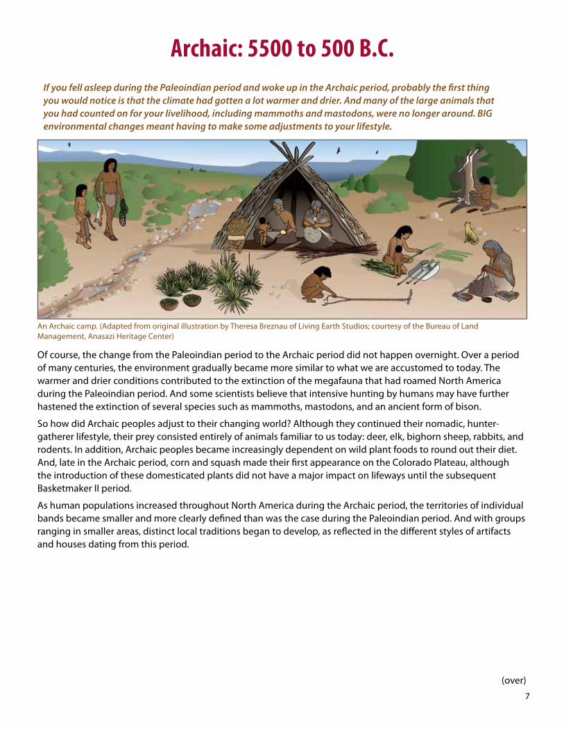
Archaic: 5500 to 500 B.C.If you fell asleep during the Paleoindian period and woke up in the Archaic period, probably the first thing you would notice is that the climate had gotten a lot warmer and drier. And many of the large animals that you had counted on for your livelihood, including mammoths and mastodons, were no longer around. BIG environmental changes meant having to make some adjustments to your lifestyle.
An Archaic camp. (Adapted from original illustration by Theresa Breznau of Living Earth Studios; courtesy of the Bureau of Land Management, Anasazi Heritage Center)
Of course, the change from the Paleoindian period to the Archaic period did not happen overnight. Over a period of many centuries, the environment gradually became more similar to what we are accustomed to today. The warmer and drier conditions contributed to the extinction of the megafauna that had roamed North America during the Paleoindian period. And some scientists believe that intensive hunting by humans may have further hastened the extinction of several species such as mammoths, mastodons, and an ancient form of bison.
So how did Archaic peoples adjust to their changing world? Although they continued their nomadic, hunter-gatherer lifestyle, their prey consisted entirely of animals familiar to us today: deer, elk, bighorn sheep, rabbits, and rodents. In addition, Archaic peoples became increasingly dependent on wild plant foods to round out their diet. And, late in the Archaic period, corn and squash made their first appearance on the Colorado Plateau, although the introduction of these domesticated plants did not have a major impact on lifeways until the subsequent Basketmaker II period.
As human populations increased throughout North America during the Archaic period, the territories of individual bands became smaller and more clearly defined than was the case during the Paleoindian period. And with groups ranging in smaller areas, distinct local traditions began to develop, as reflected in the different styles of artifacts and houses dating from this period.
(over)

8
Colorado
Utah
ArizonaNew Mexico
N
L i ttl eColorado R.
Grand Ca nyo n
Rio
Gr a
nd
e
Colorado PlateauArchaic peoples
Ro
ck
y M
ou
nt a
i ns
Colo
rado R
.
Mesa Verde Region
Colorado Plateau
Gre
en
R.
S a n J u a n R .
Flagsta Albuquerque
Denver
Salt Lake City
Tucson
Southern Arizona Archaic peoples
Miles
Kilometers1000
0 100
Archaic peoples from southern Arizona migrated to the Colorado Plateau, where they met other Archaic peoples who were already living there.
Two such local traditions figure prominently in the history of the Mesa Verde region: one that developed on the Colorado Plateau (which includes the Mesa Verde region), and another that developed in southern Arizona, in the vicinity of present-day Tucson. Archaeologists think that Archaic peoples from southern Arizona migrated north to the Colorado Plateau, bringing not only their own distinctive language, artifacts, and house styles but also seeds of domesticated plants and knowledge of plant cultivation. This is probably how the Archaic peoples who were already living on the Colorado Plateau first learned about agriculture.

9
Basketmaker II: 500 B.C. to A.D. 500For several thousand years, people have been on the move, walking to wherever the food happened to be. But as people become dependent on agriculture—especially corn—the seeds of Pueblo culture are planted, and life in the Mesa Verde region is forever changed.
A growing dependence on agriculture—especially corn—and the beginnings of a settled way of life marked the transition from the Archaic period to the Basketmaker II period.
Although corn and squash were introduced onto the Colorado Plateau about 1000 to 2000 B.C, it was several centuries before people became dependent on agriculture, with corn becoming a major component of their diets. This shift in emphasis from hunting and gathering to farming required a similar shift in how people lived on the landscape: Specifically, they had to give up their nomadic existence for a more settled way of life that allowed them to stay close to home to tend their crops. So they began building more-permanent structures on farmsteads located close to good agricultural land. Because farming and settled life were two of the distinguishing characteristics of later Pueblo culture, most archaeologists consider the people of the Basketmaker II period to be the first Pueblo Indians.
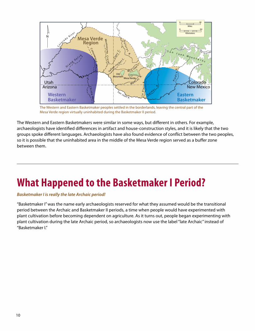
In the Mesa Verde region, Basketmaker peoples settled mostly in the western and eastern borderlands—archaeologists have found virtually no evidence of people living in the central part of the Mesa Verde region during this time. The Basketmakers who lived to the west (called the “Western Basketmakers”) are thought by some archaeologists to have been the descendants of Archaic peoples who migrated to the area from southern Arizona. Those who lived to the east (called the “Eastern Basketmakers”) may have been descendants of the original Archaic inhabitants of the Colorado Plateau.
A Basketmaker II farmstead. (Adapted from original illustration by Theresa Breznau of Living Earth Studios; courtesy of the Bureau of Land Management, Anasazi Heritage Center)
(over)
10
N
Mesa Verde
Co
l o
r a d o R i v e r
hsa
Wel
nih
C
G r a n dG u l c h
tn
eM
ezu
ma
Cr
oe
k
C.s
Cros
aw
J
C.
ec k
t
Yell o cM E l
C r.o
m
Ma n c os
R.P
ala
tR.
aL
R.
Amin
sa
R.a
rd
eiP
iRo G r a nd e
Do
lor e
sR
.
Mesa Verde Region
WesternBasketmaker
EasternBasketmaker
to nwoo
dW
ash
otC
San Juan R .
ColoradoNew Mexico
UtahArizona
un J
S a
oMa n
i nu n t a
s
Ute Mountain
0
Kilometers
0
Miles
30
The Western and Eastern Basketmakers were similar in some ways, but different in others. For example, archaeologists have identified differences in artifact and house-construction styles, and it is likely that the two groups spoke different languages. Archaeologists have also found evidence of conflict between the two peoples, so it is possible that the uninhabited area in the middle of the Mesa Verde region served as a buffer zone between them.
The Western and Eastern Basketmaker peoples settled in the borderlands, leaving the central part of the Mesa Verde region virtually uninhabited during the Basketmaker II period.
What Happened to the Basketmaker I Period?Basketmaker I is really the late Archaic period!
“Basketmaker I” was the name early archaeologists reserved for what they assumed would be the transitional period between the Archaic and Basketmaker II periods, a time when people would have experimented with plant cultivation before becoming dependent on agriculture. As it turns out, people began experimenting with plant cultivation during the late Archaic period, so archaeologists now use the label “late Archaic” instead of “Basketmaker I.”

11
Basketmaker III: A.D. 500 to 750If you had lived during this time period, you would have been witness to great technological and social changes. Things that later Pueblo people would take for granted—like pottery and the bow and arrow—were the latest innovations for people during the Basketmaker III period. And, as the population grew, people developed new ways to manage their increasingly complex society.
A Basketmaker III farmstead. (Adapted from original illustration by Theresa Breznau of Living Earth Studios; courtesy of the Bureau of Land Management, Anasazi Heritage Center)
The Basketmaker III period was a time of rapid population growth in the Mesa Verde region, which archaeologists believe was largely the result of immigration. Earlier Basketmaker peoples had lived mostly in the extreme eastern and western parts of the region and adjacent areas outside the region. But starting in the sixth century, descendants of these early Eastern and Western Basketmakers apparently began moving into the central Mesa Verde region in large numbers.
The population boom ushered in an era of great change and progress. Domesticated beans, pottery, and the bow and arrow were all introduced during this time. Farming became increasingly important, with people relying more and more on domesticated crops, especially corn. For most of the period, the climate was very favorable for agriculture, with few droughts, which may have encouraged immigration from adjacent regions with less-favorable conditions.
But the population boom probably brought its own share of problems, too. As discussed before, it is likely that the people moving in from the east and the west spoke different languages, and archaeologists have found evidence of conflict between them during the preceding Basketmaker II period. So it would have been important for people to develop ways to live together.
(over)

12
N
Co
l o
r a d o R i v e r
hsa
Wel
nih
C
G r a n dG u l c h
tn
eM
ezu
ma
Cr
oe
k
C.s
Cro
s
aw
J
C.
ec k
t
Yell o cM E l
C r.o
m
M a n c o s
R .P
ala
tR.
aL
R.
Amin
sa
R.a
rd
eiP
Do
lor e
sR
.
Mesa Verde Region
WesternBasketmaker
EasternBasketmaker
to nwoo
dW
ash
otC
San Juan R .
iRo Gr ande
un J
S a
oMa n
i nu n t a
s
ColoradoNew Mexico
UtahArizona
Mesa Verde
Ute Mountain
0
Kilometers
0
Miles
30
How did they do it? Archaeologists look at where and how people settled on the landscape for the answer. Most people in the Mesa Verde region during this time lived in small, scattered farmsteads that were home to one, two, or three households, each with its own pithouse and outdoor storage facilities. As the population grew, clusters of these farmsteads began to appear, forming early communities.
Basketmaker III communities consisted of farmsteads loosely clustered around a great kiva.
And with the formation of early communities, something else happened, something enormously important to Basketmaker and all future Pueblo society. For the very first time, the people of the Mesa Verde region began building large, public structures called “great kivas.” These structures appear to have served as the focal points of their communities, providing a place where residents could participate in community-wide ceremonies and other important events. Archaeologists think that having a special place where everyone in the community could gather might have eased tensions and promoted social unity. If so, it was a strategy that served the Pueblo people reasonably well for the next 700 years, until the hardship and strife of the mid-thirteenth century led to large-scale migrations from the region.
During the Basketmaker III period, Western and Eastern Basketmaker peoples moved into the central part of the Mesa Verde region.

13
The Pueblo I Period: A.D. 750 to 900For the last two centuries, the people of the Mesa Verde region have been living on small farmsteads scattered across the landscape. But by the end of this period, most are residents of much larger settlements, with dozens— if not hundreds—of near neighbors.
During the Pueblo I period, large villages of up to several hundred people came into existence. Although communities were known from the earlier Basketmaker III time period, they had consisted primarily of clusters of small farmsteads. In contrast, by the end of the Pueblo I period, the majority of people were living in densely populated villages, some quite large.
Pithouses continued to be built throughout the Pueblo I period, but people increasingly spent part of their time in structures built aboveground, structures that included both living space and storage space. Large public buildings became more common, which may indicate that society was becoming more complex. Archaeologists believe that religious, economic, and political institutions were developed during this time to deal with large numbers of people living near one another.
At the very end of the Pueblo I period, after many decades of population growth, there was a sudden decline in population throughout much of the Mesa Verde region. The decline may have been associated with warmer and drier conditions that made it difficult for the Pueblo farmers to grow corn. Some people moved to higher-elevation areas along the northern edge of the Mesa Verde region, where there was more moisture. But it appears that many people left the area altogether.
A Pueblo I farmstead, including aboveground rooms and two belowground pithouses. (Adapted from original illustration by Theresa Breznau of Living Earth Studios; courtesy of the Bureau of Land Management, Anasazi Heritage Center)
(over)

14
N
Co l o
r ad o R
.
Mesa Verde Region
S a n J u a n R .
Do lo re s R .
Ch
i nl e
Wa
s h
ColoradoNew MexicoUtah
Arizona
Chaco Canyon
Ch
aco
R.
Rio Grande
Rio
Gra
nde
San Juan Mountains
Miles
0
Kilometers
10000 5
Late Pueblo I communities consisted of densely populated villages and a few scattered farmsteads.
Where did they go? According to Pueblo oral tradition, people moved to areas south of the Mesa Verde region. Archaeological evidence indicates that people from the Mesa Verde region emigrated to present-day New Mexico, in and near Chaco Canyon—an area that was to play a pivotal role in the developments of the next period.
At the end of the Pueblo I period, many people moved south, probably to areas in and near Chaco Canyon in present-day New Mexico.

15
N
Co
l or a
do
R.
Mesa Verde Region
S a n J u a n R .
Do
lore s R .
Ch
i nl e
Wa
s h
ColoradoNew MexicoUtah
Arizona
Chaco Canyon
Ch
ac
o R
.
Rio Grande
Rio
Gra
nde
San Juan Mountains
Miles
0
Kilometers
10000 5
The Pueblo II Period: A.D. 900 to 1150This was an exciting time to live in the Mesa Verde region. A vast trade network centered on Chaco Canyon, 100 miles to the south, connected the Pueblo people of the Mesa Verde region with new people, new ideas, and new goods from far beyond their traditional homeland.
During the Pueblo II period, large structures called “great houses” reflected influence from Chaco Canyon. However, most people in the Mesa Verde region lived in small farmsteads during this time. (Adapted from original illustration by Theresa Breznau of Living Earth Studios; courtesy of the Bureau of Land Management, Anasazi Heritage Center)
After the departure of so many people at the end of the Pueblo I period, only a small population remained in the Mesa Verde region in the early part of the Pueblo II period. But as climatic conditions improved in the early A.D. 1000s, people began returning to the Mesa Verde region, settling in upland areas with good soils for farming.
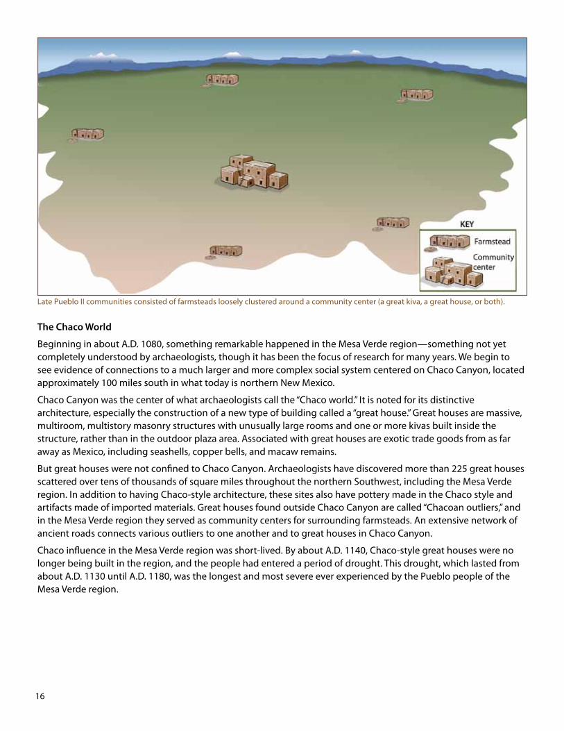
Unlike the communities of the preceding period, those of the late Pueblo II period consisted primarily of small farmsteads loosely clustered around a larger site called a “community center.” Community centers had large public buildings that could be used for community-wide ceremonies and meetings; some may have also served as storage facilities and distribution points for food and other goods to be shared by residents. One type of public building—the great kiva—was already well known to the people of the Mesa Verde region. In addition, a new form of public architecture called a “great house” made its first appearance during the Pueblo II period. The construction of great houses in the Mesa Verde region was part of a wider cultural development associated with Chaco Canyon in New Mexico, described below.
During the Pueblo II period, people who had been living in and near Chaco Canyon apparently began moving east, west, south, and north, including back to the Mesa Verde region. (over)
16
Late Pueblo II communities consisted of farmsteads loosely clustered around a community center (a great kiva, a great house, or both).
The Chaco World
Beginning in about A.D. 1080, something remarkable happened in the Mesa Verde region—something not yet completely understood by archaeologists, though it has been the focus of research for many years. We begin to see evidence of connections to a much larger and more complex social system centered on Chaco Canyon, located approximately 100 miles south in what today is northern New Mexico.
Chaco Canyon was the center of what archaeologists call the “Chaco world.” It is noted for its distinctive architecture, especially the construction of a new type of building called a “great house.” Great houses are massive, multiroom, multistory masonry structures with unusually large rooms and one or more kivas built inside the structure, rather than in the outdoor plaza area. Associated with great houses are exotic trade goods from as far away as Mexico, including seashells, copper bells, and macaw remains.
But great houses were not confined to Chaco Canyon. Archaeologists have discovered more than 225 great houses scattered over tens of thousands of square miles throughout the northern Southwest, including the Mesa Verde region. In addition to having Chaco-style architecture, these sites also have pottery made in the Chaco style and artifacts made of imported materials. Great houses found outside Chaco Canyon are called “Chacoan outliers,” and in the Mesa Verde region they served as community centers for surrounding farmsteads. An extensive network of ancient roads connects various outliers to one another and to great houses in Chaco Canyon.
Chaco influence in the Mesa Verde region was short-lived. By about A.D. 1140, Chaco-style great houses were no longer being built in the region, and the people had entered a period of drought. This drought, which lasted from about A.D. 1130 until A.D. 1180, was the longest and most severe ever experienced by the Pueblo people of the Mesa Verde region.

17
The Pueblo III Period: A.D. 1150 to 1300Across the Mesa Verde region, thousands of people are congregating in immense pueblos. Walled villages wrapped around canyon heads and magnificent cliff dwellings perched on steep, rocky slopes are home to the majority of the population. The time is the mid-thirteenth century, and the Pueblo people of the Mesa Verde region, who over the centuries have built a remarkable cultural legacy, will soon carry that legacy to new homes in the south.
A late Pueblo III canyon-head village. (Illustration by Theresa Breznau of Living Earth Studios; courtesy of the Bureau of Land Management, Anasazi Heritage Center.)
The Pueblo III period was a time of dramatic change for Pueblo communities in the Mesa Verde region. Early in the period, most people lived on small farmsteads loosely clustered around community centers. But by A.D. 1250, almost everyone had left their farmsteads and moved into the community centers, resulting in the formation of large villages. And most of those villages were located in canyon settings—around canyon heads or in rock alcoves high above the canyon floors.
Late Pueblo III communities consisted of large, densely populated villages—often located at the heads of canyons—and a few scattered farmsteads. (over)

18
Wa
sa
t ch
ColoradoNew Mexico
San Juan Mountains
MountainsJemez
Mt. Taylor
N
oM
nu
t ani
s
Mogollon Rim
ArizonaUtah
Hopi Mesas
Pueblo communities of Arizona
and New Mexico
Gre
en
R.
Do
lo re sR.
S a n J u a nR.
Goi
Rra
nde
Li t t l e
Co lor a do
R.
R.e
r de
V
Mesa Verde Region
Ch
inle
Wa
sh
C h a c o R .
SandiaMountains
ZuniMountains
Co
l or a
do
R. Elevation above 8000 feet
Miles
0
Kilometers
10000 5
Archaeologists have long pondered these and related questions, and they continue to explore a variety of explanations. Deteriorating environmental conditions, food shortages, and social conflict in the Mesa Verde region appear to have contributed to the migration from the area. In addition, the inhabitants of the Mesa Verde region probably already knew about, and had connections to, Pueblo people living in numerous villages in Arizona and New Mexico. Having those connections might have made the decision to leave the Mesa Verde region—and adjusting to their new homes—easier.
Paralleling these developments was an astonishing increase in the number of people living in the area. Archaeologists believe that the Pueblo population in the Mesa Verde region reached its peak between A.D. 1200 and 1250, probably numbering more than 20,000. But only a few decades later, by about A.D. 1285, the Pueblo people had left the region, moving south to numerous villages in present-day Arizona and New Mexico.
Such dramatic changes in such a short period of time naturally raise the question, “Why?” Why did the Pueblo people suddenly congregate in such large numbers in and near the canyons? Why, after investing so much effort in building enormous villages, did the entire population depart the region?
By the end of the Pueblo III period, the Pueblo people had left the Mesa Verde region, moving south to numerous villages in present-day Arizona and New Mexico.
19
Wa
sa
t ch
ColoradoNew Mexico
San Juan Mountains
MountainsJemez
Mt. Taylor
N
oM
nu
t ani
s
Mogollon Rim
ArizonaUtah
Hopi Mesas
Pueblo communities of Arizona
and New Mexico
Gre
en
R.
Do
lo re sR.
S a n J u a n
R.
Goi
Rra
nde
Li t t l e
Co lor a do
R.
R.e
r de
VMesa Verde
Region
Ch
inle
Wa
sh
C h a c o R .
SandiaMountains
ZuniMountains
Co
l or a
do
R.
Ancestral Ute
Ancestral N
avajo
Elevation above 8000 feet
Miles
0
Kilometers
10000 5
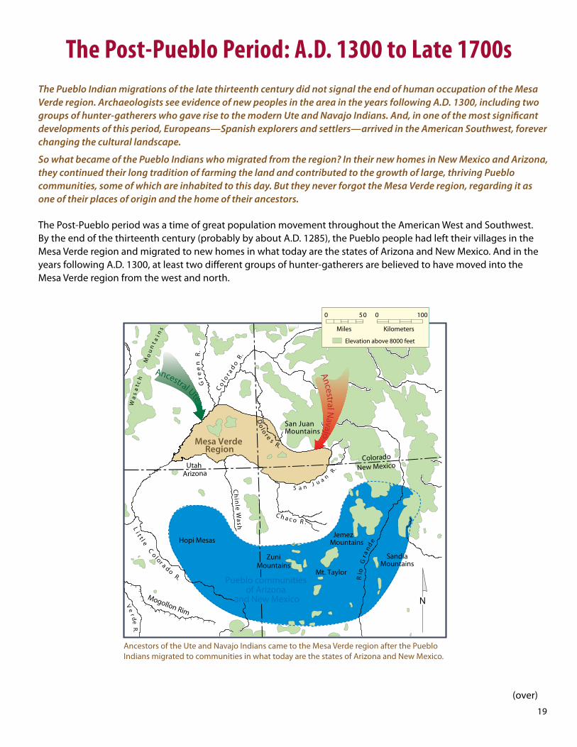
The Post-Pueblo Period: A.D. 1300 to Late 1700sThe Pueblo Indian migrations of the late thirteenth century did not signal the end of human occupation of the Mesa Verde region. Archaeologists see evidence of new peoples in the area in the years following A.D. 1300, including two groups of hunter-gatherers who gave rise to the modern Ute and Navajo Indians. And, in one of the most significant developments of this period, Europeans—Spanish explorers and settlers—arrived in the American Southwest, forever changing the cultural landscape.
So what became of the Pueblo Indians who migrated from the region? In their new homes in New Mexico and Arizona, they continued their long tradition of farming the land and contributed to the growth of large, thriving Pueblo communities, some of which are inhabited to this day. But they never forgot the Mesa Verde region, regarding it as one of their places of origin and the home of their ancestors.
The Post-Pueblo period was a time of great population movement throughout the American West and Southwest. By the end of the thirteenth century (probably by about A.D. 1285), the Pueblo people had left their villages in the Mesa Verde region and migrated to new homes in what today are the states of Arizona and New Mexico. And in the years following A.D. 1300, at least two different groups of hunter-gatherers are believed to have moved into the Mesa Verde region from the west and north.
Ancestors of the Ute and Navajo Indians came to the Mesa Verde region after the Pueblo Indians migrated to communities in what today are the states of Arizona and New Mexico.
(over)

20
One of these groups, the Utes, was living in the Mesa Verde region and adjacent areas when the first Spanish explorers arrived in the middle to late 1700s. Archaeological evidence indicates that the ancestors of the Utes had entered western Colorado centuries earlier, migrating from areas farther west. As for when they began living in the Mesa Verde region specifically, we aren’t sure. Both Ute and Hopi (Pueblo Indians who today live in northeastern Arizona) oral histories say that Ute and Pueblo peoples lived in the region at the same time. Although no clear archaeological evidence has been found to support this, more research is needed.
The second group of hunter-gatherers, ancestors of today’s Navajo Indians, migrated from the north. Scholars debate the exact timing of their arrival in the American Southwest, but they were probably in the Mesa Verde region at least by the early 1500s and possibly earlier.
A pivotal event toward the end of the Post-Pueblo period was the arrival of the Spanish, the first Europeans to enter the American Southwest. The Spanish settled in present-day New Mexico in the late 1500s, but not until the middle to late 1700s did explorers venture north into the Mesa Verde region. Although the Spanish did not build any permanent settlements in the Mesa Verde region—they were mostly interested in finding a route to their missions in California—their occupation of New Mexico had a ripple effect on American Indians living in the Mesa Verde region and beyond. From the introduction of horses, guns, and deadly diseases to their attempts to impose European language, religion, and systems of government, the Spanish were to have a profound and far-reaching impact on native cultures.
21
N
Mexican Ha t
Carrizo Mountains
Bluf f
Aneth
Blanding
Monticello
Pagosa SpringsDurango
Creek
Ute Mnt.
Azte c
t on
wo
od
Wa
sh
ot
C
MancosMesa Verde
Ignaci o
Towaoc
settle southNavajos
Dove
Abajo Mountains
New Mexico
oMn J u a n
S a
i n su n t a
FarmingtonShiprock
Mesa Verde Region
Colorado
Ute territory reduced through
treaties
Dolore
Corte z
s
UtahArizona
ednarGoi
R
R.a
rd
eiP
R.
a sm
nAi
La
Pl a
t a
R.
M a n c o s R .
cM E l
Cr.
om
C.
s
Cr o
s
tn
Me
zu
ma
Cr.
o
Gr a n d
G u l c h
o
da
ol
oC
r
i
R
re
v
hs
aW
elni
hC
aS
n
au
J
n
R i rev
Do
l or
es
R.
Elevation above 8000 feet
0
Kilometer s
0
Miles
30
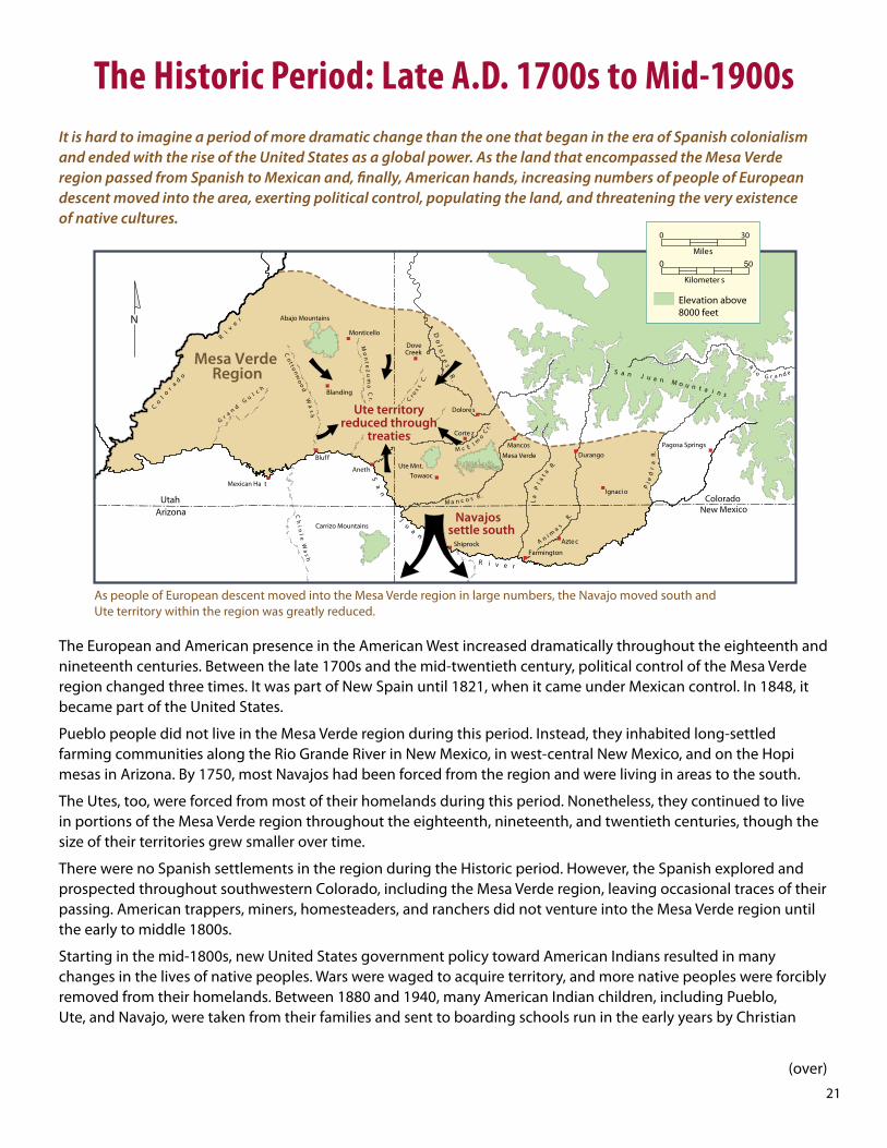
The Historic Period: Late A.D. 1700s to Mid-1900sIt is hard to imagine a period of more dramatic change than the one that began in the era of Spanish colonialism and ended with the rise of the United States as a global power. As the land that encompassed the Mesa Verde region passed from Spanish to Mexican and, finally, American hands, increasing numbers of people of European descent moved into the area, exerting political control, populating the land, and threatening the very existence of native cultures.
As people of European descent moved into the Mesa Verde region in large numbers, the Navajo moved south and Ute territory within the region was greatly reduced.
The European and American presence in the American West increased dramatically throughout the eighteenth and nineteenth centuries. Between the late 1700s and the mid-twentieth century, political control of the Mesa Verde region changed three times. It was part of New Spain until 1821, when it came under Mexican control. In 1848, it became part of the United States.
Pueblo people did not live in the Mesa Verde region during this period. Instead, they inhabited long-settled farming communities along the Rio Grande River in New Mexico, in west-central New Mexico, and on the Hopi mesas in Arizona. By 1750, most Navajos had been forced from the region and were living in areas to the south.
The Utes, too, were forced from most of their homelands during this period. Nonetheless, they continued to live in portions of the Mesa Verde region throughout the eighteenth, nineteenth, and twentieth centuries, though the size of their territories grew smaller over time.
There were no Spanish settlements in the region during the Historic period. However, the Spanish explored and prospected throughout southwestern Colorado, including the Mesa Verde region, leaving occasional traces of their passing. American trappers, miners, homesteaders, and ranchers did not venture into the Mesa Verde region until the early to middle 1800s.
Starting in the mid-1800s, new United States government policy toward American Indians resulted in many changes in the lives of native peoples. Wars were waged to acquire territory, and more native peoples were forcibly removed from their homelands. Between 1880 and 1940, many American Indian children, including Pueblo, Ute, and Navajo, were taken from their families and sent to boarding schools run in the early years by Christian
(over)

22
churches and in later years by the Bureau of Indian Affairs, a division of the federal government. There they were taught English, white American dress, and vocational skills and were punished for speaking their native languages or attempting to practice native customs. The philosophy and intent of the boarding schools was to assimilate Indian children into mainstream society and eliminate native cultures.

23
N
Blanding
Corte z
Monticello
Pagosa SpringsDurango
Ute Mnt.
Azte c
Ignaci o
Towaoc
Reservation(at White Mesa)
Ute Mountain Ute
Mexican Ha t
Bluf f
Aneth
Shiprock
(constructed in
Abajo Mountains
un JS a
oMa n
i nu n t a
s
Dove Creek
Dolore s
MancosMesa Verde
Farmington
Carrizo Mountains
Navajo Reservation(partial)
UtahArizona New Mexico
Colorado
Mesa Verde Region
M a n c o s
R .
Do
lor e
sR.
C.
s
Cr o
s
aw
J
C .e
c kt
Ye ll o
ton
wo
od
Wa
sh
ot
C
n
S
a
nJ u a
viR e r
Ch
i nl e
Wa
sh
Gr a n d
G u l c h
o
da
ol
oC
r
i
R
re
v
tn
eM
ez
um
aC
ro
ek
cM E l
Cr.
om
R
i oG r a n d e
Lake Powell
1950s and 1960s)
R.
ar
dei
P
R.
a sm
nAiP
al a
tR
.a
L
Southern Ute Reservation Ute Mountain Ute
Reservation
Elevation above 8000 feet
0
Kilometer s
0
Miles
30
Today: Mid-1900s to the PresentMore than 150 years after becoming a part of the United States, the Mesa Verde region is both a melting pot of peoples and a remarkable example of cultural perseverance in the face of seemingly overwhelming odds. American Indians are members of, and participate in, a regional community dominated by Americans of European descent, yet they have succeeded in preserving their own distinctive identities and cultures.
For much of the preceding history, the Mesa Verde region has been defined in archaeological terms, and most of our knowledge of the peoples who have lived in the region has come, not from written records, but from the physical clues—bits of broken tools, scraps of food, and the remains of houses—they left behind. In contrast, the Mesa Verde region today is defined in terms of modern political subdivisions, and much of our knowledge of the people living in the area is derived from censuses and other official government records.
The Mesa Verde region today includes all or portions of three American Indian reservations: Ute Mountain Ute, Southern Ute, and Navajo.
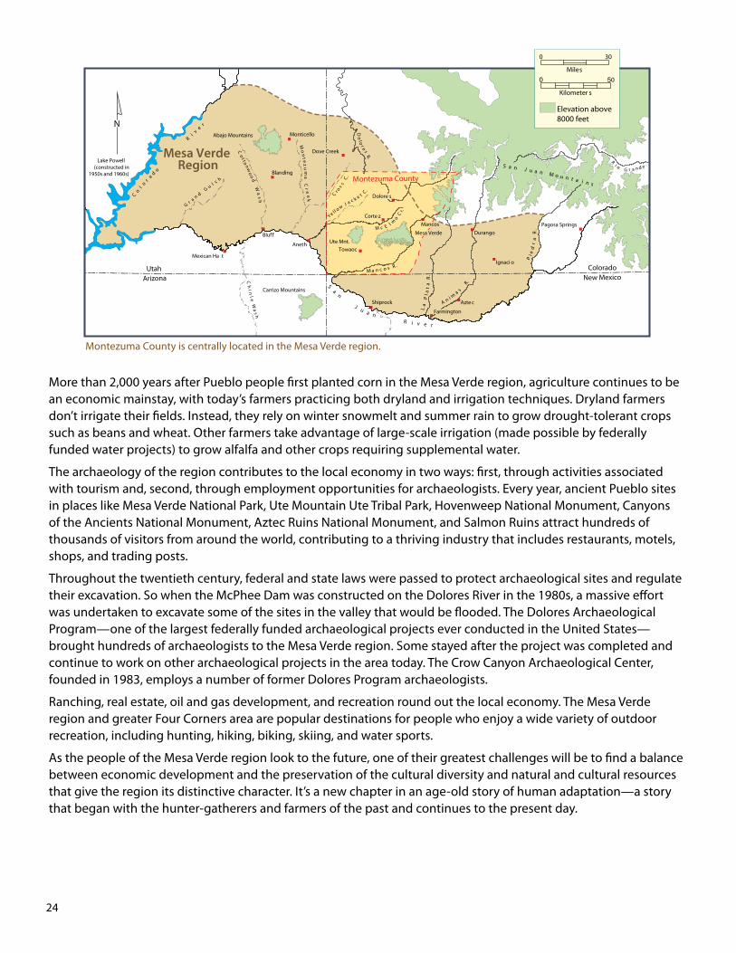
The Mesa Verde region is divided among three states—Colorado, New Mexico, and Utah—and seven counties, including Montezuma County, Colorado, where the Crow Canyon Archaeological Center is located. The region is home to more than 100,000 people of diverse ancestry. More than 20,000 American Indians live in the region today, but the majority of the population consists of non-Indians—primarily peoples of European descent, but also individuals of African, Asian, and mixed heritage. All contribute to the complex fabric of community life, which reflects a unique blend of age-old traditions and twenty-first-century American culture.
What is life like in the Mesa Verde region today? There continues to be a sizeable rural population, but many people also live in several main towns and cities, including Cortez, Dolores, Dove Creek, Durango, Ignacio, Mancos, and Towaoc in Colorado; Blanding and Monticello in Utah; and Farmington and Shiprock in New Mexico. The region includes all of the Ute Mountain Ute Reservation, most of the Southern Ute Reservation, and a small portion of the Navajo Reservation.
(over)
24
N
Blanding
Corte z
Monticello
Pagosa SpringsDurango
Ute Mnt.
Azte c
R
i oG r a nd e
t on
wo
od
Wa
sh
ot
C
Ignaci o
TowaocMexican Ha t
Bluf f
Aneth
Shiprock
(constructed inLake Powell
1950s and 1960s)
Abajo Mountains
un JS a
oMa n
i nu n t a
s
Dove Creek
Dolore s
Farmington
Carrizo Mountains
UtahArizona New Mexico
Colorado
Mesa Verde Region
Montezuma Countyo
da
ol
oC
r
i
R
re
v
Gr a n d
G u l c h
tn
eM
ez
um
aC
ro
ek
Ch
i nl e
Wa
sh
n
S
a
nJ u a
viR e r
M a n c o s R .
cM E l
Cr.
om
Do
lor e
sR.
aw
J
C .e
c kt
Ye ll o
C.
s
Cr o
s
Pa
l at
R.
aL
R.
a sm
nAi
R.
ar
dei
P
Mesa Verde
Mancos
Elevation above 8000 feet
0
Kilometer s
0
Miles
30
Montezuma County is centrally located in the Mesa Verde region.
More than 2,000 years after Pueblo people first planted corn in the Mesa Verde region, agriculture continues to be an economic mainstay, with today’s farmers practicing both dryland and irrigation techniques. Dryland farmers don’t irrigate their fields. Instead, they rely on winter snowmelt and summer rain to grow drought-tolerant crops such as beans and wheat. Other farmers take advantage of large-scale irrigation (made possible by federally funded water projects) to grow alfalfa and other crops requiring supplemental water.
The archaeology of the region contributes to the local economy in two ways: first, through activities associated with tourism and, second, through employment opportunities for archaeologists. Every year, ancient Pueblo sites in places like Mesa Verde National Park, Ute Mountain Ute Tribal Park, Hovenweep National Monument, Canyons of the Ancients National Monument, Aztec Ruins National Monument, and Salmon Ruins attract hundreds of thousands of visitors from around the world, contributing to a thriving industry that includes restaurants, motels, shops, and trading posts.
Throughout the twentieth century, federal and state laws were passed to protect archaeological sites and regulate their excavation. So when the McPhee Dam was constructed on the Dolores River in the 1980s, a massive effort was undertaken to excavate some of the sites in the valley that would be flooded. The Dolores Archaeological Program—one of the largest federally funded archaeological projects ever conducted in the United States—brought hundreds of archaeologists to the Mesa Verde region. Some stayed after the project was completed and continue to work on other archaeological projects in the area today. The Crow Canyon Archaeological Center, founded in 1983, employs a number of former Dolores Program archaeologists.
Ranching, real estate, oil and gas development, and recreation round out the local economy. The Mesa Verde region and greater Four Corners area are popular destinations for people who enjoy a wide variety of outdoor recreation, including hunting, hiking, biking, skiing, and water sports.
As the people of the Mesa Verde region look to the future, one of their greatest challenges will be to find a balance between economic development and the preservation of the cultural diversity and natural and cultural resources that give the region its distinctive character. It’s a new chapter in an age-old story of human adaptation—a story that began with the hunter-gatherers and farmers of the past and continues to the present day.

Crow Canyon is a great place to learn about archaeology and the culture and history of the Pueblo Indians!
Visit www.crowcanyon.org for information on all of Crow Canyon’s programs for the public. You can sign-up online or call 800.422.8975, ext. 146, to register.
The Crow Canyon Archaeological Center’s programs and admission practices are open to applicants of any race, color, nationality, ethnic origin, gender, or sexual orientation.
Teen Camps
High School Field School
Lab Program
Day Tour
Family WeekSchool Groups and Field Trips
Travel Adventures
Archaeology Research Program