Embed Size (px)
Citation preview

Pix4D Chillon Project– Aerial/ terrestrial and Indoor integration
Page 1 Copyright: Pix4D
The Chillon Project: Aerial/ Terrestrial and Indoor Integration
How can one map a whole castle efficiently in full 3D? Is it possible to have a 3D model containing both the inside and outside? The Chillon project performed by Pix4D in May 2014 is a use case to show the accuracy, feasibility and efficiency of image based 3D modelling for very complex architectural objects.
Authors: Christoph Strecha, Marten Krull and Sonja Betschart
June 2014

Pix4D Chillon Project– Aerial/ terrestrial and Indoor integration
Page 2 Copyright: Pix4D
1 Introduction Overthelastyears,moreandmorehighqualityimagingsensorshavebecomeavailableforaveryaffordableprice.Atthesametime,usershaveaccesstosoftwarethatcanhandlesuchsensorsefficientlyandautomaticallybuild3Dmodelsfromimagesonly.For very complex structures and when speaking about “efficient mapping”, efficiencyrelates to the question “how many image locations are needed to model a complexstructure(forinstanceacastle)withallitsgeometricallycomplexstructuresandwithallinsiderooms”.Whenconsideringtraditionallaserscanning,allpointsthatarenotoccludedbyanotherobjectcanbereachedoverafullcircleof360degrees.Onelaserscancanthusmeasuremanypointsfromonlyoneposition.Imagebased3D reconstructionsneeds theoretically at least two images. Based on twoimages,onecancomputea3Dpointonly for thestructuresvisible inboth images.Theamountofa3Dstructurethatcanbemodelledwithtwoimagesalsodependsonthelens:a fisheye lens covering 180 degree of the scene can map a much larger area thanperspectiveimagesthatdepictonlyasmallarea.
2 The test site TheChilloncastle (alsoknownasChateaudeChillon) isan islandcastle locatedontheshore of Lake Geneva, next to city of Montreux. The castle, consisting of over 21independentbuildingsthatweregraduallyconnectedtobecomethebuildingasitstandsnow,isSwitzerland’smostvisitedhistoricmonument.Theoldestpartsofthecastlehavenotbeendefinitivelydated,butthefirstwrittenrecordofthecastleisin1160or1005.TherockyislandonwhichthecastleisbuiltwasbothanaturalprotectionandastrategiclocationtocontrolthepassagebetweennorthernandsouthernEurope.Fromthemid12thcentury,thecastlewashometotheCountsofSavoy,anditwasgreatlyexpandedinthe13thcenturybyPietroII.TheCastlewasnevertakeninasiege,butdidchangehandsthroughtreaties.ItwasmadepopularbyLordByron,whowrotethepoem“ThePrisonerOfChillon”in1816andwhoalsocarvedhisnameonapillarofthedungeon.Thecastlehas inspiredmanyartistsandwriters,fromJean‐JacquesRousseau,VictorHugoandHenryJamestoDelacroixandCourbet.Initscurrentstate,theChillonCastleistheresultofseveralcenturiesofconstantbuilding,adaptations,renovationsandrestorations.

Pix4D Chillon Project– Aerial/ terrestrial and Indoor integration
Page 3 Copyright: Pix4D
Figure1:ChillonCastle
Figure2:MapofChillonCastlewithmodelledinsideroomsingreencolour

Pix4D Chillon Project– Aerial/ terrestrial and Indoor integration
Page 4 Copyright: Pix4D
3 The surveying equipments
3.1 GNSS data ATrimbleR10GNSSreceiverwasusedinRTK‐modeusingavirtualreferencestationformeasuring 11 marked points two times in different satellite constellations. The meandifferencesbetweenthetwomeasurementswere1cminxandyand2cminz.SomeoftheGCPswerevisibleintheimagedata(asshowninFigure)andsomeofthemusedtodefinethetachymetricnetworkasdescribedbelow.3.2 Tachymeter data For surveying the control points measurable in the terrestrial and aerial pictures, atachymetricnetworkwasmeasuredwithaTrimble5601totalstationfromthelandside.
Figure3:Markedcontrolpointandlaserscantargetfrom
obliqueaerialview
Beingaculturalheritagesite,nosurveyingmarkswereallowedtobeplacedonfacades.Weuseddistinctivenaturalpointsofthebuildingsforcontrolpointsinstead.
Figure4:Naturalcontrolpoints
Most of the pointsweremeasured fromdifferent viewpoints in both instrument faces;someasaspatialintersectionwithoutdistancemeasurement(e.g.mostofthespheroidson the top of the roofs) and somewith reflector‐less distancemeasurement. The leastsquareadjustmenttookintoaccounttheerrorsoftheGNSS‐points,alsorefiningthem,andledinternaltomeanstandarddeviationsof8,7and6mminx,yandz.

Pix4D Chillon Project– Aerial/ terrestrial and Indoor integration
Page 5 Copyright: Pix4D
Figure5:Tachymetricnetworkforsurveyingthecontrolpoints
3.3 Canon 6D 8mm Sigma lens TheCanon6Dhasa20.2MPfullframeCMOSsensor.Theimagesinthisexperimenthavebeencapturefromvariouspositionwiththecameramountedonatripod.TheSigma8mmlensproduces180degreeimagery.
Figure4:Canon6DwithSigmafisheye8mm
3.4 Sony alpha 7r with 8mm lens TheSonyalpha7rhasafull frameCMOSsensor. Inconjunctionwiththe8mmRokinonfisheyelens,itcapturesAPS‐Csizeimageswith4800x3200pixels.All imageshavebeencapturesonatripodmount.

Pix4D Chillon Project– Aerial/ terrestrial and Indoor integration
Page 6 Copyright: Pix4D
Figure6:Sonyalpha7rwith8mmRikononfisheyelens
3.5 Gopro Hero3+ Goprodesignedthiscameraasanactioncamera.ItisawidespreadcamerawhichiswellsuitedforuseonaUAVduetoislightweightofjust100g.TheGoprocapturesimagesataresolutionof4000x3000pixelsandcomeswithawideanglefisheyelens.Imagescanbetriggered through amobile phone connectedwithWiFi. There is a time laps capturingmodewithvarioustimeintervalsstartingfrom0.5sec.Theimagescapturedinthispaperusedtjehandheldintervalcapturingmodeof0.5sec.
Figure7:Goprocamera
3.6 Phantom Vision 2 ThePhantomVision2isaremotelycontrolledquadro‐copter.Itisfittedwitha4000x3000pixelcamerathatcanbetriggeredfromamobilephoneoranintervalmodestartingfrom1image/second.SimilartotheGopro,ithasawideanglefisheyelens.TheimagesinthispaperwerecapturesusingthePhantomVision2inremotelycontrolledflightmodewithanimageacquisitionintervalof1second.
Figure8:PhantomVision2

Pix4D Chillon Project– Aerial/ terrestrial and Indoor integration
Page 7 Copyright: Pix4D
4 Data Acquisition Thedataacquisitionwasdonebyseveralpeoplewithinoneday:
DJIPhantomVision2 All five courtyards inside
the castle with obliqueaerialimagery
1person2h
Outside oblique aerialimageryfromstreetinfromofthecasteandfromaboattocapturethelakeside
2person2h(1boatdriver)
CustomQuadro‐copterwithGoProHero3+
Nadir and oblique aerialimageryfromthecastle
1person½h
Canon6D8mmfisheyeand Sony alpha7R withfisheye
Inside courtyards and allrooms inside the castlefromatripodfortheinsidecaste
2person3h
GNNSacquisition Groundcontrolpointsfromtargetontheground.
1person2h
Tachymeter Measurements of the toptowers of the castle, theseground control pointsconnect the courtyards ofthe castle with the streetside and the images fromtheboatonthelake.
2 person5h
Figure9:InsideimageacquisitionwiththeCanon6DontripodFigure10:thewholeteam&equipmentused

Pix4D Chillon Project– Aerial/ terrestrial and Indoor integration
Page 8 Copyright: Pix4D
Theimagedatafromthevariouscameraswascapturedwithaveryhighoverlap(80‐90%),whichisnotdifficulttoachieveconsideringtheuseofmanywideangleorevenfisheyelenses.Morecareandoverlapisneededtoconnecttheoutdoorterrestrialimageswiththeindoor imagesof thesamecamera.Sincewedonothavegroundcontrolpoints for theindoorparts,theseconnectionsneededtobeverystrong(highoverlap).TheUAVdatawascapturedwithacustommadeUAVwithaGoPromountthatwassettocontinuousexposureevery1second.ThesamesettingwasusedforthePhantomVisionimages.
5 Data Processing Pix4Dmapper software allows to create projects by merging already computed subprojects.Thishasmainlytwoadvantages:
Speed:Efficientandfastprocessingforsmallersizedsubprojects Quality:Separatequalitycontrol
InthecaseofChillon,thedataofthevariouscamerasandsourceshasbeenprocessedfirstindependently.Eachsubprojecthasbeengeo‐referencedwiththesamegroundcontrolpoints (when visible) and the quality/ accuracy had been ensured. After this stepwemergedthedifferentsubprojectsintolargerprojectsuntil–finally‐allimageshavebeenput together. At each step of the merging process, a separate bundle adjustment wasperformed(“Re‐optimize”optioninrayCloudeditor).Hereaftermoredetailonsomeofthesubprojects.5.1 Canon 6D 8mm fisheye 1885imageswerecapturedfromthecastlecourtyardsandinsidesrooms.Moreoverlapwasneededwhenmovingfromtheoutsidecourtyardsthroughtheopendoorstowardstheinside.Geo‐referencingispossiblefromthetachymetricmeasurementsofthetowersthatarevisiblefromtheindividualcourtyards.
Figure11:ExampleoftheCanon6DSigma8mmfisheyeimageryfromoneofthecourtyards

Pix4D Chillon Project– Aerial/ terrestrial and Indoor integration
Page 9 Copyright: Pix4D
Figure12:Reconstructionofthe1885Canon8mmimagesofthecourtyardsandinsiderooms
Figure13:Reconstructionofthe453Canon8mmcaveimages
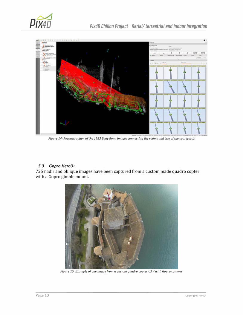
5.2 Sony alpha 7r with 8mm fisheye lens The1933imagestakenfromatripodconnecttheinsideroomswithtwoofthecourtyards.Thereconstructionisgeo‐referencedbytheGCPsvisibleinthecourtyards.
Pix4D Chillon Project– Aerial/ terrestrial and Indoor integration
Page 10 Copyright: Pix4D
Figure14:Reconstructionofthe1933Sony8mmimagesconnectingtheroomsandtwoofthecourtyards
5.3 Gopro Hero3+ 725nadirandobliqueimageshavebeencapturedfromacustommadequadrocopterwithaGoprogimblemount.
Figure15:ExampleofoneimagefromacustomquadrocopterUAVwithGoprocamera.

Pix4D Chillon Project– Aerial/ terrestrial and Indoor integration
Page 11 Copyright: Pix4D
Figure16:ReconstructionoftheGoproaerialobliqueandnadirimagery.
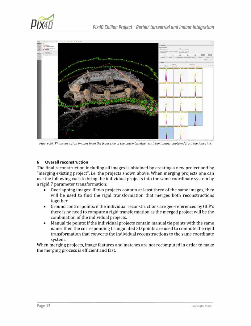
5.4 DJI Phantom Vision 2 712imageshavebeencapture fromthecourtyardswiththeDJIPhantomVision2.TheresultisshowninFigure20.469imageshavebeencapturedfromthelakeside(withtheDJIoperatedfromaboat)andfromthefrontsideofthecastleandtheresultofthebundleadjustmentisshowninFigure19.
Figure17:ExampleofthePhantom2Visionimageryfromthefrontside.

Pix4D Chillon Project– Aerial/ terrestrial and Indoor integration
Page 12 Copyright: Pix4D
Figure18:ExampleofoneDJIPhantom2Visionimagefromthelakeside,capturedbyboatoperation
Figure19:ReconstructionoftheDJIPhantomvisionimageslaunchedfromeachindividualofthefivecourtyards.
Pix4D Chillon Project– Aerial/ terrestrial and Indoor integration
Page 13 Copyright: Pix4D
Figure20:Phantomvisionimagesfromthefrontsideofthecastletogetherwiththeimagescapturedfromthelakeside.
6 Overall reconstruction Thefinalreconstructionincludingallimagesisobtainedbycreatinganewprojectandby“mergingexistingproject”,i.e.theprojectsshownabove.Whenmergingprojectsonecanusethefollowingcuestobringtheindividualprojectsintothesamecoordinatesystembyarigid7parametertransformation:
Overlappingimages:iftwoprojectscontainatleastthreeofthesameimages,theywill be used to find the rigid transformation that merges both reconstructionstogether
Groundcontrolpoints:iftheindividualreconstructionsaregeo‐referencedbyGCP’sthereisnoneedtocomputearigidtransformationasthemergedprojectwillbethecombinationoftheindividualprojects.
Manualtiepoints:iftheindividualprojectscontainmanualtiepointswiththesamename,thenthecorrespondingtriangulated3Dpointsareusedtocomputetherigidtransformationthatconvertstheindividualreconstructionstothesamecoordinatesystem.
Whenmergingprojects,imagefeaturesandmatchesarenotrecomputedinordertomakethemergingprocessisefficientandfast.

Pix4D Chillon Project– Aerial/ terrestrial and Indoor integration
Page 14 Copyright: Pix4D
Figure21:TwodifferentscreenshotsoftherayCloudfromtheoverallreconstructionaftertheBundleblockadjustment.
Figure22:Connectivitygraphoftheoverallreconstruction

Pix4D Chillon Project– Aerial/ terrestrial and Indoor integration
Page 15 Copyright: Pix4D
Figure23showsthefinalaccuracyofallGroundControlPointsafterbundleblockadjustmentofthecompleteproject.GCP name Error X [m] Error Y [m] Error Z [m] Projection error [pixel]
3D GCP: 1towerW ‐0.012 ‐0.014 0.009 1.604
3D GCP: 4towerE ‐0.029 ‐0.012 ‐0.006 1.495
3D GCP: 2towerW ‐0.001 ‐0.008 0.010 1.592
3D GCP: ctowerW ‐0.010 0.002 ‐0.002 1.218
3D GCP: 3towerE ‐0.005 ‐0.002 0.008 1.464
3D GCP: 1towerE ‐0.011 ‐0.003 0.004 1.235
3D GCP: 0towerE ‐0.003 ‐0.007 0.001 1.523
3D GCP: ctowerE 0.000 0.000 ‐0.005 1.479
3D GCP: ctowerM 0.021 0.023 ‐0.015 1.190
3D GCP: 2towerE ‐0.003 0.000 ‐0.007 1.383
3D GCP: ntowerE 0.007 ‐0.023 0.011 1.427
3D GCP: ntowerW 0.014 ‐0.027 0.011 1.306
3D GCP: chimneyM3cornerSE ‐0.011 0.020 0.013 2.234
3D GCP: 3towerW ‐0.011 ‐0.026 0.027 1.699
3D GCP: marked_GCP_seaside_south 0.010 ‐0.010 ‐0.008 1.293
3D GCP: marked_GCP_wall_N 0.002 ‐0.001 0.004 1.259
3D GCP: marked_GCP_wall_M 0.003 ‐0.004 0.009 1.178
3D GCP: marked_GCP_wall_S 0.004 ‐0.008 0.009 1.050
3D GCP: marked_GCP_courtyard 0.007 ‐0.003 0.004 0.909
3D GCP: markedGCP_north_just_GPS ‐0.019 0.016 0.035 1.179
3D GCP: chimneyM2deepercorner ‐0.011 ‐0.006 ‐0.036 2.175
3D GCP: chimneyM0deepercorner 0.035 0.012 0.021 1.789
3D GCP: chimney3towerEdeepercorner ‐0.022 ‐0.003 ‐0.019 2.489
3D GCP: chimney_n_tower_deeper_corner ‐0.034 ‐0.016 ‐0.066 1.424
3D GCP: ctowerSE 0.002 ‐0.005 0.001 1.537
3D GCP: ctowerSW 0.003 ‐0.006 ‐0.001 1.734
3D GCP: chimneyM2BS ‐0.003 ‐0.039 0.046 1.915
3D GCP: chimneyM2BN 0.014 ‐0.015 0.023 2.035
3D GCP: top_left_white_stone 0.036 ‐0.009 ‐0.015 1.506
3D GCP: circle_down_8 0.010 ‐0.007 0.011 1.127
3D GCP: top_left_corner_painted_cross ‐0.009 0.014 ‐0.022 1.897
3D GCP: 3towerE_top_left_cross_middle ‐0.013 0.019 ‐0.010 1.296
3D GCP: 1towerE_top_left_cross_left 0.007 ‐0.000 ‐0.004 1.446
3D GCP: 1towerE_top_left_cross_middle 0.006 0.015 ‐0.014 0.567
3D GCP: 2towerE_top_left_cross_middle 0.003 0.012 0.002 0.861
3D GCP: top_left_front_cross_corner 0.033 ‐0.014 ‐0.007 1.223
3D GCP: top_left_corner_red_cross_bridge ‐0.077 ‐0.063 ‐0.002 0.705
Mean ‐0.007544 ‐0.007131 ‐0.006376
Sigma 0.039784 0.019542 0.045805
RMS error 0.040493 0.020803 0.046247
Figure23:Groundcontrolpointaccuracyafterfinalbundleadjustmentoftheoverallproject.
AftertheInitialprocessing(firststep),theexternalandinternalcameraparametersofallimagesareknownandwillbeusedforthePointCloudDensification.

Pix4D Chillon Project– Aerial/ terrestrial and Indoor integration
Page 16 Copyright: Pix4D
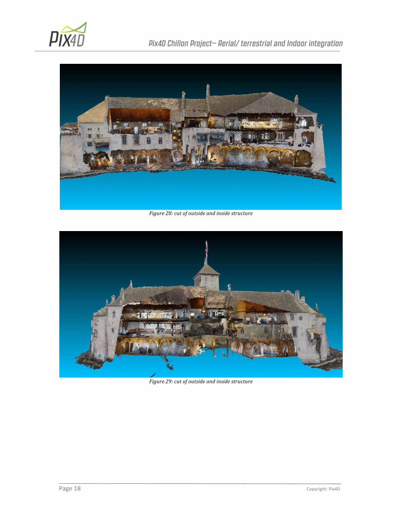
7 Final results Figures24‐30showtherenderingofthedensereconstruction.Thevideooftheprojectcanbeviewedat:http://youtu.be/j7PGgrMSi5oThe3Dmodelcanbeviewedbothasaninsideandoutsidepointcloudaswellasatriangulatedmeshonwww.pix4d.com/chillon
Figure24:Frontside(streetside)ofoutsidestructure
Figure25:Backside(lakeside)ofoutsidestructure

Pix4D Chillon Project– Aerial/ terrestrial and Indoor integration
Page 17 Copyright: Pix4D
Figure26:Aerial(oblique)viewofoutsidestructureandcourtyards
Figure27:cutofpartsoftheinsiderooms
Pix4D Chillon Project– Aerial/ terrestrial and Indoor integration
Page 18 Copyright: Pix4D
Figure28:cutofoutsideandinsidestructure
Figure29:cutofoutsideandinsidestructure

Pix4D Chillon Project– Aerial/ terrestrial and Indoor integration
Page 19 Copyright: Pix4D
Figure30:topviewofcut


![Informe Rio Chillon Final[1]](https://img.pdfslide.us/doc/110x75/55cf9c1d550346d033a8a705/informe-rio-chillon-final1.jpg)