Embed Size (px)
Citation preview
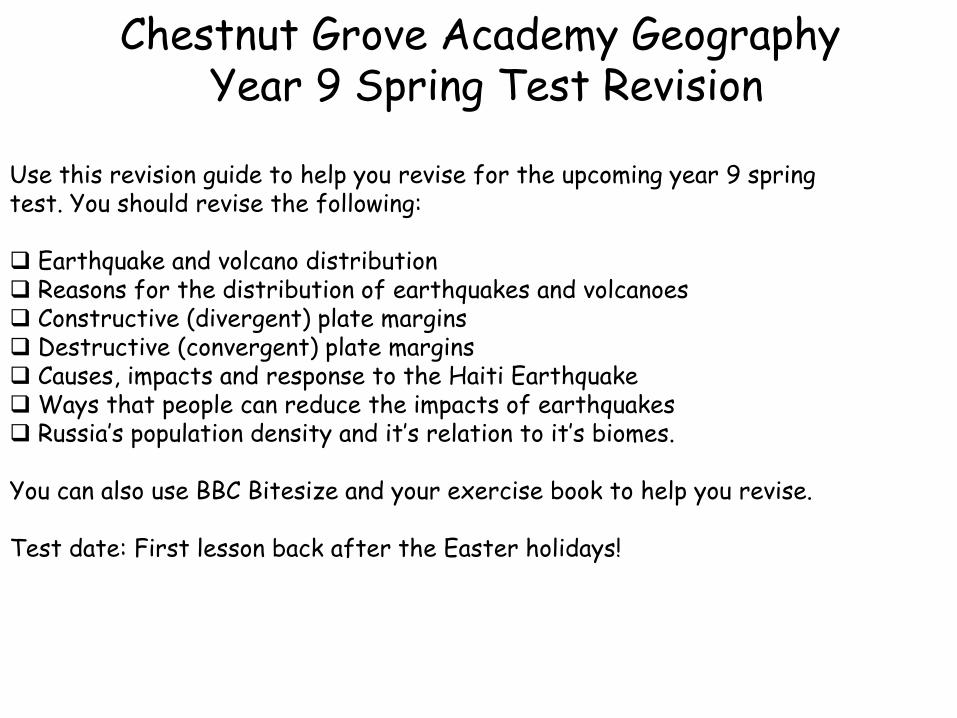
Chestnut Grove Academy Geography Year 9 Spring Test Revision
Use this revision guide to help you revise for the upcoming year 9 spring test. You should revise the following: Earthquake and volcano distribution Reasons for the distribution of earthquakes and volcanoes Constructive (divergent) plate margins Destructive (convergent) plate margins Causes, impacts and response to the Haiti Earthquake Ways that people can reduce the impacts of earthquakes Russia’s population density and it’s relation to it’s biomes.
You can also use BBC Bitesize and your exercise book to help you revise. Test date: First lesson back after the Easter holidays!
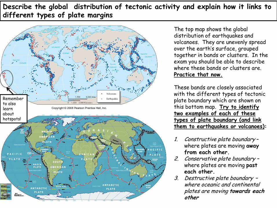
Describe the global distribution of tectonic activity and explain how it links to different types of plate margins
The top map shows the global distribution of earthquakes and volcanoes. They are unevenly spread over the earth’s surface, grouped together in bands or clusters. In the exam you should be able to describe where these bands or clusters are. Practice that now. These bands are closely associated with the different types of tectonic plate boundary which are shown on this bottom map. Try to identify two examples of each of these types of plate boundary (and link them to earthquakes or volcanoes): 1. Constructive plate boundary –
where plates are moving away from each other.
2. Conservative plate boundary – where plates are moving past each other.
3. Destructive plate boundary – where oceanic and continental plates are moving towards each other
Remember to also learn about hotspots!
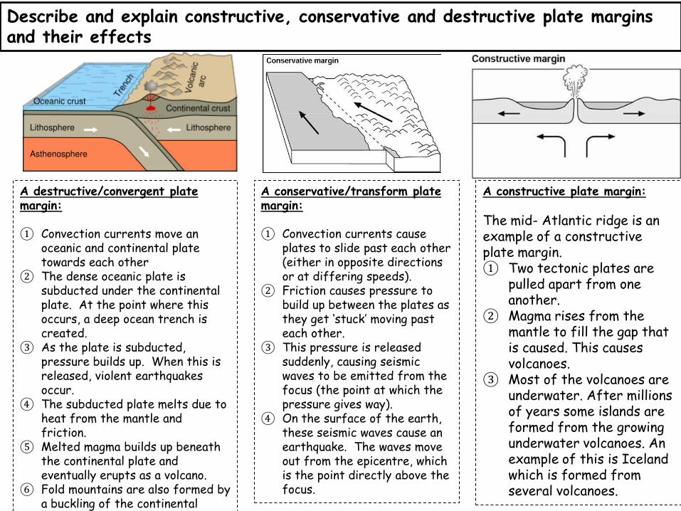
Describe and explain constructive, conservative and destructive plate margins and their effects
A destructive/convergent plate margin:
① Convection currents move an
oceanic and continental plate towards each other
② The dense oceanic plate is subducted under the continental plate. At the point where this occurs, a deep ocean trench is created.
③ As the plate is subducted, pressure builds up. When this is released, violent earthquakes occur.
④ The subducted plate melts due to heat from the mantle and friction.
⑤ Melted magma builds up beneath the continental plate and eventually erupts as a volcano.
⑥ Fold mountains are also formed by a buckling of the continental crust.
A conservative/transform plate margin:
① Convection currents cause
plates to slide past each other (either in opposite directions or at differing speeds).
② Friction causes pressure to build up between the plates as they get ‘stuck’ moving past each other.
③ This pressure is released suddenly, causing seismic waves to be emitted from the focus (the point at which the pressure gives way).
④ On the surface of the earth, these seismic waves cause an earthquake. The waves move out from the epicentre, which is the point directly above the focus.
A constructive plate margin: The mid- Atlantic ridge is an example of a constructive plate margin. ① Two tectonic plates are
pulled apart from one another.
② Magma rises from the mantle to fill the gap that is caused. This causes volcanoes.
③ Most of the volcanoes are underwater. After millions of years some islands are formed from the growing underwater volcanoes. An example of this is Iceland which is formed from several volcanoes.
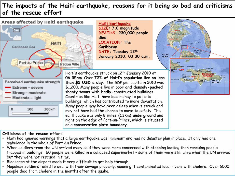
The impacts of the Haiti earthquake, reasons for it being so bad and criticisms of the rescue effort
Haiti Earthquake SIZE: 7.0 magnitude DEATHS: 230,000 people died LOCATION: The Caribbean DATE: Tuesday 12th January 2010, 03:30 a.m.
Haiti’s earthquake struck on 12th January 2010 at 06.35am. Over 72% of Haiti’s population live on less than $2 USD a day. The GDP per capita in 2010 was $1,200. Many people live in poor and densely-packed shanty towns with badly-constructed buildings. Countries like Haiti have less money to put into buildings, which has contributed to more devastation. Many people may have been asleep when it struck and may not have had the chance to move to safety. The earthquake was only 8 miles (13km) underground and right on the edge of Port-au-Prince, which is situated on a conservative plate boundary.
Criticisms of the rescue effort: • Haiti had ignored warnings that a large earthquake was imminent and had no disaster plan in place. It only had one
ambulance in the whole of Port Au Prince. • When soldiers from the UN arrived many said they were more concerned with stopping looting than rescuing people
trapped in buildings. 60 people were killed in a collapsed supermarket – some of them were still alive when the UN arrived but they were not rescued in time.
• Blockages at the airport made it very difficult to get help through. • Nepalese soldiers failed to deal with their sewage properly, meaning it contaminated local rivers with cholera. Over 6000
people died from cholera in the months after the quake.
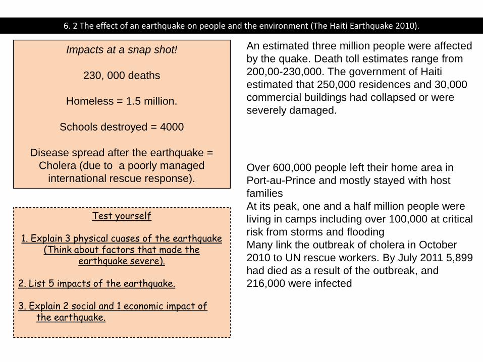
6. 2 The effect of an earthquake on people and the environment (The Haiti Earthquake 2010).
Impacts at a snap shot!
230, 000 deaths
Homeless = 1.5 million.
Schools destroyed = 4000
Disease spread after the earthquake =
Cholera (due to a poorly managed
international rescue response).
An estimated three million people were affected
by the quake. Death toll estimates range from
200,00-230,000. The government of Haiti
estimated that 250,000 residences and 30,000
commercial buildings had collapsed or were
severely damaged.
Over 600,000 people left their home area in
Port-au-Prince and mostly stayed with host
families
At its peak, one and a half million people were
living in camps including over 100,000 at critical
risk from storms and flooding
Many link the outbreak of cholera in October
2010 to UN rescue workers. By July 2011 5,899
had died as a result of the outbreak, and
216,000 were infected
Test yourself
1. Explain 3 physical cuases of the earthquake (Think about factors that made the
earthquake severe).
2. List 5 impacts of the earthquake. 3. Explain 2 social and 1 economic impact of
the earthquake.
How the impacts of earthquakes can be reduced.
Many of the prediction techniques used to monitor earthquakes are
not 100 per cent reliable. Planning and preparing for an
earthquake is therefore very important.
•People living in earthquake zones need to know what they should
do in the event of a quake. Training people may involve
holding earthquake drills and educating people via TV or radio.
•People may put together emergency kits and store them in their
homes. An emergency kit may include first-aid items,
blankets and tinned food.
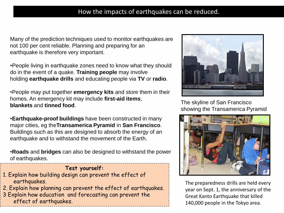
•Earthquake-proof buildings have been constructed in many
major cities, eg theTransamerica Pyramid in San Francisco.
Buildings such as this are designed to absorb the energy of an
earthquake and to withstand the movement of the Earth.
•Roads and bridges can also be designed to withstand the power
of earthquakes.
The skyline of San Francisco
showing the Transamerica Pyramid
The preparedness drills are held every year on Sept. 1, the anniversary of the Great Kanto Earthquake that killed 140,000 people in the Tokyo area.
Test yourself: 1. Explain how building design can prevent the effect of
earthquakes. 2. Explain how planning can prevent the effect of earthquakes. 3 Explain how education and forecasting can prevent the
effect of earthquakes.
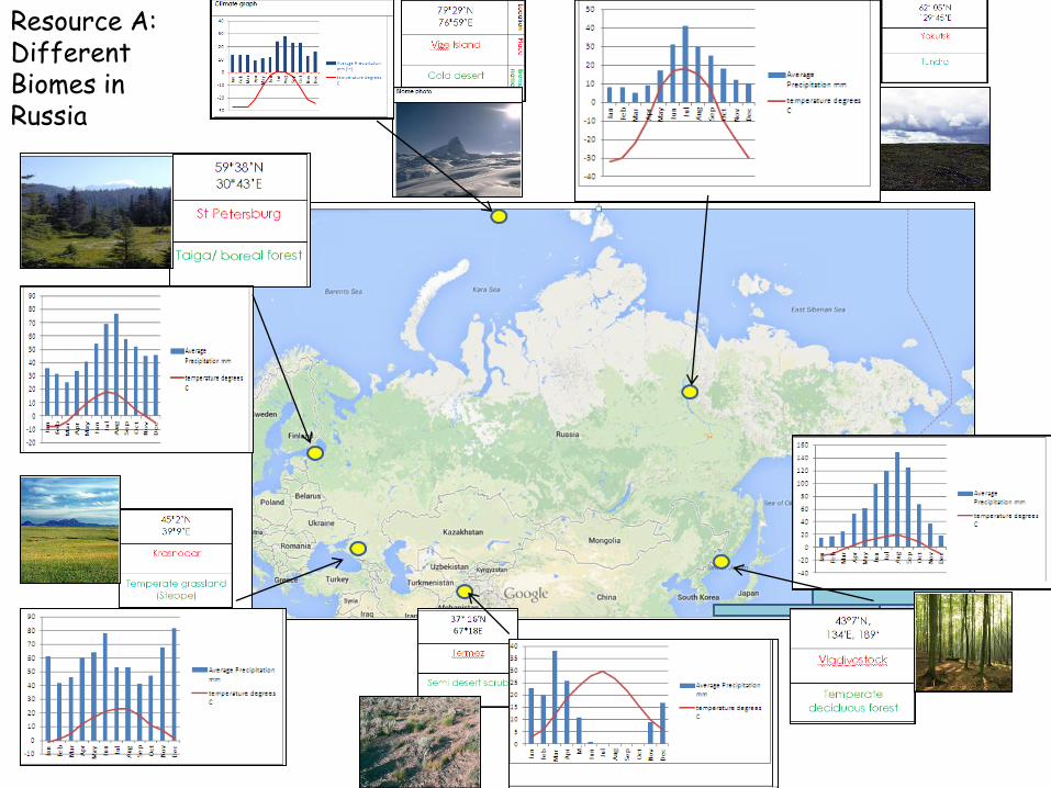
Resource A: Different Biomes in Russia
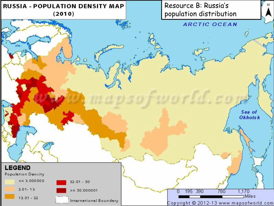
Resource B: Russia’s population distribution


![Chestnut Newsfluencycontent2-schoolwebsite.netdna-ssl.com/FileCluster/...[Type text] Refugees Welcome Schools Summit On 21st June, five outstanding Chestnut Grove students were invited](https://img.pdfslide.us/doc/110x75/5ab306667f8b9ac3348de246/chestnut-newsfluencycontent2-type-text-refugees-welcome-schools-summit-on-21st.jpg)


![Sixth Form Course Guide 2019[1]fluencycontent2-schoolwebsite.netdna-ssl.com/FileCluster/... · 2018-12-10 · Sixth Form Course Guide 2019 Entry The Chestnut Grove curriculum provides](https://img.pdfslide.us/doc/110x75/5e53b95399823f5371149f47/sixth-form-course-guide-20191fluencycontent2-2018-12-10-sixth-form-course-guide.jpg)