Embed Size (px)
Citation preview
CHESHIRE HISTORIC TOWNS SURVEY
Middlewich
Revised Archaeological Assessment
2013
CHESHIRE HISTORIC TOWNS SURVEY
Middlewich
Revised Archaeological Assessment
2013
Archaeology Planning Advisory Service Cheshire Shared Services
The Forum Chester
CH1 2HS These reports are the copyright of Cheshire East Council and English Heritage. All maps are © Crown copyright and database rights 2013. Ordnance Survey 100049045 & Ordnance Survey 100049046. Front cover : J Cowley, 1744 An Improved Map of Cheshire, Containing the Borough and Market Towns, with those adjoining; also its Principal Roads and Rivers Cheshire Archives and Local Studies, PM 2/20.
Cheshire Historic Towns Survey 1 © Cheshire East Council and English Heritage 2013
MIDDLEWICH
ARCHAEOLOGICAL ASSESSMENT
Mike Shaw & Jo Clark (2002), revised and updated by Malcolm Reid (2012)
1. SUMMARY Middlewich is best known as one of Cheshire’s three historic salt towns, for which it has been important since the Roman period (the other two being Nantwich and Northwich). However, with the increasing industrialisation of the salt industry from the 18th to 19th centuries, Middlewich lost ground to Northwich and Winsford, and by the 1970s there was only one saltworks left in the town. 1.1 Topography and Geology The town is located in mid-Cheshire on the Cheshire Plain at c. 30m AOD. It is 33km east of Chester, and immediately to the north of the town is the confluence of the rivers Dane and Croco. Middlewich lies on a geological fault line (the King Street fault). To the west are Lower Keuper Saliferous Beds, while to the east are Upper Keuper Saliferous Beds. The west of the town lies on a drift geology of fluvio-glacial deposits, while the east consists of an area of river terrace deposits. The surrounding area comprises mainly boulder clay (British Geological Survey 1968). The soils of the surrounding area are generally brown earths with sandy gleys and alluvial gleys to the north along the valley of the River Dane. The brown earths are best suited to grass and are graded classes 3-4 (Furness 1978). The town lies at a nodal point in the road network where the A530, a major north-south road connecting Nantwich and Warrington, is crossed by the A54, an east-west route from Chester to Buxton. Other routes lead north-west to Northwich (A533), south-east to Sandbach (A533) and north-east towards Knutsford (B5081). Many of these routes originated as either Roman roads or as medieval tracks for the carriage of salt. 1.2 Administrative Unit Middlewich is a civil parish. Until 2009 it lay within the Borough of Congleton and is now part of the Cheshire East unitary authority. Formerly it was a township within the parish of the same name which comprised fifteen townships. In 1086 the town was part of Middlewich (Mildestuic) Hundred but reorganisation of the hundreds in the 13th century saw the focus shift to Northwich, after which time it became known as Northwich Hundred (Dodgson 1970, 184). The town was part of the Middlewich Deanery (Dunn 1987, 17).
Cheshire Historic Towns Survey 2 © Cheshire East Council and English Heritage 2013
1.3 Place Name In the Roman period Middlewich may have been referred to as Salinae – ‘salt-works’ – in the Ravenna Cosmography (Rivet and Smith 1979, 451). Middlewich as a place name is known from the 11th century and refers to the town’s location as the middle of the county’s three saltworking towns. Spelling variations include: wic (c. 1100), wich (1086), Medius Wichus (1205-15), Middewiz (1351) (Dodgson 1970, 240-7). 2. SOURCES 2.1 Historical Thompson has produced a useful survey, which provides a general overview of the archaeological potential of Middlewich (Thompson 1981). Information relating to the history of investigation of the Roman settlement at Middlewich has been discussed in Garner and Reid (2012). Useful manorial and ecclesiastical histories are found in Ormerod’s Cheshire history (1882) and a historical overview of late Saxon and Norman Middlewich has been presented by Strickland and Lequette (2008). Meanwhile, the history of the salt industry is covered in depth by Calvert (1915) and various publications by Cheshire Libraries and Museums (undated a, b, c and d). More recently the history of salt production and the canal network serving Middlewich has been summarised by Malim and Nash (2009), and a history of Middlewich during the Second World War has been produced by Earl (2010). The documentary material that is available for Middlewich is summarised in Thompson (1981, 15), and clearly there is material that would repay detailed transcription and analysis. Unfortunately, this is beyond the remit of the present survey. 2.2 Cartographic Middlewich is marked on Saxton’s county map of 1577 and Speed’s county map of 1610. The earliest map to show an outline plan of the town and the road pattern is Burdett’s map of Cheshire (1777). The Vernon Estate Map, which dates to 1770 also provides an early plan of Middlewich. However, detailed information is provided by the tithe map of 1848 and the Ordnance Survey (OS) First Edition 6”: 1 mile map surveyed 1874-5. 2.3 Archaeological Prior to 2002, when this initial survey of Middlewich was undertaken, there were 116 sites of archaeological remains recorded from the area of the town in the County Sites and Monuments Record, now the Cheshire Historic Environment Record (CHER). Since 2002, 169 records have been added to CHER, including industrial sites of 18th to 19th century date. Many of the discoveries in the area relate to the period of Roman occupation, as shown in Figure 1. Throughout this document the relevant reference is provided for any records that have been identified from the CHER.
Cheshire Historic Towns Survey 3 © Cheshire East Council and English Heritage 2013
2.3.1 Roman (c. AD 50 – c. 400) There has been a great deal of archaeological attention paid to Roman Middlewich. The early work is summarised in Watkin (1886) and Thompson (1965). Syntheses of the settlement are provided by Petch (1987, 202-208) and by Burnham and Wacher (1990, 225-8), while more recent work has been summarised by Strickland (2001). A comprehensive review of the Roman settlement at Middlewich has been produced by Garner and Reid (2012). In that paper the evidence from all investigations undertaken up to and including 2011 has been examined. Appendix 1 provides a summary of the archaeological work carried out in Middlewich. Much of the excavation work is discussed below under relevant headings. However, a summary of archaeological work undertaken in Middlewich may be useful. This begins with Watkin, who in 1886 published details from several antiquarian accounts of a Roman settlement at Middlewich, including a description of earthworks of a fort at Harbutt’s Field, at the junction of the rivers Dane and Croco (ibid 244). Watkin also includes a discussion of the various discoveries made at Middlewich, including a great number of finds discovered in the area of the railway station, particularly in the fields to the south, which included an abundance of pottery as well as brooches, coins, metal and leather objects (ibid 246). Also mentioned are the fragments of pottery, charcoal and hand-made bricks (probable briquetage – furniture from hearths used in the production of salt), which were found during the construction of the gas works in 1854 (ibid 247). In the vicinity of the railway a possible burial was discovered when fragments of burnt bones and charcoal were revealed within close proximity to two shafts, which may have been wells or brine shafts (ibid 248). In 1921 Donald Atkinson carried out excavations in Harbutt’s Field but found no evidence of the Roman fort (Thompson 1965, 91-2). A notable discovery, made in 1939 during house building but not brought to light until 1959, was a bronze military diploma found to the north of the gas works site and east of King Street (ibid 94). The 1960s and 1970s witnessed a series of archaeological excavations, starting in 1960 when Dennis Harding and Ian Blake carried out an excavation to the rear of the house where the diploma had been found, and discovered a clay-lined Roman salt kiln or heath and 1st to 2nd century pottery (ibid 95). This was the only inland saltern known at the time. Between 1964 and 1975 John Bestwick, on behalf of the Middlewich Archaeological Society, directed a series of excavations which revealed for the first time extensive evidence for Roman occupation and saltworking in the town. Unfortunately, only brief details have been published on these important excavations, but these demonstrate the significance of Middlewich as a saltworking settlement during the 1st to 4th centuries AD. The major sites examined at this time include a site north of the 1960s kiln (57 King Street) which revealed 3rd century domestic buildings overlying timber workshops built around a central courtyard, and saltworking features including brine pits and kilns dated to the 2nd century AD (Bestwick 1975, Petch 1987, 205). A site to the south of this (Kinderton Street) also revealed brine pits, kilns with fire bars and briquetage, a turf and timber leat and timber strip buildings, which occupied elongated plots fronting King Street (ibid).
Cheshire Historic Towns Survey 4 © Cheshire East Council and English Heritage 2013
Between 1992 and 2011, 36 schemes of archaeological work were carried out on the Roman settlement by professional archaeological contractors as part of the planning process. This work was undertaken in line with the guidance in PPG 16: Planning and Archaeology (1990). The most significant investigations are summarised below. The area between King Street and the River Croco has been subjected to a series of archaeological investigations prior to proposed residential development. In 1993, during an evaluation at Harbutt’s Field (Gifford and Partners, 1993a), the defensive ditch of the Roman fort was located by geophysics and confirmed by sample excavation. A timber structure was also located within the fort. The remains of the fort was given statutory protection as a Scheduled Monument in 1993. A civilian settlement developed in the area to the south of the fort and this area has been subjected to a series of evaluations, excavations and watching briefs from 1994 to 2011. This work has demonstrated that the area was intensively occupied and that a variety of domestic and industrial activities took place. Archaeological work has revealed evidence of buildings, mostly rectangular in plan and constructed of timber, associated deposits and features, as well as numerous artefacts, including large quantities of pottery (Garner and Reid 2012). Excavations in 2001 in the area c.200m south of the fort revealed spectacular waterlogged remains, including a plank-lined well and wicker-lined brine pits. A well preserved section of a Roman road was also revealed, running east-west from King Street to the River Croco, suggesting that it crossed the river and probably led ultimately to Chester (Williams and Reid 2008). An excavation a short distance to the south in 2005, which involved the local community, also discovered a complex sequence of Roman features, including road surfaces and structural remains, as well as a range of artefacts and an important assemblage of organic remains (Gifford Consulting Engineers 2005; Hayes forthcoming). To the east and south east of the nucleus of the Roman settlement a great deal of work has been undertaken since 1995 in response to residential and industrial development. This work has revealed important evidence about the Roman utilisation of the land and Roman farming practices. In the area to the north and south of Holmes Chapel Road, to the east and south-east of the civilian settlement, parcels of land were subdivided into a series of small enclosures defined by ditches. Most of these enclosures seem to have been used as fields or paddocks, while others contained buildings and features associated with the production of salt. In one of these plots to the south of Holmes Chapel Road a pottery kiln complete with its final firing of pottery was revealed (Earthworks Archaeological Services 2001; Cheshire Archaeology News 2002). Within this area isolated cremation burials have also been discovered (Burnham et al (eds) 2001, 348; Oxford Archaeology North 2008), together with other grave-like features containing late 1st- and 2nd-century pottery vessels (Earthworks Archaeological Services 1997).
Cheshire Historic Towns Survey 5 © Cheshire East Council and English Heritage 2013
2.3.2 Early Medieval – Early Post Medieval (c. 400 – c. 1700) There are no known records or references to archaeological deposits or features of early medieval date from Middlewich. Archaeological investigations of the medieval town have been fewer, and have tended to be more limited in scale, than those for the Roman settlement. This has resulted in a much smaller amount of excavated data from the medieval and early post medieval periods. Although the archaeological work undertaken before 1990 has only been recorded in summary, subsequent investigations provide a much more detailed picture of the archaeological evidence. A list of investigations relating to the medieval and early post medieval town is noted in Appendix 1. The earliest known discovery of medieval remains dates back to 1854, when a brine pit was excavated c. 13 feet below the ground surface, during the construction of the gas works. Oak logs and planks were recovered, the preservation of which suggested they were of medieval rather then Roman date (Thompson 1981, 8). Waterlogged organic deposits containing the troughs and barrels associated with salt production of probable medieval or early post medieval date were found, together with the remains of antlers and tusks, when digging the foundations of the new town bridge across the Croco and the Trent and Mersey Canal (Lawrence 1931, 14). Approximately where Kinderton Street and Sea Bank meet, a potential medieval brine pit c. 6m in diameter and 5m deep, with a lining of 16th or 17th century date was discovered in 1973-4. Two possible 12th to 14th century timber buildings, c. 3m x 4.5m with small porches on their south sides, were revealed adjacent to Kinderton Street (Bestwick 1974b). In 1982 in Wych-House Lane a large clay lined pit, c 5m x 6m, dug into re-deposited medieval layers was found, together with a large amount of medieval pottery and animal bones (Williams 1982). Archaeological investigations undertaken since 1993 in Lewin Street, Wyche-House Lane and Wheelock Street have mainly concentrated on the areas at the backs of the properties fronting onto these streets (Gifford and Partners, 1993b, 1997a, 2001b; Gifford and Partners 2003a; Earthworks Archaeological Services 2004a and 2006; University of Manchester Archaeological Unit 2006; Foundations Archaeology 2008). Linear gullies and ditches, representing property divisions dating to the 13th / 14th centuries, have been found (Towle and Hayes 2009). Other features examined include pits, most probably dug as receptacles for domestic rubbish, brine pits or tanks, and structures represented by postholes. Many of these features were directly associated with horticultural soils. The extensive remains of buildings have not been found, which is partly due to the limited size of most investigations. From the various excavated features and associated deposits an important assemblage of medieval and early post medieval pottery has been recovered, which can be compared with other contemporary assemblages recovered from other towns and settlements in the area. Apart from pottery, only a few domestic artefacts have been discovered. These include a small collection of medieval shoes and leather off-cuts probably from the manufacture of footwear (Earthworks Archaeological Services 2004a and 2006), a piece of medieval decorative metalwork and a lead spindle whorl, dated to the 14th century (Gifford and Partners 2003a). Fragments of post medieval clay tobacco pipes have been found on several sites. The amount of animal bone recovered from medieval and early post medieval deposits is very small. However, of particular note are the horn cores from medieval deposits on sites in Wheelock Street, which
Cheshire Historic Towns Survey 6 © Cheshire East Council and English Heritage 2013
possibly suggests horn working in the immediate vicinity (Earthworks Archaeological Services 2004a and 2006). In the parcel of land between Leadsmithy Street and the Trent and Mersey Canal (in the low-lying area formerly next to the River Croco) sample excavation uncovered the remains of a timber-revetted pit or structure associated with waterlogged organic deposits containing early post medieval pottery. This structure, of unknown function, had cut into alluvial deposits and was sealed by the building rubble associated with the building of the canal in the late 18th century (SLR 2010, 19-21). In addition to these investigations, the remains of a cellared structure predating the town hall (built in 1844) were indentified in Hightown, immediately to the north-west of St Michael’s Church. This former building, known as the market hall, may possibly be a medieval construction (Gifford and Partners 2003c). 2.3.3 Industrial and Modern Era (c. 1700 onwards) On the majority of the sites excavated within the town centre the digging of rubbish pits continued during the 18th and 19th centuries. The fills of these features and the associated deposits commonly contained pottery. Other household and personal items recovered were few in number. At one site on Wheelock Street, samples taken for scientific analysis from an 18th century cess pit were found to contain seeds of blackberries, elderberries and the pea/vetch family of plants (Earthworks Archaeological Services 2006). 3. HISTORICAL AND ARCHAEOLOGICAL SUMMARY: (Figure 1) 3.1 Prehistoric: Neolithic – Bronze Age (c. 4000 BC – c. 750 BC) Within the area of the modern settlement there are a number of prehistoric find spots. These include a Neolithic stone axe found near St Michael’s Way (CHER 1074), a Bronze Age stone axe found in the vicinity of Park Road, Newtonia (CHER 2327), prehistoric flints found near Bembridge Drive (CHER 1078), and prehistoric flints discovered in the northern suburbs of the modern settlement (CHER 809). Possible worked flints were found during an evaluation at Centurion Way (Gifford and Partners 2001a). In the surrounding landscape, finds include Bronze Age axes 2.5km north-west of the centre of Middlewich near Oldhall Farm (CHER 827); 1.5km north at Croxton Hall Farm (CHER 799), a surface scatter of flints and a Bronze Age axe located 1.5km east of Middlewich and a cropmark of a potential Bronze Age ring ditch identified 1km north-east. These finds suggest that during the Neolithic and Bronze Age the area of Middlewich and its immediate environs were not densely populated or the focus of any particular activity. 3.2 Prehistoric: Iron Age (c. 750 BC – c. AD 50) By the late Iron Age, Middlewich lay in the territory of the Celtic tribe of the Cornovii. Strickland has suggested that the main north-south Roman road of King Street as it passed through Middlewich followed a pre-existing routeway (Strickland 2001, 18). There is currently no evidence to substantiate this claim.
Cheshire Historic Towns Survey 7 © Cheshire East Council and English Heritage 2013
Remains of known or suspected Iron Age date from Middlewich have been discussed by Garner and Reid (2012). Features include the undated fragments of two possible roundhouses, which predate Roman features in the centre of the Roman settlement and in the area occupied by a Roman field system to the south of Holmes Chapel Road (Garner 2004-5, 18 and 23; Earthworks Archaeological Services 2006, 23-4, 34), together with linear gullies and pits, which also pre-date Roman features in the southern part of the Roman settlement (Hayes, forthcoming). Sherds of Iron Age / native style pottery have been recovered from the centre of the Roman settlement (Garner 2004-5, 23). From various excavations small quantities of sherds of salt-containers made from Cheshire Stony VCP (Very Coarse Pottery) have been found and provide evidence of probable pre-Roman Iron Age saltworking. It is believed that salt-production using this type of pottery persisted after the Roman conquest of the area to the end of the 1st century (Nevell 2004–5, 12). However, the most tangible evidence of late Iron Age activity at Middlewich comes from the chance finding of several pieces of high-status metalwork: two terret rings (CHER 1080/0/95 and 1080/0/109) and a scabbard chape (CHER 2813).
The general impression gained from this evidence is of small-scale and dispersed settlement in the Iron Age, with people probably producing salt from the nearby brine springs. 3.3 Roman (c. AD 50 – c. 400) With the coming of the Roman forces the land bounded by the Rivers Dane and Croco became strategically important. It was here that a Roman fort was established and where a civilian settlement developed. The production of salt continued, but on an increasing scale and remained an important activity during this period (Garner and Reid 2012). 3.3.1 Fort The fort in Harbutt’s Field has a classic ‘playing card’ shape. Its defences consisted of a single ditch and an internal bank, defining an area of 1.4ha, with entrances at the middle of each side. A geophysical survey suggested that the entrance on the north-western side had an internal stagger, possibly a claviculum – an entrance type found in some marching camps (Gifford and Partners 1993a, 14, 40, fig 4). The survey also revealed a series of linear ditches or gullies within the interior, possibly representing the remains of enclosures or drains. However, it failed to find any evidence of internal roads or buildings. The geophysical work was supplemented by a limited excavation. Two trenches were cut across the defences, which demonstrated that the ditch had been recut. In addition, remains of a construction trench of an associated timber building were found in the northern part of the fort interior. The excavation failed to produce any reliable dating evidence. Late 1st- and 2nd-century pottery was recovered from upper layers, but these also contained medieval and post-medieval sherds. In 1997 a watching brief was conducted when the field was ploughed and recovered pottery of late 1st- to early 2nd-century date, plus fragments of Roman tile (Gifford and Partners 1997).
Cheshire Historic Towns Survey 8 © Cheshire East Council and English Heritage 2013
Artefactual evidence from the adjoining civilian settlement to the south indicates that the fort was probably garrisoned c. AD 70-130. However, an analysis of Roman coins from Middlewich suggests that the military presence possibly began in the pre-Flavian period (before c. AD 70) or in the early Flavian period (in the following decade) (Shotter 1998-9; 2000, 101-7). Roman strategic considerations and the numismatic evidence have led to the further suggestion that the first military presence at Middlewich was a campaign camp (Shotter, ibid; Strickland 2001, 20–3). However, no archaeological evidence for any military installation other than the fort has yet been recognised. The size of the fort argues for its garrison having been the smallest Roman army unit, of around 480 auxiliary infantrymen. It therefore seems unlikely that it was the base of the cavalry unit noted on the discharge diploma of AD 105 (CHER 1080/0/9). Such a unit of 500 troops and horses, would probably have required a larger fort, with an area of c. 2.4ha (Garner and Reid 2012). The fort is a Scheduled Monument (SM 12615). 3.3.2 Roads The road network provided the framework around which the Roman settlement was formed. It also contributed to the layout of the rural hinterland. Investigations within and around the modern town have identified a converging Roman road network, although there is much uncertainty about the exact course of these roads as they entered and ran through the settlement. It has long been known that the Roman settlement existed close to the intersection of two major roads coming from the south: the ancient King Street, from Holditch and Chesterton, continuing northwards to Wilderspool (Margary 1973, Route 70a); and that from Whitchurch, Route 700 (Margary 1973, 302–4 and fig 12). These roads would have met a short distance to the south of the settlement, but the precise point of intersection is uncertain. A section of the Chesterton road was excavated to the south of the intersection and consisted of a layer of rammed cobbles and pebbles, overlain by spreads of clay and gravel with a roadside ditch to the west (Gifford and Partners 2003b). An initial consideration in the establishment of the road network would have been access to the fort in Harbutt’s Field, but direct evidence for this thoroughfare is far from clear. How this southern approach road to the fort joined the Whitchurch and Chesterton roads is again uncertain. However, an observation by Watkin (1886, 246) may suggest that the Whitchurch road continued its north-north-easterly course until it had crossed the present confluence of the Allum Brook with the River Croco, and then turned north-north-west to head for the fort at Harbutt’s Field.
In addition to the uncertainties regarding the position of the road to the south of the fort, it is also unclear where the road crossed the River Dane, whether it was directly to the north of the fort or a short distance to the north-east. The river has cut a fairly deep and steep-sided gorge to the north of the fort, but to the east the cutting is wider and less pronounced. On this basis it seems likely that the road crossed the
Cheshire Historic Towns Survey 9 © Cheshire East Council and English Heritage 2013
river to the east of the fort, perhaps via a short spur road bypassing the fort (Strickland 2001, 22–3, 32–3). It is apparent from the excavated evidence that this route, as it ran through the settlement, was realigned, possibly after the fort was abandoned. Sightings of Roman road metalling suggest that the course of Roman King Street was straight as it ran through the settlement. The road would presumably have diverted to the north-east, perhaps beyond the River Dane, before it took on the alignment now represented by the modern highway, the B5309 (Garner and Reid 2012). Excavations to the south of Harbutt’s Field in 2001 exposed the well-preserved remains of a Roman road about 6m wide, orientated east – west, perpendicular to Roman King Street. Beneath the road was a soil that contained pottery dated to c. AD 70–90, while the deposits forming the road produced pottery of AD 120–160. The road was defined by a ditch on either side, both of which showed signs of having been recut on several occasions. Pottery in these ditches included wares extending to the late fourth century, and a Constantinian coin was found on the surface of the road next to the northern ditch (Williams & Reid 2008, 7). It seems extremely likely that the road ultimately led to Chester (Garner and Reid 2012). Excavation to the north of Holmes Chapel Road in 1999 uncovered a large section of a Roman road orientated roughly north-west–south-east, which is believed to be the southern part of the route from Middlewich to Manchester (Margary 1973, 303–4 and fig 12, Route 700). Its remains consisted of a stony layer up to 0.2m thick, containing 2nd-century pottery, overlying a soil which formed an agger. Both sides of the road were defined by ditches, set about 6m apart, which had been recut; one contained the remains of a 3rd-century urned cremation (Burnham et al eds 2001, 348). This cremation adds to the small corpus of burials from Middlewich (Garner and Reid 2012). 3.3.3 The settlement and its rural environs The civilian settlement, or vicus, was founded to the south of the fort. In common with other military vici, its presence was presumably planned from the outset on land allocated for the purpose. The distribution of structural features dating to the late 1st century indicates that the settlement was about 650m long. It was delimited to the north and west by the rivers Dane and Croco respectively. To the east and south of the built-up area, a network of ditched enclosures was established, defining fields and plots of land containing occasional buildings and features associated with salt production. The change between the vicus and its rural hinterland appears gradual, and may indeed have been so in antiquity (Garner and Reid 2012). Excavations and observations of in situ Roman stratigraphy to the west of the railway line indicate that the settlement covered an area of about 12ha and possibly up to 15ha. However, it is possible that a sizeable ditch to the east of the railway line, orientated north-west – south-east, which had been recut on several occasions and which contained Roman leatherwork and pottery of the late 1st and early 2nd centuries may have marked the boundary of the intensively built-up area (Earthworks Archaeological Services 1997). If so, then its full extent of the settlement may have been over 20ha (Garner and Reid 2012).
Cheshire Historic Towns Survey 10 © Cheshire East Council and English Heritage 2013
Immediately to the north of the road that is thought to have led to Chester a sizeable area was excavated (Williams and Reid 2008).The land here had been divided into a series of plots defined by shallow ditches and represented the backs of properties whose fronts faced directly onto Roman King Street. The partial remains of several long rectangular Roman timber buildings (known as strip buildings) were excavated, together with numerous associated pits and a plank-lined well. Brine extraction and the production of salt seems to have been a major activity here (see 3.3.4 below). Pottery and other artefacts indicate that occupation started in the late 1st century AD and continued until the late 4th century, if not beyond. Other investigations of a more limited nature have also provided significant information about the character of the built-up area and the types of activities practiced there. Virtually all the buildings excavated so far appear to be rectangular in plan and of timber construction. One such building, next to the southern defences of the fort, measured 28m long and over 4m wide (its full width was never ascertained) (Gifford and Partners 1999b). Buildings of this type would have functioned as houses, most probably acting also as commercial premises or as workshops and warehouses. In addition to salt production, evidence has been found for metalworking (the production of items made from copper alloy, iron and lead), leatherworking and tanning, textile manufacture, and window glass manufacture (Garner and Reid 2012). Significant quantities of Roman pottery (cooking vessels and tableware) have been discovered. Analysis of this material shows that wares came from local kilns and further afield – production centres in Britain and overseas (ibid). One pottery kiln has been found at Middlewich, to the south-east of the settlement and contained vessels dated to the late 1st and early 2nd centuries (Earthworks Archaeological Services 2001). The discovery of field systems to the east and south-east of the settlement, together with finding of numerous quern stones and a millstone, plus the retrieval of animal bones and botanical remains from several sites clearly indicates the importance of farming (arable and pastoral) and related processing activities to the economy of Roman Middlewich (Garner and Reid 2012). It is evident that the initial period of the settlement’s prosperity coincided with the military presence at the fort in Harbutt’s Field, until c. AD 130. During the rest of the 2nd century it would appear that Middlewich continued to flourish, aided no doubt by the existence of the brine springs and the nodal position of the settlement in relation to the local road network. During the 3rd century the settlement appears to have gone into decline, although the severity of this decline is uncertain because of the general lack of well-preserved deposits dated to that period. Occupation certainly continued until the middle of the 4th century and probably beyond (Garner and Reid 2012). 3.3.4 Saltworking At present there is limited evidence for salt production prior to the arrival of the Roman forces. Small quantities of sherds from salt-containers made from locally
Cheshire Historic Towns Survey 11 © Cheshire East Council and English Heritage 2013
produced coarse pottery provide the only possible indication, but the use and production of such vessels is thought to have persisted until the late 1st century AD (Garner and Reid 2012). Pits and a well, thought to be used for the extraction of brine, were discovered in the backs of Roman properties to the west of Roman King Street. These features are mostly dated to the period when the fort was occupied. An adjacent, undated but probably contemporary, brine hearth, initially uncovered in 1960, was also found (Williams and Reid 2008). This structure was used to boil brine in order to extract salt. Brine hearths and ovens, plus tanks and vessels apparently for the storage of brine, have been discovered at other locations within the main area of the settlement and in the farmland to the east and south-east (Garner and Reid 2012). While it is clear that these features are of Roman date, their exact currency is often difficult to determine. Ceramic fragments from the linings and internal supports of the hearths and ovens (briquetage) are commonly found and gives the clear impression that salt making was a mainstay of the Middlewich economy in the Roman period (ibid). Several lead salt pans have been discovered at Middlewich. It is thought that these, like the examples from other locations in Cheshire, are of late Roman or post Roman date, when the Christian church may have exercised control over saltworking (ibid; Shotter 2004-5). Good evidence of salt production was also recognised during excavation work at Jersey Way, immediately to the east of the railway and north of Holmes Chapel Road (OAN, forthcoming). In this area brine wells, a timber-lined tank and associated hearth were excavated. Pits, buildings, trackways, and evidence of formal land division were also recognised and this part of the settlement appears to have had an industrial character reminiscent of the site at Kingsley Fields, Nantwich 3.4 Post Roman / Early Medieval (c. 400 – c. 1070) Besides the likely continuation in the production of salt in the early part of this period, the only other artefacts of early medieval date to have been discovered so far are all late Saxon copper alloy objects. These were found in the northern part of the Roman settlement and in the farmland to the east (Garner and Reid 2012). It is evident from the Domesday survey that Middlewich was an active salt producing centre in the later part of this period. While Nantwich was the most successful of the wiches, valued at £21 in 1066, Northwich and Middlewich were both valued at £8 each. Salt production was regulated by a complex series of tolls and fines which may owe their origin to taxes levied in the late Roman period (Sawyer 1978, 87, 225-226). The Domesday survey records that: (317) In Mildestuic hundred there was another Wich [shared] between the king and the earl. There were no demesne salt houses there but the same laws and customs were in force there as have been mentioned under the previous Wich and the king and the earl took their shares in the same way. This wich was at farm for £8, and the hundred in which it lay for 40s. The king took 2 [third] parts; the earl the third. It
Cheshire Historic Towns Survey 12 © Cheshire East Council and English Heritage 2013
was waste when earl Hugh received it. Now the earl holds it himself and it is at farm for 25s and two cartloads of salt. The hundred is, however, worth 40s.
(Harris and Thacker 1987, 365) The Domesday entry for Middlewich demonstrates that the saltworks were in operation by the 11th century, but whether they had continued in production from the Roman period or whether there had been a gap in their use is uncertain. The small size of Middlewich township, and the fact that the Domesday entry concerns itself entirely with saltworking and makes no mention of agricultural production, suggests that the township originated as a purely industrial (saltworking) enclave (Varley (ed) 1941, 33). According to the Domesday survey, Newton township, immediately to the west of Middlewich, possessed a priest and therefore probably a church. So was Middlewich originally part of the Newton estate, from which it was removed in the early medieval period? This is perhaps similar to Northwich, which appears to have been taken out of the Witton estate (Shaw and Clark 2002). In both cases the saltworking centres appear to have assumed a greater importance than their parent land units. However, it is equally possible that Newton was an offshoot of the main focus of settlement at Middlewich. The ecclesiastical presence there gave it a standing, which is reflected in the Domesday survey. The Domesday entry also indicates that Middlewich, like many Cheshire townships, had suffered devastation in the ‘harrying of the north’ by the Norman forces c. 1069-70, and had made only a partial recovery by 1086. 3.5 Medieval (c. 1070 – c. 1550) 3.5.1 The Manor The Manor of Middlewich belonged to the Earl of Chester and therefore the crown, but it was leased out to farmers. The administration of the town was in the hands of officers, including a chamberlain, steward and bailiff. 3.5.2 Settlement The focal point of the medieval settlement was the Church of St Michael. It is apparent from documentary sources that the streets surrounding, and in close proximity to, the church – notably High Town, Leadsmithy Street, Wheelock Street, Lewin Street and Wyche-House Lane – had all become established by the 13th / 14th centuries (Strickland and Lequette 2008, 75, based on the work by Earl, 1990). Land holdings in the town between the 13th and 17th centuries are recorded in the Middlewich Chartulary (Varley (ed) 1941; Varley and Tait (eds) 1944). Grants for land in Wheelock Street in the 13th and 14th centuries noted in the chartulary appear to accord with the archaeological evidence of plot formation (Towle and Hayes 2009, 39). There is no surviving borough charter for Middlewich. Nevertheless, it was regarded as a borough and there are frequent references to burgesses within the town from the 13th century onwards (Stewart-Brown 1925, 111, 115; Thompson 1981, 3).
Cheshire Historic Towns Survey 13 © Cheshire East Council and English Heritage 2013
Middlewich was granted a market charter in 1260 and there were two annual fairs held in the town (Hewitt 1929, 119). The hundred courts were held in the town until c 1217 when they were transferred to Northwich, and Middlewich had one of the largest prisons outside Chester (Thompson 1981, 3). The town was destroyed by fire in 1281, which indicates that the main building material was timber (ibid, 3). Two bridges are mentioned early in the 14th century: pons magnus and parvus pons. In the 17th century, they are referred to as Great Bridge and Little Bridge. It is likely that the site of the Great Bridge is that of Kinderton Bridge, the present town bridge. The location of Little Bridge is unknown (ibid, 7). 3.5.3 Economy Throughout the medieval period Nantwich was the most important centre for salt production in Cheshire. Data for Cheshire towns is rare because in the medieval period the shire was exempt from national taxation, having its own taxation system, the Mize. In the Cheshire Mize of 1405, Nantwich had the largest assessment (£7 3s), Middlewich the fourth largest (76s 10d), and Northwich the sixth largest (67s 2d) (Booth 1985). The town’s economy was dominated by the salt industry (Varley (ed) 1941; Varley and Tait (eds) 1944), with its role as a market centre providing further revenue. A leadsmithy was present in the town before 1316, which presumably produced lead pans for use in the salt industry. In the 14th century, shops were built in the town ‘for the use of merchants coming in from outside with their goods’ (Ormerod 1882, 174). The lord’s hall was built c. 1334 and this possibly stood on the site of the later market hall. In the mid-14th century stalls in the lord’s hall were leased to butchers and other merchants. In the 15th century there is reference to a steward of the town (mayor), as well as reference to a doctor. Other positions in the town include: kennel lookers who inspected the streets, watercourses and wells, fire lookers, leave lookers, and ale barters, who checked weights and measures. There were also various officials who controlled the salt industry, for example, Rulers of the Walling and Steward of the Wych (Thompson 1981, 3-4). A Hall of Pleas is mentioned in 1436-7, the exact location of which is unknown. A mill is recorded at Kinderton in 1330, and the mill way leading to Kinderton was also mentioned in the early 14th century. It is likely that this was located on the site of the later corn mill on Mill Lane, which has a date stone of 1609 and is listed Grade II (ibid, 7; English Heritage, The National Heritage List for England). The mill pool and dam of this later mill lay between the Mill Lane and King Street, it has subsequently been filled in and built over. 3.5.3.1 Saltworking A number of religious houses held land and property in Middlewich. Dieulacres, (Staffordshire), Basingwerk (Flintshire) and Vale Royal Abbeys all had vested interests in land or salt houses during the 13th to 15th centuries (Thompson 1981, 4). The Priory of St John of Jerusalem held a salt house in the late 15th century and Brasenose College, Oxford held property in the town in the 16th century (ibid, 4 ).
Cheshire Historic Towns Survey 14 © Cheshire East Council and English Heritage 2013
Saltworking was carried out on the banks of the River Croco and, while Northwich and Nantwich had just one brine pit each, there were a number located at Middlewich. Six pits are named in the medieval period, although some may be different names for the same pit (Dodgson 1970, 243). William Smith writing in the late 16th century referred to ‘two brine pits on each side the river’ (Ormerod 1882, 138). A 17th century account records that brine was distributed from the brine pits to salt houses (wych houses) in overhead wooden troughs (Thompson 1981, 9). This was then boiled in lead salt pans. As the water evaporated salt crystals were formed, and these were then raked off and dried in wicker baskets called ‘barrows’ (ibid, 9). The earliest recorded salt houses date back to the 13th century, when reference is made to Elworth House, Salina de Kinderton and Le longe Wichehouse. In the reign of Henry III (mid-13th century) there were 75 salt pans in Middlewich. The number of salt pans in the town rose and in 1485, 82 six-lead houses and one eight-lead house were documented (Thompson 1981, 9). In the 16th century references were made to wichhouses along Kinderton Street and by 1605 there were an estimated 646 salt pans in operation in Middlewich, compared to 1296 in Nantwich, and 452 in Northwich (Hewitt 1929, 119). Archaeological investigations undertaken since 1973 have found evidence of medieval and post medieval salt production extending from the western end of Kinderton Street in the north to Wyche-House Lane and Lewin Street in the south (Bestwick 1974b; Williams 1982; Gifford and Partners 1993b; University of Manchester Archaeological Unit 2006). Timber or clay-lined tanks set into the ground, some 5m to 6m across, for the storage of brine are notable features. The waterlogged remains of troughs and barrels of probable medieval or early post medieval date, which may have been used as brine containers, were found when digging the foundations of the new town bridge across the Croco and the Trent and Mersey Canal (Lawrence 1931, 14). Similar, probably contemporary, remains are reported to have been found at the former Gas Works site (Thompson 1981, 8). 3.5.4 Religion The present form of the parish church of St Michael and All Angels (CHER 1083/1) dates mainly from the late 14th or early 15th century, but incorporates 12th century masonry. The church was extensively restored in the mid-19th century (Richards 1973, 234-7). It is a Grade II* Listed Building. There may also have been a chapel at the southern end of Newton. St Anne’s Field is named in the tithe award of 1848 and a deed of 1666 refers to St Anne’s Chapel. Richards (1973) suggests this may be a precursor of the parish church and therefore of medieval date. He also suggests that the name Kitfield , which has been identified in the same area, may be a corruption of Kirkfield. However, a field on the 1770 estate map is marked as Widow Kitt’s land and hence the Kit element is likely to stem from a family name.
Cheshire Historic Towns Survey 15 © Cheshire East Council and English Heritage 2013
3.5.5 The Surrounding Area There are a number of medieval sites in the surrounding area. Of these, the most important is that of Kinderton Hall, the supposed site of a castle at Domesday which lies around 1km north-east of Middlewich and immediately north east of the Roman settlement. Both the castle and the hall that succeeded it have been removed. The present hall is an early 18th century farmhouse, which survives along with earthworks of a moated site, gardens including a prospect mound, and fishponds (CHER 753/1/1; SM 13492). Other sites of significance include Croxton deserted medieval village, 1.5km north-west of Middlewich (CHER 865), a deserted hamlet in Wimboldsey, 2.5km south of Middlewich (CHER 829), and the site of a medieval hospital at Stanthorne, 1km west of Middlewich (CHER 862/1). 3.6 Post Medieval – Industrial and Modern Era (c. 1550 onwards) 3.6.1 Civil War Middlewich was the scene of two battles in the Civil War. The first took place in March 1643, when the Royalists under Sir Thomas Aston were defeated by the Parliamentarians under Sir William Brereton. The second took place in December 1643 and January 1644 when the tables were turned and the Parliamentarians were defeated by the Royalists. Sir Thomas Aston’s account of his defeat (Ormerod 1882, 178-180) describes the defences that were hastily thrown up, but no evidence of these is thought to survive. 3.6.2 The Manor The manor continued to be held by the crown and farmed out in return for a fixed monetary payment until 1844, when it was purchased by James France of Bostock. In 1892, Col CH France-Hayhurst of Bostock Hall was recorded as being the lord of the manor and principal land owner (Kelly 1892, 353). 3.6.3 Settlement William Smith, writing at the end of the 16th century, recorded that Middlewich had a market on a Saturday and two annual fairs. He also noted a “broad place in the middest of the town, in manner of a market place, called the ‘king’s mexon’” (Ormerod 1882, 138). A plaque located at the site of the Mexon, which lies just to the west of St Michael’s churchyard records that this was where bull and bear baiting was staged until 1834. Middlewich acted as a sessions town, along with Chester, Knutsford, Nantwich and Northwich, until 1723 (Phillips and Smith 1994, 100). A grammar school was founded at Newton towards the end of the 17th century and is shown on the estate map of 1770. It was joined by a National School for Boys and Girls by the mid-19th century. At this time the town was described as ‘irregularly built, and contains some good shops, and respectable houses, but many of the cottages have a mean appearance’ (Bagshaw 1850, 475-482).
Cheshire Historic Towns Survey 16 © Cheshire East Council and English Heritage 2013
3.6.4 Economy Middlewich depended largely on salt production and on its role as a market centre for the surrounding agricultural area. Nevertheless, by the post medieval period it had developed a sufficiently diverse base to survive the downturn in salt production and in the mid-19th century a wide range of service functions were available, including seven bakers, six beerhouses, three blacksmiths, thirteen boot and shoe makers, six butchers, four linen dealers, twenty eight shopkeepers, ten tailors and eight wheelwrights. Other trades included: cheesemaking, tanning, engine smithing, boat building, nail-making, rope-making and a silk factory which employed 80 people (Bagshaw 1850, 475-82). The town had a minor role as a coaching stage post in the 18th to 19th centuries, and there were thirteen inns in 1774, increasing to fifteen in 1801 (MacGregor 1992). The town also acted as a residential base for agricultural workers, and in 1861 a large number of these were recorded, many of them immigrants from Ireland (Phillips and Smith 1994, 152-3). The 17th century was a period of great technological change in the salt industry. Pumps were installed to raise the brine, coal replaced wood as a fuel for heating and iron pans replaced lead ones. Nevertheless, there was a drastic reduction in salt production in Cheshire. By 1682 there were said to be only 22 pans in operation at Middlewich, 23 at Northwich and 27 at Nantwich (Cheshire Libraries and Museums undated c). Of the three towns, Northwich would ultimately develop as the dominant salt producer. Middlewich’s standing was aided by the opening of the Trent and Mersey Canal in 1777. Six saltworks are known to have existed at that time (Malim and Nash 2009, 6, 19). In 1850 Bagshaw listed four salt manufacturers in Middlewich and the OS First Edition 6”:1mile map (1874-5) also depicts four saltworks sited along both banks of the Trent and Mersey Canal. By the time of the OS Second Edition (1897), at least two of the works are disused, but new saltworks had been built to take advantage of the railway, serving the large chemical works that had been built on the south side of the town (Malim and Nash 2009, 8, 24). Kelly’s Directory of 1914 lists four salt works and notes that “the salt works here are on a large scale and there are extensive chemical works” (cited in Malim and Nash 2009, 8). The Murgatroyd Salt Works brine pumping station at Brooks Lane, opened in 1889, continued pumping brine until 1977. The pumps were retained as a remnant of saltmaking in the town and became a Scheduled Monument in 2001. Other major industrial works operating in the town in the late 19th and 20th centuries (recorded in trade directories and on OS maps) include milk processing factories, the gas works, a silk factory (its operation probably ceased by the end of the 19th century) and a velvet manufactory that changed to a fustian works – both velvet and fustian needed salt in their manufacture and finishing (Malim and Nash 2009, 7-8, 22-5). 3.6.5 Religion The Church of St Michael continued to act as the parish church, but there was increasing provision for Protestant Nonconformity from the 18th century onwards. A Quaker Meeting House in Newton is shown on the 1770 estate map, and by the time
Cheshire Historic Towns Survey 17 © Cheshire East Council and English Heritage 2013
of the 1874-5 OS First Edition map there were a further two Methodist chapels and a Roman Catholic chapel along Lewin Street. The Wesleyan Methodist Chapel on Lewin Street was erected in 1828, the Independent Chapel on Queen Street had a school and burial ground attached, the Primitive Methodist Chapel on Lewin Street was built in 1843, and there was a Friend’s Meeting House on Swan Bank, which by 1850 was used as a British School (Bagshaw 1850, 475). 3.6.6 Population The population of Middlewich in 1664 has been estimated from the Hearth Tax returns as numbering 635 (MacGregor (ed) 1992). This would make it the third largest settlement in Northwich Hundred, some way behind Congleton (1,950) but of similar size to Sandbach (685) and Northwich (560). From 1801-1971 population data is available from the census returns printed in the Victoria County History (Harris 1979, 202-240), and for 1981 and 1991 census data has been reproduced under Class Licence Number C01W0000125 with the permission of the Controller of the HMSO.
1801 1190 1901 4669 1811 1232 1911 4909 1821 1212 1921 5115 1831 1325 1931 5458 1841 1242 1951 6736 1851 1235 1961 6863 1861 1203 1971 7848 1871 1283 1981 8208 1881 3379 1991 10100 1891 3706
The figures indicate that Middlewich experienced little population growth throughout the census period. The large increase between 1871 and 1881 is partly due to the creation of Middlewich Urban Sanitary District, which included parts of the previously separate townships of Newton and Kinderton cum Hulme, although the coming of the railway may have led to slight population increase. 3.6.7 Transport and Communications The roads north to Northwich (A535) and west to Winsford (A54) were turnpiked in 1752. The road south to Sandbach was turnpiked in 1788 and the roads south-west to Nantwich (A530) and east to Holmes Chapel in 1835 (Harrison 1886). The Trent and Mersey Canal, which was built between 1766 and 1777, connected the river Mersey with the Potteries and the towns of the North Midlands, passing through the centre of Middlewich. The Middlewich Branch of the Shropshire Union Canal, which was built in the 1820s to 1830s, provided a link between the Shropshire Union and the Trent and Mersey Canals (Owen 1982; Malim and Nash 2009).
Cheshire Historic Towns Survey 18 © Cheshire East Council and English Heritage 2013
A railway station was opened at Kinderton in 1867, immediately east of the town, on a branch line of the London and North Western Railway that ran between Northwich and Sandbach (Greville 1954). 3.6.8 The Surrounding Area A number of 17th century buildings survive in the surrounding area. These include Stanthorne Lodge 1.5km north-west of Middlewich (CHER 804), Park Farmhouse, 2km south-west (CHER 803/1), and Briar Pool Farmhouse, 2km east (CHER 1087/1). All of the above are Listed Buildings, Grade II. 4. PLAN COMPONENTS The town has been divided into 20 components (prefixed by COM). These have been tentatively sub-divided by period, although there is a need for a great deal of further work to define the date of these plan components more closely. Many would have spanned more than one period, but are discussed under their earliest likely date of occurrence. In some cases tightly defined plan components can be identified, in others only a general area can be delineated and these should be treated as a model against which future evidence should be tested. For the Roman period the likely extent of activity is shown and accords with the area proposed by Garner and Reid (2012). Although there was an active salt producing settlement at Middlewich during the early medieval period there is no physical evidence to indicate where this activity took place. This period is therefore not mapped and the plan components run from the Roman to the medieval period. A plan of the town c. 1875 has been produced from the OS First Edition 6”: 1mile map, which, despite being mapped as a single component, provides a useful indication of the largest industrial sites in existence at that time. ROMAN SETTLEMENT c. AD 50 – c. 400 (Figure 2) COM 1 - Roman roads COM 2 - Fort COM 3a - Principal extent of the civilian settlement COM 3b - Associated area of Roman activity MEDIEVAL SETTLEMENT c. 1066 – c.1550 (Figure 2) COM 4 - St Michael’s Church and the market place COM 5 - Kinderton corn mill COM 6 - Saltworking area, the Bull Ring COM 7 - Saltworking area, north of Kinderton Street COM 8 - Saltworking area, south of Sea Bank COM 9 - Saltworking area, east of Lewin Street COM 10 - Saltworking area, south of Kinderton Street COM 11 - Burgage plots, north of Wheelock Street COM 12 - Burgage plots, south of Wheelock Street COM 13 - Tenements, west of Lewin Street COM 14 - Tenements (Newton Township)
Cheshire Historic Towns Survey 19 © Cheshire East Council and English Heritage 2013
COM 15 - Kinderton Bridge – Great Bridge? COM 16 - River Crossing POST MEDIEVAL AND LATER SETTLEMENT c. 1550 – c. 1875 (Figure 2) COM 17 - Settlement COM 18a - Trent and Mersey Canal COM 18b - Shropshire Union Canal COM 19 - London & North Western Railway PRESENT DAY (Figure 2) COM 20 - Settlement – housing, commercial and industrial development 4.1 Roman (Figure 2) It is not known when the brine springs at Middlewich were first exploited, but it seems likely that saltworking here started in the Iron Age. In relation to the uncertainty surrounding the nature and extent of Iron Age occupation, the mapped components commence with the extensive activity that occurred here during the Roman period. Plan components have been divided into four: roads (COM 1), fort (COM 2), the principal area of the civilian settlement (COM 3a) and the hinterland serving the settlement (COM 3b). It is evident from archaeological work that the Roman settlement was served by a converging series of roads (COM 1), with principal roads joining from the south-west and south-east and then continuing north-westwards, while other roads led westwards and to the north/north-east. The road running north-west originally served the fort, but was later re-aligned in order to bypass it. From the short lengths of the roads that have been examined there is uncertainty about the exact course of these thoroughfares as they entered and ran through the settlement. The fort, founded c. AD 70, is located in Harbutt’s Field (COM 2). The plan form and size of the fort has been confirmed by geophysical survey and archaeological excavation. There is the possibility that the fort was preceded by a marching camp. To the south and east of the fort lay the civilian settlement (COM 3a), which was established at the same time as the fort. It is apparent that building plots were separated by ditches, with buildings facing directly onto the principal street that ran south-east – north-west through the settlement. Behind these buildings were ancillary structures and areas given over to cultivation. The settlement was bounded to the west by the River Croco. The production of salt seems to have been an essential element of the settlement’s economy, supplemented by other activities including the milling of grain, metalworking and the production of leather goods. The settlement was inhabited until at least the middle of the 4th century. To the east and south-east of the civilian settlement, parcels of land were subdivided into a series of small enclosures defined by ditches (COM 3b). Most of these
Cheshire Historic Towns Survey 20 © Cheshire East Council and English Heritage 2013
enclosures seem to have used as fields or paddocks, while others contained buildings and features associated with the production of salt. In one of these plots a pottery kiln was found. The exact extent of this area of Roman activity is difficult to specify. However, the archaeological evidence so far obtained suggests that this area was probably defined by the River Dane in the north and by the former course of the River Croco (now the Allum Brook) in the south. To the east it would appear that the Roman landscape influenced the layout of the medieval moated site of Kinderton Manor. The extent of this component has been drawn to coincide with the medieval remains, as well as the two rivers. 4.2 Medieval (Figure 2) By the 11th century there was a saltworking enclave at Middlewich, whose operation, as at Nantwich and Northwich, was closely regulated. There is no evidence at present to suggest the whereabouts and extent of the early medieval saltworks, and it is not until the medieval period that this activity can be mapped. The parish church of St Michael contains masonry dated to the 12th century, and its foundation or possible translocation from Newton perhaps dates from that century. The location of the church at Newton is unknown. St Michael’s Church lies within a triangular plot of land (COM 4), which may also have served as the market place. The area to the north of the church is broad and wide and this was no doubt the area identified in the 16th century as the King’s Mexon in the centre of the town. It may even be the site of the market granted by charter in 1260. How the market place was differentiated from the churchyard is unclear. It may originally have been taken out of the churchyard, or as it fell out of use the market place may have been subsumed by an expansion of the churchyard.
A corn mill (COM 5) is known from the early 14th century, and this is thought to have been located on the site of the later Kinderton mill. The mapped extent of this component includes the mill and the site of the mill pond.
Saltworking is recorded on both sides of the River Croco, and this has been confirmed by archaeological investigation. Hence, COMs 6, 7, 8, 9 and 10 have been identified as an approximate indication of the location of saltworking at Middlewich. This may have extended further along the banks of the Croco – indeed a saltworking site is recorded on Brooks Lane, which lies to the south-east of the medieval town. The distinction between ‘settlement’ and ‘saltworking’ is intended as a basic framework from which to assess the township plan, although it is likely that settlement took place in saltworking areas and vice versa.
Despite the lack of a borough charter, frequent references to burgesses and burgages by the late 13th century indicate that the town had assumed urban functions. The borough charter may have been lost or perhaps the success of the town at an early date precluded the need to have the town’s rights formally recognised. To the west of the church, on either side of Wheelock Street, are long, narrow tenements, which appear to have been deliberately planned (COMs 11, 12)..
To the west of Lewin Street, however, are irregular properties that do not appear to have been formally laid out (COM 13). They are perhaps areas occupied by people of lower status, such as saltworkers and other craftsmen.
Cheshire Historic Towns Survey 21 © Cheshire East Council and English Heritage 2013
The settlement of Newton is outlined as COM 14 where small tenements appear to have been arranged around a large triangular green, which was later in-filled.
Two bridges are mentioned early in the 14th century, but it is not known where these were located. Two potential sites are identified as COMs 15 and 16. COM 15 is Kinderton Bridge, which is possibly the site of the Great Bridge mentioned in the 17th century, and it may have been a favoured crossing point from much earlier. The nature and date of the crossing identified as COM 16 is unknown, but the alignment of Sea Bank as it runs directly towards the River Croco is suggestive of a bridge or ford. Again, this is something that remains to be tested against future evidence.
4.3 Post-Medieval and Later Settlement (Figure 2) COM 17 identifies the extent of the settlement area as shown on the OS First Edition 6”: 1mile map of 1875. Saltworks had spread along both banks of the River Croco, including an area to the north where a Condensed Milk Factory and a Rope Walk existed. Otherwise the town experienced limited expansion along Lewin Street, Chester Street and in the area that was to become known as Newtonia. Middlewich did not achieve a substantial level of growth in the post medieval period. There was a period of decline in the Cheshire salt industry in the 17th century and the opening of the River Weaver to navigation in the 18th century led to the pre-eminence of Northwich, and later Winsford. Middlewich’s isolation was alleviated by the opening of the Trent and Mersey Canal (COM 18a) in the later 18th century, although the construction of a branch of the Shropshire Union canal in the 19th century (COM 18b) probably came too late to affect the situation. A rail link (COM 19) was opened in 1867, with the building of the Sandbach to Northwich Branch of the London and North Western Railway (LNWR), but this had not greatly affected the settlement pattern by 1875. 4.4 Present day (Figure 2) During the 20th century Middlewich grew substantially, with industrial estates to the east along the route of the railway and a general expansion of housing estates to the north, west and south (COM 20). 5. ARCHAEOLOGICAL SIGNIFICANCE 5.1 Introduction Middlewich has a fascinating multi-facetted past, extending from its Roman, and probable later prehistoric, origins, to the formation of the medieval town and the subsequent urban development. All these periods are linked by the importance of Middlewich as a major salt producing centre. This considerable historic legacy is not only interesting for its own sake, but is fundamental to the distinctiveness and character of the place.
Cheshire Historic Towns Survey 22 © Cheshire East Council and English Heritage 2013
The statements produced below are formulated in accordance with the national policy framework devised by English Heritage for managing the historic environment (English Heritage 2008) and the National Planning Policy Framework (Communities and Local Government 2012). 5.2 Nature and Potential of the Archaeological Resource The archaeological significance of Middlewich can be measured by its potential to yield information about past human activity – what may be termed ‘evidential value’. 5.2.1 Roman period Little is known about Middlewich’s prehistoric past to provide a statement on its archaeological potential. Archaeological work has demonstrated that the remains of the Roman fort, civilian settlement and the network of contemporary fields and enclosures within the rural hinterland have survived well as buried features. The discovery of waterlogged deposits containing organic remains (structural, artefactual and ecofactual) are especially important. These remains help in understanding the conditions and lifestyles of the inhabitants, as well as providing information about the economy and the local contemporary environment. Previous investigations have demonstrated the quality, quantity and diverse range of the artefacts that have survived. Artefacts also provide information about the contemporary economy. They are important in the study of technological innovation, changes in style and fashion, and in the social standing of the inhabitants. In addition, artefacts are often useful as chronological indicators and hence provide a means of dating archaeological stratigraphy. Therefore, the surviving in situ remains of Roman date offer a huge potential to add to and clarify the nature of occupation at Middlewich over the three and a half centuries of Roman rule. 5.2.2 Medieval and Post Medieval Periods The meagre body of archaeological evidence so far obtained for the Early Medieval period for Middlewich precludes a statement on its potential, although it is clear from the Domesday survey that by the late 11th century Middlewich was an important salt producing centre. Archaeological investigation, in combination with historic research, provides the key to understanding the development of the town through the medieval and post medieval periods. It is important to appreciate that the below ground heritage often has a direct relationship with what is apparent above ground, in terms of street patterns, the layout of properties and the position and plan form of buildings. In some instances archaeological investigation has shown that subsequent development has compromised the survival of buried remains, whereas at other locations later development has sealed and protected earlier features. Like the Roman settlement, the discovery of waterlogged deposits containing organic remains (structural, artefactual and ecofactual) are especially important. Overall, artefact assemblages are smaller and less diverse than for the Roman period. Nevertheless, these assemblages provide important information about the lives of the inhabitants of the town, and the economic and social conditions prevailing at the time. Therefore, the surviving in situ remains of medieval and post medieval date offer a huge potential to add to and clarify the nature of occupation at Middlewich throughout these periods.
Cheshire Historic Towns Survey 23 © Cheshire East Council and English Heritage 2013
5.3 Communal Significance In addition to their evidential value, archaeological remains and historic features may have a wider communal appeal. While it is recognised that the Roman fort is a notable archaeological asset (as indicated by its legal protection as a Scheduled Monument), this open green space, accessed by means of the canal towpath of the Trent and Mersey Canal and other Public Rights of Way, is also an important recreational facility in the town. Much has been done over the years by Middlewich Town Council and the local authorities to impart the historic legacy of the town to a wide audience, through the provision of information panels, displays, publications and public events. All of this work underlines the importance of the heritage in Middlewich and helps engender feelings of identity and belonging. 6. PRIORITIES FOR ARCHAEOLOGICAL WORK 6.1 General While much has been discovered about Middlewich through archaeological means, a great deal remains to be done to refine the current picture about the successive phases of the town’s development, the historical relationship of Middlewich to its surroundings (the rural environs and other centres of population), and the conditions and lifestyles of the town’s inhabitants through the ages. The statements produced below are in line with the National Heritage Protection Plan (English Heritage 2010) and the Archaeological Research Agenda and Strategy for North West England (Brennand (ed) 2007). Given the significance outlined above, any future archaeological work in the town would need to be carried out as part of an appropriately justified and resourced programme. 6.2 Iron Age
The nature and extent of activity and settlement in the area of Middlewich immediately prior to the arrival of Roman forces is far from clear. Future work undertaken on the Roman settlement should focus on looking for evidence of Iron Age activity.
6.3 Roman
The chronology, initial form and function of military installations at Middlewich remains unclear. Further fieldwork is needed to address these questions, but given the scheduled status of the site, such work could only be justified within a well argued and resourced research programme, and with the support of English Heritage.
Although recent work has helped to discern the framework of roads entering and running through the civilian settlement, questions remain about the
Cheshire Historic Towns Survey 24 © Cheshire East Council and English Heritage 2013
chronology of these roads and their exact course. Future investigations should seek to answer these questions.
Clarification is needed on the actual size of the built-up area of the civilian settlement, in particular whether it extended to the east of the railway line. This issue is likely to be elucidated by the forthcoming publication of the excavations at Jersey Way (OAN, forthcoming).
Little can yet be said about property size and chronology, and the patterns of residence and building density throughout the settlement. A particular concern is understanding the nature of late Roman settlement and if occupation here extended into the post Roman period. Further investigations should seek to answer these questions.
Similarly, clarification is needed about the extent of the rural hinterland, how and when land was apportioned, together with a fuller account of the activities (agricultural and non-agricultural) that were practised.
Questions remain about the scale, organisation and techniques of salt production, and to what degree this activity changed over time.
Little is also known about the scale and organisation of other industries and how these may have changed with time.
In relation to survival of waterlogged deposits, opportunities should always be taken to fully record wooden structures and artefacts in order to demonstrate the nature of woodworking techniques and to provide information on woodland management. Such items may also have the potential to yield important evidence for writing (as demonstrated by the discovery of a wooden writing tablet and a stamped barrel stave from Middlewich).
Opportunities should be sought to further increase knowledge of diet, health, use of natural resources and consumption patterns by the sampling and analysis of deposits, especially those that are waterlogged.
Early Medieval
The location, extent and date of inception of the salt workers’ settlement needs to be established. Was it in Middlewich or Newton?
If, and when, such evidence comes to light, the techniques employed in the production of salt need to be examined to see how they may differ from the techniques used in the Roman and medieval periods.
Medieval and Post Medieval
Although important work has recently been conducted on plot formation in the medieval period in Middlewich, further evidence is needed about how and
Cheshire Historic Towns Survey 25 © Cheshire East Council and English Heritage 2013
when land was apportioned throughout the town. At present very little is known about the patterns of residence and building densities. Suggested differences in social status between the formal planned parts of the town and more irregular demarcated areas need to be examined.
Other fundamental questions about the urban topography need to be addressed, namely: verification of the location of bridges and river crossings; verification of the location and extent of the market place, and the existence of the market hall; verification of when all the settlement components were established and greater definition concerning phases of expansion and contraction.
The original form and foundation date of St Michael’s Church needs to be established, together with more detailed information on the subsequent phases of construction of the church.
Questions remain about the location, scale, organisation and techniques of salt production, and to what degree this activity changed over time.
Little is known about the scale and organisation of other industries and how these may have changed with time.
More evidence needs to be sought on trade, especially the types and quantity of products imported.
In relation to survival of waterlogged deposits, opportunities should always be taken to fully record wooden structures and artefacts in order to demonstrate the nature of woodworking techniques and to provide information on woodland management.
Opportunities should be sought to further increase knowledge of diet, health, use of natural resources and consumption patterns by the sampling and analysis of deposits, especially those that are waterlogged.
All periods
Much important evidence on chronology of the settlement has been derived from programmes of metal detecting carried out under archaeological supervision in conjunction with formal excavation work or other mitigation measures. Such work can supply valuable information on all periods, but is particularly relevant to obtaining good coin sequences and could be crucial in identifying any early medieval focus.
Cheshire Historic Towns Survey 26 © Cheshire East Council and English Heritage 2013
7. SOURCES 7.1 Bibliography AAA Archaeological Advisors 2002 ERF Works, Road Beta, Middlewich Road, Cheshire: Archaeological Assessment. Unpublished report (CHER report R2422) Archaeological Research Services Ltd 2012 ERF Works, Road Beta, Middlewich Road, Cheshire: Report on an Archaeological Evaluation. Unpublished report (CHER report R3316) Bagshaw, S 1850 History, Gazetteer and Directory of the County Palatine of Chester Bestwick, J D 1972 Excavations at the Roman Town of Middlewich (Salinae) 1964 -1971. Middlewich Archaeological Society Newsletter 1, 3-6 Bestwick, J D 1974a Excavation of Site J, 1973-4. Cheshire Archaeological Bulletin 2, 29-30 Bestwick, J D 1974b Middlewich (Salinae). Council for British Archaeology Group 5 Archaeological Newsletter 24, 11 Bestwick, J D 1975 Romano-British Inland Salting at Middlewich (Salinae), Cheshire. Salt, The Study of an Ancient Industry. Report on the salt weekend held at the University of Essex 20,21,22 September 1974. Colchester Archaeological Group Birmingham University Field Unit 2003 British Crepe Factory, Finney’s Lane Middlewich. Archaeological evaluation 2003. Unpublished report (CHER report R2455) Booth, P H W 1985 Cheshire Mize Book 1405. Unpublished transcript Brennand, M (ed) 2007 Research and Archaeology in North West England. An Archaeological Research Framework for North West England. Volume 2. Council for British Archaeology North West Regional Group (Archaeology North West 7 (19)
Burnham, B C, Keppie, L J F, Fitzpatrick, A P (eds) 2001 Roman Britain in 2000, 1. Sites explored. Britannia 32, 312–85 Burnham, B C and Wacher, J 1990 The ‘Small Towns’ of Roman Britain. Batsford Calvert, A F 1915 Salt in Cheshire Cambrian Archaeological Projects 2010 46 King Street, Middlewich, Cheshire. Archaeological watching brief. Unpublished report (CHER report R3067) Chester Archaeological Service, 1993 Archaeological Watching Brief at the King’s Arms, Middlewich, Cheshire. Unpublished report (CHER report R2034)
Cheshire Historic Towns Survey 27 © Cheshire East Council and English Heritage 2013
Cheshire Archaeology News 2000 Issue 7 Cheshire Archaeology News 2002 Issue 9 Cheshire Libraries and Museums undated The Cheshire Salt Industry in Tudor and Stuart times (1485-1714) Cheshire Libraries and Museums undated a Roman Salt Making Cheshire Libraries and Museums undated b Salt Making in Domesday Cheshire Cheshire Libraries and Museums undated c The Cheshire Salt Industry in Tudor and Stuart times (1485-1714) Cheshire Libraries and Museums undated d The Growth of the Salt Industry in the 19th century Crosby, A 1996 A History of Cheshire. Phillimore CHER Cheshire Historic Environment Record. Archaeology Planning Advisory Service. Cheshire Shared Services – Cheshire West and Chester Council and Cheshire East Council Communities and Local Government 2012 National Planning Policy Framework. Stationery Office Dodgson, J McN 1970 The Place-Names of Cheshire: Part ll. The Place-Names of Bucklow Hundred and Northwich Hundred, Cambridge. Dunn, F I 1987 The Ancient Parishes, Townships and Chapelries of Cheshire Earl, A L 1990 Middlewich 900 – 1900 Earl, A 2010 Middlewich at War Earthworks Archaeological Services 1995 An Archaeological Watching Brief at Kinderton Hall Farm, Middlewich, Cheshire. Unpublished report (CHER report R2080) Earthworks Archaeological Services 1996 An Archaeological Watching Brief Close to Kinderton Hall Farm, Middlewich, Cheshire. Unpublished report (CHER report R2108) Earthworks Archaeological Services 1997 Archaeological Investigations at Kinderton Manor, Middlewich, Cheshire. Unpublished report (CHER report R2176) Earthworks Archaeological Services 1998a An Archaeological Watching Brief at Gentry’s Green, Kinderton Hall Farm, Middlewich, Cheshire. Unpublished report (CHER report R2215)
Cheshire Historic Towns Survey 28 © Cheshire East Council and English Heritage 2013
Earthworks Archaeological Services 1998b Housing Development at Gentry’s Green, Kinderton Hall Farm, Middlewich, Cheshire. Further Archaeological Monitoring. Unpublished report (CHER report R2276) Earthworks Archaeological Services 1998c Land at the Junction of Holmes Chapel Road & Pochin Way, Middlewich, Cheshire. Unpublished report (CHER report R2238) Earthworks Archaeological Services 1998d Proposed Public House & Restaurant at the Junction of Holmes Chapel Road & Pochin Way, Middlewich, Cheshire. Unpublished report (CHER report R2240) Earthworks Archaeological Services 2001 Proposed Development on Land Between Holmes Chapel Road and Prosperity Way, Middlewich, Cheshire. Unpublished report (CHER report R2370) Earthworks Archaeological Services 2004a Proposed Development at the Former Tannery, Wheelock Street, Middlewich, Cheshire. A programme of archaeological evaluation. Unpublished report (CHER report R2506) Earthworks Archaeological Services 2004b Residential development on land at Centurion Way, Middlewich, Cheshire. A programme of archaeological excavation. (CHER report R2511) Earthworks Archaeological Services 2004c Proposed Housing Development on Land at King Street, Middlewich, Cheshire. A programme of archaeological evaluation. Unpublished report (CHER report R2518) Earthworks Archaeological Services 2006 An Archaeological Excavation at Wheelock Street, Middlewich, Cheshire. Unpublished report (CHER report R2599) English Heritage National Heritage List for England English Heritage 2008 Conservation Principles. Policies and Guidance for the Sustainable Management of the Historic Environment English Heritage 2010 National Heritage Protection Plan Foundations Archaeology 2008 Land to the south of Wheelock Street, Middlewich, Cheshire. Archaeological Evaluation. Unpublished report (CHER report R2880) Furness, R R 1978 Soils of Cheshire Soil Survey Bulletin No.6 Garner, D J 2004-5 Salt-making in Roman Middlewich part 1. Discoveries before 2000. In: Nevell, M & Fielding, A P (eds), 15–24 Garner, D and Reid M 2012 Roman Middlewich: reassessing its form, function and chronology. Journal of the Chester Archaeological Society 83
Cheshire Historic Towns Survey 29 © Cheshire East Council and English Heritage 2013
Gifford and Partners 1992a Archaeological Evaluation at King Street, Middlewich, Cheshire. Unpublished report (CHER report R2056) Gifford and Partners 1992b Archaeological Evaluation at Lewin Street, Middlewich, Cheshire. Unpublished report (CHER report R2026) Gifford and Partners 1993a Report on an Archaeological Evaluation carried out on land between the river Croco and King Street, Middlewich, Cheshire. Unpublished report (CHER report R2103) Gifford and Partners 1993b Report on an Archaeological Watching Brief carried out on land beside Lewin Street, Middlewich, Cheshire. Unpublished report (CHER report R2057) Gifford and Partners 1994 Draft Report on an Archaeological Evaluation at King Street, Middlewich, Cheshire. Unpublished report (CHER report R2106) Gifford and Partners, 1995a Report on an Archaeological Excavation at Kinderton Hall Farm, Middlewich, Cheshire. Unpublished report (CHER report R2107) Gifford and Partners 1995b An Archaeological Desk Based Assessment of Field Numbers 3552 and 4334 between King Street and the river Croco, Middlewich, Cheshire. Unpublished report (CHER report R2105) Gifford and Partners 1996a King Street, Middlewich, Harbutts Field, Excavation of Two Sample Trenches. Unpublished report (CHER report R2104) Gifford and Partners 1996b Report on an Archaeological Evaluation at Harbutt’s Field Farm, Middlewich, Cheshire (stage 5). Unpublished report (CHER report R2122) Gifford and Partners 1997a Report on an Archaeological Evaluation at 20/20A Lewin Street, Middlewich, Cheshire Unpublished report (CHER report R2214) Gifford and Partners 1997b Report on an Archaeological Watching Brief at King Street Trading Estate, Middlewich, Cheshire. Unpublished report (CCC report R2185) Gifford and Partners 1997c Report on an Archaeological Watching Brief, Harbutt’s Field, Middlewich, Cheshire. Unpublished report (CHER report R2202) Gifford and Partners 1998a Report on an Archaeological Watching Brief at Holmes Chapel Road, Middlewich, Cheshire. Unpublished report (CHER report R2203) Gifford and Partners 1998b Report on an Archaeological Watching Brief at the Narrowboat, 22 Lewin Street, Middlewich, Cheshire. Unpublished report (CHER report R2286) Gifford and Partners 1999a Report on Archaeological Investigations at King Street, Middlewich, Cheshire. Unpublished report (CHER report R2450)
Cheshire Historic Towns Survey 30 © Cheshire East Council and English Heritage 2013
Gifford and Partners 1999b Report on an Archaeological Desk-based assessment . The Tannery, Wheelock Street, Middlewich, Cheshire. Unpublished report (CHER report R2282) Gifford and Partners 2000 Field 3552, Adjacent to King Street, Middlewich, Cheshire: Results of Archaeological Investigation Works. Unpublished report (CHER report R2325) Gifford and Partners 2001a Land off Centurion Way, Middlewich, Cheshire. Report on an archaeological evaluation. Unpublished report (CHER report R2383) Gifford and Partners 2001b 20/20A Lewin Street, Middlewich, Cheshire, Archaeological Excavation Assessment Report. Unpublished report (CHER report R2379) Gifford and Partners 2002 Builder Center, 21 Lewin Street, Middlewich, Cheshire. Unpublished report (CHER report R2434) Gifford and Partners 2003a Report on an Archaeological Evaluation at the Works, Wheelock Street, Middlewich. Unpublished report (CHER report R2465) Gifford and Partners 2003b Report on an Archaeological Evaluation at Maidenhills, Lewin Street, Middlewich. Unpublished report (CHER report (R2477) Gifford and Partners 2003c The Bull Ring Hightown, Middlewich. Report on an Archaeological Evaluation. Unpublished report (CHER report R2502) Gifford Consulting Engineers 2005 Roman Middlewich community dig: post-excavation assessment report. Unpublished report (CHER report R2604) Gifford Consulting Engineers 2007 A Comparison of Medieval Burgage Plots at Sites in Warrington and Middlewich. Unpublished report (CHER report R2772) Greater Manchester Archaeological Unit 1996 Lewin Street, Middlewich, An Evaluation of a Possible Roman Fort Site. Unpublished report (CHER report R2157) Greville, M D 1954 Chronological list of the railways of Cheshire, 1837-1939 Transactions of the Historic Society of Lancashire and Cheshire Harris, B E and Thacker, A T (eds) 1987 The Victoria History of the County of Chester. Vol l. Oxford University Press Harris, B E (ed) 1979 The Victoria History of the County of Chester. Vol ll. Oxford University Press Harrison, W, 1886 The Development of the Turnpike System in Lancashire and Cheshire. Transactions of the Lancashire and Cheshire Antiquarian Society 4, 80-92
Cheshire Historic Towns Survey 31 © Cheshire East Council and English Heritage 2013
Hayes, L forthcoming An Archaeological Excavation at Buckley’s Field, Middlewich, Cheshire Hewitt, H J 1929 Medieval Cheshire: a social and economic history of Cheshire in the reigns of the three Edwards Chetham Society, 2nd series, 88 Kelly 1892 Kelly’s Directory of Cheshire Lawrence, C F 1931 Historical Notes Concerning Old Roads and Town Bridge. In: Town Bridge and Road Widening Scheme Souvenir. Middlewich Urban District, 12-18 Liverpool Museum Field Archaeology Unit 2002 An Archaeological Desk-Based Assessment of Land at The Bull Ring, Middlewich. Unpublished report (CHER report R2442) Liverpool Museum Field Archaeology Unit 2004 An Archaeological Watching Brief at A530/B5309. Unpublished report (CHER report R2505) L-P Archaeology 2002 Archaeological Desk-Based Assessment of Land at Wheelock Street, Middlewich. Unpublished report (CHER report R2443) MacGregor, A J (ed) 1992 The Alehouses and Alehouse Keepers of Cheshire 1629-1828 Malim, T and Nash, G 2009 Wych and Water: Middlewich’s canal and salt heritage. Middlewich Vision’s Canal & Salt Project Marches Archaeology 2004 Kinderton Lodge, Middlewich, Cheshire. Report on an archaeological evaluation. Unpublished report (CHER report R2529) Margary, I D 1973 Roman Roads in Britain. 3rd edition. Barker Nevell, M and Fielding, A P (eds) 2004-5 Brine in Britannia: recent archaeological work on the Roman salt industry in Cheshire. Council for British Archaeology North West Regional Group (Archaeology North West 7 (17) On-Site Archaeology 2011 Tesco, South of Wheelock Street, Middlewich, Cheshire. An archaeological desk-based assessment. Unpublished report (CHER report R3281) Ormerod, G 1882 The History of the County Palatine and City of Chester. 3 vols, 2nd edition, edited by Thomas Helsby Owen, D E 1982 Cheshire Canals. Cheshire History 10 Oxford Archaeology North 2008 Jersey Way, Middlewich, Cheshire. Unpublished report (CHER report R2825)
Cheshire Historic Towns Survey 32 © Cheshire East Council and English Heritage 2013
Oxford Archaeology North forthcoming, Excavations at Jersey Way, Middlewich, Cheshire, Archaeol J
Petch, D F 1987 The Roman period. In: Harris, B and Thaker, A (eds) Phillips, C B, and Smith, J H 1994 Lancashire and Cheshire from AD 1540. Longman Reid, M L 2011 An Archaeological Watching Brief in Response to A Gas Main Replacement Programme, King Street and Kinderton Street, Middlewich, Cheshire. Unpublished report (CHER report R3101) Richards, R, 1973 Old Cheshire Churches. Revised edition Rivet, A L F and Smith, C 1979 The Place Names of Roman Britain. Batsford Sawyer, P H, 1978 From Roman Britain to the Norman Conquest Shaw, M and Clark J 2002 Northwich Archaeological Assessment. Cheshire County Council Shotter, D C A 2000a The Evidence of Roman Coin Loss. In: Carrington, P (ed), Journal of the Chester Archaeology Society 1998-9 75 Shotter, D C A 2000b Roman Coins from North-West England. Lancaster University Shotter, D C A 2004-5 Salt proprietors in Roman Cheshire: realities and responsibilities. In: Nevell, M & Fielding, A P (eds), 41–6 SLR 2010 Middlewich Wharf, Leadsmithy Street, Middlewich. Report on an archaeological evaluation. Unpublished report (CHER report R2983) SMN Pipelines Ltd 2011 Proposed Gas Pipeline Works in Harbutt’s Field, Middlewich, Cheshire. Unpublished report (CHER report R3199) Stewart-Brown, R (ed) 1925, Chester County Court Rolls 1259-1297. Chetham Society 84 Strickland, T 2001, Roman Middlewich. A Story of Roman and Briton in Mid-Cheshire The Roman Middlewich Project Strickland, T and Lequette, P 2008 Normans at Middlewich and Venables. A Tale of a Shared Heritage and a Friendship Thompson, F H 1965 Roman Cheshire. Cheshire Community Council Thompson, P, 1981 Middlewich: the archaeological potential of a town. Cheshire County Council Towle, A and Hayes, L 2009 Kicking Over the Traces: the challenges of investigating small medieval towns in Cheshire. In: Saunders, T (ed) Surveys, Excavations and
Cheshire Historic Towns Survey 33 © Cheshire East Council and English Heritage 2013
Burgage Plots. Recent work on the medieval towns of north west England. Council for British Archaeology North West Group. New Series Vol 1., 31-41 University of Manchester Archaeological Unit 2006 5 Lewin Street Middlewich: an archaeological watching brief. Unpublished report (CHER report R2609) Varley, J (ed) 1941 A Middlewich Chartulary Compiled by William Vernon in the Seventeenth Century. Part 1. The Cheetham Society. 105 (new series) Varley, J and Tait, J (eds) 1944 A Middlewich Chartulary Compiled by William Vernon in the Seventeenth Century. Part 2. The Cheetham Society. 108 (new series) Waterman CPM 2008 Middlewich, Cheshire. Archaeology and cultural heritage assessment. Unpublished report (CHER report R2849) Watkin, W T 1886 Roman Cheshire: A Description of Roman Remains in the County of Chester (reprinted 1974) Williams, S R 1982 Middlewich, Wych House Lane. Cheshire Archaeological Bulletin 8, 52 Williams, M and Reid, M 2008 Salt: life and industry. Excavations at King Street, Middlewich, Cheshire, 2001-2002. BAR British Series 456. Archaeopress 7.2 Maps (CRO – Cheshire Record Office) British Geological Survey 1:50000 map – Sheet 110: Macclesfield – solid and drift editions, 1968 Burdett, P P 1777 A Survey of the County Palatine of Chester (The Historic Society of Lancashire and Cheshire Occasional Series Volume 1 1974) Ordnance Survey First Edition 6”:1 mile sheet 41 surveyed 1874-5 Ordnance Survey Second Edition 25”:1 mile surveyed 1897 Saxton, C , 1577 Cestriae Comitatus (CRO PM12/10) Speed, J, 1662 The County Palatine of Chester with the Most Ancient Citie Described (reprint of the 1610 original) (CRO PM 1/11) Tithe map of Middlewich and Newton 1848 (CRO EDT 271/2) Tithe map of Kinderton cum Hulme 1848 (CRO EDT 224/2) Vernon Estate Map of Middlewich 1770 (CRO DDX 471)
Cheshire Historic Towns Survey 34 © Cheshire East Council and English Heritage 2013
8. ILLUSTRATIONS Figure 1: Middlewich and Surrounding Area Figure 2: The Development of Middlewich
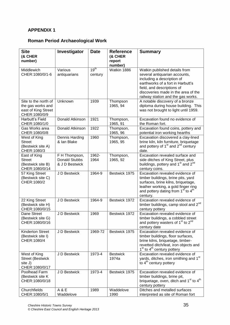
Cheshire Historic Towns Survey 35 © Cheshire East Council and English Heritage 2013
APPENDIX 1
Roman Period Archaeological Work
Site (& CHER number)
Investigator Date Reference (& CHER report number)
Summary
Middlewich CHER:1080/0/1-6
Various antiquarians
19th
century Watkin 1886 Watkin published details from
several antiquarian accounts, including a description of earthworks of a fort in Harbutt’s field, and descriptions of discoveries made in the area of the railway station and the gas works.
Site to the north of the gas works and east of King Street CHER:1080/0/9
Unknown 1939 Thompson 1965, 94
A notable discovery of a bronze diploma during house building. This was not brought to light until 1959.
Harbutt’s Field CHER:1080/1/0
Donald Atkinson 1921 Thompson, 1965, 91
Excavation found no evidence of the Roman fort.
Gas Works area CHER:1080/0/8
Donald Atkinson 1922 Thompson, 1965, 96
Excavation found coins, pottery and potential iron working hearths
West of King Street (Bestwick site A) CHER:1080/3
Dennis Harding & Ian Blake
1960 Thompson, 1965, 95
Excavation discovered a clay-lined brine kiln, kiln furniture, briquetage and pottery of 1
st and 2
nd century
date.
East of King Street (Bestwick site B) CHER:1080/0/14
F H Thompson, Donald Stubbs & J D Bestwick
1962-1964
Thompson, 1965, 92
Excavation revealed surface and side ditches of King Street, plus buildings, pottery and 1
st and 2
nd
century coins.
57 King Street (Bestwick site C) CHER:1080/2
J D Bestwick
1964-9 Bestwick 1975 Excavation revealed evidence of timber buildings, brine pits, yard surfaces, brine kilns, briquetage, leather working, a gold finger ring and pottery dating from 1
st to 4
th
century.
22 King Street (Bestwick site H) CHER:1080/0/15
J D Bestwick
1964-9
Bestwick 1972 Excavation revealed evidence of timber buildings, camp stool and 2
nd
century pottery
Dane Street (Bestwick site G) CHER:1080/0/16
J D Bestwick
1969 Bestwick 1972 Excavation revealed evidence of timber buildings, a cobbled street and pottery wasters of 1
st to 2
nd
century date
Kinderton Street (Bestwick site I) CHER:1080/4
J D Bestwick
1969-72 Bestwick 1975 Excavation revealed evidence of timber buildings, floor surfaces, brine kilns, briquetage, timber-revetted ditch/leat, iron objects and 1
st to 4
th century pottery
West of King Street (Bestwick site J) CHER:1080/0/17
J D Bestwick
1973-4 Bestwick 1974a
Excavation revealed evidence of yards, ditches, iron smithing and 1
st
to 4th century pottery
Poolhead Farm (Bestwick site K CHER:1080/0/18
J D Bestwick
1973-4 Bestwick 1975 Excavation revealed evidence of timber buildings, brine pit, briquetage, oven, ditch and 1
st to 4
th
century pottery
Churchfields CHER:1080/5/1
A & E Waddelove
1989 Waddelove 1990
Ditches and metalled surfaces interpreted as site of Roman fort
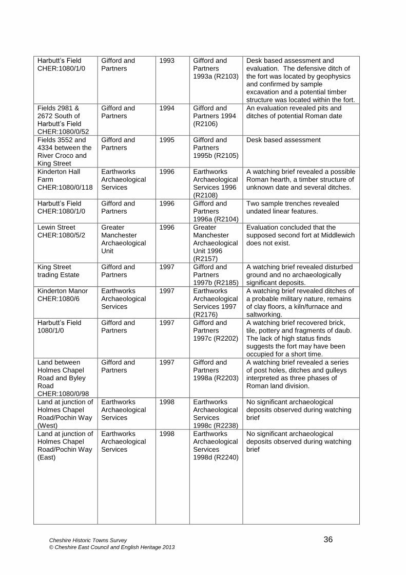
Cheshire Historic Towns Survey 36 © Cheshire East Council and English Heritage 2013
Harbutt’s Field CHER:1080/1/0
Gifford and Partners
1993 Gifford and Partners 1993a (R2103)
Desk based assessment and evaluation. The defensive ditch of the fort was located by geophysics and confirmed by sample excavation and a potential timber structure was located within the fort.
Fields 2981 & 2672 South of Harbutt’s Field CHER:1080/0/52
Gifford and Partners
1994 Gifford and Partners 1994 (R2106)
An evaluation revealed pits and ditches of potential Roman date
Fields 3552 and 4334 between the River Croco and King Street
Gifford and Partners
1995 Gifford and Partners 1995b (R2105)
Desk based assessment
Kinderton Hall Farm CHER:1080/0/118
Earthworks Archaeological Services
1996 Earthworks Archaeological Services 1996 (R2108)
A watching brief revealed a possible Roman hearth, a timber structure of unknown date and several ditches.
Harbutt’s Field CHER:1080/1/0
Gifford and Partners
1996 Gifford and Partners 1996a (R2104)
Two sample trenches revealed undated linear features.
Lewin Street CHER:1080/5/2
Greater Manchester Archaeological Unit
1996 Greater Manchester Archaeological Unit 1996 (R2157)
Evaluation concluded that the supposed second fort at Middlewich does not exist.
King Street trading Estate
Gifford and Partners
1997 Gifford and Partners 1997b (R2185)
A watching brief revealed disturbed ground and no archaeologically significant deposits.
Kinderton Manor CHER:1080/6
Earthworks Archaeological Services
1997 Earthworks Archaeological Services 1997 (R2176)
A watching brief revealed ditches of a probable military nature, remains of clay floors, a kiln/furnace and saltworking.
Harbutt’s Field 1080/1/0
Gifford and Partners
1997 Gifford and Partners 1997c (R2202)
A watching brief recovered brick, tile, pottery and fragments of daub. The lack of high status finds suggests the fort may have been occupied for a short time.
Land between Holmes Chapel Road and Byley Road CHER:1080/0/98
Gifford and Partners
1997 Gifford and Partners 1998a (R2203)
A watching brief revealed a series of post holes, ditches and gulleys interpreted as three phases of Roman land division.
Land at junction of Holmes Chapel Road/Pochin Way (West)
Earthworks Archaeological Services
1998
Earthworks Archaeological Services 1998c (R2238)
No significant archaeological deposits observed during watching brief
Land at junction of Holmes Chapel Road/Pochin Way (East)
Earthworks Archaeological Services
1998 Earthworks Archaeological Services 1998d (R2240)
No significant archaeological deposits observed during watching brief
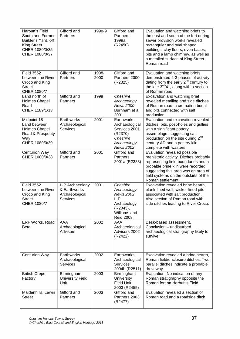
Cheshire Historic Towns Survey 37 © Cheshire East Council and English Heritage 2013
Harbutt’s Field South and Former Builder’s Yard, off King Street CHER:1080/0/35 CHER:1080/0/37
Gifford and Partners
1998-9 Gifford and Partners 1999a (R2450)
Evaluation and watching briefs to the east and south of the fort during sewer provision works revealed rectangular and oval shaped buildings, clay floors, oven bases, pits and a lamp chimney, as well as a metalled surface of King Street Roman road
Field 3552 between the River Croco and King Street CHER:1080/7
Gifford and Partners
1998-2000
Gifford and Partners 2000 (R2325)
Evaluation and watching briefs demonstrated 2-3 phases of activity dating from the early 2
nd century to
the late 3rd
/4th, along with a section
of Roman road.
Land north of Holmes Chapel Road CHER:1189/1/13
Gifford and Partners
1999 Cheshire Archaeology News 2000, Burnham et al 2001
Excavation and watching brief revealed metalling and side ditches of Roman road, a cremation burial and pits connected with salt production
Midpoint 18 – Land between Holmes Chapel Road & Prosperity Way CHER:1080/0/39
Earthworks Archaeological Services
2001 Earthworks Archaeological Services 2001 (R2370) Cheshire Archaeology News 2002
Evaluation and excavation revealed ditches, pits, post-holes and gullies with a significant pottery assemblage, suggesting salt production on the site during 2
nd
century AD and a pottery kiln complete with wasters
Centurion Way CHER:1080/0/38
Gifford and Partners
2001 Gifford and Partners 2001a (R2383)
Evaluation revealed possible prehistoric activity. Ditches probably representing field boundaries and a probable brine kiln were recorded, suggesting this area was an area of field systems on the outskirts of the Roman settlement
Field 3552 between the River Croco and King Street CHER:1080/7
L-P Archaeology & Earthworks Archaeological Services
2001 Cheshire Archaeology News 2002, L-P Archaeology (R2843), Williams and Reid 2008
Excavation revealed brine hearth, plank-lined well, wicker-lined pits associated with salt production. Also section of Roman road with side ditches leading to River Croco.
ERF Works, Road Beta
AAA Archaeological Advisors
2002 AAA Archaeological Advisors 2002 (R2422)
Desk-based assessment. Conclusion – undisturbed archaeological stratigraphy likely to survive.
Centurion Way Earthworks Archaeological Services
2002 Earthworks Archaeological Services 2004b (R2511)
Excavation revealed a brine hearth, Roman field/enclosure ditches. Two parallel ditches indicate a probable droveway.
British Crepe Factory
Birmingham University Field Unit
2003 Birmingham University Field Unit 2003 (R2455)
Evaluation. No indication of any Roman stratigraphy opposite the Roman fort on Harbutt’s Field.
Maidenhills, Lewin Street
Gifford and Partners
2003 Gifford and Partners 2003 (R2477)
Evaluation revealed a section of Roman road and a roadside ditch.
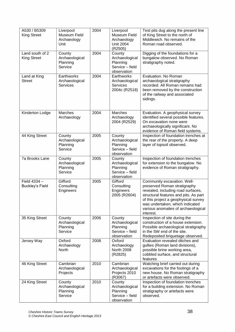
Cheshire Historic Towns Survey 38 © Cheshire East Council and English Heritage 2013
A530 / B5309 King Street
Liverpool Museum Field Archaeology Unit
2004 Liverpool Museum Field Archaeology Unit 2004 (R2505)
Test pits dug along the present line of King Street to the north of Middlewich. No remains of the Roman road observed.
Land south of 2 King Street
County Archaeological Planning Service
2004 County Archaeological Planning Service – field observation
Digging of the foundations for a bungalow observed. No Roman stratigraphy noted.
Land at King Street
Earthworks Archaeological Services
2004 Earthworks Archaeological Services 2004c (R2518)
Evaluation. No Roman archaeological stratigraphy recorded. All Roman remains had been removed by the construction of the railway and associated sidings.
Kinderton Lodge Marches Archaeology
2004 Marches Archaeology 2004 (R2529)
Evaluation. A geophysical survey identified several possible features. On excavation none were archaeologically significant. No evidence of Roman field systems.
44 King Street County Archaeological Planning Service
2005 County Archaeological Planning Service – field observation
Inspection of foundation trenches at the rear of the property. A deep layer of topsoil observed.
7a Brooks Lane County Archaeological Planning Service
2005 County Archaeological Planning Service – field observation
Inspection of foundation trenches for extension to the bungalow. No evidence of Roman stratigraphy.
Field 4334 – Buckley’s Field
Gifford Consulting Engineers
2005 Gifford Consulting Engineers 2005 (R2604)
Community excavation. Well- preserved Roman stratigraphy revealed, including road surfaces, structural features and pits. As part of this project a geophysical survey was undertaken, which indicated various anomalies of archaeological interest.
35 King Street County Archaeological Planning Service
2006 County Archaeological Planning Service – field observation
Inspection of site during the construction of a house extension. Possible archaeological stratigraphy in the SW end of the site. Redeposited briquetage observed.
Jersey Way Oxford Archaeology North
2008 Oxford Archaeology North 2008 (R2825)
Evaluation revealed ditches and gullies (Roman land divisions), possible brine working area, cobbled surface, and structural features
46 King Street Cambrian Archaeological Projects
2010 Cambrian Archaeological Projects 2010 (R3067)
Watching brief carried out during excavations for the footings of a new house. No Roman stratigraphy or artefacts were observed.
24 King Street County Archaeological Planning Service
2010 County Archaeological Planning Service – field observation
Inspection of foundation trenches for a building extension. No Roman stratigraphy or artefacts were observed.
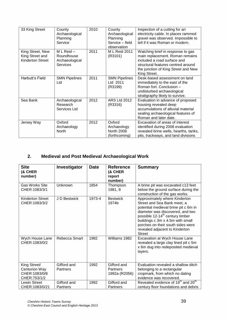
Cheshire Historic Towns Survey 39 © Cheshire East Council and English Heritage 2013
33 King Street County Archaeological Planning Service
2010 County Archaeological Planning Service – field observation
Inspection of a cutting for an electricity cable. In places rammed gravel was observed. Impossible to tell if it was Roman or modern.
King Street, New King Street and Kinderton Street
M L Reid – Roundhouse Archaeological Services
2011 M L Reid 2011 (R3101)
Watching brief in response to gas main replacement. Roman remains included a road surface and structural features centred around the junction of King Street and New King Street.
Harbutt’s Field SMN Pipelines Ltd
2011 SMN Pipelines Ltd 2011 (R3199)
Desk-based assessment on land immediately to the east of the Roman fort. Conclusion –undisturbed archaeological stratigraphy likely to survive.
Sea Bank Archaeological Research Services Ltd
2012 ARS Ltd 2012 (R3316)
Evaluation in advance of proposed housing revealed deep accumulations of alluvial material sealing archaeological features of Roman and later date.
Jersey Way Oxford Archaeology North
2012 Oxford Archaeology North 2008 (forthcoming)
Excavation of areas of interest identified during 2008 evaluation revealed brine wells, hearths, tanks, pits, trackways, and land divisions
2. Medieval and Post Medieval Archaeological Work
Site (& CHER number)
Investigator Date Reference (& CHER report number)
Summary
Gas Works Site CHER:1083/3/1
Unknown 1854 Thompson 1981, 8
A brine pit was excavated c13 feet below the ground surface during the construction of the gas works.
Kinderton Street CHER:1083/3/2
J D Bestwick 1973-4 Bestwick 1974b
Approximately where Kinderton Street and Sea Bank meet, a potential medieval brine pit c 6m in diameter was discovered, and two possible 12-14
th century timber
buildings c 3m x 4.5m with small porches on their south sides were revealed adjacent to Kinderton Street
Wych House Lane CHER:1083/0/2
Rebecca Smart 1982 Williams 1982 Excavation at Wych House Lane revealed a large clay lined pit c 5m x 6m dug into redeposited medieval layers.
King Street/ Centurion Way CHER:1083/0/8 CHER:753/1/2
Gifford and Partners
1992 Gifford and Partners 1992a (R2056)
Evaluation revealed a shallow ditch belonging to a rectangular cropmark, from which no dating evidence was recovered.
Lewin Street CHER:1083/0/21
Gifford and Partners
1992 Gifford and Partners
Revealed evidence of 19th and 20
th
century floor foundations and debris
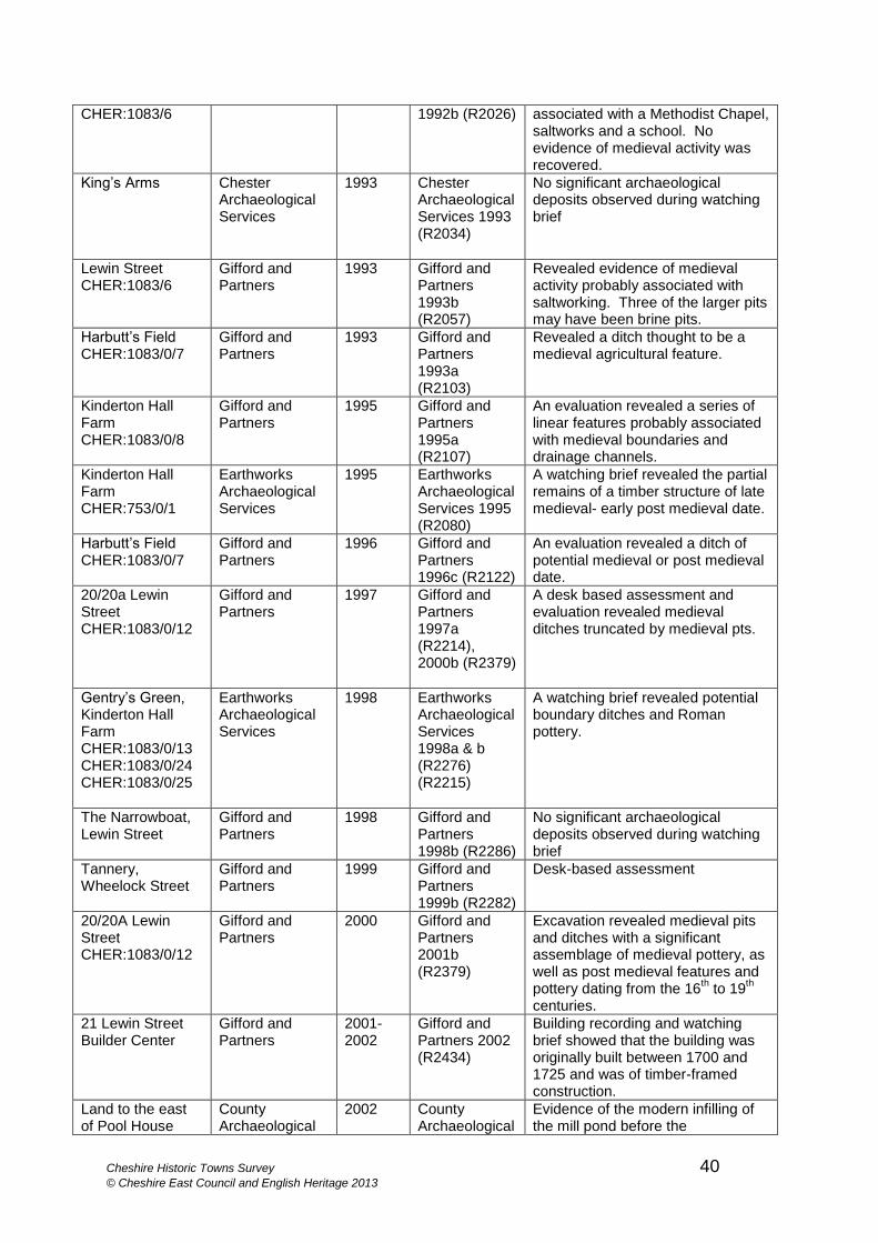
Cheshire Historic Towns Survey 40 © Cheshire East Council and English Heritage 2013
CHER:1083/6 1992b (R2026) associated with a Methodist Chapel, saltworks and a school. No evidence of medieval activity was recovered.
King’s Arms Chester Archaeological Services
1993 Chester Archaeological Services 1993 (R2034)
No significant archaeological deposits observed during watching brief
Lewin Street CHER:1083/6
Gifford and Partners
1993 Gifford and Partners 1993b (R2057)
Revealed evidence of medieval activity probably associated with saltworking. Three of the larger pits may have been brine pits.
Harbutt’s Field CHER:1083/0/7
Gifford and Partners
1993 Gifford and Partners 1993a (R2103)
Revealed a ditch thought to be a medieval agricultural feature.
Kinderton Hall Farm CHER:1083/0/8
Gifford and Partners
1995 Gifford and Partners 1995a (R2107)
An evaluation revealed a series of linear features probably associated with medieval boundaries and drainage channels.
Kinderton Hall Farm CHER:753/0/1
Earthworks Archaeological Services
1995 Earthworks Archaeological Services 1995 (R2080)
A watching brief revealed the partial remains of a timber structure of late medieval- early post medieval date.
Harbutt’s Field CHER:1083/0/7
Gifford and Partners
1996 Gifford and Partners 1996c (R2122)
An evaluation revealed a ditch of potential medieval or post medieval date.
20/20a Lewin Street CHER:1083/0/12
Gifford and Partners
1997 Gifford and Partners 1997a (R2214), 2000b (R2379)
A desk based assessment and evaluation revealed medieval ditches truncated by medieval pts.
Gentry’s Green, Kinderton Hall Farm CHER:1083/0/13 CHER:1083/0/24 CHER:1083/0/25
Earthworks Archaeological Services
1998 Earthworks Archaeological Services 1998a & b (R2276) (R2215)
A watching brief revealed potential boundary ditches and Roman pottery.
The Narrowboat, Lewin Street
Gifford and Partners
1998 Gifford and Partners 1998b (R2286)
No significant archaeological deposits observed during watching brief
Tannery, Wheelock Street
Gifford and Partners
1999 Gifford and Partners 1999b (R2282)
Desk-based assessment
20/20A Lewin Street CHER:1083/0/12
Gifford and Partners
2000 Gifford and Partners 2001b (R2379)
Excavation revealed medieval pits and ditches with a significant assemblage of medieval pottery, as well as post medieval features and pottery dating from the 16
th to 19
th
centuries.
21 Lewin Street Builder Center
Gifford and Partners
2001-2002
Gifford and Partners 2002 (R2434)
Building recording and watching brief showed that the building was originally built between 1700 and 1725 and was of timber-framed construction.
Land to the east of Pool House
County Archaeological
2002 County Archaeological
Evidence of the modern infilling of the mill pond before the
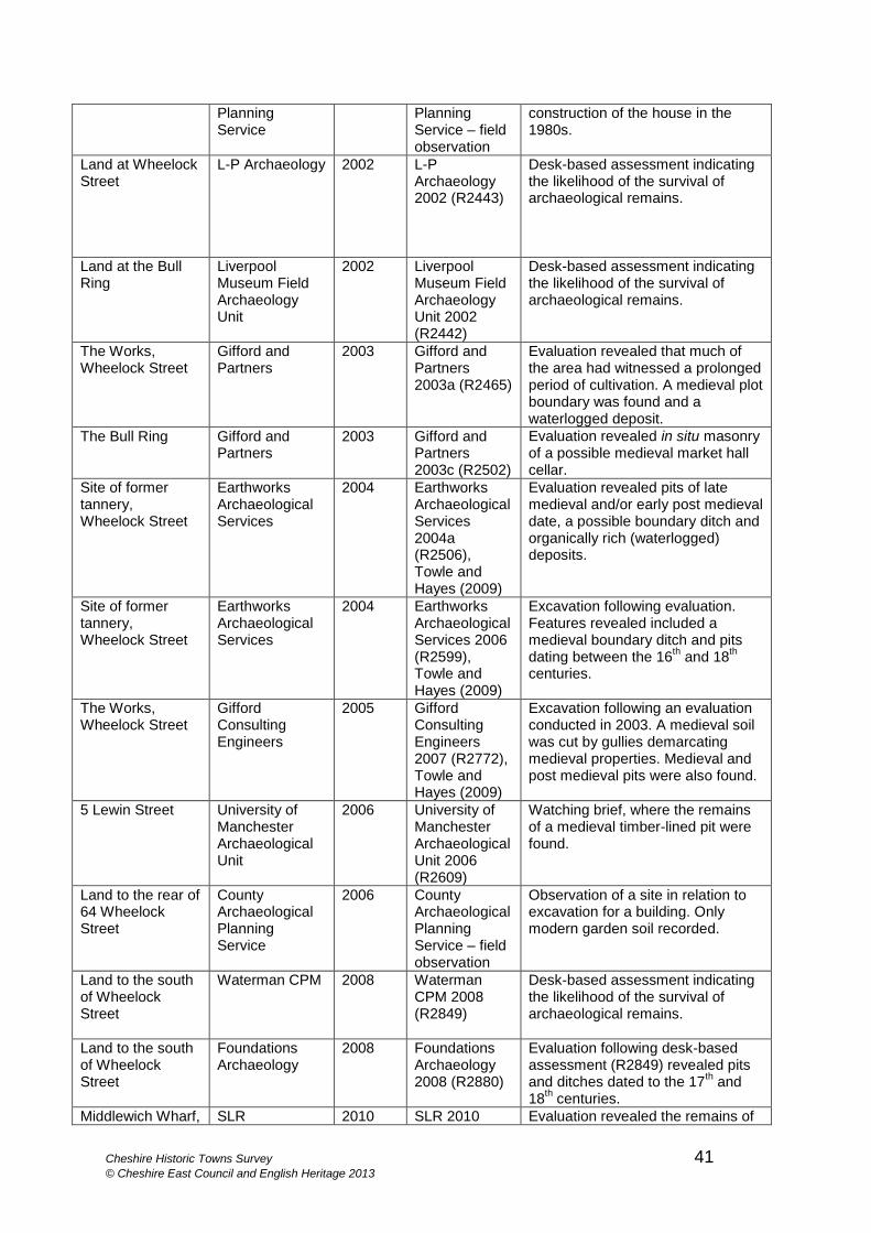
Cheshire Historic Towns Survey 41 © Cheshire East Council and English Heritage 2013
Planning Service
Planning Service – field observation
construction of the house in the 1980s.
Land at Wheelock Street
L-P Archaeology 2002 L-P Archaeology 2002 (R2443)
Desk-based assessment indicating the likelihood of the survival of archaeological remains.
Land at the Bull Ring
Liverpool Museum Field Archaeology Unit
2002 Liverpool Museum Field Archaeology Unit 2002 (R2442)
Desk-based assessment indicating the likelihood of the survival of archaeological remains.
The Works, Wheelock Street
Gifford and Partners
2003 Gifford and Partners 2003a (R2465)
Evaluation revealed that much of the area had witnessed a prolonged period of cultivation. A medieval plot boundary was found and a waterlogged deposit.
The Bull Ring Gifford and Partners
2003 Gifford and Partners 2003c (R2502)
Evaluation revealed in situ masonry of a possible medieval market hall cellar.
Site of former tannery, Wheelock Street
Earthworks Archaeological Services
2004 Earthworks Archaeological Services 2004a (R2506), Towle and Hayes (2009)
Evaluation revealed pits of late medieval and/or early post medieval date, a possible boundary ditch and organically rich (waterlogged) deposits.
Site of former tannery, Wheelock Street
Earthworks Archaeological Services
2004 Earthworks Archaeological Services 2006 (R2599), Towle and Hayes (2009)
Excavation following evaluation. Features revealed included a medieval boundary ditch and pits dating between the 16
th and 18
th
centuries.
The Works, Wheelock Street
Gifford Consulting Engineers
2005 Gifford Consulting Engineers 2007 (R2772), Towle and Hayes (2009)
Excavation following an evaluation conducted in 2003. A medieval soil was cut by gullies demarcating medieval properties. Medieval and post medieval pits were also found.
5 Lewin Street University of Manchester Archaeological Unit
2006 University of Manchester Archaeological Unit 2006 (R2609)
Watching brief, where the remains of a medieval timber-lined pit were found.
Land to the rear of 64 Wheelock Street
County Archaeological Planning Service
2006 County Archaeological Planning Service – field observation
Observation of a site in relation to excavation for a building. Only modern garden soil recorded.
Land to the south of Wheelock Street
Waterman CPM 2008 Waterman CPM 2008 (R2849)
Desk-based assessment indicating the likelihood of the survival of archaeological remains.
Land to the south of Wheelock Street
Foundations Archaeology
2008 Foundations Archaeology 2008 (R2880)
Evaluation following desk-based assessment (R2849) revealed pits and ditches dated to the 17
th and
18th centuries.
Middlewich Wharf, SLR 2010 SLR 2010 Evaluation revealed the remains of
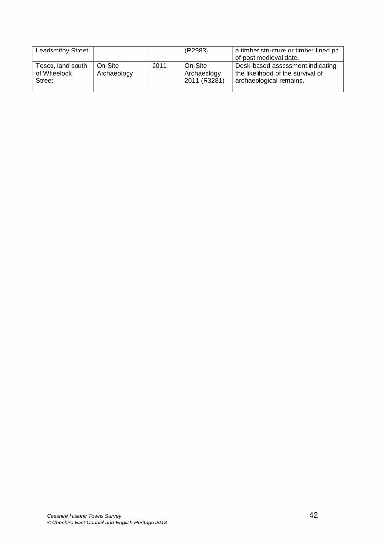
Cheshire Historic Towns Survey 42 © Cheshire East Council and English Heritage 2013
Leadsmithy Street (R2983) a timber structure or timber-lined pit of post medieval date.
Tesco, land south of Wheelock Street
On-Site Archaeology
2011 On-Site Archaeology 2011 (R3281)
Desk-based assessment indicating the likelihood of the survival of archaeological remains.
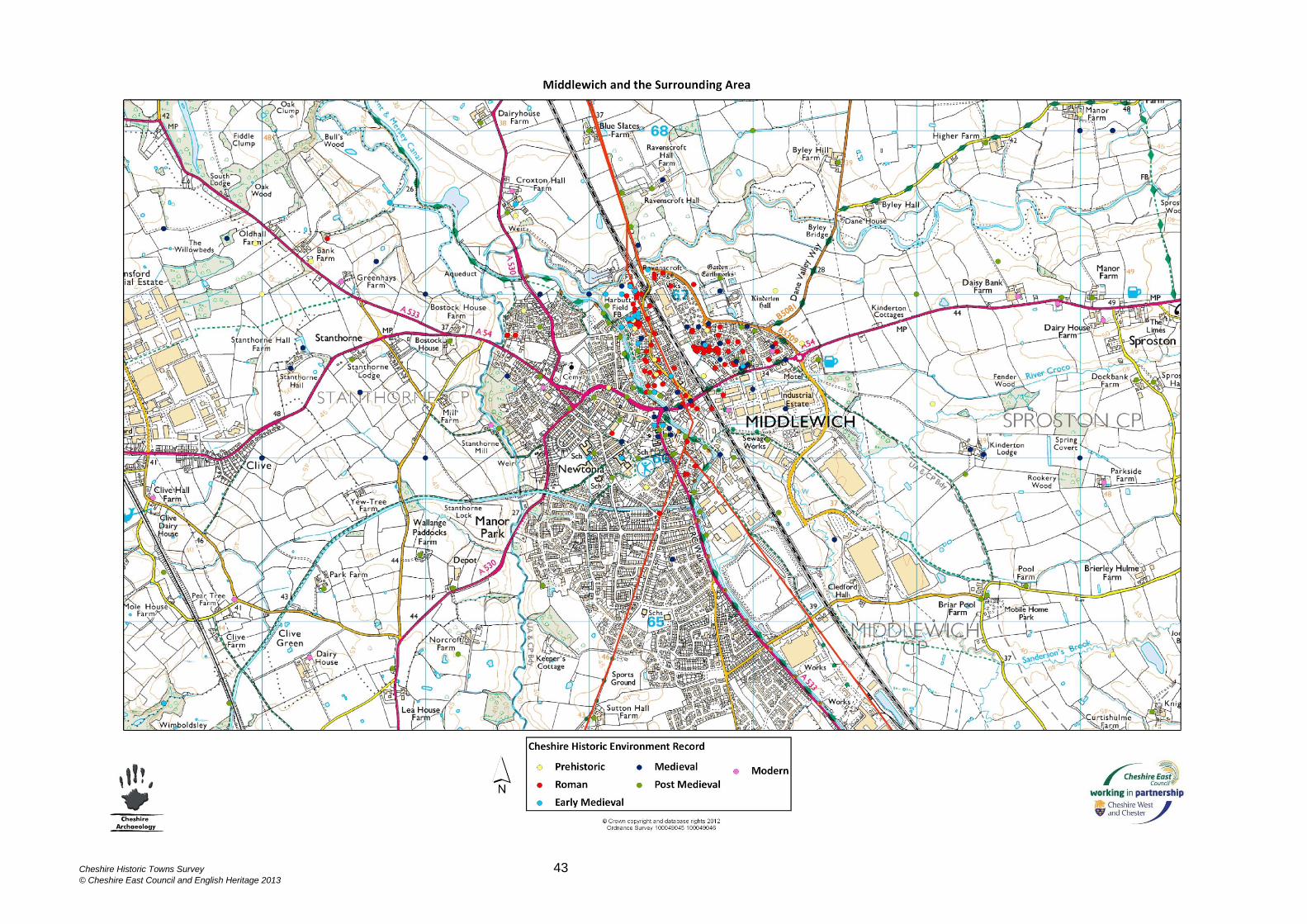
Cheshire Historic Towns Survey 43
© Cheshire East Council and English Heritage 2013
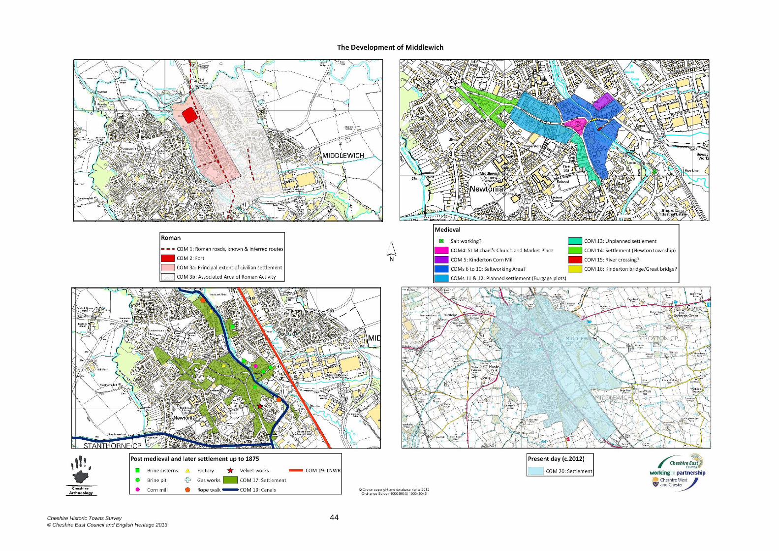
Cheshire Historic Towns Survey 44
© Cheshire East Council and English Heritage 2013