Embed Size (px)
Citation preview

Chelmsford CityGrowth Package
July - August 2017
Public Consultation DocumentVolume 5 South and East Chelmsford

Chelmsford City Growth PackagePublic Consultation Document - Volume 5 - South and East Chelmsford
32
Contents
Introduction 5
Army and Navy Roundabout Improvements: Baddow Road Bus Gate 7
Great Baddow to City Centre Cycle Route 12
Chelmer Village Way Cycling Route 14
Beehive Lane and Loftin Way Connections 16
Great Baddow High School Cycling Route 18

Chelmsford City Growth PackagePublic Consultation Document - Volume 5 - South and East Chelmsford
54
This volume presents proposals for southern and eastern Chelmsford as part of the Chelmsford City Growth Package, covering areas such as Chelmer Village and Great Baddow. There are five schemes in total in this volume, which propose the implementation of a bus gate, improvements to cycling infrastructure which includes the introduction of new cycleways, and connectivity of the existing cycling network.
Volume 5 - South and East Chelmsford
25. Army and Navy Roundabout Improvements: Baddow Road Bus Gate (repeated in Volume 4) 26. Great Baddow to City Centre Cycle Route 27. Chelmer Village Way Cycling Route 28. Beehive Lane and Loftin Way Connections 29. Great Baddow High School Cycling Route
Introduction
Chelmsford City Growth PackagePublic Consultation Document - Volume 5 - South and East Chelmsford
76
Army and Navy Roundabout Improvements: Baddow Road Bus Gate
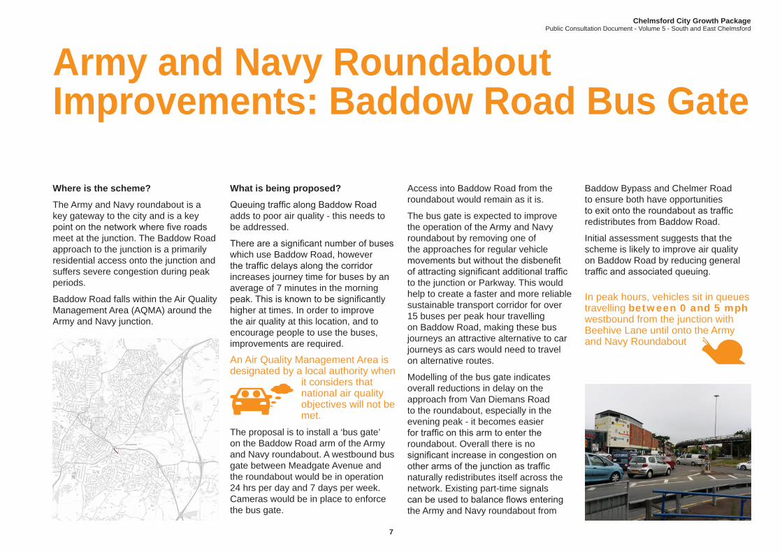
Where is the scheme?
The Army and Navy roundabout is a key gateway to the city and is a key point on the network where five roads meet at the junction. The Baddow Road approach to the junction is a primarily residential access onto the junction and suffers severe congestion during peak periods.
Baddow Road falls within the Air Quality Management Area (AQMA) around the Army and Navy junction.
What is being proposed?
Queuing traffic along Baddow Road adds to poor air quality - this needs to be addressed.
There are a significant number of buses which use Baddow Road, however the traffic delays along the corridor increases journey time for buses by an average of 7 minutes in the morning peak. This is known to be significantly higher at times. In order to improve the air quality at this location, and to encourage people to use the buses, improvements are required.
An Air Quality Management Area is designated by a local authority when
it considers that national air quality objectives will not be met.
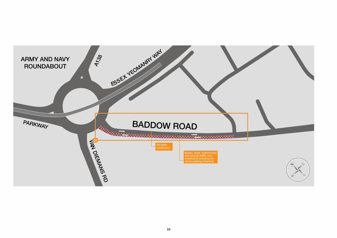
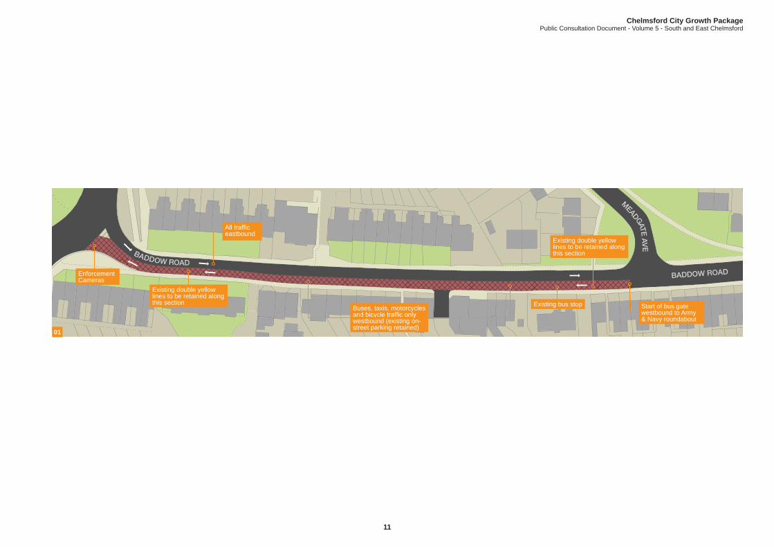
The proposal is to install a ‘bus gate’ on the Baddow Road arm of the Army and Navy roundabout. A westbound bus gate between Meadgate Avenue and the roundabout would be in operation 24 hrs per day and 7 days per week. Cameras would be in place to enforce the bus gate.
Access into Baddow Road from the roundabout would remain as it is.
The bus gate is expected to improve the operation of the Army and Navy roundabout by removing one of the approaches for regular vehicle movements but without the disbenefit of attracting significant additional traffic to the junction or Parkway. This would help to create a faster and more reliable sustainable transport corridor for over 15 buses per peak hour travelling on Baddow Road, making these bus journeys an attractive alternative to car journeys as cars would need to travel on alternative routes.
Modelling of the bus gate indicates overall reductions in delay on the approach from Van Diemans Road to the roundabout, especially in the evening peak - it becomes easier for traffic on this arm to enter the roundabout. Overall there is no significant increase in congestion on other arms of the junction as traffic naturally redistributes itself across the network. Existing part-time signals can be used to balance flows entering the Army and Navy roundabout from
Baddow Bypass and Chelmer Road to ensure both have opportunities to exit onto the roundabout as traffic redistributes from Baddow Road.
Initial assessment suggests that the scheme is likely to improve air quality on Baddow Road by reducing general traffic and associated queuing.
In peak hours, vehicles sit in queues travelling between 0 and 5 mph westbound from the junction with Beehive Lane until onto the Army and Navy Roundabout

8
The Baddow Road bus gate scheme will also be supported by complementary measures that have been included in the overall package of proposals. These include: � Beehive Lane and Loftin Way cycle
scheme (described later in this document);
� Gt Baddow High School cycleway (described later in this document);
� Gt Baddow to City Centre cycleway (described later in this document); and
� Parkway Corridor improvements (see Volume 4 document).
The bus gate will be implemented for an 18 month trial to monitor the impacts on both local traffic and the traffic using the Army and Navy roundabout. Further options to optimise operation at the Army and Navy will be assessed during this period once traffic has settled into the new travel patterns.
There is a separate proposal in this volume, part of which relates to the provisions for people who cycle around the Army and Navy Roundabout. The Great Baddow to City Centre Cycle Route proposal can be found on page 12 of this document.
15 BUSES travel along Baddow Rd in the AM peak hour.One full bus can take 40 passengers - that’s 40 fewer cars on the road.If each of these buses were full, there could be up to 600 fewer cars on the road.Other Options
Other options were considered for this area prior to choosing the bus gate but were discounted for the following reasons: � Full signalisation of the roundabout
was discounted because of the lack of queuing space on the roundabout which caused the junction to ‘lock up’;
� Replacing the flyover with a two-way structure was discounted in the short term due to cost and land issues. This option is being considered as a potential longer-term scheme; and Restricting all general traffic into and out of Baddow Road at the Army and Navy roundabout by creating a two way bus gate was discounted due to significant impacts of Baddow Road traffic re-routing onto the local road network.
You said: buses should have priority on the network over other
motorised vehicles
It can take an additional 6.5 minutes to travel 650 metres from Beehive Lane to the Army and Navy Roundabout during the AM peak hour compared to the free-flow journey time

Chelmsford City Growth PackagePublic Consultation Document - Volume 5 - South and East Chelmsford
98
Benefits:Improvement in air quality at the Baddow Road junction with the Army and Navy roundabout, which is identified as an Air Quality Management Area. The reduction in queuing traffic along Baddow Road is expected to reduce pollution in the area and improve air quality with benefits for the health of residents of the local area.
Improve congestion by removing the majority of traffic exiting from Baddow Road, and improve the overall operation of the roundabout.
Improve bus journey times and reliability: Reducing bus journey times and improving journey time reliability on Baddow Road is likely to make local bus services much more attractive as an alternative to travelling by car into the city centre.
Improve cycling access by allowing people who cycle to use the existing subway under the roundabout through Great Baddow to city centre cycle route improvements.
Improve response time for emergency vehicles by enabling them to use the bus gate. They will also benefit from the reduced congestion along the route.
Impacts: Traffic: General traffic using Baddow Road onto the Army and Navy will need to change routes or choose another mode of travel such as bus, cycling or walking. There is likely to be additional traffic routing east via Great Baddow to the Maldon Road junction with the Baddow Bypass and traffic switching to Wood Street and London Road.
Access: Access to residential properties and businesses west of Meadgate Avenue will only be possible from the Army and Navy roundabout.
Access for delivery vehicles and council services such as refuse collections will be considered during the detailed design phase.
Heavy goods vehicles: An alternative route will be identified to enable large vehicles that have reached the bus gate, but are not permitted to exit, to safely turn back. This may be via Meadgate Avenue and is likely to result in some additional heavy goods vehicles on this road.
Cost estimate: Less than £500,000
10
ARMY AND NAVYROUNDABOUT A1
38
ESSEX YEOMANRY WAY
PARKWAY
VAN
DIE
MA
NS
RD
BADDOW ROAD01
All traffic eastbound
Buses, taxis, motorcycles and bicycle traffic only westbound (existing on-street parking retained)
Chelmsford City Growth PackagePublic Consultation Document - Volume 5 - South and East Chelmsford
1110
BADDOW ROAD
BADDOW ROAD
M
EADGATE A
VE
01
All traffic eastbound
Enforcement Cameras
Buses, taxis, motorcycles and bicycle traffic only westbound (existing on-street parking retained)
Existing bus stop
Existing double yellow lines to be retained along this section
Existing double yellow lines to be retained along this section
Start of bus gate westbound to Army & Navy roundabout

12
Where is the scheme?
The scheme runs between Sandon School, Great Baddow and the Great Baddow long stay surface car park on the east side of Parkway just to the north of the Army and Navy roundabout.
What is being proposed?
The Army and Navy junction is a key barrier for cycling links between Great Baddow and the city centre. A lack of dedicated and clearly signed routes can discourage people to cycle this route, or can cause problems for those people who cycle who do use it.
The cycle scheme would provide a dedicated signed route between Great Baddow and Chelmsford city centre, joining on to the existing shared off-road cycle route along The Bringey, and a new proposed cycle route past the schools in Great Baddow.
The scheme to the city centre would start at the junction of New Road/Crescent Road, and would include a new signed on-road cycle route through quieter residential areas, along Crescent Road, Jeffery Road and across Maldon Road, onto Longmead Avenue and Meadgate Avenue and along Meadgate Terrace near to the Army and Navy Roundabout. The existing subway arrangements would be reviewed to allow cycle use so that the existing shared cycle/pedestrian facility along Parkway can be used. This would
be extended to reach the Baddow Road long stay car park where the new route would link up with the existing off-road shared cycle footway towards the city centre.
The proposals include widening the footway along sections of Parkway to provide the additional length of off road route, converting an existing section of footway immediately south of the Army and Navy roundabout, to a shared use
facility. The surface would be upgraded and cycle route signing throughout the area would direct people who cycle to the advisory route. This route, along Longmead Avenue and Meadgate Avenue, would be advisory only.
The signage would include destinations and the expected cycle journey times.
Great Baddow to City Centre Cycle Route You said: you want
to see improved facilities for people who cycle and pedestrians
Benefits:Extend cycling connectivity by providing an additional link to connect key residential areas to Chelmsford city centre, encouraging people to use their bikes for commuter and leisure trips.
Provide on and off-road cycling and walking infrastructure to encourage local cycling and walking trips to shops, health care, recreational areas and other local facilities as an alternative to car trips.
Extend the existing cycling options providing safer routes to the city centre and local schools and encouraging cycling and walking.
Impacts:Traffic: The increased provision of cycle routes in the Great Baddow area should help to encourage more cycling and walking and reduce congestion on the roads.
Environmental: An initial review of the project proposal and site location has identified that there may be environmental constraints due to the nature and location of the works. An appraisal will be undertaken at the next stage of activities.
Cost estimate: £500,000 - £1 million

Chelmsford City Growth PackagePublic Consultation Document - Volume 5 - South and East Chelmsford
1312
BADDOW ROAD
MEADGATE AVENUE
ESSEX YEOMANRY WAY (A1114)
TABOR S
AV
EN
UE
LON
GFIE
LD R
D
River C
helmer
HIGH STREET
MO
LR
AM
S L
AN
E
PARKWAY
HIGH
BR
I DG
E RD
LONGMEAD AVENUE
JEFFE
RY
RD
01 02 03
B&M Store
Kings Head Walk existing off-road cycle route
Baddow Road long stay surface car park
Baddow Road long stay surface car park
Existing off-road cycle route
01
0203
The Bringey off-road cycle route
Signed on-road cycle route
Army and Navy Roundabout
Longmead Avenue
Army and Navy Roundabout
Existing subway
Baddow Road
Meadgate Terrace
Signed on-road cycle route
Essex Yeomanry Way
14
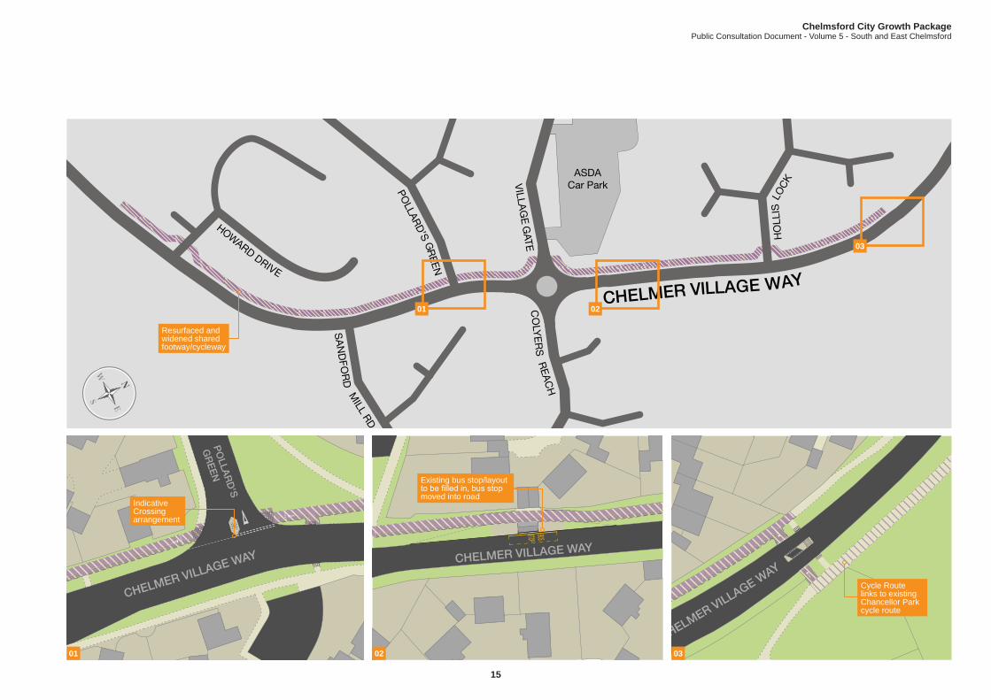
Where is the scheme?
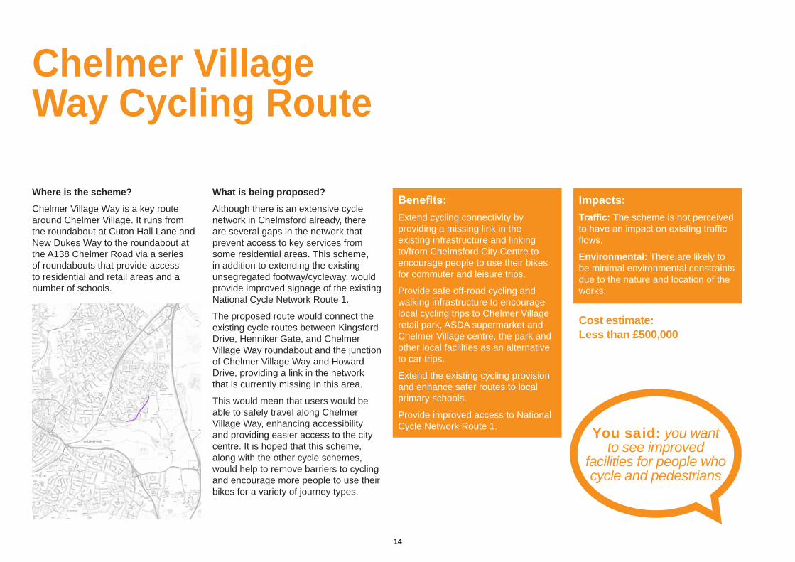
Chelmer Village Way is a key route around Chelmer Village. It runs from the roundabout at Cuton Hall Lane and New Dukes Way to the roundabout at the A138 Chelmer Road via a series of roundabouts that provide access to residential and retail areas and a number of schools.
What is being proposed?
Although there is an extensive cycle network in Chelmsford already, there are several gaps in the network that prevent access to key services from some residential areas. This scheme, in addition to extending the existing unsegregated footway/cycleway, would provide improved signage of the existing National Cycle Network Route 1.
The proposed route would connect the existing cycle routes between Kingsford Drive, Henniker Gate, and Chelmer Village Way roundabout and the junction of Chelmer Village Way and Howard Drive, providing a link in the network that is currently missing in this area.
This would mean that users would be able to safely travel along Chelmer Village Way, enhancing accessibility and providing easier access to the city centre. It is hoped that this scheme, along with the other cycle schemes, would help to remove barriers to cycling and encourage more people to use their bikes for a variety of journey types.
Chelmer Village Way Cycling Route
You said: you want to see improved
facilities for people who cycle and pedestrians
Benefits:Extend cycling connectivity by providing a missing link in the existing infrastructure and linking to/from Chelmsford City Centre to encourage people to use their bikes for commuter and leisure trips.
Provide safe off-road cycling and walking infrastructure to encourage local cycling trips to Chelmer Village retail park, ASDA supermarket and Chelmer Village centre, the park and other local facilities as an alternative to car trips.
Extend the existing cycling provision and enhance safer routes to local primary schools.
Provide improved access to National Cycle Network Route 1.
Impacts:Traffic: The scheme is not perceived to have an impact on existing traffic flows.
Environmental: There are likely to be minimal environmental constraints due to the nature and location of the works.
Cost estimate: Less than £500,000
Chelmsford City Growth PackagePublic Consultation Document - Volume 5 - South and East Chelmsford
1514
ASDACar Park
CHELMER VILLAGE WAY
HO
LLIS
LO
CK
CO
LYE
RS
REA
CH
VILLA
GE
GATE
SA
ND
FOR
D M
ILL RD
POLLAR
D’S G
REEN
HOWARD DRIVE
PO
LLAR
D'S
GR
EE
N
CHELMER VILLAGE WAY
BUSSTOP
CHELMER VILLAGE WAY
CHELMER VILLAGE WAY
01
01
02
03
02 03
Resurfaced and widened shared footway/cycleway
Indicative Crossing arrangement
Existing bus stop/layout to be filled in, bus stop moved into road
Cycle Route links to existing Chancellor Park cycle route

16
Where is the scheme?
The proposed new cycle route is located to the north of Beehive Lane and will provide a continuous cycle link to Loftin Way and onto Baddow Road. It provides a connection to other cycle routes towards Moulsham and the city centre.
What is being proposed?
Although there is an extensive cycle network in Chelmsford already, there are several gaps in the network that prevent access to key services and the city centre from some residential areas.
The proposal is in two parts.
The first section, from Beehive Lane to Loftin Way, would upgrade and convert an existing unsurfaced footpath into a new cycle route. It would provide a high quality shared cycleway which would be lit to provide a year round dedicated cycle connection away from traffic. To the south of Beehive Lane it is proposed to provide a link to the Great Baddow High School cycle scheme.
The second section would complete the missing 90m link, between Loftin Way and Gunson Gate, connecting to the existing segregated cycleway that links through to Baddow Road.
Beehive Lane and Loftin Way Connections
You said: improved safety, security and lighting
of cycle routes would encourage you to cycle
more frequently
Benefits:Extend cycling connectivity by providing a new off-road link to connect residential areas to Chelmsford city centre, encouraging people to use their bikes for commuter and leisure trips.
Provide safe off-road cycling and walking infrastructure to encourage local cycling and walking trips to healthcare, local shops, the park and other local facilities as an alternative to car trips.
Improve existing cycle routes and enhance safer routes to local primary and secondary schools.
Impacts:Traffic: Improved cycle routes in the Great Baddow area should encourage more people to cycle, resulting in reduced car use.
Environmental: An initial review of the project proposal and site location has identified that there are likely to be environmental constraints due to the nature and location of the works. Further studies will take place during the next stage of design.
Cost estimate: Less than £500,000

Chelmsford City Growth PackagePublic Consultation Document - Volume 5 - South and East Chelmsford
1716
BEEHIVE LA
NE
LOFTIN WAY
LUC
AS
AVE S
AW
KIN
S A
VE
GLOUCESTER AVE
LIME W
ALK
FAIR
WA
Y
HONEY C
LOSE
01
01
Resurfaced shared use footway/cycle route
Existing informal cycle route (footpath)
Potential new surfacing here
3m wide surfaced off-road route
Widening of existing route
Existing footpath could be upgraded
18
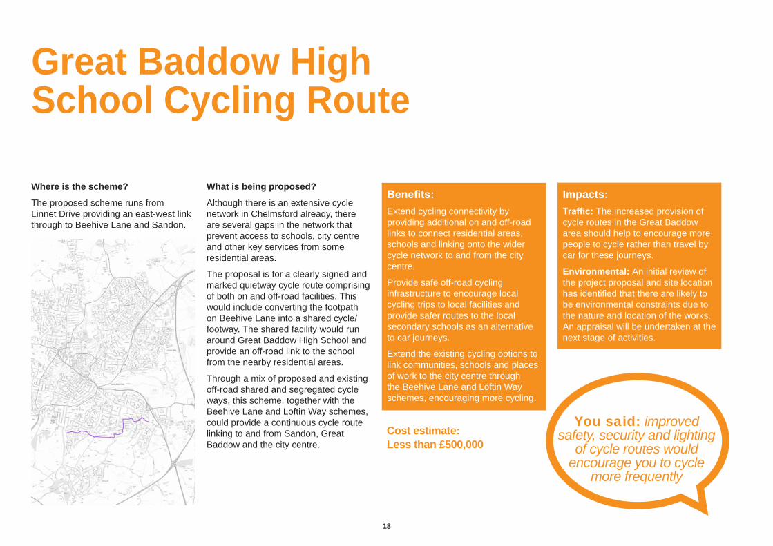
Where is the scheme?
The proposed scheme runs from Linnet Drive providing an east-west link through to Beehive Lane and Sandon.
What is being proposed?
Although there is an extensive cycle network in Chelmsford already, there are several gaps in the network that prevent access to schools, city centre and other key services from some residential areas.
The proposal is for a clearly signed and marked quietway cycle route comprising of both on and off-road facilities. This would include converting the footpath on Beehive Lane into a shared cycle/footway. The shared facility would run around Great Baddow High School and provide an off-road link to the school from the nearby residential areas.
Through a mix of proposed and existing off-road shared and segregated cycle ways, this scheme, together with the Beehive Lane and Loftin Way schemes, could provide a continuous cycle route linking to and from Sandon, Great Baddow and the city centre.
Great Baddow High School Cycling Route
You said: improved safety, security and lighting
of cycle routes would encourage you to cycle
more frequently
Benefits:Extend cycling connectivity by providing additional on and off-road links to connect residential areas, schools and linking onto the wider cycle network to and from the city centre.
Provide safe off-road cycling infrastructure to encourage local cycling trips to local facilities and provide safer routes to the local secondary schools as an alternative to car journeys.
Extend the existing cycling options to link communities, schools and places of work to the city centre through the Beehive Lane and Loftin Way schemes, encouraging more cycling.
Impacts:Traffic: The increased provision of cycle routes in the Great Baddow area should help to encourage more people to cycle rather than travel by car for these journeys.
Environmental: An initial review of the project proposal and site location has identified that there are likely to be environmental constraints due to the nature and location of the works. An appraisal will be undertaken at the next stage of activities.
Cost estimate: Less than £500,000

Chelmsford City Growth PackagePublic Consultation Document - Volume 5 - South and East Chelmsford
1918
GALLEYWOOD RO A D
LON
GTO
MP
S A
VE
GA
LLE
YW
OO
D R
OA
D
LINNET DRIVE
GOSHAWK DRIVEBEE
HIVE L
ANE
DO
RS
ET
AV
E
CHURCH STREET
BADDOW ROAD A1114
ROTHMANS AVE
NO
AK
ES A
VE
GLOUCESTER AVE
LOFTIN WAY
FOXHOLES RD
VIC
AR
AG
E LA
NE
NEW
R D
GREAT BADDOWHIGH SCHOOL
RECREST RD BEEH
IVE
LANE
NO
AK
ES
AV
EN
UE H
IGH
STREET
FOXHOLES ROAD
PUMP HILL
Links to existing route to Sandon
Links to existing routes
01
01
02
02
03
03
Beehive Lane connection off-road scheme
Final route option to be determined
Signed off-road cycle route
Signed on-road cycle route

20
This information is issued byEssex County Council You can contact us in the following ways:
By email: [email protected]
Visit our website: www.essex.gov.uk/chelmsfordtransport
By post: Essex County Council County Hall Chelmsford Essex CM1 1QH
Sign up to Keep Me Posted email updates on topics you want to hear about at: essex.gov.uk/keepmeposted
Follow us on Essex_CC
Find us on fb.com/essexcountycouncil
The information contained in this document can be translated, and/or made available in alternative formats, on request.
Published July 2017