Embed Size (px)
Citation preview
Research ArticleCharacterization of Origin and Evolution of FormationWater in Buried Hill of Jizhong Depression, China, UsingMultivariate Statistical Analysis of Geochemical Data
Fei Li1,2 and Jianhui Zeng1,2
1State Key Laboratory of Petroleum Resource and Prospecting, China University of Petroleum, Beijing, China2College of Geosciences, China University of Petroleum, Beijing, China
Correspondence should be addressed to Jianhui Zeng; [email protected]
Received 30 June 2017; Accepted 7 November 2017; Published 19 December 2017
Academic Editor: Jet-Chau Wen
Copyright © 2017 Fei Li and Jianhui Zeng. This is an open access article distributed under the Creative Commons AttributionLicense, which permits unrestricted use, distribution, and reproduction in any medium, provided the original work is properlycited.
Groundwater samples from buried hill of Jizhong Depression were evaluated using two statistical analyses: hierarchical clusteranalysis (HCA) and principal component analysis (PCA). The samples were classified into four clusters, C1–C4, in HCA and thehydrochemical types of C1–C4 are HCO3-Na, Cl⋅HCO3-Na, Cl-Na, and Cl-Na⋅Ca. From C1 to C2, C3, and C4, the water-rockinteraction becomes increasingly intensive, and rNa/rCl gets lower while total dissolved solids and r(Cl-Na)/rMg get higher. Threecomponents of PCA explain 86.87% of the variance. Component1 (PC1), characterized by highly positive loadings in Na+ andCl−, is related to evaporation concentration. Component2 (PC2) is defined by highly positive loading in HCO3
− and is relatedto influence of atmospheric water. With high positive loadings in Ca2+ and high negative loadings in Na+ and SO4
2−, component3(PC3) suggests plagioclase albitization.The combination of HCA and PCAwithin the hydrogeological contexts allowed the divisionof study area into five dynamic areas. From recharge area to discharge area, the influence of atmospheric water gets weaker andwater-rock interactions such as evaporation concentration and plagioclase albitization become intensive. Therefore groundwaterin buried hill showed paths of hydrochemical evolution, from C1, to C2, C3, and C4. Buried hill reservoir in Jizhong Depression ismainly distributed in hydrodynamic blocking and discharge area; therefore the two regions can be the favorable areas for petroleummigration.
1. Introduction
In petroleum basins, hydrocarbon is always associated withformation water in porous stratigraphic units. Hydrocarbongeneration, migration, accumulation, preservation, and lossall take place in the environment of formation water orare all accompanied by the participation of formation water(Davisson et al. 1991 [1–3]). Formation water in petroleumbasins plays a vital role asmedia for the transport and redistri-bution ofmaterial and energy during the process of hydrocar-bon generation, migration, and accumulation. The chemicalcomposition, origin, and evolution can directly or indirectlyreflect the closedness of sedimentary basin and hydrocarbonpreservation conditions [4–6]. Therefore, understanding theorigin, evolution, and controls on the composition of for-mation water is of considerable importance for successful
appraisal of hydrocarbon exploration targets in sedimentarybasins [7]. The chemical and isotopic compositions of for-mation water are widely applied in sedimentary basins tostudy the origins, evolution, and hydrogeological conditions.However, the origin and evolution of formation water are stillbeing debated [8, 9]. Generally speaking, origins of formationwater have previously been attributed to meteoric water,evaporation concentrated seawater, or halite dissolution [10–12].
In recent decades, multivariate statistical techniques suchas hierarchical cluster analysis (HCA) and principal com-ponents analysis (PCA) have been successfully used as aneffective tool to analyze the origin and evolution of shallowgroundwater which is less than 200m deep. Farnham et al.[13] applied principal components and clusters analysis to
HindawiGeofluidsVolume 2017, Article ID 5290686, 15 pageshttps://doi.org/10.1155/2017/5290686
2 Geofluids
trace element chemistry of groundwater and identify rock-water interaction processes. In the study of Cloutier et al. [14],multivariate statistical methods were applied to classify thegroundwater samples and to identify geochemical processescontrolling groundwater geochemistry. Yidana et al. [15]applied cluster and factor analysis to assess the main controlson the chemistry of surfacewater resources.The above studiesshow that multivariate statistical techniques, such as HCAand PCA, significantly help to classify shallow groundwaterand identify major mechanisms influencing groundwaterchemistry.
As a second major tectonic unit of the Bohai Bay basin,the Jizhong Depression is a very typical area in China withenrichment of buried hill hydrocarbon reservoirs.The largestburied hill oilfield in China-Renqiu oilfield, covering an areaof 80 km2, was discovered in Jizhong Depression in 1975 [16].In the next ten years following its discovery, more than 20buried hill oilfields were successively discovered. The provenoil reserves in these buried hill oilfields amount to 5.5 × 10⁸ t,accounting for 60% of the total proven oil reserves in JizhongDepression in that period [17, 18]. However, the explorationof buried hill oil reservoirs entered a quiet stage in JizhongDepression and few buried hill oil reservoirs were discoveredin the following 20 years. In recent years, much progresshas been made in the exploration technology of buried hilloil reservoirs and some buried hill oil reservoirs have beendiscovered, including Wengu 3, Niudong 1, Chang 3, andChang 6, demonstrating good exploration prospect of buriedhill oil reservoirs in Jizhong Depression [19–21].
Several studies have been performed to study the originof formation water in buried hill [22–24], most of whichused conventional graphical interpretative tools, such as piperplots, scatter plots, box plots, and stiff pattern diagram, toclassify and account for the geochemical data. The under-standing of the hydrogeochemistry of buried hill represents agood chance to further use statistical analysis, a quantitativemethod allowing us to classify formation water samples, toinvestigate correlations between the chemical parameters,and to appraise the similarity between the formation watersamples. Compared to conventional graphical interpretativetools, the use of statistical methods for better identifying theprocesses controlling the geochemical evolution of formationwater has some advantages. First of all, the utilisation ofconventional graphical approach alone is always limited dueto lack of objective criteria to discriminate different types offormation waters and the division into different hydrochem-ical facies is always qualitative rather than quantitative [25].Secondly, conventional graphical methods are always short ofclarity where large datasets are displayed [26].
The migration, accumulation, and preservation of oilreservoirs are also closely related to the movement of for-mation water and there is a good corresponding betweenpetroleum accumulation and chemical composition. Li etal. [27] studied the chemical composition of Yanchangformation water in the Ordos Basin and revealed that theformation water with major ions of Cl− and Na+ is morefavorable for oil reservoir preservation. Wang et al. [28]investigated the implications of formation water features for
hydrocarbon accumulation in Wenliu region in Dongpu sag,Bohai Bay Basin; the results showed that the areas withhigh concentration of Cl−, Na+, and Ca2+ correlate well tohydrocarbon enrichment areas.Therefore, understanding thechemical composition, origin, evolution, and controls onthe composition of formation water will provide theoreticaland practical guidance for exploration of buried hill oilreservoirs in Jizhong Depression. The depth of buried hill inJizhong Depression is more than 2000m and the deepest upto 5000m. In previous studies, multivariate statistical tech-niques such as HCA and PCAwere mainly applied to analyzethe origin and evolution of shallow groundwater.The shallowgroundwater with lower temperature (<50∘C) is less than200m deep and human activities impact and atmosphericwater play important part roles during the formation ofshallow groundwater. Compared with shallow groundwater,the formation water in buried hill with high temperature(>100∘C) is more than 2000m deep; the influences of humanactivities impact and atmospheric water get weak and water-rock interactions become intensive. Besides, somewater-rockinteractions can only occur in deep formationwaterwith hightemperature. Take plagioclase albitization effect, for example,it can only occur at the temperature ranging from 100∘C to150∘C [29]. In this study, two multivariate methods, HCAand PCA, were used to analyze the geochemical data, andgeological and hydrogeological conditions were employedto better assess the origin and evolution of deep formationwater in buried hill of Jizhong Depression. Based on thedistribution features of proved oil reserves in buried hill,the implication between evolution of formation water andhydrocarbon distribution, which will provide theoretical andpractical guidance for exploration of similar oil reservoirs,has been investigated.
2. Geology and Hydrogeology
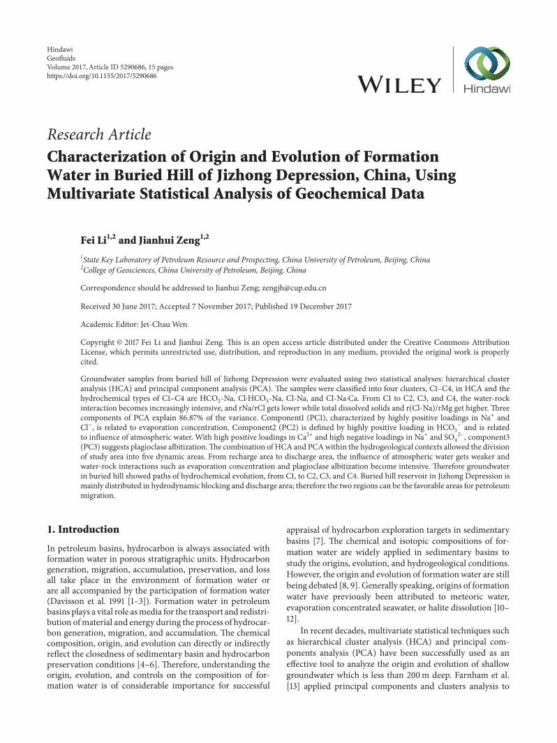
Jizhong Depression, located in the west of Bohai Gulf Basin(BGB) (Figure 1), is a Cenozoic sedimentary depressionwhich formed on the basement of Huabei Platform. It is anelongated half-graben, bordered by the Yanshan uplift to thenorth, Xingheng uplift to the south, Taihangshan uplift tothe west, and Cangxian uplift to the east, which covers anarea of 32000 km2 (Figure 1). It is divided into three areasby two EW and SWW transformation belts, which are theeast, middle, and west district, respectively. The Southerndistrict included Shijiazhuang Sag, Jinxian Sag, Sulu Sag, andJining uplift, the middle district consists of Raoyang Sag,Baoding Sag, Shenxian Sag, Gaoyang uplift, Shenze uplift,and Lixian Slope, and the north district can be divided intoBeijing Sag, Daguang Sag, Langgu Sag, Xushui Sag, WuqingSag, Baxian Sag, Daxing uplift, Niutuozhen uplift, Rongchenguplift, Niubei Slope, Yangcun Slope, and Wenan Slope.
In the extended geological period, Jizhong Depressionexperienced three developmental stages, namely, geosyncline,platform, and rifting stage. In the geosyncline developmentalstage (3.5–1.8 billion years ago), the study area experiencedthe Fuping, Wutai, and Lvliang Orogenies, forming theancient basement consisting of granite and hornblende schist.In the subsequent platform developmental stage (1.8–0.2
Geofluids 3
Beijing
Beijing
BGB
Study area
Taihangshan
Yanshanupli�
upli�upli� Cangxian
Xingheng upli�
China
A
B
Cang
Xian
Upli�
upli�
Upli�
Tai
Hang
Shan
Upli�
Da
Da
guang
sagWu
qing
sagsag
Lang
gu
sag
shui
xu
sag
ding
bao
yang
rao
sag
sagshenxian
slope
yangcun
Upli�
da
cheng
slope
wen
ansag
xianba
upli�
rongcheng
slope
niubei niutuo
zhen
upli�
gao
yang
slope
li
xian
upli�shen
ze
sag
shi
jia
zhuang
sag
xian
jin
sag
su
lu
upli�
ning
ji
sag
jing
bei
upli�
wu
ji
40∘
39∘
38∘
40∘
39∘
38∘
115∘ 116∘ 117∘
115∘ 116∘ 117∘
0 20 40(km)
0 200(km)
Figure 1: Sketch map showing location and structure of the Jizhong Depression.
billion years ago), the basin deposited a set of marinecarbonate sediments with thicknesses of up to 6.8 km. Underthe influence of the Hercynian and Indosinian Orogenies,the marine carbonates repeatedly suffered weathering anddenudation and the buried hills were formed in this stage.After the Indosinian orogenies, the study area moved intothe stage of rifting basin (0.2 billion years ago up to thepresent), sedimenting a set of terrestrial deposits of up to8000m [30, 31].
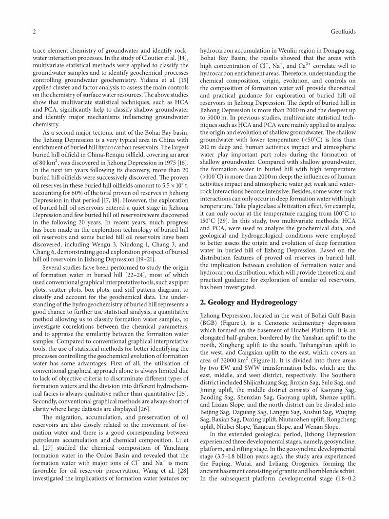
The basin fill of study area can be divided into two parts:the bottom part consists of Meso-Neoproterozoic throughPaleozoic weathered marine carbonates, and the upper partis Cenozoic continental clastic sediment (Figures 2 and 3).From bottom to top, the upper part can be divided intosix formations: the Kongdian (Ek), Shahejie (Es), Dongying(Ed), Guantao (Ng), Minghuazhen (Nm), and Pingyuanformations (Qp). The Pingyuan formations (Qp) includesyellow clay powder and fine sandstone. The Minghuazhen
formation (Nm) consists of light grey sandstone, conglom-eratic sandstones, and palm red mudstone. The Guantaoformation (Ng) consists of aubergine mudstone and lightgrey granular sandstone. The Dongying formation (Ed) iscomposed of three units: the lower part starts with amaranthmudstone and grey mudstone, the middle part is composedof grey mudstone interbedded with siltstone, and the upperpart mainly consists of light grey sandstone and purplemudstone layer. The Shahejie formation (Es) can be furtherdivided into four members based on lithology and electricalproperties: Shahejie 1 (Es1), Shahejie 2 (Es2), Shahejie 3 (Es3),and Shahejie 4 (Es4). Shahejie 1 includes grey mudstone,calcareous shale, and calcareous sandstone, which graduallychange upward into amaranth mudstone and grey sandstone.Shahejie 2 consists of red to purplish-red sandstone andmud-stone. The Shahejie 3 is composed of dark grey mudstonesinterbedded with fine-grained sandstones, which is one ofthe most important source rocks. Shahejie 4 (Es4) consists
4 Geofluids
Stratigraphic age Member Lithology Sedimentaryfacies
Openplatform
Mesoprotero-zoic
Guantao formation
Ek
Ordovician
Jxw
Stratumsymbol
Qp
Nm
Ng
Ed
O
Jixiansystem
Number 1
Cenozoic
Paleozic
Quaternary
Neogene
Palaeogene
Cambrian
Pingyuan formationMinghuazhen
formation
Dongyingformation
Shahejieformation
Kongdianformation
Formation
Number 2
Number 3
Number 4
Fluvialfacies
facies
facies
facies
platformfacies
Lacustrine
Delta
Restricted
MudstoneLimestoneDolomite Siltstone
SandstoneArgillaceous dolomite
%s1
%s2
%s3
%s4
∈
Figure 2: Stratigraphic histogram of the Jizhong Depression.
of grey mudstone and light grey sandstone interbeddedwith dolomite and gypsum, which is another importantsource rock. The Kongdian formation (Ek) includes varie-gated sandstone and red sandy mudstone, which graduallychange upward into greymudstone interbeddedwith gypsummudstone [32].
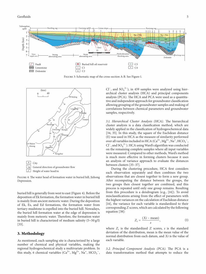
The bottom part, weatheredmarine carbonate, consists ofthe Wumishan formation of the Jixian system (Jxw); Cam-brian (∈) and Ordovician (O) are the focus of this study. TheWumishan formation of the Jixian system,mainly distributedin the west of study area, is composed of dolomite andargillaceous dolomite. Cambrian (∈) and Ordovician, mainlydistributed in the east of study area, consist of limestone.Theburied hills, consisting of weathered marine carbonates, aredirectly covered by Es4-Ek or Es3 which are two primaryhydrocarbon source rocks in study area. The hydrocarbon,generated from Es4-Ek or Es3 source rocks, migrated directlyor through the fault-unconformity to the buried hill trap.
In the study area, there are five aquifers (Ng, Ed, Es2and Ek, and buried hill) and four aquitards (Nm, Es1, Es3,
and Es4). Formation water in the Ng formations consistingof fluvial facies is characterized by lower salinity (<5 g/l)and high rNa/rCl (>3.0) [33]. The stable isotope value offormation water in the Ng formation, which is similar topresent rainwater, suggested that it is related to the influenceof atmospheric water.The Ek, Es, and Ed formations, consist-ing of terrestrial facies lake basin depositions which are morethan 2000m deep, rarely outcrop. The formation water inEk, Es, and Ed formations is characterized by higher salinity(10∼100 g/l) and lower rNa/rCl (<3.0) [33]. In the study ofQu et al. [24], the application of isotopic composition is usedto trace the origin of formation water in Ek, Es, and Ed,which is mainly from sedimentary water and small amountof atmospheric water. Evaporation concentration effect playsan important part role during the evolution of formationwater in the Ek, Es, and Ed. Du et al. [33] studied the fluidpotential of Ek, Es, and Ed and the migration direction of theformationwater is from the depression center to the edge.Theweathered marine carbonates widely outcrop in the west ofTaihangMountains; themain flow path of formation water in
Geofluids 5
Ed
Ng + Nm Ng + Nm
Ed
Gs1Bs
1
G14
Y10
G9
C3 R99
R65
R31
R15
R56
R13
R819
M87
M48
M92
M89
X2
Dep
th (k
m)
1
432
765
Watersupple area
Strongalternating area
Weakalternating area
Hydrodynamicblocking area Discharge area
A
B
C3C4C1
C2
Buried hill oil reservoirFaultLimestoneDolomite
Dolomite
Baoding sag Gaoyang upli� Lixian slope Raoyang sagTaihangshan
upli�
0 10 20(km)
%M1 %M1%M2+3
%M2+3%M4-Ek %M4-Ek
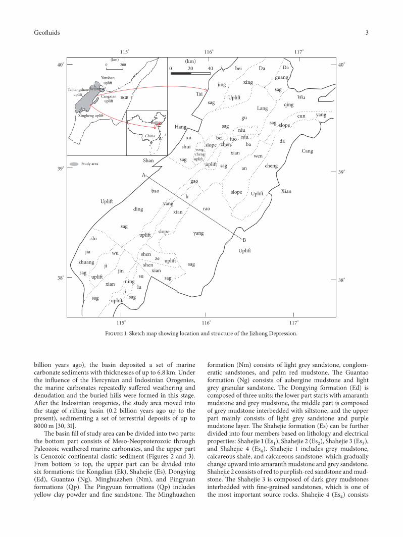
Figure 3: Schematic map of the cross-section A-B. See Figure 1.
Beijing
Tianjin
Shijianzhuang
Hengshui
Langfang
Baoding
Renqiu
Hejian
Wuqing
Gaoyang
Shenxian
8040
0−40
0
40
0 40(km)
−40
CityGeneral direction of groundwater �ow
10 Height of water head/m
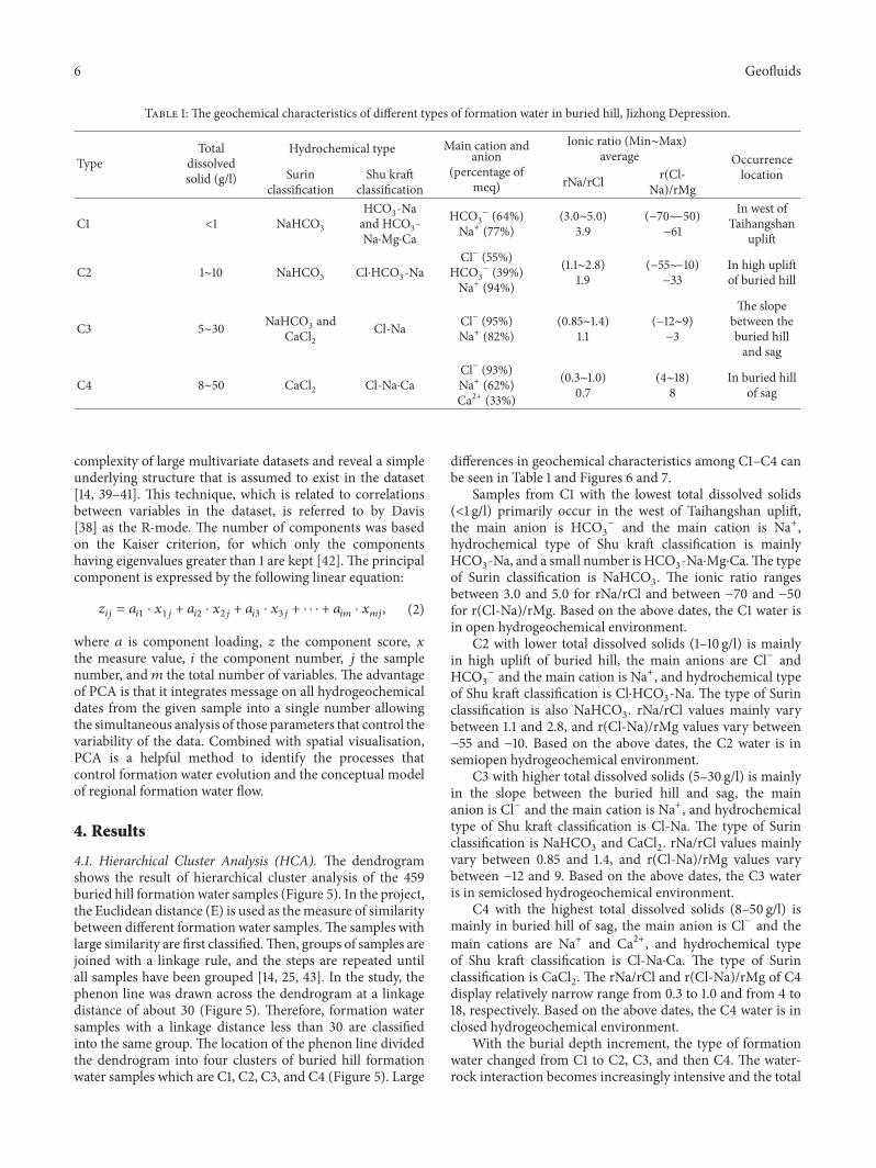
Figure 4: The water head of formation water in buried hill, JizhongDepression.
buried hill is generally fromwest to east (Figure 4). Before thedeposition of Ek formation, the formationwater in buried hillis mainly from ancient meteoric water. During the depositionof Ek, Es, and Ed formations, the formation water fromtertiary mudstone is expelled into the buried hill. Nowadays,the buried hill formation water at the edge of depression ismainly from meteoric water. Therefore, the formation waterin buried hill is characterized of medium salinity (5∼50 g/l)[33].
3. Methodology
As mentioned, each sampling site is characterized by a largenumber of chemical and physical variables, making theregional hydrogeochemical study a multivariate problem. Inthis study, 6 chemical variables (Ca2+, Mg2+, Na+, HCO3
−,
Cl−, and SO42−), in 459 samples were analyzed using hier-
archical cluster analysis (HCA) and principal componentsanalysis (PCA). The HCA and PCA were used as a quantita-tive and independent approach for groundwater classificationallowing grouping of the groundwater samples andmaking ofcorrelations between chemical parameters and groundwatersamples, respectively.
3.1. Hierarchical Cluster Analysis (HCA). The hierarchicalcluster analysis is a data classification method, which arewidely applied in the classification of hydrogeochemical data[34, 35]. In this study, the square of the Euclidean distance(E) was used in HCA as the measure of similarity performedover all variables included inHCA (Ca2+,Mg2+, Na+, HCO3
−,Cl−, and SO4
2−). HCAusingWard’s algorithmwas conductedon the remaining complete samples where all input variableswere measured. Compared to other methods, Ward’s methodis much more effective in forming clusters because it usesan analysis of variance approach to evaluate the distancesbetween clusters [35–37].
During the clustering procedure, HCA first considerseach observation separately and then combines the twoobservations that are closest together to form a new group.After recomputing the distance between the groups, thetwo groups then closest together are combined, and thisprocess is repeated until only one group remains. Resultingfrom this procedure is a dendrogram (e.g., [14]). To avoidmisclassifications arising from the effect of parameters withthe highest variances on the calculation of Euclidean distance[14], the variance for each variable is standardized to theircorresponding𝑍 scores, which are calculated by the followingequation [38]:
𝑍𝑖 = (𝑋𝑖 −mean)𝑠 , (1)
where 𝑍𝑖 is the standardized 𝑍 scores, 𝑠 is the standarddeviation of the distribution, mean is the mean value of thenormal distribution from each datum, and 𝑋𝑖 is the value ofeach variable.
3.2. Principal Component Analysis (PCA). The PCA is adata transformation method that attempts to reduce the
6 Geofluids
Table 1: The geochemical characteristics of different types of formation water in buried hill, Jizhong Depression.
TypeTotal
dissolvedsolid (g/l)
Hydrochemical type Main cation andanion
(percentage ofmeq)
Ionic ratio (Min∼Max)average Occurrence
locationSurinclassification
Shu kraftclassification rNa/rCl r(Cl-
Na)/rMg
C1 <1 NaHCO3HCO3-Naand HCO3-Na⋅Mg⋅Ca
HCO3− (64%)
Na+ (77%)(3.0∼5.0)
3.9(−70∼−50)−61
In west ofTaihangshan
uplift
C2 1∼10 NaHCO3 Cl⋅HCO3-NaCl− (55%)
HCO3− (39%)
Na+ (94%)
(1.1∼2.8)1.9
(−55∼−10)−33
In high upliftof buried hill
C3 5∼30 NaHCO3 andCaCl2
Cl-Na Cl− (95%)Na+ (82%)
(0.85∼1.4)1.1
(−12∼9)−3
The slopebetween theburied hilland sag
C4 8∼50 CaCl2 Cl-Na⋅CaCl− (93%)Na+ (62%)Ca2+ (33%)
(0.3∼1.0)0.7
(4∼18)8
In buried hillof sag
complexity of large multivariate datasets and reveal a simpleunderlying structure that is assumed to exist in the dataset[14, 39–41]. This technique, which is related to correlationsbetween variables in the dataset, is referred to by Davis[38] as the R-mode. The number of components was basedon the Kaiser criterion, for which only the componentshaving eigenvalues greater than 1 are kept [42]. The principalcomponent is expressed by the following linear equation:
𝑧𝑖𝑗 = 𝑎𝑖1 ⋅ 𝑥1𝑗 + 𝑎𝑖2 ⋅ 𝑥2𝑗 + 𝑎𝑖3 ⋅ 𝑥3𝑗 + ⋅ ⋅ ⋅ + 𝑎𝑖𝑚 ⋅ 𝑥𝑚𝑗, (2)
where 𝑎 is component loading, 𝑧 the component score, 𝑥the measure value, 𝑖 the component number, 𝑗 the samplenumber, and 𝑚 the total number of variables. The advantageof PCA is that it integrates message on all hydrogeochemicaldates from the given sample into a single number allowingthe simultaneous analysis of those parameters that control thevariability of the data. Combined with spatial visualisation,PCA is a helpful method to identify the processes thatcontrol formation water evolution and the conceptual modelof regional formation water flow.
4. Results
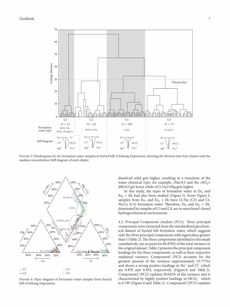
4.1. Hierarchical Cluster Analysis (HCA). The dendrogramshows the result of hierarchical cluster analysis of the 459buried hill formationwater samples (Figure 5). In the project,the Euclidean distance (E) is used as themeasure of similaritybetween different formation water samples.The samples withlarge similarity are first classified.Then, groups of samples arejoined with a linkage rule, and the steps are repeated untilall samples have been grouped [14, 25, 43]. In the study, thephenon line was drawn across the dendrogram at a linkagedistance of about 30 (Figure 5). Therefore, formation watersamples with a linkage distance less than 30 are classifiedinto the same group. The location of the phenon line dividedthe dendrogram into four clusters of buried hill formationwater samples which are C1, C2, C3, and C4 (Figure 5). Large
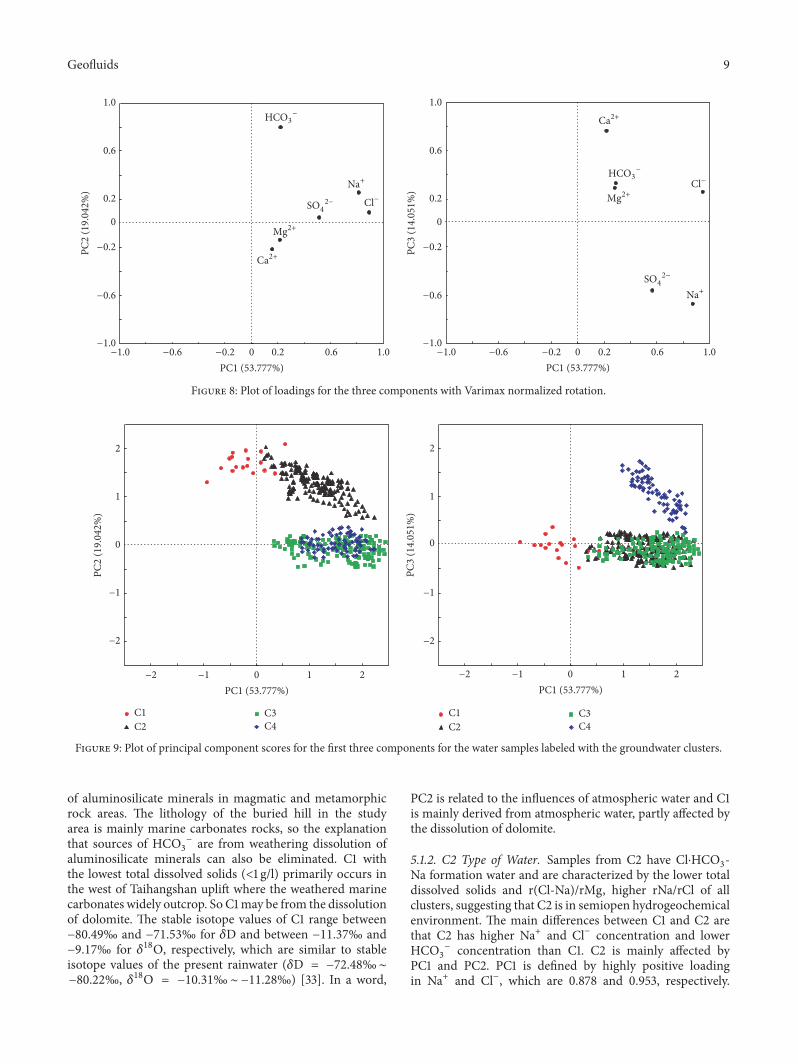
differences in geochemical characteristics among C1–C4 canbe seen in Table 1 and Figures 6 and 7.
Samples from C1 with the lowest total dissolved solids(<1 g/l) primarily occur in the west of Taihangshan uplift,the main anion is HCO3
− and the main cation is Na+,hydrochemical type of Shu kraft classification is mainlyHCO3-Na, and a small number is HCO3-Na⋅Mg⋅Ca.The typeof Surin classification is NaHCO3. The ionic ratio rangesbetween 3.0 and 5.0 for rNa/rCl and between −70 and −50for r(Cl-Na)/rMg. Based on the above dates, the C1 water isin open hydrogeochemical environment.
C2 with lower total dissolved solids (1–10 g/l) is mainlyin high uplift of buried hill, the main anions are Cl− andHCO3
− and the main cation is Na+, and hydrochemical typeof Shu kraft classification is Cl⋅HCO3-Na. The type of Surinclassification is also NaHCO3. rNa/rCl values mainly varybetween 1.1 and 2.8, and r(Cl-Na)/rMg values vary between−55 and −10. Based on the above dates, the C2 water is insemiopen hydrogeochemical environment.
C3 with higher total dissolved solids (5–30 g/l) is mainlyin the slope between the buried hill and sag, the mainanion is Cl− and the main cation is Na+, and hydrochemicaltype of Shu kraft classification is Cl-Na. The type of Surinclassification is NaHCO3 and CaCl2. rNa/rCl values mainlyvary between 0.85 and 1.4, and r(Cl-Na)/rMg values varybetween −12 and 9. Based on the above dates, the C3 wateris in semiclosed hydrogeochemical environment.
C4 with the highest total dissolved solids (8–50 g/l) ismainly in buried hill of sag, the main anion is Cl− and themain cations are Na+ and Ca2+, and hydrochemical typeof Shu kraft classification is Cl-Na⋅Ca. The type of Surinclassification is CaCl2. The rNa/rCl and r(Cl-Na)/rMg of C4display relatively narrow range from 0.3 to 1.0 and from 4 to18, respectively. Based on the above dates, the C4 water is inclosed hydrogeochemical environment.
With the burial depth increment, the type of formationwater changed from C1 to C2, C3, and then C4. The water-rock interaction becomes increasingly intensive and the total
Geofluids 7
70
60
50
40
30
20
10
0
Phenon lineLink
age d
istan
ce
C1 C2 C3 C4
Formationwater type
Sti� diagram
Cl-Na
.;+
#;2+
-A2+
#F− .;+
#;2+
-A2+
#F− .;+
#;2+
-A2+
#F− .;+
#;2+
-A2+
#F−
N = 11 N = 45 N = 330 N = 73HC/3-Na,
HC/3·#F-Na
HC/3− HC/3
−HC/3
−HC/3
−
3/42−
HC/3-Na·Mg·Ca
3/42−
3/42−
3/42−
Cl-Na·Ca
Figure 5: Dendrogram for the formation water samples in buried hill of Jizhong Depression, showing the division into four clusters and themedian concentration Stiff diagram of each cluster.
80% 60% 40% 20%
20%
20%
40%
40%60%
60%
80%
80%
80%60%40%20%
20%
20%
40%
40%60%
60%
80%
80%
80% 80%
60% 60%
40% 40%
20% 20%
ClCa
MgNa
Mg + Ca
Cl-Na
#F·(#/3-Na
(#/3-Na (#/3
S/4
Cl +
S/4
C1C2
C3C4
Cl-Na·Ca
Figure 6: Piper diagram of formation water samples from buriedhill of Jizhong Depression.
dissolved solid gets higher, resulting in a transition of thewater chemical type; for example, rNa/rCl and the rSO4×100/rCl get lower while r(Cl-Na)/rMg gets higher.
In this study, the types of formation water in Es3 andEs4 + Ek had also been studied (Figure 3). From Figure 3,samples from Es3 and Es4 + Ek have Cl-Na (C3) and Cl-Na⋅Ca (C4) formation water. Therefore, Es3 and Es4 + Ek,dominated by samples of C3 andC4, are in semiclosed-closedhydrogeochemical environment.
4.2. Principal Components Analysis (PCA). Three principalcomponents were extracted from the standardized geochem-ical dataset of buried hill formation water, which suggestsonly the three principal components with eigenvalues greaterthan 1 (Table 2).The three components identified in this studycumulatively can account for 86.870% of the total variance inthe original dataset. Table 2 presents the principal componentloadings for the three components, as well as their respectiveexplained variance. Component1 (PC1) accounts for thegreatest amount of the variance (approximately 53.777%)and shows a strong positive loadings in Na+ and Cl− whichare 0.878 and 0.953, respectively (Figure 8 and Table 2).Component2 (PC2) explains 19.042% of the variance and ischaracterized by highly positive loadings in HCO3
− whichis 0.799 (Figure 8 and Table 2). Component3 (PC3) explains

8 Geofluids
Table 2: Table of component weightings, principal component eigenvalues, and variance of principal components.
Parameters PC1 PC2 PC3Na+ 0.878 0.256 −0.682Mg2+ 0.281 −0.137 0.280Ca2+ 0.219 −0.219 0.756HCO3
− 0.288 0.799 0.324Cl− 0.953 0.093 0.249SO42− 0.571 0.021 −0.570
Eigenvalue variance 3.227 1.343 1.043Explained variance (%) 53.777 19.042 14.051Cumulative % of variance 53.777 72.820 86.870
0 10 20 30 40 50 60Total dissolved solid (g/l) Total dissolved solid (g/l)
rNa/
rCl
0 10 20 30 40 50 60−80
−60
−40
−20
0
20
rCl-N
a/rM
g
5.0
4.0
3.0
2.0
1.0
0
C1C2
C3C4
C1C2
C3C4
Figure 7: The relationship between salinity and sodium chloride coefficient and metamorphic coefficient from different types of formationwater in buried hill of Jizhong Depression.
about 14.051% of the variance and shows a strong negativeloading of SO4
2− and Na+ and strong positive loadingsof Ca2+ which are −0.570, −0.682, and 0.756, respectively(Figure 8 and Table 2). Figure 9 shows a scatter plot of theprojected scores of PC1-PC2 and PC1-PC3 for the above fourtypes of formation water. From Figure 9, C1 is mainly affectedby PC2, C2 is mainly affected by PC1 and PC2, C3 is mainlyaffected by PC1, and C4 is mainly affected by PC1 and PC3.
5. Discussion
5.1. Origin of Formation Water in Buried Hill. Formationwater in sedimentary basin is usually derived from leachedwater, sedimentationwater, endogenouswater, or themixtureof them [44, 45]. The leached water is mainly meteoric waterenriched in CO2 and O2, sedimentation water is the ancientgroundwater which evolved from the ancient surface water,and endogenous water is the high heat fluid from deep earth[46]. The origin of formation water and a series of physicaland chemical reaction, such as halite dissolution, evaporation
concentrated seawater, generation of organic matter, andbiodegradation, will affect the hydrochemical characteristicof formation water. The multivariate statistical methods ofHCAandPCAdonot indicate cause-and-effect relationships;they can only provide information from which such relation-ships can be inferred.Therefore, in order to better identify thephysical and chemical processes controlling the geochemicalevolution of groundwater, the results of the multivariatestatistical analysis have to be combined with the knowledgeof the geological and hydrogeological setting [47, 48].
5.1.1. C1 Type of Water. Samples from C1 have HCO3-Na andHCO3-Na⋅Mg⋅Ca formation water type and are character-ized by the lowest total dissolved solids and r(Cl-Na)/rMg,highest rNa/rCl of all clusters, suggesting that C1 is in openhydrogeochemical environment. According to the abovestudy, C1 is mainly affected by PC2 which shows a strongpositive loadings in HCO3
−. Generally speaking, there aremain three sources of HCO3
− which are atmospheric water,dissolution of carbonate rocks, and weathering dissolution
Geofluids 9
PC1 (53.777%)
PC3
(14.
051%
)
.;+
#;2+
-A2+
#F−
HC/3−
.;+
#;2+
-A2+#F−
HC/3−
1.00.60.20−0.2−0.6−1.0
1.0
0.6
0.2
0
−0.2
−0.6
−1.0
PC1 (53.777%)
PC2
(19.
042%
)
1.00.60.20−0.2−0.6−1.0
1.0
0.6
0.2
0
−0.2
−0.6
−1.0
3/42−
3/42−
Figure 8: Plot of loadings for the three components with Varimax normalized rotation.
1
2
0 1 2
0
−2
−2
−1−2 −1
−1
−2
−1
0 1 2
1
2
0
PC1 (53.777%) PC1 (53.777%)
PC2
(19.
042%
)
PC3
(14.
051%
)
C1C2
C3C4
C1C2
C3C4
Figure 9: Plot of principal component scores for the first three components for the water samples labeled with the groundwater clusters.
of aluminosilicate minerals in magmatic and metamorphicrock areas. The lithology of the buried hill in the studyarea is mainly marine carbonates rocks, so the explanationthat sources of HCO3
− are from weathering dissolution ofaluminosilicate minerals can also be eliminated. C1 withthe lowest total dissolved solids (<1 g/l) primarily occurs inthe west of Taihangshan uplift where the weathered marinecarbonates widely outcrop. So C1may be from the dissolutionof dolomite. The stable isotope values of C1 range between−80.49‰ and −71.53‰ for 𝛿D and between −11.37‰ and−9.17‰ for 𝛿18O, respectively, which are similar to stableisotope values of the present rainwater (𝛿D = −72.48‰∼−80.22‰, 𝛿18O = −10.31‰ ∼ −11.28‰) [33]. In a word,
PC2 is related to the influences of atmospheric water and C1is mainly derived from atmospheric water, partly affected bythe dissolution of dolomite.
5.1.2. C2 Type of Water. Samples from C2 have Cl⋅HCO3-Na formation water and are characterized by the lower totaldissolved solids and r(Cl-Na)/rMg, higher rNa/rCl of allclusters, suggesting that C2 is in semiopen hydrogeochemicalenvironment. The main differences between C1 and C2 arethat C2 has higher Na+ and Cl− concentration and lowerHCO3
− concentration than C1. C2 is mainly affected byPC1 and PC2. PC1 is defined by highly positive loadingin Na+ and Cl−, which are 0.878 and 0.953, respectively.
10 Geofluids
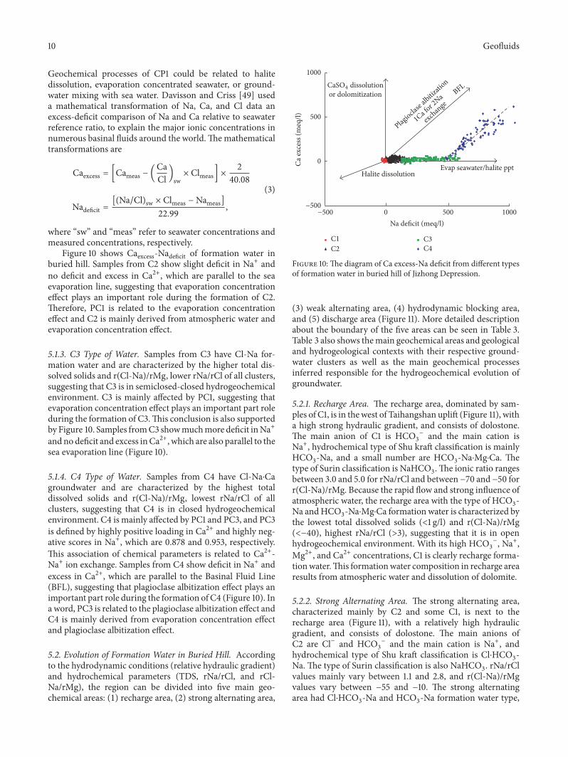
Geochemical processes of CP1 could be related to halitedissolution, evaporation concentrated seawater, or ground-water mixing with sea water. Davisson and Criss [49] useda mathematical transformation of Na, Ca, and Cl data anexcess-deficit comparison of Na and Ca relative to seawaterreference ratio, to explain the major ionic concentrations innumerous basinal fluids around the world.Themathematicaltransformations are
Caexcess = [Cameas − (CaCl )sw × Clmeas] × 240.08
Nadeficit = [(Na/Cl)sw × Clmeas −Nameas]22.99 ,
(3)
where “sw” and “meas” refer to seawater concentrations andmeasured concentrations, respectively.
Figure 10 shows Caexcess-Nadeficit of formation water inburied hill. Samples from C2 show slight deficit in Na+ andno deficit and excess in Ca2+, which are parallel to the seaevaporation line, suggesting that evaporation concentrationeffect plays an important role during the formation of C2.Therefore, PC1 is related to the evaporation concentrationeffect and C2 is mainly derived from atmospheric water andevaporation concentration effect.
5.1.3. C3 Type of Water. Samples from C3 have Cl-Na for-mation water and are characterized by the higher total dis-solved solids and r(Cl-Na)/rMg, lower rNa/rCl of all clusters,suggesting that C3 is in semiclosed-closed hydrogeochemicalenvironment. C3 is mainly affected by PC1, suggesting thatevaporation concentration effect plays an important part roleduring the formation of C3.This conclusion is also supportedby Figure 10. Samples fromC3 showmuchmore deficit inNa+andnodeficit and excess inCa2+, which are also parallel to thesea evaporation line (Figure 10).
5.1.4. C4 Type of Water. Samples from C4 have Cl-Na⋅Cagroundwater and are characterized by the highest totaldissolved solids and r(Cl-Na)/rMg, lowest rNa/rCl of allclusters, suggesting that C4 is in closed hydrogeochemicalenvironment. C4 is mainly affected by PC1 and PC3, and PC3is defined by highly positive loading in Ca2+ and highly neg-ative scores in Na+, which are 0.878 and 0.953, respectively.This association of chemical parameters is related to Ca2+-Na+ ion exchange. Samples from C4 show deficit in Na+ andexcess in Ca2+, which are parallel to the Basinal Fluid Line(BFL), suggesting that plagioclase albitization effect plays animportant part role during the formation of C4 (Figure 10). Ina word, PC3 is related to the plagioclase albitization effect andC4 is mainly derived from evaporation concentration effectand plagioclase albitization effect.
5.2. Evolution of Formation Water in Buried Hill. Accordingto the hydrodynamic conditions (relative hydraulic gradient)and hydrochemical parameters (TDS, rNa/rCl, and rCl-Na/rMg), the region can be divided into five main geo-chemical areas: (1) recharge area, (2) strong alternating area,
−500
0
500
1000
−500 0 500Na de�cit (meq/l)
1000
BFL
Evap seawater/halite ppt
or dolomitization
Plagiocla
se alb
itizatio
n
1Ca for 2
Na
exchange
Halite dissolution
C1C2
C3C4
Ca ex
cess
(meq
/l)
CaS/4 dissolution
Figure 10:The diagram of Ca excess-Na deficit from different typesof formation water in buried hill of Jizhong Depression.
(3) weak alternating area, (4) hydrodynamic blocking area,and (5) discharge area (Figure 11). More detailed descriptionabout the boundary of the five areas can be seen in Table 3.Table 3 also shows themain geochemical areas and geologicaland hydrogeological contexts with their respective ground-water clusters as well as the main geochemical processesinferred responsible for the hydrogeochemical evolution ofgroundwater.
5.2.1. Recharge Area. The recharge area, dominated by sam-ples of C1, is in thewest of Taihangshan uplift (Figure 11), witha high strong hydraulic gradient, and consists of dolostone.The main anion of C1 is HCO3
− and the main cation isNa+, hydrochemical type of Shu kraft classification is mainlyHCO3-Na, and a small number are HCO3-Na⋅Mg⋅Ca. Thetype of Surin classification is NaHCO3.The ionic ratio rangesbetween 3.0 and 5.0 for rNa/rCl and between −70 and −50 forr(Cl-Na)/rMg. Because the rapid flow and strong influence ofatmospheric water, the recharge area with the type of HCO3-Na andHCO3-Na⋅Mg⋅Ca formation water is characterized bythe lowest total dissolved solids (<1 g/l) and r(Cl-Na)/rMg(<−40), highest rNa/rCl (>3), suggesting that it is in openhydrogeochemical environment. With its high HCO3
−, Na+,Mg2+, and Ca2+ concentrations, C1 is clearly recharge forma-tionwater.This formationwater composition in recharge arearesults from atmospheric water and dissolution of dolomite.
5.2.2. Strong Alternating Area. The strong alternating area,characterized mainly by C2 and some C1, is next to therecharge area (Figure 11), with a relatively high hydraulicgradient, and consists of dolostone. The main anions ofC2 are Cl− and HCO3
− and the main cation is Na+, andhydrochemical type of Shu kraft classification is Cl⋅HCO3-Na. The type of Surin classification is also NaHCO3. rNa/rClvalues mainly vary between 1.1 and 2.8, and r(Cl-Na)/rMgvalues vary between −55 and −10. The strong alternatingarea had Cl⋅HCO3-Na and HCO3-Na formation water type,
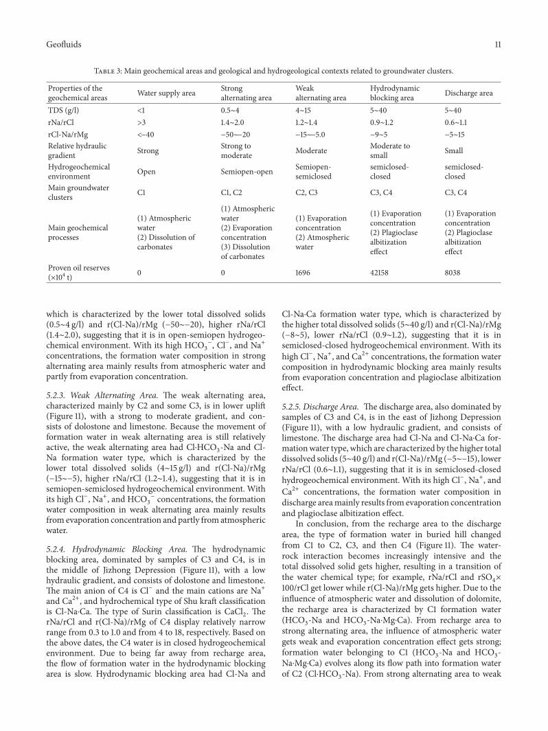
Geofluids 11
Table 3: Main geochemical areas and geological and hydrogeological contexts related to groundwater clusters.
Properties of thegeochemical areas Water supply area Strong
alternating areaWeakalternating area
Hydrodynamicblocking area Discharge area
TDS (g/l) <1 0.5∼4 4∼15 5∼40 5∼40rNa/rCl >3 1.4∼2.0 1.2∼1.4 0.9∼1.2 0.6∼1.1rCl-Na/rMg <−40 −50∼−20 −15∼−5.0 −9∼5 −5∼15Relative hydraulicgradient Strong Strong to
moderate Moderate Moderate tosmall Small
Hydrogeochemicalenvironment Open Semiopen-open Semiopen-
semiclosedsemiclosed-closed
semiclosed-closed
Main groundwaterclusters C1 C1, C2 C2, C3 C3, C4 C3, C4
Main geochemicalprocesses
(1) Atmosphericwater(2) Dissolution ofcarbonates
(1) Atmosphericwater(2) Evaporationconcentration(3) Dissolutionof carbonates
(1) Evaporationconcentration(2) Atmosphericwater
(1) Evaporationconcentration(2) Plagioclasealbitizationeffect
(1) Evaporationconcentration(2) Plagioclasealbitizationeffect
Proven oil reserves(×104 t) 0 0 1696 42158 8038
which is characterized by the lower total dissolved solids(0.5∼4 g/l) and r(Cl-Na)/rMg (−50∼−20), higher rNa/rCl(1.4∼2.0), suggesting that it is in open-semiopen hydrogeo-chemical environment. With its high HCO3
−, Cl−, and Na+concentrations, the formation water composition in strongalternating area mainly results from atmospheric water andpartly from evaporation concentration.
5.2.3. Weak Alternating Area. The weak alternating area,characterized mainly by C2 and some C3, is in lower uplift(Figure 11), with a strong to moderate gradient, and con-sists of dolostone and limestone. Because the movement offormation water in weak alternating area is still relativelyactive, the weak alternating area had Cl⋅HCO3-Na and Cl-Na formation water type, which is characterized by thelower total dissolved solids (4∼15 g/l) and r(Cl-Na)/rMg(−15∼−5), higher rNa/rCl (1.2∼1.4), suggesting that it is insemiopen-semiclosed hydrogeochemical environment. Withits high Cl−, Na+, and HCO3
− concentrations, the formationwater composition in weak alternating area mainly resultsfrom evaporation concentration and partly from atmosphericwater.
5.2.4. Hydrodynamic Blocking Area. The hydrodynamicblocking area, dominated by samples of C3 and C4, is inthe middle of Jizhong Depression (Figure 11), with a lowhydraulic gradient, and consists of dolostone and limestone.The main anion of C4 is Cl− and the main cations are Na+and Ca2+, and hydrochemical type of Shu kraft classificationis Cl-Na⋅Ca. The type of Surin classification is CaCl2. TherNa/rCl and r(Cl-Na)/rMg of C4 display relatively narrowrange from 0.3 to 1.0 and from 4 to 18, respectively. Based onthe above dates, the C4 water is in closed hydrogeochemicalenvironment. Due to being far away from recharge area,the flow of formation water in the hydrodynamic blockingarea is slow. Hydrodynamic blocking area had Cl-Na and
Cl-Na⋅Ca formation water type, which is characterized bythe higher total dissolved solids (5∼40 g/l) and r(Cl-Na)/rMg(−8∼5), lower rNa/rCl (0.9∼1.2), suggesting that it is insemiclosed-closed hydrogeochemical environment. With itshigh Cl−, Na+, and Ca2+ concentrations, the formation watercomposition in hydrodynamic blocking area mainly resultsfrom evaporation concentration and plagioclase albitizationeffect.
5.2.5. Discharge Area. The discharge area, also dominated bysamples of C3 and C4, is in the east of Jizhong Depression(Figure 11), with a low hydraulic gradient, and consists oflimestone. The discharge area had Cl-Na and Cl-Na⋅Ca for-mationwater type, which are characterized by the higher totaldissolved solids (5∼40 g/l) and r(Cl-Na)/rMg (−5∼−15), lowerrNa/rCl (0.6∼1.1), suggesting that it is in semiclosed-closedhydrogeochemical environment. With its high Cl−, Na+, andCa2+ concentrations, the formation water composition indischarge areamainly results from evaporation concentrationand plagioclase albitization effect.
In conclusion, from the recharge area to the dischargearea, the type of formation water in buried hill changedfrom C1 to C2, C3, and then C4 (Figure 11). The water-rock interaction becomes increasingly intensive and thetotal dissolved solid gets higher, resulting in a transition ofthe water chemical type; for example, rNa/rCl and rSO4×100/rCl get lower while r(Cl-Na)/rMg gets higher. Due to theinfluence of atmospheric water and dissolution of dolomite,the recharge area is characterized by C1 formation water(HCO3-Na and HCO3-Na⋅Mg⋅Ca). From recharge area tostrong alternating area, the influence of atmospheric watergets weak and evaporation concentration effect gets strong;formation water belonging to C1 (HCO3-Na and HCO3-Na⋅Mg⋅Ca) evolves along its flow path into formation waterof C2 (Cl⋅HCO3-Na). From strong alternating area to weak
12 Geofluids
0 20 40
A
B
40∘
39∘
38∘
40∘
39∘
38∘
115∘ 116∘ 117∘
115∘ 116∘ 117∘
(km)
Buried hill reservoirs
Well
C1
C2
C3
C4
General directionof formation water �ow
Recharge area
Strong alternating
Weak alternating
Hydrodynamic
Discharge areaarea
area
blocking area
Figure 11: The analysis of hydrodynamic conditions in buried hill, Jizhong Depression.
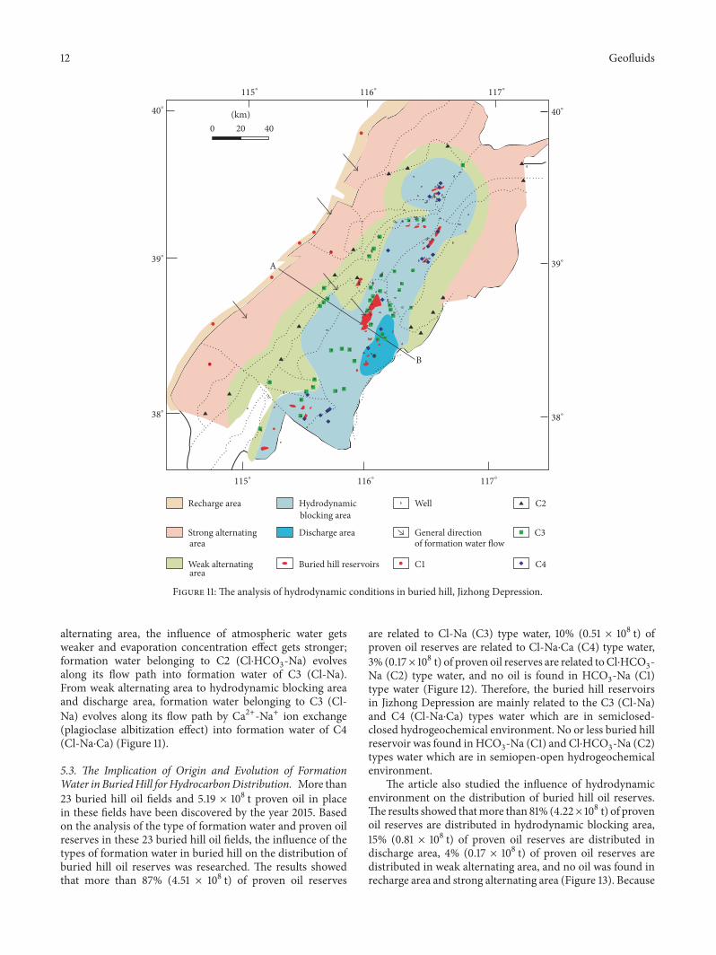
alternating area, the influence of atmospheric water getsweaker and evaporation concentration effect gets stronger;formation water belonging to C2 (Cl⋅HCO3-Na) evolvesalong its flow path into formation water of C3 (Cl-Na).From weak alternating area to hydrodynamic blocking areaand discharge area, formation water belonging to C3 (Cl-Na) evolves along its flow path by Ca2+-Na+ ion exchange(plagioclase albitization effect) into formation water of C4(Cl-Na⋅Ca) (Figure 11).5.3. The Implication of Origin and Evolution of FormationWater in BuriedHill forHydrocarbonDistribution. More than23 buried hill oil fields and 5.19 × 10⁸ t proven oil in placein these fields have been discovered by the year 2015. Basedon the analysis of the type of formation water and proven oilreserves in these 23 buried hill oil fields, the influence of thetypes of formation water in buried hill on the distribution ofburied hill oil reserves was researched. The results showedthat more than 87% (4.51 × 10⁸ t) of proven oil reserves
are related to Cl-Na (C3) type water, 10% (0.51 × 10⁸ t) ofproven oil reserves are related to Cl-Na⋅Ca (C4) type water,3% (0.17× 10⁸ t) of proven oil reserves are related toCl⋅HCO3-Na (C2) type water, and no oil is found in HCO3-Na (C1)type water (Figure 12). Therefore, the buried hill reservoirsin Jizhong Depression are mainly related to the C3 (Cl-Na)and C4 (Cl-Na⋅Ca) types water which are in semiclosed-closed hydrogeochemical environment. No or less buried hillreservoir was found in HCO3-Na (C1) and Cl⋅HCO3-Na (C2)types water which are in semiopen-open hydrogeochemicalenvironment.
The article also studied the influence of hydrodynamicenvironment on the distribution of buried hill oil reserves.The results showed thatmore than 81% (4.22× 10⁸ t) of provenoil reserves are distributed in hydrodynamic blocking area,15% (0.81 × 10⁸ t) of proven oil reserves are distributed indischarge area, 4% (0.17 × 10⁸ t) of proven oil reserves aredistributed in weak alternating area, and no oil was found inrecharge area and strong alternating area (Figure 13). Because
Geofluids 13
01696
45064
5132
0
10000
20000
30000
40000
50000
C1 C2 C3 C4
(104N)
Figure 12: Proven oil reserves in different types of formation waterin buried hill, Jizhong Depression.
0 0 1696
42158
8038
0
10000
20000
30000
40000
50000
Rech
arge
area
Stro
ngal
tern
atin
g ar
ea
Wea
kal
tern
atin
g ar
ea
Hyd
rody
nam
icbl
ocki
ng ar
ea
Disc
harg
e are
a
(104N)
Figure 13: Proven oil reserves in different hydrodynamic systems ofburied hill, Jizhong Depression.
the rapid flow and strong influence of atmospheric water,the preservation condition of oil and gas is poor and no oiland gas were found in recharge area and strong alternatingarea. The movement of formation water in weak alternatingarea is still relatively active and the oil and gas can only bepreserved in relatively weak hydrodynamic areas. So less oiland gas were found in weak alternating area. Due to being faraway from recharge area, the flow of formation water in thehydrodynamic blocking area and discharge area is slow andthey are favorable regions to preserve oil and gas. Therefore,more than 95% of buried hill oil in Jizhong Depression isdistributed in hydrodynamic blocking area and dischargearea.
The above study shows that the buried hill reserves ofJizhong Depression are mainly distributed in hydrodynamicblocking area and discharge area whose formation watertypes are Cl-Na and Cl-Na⋅Ca, so the two regions can be thefavorable areas for petroleum migration.
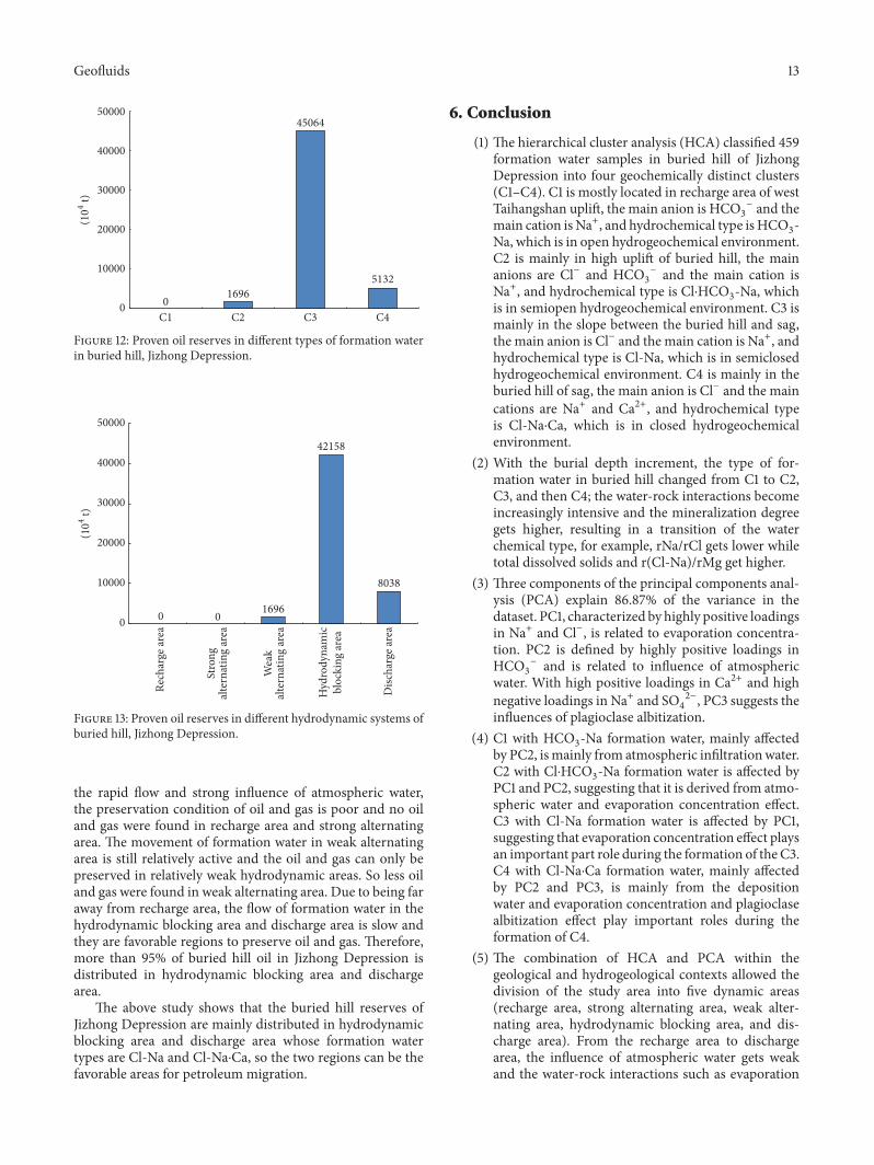
6. Conclusion
(1) The hierarchical cluster analysis (HCA) classified 459formation water samples in buried hill of JizhongDepression into four geochemically distinct clusters(C1–C4). C1 is mostly located in recharge area of westTaihangshan uplift, the main anion is HCO3
− and themain cation is Na+, and hydrochemical type isHCO3-Na, which is in open hydrogeochemical environment.C2 is mainly in high uplift of buried hill, the mainanions are Cl− and HCO3
− and the main cation isNa+, and hydrochemical type is Cl⋅HCO3-Na, whichis in semiopen hydrogeochemical environment. C3 ismainly in the slope between the buried hill and sag,the main anion is Cl− and the main cation is Na+, andhydrochemical type is Cl-Na, which is in semiclosedhydrogeochemical environment. C4 is mainly in theburied hill of sag, the main anion is Cl− and the maincations are Na+ and Ca2+, and hydrochemical typeis Cl-Na⋅Ca, which is in closed hydrogeochemicalenvironment.
(2) With the burial depth increment, the type of for-mation water in buried hill changed from C1 to C2,C3, and then C4; the water-rock interactions becomeincreasingly intensive and the mineralization degreegets higher, resulting in a transition of the waterchemical type, for example, rNa/rCl gets lower whiletotal dissolved solids and r(Cl-Na)/rMg get higher.
(3) Three components of the principal components anal-ysis (PCA) explain 86.87% of the variance in thedataset. PC1, characterized by highly positive loadingsin Na+ and Cl−, is related to evaporation concentra-tion. PC2 is defined by highly positive loadings inHCO3
− and is related to influence of atmosphericwater. With high positive loadings in Ca2+ and highnegative loadings in Na+ and SO4
2−, PC3 suggests theinfluences of plagioclase albitization.
(4) C1 with HCO3-Na formation water, mainly affectedby PC2, ismainly from atmospheric infiltrationwater.C2 with Cl⋅HCO3-Na formation water is affected byPC1 and PC2, suggesting that it is derived from atmo-spheric water and evaporation concentration effect.C3 with Cl-Na formation water is affected by PC1,suggesting that evaporation concentration effect playsan important part role during the formation of the C3.C4 with Cl-Na⋅Ca formation water, mainly affectedby PC2 and PC3, is mainly from the depositionwater and evaporation concentration and plagioclasealbitization effect play important roles during theformation of C4.
(5) The combination of HCA and PCA within thegeological and hydrogeological contexts allowed thedivision of the study area into five dynamic areas(recharge area, strong alternating area, weak alter-nating area, hydrodynamic blocking area, and dis-charge area). From the recharge area to dischargearea, the influence of atmospheric water gets weakand the water-rock interactions such as evaporation
14 Geofluids
concentration and plagioclase albitization becomeincreasingly intensive; therefore the recharge area isdominated by samples of C1, strong alternating area isdominated by samples of C1 and C2, weak alternatingarea is dominated by samples of C2 and C3, andhydrodynamic blocking area and discharge area aredominated by samples of C3 and C4.
(6) Buried hill reservoir in Jizhong Depression is mainlydistributed in hydrodynamic blocking area and dis-charge area; therefore the two regions can be thefavorable areas for petroleum migration and theabove statistical analyses’ methodology can be usedin the other study areas which have similar geologicaland hydrogeological background to the study area.
Conflicts of Interest
The authors declare that they have no conflicts of interest.
Acknowledgments
This study was financially supported by the National Sci-ence and Technology Special Grant (no. 2016ZX05006-001).Thanks are also given toHuabeiOilfieldCompany of Sinopec,which provided all the related data of Jizhong Depression.
References
[1] H. G. Machel, “Bacterial and thermochemical sulfate reductionin diagenetic settings - old and new insights,” SedimentaryGeology, vol. 140, no. 1-2, pp. 143–175, 2001.
[2] K. Michael and S. Bachu, “Origin, chemistry and flow offormation waters in the Mississippian-Jurassic sedimentarysuccession in the west-central part of the Alberta Basin,Canada,”Marine and Petroleum Geology, vol. 19, no. 3, pp. 289–306, 2002.
[3] X. Xie, Z. Fan, X. Liu, and Y. Lu, “Geochemistry of formationwater and its implication on overpressured fluid flow in theDongying Depression of the Bohaiwan Basin, China,” Journalof Geochemical Exploration, vol. 89, no. 1-3, pp. 432–435, 2006.
[4] Y. Fu andH. Zhan, “On the origin of oil-fieldwater in the BiyangDepression of China,” Environmental Geology, vol. 58, no. 6, pp.1191–1196, 2009.
[5] Y. Wang, H. Xu, C. Wang, and B. Jia, “Characteristics of thesalinity and distribution of the Neopaleozoic formation waterin Ordos Basin,” Shiyou Xuebao/Acta Petrolei Sinica, vol. 31, no.5, pp. 748–761, 2010.
[6] R. Bagheri, A. Nadri, E. Raeisi, H. G. M. Eggenkamp, G. A.Kazemi, andA.Montaseri, “Hydrochemical and isotopic (𝛿18O,𝛿2H, 87Sr/86Sr, 𝛿37Cl and 𝛿81Br) evidence for the origin ofsaline formationwater in a gas reservoir,”Chemical Geology, vol.384, pp. 62–75, 2014.
[7] J. S. Hanor and J. C. Mcintosh, “Diverse origins and timing offormation of basinal brines in the Gulf of Mexico sedimentarybasin,” Geofluids, vol. 7, no. 2, pp. 227–237, 2007.
[8] Y. K. Kharaka and J. S. Hanor, “Deep Fluids in the Continents:I. Sedimentary Basins,” Treatise on Geochemistry, vol. 5-9, pp.1–48, 2003.
[9] M. Tesmer, P. Moller, S. Wieland, C. Jahnke, H. Voigt, and A.Pekdeger, “Deep reaching fluid flow in the North East Ger-man Basin: Origin and processes of groundwater salinisation,”Hydrogeology Journal, vol. 15, no. 7, pp. 1291–1306, 2007.
[10] P. Birkle and R. A. Maruri, “Isotopic indications for the originof formation water at the Activo Samaria-Sitio Grande oil field,Mexico,” Journal of Geochemical Exploration, vol. 78-79, pp.453–458, 2003.
[11] T. K. Lowenstein, L. A. Hardie, M. N. Timofeeff, and R. V.Demicco, “Secular variation in seawater chemistry and theorigin of calcium chloride basinal brines,” Geology, vol. 31, no.10, pp. 857–860, 2003.
[12] S. V. Panno, K. C. Hackley, R. A. Locke et al., “Formation watersfrom Cambrian-age strata, Illinois Basin, USA: constraints ontheir origin and evolution,” Geochimica et Cosmochimica Acta,vol. 122, pp. 184–187, 2013.
[13] I.M. Farnham, K. H. Johannesson, A. K. Singh, V. F. Hodge, andK. J. Stetzenbach, “Factor analytical approaches for evaluatinggroundwater trace element chemistry data,” Analytica ChimicaActa, vol. 490, no. 1-2, pp. 123–138, 2003.
[14] V. Cloutier, R. Lefebvre, R. Therrien, and M. M. Savard,“Multivariate statistical analysis of geochemical data as indica-tive of the hydrogeochemical evolution of groundwater in asedimentary rock aquifer system,” Journal ofHydrology, vol. 353,no. 3-4, pp. 294–313, 2008.
[15] S. M. Yidana, D. Ophori, and B. Banoeng-Yakubo, “A multi-variate statistical analysis of surface water chemistry data-TheAnkobra Basin, Ghana,” Journal of EnvironmentalManagement,vol. 86, no. 1, pp. 80–87, 2008.
[16] P. S. Yang and G. Z. Li, “Development of carbonate reservoirsin the Renqiu Oil Field,” Acta Petrolei Sinica, vol. 1, pp. 57–64,1980.
[17] X. Zhao, Q. Wang, F. Jin et al., “Main controlling factors andexploration practice of subtle buried-hill hydrocarbon reservoirin Jizhong depression,” Shiyou Xuebao/Acta Petrolei Sinica, vol.33, no. 1, pp. 71–79, 2012.
[18] C. H. Gao, M. Zha, X. Z. Zhao, and F. Peng, “Migration systemsand hydrocarbon accumulationmodels of buried hill reservoirsin Jizhong Depression,” Lithologic Reservoirs, vol. 2, pp. 26–30,2015.
[19] X. Zhao, F. Jin, Y. Wang, Y. Guo, J. Liu, and R. Zheng, “Buried-hill reservoir-forming mode of ’old reservoir-old sealing for-mation’ in Changyangdian area of Jizhong Depression,” ShiyouXuebao/Acta Petrolei Sinica, vol. 29, no. 4, pp. 489–493, 2008.
[20] X. Zhao, F. Jin, Q. Wang et al., “Niudong 1 ultra-deep and ultra-high temperature subtle buried hill field in Bohai Bay Basin:discovery and significance,” Shiyou Xuebao/Acta Petrolei Sinica,vol. 32, no. 6, pp. 915–927, 2011.
[21] Q. H. Chen, H. G. Lao, K. Y. Wu, Z. H. Wu, and Y. Q. Cui,“Favorable hydrocabon accumulation conditions for carbonatereservoirs in deepburied hills in the JizhongDeprssion,”NaturalGas Industry, vol. 27, pp. 32–39, 2013.
[22] S. Sun, J. S. Xie, G. R. Li, and C. Y. Qiu, “Hydrogen and oxygenisotopic composition and genesis of the groundwater in JizhongDepression,” Oil Gas Geology, vol. 3, pp. 240–250, 1982.
[23] B. P. Han, “Study on chemistry of oilfield water in buried blockhill in Jizhong Depression,” Scientia Geologica Sinica, vol. 3, pp.263–273, 1989.
[24] Y. H. Qu, Z. C. Sun, X. J. Feng, and Z. M. Chen, “Middle-upperproterozoic buried hill groundwater geohydrologic characterand significance for exploration in northern Jizhong depression
Geofluids 15
basin,” Journal of Daqing Petroleum Institute, vol. 23, pp. 8–11,1999.
[25] C. J. Daughney and R. R. Reeves, “Definition of hydrochemicalfacies in the New Zealand National Groundwater MonitoringProgramme,” Journal of Hydrology (New Zealand), vol. 44, no.2, pp. 105–130, 2005.
[26] B. O’Shea and J. Jankowski, “Detecting subtle hydrochemicalanomalies withmultivariate statistics: An example from ’homo-geneous’ groundwaters in the Great Artesian Basin, Australia,”Hydrological Processes, vol. 20, no. 20, pp. 4317–4333, 2006.
[27] S. X. Li,M. J. Chu, T. F.Wang, andW. X. Zhang, “Features of for-mation water and implications for hydrocarbon accumulationinChang 6pay zone, Jiyuan area,OrdosBasin,”ChinaPetroleumExploration, vol. 22, pp. 43–52, 2017.
[28] J. Wang, Z. Lou, R. Zhu et al., “Hydrochemistry of Paleogeneformation water and its relationship with hydrocarbon migra-tion and accumulation in Wenliu region in Dongpu sag, BohaiBay Basin,” Oil and Gas Geology, vol. 35, no. 4, pp. 449–455,2014.
[29] M. L. Davisson, T. S. Presser, and R. E. Criss, “Geochemistryof tectonically expelled fluids from the northern Coast ranges,Rumsey Hills, California, USA,” Geochimica et CosmochimicaActa, vol. 58, no. 7, pp. 1687–1699, 1994.
[30] K. S. Lu, Y. J. Li, and Y. K.Wu, “Tectonic evolution of buried hillin JiZhong Depression and petroleum geological significance,”Journal of oil and gas technology, vol. 33, pp. 35–42, 2011.
[31] D. Dong, L. Li, J. Liu, and J. Li, “Cenozoic tectonic evolutionin the north-central Jizhong Depression,” Oil and Gas Geology,vol. 34, no. 6, pp. 771–780, 2013.
[32] H. G. Lao, K. Y. Wu, and Q. H. Chen, “Geology characterand evolution of the accommodation zone in the JiZhongDepression,” Journal of geomechanics, vol. 16, pp. 294–309, 2010.
[33] J. H. Du, H. W. Zou, B. S. Fei, H. Y. Lei, F. Z. Zhang, and Y. M.Zhang, BurieD Hill Composite Hydrocarbon Accumulation Zoneof Jizhong Depression, Science Press, 2002.
[34] R. K. Steinhorst and R. E.Williams, “Discrimination of ground-water sources using cluster analysis, MANOVA, CanonicalAnalysis andDiscriminant Analysis,”Water Resources Research,vol. 21, no. 8, pp. 1149–1156, 1985.
[35] C. Guler, G. D. Thyne, J. E. McCray, and A. K. Turner,“Evaluation of graphical and multivariate statistical methodsfor classification ofwater chemistry data,”Hydrogeology Journal,vol. 10, no. 4, pp. 455–474, 2002.
[36] E.M. Adar, E. Rosenthal, A. S. Issar, andO. Batelaan, “Quantita-tive assessment of the flow pattern in the southern Arava Valley(Israel) by environmental tracers and a mixing cell model,”Journal of Hydrology, vol. 136, no. 1-4, pp. 333–352, 1992.
[37] P. P. Schot and J. van der Wal, “Human impact on regionalgroundwater composition through intervention in natural flowpatterns and changes in land use,” Journal of Hydrology, vol. 134,no. 1-4, pp. 297–313, 1992.
[38] J. C. Davis, Statistics and Data Analysis in Geology, John Wiley& Sons Inc, New York, NY, USA, 1986.
[39] A. Melloul and M. Collin, “The ’principal components’ sta-tistical method as a complementary approach to geochemicalmethods inwater quality factor identification; application to theCoastal Plain aquifer of Israel,” Journal ofHydrology, vol. 140, no.1-4, pp. 49–73, 1992.
[40] T. C. Winter, S. E. Mallory, T. R. Allen, and D. O. Rosenberry,“The use of principal component analysis for interpretingground water hydrographs,” Groundwater, vol. 38, no. 2, pp.234–246, 2000.
[41] G.Thyne, C. Guler, and E. Poeter, “Sequential analysis of hydro-chemical data for watershed characterization,” Groundwater,vol. 42, no. 5, pp. 711–723, 2004.
[42] StatSoft Inc STATISTICA (Data Analysis Software System, Ver-sion 6, 2004.
[43] C. J. Daughney, M. Raiber, M. Moreau-Fournier, U. Morgen-stern, and R. van der Raaij, “Use of hierarchical cluster analysisto assess the representativeness of a baseline groundwater qual-ity monitoring network: comparison of New Zealand’s nationaland regional groundwatermonitoring programs,”HydrogeologyJournal, vol. 20, no. 1, pp. 185–200, 2012.
[44] W. J. Xiao, J. R. Lu, Q. X. Liu et al., “Analysis of geochemicalcharacteristics and formation age of gethermal fluid depositedin Beiyuan Jiayuan to BeijingOlympic Park Area,” Earth ScienceFrontiers, vol. 16, pp. 384–395, 2009.
[45] L. Luo, Z. Pang, and F. Yang, “Genesis analysis of sulfate thermalmineral water in carbonate aquifers at Jianhu Uplift, SubeiBasin,” Earth Science Frontiers, vol. 22, no. 2, pp. 263–270, 2015.
[46] G. Lin, J. A. Nunn, and D. Deming, “Thermal buffering ofsedimentary basins by basement rocks: Implications arisingfrom numerical simulations,” Petroleum Geoscience, vol. 6, no.4, pp. 299–307, 2000.
[47] I. M. Farnham, K. J. Stetzenbach, A. K. Singh, and K. H.Johannesson, “Deciphering groundwater flow systems in OasisValley, Nevada, using trace element chemistry, multivariatestatistics, and geographical information system,” MathematicalGeology, vol. 32, no. 8, pp. 943–968, 2000.
[48] K. J. Stetzenbach, V. F. Hodge, C. Guo, I. M. Farnham, andK. H. Johannesson, “Geochemical and statistical evidence ofdeep carbonate groundwater within overlying volcanic rockaquifers/aquitards of southernNevada,USA,” Journal ofHydrol-ogy, vol. 243, no. 3-4, pp. 254–271, 2001.
[49] M. L. Davisson and R. E. Criss, “Na-Ca-Cl relations in basinalfluids,” Geochimica et Cosmochimica Acta, vol. 60, no. 15, pp.2743–2752, 1996.

Submit your manuscripts athttps://www.hindawi.com
Hindawi Publishing Corporationhttp://www.hindawi.com Volume 2014
ClimatologyJournal of
EcologyInternational Journal of
Hindawi Publishing Corporationhttp://www.hindawi.com Volume 2014
EarthquakesJournal of
Hindawi Publishing Corporationhttp://www.hindawi.com Volume 2014
Mining
Hindawi Publishing Corporationhttp://www.hindawi.com Volume 2014
Journal of
Hindawi Publishing Corporation http://www.hindawi.com Volume 201
International Journal of
OceanographyInternational Journal of
Hindawi Publishing Corporationhttp://www.hindawi.com Volume 2014
Journal of Computational Environmental SciencesHindawi Publishing Corporationhttp://www.hindawi.com Volume 2014
Journal ofPetroleum Engineering
Hindawi Publishing Corporationhttp://www.hindawi.com Volume 2014
GeochemistryHindawi Publishing Corporationhttp://www.hindawi.com Volume 2014
Journal of
Atmospheric SciencesInternational Journal of
Hindawi Publishing Corporationhttp://www.hindawi.com Volume 2014
OceanographyHindawi Publishing Corporationhttp://www.hindawi.com Volume 2014
Advances in
Hindawi Publishing Corporationhttp://www.hindawi.com Volume 2014
MineralogyInternational Journal of
Hindawi Publishing Corporationhttp://www.hindawi.com Volume 2014
MeteorologyAdvances in
The Scientific World JournalHindawi Publishing Corporation http://www.hindawi.com Volume 2014
Paleontology JournalHindawi Publishing Corporationhttp://www.hindawi.com Volume 2014
ScientificaHindawi Publishing Corporationhttp://www.hindawi.com Volume 2014
Hindawi Publishing Corporationhttp://www.hindawi.com Volume 2014
Geological ResearchJournal of
Hindawi Publishing Corporationhttp://www.hindawi.com Volume 2014
Geology Advances in