Embed Size (px)
Citation preview

Chapter 14: Confluence or Into the Valley of the Foot of the Turkey
Mile 58.4
Mile 58.5 Turkeyfoot Trail
The Turkeyfoot Path, a Native American trail, ran from here over the mountains to what is now Cumberland. It
was laid out as a shortcut to following the rivers, which were then more an impediment to travel than a
convenience. The Ohio Company (the one started by George Washington’s brothers and friends) proposed to
widen the Path in 1751 as a road and advertised to pay anyone who did the work the sum of “twenty five pounds
Virginia currency.” A 1752 map showed the road, so they must have gotten the work done. There were roads that
led in several directions from here and each was called “the Turkeyfoot Road.”
The main route that carried the name ran from Shippensburg, Pennsylvania to the east, through Turkeyfoot then
south of Sugar Loaf Mountain to Dunbar and Uniontown. The road you cross here was the Turkeyfoot Trail and
unless they change it by the time you read this, the sign that says Ursina-Harnedsville Road is wrong. It’s now
Hogback Road, named for the ridge you see to the north.
Mile 58.6 Harnedsville, unincorporated
Harnedsville is one of the oldest towns in the area; Native Americans of the Monongahela Culture had several
communities around here.
Bridge No. 224.6, Deck Plate Girder Bridge, 302.7’ Long
John Barriger III was president of the Pittsburgh & Lake Erie
Railroad when he took this picture from the rear platform of a
business car on an eastbound inspection tour of the Western
Maryland Railway (WM) in the early 1960s. The bridge was
decked for trail use in 1994. Some nice sized fish hang out just
upstream.
Photo courtesy of The University of Missouri of St. Louis
John W. Barriger III National Railway Library collection of the
St. Louis Mercantile Library
Settlers from New Jersey came into the area about 1770. They are said to have built mud houses as their first
dwellings so of course the place was called Mudtown. “Edward Harned was the first of the name in this county. His
son Samuel, who laid out the village of Harnedsville, was a man of business activity, and at one time owned
considerable property,” according to The History of the Turkeyfoot Road.
Edward built a distillery in 1785. The man had his priorities straight; he built the still first. According to a recent
article in the Somerset Daily American, once Harned got the still a’goin’, he added, “a gristmill and a tannery to the
town, attracting a new settlement of people. He also operated one of the first stores in the town. By 1876,
Harnedsville had a blacksmith shop, shoe shop, saddle shop, cabinet shop, church and about 17 houses.”
The B&O built the Low Grade Line through town in 1902, the Western Maryland came in 1912, and the B&O
Whites Creek Branch (see Mile 60.3) originally owned by the Droney Lumber Co. was just across the creek. But
even with three railroads close by, only the Western Maryland bothered to put a station shelter here. It sat where
the kayak launch and porta-potty are now and was removed in 1933. There was no point in keeping it since the
last passenger train stopped here in 1933.
The B&O put their small station in Ursina just over Hogback Ridge on the original main line and the WM’s manned
station was in Confluence, just two miles away. Confluence got the stations; Confluence prospered and
Harnedsville dwindled. Ursina (pop. 217) did pretty well while the coal and timber lasted. The name was derived
from “ursum,” the Latin word for bear. The man who laid the town out was named Baer.
Mile 58.8 Borrow pit
SWAG (Scientific Wild-Assed Guess) is a fairly well known engineering term. This is my SWAG. I believe that the
quarried-out area on the opposite side of the trail from the river was a borrow pit for the railroad. Civil engineers
never really “borrow” anything; they dig it up and use it somewhere else where fill is needed. A great deal of fill
was needed to cross the Yough River at Confluence and I think this is where they borrowed a lot of it. It’s only a
SWAG but will do until someone comes along and proves me wrong.
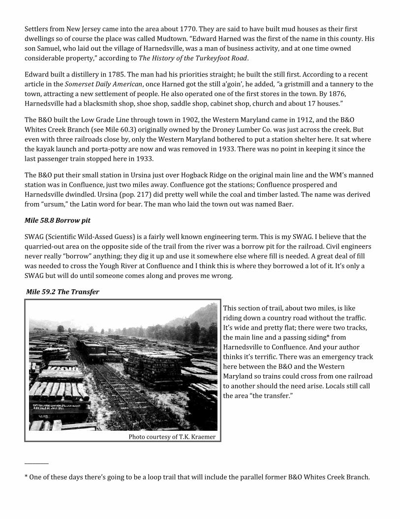
Mile 59.2 The Transfer
This section of trail, about two miles, is like
riding down a country road without the traffic.
It’s wide and pretty flat; there were two tracks,
the main line and a passing siding* from
Harnedsville to Confluence. And your author
thinks it’s terrific. There was an emergency track
here between the B&O and the Western
Maryland so trains could cross from one railroad
to another should the need arise. Locals still call
the area “the transfer.”
_________
* One of these days there’s going to be a loop trail that will include the parallel former B&O Whites Creek Branch.
Photo courtesy of T.K. Kraemer
During the railroad’s construction this was a material storage area. Both Somerset County and the Western
Pennsylvania Conservancy now own the properties through here.
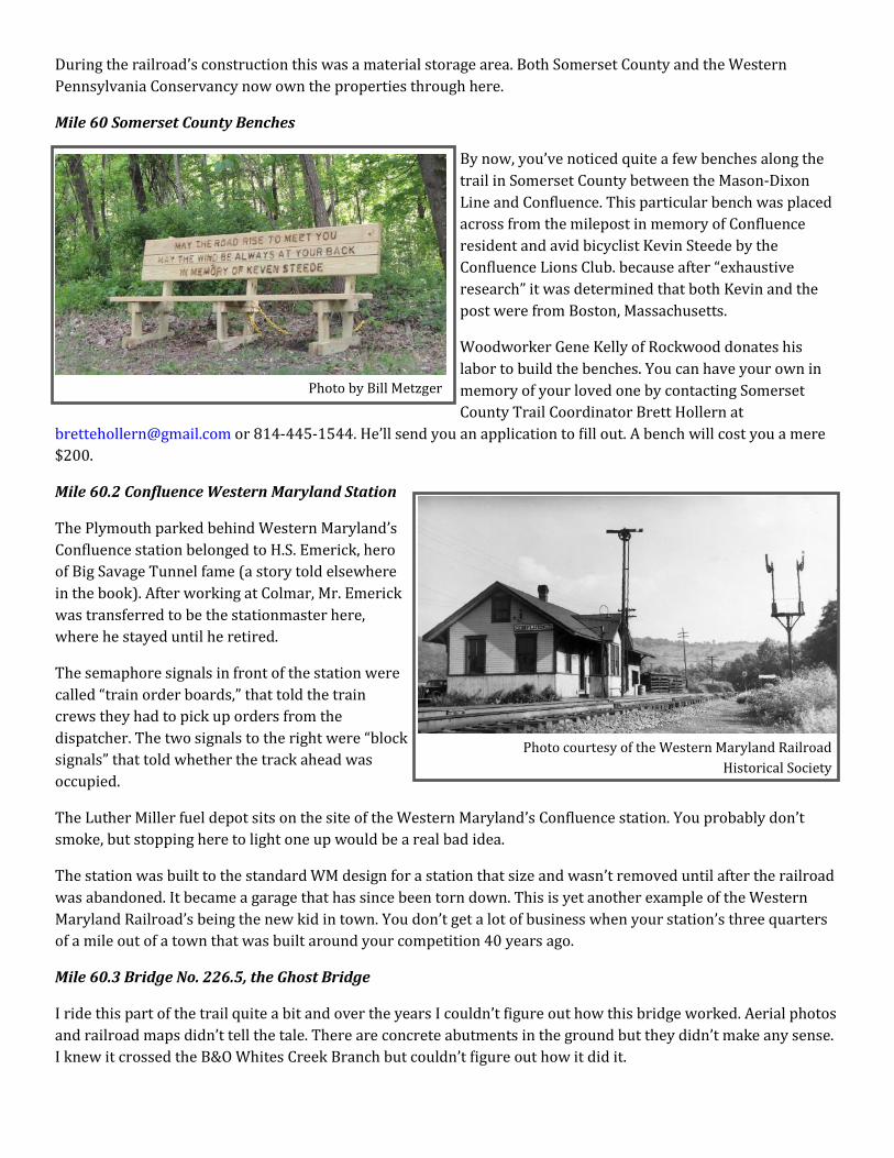
Mile 60 Somerset County Benches
By now, you’ve noticed quite a few benches along the
trail in Somerset County between the Mason-Dixon
Line and Confluence. This particular bench was placed
across from the milepost in memory of Confluence
resident and avid bicyclist Kevin Steede by the
Confluence Lions Club. because after “exhaustive
research” it was determined that both Kevin and the
post were from Boston, Massachusetts.
Woodworker Gene Kelly of Rockwood donates his
labor to build the benches. You can have your own in
memory of your loved one by contacting Somerset
County Trail Coordinator Brett Hollern at
[email protected] or 814-445-1544. He’ll send you an application to fill out. A bench will cost you a mere
$200.
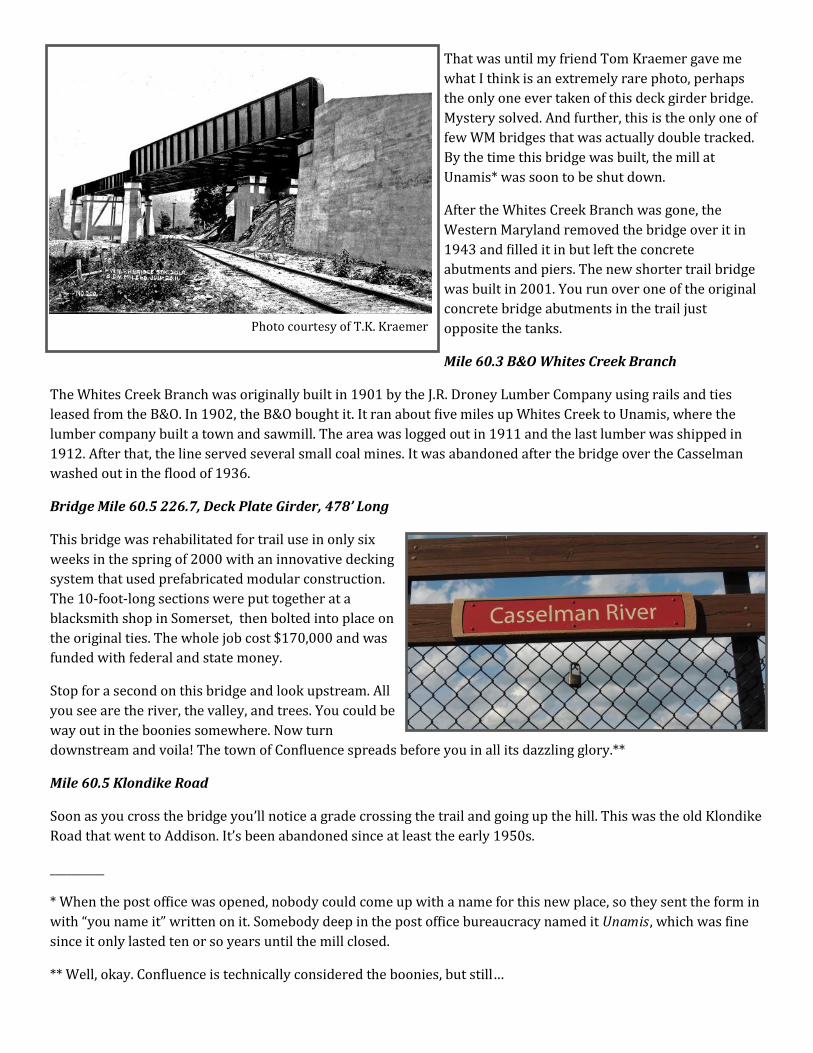
Mile 60.2 Confluence Western Maryland Station
The Plymouth parked behind Western Maryland’s
Confluence station belonged to H.S. Emerick, hero
of Big Savage Tunnel fame (a story told elsewhere
in the book). After working at Colmar, Mr. Emerick
was transferred to be the stationmaster here,
where he stayed until he retired.
The semaphore signals in front of the station were
called “train order boards,” that told the train
crews they had to pick up orders from the
dispatcher. The two signals to the right were “block
signals” that told whether the track ahead was
occupied.
The Luther Miller fuel depot sits on the site of the Western Maryland’s Confluence station. You probably don’t
smoke, but stopping here to light one up would be a real bad idea.
The station was built to the standard WM design for a station that size and wasn’t removed until after the railroad
was abandoned. It became a garage that has since been torn down. This is yet another example of the Western
Maryland Railroad’s being the new kid in town. You don’t get a lot of business when your station’s three quarters
of a mile out of a town that was built around your competition 40 years ago.
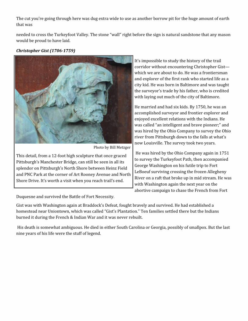
Mile 60.3 Bridge No. 226.5, the Ghost Bridge
I ride this part of the trail quite a bit and over the years I couldn’t figure out how this bridge worked. Aerial photos
and railroad maps didn’t tell the tale. There are concrete abutments in the ground but they didn’t make any sense.
I knew it crossed the B&O Whites Creek Branch but couldn’t figure out how it did it.
Photo by Bill Metzger
Photo courtesy of the Western Maryland Railroad
Historical Society
That was until my friend Tom Kraemer gave me
what I think is an extremely rare photo, perhaps
the only one ever taken of this deck girder bridge.
Mystery solved. And further, this is the only one of
few WM bridges that was actually double tracked.
By the time this bridge was built, the mill at
Unamis* was soon to be shut down.
After the Whites Creek Branch was gone, the
Western Maryland removed the bridge over it in
1943 and filled it in but left the concrete
abutments and piers. The new shorter trail bridge
was built in 2001. You run over one of the original
concrete bridge abutments in the trail just
opposite the tanks.
Mile 60.3 B&O Whites Creek Branch
The Whites Creek Branch was originally built in 1901 by the J.R. Droney Lumber Company using rails and ties
leased from the B&O. In 1902, the B&O bought it. It ran about five miles up Whites Creek to Unamis, where the
lumber company built a town and sawmill. The area was logged out in 1911 and the last lumber was shipped in
1912. After that, the line served several small coal mines. It was abandoned after the bridge over the Casselman
washed out in the flood of 1936.
Bridge Mile 60.5 226.7, Deck Plate Girder, 478’ Long
This bridge was rehabilitated for trail use in only six
weeks in the spring of 2000 with an innovative decking
system that used prefabricated modular construction.
The 10‑foot‑long sections were put together at a
blacksmith shop in Somerset, then bolted into place on
the original ties. The whole job cost $170,000 and was
funded with federal and state money.
Stop for a second on this bridge and look upstream. All
you see are the river, the valley, and trees. You could be
way out in the boonies somewhere. Now turn
downstream and voila! The town of Confluence spreads before you in all its dazzling glory.**
Mile 60.5 Klondike Road
Soon as you cross the bridge you’ll notice a grade crossing the trail and going up the hill. This was the old Klondike
Road that went to Addison. It’s been abandoned since at least the early 1950s.
__________
* When the post office was opened, nobody could come up with a name for this new place, so they sent the form in
with “you name it” written on it. Somebody deep in the post office bureaucracy named it Unamis, which was fine
since it only lasted ten or so years until the mill closed.
** Well, okay. Confluence is technically considered the boonies, but still…
Photo courtesy of T.K. Kraemer
The cut you’re going through here was dug extra wide to use as another borrow pit for the huge amount of earth
that was
needed to cross the Turkeyfoot Valley. The stone “wall” right before the sign is natural sandstone that any mason
would be proud to have laid.
Christopher Gist (1706-1759)
It’s impossible to study the history of the trail
corridor without encountering Christopher Gist—
which we are about to do. He was a frontiersman
and explorer of the first rank who started life as a
city kid. He was born in Baltimore and was taught
the surveyor’s trade by his father, who is credited
with laying out much of the city of Baltimore.
He married and had six kids. By 1750, he was an
accomplished surveyor and frontier explorer and
enjoyed excellent relations with the Indians. He
was called “an intelligent and brave pioneer;” and
was hired by the Ohio Company to survey the Ohio
river from Pittsburgh down to the falls at what’s
now Louisville. The survey took two years.
He was hired by the Ohio Company again in 1751
to survey the Turkeyfoot Path, then accompanied
George Washington on his futile trip to Fort
LeBoeuf surviving crossing the frozen Allegheny
River on a raft that broke up in mid stream. He was
with Washington again the next year on the
abortive campaign to chase the French from Fort
Duquesne and survived the Battle of Fort Necessity.
Gist was with Washington again at Braddock’s Defeat, fought bravely and survived. He had established a
homestead near Uniontown, which was called “Gist’s Plantation.” Ten families settled there but the Indians
burned it during the French & Indian War and it was never rebuilt.
His death is somewhat ambiguous. He died in either South Carolina or Georgia, possibly of smallpox. But the last
nine years of his life were the stuff of legend.
Photo by Bill Metzger
This detail, from a 12-foot high sculpture that once graced
Pittsburgh’s Manchester Bridge, can still be seen in all its
splendor on Pittsburgh’s North Shore between Heinz Field
and PNC Park at the corner of Art Rooney Avenue and North
Shore Drive. It’s worth a visit when you reach trail’s end.

Mile 60.7 Confluence, Population 759
AUTHOR’S NOTE: Everybody who writes about Confluence says it’s “nestled in the mountains.” So I will too.
Confluence is nestled in the mountains. On June 26,
1871, the Pittsburgh and Connellsville Railroad
from Cumberland to Pittsburgh was completed; the
line from Cumberland met the line from Pittsburgh
at Fort Hill. The celebration was held in Confluence
(CON‑flu-ens). One hundred and thirty years later,
on August 24, 2001, the section connecting the first
100 miles of the Great Allegheny Passage was
opened between Confluence and Fort Hill.
Repeating history, a two-day celebration was held
here.
The word “confluence” is defined as “a coming
together.” The town is well named. The Yough and
Casselman Rivers and Laurel Hill Creek join here.
Christopher Gist is said to have given it the name
Turkeyfoot because the three streams flowing into
one resembled a turkey’s foot when viewed from
up on the surrounding hills. It’s more likely that
Gist was the first to call it the Turkeyfoot in English,
having learned the name from the area’s Native Americans. Several of their settlements were located in the area,
but most had left by the time Gist got here. It was also called Crow Foot. Whatever the bird in question, a look at
the map shows that said fowl had really crooked toes.
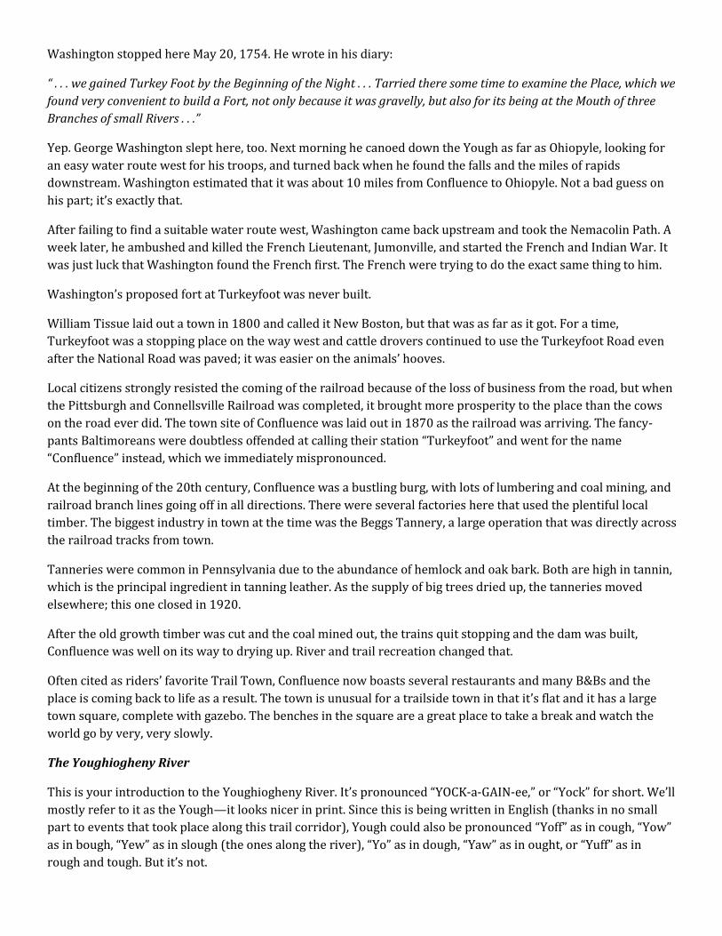
Aerial view of Confluence, Yough Lake, and the way east Photo by Bill Metzger
Photo by Bill Metzger
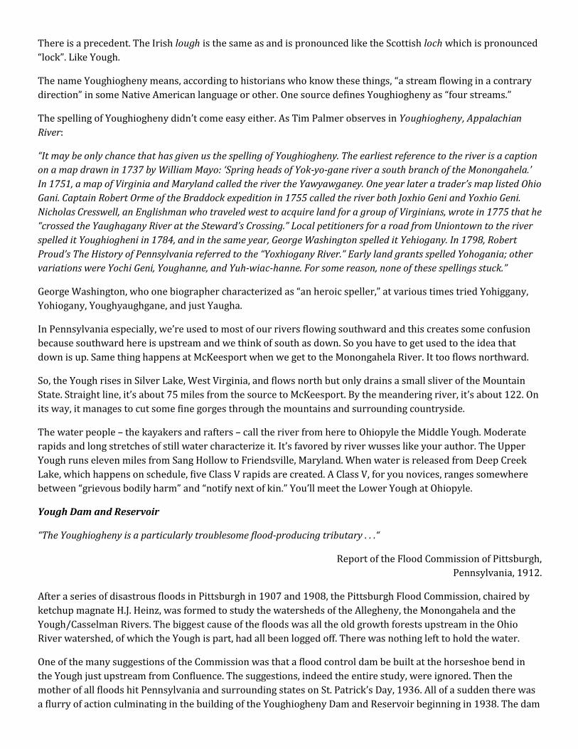
Sometimes time stands still in Confluence. Such was the
case when this military re-enacter band played in the
gazebo just like countless other bands who have
entertained folks here for more than a century.
Washington stopped here May 20, 1754. He wrote in his diary:
“ . . . we gained Turkey Foot by the Beginning of the Night . . . Tarried there some time to examine the Place, which we
found very convenient to build a Fort, not only because it was gravelly, but also for its being at the Mouth of three
Branches of small Rivers . . .”
Yep. George Washington slept here, too. Next morning he canoed down the Yough as far as Ohiopyle, looking for
an easy water route west for his troops, and turned back when he found the falls and the miles of rapids
downstream. Washington estimated that it was about 10 miles from Confluence to Ohiopyle. Not a bad guess on
his part; it’s exactly that.
After failing to find a suitable water route west, Washington came back upstream and took the Nemacolin Path. A
week later, he ambushed and killed the French Lieutenant, Jumonville, and started the French and Indian War. It
was just luck that Washington found the French first. The French were trying to do the exact same thing to him.
Washington’s proposed fort at Turkeyfoot was never built.
William Tissue laid out a town in 1800 and called it New Boston, but that was as far as it got. For a time,
Turkeyfoot was a stopping place on the way west and cattle drovers continued to use the Turkeyfoot Road even
after the National Road was paved; it was easier on the animals’ hooves.
Local citizens strongly resisted the coming of the railroad because of the loss of business from the road, but when
the Pittsburgh and Connellsville Railroad was completed, it brought more prosperity to the place than the cows
on the road ever did. The town site of Confluence was laid out in 1870 as the railroad was arriving. The fancy-
pants Baltimoreans were doubtless offended at calling their station “Turkeyfoot” and went for the name
“Confluence” instead, which we immediately mispronounced.
At the beginning of the 20th century, Confluence was a bustling burg, with lots of lumbering and coal mining, and
railroad branch lines going off in all directions. There were several factories here that used the plentiful local
timber. The biggest industry in town at the time was the Beggs Tannery, a large operation that was directly across
the railroad tracks from town.
Tanneries were common in Pennsylvania due to the abundance of hemlock and oak bark. Both are high in tannin,
which is the principal ingredient in tanning leather. As the supply of big trees dried up, the tanneries moved
elsewhere; this one closed in 1920.
After the old growth timber was cut and the coal mined out, the trains quit stopping and the dam was built,
Confluence was well on its way to drying up. River and trail recreation changed that.
Often cited as riders’ favorite Trail Town, Confluence now boasts several restaurants and many B&Bs and the
place is coming back to life as a result. The town is unusual for a trailside town in that it’s flat and it has a large
town square, complete with gazebo. The benches in the square are a great place to take a break and watch the
world go by very, very slowly.
The Youghiogheny River
This is your introduction to the Youghiogheny River. It’s pronounced “YOCK‑a‑GAIN‑ee,” or “Yock” for short. We’ll
mostly refer to it as the Yough—it looks nicer in print. Since this is being written in English (thanks in no small
part to events that took place along this trail corridor), Yough could also be pronounced “Yoff” as in cough, “Yow”
as in bough, “Yew” as in slough (the ones along the river), “Yo” as in dough, “Yaw” as in ought, or “Yuff” as in
rough and tough. But it’s not.
There is a precedent. The Irish lough is the same as and is pronounced like the Scottish loch which is pronounced
“lock”. Like Yough.
The name Youghiogheny means, according to historians who know these things, “a stream flowing in a contrary
direction” in some Native American language or other. One source defines Youghiogheny as “four streams.”
The spelling of Youghiogheny didn’t come easy either. As Tim Palmer observes in Youghiogheny, Appalachian
River:
“It may be only chance that has given us the spelling of Youghiogheny. The earliest reference to the river is a caption
on a map drawn in 1737 by William Mayo: ‘Spring heads of Yok‑yo‑gane river a south branch of the Monongahela.’
In 1751, a map of Virginia and Maryland called the river the Yawyawganey. One year later a trader’s map listed Ohio
Gani. Captain Robert Orme of the Braddock expedition in 1755 called the river both Joxhio Geni and Yoxhio Geni.
Nicholas Cresswell, an Englishman who traveled west to acquire land for a group of Virginians, wrote in 1775 that he
“crossed the Yaughagany River at the Steward’s Crossing.” Local petitioners for a road from Uniontown to the river
spelled it Youghiogheni in 1784, and in the same year, George Washington spelled it Yehiogany. In 1798, Robert
Proud’s The History of Pennsylvania referred to the “Yoxhiogany River.” Early land grants spelled Yohogania; other
variations were Yochi Geni, Youghanne, and Yuh‑wiac‑hanne. For some reason, none of these spellings stuck.”
George Washington, who one biographer characterized as “an heroic speller,” at various times tried Yohiggany,
Yohiogany, Youghyaughgane, and just Yaugha.
In Pennsylvania especially, we’re used to most of our rivers flowing southward and this creates some confusion
because southward here is upstream and we think of south as down. So you have to get used to the idea that
down is up. Same thing happens at McKeesport when we get to the Monongahela River. It too flows northward.
So, the Yough rises in Silver Lake, West Virginia, and flows north but only drains a small sliver of the Mountain
State. Straight line, it’s about 75 miles from the source to McKeesport. By the meandering river, it’s about 122. On
its way, it manages to cut some fine gorges through the mountains and surrounding countryside.
The water people – the kayakers and rafters – call the river from here to Ohiopyle the Middle Yough. Moderate
rapids and long stretches of still water characterize it. It’s favored by river wusses like your author. The Upper
Yough runs eleven miles from Sang Hollow to Friendsville, Maryland. When water is released from Deep Creek
Lake, which happens on schedule, five Class V rapids are created. A Class V, for you novices, ranges somewhere
between “grievous bodily harm” and “notify next of kin.” You’ll meet the Lower Yough at Ohiopyle.
Yough Dam and Reservoir
“The Youghiogheny is a particularly troublesome flood‑producing tributary . . .“
Report of the Flood Commission of Pittsburgh,
Pennsylvania, 1912.
After a series of disastrous floods in Pittsburgh in 1907 and 1908, the Pittsburgh Flood Commission, chaired by
ketchup magnate H.J. Heinz, was formed to study the watersheds of the Allegheny, the Monongahela and the
Yough/Casselman Rivers. The biggest cause of the floods was all the old growth forests upstream in the Ohio
River watershed, of which the Yough is part, had all been logged off. There was nothing left to hold the water.
One of the many suggestions of the Commission was that a flood control dam be built at the horseshoe bend in
the Yough just upstream from Confluence. The suggestions, indeed the entire study, were ignored. Then the
mother of all floods hit Pennsylvania and surrounding states on St. Patrick’s Day, 1936. All of a sudden there was
a flurry of action culminating in the building of the Youghiogheny Dam and Reservoir beginning in 1938. The dam
was officially completed in 1943 and is 184 feet high, 1,100 feet wide at the base, and 1,160 feet long at the top. It
is built of 3,060,500 cubic yards of concrete, stone, and earth and backs up a lake 14 miles long down into
Maryland.
The 12-megawatt hydroelectric plant generates electricity that goes out on the power grid. It’s enough to power
14,400 of those average homes you hear about. Youghiogheny Hydroelectric Authority owns the plant and it’s
operated by D/R Hydro Co. It went into operation in 1989 after costing $19 million to build.
The dam makes the river cleaner because silt coming downstream settles out into the upper lake, which of course,
is filling up. The dam also makes the river really cold because they draw the water off the bottom at a
temperature of around 52 degrees Fahrenheit, which makes Confluence very foggy. Because of the dam, a flood at
Pittsburgh will be but six inches lower. But the big benefit of the dam, as far as recreation is concerned, is that it
keeps the downstream river levels high enough for boating and fishing.
Operators at the dam maintain the water level, but they get their orders from the US Army Corps of Engineers
District Office in Pittsburgh. Each flood control dam in the district sends in a daily morning report that includes
rainfall, stream flow based on gauges in each river, and the lake level. The district then tells each dam what the
flow should be based on the optimum lake level for the time of the year and down‑stream needs. The Corps works
closely with Ohiopyle State Park and their needs for water not only for daily recreation but also for special events.
Yough Dam is the second hydro dam on the Yough. Upstream, the Deep Creek Hydro plant has two generators
built in 1925 that generate 20 megawatts.
If you’re feeling frisky and want to ride up to see the dam - you can ride or drive across it - there’s a visitor’s
center of sorts at the top of dam with a real restroom, picnic tables, and brochures and a swimming beach on the
other side of the lake. If you feel going swimming, be advised it’s a pretty steep climb afterwards back up to the
dam, which pretty much cancels out the cooling effects of your swim.
Outflow Campground
In a choice between camping her and at Ohiopyle, camp here. First, it’s at the same level as the trail. You don’t
have to climb a mountain to get there. Second, the restrooms are excellent with fine showers. Third, it’s close to
Confluence and all its services. And last and most important, they have hiker- and biker-only campsites for less
than ten bucks a pop. Is that a great deal or what?
Mile 61 Old Route 281 Bridge
The nifty pedestrian bridge you’re crossing here didn’t always look this way. It was originally a steel truss bridge
that carried Route 281. It had an open grate steel deck that scared the bejeezus out of bikers (including your
author) and was slated to be demolished when the new bridge, the one upstream from here, was put into service.
The superstructure was seriously deteriorated and everything pointed to tearing it down. But the borough (that’s
what we call a town in Pennsylvania) of Confluence wanted to keep it open for trail use because of the heavy bike
traffic that comes into town.
PennDOT did a safety analysis and it turned out to be cheaper to save the bridge than to tear it down. Girders that
had been placed under the bridge in the 1930s to strengthen it were actually the only things holding it up. The
girders needed to be repainted but were otherwise in fine shape. With a $200,000 grant, the superstructure and
offending steel deck were torn off, the bridge was re-decked and observation platforms with benches were added.
All in all, it’s a vast improvement over the old bridge. The builder’s plates for the original bridge, which was built
by the King Iron Bridge Co. of Cleveland in 1896, are embedded in the stone walls at each end.
It was re-decked again in 2016 by volunteers from the Confluence Tourism Association and a funding campaign is
underway as of this writing to replace the temporary wooden decking with permanent concrete. Contact Brad
Smith at the Confluence Cyclery to help make this happen.
When you cross this bridge, you leave Somerset County and enter Fayette County. You’ve entered the
Youghiogheny Trail South, owned and operated by Ohiopyle State Park from here to Connellsville. Or you can turn
left and take a side trip on the trail up to the Outflow Campground and take a look at the dam. It’s an impressive
pile of rocks.
Local volunteers keep the flower beds at each end of the bridge looking sharp and there’s a visitors booth on the
Fayette County side, where our well-informed local “Town Criers” will tell you all you need to know and maybe
even a little more. Our kids are good.
Mile 61.2 Bridge No. 227.2, Deck Plate Girder Bridge, 715’ Long
This is the only former Western Maryland bridge that’s not being used by the trail. In 1975, within days after this
section of the Western Maryland was abandoned, PennDOT removed the eastern two spans of this bridge on the
Confluence side to improve highway clearances. River Road was Route 281 then, before the bypass was built. The
Pennsylvania Department of Conservation and Natural Resources made a deal with the Turkeyfoot Fish and Game
Club to swap property—the original right of way ran right through the club—and the railroad bridge was
bypassed. And there it rustily sits and probably will for a long, long time.
The murals on the bridge pier and abutment were part of a Community Co-op Art Project. They were designed by
professional printmaker Eddie Maier of Morgantown, West Virginia, who also did the outlines, sort of like a giant
paint by numbers project that was filled in by kids from the community.
Mile 61.2 Confluence & Oakland Railroad
The section of trail from here to the ramp up to the overlook is built on the grade of the Confluence & Oakland
Railroad, once a branch of the Baltimore & Ohio. This C&O also had no relation with the C&O Canal or the C&O
Railroad, former owner of the caboose at Meyersdale. This line was built in 1890 and connected with the B&O
main line across the river. It ran 20 miles south to Kendall, Maryland and seldom if ever operated more than one
train a train a day down and back. It never quite got to Oakland, Maryland, another 20 or so miles upstream. The
southern end of the line was abandoned in 1941 in anticipation of the building of the Yough Dam. The northern
two or so miles were used to bring materials for the dam’s construction. The bridge that crossed the river here
was removed without a trace in 1960 after debris backed up behind it and caused flooding. Much of the grade of
the Confluence & Oakland is now on the bottom of the Yough Lake but three miles of the old line are now a hiking
rail trail south of Friendsville, Maryland.
Weather in the Gorge
“Since Laurel Ridge is oriented at right‑angles to approaching weather systems, it forces the prevailing westerly
airflows upward. As the rising air cools, the moisture it contains can condense. If the level of moisture reaches the
saturation point, precipitation results. Additionally, the mountain can act as a barrier and slow the movement of
storms, prolonging their impact on the local area.”
A Hiker’s Guide to the Laurel Highlands Trail, Sierra Club, Pennsylvania Chapter.
What this means to you is that if it’s going to rain here, chances are it’s going to rain harder and longer than every
place else. The other problem is the mountains often block the radar so it can be raining like a cow peeing on a flat
rock here and it won’t show up on the radar.