Embed Size (px)
Citation preview

Damage, Loss and Preliminary Needs Assessment
1
CHAPTER I
THE WEST SUMATRA EARTHQUAKE

Damage, Loss and Preliminary Needs Assessment
2
1.1 THE WEST SUMATRA EARTHQUAKE
A magnitude (Mw) 7.6 earthquake struck West Sumatra on 30 September 2009 at 5.16 pm local time, with an epicentre at a depth of 71 kilometers according to the Indonesian Meterological, Climotological and Geophysical Agency (BMKG).2 The epicentre was reported at 57 kilometers off the coast northwest of Pariaman at 0.84 longitude and 99.65 lattitude. A major Mw 6.2 aftershock occurred at 5.38 pm, with an epicentre at a depth of 110 kilometers and located at 0.72 longitude and 99.94 lattitude. A summary of the earthquake‘s locational information is provided in Map 1.1 produced by the Indonesian Volcanological and Geological Disaster Mitigation Center.
Map 1. 1 Epicenter of the West Sumatra earthquake, 30 September 2009
96,0¡ BT
97,0¡ BT
2,0¡ LU
2.0¡ LS
505050505050505050
25
2,0¡ LU
103,0¡ BT
50
Antiklin
Pusat gempabumi BMKG
Sesar mendatar tidak aktif
Kontur kedalaman zona benioff
Keterangan:
0 60
kilometers
Zona penunjaman
Sesar mendatar aktif
120
PETA PUSAT GEMPABUMI PADANG
30 SEPTEMBER 2009
103,0¡ BT
3.0¡ LS
DEPARTEMEN ENERGI DAN SUMBER DAYA MINERALDEPARTEMEN ENERGI DAN SUMBER DAYA MINERALDEPARTEMEN ENERGI DAN SUMBER DAYA MINERALDEPARTEMEN ENERGI DAN SUMBER DAYA MINERALDEPARTEMEN ENERGI DAN SUMBER DAYA MINERALDEPAR TEMEN ENERGI DAN SUMBER DAYA MINERALDEPAR TEMEN ENERGI DAN SUMBER DAYA MINERALDEPAR TEMEN ENERGI DAN SUMBER DAYA MINERALDEPARTEMEN ENERGI DAN SUMBER DAYA MINERALBADAN GEOLOGIBADAN GEOLOGIBADAN GEOLOGIBADAN GEOLOGIBADAN GEOLOGIBAD AN GEOLOGIBAD AN GEOLOGIBAD AN GEOLOGIBADAN GEOLOGI
PUSAT VULKANOLOGI DAN MITIGASI BENC ANA GEOLOGIPUSAT VULKANOLOGI DAN MITIGASI BENC ANA GEOLOGIPUSAT VULKANOLOGI DAN MITIGASI BENC ANA GEOLOGIPUSAT VULKANOLOGI DAN MITIGASI BENCANA GEOLOGIPUSAT VULKANOLOGI DAN MITIGASI BENCANA GEOLOGIPUSAT VULKANOLOGI DAN MITIGASI BENCANA GEOLOGIPUSAT VULKANOLOGI DAN MITIGASI BENCANA GEOLOGIPUSAT VULKANOLOGI DAN MITIGASI BENCANA GEOLOGIPUSAT VULKANOLOGI DAN MITIGASI BENCANA GEOLOGI
Pusat gempabumi USGS
NatalNatalNatalNatalNatalNatalNatalNatalNatal
PadangPadangPadangPadangPadangPadangPadangPadangPadang
PariamanPariamanPariamanPariamanPariamanPariamanPariamanPariamanPariaman SawahluntoSawahluntoSawahluntoSawahluntoSawahluntoSawahluntoSawahluntoSawahluntoSawahlunto
BangkinangBangkinangBangkinangBangkinangBangkinangBangkinangBangkinangBangkinangBangkinang
LUBUKSIKAPINGLUBUKSIKAPINGLUBUKSIKAPINGLUBUKSIKAPINGLUBUKSIKAPINGLUBUKSIKAPINGLUBUKSIKAPINGLUBUKSIKAPINGLUBUKSIKAPING
PayakumbuhPayakumbuhPayakumbuhPayakumbuhPayakumbuhPayakumbuhPayakumbuhPayakumbuhPayakumbuh
AirhajiAirhajiAirhajiAirhajiAirhajiAirhajiAirhajiAirhajiAirhaji
DUMAIDUMAIDUMAIDUMAIDUMAIDUMAIDUMAIDUMAIDUMAI
BengkalisBengkalisBengkalisBengkalisBengkalisBengkalisBengkalisBengkalisBengkalis
MUARA BUNGOMUARA BUNGOMUARA BUNGOMUARA BUNGOMUARA BUNGOMUARA BUNGOMUARA BUNGOMUARA BUNGOMUARA BUNGO
RanjaupanjangRanjaupanjangRanjaupanjangRanjaupanjangRanjaupanjangRanjaupanjangRanjaupanjangRanjaupanjangRanjaupanjang
SIBOLGASIBOLGASIBOLGASIBOLGASIBOLGASIBOLGASIBOLGASIBOLGASIBOLGA
PadangsidempuanPadangsidempuanPadangsidempuanPadangsidempuanPadangsidempuanPadangsidempuanPadangsidempuanPadangsidempuanPadangsidempuan
PainanPainanPainanPainanPainanPainanPainanPainanPainan
PekanbaruPekanbaruPekanbaruPekanbaruPekanbaruPekanbaruPekanbaruPekanbaruPekanbaruTelukdalamTelukdalamTelukdalamTelukdalamTelukdalamTelukdalamTelukdalamTelukdalamTelukdalam
OnolimbuOnolimbuOnolimbuOnolimbuOnolimbuOnolimbuOnolimbuOnolimbuOnolimbu
LahusaLahusaLahusaLahusaLahusaLahusaLahusaLahusaLahusa
OloraOloraOloraOloraOloraOloraOloraOloraOlora
KatietKatietKatietKatietKatietKatietKatietKatietKatiet
SaumanganyaSaumanganyaSaumanganyaSaumanganyaSaumanganyaSaumanganyaSaumanganyaSaumanganyaSaumanganya
SigoisooinanSigoisooinanSigoisooinanSigoisooinanSigoisooinanSigoisooinanSigoisooinanSigoisooinanSigoisooinan
MuarasigepMuarasigepMuarasigepMuarasigepMuarasigepMuarasigepMuarasigepMuarasigepMuarasigep
TasirirekrekTasirirekrekTasirirekrekTasirirekrekTasirirekrekTasirirekrekTasirirekrekTasirirekrekTasirirekrek
Source: Volcanological Survey of Indonesia (http://vsi.esdm.go.id)
2 The U.S. Geological Survey (USGS) reported Mw 7.6 at the depth of 85 kilometers. Mw refers to the moment magnitude scale.
Damage, Loss and Preliminary Needs Assessment
3
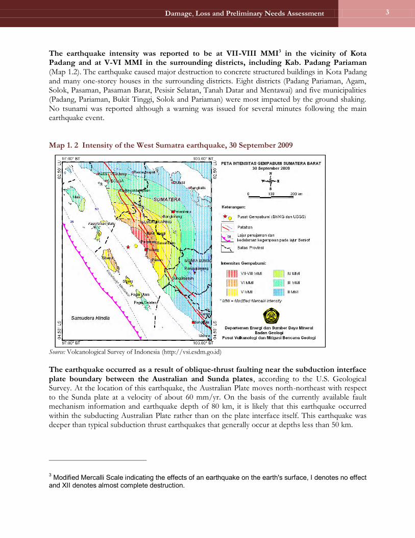
The earthquake intensity was reported to be at VII-VIII MMI3 in the vicinity of Kota Padang and at V-VI MMI in the surrounding districts, including Kab. Padang Pariaman (Map 1.2). The earthquake caused major destruction to concrete structured buildings in Kota Padang and many one-storey houses in the surrounding districts. Eight districts (Padang Pariaman, Agam, Solok, Pasaman, Pasaman Barat, Pesisir Selatan, Tanah Datar and Mentawai) and five municipalities (Padang, Pariaman, Bukit Tinggi, Solok and Pariaman) were most impacted by the ground shaking. No tsunami was reported although a warning was issued for several minutes following the main earthquake event.
Map 1. 2 Intensity of the West Sumatra earthquake, 30 September 2009
Source: Volcanological Survey of Indonesia (http://vsi.esdm.go.id) The earthquake occurred as a result of oblique-thrust faulting near the subduction interface plate boundary between the Australian and Sunda plates, according to the U.S. Geological Survey. At the location of this earthquake, the Australian Plate moves north-northeast with respect to the Sunda plate at a velocity of about 60 mm/yr. On the basis of the currently available fault mechanism information and earthquake depth of 80 km, it is likely that this earthquake occurred within the subducting Australian Plate rather than on the plate interface itself. This earthquake was deeper than typical subduction thrust earthquakes that generally occur at depths less than 50 km.
3 Modified Mercalli Scale indicating the effects of an earthquake on the earth's surface, I denotes no effect and XII denotes almost complete destruction.

Damage, Loss and Preliminary Needs Assessment
4
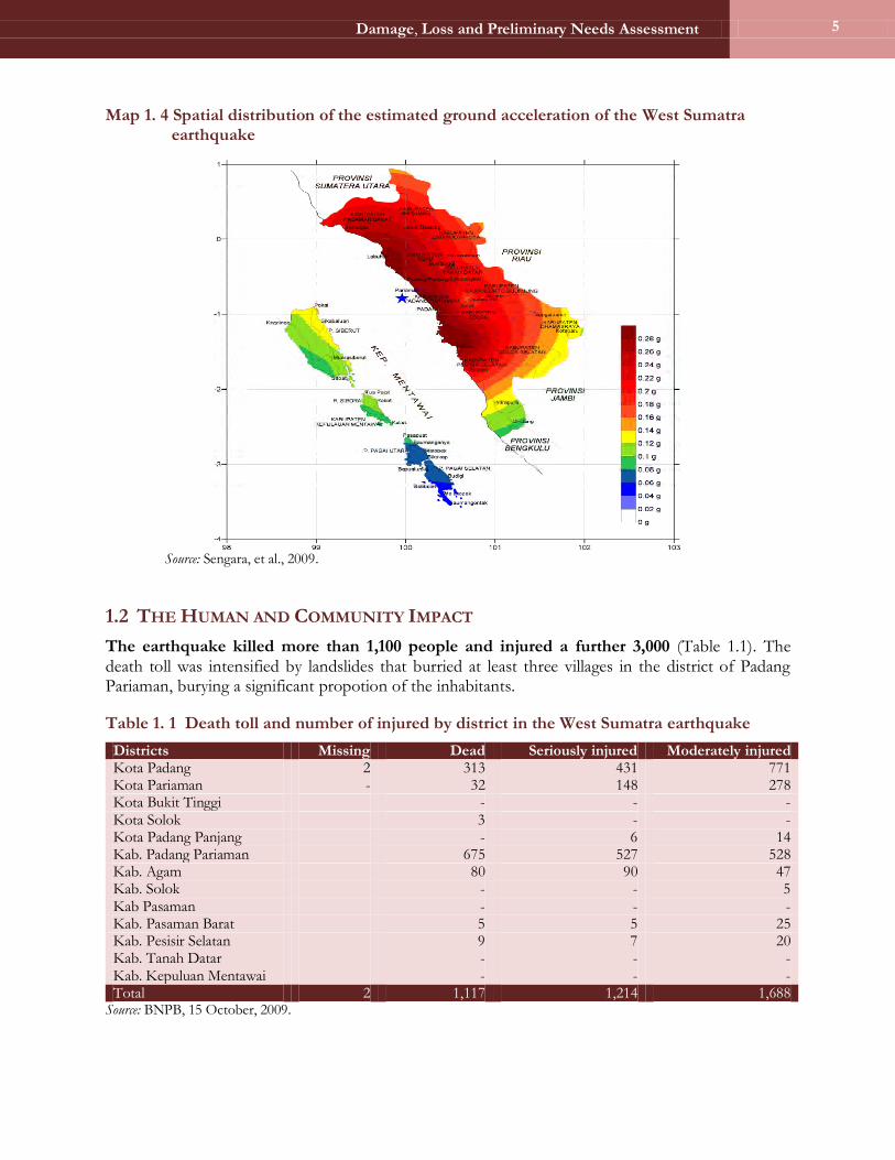
Preliminary analysis of the earthquake characteristics by the Center for Disaster Mitigation at the Bandung Institute of Technology (ITB) suggests that the hypocenter of the 30 September earthquake was located at the Benioff zone of the subduction between the Indo-Australian and Eurasian plates, as shown in the lateral profile of the tomography of the subduction (Figure 1.1). Based on preliminary calculations, the earthquake propagation may have produced peak ground acceleration at the bedrock reaching 0.25-0.3g.4 With the spatial variability of the local geological and geotechnical characteristics of Kota Padang and Kab. Padang Pariaman, the seismic amplifications in these locations are estimated to be in the range of 1.2-1.5g, which could have produced a relatively high ground acceleration in the range of 0.3-0.35g. The estimated spatial distribution of the ground acceleration of the 30 September 2009 earthquake is shown in Figure 1 below. Map 1. 3 Profile of 1-1‟ of the epicenter the location of the West Sumatra earthquake
Source: Sengara and Widiantoro, 2009.
4 Center for Disaster Mitigation, ITB, 2009.
Damage, Loss and Preliminary Needs Assessment
5
Map 1. 4 Spatial distribution of the estimated ground acceleration of the West Sumatra earthquake
Source: Sengara, et al., 2009.
1.2 THE HUMAN AND COMMUNITY IMPACT
The earthquake killed more than 1,100 people and injured a further 3,000 (Table 1.1). The death toll was intensified by landslides that burried at least three villages in the district of Padang Pariaman, burying a significant propotion of the inhabitants.
Table 1. 1 Death toll and number of injured by district in the West Sumatra earthquake
Districts Missing Dead Seriously injured Moderately injured Kota Padang 2 313 431 771 Kota Pariaman - 32 148 278 Kota Bukit Tinggi - - - Kota Solok 3 - - Kota Padang Panjang - 6 14 Kab. Padang Pariaman 675 527 528 Kab. Agam 80 90 47 Kab. Solok - - 5 Kab Pasaman - - - Kab. Pasaman Barat 5 5 25 Kab. Pesisir Selatan 9 7 20 Kab. Tanah Datar - - - Kab. Kepuluan Mentawai - - - Total 2 1,117 1,214 1,688
Source: BNPB, 15 October, 2009.

Damage, Loss and Preliminary Needs Assessment
6
The West Sumatra earthquake caused damage in 13 districts. These districts are Kota Padang, Kota Pariaman, Kota Bukit Tinggi, Kota Solok, Kota Padang Panjang, Kab. Pariaman, Kab. Agam, Kab. Solok, Kab. Pasaman, Kab. Pasaman Barat, Kab. Pesisir Selatan, Kab. Tanah Datar and Kab. Kepulauan Mentawai. The subsequent 1 October 2009 earthquake caused damage in Kab. Kerinci and Kab. Merangin in the province of Jambi. The six worst affected districts are Kota Padang, Kab. Pasaman Barat, Kab. Agam, Kab. Padang Pariaman, Kota Pariaman, and Kab. Pesisir Selatan.
More than 15 days after the earthquake, access to some rural areas remained challening due to extensive debris or landslides. The ability of local government agencies to operate was crippled and in some instances paralyzed due to the destruction or heavy damage to their operational capacity and office facilities, including furniture, equipment and vital records. Heavy damage was incurred in urban/semi-urban districts/municipalities including KotaPadang (population: 777,893), Kota Pariaman (population: 338,098) and in Kab. Padang Pariaman (population: 78,920).
Map 1. 5 Density of people killed by the disasters

Damage, Loss and Preliminary Needs Assessment
7
Map 1. 6 Density of people suffering severe injures

Damage, Loss and Preliminary Needs Assessment
8
Map 1. 7 Density of people suffering minor injures
1.3 THE RESPONSE
The Government of Indonesia responded immediately to the emergency. The Government declared a one-month emergency phase and indicated that it welcomed international assistance under close national coordination. President Susilo Bambang Yudhoyono visited West Sumatra in the immediate aftermath of the earthquake, as did Vice-President Jusuf Kalla and a number of senior government ministers. The Government provided an initial emergency relief fund of Rp 100 billion (about US$10.6 million), and indicated that up to Rp 6 trillion (about US$640 million) could be forthcoming. The Government provided tents, blankets and food, as well as medical personnel, emergency clean water facilities and toilets during its immediate response. It established an Emergency Coordination Post to facilitate extra commercial flights for numerous humanitarian workers entering the affected areas. The armed forces were also engaged in Search and Rescue Operations and provided air transportation to deliver relief aid, among other activities. National partners, including the Indonesian Red Cross, engaged immediately in emergency response efforts. The Government also initiated a process through the UN Early Recovery Cluster to undertake a

Damage, Loss and Preliminary Needs Assessment
9
Human Recovery Needs Assessment (HRNA). A local NGO, Kogami, is the UN partner working through about 120 field enumerators from Andalas University to assess the perceived early recovery and reconstruction needs of communities in the six most affected districts of West Sumatra. The international community has responded by sending food, medical supplies, equipment, personnel and funds to aid the emergency relief process. Amongst the many government contributions the European Union donated €3 million and the U.S. Government donated US$3 million with an additional US$3 million for the reconstruction program. The Asian Development Bank (ADB) approved a grant of US$3 million to the Government in response to the disaster. NGOs involved in the emergency relief include World Vision, Oxfam, the Red Cross and Red Crescent Movement, and Mercy Corps.
The UN has worked hard to support the Government in coordinating the immediate response. In both Padang and Jakarta, the United Nations Office for the Coordination of Humanitarian Affairs (OCHA) worked to coordinate the response among international partners, both bilateral and non-governmental. Strong emphasis has been placed on the imperative need to work in close coordination with the Government, and provincial
and municipal authorities. The cluster structure was established on the ground in the first day and is still in operation; an initial rapid assessment was conducted of the affected areas using a template previously prepared as part of the clusters‘ contingency planning. International Search and Rescue (SAR) teams were deployed to the affected areas to support national SAR and provided immediate medical assistance to survivors and helped assess the overall humanitarian situation in the expanded area. On 5 October, following discussions among the BNPB, UNDAC, and the West Sumatra Provincial SAR coordinator, it was agreed that national SAR teams were fully engaged in all sectors and international SAR teams were no longer necessary. The UN system in Indonesia immediately sent an inter-agency assessment mission to the affected area, comprising participants from FAO, OCHA, UNDP, UNFPA, UNICEF, and WHO to complement NGO assessments conducted quickly by national NGOs and the Indonesian Red Cross. The UN worked through its RC/HC office in coordination with the Government to prepare and issue a Humanitarian Response Plan requesting almost US$36 million in emergency assistance and early recovery assistance.

Damage, Loss and Preliminary Needs Assessment
10
1.4 SOCIAL AND ECONOMIC BACKGROUND OF THE AFFECTED AREAS
The affected 13 districts are home to roughly 3.75 million people. Of the 13 districts, Kota Padang, the economic hub of the province, has the highest population. The total population of the province is about 4.76 million spread over 19 districts.
The province is not considered to be poor but there are great disparities across the affected districts. Four of the 13 affected districts are equal to, or above, the national average poverty rate (16.6 percent as of 2007) while the top five districts fare far better, with poverty rates of 5.9 percent for Kota Pariaman to 4.6 percent for Kota Solok.
The earthquake has directly affected 62.5 percent of the population covering 78.85 percent of the geographic area of the province. The total geographic area of the province is 50,939 km2 while the affected geographic area is 31,842 km2. The affected districts vary greatly in their geographic characteristics, including areas of coastline, highlands, small tropical islands and also densely populated urban areas.
The affected districts also have very different characteristics in terms of population and density. The most densely populated district is Kota Bukti Tinggi (about 4,021 inhabitants per km2) while the least populated district is Kab. Kepulauan Mentawai (about 9 inhabitants per km2). These figures compare with a national provincial average density of 94 inhabitants per km2.
Table 1. 2 Demographic summary by affected districts
Population
(‟000s) % of
Province % of
Indonesia Area (km2)
Inhabitants (per km2)
West Sumatra Province 4,763 100 2.08 50,939 94 Kab Agam 430 9.02 0.19 1,887 228 Kab. Padang Pariaman 387 8.13 0.17 1,520 255 Kab. Pasaman 257 5.40 0.11 3,948 65 Kab. Pesisir Selatan 442 9.29 0.19 6,388 69 Kab. Solok 356 7.47 0.16 3,738 95 Kab. Tanah Datar 336 7.05 0.15 1,336 251 Kab. Kepulauan Mentawai 68 1.43 0.03 7,856 9 Kota Bukit Tinggi 106 2.23 0.05 25 4,201 Kota Padang 857 17.99 0.38 858 999 Kota Padang Panjang 54 1.14 0.02 23 2,357 Kota Solok 58 1.23 0.03 58 1,014 Kota Pariaman 71 1.48 0.03 98 723 Kab. Pasaman Barat 333 7.00 0.15 4,108 81 Indonesia 228,523 - 100 2,310,241 99
Source: BPS, 2008. Note: The list contains affected districts only. There are a total of 19 districts in the West Sumatra province.
The affected districts make up over 80 percent of the provincial GRDP. Annual per capita income in the 13 affected districts is Rp 12.17 million, similar to the provincial annual per capita income (Rp 12.55 million, as shown in table 3 below), or about 70 percent of the national figure of Rp 17.32 million. However, the district-level figures vary greatly. Kab. Pesisir Selatan has the lowest annual per capita income of Rp 6.97 million, while Kota Padang has the highest at Rp 20.27 million.

Damage, Loss and Preliminary Needs Assessment
11
Table 1. 3 GRDP and GDP per capita, 2007
GRDP GRDP per capita Rp billion % in
Province % in
Indonesia Population
(‟000) Rp
million % in
Province % in
Indonesia West Sumatra Province 59,799 100.0 1.5 4,763 12.55 100.0 72.5 Kab. Agam 4,463 7.5 0.1 430 10.38 82.7 65.4 Kab. Padang Pariaman 4,328 7.3 0.1 387 11.32 90.1 50.1 Kab. Pasaman 2,234 3.7 0.1 257 8.68 69.1 40.3 Kab. Pesisir Selatan 3,083 5.2 0.1 442 6.97 55.5 55.5 Kab. Solok 3,421 5.7 0.1 356 9.62 76.6 65.6 Kab. Tanah Datar 3,814 6.4 0.1 336 11.35 90.4 77.4 Kab. Kepulauan Mentawai 913 1.5 0.0 68 13.40 106.8 78.2 Kota Bukit Tinggi 1,436 2.4 0.0 106 13.54 107.8 117.1 Kota Padang 17,369 29.0 0.4 857 20.27 161.5 66.3 Kota Padang Panjang 623 1.0 0.0 54 11.48 91.5 74.7 Kota Solok 757 1.3 0.0 58 12.94 103.1 92.1 Kota Pariaman 1,126 1.9 0.0 71 15.94 127.0 71.3 Kab. Pasaman Barat 4,116 6.9 0.1 333 12.35 98.4 60.0 All other districts in West Sumatra*
10,995 18.4 0.3 1,007 10.92 86.9 63.0
Indonesia 3,957,404 100.0 228,523
17.32
100.0 Source: BPS, 2007. Note: All figures are current rupiah prices.
Agriculture accounts for almost one quarter of the province‟s economy, while trade and transportation together account for about one third, reflecting the status of Kota Padang as a main trading center (Table 1.4). Agriculture is the main productive sector in nine of the 13 affected districts, with services being the main sector in Kab. Solok, Kota Bukitinggi, and Kab. Padang Panjang and transport in Kota Padang.
Table 1. 4 West Sumatra‟s economic structure, 2007
West Sumatra Indonesia Rp bn Share % Rp bn Share %
Agriculture 14,755 24.7 547,236 13.8
Mining and Quarrying 2,060 3.4 440,826 11.1
Manufacturing 7,179 12.0 1,068,806 27.0
Electricity, Gas & Water Supply 822 1.4 34,726 0.9 Construction 3,290 5.5 305,216 7.7
Trade, Restaurant & Hotel 10,368 17.3 590,822 14.9
Transportation & Communication 9,009 15.1 265,257 6.7
Financial Services 2,963 5.0 305,216 7.7
Services 9,352 15.6 399,299 10.1
GDP (without Oil & Gas) 59,799 100.0 3,540,950 89.5
GDP Total 59,799 100.0 3,957,404 100.0
Source: BPS, 2007.
West Sumatra, including the affected districts, generates very little of its own revenue, and similar to other provinces in Indonesia, depends heavily on the central Government‟s general allocation fund (DAU). Even Kota Padang, the province‘s capital, generates only 7.7 percent of its own income.

Damage, Loss and Preliminary Needs Assessment
12
Figures for West Sumatra show that the unemployment rate is higher than the national average. The unemployment rate of West Sumatra is 9.7 percent, which is slightly above the national average of 8.5 percent. Coupled with this, the average minimum wage in the province (Rp 750,000 per month) is slightly lower than that of Jakarta (Rp 900,000 per month) Table 1. 5 Labor market, 2008
Indonesia West Sumatra
Employment 102,050,000 1,920,000
Unemployment 9,427,590 206,740
Unemployment rate (%) 8.5 9.7
Source: Sakernas, February 2009; BPS, 2008.
There are more than 400,000 people living below the poverty line in the area affected by the earthquake, although the province as a whole compares reasonably well with national average poverty rates. The province is in the fourth national decile (the tenth being the poorest decile). However, four of the affected districts, namely Kab. Padang Pariaman, Kab. Pesisir Selatan, Kab. Solok and Kab. Kepulauan Mentawai, are either on a par with, or above, the national poverty rate (16.6 percent in 2007). Attention will be needed in these districts to ensure that more people do not slip below the poverty line as a result of the earthquake. At the other end of the scale, Kota Solok has a poverty rate of only 4.6 percent.
Table 1. 6 Poverty indicators in West Sumatra, 2007
Poor population (‟000)
Poor (%)
Decile national (10 poorest)
West Sumatra 529.2 11.9 4 Kab Agam 51.1 12.6 4 Kab. Limapuluh Kota 173.346.1 14.8 5 Kab. Padang Pariaman 62.5 17.1 6 Kab. Pasaman 94.642.8 17.9 6 Kab. Pesisir Selatan 54.6 13.2 4 Kab. Sawahlunto Siunjung 146.528.8 15.4 5 Kab. Solok 58.5 17.6 6 Kab. Tanah Datar 185.824.6 7.7 2 Kab. Kepulauan Mentawai 10.0 16.0 5 Kota Bukit Tinggi 172.35.2 5.2 1 Kota Padang 118.139.5 5.0 1 Kota Padang Panjang 246.12.6 5.2 1 Kota Payakumbuh 167.17.7 7.8 2 Kota Sawahlunto 1.1 2.3 1 Kota Solok 2.5 4.6 1 Kota Pariaman 3.9 5.9 1 Kab. Pasaman Barat 42.7 13.8 4 Kab. Dharmas Raya 23.8 14.4 5 Kab. Solok Selatan 21.3 17.4 6
Indonesia 37,170 16.6 -- Source: BPS, 2007. Note: Italics indicate districts not affected by the disaster.

Damage, Loss and Preliminary Needs Assessment
13
1.5 VULNERABILITY TO NATURAL HAZARDS
The Indonesian archipelago is located at the convergence zone of four major tectonic plates: Eurasian, Indian-Australian, Pacific and the Philippines. Interaction between the movements of these plates affected the seismo-tectonic characteristics of the Indonesia region. The Indian-Australian plate is moving northwards relative to Eurasian plate, whereas the Pacific plate is moving westwards relative to both the Indian-Australian and Eurasian plates. Some subduction and surficial fault mechanisms occur in the Indonesian region. The Sunda subduction zone that extends from western part of the Andaman islands in the northwest and the Banda islands in the east is the most active seismic source in the Indonesian region. The high seismicity in Sumatra, Java, Bali and the islands of Nusa Tenggara is affected by the Sunda Arc source zone.5
1.5.1 Historical Hazards and Risk Profile
Historical data show that West Sumatra is particularly prone to seismic activity. Map 1.4 of the siesmicity of the Indonesian regionshows earthquake occurrence data collected by the National Earthquake Information Center (NEIC) of the U.S. Geological Survey, and from other sources provided by the Indonesian Geological Research and Development Center. It provides historical data of recorded earthquakes in the past 200 years. The area of West Sumatra is shown to be among the most frequent earthquake stricken zones in Indonesia.
Map 1. 8 Distribution of earthquake epicenters
Source: Kertapati,1999, as referred to by Center for Disaster Mitigation, ITB, 2009.
5 Progress Report: Risk Assessment Study to support the Formulation of National Action Plan for Disaster Risk Reduction (2010-12). The Center for Disaster Mitigation ITB and the World Bank (2009).

Damage, Loss and Preliminary Needs Assessment
14
West Sumatra‟s geology has contributed to an increased risk of landslides. According to geologic map of West Sumatra (Map 1.5), the lowland areas of the province are situated in mostly quartenary sediment, whereas the upland areas are mostly tertiary and pre-tertiary sediments, which have been exposed by long-term erosion. The quartenary sediment consists of softer and looser material that may have amplified ground acceleration during the earthquake, and potentially eroded afterwards (creating subsequent landslide hazards). Many of these sedimentary areas are relatively densely populated because of their accessibility, as well as their suitablility for agriculture and settlement.
Map 1. 9 Geology map of West Sumatra
Source: Volcanological Survey of Indonesia (http://vsi.esdm.go.id)
1.5.2 Hazard Exposure in the Most Affected Areas
Kota Padang and Kota Pariaman are at risk of larger ground amplification from earthquakes. The Vulcanological Survey of Indonesia (VSI) has produced a micro-zoning map indicating areas in West Sumatra (particularly surrounding Kota Padang and Kota Solok) that are at high risk from potentially larger ground amplification of earthquakes. The micro-zoning map below shows that most of the areas in KotaPadang and some of the national road segments connecting Kota Padang and Kota Pariaman and the northern districts are situated on the very-high to high amplification zones. This may explain the more severe damage to houses and buildings in Kota Padang and Kota Pariaman, and along the national and provincial, as well as district, roads (including some landslide occurrences).

Damage, Loss and Preliminary Needs Assessment
15
Map 1. 10 Micro-zoning of Kota Padang and Kota Solok
Source: Volcanological Survey of Indonesia (http://vsi.esdm.go.id).
There are continuing reports of landslides. In its briefing on the 30 September West Sumatra earthquake, the VSI identified the high landslide vulnerability of many areas in the province, where the earthquake triggered landslides and increased the risk of subsequent landmass movements, especially during the rainy season. Additional landslides were reported several days after the earthquake, including in the area surrounding Lake Maninjau. Landslides also occurred along national roads with some fatalities, and subsequent events continue to occur as late as 19 October 2009.
Damage, Loss and Preliminary Needs Assessment
16
1.6 MANAGING DISASTER RISKS: KEY PRIORITIES
The main earthquake on 30 September 2009 triggered major destruction to houses and buildings located on the high amplification zones and/or that had relatively weak structural strength. Road segments were also damaged, making access to some areas challenging. The damage to houses and businesses was amplified by the delays in transporting goods for relief purposes.
While basic humanitarian needs have now been met with improved distribution of relief and emergency assistance, community early recovery through the provision of basic services has become an urgent priority. The large number of damaged homes spread across dispersed locations poses a major challenge in ensuring that residents have appropriate temporary shelters. In rural areas such as Kab. Padang Pariaman, which has the largest number of severly damaged homes, rebuilding livelihoods through interim income-generating activities will be of critical importance, considering that many residents in these areas are dependent on agriculture and rural trade. The absence of safe shelter and the presence of damaged structures increase the population‘s exposure to hazards from subsequent aftershocks and possible landslides, as well as exposure to rainfall during the approaching rainy season.
Equally important for managing further risks is the normalization of basic social services such as schools, health centers and religious facilities. Damaged school buildings pose both the secondary hazards of collapsing structures and the disruption of normal school activities, which are critical for social recovery. The capacity of provincial and district governments is amongst the most adversely impacted as a result of the destruction of government buildings, as well as the properties of government employees. Normalizing public services is another urgent priority to enable them to assist the community in the early recovery, as well as in longer-term reconstruction and rehabilitation. Risks associated with future disasters, as well as other related hazards such as landslides, floods and communicable diseases, will require local governments to fully function once again if they are to facilitate community preparedness.