Embed Size (px)
Citation preview

The designations employed and the presentation of the material in this document do not imply the expression of any opinion whatsoever on the part of UNEP/MAP-RAC/SPA concerning the legal status of any State, Territory, city or area, or of its authorities, or concerning the delimitation of their frontiers or boundaries. The views expressed in this publication do not necessarily reflect those of UNEP/MAP-RAC/SPA. Copyright: © 2015 - RAC/SPA Reproduction of this publication for educational or other non-commercial purposes is authorized without prior written permission from the copyright holder provided the source is fully acknowledged. Reproduction of this publication for resale or other commercial purposes is prohibited without prior written permission of the copyright holder. For bibliographic purposes, this volume may be cited as: RAC/SPA - UNEP/MAP, 2015. Ecological study for the creation of a Marine Protected Area in the north-eastern part of the Kerkennah islands in Tunisia. By Cyrine BOUAFIF and Habib LANGAR. Ed. RAC/SPA – Replication Activity, Tunis. 61 pages. Cover photo credit: RAC/SPA / Audimage. Photos credits: Cyrine BOUAFIF and Habib LANGAR. The Replication Activity has been implemented in the framework of the UNEP/MAP-GEF MedPartnership, with the financial support of the Global Environment Facility (GEF).
Study required and financed by:
Regional Activity Centre for Specially Protected Areas (RAC/SPA) Boulevard du Leader Yasser Arafat B.P. 337 1080 Tunis Cedex – Tunisia In charge of the study:
Atef LIMAM, MedMPAnet Project, RAC/SPA Asma KHERIJI, MedMPAnet project, RAC/SPA Saba GUELLOUZ, APAL Scientific responsibles of the study:
Report prepared by: Cyrine Bouafif, PhD studient, Faculty of Sciences of Tunis (FST) (Tunisia) Elaboration of maps: Habib Langar, Senior Lecturer, Faculty of Sciences of Tunis (FST) (Tunisia) Scientific review of the Report: Gérard PERGENT, Professor, Faculty of Sciences of corte (France) Technical Coordination of the Study: Asma KHERIJI, MedMPAnet project Technical Assistant, RAC/SPA (Tunisia) Ahmed BEN HMIDA, Halieutic engineer (Tunisia) Morsi FEKIH, Coastal Protection and Planning Agency (APAL) representer (Tunisia) With the participation of: Youssef MAROUANI, Technician and diver (Tunisia) Samir BEN HMIDA, Fisherman and skipper (Tunisia) Slah BEN YAHIA, Fisherman and skipper (Tunisia) Reference of the study:
Contracts N° 05/SSFA/2015
1
SUMMARY CHAPTER I: SITUATION AND GENERAL CONTEXT OF THE STUDY……….
I. General context of the study……………………………………………...……. 1. Assessing the current situation…………………………………………... 2. Geographical situation and general introduction of the sensitive area
north-east of the Kerkennah Islands…………………………………………..
CHAPTER II: PHYSICAL CONTEXT OF THE KERKENNAH ISLANDS………. I. Topographical, geomorphological and oceanographic context………………...
1. Origin, geological formations, geomorphology……………………………… 2. Underwater topography and bathymetry…………………………………….. 3. Littoral morphology, nature of coastal beds and bathymetry………………… 4. Coastal morphology………………………………………………………….. 5. Nature of the coastal beds…………………………………………………….
5.1. The bhirats or silty stretches………………………………………. 5.2. The Posidonia belts or tsirs……………………………………..… 5.3. The oueds or tidal channels………………………………………..
6. Hydrodynamic conditions……………………………………………………. 6.1. The tides…………………………………………………………… 6.2. Currents and swell…………………………………………………
CHAPTER III: STRATEGY SELECTED FOR INVENTORYING AND ASSESSING HABITATS AND SPECIES……………………………………………...
I. Chronological schedule for the assignment……………………………………. II. Site of the study ……………………………………………………………….. III. Methods of study………………………………………………………………. IV. Equipment and means implemented……………………………………………
1. Navigational means…………………………………………………………... 2. Technical means………………………………………………………………
CHAPTER IV: PRESENTING AND EXPLOITING THE RESULTS……………… Benthic bionomy – Description of the main biocenoses and bed types……………….
I. Adlittoral level: land area……………………………………………………… II. Supralittoral level………………………………………………………………
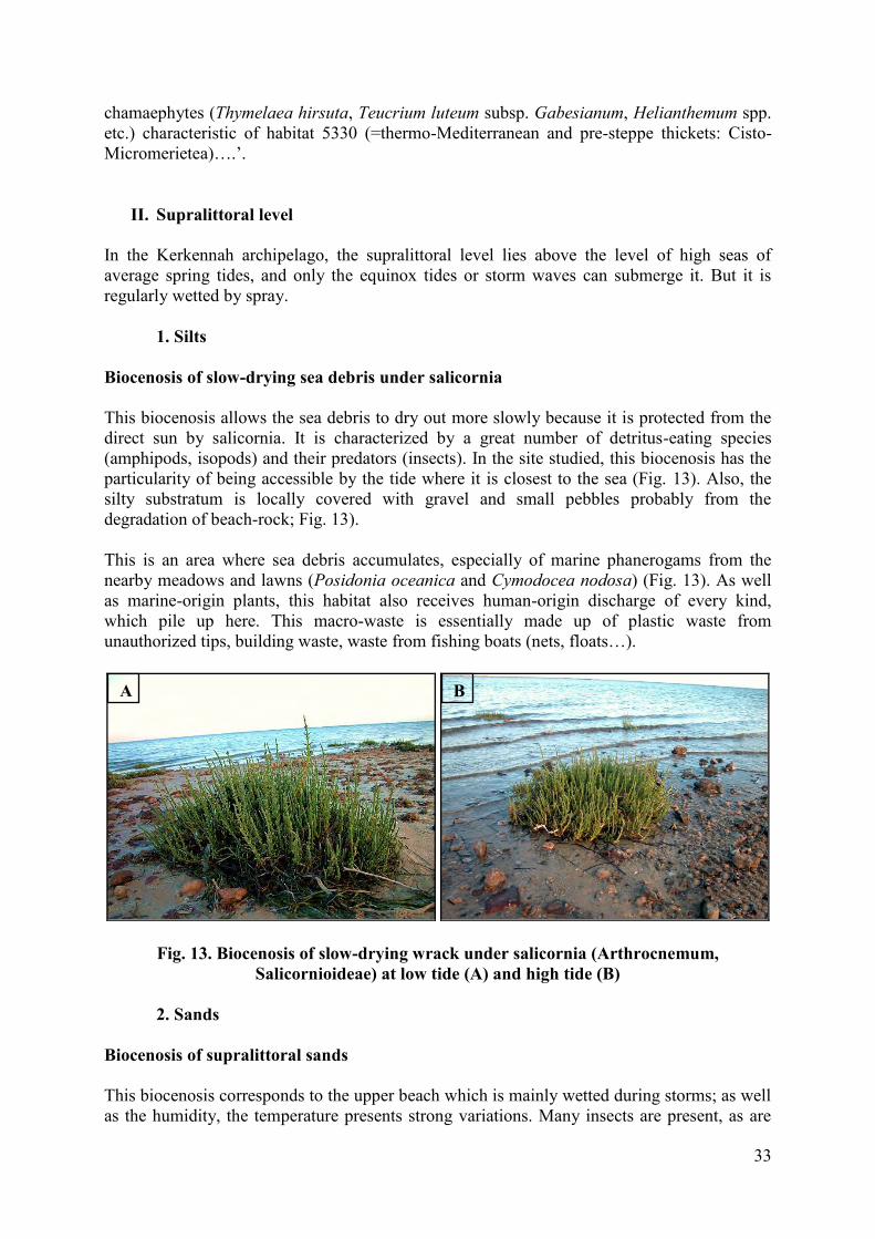
1. Silts……………………………………………………………………………. Biocenosis of slow-drying foreshores under salicornia………………………………...
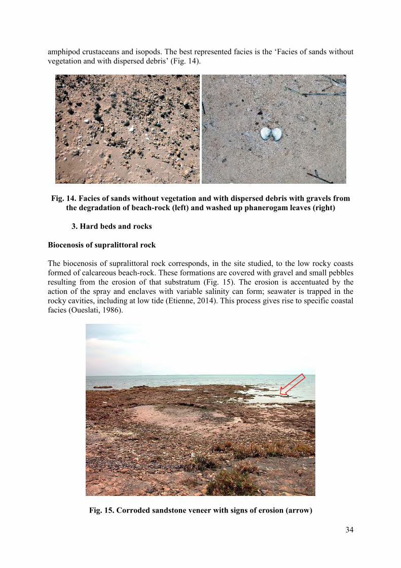
2. Sands………………………………………………………………………….. Biocenosis of supralittoral sands………………………………………………………...
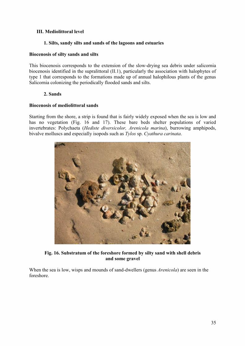
3. Hard beds and rocks…………………………………………………………... Biocenosis of supralittoral rock…………………………………………………………
III. Mediolittoral level……………………………………………………………...
9 9 10 11
13 13 13 13 14 15 18 18 18 19 19 19 20 22 22 24 24 26 26 27 29 29 32 33 33 33 33 33 34 34 35
2
1. Silts, sandy silts and sands of the lagoons and estuaries……………………… Biocenosis of silty sands and silts………………………………………………………..
2. Sands………………………………………………………………………….. Biocenosis of mediolittoral sands………………………………………………………..
3. Hard beds and rocks…………………………………………………………... Biocenosis of upper and lower mediolittoral rock……………………………………..
IV. Infralittoral……………………………………………………………….…….. 1. Fairly silty fine sands………………………………………………….………
Biocenosis of superficial calm mode silty sands……………………………………….. Association with Cymodocea nodos…………………………..………………………….
2. Posidonia oceanica meadow…………………………………………………. Biocenosis of Posidonia oceanica meadow……………………………………………... Striped meadow ecomorphosis………………………………………………………….. Characterization of the Posidonia oceanica meadow…………………..……………… Biocenosis of infralittoral algae……………………………………………….………… Benthic fauna………………………………………………………………………….…. CHAPTER V. SUMMARY OF NATURAL AND CULTURAL POTENTIAL AND VULNERABILITIES IN THE AREA OF STUDY……………………………………
I. Assessment of natural and cultural potential of the area north-east of the Kerkennah archipelago ……………………...…………………………………
1. Marine biodiversity…………………………………………………………… High biodiversity and an outstanding marine landscape……………………………... Outstanding flora………………………………………………………………………... Outstanding fauna……………………………………………………………….………. Varied avifauna…………………………………………………………………………..
2. Social and cultural values………………...…………………………………… Undeniable social and cultural values………………………………………………….. Natural protection………………………………………………………………….…….
II. Vulnerability and main risks and threats to the biotope……………………….. 1. Human-origin threats…………………………………………………………
1.1. Threats to the Kerkennah archipelago as a whole………..…………… Trawling and over-use of living resources…………………………………………….. Using sea sand for building……………………………………………………………...
1.2. Specific threats to the north-eastern part of the archipelago…...……… Poaching and illegal fishing…………………………………………………………….. Destruction of plant cover………………………………………………………………. Dwindling sponge stock………………………………………………………………….
2. Natural threats……………………………………………………………….. Insularity………………………………………………………………………………… Rise in sea level………………………………………………………………………….. Coastal erosion and retreat of the coastline……………………………………………. Heterogenous extension of the sebkha areas…………………………………………... Social problems: a factor that amplifies threats……………………………………….
35 35 35 35 36 36 40 40 40 40 41 41 41 43 44 46 49 49 49 49 49 50 50 51 51 51 51 51 51 51 52 52 53 53 53 54 54 54 54 55 56
3
Summary of threats and vulnerabilities………………………………………………...
CONCLUSION…………………………………………………………………………...
Bibliographic references………………………………………………………………… Annexes SDF
58
59
60
4
LIST OF FIGURES
Figure 1. Location-toponomy-surface area of the islands and islets of the Kerkennah archipelago (Source: Etienne, 2014)
Figure 2. General view of Roumadiya islet
Figure 3. Types of coast in the area of study (From Etienne, 2014, modified)
Figure 4. Map of the Kerkennah islands and their shallows between 0 and -2 m. (dotted lines) and the bhirats (B) (From A. Oueslati, 1995) Figure 5. Low-lying coast with micro-cliff (between 0.5 and 1 m. high) showing plant debris thrown up as wrack (Cymodocea nodosa and Cystoseira sp.) Figure 6. The sansouires, a characteristic plant formation composed of halophilous plants – here Salicornia; ripple-marks on the sand caused by currents are clearly visible Figure 7. Main features of the coastal morphology of the islets lying north-east of the Kerkennah archipelago Figure 8. Underwater topography, main currents and tide in the Kerkennah archipelago (Source: Etienne, 2014) Figure 9. Locating the area of study in the north-eastern part of the Kerkennah archipelago Figure 10. a) Various equipment used; b) and c) Hand sonar used for bathymetric measuring; d) Navigation rod used to determine the type of bed; e) Tip of the rod coated with silt; f) Observations using a caulked window; g) GPS and slate; h) Underwater shot
Figure 11. Satellite image of the area studied cut up into 24 bits
Figure 12. The two boats used for field prospection
Figure 13. Biocenosis of slow-drying wrack under salicornia (Arthrocnemum, Salicornioideae) at low tide (A) and high tide (B) Figure 14. Facies of sands without vegetation and with dispersed debris with gravels from the degradation of beach-rock (left) and washed up phanerogam leaves (right)
Figure 15. Corroded sandstone veneer with signs of erosion (arrow)
Figure 16. Substratum of strand formed by silty sand with shell debris and some gravel
Figure 17. Sandy-silty strand at low tide (period of spring tide) basically covered with wisps and mounds of sand-dwellers (polychaeta worms) and stranded macrophytes (Cystoseira)
Figure 18. Beach-rock observed at mediolittoral level in the Kerkennah archipelago
5
Figure 19. Littoral organogenic concretions of photophilous algae (Left: concretion with Neogoniolithon brassica-florida)
Figure 20. Photograph (above): detail of a biogenic concretion showing the incorporation of fragments of calcareous sandstone (yellow arrow) made up of shell debris (red arrow) and Serpula-polychaetae (green arrow). Photograph (below): biogenic concretion formed of a fine layer of crusting calcareous alga (1) and (3) bivalve shells, (2) benthic foraminifers (here Peneroplis pertusus) and (3) species of the family of Vermetidae.
Figure 21. (A) Cymodocea nodosa and Caulerpa prolifera prairie surrounding the sponge Sarcotragus muscarum, and (B) Aplysina aerophoba; (C) and (D) prairies with Cymodocea nodosa on sandy-silty bed.
Figure 22. Striped meadow: (A) typical configuration, (B) circular configuration, (C) belt configuration, (D) a strip of Posidonia oceanica near the surface interrupted by a mosaic of Cymodocea nodosa and (E) belts of striped meadows (tsir) marking out a bhirat where isolated strips of Posidonia oceanica are scattered
Figure 23. Channel between strips of Posidonia oceanica carpeted by a lawn of Cymodocea nodosa and Caulerpa prolifera
Figure 24. (A) Rocky veneer covered with photophilous algae essentially Padina pavonica, Laurencia and Cystoseiras; (B) Cluster of free-form Cystoseiras
Figure 25. Pinna nobilis in prairies with Cymodocea nodosa and Caulerpa prolifera
Figure 26. Poaching Caretta caretta marine turtles in the Kerkennah archipelago
Figure 27. Assessing the occupation of the soil and the sebkha areas in the archipelago between 1984 (A) and 2011 (B) (From Etienne, 2014, modified)
6
LIST OF TABLES Table 1. Variation of size of tide according to tidal cycle (From Bejaoui, 1988)
Table 2. Features of the boats used for prospecting
Table 3. Logistical means implemented for the assignment of prospecting the north-eastern part of the Kerkennah archipelago
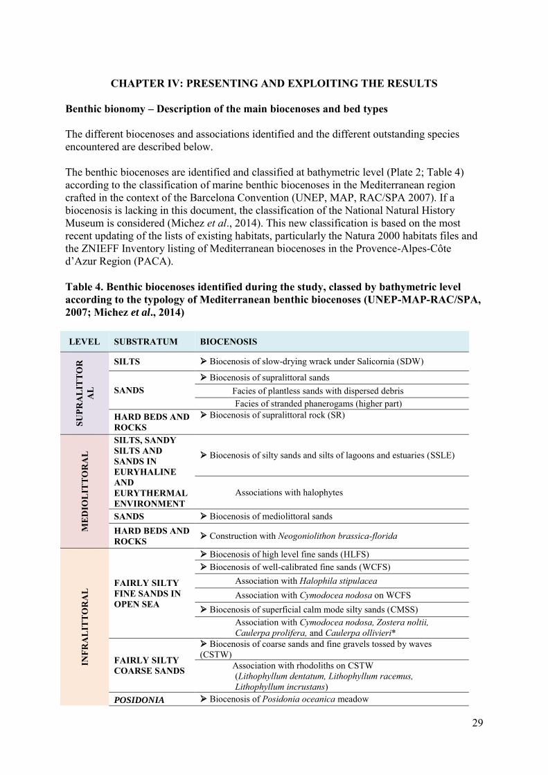
Table 4. Benthic biocenoses identified during the study, classed by bathymetric level according to the typology of Mediterranean benthic biocenoses (UNEP/MAP-RAC/SPA, 2007; Michez et al., 2014)
Table 5. Phenological parameters of the Posidonia oceanica meadow in the north-eastern part of the Kerkennah Islands archipelago in July 2015 (average ± 95% confidence interval ). LAI=Leaf Area Index. Weighting A = (number of broken Ad+In leaves/total number of leaves) x 100
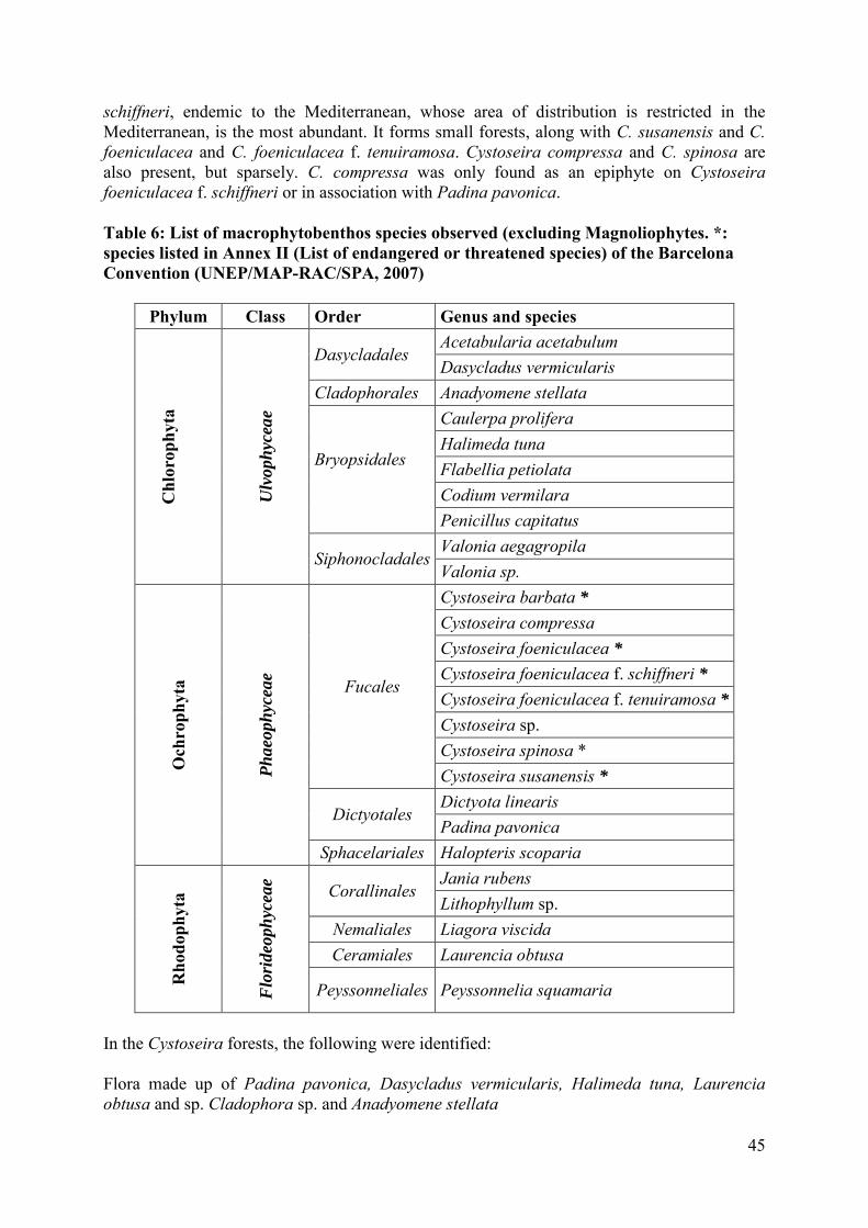
Table 6. List of macrophytobenthos species observed (excluding Magnoliophytes. *: species listed in Annex II (List of endangered or threatened species) of the Barcelona Convention (UNEP/MAP-RAC/SPA, 2007)
LIST OF PLATES Plate 1. Study and characterization of the state of the Posidonia meadow
Plate 2. Different biological communities distributed in the study area
Plate 3. Illustration of facies with organogenic concretions in the zone
Plate 4. Illustration of the main biocenoses in the north-eastern part of the kerkennah islands
Plate 5. Species of the cystoseira genus found in the zone
7
LIST OF ACRONYMS AND ABBREVIATIONS
AAO Association of Birdlovers (Association des Amis des Oiseaux)
ACI Internal Cooperation Agreement
AECID Spanish Agency of International Cooperation for Development (Agence Espagnole de Coopération Internationale pour le Développement)
APAL Coastal Protection and Planning Agency (Agence de Protection et d’Aménagement du Littoral)
cm Centimeters
cm/s Centimeters per second
DEPI Division of Environmental Policy Implementation
DGEF Division of Global Environment Facility Coordination
EC European Commission
FFEM French Fund for Global Environment (Fonds Français pour l'Environnement Mondial)
GEF Global Environment Facility
GIS Geographic Information Systems
ha Hectares
IBA Important Bird and Biodiversity Areas
IUCN International Union for Conservation of Nature
km Kilometre
m Metre
MAP Mediterranean Action Plan
MCPA Marine and Coastal Protected Area
MedMPAnet Mediterranean Marine Protected Areas Network
MedPartnership Strategic Partnership for the Mediterranean Sea Large Marine Ecosystem
MPA Marine Protected Area
mm Millimetre
MPD Maritime Public Domain
m/s Metre per second
NAP National Action Plans
Protocole ASP/DB
Specially Protected Areas and Biological Diversity Protocol of the Barcelone Convention
RAC/SPA Regional Activity Centre for Specially Protected Areas
SAP-BIO Strategic Action Programme for the Conservation of Biological Diversity in the Mediterranean
8
SDF Standard Data-Entry Form
SSFA Small Scale Funding Agreement
UNEP United Nations Environment Programme
WWF World Wide Fund for Nature
ZICO Important Area for the Conservation of Waterbirds (Zone Importante pour la Conservation des Oiseaux d’eau)
9
CHAPTER I: SITUATION AND GENERAL CONTEXT OF THE STUDY
I. General context of the study The present study comes under the implementing of the MAP/UNEP-GEF Strategic Partnership for the Mediterranean Large marine ecosystem (MedPartnership), in particular its Component 3, Conservation of Biological Diversity: Implementing SAP BIO and the corresponding NAPs/Sub-component 3.1 Conservation of marine and coastal biodiversity as part of setting up a Mediterranean network of Marine Protected Areas (MPAs), the Regional Activity Centre for Specially Protected Areas (RAC/SPA) is implementing the Regional Project for Developing a Mediterranean Network of Marine and Coastal Protected Areas (MPAs) via enhancing the Creation and Management of MPAs (MedMPAnet Project). The MedMPAnet Project is funded by the European Commission (EC), the Spanish Agency for International Cooperation for Development (Agence Espagnole de Coopération Internationale pour le Développement, AECID) and the French Fund for the Global Environment (Fonds Français pour l´Environnement Mondial, FFEM) and helps 12 Mediterranean countries: Albania, Algeria, Bosnia-Herzegovina, Croatia, Egypt, Lebanon, Libya, Montenegro, Morocco, Syria, Tunisia and Turkey. The project aims to increase the ability to protect marine and coastal biodiversity of regional importance by setting up, in the Mediterranean region, a network that is ecologically representative, coherent and effective, backed by a regional network of managers of MPAs, according to the provisions of the Protocol on Specially Protected Areas and Biological Diversity (SPA/BD Protocol) of the Barcelona Convention. Alongside the MedMPAnet Project, RAC/SPA and the UNEP signed a Small Scale Funding Agreement (SSFA). On the basis of the Internal Cooperation Agreement (ICA) between UNEP/MAP and UNEP/DGEF (now a part of UNEP-DEPI), UNEP has committed to cooperating with RAC/SPA on the project/programme entitled Strategic Partnership for the Mediterranean Greater Marine Ecosystem – a regional element of actions implemented for the protection of the environmental resources of the Mediterranean and its coastal areas (MedPartnership) – in thirteen Mediterranean countries. The main aim of this SSFA is to undertake additional activities to boost the best ‘Replicable Practices’ for the creation of MPAs in the Mediterranean. The original project of MedPartnership, allocated resources for this purpose and replication activities were presented, discussed and endorsed by the 4th Steering Committee Meeting of the MedPartnership (Hammamet, Tunisia, February 2014). Today the north-eastern part of the Kerkennah Islands has the status of sensitive coastal area, and constitutes one of the five sites chosen to enjoy Marine and Coastal Protected Area (MCPA) status by the National Programme for the Creation of Marine and Coastal Protected Areas in Tunisia, run by the Coastal Protection and Planning Agency (APAL), which is part of national policy on biodiversity as defined by the National Plan for Biodiversity approved in 1998, which aims to set up a network of Protected Areas along the Tunisian coast.
10
Sensitive coastal areas were defined by the law that created APAL as ‘spaces which characterize the national natural heritage, presenting an ensemble of elements in a fragile ecosystem and constituting an outstanding natural landscape, threatened by degradation or unreasonable use and subjected to human-origin pressure that risks destabilising them’.
1. Assessing the current situation MCPAs in Tunisia have gone beyond their legal framework. MPAs were born before the Law of 21 July 2009 on MCPAs was passed. The national programme for MCPAs selected five sites and involved two stages. The first was the creation of the National Park of the Galite archipelago. The second saw the extension of the MCPA network, i.e. the setting up of four other sites – the islands of Zembra and Zembretta, the Kuriat Islands, the north-eastern part of Kerkennah and the coast from Cap Negro to Cap Serrat. With the passing of Law no. 2009-49 of 21 July 2009 Tunisia finally enjoyed a specific framework for these areas. The law defined them and clarified their legal system, more rigorous than that of the littoral or of the Maritime Public Domain (MPD). The main provisions were inspired by international norms on the subject, particularly those established by the International Union for the Protection of Nature (UICN). The definition of a MPA according to Article 2 of the above-mentioned Law of 21 July 2009 states that ‘Within the sense of the present law, ‘marine and coastal protected areas’ is understood as meaning the areas designated by the law with a view to protecting natural environments, flora, fauna, marine and coastal ecosystems of particular interest from a natural, scientific, instructive, recreational or educational point of view or which constitute outstanding natural landscapes that must be protected’ (Source: Official Journal of the Tunisian Republic, JORT No. 58). This broad definition expresses the difficulty regional and international instruments have in defining MPAs. The Kerkennah Islands are classed as a nature reserve. This archipelago is a major migration route for birds crossing the Mediterranean between the Gulf of Gabès and southern Italy. The site has since 2001 been listed as an Important Zone for the Conservation of Waterbirds (ZICO) by Bird Life International and the Association of Birdlovers (AAO) (Bird Life International, 2015). From 2001 the north-eastern part of the site has seen a MPA set up there. In this context, to help craft a zoning plan for outstanding marine habitats that will be a basic tool for crafting a management plan for the marine part of this future MCPA, a first phase concerning a management study for the sensitive zone of Kerkennah’s north-eastern islets was carried out in 2001 by APAL; it aimed at understanding the spatio-temporal evolution of the site and identifying natural evolution scenarios. During this phase, the results obtained allowed the site’s state of equilibrium to be determined, potential risks it could encounter to be identified, and potential and skills to be assessed as to development within the contexts of environment protection and making best social, economic and cultural use of it. The present work, which complements that done in 2001 by APAL, aims at supplying further information on the natural elements of heritage value that lie around the islands of the
11
concerned zone. Particular attention will be paid to the characterization and mapping of the meadows of the marine phanerogam Posidonia oceanica L. (Delile), species and habitats that are of Mediterranean importance, especially those appearing in the Annexes to the SPA Protocol. A Standard Data Form (SDF) for national inventories of natural sites of conservation interest will also be filled in.
2. Geographical situation and general introduction of the sensitive area north-east of the Kerkennah Islands
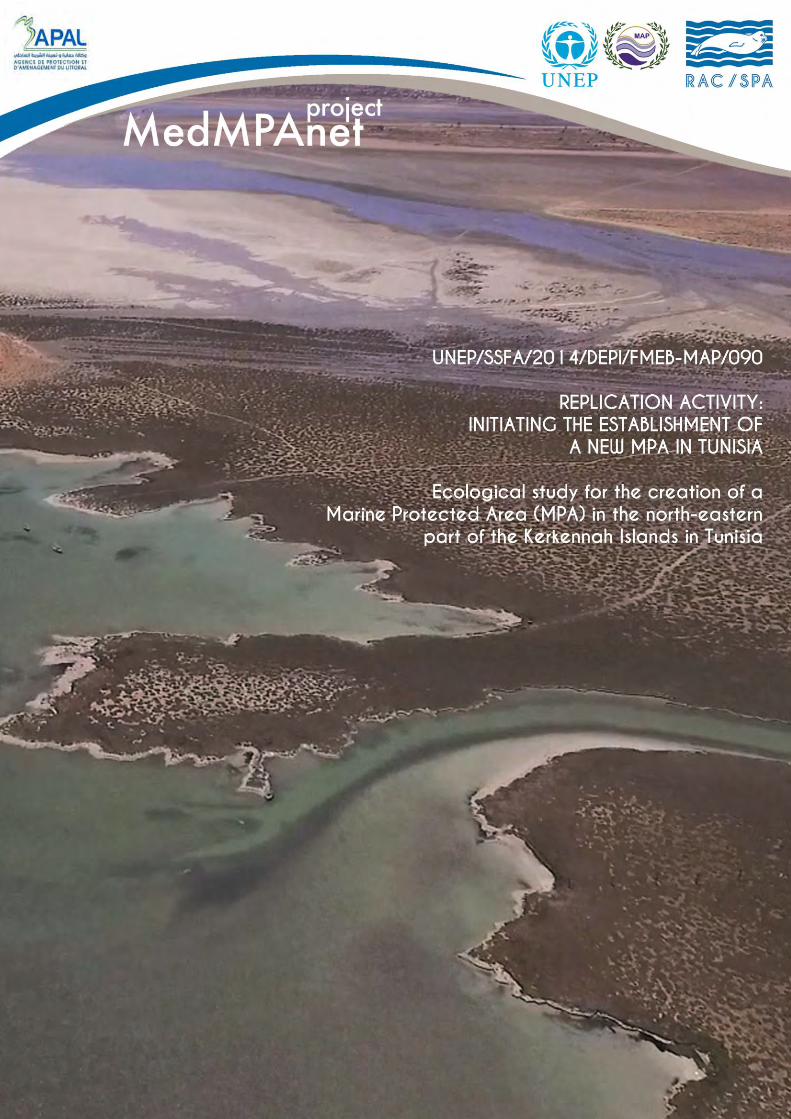
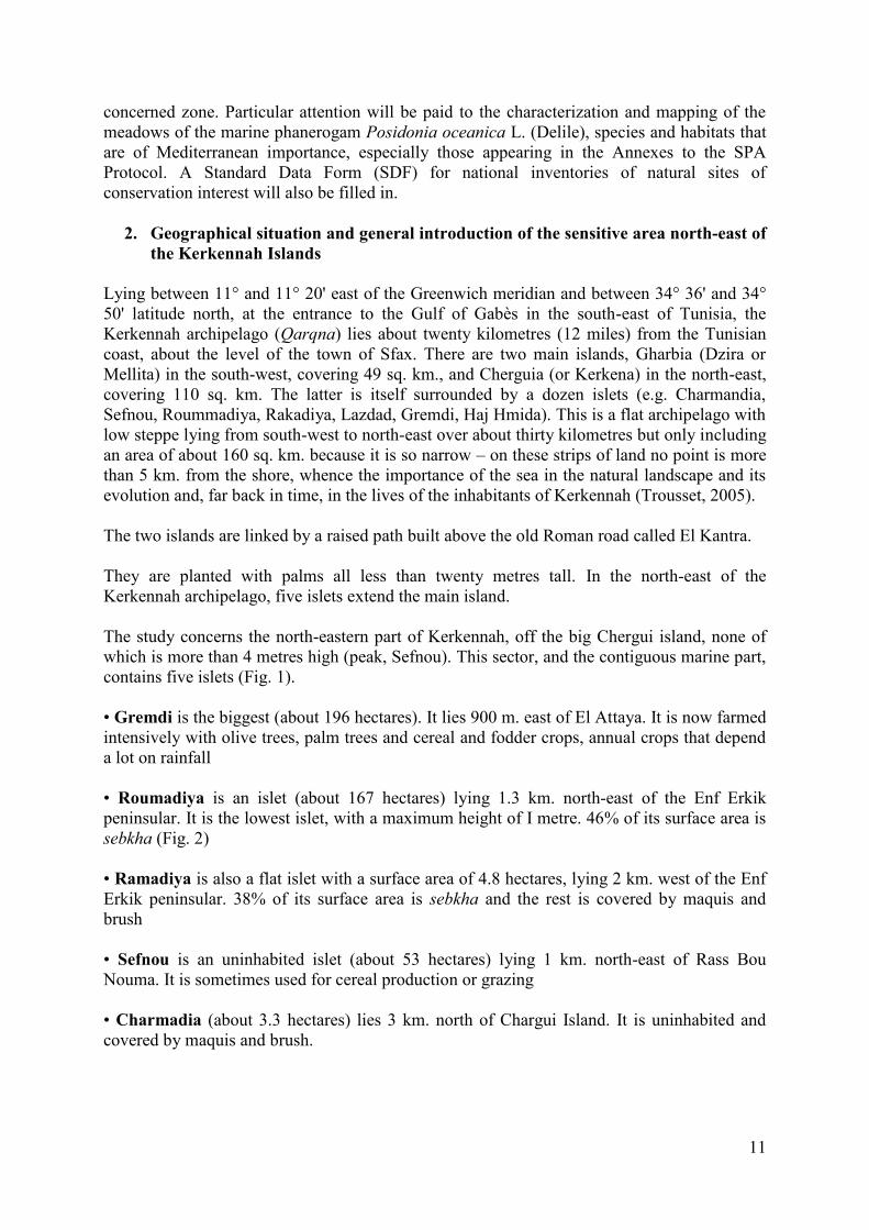
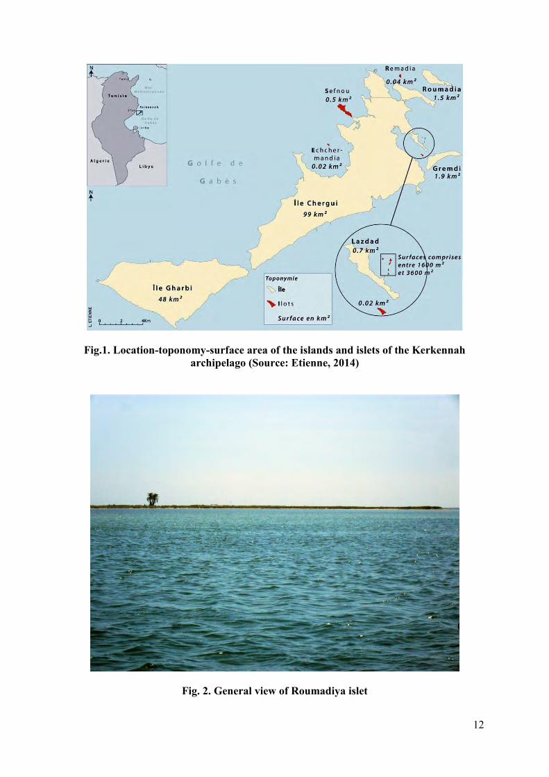
Lying between 11° and 11° 20' east of the Greenwich meridian and between 34° 36' and 34° 50' latitude north, at the entrance to the Gulf of Gabès in the south-east of Tunisia, the Kerkennah archipelago (Qarqna) lies about twenty kilometres (12 miles) from the Tunisian coast, about the level of the town of Sfax. There are two main islands, Gharbia (Dzira or Mellita) in the south-west, covering 49 sq. km., and Cherguia (or Kerkena) in the north-east, covering 110 sq. km. The latter is itself surrounded by a dozen islets (e.g. Charmandia, Sefnou, Roummadiya, Rakadiya, Lazdad, Gremdi, Haj Hmida). This is a flat archipelago with low steppe lying from south-west to north-east over about thirty kilometres but only including an area of about 160 sq. km. because it is so narrow – on these strips of land no point is more than 5 km. from the shore, whence the importance of the sea in the natural landscape and its evolution and, far back in time, in the lives of the inhabitants of Kerkennah (Trousset, 2005). The two islands are linked by a raised path built above the old Roman road called El Kantra. They are planted with palms all less than twenty metres tall. In the north-east of the Kerkennah archipelago, five islets extend the main island. The study concerns the north-eastern part of Kerkennah, off the big Chergui island, none of which is more than 4 metres high (peak, Sefnou). This sector, and the contiguous marine part, contains five islets (Fig. 1). • Gremdi is the biggest (about 196 hectares). It lies 900 m. east of El Attaya. It is now farmed intensively with olive trees, palm trees and cereal and fodder crops, annual crops that depend a lot on rainfall • Roumadiya is an islet (about 167 hectares) lying 1.3 km. north-east of the Enf Erkik peninsular. It is the lowest islet, with a maximum height of I metre. 46% of its surface area is sebkha (Fig. 2) • Ramadiya is also a flat islet with a surface area of 4.8 hectares, lying 2 km. west of the Enf Erkik peninsular. 38% of its surface area is sebkha and the rest is covered by maquis and brush • Sefnou is an uninhabited islet (about 53 hectares) lying 1 km. north-east of Rass Bou Nouma. It is sometimes used for cereal production or grazing • Charmadia (about 3.3 hectares) lies 3 km. north of Chargui Island. It is uninhabited and covered by maquis and brush.
12
Fig.1. Location-toponomy-surface area of the islands and islets of the Kerkennah archipelago (Source: Etienne, 2014)
Fig. 2. General view of Roumadiya islet
13
CHAPTER II: PHYSICAL CONTEXT OF THE KERKENNAH ISLANDS
I. Topographical, geomorphological and oceanographic context
1. Origin, geological formations, geomorphology The archipelago broke off from the continent during the latest phase of warming, which caused a rise in the sea level, accentuated in the archipelago by major subsidence that continues today (Paskoff & Sanlaville, 1983; Oueslati, 1986). The islands of the archipelago fall within the category of disarticulation islands according to the classification of islands by Aubert de la Rüe (1935) adopted by Bernardie and Taglioni in 2005. This classification is based on how they were formed and their distance from the continental mass (Etienne, 2014). They are cut off from the continent by difference in sea level, dependent and continental since geologically part of the continent. Lying in the Gulf of Gabès, the Kerkennah archipelago emerges from the continental shelf west of the town of Sfax (Etienne, 2014). The archipelago is characterized by an impressive opposition between the very straight eastern coasts and the very indented western and northen coasts. These morphological features are due to two causes: first, the western coast is exposed to active dynamics, particularly the persistence and dominance all year round of northern and north-western swells, and then to neotectonic movement, particularly the N601 accident that are responsible for the rectilinear aspect of the Kerkennah Islands coast. The geomorphological features of the shore in the Kerkennah Islands show that the 162-km.-long coasts are made up of 95 km. of sebkha edging, 43 km. of rocky cliffs, and 24 km. of sandy-clayey cliffs. This topography is the submerged extension of the continental topography.
2. Underwater topography and bathymetry The archipelago’s topography is very low-lying, hardly emerging from a vast area of shallows in the Gulf of Gabès – the highest point is 13 metres above sea level. The archipelago is characterized by wide saline depressions, chotts or sebkhas, today unsuitable for agriculture, alternating with fairly marked relief that corresponds to Quaternary calcareous crusts partially covered by the Aeolian sand and themselves covering the red Mio-Pliocene clayey formations that the sea cuts into cliffs on the western coast (Trousset, 2005). The islets in the north-east of the archipelago off the big island of Chergui are uninhabitable because there are no water spots, but until recently they, particularly the two bigger islets (Roumadiya and Gremdi) were used to graze herds and to plant fig and olive trees (APAL, 2001). The coasts of the Kerkennah archipelago are mostly low-lying and the highest cliffs reach a maximum 11 metres. Its coasts are fairly varied, from the very exposed open cliff to the
1 These are bundles of faults in the North 60 tectonic direction, local overlappings or slidings, side by side with the Atlas direction that corresponds to the Atlas folds that took shape in the Tortonian (-11 MY).
14
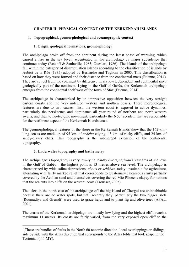
maritime marshes in sheltered places. On the south and west fronts of the islands the coastline is more rectilinear. These coasts are also protected from the heavy swells, which are relatively rare, by a slope lying a few hundred metres from the shore. These natural obstacles form protective breakwaters. But on the northern front, the coastline is very jagged (Fig. 3) because eroded by sea storms caused by the strong winds that come in from the north or north-west (Dahech, 2007). The height of the archipelago’s cliffs varies from a few centimetres to about 11 metres (Jorf). The cliffs are all active, which indicates current erosion of the coasts. The lowest coasts are made up of beaches and outlets of sebkhas or maritime marshes.
Fig. 3. Types of coast in the area of study (From Etienne, 2014, modified)
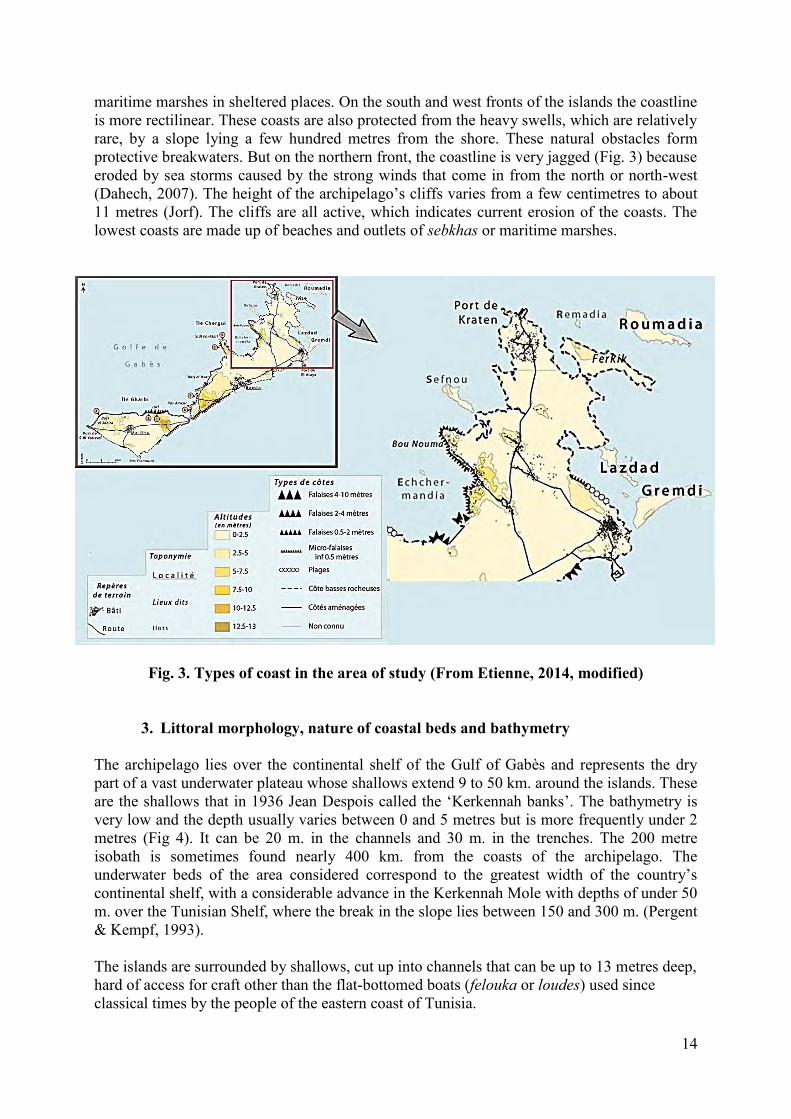
3. Littoral morphology, nature of coastal beds and bathymetry The archipelago lies over the continental shelf of the Gulf of Gabès and represents the dry part of a vast underwater plateau whose shallows extend 9 to 50 km. around the islands. These are the shallows that in 1936 Jean Despois called the ‘Kerkennah banks’. The bathymetry is very low and the depth usually varies between 0 and 5 metres but is more frequently under 2 metres (Fig 4). It can be 20 m. in the channels and 30 m. in the trenches. The 200 metre isobath is sometimes found nearly 400 km. from the coasts of the archipelago. The underwater beds of the area considered correspond to the greatest width of the country’s continental shelf, with a considerable advance in the Kerkennah Mole with depths of under 50 m. over the Tunisian Shelf, where the break in the slope lies between 150 and 300 m. (Pergent & Kempf, 1993). The islands are surrounded by shallows, cut up into channels that can be up to 13 metres deep, hard of access for craft other than the flat-bottomed boats (felouka or loudes) used since classical times by the people of the eastern coast of Tunisia.
15
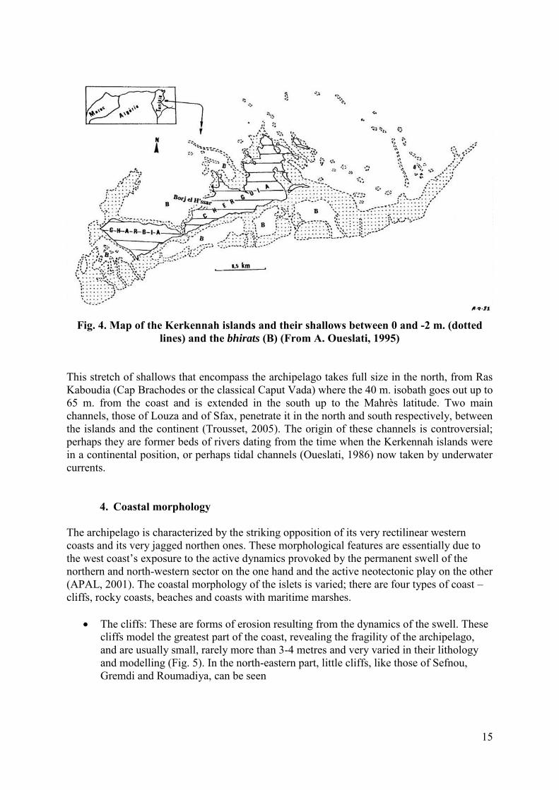
Fig. 4. Map of the Kerkennah islands and their shallows between 0 and -2 m. (dotted
lines) and the bhirats (B) (From A. Oueslati, 1995) This stretch of shallows that encompass the archipelago takes full size in the north, from Ras Kaboudia (Cap Brachodes or the classical Caput Vada) where the 40 m. isobath goes out up to 65 m. from the coast and is extended in the south up to the Mahrès latitude. Two main channels, those of Louza and of Sfax, penetrate it in the north and south respectively, between the islands and the continent (Trousset, 2005). The origin of these channels is controversial; perhaps they are former beds of rivers dating from the time when the Kerkennah islands were in a continental position, or perhaps tidal channels (Oueslati, 1986) now taken by underwater currents.
4. Coastal morphology The archipelago is characterized by the striking opposition of its very rectilinear western coasts and its very jagged northen ones. These morphological features are essentially due to the west coast’s exposure to the active dynamics provoked by the permanent swell of the northern and north-western sector on the one hand and the active neotectonic play on the other (APAL, 2001). The coastal morphology of the islets is varied; there are four types of coast – cliffs, rocky coasts, beaches and coasts with maritime marshes.
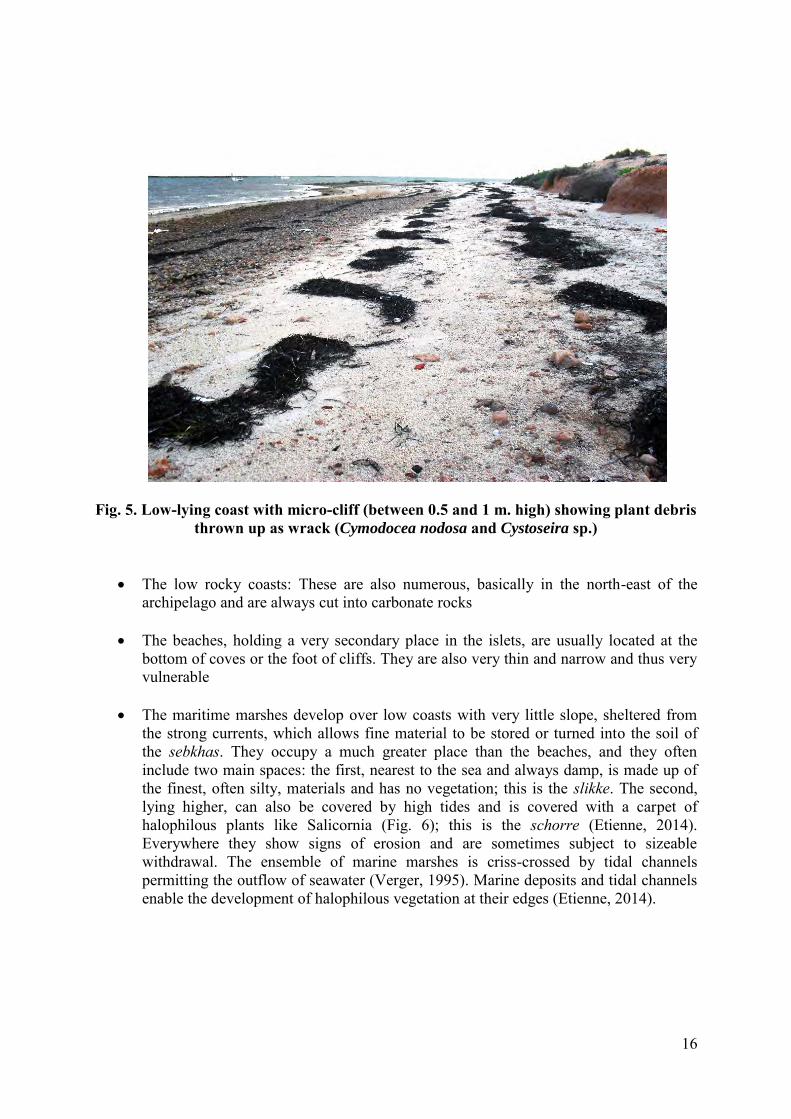
The cliffs: These are forms of erosion resulting from the dynamics of the swell. These cliffs model the greatest part of the coast, revealing the fragility of the archipelago, and are usually small, rarely more than 3-4 metres and very varied in their lithology and modelling (Fig. 5). In the north-eastern part, little cliffs, like those of Sefnou, Gremdi and Roumadiya, can be seen
16
Fig. 5. Low-lying coast with micro-cliff (between 0.5 and 1 m. high) showing plant debris thrown up as wrack (Cymodocea nodosa and Cystoseira sp.)
The low rocky coasts: These are also numerous, basically in the north-east of the
archipelago and are always cut into carbonate rocks The beaches, holding a very secondary place in the islets, are usually located at the
bottom of coves or the foot of cliffs. They are also very thin and narrow and thus very vulnerable
The maritime marshes develop over low coasts with very little slope, sheltered from
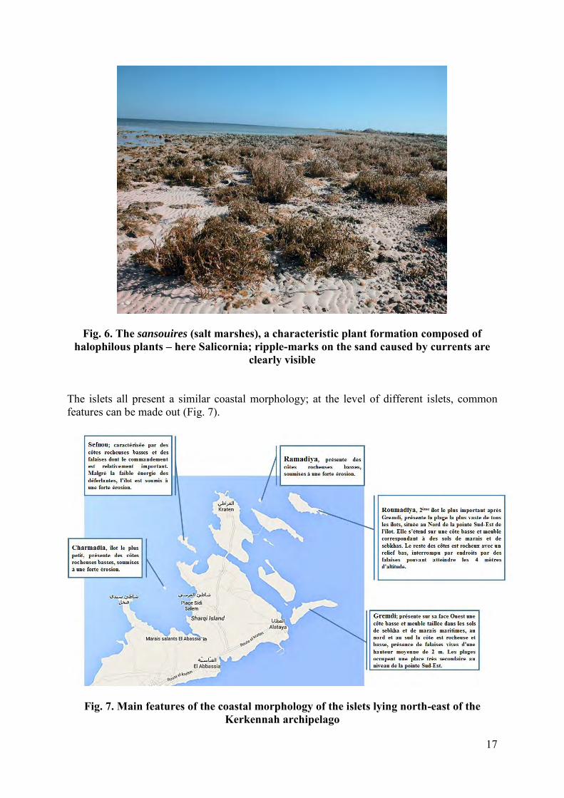
the strong currents, which allows fine material to be stored or turned into the soil of the sebkhas. They occupy a much greater place than the beaches, and they often include two main spaces: the first, nearest to the sea and always damp, is made up of the finest, often silty, materials and has no vegetation; this is the slikke. The second, lying higher, can also be covered by high tides and is covered with a carpet of halophilous plants like Salicornia (Fig. 6); this is the schorre (Etienne, 2014). Everywhere they show signs of erosion and are sometimes subject to sizeable withdrawal. The ensemble of marine marshes is criss-crossed by tidal channels permitting the outflow of seawater (Verger, 1995). Marine deposits and tidal channels enable the development of halophilous vegetation at their edges (Etienne, 2014).
17
Fig. 6. The sansouires (salt marshes), a characteristic plant formation composed of halophilous plants – here Salicornia; ripple-marks on the sand caused by currents are
clearly visible
The islets all present a similar coastal morphology; at the level of different islets, common features can be made out (Fig. 7).
Fig. 7. Main features of the coastal morphology of the islets lying north-east of the Kerkennah archipelago

18
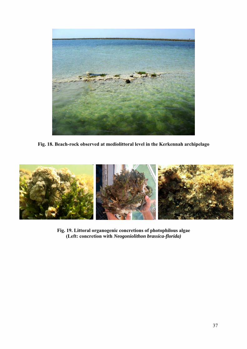
5. Nature of the coastal beds
Strictly speaking, the Kerkennah platform is a vast platform of 2-3 metres depth. The morphology of the Kerkennah platform is very complex, characterized by silty stretches or bhirats, belts or tsirs, and tidal channels or oueds (APAL, 2001; Etienne, 2014). There are:
5.1. The bhirats or silty stretches These are depressions lying parallel to the east coast whose depth varies from 2-3 metres and can be greater than 5 m. They contain very still water and are usually surrounded by belts of Posidonia (Posidonia oceanica) that protect them from the violence of the water and encourage the sedimentation of fine particles. This configuration allows certain species of marine phanerogam, such as Cymodocea (Cymodocea nodosa) and weed like Caulerpa (Caulerpa prolifera) to settle and cover the bed, forming vast meadows that favour the reproduction of different animal species. Along the eastern coast of Chergui four silty stretches can be identified; the biggest are Bhiret El Abbassia and Bhiret El Gremdi. These meniscus-shaped bhirats lying parallel to the coasts open onto the open sea via oueds or tidal channels (APAL, 2001). In the north of Chergui, the biggest bhirat has an average depth of 4 metres but can be even more than 5 metres. It separates the northern islets (Roumadiya) from the zone called Hmadet El Babouche. In the west of Chergui, there are two: Bhiret Sefnou and Bhiret Sidi Fredj. These bhirats are completely surrounded by belts – tsirs (APAL, 2001).
5.2. The Posidonia belts or tsirs These are narrow belts of Posidonia and sometimes Caulerpa meadows, not at all deep, that can surface at low tide, and are several kilometres long. Also called banks, these belts, which separate the silty stretches from each other, are made up of biogenic shell debris. According to APAL (2001), two categories of bank have been identified: Banks running parallel to the coast: Parallel to the eastern coast a long belt extends from the Ras El Besch promontory in the south-west to Sekiet Hmida, where it takes a north-north-easterly direction. The belt, about 77 kilometres long, goes round the platform to the south and the north. The shallows of this belt come within a few dozen centimetres of the surface at low tide. Further out, the break in the slope starts and quickly reaches the -5 and -10 metre isobaths. This long belt is interrupted by very narrow passages that open onto the oueds that lead out to sea. North-east of Chergui, the biggest platform of the Kerkennah platform presents banks oriented north-west/south-east parallel to the coast like that of Roumadiya, on which is the island of the same name (APAL, 2001). Banks running perpendicular to the coast: These are special in that they start from the island and extend towards the marine domain in the shape of littoral sedimentary constructions (arrows) or continental ripple-marks.
19
East of the archipelago these banks join the coast to the main bank that is parallel to it. They thus separate the bhirats from each other. In the west, the banks are wider and mark out the silty stretches (APAL, 2001).
5.3. The oueds or tidal channels
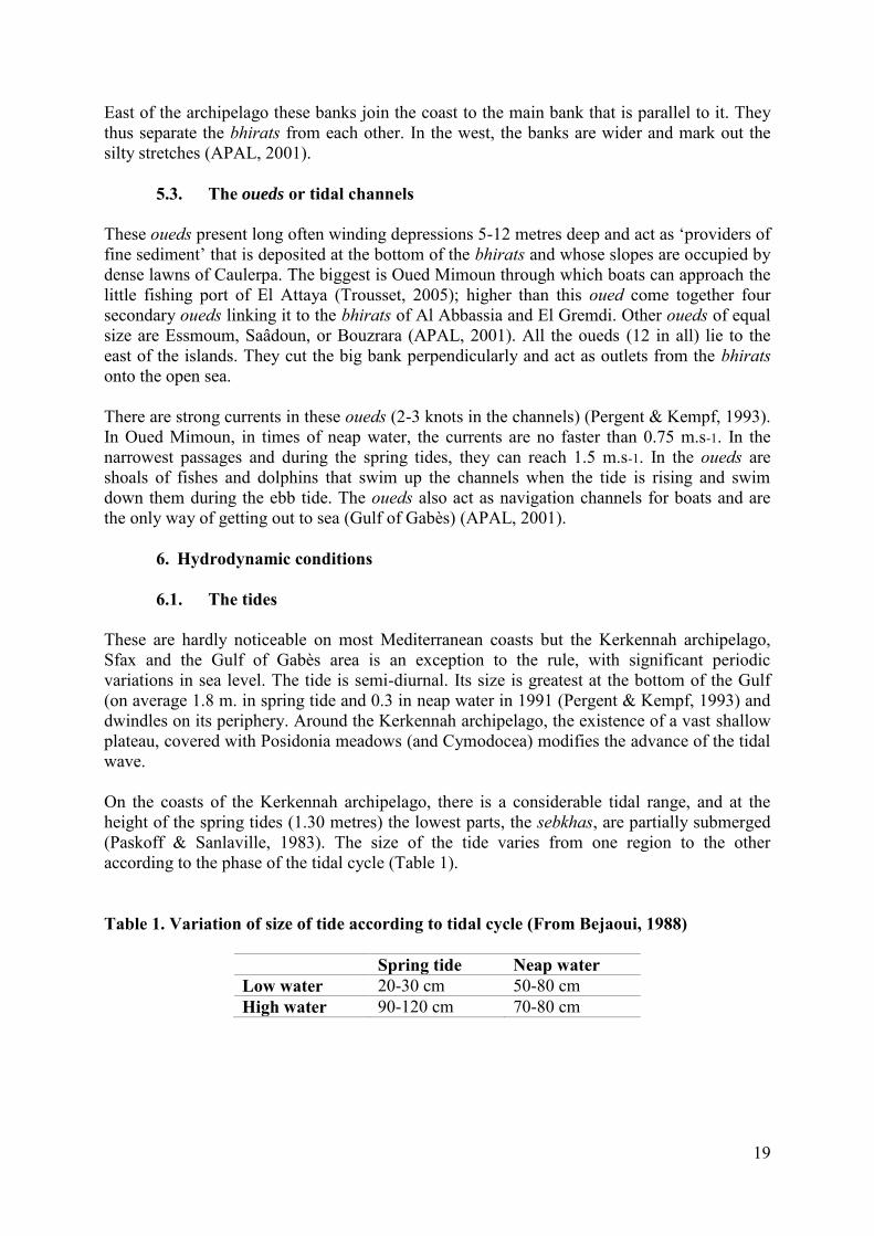
These oueds present long often winding depressions 5-12 metres deep and act as ‘providers of fine sediment’ that is deposited at the bottom of the bhirats and whose slopes are occupied by dense lawns of Caulerpa. The biggest is Oued Mimoun through which boats can approach the little fishing port of El Attaya (Trousset, 2005); higher than this oued come together four secondary oueds linking it to the bhirats of Al Abbassia and El Gremdi. Other oueds of equal size are Essmoum, Saâdoun, or Bouzrara (APAL, 2001). All the oueds (12 in all) lie to the east of the islands. They cut the big bank perpendicularly and act as outlets from the bhirats onto the open sea. There are strong currents in these oueds (2-3 knots in the channels) (Pergent & Kempf, 1993). In Oued Mimoun, in times of neap water, the currents are no faster than 0.75 m.s-1. In the narrowest passages and during the spring tides, they can reach 1.5 m.s-1. In the oueds are shoals of fishes and dolphins that swim up the channels when the tide is rising and swim down them during the ebb tide. The oueds also act as navigation channels for boats and are the only way of getting out to sea (Gulf of Gabès) (APAL, 2001).
6. Hydrodynamic conditions
6.1. The tides These are hardly noticeable on most Mediterranean coasts but the Kerkennah archipelago, Sfax and the Gulf of Gabès area is an exception to the rule, with significant periodic variations in sea level. The tide is semi-diurnal. Its size is greatest at the bottom of the Gulf (on average 1.8 m. in spring tide and 0.3 in neap water in 1991 (Pergent & Kempf, 1993) and dwindles on its periphery. Around the Kerkennah archipelago, the existence of a vast shallow plateau, covered with Posidonia meadows (and Cymodocea) modifies the advance of the tidal wave. On the coasts of the Kerkennah archipelago, there is a considerable tidal range, and at the height of the spring tides (1.30 metres) the lowest parts, the sebkhas, are partially submerged (Paskoff & Sanlaville, 1983). The size of the tide varies from one region to the other according to the phase of the tidal cycle (Table 1). Table 1. Variation of size of tide according to tidal cycle (From Bejaoui, 1988)
Spring tide Neap water Low water 20-30 cm 50-80 cm High water 90-120 cm 70-80 cm
20
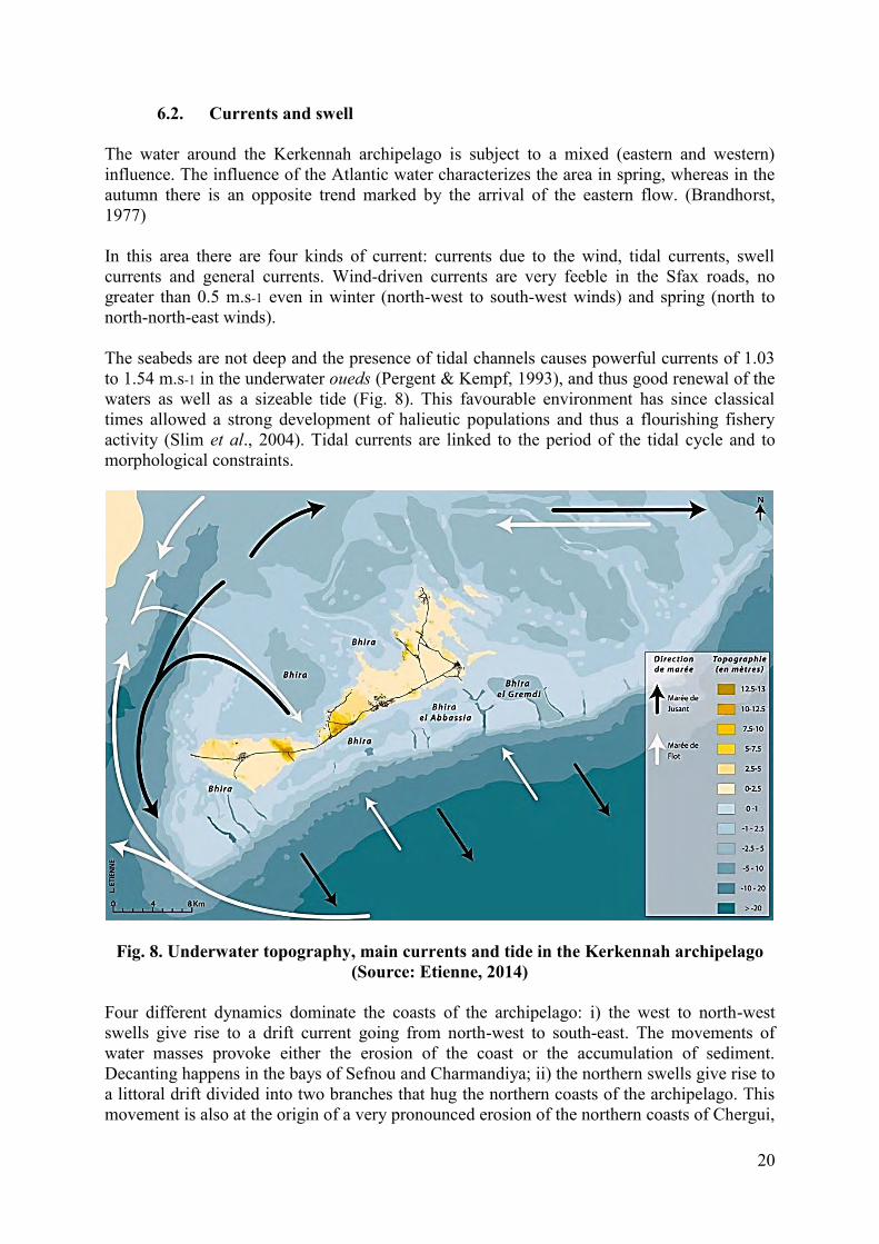
6.2. Currents and swell The water around the Kerkennah archipelago is subject to a mixed (eastern and western) influence. The influence of the Atlantic water characterizes the area in spring, whereas in the autumn there is an opposite trend marked by the arrival of the eastern flow. (Brandhorst, 1977) In this area there are four kinds of current: currents due to the wind, tidal currents, swell currents and general currents. Wind-driven currents are very feeble in the Sfax roads, no greater than 0.5 m.s-1 even in winter (north-west to south-west winds) and spring (north to north-north-east winds). The seabeds are not deep and the presence of tidal channels causes powerful currents of 1.03 to 1.54 m.s-1 in the underwater oueds (Pergent & Kempf, 1993), and thus good renewal of the waters as well as a sizeable tide (Fig. 8). This favourable environment has since classical times allowed a strong development of halieutic populations and thus a flourishing fishery activity (Slim et al., 2004). Tidal currents are linked to the period of the tidal cycle and to morphological constraints.
Fig. 8. Underwater topography, main currents and tide in the Kerkennah archipelago (Source: Etienne, 2014)
Four different dynamics dominate the coasts of the archipelago: i) the west to north-west swells give rise to a drift current going from north-west to south-east. The movements of water masses provoke either the erosion of the coast or the accumulation of sediment. Decanting happens in the bays of Sefnou and Charmandiya; ii) the northern swells give rise to a littoral drift divided into two branches that hug the northern coasts of the archipelago. This movement is also at the origin of a very pronounced erosion of the northern coasts of Chergui,
21
particularly near Roumadiya; iii) the swells cause a littoral drift with low-intensity spread, usually cushioned by the belts lying parallel to the coast; there is therefore little erosion; iv) the south-western swells give rise to a drift current going from south to north. The drag is in the same direction, thus causing areas of sedimentary deposit in the bay of Charmandiya and the islets of Roumadiya and Gremdi (Geoid, 2001). Sheltered by the Kerkennah Islands and the shallows that lie all round, the swells from the open sea are cushioned as they spread to the Sfax littoral (APAL-WWF, 2006). This phenomenon is strengthened by the presence of Cymodocea prairies and Posidonia meadows.

22
CHAPTER III: STRATEGY SELECTED FOR INVENTORYING AND ASSESSING
HABITATS AND SPECIES
I. Chronological schedule for the assignment The field campaign took place between 19 and 29 July 2015, using two fishing boats. During this assignment, the organisation and coordination of the activities was done by the representatives of RAC/SPA. Apart from the days 23, 25 and 26 July 2015, when the meteorological conditions were unfavourable for prospecting, the sea was calm and the observations took place in good conditions. Sunday 19 July
Trip, Tunis-Monastir-Sfax-Kerkennah Islands Departure: 8.30; arrival: 20.30
Check-in at the Cercina Hotel Monday 20 July
Checking the terrain 8.00 sail out from the El Attaya port 17.00 return to the port Prospecting the points Initiating the team into prospection work
21.00 Debriefing; planning the next day’s prospecting Tuesday 21 July
Checking the terrain 7.40 sail out from the El Attaya port 12.30 return to the port Prospecting the points
20.00 Debriefing; planning the next day’s prospecting Wednesday 22 July
Checking the terrain 7.00 sail out from the El Attaya port 12.50 return to the port Prospecting the points
20.00 Debriefing; planning the next day’s prospecting Thursday 23 July
No field work because of bad weather conditions Start reconstructing the previous days’ data
23
Packaging the samples gathered Friday 24 July
Checking the terrain Forming work groups 6.06 sail out from the El Attaya port 13.50 return to the port Prospecting the points
20.00 Debriefing; planning the next day’s prospecting Saturday 25 July
No field work because of bad weather conditions Reconstructing the previous days’ data Packaging the samples gathered
Sunday 26 July
No field work because of bad weather conditions Reconstructing the previous days’ data Processing the samples gathered Planning the next day’s prospecting
Monday 27 July
Checking the terrain Two work groups 6.55 sail out from the El Attaya port 15.25 return to the port Prospecting the points
20.00 Debriefing; planning the next day’s prospecting Tuesday 28 July
Checking the terrain Two work groups 6.30 sail out from the El Attaya port 13.30 return to the port Prospecting the points
16.00 Debriefing From 18.00, preparing the equipment and processing the samples with a view to
returning to Tunis
Wednesday 29 July
Return to Tunis via Sfax 8.30 leave Kerkennah About 15.00 arrive in Tunis; hand over the equipment to RAC/SPA
24
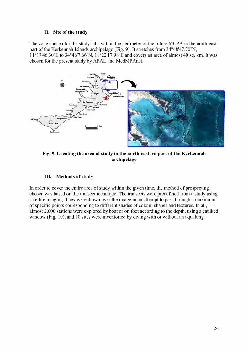
II. Site of the study The zone chosen for the study falls within the perimeter of the future MCPA in the north-east part of the Kerkennah Islands archipelago (Fig. 9). It stretches from 34°48'47.70''N, 11°17'46.30''E to 34°46'7.66''N, 11°22'17.98''E and covers an area of almost 40 sq. km. It was chosen for the present study by APAL and MedMPAnet.
Fig. 9. Locating the area of study in the north-eastern part of the Kerkennah
archipelago
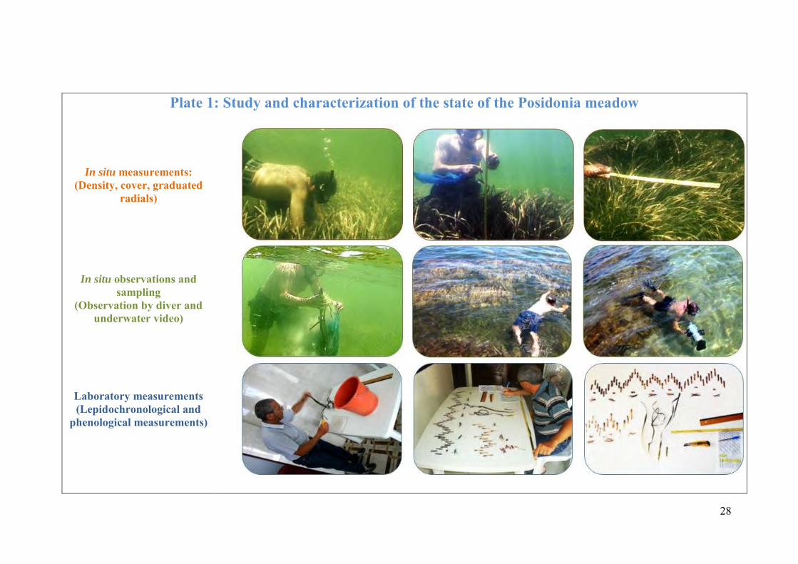
III. Methods of study In order to cover the entire area of study within the given time, the method of prospecting chosen was based on the transect technique. The transects were predefined from a study using satellite imaging. They were drawn over the image in an attempt to pass through a maximum of specific points corresponding to different shades of colour, shapes and textures. In all, almost 2,000 stations were explored by boat or on foot according to the depth, using a caulked window (Fig. 10), and 10 sites were inventoried by diving with or without an aqualung.
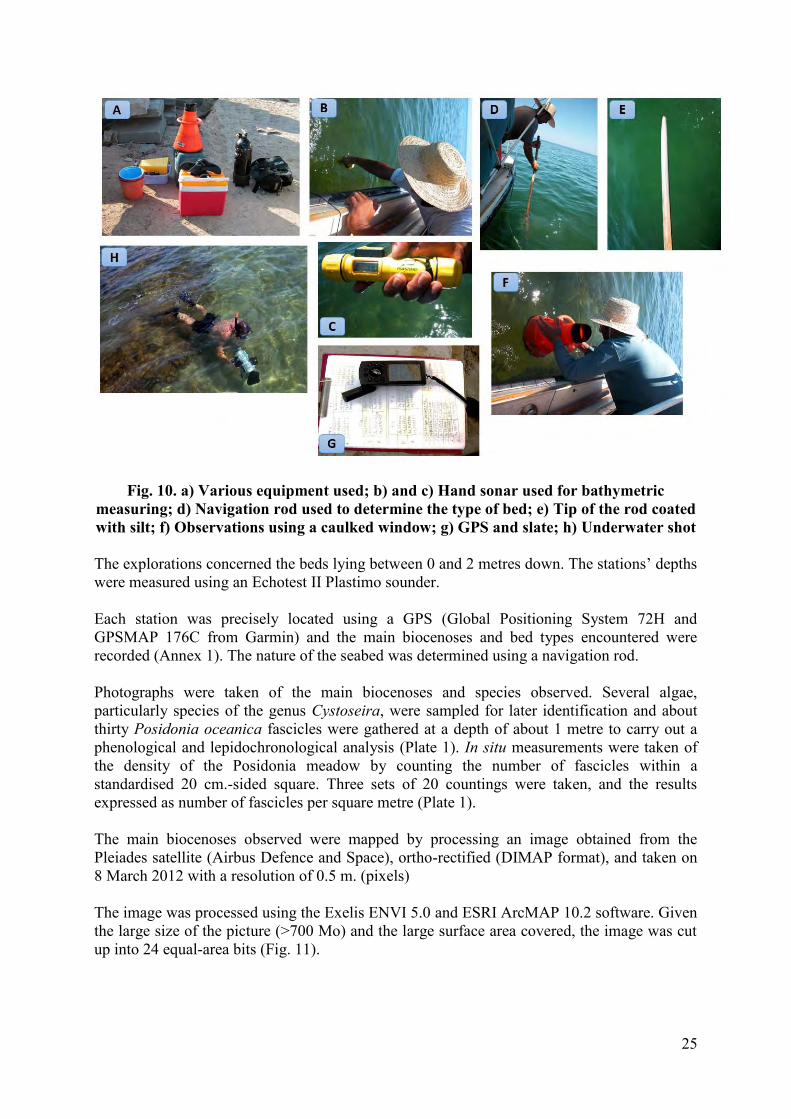
25
Fig. 10. a) Various equipment used; b) and c) Hand sonar used for bathymetric measuring; d) Navigation rod used to determine the type of bed; e) Tip of the rod coated with silt; f) Observations using a caulked window; g) GPS and slate; h) Underwater shot The explorations concerned the beds lying between 0 and 2 metres down. The stations’ depths were measured using an Echotest II Plastimo sounder. Each station was precisely located using a GPS (Global Positioning System 72H and GPSMAP 176C from Garmin) and the main biocenoses and bed types encountered were recorded (Annex 1). The nature of the seabed was determined using a navigation rod. Photographs were taken of the main biocenoses and species observed. Several algae, particularly species of the genus Cystoseira, were sampled for later identification and about thirty Posidonia oceanica fascicles were gathered at a depth of about 1 metre to carry out a phenological and lepidochronological analysis (Plate 1). In situ measurements were taken of the density of the Posidonia meadow by counting the number of fascicles within a standardised 20 cm.-sided square. Three sets of 20 countings were taken, and the results expressed as number of fascicles per square metre (Plate 1). The main biocenoses observed were mapped by processing an image obtained from the Pleiades satellite (Airbus Defence and Space), ortho-rectified (DIMAP format), and taken on 8 March 2012 with a resolution of 0.5 m. (pixels) The image was processed using the Exelis ENVI 5.0 and ESRI ArcMAP 10.2 software. Given the large size of the picture (>700 Mo) and the large surface area covered, the image was cut up into 24 equal-area bits (Fig. 11).
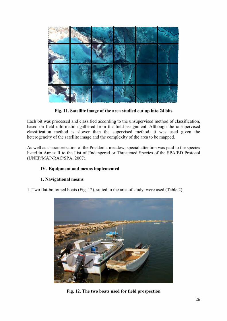
26
Fig. 11. Satellite image of the area studied cut up into 24 bits Each bit was processed and classified according to the unsupervised method of classification, based on field information gathered from the field assignment. Although the unsupervised classification method is slower than the supervised method, it was used given the heterogeneity of the satellite image and the complexity of the area to be mapped. As well as characterization of the Posidonia meadow, special attention was paid to the species listed in Annex II to the List of Endangered or Threatened Species of the SPA/BD Protocol (UNEP/MAP-RAC/SPA, 2007).
IV. Equipment and means implemented
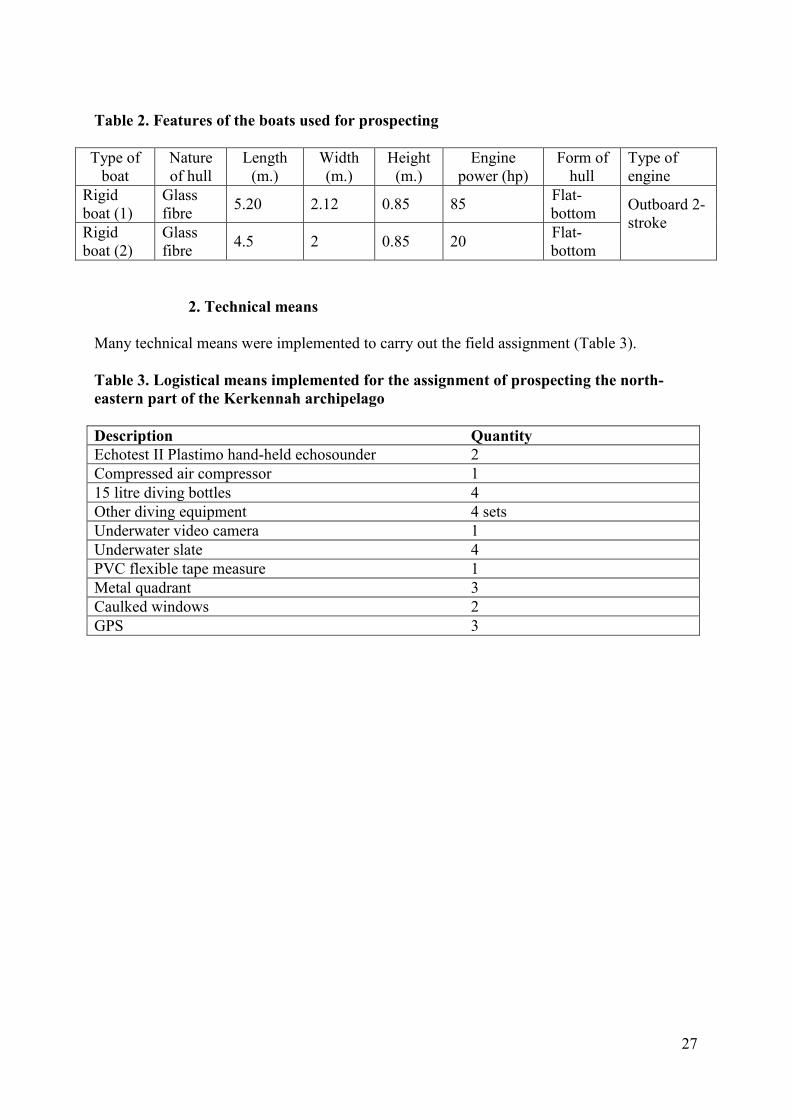
1. Navigational means 1. Two flat-bottomed boats (Fig. 12), suited to the area of study, were used (Table 2).
Fig. 12. The two boats used for field prospection
27
Table 2. Features of the boats used for prospecting
Type of boat
Nature of hull
Length (m.)
Width (m.)
Height (m.)
Engine power (hp)
Form of hull
Type of engine
Rigid boat (1)
Glass fibre 5.20 2.12 0.85 85 Flat-
bottom Outboard 2-stroke Rigid
boat (2) Glass fibre 4.5 2 0.85 20 Flat-
bottom
2. Technical means Many technical means were implemented to carry out the field assignment (Table 3). Table 3. Logistical means implemented for the assignment of prospecting the north-eastern part of the Kerkennah archipelago Description Quantity Echotest II Plastimo hand-held echosounder 2 Compressed air compressor 1 15 litre diving bottles 4 Other diving equipment 4 sets Underwater video camera 1 Underwater slate 4 PVC flexible tape measure 1 Metal quadrant 3 Caulked windows 2 GPS 3
28
Plate 1: Study and characterization of the state of the Posidonia meadow
In situ measurements: (Density, cover, graduated
radials)
In situ observations and sampling
(Observation by diver and underwater video)
Laboratory measurements (Lepidochronological and
phenological measurements)
29
CHAPTER IV: PRESENTING AND EXPLOITING THE RESULTS
Benthic bionomy – Description of the main biocenoses and bed types The different biocenoses and associations identified and the different outstanding species encountered are described below. The benthic biocenoses are identified and classified at bathymetric level (Plate 2; Table 4) according to the classification of marine benthic biocenoses in the Mediterranean region crafted in the context of the Barcelona Convention (UNEP, MAP, RAC/SPA 2007). If a biocenosis is lacking in this document, the classification of the National Natural History Museum is considered (Michez et al., 2014). This new classification is based on the most recent updating of the lists of existing habitats, particularly the Natura 2000 habitats files and the ZNIEFF Inventory listing of Mediterranean biocenoses in the Provence-Alpes-Côte d’Azur Region (PACA). Table 4. Benthic biocenoses identified during the study, classed by bathymetric level according to the typology of Mediterranean benthic biocenoses (UNEP-MAP-RAC/SPA, 2007; Michez et al., 2014) LEVEL SUBSTRATUM BIOCENOSIS
SUPR
AL
ITT
OR
AL
SILTS Biocenosis of slow-drying wrack under Salicornia (SDW)
SANDS Biocenosis of supralittoral sands Facies of plantless sands with dispersed debris
Facies of stranded phanerogams (higher part) HARD BEDS AND ROCKS
Biocenosis of supralittoral rock (SR)
ME
DIO
LIT
TO
RA
L
SILTS, SANDY SILTS AND SANDS IN EURYHALINE AND EURYTHERMAL ENVIRONMENT
Biocenosis of silty sands and silts of lagoons and estuaries (SSLE)
Associations with halophytes
SANDS Biocenosis of mediolittoral sands
HARD BEDS AND ROCKS Construction with Neogoniolithon brassica-florida
INFR
AL
ITT
OR
AL
FAIRLY SILTY FINE SANDS IN OPEN SEA
Biocenosis of high level fine sands (HLFS) Biocenosis of well-calibrated fine sands (WCFS)
Association with Halophila stipulacea Association with Cymodocea nodosa on WCFS
Biocenosis of superficial calm mode silty sands (CMSS) Association with Cymodocea nodosa, Zostera noltii, Caulerpa prolifera, and Caulerpa ollivieri*
FAIRLY SILTY COARSE SANDS
Biocenosis of coarse sands and fine gravels tossed by waves (CSTW) Association with rhodoliths on CSTW
(Lithophyllum dentatum, Lithophyllum racemus, Lithophyllum incrustans)
POSIDONIA Biocenosis of Posidonia oceanica meadow
30
OCEANICA MEADOW Biocenosis of Posidonia oceanica meadow association
Striped meadow ecomorphosis
HARD BEDS AND ROCKS
Biocenosis of infralittoral algae Association with Cystoseira crinita, C. foeniculacea (Syn. C. discors) and C. compressa/C. crinitophylla * Association with Cystoseira brachycarpa, C. funkii) and C. spinosa var. tenuior/C. squarrosa * Association with Cystoseira sauvageaueana and C. barbata * Association with Cystoseira spinosa and C. usneoides * Association with Corallina elongata and Herposiphonia secunda * Association with Padina pavonica, Dictyotales, Stypocaulon scoparium and Laurencia spp./Anadyomene stellata * Association with Codium spp * Association with Cladostephus spongiosus (Syn. C. hirsutus) and Dasycladus vermicularis * Association with Acetabularia acetabulum *
* See description suited to the situation in the area of study in the later part of the text
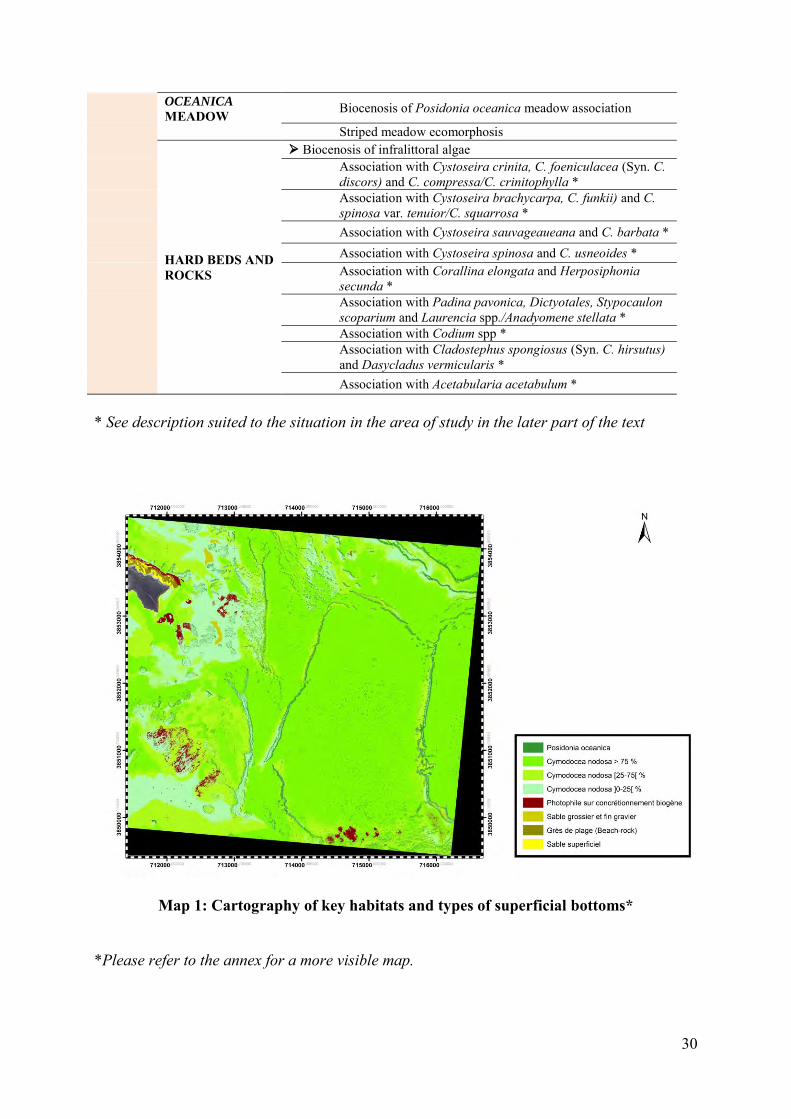
Map 1: Cartography of key habitats and types of superficial bottoms* *Please refer to the annex for a more visible map.
31
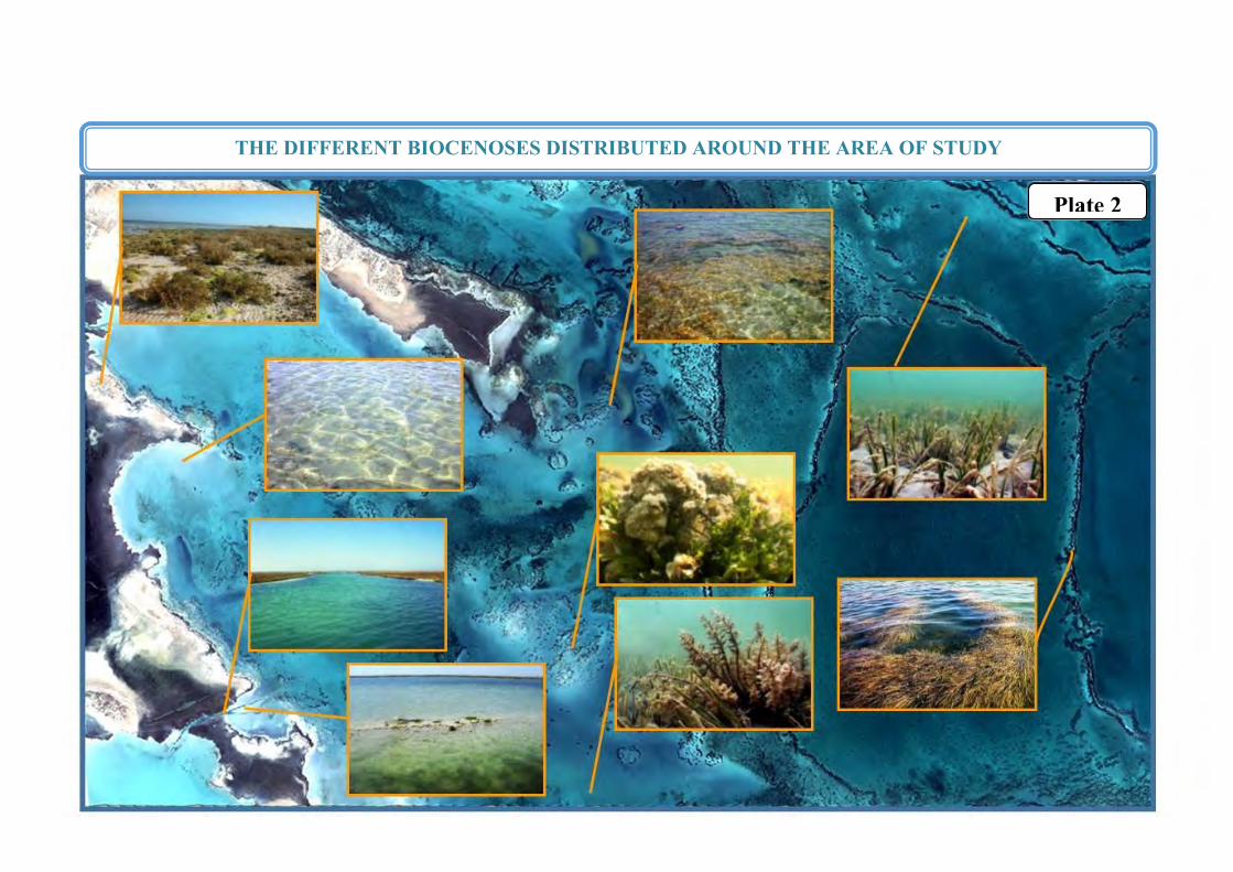
THE DIFFERENT BIOCENOSES DISTRIBUTED AROUND THE AREA OF STUDY
Plate 2
32
I. Adlittoral level: land area This ‘land’ level has not been the subject of specific observation; a recent, very detailed, study was done in the context of the programme on Small Mediterranean Islands (Médail et al., 2015). It looked at the flora and vegetation in the Kerkennah archipelago’s islands and satellite islets; the main findings appear below. ‘…One can make out three different communities linked to the sandy coasts, especially well represented in the Gremdi, Roumadiya and Gharsa islands. The first is made up of a small number of pioneer nitrophilous therophytes (e.g. Cakile maritima), that specialize in exploiting the organic sediment brought by the sea, which corresponds to habitat 1210 (= annual vegetation of the sea debris). The second is characterized by Pancratium maritimum, Polygonum maritimum, etc., species that are typical of habitat 2110 (= embryonic moving dunes); lastly, the ‘white dunes’ of the littoral belt corresponding to habitat 2120 (moving dunes with Ammophila arenaria). On the slightly rocky coasts strongly affected by marine spray develop communities with halo-xerophilous therophytes with a very brief cycle that exploit the little layers of sandy-silty and salty soil that can accumulate in the hollows of the soil; this corresponds to habitat 1510 (=Mediterranean salty steppe: Limonietalia, Frankenietalia pulverulentae) with, as characteristic species, Limonium avei, Frankenia pulverulenta, etc.). The clayey and salt-marshy soils allow a low shrubby vegetation to develop dominated by numerous species of Amaranthacea (genus Arthrocnemum, Suaeda, Sarcocornia, Salsola, Halimione, Atriplex, etc.) that form rather uniform and paucispecific plant formations of sansouires referred to habitat 1420 (=Mediterranean and thermo-Atlantic halophilous thickets: Sarcocornietea fruticosae); on the southern coast of Gremdi and in Sefnou a formation with Limonium tunetanum and Juncus maritimus falls within this wide type of vegetation. In an even more nitrophilous and xeric context there exists a facies characterized by the prevalence of Limoniastrum monopetalum, Anabasis oropediorum, Halocnemum cruciatum, Salsola oppositifolia, Atriplex glauca, Nitraria retusa and Lycium schweinfurthii, typical of habitat 1430 (=halo-nitrophilous thickets: Pegano-Salsoletea). Among these woody formations can be seen open clayey-sandy zones occupied by paucispecific phytocenoses, dominated by annual salicornia (Salicornia sp.) and corresponding to habitat 1310 (=pioneer vegetations with Salicornia and other annual species of the muddy and sandy zones: Thero-Salicornietea). In slightly higher sectors, exposed to the wind, develop still more xerophilous herbaceous communities, dominated by perennial grasses such as esparto (Lygeum spartum) that can be linked to habitat 6220 (=sub-steppe areas of grasses and annuals: Lygeo-Stipetea tenacissimae). In the bigger islands, herbaceous formations of perennial plants are very discontinuous and are disturbed by grazing, and the big perennial grasses like Stipa parviflora, formerly much more widespread in Gremdi, have become extremely rare. But there exist various types of annual prairies that are very rich in species and overgrazing has given rise to the forming of herbaceous phytocenoses dominated by toxic bulbous plants like the asphodels and sea squill or very glandular and/or spiny hemicryptophytes (particularly the Asteraceae and Boraginaceae). Centuries of overgrazing and wood cutting (cf. below) have caused the total absence of pre-forest and forest formations. The only appreciable woody plant is represented by various facies of very low and discontinuous matorral, dominated especially by suffrutescent
33
chamaephytes (Thymelaea hirsuta, Teucrium luteum subsp. Gabesianum, Helianthemum spp. etc.) characteristic of habitat 5330 (=thermo-Mediterranean and pre-steppe thickets: Cisto-Micromerietea)….’.
II. Supralittoral level In the Kerkennah archipelago, the supralittoral level lies above the level of high seas of average spring tides, and only the equinox tides or storm waves can submerge it. But it is regularly wetted by spray.
1. Silts Biocenosis of slow-drying sea debris under salicornia This biocenosis allows the sea debris to dry out more slowly because it is protected from the direct sun by salicornia. It is characterized by a great number of detritus-eating species (amphipods, isopods) and their predators (insects). In the site studied, this biocenosis has the particularity of being accessible by the tide where it is closest to the sea (Fig. 13). Also, the silty substratum is locally covered with gravel and small pebbles probably from the degradation of beach-rock; Fig. 13). This is an area where sea debris accumulates, especially of marine phanerogams from the nearby meadows and lawns (Posidonia oceanica and Cymodocea nodosa) (Fig. 13). As well as marine-origin plants, this habitat also receives human-origin discharge of every kind, which pile up here. This macro-waste is essentially made up of plastic waste from unauthorized tips, building waste, waste from fishing boats (nets, floats…).
Fig. 13. Biocenosis of slow-drying wrack under salicornia (Arthrocnemum, Salicornioideae) at low tide (A) and high tide (B)
2. Sands
Biocenosis of supralittoral sands This biocenosis corresponds to the upper beach which is mainly wetted during storms; as well as the humidity, the temperature presents strong variations. Many insects are present, as are
B A
34
amphipod crustaceans and isopods. The best represented facies is the ‘Facies of sands without vegetation and with dispersed debris’ (Fig. 14).
Fig. 14. Facies of sands without vegetation and with dispersed debris with gravels from the degradation of beach-rock (left) and washed up phanerogam leaves (right)
3. Hard beds and rocks
Biocenosis of supralittoral rock The biocenosis of supralittoral rock corresponds, in the site studied, to the low rocky coasts formed of calcareous beach-rock. These formations are covered with gravel and small pebbles resulting from the erosion of that substratum (Fig. 15). The erosion is accentuated by the action of the spray and enclaves with variable salinity can form; seawater is trapped in the rocky cavities, including at low tide (Etienne, 2014). This process gives rise to specific coastal facies (Oueslati, 1986).
Fig. 15. Corroded sandstone veneer with signs of erosion (arrow)
35
III. Mediolittoral level
1. Silts, sandy silts and sands of the lagoons and estuaries Biocenosis of silty sands and silts This biocenosis corresponds to the extension of the slow-drying sea debris under salicornia biocenosis identified in the supralittoral (II.1), particularly the association with halophytes of type 1 that corresponds to the formations made up of annual halophilous plants of the genus Salicornia colonizing the periodically flooded sands and silts.
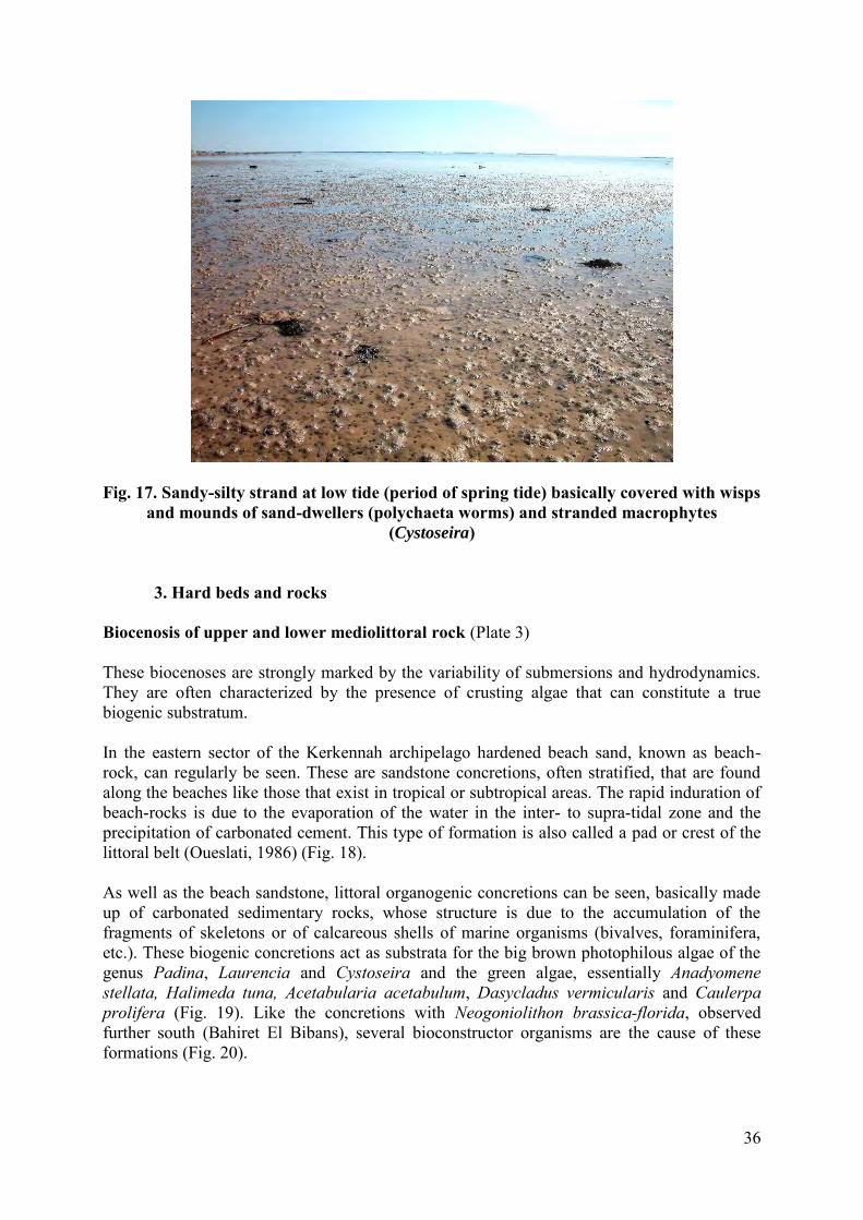
2. Sands Biocenosis of mediolittoral sands Starting from the shore, a strip is found that is fairly widely exposed when the sea is low and has no vegetation (Fig. 16 and 17). These bare beds shelter populations of varied invertebrates: Polychaeta (Hediste diversicolor, Arenicola marina), burrowing amphipods, bivalve molluscs and especially isopods such as Tylos sp. Cyathura carinata.
Fig. 16. Substratum of the foreshore formed by silty sand with shell debris and some gravel
When the sea is low, wisps and mounds of sand-dwellers (genus Arenicola) are seen in the foreshore.
36
Fig. 17. Sandy-silty strand at low tide (period of spring tide) basically covered with wisps and mounds of sand-dwellers (polychaeta worms) and stranded macrophytes
(Cystoseira)
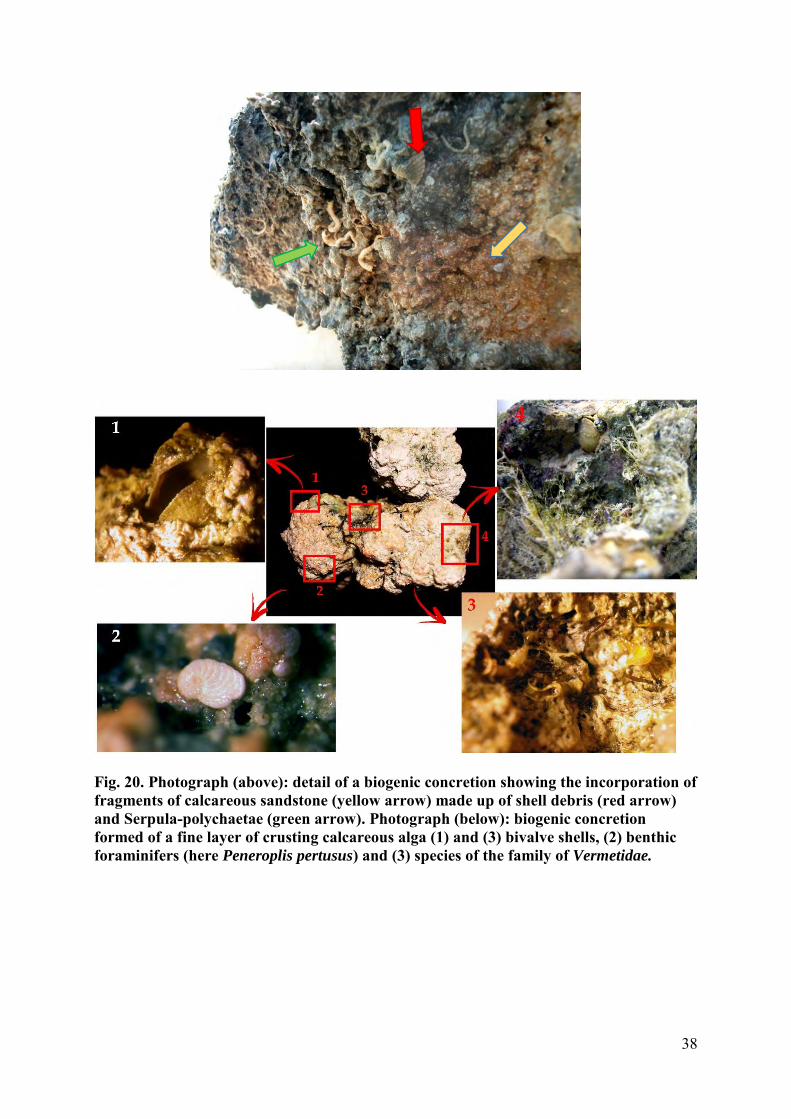
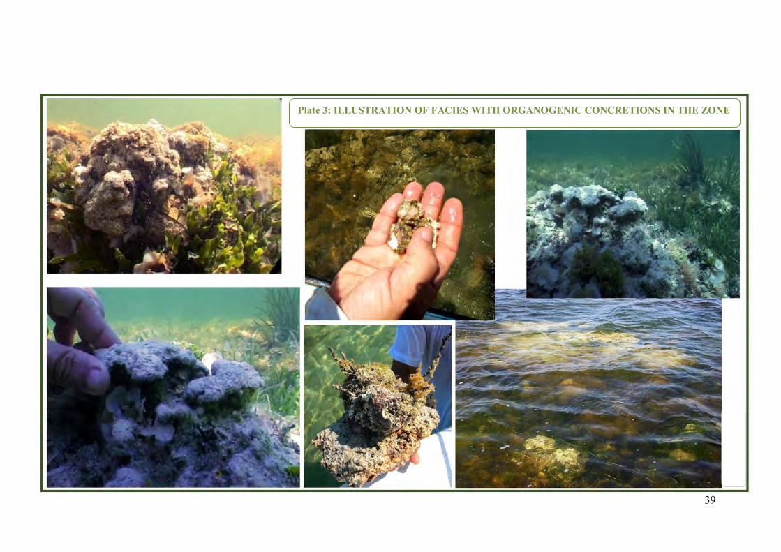
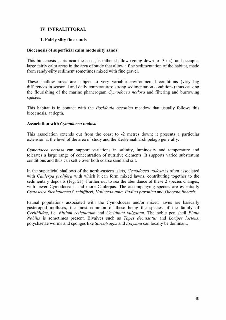
3. Hard beds and rocks Biocenosis of upper and lower mediolittoral rock (Plate 3) These biocenoses are strongly marked by the variability of submersions and hydrodynamics. They are often characterized by the presence of crusting algae that can constitute a true biogenic substratum. In the eastern sector of the Kerkennah archipelago hardened beach sand, known as beach-rock, can regularly be seen. These are sandstone concretions, often stratified, that are found along the beaches like those that exist in tropical or subtropical areas. The rapid induration of beach-rocks is due to the evaporation of the water in the inter- to supra-tidal zone and the precipitation of carbonated cement. This type of formation is also called a pad or crest of the littoral belt (Oueslati, 1986) (Fig. 18). As well as the beach sandstone, littoral organogenic concretions can be seen, basically made up of carbonated sedimentary rocks, whose structure is due to the accumulation of the fragments of skeletons or of calcareous shells of marine organisms (bivalves, foraminifera, etc.). These biogenic concretions act as substrata for the big brown photophilous algae of the genus Padina, Laurencia and Cystoseira and the green algae, essentially Anadyomene stellata, Halimeda tuna, Acetabularia acetabulum, Dasycladus vermicularis and Caulerpa prolifera (Fig. 19). Like the concretions with Neogoniolithon brassica-florida, observed further south (Bahiret El Bibans), several bioconstructor organisms are the cause of these formations (Fig. 20).
37
Fig. 18. Beach-rock observed at mediolittoral level in the Kerkennah archipelago
Fig. 19. Littoral organogenic concretions of photophilous algae
(Left: concretion with Neogoniolithon brassica-florida)
38
Fig. 20. Photograph (above): detail of a biogenic concretion showing the incorporation of fragments of calcareous sandstone (yellow arrow) made up of shell debris (red arrow) and Serpula-polychaetae (green arrow). Photograph (below): biogenic concretion formed of a fine layer of crusting calcareous alga (1) and (3) bivalve shells, (2) benthic foraminifers (here Peneroplis pertusus) and (3) species of the family of Vermetidae.
39
Plate 3: ILLUSTRATION OF FACIES WITH ORGANOGENIC CONCRETIONS IN THE ZONE
40
IV. INFRALITTORAL
1. Fairly silty fine sands Biocenosis of superficial calm mode silty sands This biocenosis starts near the coast, is rather shallow (going down to -3 m.), and occupies large fairly calm areas in the area of study that allow a fine sedimentation of the habitat, made from sandy-silty sediment sometimes mixed with fine gravel. These shallow areas are subject to very variable environmental conditions (very big differences in seasonal and daily temperatures; strong sedimentation conditions) thus causing the flourishing of the marine phanerogam Cymodocea nodosa and filtering and burrowing species. This habitat is in contact with the Posidonia oceanica meadow that usually follows this biocenosis, at depth. Association with Cymodocea nodosa This association extends out from the coast to -2 metres down; it presents a particular extension at the level of the area of study and the Kerkennah archipelago generally. Cymodocea nodosa can support variations in salinity, luminosity and temperature and tolerates a large range of concentration of nutritive elements. It supports varied substratum conditions and thus can settle over both coarse sand and silt. In the superficial shallows of the north-eastern islets, Cymodocea nodosa is often associated with Caulerpa prolifera with which it can form mixed lawns, contributing together to the sedimentary deposits (Fig. 21). Further out to sea the abundance of these 2 species changes, with fewer Cymodoceans and more Caulerpas. The accompanying species are essentially Cystoseira foeniculacea f. schiffneri, Halimeda tuna, Padina pavonica and Dictyota linearis. Faunal populations associated with the Cymodoceas and/or mixed lawns are basically gasteropod molluscs, the most common of these being the species of the family of Cerithiidae, i.e. Bittium reticulatum and Cerithium vulgatum. The noble pen shell Pinna Nobilis is sometimes present. Bivalves such as Tapes decussatus and Loripes lacteus, polychaetae worms and sponges like Sarcotragus and Aplysina can locally be dominant.
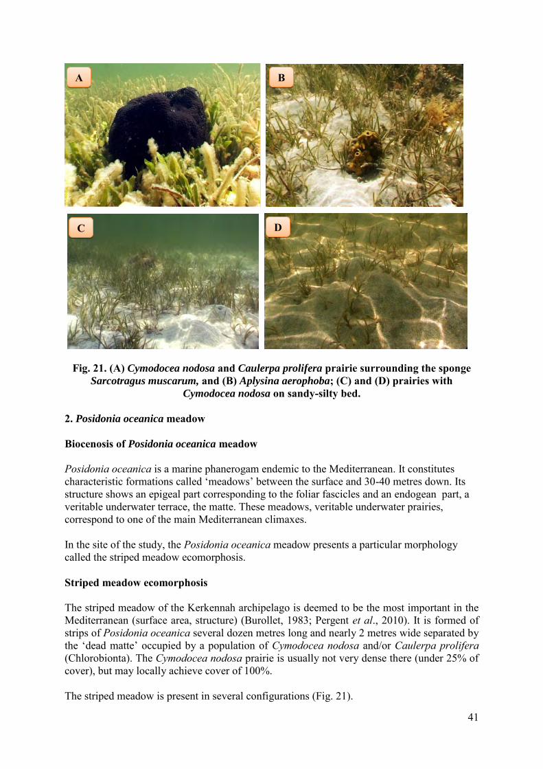
41
Fig. 21. (A) Cymodocea nodosa and Caulerpa prolifera prairie surrounding the sponge
Sarcotragus muscarum, and (B) Aplysina aerophoba; (C) and (D) prairies with
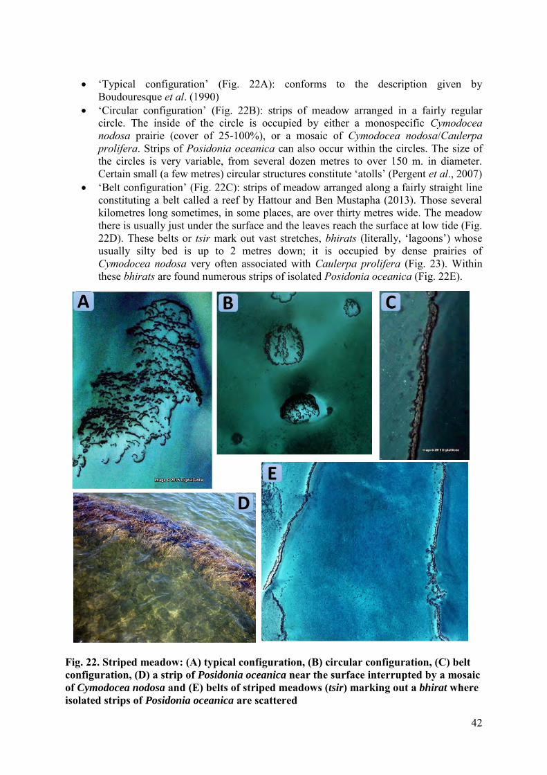
Cymodocea nodosa on sandy-silty bed. 2. Posidonia oceanica meadow Biocenosis of Posidonia oceanica meadow Posidonia oceanica is a marine phanerogam endemic to the Mediterranean. It constitutes characteristic formations called ‘meadows’ between the surface and 30-40 metres down. Its structure shows an epigeal part corresponding to the foliar fascicles and an endogean part, a veritable underwater terrace, the matte. These meadows, veritable underwater prairies, correspond to one of the main Mediterranean climaxes. In the site of the study, the Posidonia oceanica meadow presents a particular morphology called the striped meadow ecomorphosis. Striped meadow ecomorphosis The striped meadow of the Kerkennah archipelago is deemed to be the most important in the Mediterranean (surface area, structure) (Burollet, 1983; Pergent et al., 2010). It is formed of strips of Posidonia oceanica several dozen metres long and nearly 2 metres wide separated by the ‘dead matte’ occupied by a population of Cymodocea nodosa and/or Caulerpa prolifera (Chlorobionta). The Cymodocea nodosa prairie is usually not very dense there (under 25% of cover), but may locally achieve cover of 100%. The striped meadow is present in several configurations (Fig. 21).
C D
A B
42
‘Typical configuration’ (Fig. 22A): conforms to the description given by
Boudouresque et al. (1990) ‘Circular configuration’ (Fig. 22B): strips of meadow arranged in a fairly regular
circle. The inside of the circle is occupied by either a monospecific Cymodocea nodosa prairie (cover of 25-100%), or a mosaic of Cymodocea nodosa/Caulerpa
prolifera. Strips of Posidonia oceanica can also occur within the circles. The size of the circles is very variable, from several dozen metres to over 150 m. in diameter. Certain small (a few metres) circular structures constitute ‘atolls’ (Pergent et al., 2007)
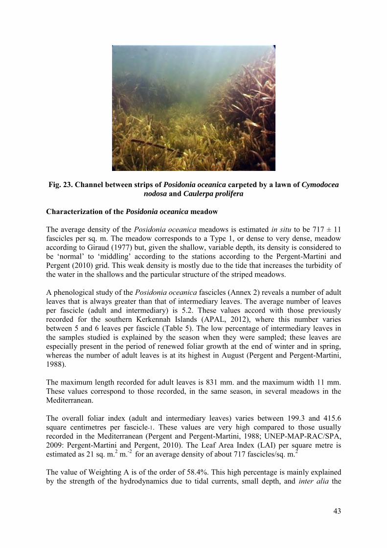
‘Belt configuration’ (Fig. 22C): strips of meadow arranged along a fairly straight line constituting a belt called a reef by Hattour and Ben Mustapha (2013). Those several kilometres long sometimes, in some places, are over thirty metres wide. The meadow there is usually just under the surface and the leaves reach the surface at low tide (Fig. 22D). These belts or tsir mark out vast stretches, bhirats (literally, ‘lagoons’) whose usually silty bed is up to 2 metres down; it is occupied by dense prairies of Cymodocea nodosa very often associated with Caulerpa prolifera (Fig. 23). Within these bhirats are found numerous strips of isolated Posidonia oceanica (Fig. 22E).
Fig. 22. Striped meadow: (A) typical configuration, (B) circular configuration, (C) belt configuration, (D) a strip of Posidonia oceanica near the surface interrupted by a mosaic of Cymodocea nodosa and (E) belts of striped meadows (tsir) marking out a bhirat where isolated strips of Posidonia oceanica are scattered
43
Fig. 23. Channel between strips of Posidonia oceanica carpeted by a lawn of Cymodocea
nodosa and Caulerpa prolifera Characterization of the Posidonia oceanica meadow The average density of the Posidonia oceanica meadows is estimated in situ to be 717 ± 11 fascicles per sq. m. The meadow corresponds to a Type 1, or dense to very dense, meadow according to Giraud (1977) but, given the shallow, variable depth, its density is considered to be ‘normal’ to ‘middling’ according to the stations according to the Pergent-Martini and Pergent (2010) grid. This weak density is mostly due to the tide that increases the turbidity of the water in the shallows and the particular structure of the striped meadows. A phenological study of the Posidonia oceanica fascicles (Annex 2) reveals a number of adult leaves that is always greater than that of intermediary leaves. The average number of leaves per fascicle (adult and intermediary) is 5.2. These values accord with those previously recorded for the southern Kerkennah Islands (APAL, 2012), where this number varies between 5 and 6 leaves per fascicle (Table 5). The low percentage of intermediary leaves in the samples studied is explained by the season when they were sampled; these leaves are especially present in the period of renewed foliar growth at the end of winter and in spring, whereas the number of adult leaves is at its highest in August (Pergent and Pergent-Martini, 1988). The maximum length recorded for adult leaves is 831 mm. and the maximum width 11 mm. These values correspond to those recorded, in the same season, in several meadows in the Mediterranean. The overall foliar index (adult and intermediary leaves) varies between 199.3 and 415.6 square centimetres per fascicle-1. These values are very high compared to those usually recorded in the Mediterranean (Pergent and Pergent-Martini, 1988; UNEP-MAP-RAC/SPA, 2009: Pergent-Martini and Pergent, 2010). The Leaf Area Index (LAI) per square metre is estimated as 21 sq. m.2 m.-2 for an average density of about 717 fascicles/sq. m.2 The value of Weighting A is of the order of 58.4%. This high percentage is mainly explained by the strength of the hydrodynamics due to tidal currents, small depth, and inter alia the
44
mechanical pressure exercised by maritime traffic in this zone. Epiphytism and grazing are secondary factors that increase the risk of loss of apex in this zone. Table 5. Phenological parameters of the Posidonia oceanica meadow in the north-eastern part of the Kerkennah Islands archipelago in July 2015 (average ± 95% confidence interval ). LAI=Leaf Area Index. Weighting A = (number of broken Ad+In leaves/total number of leaves) x 100 Adult (Ad) Intermediary (Int) Total (Ad+Int) Average number of leaves.fascicle-1
3,4 ± 0,4 1.8 ± 0,4 5.2 ± 0.6
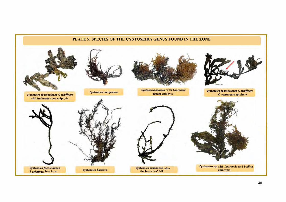
Average length (mm.) 718,0 ± 44.3 294.0 ± 37,8 510,6 ± 104,6 Average width (mm.) 10,5 ± 0.2 10,3 ± 0.2 10,4 ± 0,2 Weighting A (%.fascicle-1) 84,1 ± 0,08 6,5 ± 0,07 58.4 ± 0.07 Foliar index (cm2.fascicle-1) 255,6 ± 30.9 54.9 ± 12.2 308.1 ± 28.9 LAI (m2.m-2) 18.3 ± 2.2 3.8 ± 0.9 21.1 ± 2.7 A lepidochronological analysis (Annex 3) confirms a very great vertical growth of the rhizome (16.4 ± 1.27 mm./year). These values are considered to be high compared to the average values measured in the Mediterranean (7.4 mm.year-1 in Pergent et al., 1995). Average annual foliar production varies between 3.8 and 9.8 leaves for an overall average of 6.9 ± 0.01. This production is close to the average observed in various Mediterranean stations estimated by Pergent et al., 1995) at 7.5 scales per cycle. In general, the meadows observed in the area under study present a good vitality and do not seem to be suffering from significant human-origin pressure. Biocenosis of infralittoral algae Since the study did not aim at establishing an exhaustive inventory of the macrophytobenthos, we are presenting here the species of conservation interest targeted by our samplings and a few accompanying species gathered at the same time. Thus, 26 species of macrophyte were recorded in the area studied: 10 Chlorophyta, 5 Rhodophyta and 11 Ochrophyta (Table 6). The macrophytobenthos is mostly planted over an organogenic concretion (Fig. 24). It should be noted that the concretions are present both in the infralittoral and in the mediolittoral. The order of Fucals (Ochrophyta) is the most representative, with 7 species (Plate 5) which appear on the List in Annex II to the SPA/BD Protocol. The only species of conservation interest observed in the study area belong to the genus Cystoseira. The Cystoseiras are species with high heritage value in the Mediterranean which build ‘forests’ like those found on land. These forests characterize habitats that are outstanding in terms of biodiversity and productivity. Among these species, Cystoseira foeniculacea f.
45
schiffneri, endemic to the Mediterranean, whose area of distribution is restricted in the Mediterranean, is the most abundant. It forms small forests, along with C. susanensis and C. foeniculacea and C. foeniculacea f. tenuiramosa. Cystoseira compressa and C. spinosa are also present, but sparsely. C. compressa was only found as an epiphyte on Cystoseira foeniculacea f. schiffneri or in association with Padina pavonica. Table 6: List of macrophytobenthos species observed (excluding Magnoliophytes. *: species listed in Annex II (List of endangered or threatened species) of the Barcelona Convention (UNEP/MAP-RAC/SPA, 2007)
Phylum Class Order Genus and species
Chl
orop
hyta
Ulv
oph
ycea
e
Dasycladales Acetabularia acetabulum Dasycladus vermicularis
Cladophorales Anadyomene stellata
Bryopsidales
Caulerpa prolifera Halimeda tuna Flabellia petiolata Codium vermilara Penicillus capitatus
Siphonocladales Valonia aegagropila Valonia sp.
Och
roph
yta
Ph
aeo
ph
ycea
e
Fucales
Cystoseira barbata * Cystoseira compressa Cystoseira foeniculacea * Cystoseira foeniculacea f. schiffneri * Cystoseira foeniculacea f. tenuiramosa * Cystoseira sp. Cystoseira spinosa * Cystoseira susanensis *
Dictyotales Dictyota linearis Padina pavonica
Sphacelariales Halopteris scoparia
Rho
doph
yta
Flo
rideo
ph
ycea
e
Corallinales Jania rubens Lithophyllum sp.
Nemaliales Liagora viscida Ceramiales Laurencia obtusa
Peyssonneliales Peyssonnelia squamaria
In the Cystoseira forests, the following were identified: Flora made up of Padina pavonica, Dasycladus vermicularis, Halimeda tuna, Laurencia obtusa and sp. Cladophora sp. and Anadyomene stellata
46
Fauna made up of isopod crustaceans (Spaeroma serratum, Eurydice pulchra), juvenile holothurians, Echinoderms (Amphipholis squamata and Ophioderma longicauda, Asterina gibbosa), ascidians (Didemnum sp. and Ectinascidia turbinata) and the black-striped pipefish Syngnathus abaster.
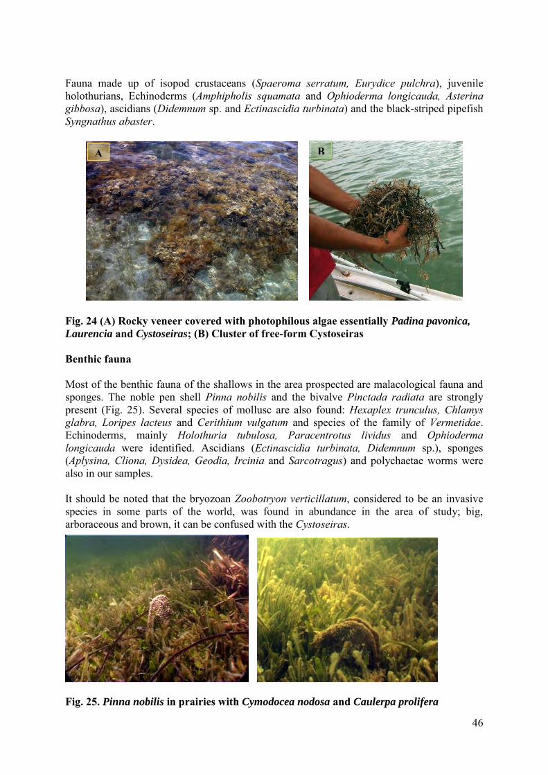
Fig. 24 (A) Rocky veneer covered with photophilous algae essentially Padina pavonica,
Laurencia and Cystoseiras; (B) Cluster of free-form Cystoseiras Benthic fauna Most of the benthic fauna of the shallows in the area prospected are malacological fauna and sponges. The noble pen shell Pinna nobilis and the bivalve Pinctada radiata are strongly present (Fig. 25). Several species of mollusc are also found: Hexaplex trunculus, Chlamys glabra, Loripes lacteus and Cerithium vulgatum and species of the family of Vermetidae. Echinoderms, mainly Holothuria tubulosa, Paracentrotus lividus and Ophioderma longicauda were identified. Ascidians (Ectinascidia turbinata, Didemnum sp.), sponges (Aplysina, Cliona, Dysidea, Geodia, Ircinia and Sarcotragus) and polychaetae worms were also in our samples. It should be noted that the bryozoan Zoobotryon verticillatum, considered to be an invasive species in some parts of the world, was found in abundance in the area of study; big, arboraceous and brown, it can be confused with the Cystoseiras.
Fig. 25. Pinna nobilis in prairies with Cymodocea nodosa and Caulerpa prolifera
A B
47
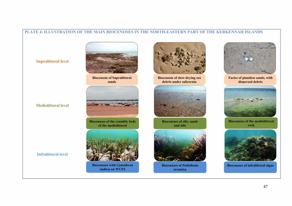
PLATE 4: ILLUSTRATION OF THE MAIN BIOCENOSES IN THE NORTH-EASTERN PART OF THE KERKENNAH ISLANDS
Supralittoral level
Mediolittoral level
Infralittoral level
Biocenosis of Supralittoral sands
Biocenosis of slow-drying sea debris under salicornia
Facies of plantless sands, with dispersed debris
Biocenoses of the crumbly beds of the mediolittoral
Biocenoses of silty sands and silts
Biocenoses of the mediolittoral rock
Biocenoses with Cymodocea
nodosa on WCFS Biocenoses of Podsidonia
oceanica Biocenoses of infralittoral algae
48
with epiphyte epiphyte
with
with Laurencia and Padina free form the branches’ fall
after
epiphyte
epiphytes
PLATE 5: SPECIES OF THE CYSTOSEIRA GENUS FOUND IN THE ZONE
49
CHAPTER V. SUMMARY OF NATURAL AND CULTURAL POTENTIAL AND
VULNERABILITIES IN THE AREA OF STUDY
I. Assessment of natural and cultural potential of the area north-east of the Kerkennah archipelago
1. Marine biodiversity
High biodiversity and an outstanding marine landscape The data gathered during the investigation campaign confirms the presence of a great natural potential associated with a very high marine biological diversity. Moreover, the observations bear witness to a good state of conservation of the marine environment in general. Outstanding flora The underwater landscape in the area north-east of the Kerkennah archipelago is characterized by the presence of an immense Posidonia oceanica meadow, of high vitality, which carpets the shallows and appears on the surface at low tide. This natural heritage, considered to be one of the most outstanding in all the Mediterranean, is important in that: i) it occupies a very large surface area in the zone of study, ii) it presents a very rare ‘striped meadow’ structure because of tidal currents and thus constitutes a unique natural monument, iii) it has a primordial role at ecological level and in the maintaining of littoral balances: big primary production and high biological diversity, protecting the littoral from erosion, exporting organic matter to other ecosystems, it is a spawning and nursery area for many species of commercial interest, and has underwater landscapes with high aesthetic value. The ecological importance of the shallows surrounding the archipelago are a result of not only the presence of the marine phanerogam Posidonia oceanica but also that of another phanerogam Cymodocea nodosa which helps to fashion the configuration of the marine vegetation of the zone, occupying a surface area of over 1,000 km.2. A mosaic of plant species characterized by mixed meadows of marine phanerogams (Cymodocea nodosa and Posidonia oceanica) and the Chlorobionta Caulerpa prolifera dominate the underwater landscape in the zone. The prairies of Cymodocea nodosa and the meadows of Posidonia oceanica have a vital hydrodynamic role and help fix sediment. Whether by their rhizomes and roots (Posidonia oceanica and Cymodocea nodosa) or by their stolons (Caulerpa prolifera), they fix the crumbly bed and slow down the hydrodynamics, thus acting as sediment stabilisers. These prairies and meadows also present a more direct ecological function, thanks to their high primary production and all the forms of support and shelter they offer. The meadows, especially that of Posidonia oceanica, the biggest ones, act as support and shelter for many other organisms which use them as their exclusive or preferred biotope. They allow the differentiation of many ecological niches (organisms that are fixed, sedentary or vagile on leaves and rhizomes, on the surface or in the sediment, in the water column between or near the plants), occupied by many species that come to spend at least a phase of their lives (reproduction or juvenile stage) there.
50
Also, species of the Cystoseira genus, listed, except for one of them, in Annex II to the SPA/BD Protocol, build marine habitats of great importance, taken into account in the selection of sites to be included in the National Inventory of Natural Sites of Interest for Conservation. Among these species, six are present in the area of study, Cystoseira foeniculacea f. schiffneri being the best represented. Outstanding fauna At benthic level, two species of bivalve mollusc are particularly well represented, the noble pen shell Pinna nobilis, which constitutes a good bio-indicator of the quality of the Mediterranean littoral environment, and Pinctada radiata, which is enfeoffed to the Posidonia oceanica meadow and on the palms of fixed fisheries. The Kerkennah archipelago is also known for its importance in the Tunisian production of commercial sponges (Ben Mustapha, 1991). Several species were identified in the shallows: Spongia officinalis, Petrosia ficiformis and Hippospongia communis. The presence of the marine turtle, the loggerhead Caretta caretta, is regularly signalled (APAL, 2001). Varied avifauna The Kerkennah archipelago is listed as an important zone for birds, an ‘Important Bird and Biodiversity Areas (IBA) and an Important Zone for the Conservation of Waterbirds’ (ZICO). The many sebkhas (one-third of the archipelago’s total surface area) constitute a special wintering area (permanent presence of water) for many waterfowl that come to nest there, for example the great cormorant Phalacrocorax carbo, the gulls and terns, including Larus genei, Larus fuscus, Larus cachinnans, Sterna caspia and Sterna sandvicensis. Other species reproduce in the archipelago, especially the Eurasian kestrel Falco tinnunculus, the cream-coloured courser Cursorius cursor, the European bee-eater Merops apiaster and the grey shrike Lanius excubitor. Also, the archipelago constitutes a major stopover in spring and autumn for hundreds of thousands of migrant passerines (BirdLife International, 2015). In times of migration, a lot of birds coming from Europe go there: limicolous birds and waterfowl like the common spoonbill Platalea leucorodia (Charmadiya and Gremdi), the grey herons Ardea cinerea (Charmadiya and Gremdi), the Caspian gull Larus cachinnans (Charmadiya), limicolous birds and terns. The archipelago shelters 1% of the population of the common spoonbill Platalea leucorodia (176 individuals recorded in January 2009) and 1% of the population of the slender-billed gull Larus genei (1,981 individuals recorded in January 2009). A recent study confirms the importance of the Kerkennah archipelago for avifauna (Qninba & Ouni, 2014). According to this study, several outstanding species of waterfowl were identified in the north-eastern part of the archipelago: the Eurasian stone-curlew Burhinus oedicnemus, very abundant, the terns, relatively rare and very localised in the Maghreb, the ringed plover (Haradrius alexandrinus), the redshank (Tringa totanus) which only reproduces in Africa in Tunisia, the great cormorant (Phalacrocorax carbo) (1,000 to 10,000 present in winter) and the pipit (Anthus campestris).
51
2. Social and cultural values Undeniable social and cultural values Coastal fishing is the oldest activity of the Kerkennah archipelago and has for centuries been the main activity of the people of the region. The typical conditions of Kerkennah encouraged the system of fixed net fisheries that is Kerkennah’s, the Charfia. These fisheries probably go back to the Phoenician age. This original and traditional fishing technique is used and is handed down from father to son. The Charfia uses palm branches planted in the bed to form a path at the end of which the fish are trapped. It can be described as a rectilinear ‘wall’ about 500 m. long made out of palm leaves that ends in a V-shaped wedge of two palm hedges (80-100 m.) whose tip faces onto to the sea. At the tip of the V is an entrance corridor that leads into a holding chamber giving access to several esparto grass (Stipa tenacissima) keepnets (or Drinas) and palm branches in which the fish are trapped at low tide. The Charfias form barriers that stud the coasts of the archipelago with zig-zag lines in the turquoise shimmer of the sea. In the archipelago, there is another local activity, unfortunately declining – the valorizing of dates from the area’s date palms. Climate constraints and poor soil have led the farmers of Kerkennah to adapt and use specific cultural techniques for traditional farming practices, the most important being palm groves and gardens. Among these techniques is dry soil farming, regular and frequent ploughing, scraping of soil, pruning the vines and olives so that they retain the damp, improving the soil etc. (Kebaïli Tarchouna, 2013; Etienne, 2014). Natural protection The Kerkennah archipelago encompasses 161.6 km. of coast but, because of the existence of the sebkhas, only half of the shore is suited to tourist development. Also, the quality of the beaches, often covered at high tide, silty at low tide, with shallow water, does not attract tourists (UNESCO, 1981). The shallows that surround the islands make them hard of access, and only flat-bottomed boats can reach them. All these constraints plus the absence of development facilitating access to the islets in the north-eastern part of the archipelago afford natural protection against the many risks of crowding and exploitation.
II. Vulnerability and main risks and threats to the biotope
1. Human-origin threats
1.1. Threats to the Kerkennah archipelago as a whole Trawling and over-use of living resources The threats are mostly linked to traditional fishing being replaced by modern fishing. Illegal fishing threatens the Kerkennians’ means of existence. Living off fishing has recently become even more difficult, since the trawlers worry the fishing communities by poaching in the area near the islands, reserved for traditional fishermen in small boats. Moreover, catching young small fishes threatens the halieutic stock in the short term.
52
It is clear that illegal fishing by trawlers to the detriment of traditional fishing with Charfias is increasing, as well as modernisation of the equipment. Modernisation, which has also affected fixed fisheries, involves replacing traditional materials by more modern ones that offer better resistance to bad weather and wear and tear. For example, stretcher frames made of reworked palm nervures have been replaced by nets of 12-18 mm. mesh, and olive wood stakes replaced by PVC tubing; the fish traps, made from the stalks of dates, have been replaced by wire-netting fish traps, and the use of wire netting to protect the fish traps from dolphins is becoming increasingly frequent. Such modifications, forced by a greater availability of new materials and their obvious positive effect on profitability, risk changing the traditional, aesthetic side of the fixed fisheries that give such charm to the marine landscapes in the Kerkennah archipelago. Use of plastic-based nets and products has become common and leads to the abandoning of an increasingly great part of the palm groves, where the branches are no longer cut off or maintained, and this speeds up the grove’s degradation. Trawling by fishing gear, locally known as the ‘Kiss’, threatens the halieutic resources, especially the Posidonia oceanica meadows in the north-eastern part of the Kerkennah Islands. According to Ben Hmida (2014), benthic trawling by Kiss nets puts strong pressure on the meadows and particularly affects the meadow cover. This destructive gear is strictly forbidden by the current laws but the number of users is constantly rising. As well as the destruction of the Posidonia oceanica and Cymodocea nodosa meadows, Kiss (or small trawl) fishing implies catching a great number of immature, non-commercial smaller fishes, which are thrown back into the sea, especially small annular sea bream (Diplodus annularis), whose individual weight is no more than ten grammes. Fishermen in the Mellita region (north-west) have been able to preserve their Charfias, unlike the fisheries in the north and east of the archipelago, which are dwindling. Using sea sand for building Five quarries for the illicit mining of sands have now been abandoned (Fehri, 2011). The El-Kbour quarry, north of El-Abbassia, and that of Enf Errkik, have been opened into the villafranchian calcareous crust and have respectively served to build jetties in the fishing ports of El Attaya and Kraten. The same source states that several points of illicit mining of historic Holocene sands for the requirements of the building industry exist at the present time in the archipelago, and cause the exposure of the roots of many dozens of palms, and can even harm the salty phreatic sheet. Such consequences are irreversible; worse, these quarries have usually been transformed into unauthorized household rubbish tips. Worse still, in some cases, they have been opened up on archaeological sites, and these have been purely and simply ravaged.
1.2. Specific threats to the north-eastern part of the archipelago Although the north-eastern part of the archipelago is still not much exploited or frequented, it is particularly threatened. Among the most important threats are the destruction of plant cover and certain acts of poaching.
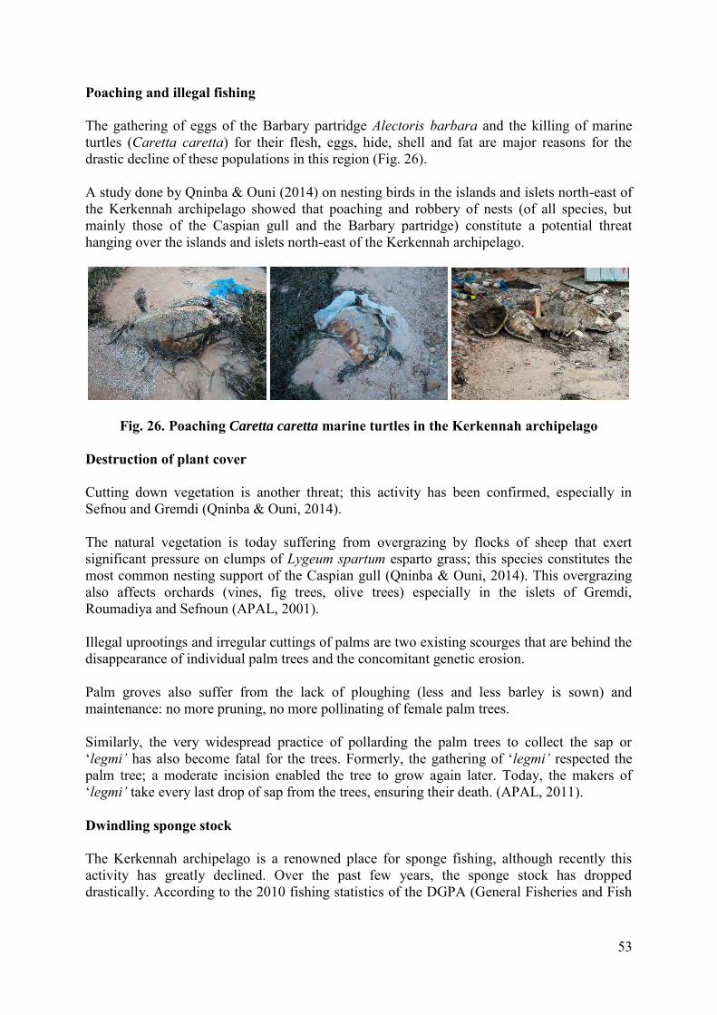
53
Poaching and illegal fishing The gathering of eggs of the Barbary partridge Alectoris barbara and the killing of marine turtles (Caretta caretta) for their flesh, eggs, hide, shell and fat are major reasons for the drastic decline of these populations in this region (Fig. 26). A study done by Qninba & Ouni (2014) on nesting birds in the islands and islets north-east of the Kerkennah archipelago showed that poaching and robbery of nests (of all species, but mainly those of the Caspian gull and the Barbary partridge) constitute a potential threat hanging over the islands and islets north-east of the Kerkennah archipelago.
Fig. 26. Poaching Caretta caretta marine turtles in the Kerkennah archipelago Destruction of plant cover Cutting down vegetation is another threat; this activity has been confirmed, especially in Sefnou and Gremdi (Qninba & Ouni, 2014). The natural vegetation is today suffering from overgrazing by flocks of sheep that exert significant pressure on clumps of Lygeum spartum esparto grass; this species constitutes the most common nesting support of the Caspian gull (Qninba & Ouni, 2014). This overgrazing also affects orchards (vines, fig trees, olive trees) especially in the islets of Gremdi, Roumadiya and Sefnoun (APAL, 2001). Illegal uprootings and irregular cuttings of palms are two existing scourges that are behind the disappearance of individual palm trees and the concomitant genetic erosion. Palm groves also suffer from the lack of ploughing (less and less barley is sown) and maintenance: no more pruning, no more pollinating of female palm trees. Similarly, the very widespread practice of pollarding the palm trees to collect the sap or ‘legmi’ has also become fatal for the trees. Formerly, the gathering of ‘legmi’ respected the palm tree; a moderate incision enabled the tree to grow again later. Today, the makers of ‘legmi’ take every last drop of sap from the trees, ensuring their death. (APAL, 2011). Dwindling sponge stock The Kerkennah archipelago is a renowned place for sponge fishing, although recently this activity has greatly declined. Over the past few years, the sponge stock has dropped drastically. According to the 2010 fishing statistics of the DGPA (General Fisheries and Fish
54
Farming Department), the stock has been constantly falling since 2006, from 101 tonnes in 2006 to only ten tonnes in 2009 and 2010, i.e. a drop of almost 90%. According to a local fisherman in Attaya, sponge fishing is a very old tradition which used to be done standing up over beds of 1-1.5 metres; formerly very widespread, the activity has plummeted over the past few years; it is threatened with extinction, given the over-exploitation of the stock of commercialised sponges in the area.
2. Natural threats Insularity The insularity and small size of the islands of the Kerkennah archipelago is an important factor of vulnerability. Islands, especially the little islands and islets like those of Kerkennah, are more vulnerable to environmental change (climate change, rising sea level) than the continental masses (Etienne, 2014). Climate change is thought to be a powerful supplementary factor of the island territories’ vulnerability (David, 2010). Rise in sea level According to Etienne (2014), in classical times the archipelago was 37 km. long and 18.5 wide; today it is 30 km. long by 14 km. wide, the result of the advancing sea. Slim et al. (2004) suppose that certain islets, now isolated, used to be joined to the main islands, particularly Gremdi islet, for the remains of classical roads have been discovered between the island of Chergui and the islets. The Kerkennah archipelago is physically vulnerable and low-lying, with fragile lithostratigraphic layers. The sea level rises more quickly around the archipelago than elsewhere in Tunisia, because of the combination of subsidence and climate warming. The arguments for this subsidence are based on the historical remains dating from Roman times that can be found covered by a strip of water of over two metres. Among other arguments are the immersion of a quarry used in classical times and a highway that, at the same date, linked At Attaya to Gremdi islet (APAL, 2001). The combination of a warmer climate, rise in sea level, and the physical fragility of the islands of the archipelago plus the presence of economic stakes likely to degrade the environment enhance the vulnerability of the archipelago. Coastal erosion and retreat of the coastline Most of the coasts of the Kerkennah archipelago are retreating. According to Etienne (2014), the maximum value of erosion is 32.2 metres over 47 years, or 0.68 m./year on average and the significant average withdrawal is -11.8 m. between 1963 and 2010, or -0.25 m./year on average. The coasts most affected by this erosion are those that are sensitive to both erosion (coasts made up of fragile materials) and immersion (low-lying coasts). The geological structures are mostly fragile and can be easily eroded, which accentuates the risk of marine erosion; also, the low altitude of the littoral favours the extension of the sebkhas that already represent a great part of the archipelago’s surface area (about 45% of the surface area)
55
(Etienne, 2014). The vulnerability of the coasts, already great, has worsened since the 1960s (Etienne, 2014). The extension of urbanised littoral areas has led to a greater concentration of stakes in vulnerable zones. Increasingly numerous dwellings and activities that are very important for the archipelago are now very close to the sea. Associated with coastal building, littoral development is heavy in certain zones and disturbs the littoral and sedimentary dynamics. This disturbance now leads to an increased vulnerability to erosion behind the sea walls or in spaces near the development. It also causes long-term vulnerability in the spaces developed; protective measures cannot stop, but only slow down, the erosion. The retreat of the coastline is caused by the phenomenon of erosion due to both the mechanical and chemical action of the waves, the rise in sea level, and the subsidence of the soil. The retreat of the coast is bound up with lithology. Heterogenous extension of the sebkha areas The retreat of the coastline is not the only danger to the archipelago and its residents. The extension of the sebkhas and the increasing saltiness of the soil are another danger. Since the 1950s and ‘60s, climate and societal change has brought about major modifications in the occupation of the soil of the archipelago; the soils become salty, the palm trees die, and the sebkhas grow bigger (Etienne, 2014). The occupation of the soil has been transformed, causing an urban expansion that is sometimes great, a marked retreat of the traditional palm groves, a displacement and growth of the irrigated areas and an extension of the sebkha areas (Etienne, 2014). So the pressure on the resources is increasing, which indicates a greater vulnerability. According to Etienne (2014), certain classical cultural features such as the traditional palm groves, which acted as a brake on the increased saltiness of the soil and maintained agriculture on the edges of the sebkhas, have been abandoned. It seems that nowadays the archipelago is more vulnerable to increasingly salty soil and extension of the sebkhas than it was before the 1960s. The factors of vulnerability resulting from the moving coastline are linked to: i) the nature of the coasts (the lithology that informs about the coast’s ability to undergo erosion and the height of the coast that informs about the vulnerability to immersion; ii) climate change; iii) stakes that accentuate vulnerability and impacts of development that can increase or decrease the rate of erosion. According to a study done by remote sensing (Etienne, 2014), which takes into consideration all the sebkhas of the archipelago, including the north-eastern part, the surface area of the sebkhas has gone from 4,164 hectares in 1984 to 4,900 hectares in 2011, or an increase of 736 hectares (15%) in 27 years (Fig. 27; Etienne, 2014).
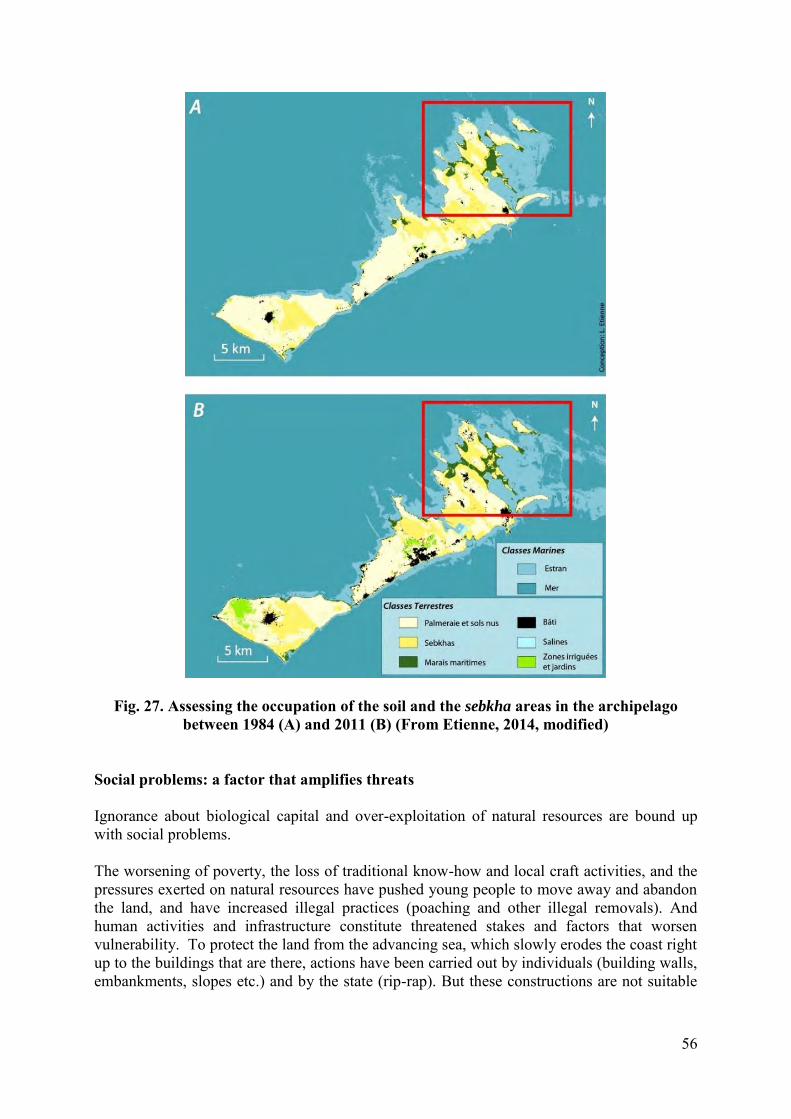
56
Fig. 27. Assessing the occupation of the soil and the sebkha areas in the archipelago between 1984 (A) and 2011 (B) (From Etienne, 2014, modified)
Social problems: a factor that amplifies threats Ignorance about biological capital and over-exploitation of natural resources are bound up with social problems. The worsening of poverty, the loss of traditional know-how and local craft activities, and the pressures exerted on natural resources have pushed young people to move away and abandon the land, and have increased illegal practices (poaching and other illegal removals). And human activities and infrastructure constitute threatened stakes and factors that worsen vulnerability. To protect the land from the advancing sea, which slowly erodes the coast right up to the buildings that are there, actions have been carried out by individuals (building walls, embankments, slopes etc.) and by the state (rip-rap). But these constructions are not suitable
57
for they only slow down the marine erosion in the short term and cause littoral unbalance that can worsen the erosive processes (Etienne, 2014). The rural exodus from the Kerkennah archipelago constitutes an index of how much its natural potential is being exhausted. The major factor of degradation is the growing demographic expansion associated to the shortage of economic resources in the region. Reconciling the socio-economic development and the protection of the natural environment is a difficult task, explained by the demographic expansion on the one hand and the fragility of the ecosystems/ineffectiveness of management on the other.
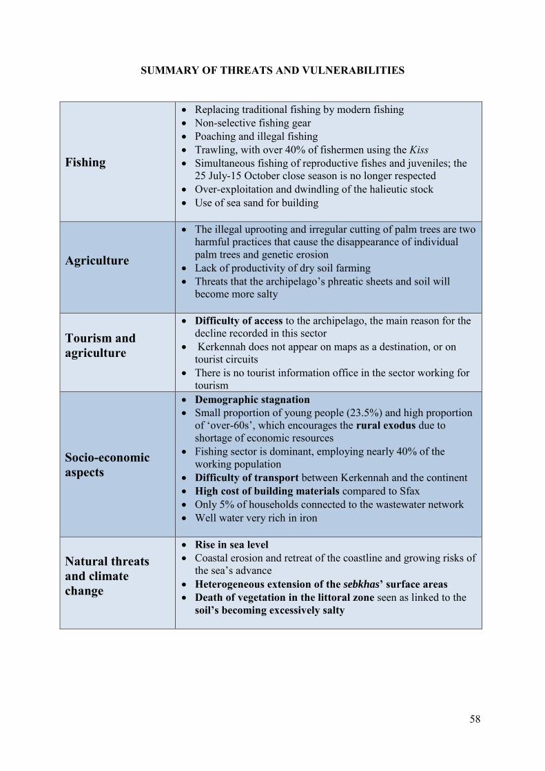
58
SUMMARY OF THREATS AND VULNERABILITIES
Fishing
Replacing traditional fishing by modern fishing Non-selective fishing gear Poaching and illegal fishing Trawling, with over 40% of fishermen using the Kiss Simultaneous fishing of reproductive fishes and juveniles; the
25 July-15 October close season is no longer respected Over-exploitation and dwindling of the halieutic stock Use of sea sand for building
Agriculture
The illegal uprooting and irregular cutting of palm trees are two harmful practices that cause the disappearance of individual palm trees and genetic erosion
Lack of productivity of dry soil farming Threats that the archipelago’s phreatic sheets and soil will
become more salty
Tourism and agriculture
Difficulty of access to the archipelago, the main reason for the decline recorded in this sector
Kerkennah does not appear on maps as a destination, or on tourist circuits
There is no tourist information office in the sector working for tourism
Socio-economic aspects
Demographic stagnation Small proportion of young people (23.5%) and high proportion
of ‘over-60s’, which encourages the rural exodus due to shortage of economic resources
Fishing sector is dominant, employing nearly 40% of the working population
Difficulty of transport between Kerkennah and the continent High cost of building materials compared to Sfax Only 5% of households connected to the wastewater network Well water very rich in iron
Natural threats and climate change
Rise in sea level Coastal erosion and retreat of the coastline and growing risks of
the sea’s advance Heterogeneous extension of the sebkhas’ surface areas Death of vegetation in the littoral zone seen as linked to the
soil’s becoming excessively salty
59
CONCLUSION The area studied, lying north-east of the Kerkennah archipelago, possesses rich, diversified marine and coastal resources. The results obtained confirm that the area possesses an original landscape made up of species of fauna and flora and formations that are outstanding at national and regional level. The unique extension of the Posidonia oceanica striped meadow confirms the area’s high value. This meadow seems to be in a good state of conservation, demonstrating the good quality of the littoral water in the area of study. The outstanding marine flora is characterized not only by the abundance of the meadows of the marine phanerogam Posidonia oceanica but also the predominance of the phanerogam of heritage interest Cymodocea nodosa, which, mixed with the Chlorobionta Caulerpa prolifera, form prairies that have a vital role that is both ecological (important primary production, a spawning area and nursery for many species of fish and crustacean of economic interest) and hydrodynamic (fixing sediment, reducing hydrodynamics). There is undeniable biological richness due to the presence of species that are rare and/or threatened at Mediterranean level, i.e. Pinna nobilis and Cystoseira forests (Cystoseira barbata, C. compressa, C. foeniculacea f. schiffneri, C. foeniculacea f. tenuiramosa, C. spinosa and C. susanensis). The floral-faunal inventory has highlighted outstanding benthic communities over the whole area of study. These communities have great heritage value in the Mediterranean, and are listed in Annex II to the SPA/BD Protocol of the Barcelona Convention. The natural isolation of this north-eastern part of the Kerkennah Islands has naturally protected it from many human-origin degradations commonly seen on the rest of the archipelago’s often more accessible coasts. The marine environment is thus well protected from all over-crowding and coastal pollution, and due to this, no significant degradation of the underwater environment was observed. A Marine Protected Area groups the totality of the environments deemed to present heritage interest; the area studied possesses all the advantages that justify setting up a Marine and Coastal Protected Area (MCPA) that encompasses either part or all of this sector. Setting up a MCPA would help protect all the marine ecosystems of high heritage value that are present. It would also enable ecologically viable human activities to be pursued and developed, via encouraging the use of fixed fisheries and conserving the traditional and aesthetic side of this practice, which seems to be declining all around the Kerkennah archipelago.
60
REFERENCES APAL, 2001. Etude de gestion de la zone sensible littorale des îlots nord-est de Kerkennah. Phase 1. Caractérisation du milieu naturel. Rapport définitif. République tunisienne, Ministère de l'Environnement et de l'aménagement du territoire, Agence de Protection et d'Aménagement du Littoral (APAL), Tunis : 40 p. APAL, 2012. Etude de faisabilité pour la mise en place de récifs artificiels dans le sud des îles Kerkennah. Rapport de phase I. SERAH / ABARLOA 2. 145 pp. + Annexes.
APAL-WWF, 2006. Projet SMAP III : Etude d’impact de la ville de Sfax sur la biodiversité marine et côtière et promotion d’une pêche durable. Rapport définitif, Tunisie : 112p.
Ben Hmida A. 2014. Impact du mini-chalut benthique « Kiss » sur les herbiers à Posidonia oceanica dans la région des îles Kerkennah. Institut National Agronomique de Tunisie. 66 p.
Ben Mustapha K. 2007. Démosponges littorales des iles de Kerkennah (Tunisie). Bull. lnst. nat. sci. techn. Océanogr. Pêche Salammbô, 34 : 37-60.
Bernardie, N. et Taglioni, F. 2005. Les dynamiques contemporaines des petits espaces insulaires : De l'île-relais aux réseaux insulaires. KARTHALA Editions, 450 p.
BirdLife International (2015) Important Bird Areas factsheet: Kerkennah islands. Downloaded from http://www.birdlife.org on 12/09/2015.
Boudouresque C.F., Ballesteros E., Ben Maiz N., Boisset F., Bouladier E., Cinelli F., Cirik S., Cormaci M., Jeudy De Grissac A., Laborel J., Lanfranco E., Lundberg B., Mayhoub H., Meinesz A., Panayotidis P., Semroud R., Sinnassamy J.M., Span A., Vuignier G., 1990. Livre rouge “Gérard Vuignier” des végétaux, peuplements et paysages marins menacés de Méditerranée. Programme des Nations Unies pour l’Environnement publ.: 1-250.
BRANDHORST W., 1977.- Les conditions de milieu au large de la côte tunisienne. Bull. lnst. nat. sci. techn. Océanogr. Pêche Salammbô, Tunis, 1977, 4(2-4): 129-220.
Burollet P.F., Clairefond P. et Winnock E., 1979. La mer Pélagienne : étude sédimentologique et écologique du plateau tunisien et du golfe de Gabès. Ann. Univ. Provence, 6 (1 ; 1-345).
Dahech, S. 2007. Le vent à Sfax (Tunisie), impacts sur le climat et la pollution atmosphérique. Thèse de l'Université de Paris 7, 351 p.
Etienne Lucile.2014. Accentuation récente de la vulnérabilité liée à la mobilité du trait de côte et à la salinisation des sols dans l’archipel de Kerkennah (Tunisie). Geography. Université Paris Diderot (Paris 7) Sorbonne Paris Cité ; Université de Sfax (Faculté des Lettres et Sciences Humaines), Thèse de Doctorat. 326 pp.
Fehri Noômène, 2011. « La palmeraie des Îles Kerkennah (Tunisie), un paysage d'oasis maritime en dégradation : déterminisme naturel ou responsabilité anthropique ? », Physio-Géo [En ligne], Volume 5 | 2011, mis en ligne le 13 septembre 2011, Consulté le 20 août 2015. URL : http://physio-geo.revues.org/2011 ; DOI : 10.4000/physio-geo.2011.
Le Floc'H, E. & L. Boulos (2008). Flore de Tunisie. Catalogue synonymique commenté. Montpellier. 461pp. p.258.
Médail F., Pasta S. & Chaieb M., 2015. Flore et végétation des îles et îlots satellites de l'archipel des Kerkennah (Tunisie orientale). Bilan de la biodiversité végétale terrestre, impacts environnementaux et recommandations de gestion. Note naturaliste PIM, Aix-en-Provence : 66 p.
61
Oueslati, A. 1986. Jerba et Kerkna: îles de la côte orientale de la Tunisie. Leur évolution géomorphologique au cours du quaternaire. Faculté des lettres et sciences humaines de Tunis, Université de Tunis, 210 p.
Paskoff, R. et Sanlaville, P. 1983. Les côtes de la Tunisie. Variations du niveau marin depuis le Tyrrhénien,. Lyon : Maison de l'Orient et de la Méditerranée Collection de la Maison de l'Orient méditerranéen Série géographique et préhistorique, 192 p.
Pergent G., Calvo S., Cancemi G., Djellouli A., Dupuy de la Grandrive R., Langar H., Pergent-Martini C., Tomasello A., 2010. Nouvelles connaissances sur les herbiers tigrés de Méditerranée. Proceedings of the 4th Mediterranean symposium on marine vegetation (Hammamet, 2-4 December 2010). S. El Asmi, H. Langar& W. Belgacem edits., RAC/SPA publ., Tunis : 95-98.
Pergent G., Djellouli A., Hamza A.A., Ettayeb K.S., Alkekli A., Talha M., Alkunti E., 2007a. Structure of Posidonia oceanica meadows in the vicinity of ain al-ghazala lagoon (Libya): the « macroatoll » ecomorphosis. Proceedings of the third Mediterranean symposium on marine vegetation (Marseilles, 27-29 March 2007). C. Pergent-Martini, S. El Asmi, C. Le Ravallec edits., RAC/SPA publ., Tunis: 135-140.
Pergent G., Langar H., Pergent-Martini C., 2007. Surveillance de l’herbier des îles Kerkennah (Tunisie). Programme « MedPosidonia » / CAR/ASP - Fondation d’entreprise TOTAL pour la Biodiversité et la Mer ; Mémorandum d’Accord Nautilus - CAR/ASP N°21/2007 : 14p.
Pergent G., Pergent-Martini C., 1988. Phénologie de Posidonia oceanica dans le bassin méditerranéen. Annales Institut océanographique, Paris, N.S., 64(2) : 79-100.
Pergent G., Pergent-Martini C., Boudouresque C.F., 1995. Utilisation de l’herbier à Posidoniaoceanica comme indicateur biologique de la qualité du milieu littoral en Méditerranée : état des connaissances. Mésogée 54, 3-29.
Pergent, G. & Kempf, M. 1993. L’environnement marine côtier en Tunisie. . IFREMER, Brest, France I. Rapport de synthèse, 55pp. 2. Etude documentaire, 395 pp. 3 Annexes, 173 pp.
Pergent-Martini C., PergentG., 2010. Propositions de lignes directrices pour la standardisation des méthodes de cartographie et de surveillance des magnoliophytes Marines en Méditerranée. PNUE--‐PAM--‐CAR/ASP, Contrat N°72/2009, Tunis :1 - 70.
Qninba A. & Ouni R. 2014. Les oiseaux nicheurs sur les îles et îlots nord-est de l’archipel de Kerkennah, Tunisie. Initiative PIM. CdL (France)-APAL (Tunisie). 24 pp.
Ramos-Espla A., Ouergui A., Bayle J.T., Ben Mbarek N., Fernandeztorquemada Y., Guallouz S., Khidri R., Sanchez-Lizaso J.L., Yamak S. (2000) - Contribution à la caractérisation des herbiers à Posidonia oceanica (L) Delile aux iles kerkennah (Est de la Tunisie, méditerranée orientale. Actes du premier symposium méditerranéen sur la végétation marine (Ajaccio, 3-4 Octobre 2000), pp. 177.
Slim, H., Trousset, P., Paskoff, R. et Oueslati, A. 2004. Le littoral de la Tunisie, Etude Géoarchéologique et Historique. CNRS Edition, 308 p.
Trousset P., 2005. « Kerkena/Kerkennah », in 27 | Kairouan – Kifan Bel-Ghomari, Aix-en-Provence, Edisud (« Volumes », no 27) , 2005 [En ligne], mis en ligne le 01 juin 2011, consulté le 26 juillet 2015. URL : http://encyclopedieberbere.revues.org/1338.
Verger, F. 1995. Slikkes et Schorres : milieux et aménagement. Norois. 165 (1), pp: 235-245.
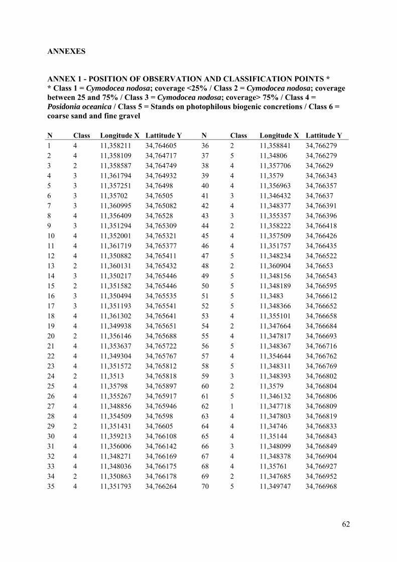
62
ANNEXES ANNEX 1 - POSITION OF OBSERVATION AND CLASSIFICATION POINTS * * Class 1 = Cymodocea nodosa; coverage <25% / Class 2 = Cymodocea nodosa; coverage between 25 and 75% / Class 3 = Cymodocea nodosa; coverage> 75% / Class 4 = Posidonia oceanica / Class 5 = Stands on photophilous biogenic concretions / Class 6 = coarse sand and fine gravel N Class Longitude X Lattitude Y
N Class Longitude X Lattitude Y
1 4 11,358211 34,764605
36 2 11,358841 34,766279 2 4 11,358109 34,764717
37 5 11,34806 34,766279
3 2 11,358587 34,764749
38 4 11,357706 34,76629 4 3 11,361794 34,764932
39 4 11,3579 34,766343
5 3 11,357251 34,76498
40 4 11,356963 34,766357 6 3 11,35702 34,76505
41 3 11,346432 34,76637
7 3 11,360995 34,765082
42 4 11,348377 34,766391 8 4 11,356409 34,76528
43 3 11,355357 34,766396
9 3 11,351294 34,765309
44 2 11,358222 34,766418 10 4 11,352001 34,765321
45 4 11,357509 34,766426
11 4 11,361719 34,765377
46 4 11,351757 34,766435 12 4 11,350882 34,765411
47 5 11,348234 34,766522
13 2 11,360131 34,765432
48 2 11,360904 34,76653 14 3 11,350217 34,765446
49 5 11,348156 34,766543
15 2 11,351582 34,765446
50 5 11,348189 34,766595 16 3 11,350494 34,765535
51 5 11,3483 34,766612
17 3 11,351193 34,765541
52 5 11,348366 34,766652 18 4 11,361302 34,765641
53 4 11,355101 34,766658
19 4 11,349938 34,765651
54 2 11,347664 34,766684 20 2 11,356146 34,765688
55 4 11,347817 34,766693
21 4 11,353637 34,765722
56 5 11,348367 34,766716 22 4 11,349304 34,765767
57 4 11,354644 34,766762
23 4 11,351572 34,765812
58 5 11,348311 34,766769 24 2 11,3513 34,765818
59 3 11,348393 34,766802
25 4 11,35798 34,765897
60 2 11,3579 34,766804 26 4 11,355267 34,765917
61 5 11,346132 34,766806
27 4 11,348856 34,765946
62 1 11,347718 34,766809 28 4 11,354509 34,76598
63 4 11,347803 34,766819
29 2 11,351431 34,76605
64 4 11,34746 34,766833 30 4 11,359213 34,766108
65 4 11,35144 34,766843
31 4 11,356006 34,766142
66 3 11,348099 34,766849 32 4 11,348271 34,766169
67 4 11,348378 34,766904
33 4 11,348036 34,766175
68 4 11,35761 34,766927 34 2 11,350863 34,766178
69 2 11,347685 34,766952
35 4 11,351793 34,766264
70 5 11,349747 34,766968
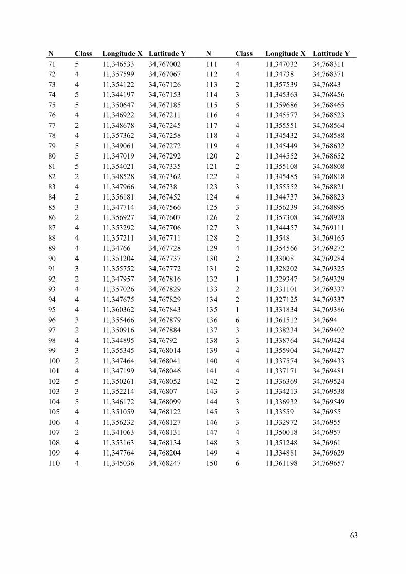
63
N Class Longitude X Lattitude Y
N Class Longitude X Lattitude Y 71 5 11,346533 34,767002
111 4 11,347032 34,768311
72 4 11,357599 34,767067
112 4 11,34738 34,768371 73 4 11,354122 34,767126
113 2 11,357539 34,76843
74 5 11,344197 34,767153
114 3 11,345363 34,768456 75 5 11,350647 34,767185
115 5 11,359686 34,768465
76 4 11,346922 34,767211
116 4 11,345577 34,768523 77 2 11,348678 34,767245
117 4 11,355551 34,768564
78 4 11,357362 34,767258
118 4 11,345432 34,768588 79 5 11,349061 34,767272
119 4 11,345449 34,768632
80 5 11,347019 34,767292
120 2 11,344552 34,768652 81 5 11,354021 34,767335
121 2 11,355108 34,768808
82 2 11,348528 34,767362
122 4 11,345485 34,768818 83 4 11,347966 34,76738
123 3 11,355552 34,768821
84 2 11,356181 34,767452
124 4 11,344737 34,768823 85 3 11,347714 34,767566
125 3 11,356239 34,768895
86 2 11,356927 34,767607
126 2 11,357308 34,768928 87 4 11,353292 34,767706
127 3 11,344457 34,769111
88 4 11,357211 34,767711
128 2 11,3548 34,769165 89 4 11,34766 34,767728
129 4 11,354566 34,769272
90 4 11,351204 34,767737
130 2 11,33008 34,769284 91 3 11,355752 34,767772
131 2 11,328202 34,769325
92 2 11,347957 34,767816
132 1 11,329347 34,769329 93 4 11,357026 34,767829
133 2 11,331101 34,769337
94 4 11,347675 34,767829
134 2 11,327125 34,769337 95 4 11,360362 34,767843
135 1 11,331834 34,769386
96 3 11,355466 34,767879
136 6 11,361512 34,7694 97 2 11,350916 34,767884
137 3 11,338234 34,769402
98 4 11,344895 34,76792
138 3 11,338764 34,769424 99 3 11,355345 34,768014
139 4 11,355904 34,769427
100 2 11,347464 34,768041
140 4 11,337574 34,769433 101 4 11,347199 34,768046
141 4 11,337171 34,769481
102 5 11,350261 34,768052
142 2 11,336369 34,769524 103 3 11,352214 34,76807
143 3 11,334213 34,769538
104 5 11,346172 34,768099
144 3 11,336932 34,769549 105 4 11,351059 34,768122
145 3 11,33559 34,76955
106 4 11,356232 34,768127
146 3 11,332972 34,76955 107 2 11,341063 34,768131
147 4 11,350018 34,76957
108 4 11,353163 34,768134
148 3 11,351248 34,76961 109 4 11,347764 34,768204
149 4 11,334881 34,769629
110 4 11,345036 34,768247
150 6 11,361198 34,769657
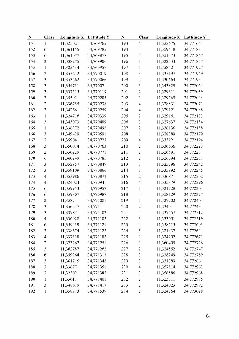
64
N Class Longitude X Lattitude Y
N Class Longitude X Lattitude Y
151 1 11,325021 34,769765
193 4 11,322675 34,771644 152 6 11,361155 34,769785
194 3 11,359418 34,77183
153 6 11,361077 34,769878
195 3 11,351473 34,771847 154 3 11,338275 34,769906
196 1 11,322334 34,771857
155 1 11,325434 34,769958
197 1 11,35842 34,771927 156 2 11,355612 34,770019
198 3 11,335197 34,771949
157 3 11,353662 34,770066
199 4 11,330664 34,77195 158 3 11,354731 34,77007
200 3 11,343829 34,772024
159 3 11,337515 34,770119
201 2 11,329311 34,772039 160 3 11,35503 34,770205
202 3 11,329769 34,772044
161 2 11,336755 34,770238
203 4 11,328831 34,772071 162 3 11,34266 34,770259
204 4 11,329121 34,772088
163 1 11,324716 34,770339
205 2 11,329161 34,772123 164 3 11,343073 34,770489
206 3 11,327637 34,772134
165 1 11,336372 34,770492
207 2 11,336136 34,772158 166 3 11,349429 34,770591
208 1 11,328389 34,772179
167 2 11,35904 34,770727
209 4 11,333921 34,772194 168 3 11,350014 34,770763
210 2 11,336636 34,772223
169 2 11,336229 34,770771
211 2 11,326891 34,77223 170 6 11,360249 34,770785
212 2 11,326094 34,772231
171 3 11,352857 34,770849
213 1 11,325296 34,772242 172 3 11,359109 34,770866
214 1 11,335992 34,772245
173 4 11,353986 34,770872
215 2 11,336971 34,772262 174 4 11,324024 34,77094
216 4 11,335879 34,772296
175 6 11,359953 34,770957
217 1 11,321728 34,772303 176 6 11,359807 34,770987
218 4 11,358129 34,772377
177 2 11,3587 34,771081
219 1 11,327202 34,772404 178 3 11,356247 34,7711
220 2 11,334911 34,77245
179 3 11,337871 34,771102
221 4 11,337557 34,772512 180 4 11,336028 34,771102
222 3 11,333051 34,772519
181 6 11,359439 34,771121
223 4 11,358715 34,772603 182 3 11,338674 34,771127
224 5 11,321437 34,77264
183 4 11,337328 34,771182
225 3 11,334202 34,772671 184 2 11,323262 34,771251
226 3 11,360405 34,772726
185 3 11,362787 34,771262
227 2 11,324852 34,772747 186 6 11,359264 34,771313
228 3 11,338249 34,772789
187 3 11,361715 34,771348
229 3 11,331789 34,77286 188 2 11,33677 34,771351
230 4 11,357814 34,772962
189 2 11,32302 34,771385
231 3 11,356586 34,772968 190 1 11,33611 34,771401
232 2 11,323711 34,772985
191 3 11,348619 34,771417
233 2 11,324023 34,772992 192 1 11,358773 34,771539
234 2 11,324264 34,773028
65
N Class Longitude X Lattitude Y
N Class Longitude X Lattitude Y 235 2 11,32286 34,773032
278 1 11,317521 34,774513
236 1 11,320671 34,773086
279 2 11,326454 34,774555 237 3 11,333607 34,773097
280 2 11,329781 34,774572
238 4 11,324179 34,773111
281 1 11,321023 34,774582 239 5 11,32187 34,773169
282 4 11,329422 34,774606
240 5 11,322379 34,77319
283 2 11,33188 34,774613 241 4 11,330819 34,773196
284 2 11,327355 34,774615
242 2 11,324171 34,773224
285 1 11,32906 34,774776 243 4 11,338622 34,773271
286 3 11,331613 34,774835
244 2 11,321557 34,77331
287 3 11,339854 34,774845 245 3 11,330157 34,77342
288 1 11,325162 34,774864
246 3 11,333158 34,773441
289 1 11,32382 34,774907 247 4 11,326841 34,773456
290 4 11,326246 34,774915
248 2 11,324124 34,773477
291 1 11,318033 34,775049 249 5 11,32145 34,773591
292 3 11,327752 34,775049
250 1 11,311782 34,77366
293 4 11,337214 34,775093 251 4 11,338412 34,773661
294 3 11,338733 34,775104
252 1 11,326824 34,773665
295 3 11,337751 34,775118 253 3 11,348233 34,773724
296 1 11,325033 34,775128
254 1 11,319952 34,773767
297 4 11,336762 34,775133 255 2 11,329546 34,773779
298 3 11,33219 34,775139
256 4 11,35908 34,773799
299 3 11,332954 34,775157 257 3 11,33779 34,773815
300 3 11,334452 34,775159
258 2 11,32126 34,773816
301 3 11,331174 34,775159 259 4 11,337033 34,773901
302 3 11,330408 34,775164
260 1 11,327046 34,773911
303 1 11,335448 34,775178 261 2 11,324044 34,773925
304 4 11,33519 34,775181
262 4 11,329644 34,773953
305 2 11,335505 34,775214 263 3 11,336597 34,774058
306 3 11,336263 34,775221
264 3 11,332364 34,774086
307 2 11,335909 34,775235 265 1 11,335859 34,774108
308 1 11,326135 34,775246
266 2 11,32707 34,774149
309 1 11,32083 34,775248 267 4 11,326711 34,774167
310 3 11,331265 34,775263
268 2 11,358206 34,774175
311 3 11,330329 34,775281 269 2 11,335923 34,774214
312 2 11,329791 34,775289
270 2 11,357975 34,774244
313 2 11,329796 34,775289 271 4 11,335583 34,774249
314 4 11,329016 34,775317
272 4 11,326353 34,774268
315 1 11,329267 34,775322 273 2 11,325561 34,774275
316 1 11,329396 34,775399
274 4 11,327146 34,77432
317 2 11,327999 34,775441 275 4 11,325391 34,774449
318 1 11,324988 34,775444
276 4 11,318991 34,774461
319 1 11,326086 34,775468 277 5 11,323923 34,774482
320 3 11,356006 34,775468
66
N Class Longitude X Lattitude Y
N Class Longitude X Lattitude Y
321 5 11,323837 34,775511
366 4 11,32889 34,77643 322 5 11,324867 34,775622
367 4 11,325224 34,776438
323 4 11,329132 34,77565
368 3 11,343384 34,776444 324 3 11,330974 34,775667
369 2 11,330009 34,776461
325 2 11,334303 34,775671
370 2 11,317222 34,776471 326 4 11,325885 34,775693
371 3 11,356001 34,776519
327 1 11,325558 34,775704
372 5 11,321386 34,776527 328 2 11,31793 34,775725
373 2 11,328916 34,77654
329 3 11,328219 34,775725
374 2 11,320878 34,776555 330 4 11,325722 34,775727
375 5 11,324253 34,77657
331 2 11,328759 34,77573
376 2 11,323217 34,776591 332 3 11,322166 34,775732
377 1 11,359349 34,776595
333 3 11,354665 34,775736
378 5 11,31989 34,776605 334 2 11,320707 34,775748
379 1 11,319078 34,776615
335 5 11,32333 34,775769
380 5 11,320246 34,776634 336 3 11,331285 34,77577
381 3 11,32252 34,77665
337 2 11,321692 34,7758
382 2 11,317023 34,776675 338 1 11,318391 34,775805
383 5 11,318957 34,776678
339 1 11,321366 34,775833
384 1 11,330054 34,776699 340 1 11,325255 34,77584
385 1 11,319104 34,776707
341 4 11,325299 34,775848
386 5 11,321331 34,776774 342 5 11,325032 34,775853
387 4 11,329122 34,7768
343 2 11,324979 34,775904
388 5 11,317991 34,776808 344 4 11,317558 34,775917
389 1 11,320627 34,776817
345 3 11,327918 34,775947
390 2 11,358549 34,776825 346 1 11,318333 34,775995
391 4 11,33384 34,776836
347 4 11,328576 34,776102
392 5 11,319658 34,77687 348 1 11,326222 34,776165
393 1 11,319967 34,776874
349 2 11,326752 34,776179
394 2 11,357284 34,776902 350 3 11,330591 34,776184
395 4 11,329288 34,777038
351 2 11,332056 34,776192
396 5 11,319373 34,777066 352 2 11,317267 34,776214
397 1 11,329614 34,777145
353 1 11,32577 34,776236
398 5 11,319507 34,777179 354 2 11,32861 34,776256
399 3 11,347836 34,7772
355 5 11,320717 34,776278
400 2 11,316342 34,777232 356 3 11,333549 34,776305
401 4 11,329535 34,777255
357 2 11,331863 34,776318
402 5 11,318024 34,77732 358 3 11,330219 34,776331
403 5 11,318873 34,777327
359 2 11,331252 34,776347
404 1 11,329614 34,777345 360 4 11,334049 34,776352
405 1 11,319956 34,777346
361 5 11,324888 34,776356
406 1 11,329833 34,777533 362 5 11,319099 34,776358
407 5 11,320893 34,77763
363 2 11,333864 34,776387
408 5 11,31802 34,777672 364 1 11,332149 34,776393
409 4 11,311071 34,777714
365 3 11,330795 34,776419
410 2 11,321572 34,777737
67
N Class Longitude X Lattitude Y
N Class Longitude X Lattitude Y
411 4 11,329321 34,777765
455 3 11,328818 34,779287 412 2 11,321953 34,777828
456 5 11,320247 34,779292
413 2 11,322452 34,777908
457 1 11,314984 34,779308 414 5 11,323353 34,777927
458 3 11,331802 34,779308
415 1 11,330627 34,777978
459 1 11,319323 34,779318 416 2 11,325185 34,777991
460 5 11,317911 34,77933
417 2 11,329287 34,778001
461 5 11,322221 34,779469 418 5 11,318683 34,778051
462 3 11,339119 34,779485
419 2 11,314759 34,778123
463 2 11,328641 34,779537 420 1 11,311031 34,778128
464 2 11,321894 34,779577
421 1 11,330751 34,77816
465 4 11,323324 34,779614 422 3 11,362014 34,778166
466 2 11,31794 34,779639
423 4 11,331491 34,778186
467 1 11,322881 34,779657 424 4 11,324636 34,778225
468 4 11,322793 34,779679
425 1 11,319554 34,778279
469 1 11,316553 34,779681 426 2 11,318043 34,778349
470 3 11,311814 34,779684
427 4 11,324501 34,778396
471 4 11,324388 34,779732 428 5 11,322575 34,778429
472 3 11,361027 34,779738
429 4 11,330988 34,778457
473 2 11,32489 34,779742 430 5 11,3212 34,778502
474 1 11,314356 34,779742
431 3 11,311498 34,778504
475 2 11,322516 34,779759 432 2 11,324319 34,778509
476 4 11,323914 34,77977
433 2 11,318186 34,77851
477 4 11,323018 34,779772 434 4 11,331279 34,778596
478 5 11,322162 34,77984
435 3 11,331105 34,778659
479 5 11,319295 34,77986 436 4 11,328966 34,778672
480 5 11,319017 34,779895
437 3 11,362374 34,778686
481 2 11,313174 34,779907 438 1 11,324259 34,778699
482 3 11,332414 34,779925
439 2 11,357925 34,77885
483 5 11,321765 34,779974 440 2 11,313504 34,778858
484 3 11,351779 34,779974
441 5 11,318785 34,778873
485 5 11,317837 34,779991 442 4 11,323984 34,778894
486 5 11,315043 34,779996
443 4 11,324394 34,778911
487 5 11,321663 34,780022 444 3 11,325653 34,778925
488 5 11,318337 34,780051
445 4 11,331541 34,779011
489 3 11,311069 34,780059 446 4 11,312041 34,779018
490 3 11,344612 34,780081
447 4 11,324387 34,779074
491 5 11,317501 34,78015 448 4 11,323723 34,779094
492 2 11,32139 34,780253
449 4 11,323601 34,779194
493 1 11,314076 34,780283 450 2 11,324897 34,779219
494 5 11,320896 34,780301
451 3 11,31278 34,779223
495 2 11,319945 34,780343 452 2 11,325386 34,779239
496 2 11,328294 34,780346
453 4 11,323432 34,77926
497 4 11,332858 34,780382 454 1 11,31581 34,779268
498 5 11,315962 34,780395
68
N Class Longitude X Lattitude Y
N Class Longitude X Lattitude Y
499 5 11,320616 34,780397
541 5 11,320027 34,781471 500 5 11,314876 34,780476
542 2 11,35752 34,781563
501 5 11,320295 34,780505
543 5 11,31394 34,781589 502 5 11,317935 34,780569
544 5 11,317149 34,781594
503 5 11,320164 34,780576
545 2 11,327726 34,781622 504 2 11,320006 34,780601
546 2 11,31347 34,781635
505 5 11,313776 34,780603
547 3 11,347327 34,781647 506 2 11,319184 34,780747
548 5 11,314598 34,781667
507 1 11,318634 34,780751
549 5 11,314926 34,781671 508 2 11,319469 34,780794
550 5 11,314942 34,781699
509 1 11,31322 34,780816
551 5 11,315699 34,781723 510 1 11,314458 34,780823
552 1 11,31433 34,78176
511 2 11,328063 34,780834
553 5 11,31811 34,781906 512 3 11,324375 34,780883
554 2 11,326838 34,782003
513 5 11,319756 34,780909
555 4 11,34931 34,782007 514 5 11,319132 34,78093
556 4 11,346702 34,782035
515 5 11,314829 34,780958
557 3 11,333937 34,782055 516 1 11,31586 34,780972
558 4 11,346326 34,782097
517 5 11,317109 34,781009
559 5 11,31821 34,782115 518 5 11,316894 34,781055
560 4 11,349062 34,782131
519 1 11,316277 34,781057
561 3 11,355604 34,782135 520 4 11,35841 34,781079
562 5 11,317779 34,782157
521 1 11,31301 34,7811
563 3 11,327389 34,782184 522 1 11,315929 34,781116
564 2 11,317699 34,782227
523 2 11,31767 34,781136
565 4 11,346264 34,782231 524 1 11,316446 34,781151
566 4 11,334268 34,782238
525 1 11,317275 34,781152
567 2 11,311058 34,782308 526 5 11,314199 34,781172
568 4 11,346421 34,782392
527 5 11,31587 34,78121
569 2 11,317377 34,782425 528 2 11,320834 34,781234
570 1 11,318632 34,782425
529 5 11,317617 34,781238
571 1 11,3172 34,782482 530 5 11,318671 34,781241
572 4 11,346164 34,782483
531 5 11,316737 34,781282
573 4 11,348148 34,782497 532 1 11,318949 34,781288
574 2 11,312534 34,782527
533 5 11,315634 34,781316
575 4 11,349386 34,782549 534 4 11,312539 34,781351
576 4 11,327077 34,782614
535 5 11,316524 34,781358
577 4 11,346373 34,782649 536 1 11,318718 34,781363
578 1 11,317107 34,782672
537 5 11,315302 34,781386
579 4 11,310873 34,782731 538 5 11,317237 34,781402
580 2 11,319754 34,782767
539 4 11,357659 34,78143
581 3 11,334436 34,782774 540 5 11,316331 34,78146
582 4 11,349043 34,782816
69
N Class Longitude X Lattitude Y
N Class Longitude X Lattitude Y
583 1 11,310678 34,782816
625 3 11,34208 34,784185 584 4 11,348691 34,782825
626 2 11,326318 34,784301
585 1 11,31654 34,782844
627 4 11,345859 34,78432 586 4 11,348001 34,782883
628 1 11,313122 34,784325
587 1 11,313118 34,782941
629 1 11,313955 34,78433 588 4 11,345403 34,782944
630 2 11,32596 34,78434
589 4 11,345588 34,782944
631 4 11,345407 34,784515 590 4 11,347515 34,782976
632 2 11,336206 34,784539
591 4 11,316304 34,782999
633 4 11,345731 34,784591 592 2 11,32688 34,783009
634 4 11,336511 34,784632
593 2 11,321706 34,783128
635 2 11,32102 34,784658 594 4 11,34718 34,783157
636 4 11,327135 34,784678
595 4 11,349376 34,78322
637 4 11,346116 34,784705 596 4 11,346708 34,783228
638 4 11,313238 34,78476
597 2 11,323214 34,783267
639 3 11,310784 34,784764 598 4 11,348991 34,783311
640 4 11,34743 34,784767
599 3 11,320656 34,783359
641 4 11,345398 34,7848 600 4 11,347694 34,783378
642 1 11,336832 34,784863
601 3 11,354177 34,783423
643 2 11,32841 34,784876 602 4 11,346304 34,783433
644 3 11,356881 34,784898
603 4 11,347458 34,783447
645 1 11,317441 34,784922 604 4 11,315752 34,783466
646 4 11,346383 34,784924
605 2 11,324217 34,783466
647 1 11,312828 34,784968 606 4 11,348629 34,783468
648 2 11,325726 34,785081
607 4 11,346787 34,783514
649 2 11,312554 34,785123 608 4 11,346304 34,783516
650 3 11,348217 34,785209
609 2 11,335446 34,783561
651 4 11,337153 34,785266 610 1 11,317299 34,783562
652 4 11,348881 34,785272
611 4 11,315519 34,783568
653 4 11,329211 34,785279 612 4 11,310871 34,783633
654 3 11,312351 34,78529
613 2 11,315172 34,783637
655 1 11,329809 34,785305 614 4 11,34644 34,783761
656 3 11,330361 34,785323
615 2 11,318833 34,783772
657 4 11,347049 34,785329 616 2 11,326559 34,783818
658 3 11,310988 34,785349
617 4 11,34723 34,783854
659 2 11,312254 34,785365 618 4 11,349462 34,783891
660 1 11,312206 34,785402
619 4 11,314721 34,783905
661 2 11,312179 34,785424 620 2 11,335713 34,783906
662 1 11,312148 34,785448
621 4 11,347877 34,78398
663 3 11,331292 34,785448 622 4 11,314506 34,784063
664 4 11,31925 34,785459
623 2 11,317323 34,784136
665 4 11,312093 34,785494 624 2 11,314344 34,784169
666 3 11,311035 34,785549
70
N Class Longitude X Lattitude Y
N Class Longitude X Lattitude Y
667 3 11,332628 34,785601
709 3 11,323489 34,786967 668 3 11,311932 34,785676
710 1 11,32237 34,786995
669 2 11,358984 34,785815
711 4 11,323383 34,787004 670 3 11,311079 34,78588
712 1 11,323192 34,787005
671 4 11,3254 34,785899
713 4 11,323615 34,787013 672 3 11,311546 34,785928
714 4 11,323222 34,787016
673 4 11,325256 34,78593
715 1 11,321974 34,787049 674 3 11,336791 34,785987
716 3 11,31794 34,787071
675 3 11,317373 34,786032
717 3 11,360936 34,787071 676 3 11,311272 34,786068
718 4 11,323368 34,787107
677 3 11,333562 34,786111
719 2 11,326859 34,787117 678 3 11,311015 34,786164
720 3 11,324757 34,787193
679 4 11,359804 34,786261
721 3 11,320936 34,787229 680 3 11,31072 34,786282
722 4 11,310677 34,787233
681 4 11,334035 34,786346
723 3 11,31727 34,787266 682 2 11,32127 34,786538
724 3 11,316106 34,78728
683 3 11,354381 34,786566
725 2 11,314529 34,787366 684 4 11,335428 34,786588
726 3 11,321356 34,787376
685 3 11,324033 34,786594
727 2 11,322715 34,787395 686 4 11,324176 34,786611
728 3 11,327263 34,787395
687 1 11,321915 34,78662
729 1 11,327886 34,787415 688 4 11,323843 34,786644
730 4 11,327638 34,787455
689 3 11,311058 34,786658
731 1 11,327817 34,787488 690 4 11,320848 34,786668
732 3 11,328516 34,787575
691 1 11,323586 34,78668
733 3 11,328574 34,787587 692 1 11,323147 34,786693
734 3 11,328139 34,787638
693 4 11,323907 34,786715
735 1 11,324569 34,787659 694 3 11,325032 34,786723
736 2 11,317013 34,78771
695 1 11,323312 34,786741
737 3 11,312009 34,787731 696 4 11,323762 34,786765
738 3 11,32198 34,787745
697 4 11,320196 34,786771
739 3 11,322322 34,787772 698 4 11,32385 34,786786
740 4 11,3277 34,787806
699 3 11,325472 34,786793
741 3 11,320624 34,78781 700 3 11,319925 34,786806
742 3 11,321593 34,787962
701 4 11,324105 34,786811
743 3 11,321909 34,788003 702 3 11,326141 34,786813
744 1 11,317797 34,788053
703 1 11,323004 34,786829
745 3 11,320871 34,788063 704 4 11,323741 34,786852
746 3 11,322113 34,788117
705 4 11,319616 34,786887
747 3 11,328401 34,788125 706 4 11,323862 34,78692
748 3 11,327869 34,788184
707 4 11,319074 34,786925
749 1 11,319307 34,788229 708 3 11,326567 34,786966
750 3 11,363259 34,788235
71
N Class Longitude X Lattitude Y
N Class Longitude X Lattitude Y
751 3 11,321864 34,788253
793 1 11,332108 34,792427 752 3 11,3108 34,78839
794 1 11,327773 34,792465
753 1 11,316614 34,788399
795 1 11,326745 34,792499 754 3 11,321576 34,788473
796 1 11,3326 34,792521
755 3 11,327439 34,788474
797 1 11,327085 34,792547 756 3 11,36306 34,788498
798 4 11,364562 34,792562
757 3 11,328158 34,788593
799 1 11,333249 34,792598 758 2 11,311299 34,788659
800 1 11,326764 34,792758
759 1 11,311165 34,788685
801 4 11,360427 34,7928 760 4 11,326995 34,788894
802 3 11,33369 34,792804
761 3 11,353421 34,788975
803 2 11,332077 34,79287 762 3 11,326737 34,788992
804 1 11,326193 34,792907
763 3 11,349548 34,789002
805 1 11,327277 34,792957 764 4 11,330251 34,789154
806 4 11,330944 34,792968
765 4 11,326587 34,789155
807 2 11,331572 34,792974 766 4 11,329898 34,789282
808 2 11,332794 34,793013
767 4 11,331679 34,789338
809 4 11,326005 34,793094 768 4 11,360239 34,789399
810 3 11,356409 34,7931
769 3 11,327904 34,789429
811 1 11,327522 34,793133 770 3 11,359499 34,789431
812 2 11,330063 34,793138
771 4 11,33258 34,789541
813 1 11,326507 34,793184 772 3 11,326054 34,789608
814 1 11,325883 34,793282
773 3 11,327634 34,789749
815 1 11,332347 34,793332 774 3 11,325608 34,78999
816 3 11,339918 34,79334
775 4 11,333174 34,790017
817 4 11,326842 34,793405 776 3 11,346055 34,790053
818 4 11,361269 34,793556
777 3 11,356752 34,790161
819 6 11,325762 34,793602 778 3 11,327083 34,790355
820 1 11,326339 34,793784
779 2 11,325134 34,79036
821 3 11,362975 34,793921 780 1 11,332883 34,790552
822 3 11,365018 34,793926
781 1 11,326954 34,790794
823 3 11,356741 34,793959 782 3 11,354772 34,790842
824 2 11,341625 34,79405
783 1 11,32691 34,791259
825 3 11,343228 34,794058 784 3 11,352246 34,791604
826 3 11,329615 34,794098
785 3 11,33069 34,791913
827 4 11,331583 34,794132 786 2 11,340604 34,791936
828 4 11,357085 34,794243
787 2 11,329216 34,792071
829 6 11,325781 34,794262 788 2 11,330964 34,792143
830 3 11,362481 34,794393
789 1 11,328354 34,792183
831 4 11,330976 34,794523 790 1 11,328664 34,792223
832 3 11,362765 34,794538
791 3 11,346602 34,792258
833 1 11,327198 34,794608 792 4 11,364777 34,792417
834 4 11,326851 34,794728
72
N Class Longitude X Lattitude Y
N Class Longitude X Lattitude Y
835 4 11,365376 34,794742
877 5 11,326458 34,797467 836 6 11,325607 34,794752
878 3 11,340046 34,797503
837 1 11,330525 34,794788
879 3 11,353263 34,797553 838 4 11,362308 34,794902
880 5 11,327019 34,797587
839 4 11,365515 34,794921
881 1 11,340636 34,797599 840 3 11,352214 34,794999
882 2 11,343675 34,797703
841 6 11,325723 34,795002
883 1 11,326149 34,797721 842 4 11,327352 34,795038
884 1 11,327724 34,797763
843 1 11,330245 34,795118
885 4 11,353388 34,797766 844 3 11,361811 34,795144
886 1 11,340126 34,797838
845 2 11,32888 34,79518
887 5 11,326841 34,797852 846 6 11,325376 34,795242
888 2 11,340604 34,797854
847 3 11,357616 34,795364
889 1 11,327438 34,797921 848 6 11,325273 34,795397
890 4 11,340548 34,797942
849 1 11,326354 34,795517
891 4 11,353474 34,797955 850 4 11,329835 34,795518
892 5 11,325949 34,798013
851 3 11,36085 34,795573
893 1 11,326813 34,798037 852 1 11,328608 34,795582
894 3 11,340373 34,798174
853 1 11,329693 34,795706
895 1 11,327095 34,798334 854 1 11,327431 34,795717
896 5 11,326604 34,798366
855 1 11,328457 34,795878
897 1 11,327784 34,798366 856 4 11,329405 34,795946
898 4 11,340213 34,798373
857 1 11,326729 34,796222
899 5 11,32796 34,798412 858 1 11,329004 34,796269
900 1 11,339966 34,79854
859 4 11,328212 34,79627
901 5 11,326858 34,798649 860 3 11,358184 34,796298
902 1 11,326203 34,798675
861 4 11,365724 34,796418
903 4 11,339966 34,798692 862 1 11,327992 34,796432
904 1 11,328012 34,798699
863 3 11,352434 34,796458
905 1 11,326717 34,798873 864 1 11,328755 34,796562
906 1 11,342949 34,798939
865 4 11,365765 34,7967
907 1 11,328108 34,798999 866 4 11,327601 34,796706
908 1 11,326579 34,799051
867 4 11,327762 34,796797
909 5 11,327898 34,799301 868 3 11,358501 34,796845
910 3 11,359547 34,799302
869 1 11,328356 34,796944
911 1 11,344178 34,799362 870 1 11,327601 34,79708
912 4 11,365974 34,799367
871 4 11,365821 34,797083
913 5 11,326319 34,799489 872 6 11,327034 34,797154
914 3 11,354987 34,799559
873 4 11,35312 34,797215
915 4 11,365844 34,799653 874 6 11,327362 34,797328
916 2 11,342375 34,799769
875 1 11,327834 34,797405
917 1 11,326168 34,799776 876 4 11,365947 34,797424
918 3 11,357777 34,799978
73
N Class Longitude X Lattitude Y
N Class Longitude X Lattitude Y
919 1 11,325935 34,800037
961 1 11,347469 34,801728 920 3 11,360732 34,800289
962 2 11,327076 34,801764
921 3 11,365812 34,80031
963 1 11,340697 34,801783 922 4 11,350726 34,800414
964 3 11,334361 34,801807
923 1 11,332443 34,800435
965 3 11,353227 34,801807 924 3 11,328465 34,800437
966 3 11,352128 34,801866
925 2 11,333755 34,80045
967 3 11,354949 34,801903 926 1 11,33008 34,800482
968 4 11,365851 34,801969
927 3 11,359402 34,800503
969 2 11,330981 34,801997 928 3 11,350371 34,800605
970 4 11,363485 34,801997
929 4 11,36154 34,800611
971 4 11,363657 34,802124 930 2 11,345917 34,800615
972 4 11,32939 34,802164
931 1 11,345087 34,800624
973 2 11,332274 34,802204 932 3 11,328604 34,800706
974 3 11,354397 34,802306
933 4 11,36166 34,800777
975 4 11,36527 34,802397 934 2 11,34453 34,800797
976 1 11,329655 34,802481
935 4 11,330439 34,800804
977 3 11,334811 34,802488 936 2 11,347998 34,800806
978 2 11,330246 34,802516
937 3 11,35658 34,800873
979 4 11,365365 34,80254 938 2 11,331872 34,800875
980 4 11,365227 34,802545
939 4 11,341071 34,800879
981 1 11,340725 34,802549 940 3 11,333969 34,8009
982 3 11,364294 34,802552
941 3 11,349332 34,800922
983 3 11,341528 34,802558 942 3 11,343481 34,800925
984 3 11,357299 34,802611
943 3 11,342869 34,800934
985 1 11,342431 34,802631 944 1 11,341327 34,801053
986 4 11,36607 34,802669
945 4 11,365812 34,801083
987 1 11,329886 34,80271 946 1 11,326656 34,801092
988 4 11,364899 34,802726
947 3 11,356237 34,801109
989 3 11,342614 34,80275 948 2 11,34223 34,801126
990 4 11,333401 34,802751
949 4 11,339593 34,801158
991 4 11,327611 34,802894 950 2 11,350936 34,801162
992 4 11,367688 34,802916
951 3 11,362385 34,801254
993 1 11,343106 34,802932 952 2 11,331568 34,80126
994 3 11,333835 34,802976
953 1 11,35119 34,801388
995 4 11,366803 34,802978 954 4 11,351801 34,801404
996 3 11,334828 34,803019
955 1 11,351046 34,801418
997 4 11,343444 34,803069 956 3 11,341738 34,801418
998 4 11,326153 34,803159
957 4 11,337713 34,801537
999 3 11,341865 34,803206 958 4 11,365865 34,801575
1000 1 11,325482 34,803275
959 2 11,329185 34,801592
1001 3 11,352426 34,803296 960 2 11,331518 34,801657
1002 4 11,364851 34,803321
74
N Class Longitude X Lattitude Y
N Class Longitude X Lattitude Y
1003 2 11,32765 34,803373
1045 1 11,359116 34,80451 1004 3 11,334157 34,803389
1046 4 11,356618 34,804521
1005 4 11,342376 34,803425
1047 2 11,345278 34,804529 1006 4 11,36497 34,803516
1048 2 11,360441 34,804537
1007 4 11,365851 34,803516
1049 4 11,36192 34,804566 1008 4 11,366198 34,803525
1050 2 11,348509 34,804566
1009 4 11,364323 34,803549
1051 3 11,351929 34,804575 1010 2 11,344092 34,80358
1052 4 11,366907 34,804591
1011 4 11,368035 34,803601
1053 4 11,357156 34,804601 1012 3 11,352375 34,803679
1054 1 11,347952 34,804612
1013 4 11,367654 34,80372
1055 3 11,350352 34,80463 1014 3 11,365888 34,803753
1056 4 11,352054 34,804641
1015 1 11,326124 34,803788
1057 4 11,365351 34,804644 1016 1 11,325858 34,803801
1058 4 11,366136 34,804648
1017 4 11,367131 34,80382
1059 1 11,358859 34,804651 1018 4 11,329972 34,803839
1060 4 11,355732 34,804653
1019 4 11,365513 34,803858
1061 3 11,362889 34,804661 1020 4 11,36803 34,803863
1062 1 11,345634 34,804694
1021 4 11,365223 34,803868
1063 1 11,340697 34,804739 1022 4 11,36696 34,803882
1064 4 11,367369 34,804786
1023 4 11,358104 34,803888
1065 4 11,361923 34,804794 1024 4 11,327822 34,804006
1066 1 11,328138 34,804886
1025 4 11,362434 34,804073
1067 3 11,3303 34,804886 1026 4 11,358273 34,804141
1068 4 11,330603 34,80492
1027 1 11,341181 34,804146
1069 4 11,367707 34,804953 1028 3 11,344612 34,804219
1070 4 11,361549 34,804991
1029 4 11,332013 34,804221
1071 3 11,331273 34,804992 1030 4 11,364928 34,804225
1072 4 11,362323 34,804998
1031 4 11,362137 34,804266
1073 4 11,36278 34,805008 1032 4 11,36735 34,804282
1074 4 11,36775 34,805048
1033 3 11,361601 34,804285
1075 1 11,358919 34,805101 1034 1 11,353948 34,80431
1076 4 11,345789 34,805104
1035 4 11,360196 34,804312
1077 2 11,331893 34,805106 1036 3 11,32651 34,80432
1078 1 11,32817 34,805143
1037 2 11,358789 34,804326
1079 4 11,360753 34,805151 1038 1 11,359386 34,80436
1080 2 11,342194 34,805159
1039 4 11,368211 34,804363
1081 3 11,344393 34,805177 1040 4 11,366331 34,80443
1082 2 11,343371 34,805177
1041 3 11,330654 34,804451
1083 1 11,341391 34,805177 1042 3 11,354672 34,804456
1084 4 11,332132 34,805185
1043 4 11,354701 34,804479
1085 3 11,344046 34,805187 1044 4 11,357455 34,804484
1086 3 11,345141 34,805196
75
N Class Longitude X Lattitude Y
N Class Longitude X Lattitude Y
1087 1 11,342522 34,805232
1101 1 11,326656 34,805772 1088 4 11,355482 34,805243
1102 4 11,336383 34,805825
1089 1 11,326649 34,805248
1103 1 11,328347 34,805846 1090 3 11,33287 34,805256
1104 4 11,337701 34,805879
1091 4 11,361417 34,805297
1105 2 11,326623 34,806323 1092 2 11,33339 34,805299
1106 4 11,328573 34,807241
1093 3 11,333889 34,805369
1107 1 11,326748 34,807402 1094 4 11,339259 34,80544
1108 2 11,326696 34,807841
1095 4 11,334256 34,805509
1109 2 11,32571 34,807842 1096 4 11,360246 34,805687
1110 2 11,328068 34,808266
1097 4 11,359152 34,805689
1111 4 11,326479 34,808591 1098 2 11,338025 34,805707
1112 1 11,326692 34,808651
1099 3 11,335235 34,805717
1113 4 11,32669 34,808826 1100 3 11,338187 34,805723
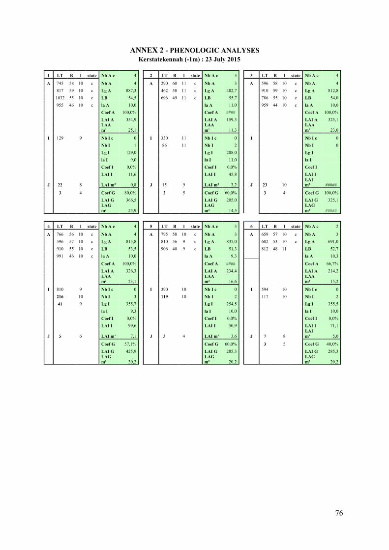
76
ANNEX 2 - PHENOLOGIC ANALYSES
Kerstatekennah (-1m) : 23 July 2015
1 LT B l state Nb A c 4
2 LT B l state Nb A c 3
3 LT B l state Nb A c 4
A 745 58 10 c Nb A 4
A 290 60 11 c Nb A 3
A 596 58 10 c Nb A 4 817 59 10 c Lg A 887,3
462 58 11 c Lg A 482,7
910 59 10 c Lg A 812,8
1032 55 10 c LB 54,5
696 49 11 c LB 55,7
786 55 10 c LB 54,0 955 46 10 c la A 10,0
la A 11,0
959 44 10 c la A 10,0
Coef A 100,0%
Coef A ####
Coef A 100,0%
LAI A 354,9
LAI A 159,3
LAI A 325,1
LAA m² 25,1
LAA m² 11,3
LAA m² 23,0
I 129
9
Nb I c 0
I 330
11
Nb I c 0
I
Nb I c 0
Nb I 1
86
11
Nb I 2
Nb I 0
Lg I 129,0
Lg I 208,0
Lg I
la I 9,0
la I 11,0
la I
Coef I 0,0%
Coef I 0,0%
Coef I
LAI I 11,6
LAI I 45,8
LAI I
J 22
8
LAI m² 0,8
J 15
9
LAI m² 3,2
J 23
10
LAI m² #####
3
4
Coef G 80,0%
2
5
Coef G 60,0%
3
4
Coef G 100,0%
LAI G 366,5
LAI G 205,0
LAI G 325,1
LAG m² 25,9
LAG m² 14,5
LAG m² #####
4 LT B l state Nb A c 4
5 LT B l state Nb A c 3
6 LT B l state Nb A c 2
A 766 56 10 c Nb A 4
A 795 58 10 c Nb A 3
A 659 57 10 c Nb A 3 596 57 10 c Lg A 815,8
810 56 9 c Lg A 837,0
602 53 10 c Lg A 691,0
910 55 10 c LB 53,5
906 40 9 c LB 51,3
812 48 11
LB 52,7 991 46 10 c la A 10,0
la A 9,3
la A 10,3
Coef A 100,0%
Coef A ####
Coef A 66,7%
LAI A 326,3
LAI A 234,4
LAI A 214,2
LAA m² 23,1
LAA m² 16,6
LAA m² 15,2
I 810
9
Nb I c 0
I 390
10
Nb I c 0
I 594
10
Nb I c 0 216
10
Nb I 3
119
10
Nb I 2
117
10
Nb I 2
41
9
Lg I 355,7
Lg I 254,5
Lg I 355,5
la I 9,3
la I 10,0
la I 10,0
Coef I 0,0%
Coef I 0,0%
Coef I 0,0%
LAI I 99,6
LAI I 50,9
LAI I 71,1
J 5
6
LAI m² 7,1
J 3
4
LAI m² 3,6
J 7
8
LAI m² 5,0
Coef G 57,1%
Coef G 60,0%
3
5
Coef G 40,0%
LAI G 425,9
LAI G 285,3
LAI G 285,3
LAG m² 30,2
LAG m² 20,2
LAG m² 20,2
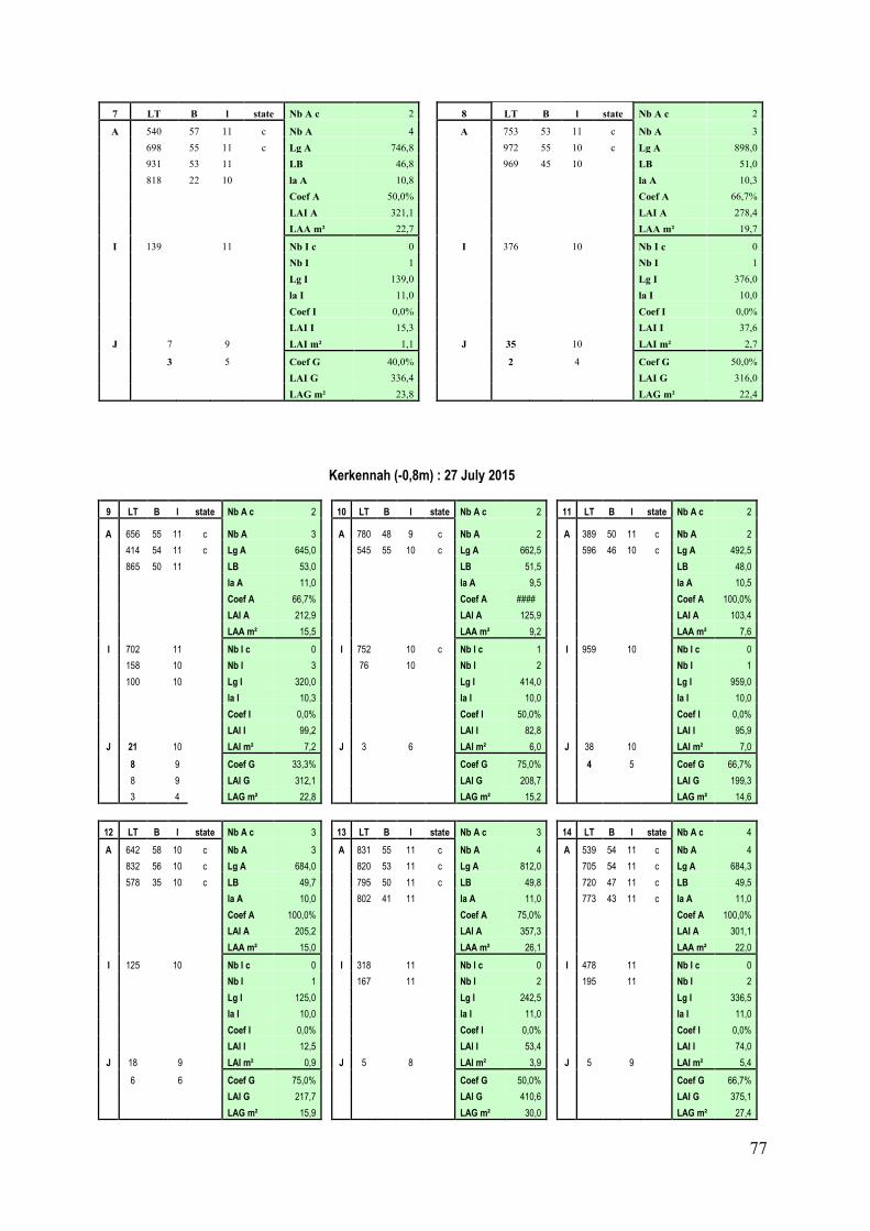
77
7 LT B l state Nb A c 2
8 LT B l state Nb A c 2
A 540 57 11 c Nb A 4
A 753 53 11 c Nb A 3 698 55 11 c Lg A 746,8
972 55 10 c Lg A 898,0
931 53 11
LB 46,8
969 45 10
LB 51,0 818 22 10
la A 10,8
la A 10,3
Coef A 50,0%
Coef A 66,7%
LAI A 321,1
LAI A 278,4
LAA m² 22,7
LAA m² 19,7
I 139
11
Nb I c 0
I 376
10
Nb I c 0
Nb I 1
Nb I 1
Lg I 139,0
Lg I 376,0
la I 11,0
la I 10,0
Coef I 0,0%
Coef I 0,0%
LAI I 15,3
LAI I 37,6
J 7
9
LAI m² 1,1
J 35
10
LAI m² 2,7
3
5
Coef G 40,0%
2
4
Coef G 50,0%
LAI G 336,4
LAI G 316,0
LAG m² 23,8
LAG m² 22,4
Kerkennah (-0,8m) : 27 July 2015
9 LT B l state Nb A c 2
10 LT B l state Nb A c 2
11 LT B l state Nb A c 2
A 656 55 11 c Nb A 3
A 780 48 9 c Nb A 2
A 389 50 11 c Nb A 2
414 54 11 c Lg A 645,0
545 55 10 c Lg A 662,5
596 46 10 c Lg A 492,5
865 50 11
LB 53,0
LB 51,5
LB 48,0
la A 11,0
la A 9,5
la A 10,5
Coef A 66,7%
Coef A ####
Coef A 100,0%
LAI A 212,9
LAI A 125,9
LAI A 103,4
LAA m² 15,5
LAA m² 9,2
LAA m² 7,6
I 702
11
Nb I c 0
I 752
10 c Nb I c 1
I 959
10
Nb I c 0
158
10
Nb I 3
76
10
Nb I 2
Nb I 1
100
10
Lg I 320,0
Lg I 414,0
Lg I 959,0
la I 10,3
la I 10,0
la I 10,0
Coef I 0,0%
Coef I 50,0%
Coef I 0,0%
LAI I 99,2
LAI I 82,8
LAI I 95,9
J 21
10
LAI m² 7,2
J 3
6
LAI m² 6,0
J 38
10
LAI m² 7,0
8
9
Coef G 33,3%
Coef G 75,0%
4
5
Coef G 66,7%
8
9
LAI G 312,1
LAI G 208,7
LAI G 199,3
3
4
LAG m² 22,8
LAG m² 15,2
LAG m² 14,6
12 LT B l state Nb A c 3
13 LT B l state Nb A c 3
14 LT B l state Nb A c 4
A 642 58 10 c Nb A 3
A 831 55 11 c Nb A 4
A 539 54 11 c Nb A 4
832 56 10 c Lg A 684,0
820 53 11 c Lg A 812,0
705 54 11 c Lg A 684,3
578 35 10 c LB 49,7
795 50 11 c LB 49,8
720 47 11 c LB 49,5
la A 10,0
802 41 11
la A 11,0
773 43 11 c la A 11,0
Coef A 100,0%
Coef A 75,0%
Coef A 100,0%
LAI A 205,2
LAI A 357,3
LAI A 301,1
LAA m² 15,0
LAA m² 26,1
LAA m² 22,0
I 125
10
Nb I c 0
I 318
11
Nb I c 0
I 478
11
Nb I c 0
Nb I 1
167
11
Nb I 2
195
11
Nb I 2
Lg I 125,0
Lg I 242,5
Lg I 336,5
la I 10,0
la I 11,0
la I 11,0
Coef I 0,0%
Coef I 0,0%
Coef I 0,0%
LAI I 12,5
LAI I 53,4
LAI I 74,0
J 18
9
LAI m² 0,9
J 5
8
LAI m² 3,9
J 5
9
LAI m² 5,4
6
6
Coef G 75,0%
Coef G 50,0%
Coef G 66,7%
LAI G 217,7
LAI G 410,6
LAI G 375,1
LAG m² 15,9
LAG m² 30,0
LAG m² 27,4
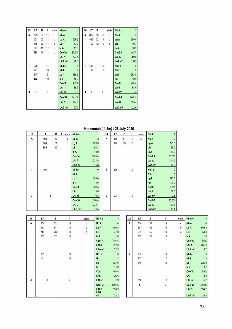
78
15 LT B l state Nb A c 4
16 LT B l state Nb A c 3
A 775 56 11
Nb A 5
A 827 55 10 c Nb A 3
531 55 11 c Lg A 559,2
838 52 11 c Lg A 809,0
345 43 11 c LB 47,0
762 42 10 c LB 49,7
577 41 11 c la A 11,0
la A 10,3
568 40 11 c Coef A 80,0%
Coef A ####
LAI A 307,6
LAI A 250,8
LAA m² 22,5
LAA m² 18,3
I 225
11
Nb I c 0
I 447
10
Nb I c 0
221
10
Nb I 4
139
10
Nb I 2
117
9
Lg I 166,3
Lg I 293,0
102
10
la I 10,0
la I 10,0
Coef I 0,0%
Coef I 0,0%
LAI I 66,5
LAI I 58,6
J 11
8
LAI m² 4,9
J 3
9
LAI m² 4,3
Coef G 44,4%
Coef G 60,0%
LAI G 374,1
LAI G 309,4
LAG m² 27,3
LAG m² 22,6
Kerkennah (-1,3m) : 28 July 2015
17 LT B l state Nb A c 1
18 LT B l state Nb A c 1
A 460 59
c Nb A 3
A 815 57 10 c Nb A 2 900 58
Lg A 738,3
627 53 10
Lg A 721,0
855 43
LB 53,3
LB 55,0
la A 10,0
la A 10,0
Coef A 33,3%
Coef A 50,0%
LAI A 221,5
LAI A 144,2
LAA m² 15,8
LAA m² 10,3
I 106
Nb I c 0
I 395
10
Nb I c 0
Nb I 1
Nb I 1
Lg I 106,0
Lg I 395,0
la I 10,0
la I 10,0
Coef I 0,0%
Coef I 0,0%
LAI I 10,6
LAI I 39,5
J 8
LAI m² 0,8
J 23
10
LAI m² 2,8
Coef G 25,0%
Coef G 33,3%
LAI G 232,1
LAI G 183,7
LAG m² 16,5
LAG m² 13,1
19 LT B l state Nb A c 3
20 LT B l state Nb A c 3
A 654 52 11 c Nb A 4
A 514 58 11 c Nb A 4
640 54 11 c Lg A 709,8
371 52 11 c Lg A 595,3
745 48 11 c LB 47,8
639 55 11 c LB 53,8
800 37 11
la A 11,0
857 50 11
la A 11,0
Coef A 75,0%
Coef A 75,0%
LAI A 312,3
LAI A 261,9
LAA m² 22,3
LAA m² 18,7
I 191
11
Nb I c 0
I 360
11
Nb I c 0
51
11
Nb I 2
202
10
Nb I 3
Lg I 121,0
116
11
Lg I 226,0
la I 11,0
la I 10,7
Coef I 0,0%
Coef I 0,0%
LAI I 26,6
LAI I 72,3
J 3
7
LAI m² 1,9
J 25
10
LAI m² 5,2
Coef G 50,0%
5
7
Coef G 42,9%
LAI G 338,9
LAI G 334,2
LAG m² 24,2
LAG m² 23,8
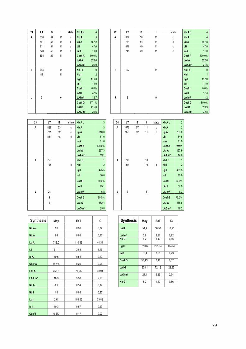
79
21 LT B l state Nb A c 4
22 LT B l state Nb A c 4
A 600 54 11 c Nb A 5
A 357 56 11 c Nb A 4
761 55 11 c Lg A 687,2
771 54 11 c Lg A 687,8
611 54 11 c LB 47,0
878 49 11 c LB 47,0
870 50 11 c la A 11,0
745 29 11 c la A 11,0
594 22 11
Coef A 80,0%
Coef A 100,0%
LAI A 378,0
LAI A 302,6
LAA m² 26,9
LAA m² 21,6
I 254
11
Nb I c 0
I 157
11
Nb I c 0
88
11
Nb I 2
Nb I 1
Lg I 171,0
Lg I 157,0
la I 11,0
la I 11,0
Coef I 0,0%
Coef I 0,0%
LAI I 37,6
LAI I 17,3
J 3
6
LAI m² 2,7
J 9
9
LAI m² 1,2
Coef G 57,1%
Coef G 80,0%
LAI G 415,6
LAI G 319,9
LAG m² 29,6
LAG m² 22,8
23 LT B l state Nb A c 3
24 LT B l state Nb A c 2
A 828 53
c Nb A 3
A 573 57 11 c Nb A 2
771 52
c Lg A 810,0
953 52 11 c Lg A 763,0
831 48
c LB 51,0
LB 54,5
la A 11,0
la A 11,0
Coef A 100,0%
Coef A ####
LAI A 267,3
LAI A 167,9
LAA m² 19,1
LAA m² 12,0
I 756
Nb I c 1
I 790
10
Nb I c 1
195
c Nb I 2
89
10 c Nb I 2
Lg I 475,5
Lg I 439,5
la I 10,0
la I 10,0
Coef I 50,0%
Coef I 50,0%
LAI I 95,1
LAI I 87,9
J 24
LAI m² 6,8
J 5
8
LAI m² 6,3
3
Coef G 80,0%
Coef G 75,0%
2
LAI G 362,4
LAI G 255,8
LAG m² 25,8
LAG m² 18,2
Synthesis Moy EcT IC
Synthesis Moy EcT IC
Nb A c 2,8 0,96 0,39
LAI I 54,9 30,57 12,23
Nb A 3,4 0,88 0,35
LAI m² 3,8 2,31 0,92
Lg A 718,0 110,82 44,34
Nb G 5,2 1,40 0,56
LB 51,1 2,88 1,15
Lg G 510,6 261,34 104,56
la A 10,5 0,54 0,22
la G 10,4 0,56 0,23
Coef A 84,1% 0,20 0,08
Coef G 58,4% 0,18 0,07
LAI A 255,6 77,25 30,91
LAI G 308,1 72,12 28,85
LAA m² 18,3 5,50 2,20
LAG m² 21,1 6,85 2,74
Nb I c 0,1 0,34 0,14
Nb G 5,2 1,40 0,56
Nb I 1,8 0,88 0,35
Lg I 294 184,55 73,83
la I 10,3 0,57 0,23
Coef I 6,5% 0,17 0,07
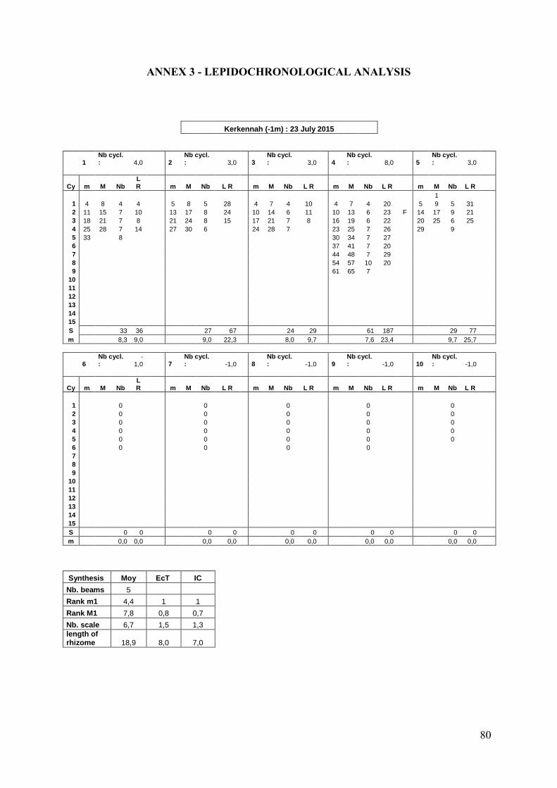
80
ANNEX 3 - LEPIDOCHRONOLOGICAL ANALYSIS
Kerkennah (-1m) : 23 July 2015
1
Nb cycl. : 4,0
2
Nb cycl. : 3,0
3
Nb cycl. : 3,0
4
Nb cycl. : 8,0
5
Nb cycl. : 3,0
Cy m M Nb
L R m M Nb L R m M Nb L R m M Nb L R m M Nb L R
1
1 4 8 4 4 5 8 5 28 4 7 4 10 4 7 4 20 5 9 5 31
2 11 15 7 10 13 17 8 24 10 14 6 11 10 13 6 23 F 14 17 9 21
3 18 21 7 8 21 24 8 15 17 21 7 8 16 19 6 22 20 25 6 25
4 25 28 7 14 27 30 6 24 28 7 23 25 7 26 29 9
5 33 8
30 34 7 27
6
37 41 7 20
7
44 48 7 29
8
54 57 10 20
9
61 65 7
10
11
12
13
14
15
S 33 36 27 67 24 29 61 187 29 77
m 8,3 9,0 9,0 22,3 8,0 9,7 7,6 23,4 9,7 25,7
6
Nb cycl. :
-1,0
7
Nb cycl. : -1,0
8
Nb cycl. : -1,0
9
Nb cycl. : -1,0
10
Nb cycl. : -1,0
Cy m M Nb
L R m M Nb L R m M Nb L R m M Nb L R m M Nb L R
1 0 0 0 0
0
2 0 0 0 0
0
3 0 0 0 0
0
4 0 0 0 0
0
5 0 0 0 0
0
6 0 0 0 0
7
8
9
10
11
12
13
14
15
S 0 0 0 0 0 0 0 0 0 0
m 0,0 0,0 0,0 0,0 0,0 0,0 0,0 0,0 0,0 0,0
Synthesis Moy EcT IC
Nb. beams 5 Rank m1 4,4 1 1 Rank M1 7,8 0,8 0,7 Nb. scale 6,7 1,5 1,3 length of
rhizome 18,9 8,0 7,0
81
Kerkennah (-1m) : 27 July 2015
1 Nb cycl. : 4,0
2
Nb cycl. : 7,0
3
Nb cycl. : 7,0
4
Nb cycl. : 4,0
5
Nb cycl. : 7,0
Cy m M Nb L R m M Nb L R m M Nb L R m M Nb L R m M Nb
L R
1
2
1
2
1 5 9 5 28 4 8 4 14 5 9 5 23 4 9 4 37 F 6 8 6 10
2 13 17 8 28 12 15 8 8 12 15 7 20 F 13 16 9 25
11 14 5 12 F
3 23 27 10 26 18 21 6 7 18 22 6 30 20 23 7 23 19 22 8 14
4 31 35 8 32 F 24 27 6 5 27 30 9 14 26 30 6 18 25 28 6 8
5 39 43 8 29 32 5 6 33 38 6 13 33 7 31 35 6 12
6
35 39 6 6 42 46 9 20
37 40 6 5
7
42 46 7 7 51 55 9 24
43 45 6 5
8
49 52 7 8 59 8
50 7
9
10
11
12
13
14
15
S 39 114 49 61 59 144 33 103 50 66
m 9,8 28,5 7,0 8,7 8,4 20,6 8,3 25,8 7,1 9,4
Cy m M Nb L R m M Nb L R m M Nb L R m M Nb L R m M Nb
L R
1 0 0 0 0
0
2 0 0 0 0
0
3 0 0 0 0
0
4 0 0 0 0
0
5 0 0 0 0
0
6 0 0 0 0
7
8
9
10
11
12
13
14
15
S 0 0 0 0 0 0 0 0 0 0
m 0,0 0,0 0,0 0,0 0,0 0,0 0,0 0,0 0,0 0,0
Synthesis Moy EcT IC
Nb. beams 5 Rank m1 4,8 1 1 Rank M1 8,6 0,5 0,5 Nb. scale 6,8 1,5 1,3 length of
rhizome 16,3 9,4 8,2
82
Kerkennah (-1,3m) : 28 July 2015
1
Nb cycl. : 9,0
2
Nb cycl. :
14,0
3
Nb cycl. :
11,0
4
Nb cycl. :
14,0
5
Nb cycl. :
13,0
Cy m M Nb L R m M Nb L R m M Nb L R m M Nb L R m M Nb L R
1 4 8 4 12 F 4 6 4 12 5 10 5 25 2 6 2 19 3 7 3 11
2 11 15 7 11
9 13 5 11 15 21 10 17
10 13 8 11
12 16 9 10
3 18 22 7 11
18 22 9 12 25 29 10 20 17 21 7 11 19 22 7 13
4 26 30 8 15 F 25 29 7 17 35 40 10 16 25 29 8 10 25 28 6 11
5 34 37 8 13
33 36 8 11 43 48 8 25 32 34 7 11 32 37 7 11
6 41 45
11
40 43 7 13 52 55 9 20 F 38 42 6 19 40 44 8 13
7 48 54
15
46 50 6 15 59 63 7 25 47 50 9 23 47 50 7 14
8 57 60
14
54 58 8 18 67 71 8 14 55 59 8 13 54 59 7 16
9 64 67
10 F 62 66 8 16 75 80 8 15 F 62 66 7 14 64 68 10 19 F
10 71 74
69 72 7 20 84 89 9 15 F 69 72 7 13 71 75 7 21
11
76 80 7 21 F 93 97 9 15 76 86 7 9 79 83 8 13
12
83 86 7 10 100
104 7 83 86 7 6 87 90 8 11 F
13
89 92 6 11
90 93 7 9 F 94 98 7 10 F
14
96 100 7 14
97
100 7 13
101
105 7
15
103
107 7
104
108 7 7
S 34 112 103 201 100 207 104 188 101 173
m 3,8 12,4 7,4 14,
4 9,1 18,
8 7,4 13,
4 7,8 13,
3
Cy m M Nb L R m M Nb L R m M Nb L R m M Nb L R m M Nb L R
1 0 0 0 0
0
2 0 0 0 0
0
3 0 0 0 0
0
4 0 0 0 0
0
5 0 0 0 0
0
6 0 0 0 0
7
8
9
10
11
12
13
14
15
S 0 0 0 0 0 0 0 0 0 0
m 0,0 0,0 0,0 0,0
0,0 0,0
0,0 0,0
0,0 0,0
Synthesis Moy EcT IC
Nb. beams 5 Rank m1 3,6 1 1 Rank M1 7,4 1,7 1,5 Nb. scale 7,2 1,5 1,3 length of
rhizome 14,2 4,4 3,8
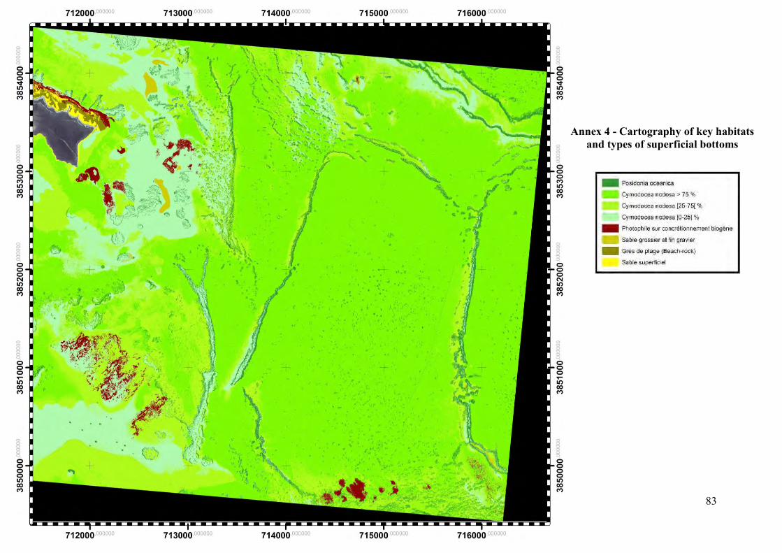
83
Annex 4 - Cartography of key habitats and types of superficial bottoms
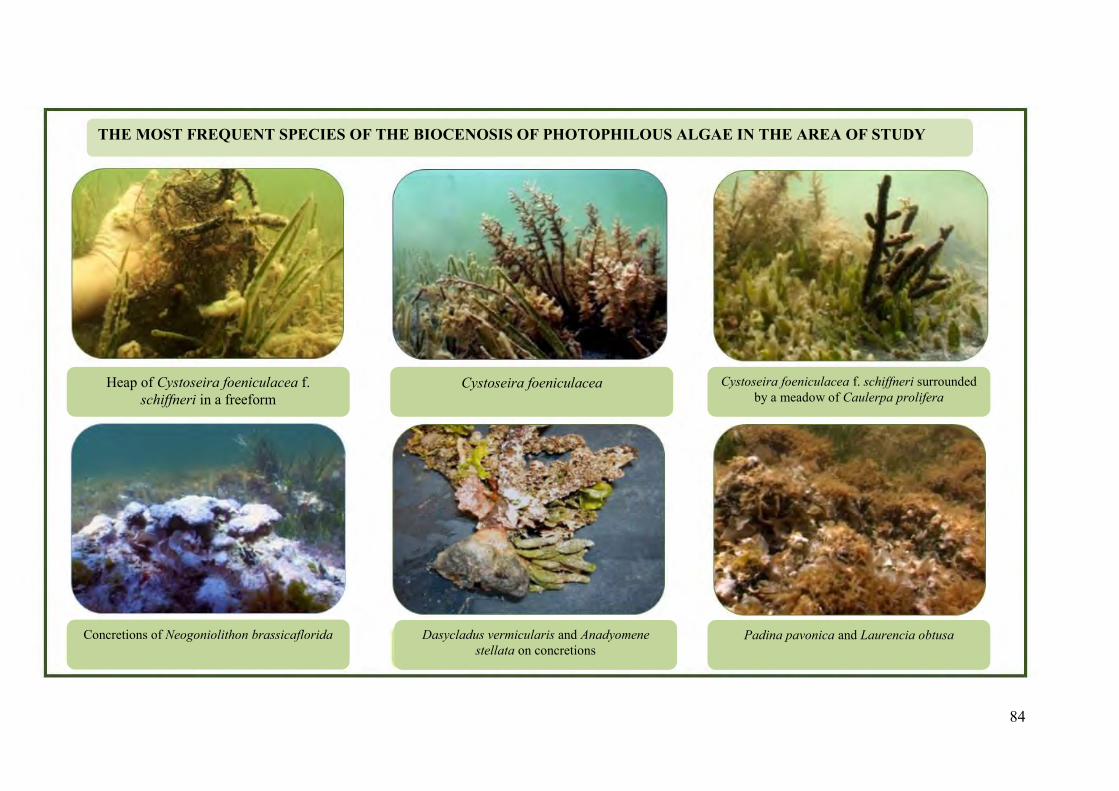
84
THE MOST FREQUENT SPECIES OF THE BIOCENOSIS OF PHOTOPHILOUS ALGAE IN THE AREA OF STUDY
Heap of Cystoseira foeniculacea f. schiffneri in a freeform
Cystoseira foeniculacea Cystoseira foeniculacea f. schiffneri surrounded by a meadow of Caulerpa prolifera
Concretions of Neogoniolithon brassicaflorida Dasycladus vermicularis and Anadyomene stellata on concretions
Padina pavonica and Laurencia obtusa
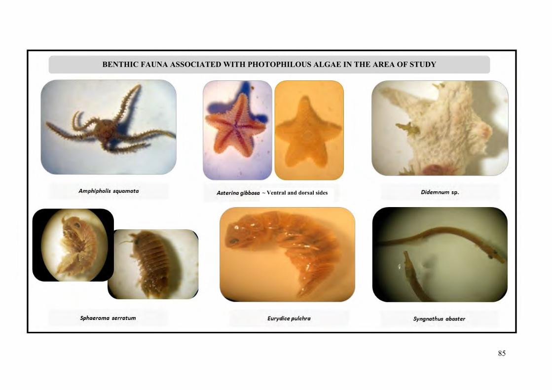
85
BENTHIC FAUNA ASSOCIATED WITH PHOTOPHILOUS ALGAE IN THE AREA OF STUDY
~ Ventral and dorsal sides