Embed Size (px)
Citation preview

NOTE: This Chapter should not be read in isolation. You may need to consider other chapters of this DCP when preparing your application.
CHAPTER G9: DEVELOPMENT ON FLOOD PRONE LAND
Shoalhaven Development Control Plan 2014
Chapter G9: Development on Flood Prone Land
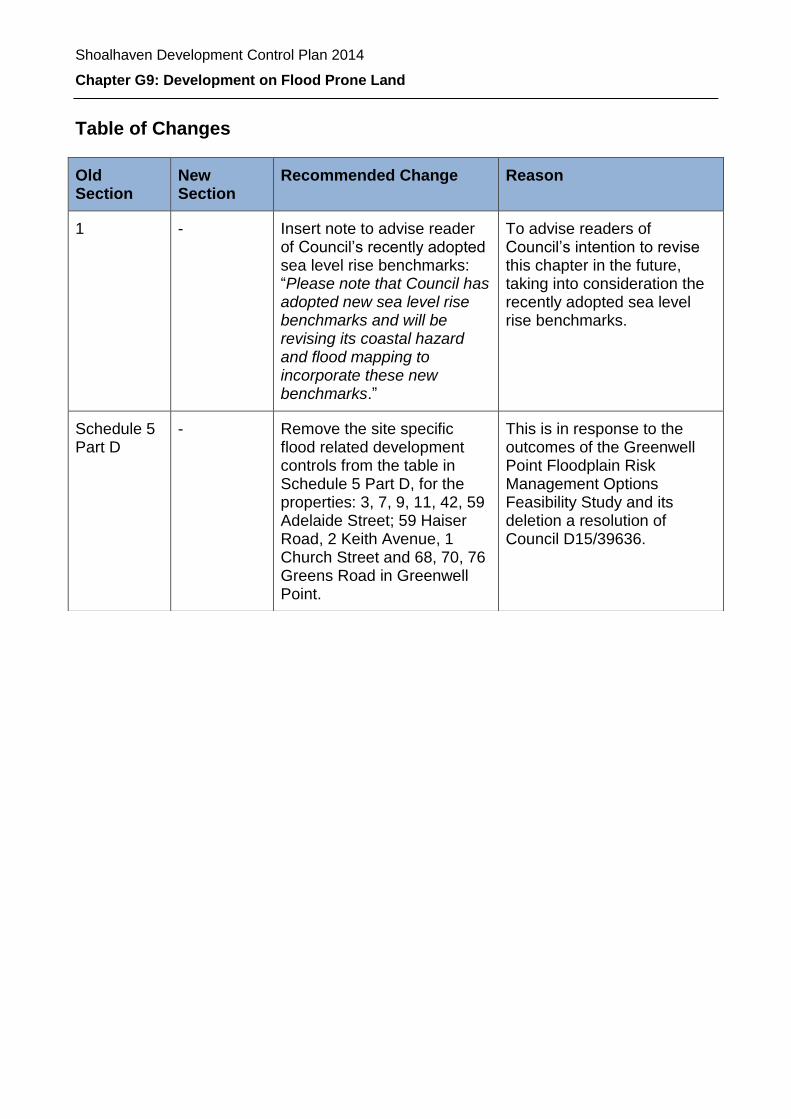
Table of Changes
Old Section
New Section
Recommended Change Reason
1 - Insert note to advise reader of Council’s recently adopted sea level rise benchmarks: “Please note that Council has adopted new sea level rise benchmarks and will be revising its coastal hazard and flood mapping to incorporate these new benchmarks.”
To advise readers of Council’s intention to revise this chapter in the future, taking into consideration the recently adopted sea level rise benchmarks.
Schedule 5 Part D
- Remove the site specific flood related development controls from the table in Schedule 5 Part D, for the properties: 3, 7, 9, 11, 42, 59 Adelaide Street; 59 Haiser Road, 2 Keith Avenue, 1 Church Street and 68, 70, 76 Greens Road in Greenwell Point.
This is in response to the outcomes of the Greenwell Point Floodplain Risk Management Options Feasibility Study and its deletion a resolution of Council D15/39636.

Shoalhaven Development Control Plan 2014
Chapter G9: Development on Flood Prone Land
Page | 2
Chapter G9: Development on Flood Prone Land
Contents
1 Purpose ........................................................................................................................ 4
2 Application .................................................................................................................... 4
3 Context ......................................................................................................................... 4
4 Objectives ..................................................................................................................... 5
5 Controls ........................................................................................................................ 5
5.1 General ................................................................................................................... 5
5.2 Fill or Excavation on the Floodplain ........................................................................ 8
5.3 Subdivision in the Floodplain .................................................................................. 9
6 Advisory Information ................................................................................................... 10
6.1 Considerations when preparing a development application .................................. 10
6.1.1 My proposal is small scale – do I still need consent? ........................................... 10
6.1.2 What type of flood information is available? ......................................................... 10
6.1.3 What sections of the Chapter apply to my application? ........................................ 11
6.2 How to address the requirements of this Chapter ................................................. 12
6.3 Management of development on Flood Prone Land ............................................. 13
6.3.1 Flood Prone Land: The Policy Context ................................................................. 13
6.3.2 Flood Prone Land Policy (1984) ........................................................................... 13
6.3.3 NSW Floodplain Development Manual (2005) ...................................................... 14
6.4 Flood Planning Concepts ...................................................................................... 17
6.4.1 Flood Planning Area ............................................................................................. 17
6.4.2 Flood Planning Levels and Freeboard .................................................................. 18
6.4.3 Climate Change .................................................................................................... 19
6.5 Development application documents .................................................................... 20
6.5.1 Flood Compliance Report ..................................................................................... 20
6.5.2 Other additional development application documents .......................................... 22
6.6 Flood DCP Compliance Report Checklist and Schedules .................................... 24
7 Other legislation or policies you may need to check ................................................... 24
8 Flood Compliance Report Checklist ............................................................................ 25
Schedule 1 – Land Use Categories ................................................................................... 26

Shoalhaven Development Control Plan 2014
Chapter G9: Development on Flood Prone Land
Page | 3
Schedule 2 – Flood Information Enquiries and Flood Certificates ..................................... 29
Schedule 3 – Technical Reporting Requirements .............................................................. 31
Schedule 4 – Flood Proofing Guidelines ............................................................................ 37
Schedule 5 – Flood Related Development Controls – Site Specific as per the adopted Floodplain Risk Management Plan .................................................................................... 42
Schedule 6 – Flood Related Development Controls - Generic ........................................... 51
Figures
Figure 1: Floodplain Risk Management Process- Source: 2005 NSW Floodplain Development Manual ......................................................................................................... 15 Figure 2: Floodplain Aerial View ........................................................................................ 17
Figure 3: Cross Section through floodplain – hydraulic categories within flood planning area.................................................................................................................................... 18 Figure 4: Coastal Flooding Consideration in Development Assessment Process ............. 19 Figure 5: Procedure for obtaining a Flood Certificate from Council ................................... 30
Amendment history
Version Number Date Adopted by Council Commencement Date Amendment Type
1 14 October 2014 22 October 2014 New
2 Draft

Shoalhaven Development Control Plan 2014
Chapter G9: Development on Flood Prone Land
Page | 4
1 Purpose
The purpose of this Chapter is to provide information and development controls needed to
prepare and assess development applications on flood prone land.
Notes:
For this purpose of this Chapter, ‘flood prone land’ means the land susceptible to flooding by the probable maximum flood event (that is, land within the floodplain) as indicated on the map marked "Flood Prone Land" deposited in the office of the Council as amended from time to time.
Please note that Council has adopted new sea level rise benchmarks and will be revising its coastal hazard and flood mapping to incorporate these new benchmarks.
2 Application
This Chapter applies to all development on flood prone land within Shoalhaven.
Note: Proposed development on land outside the flood planning area (see Figure 2) may still be located on land which is classified as flood prone land if it is below the probable maximum flood (PMF) level.
Flood prone land is described in detail in Section 6 under the heading Flood Planning Concepts. Development controls apply for development in the flood planning area. Additional controls apply to ‘Buildings and activities requiring special evacuation consideration’ (as per Schedule 6) up to the probable maximum food event.
In cases where a site is classified as partially flood affected, it is strongly recommended to only consider development on the flood free portion of the allotment.
3 Context
The NSW Flood Prone Land Policy provides a framework for Council to manage flood prone land. Council is required under the Environmental Planning and Assessment Act 1979, and in various environmental planning instruments including the Shoalhaven LEP 2014, to ensure that due regard is given to the effect of natural hazards upon development.
Note: Hazard is a source of potential harm or a situation with the potential to cause loss. In relation to this Chapter the hazard is flooding which has the potential to cause damage to the community. Hazard can be categorised as high hazard and low hazard.
In high hazard areas there is a possible danger to personal safety, evacuation by trucks is difficult, able bodied adults would have difficulties wading to safety, and flooding can cause potential significant structural damage to buildings.
Shoalhaven Development Control Plan 2014
Chapter G9: Development on Flood Prone Land
Page | 5
In low hazard areas, trucks could evacuate people and their possessions and able bodied adults would have little difficulty in wading to safety.
A flood is defined by the NSW Floodplain Development Manual as:
a relatively high stream flow which overtops the natural or artificial banks in any part of a stream, river, estuary, lake or dam, and/or
local overland flooding associated with major drainage before entering a watercourse, and/or
coastal inundation resulting from super-elevated sea levels and/or waves overtopping coastline defences excluding tsunami
Local overland flooding means inundation by local runoff rather than overbank discharge from a stream, river, estuary, lake or dam.
Annual exceedance probability (AEP) means the chance of a flood of a given or larger size occurring in any one year, usually expressed as a percentage.
4 Objectives
The objectives are to:
i. Reduce risk to life and property resulting from floods;
ii. Ensure that the impacts of the full range of flood sizes up to and including the PMF
are considered when assessing development on flood prone land;
iii. Ensure that the impact of climate change is considered when assessing
development on flood prone land:
iv. Ensure the future use of flood prone land does not cause undue distress to
individuals or unduly increases potential flood liability to individuals or the
community; and
v. Incorporate site specific floodplain management recommendations from local
floodplain risk management plans into Council’s overall planning framework.
Note: Risk means the chance of something happening that will have an impact. It is measured in terms of consequences and probability (likelihood). In the context of this Chapter, it is the likelihood of consequences arising from the interaction of floods, communities and the environment.
5 Controls
5.1 General
The specific objectives are to:
i. Minimise risk to life and damage to property by controlling development on flood
prone land;

Shoalhaven Development Control Plan 2014
Chapter G9: Development on Flood Prone Land
Page | 6
ii. To ensure that the impacts of the full range of flood sizes up to and including the
PMF are considered when assessing development on flood prone areas within
Shoalhaven;
iii. To ensure that development does not have a significant impact on flood behaviour,
people’s safety, surrounding properties and structures, and the natural environment;
iv. To ensure that the effects of climate change are considered when assessing
development in flood prone land within Shoalhaven;
v. To ensure that development on the floodplain is consistent with the NSW Flood
Prone Land Policy and NSW Floodplain Development Manual;
vi. To ensure that developers and the community are conscious of the potential flood
hazard and consequent risk associated with the use and development of land within
the floodplain;
vii. To protect the integrity of floodplains and floodways, including riparian vegetation,
fluvial geomorphologic environmental processes and water quality;
viii. To ensure that all land uses and essential services are appropriately sited and
designed in recognition of all potential floods; and
ix. To ensure that development on flood prone land does not place an unacceptable
financial burden on landowners or the community.
Performance Criteria Acceptable Solutions
P1 Development or work on flood
prone land will meet the
following:
The development will not
increase the risk to life or
safety of persons during a
flood event on the
development site and
adjoining land.
The development or work
will not unduly restrict the
flow behaviour of
floodwaters.
The development or work
will not unduly increase the
level or flow of floodwaters
or stormwater runoff on
land in the vicinity. The
development or work will
not exacerbate the adverse
consequences of
floodwaters flowing on the
land with regard to erosion,
A1.1 The development satisfies the requirements as shown
in the planning matrix at Schedule 6 including climate
change considerations (See section 7.3); and
A1.2 Buildings and structures are constructed in accordance
with the flood proofing guidelines (see Schedule 4); and
Note: Flood proofing means a combination of measures incorporated in the design, construction and alteration of individual buildings or structures subject to flooding, to reduce or eliminate flood damages.
A1.3 Buildings and structures are constructed in accordance
with the Building Code of Australia - Construction of
Buildings in Flood Hazard Areas – Standard 2012.
The controls in this Chapter are to be used in instances
where this Chapter specifies more stringent controls;
and
Buildings and structures are designed to withstand the forces of flood waters in accordance with best practice engineering standards; or
A1.4 Where appropriate structures are designed to collapse
under the force of water to not obstruct the flood flow,
but are sufficiently secured to not become floating
debris and to not endanger people or animals; or
Shoalhaven Development Control Plan 2014
Chapter G9: Development on Flood Prone Land
Page | 7
Performance Criteria Acceptable Solutions
siltation and destruction of
vegetation.
The structural
characteristics of any
building or work that are the
subject of the application
are capable of withstanding
flooding in accordance with
the requirements of the
Council.
The development will not
become unsafe during
floods or result in moving
debris that potentially
threatens the safety of
people or the integrity of
structures.
Potential damage due to
inundation of proposed
buildings and structures is
minimised.
The development will not
obstruct escape routes for
both people and stock in
the event of a flood.
The development will not
unduly increase
dependency on emergency
services.
Interaction of flooding from
all possible sources has
been taken into account in
assessing the proposed
development against risks
to life and property resulting
from any adverse hydraulic
impacts.
The development will not
adversely affect the
integrity of floodplains and
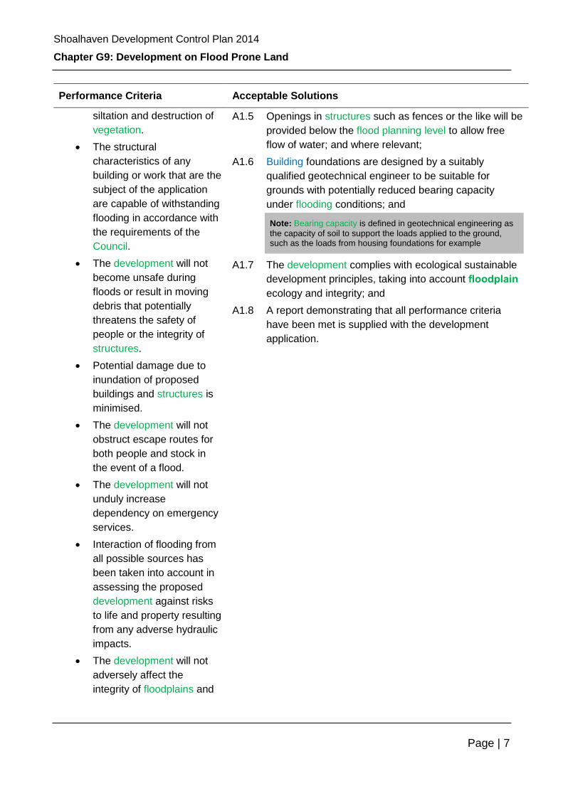
A1.5 Openings in structures such as fences or the like will be
provided below the flood planning level to allow free
flow of water; and where relevant;
A1.6 Building foundations are designed by a suitably
qualified geotechnical engineer to be suitable for
grounds with potentially reduced bearing capacity
under flooding conditions; and
Note: Bearing capacity is defined in geotechnical engineering as
the capacity of soil to support the loads applied to the ground, such as the loads from housing foundations for example
A1.7 The development complies with ecological sustainable
development principles, taking into account floodplain
ecology and integrity; and
A1.8 A report demonstrating that all performance criteria
have been met is supplied with the development
application.

Shoalhaven Development Control Plan 2014
Chapter G9: Development on Flood Prone Land
Page | 8
Performance Criteria Acceptable Solutions
floodways, including
riparian vegetation, fluvial
geomorphologic
environmental processes
and water quality.
Note: Fluvial geomorphology is the branch of geology that examines the formation and structure of the features of the surface of the earth which is created by flowing rivers
5.2 Fill or Excavation on the Floodplain
The specific objective is to:
i. Ensure that filling or excavation within the floodplain does not have a significant
impact on flood behaviour, conveyance and storage capacity, as well as
surrounding properties or structures and the environment in the specific area where
the development is proposed.
Note: Conveyance is a direct measure of the flow carrying capacity
of a particular cross-section of a stream or stormwater channel. (For
example, if the conveyance of a channel cross-section is reduced by
half, then the flow carrying capacity of that channel cross-section will
also be halved).
Performance Criteria Acceptable Solutions
P2 Filling or excavation on flood prone
land will meet the following:
High hazard floodway areas are
kept free of fill and/or obstructions.
The proposed fill or excavation will
not unduly restrict the flow
behaviour of floodwaters.
The proposed fill or excavation will
not unduly increase the level or flow
of floodwaters or stormwater runoff
on land in the vicinity, including
adjoining land.
The proposed fill or excavation will
not exacerbate erosion, siltation
and destruction of vegetation
caused by floodwaters flowing on
A2.1 The development satisfies the requirements as
shown in the planning matrix at Schedule 6.
A2.2 The proposed fill volume occupies less than
the 2050 1% of the available 20%, 5% and 1%
AEP flood volume on the development site and
does not create a depth exceeding 1 metre
above natural ground level or require more
than 250 cubic metres of filling materials.
A2.3 The proposed fill and excavation does not
adversely affect neighbouring properties or the
overall flood behaviour and flood storage
volume.
A2.4 The proposed fill is used only for the purpose
of filling a local depression beneath the
confines of a building within an existing
residential/ commercial area.

Shoalhaven Development Control Plan 2014
Chapter G9: Development on Flood Prone Land
Page | 9
Performance Criteria Acceptable Solutions
the land.
The proposed fill or excavation will
not be carried out on flood prone
land if sufficient flood free area is
available for development within the
subject property.
The proposed excavation does not
create new habitable rooms, non-
habitable storage areas or carparks
with floor levels below the existing
ground level.
Note: Habitable room has the same meaning as the Building Code of Australia. This is a room used for normal domestic activities, other than a bathroom, laundry, toilet, pantry, walk in wardrobe, hallway, lobby, clothes drying room or other space of a specialised nature that is not occupied frequently or for extended periods.
5.3 Subdivision in the Floodplain
The specific objective is to:
i. Ensure that the creation of new lots does not increase potential flood risks to land
owners or the community.
Performance Criteria Acceptable Solutions
P3.1 Potential development as a
consequence of a subdivision
proposal must be able to be
undertaken in compliance with this
Chapter.
P3.2 The proposed subdivision will not
create new lots that are affected by
a high hazard area, or floodway in
today’s flood conditions or in
climate change conditions up to the
year 2100.
P3.3 The proposed subdivision will not
increase the potential population
density in any areas (flood prone or
flood free) with restricted
evacuation access
A3.1 The development satisfies the requirements
as shown in the planning matrix at Schedule
6; and
A3.2 Flood conditions for the year 2100, which
include sea level rise of 0.9m, are used.

Shoalhaven Development Control Plan 2014
Chapter G9: Development on Flood Prone Land
Page | 10
P4 Lots are provided with flood free
access.
A4.1 The proposed access to the lots
demonstrates compliance with Chapter G:
Development on Flood Prone Land.
A4.2 All drainage design to be in accordance with
Council’s Engineering Design Specifications,
Chapter 5.
P5 Culverts, roads and other drainage
structures are designed for 20% AEP
storm event.
A5.1 Culverts and small bridges within rights of way
are designed for the 20% AEP storm event
and designed to withstand the 1% AEP flow.
A5.2 Overflow over roads is in accordance with
velocity and depth criteria.
P6 Bridges to be designed for 1% AEP
storm event.
A6.1 Bridge design to conform to AUSTROADS -
Bridge Design Code 1992 and Waterway
Design, 1994.
6 Advisory Information
6.1 Considerations when preparing a development application
In preparing a development application, you will need to make investigations in order to
ensure your application meets Council’s requirements for development on flood prone
land. These considerations are:
6.1.1 My proposal is small scale – do I still need consent?
Some small scale developments such as some fences or drainage works and the like may
not require development consent, however, on flood prone land careful consideration is
needed to ensure that such development does not have a significant impact in relation to
flooding. Please check with Council whether you need consent or meet specific conditions
to minimise flood impact.
6.1.2 What type of flood information is available?
The controls that apply to development on flood prone land will depend on the hydraulic
and hazard categorisations for a site, which can only be determined if flood information is
available. Due to the large number of water bodies within Shoalhaven, the information that
is available for different catchments varies significantly and could range from historical
information to very detailed flood modelling data formulated as part of the floodplain risk
management process.

Shoalhaven Development Control Plan 2014
Chapter G9: Development on Flood Prone Land
Page | 11
It is necessary to determine the type of information available for your site, including
whether or not a floodplain risk management plan has been adopted for your area. This
can be done by checking the most up to date flood maps on Council’s website at
www.shoalhaven.nsw.gov.au
For areas where sufficient flood information is available, you will be able to obtain a site
specific flood certificate from Council (please refer to Schedule 2 for information on how to
do this)
There are a number of catchments within Shoalhaven that have not been the subject of a
detailed flood study and will not be studied in the near future. Any development
application proposing works within such an area must therefore be accompanied by a
flood assessment report undertaken by a suitably qualified hydraulic engineer (please refer
to Schedule 3).
6.1.3 What sections of the Chapter apply to my application?
Depending on the type of development proposed as well as the type of flood information
that is available for a particular site, the development application will be assessed against
different sections within the Chapter:
Flood prone land where a floodplain risk management plan has not been
adopted
For areas where Council has not adopted a floodplain risk management plan,
generic development controls as contained in Section 9 and Schedule 6 will apply.
These controls will also apply if the property is within 40m of a watercourse or within
10m of a major drainage system, overland flood path or drainage easement. Please
check www.shoalhaven.nsw.gov.au for up to date information on which areas
currently do not have a floodplain risk management plan.
Land where a floodplain risk management plan has been adopted.
For areas where Council has adopted a floodplain risk management plan, site
specific controls will apply in addition to generic controls as mentioned above.
These specific controls are contained in Schedule 5. Please check
www.shoalhaven.nsw.gov.au for up to date information on which areas currently do
have an adopted floodplain risk management plan.

Shoalhaven Development Control Plan 2014
Chapter G9: Development on Flood Prone Land
Page | 12
6.2 How to address the requirements of this Chapter
To determine the flood-based development controls that are relevant to a proposed
development and to prepare your submission to Council, the following steps should be
taken:
Step 1:
Read the background information in Section 6 of this Chapter including flood
prone land: The policy context and flood planning concepts.
Step 2:
Determine what flood information is available for your site and whether or not
Council has adopted a floodplain risk management plan for the area via
www.shoalhaven.nsw.gov.au
If flood information is available, obtain a flood certificate. If no flood information is
available from Council, you may be required to engage a suitably qualified
engineer recognised under the National Professional Engineers Register (NPER)
to undertake a flood assessment report. Refer to Schedule 4 for more
information on what is required for such an assessment.
Step 3:
Determine the land use category that best fits the proposed development,
keeping in mind that your development may relate to more than one land use
category for example retail outlet plus ancillary car park (refer to Schedule 3 for
assistance).
If a proposed type of development does not fit within one of the categories, the
development will be assessed on a merit basis, however you will be required to
provide additional supporting information as determined by Council. Confirm the
chosen land use category with Council.
Step 4:
From your flood certificate or flood assessment report determine which part of the
floodplain the site is located on. In this regard, the categories are:
i. Within the flood planning area (refer to Figure 2):
a) High Hazard floodway
b) High Hazard flood storage area
c) High Hazard flood fringe
d) Low Hazard floodway
e) Low Hazard flood storage area
f) Low Hazard flood fringe
ii. Outside the flood planning area but within the flood prone area, that is
below the PMF level (refer to Figure 2).
Step 5:
Review the appropriate development performance criteria in Section 5 and
Schedule 6 and determine which criteria are relevant to your proposal.
Shoalhaven Development Control Plan 2014
Chapter G9: Development on Flood Prone Land
Page | 13
Step 6: If a floodplain risk management plan has been adopted for your area, review all
additional development controls in Schedule 4 and determine which of these
additional criteria are relevant to your proposal. If site specific controls contradict
generic controls determined in Step 5, the site specific controls will prevail.
Step 7:
Compile your flood DCP compliance report for the proposed development, as
outlined in this Chapter.
Step 8:
Ensure that you have included all required documentation with your development
application. Refer to checklist within this Chapter.
Step 9: Submit all information to Council for assessment.
6.3 Management of development on Flood Prone Land
6.3.1 Flood Prone Land: The Policy Context
This Chapter is based on best practice principles as set out in the NSW Flood Prone Land
Policy and the NSW Floodplain Development Manual. The following provides a summary
of the contents of these documents and shows how this Chapter sits within the overall
policy framework.
6.3.2 Flood Prone Land Policy (1984)
The primary objective of the NSW Flood Prone Land Policy is to reduce the impact of
flooding and flood liability on individual owners and occupiers of flood prone land, and to
reduce private and public losses resulting from floods.
At the same time, the policy recognises the benefits flowing from the limited use,
occupation and development of flood prone land.
The policy promotes the use of a merit approach which balances social, economic,
environmental and flood risk parameters to determine whether a particular development or
use of the floodplain is appropriate and sustainable.
In this way the policy avoids the unnecessary sterilisation of flood prone land. Equally it
ensures that flood prone land is not the subject of uncontrolled development inconsistent
with its exposure to flooding.
The policy requires that:
Both mainstream and overland flooding be addressed in the preparation and
implementation, by councils, of strategically generated floodplain risk management
plans;

Shoalhaven Development Control Plan 2014
Chapter G9: Development on Flood Prone Land
Page | 14
The impact of flooding and flood liability on existing developed areas identified in
floodplain risk management plans be reduced by flood mitigation works and
measures, including on-going emergency management measures, the raising of
houses where appropriate and by development controls; and
The potential for flood losses in all areas proposed for development or
redevelopment be contained by the application of ecologically sensitive planning
and development controls.
6.3.3 NSW Floodplain Development Manual (2005)
The NSW Floodplain Development Manual 2005 (the Manual) is concerned with the
management of the consequences of flooding as they relate to the human occupation of
the floodplain for urban development and agricultural production. The Manual addresses
flood risk. The Manual requires that management decisions taken in respect of the human
occupation of the floodplain need to satisfy the social and economic needs of the
community, as well as being compatible with the maintenance or enhancement of the
natural ecosystems that the floodplain sustains.
The Manual supports the NSW Flood Prone Land Policy in providing for the development
of sustainable strategies for managing human occupation and use of the floodplain
considering risk management principles. These are based upon a hierarchy of avoidance,
minimisation (using planning controls) and mitigation works.
The Manual states that the most effective means of achieving sound flood risk
management outcomes is to formulate and implement management plans through the
floodplain risk management process as shown in Figure 1 below. Due to the level of detail
required; technical studies and other complexities, the process generally takes several
years to be completed.

Shoalhaven Development Control Plan 2014
Chapter G9: Development on Flood Prone Land
Page | 15
Figure 1: Floodplain Risk Management Process- Source: 2005 NSW Floodplain Development Manual
A management plan generally involves a mix of options as it is unusual for a single
management option to manage the full range of flood risk. Determining the optimum mix of
measures can require complex studies, exercise of professional judgement and extensive
community consultation. Typical options considered are:
a) Property modification measures such as development controls in new areas or
voluntary purchase and house raising in developed areas;
b) Response modification measures such as evacuation and associated operational
logistics; and
c) Flood modification measures such as levees or bypass channels.
Note: Bypass channels redirect a portion of floodwater away from areas under threat from flooding, and so reduce flood levels along the channel downstream of the diversion.
As per the Flood Prone Land Policy, the Manual provides for the application of a “merit
approach” for decisions on the future use of the floodplain. This is an approach which
weighs social, economic, ecological and cultural impacts of land use options for different
flood prone areas together with flood damage, hazard and behaviour implications, and
environmental protection and wellbeing of the State’s rivers and floodplains.
Floodplain
Risk
Management
Committee
Data
Collection
Flood
Study
Floodplain
Risk
Management
Study
Floodplain
Risk
Management
Plan
Implementation
of Plan
Established by the
Council, must include
community groups
and state agency
specialists
Compilation of
existing data and
collection of
additional data.
Usually
undertaken by
consultants
appointed by the
Council.
Defines the nature
and extent of the
flood problem, in
technical rather
than map form.
Usually
undertaken by
consultants
appointed by the
Council.
Determines
options in
consideration of
social, ecological
and economic
factors relating to
flood risk. Usually
undertaken by
consultants
appointed by the
Council.
Preferred options
publicly exhibited
and subject to
revision in light of
responses. Formally
approved by the
Council after public
exhibition and any
necessary revisions
due to public
comments.
Flood, response and
property modification
measures including
mitigation works,
planning controls,
flood warnings, flood
readiness and
response plans,
environmental
rehabilitation,
ongoing data
collection and
monitoring.
Shoalhaven Development Control Plan 2014
Chapter G9: Development on Flood Prone Land
Page | 16
This "merit approach" operates at two levels:
i. the strategic level; and
ii. the site specific level.
At the strategic level, the "merit approach" allows for consideration of social, economic,
ecological, cultural and flooding issues to determine strategies for the management of
continuing and future flood risk. For example, floodplain risk management plans and
Council environmental planning instruments such as the Shoalhaven LEP 2014.
At a site specific level, the "merit approach" involves consideration of the best way of
assessing development allowable under the floodplain risk management plans, the local
floodplain risk management policy and environmental planning Instruments. These
considerations include site specific issues such as minimum floor levels, building location
within the site, access to the site, structural stability, and flood proofing etc, as appropriate.

Shoalhaven Development Control Plan 2014
Chapter G9: Development on Flood Prone Land
Page | 17
6.4 Flood Planning Concepts
6.4.1 Flood Planning Area
The criteria within this Chapter for determining development applications for development
on flood prone land are structured in recognition that different controls are applicable to
different land uses and levels of potential flood inundation and hazard. The following
hydraulic and hazard classifications apply:
a) Within the flood planning area (refer to Figure 2)
Figure 2: Floodplain Aerial View
b) Outside the flood planning area but within the flood prone area, that is below the
PMF level

Shoalhaven Development Control Plan 2014
Chapter G9: Development on Flood Prone Land
Page | 18
Figure 3: Cross Section through floodplain – hydraulic categories within flood planning area
6.4.2 Flood Planning Levels and Freeboard
Flood planning levels are the combination of adopted design flood level plus freeboard.
They determine the area of land (flood planning area) on which specific flood related
development controls will be imposed. They are set during the floodplain risk
management process and are based on a detailed understanding of flood behaviour
across the full range of floods, their probability of occurrence and the social, economic and
ecological consequences associated with those floods.
Freeboard is a factor of safety applied as an additional height to identified flood levels.
The purpose of a freeboard is to cater for uncertainties in the estimation of flood levels
across the floodplain due to wave action, localised hydraulic behaviour such as eddies and
embankment or levee settlement and some of the uncertainties associated with estimating
climate change impacts. The freeboard and flood planning levels can be seen in Figure 3.
Note: Eddies are small whirls caused by movement in a flowing
stream of liquid.
Different development controls apply to different land uses, levels of potential flood
inundation and hazard within the flood planning area. The following hydraulic categories
apply:
Flood fringe
Flood storage area
Floodway

Shoalhaven Development Control Plan 2014
Chapter G9: Development on Flood Prone Land
Page | 19
6.4.3 Climate Change
Climate change is expected to have impacts on sea levels and rainfall intensities, both of
which may influence flood behaviour at specific locations. Potential impacts are therefore
considered during the floodplain risk management process and are taken into account
when design flood levels for each individual catchment are determined.
Current NSW Government legislation requires climate change to be considered.
Figure 4 shows how the 1% AEP flood levels will incrementally factor in sea level rise
planning benchmarks:
Figure 4: Coastal Flooding Consideration in Development Assessment Process Source: NSW Coastal Planning Guideline: Adapting to Sea Level Rise 2010
Currently no relevant planning benchmarks have been adopted by Government in relation
to rainfall intensity changes. However, NSW State Government guidelines recommend
doing a sensitivity analysis using nominal increases in rainfall intensities. If a flood
assessment report is required, the sensitivity analysis is to be done at this time.
In order to meet the above requirements, the following is to be considered.
For new building applications below 4m AHD, the impact of a 0.4m sea level rise is
to be included when determining the flood planning level. This can be done by
adding 0.4m to identified flood levels or through a flood assessment report which
includes 0.4m sea level rise increase in design flood calculations.
Shoalhaven Development Control Plan 2014
Chapter G9: Development on Flood Prone Land
Page | 20
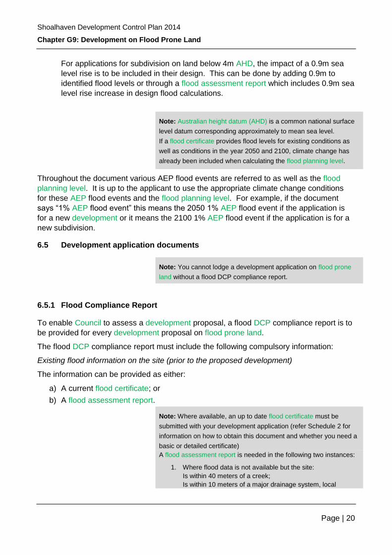
For applications for subdivision on land below 4m AHD, the impact of a 0.9m sea
level rise is to be included in their design. This can be done by adding 0.9m to
identified flood levels or through a flood assessment report which includes 0.9m sea
level rise increase in design flood calculations.
Note: Australian height datum (AHD) is a common national surface
level datum corresponding approximately to mean sea level.
If a flood certificate provides flood levels for existing conditions as
well as conditions in the year 2050 and 2100, climate change has
already been included when calculating the flood planning level.
Throughout the document various AEP flood events are referred to as well as the flood
planning level. It is up to the applicant to use the appropriate climate change conditions
for these AEP flood events and the flood planning level. For example, if the document
says “1% AEP flood event” this means the 2050 1% AEP flood event if the application is
for a new development or it means the 2100 1% AEP flood event if the application is for a
new subdivision.
6.5 Development application documents
Note: You cannot lodge a development application on flood prone
land without a flood DCP compliance report.
6.5.1 Flood Compliance Report
To enable Council to assess a development proposal, a flood DCP compliance report is to
be provided for every development proposal on flood prone land.
The flood DCP compliance report must include the following compulsory information:
Existing flood information on the site (prior to the proposed development)
The information can be provided as either:
a) A current flood certificate; or
b) A flood assessment report.
Note: Where available, an up to date flood certificate must be
submitted with your development application (refer Schedule 2 for
information on how to obtain this document and whether you need a
basic or detailed certificate)
A flood assessment report is needed in the following two instances:
1. Where flood data is not available but the site:
Is within 40 meters of a creek;
Is within 10 meters of a major drainage system, local

Shoalhaven Development Control Plan 2014
Chapter G9: Development on Flood Prone Land
Page | 21
overland flood path or drainage easement; or
Has a history of flooding; or
Is considered to be flood prone by Council’s Floodplain
Engineer
OR
2. Where flood data is available but my require interpolation,
extrapolation, or refinement to greater detail.
Where a flood assessment report is required, the report must be
submitted with the development application as part of the flood DCP
compliance report.
A flood assessment report must be prepared by a suitable qualified
and experienced engineer recognised under the National
Professional Engineers Register (NPER) in this field. The full name
of the person who prepared the report, relevant qualifications and
registration number are to be provided on the front page of the
report.
Please refer to (Schedule 3 in this Chapter) for a detailed description
on what information is required within such a report.
Compliance
Assessment
A detailed assessment on how the proposed development will achieve all
relevant objectives, performance criteria and/or acceptable solutions of this
Chapter is required. It is expected that you list all relevant performance criteria
and explain how each individual criteria has been met.
Development
Plans
Plans for the proposed development or works that indicate compliance with all
relevant development controls must be submitted.
Survey Details
In addition to the requirement to lodge general survey details with the
development application, the survey plan prepared by a registered surveyor must
also indicate the following:
a) Existing ground levels at each corner of the proposed building envelope;
b) The floor levels of all existing buildings or structures to be retained as well
as proposed floor levels for all new buildings and structures; and
c) The location of any existing buildings or structures.
All levels must be relative to Australian Height Datum (AHD). Levels relating to an
arbitrary assumed datum are not acceptable.
Note: Some applications for minor / ancillary development may not
require survey details if a structural engineering certificate is
provided.
Fill or
Excavation
A development application that includes land filling must be supported by:
a) A site plan drawn to scale showing:
Shoalhaven Development Control Plan 2014
Chapter G9: Development on Flood Prone Land
Page | 22
Details
i. The extent of the proposed filling or excavation and the existing
contours and levels of the land;
ii. The proposed contours and levels of the land and the depth and
quantity of the filling, and;
iii. Details of proposed filling material, the method of compaction and
stabilisation of the filling material.
b) Calculations showing the fill volume and the percentage of the 20%, 5%
and 1% AEP flood volume taken up by the proposed fill material on site
(for climate change conditions);
c) Details of the purpose of the proposed filling;
d) Details of the quality of the proposed fill material; and
e) Details of when the filling will be carried out and any other reasonable
information required by Council.
Note: Land filling means to place or allow to fall upon any land any
ballast, rock, stone, shingle, gravel, sand, clay, earth, cinders, debris
or any other matter or thing so as to alter the contours or levels of
the land.
6.5.2 Other additional development application documents
Note: The reporting requirements vary depending on the nature of the
proposed development. Please confirm with Council which certification
and reporting requirements apply to your specific development
application before commissioning a consultant to undertake the work.
Additional
Survey
Information
For some development the above minimum survey requirements may not be
sufficient to assess the proposed development. Council may ask for the following
additional information to be provided by the applicant:
a) Existing ground levels at 0.2 metre contour intervals across the entire
property (contours are to extend across adjoining land to enable suitable
consideration of the effect of the proposed development);
b) The ceiling heights of existing buildings or structures that are retained as well
as for proposed new buildings and structures;
c) Existing and/or proposed drainage lines (including sizes and if piped or open
channel) or easements and watercourses, or other means of conveying
stormwater that are relevant to the flood characteristics of the site; and,
d) The contour lines showing the 2050/2100 flood planning level and PMF level
if only parts of the property are flood prone.
Hydraulic
Impact
Assessment
Some development (see Schedule 6 Matrix) will require a hydraulic impact
assessment report. A hydraulic impact assessment report is a document prepared
by a suitably qualified hydraulic engineer, detailing how a proposed development will

Shoalhaven Development Control Plan 2014
Chapter G9: Development on Flood Prone Land
Page | 23
Report
change flood behaviour on and off the site as well as how the new development
itself will be impacted by flooding.
Note: A suitably qualified hydraulic engineer means an experienced
and qualified professional engineer, recognised as a chartered
professional engineer by the Institution of Engineers Australia in the
field of civil engineering, flood risk management, emergency
management, structural engineering or similar, acting at all times within
their experience and qualifications, and able to demonstrate to Council
that they have the experience and qualifications to act as required.
The report must demonstrate that the development will not increase flood hazard or
flood damage to other properties or adversely affect flood behaviour for a 5% AEP
up to the PMF scenario (using the relevant 2050 or 2100 climate change conditions).
Note: The report must be prepared by a suitable qualified and
experienced civil engineer recognised under the National Professional
Engineers Register (NPER) in this field. The full name of the person
who prepared the report, relevant qualifications and registration
number are to be provided on the front page of the report.
Please refer to Schedule 3 for a detailed description on what information is required
within such a report.
Note: Hydraulics is a term given to the study of water flow in
waterways. In particular, the evaluation of flow parameters such as
water level and velocity.
Structural
Engineering
Certificate
Some developments may require structural engineering certification to ensure that
the proposed structures can withstand flood forces including debris and buoyancy
forces up to a specified flood scenario. Please refer to Schedule 4 to confirm the
level of certification required. Schedule 4 also provides suggested structural
conditions for developments affected by flood waters. Consultation with the Building
Code of Australia - Construction of Buildings in Flood Hazard Areas – Standard
2012 is also recommended.
Flood
Evacuation
Plan
Some development may require an engineering report demonstrating that
permanent, fail-safe, maintenance free measures are incorporated in the
development to ensure that the timely orderly and safe evacuation of people is
possible from the area and that it will not add significant cost and disruption to the
community or the SES.
Community
Consultation
Details
Some development may require a report on community consultation that was
undertaken as part of the pre-development investigations. It should note all issues
raised and how they were addressed.
Please note that Council may undertake further community consultation in
accordance with Council’s Community Consultation Policy for Subdivision and
Shoalhaven Development Control Plan 2014
Chapter G9: Development on Flood Prone Land
Page | 24
Development Applications.
6.6 Flood DCP Compliance Report Checklist and Schedules
A flood DCP compliance report checklist is provided in this Chapter (Section 8), with
Schedules as identified thereafter.
7 Other legislation or policies you may need to check
Note: This section is not exclusive and you may be required to consider other legislation, policies and other documents with your application
Council Policies
& Guidelines
Engineering Guidelines
Floodplain risk management plans for specific areas
Community Consultation Policy for Subdivision and Development
Applications.
External Policies
& Guidelines
NSW Flood Prone Land Policy 1984
NSW Floodplain Development Manual 2005 and other associated
Guidelines
NSW Coastal Planning Guideline: Adapting to Sea Level Rise 2010
NSW Sea Level Rise Policy Statement 2009
Building Code of Australia - Construction of Buildings in Flood Hazard
Areas – Standard 2012.
Legislation Nil
Shoalhaven Development Control Plan 2014
Chapter G9: Development on Flood Prone Land
Page | 25
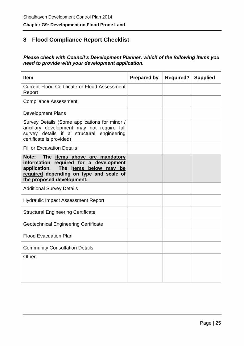
8 Flood Compliance Report Checklist
Please check with Council’s Development Planner, which of the following items you need to provide with your development application.
Item Prepared by Required? Supplied
Current Flood Certificate or Flood Assessment Report
Compliance Assessment
Development Plans
Survey Details (Some applications for minor / ancillary development may not require full survey details if a structural engineering certificate is provided)
Fill or Excavation Details
Note: The items above are mandatory information required for a development application. The items below may be required depending on type and scale of the proposed development.
Additional Survey Details
Hydraulic Impact Assessment Report
Structural Engineering Certificate
Geotechnical Engineering Certificate
Flood Evacuation Plan
Community Consultation Details
Other:
Shoalhaven Development Control Plan 2014
Chapter G9: Development on Flood Prone Land
Page | 26
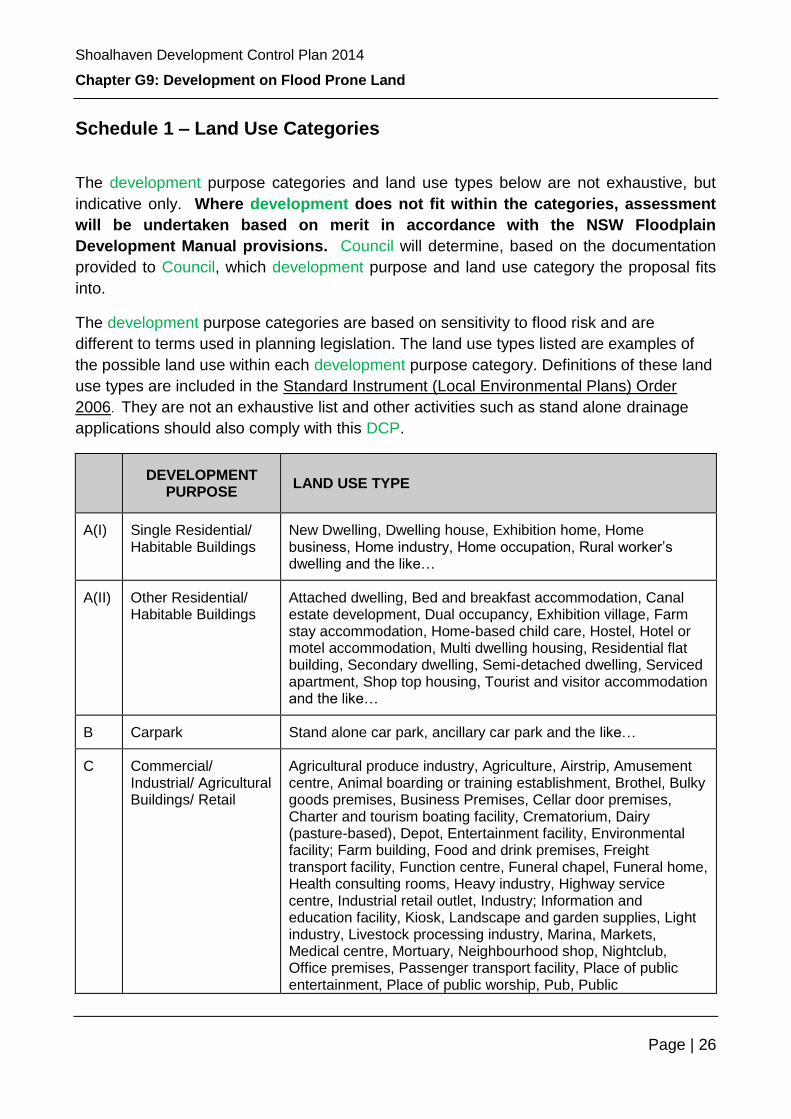
Schedule 1 – Land Use Categories
The development purpose categories and land use types below are not exhaustive, but
indicative only. Where development does not fit within the categories, assessment
will be undertaken based on merit in accordance with the NSW Floodplain
Development Manual provisions. Council will determine, based on the documentation
provided to Council, which development purpose and land use category the proposal fits
into.
The development purpose categories are based on sensitivity to flood risk and are
different to terms used in planning legislation. The land use types listed are examples of
the possible land use within each development purpose category. Definitions of these land
use types are included in the Standard Instrument (Local Environmental Plans) Order
2006. They are not an exhaustive list and other activities such as stand alone drainage
applications should also comply with this DCP.
DEVELOPMENT PURPOSE
LAND USE TYPE
A(I) Single Residential/ Habitable Buildings
New Dwelling, Dwelling house, Exhibition home, Home business, Home industry, Home occupation, Rural worker’s dwelling and the like…
A(II) Other Residential/ Habitable Buildings
Attached dwelling, Bed and breakfast accommodation, Canal estate development, Dual occupancy, Exhibition village, Farm stay accommodation, Home-based child care, Hostel, Hotel or motel accommodation, Multi dwelling housing, Residential flat building, Secondary dwelling, Semi-detached dwelling, Serviced apartment, Shop top housing, Tourist and visitor accommodation and the like…
B Carpark Stand alone car park, ancillary car park and the like…
C Commercial/ Industrial/ Agricultural Buildings/ Retail
Agricultural produce industry, Agriculture, Airstrip, Amusement centre, Animal boarding or training establishment, Brothel, Bulky goods premises, Business Premises, Cellar door premises, Charter and tourism boating facility, Crematorium, Dairy (pasture-based), Depot, Entertainment facility, Environmental facility; Farm building, Food and drink premises, Freight transport facility, Function centre, Funeral chapel, Funeral home, Health consulting rooms, Heavy industry, Highway service centre, Industrial retail outlet, Industry; Information and education facility, Kiosk, Landscape and garden supplies, Light industry, Livestock processing industry, Marina, Markets, Medical centre, Mortuary, Neighbourhood shop, Nightclub, Office premises, Passenger transport facility, Place of public entertainment, Place of public worship, Pub, Public

Shoalhaven Development Control Plan 2014
Chapter G9: Development on Flood Prone Land
Page | 27
administration building, Recreation facility, Registered club, Research station, Restaurant, Restricted dairy, Restriction facilities, Retail Premises, Rural industry, Sawmill or log processing works, Self-storage units, Sex service premises, Shop, Stock and sale yard, Storage premises, Take away food and drink premises, Timber and building supplies, Transport depot, Vehicle sales or hire premises, Veterinary hospital, Warehouse or distribution centre, and the like…
D Subdivision Residential subdivision, commercial subdivision and the like…
E Earthworks Extractive industry, Mining, Road, drainage works and the like…
F Resource Management/ Agriculture/ Recreational Activities
Aquaculture, Cemetery, Environmental Protection Works, Extensive agriculture, Feedlot, Forestry, Horticulture, Intensive livestock agriculture, Intensive plant agriculture, Natural water-based aquaculture, Open Space, Park, Pond-based aquaculture, Recreation area, Tank-based aquaculture, Turf farming.
G Critical Infrastructure Assets/ Potentially Polluting Activities
Air transport facility, Airport, Biosolids treatment facility; Electricity generating works, Hazardous industry, Hazardous storage establishment, Liquid fuel depot, Offensive industry; Offensive storage establishment; Public utility undertaking, Resource recovery facility, Service station, Sewage treatment plant, Sewerage system, Telecommunications facility, Waste disposal facility, Waste management facility, Waste or resource management facility, Waste or resource transfer station, Water recycling facility, Water reticulation system, Water storage facility, Water treatment facility.
H Buildings and activities requiring special evacuation consideration
Child care centre, Community facility, Educational establishment, Emergency services facility, Health services facility, Hospital, Residential care facility, Schools, Seniors housing.
I Minor Development Residential
A. Minor additions:
(i) Urban and rural residential dwelling:
A cumulative total of habitable additions (since 1988) to an existing dwelling of no more than 50m2 below the Flood planning level
or
A cumulative total floor area including all habitable and non-habitable areas on all storeys of the dwelling of 300 m2 (but with no more than a cumulative total habitable addition (since 1988) of 50m2 below the Flood planning level), whichever is the larger area;
(ii) Dwelling associated with a bona fide large rural
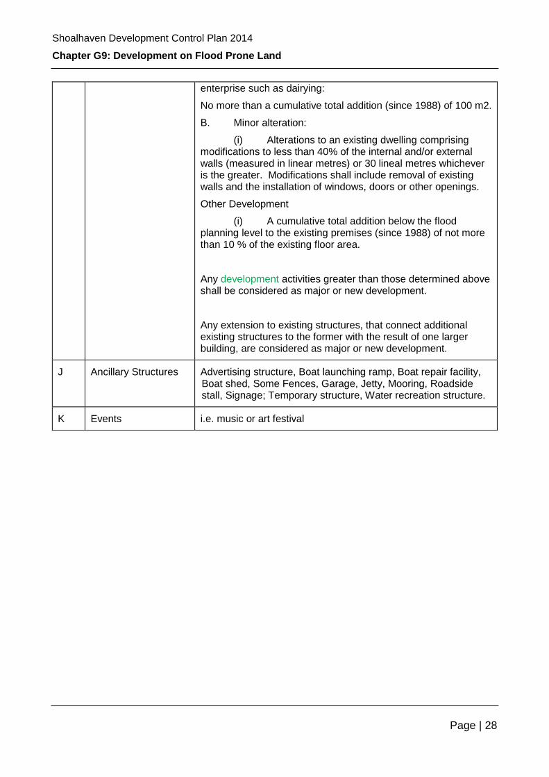
Shoalhaven Development Control Plan 2014
Chapter G9: Development on Flood Prone Land
Page | 28
enterprise such as dairying:
No more than a cumulative total addition (since 1988) of 100 m2.
B. Minor alteration:
(i) Alterations to an existing dwelling comprising modifications to less than 40% of the internal and/or external walls (measured in linear metres) or 30 lineal metres whichever is the greater. Modifications shall include removal of existing walls and the installation of windows, doors or other openings.
Other Development
(i) A cumulative total addition below the flood planning level to the existing premises (since 1988) of not more than 10 % of the existing floor area.
Any development activities greater than those determined above shall be considered as major or new development.
Any extension to existing structures, that connect additional existing structures to the former with the result of one larger building, are considered as major or new development.
J Ancillary Structures Advertising structure, Boat launching ramp, Boat repair facility, Boat shed, Some Fences, Garage, Jetty, Mooring, Roadside stall, Signage; Temporary structure, Water recreation structure.
K Events i.e. music or art festival

Shoalhaven Development Control Plan 2014
Chapter G9: Development on Flood Prone Land
Page | 29
Schedule 2 – Flood Information Enquiries and Flood Certificates
One component of your application is to determine whether the land proposed for
development is flood prone. To do this you can:
a) Look at Council’s online mapping by:
i. Searching Councils website www.shoalhaven.nsw.gov.au - the zoning details of properties within the Shoalhaven can be found in the LEP maps online. Where council has flood information, this is shown on the “flood planning area” Overlay. Alternatively you can look at the individual catchment maps in the flood risk section.
ii. Attending Councils Customer Service Counter in the Administration Building to view the mapping, or
iii. Contacting Council by either phone, email or in writing and request the flood information for a subject site.
OR
iv. Consult the Section 149 Planning Certificate (149 Certificate).
v. A 149 certificate for a parcel of land may state whether or not the land is subject to “flood related development controls”.
vi. Please note that land may still be flood prone even though the 149 Certificate contains no reference to flooding. Historical information is not contained in certificates and further research should be undertaken if the property is in the vicinity of a watercourse or if the contours suggest a local flowpath may cross the land. While existing flood information may not exist there is the possibility that a property is flood affected and further investigations by a suitably qualified engineer would be warranted.
vii. A 149 Certificate can be obtained by contacting Council.
If the property is flood affected you will need to obtain a Flood Certificate from Council. An
application fee applies in accordance with Councils Fees and Charges.
details the procedure for making a flood certificate request.
The Flood Certificate is required to be submitted with your development application.
Please note that there are two types of certificates available and you will need to specify
which type you are applying for:
A basic flood certificate will contain the following information (if available):
a) The 1% AEP flood level and the Flood planning level (including the relevant sea level rise component when available) for the individual property;
b) The hydraulic and hazard categorisation as per the NSW Floodplain Development Manual for the individual property; and
Shoalhaven Development Control Plan 2014
Chapter G9: Development on Flood Prone Land
Page | 30
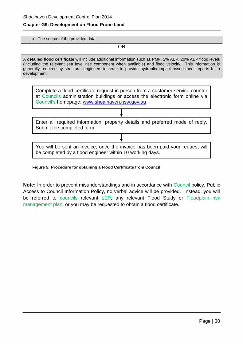
c) The source of the provided data.
OR
A detailed flood certificate will include additional information such as PMF, 5% AEP, 20% AEP flood levels (including the relevant sea level rise component when available) and flood velocity. This information is generally required by structural engineers in order to provide hydraulic impact assessment reports for a development.
Note: In order to prevent misunderstandings and in accordance with Council policy, Public
Access to Council Information Policy, no verbal advice will be provided. Instead, you will
be referred to councils relevant LEP, any relevant Flood Study or Floodplain risk
management plan, or you may be requested to obtain a flood certificate.
Complete a flood certificate request in person from a customer service counter at Councils administration buildings or access the electronic form online via Council’s homepage: www.shoalhaven.nsw.gov.au
Enter all required information, property details and preferred mode of reply. Submit the completed form.
You will be sent an invoice; once the invoice has been paid your request will be completed by a flood engineer within 10 working days.
Figure 5: Procedure for obtaining a Flood Certificate from Council
Shoalhaven Development Control Plan 2014
Chapter G9: Development on Flood Prone Land
Page | 31
Schedule 3 – Technical Reporting Requirements
A - Flood Assessment Report A Flood Assessment Report must be prepared by a suitable qualified and experienced
engineer recognised under the National Professional Engineers Register (NPER) in this
field. The full name of the person who prepared the report, relevant qualifications and
registration number are to be provided on the front page of the report.
The assessment report provides information on existing flood risk for a catchment and is to
be commensurate with the NSW Floodplain Development Manual and must include the
following information:
(a) A description of the creek or drainage system that is relevant to the flood
characteristics of the site, whether located on, adjacent to or remote from the
development site;
(b) A plan showing cross-sections through site - as a guide, the following cross-section
information should be provided:
– A minimum of 5 cross-sections, at a maximum distance of 20m apart, should be
taken through the site, perpendicular to the likely flow path (i.e. the direction of
the cross-section may not necessarily be in a single straight line);
– One cross-section should be at the upstream end and one cross-section at the
downstream end of the proposed development site;
– Cross-sections should extend at least as high as the highest flood level
available at the site and if possible be wide enough to cover the full width of the
floodplain at that location; and
– The cross-sections should be plotted at a suitable exaggerated scale (i.e. the
vertical scale is not necessarily the same as the horizontal scale);
(c) Flood levels for the PMF, 1%, 5%, 10% and 20% AEP events for the climate change
pre development scenario (all assumptions, calculations and modelling output tables
must be provided);
(d) Flood velocities and vectors for the 1% AEP event for the climate change pre
development scenario (all assumptions, calculations and modelling output tables must
be provided);
(e) Provisional Hazard categories based on depth and velocity as well as obvious other
hazards such as evacuation difficulties as per the requirements of the 2005 NSW
Floodplain Development Manual;
(f) Provisional Hydraulic categories based on depth and velocity as per the requirements
of the 2005 NSW Floodplain Development Manual; and

Shoalhaven Development Control Plan 2014
Chapter G9: Development on Flood Prone Land
Page | 32
(g) Plans showing the results of (c) to (f) as well as the location of the proposed
development.
Please note for:
dot point a) The modelling shall include climate change considerations as per
current Government Guidelines for both sea level rise and predicted changes in
rainfall.
dot point b) The modelling shall include a 50% and 100% blockage analysis of all
existing drainage structures that may affect the development site.
dot point c) Localised flow effects shall be investigated and reported on where
relevant.
dot point d) The roughness coefficients used shall allow for fully vegetated stream
conditions in order to account for potential revegetation of degraded areas without
impact on flood levels.
Note: Roughness coefficients describe the resistance of the bed of a channel to the
flow of water within it. They are used in equations calculating energy loss due to
roughness of a surface.
dot point e) In areas where local sub-catchment flooding, such as flows from
drains, overland flow paths or similar, interact with overall catchment flooding from
waterways and lakes; or, with ocean inundation a joint probability analysis of flood
behaviour shall be undertaken.
B - Hydraulic Impact Assessment Report For some development a Hydraulic Impact Assessment is required as part of the Flood
Management Report, demonstrating that the development will not increase flood hazard or
flood damage to other properties or adversely affect flood behaviour for a 5% AEP up to
the PMF scenario.
A Hydraulic Impact Assessment Report must be prepared by a suitable qualified and
experienced engineer recognised under the National Professional Engineers Register
(NPER) in this field. The full name of the person who prepared the report, relevant
qualifications and registration number are to be provided on the front page of the report.
This Schedule describes two methods for assessing hydraulic impacts of proposed
developments. The two methods are:
► Assessment Method 1 — Cross-section Analysis (No Computer Modelling);
► Assessment Method 2 — Use of Existing Flood Study data or Preparation of Site-
Specific Model (Computer Modelling).

Shoalhaven Development Control Plan 2014
Chapter G9: Development on Flood Prone Land
Page | 33
Method 1 will be sufficient for small scale development proposals. For larger
developments, developments in sensitive areas, or where special circumstances exist,
Council may require assessment method 2 to be used.
Both Assessment Methods need to be carried out by an experienced engineer and are to
be commensurate with the NSW Floodplain Development Manual. In some
circumstances, Council may determine the method(s) to be used.
Assessment Method 1 - Cross-section Analysis (No Computer Modelling)
In order to satisfy the requirement that the development will not increase flood hazard or
potential flood damage to other properties or adversely affect flood behaviour for the full
range of flood scenarios, the applicant must demonstrate that:
(i) The proposed development will not involve fill volumes that occupy more
than 1% of the available 20%, 5% and 1% AEP flood volume on the
development site or involve cutting or filling in floodways.
Please note: it is too simplistic to assume that earthworks will have a
negligible impact on the hydraulics of a waterway if the net cut and fill
volumes for the PMF balance out. Hydraulic processes are complex and a
simple “total fill < total cut” equation will not guarantee that the flood storage
capacity of a waterway corridor are maintained. It is therefore necessary to
check net cut and fill volumes within the site over a range of flood events.
Note that ‘hydraulics’ is a term given to the study of water flow in waterways.
In particular, the evaluation of flow parameters such as water level and
velocity.
(ii) The proposed development will not adversely change flow direction and
velocity or create any new preferential flow paths for the PMF, 1%, 5%, 10%
and 20% AEP events; and
(iii) The proposed development will not change the flood conveyance at any of
the cross sections up to and including the PMF.
Please note:
Flood conveyance is a direct measure of the flow carrying capacity of a
particular cross-section of a stream or stormwater channel.
The flood conveyance should be calculated at each cross-section for pre-
development and post-development conditions. Flood conveyance should
be calculated at a range of water levels, at each cross-section, including the
1% AEP and PMF. All assumptions, particularly those relating to hydraulic
Shoalhaven Development Control Plan 2014
Chapter G9: Development on Flood Prone Land
Page | 34
roughness, must be documented, especially where the development results
in a change in hydraulic roughness.
In special circumstances, small size developments inside a floodway may not
reduce conveyance (e.g. minor alterations or additions carried out in the ‘lee’
of an existing structure). In such cases, Council may require assessment
using Assessment Method 1 and 2 of this Schedule to demonstrate that
conveyance is not being reduced.
This method does not require computer modelling. It checks for changes in flood storage
volume, flood behaviour and conveyance at critical cross sections only through the
proposed development.
This approach, whilst simpler than computer modelling, assumes a thorough knowledge of
flood behaviour to ensure that the cross-section locations are representative of the
principal impacts of the development.
In addition to the survey details and pre development flood information, the following shall
be submitted, accompanied by appropriate supporting written information:
(a) Post development flood level plots for the PMF, 1%, 5%, 10% and 20% AEP events at
all cross sections (all assumptions, calculations and modelling output tables must be
provided);
(b) Post development in-stream and overbank flow velocity vector plots for the 1% AEP
event at all cross sections (all assumptions, calculations and modelling output tables
must be provided);
(c) Calculation results for all calculations undertaken in order to demonstrate the above
requirements; and
(d) Pre and post development ground surface levels — this information should be shown
on each cross-section, with areas of cut and fill clearly shown.
Assessment Method 2 - Use of Existing Flood Study or Preparation of Site-Specific Flood
Study (Computer Modelling)
This method requires computer modelling. An existing flood study model may be used if
available and suitable (e.g. it contains sufficient local detail).
For large scale developments or developments in critical locations, a flood study using a
fully dynamic one or two dimensional hydraulic computer model may be required. Such a
flood study would be prepared in a manner consistent with the NSW Floodplain
Development Manual, Australian Rainfall and Runoff — A Guide to Flood Estimation
(Institution of Engineers, Australia, 1987) and relevant Council codes.
Shoalhaven Development Control Plan 2014
Chapter G9: Development on Flood Prone Land
Page | 35
In addition to the survey details and pre development flood information, the following shall
be submitted in plan form, accompanied by appropriate supporting written information:
(a) Post development water surface contours — these should be provided in metres to
Australian Height Datum (m AHD);
(b) Post development flood profiles — these should be provided at a suitable vertical and
horizontal scale such that any changes in flood levels are easily identified;
(c) Post development velocity vectors — these show direction and relative size of flood
velocities and should be provided in metres per second (m/s);
(d) Difference plots for flood levels and velocities for the 20% and 1% AEP flood events;
(e) Post development contours of flood velocities multiplied by depth of flooding over
ground level indicating provisional hydraulic categories as per the requirements of the
2005 NSW Floodplain development manual — these should be provided to one
decimal place; and
(f) Post development provisional hazard categories based on depth and velocity as well
as obvious other hazards such as evacuation difficulties as per the requirements of the
2005 NSW Floodplain development manual.
An interpretation of the results clearly indicating the effects of the proposed development
on general and local flood behaviours and potential impacts on neighbouring properties is
to be provided. This interpretation should clearly inform the last section of the Flood DCP
Compliance Report which seeks to provide a detailed assessment of how the proposed
development will achieve the objectives and performance criteria of this DCP.
Please note:
A range of flood sizes should be chosen for the above analyses so that the full
impacts of the development can be assessed. Typically, the flood sizes to be
considered would be: a 20% AEP, 5% AEP, 1% AEP and a probable maximum
flood.
For the post-development scenario, all proposed works and structures, including
any revegetation and enhancements should be included in the analysis.
All assumptions relating to hydraulic roughness should be clearly documented.
Flood levels and velocities need to be computed not only at the site but also at an
appropriate distance upstream and downstream to allow the principal impacts of the
development to be determined.
Shoalhaven Development Control Plan 2014
Chapter G9: Development on Flood Prone Land
Page | 36
C - Structural Conditions for Developments Affected by Flood A structural engineer should certify that the building will be able to withstand hydrostatic
and hydrodynamic forces of flood waters including debris and buoyancy forces based on
relevant depth, velocity and debris loadings for the specific site.
Some guidance is provided in Appendix A of the Hawkesbury and Nepean floodplain
Management Steering committees. Reducing Vulnerability of Buildings to Flood Damage.

Shoalhaven Development Control Plan 2014
Chapter G9: Development on Flood Prone Land
Page | 37
Schedule 4 – Flood Proofing Guidelines
There are many different ways in which to reduce flood damages and flood proofing is
generally recommended for any building on land that is considered by Council as being
flood prone. Flood proofing refers to the design and construction of buildings with
appropriate water resistant materials such that flood damage to the building is minimised,
should it be inundated. Certain types of materials are better able to withstand inundation
than others, for example, plasterboard and chipboard, both materials commonly used for
the internal wall linings and cupboard fittings of a house, can be badly damaged on
inundation and may have to be replaced. In contrast, double brick construction can
withstand inundation and may only require a hose and scrub down when the flood
subsides.
Adequate flood proofing of buildings in flood liable areas is an effective and equitable
means of reducing flood damage to the structure or building. The following table provides
information on flood proofing measures and flood compatible materials (being those
materials used in building that are resistant to damage when inundated). The table is not
an exhaustive list, however provides an indication of what is considered as suitable in
flood prone areas.
Further reference can be made to the Building Code of Australia - Construction of
Buildings in Flood Hazard Areas – Standard 2012
A) Construction Methods and Materials
Construction methods and materials listed in the following table are graded into four
classes according to their resistance to floodwaters:
Suitable - the materials or products which are relatively unaffected by submersion and
unmitigated flood exposure and are the best available for the particular application.
Mild effects - where the most suitable materials or products are unavailable or economic
considerations prohibit their use, these materials or products are considered the next best
choice to minimise the damage caused by flooding.
Marked effects - as for "2nd preference" but considered to be more liable to damage
under flood conditions.
Severe effects - the materials or products listed here are seriously affected by floodwaters
and in general have to be replaced if submerged. They are not recommended for use in
flood prone areas.
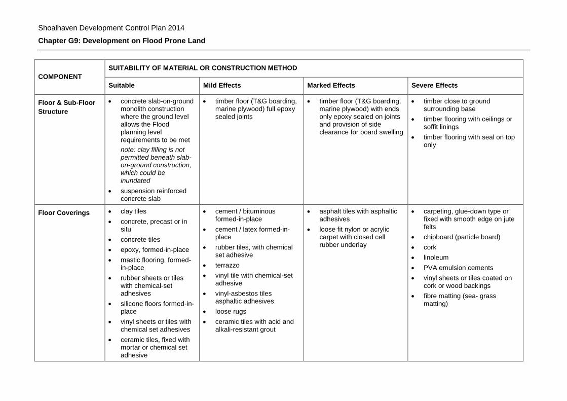
Shoalhaven Development Control Plan 2014
Chapter G9: Development on Flood Prone Land
COMPONENT
SUITABILITY OF MATERIAL OR CONSTRUCTION METHOD
Suitable Mild Effects Marked Effects Severe Effects
Floor & Sub-Floor
Structure
concrete slab-on-ground monolith construction where the ground level allows the Flood planning level requirements to be met
note: clay filling is not permitted beneath slab-on-ground construction, which could be inundated
suspension reinforced concrete slab
timber floor (T&G boarding, marine plywood) full epoxy sealed joints
timber floor (T&G boarding, marine plywood) with ends only epoxy sealed on joints and provision of side clearance for board swelling
timber close to ground surrounding base
timber flooring with ceilings or soffit linings
timber flooring with seal on top only
Floor Coverings clay tiles
concrete, precast or in situ
concrete tiles
epoxy, formed-in-place
mastic flooring, formed-in-place
rubber sheets or tiles with chemical-set adhesives
silicone floors formed-in-place
vinyl sheets or tiles with chemical set adhesives
ceramic tiles, fixed with mortar or chemical set adhesive
cement / bituminous formed-in-place
cement / latex formed-in-place
rubber tiles, with chemical set adhesive
terrazzo
vinyl tile with chemical-set adhesive
vinyl-asbestos tiles asphaltic adhesives
loose rugs
ceramic tiles with acid and alkali-resistant grout
asphalt tiles with asphaltic adhesives
loose fit nylon or acrylic carpet with closed cell rubber underlay
carpeting, glue-down type or fixed with smooth edge on jute felts
chipboard (particle board)
cork
linoleum
PVA emulsion cements
vinyl sheets or tiles coated on cork or wood backings
fibre matting (sea- grass matting)
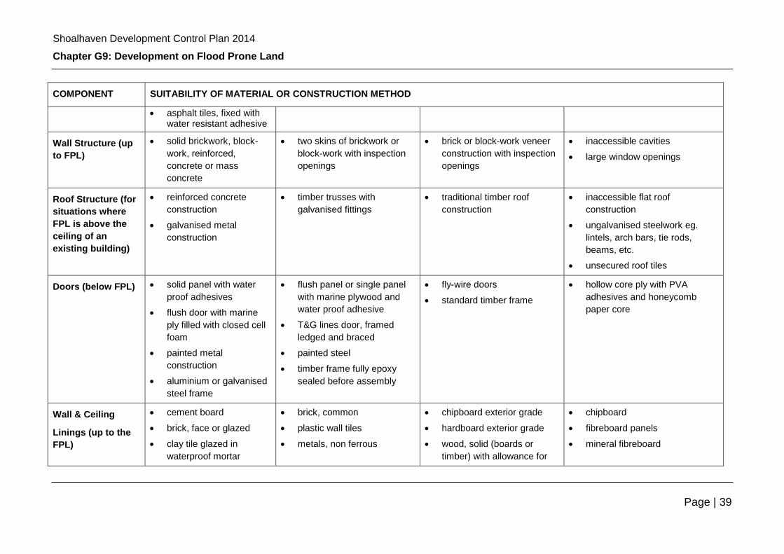
Shoalhaven Development Control Plan 2014
Chapter G9: Development on Flood Prone Land
Page | 39
COMPONENT SUITABILITY OF MATERIAL OR CONSTRUCTION METHOD
asphalt tiles, fixed with water resistant adhesive
Wall Structure (up
to FPL)
solid brickwork, block-
work, reinforced,
concrete or mass
concrete
two skins of brickwork or
block-work with inspection
openings
brick or block-work veneer
construction with inspection
openings
inaccessible cavities
large window openings
Roof Structure (for
situations where
FPL is above the
ceiling of an
existing building)
reinforced concrete
construction
galvanised metal
construction
timber trusses with
galvanised fittings
traditional timber roof
construction
inaccessible flat roof
construction
ungalvanised steelwork eg.
lintels, arch bars, tie rods,
beams, etc.
unsecured roof tiles
Doors (below FPL) solid panel with water
proof adhesives
flush door with marine
ply filled with closed cell
foam
painted metal
construction
aluminium or galvanised
steel frame
flush panel or single panel
with marine plywood and
water proof adhesive
T&G lines door, framed
ledged and braced
painted steel
timber frame fully epoxy
sealed before assembly
fly-wire doors
standard timber frame
hollow core ply with PVA
adhesives and honeycomb
paper core
Wall & Ceiling
Linings (up to the
FPL)
cement board
brick, face or glazed
clay tile glazed in
waterproof mortar
brick, common
plastic wall tiles
metals, non ferrous
chipboard exterior grade
hardboard exterior grade
wood, solid (boards or
timber) with allowance for
chipboard
fibreboard panels
mineral fibreboard
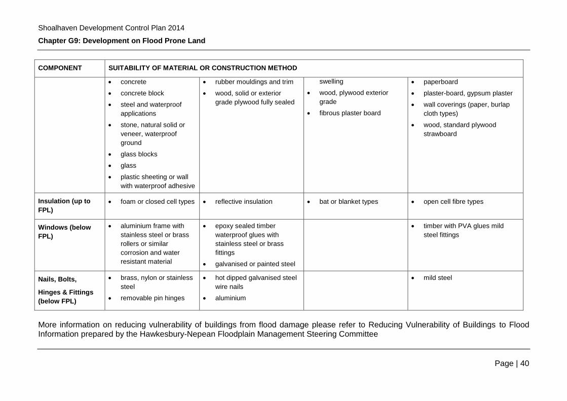
Shoalhaven Development Control Plan 2014
Chapter G9: Development on Flood Prone Land
Page | 40
COMPONENT SUITABILITY OF MATERIAL OR CONSTRUCTION METHOD
concrete
concrete block
steel and waterproof
applications
stone, natural solid or
veneer, waterproof
ground
glass blocks
glass
plastic sheeting or wall
with waterproof adhesive
rubber mouldings and trim
wood, solid or exterior
grade plywood fully sealed
swelling
wood, plywood exterior
grade
fibrous plaster board
paperboard
plaster-board, gypsum plaster
wall coverings (paper, burlap
cloth types)
wood, standard plywood
strawboard
Insulation (up to
FPL)
foam or closed cell types reflective insulation bat or blanket types open cell fibre types
Windows (below
FPL)
aluminium frame with
stainless steel or brass
rollers or similar
corrosion and water
resistant material
epoxy sealed timber
waterproof glues with
stainless steel or brass
fittings
galvanised or painted steel
timber with PVA glues mild
steel fittings
Nails, Bolts,
Hinges & Fittings
(below FPL)
brass, nylon or stainless
steel
removable pin hinges
hot dipped galvanised steel
wire nails
aluminium
mild steel
More information on reducing vulnerability of buildings from flood damage please refer to Reducing Vulnerability of Buildings to Flood Information prepared by the Hawkesbury-Nepean Floodplain Management Steering Committee
Shoalhaven Development Control Plan 2014
Chapter G9: Development on Flood Prone Land
Page | 41
B) Electrical and Mechanical Equipment
For dwellings constructed on flood liable land, the electrical and mechanical
materials, equipment and installation must conform to the following requirements:
Main power supply - Subject to the approval of the relevant power authority, the
incoming main commercial power service equipment, including all metering
equipment, is to be located above the flood planning level. Means are to be
available to easily disconnect the dwelling from the main power supply.
Wiring - all wiring, power outlets, switches, etc., must, to the maximum extent
possible, be located above the flood planning level. All electrical wiring installed
below the flood planning level must be suitable for continuous submergence in water
and must contain no fibrous components. Only submersible-type splices are to be
used below the Flood planning level. All conduits located below the flood planning
level are to be so installed that they will be self-draining if subjected to flooding.
Equipment - All equipment installed below or partially below the flood planning level
must be capable of disconnection by a single plug and socket assembly.
Reconnection - Should any electrical device and/or part of the wiring be flooded it
must be thoroughly cleaned or replaced and checked by an approved electrical
contractor before reconnection.
C) Heating and Air Conditioning Systems
Heating and air conditioning systems must, to the maximum extent possible, be
installed in areas and space of the house above the Flood planning level. When this
is not feasible every precaution must be taken to minimise the damage caused by
submersion according to the following guidelines:
Fuel - Heating systems using gas or oil as a fuel must have a manually operated
valve located in the fuel supply line to enable fuel cut-off.
Installation - The heating equipment and fuel storage tanks must be mounted on
and securely anchored to a foundation pad of sufficient mass to overcome buoyancy
and prevent movement that could damage the fuel supply line. All storage tanks
must be vented to an elevation of 0.5m above the Flood planning level.
Ducting - All ductwork located below the Flood planning level must be provided with
openings for drainage and cleaning. Self draining may be achieved by constructing
the ductwork on a suitable grade. Where ductwork must pass through a water-tight
wall or floor below the Flood planning level, the ductwork must be protected by a
closure assembly operated from above Flood planning level.
Shoalhaven Development Control Plan 2014
Chapter G9: Development on Flood Prone Land
Page | 42
Schedule 5 – Flood Related Development Controls – Site Specific as per the adopted Floodplain Risk Management Plan
This schedule provides site specific flood related development controls as recommended by Council adopted Floodplain Risk Management Plans (FRMP) that have been prepared for individual catchments consistent with the NSW Floodplain Development Manual. Information for specific areas will be added as Floodplain Risk Management Plans are completed. Note: Where the site specific controls are in conflict with the generic
flood related controls in Section 14 – Schedule 6, the site specific controls will override the generic ones.

Shoalhaven Development Control Plan 2014
Chapter G9: Development on Flood Prone Land
Page | 43
A - Terara Village Floodplain Risk Management Plan (Adopted in 2002)
Area to which this plan applies:
For a map of the area to which this plan applies, please view Council’s maps on
www.shoalhaven.nsw.gov.au
Site specific flood characteristics:
Land within Terara Village becomes a high hazard floodway in a 1% AEP flood
event. Due to the initial protection against direct river flooding from the levee, it is
likely that the community will not be prepared for the sudden change in flood hazard
which may occur with levee overtopping or failure.
Site specific flood related development controls:
Location /
Type of
Development
Specific Controls
All of Terara
Village FRMP
study area
Vacant lots cannot be developed for residential buildings unless Council is
satisfied that the dwelling house is essential for the proper and efficient use of
the land for agriculture or turf farming.
Development in a high hazard floodway will only be permitted if it can be
shown that there is no other viable alternative. Further considerations would
then need to be made regarding the specific location of the development.
The minimum required floor level for infill development and reconstruction in
the Terara village area is the 1 in 100 year pre levee flood level plus a
freeboard of 0.5 m for habitable rooms.
New
residential
buildings
where
approved in
conjunction
with
agricultural
use
Structural soundness of completed works to withstand water and debris
damage up to the 0.2% AEP (1 in 500 year) event is to be certified by a
suitably qualified structural engineer.
Owners must have measures in place to enable them to self evacuate so as to
not place additional burden on Emergency Services
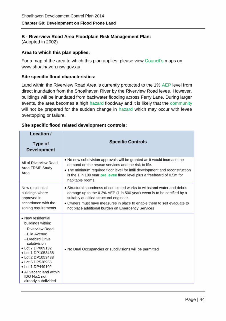
Shoalhaven Development Control Plan 2014
Chapter G9: Development on Flood Prone Land
Page | 44
B - Riverview Road Area Floodplain Risk Management Plan: (Adopted in 2002) Area to which this plan applies:
For a map of the area to which this plan applies, please view Council’s maps on
www.shoalhaven.nsw.gov.au
Site specific flood characteristics:
Land within the Riverview Road Area is currently protected to the 1% AEP level from
direct inundation from the Shoalhaven River by the Riverview Road levee. However,
buildings will be inundated from backwater flooding across Ferry Lane. During larger
events, the area becomes a high hazard floodway and it is likely that the community
will not be prepared for the sudden change in hazard which may occur with levee
overtopping or failure.
Site specific flood related development controls:
Location /
Type of
Development
Specific Controls
All of Riverview Road
Area FRMP Study
Area
No new subdivision approvals will be granted as it would increase the
demand on the rescue services and the risk to life.
The minimum required floor level for infill development and reconstruction
is the 1 in 100 year pre levee flood level plus a freeboard of 0.5m for
habitable rooms.
New residential
buildings where
approved in
accordance with the
zoning requirements
Structural soundness of completed works to withstand water and debris
damage up to the 0.2% AEP (1 in 500 year) event is to be certified by a
suitably qualified structural engineer.
Owners must have measures in place to enable them to self evacuate to
not place additional burden on Emergency Services
New residential
buildings within:
– Riverview Road,
– Elia Avenue
– Lyrebird Drive subdivision
Lot 7 DP809132
Lot 1 DP1053438
Lot 2 DP1053438
Lot 6 DP538956
Lot 1 DP449102
All vacant land within IDO No.1 not already subdivided.
No Dual Occupancies or subdivisions will be permitted

Shoalhaven Development Control Plan 2014
Chapter G9: Development on Flood Prone Land
Page | 45
C - St Georges Basin Floodplain Risk Management Plan: (Adopted 24th October 2006)
Area to which this plan applies:
For a map of the area to which this plan applies, please view Council’s maps on
www.shoalhaven.nsw.gov.au
Site specific flood characteristics:
The majority of the properties affected in the 1% AEP event are associated with the
canal estates and other areas accessed by Jacob Drive at Sussex Inlet. The flood
hazard in this area has been classified as high and there is little which can be done
to mitigate the risks for the existing situation.
Site specific flood related development controls:
Location /
Type of Development Specific Controls
St Georges Basin and tributary
creeks foreshore areas
A minimum setback of 40m from Normal Water Level
shall apply for new development (Please check Water
Management Act and Estuary Management Plans for
most up to date setback requirement).
The Nebraska Estate Only minimal increase in development and population
will be permitted in this area.
Loralyn Avenue properties
An additional freeboard of 0.3m on top of the Flood
planning level is to be enforced to new development to
account for wind wave conditions.
Lot 1 DP 1120892 - 9 Fisherman Rd
Home Creek
Lot 89 DP 247696 - 41 Roulstone
Crescent Sanctuary Point
Lot 23 DP 7984 - 20 Kallaroo Rd
Erowal Bay
Lot 5 DP 21261 – 5 Wunda Ave
Sussex Inlet
Lot 9 DP 21261 - 13 Wunda Ave
Sussex Inlet
Lot 143 DP 21038 - 52 Ellmoos Ave
Sussex Inlet
House raising by 3m (one floor) should be explored as
part of any new development application for these
properties.
Services infrastructure and utilities,
sports field amenities or similar in
high hazard floodway areas
These will only be permitted if it can be shown that
there is no other viable alternative. A merit based
assessment is to be undertaken and if approved,
conditions to minimise risk to life, property and the
environment will be imposed.
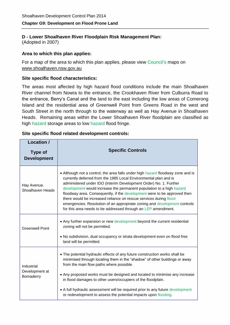
Shoalhaven Development Control Plan 2014
Chapter G9: Development on Flood Prone Land
D - Lower Shoalhaven River Floodplain Risk Management Plan: (Adopted in 2007)
Area to which this plan applies:
For a map of the area to which this plan applies, please view Council’s maps on
www.shoalhaven.nsw.gov.au
Site specific flood characteristics:
The areas most affected by high hazard flood conditions include the main Shoalhaven
River channel from Nowra to the entrance, the Crookhaven River from Culburra Road to
the entrance, Berry’s Canal and the land to the east including the low areas of Comerong
Island and the residential area of Greenwell Point from Greens Road in the west and
South Street in the north through to the waterway as well as Hay Avenue in Shoalhaven
Heads. Remaining areas within the Lower Shoalhaven River floodplain are classified as
high hazard storage areas to low hazard flood fringe.
Site specific flood related development controls:
Location /
Type of
Development
Specific Controls
Hay Avenue.
Shoalhaven Heads
Although not a control, the area falls under high hazard floodway zone and is
currently deferred from the 1985 Local Environmental plan and is
administered under IDO (Interim Development Order) No. 1. Further
development would increase the permanent population to a high hazard
floodway area. Consequently, if the development were to be approved then
there would be increased reliance on rescue services during flood
emergencies. Resolution of an appropriate zoning and development controls
for this area needs to be addressed through an LEP amendment.
Greenwell Point
Any further expansion or new development beyond the current residential
zoning will not be permitted.
No subdivision, dual occupancy or strata development even on flood free
land will be permitted.
Industrial
Development at
Bomaderry
The potential hydraulic effects of any future construction works shall be
minimised through locating them in the “shadow” of other buildings or away
from the main flow paths where possible.
Any proposed works must be designed and located to minimise any increase
in flood damages to other users/occupiers of the floodplain.
A full hydraulic assessment will be required prior to any future development
or redevelopment to assess the potential impacts upon flooding.
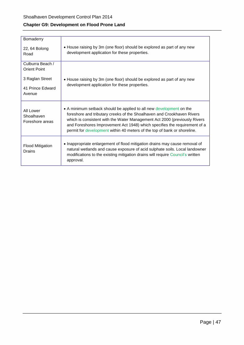
Shoalhaven Development Control Plan 2014
Chapter G9: Development on Flood Prone Land
Page | 47
Bomaderry
22, 64 Bolong
Road
House raising by 3m (one floor) should be explored as part of any new
development application for these properties.
Culburra Beach /
Orient Point
3 Raglan Street
41 Prince Edward
Avenue
House raising by 3m (one floor) should be explored as part of any new
development application for these properties.
All Lower
Shoalhaven
Foreshore areas
A minimum setback should be applied to all new development on the
foreshore and tributary creeks of the Shoalhaven and Crookhaven Rivers
which is consistent with the Water Management Act 2000 (previously Rivers
and Foreshores Improvement Act 1948) which specifies the requirement of a
permit for development within 40 meters of the top of bank or shoreline.
Flood Mitigation
Drains
Inappropriate enlargement of flood mitigation drains may cause removal of
natural wetlands and cause exposure of acid sulphate soils. Local landowner
modifications to the existing mitigation drains will require Council’s written
approval.

Shoalhaven Development Control Plan 2014
Chapter G9: Development on Flood Prone Land
Page | 48
E - Burrill Lake Floodplain Risk Management Study and Plan (Adopted 26 March 2013)
Location /
Type of
Development
Specific Controls
High Hazard areas No intensification of development - no dual occupancies or sub-divisions to
be permitted in high hazard flood zones which would increase potential risk
to life and demands on emergency services.
All areas within
2050 flood
planning area
No filling – a moratorium on filling is proposed until a long term climate
change adaptation strategy is established.
All new
development
Emergency plans - a flood emergency response and evacuation plan to be
mandatory for all new development. Such plans would be required to
demonstrate understanding of flood warning, emergency response
procedures, effective evacuation routes and post-flood recovery
considerations.
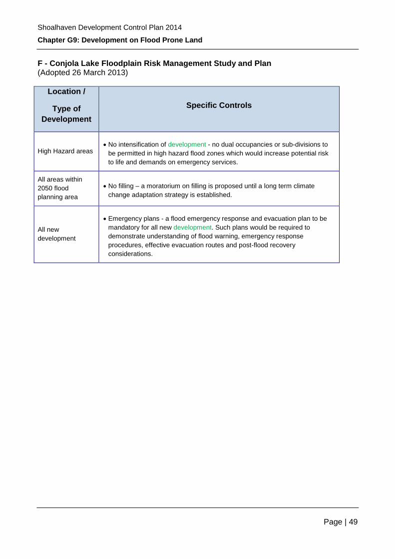
Shoalhaven Development Control Plan 2014
Chapter G9: Development on Flood Prone Land
Page | 49
F - Conjola Lake Floodplain Risk Management Study and Plan (Adopted 26 March 2013)
Location /
Type of
Development
Specific Controls
High Hazard areas No intensification of development - no dual occupancies or sub-divisions to
be permitted in high hazard flood zones which would increase potential risk
to life and demands on emergency services.
All areas within
2050 flood
planning area
No filling – a moratorium on filling is proposed until a long term climate
change adaptation strategy is established.
All new
development
Emergency plans - a flood emergency response and evacuation plan to be
mandatory for all new development. Such plans would be required to
demonstrate understanding of flood warning, emergency response
procedures, effective evacuation routes and post-flood recovery
considerations.
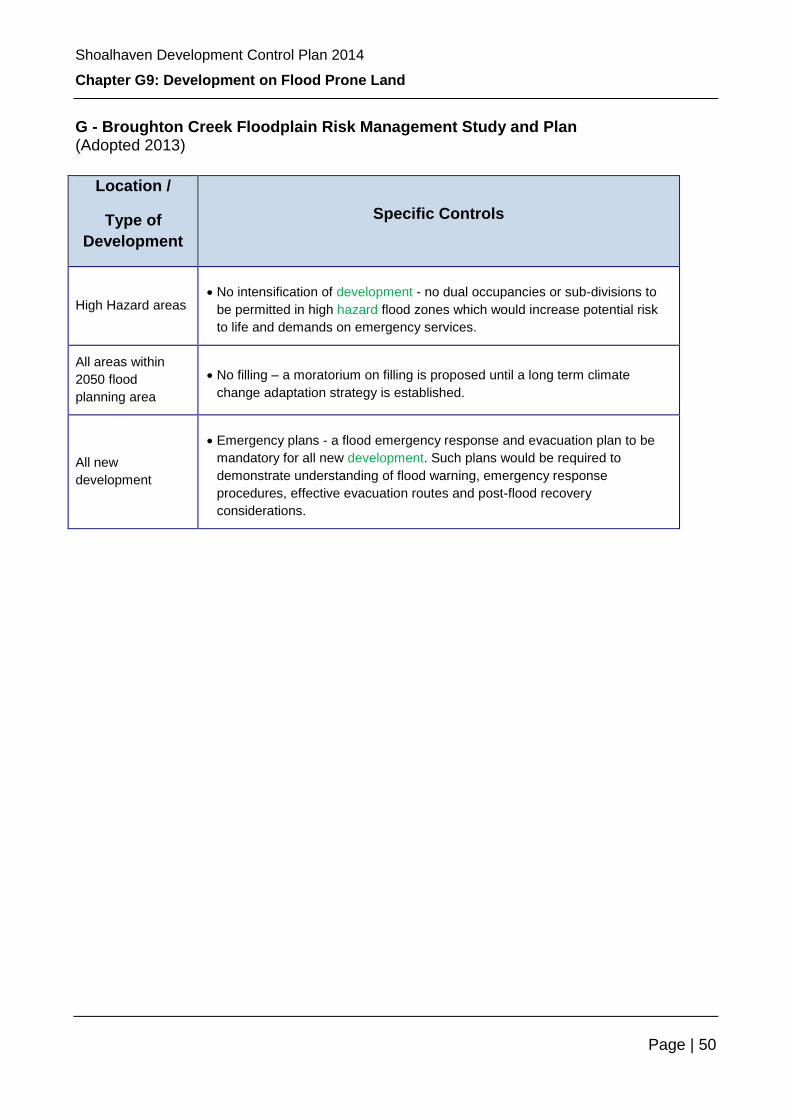
Shoalhaven Development Control Plan 2014
Chapter G9: Development on Flood Prone Land
Page | 50
G - Broughton Creek Floodplain Risk Management Study and Plan (Adopted 2013)
Location /
Type of
Development
Specific Controls
High Hazard areas No intensification of development - no dual occupancies or sub-divisions to
be permitted in high hazard flood zones which would increase potential risk
to life and demands on emergency services.
All areas within
2050 flood
planning area
No filling – a moratorium on filling is proposed until a long term climate
change adaptation strategy is established.
All new
development
Emergency plans - a flood emergency response and evacuation plan to be
mandatory for all new development. Such plans would be required to
demonstrate understanding of flood warning, emergency response
procedures, effective evacuation routes and post-flood recovery
considerations.
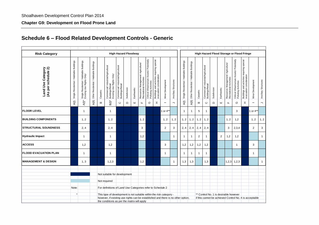
Shoalhaven Development Control Plan 2014
Chapter G9: Development on Flood Prone Land
Schedule 6 – Flood Related Development Controls - Generic
Risk Category
Sin
gle
Resid
ential /
Habitable
Build
ings
Sin
gle
Resid
ential /
Habitable
Build
ings
Exis
ting U
se R
ights
Only
!
Oth
er
Resid
ential /
Habitable
Build
ings
Carp
ark
s
Com
merc
ial/ I
ndustr
ial/A
gricultura
l
Build
ings/R
eta
il
Exis
ting U
se R
ights
Only
!
Com
merc
ial/ I
ndustr
ial/A
gricultura
l
Build
ings/R
eta
il
Subdiv
isio
n
Eart
hw
ork
s
Resourc
es M
anagem
ent/
Agriculture
/
Recre
ational A
ctivitie
s
Critical In
frastr
uctu
re A
ssets
/ P
ote
ntially
Pollu
ting A
ctivitie
s
Build
ings a
nd a
ctivitie
s r
equirin
g s
pecia
l
evacuation c
onsid
era
tion
Min
or
Develo
pm
ent
Ancill
ary
Str
uctu
res
Sin
gle
Resid
ential /
Habitable
Build
ings
Oth
er
Resid
ential /
Habitable
Build
ings
Carp
ark
s
Com
merc
ial/ I
ndustr
ial/A
gricultura
l
Build
ings/R
eta
il
Subdiv
isio
n
Eart
hw
ork
s
Resourc
es M
anagem
ent/
Agriculture
/
Recre
ational A
ctivitie
s
Critical In
frastr
uctu
re A
ssets
/ P
ote
ntially
Pollu
ting A
ctivitie
s
Build
ings a
nd a
ctivitie
s r
equirin
g s
pecia
l
evacuation c
onsid
era
tion
Min
or
Develo
pm
ent
Ancill
ary
Str
uctu
res
A(I
)
A(I
)*
A(I
I)
B
B(I
)*
C D E F G H I J
A(I
)
A(I
I)
B C D E F G H I J
FLOOR LEVEL 1 1 1 or 4** 1 1 5 1 3 1 or 4**
BUILDING COMPONENTS 1, 2 1, 2 1, 2 1, 2 1, 2 1, 2 1, 2 1, 2 1, 2 1, 2 1,2 1, 2 1, 2
STRUCTURAL SOUNDNESS 2, 4 2, 4 3 2 3 2, 4 2, 4 2, 4 2, 4 3 2,3,4 2 3
Hydraulic Impact 1 1 1,2 1 1 1 2 1 2 1,2 1,2 1
ACCESS 1,2 1,2 3 1,2 1,2 1,2 1,2 1 3
FLOOD EVACUATION PLAN 1 1 1 1 1 1 1 1
MANAGEMENT & DESIGN 1, 3 1,2,3 1,2 1 1,3 1,3 1,3 1,2,3 1,2,3 1
Not suitable for development
Not required
Note: For definitions of Land Use Categories refer to Schedule 2
* This type of development is not suitable within the risk category - ** Control No. 1 is desirable however
however, if existing use rights can be established and there is no other option, if this cannot be achieved Control No. 4 is acceptable
the conditions as per the matrix will apply
La
nd
Us
e C
ate
go
ry
(As
pe
r s
ch
ed
ule
2)
High Hazard Floodway High Hazard Flood Storage or Flood Fringe

Shoalhaven Development Control Plan 2014
Chapter G9: Development on Flood Prone Land
Page | 52
Sin
gle
Resid
ential /
Habitable
Build
ings
Oth
er
Resid
ential /
Habitable
Build
ings
Carp
ark
s
Com
merc
ial/ I
ndustr
ial/A
gricultura
l
Build
ings/R
eta
il
Subdiv
isio
n
Eart
hw
ork
s
Resourc
es M
anagem
ent/
Agriculture
/
Recre
ational A
ctivitie
s
Critical In
frastr
uctu
re A
ssets
/ P
ote
ntially
Pollu
ting A
ctivitie
s
Build
ings a
nd a
ctivitie
s r
equirin
g s
pecia
l
evacuation c
onsid
era
tion
Min
or
Develo
pm
ent
Ancill
ary
Str
uctu
res
Sin
gle
Resid
ential /
Habitable
Build
ings
Oth
er
Resid
ential /
Habitable
Build
ings
Ca
rpa
rks
Com
merc
ial/ I
ndustr
ial/A
gricultura
l
Build
ings/R
eta
il
Subdiv
isio
n
Eart
hw
ork
s
Resourc
es M
anagem
ent/
Agriculture
/
Recre
ational A
ctivitie
s
Critical In
frastr
uctu
re A
ssets
/ P
ote
ntially
Pollu
ting A
ctivitie
s
Build
ings a
nd a
ctivitie
s r
equirin
g s
pecia
l
evacuation c
onsid
era
tion
Min
or
Develo
pm
ent
Ancill
ary
Str
uctu
res
A(I
)
A(I
I)
B C D E F G H I J
A(I
)
A(I
I)
B C D E F G H I J
FLOOR LEVEL 1 1 5 1 3 4 1 1 3 2
BUILDING COMPONENTS 1,2 1, 2 1, 2 1, 2 1, 2 1,2 1, 2 1 1 1,2 1
STRUCTURAL SOUNDNESS 4 4 3 4 4 1
Hydraulic Impact 2 1,2
ACCESS 1,2 1,2 1,2 1,2 1,2 3 1
FLOOD EVACUATION PLAN 1 1
MANAGEMENT & DESIGN 1,2,3 1,2,3
Not suitable for development
Not required
For definitions of Land Use Categories refer to Schedule 2
This type of development is not suitable within the risk category -
however, if existing use rights can be established and there is no other option,
the conditions as per the matrix will apply
Outside Flood Planning Area(Above the Flood Planning Level but below the PMF)
La
nd
Us
e C
ate
go
ry
(As
pe
r s
ch
ed
ule
2)
Low Hazard Floodway or Flood Storage or Flood Fringe
Figure 1 : Matrix to Determine Flood Related Development Controls continued

Shoalhaven Development Control Plan 2014
Chapter G9: Development on Flood Prone Land
Development Controls Matrix Legend
Floor Level:
1. 1% AEP flood level + 0.50M freeboard;
2. Probable maximum flood level;
3. 5% AEP flood level;
4. Existing habitable floor level or higher as practical; and
5. High enough to ensure a velocity - depth product of less than 0.3 m2/s for a 1% AEP flood event.
Building Components:
1. Any portion of the building or structure below the FPL to be built from flood compatible materials
(being those materials used in building that are resistant to damage when inundated); and
2. All electrical installations to be above the FPL.
Structural Soundness:
1. Appropriate consulting engineer’s report – the building can withstand forces of floodwaters including
debris and buoyancy forces up to the PMF scenario;
2. Appropriate consulting engineer’s report – the building can withstand forces of floodwaters including
debris and buoyancy forces up to the 0.2% AEP flooding scenario;
3. Appropriate consulting engineer’s report – the building can withstand forces of floodwaters including
debris and buoyancy forces up to a 1% AEP flooding scenario;
4. Appropriate consulting engineer’s report – the structure will not become floating debris during a 1%
AEP flooding scenario; and
5. Certification of building foundations by a chartered geotechnical practitioner.
Hydraulic Impact:
1. Appropriate consulting engineer’s report for building footprint areas over 250 square metres, a
footprint length of more than 20 metres or any development that in the view of Council has the
potential to significantly impact on others. The report is to prove that the development will not
increase flood hazard or flood damage to other properties or adversely affect flood behaviour for a
5% AEP up to the PMF scenario.
No hydraulic impact report is required if the proposed building is raised on piers allowing free flood
flow for a 1% AEP flood event.
2. Appropriate consulting engineers report for earthworks of volumes exceeding 250 cubic metres or
with a length of more than 20 metres. The report is to prove that the earthworks will not increase
flood hazard, flood damage or adversely affect other properties for a 5% AEP up to the PMF
scenario.
Access:
1. Reliable emergency vehicle access is required for ambulance, SES, fire brigade, police and other
emergency services during a 1% AEP flood event;
2. Reliable access for pedestrians is required during a 1% AEP flood event; and
3. Reliable access for pedestrians is desirable during a 1% AEP flood event.
Note: Reliable access means the ability for people to safely evacuate an area subject to imminent flooding
within effective warning time having regard to the depth and velocity of floodwaters, the suitability of the
evacuation route, and without the need to travel through areas where the “water depth - velocity product” is
greater than 0.3m2/s. Effective warning time is the time available after receiving advice of an impending flood
and before the floodwaters prevent appropriate flood response actions being undertaken.

Shoalhaven Development Control Plan 2014
Chapter G9: Development on Flood Prone Land
Page | 54
Flood evacuation plan:
1. Appropriate engineers report demonstrating that permanent, fail-safe, maintenance-free measures
are incorporated in the development to ensure that the timely, orderly and safe evacuation of people
is possible from the area and that it will not add significant cost and disruption to the community or
the SES.
Management and design:
1. Applicant to demonstrate that there is an area where hazardous and valuable goods can be stored
above the 1% AEP Flood Level;
2. Bunding to the FPL to be installed around hazardous chemical storage areas or the like; and
Applicant to demonstrate that there is an area where animals can find refuge above the 1% AEP Flood Level