Embed Size (px)
Citation preview

Final Environmental Impact Statement/Environmental Impact Report 8-1
CHAPTER 8—
This chapter documents the Westside Subway Extension Project (Project) Public Participation Plan for the Final Environmental Impact Statement/Environmental Impact Report (EIS/EIR), in compliance with the National Environmental Policy Act (NEPA) (USC 1969) and the California Environmental Quality Act (CEQA) (PRC 2009). It also documents the public participation process and activities for public and agency review and comment from the early scoping period (October 1 to November 7, 2007) for the Alternatives Analysis (AA), the formal scoping period (April 9 to May 7, 2009) for the Draft EIS/EIR, through the adoption of the Draft EIS/EIR, and up to the release of this Final EIS/EIR.
The goals of the Public Participation Plan are as follows: Use an inclusive outreach strategy that maximizes input from a broad range of project stakeholders Provide forums for meaningful participation Create multiple opportunities for generation of ideas and comments
This chapter has been updated from the Draft EIS/EIR to include a description of outreach activities that occurred since the publication of the Draft EIS/EIR in September 2010, including the official public comment period for the Draft EIS/EIR. Metro received approximately 2,000 public comments from over 800 commenters. A section has been added to the end of this chapter summarizing the major themes of the public comments received. This section also includes thematic responses to the issues most frequently raised in the public comments. All comments received, along with the responses to comments, appear in Appendix H, Response to Comments.
8.1 Public Outreach Techniques The Project used a wide ranging public outreach program employing a comprehensive range of strategies to actively engage stakeholders. From the beginning of the AA phase through to the release of this Final EIS/EIR, the program continually expanded and adapted to improve opportunities for input and participation. The AA phase incor-porated a public participation process that included scoping meetings, community update meetings, key stakeholder meetings, and elected officials briefings, as well as development and dissemination of informational materials, a project website, a project information line, online social networking, and media relations. The Draft and Final EIS/EIR phases of the Project built upon and enhanced the public engagement efforts developed during the AA phase, re-engaging existing stakeholders while, at the same time, identifying and involving potential new stakeholders. The intent of the public involvement process during this phase was to work cooperatively with the community toward the development of a Locally Preferred Alternative (LPA) that met the Purpose and Need of the Project.
8.1.1 Stakeholder Identification
The primary objectives of the Public Participation Plan were to identify, contact, and inform stakeholders and the general community about plans to improve transit along the Westside Corridor and to gather public comment. Stakeholders for this study include, but are not limited to, local, county, state, and federal elected and appointed
CHAPTER 8—PUBLIC AND AGENCY OUTREACH

8-2 Westside Subway Extension March 2012
officials; public agencies/officials; neighborhood councils, homeowner associations, and community councils; business and labor associations and groups; representatives of retail, entertainment, and employment centers/key destinations; representatives of educational, cultural, religious, and health care institutions along the proposed align-ments; transit advocacy and environmental groups; corridor cities; and individuals who live, work, and travel in the Study Area. The stakeholder list is a living document that will continue to grow throughout the Project. The current stakeholder database for the Project includes more than 6,000 individuals, businesses, and organizations. The key stakeholders that have been identified to date and were contacted during this process are listed below.
Public Agencies/Officials
Federal and State
Members, U.S. House of Representatives U.S. Senators Office of Arnold Schwarzenegger/Jerry Brown, Governor of California California State Senators California State Assembly Members Federal Aviation Administration Federal Bureau of Investigation National Oceanic Atmospheric Administration, National Marine Fisheries Service U.S. Department of Transportation, Federal Railroad Administration U.S. Department of Transportation, Federal Transit Administration U.S. Department of Transportation, Federal Highway Administration U.S. Department of Homeland Security, Federal Emergency Management Agency U.S. National Park Service U.S. Army Corps of Engineers U.S. Department of Defense U.S. Department of Homeland Security U.S. Department of the Interior U.S. Department of Veterans Affairs U.S. Fish and Wildlife Service U.S. General Services Administration U.S. Army Reserve California Public Utilities Commission California Air Resources Board California Coastal Commission California Department of Forestry and Fire Protection California Department of Housing and Community Development California Department of Parks and Recreation California Department of Toxic Substances Control California Department of Public Resources California Energy Commission California Department of Fish and Game California Environmental Protection Agency
Chapter 8—Public and Agency Outreach
Final Environmental Impact Statement/Environmental Impact Report 8-3
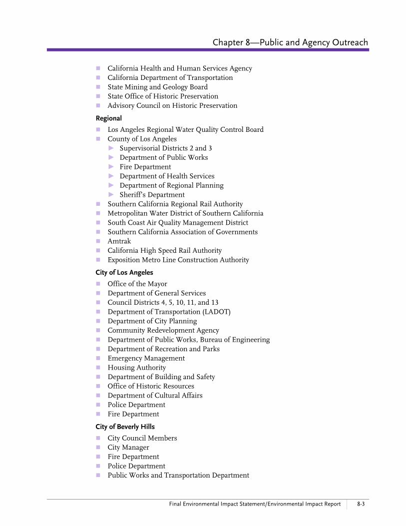
California Health and Human Services Agency California Department of Transportation State Mining and Geology Board State Office of Historic Preservation Advisory Council on Historic Preservation
Regional
Los Angeles Regional Water Quality Control Board County of Los Angeles
► Supervisorial Districts 2 and 3 ► Department of Public Works ► Fire Department ► Department of Health Services ► Department of Regional Planning ► Sheriff’s Department
Southern California Regional Rail Authority Metropolitan Water District of Southern California South Coast Air Quality Management District Southern California Association of Governments Amtrak California High Speed Rail Authority Exposition Metro Line Construction Authority
City of Los Angeles
Office of the Mayor Department of General Services Council Districts 4, 5, 10, 11, and 13 Department of Transportation (LADOT) Department of City Planning Community Redevelopment Agency Department of Public Works, Bureau of Engineering Department of Recreation and Parks Emergency Management Housing Authority Department of Building and Safety Office of Historic Resources Department of Cultural Affairs Police Department Fire Department
City of Beverly Hills
City Council Members City Manager Fire Department Police Department Public Works and Transportation Department

8-4 Westside Subway Extension March 2012
Planning Department Department of Community Development Community Services Department
City of Santa Monica
City Council Members City Manager Department of Public Works, Civil Engineering and Architecture Division Planning and Community Development Department Water Resources Division Environmental and Public Works Department Open Space Management Division Santa Monica Big Blue Bus Fire Department Police Department
City of West Hollywood
City Council Members City Manager Public Safety and Community Services Division Community Development Department Planning Division Public Works Department, Transportation Division
Culver City
City Manager Public Works Department Culver City Bus Fire Department Police Department
Westside Cities Council of Governments
Institutions
Armand Hammer Museum Cedars-Sinai Medical Center Los Angeles County Museum of Art Page Museum Petersen Automotive Museum St. John’s Health Center Santa Monica UCLA Medical Center Veterans Affairs West Los Angeles Hospital and
Medical Center Campus
The stakeholder list is a living document that would continue to grow through-out the life of the Project. The current stakeholder database for the Westside Subway Extension Project includes more than 6,000 individuals, businesses, and organizations.

Chapter 8—Public and Agency Outreach
Final Environmental Impact Statement/Environmental Impact Report 8-5
School Districts, Colleges, and Universities
Beverly Hills Unified School District Los Angeles Community College District Los Angeles County Office of Education Los Angeles Unified School District Santa Monica/Malibu Unified School District University of California, Los Angeles (UCLA)
Chambers of Commerce and Business Groups
Beverly Hills Chamber of Commerce Beverly Hills/Greater Los Angeles Area Association of Realtors Building Owners and Managers Association of Greater Los Angeles Central City Association Century City Business Improvement District Century City Chamber of Commerce Hollywood Chamber of Commerce Los Angeles Convention Center Miracle Mile Chamber of Commerce Westwood Village Business stakeholders Wilshire Center Business Improvement District
Community Organizations, Neighborhood Groups, Neighborhood Councils, and Home Owner Associations
Bel Air/Beverly Crest Neighborhood Council Century City Homeowners Alliance Comstock Hills Homeowners Association Fremont Place Association Greater Wilshire Neighborhood Council Hancock Park Homeowners Association Hollywood Hills West Neighborhood Council Mid-City West Neighborhood Council Miracle Mile Residential Association Park La Brea Residents Association South Brentwood Residents Association Southwest Beverly Hills Homeowners Tract 7260 Homeowners Association Traffic Committee, West Los Angeles Community Police Advisory Board Westwood Community Council Westwood Neighborhood Council Westwood/Comstock Homeowners Association Windsor Square Association Windsor Village Community Association
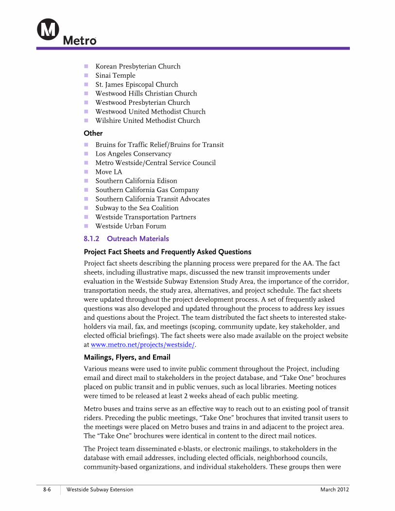
Religious Organizations
Central Korean Christian Church Church of Jesus Christ of Latter-day Saints
8-6 Westside Subway Extension March 2012
Korean Presbyterian Church Sinai Temple St. James Episcopal Church Westwood Hills Christian Church Westwood Presbyterian Church Westwood United Methodist Church Wilshire United Methodist Church
Other
Bruins for Traffic Relief/Bruins for Transit Los Angeles Conservancy Metro Westside/Central Service Council Move LA Southern California Edison Southern California Gas Company Southern California Transit Advocates Subway to the Sea Coalition Westside Transportation Partners Westside Urban Forum
8.1.2 Outreach Materials
Project Fact Sheets and Frequently Asked Questions
Project fact sheets describing the planning process were prepared for the AA. The fact sheets, including illustrative maps, discussed the new transit improvements under evaluation in the Westside Subway Extension Study Area, the importance of the corridor, transportation needs, the study area, alternatives, and project schedule. The fact sheets were updated throughout the project development process. A set of frequently asked questions was also developed and updated throughout the process to address key issues and questions about the Project. The team distributed the fact sheets to interested stake-holders via mail, fax, and meetings (scoping, community update, key stakeholder, and elected official briefings). The fact sheets were also made available on the project website at www.metro.net/projects/westside/.
Mailings, Flyers, and Email
Various means were used to invite public comment throughout the Project, including email and direct mail to stakeholders in the project database, and “Take One” brochures placed on public transit and in public venues, such as local libraries. Meeting notices were timed to be released at least 2 weeks ahead of each public meeting.
Metro buses and trains serve as an effective way to reach out to an existing pool of transit riders. Preceding the public meetings, “Take One” brochures that invited transit users to the meetings were placed on Metro buses and trains in and adjacent to the project area. The “Take One” brochures were identical in content to the direct mail notices.
The Project team disseminated e-blasts, or electronic mailings, to stakeholders in the database with email addresses, including elected officials, neighborhood councils, community-based organizations, and individual stakeholders. These groups then were

Chapter 8—Public and Agency Outreach
Final Environmental Impact Statement/Environmental Impact Report 8-7
asked to forward these e-blasts to their constituents and members. E-blasts were typically used to instantly distribute meeting announcements and other project information to large numbers of people.
Website, Social Networking, and Media Outreach and Coordination
The project website (www.metro.net/projects/westside/) serves as a central point where stakeholders can obtain information about the Project via the Internet. The Project website was initially used for the AA phase and was updated for the purposes of both the Draft and Final EIS/EIR phases, including publicizing the public scoping meetings. Website content includes a project overview, information about meetings and collateral materials, such as fact sheets, presentations made at public meetings, and other information of interest to the public from both the current and previous project phases. The website continued to be updated at key study milestones of the Final EIS/EIR phase and the Project overall.
In addition to the project website, in the spring of 2008, Metro launched the “Metro Westside Extension” group on the Facebook social networking site. The Westside Subway Extension Facebook group was an enormously helpful tool in educating the public about the Project and, in particular, getting a younger demographic interested in the Project. In March 2010, Metro also launched a Facebook fan page for the Westside Subway Extension and, after a period, began winding down support for the Facebook group and directed people to the new Facebook page. This more interactive
service from Facebook was not available when the group was launched in 2008. More than 2,200 people have now joined the Facebook fan page, which can be viewed at www.facebook.com/WestsideSubwayExtension.
Metro took a proactive role working with the mainstream media to publicize all com-munity meetings and to raise awareness of the Project. This included the development of press releases and placement of display advertisements. This effort was comple-mented by outreach to grassroots, ethnic and niche print media, broadcast and new media (such as Facebook, blogs, electronic news outlets, chat rooms, discussion boards, etc.), as well as the Spanish and Korean-language media.
Project Video (“A Subway Story”)
In the summer of 2009, Metro initiated the production of a project video. Shooting of the video took place all throughout West Los Angeles to capture the essence and complexity of the Wilshire Corridor. Key stakeholders, such as UCLA Vice Chancellor Steve Olsen, Los Angeles County Museum of Art CEO Michael Govan and President Melody Kanschat, and Hollywood Business Improvement District Executive Director Kerry Morrison, appeared in the video and provided feedback on the positive impact the subway would have on their constituencies. Additionally, through “A Subway Story,” Metro summarized the history of the Wilshire Corridor and discussed the subway construction process. This video continues to be shown at public and stakeholder meetings, is posted on the Metro website and Facebook page, and has been sent to numerous organizations for distribution to their members.

8-8 Westside Subway Extension March 2012
Twitter and Live Webcasts
To broaden the initial outreach strategy, during the Draft EIS/EIR phase Metro began using Twitter as a vehicle for providing community members not present at meetings
with quick notes (140 characters or less) throughout the proceedings, allowing stakeholders to stay informed. Metro live-tweeted its first meeting on April 12, 2010, and has continued to tweet at each subsequent community update. As with the Facebook page, Metro also uses Twitter to inform the now more than 530 followers about other project-related news, such as notice of upcoming meetings, availability of new project information and documents, and field work.
Additionally, recognizing that interested stakeholders throughout the corridor might not always be able to attend evening meetings, Metro adopted a mechanism to reach directly to stakeholders with access to computers. In the summer of 2010, Metro streamed its first community meeting live over the internet on www.ustream.tv/channel/westsidesubway, and streamed one meeting of each additional series of meetings live for the balance of the environmental process as follows: June 2010 August 2010 September 2010 January 2011 March 2011
The webcasts are also posted on the project website and remain available for anyone to view the meeting proceedings.
8.2 Government and Other Agency Consultation
8.2.1 Section 6002 of the Safe, Accountable, Flexible, and Efficient Transportation Equity Act—A Legacy for Users
Section 6002 of the Safe, Accountable, Flexible, and Efficient Transportation Equity Act—A Legacy for Users (SAFETEA-LU) (Public Law 109-59) is intended to promote efficient project management by lead agencies and enhanced opportunities for coordina-tion with the public and with other federal, state, local, and tribal government agencies during the project development process. As part of the environmental review process, the lead agency must identify as early as practicable any other federal or non-federal agencies that may have an interest in the Project, and invite such agencies to become participating agencies in the environmental review process.
Participating agency letters of invitation per Section 6002 of SAFETEA-LU were mailed to agencies at the onset of formal scoping in March 2009. Participating outreach efforts included an agency scoping meeting (described in Section 8.4.3), agency coordination meetings, and coordination meetings with individual agencies, including, but not limited to, the U.S. Army Corps of Engineers, the California Department of Transpor-tation, and the cities in the project corridor. Coordination efforts will be on-going throughout the project-development process.

Chapter 8—Public and Agency Outreach
Final Environmental Impact Statement/Environmental Impact Report 8-9
Furthermore, SAFETEA-LU emphasizes public participation, requiring that the public participation plans of metropolitan planning processes “be developed in consultation with all interested parties and … provide that all interested parties have reasonable opportunities to comment on the contents of the transportation plan.” SAFETEA-LU also expanded the definition of participation by “interested parties” to include partners, groups, and individuals affected by or involved with transportation in the appropriate county and surrounding region. Examples of parties who should be provided with a reasonable opportunity to comment on the Project include citizens, affected public agencies, representatives of public transportation employees, private providers of trans-portation, representatives of users of public transportation, representatives of users of pedestrian walkways and bicycle transportation facilities, representatives of the disabled, and other interested parties. The Public Participation Plan was developed cognizant of compliance with SAFETEA-LU and conforms to the public participation requirements of NEPA, CEQA, and the Federal Transit Administration (FTA) New Starts program.
8.2.2 Section 106 Consultation
The extensive effort to contact, identify, and consult with various cultural groups and agencies, in order to identify traditional cultural properties and cultural practices, during the environmental planning process are documented as part of consultation efforts for the Section 106 consultation process. The purpose of a Section 106 consultation is to identify cultural resources and other concerns relating to the Project’s potential effects on cultural resources. Information from individuals and organizations likely to have knowledge of potential resources in the Study Area was sought as part of this consultation.
During the process of conducting archival research and field studies for historic resources, the project team maintained communication with the State Historic Preserva-tion Officer (SHPO), the Advisory Council on Historic Preservation (ACHP), the Los Angeles Conservancy, and other jurisdictional agencies. The team conferred with the California Native American Heritage Commission (NAHC) in Sacramento, local California Indian organizations, and interested public historical or cultural organizations.
A search of the sacred lands file of the NAHC was requested on June 3, 2009. As recommended by the NAHC, individuals who may have further knowledge on sacred or prehistoric cultural resources within the project area were contacted. These include individuals from the Gabrielino Tongva Indians of California Tribal Council, Gabrielino Tongva Nation, Gabrielino Tongva Territorial Tribal Nation, Los Angeles City/County Native American Heritage Commission, Ti’At Society, Gabrielino Tongva San Gabriel Band of Mission Indians, and Gabrielino Tongva Tribe. Coordination with the SHPO, interested parties of the Native American Heritage Commission, and Native American community is on-going.
All coordination with the SHPO and the ACHP is included in Appendix D, Memorandum of Agreement and Section 106 Correspondence.

8-10 Westside Subway Extension March 2012
8.2.3 Urban Design Working Group
A key component of the station area planning for the Project is the urban design process. The urban design process initiated in the AA phase was continued during the Advanced Conceptual Engineering phase with the formation of the Urban Design Working Group (UDWG). The UDWG was composed of key staff from the Cities of Los Angeles, Beverly Hills, Santa Monica, and West Hollywood. The goals of the UDWG were as follows: Facilitate discussion about the vision and identity of the Westside Subway Extension
and how individual station areas could be designed to fit within this framework Provide a forum for critical analysis of how the Project should approach considera-
tions of land use, design, and linkages between stations along the line and their urban neighborhoods
Propose design considerations for station areas so they will fit appropriately within the surrounding urban context
Involve stakeholders and the Westside Extension planning team in a comprehensive station planning process
Facilitate discussion about sensitive areas to assist in the station location decision-making process so that alternative station locations can be resolved, if necessary
Help ensure that planning for the Project corridor considers and builds upon the needs, desires, and policies of the Westside cities
Assist in establishing guidelines and standards that may be helpful for future Metro transit corridor initiatives
The UDWG participated in workshops discussing station location, urban design, and proposed station entrance locations that were closely coordinated with the Public Outreach effort. The UDWG participated in an initial urban design workshop on July 15, 2008, with a follow-up meeting on September 4, 2008, to discuss the urban design concepts and proposed station locations. The UDWG examined local issues, urban design guidelines, and specific geographic concerns regarding station locations and station design. The workshops were part of the public outreach effort during the AA phase and have been part of the continuing design process for the station area planning process in subsequent phases of the Project.
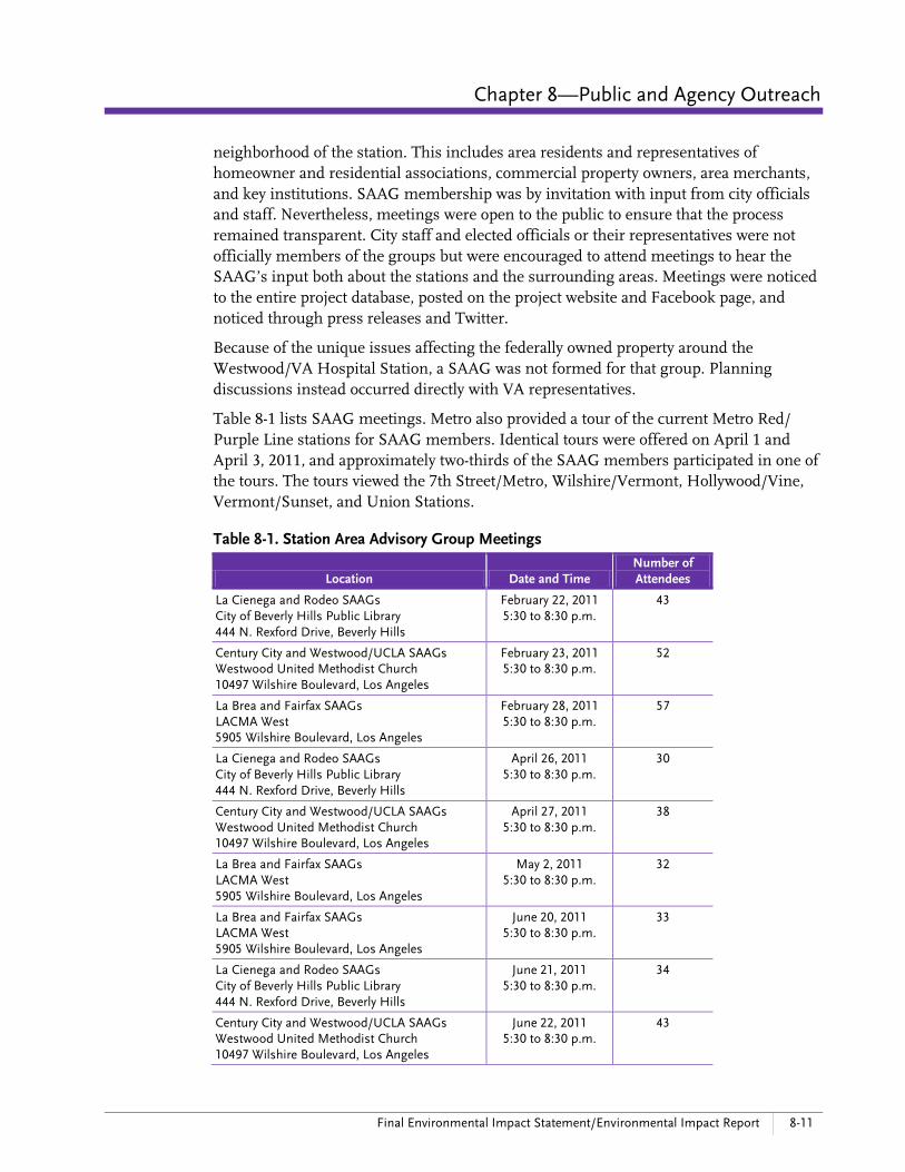
During the Final EIS/EIR phase of the project, the UDWGs evolved into “Station Area Advisory Groups” (SAAG) that met three times before the conclusion of this final planning stage of the Westside Subway Extension.
The purpose of the SAAGs was to provide community input to Metro subway planners and city planners on potential urban design and other features at each proposed station during the Final EIS/EIR and Preliminary Engineering phases of the Westside Subway Extension. Topics included station entrance locations and station design within the context of an Urban Design Station Planning Toolkit framework and station design parameters developed by Metro during this phase of the project. The SAAGs also informed communities about the status of station planning and design.
SAAGs were formed for six of the seven stations. Membership on each SAAG was comprised of stakeholders that are representative of key community groups in the
Chapter 8—Public and Agency Outreach
Final Environmental Impact Statement/Environmental Impact Report 8-11
neighborhood of the station. This includes area residents and representatives of homeowner and residential associations, commercial property owners, area merchants, and key institutions. SAAG membership was by invitation with input from city officials and staff. Nevertheless, meetings were open to the public to ensure that the process remained transparent. City staff and elected officials or their representatives were not officially members of the groups but were encouraged to attend meetings to hear the SAAG’s input both about the stations and the surrounding areas. Meetings were noticed to the entire project database, posted on the project website and Facebook page, and noticed through press releases and Twitter.
Because of the unique issues affecting the federally owned property around the Westwood/VA Hospital Station, a SAAG was not formed for that group. Planning discussions instead occurred directly with VA representatives.
Table 8-1 lists SAAG meetings. Metro also provided a tour of the current Metro Red/Purple Line stations for SAAG members. Identical tours were offered on April 1 and April 3, 2011, and approximately two-thirds of the SAAG members participated in one of the tours. The tours viewed the 7th Street/Metro, Wilshire/Vermont, Hollywood/Vine, Vermont/Sunset, and Union Stations.
Table 8-1. Station Area Advisory Group Meetings
Location Date and Time Number of Attendees
La Cienega and Rodeo SAAGs City of Beverly Hills Public Library 444 N. Rexford Drive, Beverly Hills
February 22, 2011 5:30 to 8:30 p.m.
43
Century City and Westwood/UCLA SAAGs Westwood United Methodist Church 10497 Wilshire Boulevard, Los Angeles
February 23, 2011 5:30 to 8:30 p.m.
52
La Brea and Fairfax SAAGs LACMA West 5905 Wilshire Boulevard, Los Angeles
February 28, 2011 5:30 to 8:30 p.m.
57
La Cienega and Rodeo SAAGs City of Beverly Hills Public Library 444 N. Rexford Drive, Beverly Hills
April 26, 2011 5:30 to 8:30 p.m.
30
Century City and Westwood/UCLA SAAGs Westwood United Methodist Church 10497 Wilshire Boulevard, Los Angeles
April 27, 2011 5:30 to 8:30 p.m.
38
La Brea and Fairfax SAAGs LACMA West 5905 Wilshire Boulevard, Los Angeles
May 2, 2011 5:30 to 8:30 p.m.
32
La Brea and Fairfax SAAGs LACMA West 5905 Wilshire Boulevard, Los Angeles
June 20, 2011 5:30 to 8:30 p.m.
33
La Cienega and Rodeo SAAGs City of Beverly Hills Public Library 444 N. Rexford Drive, Beverly Hills
June 21, 2011 5:30 to 8:30 p.m.
34
Century City and Westwood/UCLA SAAGs Westwood United Methodist Church 10497 Wilshire Boulevard, Los Angeles
June 22, 2011 5:30 to 8:30 p.m.
43
8-12 Westside Subway Extension March 2012
8.3 Community Outreach during the Alternatives Analysis Phase The AA encompassed an in-depth public participation process that included early scoping meetings, community update meetings, key stakeholder meetings, and elected officials briefings, as well as development and dissemination of informational materials, a project website, a project information line, and media relations. The AA phase began in October 2007 and concluded in January 2009 when it was approved by the Metro Board of Directors, which also authorized proceeding into the Draft EIS/EIR phase.
8.3.1 Early Scoping Meetings
Metro used an early public scoping process that was consistent with the FTA’s require-ments for an AA. This early scoping process was designed to solicit from stakeholders the variety of possibilities regarding the modes of transportation and proposed align-
ments and station locations prior to their further analysis in the AA. The official notification for the Westside Transit Corridor Study early scoping process began with a public notice published in the Federal Register, Volume 72, No. 189, on October 1, 2007. The official early scoping comment period was initially scheduled to continue until Novem-ber 1, 2007, but was extended until November 7, 2007, at the request of several stakeholders.
As shown in Table 8-2, the early scoping process included six public scoping meetings where agency representatives and the general public could provide verbal and written comments.
Table 8-2. Westside Subway Extension Early Scoping Meetings
Location Date and Time Number of Attendees
Emerson Middle School 1650 Selby Avenue, Los Angeles
October 9, 2007 6 to 8 p.m.
77
Pan Pacific Park Recreation Center 7600 Beverly Boulevard, Los Angeles
October 11, 2007 6 to 8 p.m.
58
Wilshire United Methodist Church 4350 Wilshire Boulevard, Los Angeles
October 16, 2007 6 to 8 p.m.
73
City of Beverly Hills Public Library 444 N. Rexford Drive, Beverly Hills
October 17, 2007 6 to 8 p.m.
69
City of Santa Monica Public Library 601 Santa Monica Boulevard, Santa Monica
October 18, 2007 6 to 8 p.m.
81
Plummer Park 7377 Santa Monica Boulevard, West Hollywood
October 29, 2007 6 to 8 p.m.
111

Chapter 8—Public and Agency Outreach
Final Environmental Impact Statement/Environmental Impact Report 8-13
A variety of methods were employed to notify stakeholders about the early public scop-ing meetings. These meetings were publicized by distributing more than 600 direct mail notices and 700 emails to those listed in the study database, as well as distributing an additional 3,100 emails through proprietary lists. Meeting notices were mailed on September 27, 2007. Emails were sent on September 27, 2007, with follow-up reminders sent on October 2, 2007. A final reminder to the community to submit written com-ments was delivered on October 30, 2007.
The project team developed a public scoping meeting invitation flyer for postal distri-bution within the Study Area. Poster-sized versions of the flyer were distributed to 43 locations throughout the Study Area, including Metro Service Centers, offices of local elected officials, libraries, and at community, recreation, and senior centers. Information was also posted on Metro’s website. Advertisements were displayed in multi-lingual publications (English, Spanish, and Korean), and notices were placed on Metro buses and trains serving the project area.
A media release was distributed to 83 local, regional, ethnic, and multi-lingual publica-tions, as well as broadcast media, blogs, and other online news and information outlets. Notices were provided in English, Spanish, and Korean and were published in the following publications: Beverly Hills Courier, Century City News, Jewish Journal, Korean Central Daily, Park La Brea/Beverly Press, The Wave (Los Angeles/West Hollywood Independent), La Opinion (Spanish language), and Santa Monica Daily Press.
To address the growing prevalence of “new” media in this region, outreach was also conducted to online sites for traditional news organizations, online-only news sites, and “blogs,” which are best described as an online continuous open conversation. The Southern California region is host to thousands of websites and blogs and, after some research, 34 key websites were identified that discuss transit, traffic, community development, and neighborhood issues. These 34 bloggers identified were sent a copy of Metro’s press release and the Federal Register public notice.
Prior to the close of the comment period, 484 comments were received. Through the early scoping process, the overwhelming majority of stakeholders supported the need for a transit improvement in the Westside Transit Corridor Study Area, with a Wilshire Boulevard subway identified as the most favored route and mode. While the Santa Monica Alignment also received noticeable support, many stakeholders suggested that Metro consider a project that would include both a Wilshire Boulevard and a Santa Monica Boulevard Alignment. In many cases, where the public was in favor of both these alignments, most thought that the Wilshire Alignment should take precedence. Limited backing was voiced for aerial/monorail, light rail, or bus rapid transit.
8.3.2 Agency Scoping Meeting
One agency scoping meeting was held during the early scoping period on October 10, 2007, at the Los Angeles County Sheriff Substation Briefing Room (720 N. San Vicente Boulevard, West Hollywood). Eighteen individuals attended, representing the following agencies and jurisdictions: California Public Utilities Commission City of Beverly Hills

8-14 Westside Subway Extension March 2012
City of Beverly Hills Fire Department City of Culver City Community Development Department City of Culver City Fire Department City of Los Angeles—Bureau of Street Lighting City of Los Angeles—Community Redevelopment Agency City of Santa Monica Big Blue Bus City of Santa Monica Police Department City of West Hollywood Federal Transit Administration Los Angeles County Sheriff’s Department UCLA
8.3.3 Community Meetings
Subsequent to the early scoping period, Metro hosted three more rounds of “Community Update” meetings during the AA phase. The first of these was in late January and early February 2008, which presented initial alternatives incorporating the public comments submitted during the early scoping period. The purpose of these meetings was to keep the public informed at key study milestones of how their comments were considered in the decision-making process as alternatives were developed and refined. Based on additional analysis and public feedback, Metro identified seven alternatives for further study that were presented to the public in May 2008.
In September 2008, Metro held the final round of “Community Update” meetings for the AA phase of the Westside Subway Extension study to provide stakeholders with its preliminary recommendations based on public input and technical analysis conducted over the previous 12 months. These meetings are shown in Table 8-3.
More than 1,400 people attended all four rounds of community meetings, and more than 900 comments were received in all forms. The public indicated overwhelming support for transit improvements in the area. Metro consistently heard from stake-holders that their preferred mode of transit is a heavy-rail subway, with more than 90 percent of comments received favoring a Wilshire Alignment. Support was also expressed for a subway on both the Wilshire and Santa Monica Alignments, with most comments requesting that the Wilshire Alignment be constructed before the Santa Monica Alignment, if phasing was necessary. In the last round of five meetings in September 2008, the public expressed support for the two heavy rail alignments that were identified for further analysis through the Draft EIS/EIR.

Chapter 8—Public and Agency Outreach
Final Environmental Impact Statement/Environmental Impact Report 8-15
Table 8-3. Community Update Meetings
Location Date and Time Number of Attendees
Los Angeles County Museum of Art (LACMA)—West 5905 Wilshire Boulevard, Los Angeles
January 31, 2008 6 to 8 p.m.
113
Westwood Presbyterian Church 10822 Wilshire Boulevard, Los Angeles
February 5, 2008 6 to 8 p.m.
106
Plummer Park 7377 Santa Monica Boulevard, West Hollywood
February 6, 2008 6 to 8 p.m.
108
LACMA—West 5905 Wilshire Boulevard, Los Angeles
May 5, 2008 6 to 8 p.m.
70
Westwood Presbyterian Church 10822 Wilshire Boulevard, Los Angeles
May 6, 2008 6 to 8 p.m.
47
Santa Monica Public Library, Multipurpose Room, 2nd Floor 601 Santa Monica Boulevard, Santa Monica
May 8, 2008 6 to 8 p.m.
64
Plummer Park 7377 Santa Monica Boulevard, West Hollywood
May 12, 2008 6 to 8 p.m.
69
Santa Monica Public Library, Auditorium, 1st Floor 601 Santa Monica Boulevard, Santa Monica
September 3 6 to 8 p.m.
75
Plummer Park 7377 Santa Monica Boulevard, West Hollywood
September 4, 2008 6 to 8 p.m.
66
Beverly Hills Public Library—Auditorium, 2nd Floor 444 N. Rexford Drive, Beverly Hills
September 6, 2008 6 to 8 p.m.
52
LACMA—West, Terrace Room, 5th Floor 5905 Wilshire Boulevard, Los Angeles
September 8, 2008 6 to 8 p.m.
66
Westwood Presbyterian Church 10822 Wilshire Boulevard, Los Angeles
September 10, 2008 6 to 8 p.m.
71
8.3.4 Stakeholder Briefings
A series of meetings with stakeholders and elected officials representing business and homeowners associations/community councils, transit advocacy groups, and local agencies were held prior to the public scoping and agency meetings conducted in fall 2007. This targeted outreach effort provided for more detailed review and discussion with these particular groups. The briefings involved the following stakeholders: Beverly Hills and Greater Los Angeles Association of Realtors Special Meeting Central City Association Century City Chamber of Commerce Greater Wilshire Neighborhood Council Hollywood Chamber of Commerce Legislative Committee Metro Westside/Central Service Council Southern California Transit Advocates Traffic Committee, West Los Angeles Community Police Advisory Board Westside Cities Council of Governments (COG) and COG Transportation
Committee Westside Transportation Partners Westwood Village stakeholders Westwood/Comstock Hills stakeholders

8-16 Westside Subway Extension March 2012
8.3.5 Elected Officials Briefings
Briefings were hosted for local elected officials and their staff. The briefings served as a sounding board for the project team and provided these officials notification about upcoming meetings as well as preliminary information about the status of the Project. Representatives from elected offices continued to support the AA and were interested to learn about potential funding sources and phasing. The elected officials and agencies who participated in the briefings included the following: United States, Office of Senator Dianne Feinstein United States, Office of Senator Barbara Boxer United States, Office of Congressman Henry Waxman State of California, Office of State Senator Sheila Kuehl State of California, Office of State Senator Mark Ridley Thomas State of California, Office of Assembly Speaker Karen Bass State of California, Office of Assemblyman Mike Feuer City of Beverly Hills, Transportation Department City of Los Angeles, City Planning Department City of Los Angeles, Community Redevelopment Agency City of Los Angeles, Department of Transportation City of Los Angeles, Office of Councilmember Jack Weiss City of Los Angeles, Office of Councilmember Tom LaBonge City of Los Angeles, Office of Councilmember Bernard Parks City of Los Angeles, Office of Mayor Antonio Villaraigosa City of Santa Monica, Councilmember Kevin McKeown City of West Hollywood, Department of Transportation Metro Board Member and City of Santa Monica, Councilmember Pam O’Connor Metro Board Deputies
8.4 Community Outreach during the Draft EIS/EIR Phase It was decided to change the project name from “Westside Extension Transit Corridor” to the “Westside Subway Extension” at the inception of the Draft EIS/EIR. This was a result of overwhelming public opinion regarding the need for a western extension of the Red/Purple Lines during the AA process and also the direction of the Metro Board of Directors at the conclusion of the AA for the environmental study to continue analysis of a heavy-rail subway alternative.
8.4.1 Scoping Meetings
The Draft EIS/EIR was initiated in March 2009 with the publication of the Notice of Intent (NOI) in the Federal Register and the Notice of Preparation (NOP) being sent to the State Clearinghouse on March 24, 2009. The NOP was distributed to agencies and organizations within the study corridor and to jurisdictions with an interest in the Project on March 24, 2009. NOP packages were sent to 25 federal agencies, 48 state agencies, seven regional agencies (including utility providers), and 98 local agencies (including school districts and study area cities).

Chapter 8—Public and Agency Outreach
Final Environmental Impact Statement/Environmental Impact Report 8-17
Six scoping meetings provided the public an opportunity to comment on the Project’s purpose, the alternatives to be considered, and issues and areas of concern to be considered in the Draft EIS/EIR. The locations, dates, and number of attendees are shown in Table 8-4.
Table 8-4. Westside Subway Extension Draft EIS/EIR Scoping Meetings
Location Date and Time Number of Attendees
LACMA West 5905 Wilshire Boulevard, Los Angeles
April 13, 2009 6 to 8 p.m.
72
Plummer Park 7377 Santa Monica Boulevard, West Hollywood
April 14, 2009 6 to 8 p.m.
44
Beverly Hills Public Library 444 N. Rexford Drive, Beverly Hills
April 16, 2009 6 to 8 p.m.
43
Westwood Presbyterian Church 10822 Wilshire Boulevard, Los Angeles
April 20, 2009 6 to 8 p.m.
65
Wilshire United Methodist Church 4350 Wilshire Boulevard, Los Angeles
April 22, 2009 5 to 7 p.m.
40
Santa Monica Public Library 601 Santa Monica Boulevard, Santa Monica
April 23, 2009 6 to 8 p.m.
78
The project team reached out to the media in anticipation of the public meetings and held a media briefing at the initiation of scoping via a web-based conference system for newspapers, print, broadcast, and digital media. At least five media groups participated in the media briefing. Other media groups, who were unable to participate and expressed interest, were briefed individually.
Metro notified stakeholders about the scoping meetings via email to approximately 1,080 individuals and via postal mail to approximately 470 individuals. In addition, meeting notifica-tions were posted to the Westside Subway Extension Facebook group, which had approximately 1,650 members at the time. In addition, electronic distribution of the meeting notice occurred on March 19 and April 9, 2009. Notices were sent to 1,032 email addresses within the existing project database. An email was also sent to those in the project database on April 30, 2009, as a reminder for stakeholders to submit their comments prior to the comment deadline of May 7, 2009. Homeowner associa-tions, chambers of commerce, and community organizations
were contacted by phone, as a supplement to the mailings, to encourage their members’ participation in the environmental review process and in determining the scope and content of the Draft EIS/EIR.

8-18 Westside Subway Extension March 2012
Display advertisements for the scoping meetings were placed in seven print and one online newspaper within the study area. These were selected based on their geographic focus, language needs, and audited circulation numbers. Newspapers that carried scoping meeting advertisements included the Korean Times (Korean language), Beverly Press/Park La Brea News, Los Angeles Independent (Hollywood and West Hollywood Editions), UCLA Daily Bruin (Online), Jewish Journal, Beverly Hills Courier, Santa Monica Daily Press, and Hoy (Spanish language).
At the scoping meetings, 91 verbal and 31 written comments were received, and a total of 253 comments were received during the scoping period. The majority of comments received supported the need for major transit improvements in the Study Area, specifically a heavy rail subway extension as a means of reducing Westside traffic congestion. Only four comments stated opposition to the Project. Most comments expressed support for a subway, with most supporting the Combined Wilshire/Santa Monica Alignment and that the Wilshire segment of the combined alignment should be built first. There was minimal support for the No Build and Transportation Systems Management (TSM) Alternatives and monorail alternatives. In general, comments reflected a variety of topics, including proposed station locations, phasing of the construction process, discussion about parking, and the need for connectivity. Several comments also mentioned urban design preferences and urged that the proposed system be “green” by using innovative technologies and approaches. Various comments were also received addressing construction issues and possible mitigation measures.
The scoping meetings were held with an open house period followed by a formal presentation and a subsequent comment period. Project team members were present to answer technical questions. Spanish and Korean language translators were available, as well as closed captioning for the hearing-impaired. The scoping meetings were recorded by a court reporter and documented in the Scoping Report as a part of the Draft EIS/EIR planning effort. The notices and comments received during scoping are included in the Scoping Report.
8.4.2 Agency Scoping Meeting
The agency scoping meeting was held at 10 a.m. on Monday, April 13, 2009, at Metro, 1 Gateway Plaza in Los Angeles. Twenty-four individuals represented the following local, state, and federal agencies and other organizations: California Department of Transportation City of Beverly Hills Transportation Department City of Culver City Police Department City of Los Angeles Planning Department City of Los Angeles Police Department City of Los Angeles Recreation and Parks Department City of Santa Monica Fire Department County of Los Angeles Community and Senior Services Department County of Los Angeles Planning Department County of Los Angeles Fire Department Exposition Metro Line Construction Authority Federal Transit Administration
Chapter 8—Public and Agency Outreach
Final Environmental Impact Statement/Environmental Impact Report 8-19
Occupational Safety and Health Administration, California Tunneling Unit Southern California Association of Governments U.S. Army Corps of Engineers U.S. General Services Administration UCLA
The agency representatives viewed the presentation and engaged in discussion related to the Westside Subway Extension. Approximately five agencies submitted formal written comments during the scoping period. The comments submitted stressed the need for the subway and particular station locations. Additional comments discussed the neces-sary coordination with the various cities’ planning, police, and fire departments if and when construction begins.
8.4.3 Community Meetings
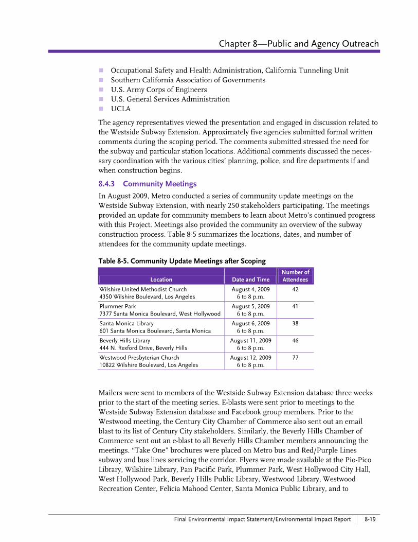
In August 2009, Metro conducted a series of community update meetings on the Westside Subway Extension, with nearly 250 stakeholders participating. The meetings provided an update for community members to learn about Metro’s continued progress with this Project. Meetings also provided the community an overview of the subway construction process. Table 8-5 summarizes the locations, dates, and number of attendees for the community update meetings.
Table 8-5. Community Update Meetings after Scoping
Location Date and Time Number of Attendees
Wilshire United Methodist Church 4350 Wilshire Boulevard, Los Angeles
August 4, 2009 6 to 8 p.m.
42
Plummer Park 7377 Santa Monica Boulevard, West Hollywood
August 5, 2009 6 to 8 p.m.
41
Santa Monica Library 601 Santa Monica Boulevard, Santa Monica
August 6, 2009 6 to 8 p.m.
38
Beverly Hills Library 444 N. Rexford Drive, Beverly Hills
August 11, 2009 6 to 8 p.m.
46
Westwood Presbyterian Church 10822 Wilshire Boulevard, Los Angeles
August 12, 2009 6 to 8 p.m.
77
Mailers were sent to members of the Westside Subway Extension database three weeks prior to the start of the meeting series. E-blasts were sent prior to meetings to the Westside Subway Extension database and Facebook group members. Prior to the Westwood meeting, the Century City Chamber of Commerce also sent out an email blast to its list of Century City stakeholders. Similarly, the Beverly Hills Chamber of Commerce sent out an e-blast to all Beverly Hills Chamber members announcing the meetings. “Take One” brochures were placed on Metro bus and Red/Purple Lines subway and bus lines servicing the corridor. Flyers were made available at the Pio-Pico Library, Wilshire Library, Pan Pacific Park, Plummer Park, West Hollywood City Hall, West Hollywood Park, Beverly Hills Public Library, Westwood Library, Westwood Recreation Center, Felicia Mahood Center, Santa Monica Public Library, and to

8-20 Westside Subway Extension March 2012
Westfield Corporate Offices for distribution at the Westfield Century City Shopping Center.
A press release was distributed to print, broadcast, and digital media for each meeting, including the Los Angeles Times, Santa Monica Daily Press, Santa Monica Mirror, The Argonaut, Santa Monica Observer, LAist, Curbed LA, Green LA Girl, Beverly Press, Korean Times, Korea Daily News, Daily Journal, Jewish Observer, Southwest Law Review, Larchmont Chronicle, LA Observed, Los Angeles, Business Journal, The Sentinel, WeHo News, Beverly Hill Courier, and Daily Bruin.
Stakeholders continued to express support for the Project but also were generally concerned about the disruption construction could cause for residents in the areas nearest the proposed station locations. Community members in the City of Beverly Hills were concerned about construction staging locations within city limits as the project alignments traverse important business and retail hubs. Community members were also interested to learn more about the actual station construction timeframe.
Station Area Information Meetings
Metro conducted its “Station Area Information Meetings” in October and November 2009. These meetings had outstanding attendance, with nearly 500 community members attending and actively engaging in discussions about such topics as station box locations, proposed station access points, locations for passenger pick up/drop off, bicycle and pedestrian access, transit connections, and other issues that relate to the facilities at or near station entrances. These meetings also provided the community with updates on the Project. More than half of the attendees were new to the Project. Table 8-6 summarizes the location, date, time, and number of attendees at these meetings.
Table 8-6. Westside Subway Extension Station Area Information Meetings
Location Date and Time Number of Attendees
Santa Monica Library 601 Santa Monica Boulevard, Santa Monica
October 22, 2009 6 to 8 p.m.
86
Los Angeles County Museum of Art, Terrace Room 5905 Wilshire Boulevard, Los Angeles
October 26, 2009 5:30 to 8 p.m.
122
Pacific Design Center 8687 Melrose Ave, West Hollywood
November 3, 2009 6 to 8 p.m.
117
Beverly Hills City Hall 455 N. Rexford Drive, Beverly Hills
November 4, 2009 5:30 to 8 p.m.
88
Veterans Affairs—Wadsworth Theatre 11301 Wilshire Boulevard, Los Angeles
November 5, 2009 6 to 8 p.m.
77
To reach potential stakeholders new to the process, postcards specific to each station were sent to residents within a one-quarter mile radius of each respective station location. E-blasts were sent prior to meetings to the Westside Subway Extension database and Facebook group members. CBRE/Century Park sent out an e-blast to property owners and tenants prior to the Westwood meeting. “Take One” brochures

Chapter 8—Public and Agency Outreach
Final Environmental Impact Statement/Environmental Impact Report 8-21
were placed on the Metro Red/Purple Lines subway and bus lines servicing the corridor. Hand drops of meeting flyers were made to the Pio-Pico Library, Wilshire Library, Pan Pacific Park, Park La Brea, Plummer Park, West Hollywood City Hall, West Hollywood Park, Beverly Hills Public Library, Westwood Library, Westwood Recreation Center, Felicia Mahood Center, Santa Monica Public Library, and Westfield Century City Mall.
A press release was distributed to broadcast, print, and digital media for each meeting, including the Los Angeles Times, Santa Monica Daily Press, Santa Monica Mirror, The Argonaut, Santa Monica Observer, LAist, Curbed LA, Green LA Girl, Beverly Press, Korean Times, Korea Daily News, Daily Journal, Jewish Observer, Southwest Law Review, Larchmont Chronicle, LA Observed, Los Angeles, Business Journal, The Sentinel, WeHo News, Beverly Hill Courier, and the Daily Bruin.
Metro utilized a new format in gathering public input for this meeting series. Following an open house and formal presentation, community members were asked to break into small groups around a table for each station location, allowing them to review the specific station area and provide input for refining the alternatives. During the breakout sessions, seven general themes emerged from the various discussions: Station entrance locations and desire for multiple entrances Accommodating bikes especially at the stations (e.g., access from street, lockers) User-friendly and sufficient pedestrian paths and sidewalks The bus and shuttle interface General amenities, including elevators, restrooms, and kiosks Station security Construction staging
Spring 2010 Community Updates
The Westside Subway Extension team concluded the spring 2010 round of community update meetings on April 21, 2010. In all, 222 people attended the five meetings held, with 72 providing verbal comments and 18 turning in written comments (Table 8-7). Outgoing West Hollywood Mayor Abbe Land spoke at the West Hollywood meeting and a representative for LA Councilman Paul Koretz also attended the
Fall 2010 station information meeting
Spring 2010 community update meeting
8-22 Westside Subway Extension March 2012
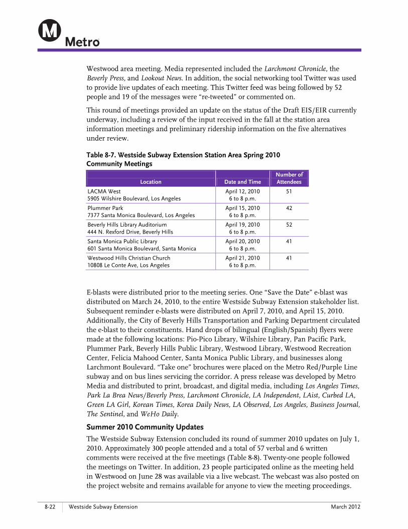
Westwood area meeting. Media represented included the Larchmont Chronicle, the Beverly Press, and Lookout News. In addition, the social networking tool Twitter was used to provide live updates of each meeting. This Twitter feed was being followed by 52 people and 19 of the messages were “re-tweeted” or commented on.
This round of meetings provided an update on the status of the Draft EIS/EIR currently underway, including a review of the input received in the fall at the station area information meetings and preliminary ridership information on the five alternatives under review.
Table 8-7. Westside Subway Extension Station Area Spring 2010 Community Meetings
Location Date and Time
Number of Attendees
LACMA West 5905 Wilshire Boulevard, Los Angeles
April 12, 2010 6 to 8 p.m.
51
Plummer Park 7377 Santa Monica Boulevard, Los Angeles
April 15, 2010 6 to 8 p.m.
42
Beverly Hills Library Auditorium 444 N. Rexford Drive, Beverly Hills
April 19, 2010 6 to 8 p.m.
52
Santa Monica Public Library 601 Santa Monica Boulevard, Santa Monica
April 20, 2010 6 to 8 p.m.
41
Westwood Hills Christian Church 10808 Le Conte Ave, Los Angeles
April 21, 2010 6 to 8 p.m.
41
E-blasts were distributed prior to the meeting series. One “Save the Date” e-blast was distributed on March 24, 2010, to the entire Westside Subway Extension stakeholder list. Subsequent reminder e-blasts were distributed on April 7, 2010, and April 15, 2010. Additionally, the City of Beverly Hills Transportation and Parking Department circulated the e-blast to their constituents. Hand drops of bilingual (English/Spanish) flyers were made at the following locations: Pio-Pico Library, Wilshire Library, Pan Pacific Park, Plummer Park, Beverly Hills Public Library, Westwood Library, Westwood Recreation Center, Felicia Mahood Center, Santa Monica Public Library, and businesses along Larchmont Boulevard. “Take one” brochures were placed on the Metro Red/Purple Line subway and on bus lines servicing the corridor. A press release was developed by Metro Media and distributed to print, broadcast, and digital media, including Los Angeles Times, Park La Brea News/Beverly Press, Larchmont Chronicle, LA Independent, LAist, Curbed LA, Green LA Girl, Korean Times, Korea Daily News, LA Observed, Los Angeles, Business Journal, The Sentinel, and WeHo Daily.
Summer 2010 Community Updates
The Westside Subway Extension concluded its round of summer 2010 updates on July 1, 2010. Approximately 300 people attended and a total of 57 verbal and 6 written comments were received at the five meetings (Table 8-8). Twenty-one people followed the meetings on Twitter. In addition, 23 people participated online as the meeting held in Westwood on June 28 was available via a live webcast. The webcast was also posted on the project website and remains available for anyone to view the meeting proceedings.
Chapter 8—Public and Agency Outreach
Final Environmental Impact Statement/Environmental Impact Report 8-23
This was the last round of community update meetings prior to the release of the Draft EIS/EIR. This series of meetings provided a review of issues presented to the public in prior meetings and preparation for the formal public review and comment on the Draft EIS/EIR.
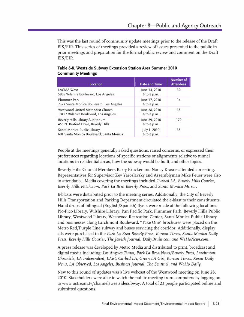
Table 8-8. Westside Subway Extension Station Area Summer 2010 Community Meetings
Location Date and Time Number of Attendees
LACMA West 5905 Wilshire Boulevard, Los Angeles
June 14, 2010 6 to 8 p.m.
30
Plummer Park 7377 Santa Monica Boulevard, Los Angeles
June 17, 2010 6 to 8 p.m.
14
Westwood United Methodist Church 10497 Wilshire Boulevard, Los Angeles
June 28, 2010 6 to 8 p.m.
35
Beverly Hills Library Auditorium 455 N. Rexford Drive, Beverly Hills
June 29, 2010 6 to 8 p.m.
170
Santa Monica Public Library 601 Santa Monica Boulevard, Santa Monica
July 1, 2010 6 to 8 p.m.
35
People at the meetings generally asked questions, raised concerns, or expressed their preferences regarding locations of specific stations or alignments relative to tunnel locations in residential areas, how the subway would be built, and other topics.
Beverly Hills Council Members Barry Brucker and Nancy Krasne attended a meeting. Representatives for Supervisor Zev Yaroslavsky and Assemblyman Mike Feuer were also in attendance. Media covering the meetings included Curbed LA, Beverly Hills Courier, Beverly Hills Patch.com, Park La Brea Beverly Press, and Santa Monica Mirror.
E-blasts were distributed prior to the meeting series. Additionally, the City of Beverly Hills Transportation and Parking Department circulated the e-blast to their constituents. Hand drops of bilingual (English/Spanish) flyers were made at the following locations: Pio-Pico Library, Wilshire Library, Pan Pacific Park, Plummer Park, Beverly Hills Public Library, Westwood Library, Westwood Recreation Center, Santa Monica Public Library and businesses along Larchmont Boulevard. “Take One” brochures were placed on the Metro Red/Purple Line subway and buses servicing the corridor. Additionally, display ads were purchased in the Park La Brea Beverly Press, Korean Times, Santa Monica Daily Press, Beverly Hills Courier, The Jewish Journal, DailyBruin.com and WeHoNews.com.
A press release was developed by Metro Media and distributed to print, broadcast and digital media including: Los Angeles Times, Park La Brea News/Beverly Press, Larchmont Chronicle, LA Independent, LAist, Curbed LA, Green LA Girl, Korean Times, Korea Daily News, LA Observed, Los Angeles, Business Journal, The Sentinel, and WeHo Daily.
New to this round of updates was a live webcast of the Westwood meeting on June 28, 2010. Stakeholders were able to watch the public meeting from computers by logging on to www.ustream.tv/channel/westsidesubway. A total of 23 people participated online and submitted questions.
8-24 Westside Subway Extension March 2012
Special Community Meetings
Century City Lunch Time “Open House”—February 2, 2010
In addition to large-scale community meetings, Metro also held a special open house in Century City to reach out to the business community and people that work in Century City who normally would not be able to participate in evening meetings. The Open House was held from 11:30 a.m. to 2:00 p.m. and allowed members of the community an opportunity to learn about the subway’s progress and how to stay involved.
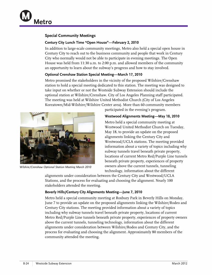
Optional Crenshaw Station Special Meeting—March 17, 2010
Metro promised the stakeholders in the vicinity of the proposed Wilshire/Crenshaw station to hold a special meeting dedicated to this station. The meeting was designed to take input on whether or not the Westside Subway Extension should include the optional station at Wilshire/Crenshaw. City of Los Angeles Planning staff participated. The meeting was held at Wilshire United Methodist Church (City of Los Angeles Koreatown/Mid-Wilshire/Wilshire Center area). More than 60 community members
participated in the evening’s program.
Westwood Alignments Meeting—May 18, 2010
Metro held a special community meeting at Westwood United Methodist Church on Tuesday, May 18, to provide an update on the proposed alignments linking the Century City and Westwood/UCLA stations. The meeting provided information about a variety of topics including why subway tunnels travel beneath private property, locations of current Metro Red/Purple Line tunnels beneath private property, experiences of property owners above the current tunnels, tunneling technology, information about the different
alignments under consideration between the Century City and Westwood/UCLA Stations, and the process for evaluating and choosing the alignment. Nearly 100 stakeholders attended the meeting.
Beverly Hills/Century City Alignments Meeting—June 7, 2010
Metro held a special community meeting at Roxbury Park in Beverly Hills on Monday, June 7 to provide an update on the proposed alignments linking the Wilshire/Rodeo and Century City stations. The meeting provided information about a variety of topics including why subway tunnels travel beneath private property, locations of current Metro Red/Purple Line tunnels beneath private property, experiences of property owners above the current tunnels, tunneling technology, information about the different alignments under consideration between Wilshire/Rodeo and Century City, and the process for evaluating and choosing the alignment. Approximately 80 members of the community attended the meeting.
Wilshire/Crenshaw Optional Station Meeting March 2010

Chapter 8—Public and Agency Outreach
Final Environmental Impact Statement/Environmental Impact Report 8-25
LACMA “Open House”—July 14, 2010
Metro held another open house for the business community in the Miracle Mile area adjacent to the proposed Wilshire/Fairfax station. The Open House was held from 11:30 a.m. to 2:00 p.m. and provided area businesses and employees with an opportunity to learn about the subway’s progress. Nearly 90 area business persons, including many museum employees, attended the daytime open house.
8.4.4 Stakeholder Briefings
In addition to the Community Update Meetings and the Station Area Information Meetings, Metro conducted community and stakeholder briefings for homeowner associations, neighborhood councils, local agencies, medical centers, property owners, and others in the Study Area. This targeted outreach effort typically involved Metro attending meetings at the invitation of these groups. To the extent that these were public meetings, the sponsoring organization was generally responsible for publicizing them to their members or intended audience. At these meetings, Metro staff typically provided a project status update and information specific to the area where the meeting was being held or for the group that was hosting the meeting. Briefings were held with the organizations listed below and were on-going throughout the Project. Beverly Hills Chamber of Commerce Beverly Hills Unified School District Caltrans CD 11 Empowerment Transportation Committee Cedars-Sinai Medical Center Century City area employees Century City BID Century City Chamber of Commerce Century City Chamber of Commerce Transportation Council Century City property owners (including CB Richard Ellis, Next Century Associates,
Constellation Place, Topa Equities, Century Plaza Hotel, Watt Companies, and Westfield)
City of Beverly Hills staff City of Los Angeles Department of Transportation City of Los Angeles Planning Department City of West Hollywood staff Los Angeles County Museum of Art Miracle Mile Chamber of Commerce Neighborhood and Community Councils and Homeowners Associations in Los
Angeles Westwood Village stakeholders UCLA US General Services Administration Veterans Affairs

8-26 Westside Subway Extension March 2012
In addition, Metro held briefings or meetings with some property owners, developers, and their representatives for properties that have been identified as possible sites for construction staging or station entrances. These include the following: George Comfort & Associates Indivest JMB Realty Los Angeles County Museum of Art Rosalinde & Arthur Gilbert Foundation Sieroty Company The Muller Company UCLA Westfield Wilshire/Crescent Heights Developer Woodridge Capital/Next Century Associates 99¢ Only Stores
8.4.5 Elected Officials Briefings
Meetings were held with elected officials and their staff during and after scoping. In general, the briefings served as a sounding board for the project team and provided these offices with notification about upcoming meetings and preliminary information about the status of the Project. The following participated in the briefings: United States, Office of U.S. Senator Diane Feinstein United States, Office of U.S. Congresswoman Diane Watson United States, Office of U.S. Congressman Henry Waxman State of California, Office of State Senator Fran Pavley State of California, Office of State Assembly Speaker Emeritus Karen Bass State of California, Office of State Assembly Speaker John Pérez State of California, Office of Assemblyman Mike Feuer State of California, Office of Assemblyman Ted Lieu State of California, Office of Assemblymember Holly Mitchell Office of Los Angeles County Supervisor Mark Ridley-Thomas Office of Los Angeles County Supervisor Zev Yaroslavsky City of Beverly Hills staff City of Los Angeles, Office of Councilman Tom LaBonge (District 4) City of Los Angeles, Office of Councilman Jack Weiss/Paul Koretz (District 5) City of Los Angeles, Office of Councilman Herb Wesson (District 10) City of Los Angeles, Office of Councilman Bill Rosendahl (District 11) City of Los Angeles, Office of Mayor Antonio Villaraigosa City of Santa Monica staff City of Beverly Hills, Traffic and Parking Commission City of West Hollywood staff
The information was typically well-received, as area elected officials are supportive of the Project.

Chapter 8—Public and Agency Outreach
Final Environmental Impact Statement/Environmental Impact Report 8-27
8.5 Draft EIS/EIR Public Hearings As part of the NEPA and CEQA process, the Draft EIS/EIR was circulated for a 45-day review and comment period starting September 3 and concluding October 18, 2010.
During this period, the document was made available to interested and concerned parties, including residents, property owners, community groups, the business community, elected officials, and public agencies for public and agency comment. The draft document was placed in public libraries (Table 8-9) and other repository sites as an effective way of providing ongoing information about the Project. The draft document, along with all technical reports, was also posted on the Metro Westside Subway Extension Project website at www.metro.net/projects/westside/draft-eis-eir-sept-2010/.
Table 8-9. Area Public Libraries Location Address
West Los Angeles Regional Library 11360 Santa Monica Boulevard, Los Angeles 90025
Robertson Branch Library 1719 S. Robertson Boulevard, Los Angeles 90035
Santa Monica Main Library 601 Santa Monica Boulevard, Santa Monica 90401
Will & Ariel Durant Library 7140 W. Sunset Boulevard, Los Angeles 90046
Frances H. G. Hollywood Regional Library 1623 N. Ivar Avenue, Hollywood 90028
West Hollywood Public Library 715 N. San Vicente, West Hollywood 90069
John C. Fremont Library 6121 Melrose Avenue, Los Angeles 90038
Fairfax Library 161 S. Gardner Street, Los Angeles 90036
Felipe de Neve Library 2820 W. Sixth Street, Los Angeles 90057
Memorial Library 4625 W. Olympic Boulevard, Los Angeles 90019
Pio Pico Koreatown Library 694 S. Oxford Avenue, Los Angeles 90005
Wilshire Library 149 N. St. Andrews Place, Los Angeles 90004
Donald Bruce Kaufman -Brentwood Library 11820 San Vicente Boulevard, Los Angeles 90049
Westwood Library 1246 Glendon Avenue, Los Angeles 90024
Beverly Hills Public Library 444 N. Rexford Drive, Los Angeles, 90210
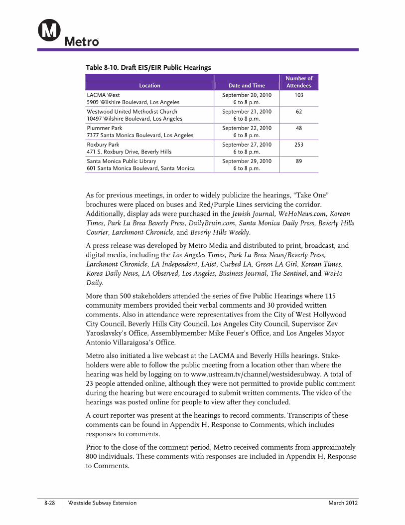
A series of formal public hearings (Table 8-10) was held during this 45-day period. The purpose of the hearings was to give interested parties an opportunity to formally submit comments on the Project and the analysis contained in the Draft EIS/EIR.
Metro provided a notice of these hearings in compliance with CEQA and NEPA. A comprehensive effort to inform the public with email, mail, print, broadcast, digital media, flyers, social networking, postings on the project website, and others was undertaken on a similar scale with the previous rounds of meetings. Attendance at the hearings was not required to submit comments. Responses to comments received are addressed in this Final EIS/EIR.
8-28 Westside Subway Extension March 2012
Table 8-10. Draft EIS/EIR Public Hearings
Location Date and Time Number of Attendees
LACMA West 5905 Wilshire Boulevard, Los Angeles
September 20, 2010 6 to 8 p.m.
103
Westwood United Methodist Church 10497 Wilshire Boulevard, Los Angeles
September 21, 2010 6 to 8 p.m.
62
Plummer Park 7377 Santa Monica Boulevard, Los Angeles
September 22, 2010 6 to 8 p.m.
48
Roxbury Park 471 S. Roxbury Drive, Beverly Hills
September 27, 2010 6 to 8 p.m.
253
Santa Monica Public Library 601 Santa Monica Boulevard, Santa Monica
September 29, 2010 6 to 8 p.m.
89
As for previous meetings, in order to widely publicize the hearings, “Take One” brochures were placed on buses and Red/Purple Lines servicing the corridor. Additionally, display ads were purchased in the Jewish Journal, WeHoNews.com, Korean Times, Park La Brea Beverly Press, DailyBruin.com, Santa Monica Daily Press, Beverly Hills Courier, Larchmont Chronicle, and Beverly Hills Weekly.
A press release was developed by Metro Media and distributed to print, broadcast, and digital media, including the Los Angeles Times, Park La Brea News/Beverly Press, Larchmont Chronicle, LA Independent, LAist, Curbed LA, Green LA Girl, Korean Times, Korea Daily News, LA Observed, Los Angeles, Business Journal, The Sentinel, and WeHo Daily.
More than 500 stakeholders attended the series of five Public Hearings where 115 community members provided their verbal comments and 30 provided written comments. Also in attendance were representatives from the City of West Hollywood City Council, Beverly Hills City Council, Los Angeles City Council, Supervisor Zev Yaroslavsky’s Office, Assemblymember Mike Feuer’s Office, and Los Angeles Mayor Antonio Villaraigosa’s Office.
Metro also initiated a live webcast at the LACMA and Beverly Hills hearings. Stake-holders were able to follow the public meeting from a location other than where the hearing was held by logging on to www.ustream.tv/channel/westsidesubway. A total of 23 people attended online, although they were not permitted to provide public comment during the hearing but were encouraged to submit written comments. The video of the hearings was posted online for people to view after they concluded.
A court reporter was present at the hearings to record comments. Transcripts of these comments can be found in Appendix H, Response to Comments, which includes responses to comments.
Prior to the close of the comment period, Metro received comments from approximately 800 individuals. These comments with responses are included in Appendix H, Response to Comments.

Chapter 8—Public and Agency Outreach
Final Environmental Impact Statement/Environmental Impact Report 8-29
The most frequently heard comments regarding the Westside Subway Extension’s LPA included the station locations in Century City, Westwood/UCLA, and Westwood/VA Hospital. Many comments were also received about the Beverly Hills to Westwood tunnel alignment, support for an accelerated construction schedule, support for building as much of the system as possible, station access, construction impacts, as well as other technical issues such as traffic and noise impacts.
8.6 Activities Since Close of the Draft EIS/EIR Public Review Period Community update meetings for the Final EIS/EIR phase included two rounds of meetings in January and March 2011 (Table 8-11), in addition to the SAAG meetings described in Section 8.2.3. More than 400 people attended the two sets of community update meetings, and 53 comments were received. Thirty people followed the two rounds of meetings on Twitter. In addition, more than 40 people participated online via the live webcasts.
The meetings, held in the Mid-Wilshire, Beverly Hills, and Westwood areas, provided stakeholders with ongoing project updates, what community members could expect during the Final EIS/EIR phase, an overview of the anticipated subway construction process, public feedback from prior community update meetings and at the SAAG meetings, and updates on the location of the Century City Station and geotechnical investigations that took place during the final phase of the environmental process.
Table 8-11. Westside Subway Extension Station Area Winter and Spring 2011 Community Meetings
Location Date and Time Number of Attendees
LACMA West 5905 Wilshire Boulevard, Los Angeles
January 24, 2011 6 to 8 p.m.
55
Westwood United Methodist Church 10497 Wilshire Boulevard, Los Angeles
January 26, 2011 6 to 8 p.m.
100
Roxbury Park 471 S. Roxbury Drive, Beverly Hills
January 31, 2011 6 to 8 p.m.
151
LACMA West 5905 Wilshire Boulevard, Los Angeles
March 21, 2011 6 to 8 p.m.
42
Westwood United Methodist Church 10497 Wilshire Boulevard, Los Angeles
March 23, 2011 6 to 8 p.m.
41
Roxbury Park 471 S. Roxbury Drive, Beverly Hills
March 29, 2011 6 to 8 p.m.
50
Comments received at the meetings indicated that the public overall continues to remain very supportive of the Project, although they continue to have specific questions about issues that were resolved in the Draft EIS/EIR or that were still under review during the Final EIS/EIR phase. The issue that generated the most discussion is the location of the Century City Station.
Beverly Hills Council Members Barry Brucker, Nancy Krasne, John Mirisch, Julian Gold, and Willie Brien attended the meetings as did members of the Beverly Hills

8-30 Westside Subway Extension March 2012
Unified School District. Representatives from the offices of U.S. Congressman Henry Waxman, Supervisor Zev Yaroslavsky, State Assemblymember Mike Feuer, and Los Angeles Councilmembers Paul Koretz and Tom La Bonge were also represented at the meetings.
Media outlets covering the meetings included the Jewish Journal, Korea Daily News, Huffington Post, Westwood-Century City Patch, Curbed LA, Neon Tommy, Beverly Hills Courier, Beverly Hills Weekly, and Beverly Hills Patch.
E-blasts of meeting notifications were distributed prior to each meeting series. Addi-tionally, the City of Beverly Hills Transportation and Parking Department circulated the e-blast to their constituents. Hand drops of bilingual (English/Spanish) flyers were made at the following locations throughout the project area: Pio-Pico Library, Wilshire Library, Pan Pacific Park, Plummer Park, Beverly Hills Public Library, Westwood Library, Westwood Recreation Center, Santa Monica Public Library, and businesses along Larchmont Boulevard. “Take One” brochures were placed on buses and Red/Purple Lines servicing the corridor. Additionally, display ads were purchased in the Park La Brea Beverly Press, Larchmont Chronicle, Beverly Hills Weekly, and DailyBruin.com.
A press release was developed by Metro Media and distributed to print, broadcast, and digital media including the Los Angeles Times, Park La Brea News/Beverly Press, Larchmont Chronicle, LA Independent, LAist, Curbed LA, Green LA Girl, Korean Times, Korea Daily News, LA Observed, Los Angeles, Business Journal, The Sentinel, and WeHo Daily.
Metro also continued to stream its community updates live over the internet on http://www.ustream.tv/channel/westsidesubway, and streamed one meeting in each series of meetings: January 2011—Westwood March 2011—Mid-Wilshire
The webcast was also posted on the project website and remains available for anyone to view the meeting proceedings.
8.7 Accommodations for Minority, Low-Income, and Persons with Disabilities Metro made every effort to ensure minority, low-income, and disabled persons were included in all outreach efforts for this Project. This included sensitivity to multiple distribution channels and language needs, but also in the selection of transit-accessible venues in compliance with the Americans with Disabilities Act of 1990 (ADA) (USC 1990). Simultaneous translations were provided at each community meeting. Spanish translation was available at every public meeting with the addition of Russian for meetings held in West Hollywood and Korean for meetings held in the Mid-Wilshire and Koreatown areas. Closed captioning for the hearing-impaired was provided to the community on an as-requested basis provided that requests were made with 72 hours advance notice.
In addition to direct mail and emails, Metro provided notifications at least 10 days in advance of meetings on buses and trains serving the Project area to ensure that those
Chapter 8—Public and Agency Outreach
Final Environmental Impact Statement/Environmental Impact Report 8-31
who are transit-dependent had access to information about the Project and were made aware of opportunities to attend the meetings. Transit advocacy groups were included in e-blasts. Furthermore, bi-lingual (Spanish/English or Korean/English) meeting notices were placed in parks, libraries, community centers, and non-profit organizations in the project area. Multi-lingual informational “Take One” brochures were placed on buses and trains throughout the Westside Corridor.
8.8 Draft EIS/EIR Comments The official public comment period for the Westside Subway Extension Draft EIS/EIR began on September 3, 2010, and closed on October 18, 2010. Five Public Hearings on the Draft EIS/EIR were held between September 20 and 29, 2010. More than 550 people attended the hearings held throughout the study area, with 115 people providing verbal testimony and an additional 29 submitting written comments. Metro received approxi-mately 2,000 public comments from over 800 commenters, including verbal and written comments received at the five public hearings, comments received via postal mail, email, and online comment forms prior to and following the public hearings.
The comments covered a variety of topics and were submitted by various stakeholders, including public agencies, elected officials, groups, and individuals. All comments were documented and organized into an electronic database for analysis and development of responses. This database identifies the name of the individual and/or commenting agency who commented, the source of the comment, the content of the comment, and the topic(s) discussed by the comment. All comments received, along with the responses to comments, appear in Appendix H, Response to Comments.
In general, public comments echoed what was heard during the previous AA phase and the Draft EIS/EIR Public Scoping period: an overwhelming majority of comments received during the public comment period for the Draft EIS/EIR support the Westside Subway Extension in the Study Area as a means of reducing Westside traffic congestion and providing an alternative mode of transportation. The majority of the comments received were related to the following topics: western terminus of the LPA Alignment; Century City Station locations; geotechnical concerns related to Century City Station locations; Century City Alignment options; Westwood/VA Hospital Station location; other optional station locations; project schedule; station connectivity; transportation issues; alternative modes/TSM preference; noise and vibration during operations; impact on property values; and construction impacts (Table 8-12). A discussion of the comments received for each of these topics with responses follows in the subsections below.
All technical reports cited in this section were prepared in response to comments and are available on the Westside Subway Extension Project website: www.metro.net/projects/westside/

8-32 Westside Subway Extension March 2012
Table 8-12: Common Comment Topics on the Draft EIS/EIR
Topics General Comments
Length of the Project’s Locally Preferred Alternative (LPA)
• Extend project as far west as possible • Extend west of I-405 • Include Santa Monica and West Hollywood
Alignments
• Maintain options for future West Hollywood or Santa Monica Alignments if funding becomes available
Century City Station Locations
• In support of Santa Monica Boulevard, opposed to Constellation
• In support of Constellation Boulevard, opposed to Santa Monica
• Constellation Boulevard location most central for employees and residents of Century City
• Decision making process for Century City Station location and preference for “original” Century City Station location along Santa Monica Boulevard
Alignment between the Wilshire/Rodeo, Century City, and Westwood/ UCLA Stations
• Wilshire/Rodeo to Century City Alignment options
• Century City to Westwood/UCLA Alignment options
• Potential impacts of tunneling under homes and schools, including Beverly Hills High School and the Good Shepherd School
Geotechnical concerns • Safety of tunneling related to various geotechnical issues
• Santa Monica Fault • Abandoned oil wells • Methane gas
• Ground settlement/subsidence • Liquefaction • Seismic differences between Century City
Station locations
Westwood/VA Hospital Station Location
• Station accessibility • Preference for Wilshire/Federal or Wilshire/Barrington as terminus
Other optional station locations
• Wilshire/Crenshaw Station • Both in favor and opposed to the construction
of a Wilshire/Crenshaw Station • Provide a connection to the Crenshaw/LAX
light rail line • Wilshire/Fairfax Station: Preference for the
East Station location to provide better access to Museum Row
• Wilshire/La Cienega Station: Preference for both the East and West Station locations
• Support to maintain potential for future West Hollywood connection
• Westwood/UCLA Station: Preference for both the On-Street and Off-Street Station locations
• Connections to the UCLA campus
Project schedule • Build project as soon as possible • 30/10 funding
Station connectivity • Connectivity to other Metro rail projects • Crenshaw/LAX connection • San Fernando Valley (Sepulveda)/I-405
connection • Expo connection
• Bus, pedestrian and bicycle connectivity • Station design • Parking • Passenger drop-off and pick-up
Transportation issues • Traffic congestion • Ridership projections
Alternative mode/ TSM Preference
• Preference for expanded bus service instead of rail
• Concerns funding will be shifted away from bus service
Noise and vibration during operations
• Concern about noise and vibration during operations, particularly potential impact on students at Beverly Hills High School
Impact on property values • Concern about potential impact on property values
Construction impacts • Traffic congestion • Noise and vibration
• Staging areas • Haul routes

Chapter 8—Public and Agency Outreach
Final Environmental Impact Statement/Environmental Impact Report 8-33
8.8.1 Length of the Project’s Locally Preferred Alternative (LPA)
Comment
With regard to the length of the Project, many individuals urged Metro to extend the subway as far west as possible, preferring a station west of the I-405 Freeway. Some suggested that the terminus be at Wilshire/Federal or Wilshire/Barrington rather than the Westwood VA Hospital, and others suggested a terminus at Wilshire/4th Street in Santa Monica. In addition, many commenters indicated that West Hollywood and surrounding communities had been strong supporters of Measure R and therefore should receive some benefit from its passage with the implementation of the Project from the Hollywood/Highland Station. Many commenters also indicated that the line would enjoy significant support and would achieve higher ridership if it extended through West Hollywood.
Many of the comments received requested that both the Santa Monica and West Hollywood Alignments (Alternative 5) be built as soon as possible; however, many commenters indicated if funding was not available, that the line should be extended to Westwood or the VA Campus as an initial improvement. While many commenters recognized that Alternatives 1 and 2 are the only financially feasible routes at this time, numerous commenters requested that Metro maintain the option for future extensions to Santa Monica and West Hollywood in the event that additional funding is secured.
Response
At its October 28, 2010 meeting, the Metro Board selected Alternative 2 (Westwood/VA Hospital Extension) as the LPA, approved the Draft EIS/EIR, and authorized Metro staff to begin the final phase of the planning process for the Westside Subway Extension Project—preparation of this Final EIS/EIR and completion of Preliminary Engineering.
The Draft EIS/EIR evaluated five Build Alternatives and two Minimum Operable Segments (MOS) with varying lengths, ranging from 8.60 to 17.49 miles for the full alternatives (Alternatives 1 through 5) and 3.10 to 6.61 miles for MOS 1 and MOS 2, respectively. Metro’s selection of Alternative 2 as the LPA was in part based on funding constraints and the cost-effectiveness of the various alternatives.
The adopted Long Range Transportation Plan (LRTP) (Metro 2009a) includes the Westside Subway Extension in the Constrained Element with a phased delivery in three construc-tion segments for completion in the following years: Fairfax Extension (2019) Century City Extension (2026) Westwood Extension (2036)
In April 2010, the Board adopted the 30/10 Initiative, which directs the Westside Subway Extension to seek funding to deliver the project in one phase to Westwood rather than three construction segments.
Of the five Build Alternatives and two MOSs studied in the Draft EIS/EIR, only Alternatives 1 and 2 are affordable within the adopted LRTP and between them, Alternative 2 provides significantly higher ridership and better cost effectiveness than Alternative 1. Additionally, Alternative 2 serves the VA Hospital and other communities
8-34 Westside Subway Extension March 2012
west of I-405 more effectively by extending the subway west of I-405. Extending to the Westwood/VA Hospital Station provides enhanced and direct service to this major regional center and provides an important access point to the regional transit system, communities, and activity centers west of the I-405 Freeway. Chapter 7 of the Draft EIS/EIR provides more detail on the comparative benefits and costs of the alternatives.
Although there is not adequate funding available in Measure R or other sources to construct Alternatives 3, 4, or 5 at this time, the Draft EIS/EIR demonstrated a significant market for transit improvements serving Santa Monica and West Hollywood. The Santa Monica and West Hollywood corridors are included in the Strategic Element of the 2009 LRTP. Therefore, further study could occur should funding be identified and secured in the future. The Project is being designed so as not to preclude future westward extension from the Westwood/VA Hospital Station.
8.8.2 Century City Station Locations
A significant volume of comments were received on the location of the Century City Station. Since the Century City Station location affects the alignment location to and from the Century City Stations, many of these comments also discussed the placement of the alignment, which is discussed in Section 8.8.3, and geotechnical safety concerns, which are discussed in Section 8.8.4.
Those in support of one station location generally expressed strong opposition to the other station location; with those in favor of a station on Santa Monica Boulevard opposed to a station on Constellation Boulevard and those in favor of Constellation Boulevard opposed to the Santa Monica Boulevard location. The Santa Monica Boulevard location has been strongly supported by the City of Beverly Hills and the Beverly Hills Unified School District. The Century City Constellation Station was supported by the majority of commenters in meetings held outside of Beverly Hills. It is, however, strongly opposed by some in Beverly Hills because the alignments between Beverly Hills and Century City would need to pass beneath property in Southwest Beverly Hills and Beverly Hills High School.
The comments specifically on the location of the Century City Station focused on two main issues discussed below—connectivity to activity centers and the “original” Century City Station location and Metro’s decision-making process. Comments on the alignment to and from Century City are addressed in Section 8.8.3.
In recognition of the volume of comments received on the Century City Station location, the Metro Board of Directors did not select a station location in Century City at its October Board Meeting. Rather, the Metro Board of Directors directed Metro staff to continue to study both station locations in Century City (Santa Monica and Constellation) as part of the LPA. The results of this further study can be found in the Westside Subway Extension Century City Station Location Report (Metro 2012e) and are summarized in Chapter 7, Evaluation of Alternatives. It should be noted that the location of the Century City Santa Monica Station analyzed in this Final EIS/EIR is located to the east of the location in the Draft EIS/EIR to avoid locating the station box on the Santa Monica Fault. Based on the additional analysis, the recommendation is to locate the Century City Station along Constellation Boulevard due to seismic safety concerns at the

Chapter 8—Public and Agency Outreach
Final Environmental Impact Statement/Environmental Impact Report 8-35
Century City Santa Monica Station and higher ridership projections with the Century City Constellation Station.
Connectivity to Activity Centers and Ridership
Comment
Many of the comments received on the Century City Station discussed proximity of the station to the employment and residential center of Century City and how the location of the station relative to commercial and residential development affects ridership. Those in favor of the Century City Constellation Station stated that it would better serve the central core of the office and residential land uses of Century City, whereas the Santa Monica Station would border on a golf course. Many stated that the Century City Santa Monica Station location would be too far for pedestrians from office and residential destinations in Century City, and that the Century City Constellation Station would generate higher ridership, be more visible, and more convenient.
Response
In response to these comments, Metro conducted further studies to refine ridership projections at the Century City Station. The ridership model from the Draft EIS/EIR was further refined to assess the LPA in this Final EIS/EIR and incorporate any changes between the Draft EIS/EIR and this Final EIS/EIR. More than 10 model runs were conducted to respond to changes, perform additional analysis, and answer questions that were raised during the Project development process in the Final EIS/EIR phase. The test runs analyzed the impact on the Purple Line ridership and project trips. The main types of refinement included feeder bus service, balanced headways, and some coding refinement to determine what changes should be included in the Final EIS/EIR model runs. The results of this further ridership analysis are available in the Westside Subway Extension Technical Report Summarizing the Results of the Forecasted Alternatives (Metro 2011an). The refined model predicts boardings along the new Westside Subway Extension stations are approximately 49,300 with the Century City Constellation Station, which is about 3,350 more than the predicted 45,986 boardings with the Century City Santa Monica Station. The main difference in boardings at the Century City Station is the increased walk access trips in the Constellation Station over the Santa Monica Station. The walking time between the TAZ 738 (Century City’s) centroid node and the Century City subway station is 3 minutes for the Constellation Station Option and 13 minutes for the Santa Monica Station option. The number of jobs and jobs per square mile in the one-quarter mile and one-half mile area around the Century City Stations is much higher for the Constellation Station option than for the Santa Monica Station option.
In addition to the refined ridership model, a supplemental ridership study was prepared to evaluate the relative accessibility of the Century City Station locations to surrounding commercial and residential development within a one-half mile walking distance. This data were then used to estimate the number of Westside Subway Extension riders who would walk to and from the stations. The results of this evaluation can be found in the Westside Subway Extension Century City TOD and Walk Access Study (Metro 2012a). It should be noted that these ridership projections only consider those riders who walk to

8-36 Westside Subway Extension March 2012
the station and these projections are intended to supplement the ridership forecasts in the Report Summarizing the Results of the Forecasted Alternatives (Metro 2011an).
As part of this study, a review of literature on walking to transit was conducted to establish best practice in thinking about walking and transit. The review shows that proximity to transit has a bigger impact on ridership than the absolute total number of jobs and residents near transit. This is because as distance increases from the station, walking rates decline significantly. Importantly for a major employment center such as Century City, this “distance decay” effect is more pronounced for work trips.
This analysis concluded that the Century City Constellation Station attracts more Westside Subway Extension riders compared to the station location along Santa Monica Boulevard. Based on both existing and projected future development in Century City, the Constellation Station has the highest concentration of jobs and residents within the critical 600-foot and one-quarter mile walksheds. As a consequence, the 14,005 riders estimated to walk to the Century City Station along Constellation Boulevard is approxi-mately 72 percent greater than the approximately 8,145 riders expected to walk to the Century City Santa Monica Station. The Century City Constellation Station has the best pedestrian environment, can be expected to attract the most transit riders, and is centrally located to help shape the redevelopment of Century City as an important transit-oriented destination on the Westside Subway Extension.
“Original” Century City Station Location and Decision-Making Process
Comment
Some commenters urged Metro to stay with what the commenters identified as the “original” location for the Century City Station along Santa Monica Boulevard, as identified in the early stages of planning for the Westside Subway Extension. These commenters also expressed concern that Metro switched to the Constellation Boulevard location to support the interests of developers in Century City over those of residents and students in Beverly Hills, questioning the decision-making process and Metro’s integrity in determining the location of the Century City Station.
Response
Metro carefully considered public input in developing the location of the Century City Station. The process of determining the location of the Century City Station began with the Westside Transit Corridor Alternatives Analysis Study (Metro 2009c). The AA Study is the first step in FTA’s New Starts project planning and development process. The AA is a focused planning study with the intent of identifying a wide range of alternatives that will then be modified and refined based on public input.
At the beginning of the AA Study, two general corridors—one along Wilshire Boulevard and the other along Santa Monica Boulevard—were presented to the public at Early Scoping meetings. The intent of the AA Study—and the identification of these two alternative routes—was to identify routes that represented street rights-of-way that could reasonably be used in an at-grade, elevated, or subway configuration. After this initial identification of alternatives, Metro then solicited public input and refined the general alignments into alignments that were more reflective of what the public wanted.

Chapter 8—Public and Agency Outreach
Final Environmental Impact Statement/Environmental Impact Report 8-37
Some people who spoke at the Early Scoping meetings generally supported the proposed station locations that were presented (Santa Monica Boulevard in Century City being one of them). However, some attendees also suggested additional or alternate station locations, with some commenting that the station in Century City should be south of Santa Monica Boulevard, closer to the center of Century City. As a result of this process conducted in the fall of 2007, 17 representative build alternatives were developed for evaluation in the AA Study. Ultimately, two alternatives (termed Alternative 1 and Alternative 11 at the time), plus the required No Build and TSM Alternatives, were recommended for further study in the Draft EIS/EIR (these two alternatives can be found in graphics in Section 2.3).
These two build alternatives—that showed two station options in Century City and several route options between Beverly Hills and Century City and between Century City and Westwood/UCLA—were subsequently shown to the public during scoping meetings held at the initiation of the Draft EIS/EIR phase in spring 2009. In addition to requesting input on the general alignments of Alternatives 1 and 11, Metro sought public comment on the two portions of the alternatives where different alignment and station options were possible in the Beverly Hills to Westwood area, including the Century City Station location, and along the West Hollywood branch alignment.
During preparation of the Draft EIS/EIR, the alignment and station locations were refined to avoid impacts to the natural and built environments where feasible, provide a cost-effective solution to increase east/west mobility in the Study Area, and respond to public and agency input. The analysis and refinement of the station and alignment locations, including the Century City Station location, are described in the Westside Subway Extension Alternatives Screening and Refinement Following Scoping Report (Metro 2010y). Based on public input, this report considered four potential locations for the Century City Station: Santa Monica Boulevard (at Avenue of the Stars), Santa Monica Boulevard (at Century Park East), Constellation at Avenue of the Stars, and Avenue of the Stars between Constellation and Santa Monica Boulevard. Based on a variety of evaluation criteria, including engineering feasibility, environmental considerations, urban design, user benefits, and cost evaluation, the Century City stations at Santa Monica at Avenue of the Stars and Constellation at Avenue of the Stars were carried forward for inclusion in the Draft EIS/EIR. The Santa Monica Boulevard at Century Park East Station was eliminated from further study in the Draft EIS/EIR because of its inferior urban design characteristics and ridership that result from its location too far to the northeast corner of the Century City commercial and business district. The Avenue of the Stars Station was also eliminated from further study in the Draft EIS/EIR because it provides similar benefits as the Constellation Station but poses additional environ-mental and community preference issues, increases travel time, and is less cost-effective. The Draft EIS/EIR included a comparative analysis of the Century City Station along Constellation Boulevard and along Santa Monica Boulevard.
During public circulation of the Draft EIS/EIR, Metro received a large volume of comments from the public on the Century City Station location. These comments were split almost evenly between those who supported the Constellation Boulevard location and those who supported the Santa Monica Boulevard location. In October 2010, the
8-38 Westside Subway Extension March 2012
Metro Board of Directors identified Alternative 2 as the LPA as described in Chapter 2, Alternatives Considered. In recognition of the numerous comments received on the Century City Station location, the Metro Board of Directors also requested Metro staff continue to study both station locations in Century City (Santa Monica and Constellation) as part of the LPA in the Final EIS/EIR phase.
In response to the Metro Board of Director’s request for more information before selecting a site for the Century City Station, further analysis was undertaken to focus on the engineering aspects of the two options during preparation of this Final EIS/EIR. The additional engineering analysis considered the following: major components, alignment, profile, traffic, utility relocation, contractor’s lay down areas, construction costs, special mitigations, and faulting and seismic risks. In addition, continuing environmental and other studies supporting the development of this Final EIS/EIR provided more detailed information regarding proximity to jobs and residences, transit travel time, right-of-way requirements, subsurface easements, cultural resource impacts, and noise and vibration. It should be noted that prior to conducting the comparative study, the Century City Santa Monica Station location was shifted slightly to the east from the location in the Draft EIS/EIR to avoid the Santa Monica Fault zone. The results of this further study can be found in the Westside Subway Extension Century City Station Location Report (Metro 2012e) and are summarized in Chapter 7, Evaluation of Alternatives. The report concluded by recommending that the Century City Station be located along Constellation Boulevard due to seismic safety concerns at the Century City Santa Monica Station and the higher ridership projections with the Century City Constellation Station.
Following public circulation of this Final EIS/EIR in early 2012, the Metro Board of Directors will certify this Final EIS/EIR and act on the Century City Station location recommendation in the adoption of the Project. In making their decision, the Metro Board of Directors will take into account all of the engineering and environmental factors that were analyzed in the Westside Subway Extension Century City Station Location Report (Metro 2012e) as well as public opinion. Following the Project adoption, the FTA will then consider issuing a Record of Decision denoting completion of federal environ-mental clearance for the Project. These combined actions will define the Project that will be submitted to the FTA for New Starts funding and that will be taken into the Final Design and construction phases.
8.8.3 Alignment between the Wilshire/Rodeo, Century City, and Westwood/UCLA Stations
In addition to comments on the location of the Century City Station, numerous comments specifically focused on the location of the alignments connecting the Wilshire/Rodeo, Century City, and Westwood/UCLA Stations, which involve tunneling beneath residences and schools. The location of the alignment in this portion of the extension is closely tied to the location of the stations at Century City and Westwood/UCLA. The specific geotechnical concerns raised are addressed in Section 8.8.4, and noise and vibration concerns are addressed in Section 8.8.11.
Chapter 8—Public and Agency Outreach
Final Environmental Impact Statement/Environmental Impact Report 8-39
Wilshire/Rodeo to Century City Alignment Options
Comment
The debate over the Wilshire/Rodeo to Century City Alignment options was closely tied to the location of the Century City Station, and more particularly to the alignments connecting the Wilshire/Rodeo and Century City Constellation Station. A large volume of comments on the alignments were received from the Southwest Beverly Hills Homeowners Associations, with residents opposed to the Constellation routes that would require tunneling beneath residences and Beverly Hills High School. Those who spoke in favor of either the Constellation North or Constellation South Alignment also supported the Constellation Station location. Most of these commenters supported the most direct alignment connecting the two stations, which would be the Constellation South Alignment.
Responses to comments related to the safety of tunneling beneath residences and schools are addressed below in the section titled “Potential Impacts of Tunneling under Homes and Schools,” and responses to geotechnical concerns are provided in Section 8.8.4.
Response
Of the two alignments that serve the Constellation Station, the Constellation North Alignment was selected by the Metro Board of Directors and the Constellation South Alignment was removed from further consideration as part of the LPA. The Constellation North Alignment would pass beneath four residential properties, and the Constellation South Alignment would pass beneath 23 residential properties and the Good Shepherd School. Both alignments pass beneath Beverly Hills High School and have similar costs. The alignment that follows Wilshire Boulevard and Santa Monica Boulevard was also recommended to be carried forward for further study as part of the LPA. This alignment does not pass beneath any residential properties or schools.
During the Final EIS/EIR preparation, Metro staff was directed to fully explore the risks associated with tunneling under residences and schools along the Wilshire/Rodeo to Century City Alignment options. A comparative study of the two proposed Century City Station locations, including engineering, costs, urban design, ridership, and environ-mental impact considerations, was conducted during the Final EIS/EIR phase. The results of this study can be found in the Westside Subway Extension Century City Station Location Report (Metro 2012e) and are summarized in Chapter 7, Evaluation of Alternatives. In addition to the Westside Subway Extension Century City Station Location Report (Metro 2012e), the detailed results of further geotechnical investigations that were conducted during the Final EIS/EIR phase, including seismic studies and analyses to identify risks of settlement and proximity to oil wells, have been incorporated into the Westside Subway Extension Century City Area Tunneling Safety Report (Metro 2011x) and the Westside Subway Extension Century City Area Fault Investigation Report (Metro 2011w).

8-40 Westside Subway Extension March 2012
Century City to Westwood/UCLA Alignment Options
Comment
A number of comments were received regarding the Century City to Westwood/UCLA Alignment options. Most commenters preferred the shortest, most direct alignment—the East Alignment. A number of people also supported the Central or West Alignment. Commenters cited that the deeper tunnel along the Central route would minimize noise and vibration impacts.
Those supporting the West Alignment cited that fewer residential properties would be affected and the potential for a station at the Westwood/Santa Monica Boulevard intersection. Some commenters preferred alternative routes below major streets to reduce tunneling under homes. A few people outlined other alternative alignments, including a request to reconsider the Golf Course Alignment (discussed in Section 2.3).
Response
As part of the LPA selection, the East Alignment was selected by the Metro Board of Directors as part of the LPA and the Central and West Alignments were eliminated from further consideration as part of the LPA. The West Alignment is approximately 3,100 to 3,300 feet longer than the Central Alignment and approximately 3,200 to 3,600 feet longer than the East Alignment, increasing travel time between Century City and Westwood by more than two minutes. This, in turn, would lead to somewhat lower ridership and user benefits, and to fewer air quality and energy conservation benefits. The West Alignment would also increase capital costs by $122 to $142 million in comparison to the East Alignment. In comparing the Central and East Alignments, both have similar performance characteristics and costs. The East Alignment, however, passes under 17 to 44 fewer properties than the Central Alignment, depending on the location of the Century City and Westwood/UCLA Stations. Therefore, the East Alignment was selected to be carried forward as part of the LPA into this Final EIS/EIR.
During preparation of this Final EIS/EIR, the East Alignment serving the Century City Santa Monica Station was modified due to the shifting of the Century City Station on Santa Monica Boulevard, from Santa Monica Boulevard at Avenue of the Stars to Santa Monica Boulevard at Century Park East. The station at Santa Monica Boulevard was shifted to avoid the Santa Monica Fault zone in the vicinity of Avenue of the Stars as it was currently understood. The refinement to the alignment resulted in shortening the alignment by 300 feet because shifting the station allowed for a more direct alignment. More detailed information about the geotechnical investigations is available in Section 4.8 of this Final EIS/EIR and in the Westside Subway Extension Century City Area Tunneling Safety Report (Metro 2011x) and the Westside Subway Extension Century City Area Fault Investigation Report (Metro 2011w).
Potential Impacts of Tunneling under Homes and Schools
Comment
A substantial number of comments were received from residents of Westwood and Beverly Hills who were concerned about the effects the tunnels between the Wilshire/Rodeo, Century City, and Westwood/UCLA Stations would have on residences and
Chapter 8—Public and Agency Outreach
Final Environmental Impact Statement/Environmental Impact Report 8-41
schools, including Beverly Hills High School and the Good Shepherd School. The concerns included potential impacts both during construction and operation. Residents felt that both the construction and operation of the subway beneath Beverly Hills High School would be distracting to students due to noise and vibration and pose safety risks due to the presence of faults, oil wells, methane gas, settlement, and subsidence. Many of the residents of Beverly Hills were concerned that the tunnels beneath Beverly Hills High School would prevent the school from being able to serve as the community emergency center in an earthquake or other disaster. Several commenters were concerned that the tunnels would preclude future planned expansions of the school, in particular preventing the school from constructing an underground parking garage.
Response
Most of the Westside Subway Extension is being planned to operate under city streets and public rights-of-way. Most of the current Metro Red/Purple Line subway operates this way. However, there are several areas where the system currently operates under private properties, including business, commercial, single-family, and multi-family residential properties. This often happens where the subway has to make turns, because the curve radius for subway tunnels is much wider than a turn at a typical surface street intersection, as is the case in the areas between Wilshire/Rodeo and Century City.
The other area where the system will operate under private properties is the alignment between Century City and Westwood. The East Alignment was approved by the Metro Board to be carried forward as part of the LPA. This alignment was selected because it provides the more direct route between Century City and Westwood, and therefore is the most direct and fastest. These benefits in turn lead to somewhat higher ridership and user benefits, and to fewer air quality and energy consumption impacts.
The LPA identified by the Metro Board of Directors in October 2010 does not include the Constellation South Alignment option under the Good Shepherd School, but does include the Constellation North Alignment option beneath Beverly Hills High School for the Century City Constellation Station and does require tunneling beneath residences in Beverly Hills and Westwood. To address the tunneling safety concerns raised by the public, the Metro Board of Directors approved the following motion from Supervisor Yaroslavsky to be undertaken during preparation of this Final EIS/EIR. Specific items in the Board motion included the following:
… that in the West Beverly Hills to Westwood area:
• Staff fully explore the risks associated with tunneling under the [Beverly Hills] High School, including but not limited to the following: risk of settlement, noise, vibration, risks from oil wells on the property, impact to use of the school as an emergency evacuation center, and overall risk to student faculty and community;
• Staff analyze the possibility of moving the subway tunnel in order to avoid all school buildings and avoid any future plans to remodel BHHS.
In addition, Metro staff was directed to fully investigate the nature and location of faults in the Century City area and their potential impact on the proposed station locations.

8-42 Westside Subway Extension March 2012
The resulting conclusions from both the tunnel safety and fault studies would provide a basis for the Metro Board of Directors to make a decision on which station option to adopt. The resulting studies have been completed and presented in two separate reports: the Westside Subway Extension Century City Area Fault Investigation Report (Metro 2011w) and the Westside Subway Extension Century City Area Tunneling Safety Report (Metro 2011x). The specific geotechnical safety concerns, including oil wells and settlement, are addressed in Section 8.8.4, and noise and vibration concerns are addressed in Section 8.8.11.
These studies concluded that tunneling can be safely carried out beneath the Beverly Hills High School campus and the West Beverly Hills, Century City, and Westwood neighborhoods. The Project is not expected to pose new threats to the students, faculty, or community as a result of its construction and operation. On most transit tunnel projects, significant portions of the alignment are constructed adjacent to or beneath buildings. The capability of tunneling beneath structures without damage has resulted in large part from the use of pressurized closed-face tunnel boring machines (TBM), with systems and protocols to monitor and control their operation. The presence of the tunnels will neither affect the risk to buildings above them during an earthquake nor change the severity of shaking. The American Public Transportation Association (APTA) prepared a report in 2006 that concluded that tunnels could be safely constructed and operated in the Wilshire Corridor. Furthermore, Metro has followed up and built on the recommendations of the APTA report through analysis of more detailed geotechnical information and their experience gained in successfully completing the tunnels for the Metro Gold Line Eastside Extension that was constructed through the former Boyle Heights oil field. The construction and operational safety measures used for that project will be incorporated into the Project’s designs and specifications.
Many considerations are analyzed to determine a tunnel alignment and station location for a project such as this. To minimize impacts to Beverly Hills High School structures as well as to achieve maximum safe train speeds between stations (by minimizing curves and grade differentials), several alignments were studied for the Century City Constellation Boulevard Alignment. The current alignment minimizes tunneling under buildings to the east and west of the Century City Constellation Station. The station position on Constellation Boulevard requires the tunnel alignment to be under the south portion of Beverly Hills High School Building B in order to reach the station location. There is no reasonable tunnel alignment that does not pass under structures within the school campus.
The Westside Subway Extension will not reduce the availability of Beverly Hills High School for use as an emergency shelter or impact the operations of its use as an emergency shelter. The tunnels will be designed so that they will not collapse even during the Maximum Design Earthquake. The presence of the tunnels would not affect the behavior of any structures during an earthquake. The tunnels would not interfere with the use of the school as an emergency evacuation center or adversely impact its operation as a shelter.

Chapter 8—Public and Agency Outreach
Final Environmental Impact Statement/Environmental Impact Report 8-43
Furthermore, tunneling would not prevent future development of the Beverly Hills High School campus. The vertical alignment of the tunnel would be 55 to 70 feet below the ground surface (to the top of the tunnel), which would allow for construction of an underground structure over the tunnel at a later date. Foundations for a future structure, including deep underground parking, could be safely set above the tunnel, while deep foundations, if necessary, could extend down so they are adjacent to or between the tunnels. Coordination would be required between Metro and Beverly Hills High School to ensure compatible designs.
8.8.4 Geotechnical Concerns
Comment
Many commenters expressed concern about safety-related issues in regard to tunneling, especially in areas where the tunnels will travel beneath homes and schools in Beverly Hills and Westwood. The issues raised included concerns related to seismic safety (specifically related to the Santa Monica Fault), methane gas, abandoned oil wells, subsidence, and liquefaction. The commenters voiced concern about subsurface hazards during both construction and operation of the subway. Numerous comments focused on the Santa Monica Fault, with some questioning the level of information provided about the Santa Monica Fault and questioned why additional analysis of the fault was needed. Some also suggested that since the Santa Monica Fault is located in Century City, both Century City Station locations would be affected by the fault equally in the event of an earthquake.
Response
Metro carefully listened to the many concerns expressed about safety and geotechnical issues. As a result, the Metro Board of Directors requested Metro staff to conduct further analysis in the Beverly Hills and Westwood areas to more specifically address the concerns of this community. Metro prepared several reports to address safety concerns, and the results of these studies can be found in the Westside Subway Extension Century City Area Fault Investigation Report (Metro 2011w), the Westside Subway Extension Century City Area Tunneling Safety Report (Metro 2011x), and the Westside Subway Extension Geotechnical and Environmental Report (Metro 2011ad). The findings of these studies are summarized below.
Seismic Safety
Many underground facilities—subway tunnels, sewers, and storm drains—have been built in Los Angeles and throughout California near and across active fault lines. At least one segment of the Santa Monica Fault crosses the LPA. In addition to the Santa Monica Fault, the West Beverly Hills Lineament (WBHL)/Newport-Inglewood Fault Zone crosses the LPA in the vicinity of Moreno Drive in the Century City area.
The hazards from an earthquake include fault rupture (cracking/fracturing of the ground where one side of the fault moves relative to the other), shaking, and other secondary effects. While the hazard due to shaking can be designed against, the hazard due to fault rupture is potentially much more severe, but is also much more limited in area, being confined to the specific zone of rupture. Because surface fault rupturing is

8-44 Westside Subway Extension March 2012
generally confined to a relative narrow zone of tens to several hundred feet wide, avoidance is often a practical means of avoiding surface fault rupture hazards for facilities, such as stations. Furthermore, since subway stations are structures for human occupancy, they should not be built on active fault/deformation zones because of life/safety concerns expressed in state regulations and in Metro Design Criteria.
However, for linear facilities, such as tunnels, avoidance may not be possible. Design will allow for the tunnels to cross the faults as perpendicular as possible to the fault line to limit the area of potential damage. Tunneling or building stations along an active fault in a parallel direction is generally not recommended and is in some instances prohibited by state law. Depending on the predicted fault off-set and area over which the movement is distributed, some distortion may be accommodated by the structure. Special designs, such as larger tunnel diameters and enhanced tunnel linings, are employed when crossing fault zones to reduce the risk of damage and allow for a relatively swift return to regular operations should fault displacement take place at a tunnel crossing. The Metro Red Line tunnels cross the Hollywood Fault north of the Highland Station and were built to these heightened standards.
The Draft EIS/EIR geotechnical studies determined that the station location at Santa Monica Boulevard would be located directly above or adjacent to a seismic fault. Because this fault had not been fully mapped in the past, extensive additional geotechnical borings and tests have been conducted to better understand the location and characteristics of this fault. The analysis completed by the release date of the Draft EIS/EIR had not led to a conclusive recommendation regarding the feasibility of a station at this location. When the Alternatives Analysis for the Westside Subway Extension began in 2007, the latest information available about the Santa Monica Fault in the vicinity of Century City came from a 2005 study using a method known as “surface topography” to estimate the location of the fault. Surface topography is based on visual examination of ground surface elevations and contours. Information gathered this way is not always sufficient to fully identify the fault location and characteristics.
In 2009–2010, as a part of studies for the Draft EIS/EIR, Metro contractors conducted preliminary geotechnical tests in the area, including soil borings and geophysical tests to better understand and locate potential seismic risks. These tests provided more infor-mation about the location and characteristics of the Santa Monica Fault in the Century City area than that earlier work. Metro conducted further geotechnical studies to provide additional information about the Santa Monica Fault in the Study Area. Detailed subsurface investigations in the vicinity of the Century City Santa Monica Station, centered on Avenue of the Stars, demonstrated that the station would be located within the active fault zone. Thus, it was recommended that this station location no longer be considered an option and, subsequently, the station was shifted to the east, between about Century Park East and South Moreno Drive, which is the location included in this Final EIS/EIR.
During the Final EIS/EIR phase, Metro conducted further geotechnical studies, which identified two active fault zones in the Century City area: the northeast-southwest trending Santa Monica fault zone and the northwest-southeast trending WBHL. This
Chapter 8—Public and Agency Outreach
Final Environmental Impact Statement/Environmental Impact Report 8-45
investigation concluded that both the Santa Monica Fault zone and WBHL are active fault zones. Each fault zone is capable of generating earthquakes of M7 or greater with average surface displacements of 3 to 6 feet. Moreover, there is no knowledge of where either of these faults resides in their respective seismic cycles.
Santa Monica Boulevard effectively lies within the Santa Monica Fault zone from west of Century Park West to east of Avenue of the Stars. The originally proposed Century City Santa Monica Station at Avenue of the Stars would be directly within the fault zone.
The WBHL is a wide fault zone with several well-defined strands situated along the eastern margin of Century City. It is the inferred northern extension of the active Newport-Inglewood fault zone. The WBHL terminates the active Santa Monica Fault to the east. The refined location of the Santa Monica Station at Century Park East would straddle the WBHL.
No evidence of faulting was found on the Century City Constellation Station site. Based on the results of these fault investigations, there is clear evidence that the station locations on Santa Monica Boulevard (both east and west) would be in active fault zones and are not viable options for station locations. The station on Constellation Boulevard would not be within an active fault zone and is a viable option for a station location.
In summary, both of the Century City Santa Monica Station options are located within active fault zones, but the Century City Constellation Station site is located outside zones of active faulting and can be considered a viable option. The LPA will cross fault zones and will require special designs to accommodate fault movement. These mitigation measures, which are detailed in Section 4.8, include GEO-2—Fault Crossing Tunnel, Fault Rupture, Tunnel Crossing GEO-7—Tunnel Advisory Panel Design Review
With implementation of these mitigation measures, impacts will be reduced to less than significant. During subsequent design phases, explorations will continue to more precisely locate the fault zones with respect to the tunnel alignment selected and the fault characteristics for design.
All tunnels, stations, shafts, and all other project facilities and infrastructure are designed and built with due consideration and a strict adherence to earthquake design requirements, building codes, and conformance to Metro Design Standards for the ground motions of the design level earthquakes. The following mitigation measures, detailed in Section 4.8, will be implemented to reduce risks associated with ground shaking due to an earthquake: GEO-1—Seismic Ground Shaking GEO-3—Operational Procedures during an Earthquake GEO-7—Tunnel Advisory Panel Design Review
By compliance with these regulations and requirements, potential seismic ground shaking impacts be minimized and impacts be reduced to less than significant. The details of the further geotechnical studies related to the Santa Monica Fault and the WBHL can be found in the Westside Subway Extension Century City Area Fault Investigation Report (Metro 2011w).

8-46 Westside Subway Extension March 2012
Abandoned Oil Wells
Greater Los Angeles is an oil producing area, and there has been substantial urban development in the vicinity of both active and abandoned oil wells. In recent Los Angeles tunneling history, there have been no oil well incidents related to tunneling, and oil well casings have been safely removed and re-abandoned.
During the Draft EIS/EIR, known oil fields and documented active or abandoned oil wells were identified from published oil well maps. Table 4-45 in the Draft EIS/EIR identified oil wells (abandoned and active) that may be located within 100 feet of the proposed tunnel or station, as well as those that may be located within the proposed tunnel alignment. The oil fields themselves are much deeper than the proposed subway tunnels. Shafts for existing active and abandoned oil wells have been mapped in the vicinity of the project alignment along with other utilities such as sewer, water, gas, and electric lines.
During preparation of the Final EIS/EIR, a comprehensive study of all available information found that there was one mapped abandoned oil well within the proposed tunnel alignment. According to the state’s records, the location of this well is beneath a parking structure on Century Park East and does not lie within the Beverly Hills High School campus. The magnetic survey program indicated that the mapped locations of abandoned oil wells could be inaccurate by 50 to 200 feet.
A geophysical (magnetic) survey was performed on the Beverly Hills High School campus to detect metal, which would indicate the presence of an abandoned oil well casing. The survey identified only one anomaly on the school campus that is close to the alignment. It is on the west edge of the lacrosse field and is located 5 to 10 feet north of the tunnel envelope. The anomaly may or may not be a well casing, but it will be further investigated and addressed appropriately as described below.
For exploration beneath the Beverly Hills High School buildings during the next phases of design, horizontal directional drilling investigation will be conducted along the alignment at tunnel level. A magnetometer probe survey will be conducted in the drilled hole to detect metal casings so that, if found, they can be re-abandoned properly below the tunnel depth prior to tunneling. Moreover, during tunnel construction in Los Angeles, magnetometer surveys have been conducted in probe borings extending in front of the TBM to ensure that obstructions, such as well casings, are detected before they are reached by the TBM. In suspected oil field areas, probing of the tunnel zone will be carried out by horizontal directional drilling either before tunneling or ahead of the face during tunneling. To ensure that these additional studies are conducted, the following mitigation is included in the Final EIS/EIR. CON-53—Further Research on Oil Well Locations
With implementation of this mitigation measure, oil wells do not pose a risk to tunnel-ing for the project. Abandoned oil wells have been encountered in the past during tunneling in Los Angeles. There are established procedures, regulated by the State of California Division of Oil, Gas, and Geothermal Resources, for safely abandoning wells that are located before or encountered during construction. These regulations are cited
Chapter 8—Public and Agency Outreach
Final Environmental Impact Statement/Environmental Impact Report 8-47
in Section 4.8. Existing oil wells near the LPA identified to date are also listed in Section 4.8.
Methane Gas
Subsurface gas is present throughout much of the Los Angeles area and is often a factor in foundation design and construction of underground structures. While tunneling for transportation has special considerations, other projects have been constructed in subsurface gas zones within the Los Angeles region, including buildings with deep parking garages and basements, storm drains, sewer projects, and other utility projects along the Wilshire Corridor.
Metro examined existing data along the Study Area and installed new gas monitoring wells at 48 locations along the alternative alignments to evaluate the presence of hazardous gases and their potential to affect construction and design of the LPA. Locations of gas monitoring wells were selected in known methane areas referenced in Section 4.8. Based on the readings from the Metro monitoring wells, methane and hydrogen sulfide are present in concentrations higher than those encountered in Metro’s Red Line Construction, along about a 1.1 mile stretch along Wilshire Boulevard from about South Burnside Avenue on the east to about South La Jolla Avenue on the west. The entire alignment passes through an area characterized by oil and gas fields and thus the possibility of encountering gaseous conditions cannot be completely discounted for any portion of the alignment. Therefore, hazardous subsurface gasses pose a significant hazard for construction of the LPA.
Tunnels and stations will be designed to provide a redundant protection system against gas intrusion. This include physical barriers to keep gas out of the tunnels and stations, high volume ventilation systems to dilute gases to safe levels, gas detection and monitoring systems with alarms, emergency ventilation triggered by the gas detection systems, and additional training of personnel to respond to alarms. The following mitigation measures will be implemented during operation of the LPA to minimize risks related to subsurface hazardous gases: GEO-5 – Hazardous Subsurface Gas Operations GEO-6—Hazardous Subsurface Gas Structural Design GEO-7 – Tunnel Advisory Panel Design Review
During construction, the pressurized face tunnel boring machines isolate gas from workers and the public, while gassy soil and tar sands are handled and disposed of appropriately. Robust underground ventilation and gas monitoring systems provide additional warning. In addition, the State of California’s division of Occupational Safety and Health (Cal/OSHA) maintains strict safety orders for tunneling where ground is classified as “Gassy” or “Potentially Gassy.” Safety measures include continuous monitoring of the environment, “spark-proof” equipment, and other means to reduce risks to workers and the surroundings. The following mitigation measures will be implemented during construction of the LPA to reduce risks related to the presence of subsurface gases: CON-51—Techniques to Lower the Risk of Exposure to Hydrogen Sulfide CON-52—Measures to Reduce Gas Inflows

8-48 Westside Subway Extension March 2012
CON-53—Further Research on Oil Well Locations CON-54—Worker Safety for Gassy Tunnels
Refer to Sections 4.8 and 4.15 for a detailed discussion of this topic.
Ground Subsidence /Settlement
In recent years, Metro has employed improved tunneling techniques to minimize impacts on adjacent properties. Pressurized face tunnel boring machines developed over the past 30 years now provide reliable control of ground movements around the tunnel and have become a standard throughout the world. Behind the cutting wheel at the front of the tunnel is an enclosed chamber that is filled with the excavated soil. This provides a pressure that supports the ground in front of the tunnel face and significantly reduces the risk of surface subsidence (ground lowering due to extraction of fluids). Using this technology, Metro recently completed 1.7 miles of twin tunnel for the Metro Gold Line Eastside Extension Project, passing beneath structures with no measurable surface subsidence and no substantiated damage claims from settlement (surface disturbance due to tunneling).
In the Study Area, both settlement and subsidence were examined (refer to Sections 4.8 and 4.15 for more detail). With regard to settlement, in general, the tunnel will primarily be located with Old Alluvium and at depths below the recently deposited alluvium or artificial fill. Since the tunnel reaches are in older alluvium, below the recently deposited alluvium and fill, and the stations are also planned in areas of relatively dense and uniform soil, seismic settlement is not considered to be a geologic hazard for the LPA.
With regard to subsidence, no current substantial subsidence problems related to petroleum or groundwater extraction have been identified in the vicinity of the LPA Alignment. Therefore, the subsidence related to extraction of petroleum and ground-water is not considered a hazard to the LPA. Subsidence is not considered an impact during operations.
However, the potential exists for ground subsidence related to construction activities such as tunneling and dewatering at station areas along the full length of the proposed alignment and options. Therefore, construction dewatering induced subsidence poses a potentially adverse impact.
Dewatering is usually not necessary when tunneling with pressure-face TBMs. However, station construction will require excavations that will encounter the groundwater table or perched groundwater, dewatering may be required to complete the construction in some areas. Dewatering of the excavations made during construction could result in poten-tially damaging subsidence adjacent to the construction area. However, experience in much of the corridor is that the soils have previously undergone numerous cycles of ground-water fluctuation, and have therefore previously experienced the settlements associated with lowering of the ground water, and will not be expected to have significant additional settlement.
Prior to construction, structures along the tunnel alignment are assessed and tunneling equipment and operating criteria are selected that will best protect the structures. Ground movements are limited by monitoring and controlling critical operations of the
Chapter 8—Public and Agency Outreach
Final Environmental Impact Statement/Environmental Impact Report 8-49
tunnel boring machine, and, if needed, by use of supplemental ground control measures, such as grouting. Ground movements around the tunnel and at the surface are measured and nearby structures are surveyed in order to make timely adjustments and to confirm that ground movements are under control as the tunnel is advanced. The following mitigation measures will be implemented during construction to minimize any potential for ground settlement or subsidence: CON-47—Use of Pressurized-face TBMs for Tunnel Construction CON-48—Preconstruction Survey, Instrumentation, and Monitoring CON-49—Additional Geotechnical Exploration CON-50—Additional Methods to Reduce Settlement
Refer to Section 4.15 for mitigation measures that will be part of the Project if the LPA is implemented.
Liquefaction
Tunnels for the Project will be mostly excavated and constructed within consolidated, dense to very dense and stiff to hard soils belonging to older alluvium/Lakewood Formation sediments, which are considered significantly less prone to liquefaction than young alluvial sediments. However, due to the presence of shallow groundwater and young surficial alluvial deposits, there may be potential liquefaction adjacent to the upper portions of some station walls at the Wilshire/La Cienega, Westwood/UCLA, and Westwood/VA Hospital Stations.
Based on the magnitude of evaluated liquefaction, either structural design or ground improvement (such as deep soil mixing) or deep foundations to non-liquefiable soil (such as drilled piles) measures to minimize these hazards will be selected. To ensure the implementation of this, the following mitigation measures will be implemented during operation to reduce risks related to liquefaction: GEO-4—Liquefaction and Seismic Settlement GEO-7—Tunnel Advisory Panel Design Review
With regard to the potential for liquefaction under homes and businesses, it should be noted that tunnel construction will not alter existing geologic conditions or increase geologic risks; in other words, if soils are not prone to liquefaction, that liquefaction potential will not change because of the tunneling. As mentioned above, there are two areas of concern for liquefaction at two station locations. There are no areas of concern along the remainder of the Project area in which the tunnel would traverse or at other station areas given the soil types. Tunnel construction will also not create or generate new conditions for liquefaction. Therefore, the potential does not exist nor will it be created for liquefaction to occur beneath homes or businesses.
8.8.5 Westwood/VA Hospital Station Location
As part of the LPA selection, the Metro Board decided to continue to study both Westwood/VA Hospital Station location options (South and North). A comparative study of the two Westwood/VA Hospital Station locations, including engineering, costs, urban design, and environmental impact considerations, was conducted during the Final EIS/EIR phase. The results of this study can be found in the Westside Subway Extension Westwood/UCLA Station and Westwood/VA Hospital Station Locations Report (Metro

8-50 Westside Subway Extension March 2012
2011t) and are summarized in Chapter 7, Evaluation of Alternatives. This report expands on the study of the Westwood/VA Hospital Station location conducted in preparation of the Draft EIS/EIR and detailed in the Westside Subway Extension Alternatives Screening and Refinement Following Scoping Report (Metro 2010y).
Preference for Wilshire/Federal or Wilshire/Barrington Station as Terminus
Comment
During scoping, the public suggested that an additional station should be provided west of I-405 because of the large distance between a Westwood/UCLA and Wilshire/Bundy Station (original stations identified during the AA). By extending the Project to a terminus location west of I-405, access for residents west of I-405 would be significantly improved and the Project would still be within Measure R funding.
The majority of commenters on the Draft EIS/EIR concurred with the extension of the subway terminus to the west of I-405; however, there continued to be disagreement as to the preferred station location. Some agreed that the Westwood/VA Hospital Station would improve veterans’ access to health care and others wanted the line extended farther west to Wilshire/Federal or Wilshire/Barrington. Some stated that the adjacency to high-density office and residential uses at either the Wilshire/Federal or Wilshire/Barrington locations was preferable to the Westwood/VA Hospital Station location due to the lack of good pedestrian access at this station.
Response
In response to these concerns expressed during the Draft EIS/EIR Scoping, five pro-posed stations west of I-405 were studied—two at Westwood/VA Hospital (one north of Wilshire and one south of Wilshire), Wilshire/Federal, Wilshire/Barrington, and Wilshire/Bundy. In analyzing the proposed stations, the potential to serve as a terminus station was an important consideration. Perhaps most importantly, all of the stations except for the stations at Westwood/VA Hospital, are located too far west to be funded as part of Measure R and beyond the adopted LRTP.
The Wilshire/Federal Station would be located under Wilshire Boulevard from just west of Federal Avenue to just west of Barrington Avenue. This station would have been located on a site currently used by the U.S. Army Reserve, and the site was determined to be too small to accommodate the subway station without impacting adjacent historic homes in the VA property. From an engineering perspective, this also would have been a challenging site to construct a subway station because of the sharp curve of Wilshire Boulevard. Therefore, the Wilshire/Federal Station was eliminated from further consideration.
The Wilshire/Barrington Station would be located at the intersection of Wilshire Boulevard and Barrington Avenue, slightly west of the proposed Wilshire/Federal Station. While the Wilshire/Barrington Station is in a high-density area with high ridership potential, comments were received from the community during scoping in opposition to locating a terminus station at Wilshire/Barrington due to traffic congestion and dense development concerns. Furthermore, the Wilshire/Barrington Station was
Chapter 8—Public and Agency Outreach
Final Environmental Impact Statement/Environmental Impact Report 8-51
not as evenly spaced between the Westwood/UCLA Station and the Wilshire/Bundy Station as is the Westwood/VA Hospital Station.
The Wilshire/Bundy Station is the farthest west of the terminus station considered and is located at the intersection of Wilshire Boulevard and Bundy Drive. The Wilshire/Bundy Station location provided better potential transit connections as it aligns with the future planned Expo station at Olympic/Bundy. The Wilshire/Bundy Station could be considered as part of a later segment that would extend the subway to Santa Monica should additional funding beyond Measure R be identified, but is too far west to be funded as part of the Project under Measure R.
Based on all of these considerations, and especially the fact that only the Westwood/VA Hospital Station is fundable within Measure R, the Wilshire/Federal, Wilshire/Barrington, and Wilshire/Bundy Stations were eliminated as potential terminus stations for the fundable Measure R alternatives. Both the North and South options at the Westwood/VA Hospital Station were carried forward for further analysis in the Draft EIS/EIR. The Wilshire/Bundy Station was also carried forward into the Draft EIS/EIR as part of the Santa Monica Extension, which is beyond available Measure R funding, and would not serve as a terminus station. For more information on this process, refer to the Westside Subway Extension Alternatives Screening and Refinement Following Scoping Report (Metro 2010y).
Westwood/VA Hospital Station Accessibility
Comment
Many commenters were concerned about access to the Westwood/VA Hospital Station location, particularly for pedestrians and bicyclists, citing a perception that the station would only be accessible to employees and veterans of the VA Hospital. Commenters indicated that good pedestrian and bicycle connections would be essential to the success of the station if it is included in the LPA and these connections would be particularly critical if it is the terminus station. There were a few comments stating that the north location would be more accessible to pedestrians. Some commenters also mentioned the fact that oftentimes the property was closed off to non-VA personnel
Some believed the station would be difficult to access by car because of the existing high levels of traffic congestion near I-405, and that because of this congestion, traffic would be further exacerbated, not reduced.
Response
Convenient and safe access by pedestrians and bicyclists will be an important element of the design of all station areas, including the Westwood/VA Hospital Station. A compre-hensive station access circulation study was conducted for this station due to feedback from both the VA and the public. The recommendations resulting from this study are available in the Westside Subway Extension Station Circulation Report (Metro 2011am). The report considered pedestrian access, bicycle access, bus access, and auto access to the Westwood/VA Hospital Station and resulted in a detailed urban design concept for the Westwood/VA Hospital Station (both the North and South options). Potential impacts to interfacing transportation networks, including bus transit (specifically, the
8-52 Westside Subway Extension March 2012
location of bus stops), and pedestrian and bicycle facilities (pedestrian crossings and bicycle lanes) are also presented in Section 3.7.
In preparation of this Final EIS/EIR, the station box and station entrance for the Westwood/VA Hospital South Station was shifted north from the location evaluated in the Draft EIS/EIR. The station box and entrances in the Draft EIS/EIR were situated in the middle of the VA Hospital parking lot. Based on feedback from the VA and the public, the station box was shifted to the far northern end of the parking lot. By shifting the station box to the edge of the parking lot, the VA would be able to more easily develop their property in the future because they would not be constrained by the station box and entrances in the middle of the lot. Additionally, by shifting the station closer to Wilshire Boulevard, public accesss to the station and circulation would be improved, addressing concerns related to the VA Campus being closed to non-VA personnel. This station location farther from the VA Hospital also facilitates a clearer delineation between station activities, near Wilshire Boulevard, and VA activities on the VA Campus, which was a concern of the VA. The entrance on the north side is generally in the same location as it was in the Draft EIS/EIR.
Currently, Wilshire Boulevard and Bonsall Avenue are grade-separated with Bonsall Avenue passing beneath Wilshire Boulevard. For the Westwood/VA Hospital South Station, the proposed station entrance, detailed in Chapter 2, Alternatives Considered, would be located on the Bonsall level, beneath the bus drop-off area to the north of the VA Hospital parking lot. The existing bus drop-off area at the Wilshire level on the north and south sides of Wilshire Boulevard would remain the same. A passenger drop-off area would also be provided on the Wilshire level within the bus drop-off area on the north side of Wilshire Boulevard.
For the Westwood/VA Hospital North Station, the station entrance would be located along the north side of Wilshire Boulevard, just west of Bonsall Avenue and south of the station box on the Bonsall level, as detailed in Chapter 2, Alternatives Considered. The existing bus drop-off area at the Wilshire level on the north and south sides of Wilshire Boulevard would remain the same.
Since the entrance for both the North and South stations are located along Wilshire Boulevard at Bonsall Avenue, on the Bonsall level, there are no major differences between the two stations for the purposes of evaluating station circulation. Section 3.7 concludes that both the North and South entrance at the Westwood/VA Hospital Station would result in increased hazards to pedestrians and bicyclists due to a design feature or incompatible uses and would conflict with adopted plans or policies related to public transit, bicycle, or pedestrian facilities prior to mitigation. To improve access, the following mitigation measures will be implemented at the Westwood/VA Hospital Station (North or South): T-8—Install High-visibility Crosswalk T-9—Provide consistency with General Plan Designation Sidewalk Width Adjacent
to Metro-controlled Parcels T-10—Provide consistency with General Plan Designation Sidewalk Width
Coordination with Jurisdictions T-11—Provide High Visibility Crosswalk Treatments

Chapter 8—Public and Agency Outreach
Final Environmental Impact Statement/Environmental Impact Report 8-53
T-12—Meet Federal, State, and Local Standards for Crossing T-13—Meet Metro Rail Design Criteria Minimums for Bicycle Parking T-14—Study Bicycle Parking Demand and Footprint Configuration T-16—Study Bus-Rail Interface
With implementation of these measures, impacts to the interfacing pedestrian and bicycle networks and bus stops will be mitigated to less than significant levels at the Westwood/VA Hospital Station. While it is acknowledged that streets in the vicinity of the Westwood/VA Hospital Station are wide, pedestrian and bicycle movements in the study area can still occur without major barriers. The vicinity of the Westwood/VA Hospital Station does contain a network of sidewalks, including connections between potential future rail station entrances and nearby activities. Escalators will provide easy connections from the bus turnouts on Wilshire Boulevard to the Bonsall level, making transfers between bus and subway relatively convenient.
With regard to traffic congestion concerns, Metro Rail Design Criteria identifies auto access at stations as a lower priority than pedestrian, bicycle, and bus access. By prioritizing the modes, the Design Criteria indicate that it is more important to minimize trade-offs that will negatively affect pedestrian and bicycle modes than to minimize trade-offs that will affect auto modes. However, using a more managed approach to station access that balances all modes could help to minimize the overall right-of-way needed because non-automobile modes (bus, pedestrian, and bicycle) can transport more people in less space than will be required if the same number of people traveled via automobile. As described in Section 2.6, a passenger drop-off area would be provided at the Westwood/VA Hospital Station, allowing riders to be dropped off or picked up. Public parking will not be provided, as discussed below. Section 3.5 includes an intersection-level traffic analysis to determine whether the LPA will result in additional traffic congestion at the local level, including in the vicinity of the Westwood/VA Hospital Station, due to passengers accessing the station. This analysis concluded that the LPA, including the Westwood/VA Hospital Station, will not adversely impact any analyzed Study Area intersections in the vicinity of the Westwood/VA Hospital Station.
Parking at Westwood/VA Hospital Station
Comment
A number of commenters discussed the need for parking at the Westwood/VA Hospital Station, especially if it is a terminus station. They cited the lack of public parking at this location.
Response
The Project Study Area, including the vicinity of the Westwood/VA Hospital Station, is already very congested and Metro seeks to discourage people from driving to access the subway. Park-and-ride facilities could lead to increased auto use and potentially result in traffic impacts at intersections. Metro Rail Design Criteria identifies auto access at stations as a lower priority than pedestrian, bicycle, and bus access. Although improve-ments to bus connections are not part of the Project, the Westwood/VA Hospital Station would provide access to five bus lines, including the Santa Monica Big Blue Bus.

8-54 Westside Subway Extension March 2012
Pedestrian and bicycle access is discussed in the preceding section, Westwood/VA Hospital Station Accessibility.
Furthermore, any added park-and-ride facilities would have major implications on Project costs. Due to land costs and scarcity, any parking would need to be in multi-story garages, resulting in substantially higher capital costs than current estimates. Additionally, any park-and-ride facility at the Westwood/VA Hospital Station would require locating the garage on the VA Campus with the cooperation of the VA.
Section 3.6 provides a further discussion of the station locations, including the Westwood/VA Hospital Station, without the provision of dedicated parking and estimated what the parking demand might be at the stations, available public and private parking that may already exist in the station areas that could be shared for subway purposes, and the potential for spillover parking into neighborhoods near stations. This analysis concluded that the demand for parking at the Westwood/VA Hospital Station (both North and South) would exceed the existing vacant unrestricted on-street parking supply within one-half mile of the station. The following mitigation measures will be implemented at the Westwood/VA Hospital Station to minimize parking spillover to a less than significant level: T-2—Parking Monitoring and Community Outreach T-4—Consideration of Shared Parking Program
For the Westwood/VA Hospital Station, the majority of station-area parking supply is for the exclusive use of VA patients, visitors, doctors, and staff. Development of a Residential Permit Parking District program, which is proposed mitigation for other stations along the alignment, is not applicable for the VA. At this station, Metro will monitor spillover parking at VA lots controlled only by decals and/or signage (i.e., no gates or other controlled access). Once the subway has opened, an assessment of the spillover parking magnitude will be made, and if the spillover parking is determined to be unmanageable by VA security, a parking management plan for the VA campus will be developed and implemented. Parking at all other stations is further addressed in Section 8.8.8.
8.8.6 Other Optional Station Locations
In addition to the numerous comments received on the Century City and Westwood/VA Hospital Station locations, comments were also received regarding optional station locations at Wilshire/Crenshaw, Wilshire/Fairfax, Wilshire/La Cienega, and Westwood/UCLA.
Wilshire/Crenshaw Station
Comment
Comments were received both for and against a Crenshaw Station. Those opposed to the station indicated that there would be too much increased traffic in the station area; the area would experience significant impacts during construction; the surrounding area was a low-density, primarily residential neighborhood that would not generate enough ridership to justify the costs of locating a station in the community; and this location was too close to the existing Wilshire/Western Station.

Chapter 8—Public and Agency Outreach
Final Environmental Impact Statement/Environmental Impact Report 8-55
Those in favor of a station at this location identified the benefits to the businesses and residences, the connection to bus lines that operate along Crenshaw Boulevard (described as a key north-south route), and the potential connection to the Crenshaw light rail line if the line is extended north along Crenshaw Boulevard in the future.
Other commenters inquired whether it would be possible to construct a Wilshire/Crenshaw Station at a later date if there is increased demand for this station in the future or to construct a structure that would allow for the future development of such a station.
Response
As part of the LPA selection, the Metro Board did not include a Wilshire/Crenshaw Station in the LPA. The Wilshire/Crenshaw Station would have been located in the Park Mile section of Wilshire Boulevard, adjacent to lower density land uses that are not planned for future growth in the adopted Community Plan and Park Mile Specific Plan. This site is only 0.5 mile from the existing Wilshire/Western Station and does not serve major north/south traffic, as Crenshaw Boulevard terminates at Wilshire Boulevard and does not extend to the north. Because this would be a comparatively lower ridership station with a cost of $153 million, deleting the station improves the cost-effectiveness of Alternative 2. Furthermore, future connections from the Westside subway stations along Wilshire Boulevard to the planned Crenshaw/LAX Light Rail Transit Project to the south have been recommended to take place at La Brea, La Cienega, or San Vicente rather than at Wilshire/Crenshaw.
As part of the decision to not include a Wilshire/Crenshaw Station, Metro also decided not to construct an empty box (or shell) for future station construction as part of the LPA. The cost of excavating an empty box for a future station adds a considerable cost to the Project (approximately $70 million) and such a future station has not been approved at this time or included in the LPA. Additionally, if the station is developed in the future, the process of constructing a full station from an undeveloped station box while the system is operational would present technical challenges that would further increase the station’s construction costs and would be disruptive to existing service. Therefore, this concept was also not included in the LPA.
Wilshire/Fairfax Station
Comment
Most comments received on this station location stated a preference for the Wilshire/Fairfax Station East as this location would better serve LACMA, Hancock Park, the Page Museum, and surrounding cultural destinations.
A few commenters suggested that the Wilshire/Fairfax Station could also be considered as a transfer station for potential future transit lines, including an extension of the Crenshaw line, a future West Hollywood line or possible shuttle connections to Farmer’s Market, the Grove, and Cedars-Sinai and Beverly Center.
There were a few comments expressing concern about the high levels of methane gas at this station location and questions regarding techniques that would be used for excavation.
8-56 Westside Subway Extension March 2012
Response
As part of the LPA selection, the Metro Board decided to include the Wilshire/Fairfax East Station location in the LPA due to its proximity to the cluster of cultural institutions surrounding LACMA. There is strong community support for locating this station farther to the east so that better access and land use integration can be provided to this regional center.
Methane gas and other subsurface hazards are addressed above in response to comments on geotechnical concerns in Section 8.8.4.
Wilshire/La Cienega Station
Comment
Comments related to the Wilshire/La Cienega Station discussed both the station location and the options for connecting to the West Hollywood branch via either a connection structure or a transfer station. Most comments received stated a preference for the Wilshire/La Cienega Station east of the intersection due to its closer proximity to higher density development and employment.
Most comments received on the West Hollywood connection structure requested that Metro not preclude a connection to a future West Hollywood Alignment in case additional funding was secured to construct the West Hollywood branch; that the connection structure would be a better investment than the Westwood/VA Hospital Station; questioned why the east Wilshire/La Cienega Station location could not serve as a transfer station to a future West Hollywood branch; and requested that the station serve as a potential connection to a future northward expansion of the Crenshaw line.
However, several commenters voiced a preference not to include the connection structure to reduce costs. Some of these commenters suggested that the funds that would be used for the connection structure should be used to extend the subway construction farther west.
Response
As part of the LPA selection, the Metro Board decided to include the East Station location without a West Hollywood connection structure in the LPA. This is the preferred station entrance location for the City of Beverly Hills because it would be located in a denser, more commercial area than the other station location to the west of La Cienega. This entrance location also would provide excellent connections to two major north-south arterials—La Cienega and San Vicente Boulevards.
The Metro Board also decided to not build the West Hollywood connection structure as part of the LPA. The $135 million cost is not within available funding reserved through the LRTP for the Project. Additionally, the heavy rail option for the West Hollywood line did not perform as well as anticipated when evaluated against FTA New Starts criteria in the Draft EIS/EIR. As such, the high cost of the connection structure was not sufficiently justified when there may be alternative, less-costly solutions to serve the route through West Hollywood. While the Draft EIS/EIR identified that the West Hollywood line has very high potential as a transit corridor, further study is needed to determine if a more cost-effective transit alternative such as light rail subway may

Chapter 8—Public and Agency Outreach
Final Environmental Impact Statement/Environmental Impact Report 8-57
provide a project that would be more competitive under federal funding criteria. If such an alternative were selected in the future, there would not be the need for a heavy rail connection structure near the La Cienega Station.
Westwood/UCLA Station
Comment
Comments were received on both the On-Street and Off-Street Station locations. Most commenters favored the station at the Wilshire/Westwood Boulevard intersection as they indicated that this station location would provide better connections to buses and better access for pedestrians. However, a few people expressed concern about the construction impacts of locating the station in the middle of Wilshire Boulevard in Westwood. There were also numerous comments received in support of the Off-Street Station location citing reductions in construction impacts and better connections to the UCLA shuttle.
Many of the Westwood/UCLA Station comments also discussed the importance of providing shuttle connections from the station to the UCLA campus due to the distance. Pedestrian and bicycle connections to the campus and Westwood Village were also mentioned. Some comments were also received requesting that Metro consider a station closer to the UCLA campus.
Response
Comparison of On-Street and Off-Street Station Locations
As part of the LPA selection, the Metro Board recommended that both the Westwood/UCLA On-Street and Off-Street Station options be carried forward in the LPA for further study in this Final EIS/EIR.
A comparative study of the two proposed Westwood/UCLA Station locations, including engineering, costs, urban design, and environmental impact considerations, was conducted during the Final EIS/EIR phase to expand on the studies conducted in preparation of the Draft EIS/EIR. The results of this study can be found in the Westside Subway Extension Westwood/UCLA Station and Westwood/VA Hospital Station Locations Report (Metro 2011t) and are summarized in Chapter 7, Evaluation of Alternatives. This report expands on the study of the Westwood/UCLA Station location conducted in preparation of the Draft EIS/EIR and detailed in the Westside Subway Extension Alternatives Screening and Refinement Following Scoping Report (Metro 2010y). In addition, the Westside Subway Extension Station Entrance Location Report and Recommendations (Metro 2012f) compared the potential entrance locations at Westwood Boulevard, Gayley Avenue, and Veteran Avenue for both the On-Street and Off-Street Stations. Chapter 7, Evaluation of Alternatives, highlights the similarities and differences between the station location and station entrance options at Westwood/UCLA.
The Westwood/UCLA Off-Street Station option would require the station and tunnels to be deep to clear the underside of foundations for a future hotel on Gayley Avenue. The Off-Street Station would be approximately 40 feet deeper than the On-Street Station. Deeper tunnel and stations are riskier to construct, and require more time for transit

8-58 Westside Subway Extension March 2012
riders to travel between the platform and the station entrance. At the margin, this may affect transit travel times and ridership.
The number of residents and jobs within one-quarter mile of the entrances is almost identical. However, the On-Street Station location would provide a direct entrance at Westwood Boulevard, with at least one of the entrances at the corner of Wilshire and Westwood Boulevards. This entrance location would provide better access to bus connections along Westwood Boulevard and would be closer to the major office buildings and Westwood Village. Furthermore, one of the station entrance options for the Westwood/UCLA On-Street Station is a split entrance between the north and south sides of Wilshire Boulevard. This entrance configuration would provide access to both sides of Wilshire Boulevard, which has four traffic lanes in each direction with double left turn lanes—a significant barrier to easy pedestrian flow across the street.
The Westwood/UCLA On-Street Station option is expected to have more impacts on traffic during construction. Three lanes would be provided in each direction on Wilshire Boulevard between Veteran Avenue and Glendon Avenue, resulting in a 25-percent reduction in roadway capacity in each direction for approximately six weeks. In addition, it is expected that Wilshire Boulevard would be closed to traffic between Veteran Avenue and Westwood Boulevard during 12 to 16 weekends to install decking and again for decking removal. Even with the planned mitigation, traffic impacts are likely to be significant during some phases of construction.
The Westwood/UCLA Off-Street Station location would require approximately 13 additional permanent underground easements due to tunneling beneath private properties on the north of Wilshire Boulevard.
The recommendation is to locate the Westwood/UCLA Station On-Street as this location could accommodate an entrance at the Wilshire Boulevard and Westwood Boulevard intersection, providing better pedestrian access to Westwood Village and connections along Westwood Boulevard.
Pedestrian and Bicycle Access to the Westwood/UCLA Station
A comprehensive station access circulation study was conducted for the Westwood/UCLA Station in response to public comments. The recommendations resulting from this study are available in the Westside Subway Extension Station Circulation Report (Metro 2011am). The report considered pedestrian access, bicycle access, bus access, and auto access to the Westwood/UCLA Station and resulted in a detailed urban design concept for the Westwood/UCLA Station (both the On-Street and Off-Street options). Potential impacts to interfacing transportation networks, including bus transit (specifically, the location of bus stops), and pedestrian and bicycle facilities (pedestrian crossings and bicycle lanes), are also presented in Section 3.7.
The Westwood area already serves as a major transportation hub for buses, shuttles, pedestrians, and bicyclists. Westwood Village is a pedestrian friendly area with wide, continuous sidewalks and many shops and restaurants. However, Wilshire Boulevard is 10 lanes wide in this area, creating a barrier for pedestrians between the north and south sides. Bicycle lanes along Wilshire Boulevard and Westwood Boulevard have been
Chapter 8—Public and Agency Outreach
Final Environmental Impact Statement/Environmental Impact Report 8-59
identified for implementation in the next five years in the adopted City of Los Angeles 2010 Bicycle Plan. In addition, Le Conte Avenue and Veteran Avenue have been identified for longer term implementation.
Section 3.7 concludes that all of the proposed entrance locations at both the On-Street and Off-Street Station locations would conflict with adopted plans or policies related to public transit, bicycle, or pedestrian facilities prior to mitigation. To improve access, the following mitigation measures will be implemented at the Westwood/UCLA Station: T-9—Provide consistency with General Plan Designation Sidewalk Width Adjacent
to Metro-controlled Parcels T-10—Provide consistency with General Plan Designation Sidewalk Width
Coordination with Jurisdictions T-11—Provide High-visibility Crosswalk Treatments T-12—Meet Federal, State, and Local Standards for Crossing T-13—Meet Metro Rail Design Criteria Minimums for Bicycle Parking (Off-Street
and On-Street Lot 36 entrance) T-14—Study Bicycle Parking Demand and Footprint Configuration T-15—Determine Alternative Sites for Bicycle Parking (On-Street Wilshire/
Westwood entrances) T-16—Study Bus-rail Interface
With implementation of these measures, impacts to the interfacing pedestrian and bicycle networks and bus stops will be mitigated to less than significant levels at the Westwood/UCLA Station (both the Off-Street and On-Street options).
Pedestrian and bicycle access was a key consideration for the Westwood/UCLA Station and resulted in the recommendation of the On-Street location. This location would allow for entrances at Westwood Boulevard on both the north and south sides of Wilshire Boulevard, eliminating the need for pedestrians to cross up to 10 lanes of heavy traffic to access the station. This location would also provide better access to the numerous bus lines that run north-south along Wilshire Boulevard.
Pedestrian and bicycle access is further discussed in Section 8.8.8, and connections to the UCLA campus are discussed in the following section.
Connections to the UCLA Campus
During public scoping, the public was presented with several station options for Westwood/UCLA. Six station location options were developed in response to scoping comments, including two locations along Le Conte Avenue closer to the UCLA campus. These station options were evaluated based on a number of engineering and environ-mental criteria. Based on the results of this screening, the two Le Conte Stations were eliminated from further consideration for two primary reasons. First, they would have required tunnel alignments to travel under the Veterans National Cemetery in order to allow the subway to continue west. In addition, the narrow streets in Westwood Village and the additional distance from Wilshire Boulevard made these locations ill-suited for station construction and associated impacts, including the location of sufficient land for construction staging and earth removal and the identification of haul routes. Station locations closer to or under Wilshire Boulevard will serve Westwood Village as well as

8-60 Westside Subway Extension March 2012
the high-rise office buildings along Wilshire Boulevard and the multi-family residential buildings in that vicinity. For details on the screening process, please refer to the Westside Subway Extension Alternatives Screening and Refinement Following Scoping Report (Metro 2010y).
Significant bus service already exists in the Westwood Village area provided by Metro, Santa Monica Big Blue Bus, Culver City Municipal Bus Lines, UCLA Transit, and others. These services provide connections between Wilshire Boulevard and the UCLA campus. The bus stop for the UCLA Campus Express is currently located on the south side of Kinross Avenue between Veteran and Gayley Avenues, which is easily accessible from the station entrance at the corner of Wilshire Boulevard and Gayley Avenue for either the Off-Street or On-Street Station.
8.8.7 Project Schedule
Comment
In addition to the general support of the Project, the vast majority of commenters urged Metro to build the Project as soon as possible. A large volume of comments discussed the need for the subway project on the Westside, commenting on existing traffic conges-tion, dense development, and lack of reliable public transit options. Many of those in support of the Project were also supportive of the America Fast Forward 30/10 program.
Response
In April 2010, the Metro Board of Directors adopted the America Fast Forward (AFF) 30/10 Initiative that directs that the Project seek accelerated federal funding to deliver the Project in a single phase to Westwood. Based on this accelerated funding schedule, the parallel construction of portions of the alignment and stations would allow the entire LPA to be open and operational in 2022 rather than opening in phases.
In the event that accelerated federal funding cannot be secured, the Project would be constructed in three sequential phases in accordance with the LRTP. The first phase to the Wilshire/La Cienega Station would open in 2020; the second phase to the Century City Station would open in 2026; and the final phase to the Westwood/VA Hospital Station would open in 2036.
8.8.8 Station Connectivity
Connectivity to Other Metro Rail Projects
Comment
Many commenters discussed connectivity to other planned or proposed Metro rail lines on the Westside. Comments were received that discussed connections to the planned Expo Phase 2 through a single, joint station; an extension to the proposed Crenshaw line (at various Wilshire Stations depending on the Crenshaw Alignment); a future linkage to a future Sepulveda Pass Transit Corridor; and an extension north from Hollywood/Highland to Burbank and points north. The comments emphasized planning for an integrated rail system that would accommodate future rail extensions.
Chapter 8—Public and Agency Outreach
Final Environmental Impact Statement/Environmental Impact Report 8-61
Response
Crenshaw/LAX Connection
In November 2009, the Metro Board approved the LPA for the Crenshaw/LAX Transit Corridor. The Crenshaw/LAX LPA includes an 8.5-mile light-rail line that would connect the Metro Green Line and the Expo Line along Crenshaw Boulevard. The Crenshaw/LAX LPA would not connect the line to Wilshire Boulevard. A potential future connec-tion to Wilshire Boulevard was studied in a May 2009 Metro feasibility report. Although beyond the available project funding, this report determined that a connection at Wilshire/La Brea, Wilshire/Fairfax or Wilshire/La Cienega instead of Wilshire/Crenshaw would be more cost-effective and more compatible with existing land uses (refer to the Crenshaw Transit Corridor Project: Final Feasibility Study—Wilshire/La Brea Light Rail Transit Extension [Metro 2009g]).
With these recommendations in mind, the Westside Subway Extension Project will be designed so as not to preclude future northward extensions of the Crenshaw/LAX line along La Brea, Fairfax, or San Vicente.
Sepulveda Pass Transit Corridor
The Sepulveda Pass Transit Corridor is included in Metro’s 2009 LRTP, and funding has been allocated in Measure R for the project. Metro will undertake planning studies for the corridor to identify the mode, alignment, and appropriate connections to other area transit projects, including the Westside Subway Extension.
Expo Connection
The potential for future transit connections, including bus connections, to the planned Expo Line were considered when the location of Project stations was determined. Since the LPA would terminate at the Westwood/VA Hospital Station rather than extend to Wilshire/4th Street in Santa Monica, a direct connection to the Expo Line, which will terminate at Colorado and 4th Street in Santa Monica, would be beyond the scope of this Project if the LPA is approved for implementation. Such a connection would be possible if the Westside Subway is extended farther west.
Bus/Pedestrian/Bicyclist Connectivity
Comment
A substantial number of comments requested that Metro incorporate well-planned bus, pedestrian, and bicycle connections into the station area design, particularly given that the stations do not include automobile parking. Several commenters felt that current Metro stations do not adequately accommodate cyclists and that future station design should include bicycle-friendly elements, such as bike racks. In addition, there were multiple comments emphasizing the importance of shuttle and bus connections. These comments also discussed the importance of designing for well-integrated bus connec-tions, including several requests for bus cut-outs at the subway stations to facilitate transfers.
Some comments indicated that the Draft EIS/EIR did not fully analyze the network for pedestrians and bicyclists, including issues related to stated reductions in walking and

8-62 Westside Subway Extension March 2012
biking trips, impacts to performance measures in the Regional Transportation Plan, and access and safety issues.
Response
Convenient and safe access by pedestrians and bicyclists will be an important element of the Project. Sidewalks, bicycle lanes, and other facilities along the project corridor support non-motorized access. However, to assess potential future access improvements to subway stations, project design efforts included a study of circulation needs in each station area. The results of this study are available in the Westside Subway Extension Station Circulation Report (Metro 2011am) and Section 3.7. This study provided important guidance on potential station features, including those specifically relating to pedestrian and bicycle access. Areas explored by the study included the following: Providing bicycle facilities at stations Enhancing bus shelters and lighting Making crosswalks more visible with crosswalk treatments and advance stop bars,
increasing safety for pedestrians transferring from buses or traveling to other destinations on foot
Providing landscaping and street furniture Improving the transit and pedestrian environment with the addition of sidewalk
treatments, such as benches, trash cans, and trees
Results of the station circulation study helped direct further design of subway stations. These results also supported station area planning for the Project. The station area planning examined access opportunities and potential improvements, such as enhanced connectivity and streetscape upgrades, in the neighborhoods surrounding subway stations.
Local bus service will also be an important access mode to high-capacity transit stations. The Westside Subway Extension Project Study Area includes substantial transit service, and many local and rapid bus routes provide frequent service, particularly in peak-demand periods.
To recognize the future role that local bus service will play, the Project carried out a study of potential service enhancements in station areas. The study had two major goals: Suggest changes in the bus network that feeds the planned subway extension,
particularly for routes that closely parallel the subway alignment for a significant portion of their route.
Define operational needs at subway stations, including space for stops and layovers and primary transfer locations. This in turn will guide station designers in locating physical features, such as bus stops, turnarounds/bus loops, and station entrances.
Locating bus stops in relation to subway entrances is a key consideration for bus/rail interface. There also is a need to preserve as much sidewalk capacity as possible to accommodate rail passengers and other pedestrians.
With regard to potential operational features of local bus service, bus cut-outs (off-line stops) are not always preferable to on-street (on-line) stops due to potential conflicts when buses reenter traffic. The majority of bus stops at existing Red/Purple Line
Chapter 8—Public and Agency Outreach
Final Environmental Impact Statement/Environmental Impact Report 8-63
stations (North Hollywood, Universal City, and Union Station excluded) involve on-line facilities.
Section 3.7 summarizes the findings of the Westside Subway Extension Station Circulation Report (Metro 2011am) and lists specific measures to be implemented at stations to improve pedestrian, bicycle, and bus access. These measures include the following: T-5 through T-8—Install Crossing Deterrents/High-visibility crosswalks T-9—Provide Consistency with General Plan Designation Sidewalk Width Adjacent
to Metro-controlled Parcels T-10—Provide Consistency with General Plan Designation Sidewalk Width
Coordination with Jurisdictions T-11—Provide High-visibility Crosswalk Treatments T-12—Meet Federal, State, and Local Standards for Crossing T-13—Meet Metro Rail Design Criteria Minimums for Bicycle Parking T-14—Study Bicycle Parking Demand and Footprint Configuration T-15—Determine Alternative Sites for Bicycle Parking T-16—Study Bus-Rail Interface
Metro is committed to working with local jurisdictions to improve the environment for pedestrians and bicyclists at all project stations and will continue to assess and refine the needs of pedestrians and bicyclists as the Project progresses into Final Design.
Station Design
Comment
Many comments indicated that Metro should build at least two entrances at every station. Most comments cited the fact that the subway will be in place for a long time and, as such, Metro should plan for the future when more than one entrance would be more efficient. Additionally, some comments expressed safety concerns about building only one entrance; that in times of emergency, one entrance would not be safe.
Response
The number of entrances at each station was based on the ridership projections for that station. Based on these projections, Metro will construct one entrance at each of the stations, with the exception of two entrances at the Westwood/UCLA Station due to high ridership projections. Knock out panels are provided within the subway stations so that additional entrances can be provided in the future.
With regard to safety and number of entrances, it should be noted that safety, both during construction and operation, is one of Metro’s highest priorities. It was also one of the key evaluation criteria used during the Draft EIS/EIR and is being further con-sidered in the Final EIS/EIR phase. Metro has safely constructed subway tunnels and has operated the current Metro Red/Purple Line subway for more than 15 years. The Westside Subway Extension will meet current fire/life safety requirements for con-struction of a subway project. In addition, Metro will also develop and implement a comprehensive emergency preparedness plan to ensure safe evacuation of patrons in the event of an emergency during operation.
8-64 Westside Subway Extension March 2012
Parking
Comment
Some comments indicated the need for parking at stations solely for subway patrons. The comments indicated that even with good bus connections to station areas, some potential subway riders (from areas not immediately adjacent to the subway corridor) would not be able to access the stations unless parking is provided. Some stated they would drive to stations and then have to park in the surrounding neighborhoods, which they indicated would lead to spillover parking issues. Without the provision of parking, some commenters indicated they did not envision how they could access and use the subway as adequate bus service is not provided in many parts of the Westside.
However, other comments were received stating that because parking structures are so expensive to build, it would be better for Metro to spend the funds on extending the subway farther west.
Some comments also pointed out that issues related to spillover parking should be addressed as part of the environmental process since the impact could not be addressed after the Project was in place.
Response
The decision whether to provide parking at stations was considered during the planning stages of the Westside Subway Extension Project, as detailed below in this response. While none of the stations will have dedicated park-and-ride facilities, there could still be demand for park-and-ride spaces at some stations. While parking is available on streets within a one-half mile walking distance of most station areas, a substantial amount of off-street parking is also provided at the commercial land uses within walking distance to each station. Parking facilities provided for these land uses may or may not be accessible to the public, and may or may not operate at or near capacity under existing conditions. However, because of the extensive supply of parking within these land uses, there is the potential for shared parking opportunities, enabling Westside Subway Extension riders to use already-built parking facilities, as is also discussed below after a discussion of the rationale for not providing parking.
During preparation of the AA for the Project, Metro conducted an urban design study to develop principles and standards for station area development. The overall purpose of the study was to identify and provide tools for making stations “good neighbors” in the communities in which they will be located.
Some of the goals of the urban design process were to discuss how individual station areas can be designed to fit within the unique identity of the corridor; provide analysis of how considerations of land use, design, and linkages between stations should be developed; and propose designs for station areas so they will fit appropriately within the surrounding urban context. From this process, fundamental principles were established to inform station planning and design. One of the most important principles was to promote sustainable design, where pedestrian connections and streetscape improve-ments create pedestrian-friendly station areas and promote transit-oriented develop-ment, and non-motorized access to stations was accommodated and encouraged.

Chapter 8—Public and Agency Outreach
Final Environmental Impact Statement/Environmental Impact Report 8-65
Along with these guiding principles for station design and integration of stations into the surrounding community, Metro considered other aspects of parking at stations. One of the first considerations was that one goal of the Project is to encourage alternative modes of transportation. As such, providing parking at stations would encourage people to drive to a station. Park-and-ride facilities would also lead to increased auto use and potentially result in traffic impacts at already-congested intersections and station areas. The potential for increased traffic and discouragement of using alternative modes to access the stations were in direct conflict with the goals of the Project and the urban design principles of creating pedestrian and non-motorized access to stations.
Metro also considered the urban environment in which the Project was being planned. The Study Area is very dense with medium- and high-density commercial and residential development. In addition, there is a lack of vacant properties on which to develop parking lots or structures. The construction of park-and-ride facilities would consume space that could be put to more productive residential and commercial uses. Therefore, providing park-and-ride facilities would also be inconsistent with both the existing built environment surrounding stations and efforts to encourage transit-oriented development.
Lastly, Metro considered the cost associated with providing park-and-ride facilities. Any added park-and-ride facilities would have major implications on project costs. The Study Area has very high land costs and, as indicated, there is a lack of available parcels for park-and-ride development. Due to land costs and scarcity, any parking would need to be in multi-story garages, resulting in substantially higher capital costs than current estimates.
As a result of these factors, Metro decided to not provide park-and-ride facilities at stations along the Westside Subway Extension. However, Metro continued to study convenient and safe access by pedestrians, bicyclists, and transit to stations as part of this Final EIS/EIR, as discussed above in the section titled Bus/Pedestrian/Bicyclist Connectivity. Section 3.6 estimates the demand for parking at the stations and determines whether surrounding neighborhoods would experience any spillover parking impacts due to subway riders looking for free, unrestricted parking. This analysis concluded that all stations, with the exception of the Wilshire/Rodeo and Century City (both Constellation and Santa Monica) Stations, would result in parking spillover impacts within one-half mile of the stations without mitigation in place. To reduce these spillover parking impacts, the following mitigation measures will be implemented at all stations where an impact was identified: T-2—Parking Monitoring and Community Outreach T-3—Residential Permit Parking Districts T-4—Consideration of Shared Parking Program
As a means of potentially using off-street parking in the vicinity of stations, Metro will consider developing a shared parking program with operators of off-street parking facilities to accommodate the Project’s parking demand, thereby allowing subway riders to use excess capacity in these facilities. The revised off-street parking analysis

8-66 Westside Subway Extension March 2012
conducted for this Final EIS/EIR determined that more than 100,000 off-street parking spaces serve commercial land uses within a one-half mile walking distance of the seven LPA station locations. As part of the analysis, a sampling of parking facility operators for each station location was contacted to determine availability of public parking in their facility on weekdays and weekends, daily parking rate, facility occupancy, and interest in partnering with Metro to make parking available to riders of the Westside Subway Extension. Based on a sample of operators at each station area, some shared parking potential for subway riders exists. However, this potential may be limited at individual facilities because many are near their capacity during weekdays.
For six months following the opening of service, Metro will monitor off-street parking activity in station areas through communication with parking operators to qualitatively gauge the effects on parking demand as a result of the Project and revisit their interest in participating in a shared parking program. It is anticipated that the Project will reduce parking demand in station areas, as some employees will use the subway to commute to work rather than driving. Because the development of a shared parking program will be contingent on the willingness of parking facility operators to participate, as well as the availability of parking supply at their facilities, it may be infeasible to implement this measure at some or all station areas where spillover parking impacts have been identified.
Passenger Drop-off Areas
Comment
There were several requests to develop passenger drop-off facilities where passengers could easily be dropped off and picked up.
Response
It is recognized that some passenger drop-offs and pick-ups would occur at subway stations. However, in developed urban areas, the space available for kiss-and-ride facilities is constrained by limited on- and off-street right-of-way. The current Red/Purple Line system (16 stations) has designated kiss-and-ride facilities only at the Westlake/MacArthur Park, North Hollywood, Universal City, and Union Stations.
As part of the Westside Subway Extension Station Circulation Report (Metro 2011am), Metro evaluated the demand for and ability to accommodate kiss-and-ride facilities at the subway stations. Kiss-and-ride facilities are considered a form of auto access, which is ranked below pedestrian, cyclist, and bus access in the Metro Rail Design Criteria. Therefore, given the choice between enhancing pedestrian connections or constructing a kiss-and-ride due to limited right-of-way, Metro would opt to improve pedestrian facilities.
For the Westside Subway Extension, a passenger drop-off area will be provided only at the Westwood/VA Hospital Station. The Westwood/VA Hospital passenger drop-off area would not be a designated kiss-and-ride as it would not meet the Metro Rail Design Criteria for a kiss-and-ride due to space limitations. Pick-up/drop-off activity is expected to be the heaviest at the Westwood/VA Hospital Station since it is a terminus station.

Chapter 8—Public and Agency Outreach
Final Environmental Impact Statement/Environmental Impact Report 8-67
The Westside Subway Extension Station Circulation Report (Metro 2011am) concluded that the remaining stations do not have adequate space to accommodate a passenger drop-off area. The stations would be located in dense, urban areas and along major thoroughfares with numerous bus stops, no-parking restrictions, and a high level of vehicular and bus activities. Additionally, recommendations to provide bicycle parking and the possibility of bus bays at stations further limit space available for kiss-and-rides. Kiss-and-ride facilities would not be provided at the expense of bicycle parking or bus stops as discussed above.
The accommodation of alternative access modes at subway stations is discussed above in the section titled Bus/Pedestrian/Bicyclist Connectivity.
8.8.9 Transportation Issues
Traffic Congestion
Comment
A number of commenters mentioned the Los Angeles Times article (Weitzel 2010) citing the less than one percent reduction in vehicle trips. Some commenters cited the statistic as an indication that the Project would have little impact on reducing traffic congestion and therefore questioned the Project’s justification. However, other commenters stated that the purpose of the Project is to provide transportation options and alternatives to driving as a means of dealing with high levels of traffic congestion rather than actually reducing traffic congestion.
Furthermore, existing traffic congestion on the Westside was frequently cited as a reason to support the Project. However, other commenters feared that the subway would increase congestion around stations rather than reduce congestion, particularly during Project construction.
Response
The Los Angeles metropolitan region has the unflattering distinction of being one of the most congested urbanized areas in the nation, according to a recent study. The Los Angeles-Long Beach-Santa Ana Metropolitan Statistical Area ranks No. 3 in annual delay per traveler, No. 1 in travel time index, and No 4 in wasted fuel per traveler based on 2009 mobility data published by the Texas Transportation Institute in the 2010 Urban Mobility Report (TTI 2010). Further, the Westside Study Area has been recognized as one of the most congested areas in the greater Los Angeles region. The Study Area includes portions of the I-10 Freeway, which runs east-west outside the Study Area until the Santa Monica city limits, and the I-405 Freeway, which runs north-south through the Study Area just west of Westwood. These two freeways, as with most freeways in Southern California, experience some of the highest levels of congestion throughout the day and particularly during peak commute periods.

8-68 Westside Subway Extension March 2012
The Study Area contains some of the most congested arterial streets in the County. Key east/west arterials, such as Wilshire, Santa Monica, Sunset, Hollywood, Olympic, and Pico Boulevards, operate at congested conditions throughout the day. North/south arterials extending westward from Western Avenue include Crenshaw Boulevard, La Brea Avenue, Fairfax Avenue, La Cienega Boulevard, Beverly Drive, Westwood Boulevard, Sepulveda Boulevard, Bundy Drive, and Lincoln Boulevard.
By 2035, the majority of study intersections will operate with congested conditions during peak hours. The traffic model predicts that by 2035, the majority of analyzed intersections along Wilshire and Santa Monica Boulevards will operate under deficient levels-of-service, resulting in significant delays for motorists traveling along east/west corridors in the Westside.
Any approach to resolving the significant traffic congestion in the County, and for purposes of this study of congestion in the Westside Extension Study Area, needs a multi-modal approach. While there are freeway, arterial, and bus improvement projects planned within the Study Area to address mobility, no one project alone can reduce the extraordinary levels of congestion in the Westside and each has trade-offs and environ-mental consequences in its implementation. High-occupancy vehicle lanes are being added to the I-405 Freeway in the Study Area, but adding more capacity to the I-405 or I-10 Freeways would necessitate significant property acquisitions. Expanding the major arterials would necessitate similar property acquisitions. In addition, local jurisdictions in the Study Area will not pursue major increases in arterial capacity.
Increasing bus service is planned for the Study Area (Wilshire Boulevard Bus-Only Lane Project), but other buses traveling in the general purpose lanes or freeways and arterials experience the same levels of congestion as automobiles, and travel speeds for both automobiles and buses are getting slower and less reliable. Even with the trade-offs, improvement projects are planned for freeways, arterials, and buses within the Study Area.
Chapter 1 details the Purpose and Need of the Project. As described, a major purpose of the Westside Subway Extension is to improve transit speed and reliability for the Study Area and, in particular, to provide enhanced mobility that will not be affected by freeway and arterial congestion levels. The improved capacity, speed, and reliability that will result from the subway’s exclusive guideway, offer the best solution to improve travel times, generate the projected 29 percent increase in transit riders in the study area between 2006 and 2035 (from 286,200 to 370,500), and provide an environmentally sound transit alternative.
Given the future conditions of the freeways, arterials, and travel speeds, the Westside Subway Extension provides benefit. Significant increases in travel are expected in the future and no major new highways or arterial widenings are planned. Without the subway, traffic congestion will be worse in the future. The Westside Subway Extension Project will provide significant new capacity to accommodate increases in travel demand but it will not, but itself, be sufficient to significantly reduce surface traffic congestion on the Westside.
Chapter 8—Public and Agency Outreach
Final Environmental Impact Statement/Environmental Impact Report 8-69
Information on how the LPA will affect travel in the region and Study Area is presented in Chapter 3, Transportation, and Chapter 7, Evaluation of Alternatives. This Final EIS/EIR also presents a detailed examination of the travel-demand projections for 2035, which provide further insights on potential impacts of the LPA, specifically in terms of reduced auto trips during the seven-hour peak period. It is recognized that the LPA will result in a relatively small percentage decrease in trips. But, under the LPA, approxi-mately 12,000 auto trips occurring in the seven-hour peak period will be eliminated. In addition, the Project will provide a highly attractive and viable public transportation alternative for Westside residents, workers, and visitors—particularly in terms of travel times and reliability.
Ridership Projections
Comment
Several commenters questioned the ridership methodology, particularly along the West Hollywood branch, at Wilshire/Crenshaw and at Century City. One recurring question was whether the ridership model took into account ridership generated by activities, such as tourism and special events, and future changes in gasoline prices. Most people who commented on ridership thought that the projections seemed low based on the activity centers the line will be serving. There were also some questions pertaining to how ridership projections affected cost-effectiveness ratings.
However, there were also a few comments suggesting that ridership projections were notorious for overestimating ridership in the past and that these projections should not be trusted either.
Response
Transit ridership projections for the forecast year of 2035 were developed using the travel forecasting model developed by Metro and the Southern California Association of Governments, which followed FTA guidance and meets FTA’s goals to have the model tell a coherent story about travel behavior, reliably reproduce current travel patterns, and ensure a rational response to change. Metro’s travel demand model is a resident model stratified by three income levels and includes the three standard trip purposes of Home-Based Work, Home-Based Other, and Non-Home Based, plus the additional trip purpose of Home-Based University. The model does not include tourism or special events. Several factors are considered in the travel forecasting modeling process. These factors include various costs associated with travel by various modes, such as transit fares, parking, and auto operating costs, which include gasoline. In general, the projected costs for gasoline in the study area are expected to keep pace with inflation.
The modeling effort included FTA’s participation throughout the process. A final review was held in September 2009 during which FTA concurred the model was ready for application to this Project. The model was calibrated with 2001 and 2006 on-board survey data and then validated against transit ridership information to ensure it properly represents travel activity for the Los Angeles County and regional transportation system.
The Metro forecasting model uses “best practices” for urban travel models in the U.S. and reflects changes in land use, socioeconomic conditions, trip flows, and transporta-

8-70 Westside Subway Extension March 2012
tion network improvements. The model is based on a set of realistic input assumptions regarding land use and demographic changes between now and 2035 and expected transportation levels-of-service on both the highway and public transit system. Key data used by the model included the following: Southern California Association of Government forecasts of population and
employment densities and socio-demographic characteristics of travelers Person trip flows Characteristics of the roadway and transit systems, including travel times, costs, and
capacity reflective of the No Build, TSM, and Build Alternatives
Documentation is available in Section 3.2.1 of this Final EIS/EIR and in the Los Angeles Mode Choice Model: Calibration/Validation Report (Metro 2011ao).
The cost-effectiveness measure used in this evaluation is derived by annualizing the LPA’s capital cost, adding the annual O&M cost, and dividing the sum by the alterna-tive’s annual transit system user benefits. User benefits refer primarily to travel time savings. User benefits are assumed to arise because of changes in mobility for individual travelers that result from a transportation project or policy and are measured in hours of travel time and aggregated over all travelers in a region. The procedures that were applied to estimate the total change in user benefits for all travelers, trip purposes, and modes are based on those developed for the FTA and applied within the travel fore-casting model using the FTA Summit software. Both costs and user benefits are computed relative to a baseline, which is the TSM Alternative presented in the Draft EIS/EIR. This measure, referred to as the “cost effectiveness index,” is used by the FTA in its rating of projects seeking New Starts funds.
8.8.10 Alternative Mode/TSM Preference
Comment
A number of comments were received that favored the No Build or TSM Alternative over any of the Build Alternatives. A few comments were received in favor of investing in alternative transportation modes, such as monorail. Most commenters who did not support the Build Alternatives cited fiscal reasons. Most comments favoring either the No Build or TSM Alternatives indicated that more buses could be purchased for the cost of the subway project that would provide better service and better meet the needs of riders. Comments indicated that Metro should invest in the bus system with more buses and more bus-only lanes that would serve low-income and minority residents across Los Angeles County. Members of the Bus Riders Union submitted a large volume of comments supporting the TSM Alternative and a more robust bus network.
Response
The Metro Board selected Alternative 2 (Westwood/VA Extension) as the LPA because the analysis in the Draft EIS/EIR demonstrated that the Build Alternatives would be far more effective than the TSM Alternative in terms of enhancing mobility, serving development opportunities, and addressing other aspects of the Purpose and Need of the Project.

Chapter 8—Public and Agency Outreach
Final Environmental Impact Statement/Environmental Impact Report 8-71
Alternative transportation modes were evaluated in depth during the AA Study (refer to the Westside Extension Transit Corridor Alternatives Analysis Study (Metro 2009c). The AA Study considered the need for transit improvements in the corridor and evaluated various transit technologies and alignments. During Early Scoping meetings, Metro presented the public with technology options that included heavy rail transit, light rail transit, and bus rapid transit. In response to comments received, Metro added a monorail to those other technologies to be analyzed in the AA Study. As a result of these analyses, the Metro Board decided to carry five subway alternatives into the Draft EIS/EIR. An underground alignment was recommended because it has fewer land use, traffic, visual, historic, and noise impacts than an elevated alignment. This is due to the impacts an elevated alignment would have on adjacent buildings (some historic), visual quality, shadow, noise, land acquisitions, and traffic, as well as the mitigations needed. The AA Study also identified heavy rail transit as the preferred mode for further study because it has the capacity to meet the anticipated ridership demand and would minimize the number of transfers.
The Project will not eliminate bus service along Wilshire Boulevard but rather will supplement it with rail. As explained in Chapter 2, Alternatives Considered, Metro Local, Rapid, and Express bus service along Wilshire Boulevard will continue to operate in conjunction with the rail system, if approved and implemented. The Wilshire Boulevard Bus Rapid Transit Project is also assumed to be in place. Maintenance of local bus service levels is an important component of the Project. With the extension of the Purple Line subway service to Westwood/VA Hospital, it is estimated that one-third of demand would involve local bus access. Metro continues to seek to improve the region’s transit needs and continually evaluates various transit corridors to achieve a more intercon-nected transportation system. To help guide design of subway stations, potential enhanced local bus service at stations is being assessed and is discussed in Chapter 3, Transportation. Bus operating funds will not be used to construct the Project, and no fare increases or service reductions are proposed to cover the Project’s costs.
Furthermore, the Project will increase transit options and improve mobility for residents across Los Angeles County, including low-income and minority residents who are transit-dependent. Transit service is meant to serve where the demand is greatest, and these areas are often within neighborhoods that have Environmental Justice populations and communities of concern. Four of the seven stations are located in, or adjacent to, the Environmental Justice populations identified in Section 4.2.6. Therefore, people living in Environmental Justice populations will have the same opportunity to access the transit and mobility improvements provided by the subway.
Using regional performance measures, ridership, mode of access, and travel time, it is possible to assess the transportation benefits of the LPA. The increased connectivity will also reduce the number of transfers, which will have a beneficial economic impact to elderly and low-income communities. The Project will also allow easier access to major employment centers. As shown in Figure 8-1, transit-user benefits associated with the LPA are anticipated both along the Project corridor as well as across the region. The transit benefits associated with the LPA are further detailed in Section 3.4.

8-72 Westside Subway Extension March 2012
Figure 8-1. User Benefits Distribution, Daily All Purposes, Production (with Century City Constellation)
8.8.11 Noise and Vibration during Operation
Comment
Comments were received that stated concern about noise and vibration impacts during operation. In particular, concern was raised about students at Beverly Hills High School and how any potential operational noise and vibration might disrupt the classrooms.
Response
Subway tunnels are typically at least 50 to 70 feet below the surface to the track depth. As a result, noise and vibration are not typically noticeable at the surface. In the Beverly Hills, Century City, and Westwood areas, the proposed subway tunnels would generally be deeper than this in the areas where it would pass beneath homes and schools. For example, at Beverly Hills High School, the track depth would be 75 to 80 feet below the first floor of the school buildings. In Westwood, the track depth is more than 100 feet deep in most places. Since the first segment of the subway opened in 1993, Metro has received no complaints about noise or vibration due to subway operations. Additionally, in the North Hollywood area, there are sound recording studios adjacent to existing subway tunnels. These studios use sensitive equipment capable of detecting noise and vibration that would otherwise be imperceptible. Special track work that includes high compliance direct fixation resilient rail track fasteners in these areas ensures that the studios are able to continue operation without being affected by subway operations.
Chapter 8—Public and Agency Outreach
Final Environmental Impact Statement/Environmental Impact Report 8-73
Additional detailed geotechnical studies were conducted during the Final EIS/EIR phase to assess soil conditions and determine the potential for noise or vibration impacts on the surface along the refined alignments. This included measurements at the Beverly Hills High School site and in its buildings, as well as in the residential area between the Century City and Westwood/UCLA Stations.
These studies concluded that the predicted vibration and noise levels are within the FTA requirements, and tunnel operation is not anticipated to have adverse impacts with the implementation of mitigation. Noise from operation of the LPA from such sources as station ventilation system fans, emergency ventilation fans, traction power substations, and emergency generators will be designed to meet the noise-level limits specified in Metro Rail Design Criteria and will not result in any noise impacts. There are no vibration-sensitive receivers along the LPA that are predicted to exceed the FTA ground-borne vibration criteria.
Three locations along the LPA were identified where exceedance of the FTA ground-borne noise criteria will occur due to train operations along tangent track or through crossovers, if mitigation measures are not implemented. These locations are the Wilshire Ebell Theatre, an apartment building on Wilshire Boulevard at Orange Drive, and the Saban Theatre. To mitigate the potential for ground-borne noise impacts at these three locations, the following mitigation measures will be implemented:
VIB-1—High compliance direct-fixation resilient rail fasteners will be incorporated into the design of the trackwork at the locations listed below, which will reduce ground-borne noise by 5 to 7 dBA: ► Wilshire Ebell Theatre ► Saban Theatre
VIB-2—A low impact crossover, such as a moveable point frog or a spring-loaded frog, will be used in the design of the following crossover, which will reduce ground-borne noise by 5 to 6 dBA: ► Wilshire/La Brea No. 10 double crossover for the apartments
With these mitigation measures, there are no vibration-sensitive receivers that are predicted to exceed the FTA ground-borne vibration criteria during operation. Mitigation measure VIB-2 was added subsequent to the Draft EIS/EIR due to the additional studies conducted during preparation of this Final EIS/EIR.
Should future underground construction be considered that would place a school building foundation closer to the tunnel, mitigation measures could be implemented to reduce ground-borne noise and vibration impacts. To mitigate such noise impacts, a high-compliance direct-fixation resilient rail fastener can be incorporated into the track work.
Results of these additional noise and vibration analyses can be found in Section 4.6 of this Final EIS/EIR and the Westside Subway Extension Noise and Vibration Study (Metro 2011g). Construction-related noise impacts are addressed in Section 8.8.13.
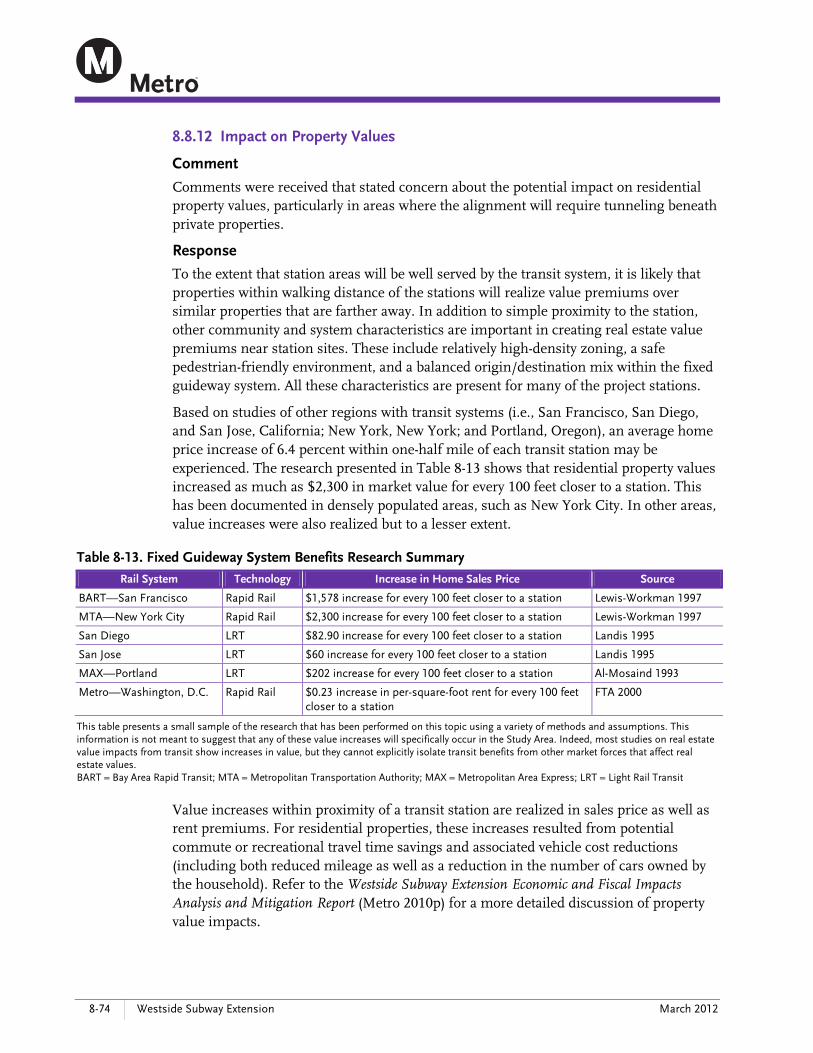
8-74 Westside Subway Extension March 2012
8.8.12 Impact on Property Values
Comment
Comments were received that stated concern about the potential impact on residential property values, particularly in areas where the alignment will require tunneling beneath private properties.
Response
To the extent that station areas will be well served by the transit system, it is likely that properties within walking distance of the stations will realize value premiums over similar properties that are farther away. In addition to simple proximity to the station, other community and system characteristics are important in creating real estate value premiums near station sites. These include relatively high-density zoning, a safe pedestrian-friendly environment, and a balanced origin/destination mix within the fixed guideway system. All these characteristics are present for many of the project stations.
Based on studies of other regions with transit systems (i.e., San Francisco, San Diego, and San Jose, California; New York, New York; and Portland, Oregon), an average home price increase of 6.4 percent within one-half mile of each transit station may be experienced. The research presented in Table 8-13 shows that residential property values increased as much as $2,300 in market value for every 100 feet closer to a station. This has been documented in densely populated areas, such as New York City. In other areas, value increases were also realized but to a lesser extent.
Table 8-13. Fixed Guideway System Benefits Research Summary
Rail System Technology Increase in Home Sales Price Source
BART—San Francisco Rapid Rail $1,578 increase for every 100 feet closer to a station Lewis-Workman 1997
MTA—New York City Rapid Rail $2,300 increase for every 100 feet closer to a station Lewis-Workman 1997
San Diego LRT $82.90 increase for every 100 feet closer to a station Landis 1995
San Jose LRT $60 increase for every 100 feet closer to a station Landis 1995
MAX—Portland LRT $202 increase for every 100 feet closer to a station Al-Mosaind 1993
Metro—Washington, D.C. Rapid Rail $0.23 increase in per-square-foot rent for every 100 feet closer to a station
FTA 2000
This table presents a small sample of the research that has been performed on this topic using a variety of methods and assumptions. This information is not meant to suggest that any of these value increases will specifically occur in the Study Area. Indeed, most studies on real estate value impacts from transit show increases in value, but they cannot explicitly isolate transit benefits from other market forces that affect real estate values. BART = Bay Area Rapid Transit; MTA = Metropolitan Transportation Authority; MAX = Metropolitan Area Express; LRT = Light Rail Transit
Value increases within proximity of a transit station are realized in sales price as well as rent premiums. For residential properties, these increases resulted from potential commute or recreational travel time savings and associated vehicle cost reductions (including both reduced mileage as well as a reduction in the number of cars owned by the household). Refer to the Westside Subway Extension Economic and Fiscal Impacts Analysis and Mitigation Report (Metro 2010p) for a more detailed discussion of property value impacts.
Chapter 8—Public and Agency Outreach
Final Environmental Impact Statement/Environmental Impact Report 8-75
Negative impacts on property values from transit (termed “nuisance” effects) also can occur. Measurable noise impacts from vehicles, increased foot traffic, adjacent struc-tures, transit-associated parking, and increased bus traffic interfacing with transit stations can reduce the desirability of properties near a fixed guideway station. Such nuisance effects will most likely occur in areas where value is not attributed to the accessibility improvements that transit provides. This does not appear likely within the Study Area, as stations are planned for areas that are already densely developed and near major roads and bus routes.
All residents and businesses displaced as a result of the LPA will be given advance written notice and will be informed of their eligibility for relocation assistance and payments under the Uniform Relocation Assistance and Real Property Acquisition Policies Act (USC 1995b). In areas where the subway operates under private property, Metro will work with the property owner to secure a subsurface easement. The following mitigation measures will be implemented to ensure just compensation for acquisitions and easements: CN-1—Metro will provide relocation assistance and compensation for all displaced
businesses and residences, as required by both the Uniform Relocation Assistance and Real Property Acquisition Act (USC 1995b) and the California Relocation Assistance Act (CCR 2011). All real property acquired by Metro will be appraised to determine its fair market value. Just compensation, which shall not be less than the approved appraisal, will be made to each displaced property owner. Each business and residence displaced as a result of the LPA will be given advance written notice and will be informed of their eligibility for relocation assistance and payments under the Uniform Act. It is anticipated that most businesses will relocate and, as such, most jobs will be relocated and will not be permanently displaced. However, there are permanent job losses anticipated. Metro shall coordinate with the appropriate jurisdictions regarding business relocations.
CN-3—For easements, Metro will appraise each property to determine the fair market value of the portion that will be used either temporarily during construction or permanently above and below ground. Just compensation, which shall not be less than the approved appraisal, will be made to each displaced property owner.
Refer to Sections 4.2.2, 4.2.3, and 4.2.4 for a discussion of the economic and fiscal impacts of the Project, including property acquisitions and easements.
8.8.13 Construction Impacts
Comment
Many commenters raised general concerns about construction impacts, including traffic congestion associated with delivery of construction materials or off-hauling of construc-tion spoils, noise and vibration, staging areas, and haul routes. Commenters also wanted to know how Metro will coordinate with the community during construction.
Response
The subway tunnels will be built using pressurized-face tunnel boring machines. Most of the tunneling happens completely below ground with little if any noticeable impact on

8-76 Westside Subway Extension March 2012
the surface. Impacts of construction and potential mitigation measures were further evaluated in this Final EIS/EIR. Section 3.8, Section 4.15, and Appendix E, Construction Methods, describe the construction process in detail. Table 4-60 provides a generalized sequence and approximate duration of construction activities and Table 4-61 provides an overall construction summary, including estimates of soil removed and haul truck trips per day. Section 3.8 identifies any transportation-related construction impacts, including traffic and circulation and parking, and Section 4.15 identifies any other construction impacts, including noise and vibration and air quality. Impacts during construction are almost entirely located at station areas where excavation from the surface is required. Typical impacts include temporary lane or roadway closures (to install decking over station areas or for temporary placement of construction equipment or materials), removal and hauling of earth from tunneling and station excavation, construction traffic and parking, potential detours to reach businesses or residences, and noise and air quality impacts. All construction impacts are temporary in duration. Section 3.8 and Section 4.15 also recommend mitigation measures to minimize effects of these construction impacts on businesses, residents, and property owners. All mitigation is also listed in Appendix I, Mitigation Monitoring and Reporting Plan.
Traffic Congestion and Haul Routes
Traffic impacts associated with LPA construction include reduced roadway traffic lanes and temporary street closures that could result in major traffic disruptions and bottlenecks. These impacts are associated with contractor work and storage areas, stations, crossovers, mining entry/exit locations, TBM operations and support activities, truck haul routes, transportation of oversized construction materials, station entrances, station appendages, grout injection, and drop holes for the LPA and are detailed in Section 3.8.2.
Subway stations are built by excavating the site for the station box and then building the station below ground. If the station is built under a street, it is covered over with concrete decking during construction to allow traffic to continue to flow overhead. Traffic will be disrupted at the beginning of station construction to allow for initial excavation and installation of the concrete decking, and again at the end to remove the decking and reconstruct the street. Table 3-19 in Section 3.8 details the traffic-control activities during station construction and the duration of each activity.
Anticipated truck haul routes consist of major city arterial streets that trucks will use to transport spoils, muck, material, and equipment between the construction laydown site locations and the offsite disposal location using the nearest freeway interchange. To minimize peak-period traffic disruptions, haul truck activity will occur during off-peak and nighttime periods. These routes generally follow major commercial streets and avoid residential areas to the greatest extent possible. The proposed routes identified are provided in Section 3.8 of this Final EIS/EIR and the Westside Subway Extension Construction Traffic Analysis Report (Metro 2011ai). The routes may be updated and revised once additional information, such as construction sequencing, is finalized. In addition, the proposed routes will be subject to the approval of Metro and appropriate departments at federal, state, and local agencies. The routes will be finalized in

Chapter 8—Public and Agency Outreach
Final Environmental Impact Statement/Environmental Impact Report 8-77
coordination with local jurisdictions and will be located so as to minimize noise, vibration, and other possible impacts to adjacent businesses and neighborhoods.
TBM components will be transported to the tunnel construction site by truck. Several oversize deliveries will be required, some during nights and weekends. However, these large component deliveries are limited to the initial setup period for the TBM, as well as during the removal period. If a TBM is re-used to excavate a subsequent tunnel, the entire machine may be transported by road from one site to the next. This would require full or partial road closures, typically at night.
Following completion of the Project, if physical damage to haul routes was found, affected roads will be treated in a manner that returns affected facilities to pre-construction conditions. This work will restore the street or ground surface to its original condition, or better. Site restoration operations will closely follow completion of the station structures. To maintain traffic flow, one-half of a street will be restored at a time and/or restoration will occur over weekends to enable an entire street to be temporarily closed to through traffic.
Backfill material will be trucked in, placed, and compacted. During backfilling over stations, utilities will be installed along with new sewer manholes and cable/duct vaults. Sidewalks will be restored, and the permanent street will be constructed, including paving, striping, and signage. Streets, sidewalks, and landscaping will be restored in accordance with City standards.
To minimize impacts to traffic circulation, the following mitigation measures will be implemented during construction: TCON-1—Traffic Control Plans TCON-2—Designated Haul Routes TCON-3—Emergency Vehicle Access TCON-4—Transportation Management Plan TCON-5—Coordination with Planned Roadway Improvements
T-CON-2, TCON-3, TCON-4, TCON-5 were added during this Final EIS/EIR phase based on additional analysis of construction impacts on traffic circulation and concerns raised by the public. With implementation of the mitigation, construction-related adverse effects on traffic circulation will be reduced for adjacent commercial areas and residential neighborhoods. Although the construction impacts on traffic circulation identified will be temporary, impacts or residual impacts after mitigation will remain significant and unavoidable during the construction period.
Construction Noise and Vibration
The greatest noise impacts will occur near stations, tunnel access portals, and construc-tion laydown areas where construction activities at the surface are concentrated. In addition, haul routes will experience increased truck traffic, which could add to traffic noise. With the exception of these areas, all other construction will occur completely below-grade. Section 4.15.3 analyzes construction noise impacts and mitigation measures.

8-78 Westside Subway Extension March 2012
When the construction site for the station box is open, noise from construction equip-ment will be audible at street level and result in an adverse effect. This time period will produce the highest levels of construction noise. The excavation and installation of street decking is expected to last four to five months. As the excavation continues below street level, the noise of construction will be reduced because the sides of the excavated opening will act as a sound barrier. Eventually when the surface opening is covered with temporary decking, construction noise at the surface will no longer be noticeable above the traffic noise. Therefore, the excavation of the station box will result in a temporary adverse noise effect.
To reduce the potential for noise and vibration impacts to schools associated with construction, Metro’s plans, specifications, and estimates (bid) documents will include measures to comply with the City of Los Angeles, City of Beverly Hills, and County of Los Angeles noise ordinances during construction hours. To further reduce noise impacts during construction, the following mitigation measures will be implemented: CON-22—Hire or Retain the Services of an Acoustical Engineer CON-23—Prepare a Noise Control Plan CON-24—Comply with the Provisions of the Nighttime Noise Variance CON-25—Noise Monitoring CON-26—Use of Specific Construction Equipment at Night CON-27—Noise Barrier Walls for Nighttime Construction CON-28—Comply with Local Noise Ordinances CON-29—Signage CON-30—Use of Noise Control Devices CON-31—Use of Fixed Noise-producing Equipment for Compliance CON-32—Use of Mobile or Fixed Noise-producing Equipment CON-33—Use of Electrically Powered Equipment CON-34—Use of Temporary Noise Barriers and Sound-control Curtains CON-35—Distance from Noise-sensitive Receivers CON-36—Limited Use of Horns, Whistles, Alarms, and Bells CON-37—Requirements on Project Equipment CON-38—Limited Audibility of Project-related Public Addresses or Music CON-39—Use of Haul Routes with the Least Overall Noise Impact CON-40—Designated Parking Areas for Construction-related Traffic TCON-2—Designated Haul Routes CON-41—Enclosures for Fixed Equipment
Although mitigation measures will help to reduce noise impacts during construction, an adverse construction noise effect will remain after mitigation in the construction areas.
In addition to noise impacts, construction of the LPA will result in vibration impacts. Impact pile driving at the station boxes will result in adverse vibration impacts. Perceptible vibration levels could be experienced within 200 feet of pile driving operations. Additionally, equipment used for underground construction, such as the TBM and mine trains, could generate vibration levels that could result in audible ground-borne noise levels in buildings at the surface, depending on the depth of the tunnel and soil conditions. Tunneling under residences and schools will occur for a
Chapter 8—Public and Agency Outreach
Final Environmental Impact Statement/Environmental Impact Report 8-79
limited time. The TBM tunnels between 30 and 100 feet per day. For an average residence or business, this means that the TBMs would be below the surface of that structure for no more than a day or two. Since underground construction is expected to occur continuously over a 24-hour day, there is the potential for the tunnel boring operation to be audible during nighttime sleep hours when background noise levels inside residential buildings are very low. However, as indicated, the period for this potential disruption would be limited to a few days or less and mitigation measures would be implemented to minimize impacts.
The contractor will be responsible for the protection of vibration-sensitive historic buildings or cultural resource structures within 200 feet of any construction activity. To ensure that noise and vibration impacts associated with construction are below threshold levels, Metro’s plans, specifications, and estimates (bid) documents will include the following measures: CON-42—Phasing of Ground-impacting Operations CON-43—Alternatives to Impact Pile Driving CON-44—Alternative Demolition Methods CON-45— Restriction on Use of Vibratory Rollers and Packers CON-46—Metro Ground-borne Noise and Ground-borne Vibration Limits
If the Metro ground-borne noise limits or ground-borne vibration limits are exceeded during tunneling, the contractor will be required to take action to reduce vibrations to acceptable levels. Such action could include reducing the muck train speed, additional rail and tie isolation, and more frequent rail and wheel maintenance. However, there were no substantiated noise-level complaints made during tunneling for the Metro Gold Line Eastside Extension. Therefore, with mitigation, there will be no construction-related vibration adverse effects due to tunneling activities.
Construction Staging Areas
Contractor staging areas (also referred to as “laydown areas”) will be necessary for tunnel construction, stations, and ancillary facilities. Off-street space will be needed for setup, insertion, operation, and extraction of equipment and materials to the tunnel and station excavations.
Work areas will be needed to support tunnel excavation operations, including processing and removing tunnel spoils (excavated materials), handling precast concrete tunnel-lining segments, and tunnel utilities (such as ventilation, water supply and return, and power supply). In-street work areas will only be used when no off-street alternatives exists. Temporary easements, typically a portion of the sidewalk, traffic lanes, or parking areas, may be required at various locations for staging.
The proposed staging areas were addressed as part of the Draft EIS/EIR in the Westside Subway Extension Real Estate and Acquisitions Technical Report (Metro 2010c), and in Chapter 2 and Appendix C of the Draft EIS/EIR. These proposed areas were refined and/or eliminated from further consideration for staging during preparation of this Final EIS/EIR. The staging areas identified for the LPA are shown in the Westside Subway Extension Acquisitions and Displacement Supplemental Report (Metro 2011c) and Chapter 2, Alternatives Considered, and Appendix C, Acquisitions, of this Final
8-80 Westside Subway Extension March 2012
EIS/EIR. It is important to note that several construction staging site alternatives are under consideration at a few station locations and are evaluated in this Final EIS/EIR. Selection of the construction staging site will consider where the station entrances could be co-located, environmental impacts, and cost as well as other factors. The decision will be made by the Metro Board of Directors following circulation and public review of this Final EIS/EIR.
Community Coordination
Metro will coordinate with affected residents and businesses prior to construction. A detailed survey of community stakeholders and businesses will be conducted in advance of construction. A construction safety campaign will be developed and community response protocols (notification of construction activities, hot lines, etc.) will be produced. A public involvement plan will be developed prior to each construction phase and will be tailored to the construction phase. Metro will maintain the project website, which will provide information to the public regarding construction phasing. Metro will develop a program tailored for different locations and needs. The program will involve signage and marketing assistance to businesses, identification of parking alternatives, and other measures.
Metro will maintain integrated field offices with Metro and contractor staff and monitor compliance with mitigation measures finalized during this Final EIS/EIR phase. Monitoring efforts will ensure that the environmental commitments in this Final EIS/EIR and the permit conditions are met during Final Design and construction of the LPA. Metro will employ a dedicated environmental compliance manager to oversee construction contractor compliance with all stormwater best management practices, construction noise mitigation measures, utility coordination, business access requirements, and all other mitigation plans prepared for the LPA.