Embed Size (px)
Citation preview

107
CHAPTER 4
CASE STUDIES OF SELECTED STREETS IN CHENNAI
4.1 INTRODUCTION
Chennai, earlier known as Madras, is the capital of the state of
Tamilnadu situated in southern India, as depicted in Figure 4.1. It is one of the
large metropolitan cities of India. A heady mixture of hoary tradition and
contemporary glitz, Chennai has witnessed unprecedented growth in recent
years, due principally to the information technology boom. The spurt in
urbanization and the resultant population has led to its infrastructure coming
under severe strain. This has resulted in development in the road
infrastructure, but usually at the cost of pedestrian facilities. Hence, Chennai
would serve as an apt example to test the efficacy of the proposed method.
Figure 4.1 Location of Chennai in Southern India
Source: Readers Digest Illustrated Atlas of the World, Readers Digest Limited, London (1997)
CHENNAI
(Madras)

108
4.2. SURVEY DESIGN AND FIELD STUDY
4.2.1. Method
A comprehensive survey of the selected stretch of pedestrian space was
carried out with the help of a checklist, at different times in the morning and
evening. The surveyors were required to evaluate the overall and detailed
characteristics of the pedestrian space.
4.2.2. Sampling framework
Streets in Chennai with significant pedestrian traffic were identified. A wide
variety of streets were taken up for study – Commercial, Residential,
Institutional, Recreational, etc. The location of the selected streets is shown in
Figure 4.2 while a description of the characteristics of each street is provided
in Table 4.1.
The selected street is divided into different stretches, to analyse it more
comprehensively. These stretches vary considerably in terms of function,
context and usage. Thus, the proposed method would be tested against a
diverse range of parameters.
An attempt was made to select streets of varying function and character to test
the suitability of the proposed method. Thus, streets of a predominantly
commercial character like Ranganathan Street and Rajaji Salai, Mixed use
areas like Gandhinagar First Main Road and streets in institutional areas like
Sardar Patel Road and Pantheon Road were evaluated, as were streets in
residential areas like Gandhi Nagar Second Main Road.
The key criteria in selecting these stretches were:
1. The presence of an observed steady-to-high pedestrian flow
throughout the day.
2. The existence of different activities imparting character to the
street.
109
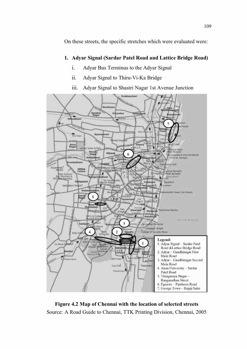
On these streets, the specific stretches which were evaluated were:
1. Adyar Signal (Sardar Patel Road and Lattice Bridge Road)
i. Adyar Bus Terminus to the Adyar Signal
ii. Adyar Signal to Thiru-Vi-Ka Bridge
iii. Adyar Signal to Shastri Nagar 1st Avenue Junction
Figure 4.2 Map of Chennai with the location of selected streets
Source: A Road Guide to Chennai, TTK Printing Division, Chennai, 2005

110
Table 4.1 Location and characteristics of streets selected for evaluation
S.No. Street Location Characteristics
1 Sardar Patel
Road and
Lattice Bridge
Road
Adyar The prime arteries of Adyar – a
residential area converted into a
commercial centre with high traffic.
2 Gandhinagar
First Main
Road
Adyar The gateway to Gandhinagar – a
serene residential layout – lined
with commercial complexes,
restaurants and showrooms.
3 Gandhinagar
Second Main
Road
Adyar This road still retains its original
residential character.
4 Sardar Patel
Road
Guindy An Institutional zone, the road is
lined on both sides by educational
institutions, the Governor’s
residence and memorials.
5 Ranganathan
Street
Theagaraya
Nagar
A famous icon of T.Nagar, it is
renowned for being a shopper’s
paradise.
6 Pantheon
Road
Egmore The main artery of Egmore – a busy
commercial and institutional area
and one of the gateways of Chennai.
7 Rajaji Salai George
Town
One of the prime arteries of George
Town lined with Government
offices, heritage buildings and
provides access to Chennai Port.

111
2. Gandhi Nagar 1st Main Road
i. Canal Bank Road to 3rd Cross Street
ii. 3rd Cross Street to 2nd Cross Street
iii. 2nd Cross Street to 4th Main Road
3. Gandhi Nagar 2nd Main Road
i. Canal Bank Road to 3rd Cross Street
ii. 3rd Cross Street to 2nd Cross Street
iii. 2nd Cross Street to 4th Main Road
4. Sardar Patel Road
i. Raj Bhavan Junction to the Anna University Main Entry
ii. Anna University Entry to Gandhi Mandapam Junction
iii. Gandhi Mandapam Junction to Madhya Kailash Junction
5. Ranganathan Street
i. Ranganathan Street
6. Pantheon Road
i. Co-optex to Casa Major Road
ii. Casa Major Road to the Museum
iii. The Museum to the Police Commissioner’s Office Road
7. Rajaji Salai
i. N.S.C.Bose Road to Nalla Muthu Street
ii. Nalla Muthu Street to Narayanappa Street
iii. Narayanappa Street to Ebrahim Sahib Street
4.2.3. Survey proforma
A detailed survey proforma was designed based on the qualitative evaluation
method proposed in sections 3.3, 3.4, 3.5, and 3.6 of chapter three. This
proforma is divided into two sections:
112
1. Evaluation of Overall level characteristics
This would provide a broad picture of the existing environment,
and help in enhancing the overall levels of safety, comfort, convenience and
the quality of the urban environment as experienced by the pedestrian.
2. Evaluation of Detailed level characteristics
This would help in identifying problems on a detailed level, within
each of the overall parameters of safety, comfort, convenience and the urban
environment.
4.2.4. Manpower & Time taken
A total of eighty surveyors comprising of the fourth year students
of the Bachelor of Architecture program at the School of Habitat, Sathyabama
University, Chennai were involved in the entire exercise, over a period of four
months. Each street was evaluated by a group comprising of eleven and in
some cases twelve students. Each group was further subdivided into smaller
groups to collect information regarding safety, comfort, convenience, and the
urban environment. A comprehensive and accurate evaluation requires
surveys to be carried out at different times of the day. One survey was carried
out in the morning and another in the evening. This was carried out by
different sets of surveyors within the same group. The specific time varied
across different streets, because of their unique character. In order to study the
conditions when maximum number of pedestrians was present, usually peak
hours relative to the particular street were chosen.
4.2.5. Limitations
1. This research has relied on data collected from a detailed
observation of the pedestrian environment for testing the
113
method, by these groups of surveyors who assume the role of
pedestrians. Primarily the method does not require users’
observations to be recorded as part of a questionnaire, as no
particular details of the pedestrian journey being undertaken are
required. Some parameters necessitated a deeper knowledge of
the case study site conditions for example frequency of
patrolling, level of noise throughout the day, effect of noise and
air pollution on roadside cafes and other activities, shortcuts,
traditional rituals and gatherings. In these cases, the input from
vendors and local residents were relied upon.
2. There is scope for subjective interpretation during the
evaluation process. Some parameters, particularly the
characteristics of the urban environment, are subjective.
However, this can be curtailed to a great deal by utilizing the
services of various groups of evaluators to evaluate the same
stretch during different stages of the process.
3. The process requires the involvement of a large number of
surveyors, who would have to make repeated visits to the sites
to collect the required data.
4.2.6. Analysis
The data obtained is collated, and then weighed against the
parameters of the Overall and Detailed characteristics of Safety, Comfort,
Convenience and the Urban Environment. The appropriate grade is selected
based on the highest number of parameters satisfied. If the data satisfy the
parameters of two grades, a combined grading is assigned.
114
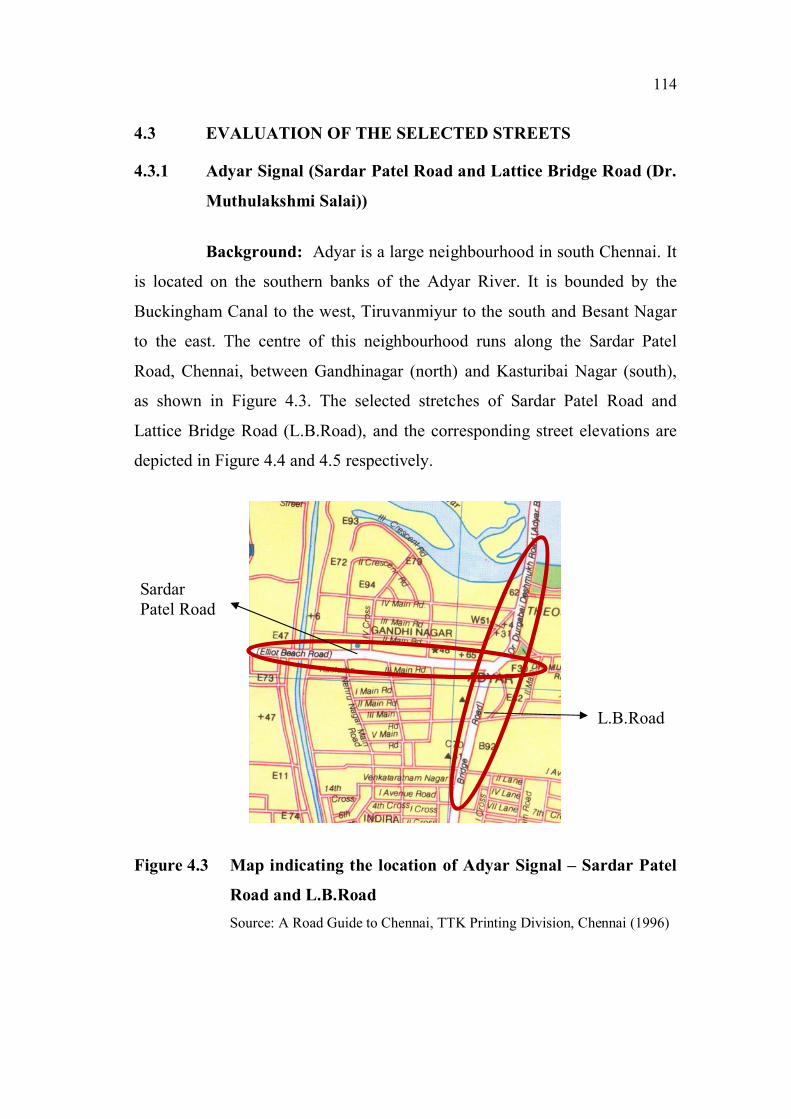
4.3 EVALUATION OF THE SELECTED STREETS
4.3.1 Adyar Signal (Sardar Patel Road and Lattice Bridge Road (Dr.
Muthulakshmi Salai))
Background: Adyar is a large neighbourhood in south Chennai. It
is located on the southern banks of the Adyar River. It is bounded by the
Buckingham Canal to the west, Tiruvanmiyur to the south and Besant Nagar
to the east. The centre of this neighbourhood runs along the Sardar Patel
Road, Chennai, between Gandhinagar (north) and Kasturibai Nagar (south),
as shown in Figure 4.3. The selected stretches of Sardar Patel Road and
Lattice Bridge Road (L.B.Road), and the corresponding street elevations are
depicted in Figure 4.4 and 4.5 respectively.
Figure 4.3 Map indicating the location of Adyar Signal – Sardar Patel
Road and L.B.Road
Source: A Road Guide to Chennai, TTK Printing Division, Chennai (1996)
L.B.Road
Sardar
Patel Road
115
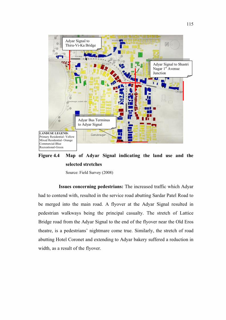
Figure 4.4 Map of Adyar Signal indicating the land use and the
selected stretches
Source: Field Survey (2008)
Issues concerning pedestrians: The increased traffic which Adyar
had to contend with, resulted in the service road abutting Sardar Patel Road to
be merged into the main road. A flyover at the Adyar Signal resulted in
pedestrian walkways being the principal casualty. The stretch of Lattice
Bridge road from the Adyar Signal to the end of the flyover near the Old Eros
theatre, is a pedestrians’ nightmare come true. Similarly, the stretch of road
abutting Hotel Coronet and extending to Adyar bakery suffered a reduction in
width, as a result of the flyover.
Adyar Signal to
Thiru-Vi-Ka Bridge
Adyar Bus Terminus
to Adyar Signal
Adyar Signal to Shastri
Nagar 1st Avenue
Junction
LANDUSE LEGEND:
Primary Residential- Yellow
Mixed Residential- Orange
Commercial-Blue
Recreational-Green
116
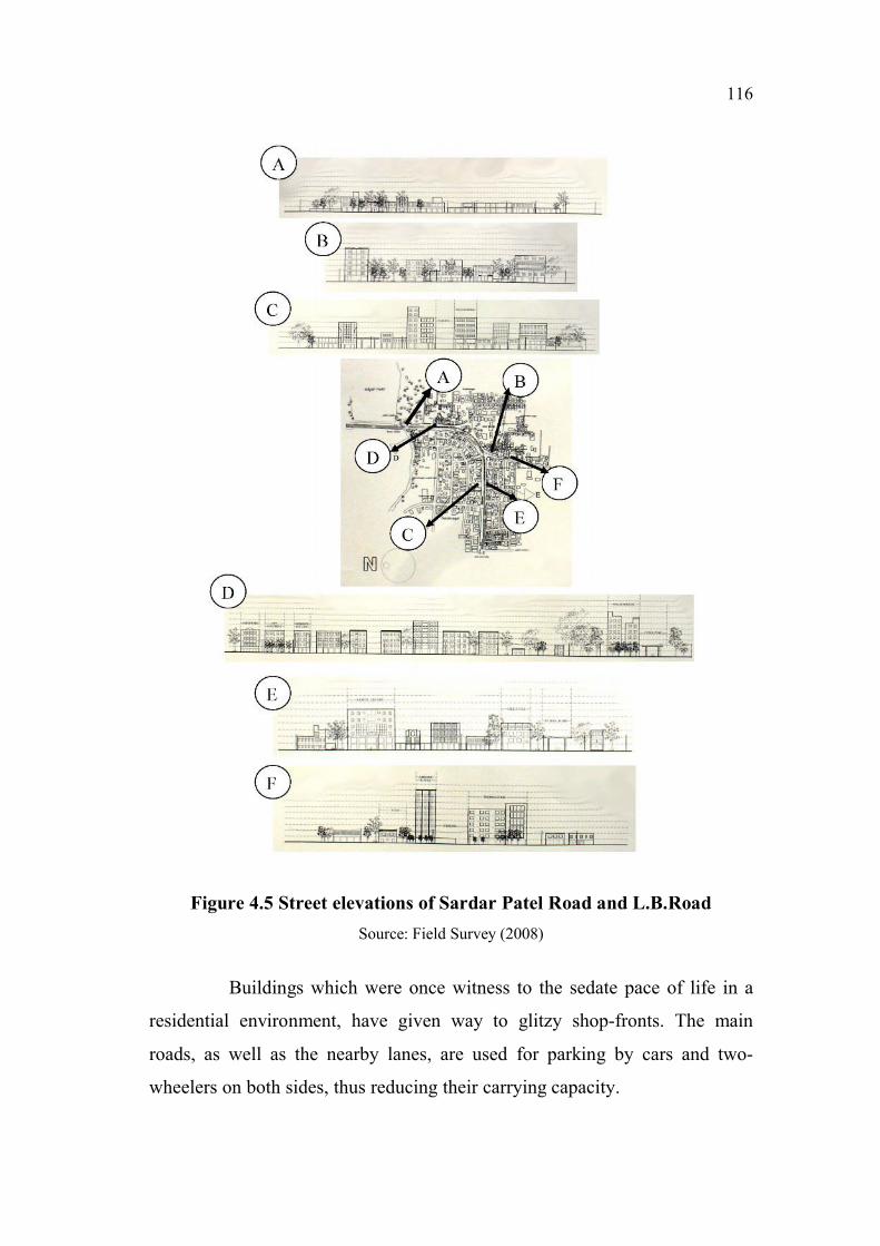
Figure 4.5 Street elevations of Sardar Patel Road and L.B.Road
Source: Field Survey (2008)
Buildings which were once witness to the sedate pace of life in a
residential environment, have given way to glitzy shop-fronts. The main
roads, as well as the nearby lanes, are used for parking by cars and two-
wheelers on both sides, thus reducing their carrying capacity.

117
There is a constant flow of people – shoppers, office workers,
employees of the commercial establishments, students, and others. But this
has not translated into better amenities or facilities for people.
Sidewalks are either not maintained properly, or are encroached
upon as shown in Figure 4.6 and Figure 4.7.
Table 4.2 and Table 4.3 highlight the results of the evaluation of the
Overall Safety characteristics while Table 4.4 and Table 4.5 depict the results
of the evaluation of the Detailed Safety characteristics.
Figure 4.6 Obstacles on the sidewalk of Sardar Patel road
Source: Field Survey (2008)
Figure 4.7 Parking on the sidewalk of L.B.Road
Source: Field Survey (2008)

118
Table 4.2 Cumulative Rating of the Overall Safety characteristics of
Adyar Signal (Sardar Patel Road)
Street Adyar Signal
Parameter
Stretch
Level of interaction with vehicles
and Consideration for the vulnerable
pedestrian
Adyar Bus Terminus to Adyar Signal D
Adyar Signal to Thiru-Vi-Ka Bridge D
Cumulative Rating of Overall Safety
CharacteristicsD
Source: Field Survey (2008)
Table 4.3 Cumulative Rating of the Overall Safety characteristics of
Adyar Signal (L.B. Road)
Street Adyar Signal
Parameter
Stretch
Level of interaction with vehicles
and Consideration for the vulnerable
pedestrian
Adyar Signal to Shastri Nagar 1st
Avenue JunctionD
Cumulative Rating of Overall Safety
CharacteristicsD
Source: Field Survey (2008)
Table 4.4 Cumulative Rating of the Detailed Safety characteristics of
Adyar Signal (Sardar Patel Road)
Street Adyar Signal
Parameter
Stretch
Deg
ree
of
ob
stru
ctio
n o
n t
he
sid
ew
alk
s
Sid
ewalk
su
rfa
ce
con
dit
ion
s
Deg
ree
of
con
flic
t at
cro
ssin
gs
Des
ign
pri
nci
ple
s
ad
op
ted
for
ped
estr
ian
sec
uri
ty
Des
ign
pri
nci
ple
s
ad
op
ted
for
traff
ic
calm
ing
Adyar Bus Terminus to Adyar Signal C C/D E A/C D/E
Adyar Signal to Thiru-Vi-Ka Bridge C C E A E
Cumulative Rating of Detailed SafetyCharacteristics
C D E C E
Source: Field Survey (2008)

119
Table 4.5 Cumulative Rating of the Detailed Safety characteristics of
Adyar Signal (L.B. Road)
Street Adyar Signal
Parameter
Stretch Deg
ree
of
ob
stru
ctio
n o
n t
he
sid
ew
alk
s
Sid
ewalk
su
rfa
ce
con
dit
ion
s
Deg
ree
of
con
flic
t
at
cro
ssin
gs
Des
ign
pri
nci
ple
s
ad
op
ted
for
ped
estr
ian
sec
uri
ty
Des
ign
pri
nci
ple
s
ad
op
ted
for
traff
ic
calm
ing
Adyar Signal to Shastri Nagar 1st
Avenue JunctionE C/D E A E
Cumulative Rating of DetailedSafety Characteristics
E D E A E
Source: Field Survey (2008)
The rating for Overall Safety – “D” – signifies that pedestrians
encounter significant conflicts with vehicles, and consideration for the vulnerable
pedestrians, i.e., children, the elderly and the disabled, is meagre or nil.
The evaluation of the Detailed Safety characteristics emphasizes
the deficiencies across the pedestrian environment. The street obtained a
rating of “C” for the “Degree of obstruction on the sidewalks” because of the
inadequate width of the sidewalk on some stretches, encroachment by street
furniture, vendors, and parking. For “Sidewalk Surface Conditions”, it
received a rating of “D”. The absence of refuge areas, pedestrian-operated
signals, pedestrian phase in signals and signage, resulted in a rating of “E” for
the “Degree of conflict at crossings”. In terms of “Pedestrian Security”, high
levels of activity were observed at some places; the adequately dense
concentration of people and sufficient illumination by high-level street lights
earned the street a rating of “C”. The “Design principles for Traffic Calming”
were almost negligible resulting in a rating of “E”.
The results of the evaluation of the Overall Comfort characteristics
are shown in Table 4.6 and Table 4.7. Table 4.8 and Table 4.9 highlight the
results of the evaluation of the Detailed Comfort characteristics.

120
Table 4.6 Cumulative Rating of the Overall Comfort characteristics of
Adyar Signal (Sardar Patel Road)
Street Adyar Signal
Parameter
Stretch
Physiological Comfort and
Psychological Comfort
Adyar Bus Terminus to Adyar Signal 10 AM C
Adyar Bus Terminus to Adyar Signal 6 PM A/C/D
Adyar Signal to Thiru-Vi-Ka Bridge C
Cumulative Rating of Overall Comfort
CharacteristicsD
Source: Field Survey (2008)
Table 4.7 Cumulative Rating of the Overall Comfort characteristics of
Adyar Signal (L.B. Road)
Street Adyar Signal
Parameter
Stretch
Physiological Comfort and
Psychological Comfort
Adyar Signal to Shastri Nagar 1st
Avenue JunctionC
Cumulative Rating of Overall Comfort
CharacteristicsC
Source: Field Survey (2008)
Table 4.8 Cumulative Rating of the Detailed Comfort characteristics of
Adyar Signal (Sardar Patel Road)
Street Adyar Signal
Parameter
Stretch
Protection
from
inclement
weather
Noise
Pollution
Air
Pollution
Facilitation
of allied
activities
Adyar Bus Terminus to Adyar
SignalD C/E E E
Adyar Signal to Thiru-Vi-Ka
BridgeC A/E A/E C
Cumulative Rating of
Detailed Comfort
Characteristics
D E E E
Source: Field Survey (2008)
121
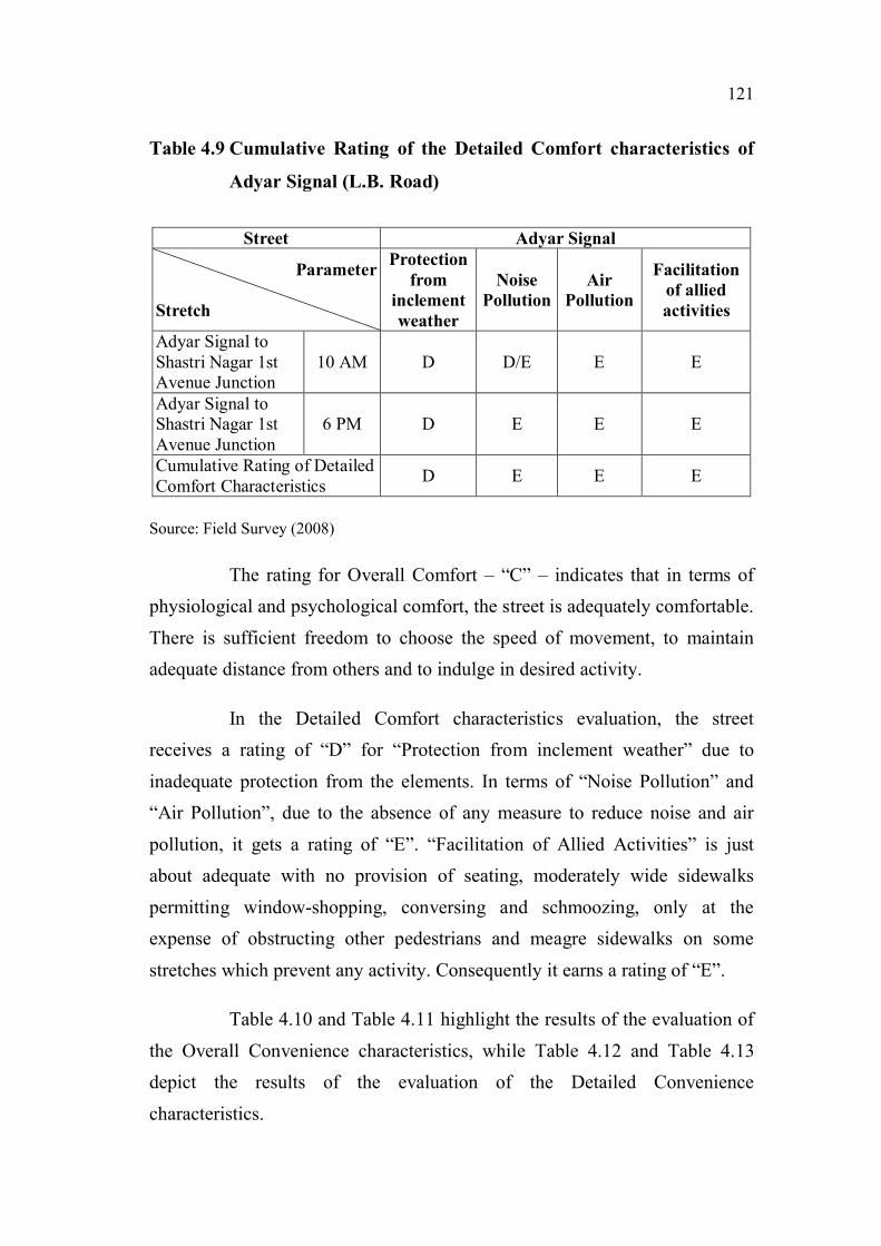
Table 4.9 Cumulative Rating of the Detailed Comfort characteristics of
Adyar Signal (L.B. Road)
Street Adyar Signal
Parameter
Stretch
Protection
from
inclement
weather
Noise
Pollution
Air
Pollution
Facilitation
of allied
activities
Adyar Signal to
Shastri Nagar 1st
Avenue Junction
10 AM D D/E E E
Adyar Signal to
Shastri Nagar 1st
Avenue Junction
6 PM D E E E
Cumulative Rating of Detailed
Comfort CharacteristicsD E E E
Source: Field Survey (2008)
The rating for Overall Comfort – “C” – indicates that in terms of
physiological and psychological comfort, the street is adequately comfortable.
There is sufficient freedom to choose the speed of movement, to maintain
adequate distance from others and to indulge in desired activity.
In the Detailed Comfort characteristics evaluation, the street
receives a rating of “D” for “Protection from inclement weather” due to
inadequate protection from the elements. In terms of “Noise Pollution” and
“Air Pollution”, due to the absence of any measure to reduce noise and air
pollution, it gets a rating of “E”. “Facilitation of Allied Activities” is just
about adequate with no provision of seating, moderately wide sidewalks
permitting window-shopping, conversing and schmoozing, only at the
expense of obstructing other pedestrians and meagre sidewalks on some
stretches which prevent any activity. Consequently it earns a rating of “E”.
Table 4.10 and Table 4.11 highlight the results of the evaluation of
the Overall Convenience characteristics, while Table 4.12 and Table 4.13
depict the results of the evaluation of the Detailed Convenience
characteristics.

122
Table 4.10 Cumulative Rating of the Overall Convenience characteristics
of Adyar Signal (Sardar Patel Road)
Street Adyar Signal
Parameter
StretchPath characteristics
Adyar Bus Terminus to Adyar Signal A
Adyar Signal to Thiru-Vi-Ka Bridge A/E
Cumulative Rating of Overall
Convenience CharacteristicsE
Source: Field Survey (2008)
Table 4.11 Cumulative Rating of the Overall Convenience characteristics
of Adyar Signal (L.B. Road)
Street Adyar Signal
Parameter
StretchPath characteristics
Adyar Signal to Shastri Nagar 1st
Avenue JunctionE
Cumulative Rating of Overall
Convenience CharacteristicsE
Source: Field Survey (2008)
Table 4.12 Cumulative Rating of the Detailed Convenience characteristics
of Adyar Signal (Sardar Patel Road)
Street Adyar Signal
Parameter
Stretch
Legibility of
the pedestrian
environment
Pedestrian
amenities
Pedestrian
crossings
Adyar Bus Terminus to Adyar
SignalB/C/D E C/E
Adyar Signal to Thiru-Vi-Ka
BridgeA E D/E
Cumulative Rating of Detailed
Convenience CharacteristicsD E E
Source: Field Survey (2008)

123
Table 4.13 Cumulative Rating of the Detailed Convenience
characteristics of Adyar Signal (L.B. Road)
Street Adyar Signal
Parameter
Stretch
Legibility of the
pedestrian
environment
Pedestrian
amenities
Pedestrian
crossings
Adyar Signal to Shastri Nagar
1st Avenue Junction
D E E
Cumulative Rating of Detailed
Convenience Characteristics
D E E
Source: Field Survey (2008)
The evaluation of the Overall Convenience – “A” and “E” – reveals
that the street is severely deficient in terms of impedances.
The Detailed level evaluation highlights the following issues. The
evaluation of the “Legibility of the pedestrian environment” shows that
though the street has sufficient landmark buildings, street activities, physical
and visual linkages and nodes, in terms of street furniture and signage it is
woefully inadequate. Consequently, it gets a rating of “D”. A complete
absence of “Pedestrian Amenities” earns it a rating of “E”. In terms of
“Pedestrian Crossings”, even though crossings are at-grade, the absence of
curb ramps, audible and tactile cues, and pedestrian operated signals, causes
the street to receive a rating of “E”.
The results of the evaluation of the Overall Urban Environment
characteristics are shown in Table 4.14 and Table 4.15, while Table 4.16 and
Table 4.17 highlight the results of the evaluation of the Detailed Urban
Environment characteristics.

124
Table 4.14 Cumulative Rating of the Overall Urban Environment
characteristics of Adyar Signal (Sardar Patel Road)
Street Adyar Signal
Parameter
Stretch
Imageability and Qualities of the
street
Adyar Bus Terminus to Adyar Signal B
Adyar Signal to Thiru-Vi-Ka Bridge A
Cumulative Rating of Overall Urban
Environment CharacteristicsB
Source: Field Survey (2008)
Table 4.15 Cumulative Rating of the Overall Urban Environment
characteristics of Adyar Signal (L.B. Road)
Street Adyar Signal
Parameter
Stretch
Imageability and Qualities of the
street
Adyar Signal to Shastri Nagar 1st
Avenue JunctionD
Cumulative Rating of Overall Urban
Environment CharacteristicsD
Source: Field Survey (2008)
Table 4.16 Cumulative Rating of the Detailed Urban Environment
characteristics of Adyar Signal (Sardar Patel Road)
Street Adyar Signal
Parameter
Stretch
Ch
ara
cter
isti
cs
of
bu
ild
ing
s
Ad
her
ence
to
hu
ma
n s
ca
le
Perm
ea
bil
ity
Vari
ety
Leg
ibil
ity
Ro
bu
stn
ess
Ric
hn
ess
Per
son
ali
zati
on
Adyar Bus Terminus to
Adyar SignalE D C/E C B B/C/D E E
Adyar Signal to Thiru-Vi-Ka
BridgeE D D D A C E E
Cumulative Rating of
Detailed Urban Environment
Characteristics
E D E D B D E E
Source: Field Survey (2008)
125
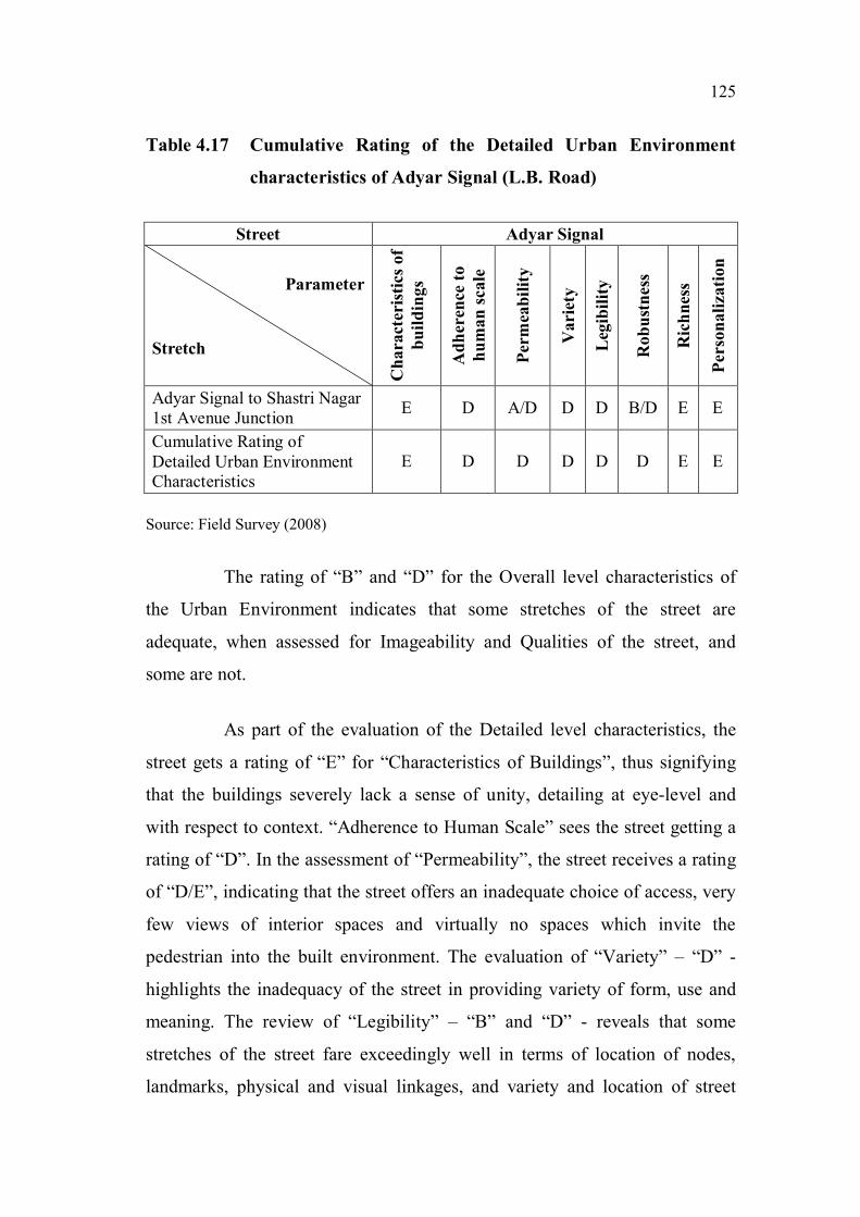
Table 4.17 Cumulative Rating of the Detailed Urban Environment
characteristics of Adyar Signal (L.B. Road)
Street Adyar Signal
Parameter
Stretch
Ch
ara
cter
isti
cs o
f
bu
ild
ing
s
Ad
her
ence
to
hu
ma
n s
ca
le
Per
mea
bil
ity
Vari
ety
Leg
ibil
ity
Ro
bu
stn
ess
Ric
hn
ess
Per
son
ali
zati
on
Adyar Signal to Shastri Nagar
1st Avenue JunctionE D A/D D D B/D E E
Cumulative Rating of
Detailed Urban Environment
Characteristics
E D D D D D E E
Source: Field Survey (2008)
The rating of “B” and “D” for the Overall level characteristics of
the Urban Environment indicates that some stretches of the street are
adequate, when assessed for Imageability and Qualities of the street, and
some are not.
As part of the evaluation of the Detailed level characteristics, the
street gets a rating of “E” for “Characteristics of Buildings”, thus signifying
that the buildings severely lack a sense of unity, detailing at eye-level and
with respect to context. “Adherence to Human Scale” sees the street getting a
rating of “D”. In the assessment of “Permeability”, the street receives a rating
of “D/E”, indicating that the street offers an inadequate choice of access, very
few views of interior spaces and virtually no spaces which invite the
pedestrian into the built environment. The evaluation of “Variety” – “D” -
highlights the inadequacy of the street in providing variety of form, use and
meaning. The review of “Legibility” – “B” and “D” - reveals that some
stretches of the street fare exceedingly well in terms of location of nodes,
landmarks, physical and visual linkages, and variety and location of street

126
activities, whereas others are inadequate. In the evaluation of “Robustness” –
“D” – the inadequate diversity of activities and adaptability of buildings to
multiple uses are highlighted. The street receives a rating of “E” for
“Richness” in terms of sensory experiences with nothing on offer for the
olfactory, kinetic and tactile senses. In terms of “Personalisation” too, the
street falls woefully short, in terms of enhancing the pedestrian environment
through personalization of personal as well as public space.
4.3.2 Gandhinagar First Main Road
Background: Gandhinagar is a residential layout located in Adyar
in South Chennai. It is bordered by the Adyar River on the north, the
Buckingham canal on the west and Sardar Patel Road on the south and east.
Figure 4.8 displays the location of Gandhinagar First Main Road.
Figure 4.8 Map indicating the location of Gandhinagar First Main Road
Source: A Road Guide to Chennai, TTK Printing Division, Chennai (1996)
From a serene residential area with large individual bungalows,
Gandhinagar has evolved into a posh area with more apartments than
individual houses. The fringes have become commercialised with the First
Gandhinagar
First Main Road
127
Main Road being dotted with commercial complexes, restaurants and
showrooms. All the top brands are represented on this short stretch.
Showrooms of Pantaloons, Titan watches, Shahs, Basics, NaiHaa, Viveks,
Parryware and Woodlands, restaurants like Sri Krishna Sweets, Sangeetha’s,
Kumarakom and Rainforest, branches of the Indian Bank, the Andhra Bank
and HSBC apart from Odyssey, Spencer’s Foodworld, and Nuts and Spices
can be found.
The First Main Road is bordered by the Adyar Bus Terminus from
where the MTC operates intra-city buses.
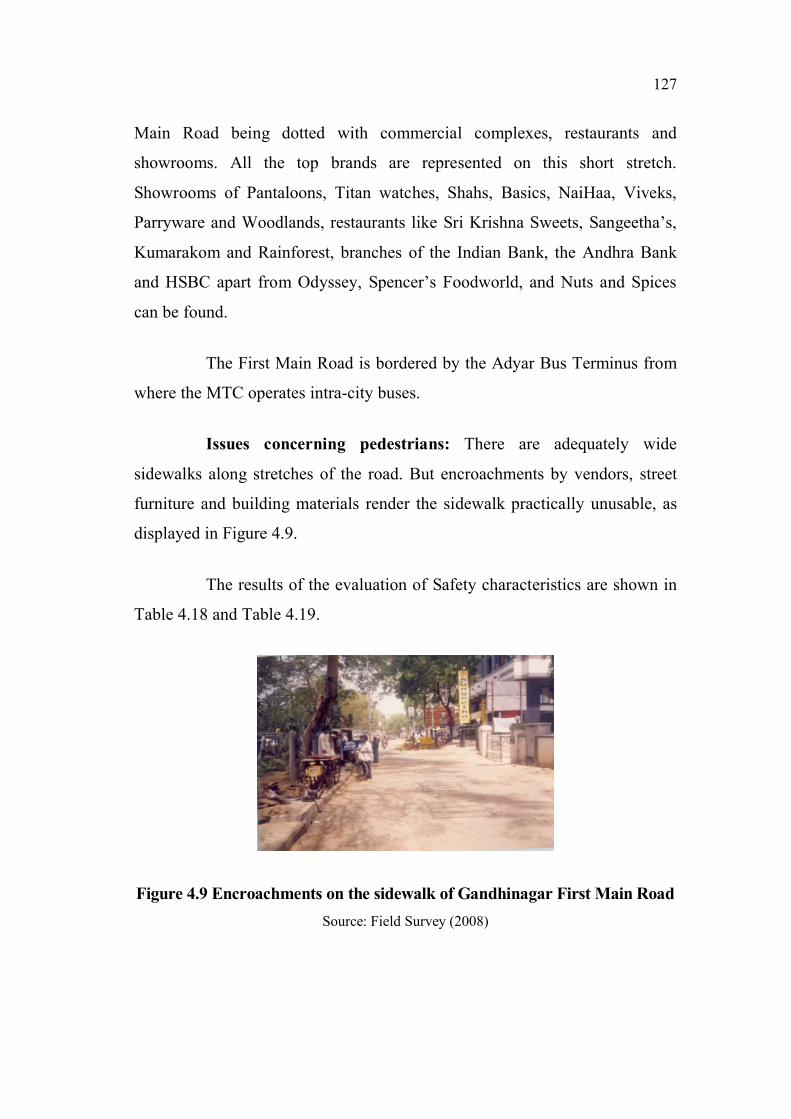
Issues concerning pedestrians: There are adequately wide
sidewalks along stretches of the road. But encroachments by vendors, street
furniture and building materials render the sidewalk practically unusable, as
displayed in Figure 4.9.
The results of the evaluation of Safety characteristics are shown in
Table 4.18 and Table 4.19.
Figure 4.9 Encroachments on the sidewalk of Gandhinagar First Main Road
Source: Field Survey (2008)

128
Table 4.18 Cumulative Rating of the Overall Safety characteristics of
Gandhinagar 1st Main Road
Street Gandhinagar 1st Main Road
Parameter
Stretch
Level of interaction with vehicles
and Consideration for the
vulnerable pedestrian
Canal Bank Road to 3rd Cross Street C/D
3rd Cross Street to 2nd Cross Street C/D
2nd Cross Street to 4th Main Road E
Cumulative Rating of Overall Safety
CharacteristicsE
Source: Field Survey (2008)
Table 4.19 Cumulative Rating of the Detailed Safety characteristics of
Gandhinagar 1st Main Road
Street Gandhinagar 1st Main Road
Parameter
Stretch
Deg
ree
of
ob
stru
ctio
n
on
th
e s
idew
alk
s
Sid
ew
alk
su
rfa
ce
con
dit
ion
s
Deg
ree
of
con
flic
t at
cro
ssin
gs
Desi
gn
prin
cip
les
ad
op
ted
for
ped
estr
ian
secu
rity
Desi
gn
prin
cip
les
ad
op
ted
for
traff
ic
ca
lmin
g
Canal Bank Road to 3rd Cross
StreetC D E D D/E
3rd Cross Street to 2nd Cross
StreetC D E D D/E
2nd Cross Street to 4th Main
RoadC E E D E
Cumulative Rating of Detailed
Safety CharacteristicsC E E D E
Source: Field Survey (2008)

129
The rating for Overall Safety – “D” and “E” – signifies that
pedestrians encounter significant conflicts with vehicles, and consideration
for the vulnerable pedestrian is meagre or nil. The evaluation of the Detailed
Safety characteristics emphasizes the deficiencies across the pedestrian
environment. The stretch obtained a rating of “C” for the “Degree of
obstruction on the sidewalks”, because of significant encroachments by street
furniture, vendors, parking, and dumping of building materials and other
miscellaneous equipment. For “Sidewalk Surface Conditions”, it received a
rating of “E”. The absence of signage and consideration for the disabled
resulted in a rating of “E” for the “Degree of conflict at crossings”. In terms
of “Pedestrian Security”, large buildings with individual commercial uses,
mostly new buildings and inadequate street activities earned the stretch a
rating of “D”. “Design principles for Traffic Calming” were almost
negligible, resulting in a rating of “E”.
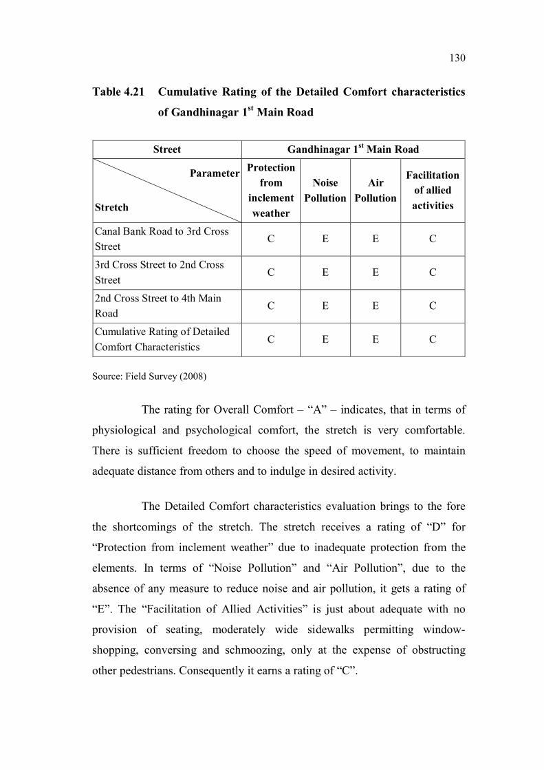
Table 4.20 and Table 4.21 depict the results of the evaluation of the
Comfort characteristics of Gandhinagar 1st Main Road.
Table 4.20 Cumulative Rating of the Overall Comfort characteristics of
Gandhinagar 1st Main Road
Street Gandhinagar 1st Main Road
Parameter
Stretch
Physiological Comfort and
Psychological Comfort
Canal Bank Road to 3rd Cross Street A
3rd Cross Street to 2nd Cross Street A
2nd Cross Street to 4th Main Road A
Cumulative Rating of Overall Comfort
CharacteristicsA
Source: Field Survey (2008)
130
Table 4.21 Cumulative Rating of the Detailed Comfort characteristics
of Gandhinagar 1st Main Road
Street Gandhinagar 1st Main Road
Parameter
Stretch
Protection
from
inclement
weather
Noise
Pollution
Air
Pollution
Facilitation
of allied
activities
Canal Bank Road to 3rd Cross
StreetC E E C
3rd Cross Street to 2nd Cross
StreetC E E C
2nd Cross Street to 4th Main
RoadC E E C
Cumulative Rating of Detailed
Comfort CharacteristicsC E E C
Source: Field Survey (2008)
The rating for Overall Comfort – “A” – indicates, that in terms of
physiological and psychological comfort, the stretch is very comfortable.
There is sufficient freedom to choose the speed of movement, to maintain
adequate distance from others and to indulge in desired activity.
The Detailed Comfort characteristics evaluation brings to the fore
the shortcomings of the stretch. The stretch receives a rating of “D” for
“Protection from inclement weather” due to inadequate protection from the
elements. In terms of “Noise Pollution” and “Air Pollution”, due to the
absence of any measure to reduce noise and air pollution, it gets a rating of
“E”. The “Facilitation of Allied Activities” is just about adequate with no
provision of seating, moderately wide sidewalks permitting window-
shopping, conversing and schmoozing, only at the expense of obstructing
other pedestrians. Consequently it earns a rating of “C”.

131
The results of the evaluation of Convenience characteristics of
Gandhinagar First Main Road are shown in Table 4.22 and Table 4.23.
Table 4.22 Cumulative Rating of the Overall Convenience characteristics
of Gandhinagar 1st Main Road
Street Gandhinagar 1st Main Road
Parameter
StretchPath characteristics
Canal Bank Road to 3rd Cross Street D
3rd Cross Street to 2nd Cross Street E
2nd Cross Street to 4th Main Road E
Cumulative Rating of Overall
Convenience CharacteristicsE
Source: Field Survey (2008)
Table 4.23 Cumulative Rating of the Detailed Convenience
characteristics of Gandhinagar 1st Main Road
Street Gandhinagar 1st Main Road
Parameter
Stretch
Legibility of
the pedestrian
environment
Pedestrian
amenities
Pedestrian
crossings
Canal Bank Road to 3rd Cross
StreetB E D
3rd Cross Street to 2nd Cross
StreetC E D
2nd Cross Street to 4th Main
RoadD E D
Cumulative Rating of Detailed
Convenience CharacteristicsD E D
Source: Field Survey (2008)

132
The evaluation of Overall Convenience – “E” – reveals that the stretch is
severely deficient in terms of shortcuts and impedances.
The Detailed level evaluation highlights the following issues. The evaluation
of the “Legibility of the pedestrian environment” shows that though the street
has sufficient landmark buildings, physical and visual linkages and nodes, in
terms of street furniture, signage and street activities it is woefully inadequate.
Consequently it gets a rating of “D”. A complete absence of “Pedestrian
Amenities” earns it a rating of “E”. In terms of “Pedestrian Crossings”, even
though crossings are at-grade, the absence of curb ramps, audible and tactile
cues, pedestrian phase in signals and pedestrian operated signals, causes the
stretch to receive a rating of “D”.
Table 4.24 and Table 4.25 display the results of the evaluation of
the Urban Environment characteristics of Gandhinagar First Main Road.
Table 4.24 Cumulative Rating of the Overall Urban Environment
characteristics of Gandhinagar 1st Main Road
Street Gandhinagar 1st Main Road
Parameter
Stretch
Imageability and Qualities of the
street
Canal Bank Road to 3rd Cross Street D
3rd Cross Street to 2nd Cross Street D
2nd Cross Street to 4th Main Road D
Cumulative Rating of Overall Urban
Environment CharacteristicsD
Source: Field Survey (2008)

133
Table 4.25 Cumulative Rating of the Detailed Urban Environment
characteristics of Gandhinagar 1st Main Road
Street Gandhinagar 1st Main Road
Parameter
Stretch
Ch
ara
cter
isti
cs
of
bu
ild
ing
s
Ad
her
ence
to
hu
ma
n s
ca
le
Per
mea
bil
ity
Vari
ety
Leg
ibil
ity
Ro
bu
stn
ess
Ric
hn
ess
Per
son
ali
zati
on
Canal Bank Road to 3rd Cross Street E D C C B C D E
3rd Cross Street to 2nd Cross Street E D D C C C D E
2nd Cross Street to 4th Main Road E D C C D C D E
Cumulative Rating of Detailed Urban
Environment CharacteristicsE D D C D C D E
Source: Field Survey (2008)
The rating of “D” for the Overall level characteristics of the Urban
Environment indicates that the street is inadequate, when assessed for
Imageability and Qualities of the street.
As part of the evaluation of the Detailed level characteristics, the
street gets a rating of “E” for “Characteristics of Buildings”, thus signifying
that the buildings severely lack a sense of unity, detailing at eye-level and
respect to context. “Adherence to Human Scale” sees the street getting a
rating of “D”. In the assessment of “Permeability”, the street receives a rating
of “D”, indicating that the street offers an inadequate choice of access, very
few views of interior spaces and virtually no spaces which invite the
pedestrian into the built environment. The evaluation of “Variety” – “C” –
shows that the street is sufficiently adequate in providing variety of form, use
and meaning. The review of “Legibility” – “D” - reveals that the street is
inadequate in terms of location of nodes, landmarks, physical and visual
linkages and variety and location of street activities. The evaluation of
“Robustness” – “C” – reveals adequate diversity of activities and adaptability
of buildings to multiple uses. The street receives a rating of “D” for

134
“Richness” in terms of sensory experiences with nothing on offer for the
olfactory, kinetic and tactile senses. In terms of “Personalisation” too, the
street falls woefully short in terms of enhancing the pedestrian environment
through personalization of personal as well as public space.
4.3.3 Gandhinagar Second Main Road
Background: Gandhinagar is a residential layout located in Adyar
in South Chennai. It is bordered by Adyar River on the north, Buckingham
canal on the west and Sardar Patel Road on the south and east. Figure 4.10
shows the location of Gandhinagar Second Main Road.
Figure 4.10 Map indicating the location of Gandhinagar Second Main Road
Source: A Road Guide to Chennai, TTK Printing Division, Chennai, 1996
Comparatively speaking, the Second Main Road has retained its
residential character, though a few commercial enterprises can be seen. Some
old bungalows still remain, but the predominant building type is the posh
apartment. Construction activity is continuing on quite a few sites with the old
Gandhinagar
Second Main
Road

135
individual houses being torn down to be replaced by multi-storeyed
apartments.
Some of the traffic generators on this street are the Grand Sweets
and Snacks, Hot Breads and the Anantha Padmanabhaswamy temple.
Issues concerning pedestrians: There are adequately wide
sidewalks along both sides of the road. But encroachments by vendors, street
furniture and building materials, and poor maintenance have forced the
pedestrian to share space with vehicular traffic. Figure 4.11 and Figure 4.12
depict the condition of the sidewalk of Gandhinagar Second Main Road.
Figure 4.11 Lack of maintenance of the sidewalk of Gandhinagar
Second Main Road
Source: Field Survey (2008)
Figure 4.12 Dumping of garbage and debris on the sidewalk of
Gandhinagar Second Main Road
Source: Field Survey (2008)

136
The results of the evaluation of Safety characteristics of
Gandhinagar Second Main Road are shown in Table 4.26 and Table 4.27.
Table 4.26 Cumulative Rating of the Overall Safety characteristics of
Gandhinagar 2nd
Main Road
Street Gandhinagar 2nd
Main Road
Parameter
Stretch
Level of interaction with vehicles and
Consideration for the vulnerable
pedestrian
Canal Bank Road to 3rd Cross Street C/D
3rd Cross Street to 2nd Cross Street C/D
2nd Cross Street to 4th Main Road C/D
Cumulative Rating of Overall Safety
CharacteristicsD
Source: Field Survey (2008)
Table 4.27 Cumulative Rating of the Detailed Safety characteristics of
Gandhinagar 2nd
Main Road
Street Gandhinagar 2nd
Main Road
Parameter
Stretch
Deg
ree
of
ob
stru
ctio
n
on
th
e s
idew
alk
s
Sid
ewalk
su
rface
co
nd
itio
ns
Deg
ree
of
con
flic
t at
cro
ssin
gs
Des
ign
pri
nci
ple
s
ad
op
ted
fo
r p
edes
tria
n
secu
rity
Des
ign
pri
nci
ple
s
ad
op
ted
fo
r tr
aff
ic
ca
lmin
g
Canal Bank Road to 3rd Cross Street C D E D D/E
3rd Cross Street to 2nd Cross Street C D E D D/E
2nd Cross Street to 4th Main Road C D E D D/E
Cumulative Rating of Detailed
Safety CharacteristicsC D E D E
Source: Field Survey (2008)
137
The rating for Overall Safety – “D” – signifies that pedestrians
encounter significant conflicts with vehicles, and consideration for the
vulnerable pedestrian is meagre or nil.
The evaluation of the Detailed Safety characteristics emphasizes
the deficiencies across the pedestrian environment. The stretch obtained a
rating of “C” for the “Degree of obstruction on the sidewalks” because of the
significant encroachments by street furniture, vendors, parking, and dumping
of building materials and other miscellaneous equipment. For “Sidewalk
Surface Conditions”, it received a rating of “D”. The absence of zebra
crossing patterns, refuge areas, pedestrian-operated signals, pedestrian phase
in signals and signage resulted in a rating of “E” for the “Degree of conflict at
crossings”. In terms of “Pedestrian Security”, low levels of activity observed
at some places, meagre concentration of people and inadequate illumination
by high-level street lights earned the stretch a rating of “D”. “Design
principles for Traffic Calming” were almost negligible resulting in a rating of
“E”.
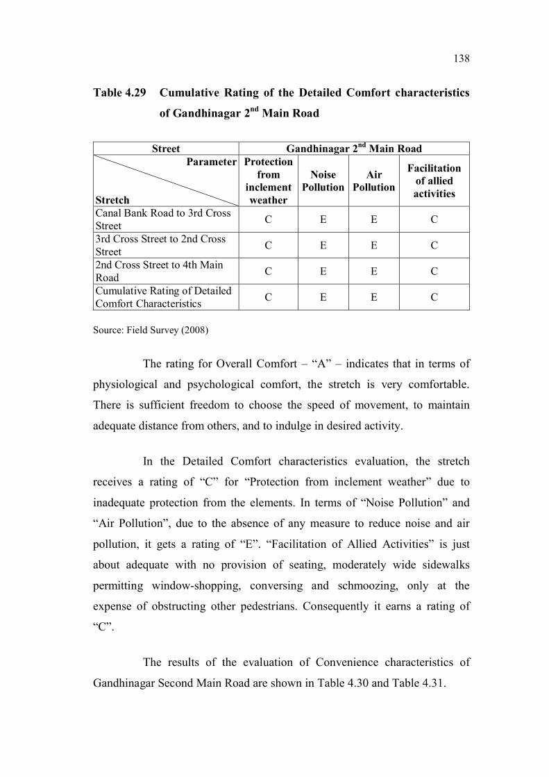
Table 4.28 and Table 4.29 display the results of the evaluation of
the Comfort characteristics of Gandhinagar Second Main Road.
Table 4.28 Cumulative Rating of the Overall Comfort characteristics of
Gandhinagar 2nd
Main Road
Street Gandhinagar 2nd
Main Road
Parameter
Stretch
Physiological Comfort and
Psychological Comfort
Canal Bank Road to 3rd Cross Street A
3rd Cross Street to 2nd Cross Street A
2nd Cross Street to 4th Main Road A
Cumulative Rating of Overall Comfort
CharacteristicsA
Source: Field Survey (2008)
138
Table 4.29 Cumulative Rating of the Detailed Comfort characteristics
of Gandhinagar 2nd
Main Road
Street Gandhinagar 2nd
Main Road
Parameter
Stretch
Protection
from
inclement
weather
Noise
Pollution
Air
Pollution
Facilitation
of allied
activities
Canal Bank Road to 3rd Cross
StreetC E E C
3rd Cross Street to 2nd Cross
StreetC E E C
2nd Cross Street to 4th Main
RoadC E E C
Cumulative Rating of Detailed
Comfort CharacteristicsC E E C
Source: Field Survey (2008)
The rating for Overall Comfort – “A” – indicates that in terms of
physiological and psychological comfort, the stretch is very comfortable.
There is sufficient freedom to choose the speed of movement, to maintain
adequate distance from others, and to indulge in desired activity.
In the Detailed Comfort characteristics evaluation, the stretch
receives a rating of “C” for “Protection from inclement weather” due to
inadequate protection from the elements. In terms of “Noise Pollution” and
“Air Pollution”, due to the absence of any measure to reduce noise and air
pollution, it gets a rating of “E”. “Facilitation of Allied Activities” is just
about adequate with no provision of seating, moderately wide sidewalks
permitting window-shopping, conversing and schmoozing, only at the
expense of obstructing other pedestrians. Consequently it earns a rating of
“C”.
The results of the evaluation of Convenience characteristics of
Gandhinagar Second Main Road are shown in Table 4.30 and Table 4.31.

139
Table 4.30 Cumulative Rating of the Overall Convenience characteristics
of Gandhinagar 2nd
Main Road
Street Gandhinagar 2nd
Main Road
Parameter
StretchPath characteristics
Canal Bank Road to 3rd Cross Street A/E
3rd Cross Street to 2nd Cross Street E
2nd Cross Street to 4th Main Road E
Cumulative Rating of Overall
Convenience CharacteristicsE
Source: Field Survey (2008)
Table 4.31 Cumulative Rating of the Detailed Convenience
characteristics of Gandhinagar 2nd
Main Road
Street Gandhinagar 2nd
Main Road
Parameter
Stretch
Legibility of the
pedestrian
environment
Pedestrian
amenities
Pedestrian
crossings
Canal Bank Road to 3rd Cross Street E E D
3rd Cross Street to 2nd Cross Street E E D
2nd Cross Street to 4th Main Road B E D
Cumulative Rating of Detailed
Convenience CharacteristicsE E D
Source: Field Survey (2008)
The evaluation of the Overall Convenience – “E” – reveals that the
stretch is severely deficient in terms of shortcuts and impedances.
The Detailed level evaluation highlights the following issues. The
evaluation of the “Legibility of the pedestrian environment” shows that the
street has no landmark buildings, inadequate street activities and no street
furniture, and signage. Consequently it gets a rating of “E”. A complete
absence of “Pedestrian Amenities” earns it a rating of “E”. In terms of
“Pedestrian Crossings”, even though crossings are at-grade, the absence of

140
curb ramps, audible and tactile cues, pedestrian phase in signals and
pedestrian operated signals causes the stretch to receive a rating of “D”.
Table 4.32 and Table 4.33 display the results of the evaluation of
the Urban Environment characteristics of Gandhinagar Second Main Road.
Table 4.32 Cumulative Rating of the Overall Urban Environment
characteristics of Gandhinagar 2nd
Main Road
Street Gandhinagar 2nd
Main Road
Parameter
Stretch
Imageability and Qualities of the
street
Canal Bank Road to 3rd Cross Street D
3rd Cross Street to 2nd Cross Street D
2nd Cross Street to 4th Main Road C
Cumulative Rating of Overall Urban
Environment CharacteristicsD
Source: Field Survey (2008)
Table 4.33 Cumulative Rating of the Detailed Urban Environment
characteristics of Gandhinagar 2nd
Main Road
Street Gandhinagar 2nd
Main Road
Parameter
Stretch
Ch
ara
cter
isti
cs
of
bu
ild
ing
s
Ad
her
ence
to
hu
ma
n s
ca
le
Per
mea
bil
ity
Vari
ety
Leg
ibil
ity
Ro
bu
stn
ess
Ric
hn
ess
Per
son
ali
zati
on
Canal Bank Road to 3rd
Cross StreetC/E D C/D/E D A/B/D C E E
3rd Cross Street to 2nd
Cross StreetC/E D C/D/E D A/B/D C E E
2nd Cross Street to 4th
Main RoadC/E D C D
A/B/
C/DC B B/E
Cumulative Rating of
Detailed Urban
Environment
Characteristics
E D E D D C E E
Source: Field Survey (2008)

141
The rating of “D” for the Overall level characteristics of the Urban
Environment indicates, that the stretch is inadequate when assessed for
Imageability (Skyline, Landmark buildings, Response to context, Nodes,
Levels, Diversity of activities, Spatial relationships and changing views) and
Qualities of the street (Street elements like the Beginning, End and places of
special activity, Sense of enclosure, Adherence of street dimensions to
guidelines, Interaction of people, conduciveness for traditional rituals and
gatherings, and the capacity to support recreation, conversation and
entertainment).
As part of the evaluation of the Detailed level characteristics, the
stretch gets a rating of “E” for “Characteristics of Buildings”, thus signifying
that the buildings severely lack a sense of unity, detailing at eye-level and
respect to context. “Adherence to Human Scale” sees the stretch getting a
rating of “D”. In the assessment of “Permeability”, the stretch receives a
rating of “E”, indicating that it offers an inadequate choice of access, very few
views of interior spaces, and virtually no spaces which invite the pedestrian
into the built environment. The evaluation of “Variety” – “D” - highlights the
inadequacy of the stretch in providing variety of form, use and meaning. The
review of “Legibility” – “D” - reveals that the stretch fares dismally in terms
of location of nodes, landmarks, physical and visual linkages, and variety and
location of street activities. The evaluation of “Robustness” – “C” – highlights
the adequate diversity of activities and adaptability of buildings to multiple
uses. The stretch receives a rating of “E” for “Richness” in terms of sensory
experiences with nothing on offer for the olfactory, kinetic and tactile senses.
In terms of “Personalisation” too, the stretch falls woefully short in terms of
enhancing the pedestrian environment through personalization of personal as
well as public space.

142
4.3.4 Sardar Patel Road
Background: This area is an institutional zone. Sardar Patel Road
starts from the Ashok Leyland corporate office at the junction between
Guindy Railway Station and Little Mount Junction, just near Alexander
Square. On one side it is bounded by the campuses of the Anna University
and the CLRI (Central Leather Research Institute), while on the other side are
the IIT (Indian Institute of Technology, Madras) campus, the Cancer Research
Institute, the Children’s Park and a multitude of memorials in homage to
Mahatma Gandhi and other prominent Indian statesmen, culminating in the
sprawling Raj Bhavan serving as the Governor’s residence. It is the arterial
road which provides the access to all these institutions. A right turn from the
Madhya Kailash Junction leads to the Old Mahabalipuram Road also known
as the IT Highway, which has now been christened Rajiv Gandhi Salai.
Figure 4.13 displays the location of Sardar Patel Road. The selected stretches
are shown in Figure 4.14.
Figure 4.13 Map indicating the location of Sardar Patel Road
Source: A Road Guide to Chennai, TTK Printing Division, Chennai (1996)
Sardar Patel Road

143
Figure 4.14 Map of Sardar Patel Road indicating the land use and the
selected stretches
Source: Field Survey (2008)
Traffic analysis: The stretch of Sardar Patel Road between Raj
Bhavan and the Halda Junction is one-way towards the direction of the Halda
Junction. The rest of the road is two-way. It is notorious for its traffic jams,
especially during peak hours. The narrow, one-way flyover in front of the IIT
has added to the traffic problem and has also deprived a prestigious institute
like the IIT, of frontage. As a result, vehicles coming to the IIT from the Raj
Bhavan side have to take a U-Turn from Madhya Kailash. For the pedestrian,
crossing over to the IIT side of the road is a nightmare due to the fast traffic
from the one-way flyover. This is especially true for students of Kendriya
Vidyalaya and Vanavani Schools in the IIT Campus. In contrast, the Anna
University has been provided with good frontage and pedestrian crossing
signals.
Issues concerning pedestrians: The area sees a huge influx of
students, faculty and tourists. But sadly, there is no consideration for the
Raj Bhavan Junction to
Anna University Main Entry
Anna University Main Entry
to Gandhi Mandapam Road
Junction
Gandhi Mandapam Road
Junction to Madhya
Kailash Junction
LANDUSE LEGEND:
Primary Residential- Yellow
Mixed Residential- Orange
Commercial-Blue
Institutional-Red
144
pedestrian. Pedestrian amenities are virtually non-existent. There are no
resting places, coherent signage system, and unified design language adopted
for street furniture, play equipment, landscaping or works of art.
The sidewalks are maintained well due to the proximity of the Raj
Bhavan. But, the recent addition of a vehicular flyover has resulted in the
pedestrian sidewalk becoming the prime casualty. Earlier the stretch abutting
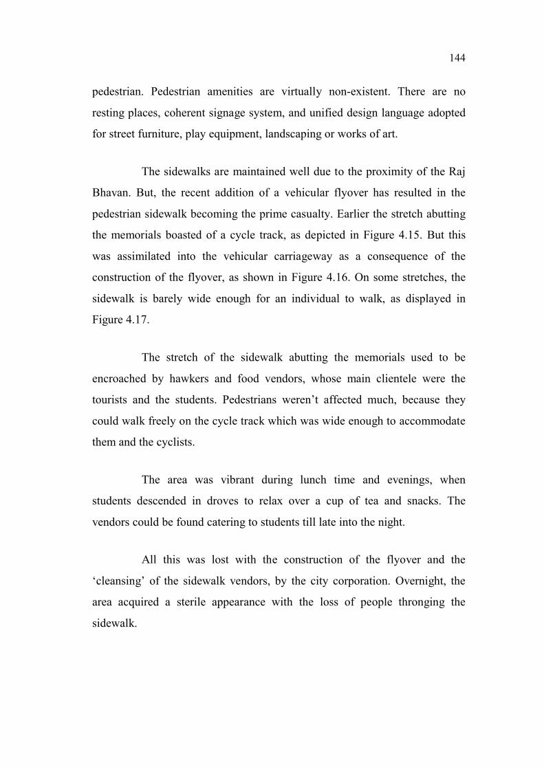
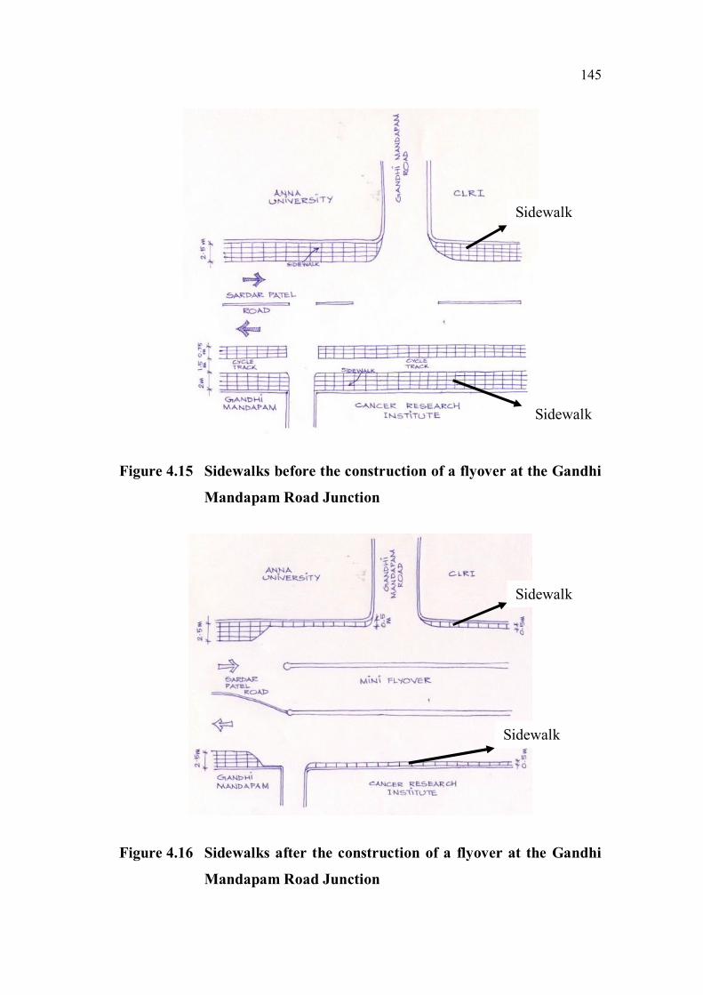
the memorials boasted of a cycle track, as depicted in Figure 4.15. But this
was assimilated into the vehicular carriageway as a consequence of the
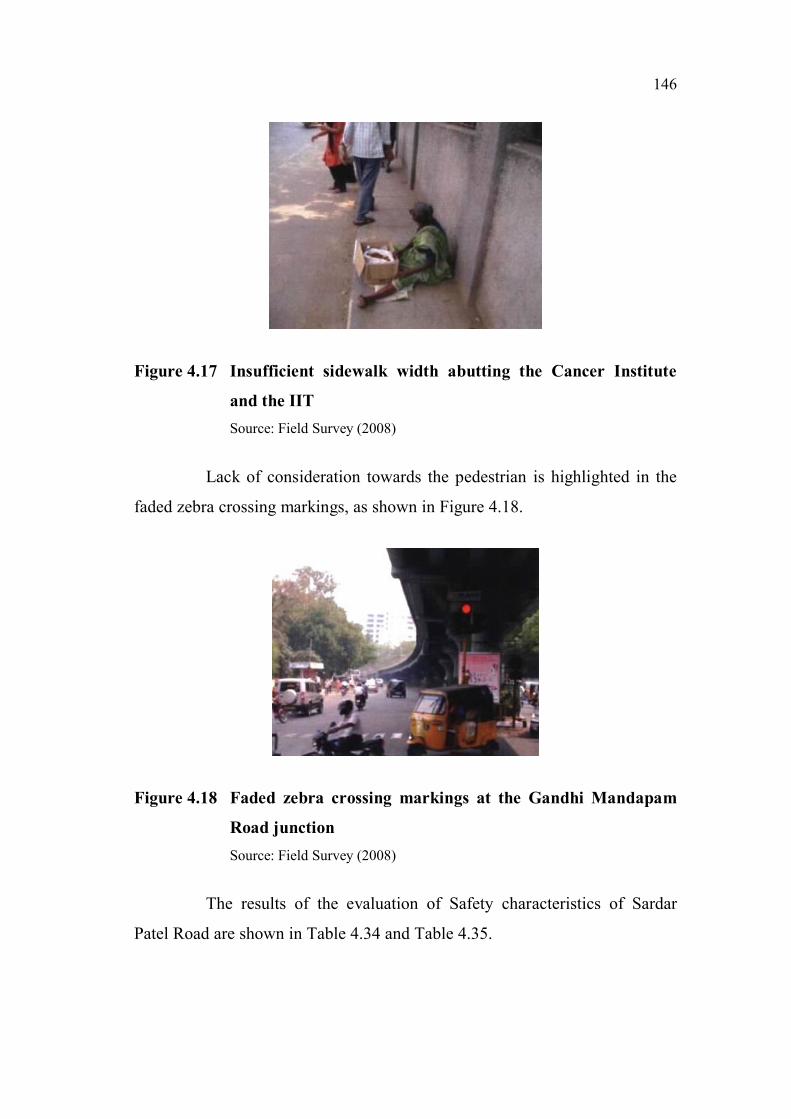
construction of the flyover, as shown in Figure 4.16. On some stretches, the
sidewalk is barely wide enough for an individual to walk, as displayed in
Figure 4.17.
The stretch of the sidewalk abutting the memorials used to be
encroached by hawkers and food vendors, whose main clientele were the
tourists and the students. Pedestrians weren’t affected much, because they
could walk freely on the cycle track which was wide enough to accommodate
them and the cyclists.
The area was vibrant during lunch time and evenings, when
students descended in droves to relax over a cup of tea and snacks. The
vendors could be found catering to students till late into the night.
All this was lost with the construction of the flyover and the
‘cleansing’ of the sidewalk vendors, by the city corporation. Overnight, the
area acquired a sterile appearance with the loss of people thronging the
sidewalk.
145
Figure 4.15 Sidewalks before the construction of a flyover at the Gandhi
Mandapam Road Junction
Figure 4.16 Sidewalks after the construction of a flyover at the Gandhi
Mandapam Road Junction
Sidewalk
Sidewalk
Sidewalk
Sidewalk
146
Figure 4.17 Insufficient sidewalk width abutting the Cancer Institute
and the IIT
Source: Field Survey (2008)
Lack of consideration towards the pedestrian is highlighted in the
faded zebra crossing markings, as shown in Figure 4.18.
Figure 4.18 Faded zebra crossing markings at the Gandhi Mandapam
Road junction
Source: Field Survey (2008)
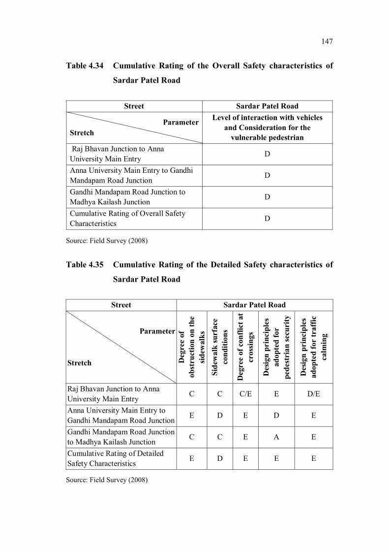
The results of the evaluation of Safety characteristics of Sardar
Patel Road are shown in Table 4.34 and Table 4.35.
147
Table 4.34 Cumulative Rating of the Overall Safety characteristics of
Sardar Patel Road
Street Sardar Patel Road
Parameter
Stretch
Level of interaction with vehicles
and Consideration for the
vulnerable pedestrian
Raj Bhavan Junction to Anna
University Main EntryD
Anna University Main Entry to Gandhi
Mandapam Road JunctionD
Gandhi Mandapam Road Junction to
Madhya Kailash JunctionD
Cumulative Rating of Overall Safety
CharacteristicsD
Source: Field Survey (2008)
Table 4.35 Cumulative Rating of the Detailed Safety characteristics of
Sardar Patel Road
Street Sardar Patel Road
Parameter
Stretch Deg
ree
of
ob
stru
ctio
n o
n t
he
sid
ewa
lks
Sid
ewalk
su
rface
co
nd
itio
ns
Deg
ree
of
con
flic
t at
cro
ssin
gs
Desi
gn
prin
cip
les
ad
op
ted
fo
r
ped
estr
ian
sec
uri
ty
Desi
gn
prin
cip
les
ad
op
ted
for
traff
ic
ca
lmin
g
Raj Bhavan Junction to Anna
University Main EntryC C C/E E D/E
Anna University Main Entry to
Gandhi Mandapam Road JunctionE D E D E
Gandhi Mandapam Road Junction
to Madhya Kailash JunctionC C E A E
Cumulative Rating of Detailed
Safety CharacteristicsE D E E E
Source: Field Survey (2008)

148
The rating for Overall Safety – “D” – signifies that pedestrians
encounter significant conflicts with vehicles, and consideration for the
vulnerable pedestrian i.e. children, the elderly and the disabled is meagre or
nil.
The evaluation of the Detailed Safety characteristics emphasizes
the deficiencies across the pedestrian environment. The stretch obtained a
rating of “E” for the “Degree of obstruction on the sidewalks” because of
highly inadequate width of sidewalks adjacent to the flyover. For “Sidewalk
Surface Conditions”, it received a rating of “D” because of the susceptibility
of the vulnerable pedestrian adjacent to the flyover. Faded zebra crossing
patterns, absence of refuge areas, pedestrian-operated signals, pedestrian
phase in signals and signage resulted in a rating of “E” for the “Degree of
conflict at crossings”. In terms of “Pedestrian Security”, the absence of
activity on the Raj Bhavan stretch, meagre concentration of people and the
absence of mixed uses earned the stretch a rating of “E”. “Design principles
for Traffic Calming” were almost negligible, resulting in a rating of “E”.
Table 4.36 and Table 4.37 display the results of the evaluation of
the Comfort characteristics of Sardar Patel Road.
Table 4.36 Cumulative Rating of the Overall Comfort characteristics of
Sardar Patel Road
Street Sardar Patel Road
Parameter
Stretch
Physiological Comfort and
Psychological Comfort
Raj Bhavan Junction to Anna University
Main EntryA
Anna University Main Entry to Gandhi
Mandapam Road JunctionA
Gandhi Mandapam Road Junction to
Madhya Kailash JunctionC
Cumulative Rating of Overall Comfort
CharacteristicsC
Source: Field Survey (2008)

149
Table 4.37 Cumulative Rating of the Detailed Comfort characteristics
of Sardar Patel Road
Street Sardar Patel Road
Parameter
Stretch
Protection from
inclement
weather
Noise
Pollution
Air
Pollution
Facilitation
of allied
activities
Raj Bhavan Junction to
Anna University Main
Entry
C/D E E C
Anna University Main
Entry to Gandhi
Mandapam Road Junction
C/D E E D/E
Gandhi Mandapam Road
Junction to Madhya
Kailash Junction
C E E C/E
Cumulative Rating of
Detailed Comfort
Characteristics
D E E E
Source: Field Survey (2008)
The rating for Overall Comfort – “C” – indicates, that in terms of
physiological and psychological comfort, the stretch is adequately
comfortable. There is sufficient freedom to choose the speed of movement, to
maintain adequate distance from others and to indulge in desired activity.
The Detailed Comfort characteristics evaluation brings to the fore
the shortcomings of the stretch. The stretch receives a rating of “D” for
“Protection from inclement weather” due to inadequate protection from the
elements. In terms of “Noise Pollution” and “Air Pollution”, due to the
absence of any measure to reduce noise and air pollution, it gets a rating of
“E”. “Facilitation of Allied Activities” is inadequate with no provision of
seating, and narrow sidewalks eliminating the chance of any activities.
Consequently, it earns a rating of “E”.

150
The results of the evaluation of Convenience characteristics of
Sardar Patel Road are shown in Table 4.38 and Table 4.39.
Table 4.38 Cumulative Rating of the Overall Convenience characteristics
of Sardar Patel Road
Street Sardar Patel Road
Parameter
StretchPath characteristics
Raj Bhavan Junction to Anna University
Main EntryA/E
Anna University Main Entry to Gandhi
Mandapam Road JunctionE
Gandhi Mandapam Road Junction to
Madhya Kailash JunctionE
Cumulative Rating of Overall
Convenience CharacteristicsE
Source: Field Survey (2008)
Table 4.39 Cumulative Rating of the Detailed Convenience characteristics
of Sardar Patel Road
Street Sardar Patel Road
Parameter
Stretch
Legibility of
the pedestrian
environment
Pedestrian
amenities
Pedestrian
crossings
Raj Bhavan Junction to Anna
University Main EntryD E D/E
Anna University Main Entry to
Gandhi Mandapam Road
Junction
D E E
Gandhi Mandapam Road
Junction to Madhya Kailash
Junction
C E D/E
Cumulative Rating of Detailed
Convenience CharacteristicsD E E
Source: Field Survey (2008)

151
The evaluation of Overall Convenience – “E” – reveals that the
stretch is severely deficient in terms of shortcuts and impedances.
The Detailed level evaluation highlights the following issues. The
evaluation of “Legibility of the pedestrian environment” shows that though
the street has sufficient landmark buildings, physical and visual linkages and
nodes, in terms of street furniture, signage and street activities, it is woefully
inadequate. Consequently it gets a rating of “D”. A complete absence of
“Pedestrian Amenities” earns it a rating of “E”. In terms of “Pedestrian
Crossings”, even though crossings are at-grade, the absence of curb ramps,
audible and tactile cues, pedestrian phase in signals and pedestrian operated
signals causes the stretch to receive a rating of “E”. The results of the
evaluation of Urban Environment characteristics of Sardar Patel Road are
shown in Table 4.40 and Table 4.41.
Table 4.40 Cumulative Rating of the Overall Urban Environment
characteristics of Sardar Patel Road
Street Sardar Patel Road
Parameter
Stretch
Imageability and Qualities of the
street
Raj Bhavan Junction to Anna
University Main EntryD
Anna University Main Entry to Gandhi
Mandapam Road JunctionD
Gandhi Mandapam Road Junction to
Madhya Kailash JunctionC
Cumulative Rating of Overall Urban
Environment CharacteristicsD
Source: Field Survey (2008)
152
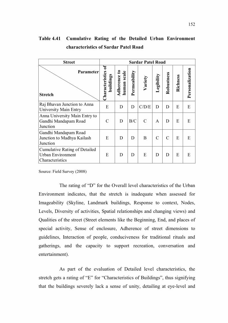
Table 4.41 Cumulative Rating of the Detailed Urban Environment
characteristics of Sardar Patel Road
Street Sardar Patel Road
Parameter
Stretch
Ch
ara
cter
isti
cs o
f
bu
ild
ing
s
Ad
her
ence
to
hu
ma
n s
ca
le
Perm
eab
ilit
y
Varie
ty
Leg
ibil
ity
Ro
bu
stn
ess
Ric
hn
ess
Per
son
ali
zati
on
Raj Bhavan Junction to Anna
University Main EntryE D D C/D/E D D E E
Anna University Main Entry to
Gandhi Mandapam Road
Junction
C D B/C C A D E E
Gandhi Mandapam Road
Junction to Madhya Kailash
Junction
E D D B C C E E
Cumulative Rating of Detailed
Urban Environment
Characteristics
E D D E D D E E
Source: Field Survey (2008)
The rating of “D” for the Overall level characteristics of the Urban
Environment indicates, that the stretch is inadequate when assessed for
Imageability (Skyline, Landmark buildings, Response to context, Nodes,
Levels, Diversity of activities, Spatial relationships and changing views) and
Qualities of the street (Street elements like the Beginning, End, and places of
special activity, Sense of enclosure, Adherence of street dimensions to
guidelines, Interaction of people, conduciveness for traditional rituals and
gatherings, and the capacity to support recreation, conversation and
entertainment).
As part of the evaluation of Detailed level characteristics, the
stretch gets a rating of “E” for “Characteristics of Buildings”, thus signifying
that the buildings severely lack a sense of unity, detailing at eye-level and

153
respect to context. “Adherence to Human Scale” sees the stretch getting a
rating of “D”. In the assessment of “Permeability”, the stretch receives a
rating of “D”, indicating that the stretch offers an inadequate choice of access,
very few views of interior spaces and virtually no spaces which invite the
pedestrian into the built environment. The evaluation of “Variety” – “E” -
highlights the inadequacy of the stretch in providing variety of form, use and
meaning. The review of “Legibility” – “D” - reveals that the stretch fares
exceedingly well in terms of location of nodes, landmarks, physical and visual
linkages and variety and location of street activities. In the evaluation of
“Robustness” – “D” – the inadequate diversity of activities and adaptability of
buildings to multiple uses are highlighted. The stretch receives a rating of “E”
for “Richness” in terms of sensory experiences with nothing on offer for the
olfactory, kinetic and tactile senses. In terms of “Personalisation” too, the
stretch falls woefully short in terms of enhancing the pedestrian environment
through personalization of personal as well as public space.
4.3.5 Ranganathan Street
Background: Ranganathan Street is located in Theagaraya Nagar
on the approach to the Mambalam railway station, as depicted in Figure 4.19.
Many commercial establishments can be found on Ranganathan Street. It is
one of the busiest streets of Chennai. The street is a famous icon of
Theagaraya Nagar and due to its proximity to the Mambalam railway station
and the Theagaraya Nagar bus terminus, people from all parts of Chennai
flock to Ranganathan Street for shopping, especially during the festive
seasons.
Ranganathan Street is a shopper's paradise for people belonging to
all ages. From safety pins to exquisite jewellery, the place is packed with
stores brimming with goods. Right from tiny tots to school goers, teens and
the elderly, Ranganathan Street has a lot to allure every visitor. Interesting

154
food to feast on, juices to quench one’s thirst, sweet shops for the sugar
hungry are part of the array of shops in Ranganathan Street. The place is very
crowded at all times during the year.
Some of the well-known outlets on Ranganathan Street include
Textile India, Saravana Stores and Jeyachandran Textiles. Every kind of
household articles, music CDs, apparel and accessories can be obtained at the
many stores that line the street. Vegetable and flower vendors sell their fresh
wares right on the street.
There are no residential buildings on Ranganthan street as such, but
there are a few very close to the street, such as Rams Flats, Narayana
apartments and Kamakoti Flats on Rameswaram road.
Figure 4.19 Map indicating the location of Ranganathan Street
Source: A Road Guide to Chennai, TTK Printing Division, Chennai (1996)
Ranganathan
Street
155
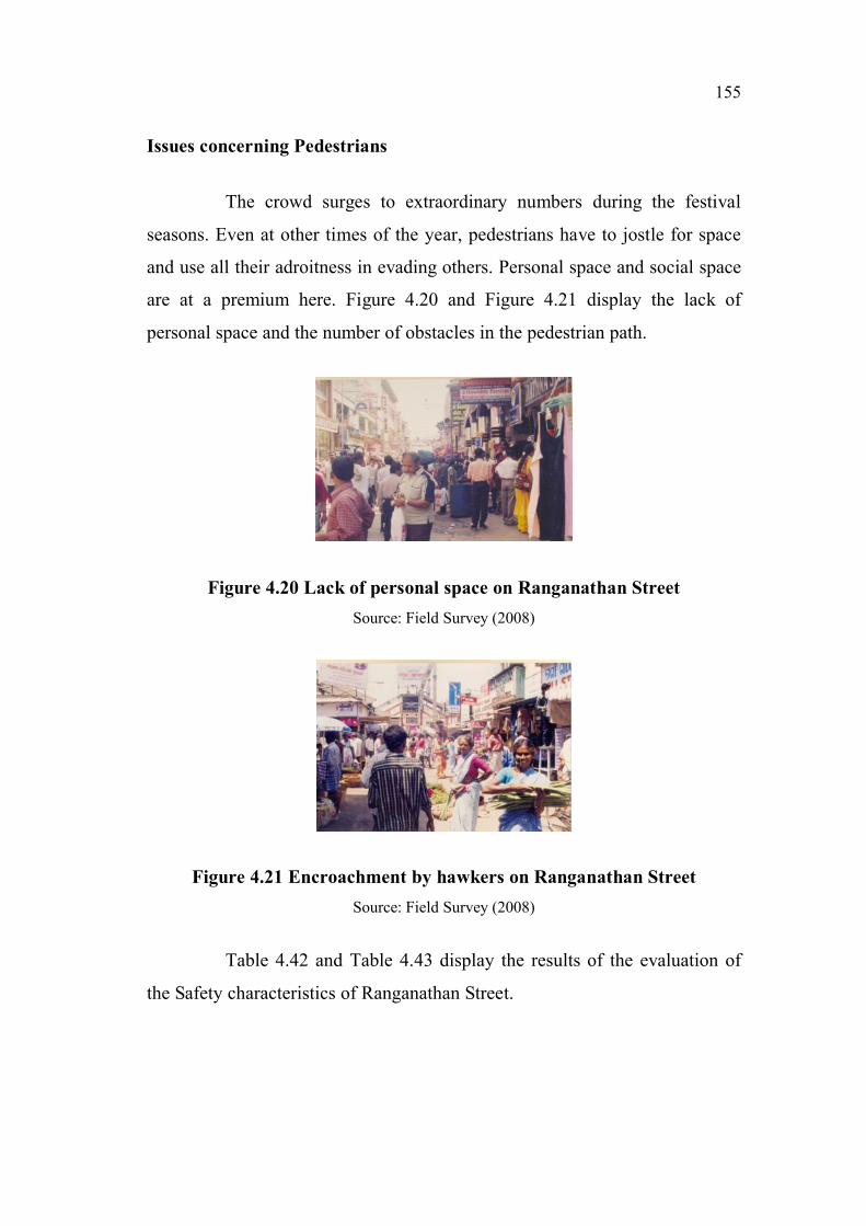
Issues concerning Pedestrians
The crowd surges to extraordinary numbers during the festival
seasons. Even at other times of the year, pedestrians have to jostle for space
and use all their adroitness in evading others. Personal space and social space
are at a premium here. Figure 4.20 and Figure 4.21 display the lack of
personal space and the number of obstacles in the pedestrian path.
Figure 4.20 Lack of personal space on Ranganathan Street
Source: Field Survey (2008)
Figure 4.21 Encroachment by hawkers on Ranganathan Street
Source: Field Survey (2008)
Table 4.42 and Table 4.43 display the results of the evaluation of
the Safety characteristics of Ranganathan Street.

156
Table 4.42 Cumulative Rating of the Overall Safety characteristics of
Ranganathan Street
Street Ranganathan Street
Parameter
Stretch
Level of interaction with vehicles
and Consideration for the
vulnerable pedestrian
Ranganathan Street D
Cumulative Rating of Overall Safety
CharacteristicsD
Source: Field Survey (2008)
Table 4.43 Cumulative Rating of the Detailed Safety characteristics of
Ranganathan Street
Street Ranganathan Street
Parameter
Stretch
Deg
ree
of
ob
stru
ctio
n
on
th
e s
idew
alk
s
Sid
ewalk
su
rface
co
nd
itio
ns
Deg
ree
of
con
flic
t at
cross
ings
Desi
gn
prin
cip
les
ad
op
ted
for
ped
estr
ian
sec
uri
ty
Desi
gn
prin
cip
les
ad
op
ted
fo
r t
raff
ic
ca
lmin
g
Ranganathan Street E D A A A/B/D
Cumulative Rating of Detailed
Safety CharacteristicsE D A A A/B/D
Source: Field Survey (2008)
The rating for Overall Safety – “D” – was the result of a meagre
consideration for the vulnerable pedestrian, i.e. children, the elderly and the
disabled.
The evaluation of Detailed Safety characteristics emphasizes the
deficiencies across the pedestrian environment. The stretch obtained a rating
of “E” for “Degree of obstruction on the sidewalks” because of significant
encroachments by street furniture, vendors, parking, and dumping of building
materials and other miscellaneous equipment. For “Sidewalk Surface
Conditions”, it received a rating of “D”. Since the stretch is almost vehicle-
157
free, it resulted in a rating of “A” for “Degree of conflict at crossings”. In
terms of “Pedestrian Security”, high levels of activity observed at some
places, adequately dense concentration of people and sufficient illumination
by high-level street lights earned the stretch a rating of “A”. “Design
principles for Traffic Calming” were almost negligible resulting in a rating of
“A/B/D”.
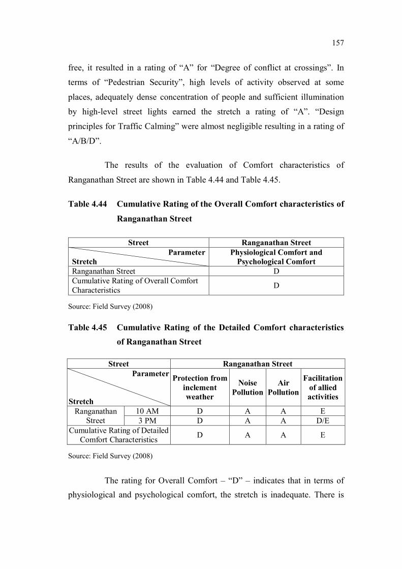
The results of the evaluation of Comfort characteristics of
Ranganathan Street are shown in Table 4.44 and Table 4.45.
Table 4.44 Cumulative Rating of the Overall Comfort characteristics of
Ranganathan Street
Street Ranganathan Street
Parameter
Stretch
Physiological Comfort and
Psychological Comfort
Ranganathan Street D
Cumulative Rating of Overall Comfort
CharacteristicsD
Source: Field Survey (2008)
Table 4.45 Cumulative Rating of the Detailed Comfort characteristics
of Ranganathan Street
Street Ranganathan Street
Parameter
Stretch
Protection from
inclement
weather
Noise
Pollution
Air
Pollution
Facilitation
of allied
activities
Ranganathan
Street
10 AM D A A E
3 PM D A A D/E
Cumulative Rating of Detailed
Comfort CharacteristicsD A A E
Source: Field Survey (2008)
The rating for Overall Comfort – “D” – indicates that in terms of
physiological and psychological comfort, the stretch is inadequate. There is
158
no freedom to choose the speed of movement, to maintain adequate distance
from others and to indulge in desired activity.
The Detailed Comfort characteristics evaluation brings to the fore
the shortcomings of the stretch. The stretch receives a rating of “D” for
“Protection from inclement weather” due to inadequate protection from the
elements. In terms of “Noise Pollution” and “Air Pollution”, due to the
absence of vehicular traffic, it gets a rating of “A”. “Facilitation of Allied
Activities” is highly inadequate with no provision of seating, and very high
concentrations of pedestrians precluding any window-shopping, conversing
and schmoozing. Consequently it earns a rating of “E”.
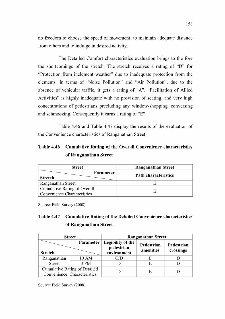
Table 4.46 and Table 4.47 display the results of the evaluation of
the Convenience characteristics of Ranganathan Street.
Table 4.46 Cumulative Rating of the Overall Convenience characteristics
of Ranganathan Street
Street Ranganathan Street
Parameter
StretchPath characteristics
Ranganathan Street E
Cumulative Rating of Overall
Convenience CharacteristicsE
Source: Field Survey (2008)
Table 4.47 Cumulative Rating of the Detailed Convenience characteristics
of Ranganathan Street
Street Ranganathan Street
Parameter
Stretch
Legibility of the
pedestrian
environment
Pedestrian
amenities
Pedestrian
crossings
Ranganathan
Street
10 AM C/D E D
3 PM D E D
Cumulative Rating of Detailed
Convenience CharacteristicsD E D
Source: Field Survey (2008)

159
The evaluation of Overall Convenience – “E” – reveals that the
stretch is severely deficient in terms of shortcuts and impedances.
The Detailed level evaluation highlights the following issues. The
evaluation of “Legibility of the pedestrian environment” shows that though
the street has sufficient landmark buildings, physical and visual linkages and
nodes, in terms of street furniture, signage and street activities it is woefully
inadequate. Consequently it gets a rating of “D”. A complete absence of
“Pedestrian Amenities” earns it a rating of “E”. In terms of “Pedestrian
Crossings”, even though crossings are at-grade, the absence of curb ramps,
audible and tactile cues, pedestrian phase in signals and pedestrian operated
signals causes the stretch to receive a rating of “D”.
The results of the evaluation of the Urban Environment
characteristics of Ranganathan Street are shown in Table 4.48 and Table 4.49.
Table 4.48 Cumulative Rating of the Overall Urban Environment
characteristics of Ranganathan Street
Street Ranganathan Street
Parameter
Stretch
Imageability and Qualities of the
street
Ranganathan Street D
Cumulative Rating of Overall Urban
Environment CharacteristicsD
Source: Field Survey (2008)

160
Table 4.49 Cumulative Rating of the Detailed Urban Environment
characteristics of Ranganathan Street
Street Ranganathan Street
Parameter
Stretch
Ch
ara
cter
isti
cs o
f
bu
ild
ing
s
Ad
her
ence
to
hu
ma
n s
ca
le
Perm
eab
ilit
y
Vari
ety
Leg
ibil
ity
Ro
bu
stn
ess
Ric
hn
ess
Per
son
ali
zati
on
Ranganathan Street E D E C D D A E
Cumulative Rating of Detailed
Urban Environment
Characteristics
E D E D D D A E
Source: Field Survey (2008)
The rating of “D” for the Overall level characteristics of the Urban
Environment indicates, that the stretch is inadequate when assessed for
Imageability (Skyline, Landmark buildings, Response to context, Nodes,
Levels, Diversity of activities, Spatial relationships and changing views) and
Qualities of the street (Street elements like the Beginning, End, and places of
special activity, Sense of enclosure, Adherence of street dimensions to
guidelines, Interaction of people, conduciveness for traditional rituals and
gatherings, and the capacity to support recreation, conversation and
entertainment).
As part of the evaluation of the Detailed level characteristics, the
stretch gets a rating of “E” for “Characteristics of Buildings”, thus signifying
that the buildings severely lack a sense of unity, detailing at eye-level and
respect to context. “Adherence to Human Scale” sees the stretch getting a
rating of “D”. In the assessment of “Permeability”, the stretch receives a
rating of “E”, indicating that the stretch offers an inadequate choice of access,
very few views of interior spaces and virtually no spaces which invite the
pedestrian into the built environment. The evaluation of “Variety” – “D” -
highlights the inadequacy of the stretch in providing variety of form, use and

161
meaning. The review of “Legibility” – “D” - reveals that the stretch fares
dismally in terms of location of nodes, landmarks, physical and visual
linkages and variety and location of street activities. In the evaluation of
“Robustness” – “D” – the inadequate diversity of activities and adaptability of
buildings to multiple uses are highlighted. The stretch receives a rating of “A”
for “Richness” in terms of sensory experiences with significant visual, aural
and kinetic diversity. In terms of “Personalisation” too, the stretch falls
woefully short in terms of enhancing the pedestrian environment through
personalization of personal as well as public space.
4.3.6 Pantheon Road
Background: Pantheon Road is the main artery of Egmore. It stretches
from the north east to the south west, and just a stone’s throw from the former end is
the Egmore Railway Station, with its main building done up in the striking Indo-
Saracenic style made famous by Robert Chisholm. Figure 4.22 displays the location
of Pantheon Road.
Figure 4.22 Map indicating the location of Pantheon Road
Source: A Road Guide to Chennai, TTK Printing Division, Chennai (1996)
Pantheon
Road
162
There has been a dramatic change in the very essence of Egmore.
From being the area where the white and brown sahibs built their houses,
Egmore today is a bustling centre of commerce. Shopping malls and hotels
are continuously springing up, and the various malls especially, draw in the
city’s youth in flocks and hordes.
The presence of three sports complexes, the University Union, the
Corporation Stadium, the Rajarathinam Stadium, and three hospitals – the
Children’s, the Maternity and the Eye – has also resulted in hundreds of
outstation visitors thronging this area daily. Egmore also boasts of the city’s
second most important railway station.
The road has quite a few sites of historical significance. The road’s
name derives from the British Raj’s Pantheon that once stood there in the 18th
century, one that played host to different kinds of entertainment shows for the
British in the then Madras. Today, art galleries and museums occupy the
space where the Pantheon once stood. The thickly wooded enclave contains
the Government Museum, the National Art Gallery, the Contemporary Art
Gallery, the famous Connemara Library, and the more recent addition, the
Children's Museum.
The selected stretches and the corresponding street elevations are
displayed in Figure 4.23.
Issues concerning pedestrians: The construction of a vehicular
flyover has resulted in considerable reduction of the sidewalk width, while
encroachment by street furniture, hawkers, petty shops and beggars render the
sidewalk unusable on many stretches, as shown in Figure 4.24, Figure 4.25
and Figure 4.26. Parking of two-wheelers and even cars on the sidewalk
abutting commercial complexes has left the pedestrian with no other option,
but to vie with vehicles for space on the vehicular carriageway.

163
Figure 4.23 Street elevations of Pantheon Road and map indicating the
selected stretches
Source: Field Survey (2008)
Figure 4.24 Insufficient sidewalk width forces the pedestrian onto
Pantheon road
Source: Field Survey (2008)
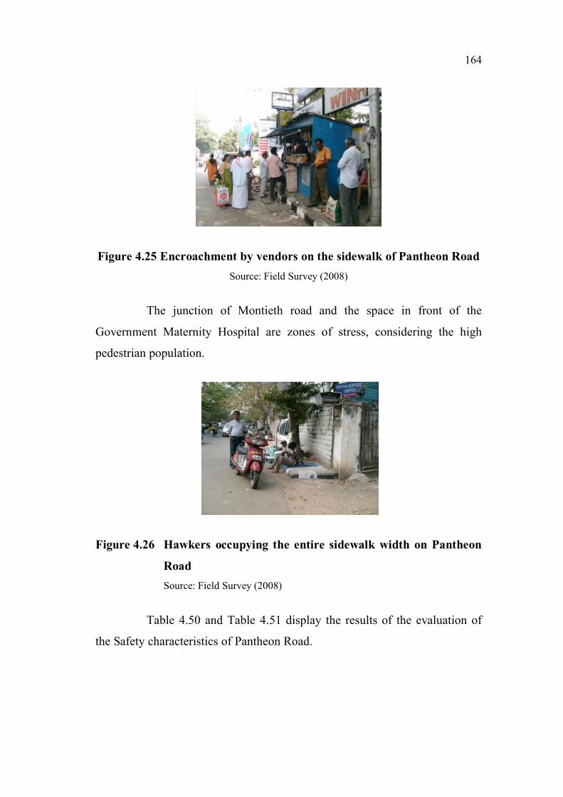
164
Figure 4.25 Encroachment by vendors on the sidewalk of Pantheon Road
Source: Field Survey (2008)
The junction of Montieth road and the space in front of the
Government Maternity Hospital are zones of stress, considering the high
pedestrian population.
Figure 4.26 Hawkers occupying the entire sidewalk width on Pantheon
Road
Source: Field Survey (2008)
Table 4.50 and Table 4.51 display the results of the evaluation of
the Safety characteristics of Pantheon Road.

165
Table 4.50 Cumulative Rating of the Overall Safety characteristics of
Pantheon Road
Street Pantheon Road
Parameter
Stretch
Level of interaction with vehicles and
Consideration for the vulnerable
pedestrian
Co-optex to Casa Major Road D
Casa Major Road to Museum D
Government Museum to Dr.Nair Road D
Cumulative Rating of Overall Safety
CharacteristicsD
Source: Field Survey (2008)
Table 4.51 Cumulative Rating of the Detailed Safety characteristics of
Pantheon Road
Street Pantheon Road
Parameter
Stretch
Deg
ree
of
ob
stru
ctio
n
on
th
e s
idew
alk
s
Sid
ewalk
su
rface
co
nd
itio
ns
Deg
ree
of
con
flic
t at
cross
ings
Des
ign
pri
nci
ple
s
ad
op
ted
for
ped
estr
ian
secu
rity
Des
ign
pri
nci
ple
s
ad
op
ted
fo
r t
ra
ffic
ca
lmin
g
Co-optex to Casa Major
RoadD C E C E
Casa Major Road to
MuseumD C E C E
Government Museum to
Dr.Nair RoadC C E C E
Cumulative Rating of
Detailed Safety
Characteristics
D C E C E
Source: Field Survey (2008)
The rating for Overall Safety – “D” – signifies that pedestrians
encounter significant conflicts with vehicles, and consideration for the

166
vulnerable pedestrian, i.e. children, the elderly and the disabled is meagre or
nil.
The evaluation of the Detailed Safety characteristics emphasizes
the deficiencies across the pedestrian environment. The stretch obtained a
rating of “D” for “Degree of obstruction on the sidewalks” because of
significant encroachment by street furniture, vendors, parking, and dumping
of building materials and other miscellaneous equipment. For “Sidewalk
Surface Conditions”, it received a rating of “C”. The absence of zebra
crossing patterns, refuge areas, pedestrian-operated signals, pedestrian phase
in signals and signage resulted in a rating of “E” for “Degree of conflict at
crossings”. In terms of “Pedestrian Security”, high levels of activity observed
at some places, adequately dense concentration of people and sufficient
illumination by high-level street lights earned the stretch a rating of “C”.
“Design principles for Traffic Calming” were almost negligible, resulting in a
rating of “E”.
The results of the evaluation of Comfort characteristics of Pantheon
Road are shown in Table 4.52 and Table 4.53.
Table 4.52 Cumulative Rating of the Overall Comfort characteristics of
Pantheon Road
Street Pantheon Road
Parameter
Stretch
Physiological Comfort and
Psychological Comfort
Co-optex to Casa Major Road C
Casa Major Road to Museum C
Government Museum to Dr.Nair
RoadC
Cumulative Rating of Overall
Comfort CharacteristicsC
Source: Field Survey (2008)

167
Table 4.53 Cumulative Rating of the Detailed Comfort characteristics
of Pantheon Road
Street Pantheon Road
Parameter
Stretch
Protection
from
inclement
weather
Noise
Pollution
Air
Pollution
Facilitation
of allied
activities
Co-optex to Casa Major Road D E E C
Casa Major Road to
Museum11 AM C C/E E D
Casa Major Road to
Museum4 PM C A/E A/E D
Museum to Police
Comm. Office Road11 AM D/E C/E E C
Museum to Police
Comm. Office Road4 PM D/E A/E A/E C
Cumulative Rating of Detailed
Comfort CharacteristicsE E E D
Source: Field Survey (2008)
The rating for Overall Comfort – “C” – indicates that in terms of
physiological and psychological comfort, the stretch is adequately
comfortable. There is sufficient freedom to choose the speed of movement, to
maintain adequate distance from others and to indulge in desired activity.
The Detailed Comfort characteristics evaluation brings to the fore
the shortcomings of the stretch. The stretch receives a rating of “D” for
“Protection from inclement weather” due to inadequate protection from the
elements. In terms of “Noise Pollution” and “Air Pollution”, due to the
absence of any measure to reduce noise and air pollution, it gets a rating of
“E”. “Facilitation of Allied Activities” is just about adequate with no
provision of seating, moderately wide sidewalks permitting window-
shopping, conversing and schmoozing only at the expense of obstructing
other pedestrians. Consequently it earns a rating of “C”.
Table 4.54 and Table 4.55 display the results of the evaluation of
the Convenience characteristics of Pantheon Road.

168
Table 4.54 Cumulative Rating of the Overall Convenience characteristics
of Pantheon Road
Street Pantheon Road
Parameter
StretchPath characteristics
Co-optex to Casa Major Road E
Casa Major Road to Museum A/E
Government Museum to Dr.Nair
RoadE
Cumulative Rating of Overall
Convenience CharacteristicsE
Source: Field Survey (2008)
Table 4.55 Cumulative Rating of the Detailed Convenience characteristics
of Pantheon Road
Street Pantheon Road
Parameter
Stretch
Legibility of the
pedestrian
environment
Pedestrian
amenities
Pedestrian
crossings
Co-optex to Casa Major Road D E E
Casa Major Road to Museum D E E
Government Museum to
Dr.Nair RoadA/E E E
Cumulative Rating of Detailed
Convenience CharacteristicsE E E
Source: Field Survey (2008)
The evaluation of Overall Convenience – “E” – reveals that the
stretch is severely deficient in terms of shortcuts and impedances.
The Detailed level evaluation highlights the following issues. The
evaluation of “Legibility of the pedestrian environment” shows, that though
the street has sufficient landmark buildings, physical and visual linkages and
nodes, in terms of street furniture, signage and street activities it is woefully
inadequate. Consequently, it gets a rating of “D”. A complete absence of
“Pedestrian Amenities” earns it a rating of “E”. In terms of “Pedestrian
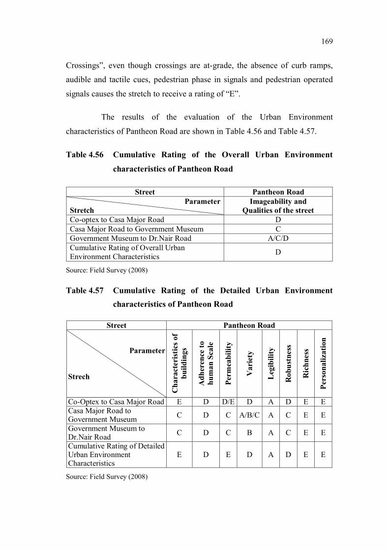
169
Crossings”, even though crossings are at-grade, the absence of curb ramps,
audible and tactile cues, pedestrian phase in signals and pedestrian operated
signals causes the stretch to receive a rating of “E”.
The results of the evaluation of the Urban Environment
characteristics of Pantheon Road are shown in Table 4.56 and Table 4.57.
Table 4.56 Cumulative Rating of the Overall Urban Environment
characteristics of Pantheon Road
Street Pantheon Road
Parameter
Stretch
Imageability and
Qualities of the street
Co-optex to Casa Major Road D
Casa Major Road to Government Museum C
Government Museum to Dr.Nair Road A/C/D
Cumulative Rating of Overall Urban
Environment CharacteristicsD
Source: Field Survey (2008)
Table 4.57 Cumulative Rating of the Detailed Urban Environment
characteristics of Pantheon Road
Street Pantheon Road
Parameter
Strech
Ch
ara
cter
isti
cs o
f
bu
ild
ing
s
Ad
her
ence
to
hu
ma
n S
ca
le
Per
mea
bil
ity
Vari
ety
Leg
ibil
ity
Ro
bu
stn
ess
Ric
hn
ess
Per
son
ali
zati
on
Co-Optex to Casa Major Road E D D/E D A D E E
Casa Major Road toGovernment Museum
C D C A/B/C A C E E
Government Museum toDr.Nair Road
C D C B A C E E
Cumulative Rating of DetailedUrban EnvironmentCharacteristics
E D E D A D E E
Source: Field Survey (2008)

170
The rating of “D” for the Overall level characteristics of the Urban
Environment indicates that the stretch is inadequate, when assessed for
Imageability (Skyline, Landmark buildings, Response to context, Nodes,
Levels, Diversity of activities, Spatial relationships and changing views) and
Qualities of the street (Street elements like Beginning, End and places of
special activity, Sense of enclosure, Adherence of street dimensions to
guidelines, Interaction of people, conduciveness for traditional rituals and
gatherings, and the capacity to support recreation, conversation and
entertainment).
As part of the evaluation of Detailed level characteristics, the
stretch gets a rating of “E” for “Characteristics of Buildings”, thus signifying
that the buildings severely lack a sense of unity, detailing at eye-level and
respect to context. “Adherence to Human Scale” sees the stretch getting a
rating of “D”. In the assessment of “Permeability”, the stretch receives a
rating of “D/E”, indicating that the stretch offers an inadequate choice of
access, very few views of interior spaces and virtually no spaces which invite
the pedestrian into the built environment. The evaluation of “Variety” – “D” -
highlights the inadequacy of the stretch in providing variety of form, use and
meaning. The review of “Legibility” – “A” - reveals that the stretch fares
exceedingly well in terms of location of nodes, landmarks, physical and visual
linkages and variety and location of street activities. In the evaluation of
“Robustness” – “D” – the inadequate diversity of activities and adaptability of
buildings to multiple uses are highlighted. The stretch receives a rating of “E”
for “Richness” in terms of sensory experiences with nothing on offer for the
olfactory, kinetic and tactile senses. In terms of “Personalisation” too, the
stretch falls woefully short in terms of enhancing the pedestrian environment
through personalization of personal as well as public space.

171
4.3.7 Rajaji Salai
Background: Rajaji Salai also known as First Line Beach is one of
the main arteries of George Town, as shown in Figure 4.27. George Town –
named after Fort St. George – became the nucleus around which the city of
Chennai (earlier known as Madras) grew.
Figure 4.27 Map indicating the location of Rajaji Salai
Source: A Road Guide to Chennai, TTK Printing Division, Chennai (1996)
The area is famed for its landmark buildings like the High Court,
the Royapuram Station, the Harbour and numerous corporate offices on
N.S.C. Bose Road and Rajaji Salai. Rajaji Salai is the road that runs parallel
to the Chennai port. Starting from Parry’s corner it runs north towards
Royapuram. The Burma Bazaar, a long stretch of small shops numbering 300
in all and dealing in imported goods, runs from Parry’s Corner to the end of
the Beach Station. The Beach Station is the starting point for local trains
Rajaji Salai
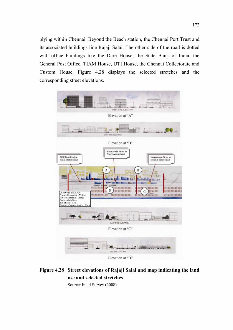
172
plying within Chennai. Beyond the Beach station, the Chennai Port Trust and
its associated buildings line Rajaji Salai. The other side of the road is dotted
with office buildings like the Dare House, the State Bank of India, the
General Post Office, TIAM House, UTI House, the Chennai Collectorate and
Custom House. Figure 4.28 displays the selected stretches and the
corresponding street elevations.
Figure 4.28 Street elevations of Rajaji Salai and map indicating the land
use and selected stretches
Source: Field Survey (2008)
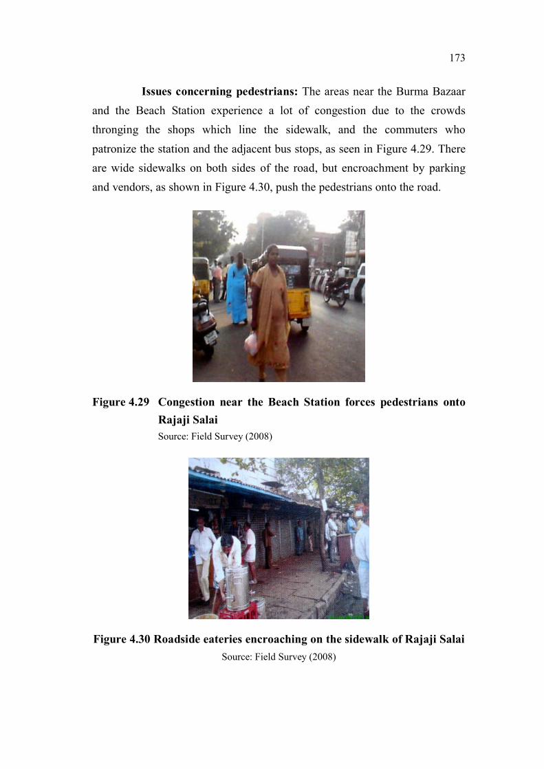
173
Issues concerning pedestrians: The areas near the Burma Bazaar
and the Beach Station experience a lot of congestion due to the crowds
thronging the shops which line the sidewalk, and the commuters who
patronize the station and the adjacent bus stops, as seen in Figure 4.29. There
are wide sidewalks on both sides of the road, but encroachment by parking
and vendors, as shown in Figure 4.30, push the pedestrians onto the road.
Figure 4.29 Congestion near the Beach Station forces pedestrians onto
Rajaji Salai
Source: Field Survey (2008)
Figure 4.30 Roadside eateries encroaching on the sidewalk of Rajaji Salai
Source: Field Survey (2008)

174
The results of the evaluation of Safety characteristics of Rajaji Salai
are shown in Table 4.58 and Table 4.59.
Table 4.58 Cumulative Rating of the Overall Safety characteristics of
Rajaji Salai
Street Rajaji Salai
Parameter
Stretch
Level of interaction with
vehicles and Consideration for
the vulnerable pedestrian
NSC Bose Road to Nalla Muthu Street D
Nalla Muthu Street to Narayanappa Street D
Narayanappa Street to Ebrahim Sahib Street D
Cumulative Rating of Overall Safety
CharacteristicsD
Source: Field Survey (2008)
Table 4.59 Cumulative Rating of the Detailed Safety characteristics of
Rajaji Salai
Street Rajaji Salai
Parameter
Stretch
Deg
ree
of
ob
stru
ctio
n
on
th
e s
idew
alk
s
Sid
ew
alk
su
rfa
ce
co
nd
itio
ns
Deg
ree
of
con
flic
t at
cross
ings
Desi
gn
prin
cip
les
ad
op
ted
for
ped
estr
ian
secu
rity
Desi
gn
prin
cip
les
ad
op
ted
fo
r t
ra
ffic
ca
lmin
g
NSC Bose Road to Nalla Muthu
StreetC D E C E
Nalla Muthu Street to
Narayanappa StreetC C E C E
Narayanappa Street to Ebrahim
Sahib StreetC D E C E
Cumulative Rating of Detailed
Safety CharacteristicsC D E C E
Source: Field Survey (2008)
The rating for Overall Safety – “D” – signifies that pedestrians
encounter significant conflicts with vehicles and consideration for the
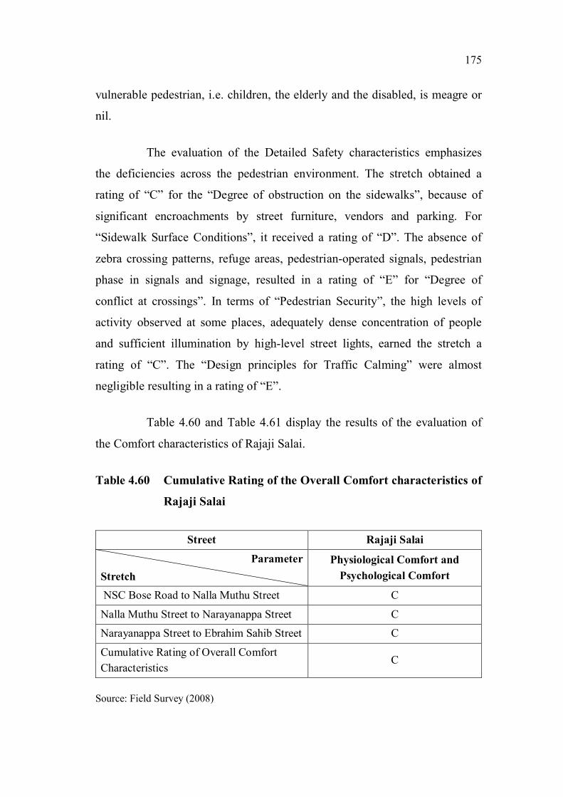
175
vulnerable pedestrian, i.e. children, the elderly and the disabled, is meagre or
nil.
The evaluation of the Detailed Safety characteristics emphasizes
the deficiencies across the pedestrian environment. The stretch obtained a
rating of “C” for the “Degree of obstruction on the sidewalks”, because of
significant encroachments by street furniture, vendors and parking. For
“Sidewalk Surface Conditions”, it received a rating of “D”. The absence of
zebra crossing patterns, refuge areas, pedestrian-operated signals, pedestrian
phase in signals and signage, resulted in a rating of “E” for “Degree of
conflict at crossings”. In terms of “Pedestrian Security”, the high levels of
activity observed at some places, adequately dense concentration of people
and sufficient illumination by high-level street lights, earned the stretch a
rating of “C”. The “Design principles for Traffic Calming” were almost
negligible resulting in a rating of “E”.
Table 4.60 and Table 4.61 display the results of the evaluation of
the Comfort characteristics of Rajaji Salai.
Table 4.60 Cumulative Rating of the Overall Comfort characteristics of
Rajaji Salai
Street Rajaji Salai
Parameter
Stretch
Physiological Comfort and
Psychological Comfort
NSC Bose Road to Nalla Muthu Street C
Nalla Muthu Street to Narayanappa Street C
Narayanappa Street to Ebrahim Sahib Street C
Cumulative Rating of Overall Comfort
CharacteristicsC
Source: Field Survey (2008)

176
Table 4.61 Cumulative Rating of the Detailed Comfort characteristics
of Rajaji Salai
Street Rajaji Salai
Parameter
Stretch
Protection
from
inclement
weather
Noise
Pollution
Air
Pollution
Facilitation
of allied
activities
NSC Bose Road to Nalla
Muthu StreetD E E E
Nalla Muthu Street to
Narayanappa StreetC E E C
Narayanappa Street to Ebrahim
Sahib StreetC E E C
Cumulative Rating of Detailed
Comfort CharacteristicsD E E E
Source: Field Survey (2008)
The rating for Overall Comfort – “C” – indicates, that in terms of
physiological and psychological comfort, the stretch is adequately
comfortable. There is sufficient freedom to choose the speed of movement, to
maintain adequate distance from others and to indulge in desired activity.
The Detailed Comfort characteristics evaluation brings to the fore
the shortcomings of the stretch. The stretch receives a rating of “D” for
“Protection from inclement weather” due to inadequate protection from the
elements. In terms of “Noise Pollution” and “Air Pollution”, due to the
absence of any measure to reduce noise and air pollution, it gets a rating of
“E”. “Facilitation of Allied Activities” is just about adequate with no
provision of seating, moderately wide sidewalks permitting window-
shopping, conversing and schmoozing, only at the expense of obstructing
other pedestrians. Consequently it earns a rating of “E”.

177
The results of the evaluation of Convenience characteristics of
Rajaji Salai are shown in Table 4.62 and Table 4.63.
Table 4.62 Cumulative Rating of the Overall Convenience characteristics
of Rajaji Salai
Street Rajaji Salai
Parameter
StretchPath characteristics
NSC Bose Road to Nalla Muthu Street D
Nalla Muthu Street to Narayanappa Street D
Narayanappa Street to Ebrahim Sahib Street E
Cumulative Rating of Overall Convenience
CharacteristicsE
Source: Field Survey (2008)
Table 4.63 Cumulative Rating of the Detailed Convenience characteristics
of Rajaji Salai
Street Rajaji Salai
Parameter
Stretch
Legibility of
the pedestrian
environment
Pedestrian
amenities
Pedestrian
crossings
NSC Bose Road to Nalla
Muthu StreetB E E
Nalla Muthu Street to
Narayanappa StreetA E D
Narayanappa Street to Ebrahim
Sahib StreetD E D
Cumulative Rating of Detailed
Convenience CharacteristicsD E E
Source: Field Survey (2008)

178
The evaluation of Overall Convenience – “E” – reveals that the
stretch is severely deficient in terms of shortcuts and impedances.
The Detailed level evaluation highlights the following issues. The
evaluation of “Legibility of the pedestrian environment” shows, that though
the street has sufficient landmark buildings, physical and visual linkages and
nodes, in terms of street furniture, signage and street activities it is woefully
inadequate. Consequently it gets a rating of “D”. A complete absence of
“Pedestrian Amenities” earns it a rating of “E”. In terms of “Pedestrian
Crossings”, even though crossings are at-grade, the absence of curb ramps,
audible and tactile cues, pedestrian phase in signals and pedestrian operated
signals causes the stretch to receive a rating of “E”.
Table 4.64 and Table 4.65 display the results of the evaluation of
the Urban Environment characteristics of Rajaji Salai.
Table 4.64 Cumulative Rating of the Overall Urban Environment
characteristics of Rajaji Salai
Street Rajaji Salai
Parameter
Stretch
Imageability and Qualities of
the street
NSC Bose Road to Nalla Muthu Street B
Nalla Muthu Street to Narayanappa Street B
Narayanappa Street to Ebrahim Sahib Street B
Cumulative Rating of Overall Urban
Environment CharacteristicsB
Source: Field Survey (2008)

179
Table 4.65 Cumulative Rating of the Detailed Urban Environment
characteristics of Rajaji Salai
Street Rajaji Salai
Parmeter
Strech Ch
ara
cter
isti
cs
of
bu
ild
ing
s
Ad
her
ence
to
hu
ma
n s
ca
le
Per
mea
bil
ity
Varie
ty
Leg
ibil
ity
Ro
bu
st-n
ess
Ric
hn
ess
Per
son
ali
zati
on
NSC Bose Road to Nalla Muthu
StreetD D C D B D E E
Nalla Muthu Street to
Narayanappa StreetD D D D B C E E
Narayanappa Street to Ebrahim
Sahib StreetD D E D B D E E
Cumulative Rating of Detailed
Urban Environment
Characteristics
D D E D B D E E
Source: Field Survey (2008)
The rating of “B” for the Overall level characteristics of the Urban
Environment indicates that the stretch is inadequate, when assessed for
Imageability (Skyline, Landmark buildings, Response to context, Nodes,
Levels, Diversity of activities, Spatial relationships and changing views) and
Qualities of the street (Street elements like the Beginning, End, and places of
special activity, Sense of enclosure, Adherence of street dimensions to
guidelines, Interaction of people, conduciveness for traditional rituals and
gatherings, and the capacity to support recreation, conversation and
entertainment).
As part of the evaluation of the Detailed level characteristics, the
stretch gets a rating of “D” for “Characteristics of Buildings”, thus signifying
that the buildings severely lack a sense of unity, detailing at eye-level and
respect to context. “Adherence to Human Scale” sees the stretch getting a
rating of “D”. In the assessment of “Permeability”, the stretch receives a
rating of “E”, indicating that the stretch offers an inadequate choice of access,
180
very few views of interior spaces and virtually no spaces which invite the
pedestrian into the built environment. The evaluation of “Variety” – “D” -
highlights the inadequacy of the stretch in providing variety of form, use and
meaning. The review of “Legibility” – “B” - reveals that the stretch fares
exceedingly well in terms of location of nodes, landmarks, physical and visual
linkages and variety and location of street activities. In the evaluation of
“Robustness” – “D” – the inadequate diversity of activities and adaptability of
buildings to multiple uses, are highlighted. The stretch receives a rating of
“E” for “Richness” in terms of sensory experiences with nothing on offer for
the olfactory, kinetic and tactile senses. In terms of “Personalisation” too, the
stretch falls woefully short in terms of enhancing the pedestrian environment
through personalization of personal as well as public space.
4.4 SUMMARY
This study has been carried out primarily to assess the problems afflicting
pedestrian environments. For testing the efficacy of the method, streets were
selected based on the observed pedestrian volume, potential pedestrian
generators, function, context and usage, and divided into different stretches
for a more comprehensive analysis. A comprehensive survey was carried out
with the help of the checklist at different times in the morning and evening.
The data obtained was collated and then weighed against the parameters of
the Overall and Detailed characteristics of Safety, Comfort, Convenience and
the Urban Environment. The appropriate grade is selected based on the
highest number of parameters satisfied.
The application of the method reveals a lot of shortcomings in the
pedestrian realm, many of which would not have been identified with
quantitative techniques.
The next chapter looks at the findings of the application and the
conclusions.