Embed Size (px)
Citation preview

8/2/2019 Chapter 3-Gis Basics r
http://slidepdf.com/reader/full/chapter-3-gis-basics-r 1/17
Chapter 3
GIS Basics
Seminar 2
8/2/2019 Chapter 3-Gis Basics r
http://slidepdf.com/reader/full/chapter-3-gis-basics-r 2/17
DEC 2011 [CHAPTER 3 ]
GIS Integrated Project Management | seminar 2
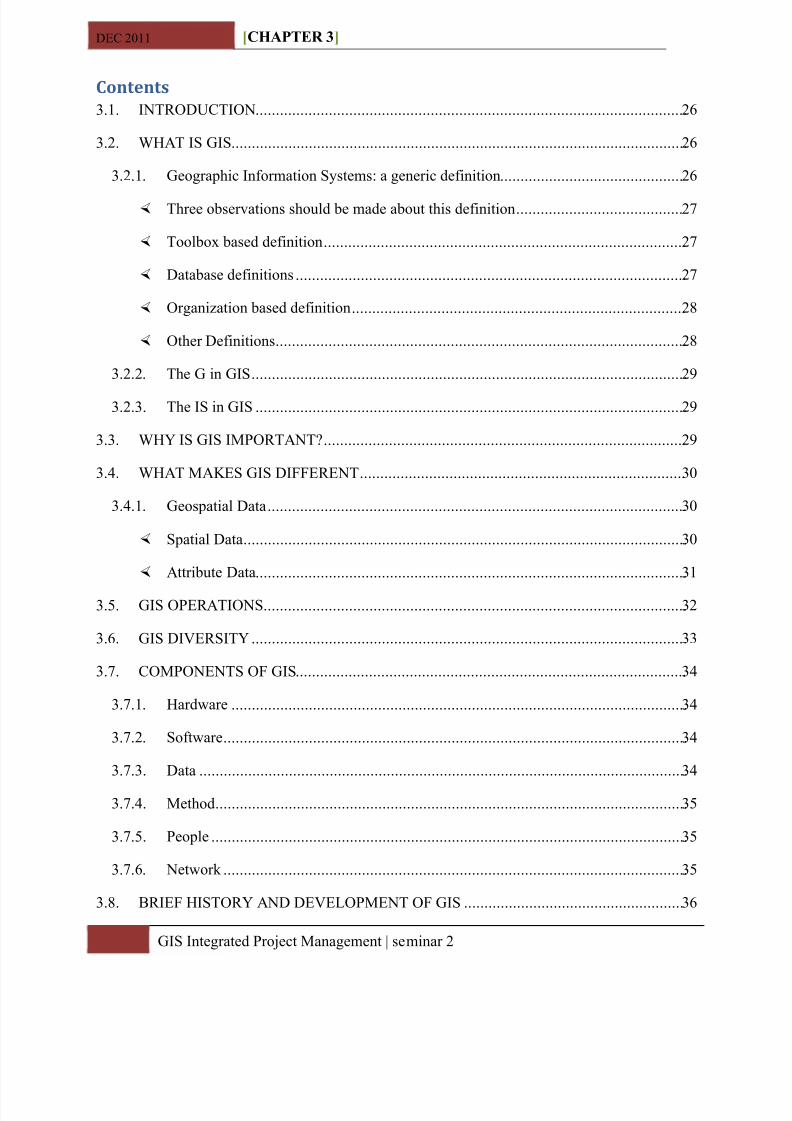
Contents3. 1. INTRODUCTION .......................................................................................................... 26
3. 2. WHA T IS GIS ................................................................................................................ 26
3. 2.1. Geographic Information Systems: a generic definition ............................................. 26
Three observations should be made about this definition ......................................... 27
Toolbox based definition ......................................................................................... 27
Database definitions ................................................................................................ 27
Organization based definition .................................................................................. 28
Other Definitions ..................................................................................................... 28
3. 2.2. The G in GIS ........................................................................................................... 29
3. 2.3. The IS in GIS .......................................................................................................... 29
3.3. WHY IS GIS IMPORT A NT? ......................................................................................... 29
3.4. WHA T M AK ES GIS DIFFERENT ................................................................................ 3 0
3.4. 1. Geospatial Data ....................................................................................................... 3 0
Spatial Data ............................................................................................................. 3 0
A ttribute Data .......................................................................................................... 3 1
3.5. GIS OPER A TIONS ........................................................................................................ 3 2
3. 6. GIS DIVERSIT Y ........................................................................................................... 33
3. 7. COMPONENTS OF GIS ................................................................................................ 34
3. 7.1. H ardware ................................................................................................................ 34
3. 7.2. Software .................................................................................................................. 34
3. 7.3. Data ........................................................................................................................ 34
3. 7.4. Method .................................................................................................................... 35
3. 7.5. People ..................................................................................................................... 35
3. 7.6. Network .................................................................................................................. 35
3. 8. B RIEF H ISTOR Y A ND DEVELOPMENT OF GIS ...................................................... 3 6
8/2/2019 Chapter 3-Gis Basics r
http://slidepdf.com/reader/full/chapter-3-gis-basics-r 3/17
DEC 2011 [CHAPTER 3 ]
GIS Integrated Project Management | seminar 2
3. 9. B ENEFITS OF COMPUTERIZING INFORM A TION ..... Error! Bookmark not defined.
3. 10 . USERS OF GIS .............................................................................................................. 3 7
y Professional operators of GIS ...................................................................................... 3 7
y General users .............................................................................................................. 3 7
3. 11 . MAJ OR A RES OF A PPLIC A TIONS ......................................................................... 3 8
8/2/2019 Chapter 3-Gis Basics r
http://slidepdf.com/reader/full/chapter-3-gis-basics-r 4/17
D 2011 [CHAPTER 3 ]
26 GIS Integrated Project Management | seminar 2
3.1. IN TRODUCT IO N
GIS is no longer for specialists . Powerful and affordable computer hardware and software, the
graphical interface, and public digital data have brought GIS to mainstream use . B ut the priority
of GIS has also created situations in which misuse or misinterpretation of data and results caneasily happen . Therefore to use GIS properly we must be familiar with technology as well as
basic concepts that drive the technology . The present chapter is an attempt to provide basic
fundamentals of GIS for beginners .
3.2. W HAT IS G IS
GIS is expressed in individual letters G ± I ± S and not at pronunciation GIS . It stands for
geographic or geographical information systems . Geographic Information Science is a new
interdisciplinary ¿eld . It is built upon knowledge from geography, cartography, computer
science, mathematics etc .
3.2.1. Geographic Information Sys tem s: a generic definition
GIS can be defined as µ A system for Capturing, storing, checking, integrating, manipulating,
analyzing and displaying data which are spatially referenced to the Earth. This is normally
considered to involve a spatially referenced computer database and appropriate applications
software ¶. A Geographic Information System is an integration of computer hardware and software which
can create, manipulate, and analyze a geographically referenced data base to produce new maps
and tabular data GIS includes the capabilities of Computer A ided Design (C A D) and Data B ase
Management Systems (D B MS), but is more than just a combination of those systems .
GIS is a special-purpose digital database in which a common spatial coordinate system is the
primary means of reference . Comprehensive GIS require a means of:
1. Data input, from maps, aerial photos, satellites, surveys, and other sources .
2. Data storage, retrieval, and query .
3. Data transformation, analysis, and modeling, including spatial statistics .
4. Data reporting, such as maps, reports, and plans .
8/2/2019 Chapter 3-Gis Basics r
http://slidepdf.com/reader/full/chapter-3-gis-basics-r 5/17
MAY 2011 [CHAPTER 3 ]
27 GIS Integrated Project Management | seminar 2
Thr ee obse rva tions s h ould be m a de a bout t h is definition
F ir st, GIS are related to other database applications, but with an important difference . A ll
information in a GIS is linked to a spatial reference . Other databases may contain locational
information (such as street addresses, or zip codes), but a GIS database uses geo-references as
the primary means of storing and accessing information .
Second, GIS integrates technology . W hereas other technologies might be used only to analyze
aerial photographs and satellite images, to create statistical models, or to draft maps, these
capabilities are all offered together within a comprehensive GIS .
Third, GIS, with its array of functions, should be viewed as a process rather than as merely
software or hardware . GIS are for making decisions . The way in which data is entered, stored,
and analyzed within a GIS must mirror the way information will be used for a specific
research or decision ± making task . To see GIS as merely a software or hardware system is tomiss the crucial role it can play in a comprehensive decision-making process .
Toolbox b a sed definition
y µA powerful set of tools for collecting, storing, retrieving at will, transforming and
displaying spatial data from the real world¶ ( B urrough 1986)
y µA system for capturing, storing, checking, manipulating, analyzing and displaying data
which are spatially referenced to earth¶ (Department of Environment 1987)
y µA n information technology which stores analyses, and displays both spatial and non
spatial data
Da t a b a se definitions
y µA database system in which most of the data are spatially indexed, and upon which a set
of procedures operated in order to answer queries about spatial entities in the database
(Smith et al. 1987)
y µA ny manual or computer based set of procedures used to store and manipulate
geographically referenced data¶ ( A ronoff 1989)
8/2/2019 Chapter 3-Gis Basics r
http://slidepdf.com/reader/full/chapter-3-gis-basics-r 6/17
MAY 2011 [CHAPTER 3 ]
28 GIS Integrated Project Management | seminar 2
Orga niz a tion b a sed definition
y µA n automated set of functions that provides professionals with advanced capabilities of
storage, retrieval, manipulation and display of geographical located data¶ (Ozemoy,
Smith, and Sicherman 1981)
y µA n institutional entity, reflecting an organizational structure that integrates technologywith database, expertise and continuing financial support over time¶ (Carter 1989)
y µA decision support system involving the integration of spatially referenced data in
problem solving environment¶ (Cowen 1988)
Ot h e r Definitions
A definition quoted in W illiam Huxhold¶s Introduction to Urban Geographic Information
Sys tem s:
µTh e purpose of a traditional GIS is first and foremost spatial analysis. Th erefore,
capabilities may h ave limited data capture and cartograp h ic output. Capabilities of
analyses typically support decision making for specific projects and / or limited
geograp h ic areas. Th e map data-base c h aracteristics (accuracy, continuity,
completeness, etc.) are typically appropriate for small-scale map output. Vector and
raster data interfaces may be available. However, topology is usually t h e sole underlying
data structure for spatial analyses.
D ana Tomlin¶s definition, from Geographic Information Sys tem s and Cartographic Modeling :
µA geograp h ic information system is a facility for preparing, presenting, and interpreting
facts t h at pertain to t h e surface of t h e eart h . Th is is a broad definition . . . a considerably
narrower definition, h owever, is more often employed. In common parlance, a
geograp h ic information system or GIS is a configuration of computer h ardware and
software specifically designed for t h e acquisition, maintenance, and use of cartograp h ic
data.
F rom Jeffrey Star and John Estes , in Geographic Information Sys tem s: An Introduction :
µA geograp h ic information system (GIS) is an information system t h at is designed to work
wit h data referenced by spatial or geograp h ic coordinates. In ot h er words, a GIS is bot h a
database system wit h specific capabilities for spatially-reference data, as well [as] a set of
8/2/2019 Chapter 3-Gis Basics r
http://slidepdf.com/reader/full/chapter-3-gis-basics-r 7/17
MAY 2011 [CHAPTER 3 ]
29 GIS Integrated Project Management | seminar 2
operations for working wit h data . . . In a sense, a GIS may be t h oug h t of as a h ig h er-order
map.
3.2.2. The G in G IS
Geographic Information´ is information which can be related to specific locations on the Earth .
It covers an enormous range including the distribution of natural resources, the influence of
pollution's, description of infrastructures such as buildings, utility and transport services, patterns
of land-use and the health, wealth, employment, housing and voting habits of people . Most
human activity depends on geographic information: on knowing where things are and
understanding how they relate to each other . ( H andling Geographic Information, Report of the
Committee of Inquiry chaired by Lord Chorley, Department of the Environment, 1987) .
3.2.3. The IS in G IS
Information Systems can have different roles in an organization . A ccording to Strobl (199 5 ) they
can be:
y Operational Support of processes; getting the data needed in the process . Or to put it in a
more simple way; automating the day to day processes like a database of clients or in
case of a GIS the catalog of a collection of maps;
y Documentation of records, documenting the available records of an organization;
y External information; providing information about activities and records of an
organization for marketing or sales purposes;
y MIS; Management Information Systems; supporting management in providing
information .
Most IS systems can be put in one of these 4 categories .
3.3. W HY IS G IS IMPORTA NT?
Many businesses have adopted GIS because they provide increased efficiency in the delivery of
goods and services .
St ra te gic position of a Geo gra p h ic Info r m a tion Sy stem in t h e Orga niz a tion.
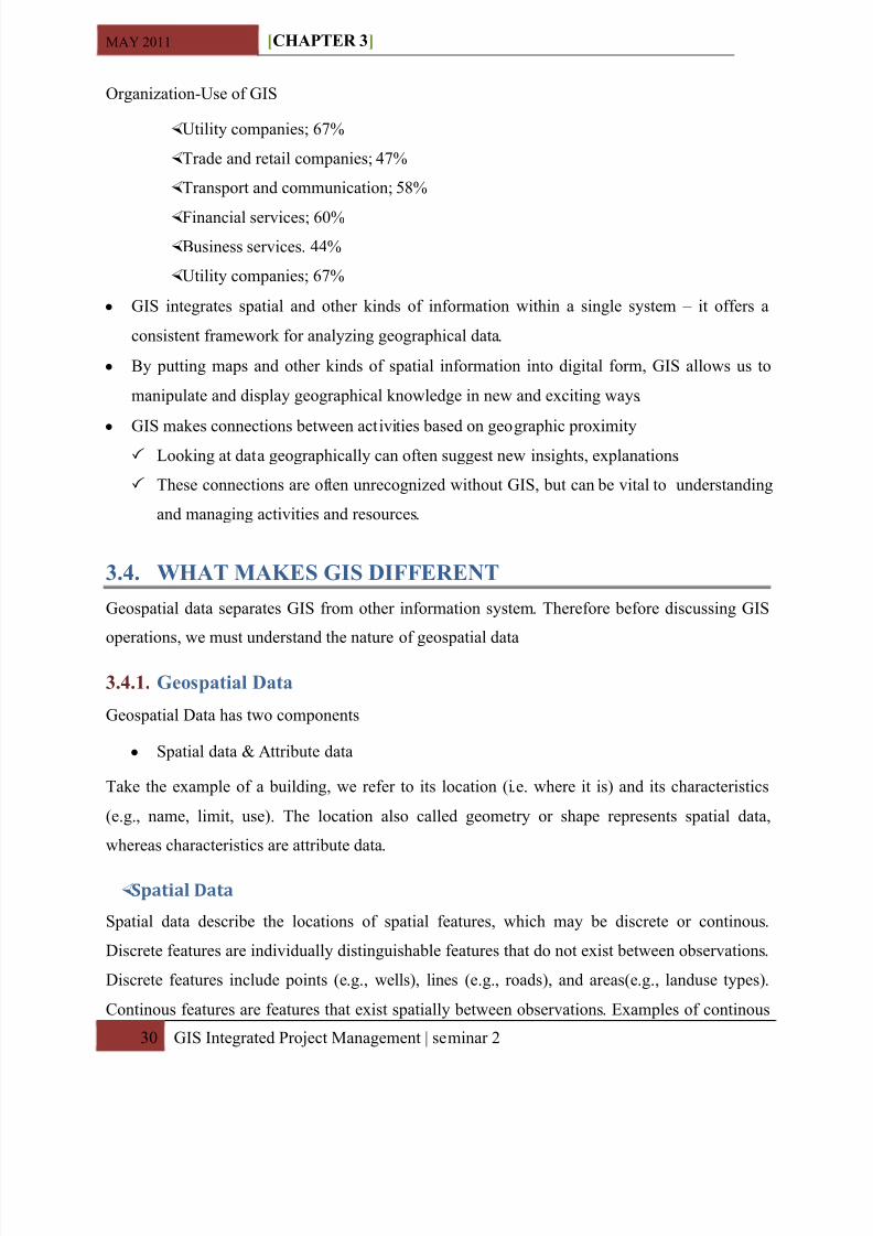
A recent Dutch study ³ Gis, noodzaak of luxe? ³ (Grothe et al . 199 4 ) looking at the the position
of GIS in 2 5 00 private organizations showed the following results:
8/2/2019 Chapter 3-Gis Basics r
http://slidepdf.com/reader/full/chapter-3-gis-basics-r 8/17
MAY 2011 [CHAPTER 3 ]
3 0 GIS Integrated Project Management | seminar 2
Organization-Use of GIS
Utility companies; 67%
Trade and retail companies; 4 7%
Transport and communication; 5 8%
Financial services; 60% B usiness services . 44 %
Utility companies; 67%
y GIS integrates spatial and other kinds of information within a single system ± it offers a
consistent framework for analyzing geographical data .
y B y putting maps and other kinds of spatial information into digital form, GIS allows us to
manipulate and display geographical knowledge in new and exciting ways .
y GIS makes connections between activities based on geographic proximity
Looking at data geographically can often suggest new insights, explanations .
These connections are often unrecognized without GIS, but can be vital to understanding
and managing activities and resources .
3.4. W HAT MAKE S G IS DIFF ERE NT
Geospatial data separates GIS from other information system . Therefore before discussing GIS
operations, we must understand the nature of geospatial data
3.4.1. Geo spatial Data
Geospatial Data has two components
y Spatial data & A ttribute data
Take the example of a building, we refer to its location (i . e. where it is) and its characteristics
(e .g., name, limit, use) . The location also called geometry or shape represents spatial data,
whereas characteristics are attribute data .
Sp a ti a l Da t a
Spatial data describe the locations of spatial features, which may be discrete or continous .
Discrete features are individually distinguishable features that do not exist between observations .
Discrete features include points (e .g. , wells), lines (e .g., roads), and areas(e .g. , landuse types) .
Continous features are features that exist spatially between observations . Examples of continous
8/2/2019 Chapter 3-Gis Basics r
http://slidepdf.com/reader/full/chapter-3-gis-basics-r 9/17
MAY 2011 [CHAPTER 3 ]
3 1 GIS Integrated Project Management | seminar 2
features are elevation and precipitation . A gis represents these spatial features on earth surface as
map features on plain surface . This transformation involves two main issues: spatial reference
system and the data model .
The location of spatial feature on earth surface are based on geographical coordinate system with
longitude and latitude values, whereas location of map features are based on a plane cordiantesystem with x and y coordinates . Projection is the process that can transform the earths spherical
surface to a plane surface and bridge the two spatial reference systems . B ut his transformations
always involve distortion .
The data models defines how spatial features are represented in a GIS . The vector data model
uses points and their x,y coordinates to construct spatial features of points, lines and areas . The
raster model uses a grid and grid cells to represent the spatial variation of feature . The two data
models differ in concept: vector data are ideal for representing discrete features; raster data are better suited for representing continuous features .
The georelational data model uses a split system to store spatial data and attribute data .
The object based model, on the other hand stores spatial data and attribute data in a single
system . Recent trends suggest that GIS vendors have adopted the object based datamodel in their
software development .
A tt r ibute Da t a
A ttribute data describe the characteristics of spatial features . For raster data, each cell has a vlue
that corresponds to the attribute of spatial feature at that location . For vector data, the amount of
attribute associated with a spatial feature can vary significantly . A road segment may only have
the attributes of length and speed limit, whereas a soil polygon may have dozens of properties,
interpretations, and performance data .
J oining Spatial & A ttribute Data
The georelational data model stores attribute data separately from spatial data in a split system .
The two data components are linked through feature ID¶s . The object based data model stores
spatial data and attribute data along with other attributes in a single system . Thus the object
based data model eliminates the complexity of coordinating and synchronizing two sets of data
files . It also brings GIS closer to other nonspatial information system .
8/2/2019 Chapter 3-Gis Basics r
http://slidepdf.com/reader/full/chapter-3-gis-basics-r 10/17
MAY 2011 [CHAPTER 3 ]
3 2 GIS Integrated Project Management | seminar 2
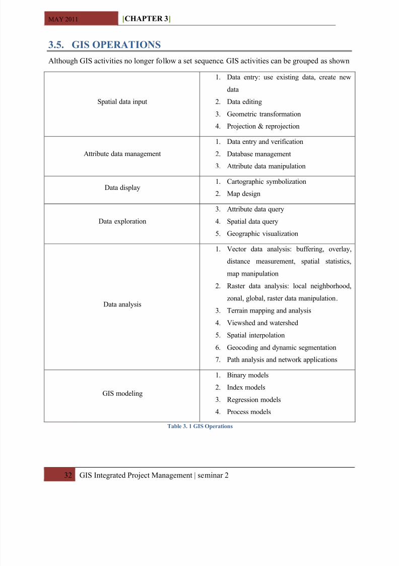
3.5. G IS OPERAT IO NS A lthough GIS activities no longer follow a set sequence . GIS activities can be grouped as shown
Spatial data input
1. Data entry: use existing data, create new
data
2. Data editing
3. Geometric transformation
4. Projection & reprojection
A ttribute data management
1. Data entry and verification
2. Database management
3. A ttribute data manipulation
Data display1. Cartographic symbolization
2. Map design
Data exploration
3. A ttribute data query
4. Spatial data query
5. Geographic visualization
Data analysis
1. Vector data analysis: buffering, overlay,
distance measurement, spatial statistics,
map manipulation
2. Raster data analysis: local neighborhood,
zonal, global, raster data manipulation . 3. Terrain mapping and analysis
4. Viewshed and watershed
5. Spatial interpolation
6. Geocoding and dynamic segmentation
7. Path analysis and network applications
GIS modeling
1. B inary models
2. Index models
3. Regression models
4. Process models
Table 3. 1 G IS Operation s
8/2/2019 Chapter 3-Gis Basics r
http://slidepdf.com/reader/full/chapter-3-gis-basics-r 11/17
MAY 2011 [CHAPTER 3 ]
33 GIS Integrated Project Management | seminar 2
3.6. G IS DIV ER SI TYA lthough the general definition of GIS given here is quite valid, in practice the diversity of GIS
has spawned various definitions .
There are many views of GISs, including:
y A data processing system designed for map production or visualization
y A data analysis system for examining conflicts over plans or optimizing the design of
transport systems
y A n information system for responding to queries about land ownership or soil type
y A management system to support the operations of a utility company, helping it to
maintain its distribution network of pipes or cables
y A planning system to aid the design of road systems, excavations, or forest harvest
operations
y A n electronic navigation system for use in land or sea transport
GISs are often designated according to application . W hen used to manage land records they are
often called land information systems (LISs); in municipal and natural resource applications they
are important components of urban information systems (UISs) and natural resource information
systems (NRISs) respectively . The terms spatial and geospatial are often used almost
interchangeably with geographical, although spatial is also used to refer more generally to any
two-or three-dimensional data whether or not it relates directly to the surface of the Earth . The
term automatic mapping/facility management ( A M/FM) is frequently used by utility companies,
transportation agencies, and local governments for systems dedicated to the operation and
maintenance of networks . Nonetheless, GIS is now accepted internationally as an umbrella term
for all digital systems designed to process geographical data .
CA D systems have been developed to support design applications in engineering, architecture,
and related fields . B roadly, C A D systems emphasize design over analysis and often lack the
capabilities needed to process the complex attributes and information of georeferenced data or tointegrate georeferenced data from many sources . Nevertheless, the distinction between C A D and
GIS has become increasingly blurred in recent years; by adding appropriate features, many
former vendors of C A D systems are now able to compete effectively in the GIS market .
8/2/2019 Chapter 3-Gis Basics r
http://slidepdf.com/reader/full/chapter-3-gis-basics-r 12/17
MAY 2011 [CHAPTER 3 ]
34 GIS Integrated Project Management | seminar 2
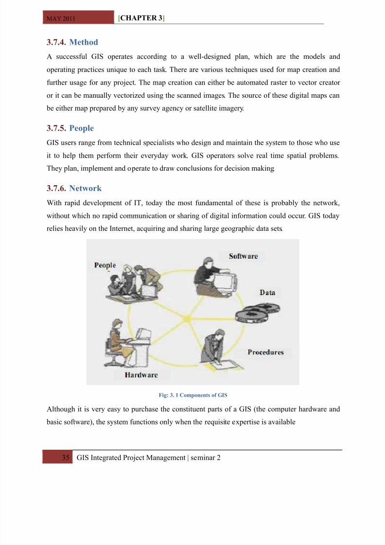
3.7. COMPO NE NT S O F G IS
Like any other information technology GIS require the following components to work with
Geospatial data .
3.7.1. Hardware
It consists of the computer system on which the GIS software will run . The choice of hardware
system ranges from Personal Computers to multi user Super Computers . These computers should
have essentially an efficient processor to run the software and sufficient memory to store enough
information (data) .typically the choices are PC¶s that use the windows operating system or work
stations that use the UNIX or Linux operating system . A dditional equipment may include
monitor for display, digitizers and scanners for spatial data input, GPS receivers and mobile
devices for field work, and printers and plotters for hardcopy data display .
3.7.2. Software
GIS software provides the functions and tools needed to store, analyze, and display geographic
information . The software available can be said to be application specific . A ll GIS software
generally fit all these requirements, but there on screen appearance (user interface) may be
different . Common user interface in GIS are menus, graphical icons, command lines, and scripts .
The software for geographical information system may be split into 5 functional groups
a. Data input and verification
b. Data storage and database management
c. Data output and presentation
d. Data transformation
e. Interaction with user
3.7.3. Data
Data consist of various kinds of inputs that sstem take into produce information . Geographic data
and related tabular data are the backbone of GIS . It can be collected in-house or purchased from
a commercial data provider . The digital map forms the basic data input for GIS . Tabular data
related to the map objects can also be attached to the digital data . A GIS will integrate spatial
data with other data resources and can even use a D B MS .
8/2/2019 Chapter 3-Gis Basics r
http://slidepdf.com/reader/full/chapter-3-gis-basics-r 13/17
8/2/2019 Chapter 3-Gis Basics r
http://slidepdf.com/reader/full/chapter-3-gis-basics-r 14/17
MAY 2011 [CHAPTER 3 ]
3 6 GIS Integrated Project Management | seminar 2
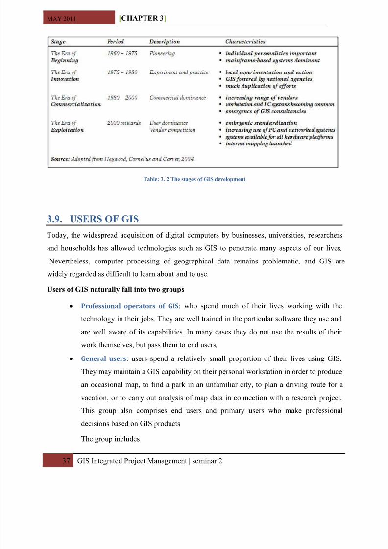
3.8. BR IE F H IS TORY A ND DE VELOPME NT O F G IS
In 18 54 , J ohn Snow depicted a cholera outbreak in London using points to represent the
locations of some individual cases, possibly the earliest use of the geographic method . H is study
of the distribution of cholera led to the source of the disease, a contaminated water pump
(the B road Street Pump, whose handle he had disconnected, thus terminating the outbreak)
within the heart of the cholera outbreak .
The early 20th century saw the development of photozincography, which allowed maps to be
split into layers, for example one layer for vegetation and another for water . This work was
originally drawn on glass plates but later, plastic film was introduced . W hen all the layers were
finished, they were combined into one image using a large process camera . Once colour printing
came in, the layers idea was also used for creating separate printing plates for each colour . W hile
the use of layers much later became one of the main typical features of a contemporary GIS, the photographic process just described is not considered to be a GIS in itself ± as the maps were just
images with no database to link them to .
Computer hardware development spurred by nuclear weapon research led to general-purpose
computer 'mapping' applications by the early 1960s .
The year 1960 saw the development of the world's first true operational GIS in Ottawa, Ontario,
Canada by the federal Department of Forestry and Rural Development . Developed by Dr .Roger
Tomlinson, it was called the Canada Geographic Information System (CGIS) and was used tostore, analyze, and manipulate data collected for the Canada Land Inventory (CLI) .
GIS is not new though, GIS has been considered to be difficult, expensive, and proprietary . The
advent of the graphical user interface (GUI), powerful and affordable hardware and software,
and public digital data broadened the range of GIS applications and brought GIS to mainstream
use in the 1990s .
8/2/2019 Chapter 3-Gis Basics r
http://slidepdf.com/reader/full/chapter-3-gis-basics-r 15/17
MAY 2011 [CHAPTER 3 ]
3 7 GIS Integrated Project Management | seminar 2
Table : 3. 2 The stage s of G IS development
3.9. USER S O F G IS
Today, the widespread acquisition of digital computers by businesses, universities, researchers
and households has allowed technologies such as GIS to penetrate many aspects of our lives .
Nevertheless, computer processing of geographical data remains problematic, and GIS are
widely regarded as difficult to learn about and to use .
User s of G IS naturall y fall into two group s
y P r ofession a l ope ra to r s of GI S: who spend much of their lives working with the
technology in their jobs . They are well trained in the particular software they use and
are well aware of its capabilities . In many cases they do not use the results of their
work themselves, but pass them to end users .
y Gene ra l use r s : users spend a relatively small proportion of their lives using GIS .
They may maintain a GIS capability on their personal workstation in order to produce
an occasional map, to find a park in an unfamiliar city, to plan a driving route for avacation, or to carry out analysis of map data in connection with a research project .
This group also comprises end users and primary users who make professional
decisions based on GIS products
The group includes
8/2/2019 Chapter 3-Gis Basics r
http://slidepdf.com/reader/full/chapter-3-gis-basics-r 16/17
8/2/2019 Chapter 3-Gis Basics r
http://slidepdf.com/reader/full/chapter-3-gis-basics-r 17/17
MAY 2011 [CHAPTER 3 ]
3 9 GIS Integrated Project Management | seminar 2
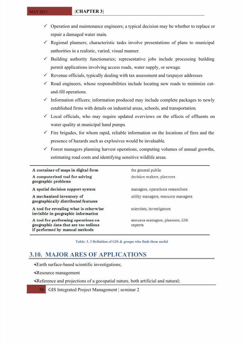
A sset management and location planning
A rchaeology;
Environmental impact-assessment;
Infrastructure assessment and development;
urban planning and regional planning; Cartography, for a thematic and/or time-based purpose;
Criminology;
Geospatial intelligence;
GIS data development;
Geographic history;
Marketing (also see Geo (marketing));
Logistics;
Population and demographic studies;
Public health planning .
Prospectively mapping;
Statistical analysis;
GIS in environmental contamination;
Disease surveillance;
Military planning .
Utility and analysis applications; high consequence area ( H CA ) analysis;
outage and trouble call management;
Damage Prevention;
Engineering A nalysis .