Embed Size (px)
Citation preview

Chapter 3: Familiarizing Yourself With the Night Sky
Introduction People of ancient cultures viewed the sky as the inaccessible home of the gods. They observed the daily motion of the stars, and grouped them into patterns and images. They assigned stories to the stars, relating to themselves and their gods. They believed that human events and cycles were part of larger cosmic events and cycles. The night sky was part of the cycle. The steady progression of star patterns across the sky was related to the ebb and flow of the seasons, the cyclical migration of herds and hibernation of bears, the correct times to plant or harvest crops. Everywhere on Earth people watched and recorded this orderly and majestic celestial procession with writings and paintings, rock art, and rock and stone monuments or alignments. When the Great Pyramid in Egypt was constructed around 2650 BC, two shafts were built into it at an angle, running from the outside into the interior of the pyramid. The shafts coincide with the North-South passage of two stars important to the Egyptians: Thuban, the star closest to the North Pole at that time, and one of the stars of Orion’s belt. Orion was associated with Osiris, one of the Egyptian gods of the underworld.
The Bighorn Medicine Wheel in Wyoming, built by Plains Indians, consists of rocks in the shape of a large circle, with lines radiating from a central hub like the spokes of a bicycle wheel. Piles of rocks, called cairns, are located in the hub of the wheel and in several locations around the outside edge. Lines drawn between pairs of cairns point to the directions of the heliacal risings (the rising of objects just before the Sun, therefore visible in the early morning) of the stars Aldebaran, Rigel, and Sirius. The Samoans used the stars to steer their canoes by aligning the head and tail of a canoe with two stars low on the horizon. The tail of Scorpio was a common star pattern against which to orient a canoe. They navigated from the island of Nokunono to the island of Atafu, beginning their voyage with Scorpio and continuing by steering directly towards the belt of Orion. For early navigators, the regularly changing patterns of the stars in the sky were a reassuring and unfailing guide.
The Ishango Bone, thought to be a 20,000 year old
lunar calendar

AAVSO Variable Star Astronomy – Chapter 3
Today, familiarity with the night sky and the ability to locate its various objects and features is a necessity for those working in many branches of astronomy, such as solar and lunar astronomers, scientists studying planets, asteroids and meteorites, or those working at satellite-based observatories, and astronomers concerned with astrometry—the measurement of the distances and positions of stars. The following activities will help you develop your skills in locating stars and constellations, as well as tracking their motions across the sky. If you are just becoming acquainted with the night sky, the most appropriate instrument to use is your unaided eye. Later on, binoculars will aid you in locating dimmer objects. Small hand-held rotating star maps called planispheres and the Sky-Gazer’s Almanac are useful aids, both for determining what is in the sky for any particular day and time, and for selecting the best times for viewing specific objects. These astronomical tools help you keep track of celestial
motions during the course of the year—the stars and constellations that appear to gradually move across your field of view, and the planets that wander into and out of the night sky.
Investigation 3.1: Drawing a Star Map
Determine your best location from which to observe the night sky. After the skies are dark enough to see several stars and constellations, draw a picture of some part of the sky of your choice. Draw appropriately-sized points to denote the magnitudes of the stars. If you see patterns that you think may be constellations, draw in the lines where you think they belong. Represent the sky as accurately as possible, including the color of any stars you may notice. If you do not know any directions, then draw in one or more objects on the horizon to use as reference points. Do you think your classmates will recognize your star map? If you go out with your sky map at the same time of night one week later, would you expect to see the same patterns? Will they be in the same location? Try it and see. Record any differences on your map. Discuss your observations and results with your classmates.
Egyptian Sun Worship
AAVSO Variable Star Astronomy – Chapter 3
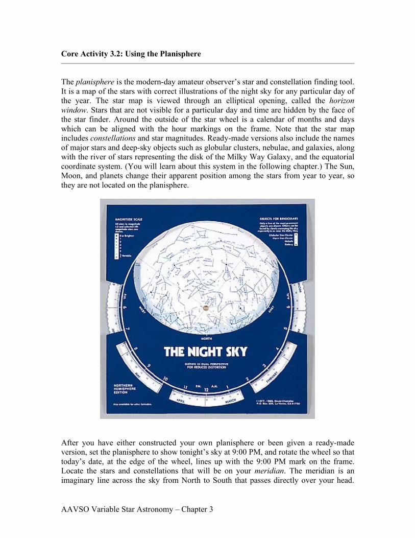
Core Activity 3.2: Using the Planisphere
The planisphere is the modern-day amateur observer’s star and constellation finding tool. It is a map of the stars with correct illustrations of the night sky for any particular day of the year. The star map is viewed through an elliptical opening, called the horizon window. Stars that are not visible for a particular day and time are hidden by the face of the star finder. Around the outside of the star wheel is a calendar of months and days which can be aligned with the hour markings on the frame. Note that the star map includes constellations and star magnitudes. Ready-made versions also include the names of major stars and deep-sky objects such as globular clusters, nebulae, and galaxies, along with the river of stars representing the disk of the Milky Way Galaxy, and the equatorial coordinate system. (You will learn about this system in the following chapter.) The Sun, Moon, and planets change their apparent position among the stars from year to year, so they are not located on the planisphere.
After you have either constructed your own planisphere or been given a ready-made version, set the planisphere to show tonight’s sky at 9:00 PM, and rotate the wheel so that today’s date, at the edge of the wheel, lines up with the 9:00 PM mark on the frame. Locate the stars and constellations that will be on your meridian. The meridian is an imaginary line across the sky from North to South that passes directly over your head.
AAVSO Variable Star Astronomy – Chapter 3
The ready-made version will allow you to determine what star or constellation is at your zenith, which is the point on the meridian directly over your head. Note that Polaris, the North Star, is in the center of the planisphere and does not appear to move in the night sky. Now set the planisphere for 12:00 midnight tonight. Notice the apparent motion of the stars. Now set the planisphere back to 9:00 PM. You are now ready to answer the following questions:
1. What constellation(s) are on your meridian at this time? (9:00 PM)
2. If you are using the ready-made planisphere, what constellation is nearest the zenith at this time?
3. As with most star maps, the brightest stars are indicated by larger points. Locate
five bright stars in tonight’s sky and write down their names (if you know them or if they are on your planisphere), along with the names of the constellations to which they belong.
4. Prominent patterns of several bright stars, called asterisms, are indicated on the
planisphere. Reproduce four asterisms as accurately as is reasonable. Label each, including the names of their brightest stars (if they are on your planisphere or if you know them).
5. Set the planisphere for 12:00 midnight. Locate one of the constellations that was
on your meridian at 9:00 PM. Which way did it move? East or West?
6. What causes this apparent motion of the stars in the real sky? You may wish to practice with other dates and times to become acquainted with your new tool for learning the night sky.
AAVSO Variable Star Astronomy – Chapter 3

AAVSO Variable Star Astronomy – Chapter 3
AAVSO Variable Star Astronomy – Chapter 3
Extension The Sun, Moon, and planets are objects that change their apparent position among the stars, so they are not located on the planisphere. Over the course of the year, the Sun completes one circuit through the stars, following an imaginary path through the zodiacal constellations. That path is called the ecliptic. If we are given the constellation in which such an object is located at any given time, we can approximate its location on the planisphere wheel. Following is a list of the constellations and the dates where the Sun may be found. Locate the approximate position of the Sun on the wheel for today’s date.
January 20–February 18 Capricornus February 19–March 20 Aquarius March 21–April 19 Pisces April 20–May 20 Aries May 21–June 20 Taurus June 21–July 22 Gemini July 23–August 22 Cancer August 23 - September 22 Leo September 23–October 22 Virgo October 23–November 21 Libra November 22–December 21 Scorpius December 22–January 19 Sagittarius
7. Place a marker dot on the ecliptic at the approximate location of the Sun today.
What actually causes the Sun to appear to move along the ecliptic through the stars? NOTE: See table above for the constellation in which the Sun is located for today’s date.
8. Move the star wheel to place the Sun on the eastern horizon. You can now read
the sunrise time for today by locating the date on the wheel edge, and reading the time that corresponds to that date. You have set the wheel to show the sky at sunrise. What time does the Sun rise?
9. Does the Sun rise exactly in the East? If not, then in what direction does it rise?
10. In what part of the sky would you expect to find the planets? Why?

AAVSO Variable Star Astronomy – Chapter 3
Activity 3.3: Searching for Constellations
Now that you have become acquainted with the planisphere, you are ready to begin to know the night sky. Some initial planning will increase the success of your new adventure. IMPORTANT: Make sure your observing site and conditions are safe (refer to(f) and (h) below.)
1. Initial preparation
a. Knowing the latest weather forecast, choose a night for observing and dress appropriately.
b. Using your planisphere, determine what constellations will be up for the
date and time you have elected to observe.
c. Bring a flashlight and tape a piece of red cellophane over the light. (Some flashlights have a red light attachment on one end.) This will allow you to read your planisphere or charts, and write without interfering with the adaptation of your eyes to the dark.
d. Use a compass if you are not sure of the cardinal directions—North,
South, East, and West—at your location.
e. Have a pencil and a notebook to record your observations and any special events or questions you may want to remember. Drawing a picture of the sky is helpful. Always record the date, time, and weather conditions.
f. Choose a viewing site that is safe, and that has the least obstruction from
buildings and trees. If you are on someone else’s property, be sure you have permission to be there. Find a comfortable surface—you may want to bring a lounge chair or blanket. Looking up at the night sky for long periods of time while standing or sitting is uncomfortable.
g. Something to eat and/or drink is not essential, but will certainly make your
experience more enjoyable.
h. Do not observe alone. Bring someone with you—parents, friends, maybe an amateur astronomer. Any knowledgeable person with a love for the night sky will eagerly accompany you to share their enthusiasm. You are now ready to begin.
2. Find your bearings with the compass or map, and make sure you are facing one of
the cardinal directions.
AAVSO Variable Star Astronomy – Chapter 3
3. Hold the star chart or planisphere straight in front of you so that the direction of the sky you are facing is at the bottom of the chart. Now raise your arms and hold the chart directly above your head so that when you look straight up, you are looking at the chart. North on the chart should be in the direction North, East on the chart to the East. The sky and your planisphere or chart should now have the same orientation. Hold the planisphere up long enough to get a general idea about how to match the sky with the chart.
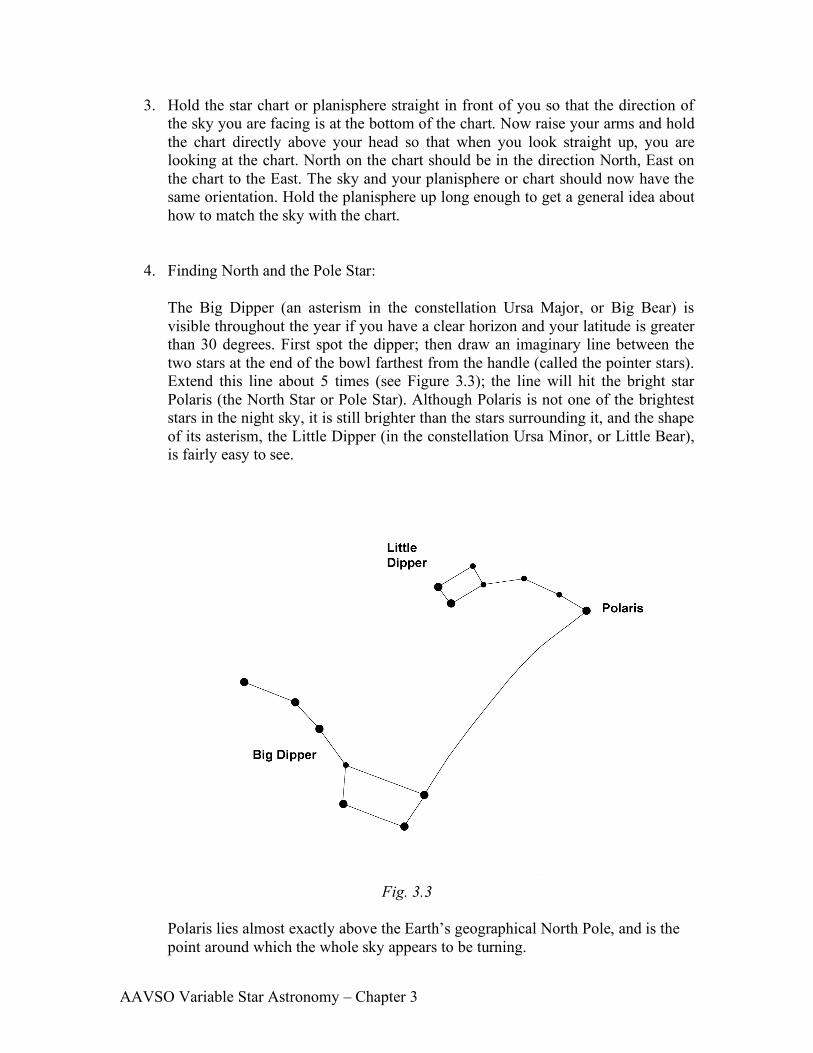
4. Finding North and the Pole Star:
The Big Dipper (an asterism in the constellation Ursa Major, or Big Bear) is visible throughout the year if you have a clear horizon and your latitude is greater than 30 degrees. First spot the dipper; then draw an imaginary line between the two stars at the end of the bowl farthest from the handle (called the pointer stars). Extend this line about 5 times (see Figure 3.3); the line will hit the bright star Polaris (the North Star or Pole Star). Although Polaris is not one of the brightest stars in the night sky, it is still brighter than the stars surrounding it, and the shape of its asterism, the Little Dipper (in the constellation Ursa Minor, or Little Bear), is fairly easy to see.
Fig. 3.3
Polaris lies almost exactly above the Earth’s geographical North Pole, and is the point around which the whole sky appears to be turning.
AAVSO Variable Star Astronomy – Chapter 3
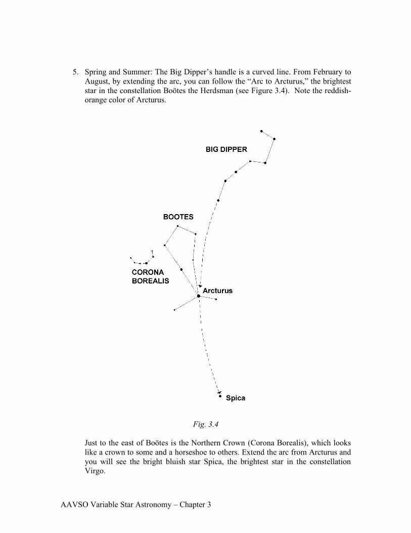
5. Spring and Summer: The Big Dipper’s handle is a curved line. From February to August, by extending the arc, you can follow the “Arc to Arcturus,” the brightest star in the constellation Boötes the Herdsman (see Figure 3.4). Note the reddish-orange color of Arcturus.
Fig. 3.4
Just to the east of Boötes is the Northern Crown (Corona Borealis), which looks like a crown to some and a horseshoe to others. Extend the arc from Arcturus and you will see the bright bluish star Spica, the brightest star in the constellation Virgo.
AAVSO Variable Star Astronomy – Chapter 3
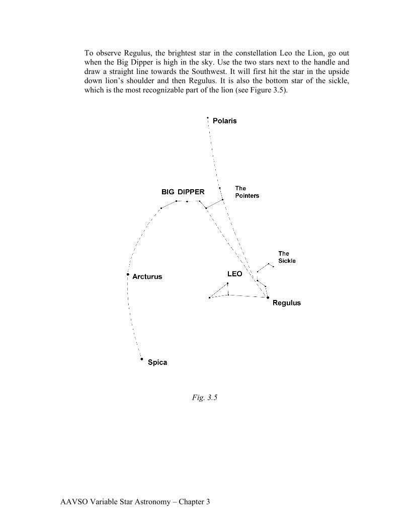
To observe Regulus, the brightest star in the constellation Leo the Lion, go out when the Big Dipper is high in the sky. Use the two stars next to the handle and draw a straight line towards the Southwest. It will first hit the star in the upside down lion’s shoulder and then Regulus. It is also the bottom star of the sickle, which is the most recognizable part of the lion (see Figure 3.5).
Fig. 3.5
AAVSO Variable Star Astronomy – Chapter 3
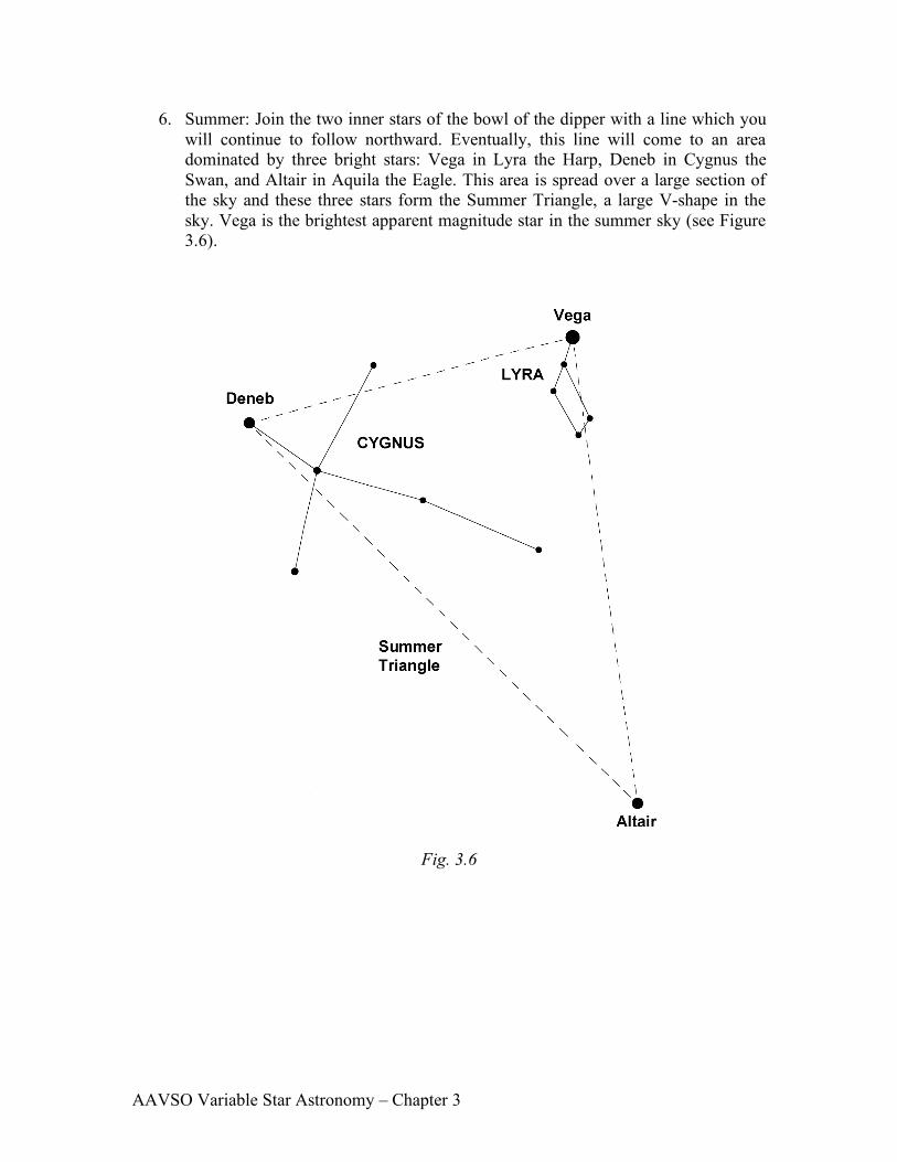
6. Summer: Join the two inner stars of the bowl of the dipper with a line which you will continue to follow northward. Eventually, this line will come to an area dominated by three bright stars: Vega in Lyra the Harp, Deneb in Cygnus the Swan, and Altair in Aquila the Eagle. This area is spread over a large section of the sky and these three stars form the Summer Triangle, a large V-shape in the sky. Vega is the brightest apparent magnitude star in the summer sky (see Figure 3.6).
Fig. 3.6
AAVSO Variable Star Astronomy – Chapter 3
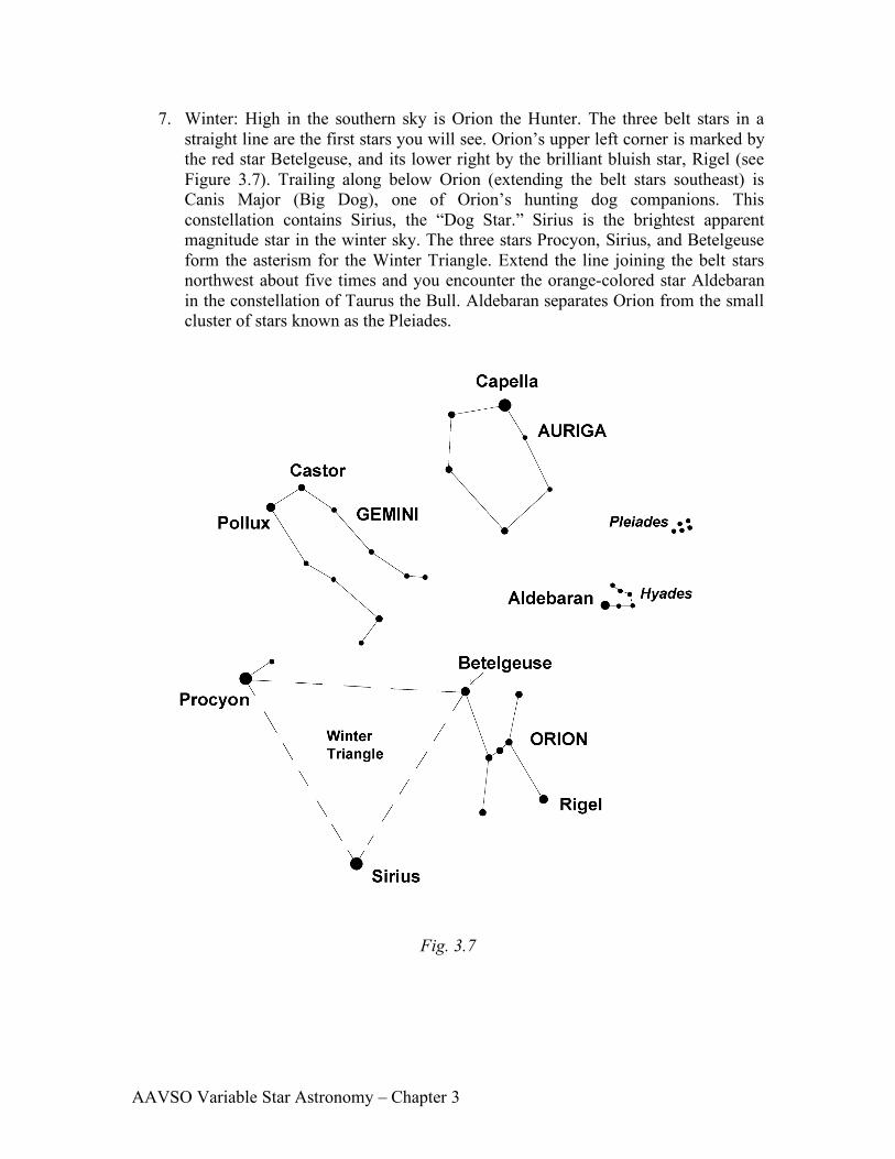
7. Winter: High in the southern sky is Orion the Hunter. The three belt stars in a straight line are the first stars you will see. Orion’s upper left corner is marked by the red star Betelgeuse, and its lower right by the brilliant bluish star, Rigel (see Figure 3.7). Trailing along below Orion (extending the belt stars southeast) is Canis Major (Big Dog), one of Orion’s hunting dog companions. This constellation contains Sirius, the “Dog Star.” Sirius is the brightest apparent magnitude star in the winter sky. The three stars Procyon, Sirius, and Betelgeuse form the asterism for the Winter Triangle. Extend the line joining the belt stars northwest about five times and you encounter the orange-colored star Aldebaran in the constellation of Taurus the Bull. Aldebaran separates Orion from the small cluster of stars known as the Pleiades.
Fig. 3.7
AAVSO Variable Star Astronomy – Chapter 3
This activity was a very brief introduction to the night sky. You will learn how to make your own shortcuts to the various stars and constellations once you become expert in reading your planisphere or star chart. Watch for the different colors of the stars. Later on you may decide to learn how to locate nebulae, globular clusters, and the Andromeda Galaxy.
Planisphaerium Coeleste, Pieter Schenk, 1705
AAVSO Variable Star Astronomy – Chapter 3
Where to go, what to do....
What would you do if you and your family and friends lived on an island about 2,500 years ago, and there was nothing but water as far as you could see? Let's say you and your friends were pretty good with boats. You can build big sailing boats, and you've already made lots of trips around the island in all kinds of weather. You don't have much else to do, but you do pay attention to the weather every day, and you have been watching the skies day and night for several years. After a while, you begin to notice that there are patterns in the way the Sun appears in the morning and goes away in the evening, and you notice a similar motion in the stars at night. There are some stars that always appear at nearly the same point on the horizon every night where the Sun appears during the day, no matter what month it is, and those stars go away each night on the opposite horizon. You notice that there are other stars which rise and set in other directions, and that these stars will rise and set in the same places only once each year. You notice, too, that most of the time the wind comes from the direction that the Sun rises in the morning, and blows towards the direction where the Sun sets in the evening. You also notice that the waves in the sea also move in the same direction as the wind most of the time, and that even when the wind dies down, the large waves continue to move in the same direction. Once you get a feel for the Sun, stars, wind, waves, and the time it takes for these things to repeat themselves, you get the idea that you might be able to sail your boat for longer distances. You wouldn't have to keep your island in sight anymore, because you could keep the Sun and stars in view instead, and you could keep an eye on the direction the waves were moving in as well. You could sail off in any direction and return to your home island again as long as you paid attention to which way you were sailing in relation to the Sun, stars, wind, and waves.
Every time you returned home from another sail out of sight of land, you became more confident of your ability to navigate by the Sun and stars. Maybe it would be a good idea to head straight for the direction where the Sun, stars, wind, and waves all seem to be coming from. That way, you would be sure of your direction all the time, whether coming or going, and also, you could sail as far into the wind as possible until your food and water ran low, and then turn around and have the wind blow you safely back to your home island.
In time, you or your friends would find other islands out there. In a few generations, your people would be able to travel even farther by establishing new home islands farther out each time, and using the new home island as a starting point to explore more of the ocean in every direction. Many believe that the Polynesians traveled to, and settled, the hundreds of islands of the western Pacific ocean over several hundred years by learning how to navigate through such simple beginning observations as outlined here. In time, they would have refined this basic knowledge into a more complex skill. Archeological evidence shows that the Polynesians generally moved from west to east as they expanded their exploration and colonization of other islands. The Tonga islands were occupied about 500 BC, and the island of Tahiti, 1,400 miles to the east, was occupied 700 years later. Altogether, the Polynesian people travelled over a triangular area of the Pacific that is about 4,000 miles on each side. Some of

AAVSO Variable Star Astronomy – Chapter 3
the islands in this area are up to 1,000 miles away from any neighboring islands. It would be very difficult and dangerous just to blindly sail off in any direction and hope to find land somewhere without a reliable navigational system based on observation of the stars. It would be even more difficult, if not impossible, to return home to tell about what you had found. Sometimes the astronomical knowledge gained from sky gazing was learned only for its practical value. Early Polynesian navigators memorized long sequences of rising and setting stars which could be seen, one after the other, above the same spot on the horizon. They rarely used charts, although they sometimes constructed compasses out of sticks to symbolize the patterns of currents and swells they would encounter on their voyages from island to island. Before the American Civil War, slaves escaping via the Underground Railroad also looked to the sky for direction. Their compass was even more simple and more portable than the Polynesians' stick compass: it was a song. A song called "Follow the Drinking Gourd" was actually a secret code describing a sky and land map directing the slaves towards freedom in the North. The slaves had to conceal their knowledge of observational astronomy, especially of the northern sky. Songs are an integral part of African culture; the slaves had a long heritage of transmitting information through songs. Creating "Follow the Drinking Gourd" not only strengthened traditional customs among the slaves, it also established a spiritual bond among them as a symbol of freedom from the suffocating chains of slavery. The song instructs the slaves to leave in winter and travel north along the Tombigee River to the Tennessee River and across the Ohio River. The "drinking gourd" refers to the Big Dipper, easier to see than the fainter Little Dipper and dim Polaris. The slaves kept their eyes on the bright stars of the drinking gourd as they journeyed through the dark and heavily wooded terrain towards the Underground Railroad and liberty.
Follow the Drinking Gourd When the Sun comes back And the first quail calls Follow the Drinking Gourd. For the old man is a-waiting for to carry you to freedom If you follow the Drinking Gourd. The riverbank makes a very good road. The dead trees will show you the way. Left foot, peg foot, traveling on, Follow the Drinking Gourd. The river ends between two hills Follow the Drinking Gourd. There's another river on the other side Follow the Drinking Gourd. When the great big river meets the little river Follow the Drinking Gourd. For the old man is a-waiting for to carry you to freedom If you follow the Drinking Gourd. Follow the Drinking Gourd, follow the Drinking Gourd For the old man is a-waiting for to carry you to freedom If you follow the Drinking Gourd.
AAVSO Variable Star Astronomy – Chapter 3
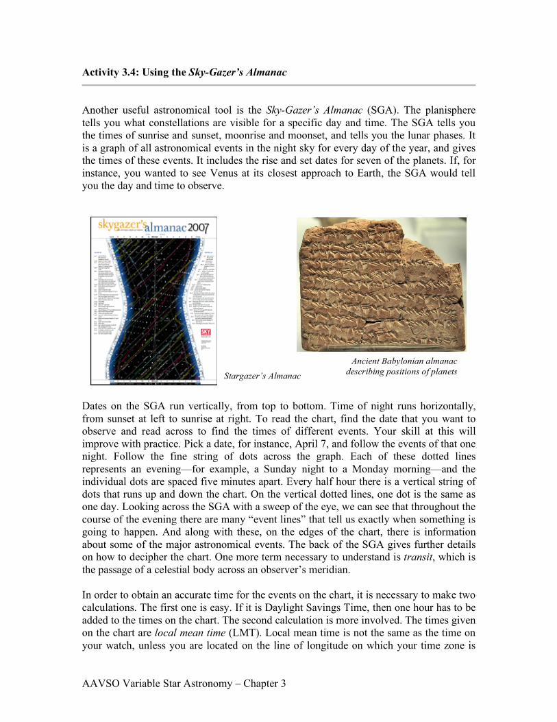
Activity 3.4: Using the Sky-Gazer’s Almanac
Another useful astronomical tool is the Sky-Gazer’s Almanac (SGA). The planisphere tells you what constellations are visible for a specific day and time. The SGA tells you the times of sunrise and sunset, moonrise and moonset, and tells you the lunar phases. It is a graph of all astronomical events in the night sky for every day of the year, and gives the times of these events. It includes the rise and set dates for seven of the planets. If, for instance, you wanted to see Venus at its closest approach to Earth, the SGA would tell you the day and time to observe.
Dates on the SGA run vertically, from top to bottom. Time of night runs horizontally, from sunset at left to sunrise at right. To read the chart, find the date that you want to observe and read across to find the times of different events. Your skill at this will improve with practice. Pick a date, for instance, April 7, and follow the events of that one night. Follow the fine string of dots across the graph. Each of these dotted lines represents an evening—for example, a Sunday night to a Monday morning—and the individual dots are spaced five minutes apart. Every half hour there is a vertical string of dots that runs up and down the chart. On the vertical dotted lines, one dot is the same as one day. Looking across the SGA with a sweep of the eye, we can see that throughout the course of the evening there are many “event lines” that tell us exactly when something is going to happen. And along with these, on the edges of the chart, there is information about some of the major astronomical events. The back of the SGA gives further details on how to decipher the chart. One more term necessary to understand is transit, which is the passage of a celestial body across an observer’s meridian.
In order to obtain an accurate time for the events on the chart, it is necessary to make two calculations. The first one is easy. If it is Daylight Savings Time, then one hour has to be added to the times on the chart. The second calculation is more involved. The times given on the chart are local mean time (LMT). Local mean time is not the same as the time on your watch, unless you are located on the line of longitude on which your time zone is
Ancient Babylonian almanac describing positions of planets Stargazer’s Almanac

AAVSO Variable Star Astronomy – Chapter 3
centered. In North America, Eastern time is standardized to 75° longitude, Central to 90°, Mountain to 105°, and Pacific to 120°. If you are on or close to one of these lines of longitude, no correction has to be made. Otherwise, you will have to make a correction. To make a correction, besides knowing what time zone you are in, you need to determine the closest line of longitude for your location. After obtaining times from the chart, you need to add four minutes for each degree of longitude that you are west of your time zone center, or if you are east of the time zone, subtract four minutes for each degree. For example, if you live in Boston, Massachusetts, you are located at 71° longitude or 4 degrees east of 75° longitude (the center of the Eastern Time Zone) and need to subtract 4 minutes for each of the 4 degrees, for a total of 16 minutes. Therefore during Standard Time you will always subtract 16 minutes from the times on the SGA to get the correct times for events. During Daylight Savings Time, you will add 44 minutes (add one hour for Daylight Savings and subtract 16 minutes for the time zone correction). The corrections for several major cities are listed on the back of the Almanac.
EXAMPLE: Using the SGA in Boston, Massachusetts, located at 71° longitude in the Eastern Time Zone, during the month of August at 9:00 PM:
1. Daylight Savings Time is in effect, so add one hour to convert this Standard Time in the SGA to Daylight Savings Time: 9:00 PM + 1 hour = 10:00 PM;
2. Eastern Time is centered at 75° longitude. Boston, at 71° longitude, is 4° East of the center of the time zone.
3. 4 minutes for each degree x 4 degrees (4 min/° x 4° ) = 16 minutes;
4. Subtract 16 minutes for being 4° east of 75° longitude: 10:00 PM – 16 minutes =
9:44 PM
Therefore, a viewing time of 9:00 PM on the SGA actually occurs at 9:44 PM in Boston during Daylight Savings Time, and 8:44 during Standard Time (9:00 – 16 minutes).

AAVSO Variable Star Astronomy – Chapter 3
The following activities will familiarize you with the information available on the Sky-Gazer’s Almanac. Remember there is also information listing events on both sides of the graph. THE SUN Notice the sunrise line and the sunset line.
1. Would you have to correct for Daylight Saving Time if you were observing tonight? __________________________________________________________
2. What is the time correction for your location? _____________________________
3. On what side of the page is sunrise?_____________________________________
4. At this time, where in the sky will the Sun be in general? ____________________
5. What is the time of sunrise on March 22nd? _______________________________
6. What is the time of sunset on September 27th? ____________________________
7. On what day in December is the duration of night the longest?________________
8. How long is the night on this day? ______________________________________
9. On what date is the duration of daylight longest in the Northern Hemisphere?
__________________________________________________________________
10. How long is the night on this particular day (in question 9)? _________________
11. Why is the chart shaped like an hourglass? _______________________________ THE STARS
Listed on the Almanac are diagonal bright white lines designating the rise or transit times for several bright stars and a few larger celestial objects.
1. When an astronomical object is transiting, where does it lie in the sky? Why?
__________________________________________________________________
2. On what date will the Orion Nebula (sometimes referred to as Messier 42 or M42) transit near midnight? ________________________________________________
3. What time does Deneb transit on August 15th? ____________________________
4. Why are all the transit lines for stars straight and parallel? __________________

AAVSO Variable Star Astronomy – Chapter 3
THE MOON
There are Moon symbols designating the phase of the Moon and its rising or setting time for each day of the year.
1. At what time is Moonrise on March 21st? ________________________________
2. On what day and at what time does a full Moon rise in the month of September?________________________________________________________
3. The transit lines for some of the bright stars “touch” or intersect some of the Moonrise or set symbols. At what time and date in January does a setting Moon intersect the Sirius transit line?_________________________________________
4. Does this intersection mean that the Moon and Sirius will appear very near to each other in the sky on that date? Explain _____________________________________ __________________________________________________________________________________
5. When you want to observe a very faint object, such as the Orion Nebula (M42),
you want the sky to be dark. Thus, you would like a moonless night, a night in which the Moon sets early, or a night in which the Moon rises late. If you wanted to see the Orion Nebula with a moonless sky, when would you look? Give at least 2 dates that differ by at least seven days. (The Orion Nebula is in the constellation Orion. Use your planisphere to determine its location in the sky.) _________________ ___________________________________________________________________________________
THE PLANETS Seven of the nine planets are represented on the SGA. The rise, transit, and set lines of these planets are in different colors. Each planet has its own unique color.
1. When is (are) the “best” time(s) to observe Mercury, and where in the sky would you look? _________________________________________________________
2. On what date is Venus at greatest brilliance?______________________________
3. On what date(s) does Jupiter set at midnight? _____________________________
4. If you wanted to see the greatest number of planets in one night, what night would
it be and what planets could you observe? Discuss why you chose that night. __________________________________________________________________
5. Study the transit lines for all the planets. Some are straight and parallel like those of the stars, and others are curved. Why?_________________________________

AAVSO Variable Star Astronomy – Chapter 3
METEOR SHOWERS There are several meteor showers indicated on the SGA.
1. Which ones occur during this season? __________________________________
2. The best conditions for viewing a meteor shower occur on a moonless night. Of the meteor showers for this season, which one occurs under the best conditions? Explain. __________________________________________________________ ___________________________________________________________________________________

AAVSO Variable Star Astronomy – Chapter 3
SPACK TALK
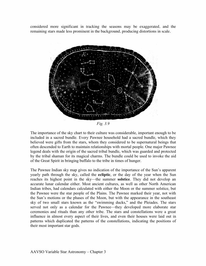
The seemingly simplistic astronomical observational tools that you have used to observe and determine the motions of the Moon, stars, and planets would have appeared extremely sophisticated to the Pawnee Indians living on the Great Plains of Nebraska a century ago. They were skillful sky watchers. Proof of their observational activities resides in the Pawnee collection of the Chicago Field Museum of Natural History. Discovered in one of the Pawnee “Sacred Bundles”—groups of ceremonial objects wrapped together—was a star chart (see Figure 3.8). The chart is made from a piece of tanned elk skin, oval in shape, and approximately 38 cm by 55 cm in size. Its exact age is uncertain, but it is thought to be between 100 and 300 years old.
One end of the Pawnee sky map is colored reddish-brown and the other brownish- yellow. The stars are represented by a four-pointed figure and drawn in five different sizes, representing different magnitudes. The map depicts several constellations with the most prominent stars drawn according to brightness or magnitude. Polaris is shown at a brighter magnitude and all the remaining stars in Ursa Minor are depicted as having a similar, fainter magnitude. Through the center of the map is a stream of fainter magnitudes, representing the stars of the Milky Way as they appear to the naked eye. The Milky Way appears in the center of the chart, and it seems to be representing a division between the two major seasons. The star groups to the right of the Milky Way resemble the summer night sky and end with the band of brownish-yellow; the star groups to the left resemble the winter night sky and end with the reddish-brown band of color. A solid line around the oval represents the horizon. The Pawnee constructed this portable planisphere to keep a record of the nighttime sky.
Some of the asterisms for the constellations that seem to be represented on the sky map are outlined in Figure 3.9. The constellations are Taurus (including the open cluster,the Pleiades), Orion, Auriga, Lyra, Corona Borealis, Ursa Minor, and Ursa Major. There has been more than one interpretation of these constellations. Some of the positions of the constellations do not coincide with their real sky counterparts—although perhaps we simply do not know how to interpret the chart. There may be other aspects of the sky being represented, such as important constellations moving from the horizon and overhead past the meridian and/or zenith. The stars and constellations the Pawnee
Fig. 3.8
AAVSO Variable Star Astronomy – Chapter 3
considered more significant in tracking the seasons may be exaggerated, and the remaining stars made less prominent in the background, producing distortions in scale.
Fig. 3.9
The importance of the sky chart to their culture was considerable, important enough to be included in a sacred bundle. Every Pawnee household had a sacred bundle, which they believed were gifts from the stars, whom they considered to be supernatural beings that often descended to Earth to maintain relationships with mortal people. One major Pawnee legend deals with the origin of the sacred tribal bundle, which was guarded and protected by the tribal shaman for its magical charms. The bundle could be used to invoke the aid of the Great Spirit in bringing buffalo to the tribe in times of hunger. The Pawnee Indian sky map gives no indication of the importance of the Sun’s apparent yearly path through the sky, called the ecliptic, or the day of the year when the Sun reaches its highest point in the sky—the summer solstice. They did not develop an accurate lunar calendar either. Most ancient cultures, as well as other North American Indian tribes, had calendars calculated with either the Moon or the summer solstice, but the Pawnee were the star people of the Plains. The Pawnee marked their year, not with the Sun’s motions or the phases of the Moon, but with the appearance in the southeast sky of two small stars known as the “swimming ducks,” and the Pleiades. The stars served not only as a calendar for the Pawnee—they developed more elaborate star ceremonies and rituals than any other tribe. The stars and constellations were a great influence in almost every aspect of their lives, and even their houses were laid out in patterns which duplicated the patterns of the constellations, indicating the positions of their most important star gods.

AAVSO Variable Star Astronomy – Chapter 3
For the Pawnee, the arrival of spring marked the beginning of their year. Spring began with the appearance in the sky of two stars called The Swimming Ducks. These stars are Lambda and Upsilon Scorpii, the stinger in the tail of the scorpion. The appearance of the Swimming Ducks was the time for thunderstorms and the Thunder ritual. To the right of the Swimming Ducks, the curving line of stars that comprise the Scorpion's body was seen as a separate constellation representing a snake, ending with the red star Antares the head of the snake.
Pawnee Spring