Embed Size (px)
Citation preview
The ArcGIS Serverarchitecture
ArcGIS Server is an object server for ArcObjects. The ArcGIS Server software
system is distributed across multiple machines. Each aspect of ArcGIS Server plays
a role in managing GIS functionality and data and making that functionality useful
to end users.
This chapter provides an overview of the ArcGIS software architecture and details
of the ArcGIS Server architecture, specifically the various aspects of the server and
how they interact, including:
• the role of the GIS server • the server object manager • server object
containers • GIS server objects • the Web application server
2
Chapter2.pmd 10/12/2004, 4:01 PM27

28 • ArcGIS Server Administrator and Developer Guide
ARCGIS SOFTWARE ARCHITECTURE
For a detailed explanation of COM see theMicrosoft COM section of Appendix D,
‘Developer environments’.
DeveloperComponents
Map Presentation
MapAnalysis
DataAccess
BaseServices
ArcGIS Engine
Before discussing the details of the ArcGIS Server architecture, it’s important todiscuss the ArcGIS system architecture as a whole. The ArcGIS architecture hasevolved over several releases of the technology to be a modular, scalable, cross-platform architecture implemented by a set of software components calledArcObjects. This section focuses on the main themes of this evolution atArcGIS 9 and introduces the reader to the libraries that compose the ArcGISsystem.
The ArcGIS software architecture supports a number of products, each with itsunique set of requirements. ArcObjects components, which make up ArcGIS, aredesigned and built to support this. This chapter introduces ArcObjects.
ArcObjects is a set of platform-independent software components, written inC++, that provides services to support GIS applications on the desktop in theform of thick and thin clients and on the server.
As stated, the language chosen to develop ArcObjects was C++; in addition tothis language, ArcObjects makes use of the Microsoft Component Object Model.COM is often thought of as simply specifying how objects are implemented andbuilt in memory and how these objects communicate with one another. Whilethis is true, COM also provides a solid infrastructure at the operating system levelto support any system built using COM. On Microsoft Windows operating sys-tems, the COM infrastructure is built directly into the operating system. Foroperating systems other than Microsoft Windows, this infrastructure must beprovided for the ArcObjects system to function.
Not all ArcObjects components are created equally. The requirements of a par-ticular object, in addition to its basic functionality, vary depending on the finalend use of the object. This end use broadly falls into one of the three ArcGISproduct families:
• ArcGIS Engine—Use of the object is within a custom application. Objectswithin the Engine must support a variety of uses; simple map dialog boxes,multithreaded servers, and complex Windows desktop applications are allpossible uses of Engine objects. The dependencies of the objects within theEngine must be well understood. The impact of adding dependencies externalto ArcObjects must be carefully reviewed, since new dependencies may intro-duce undesirable complexity to the installation of the application built on theEngine.
• ArcGIS Server—The object is used within the server framework, whereclients of the object are most often remote. The remoteness of the client canvary from local, possibly on the same machine or network, to distant, whereclients can be on the Internet. Objects running within the server must bescalable and thread safe to allow execution in a multithreaded environment.
• ArcGIS Desktop—Use of the object is within one of the ArcGIS Desktopapplications. ArcGIS Desktop applications have a rich user experience, withapplications containing many dialog boxes and property pages that allow endusers to work effectively with the functionality of the object. Objects thatcontain properties that are to be modified by users of these applicationsshould have property pages created for these properties. Not all objectsrequire property pages.
Chapter2.pmd 10/12/2004, 4:01 PM28

Chapter 2 • The ArcGIS Server architecture • 29
UserInterface
Map Presentation
MapAnalysis
DataAccess
Applications
Extensions
Base Services
ArcGIS Desktop
ArcGIS Server
WebDevelopmentFramework
Map Presentation
MapAnalysis
DataAccess
BaseServices
ARCGIS SOFTWARE ARCHITECTURE
Many of the ArcObjects components that make up ArcGIS are used within allthree of the ArcGIS products. The product diagrams on these pages show thatthe objects within the broad categories of base services, data access, map analysis,and map presentation are contained in all three products. These four categoriescontain the majority of the GIS functionality exposed to developers and users inArcGIS.
This commonality of function among all the products is important for developersto understand, since it means that when working in a particular category, muchof the development effort can be transferred between the ArcGIS products withlittle change to the software. After all, this is exactly how the ArcGIS architec-ture is developed. Code reuse is a major benefit of building a modular architec-ture, but code reuse does not simply come from creating components in a modu-lar fashion.
The ArcGIS architecture provides rich functionality to the developer, but it is nota closed system. The ArcGIS architecture is extendable by developers external toESRI. Developers have been extending the architecture for a number of years,and the ArcGIS 9 architecture is no different; it, too, can be extended. However,ArcGIS 9 introduces many new possibilities for the use of objects created byESRI and you. To realize these possibilities, components must meet additionalrequirements to ensure that they will operate successfully within this new andsignificantly enhanced ArcGIS system. Some of the changes from ArcGIS 8 toArcGIS 9 appear superficial, an example being the breakup of the type librariesinto smaller libraries. That, along with the fact that the objects with their meth-ods and properties that were present at 8.3 are still available at 9.0, masks thefact that internally ArcObjects has undergone some significant work.
The main focus of the changes made to the ArcGIS architecture at 9.0 revolvesaround four key concepts:
• Modularity—A modular system where the dependencies between componentsare well-defined in a flexible system.
• Scalability—ArcObjects must perform well in all intended operating environ-ments, from single user desktop applications to multiuser/multithreadedserver applications.
• Multiple Platform Support—ArcObjects for the Engine and Server should becapable of running on multiple computing platforms.
• Compatibility—ArcObjects 9 should remain equivalent, both functionally andprogrammatically, to ArcObjects 8.3.
MODULARITYThe esriCore object library, shipped as part of ArcGIS 8.3, effectively packagedall of ArcObjects into one large block of GIS functionality; there was no distinc-tion between components. The ArcObjects components were divided into smallergroups of components, these groups being packaged in Dynamic Link Libraries(DLLs). The one large library, while simplifying the task of development forexternal developers, prevented the software from being modular. Adding the typeinformation to all the DLLs, while possible, would have greatly increased theburden on external developers and, hence, was not an option. In addition, theDLL structure did not always reflect the best modular breakup of softwarecomponents based on functionality and dependency.
Chapter2.pmd 10/12/2004, 4:01 PM29
30 • ArcGIS Server Administrator and Developer Guide
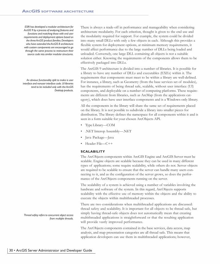
ESRI has developed a modular architecture forArcGIS 9 by a process of analyzing features and
functions and matching those with end userrequirements and deployment options based on
the three ArcGIS product families. Developerswho have extended the ArcGIS 8 architecture
with custom components are encouraged to gothrough the same process to restructure their
source code into similar modular structures.
An obvious functionality split to make is userinterface and nonuser interface code. UI libraries
tend to be included only with the ArcGISDesktop products.
Thread safety refers to concurrent object accessfrom multiple threads.
ARCGIS SOFTWARE ARCHITECTURE
There is always a trade-off in performance and manageability when consideringarchitecture modularity. For each criterion, thought is given to the end use andthe modularity required for support. For example, the system could be dividedinto many small DLLs with only a few objects in each. Although this provides aflexible system for deployment options, at minimum memory requirements, itwould affect performance due to the large number of DLLs being loaded andunloaded. Conversely, one large DLL containing all objects is not a suitablesolution either. Knowing the requirements of the components allows them to beeffectively packaged into DLLs.
The ArcGIS 9 architecture is divided into a number of libraries. It is possible fora library to have any number of DLLs and executables (EXEs) within it. Therequirements that components must meet to be within a library are well-defined.For instance, a library, such as Geometry (from the base services set of modules),has the requirements of being thread safe, scalable, without user interface (UI)components, and deployable on a number of computing platforms. These require-ments are different from libraries, such as ArcMap (from the applications cat-egory), which does have user interface components and is a Windows-only library.
All the components in the library will share the same set of requirements placedon the library. It is not possible to subdivide a library into smaller pieces fordistribution. The library defines the namespace for all components within it and isseen in a form suitable for your chosen ArcObjects API.
• Type Library—COM
• .NET Interop Assembly—.NET
• Java Package—Java
• Header File—C++
SCALABILITY
The ArcObjects components within ArcGIS Engine and ArcGIS Server must bescalable. Engine objects are scalable because they can be used in many differenttypes of applications; some require scalability, while others do not. Server objectsare required to be scalable to ensure that the server can handle many users con-necting to it, and as the configuration of the server grows, so does the perfor-mance of the ArcObjects components running on the server.
The scalability of a system is achieved using a number of variables involving thehardware and software of the system. In this regard, ArcObjects supportsscalability with the effective use of memory within the objects and the ability toexecute the objects within multithreaded processes.
There are two considerations when multithreaded applications are discussed:thread safety and scalability. It is important for all objects to be thread safe, butsimply having thread-safe objects does not automatically mean that creatingmultithreaded applications is straightforward or that the resulting applicationwill provide vastly improved performance.
The ArcObjects components contained in the base services, data access, mapanalysis, and map presentation categories are all thread safe. This means thatapplication developers can use them in multithreaded applications; however,
Chapter2.pmd 10/12/2004, 4:01 PM30
Chapter 2 • The ArcGIS Server architecture • 31
The classic singleton per process model meansthat all threads of an application will still access
the main thread hosting the singleton objects.This effectively reduces the application to a
single-threaded application.
Microsoft Windows is a little endian platform,while Sun Solaris is a big endian platform.
While the aim of ArcGIS releases is to limit thechange in the APIs, developers should still testtheir software thoroughly with later releases.
ARCGIS SOFTWARE ARCHITECTURE
programmers must still write multithreaded code in such a way as to avoid appli-cation failures due to deadlock situations and so forth.
In addition to the ArcObjects components being thread safe for ArcGIS 9, theapartment threading model used by ArcObjects was analyzed to ensure thatArcObjects could be run efficiently in a multithreaded process. A model referredto as “Threads in Isolation” was used to ensure that the ArcObjects architecture isused efficiently.
This model works by reducing cross-thread communication to an absolute mini-mum or, better still, removing it entirely. For this to work, the singleton objectsat ArcGIS 9 were changed to be singletons per thread and not singletons perprocess. The resource overhead of hosting multiple singletons in a process wasoutweighed by the performance gain of stopping cross-thread communicationwhere the singleton object is created in one thread, normally the Main single-threaded apartment (STA), and the accessing object is in another thread.
ArcGIS is an extensible system, and for the Threads in Isolation model to work,all singleton objects must adhere to this rule. If you are creating singleton objectsas part of your development, you must ensure that these objects adhere to therule.
MULTIPLE PLATFORM SUPPORT
As stated earlier, ArcObjects components are C++ objects, meaning that anycomputing platform with a C++ compiler can potentially be a platform forArcObjects. In addition to the C++ compiler, the platform must also supportsome basic services required by ArcObjects.
Although many of the platform differences do not affect the way in whichArcObjects components are developed, there are areas where differences doaffect the way code is developed. The byte order of different computing architec-tures varies between little endian and big endian. This is most readily seen whenobjects read and write data to disk. Data written using one computing platformwill not be compatible if read using another platform, unless some decodingwork is performed. All the ArcGIS Engine and ArcGIS Server objects supportthis multiple platform persistence model. ArcObjects components always persistthemselves using the little endian model; when the objects read persisted data, itis converted to the appropriate native byte order. In addition to the byte orderdifferences, there are other areas of functionality that differ between platforms;the directory structure, for example, uses different separators for Windows andUNIX—‘\’ and ‘/’, respectively. Another example is the platform-specific areasof functionality, such as Object Linking and Embedding Database (OLE DB).
COMPATIBILITY
Maintaining compatibility of the ArcGIS system between releases is important toensure that external developers are not burdened with changing their code towork with the latest release of the technology. Maintaining compatibility at theobject level was a primary goal of the ArcGIS 9 development effort. Althoughthis object-level compatibility has been maintained, there are some changesbetween the ArcGIS 8 and ArcGIS 9 architectures that will affect developers,mainly related to the compilation of the software.
Chapter2.pmd 10/12/2004, 4:01 PM31
32 • ArcGIS Server Administrator and Developer Guide
ARCGIS SOFTWARE ARCHITECTURE
Although the changes required for software created for use with ArcGIS 8 towork with ArcGIS 9 are minimal, it is important to understand that to realize anyexisting investment in the ArcObjects architecture at ArcGIS 9, you must reviewyour developments with respect to ArcGIS Engine, ArcGIS Server, and ArcGISDesktop.
ESRI understands the importance of a unified software architecture and hasmade numerous changes for ArcGIS 9 so the investment in ArcObjects can berealized on multiple products. If you have been involved in creating extensions tothe ArcGIS architecture for ArcGIS 8, you should think about how the newArcGIS 9 architecture affects the way your components are implemented.
The remainder of this chapter focuses on the components of ArcGIS Server thatmake it possible to run ArcObjects in a server environment. For more informa-tion about developing with ArcGIS Engine and ArcGIS Desktop, refer toArcGIS Engine Developer Guide and ArcGIS Desktop Developer Guide, respectively.
Chapter2.pmd 10/12/2004, 4:01 PM32
Chapter 2 • The ArcGIS Server architecture • 33
ARCGIS SERVER ARCHITECTURE
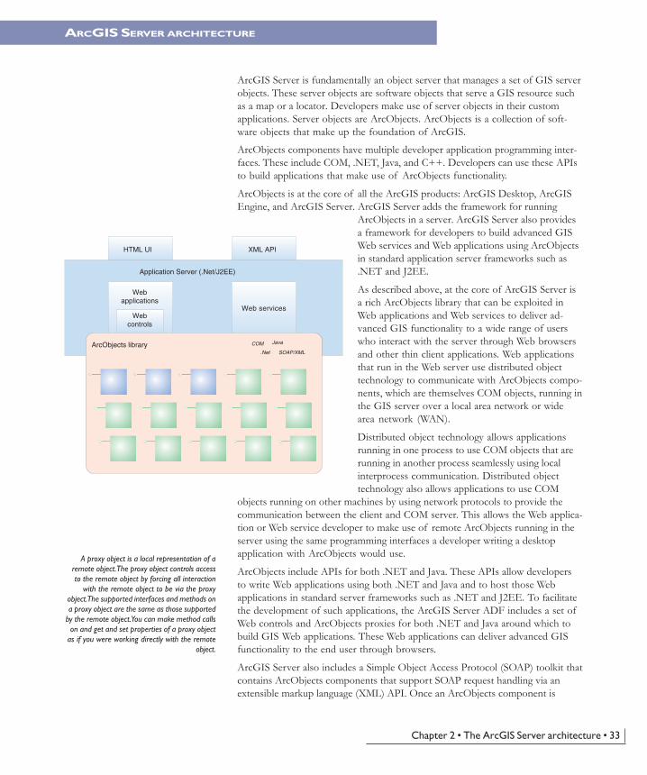
ArcGIS Server is fundamentally an object server that manages a set of GIS serverobjects. These server objects are software objects that serve a GIS resource suchas a map or a locator. Developers make use of server objects in their customapplications. Server objects are ArcObjects. ArcObjects is a collection of soft-ware objects that make up the foundation of ArcGIS.
ArcObjects components have multiple developer application programming inter-faces. These include COM, .NET, Java, and C++. Developers can use these APIsto build applications that make use of ArcObjects functionality.
ArcObjects is at the core of all the ArcGIS products: ArcGIS Desktop, ArcGISEngine, and ArcGIS Server. ArcGIS Server adds the framework for running
ArcObjects in a server. ArcGIS Server also providesa framework for developers to build advanced GISWeb services and Web applications using ArcObjectsin standard application server frameworks such as.NET and J2EE.
As described above, at the core of ArcGIS Server isa rich ArcObjects library that can be exploited inWeb applications and Web services to deliver ad-vanced GIS functionality to a wide range of userswho interact with the server through Web browsersand other thin client applications. Web applicationsthat run in the Web server use distributed objecttechnology to communicate with ArcObjects compo-nents, which are themselves COM objects, running inthe GIS server over a local area network or widearea network (WAN).
Distributed object technology allows applicationsrunning in one process to use COM objects that arerunning in another process seamlessly using localinterprocess communication. Distributed objecttechnology also allows applications to use COM
objects running on other machines by using network protocols to provide thecommunication between the client and COM server. This allows the Web applica-tion or Web service developer to make use of remote ArcObjects running in theserver using the same programming interfaces a developer writing a desktopapplication with ArcObjects would use.
ArcObjects include APIs for both .NET and Java. These APIs allow developersto write Web applications using both .NET and Java and to host those Webapplications in standard server frameworks such as .NET and J2EE. To facilitatethe development of such applications, the ArcGIS Server ADF includes a set ofWeb controls and ArcObjects proxies for both .NET and Java around which tobuild GIS Web applications. These Web applications can deliver advanced GISfunctionality to the end user through browsers.
ArcGIS Server also includes a Simple Object Access Protocol (SOAP) toolkit thatcontains ArcObjects components that support SOAP request handling via anextensible markup language (XML) API. Once an ArcObjects component is
ArcObjects library
Webapplications
Webcontrols
Web services
Application Server (.Net/J2EE)
COM Java
.Net SOAP/XML
HTML UI XML API
A proxy object is a local representation of aremote object. The proxy object controls accessto the remote object by forcing all interaction
with the remote object to be via the proxyobject. The supported interfaces and methods ona proxy object are the same as those supported
by the remote object. You can make method callson and get and set properties of a proxy object
as if you were working directly with the remoteobject.
Chapter2.pmd 10/12/2004, 4:01 PM33
34 • ArcGIS Server Administrator and Developer Guide
exposed as a Web service, this XML API allows applications to remotely use thatobject running in the server over standard Internet protocols.
The remainder of this chapter explores how the different pieces of the ArcGISServer work together to make the use of ArcObjects in server applications pos-sible. Detail is given to the ArcGIS Server programming model in Chapter 4,‘Developing ArcGIS Server applications’, and the application developer frame-works are discussed in detail in Chapters 5, ‘Developing Web applications with.NET’, and 6, ‘Developing Web applications with Java’.
ARCGIS SERVER ARCHITECTURE
Chapter2.pmd 10/12/2004, 4:01 PM34
Chapter 2 • The ArcGIS Server architecture • 35
THE ARCGIS SERVER SYSTEM
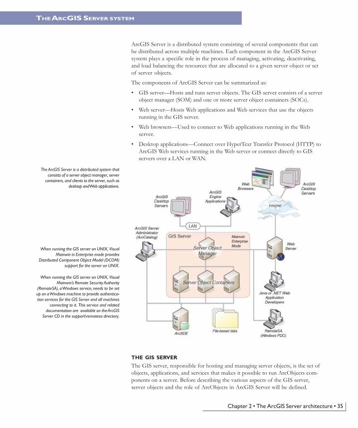
The ArcGIS Server is a distributed system thatconsists of a server object manager, server
containers, and clients to the server, such asdesktop and Web applications.
ArcGIS Server is a distributed system consisting of several components that canbe distributed across multiple machines. Each component in the ArcGIS Serversystem plays a specific role in the process of managing, activating, deactivating,and load balancing the resources that are allocated to a given server object or setof server objects.
The components of ArcGIS Server can be summarized as:
• GIS server—Hosts and runs server objects. The GIS server consists of a serverobject manager (SOM) and one or more server object containers (SOCs).
• Web server—Hosts Web applications and Web services that use the objectsrunning in the GIS server.
• Web browsers—Used to connect to Web applications running in the Webserver.
• Desktop applications—Connect over HyperText Transfer Protocol (HTTP) toArcGIS Web services running in the Web server or connect directly to GISservers over a LAN or WAN.
THE GIS SERVER
The GIS server, responsible for hosting and managing server objects, is the set ofobjects, applications, and services that makes it possible to run ArcObjects com-ponents on a server. Before describing the various aspects of the GIS server,server objects and the role of ArcObjects in ArcGIS Server will be defined.
When running the GIS server on UNIX, VisualMainwin’s Remote Security Authority
(RemoteSA), a Windows service, needs to be setup on a Windows machine to provide authentica-tion services for the GIS Server and all machines
connecting to it. This service and relateddocumentation are available on the ArcGIS
Server CD in the support\remotesa directory.
When running the GIS server on UNIX, VisualMainwin in Enterprise mode provides
Distributed Component Object Model (DCOM)support for the server on UNIX.
Chapter2.pmd 10/12/2004, 4:01 PM35
36 • ArcGIS Server Administrator and Developer Guide
THE ARCGIS SERVER SYSTEM
A server object is a software object that manages and serves a GIS resource suchas a map or a locator. For example, a server object named RedlandsMap mayserve a map document of data for the city of Redlands, while the server objectRedlandsGeocode may serve an address locator for geocoding addresses. ArcGISServer objects are themselves ArcObject components.
Server objects are managed and run within the GIS server. A server object may bepreconfigured and preloaded in the server and can be shared between applica-tions. Server applications make use of server objects and may also use otherArcObjects that are installed on the GIS server.
The server object managerThe GIS server is composed of a SOM, which is a Windows service or UNIXdaemon running on a single machine, and SOCs, which run on one or moremachines (container machines). The SOM manages the set of server objects thatare distributed across one or more container machines. When an applicationmakes a direct connection to a GIS server over a LAN or WAN, it is making aconnection to the SOM, so the parameter that is provided for the connection tobe made is the name or Internet Protocol (IP) address of the SOM machine.
The server object containersThe container machine or machines actually host the server objects that aremanaged by the SOM. Each container machine is capable of hosting multiplecontainer processes. A container process is a process in which one or more serverobjects is running. Container processes are started and shut down by the SOM.The objects hosted within the container processes are ArcObjects componentsthat are installed on the container machine as part of the installation of ArcGISServer.
All server objects run on all container machines and are balanced equally across allcontainer machines. So, it’s important that all container machines have access tothe resources and data necessary to run each server object. It’s also important tonote that the GIS server assumes that all container machines are configuredequally, such that they are all capable of hosting the same number of serverobjects. Server object resources and data are discussed in more detail in the nextsection.
The server directoriesA server directory is a location on a file system. The GIS server is configured toclean up any files it writes to a server directory. By definition, a server directorycan be written to by all container machines.
The GIS server hosts and manages server objects and other ArcObjects compo-nents for use in applications. In many cases, the use of those objects requireswriting output to files. For example, when a map server object draws a map, itwrites images to disk on the server machine. Other applications may write theirown data; for example, an application that checks out data from a geodatabasemay write the checkout personal geodatabase to disk on the server.
Typically, these files are transient and need only be available to the application fora short time—for example, the time for the application to draw the map or the
Chapter2.pmd 10/12/2004, 4:01 PM36
Chapter 2 • The ArcGIS Server architecture • 37
THE ARCGIS SERVER SYSTEM
time required to download the checkout database. As applications do their workand write out data, these files can accumulate quickly. The GIS server will auto-matically clean up its output if that output is written to a server directory.
A server directory can be configured such that files created by the GIS server in itare cleaned based on either file age or time since they were last accessed. Themaximum file age is a property of a server directory. All files created by the GISserver that are older than or have not been accessed for the time defined by themaximum age are automatically cleaned up by the GIS server.
The Remote Security Authority (GIS Server on UNIX only)A Windows machine is required to act as Primary Domain Controller (PDC) toauthenticate users of a GIS Server on UNIX.
Visual Mainwin’s Remote Security Authority, a Windows service, needs to be setup on a Windows machine to provide authentication services for the GIS Serverand all machines connecting to it. This service and related documentation areavailable on the ArcGIS Server CD in the support\remotesa directory.
Visual Mainwin in Enterprise mode (GIS Server on UNIX only)Visual Mainwin in Enterprise mode provides DCOM support for the GIS Serveron UNIX. This download and related documentation are available on the ArcGISServer CD in the support\msc directory.
THE WEB SERVER (UNIX-SPECIFIC INFORMATION)
The Web server hosts server applications and Web services written using theArcGIS Server API. These server applications use the ArcGIS Server API toconnect to a SOM, make use of server objects, and create other ArcObjects foruse in their applications.
These Web services and Web applications can be written using the ArcGIS ServerApplication Developer Framework, which is available for both .NET and Javadevelopers. Examples of Web applications include mapping applications, discon-nected editing applications, and any other application that makes use ofArcObjects and is appropriate for Web browsers.
Chapter2.pmd 10/12/2004, 4:01 PM37
38 • ArcGIS Server Administrator and Developer Guide
Examples of Web services include Web services for exposing map and geocodeserver objects that desktop GIS users can connect to and consume over theInternet. It is possible to create your own native .NET or Java Web serviceswhose parameters are not ArcObjects types, but do perform a specific GIS func-tion. For example, it is possible to write a Web service calledFindNearestHospital that accepts x,y coordinates as input and returns an applica-tion-defined Hospital object that has properties such as the address, name, andnumber of beds.
A more detailed description of the application developer’s framework and how itis used to create Web services and Web applications is given later in this book.
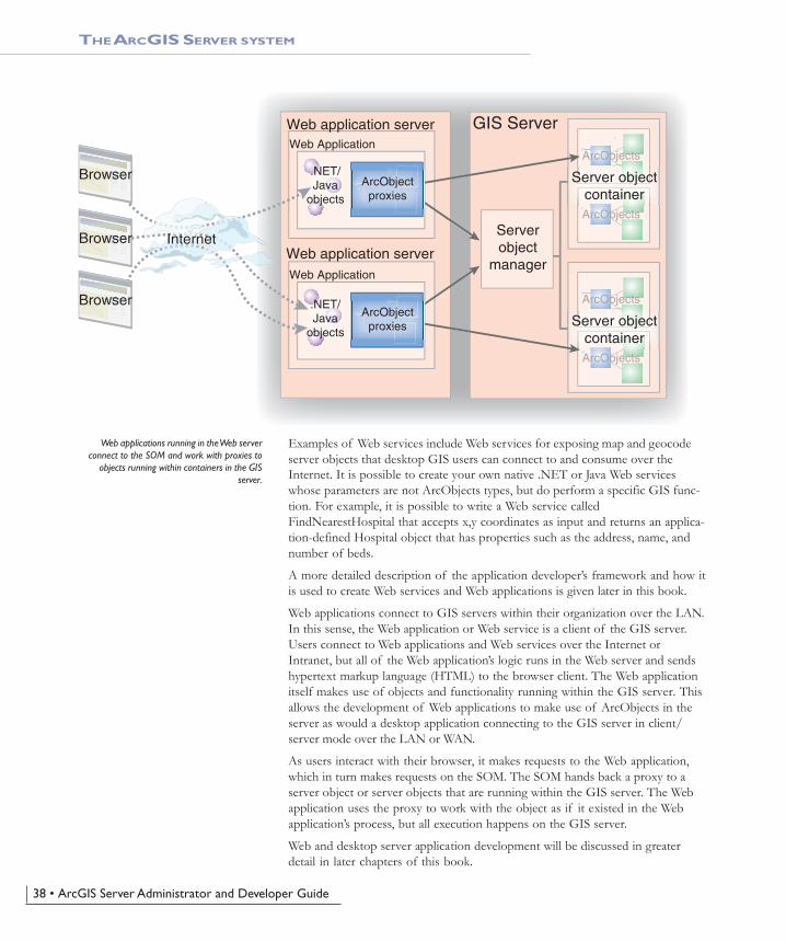
Web applications connect to GIS servers within their organization over the LAN.In this sense, the Web application or Web service is a client of the GIS server.Users connect to Web applications and Web services over the Internet orIntranet, but all of the Web application’s logic runs in the Web server and sendshypertext markup language (HTML) to the browser client. The Web applicationitself makes use of objects and functionality running within the GIS server. Thisallows the development of Web applications to make use of ArcObjects in theserver as would a desktop application connecting to the GIS server in client/server mode over the LAN or WAN.
As users interact with their browser, it makes requests to the Web application,which in turn makes requests on the SOM. The SOM hands back a proxy to aserver object or server objects that are running within the GIS server. The Webapplication uses the proxy to work with the object as if it existed in the Webapplication’s process, but all execution happens on the GIS server.
Web and desktop server application development will be discussed in greaterdetail in later chapters of this book.
THE ARCGIS SERVER SYSTEM
Web applications running in the Web serverconnect to the SOM and work with proxies to
objects running within containers in the GISserver.
GIS Server
Serverobject
manager
Server objectcontainer
ArcObjects
ArcObjects
Server objectcontainer
ArcObjects
ArcObjects
Web application server
Web application server
Web Application
Web Application
ArcObjectproxies
ArcObjectproxies
.NET/Java
objects
.NET/Java
objects
Browser
Browser
Browser
Internet
Chapter2.pmd 10/12/2004, 4:01 PM38
Chapter 2 • The ArcGIS Server architecture • 39
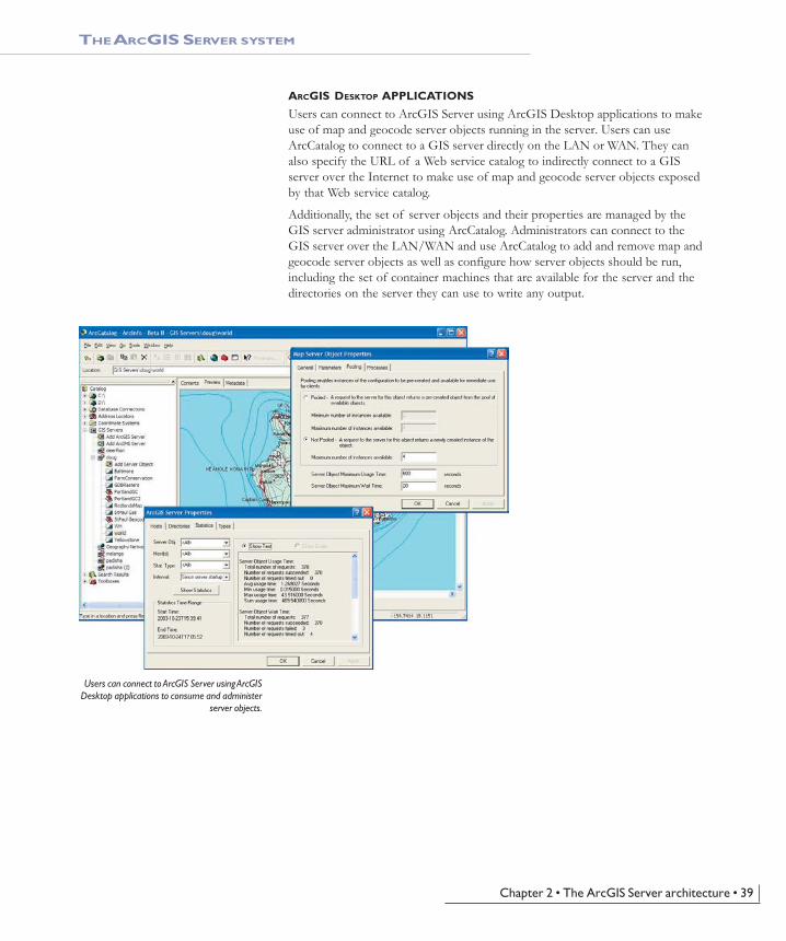
ARCGIS DESKTOP APPLICATIONS
Users can connect to ArcGIS Server using ArcGIS Desktop applications to makeuse of map and geocode server objects running in the server. Users can useArcCatalog to connect to a GIS server directly on the LAN or WAN. They canalso specify the URL of a Web service catalog to indirectly connect to a GISserver over the Internet to make use of map and geocode server objects exposedby that Web service catalog.
Additionally, the set of server objects and their properties are managed by theGIS server administrator using ArcCatalog. Administrators can connect to theGIS server over the LAN/WAN and use ArcCatalog to add and remove map andgeocode server objects as well as configure how server objects should be run,including the set of container machines that are available for the server and thedirectories on the server they can use to write any output.
Users can connect to ArcGIS Server using ArcGISDesktop applications to consume and administer
server objects.
THE ARCGIS SERVER SYSTEM
Chapter2.pmd 10/12/2004, 4:01 PM39
40 • ArcGIS Server Administrator and Developer Guide
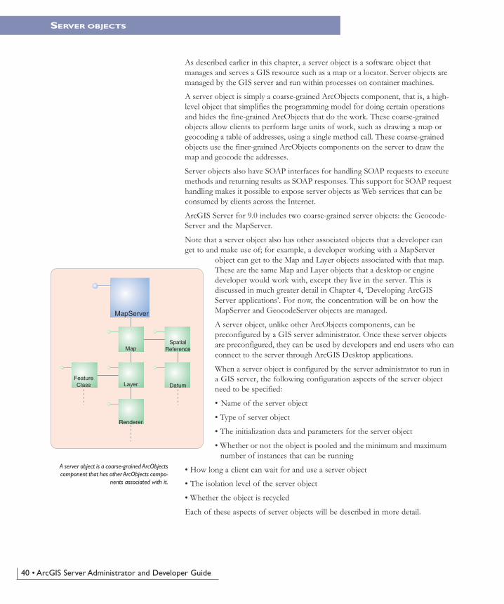
As described earlier in this chapter, a server object is a software object thatmanages and serves a GIS resource such as a map or a locator. Server objects aremanaged by the GIS server and run within processes on container machines.
A server object is simply a coarse-grained ArcObjects component, that is, a high-level object that simplifies the programming model for doing certain operationsand hides the fine-grained ArcObjects that do the work. These coarse-grainedobjects allow clients to perform large units of work, such as drawing a map orgeocoding a table of addresses, using a single method call. These coarse-grainedobjects use the finer-grained ArcObjects components on the server to draw themap and geocode the addresses.
Server objects also have SOAP interfaces for handling SOAP requests to executemethods and returning results as SOAP responses. This support for SOAP requesthandling makes it possible to expose server objects as Web services that can beconsumed by clients across the Internet.
ArcGIS Server for 9.0 includes two coarse-grained server objects: the Geocode-Server and the MapServer.
Note that a server object also has other associated objects that a developer canget to and make use of; for example, a developer working with a MapServer
object can get to the Map and Layer objects associated with that map.These are the same Map and Layer objects that a desktop or enginedeveloper would work with, except they live in the server. This isdiscussed in much greater detail in Chapter 4, ‘Developing ArcGISServer applications’. For now, the concentration will be on how theMapServer and GeocodeServer objects are managed.
A server object, unlike other ArcObjects components, can bepreconfigured by a GIS server administrator. Once these server objectsare preconfigured, they can be used by developers and end users who canconnect to the server through ArcGIS Desktop applications.
When a server object is configured by the server administrator to run ina GIS server, the following configuration aspects of the server objectneed to be specified:
• Name of the server object
• Type of server object
• The initialization data and parameters for the server object
• Whether or not the object is pooled and the minimum and maximumnumber of instances that can be running
• How long a client can wait for and use a server object
• The isolation level of the server object
• Whether the object is recycled
Each of these aspects of server objects will be described in more detail.
SERVER OBJECTS
A server object is a coarse-grained ArcObjectscomponent that has other ArcObjects compo-
nents associated with it.
MapServer
Map
Layer
Renderer
FeatureClass
SpatialReference
Datum
Chapter2.pmd 10/12/2004, 4:01 PM40
Chapter 2 • The ArcGIS Server architecture • 41
SERVER OBJECTS
SERVER OBJECT TYPE
All server objects have a type, which dictates what its initialization parametersare and what methods and properties it exposes to developers. At ArcGIS 9,there are two server object types: the MapServer, which is in the Carto library,and the GeocodeServer, which is in the Location library.
INITIALIZATION DATA AND PARAMETERS
As already stated, a GIS server object manages and serves a GIS resource. When aserver object is configured, this resource and other required parameters associatedwith the server object must be specified such that when a server object is initial-ized, it knows what resource to bind to.
The MapServer server object’s initialization data is the map document (.mxd) orpublished map document (.pmf) that it’s going to serve. When instances of aparticular MapServer object are initialized on the server, the map document isloaded.
The GeocodeServer server object’s initialization data is the address locator that itwill use to perform address matching against. The address locator may be a loca-tor file (.loc), an ArcView 3 address locator (.mxs), or an ArcSDE address loca-tor. In addition to the address locator, the GeocodeServer also has a batch sizeparameter that indicates the number of records it will process at a time whendoing batch geocoding.
Note that when configuring the initialization data for a server object, both theresource (that is, map document or locator) and the data that the resource refer-ences are accessible by the GIS server’s container machines. This becomes anespecially important consideration when the GIS server has multiple containermachines. In these cases, the location of both the resource and the data it usesmust be on a shared file system (in the case of file-based information) or on anArcSDE server that all the container machines can connect to.
For example, a map document that acts as a resource to a MapServer objecthosted on multiple container machines must be located on a shared networkdrive. All of the data for the various layers in the map that reference file-baseddata must also be on a shared network drive, and any layers that reference data inan ArcSDE geodatabase must be able to connect to that database.
Note that server objects can run on any of the container machines configured inthe GIS server. All container machines must have access to the data and resourcesneeded for a particular server object.
SERVER OBJECT POOLING
A server object that is running on the GIS server is available for use by users whoconnect to the server through ArcGIS Desktop or by developers who createapplications that connect to and make use of the server. Any server object maybe used by a number of different users. For example, a MapServer object con-taining features from a land records database may be used in an application thatusers query for information about their land parcel. The same MapServer may alsobe used by editors who update the database in a disconnected editing application.
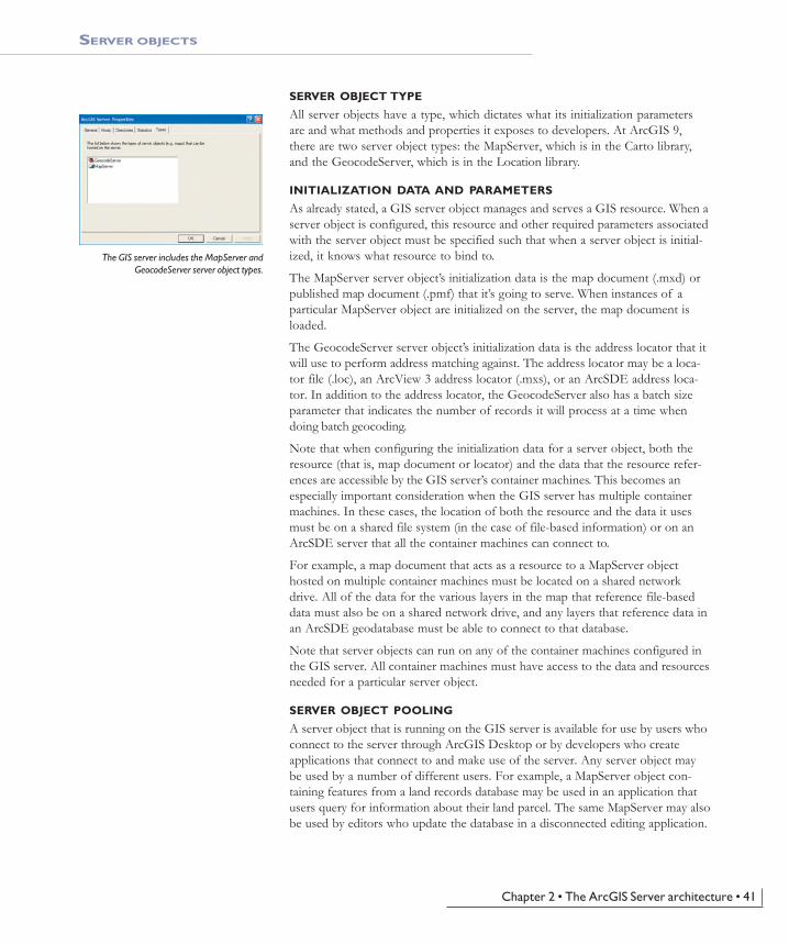
The GIS server includes the MapServer andGeocodeServer server object types.
Chapter2.pmd 10/12/2004, 4:01 PM41
42 • ArcGIS Server Administrator and Developer Guide
SERVER OBJECTS
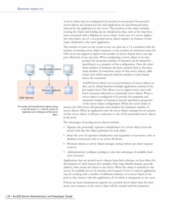
A server object may be configured to be pooled or non-pooled. Non-pooledserver objects are created new for each application use and destroyed whenreleased by the application to the server. The creation of the object includescreating the object and loading up any initialization data, such as the map docu-ment associated with a MapServer server object. Each user of a server applica-tion that makes use of a non-pooled server object requires an instance of thatobject dedicated to the user’s application.
The number of users on the system at any one time has a 1:1 correlation with thenumber of running server object instances, so the number of concurrent users theGIS server can support is equal to the number of server objects that it can sup-port effectively at any one time. When configuring a server object to be non-
pooled, the maximum number of instances can be limited byspecifying it as a property of the configuration. Once the maxi-mum number of instances has been reached (that is, the maxi-mum number of concurrent users of that server object), addi-tional users will be queued until the number of users dropsbelow the maximum.
ArcGIS Server allows you to pool instances of server objects sothey can be shared between multiple application sessions at theper request level. This allows you to support more users withfewer resources allocated to a particular server object. When aserver object is configured to be pooled, the minimum andmaximum number of instances must be specified as propertiesof the server object configuration. When the server object is
started, the GIS server will precreate and initialize the minimum number ofserver objects. When an application asks the server object manager for an instanceof that server object, it will get a reference to one of the preloaded server objectsin the pool.
The advantages of pooling server objects include:
• Separate the potentially expensive initialization of a server object from theactual work that the object performs for each client.
• Share the cost of expensive initialization and acquisition of resources, such asdatabase connections and so on, across all clients.
• Precreate objects at server object manager startup, before any client requestscome in.
• Administratively configure pooling to take best advantage of available hard-ware resources.
Applications that use pooled server objects keep their reference on that object forthe duration of their request (for example, draw map, identify feature, geocodeaddress), then return the object to the server. When the object is returned to theserver, it’s available for use by another user’s request. Users of such an applicationmay be working with a number of different instances of a server object in thepool as they interact with the application, all of which is transparent to the users.
If there are more simultaneous requests on a pooled server object than the mini-mum, new instances of the server object will be created until the maximum
The number of non-pooled server objects runningin the GIS server is 1:1 with the number ofapplication users making use of that server
object.
GIS Server
Application users
Server objects
Chapter2.pmd 10/12/2004, 4:01 PM42
Chapter 2 • The ArcGIS Server architecture • 43
SERVER OBJECTS
number of instances is reached, at which point the user is queued until objects inthe pool become free.
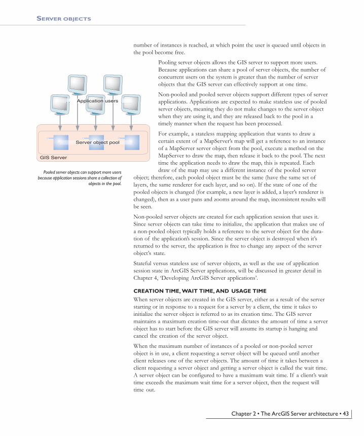
Pooling server objects allows the GIS server to support more users.Because applications can share a pool of server objects, the number ofconcurrent users on the system is greater than the number of serverobjects that the GIS server can effectively support at one time.
Non-pooled and pooled server objects support different types of serverapplications. Applications are expected to make stateless use of pooledserver objects, meaning they do not make changes to the server objectwhen they are using it, and they are released back to the pool in atimely manner when the request has been processed.
For example, a stateless mapping application that wants to draw acertain extent of a MapServer’s map will get a reference to an instanceof a MapServer server object from the pool, execute a method on theMapServer to draw the map, then release it back to the pool. The nexttime the application needs to draw the map, this is repeated. Eachdraw of the map may use a different instance of the pooled server
object; therefore, each pooled object must be the same (have the same set oflayers, the same renderer for each layer, and so on). If the state of one of thepooled objects is changed (for example, a new layer is added, a layer’s renderer ischanged), then as a user pans and zooms around the map, inconsistent results willbe seen.
Non-pooled server objects are created for each application session that uses it.Since server objects can take time to initialize, the application that makes use ofa non-pooled object typically holds a reference to the server object for the dura-tion of the application’s session. Since the server object is destroyed when it’sreturned to the server, the application is free to change any aspect of the serverobject’s state.
Stateful versus stateless use of server objects, as well as the use of applicationsession state in ArcGIS Server applications, will be discussed in greater detail inChapter 4, ‘Developing ArcGIS Server applications’.
CREATION TIME, WAIT TIME, AND USAGE TIME
When server objects are created in the GIS server, either as a result of the serverstarting or in response to a request for a server by a client, the time it takes toinitialize the server object is referred to as its creation time. The GIS servermaintains a maximum creation time-out that dictates the amount of time a serverobject has to start before the GIS server will assume its startup is hanging andcancel the creation of the server object.
When the maximum number of instances of a pooled or non-pooled serverobject is in use, a client requesting a server object will be queued until anotherclient releases one of the server objects. The amount of time it takes between aclient requesting a server object and getting a server object is called the wait time.A server object can be configured to have a maximum wait time. If a client’s waittime exceeds the maximum wait time for a server object, then the request willtime out.
Pooled server objects can support more usersbecause application sessions share a collection of
objects in the pool.
GIS Server
Application users
Server object pool
Chapter2.pmd 10/12/2004, 4:01 PM43

44 • ArcGIS Server Administrator and Developer Guide
SERVER OBJECTS
Once a client gets a reference to a server object, it can hold onto that serverobject for as long as it wants before releasing it. The amount of time betweenwhen a client gets a reference to a server object and when it releases it is calledthe usage time. To ensure that clients don’t hold references to server objects fortoo long (that is, they don’t correctly release server objects), each server objectcan also be configured with a maximum usage time. If a client holds on to aserver object for longer than the maximum usage time, then the server object isautomatically released and the client will lose its reference to the server object.
Maximum usage time also protects server objects from being used to do largervolumes of work than the administrator intended. For example, a server objectthat is used by an application to perform geodatabase checkouts may have amaximum usage time of 10 minutes. In contrast, a server object that is used byapplications that only draw maps may have a maximum usage time of one minute.
The GIS server maintains statistics both in memory and in its log files about waittime, usage time, and other events that occur within the server. The server ad-ministrator can use these statistics to determine if, for example, the wait time fora server object is high, which may indicate a need to increase the maximumnumber of instances for that server object.
For more information about how to view these statistics, see Chapter 3, ‘Admin-istering an ArcGIS Server’, and Appendix B, ‘Configuration and log files’.
Server object isolationServer objects run within processes on the container machines. Server objects can
be configured such that they run in a dedicated process on the server,or they can be configured to run in processes they share with otherserver objects. How they share processes is referred to as their isola-tion level.
Server objects with high isolation do not share a process with otherserver objects. Each instance of a server object with high isolationhas its own dedicated process on the server. Server objects with lowisolation can share processes with other server objects of the sametype.
Up to four server objects can share the same process. When more than four serverobjects of a particular type (for example, four RedlandsMap server objects) arecreated, an additional process is started for the next four server objects, and so
on. As server objects are created and destroyed, they will vacate andfill spaces in these running processes.
Instances of server objects whose isolation level is high require moreresources on the server to run, as they require dedicated processes.Since instances of server objects with low isolation can share pro-cesses, they make more efficient use of server resources. However,isolation does have its benefits: since server objects with high isola-tion do not share processes, if an error occurs on the object, causingits process to shut down or crash, it will not affect other server
objects. If a server object is sharing its process with other server objects, how-ever, and the process is shut down or crashes, all the server objects in that processwill be destroyed.
Server objects with high isolation run in dedi-cated processes on the GIS server.
Server objects with low isolation can shareprocesses with other server objects of the same
type.
Process Process Process
Server objects
GIS Server
Process Process
Server objects
GIS Server
Chapter2.pmd 10/12/2004, 4:01 PM44
Chapter 2 • The ArcGIS Server architecture • 45
Server object recyclingRecycling allows server objects that have become unusable to be destroyed andreplaced with fresh server objects; recycling also reclaims resources taken up bystale server objects. This process allows you to keep the pool of server objectsfresh and cycle out stale or unusable server objects.
Pooled server objects are typically shared between multiple applications and usersof those applications. Through reuse, a number of things can happen to a serverobject to make it unavailable for use by applications. For example, an applicationmay incorrectly modify a server object’s state, or an application may incorrectlyhold a reference to a server object, making it unavailable to other applications orsessions. In some cases, server objects may become corrupted and unusable.
Non-pooled server objects whose isolation level is low can also be recycled. Thisrecycling will shut down and restart the processes in which non-pooled objectsare started and run.
In each case, recycling occurs as a background process on the server. The timebetween recycling events is called the recycling interval. A server object’s recy-cling interval can be configured by the administrator. During recycling, instancesof server objects in use by clients are not recycled until released, so recyclingoccurs without interrupting the user of a server object.
SERVER OBJECTS
Chapter2.pmd 10/12/2004, 4:01 PM45
46 • ArcGIS Server Administrator and Developer Guide
ARCGIS SERVER SECURITY, IMPERSONATION, AND IDENTITY
The ArcGIS Server is a secure server and grants connections only to those userswho are authorized to connect by the GIS server administrator. There are twolevels at which security can be configured for an ArcGIS Server: at the GIS serverlevel itself and at the level of a Web application or Web service that runs in theWeb server. Each of these will be discussed separately.
GIS SERVER SECURITY
ArcGIS Server security is based on authenticating operating system user accounts.Connections will be granted to the server for those users who are members of theArcGIS Server users group (agsusers). The agsusers group is an operating system
group, created by the ArcGIS Server install on the SOMmachine and all container machines. When a user runs anapplication that connects to the server, that user’s login isauthenticated against the users group. If the user is a memberof that group, then access is granted to the server; if not, theconnection is rejected.
Once connected to the server, the user or application canmake use of the server objects running in the server andcreate new objects in the server for the application’s use.
Members of the users group have consumer-level privilegeson the GIS server. Consumers may not perform administra-tive tasks, such as add, remove, or modify preconfiguredserver objects, or modify properties of the server itself, suchas adding and removing machines and so on.
Users may also connect to the server if they are a member ofthe ArcGIS Server administrators group (agsadmin). Theseusers are granted administrator privileges on the GIS server.Once connected to the server as an administrator, the user orapplication can administer aspects of the server, such as:
• Add or remove container machines.
• Add, remove, or modify server directories.
• Add, delete, or modify server objects.
• Start, stop, or pause server objects.
• View statistical information.
The users (agsusers) and administrators (agsadmin) groups are created as local usergroups by the ArcGIS Server install on both the SOM machine and containermachines. When adding a user account to one of these groups, it’s important tomake sure that the account is added to the group on each machine (the SOMmachine and all container machines). One strategy for doing this is to create adomain user group for server users and another for server administrators, thenadd those domain groups to the users and administrators groups, respectively, onall machines. Then your task of adding and removing users privileges to theArcGIS Server can be managed by adding and removing them from those domainuser groups.
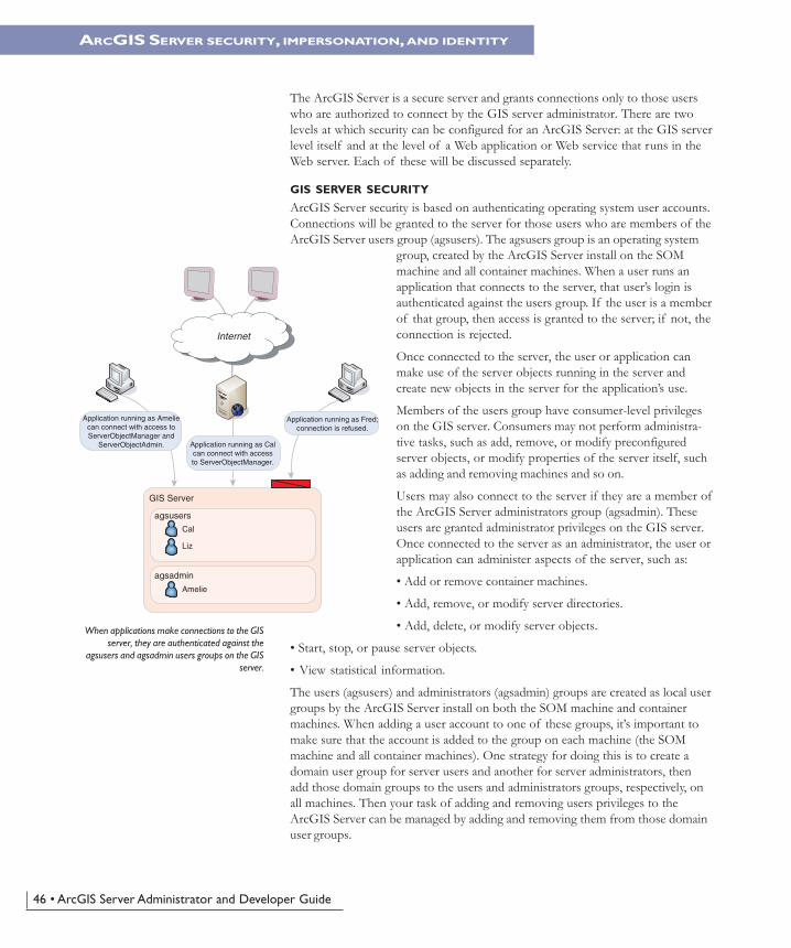
When applications make connections to the GISserver, they are authenticated against the
agsusers and agsadmin users groups on the GISserver.
` `
GIS Server
agsusers
Cal
Liz
agsadmin
Amelie
Application running as Ameliecan connect with access toServerObjectManager and
ServerObjectAdmin.
Application running as Fred;connection is refused.
Application running as Calcan connect with accessto ServerObjectManager.
Internet
Chapter2.pmd 10/12/2004, 4:01 PM46
Chapter 2 • The ArcGIS Server architecture • 47
ARCGIS SERVER SECURITY, IMPERSONATION, AND IDENTITY
A desktop client application to ArcGIS Server will run as the user account thatstarted the application. For example, if you are logged into a desktop computeras the domain user ANDY on the domain AVWORLD, and you are running anapplication such as ArcCatalog, the identity of the application isAVWORLD\ANDY. When you connect to an ArcGIS Server in that ArcCatalogsession, you are connecting as AVWORLD\ANDY. As long asAVWORLD\ANDY is a member of the users group (agsusers) on the SOM, youwill be able to connect. If AVWORLD\ANDY is a member of the administra-tors group (agsadmin), you will have administrator privileges on the serverthrough that connection.
When you connect to ArcGIS Server with ArcCatalog, you will have more com-mands when connected as an administrator than you would as a consumer—thatis, the commands necessary for administering the GIS server. For more details onhow to use ArcCatalog to administer ArcGIS Server, see Chapter 3, ‘Administer-ing an ArcGIS Server’.
IMPERSONATION
Web applications running in the Web server must connect to the ArcGIS Serveras a valid GIS server user (that is, a member of the users group). The Web appli-cation must use impersonation to connect to the server as a user account in theusers group. For more information on impersonation in Java and .NET, see Chap-ters 5, ‘Developing Web applications with .NET’, and 6, ‘Developing Web appli-cations with Java’.
At the application level, Web applications and Web services define their ownsecurity model based on ASP.NET, the .NET implementation of Active ServerPages, and Java 2 Platform Enterprise Edition (J2EE). Based on this standardsecurity infrastructure, you can build anonymous applications and Web servicesthat are open to all who know the URL. You can also build secure applicationswith their own users, authentication, and authorization independent of the GISserver. Using these security infrastructures, you can limit the accessibility of yourWeb application or Web service and deny unauthorized users from having accessto your GIS server through the Internet.
These technologies are beyond the scope of this book. For more information onsecuring ASP.NET and J2EE Web applications, consult the literature on thosetechnologies.
IDENTITY
The GIS server itself runs as two distinct operating system accounts: the serveraccount and the container account. These accounts can have any name and can beassigned to any account already existing in your organization. However, it isimportant to understand why these accounts are necessary before decidingwhether existing accounts in your domain should be used or if you should let theArcGIS Server installation create these accounts for you.
The server account is the account that runs the Server Object Manager Windowsservice or UNIX daemon and process. This process manages the container pro-cesses on the container machines as well as the GIS server’s configuration infor-mation and log files. So, the server account has privileges to write to the locations
If your login user is not a member of the usersor administrators groups, you can use the “runas”
command to run ArcCatalog as another userwho is in the appropriate group.
Chapter2.pmd 10/12/2004, 4:01 PM47
48 • ArcGIS Server Administrator and Developer Guide
ARCGIS SERVER SECURITY, IMPERSONATION, AND IDENTITY
where the server configuration information and log files are stored. It also hasprivileges to start container processes on the container machines.
The container process actually hosts the server objects and does the work. Con-tainer processes are started by the server object manager but run as the containeraccount. Therefore, the container account must have read access to any GISresources (maps, locators, data) that preconfigured and application-specific serverobjects require to do their work. In addition, the container account must havewrite access to the server directories of the GIS server so that server objectsrunning in container processes can write their output. These aspects of the con-tainer account are important for administering your site, especially when consid-ering privileges on shared network drives and so on.
One important aspect of the container account is that, since the container pro-cesses runs as that account, a user who connects to the GIS server can do any-thing that the container account can do. Because developers are free to createtheir own objects on the server, they have access to a wide range of functionality,including the ability to read data that the container account has read privilegeson. More important, developers can edit, delete, and otherwise affect files thatthe container account has write privileges to.
It can be dangerous to use a domain account with many privileges as the con-tainer account for your GIS server. The container account should only haveenough privileges to access necessary data and perform the task of running serverobjects. The ArcGIS Server installation can create the server container accountwith the following minimum privileges on each container machine:
• Ability to launch container processes
• Write access to the system temp directory
It is up to the GIS server administrator to grant this account access to any neces-sary data and write privileges to the server’s output directories.
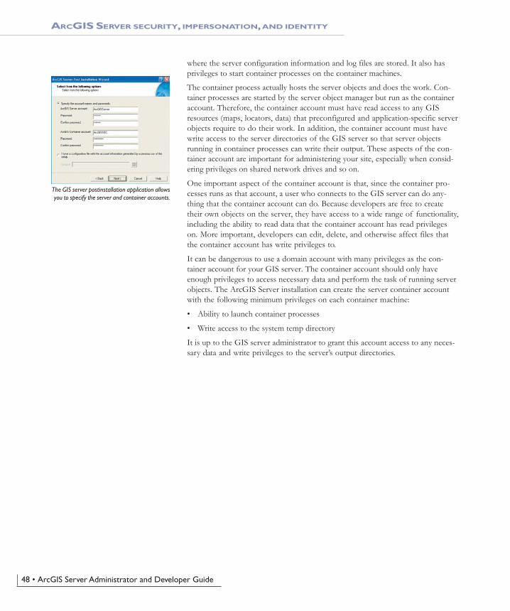
The GIS server postinstallation application allowsyou to specify the server and container accounts.
Chapter2.pmd 10/12/2004, 4:01 PM48