Embed Size (px)
Citation preview
18
CHAPTER: 2 - PHYSICAL FRAMEWORK OF MOKOKCHUNG
DISTRICT
2.1 Introduction
Nagaland is the homeland of the Naga tribes and of the “Seven Sisters” of
the Northeast of India located between 25 ̊6’ N and 27 ̊4’N latitude and 93 ̊20E
and 95 ̊15’E longitude having a geographical area of 16,579 Sq.km. Out of which
Mokokchung district has an area of 1,615 Sq.km with an average density of 120
persons per Sq.km which is inhabited by the Ao-Naga tribes. In accordance with
the legends and traditions says that the Aos sprung up from ‘Longtrok’ which
means ‘Six Stones’. They then founded the Chungliyimti village where they
settled and stayed for a considerable period of time. It is the starting point of the
different aspects of development of Ao-culture. In due course of time, they
crossed the Dikhu River by a cane bridge leaving other people behind. The people
(Aos) who went ahead leaving others behind came to be known as ‘Aoer or Ao’
which means ‘going or gone’. First they occupied a place named as ‘Soyim’
(Ungma) under Ongpangkong range which is the southernmost range and also the
highest altitude of all the ranges. In due course of time, from there they have
migrated to different places and gradually as population grew it eventually spread
out to different places establishing different villages. The word ‘MOKOK’ means

19
defiance and ‘CHUNG’ means the act of going apart. The Aos belong to three
dialectal different groups namely Chungli, Mongsen and Changki and most
comparatively among the well developed districts in Nagaland.
Before the coming of the Britishers the present site of the Mokokchung
was a thick forest. The British administrative Headquarters was established there
since February 28th 1890 as a Sub-Divisional headquarters till the formation of
Naga Hills Tuensang Area (NHTA). On 1st December 1957 when it become a
district of NHTA it remained a district even after Nagaland attained its statehood
in 1963 with Wokha and Zunheboto as its sub-divisions. Later in 1973, it was
demarcated into three districts namely-Mokokchung, Wokha and Zunheboto. The
district lies between 93 5̊3’ and 94 ̊53’ East Longitude and 25 ̊56’ and 27 ̊40’
North Latitude. It is bounded by Assam in the north, Wokha district in the west,
Tuensang and Longleng districts in the East and Zunheboto district to the south
(Fig. 2.3). It comprises of 8 (eight) circles i.e. Longchem, Alongkima, Tuli,
Changtongya, Chuchuyimlang, Kobulong, Mangkolemba and Ongpangkong and
with (six) ranges- Ongpangkong, Langpangkong, Asetkong, Japukong,
Tzurangkong and Changkikong ranges which is inhabited by 102 villages (2001
census). The total population of the district was 1, 93,171 (2011 census) of which
there was a change of -16.77% in the population compared to population as per
2001. Having a sex ratio of 927 females for every 1000 males and a literacy rate
of 92.68% with rural population comprises of 1, 37,517 followed by urban 55,654
(2011 census).

20
NORTHEAST REGION IN INDIA, NAGALAND IN THE NORTH EAST
MOKOKCHUNG DISTRICT MOKOKCHUNG DISTRICTIN NAGALAND
Fig: 2.1 Location Map of the Study Area viz. Mokokchung District ofNagaland

21
Fig: 2.2 Map of Nagaland

22
Fig: 2.3 Mokokchung District, Nagaland

23
Fig: 2.4 Map of Mokokchung District showing eight circles
24
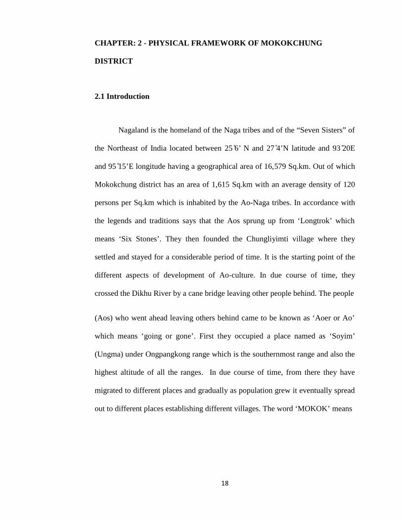
Fig: 2.5 Physiography Map of Mokokchung District

25
Fig: 2.6 Map of different ranges under Mokokchung District
26
2.2 Physiography
The entire State of Nagaland comprises of rugged terrain of which
Mokokchung district is comparatively less elevated. It is a part of Naga Hills
which are dismembered branch of Eastern Himalayas. The region is situated in
the hills and has got a number of mountain ranges coupled with sharp crust ridges
and narrow valleys with few plain lands. It spread out mostly from north- east and
south-west. The hills vary attitudinally between 1000-2000 meters and the
average height is 1500 meters. The ranges are higher on the east than in the west
where they merge with the plains of Assam (Fig. 2.6). Between the ranges there
are glens and gorges through which streams flow. Out of 1,615 Sq.km nearly half
portion of the area is having elevations which were formed cutting through soft
and loose geological strata cause by the heavy rains resulting into numerous
gorges like valleys. Within the district Milak and Tsurang Rivers with their
tributaries flows down the downstream leading to the formation of fertile flood
plains i.e. Changki, Tuli and Bhaghty valleys having an average width varies from
1-2 miles.
The river valleys of Tsurang, Milak and Dikhu on the south eastern sides
are steeper compared to the North-western sides. Numbers of perennial streams
flow through the district before joining the Brahmaputra River. The district is
agriculturally and industrially among the most progressive districts in the State
along with Kohima and Dimapur. The major agricultural regions cultivating Jhum
cultivation is located in the hilly slope areas being cultivated in different ranges
27
with the maximum cultivators under Ongpangkong range. The terrace cultivation
is cultivated in the low-lying areas of Changki-Longnak, Tsurang, Milak and
Dikhu valley regions. Tuli-Milak and Changki-Longnak valleys are also the major
small industrial areas. The physiography of the district shows parallel ranges
basing on different climate, soil, terrain and characteristics of different vegetation.
The six ranges under the district are Ongpangkong, Langpangkong, Asetkong,
Changkikong, Japukong and Tzurangkong ranges (Fig 2.6).
1. Ongpangkong Range
It is the highest altitude and also the southernmost range which is bounded by
Sema and Lotha on the south and Sangtams on the east. It has an average
altitude of 1500 msl having types of vegetations varies from evergreen forest to
mixed deciduous forest types. It present, the range consists of 17 villages by
having a population of 85,667 (2011). The range has a large tract of virgin
forests and forest by adopting ‘Community Reserved Forests’.
2. Langpangkong Range
It is the eastern most range and the terrain is spread out like a bed. The range
dodging with the course of Dikhu River by forming a natural boundary line
between Tuensang and Mon districts. It has a total population of 22, 44 (2011)
with 18 villages. National Highway No: 61 stretch through the entire length of

28
the range which covers about 85 kms. Large tracts of community biodiversity
and forest reserve are located in this range of which ‘Kanglutu Biodiversity
Reserve’ has 7060 hectares at Changtongya village.
3. Asetkong Range
This range is located between Menung and Milak Rivers and based as the
central range of all the ranges. It runs in an east-west direction with range of
Langpangkong in the east, Ongpangkong in the south and Changkikong range in
the north-west which resembles an island. Average altitude msl (mean sea level)
is 1100 meters above mean sea level which is marked by distinct warm humid,
high rainfall, rugged topography and soil types. It has five recognized villages
and small stations by having a population of 15,365 (2011).
4. Changkikong Range
It is located between Milak and Tzurang River in the west, which comprises of
09 villages with 7,316 (2011) approximately. The range has a vegetation of
mixed deciduous and evergreen forest which has an accessible Reserved Forest
covers at Tsurong valley and Kalomang. It is said to be one of the richest spot of
biodiversity under the district with the presence of thick forest covers.
Geographically, it consists of various mineral resources mainly the deposits of
coals in the area.

29
5. Japukong Range
This range is the outer most range which stretches from the north to east and
south to west lying to the interior (south) of Tzurangkong region. It has 18
villages and altitude varies from 150-950 meters msl having an approximate of
70 kms in length. The range enjoys a warm-humid and sub-tropical type with
formations of dense and thick forests. Retongkong and Satsu Tangen are some
of the well known reserved forests.
6. Tzurangkong Range
The range borders with Assam and stretches about 15 km from Tzurang River to
Tzutapela area. It consists of hillocks randomly which adjoins the plains of
Assam mostly along the valleys of Desai and Jhanzi Rivers before debouching
into Assam plains. Wangtak, Tangyong, Dzesu are some of the perennial rivers
by having a warm and humid climatic conditions.
2.3 Geology
The geological characteristics are of great influence on the nature due to
the process of aggradations and degradations are in no way insignificant in
shaping of the topographic evolution and landform of any place. The geology of

30
the district belongs to the Himalayan Orogeny, where the Himalayan mountain
system terminated in sharp acute syntaxial bend along Burmese area.1
Major portion of the district is covered by Disang series (Eocene) and then
Barail series (Oligocene) rocks and Tipam series of still younger rocks occur in
the areas bordering the plains of Assam. The lower and middle Eocene age is
represented by the group of Disang, upper Eocene and Oligocene age by the
Barail group, Miocene by Surma and the Tipam group, Miopliocene age by
Namsang beds.
The younger rocks belonging to the Tipam series borders the Assam
plains. In the foothills of the district tertiary rocks are dispersed in parallel
direction like an individual thrust shell within a system of imprecating strike
faults as known the ‘Belt of Schupen’. High rocks are found with disturbed being
sliced by cross-faults which results into blocks that have pushed southward due to
varying degrees of faulting with fine grained sandstones towards the top of the
series.
The Disang group of rocks represents the oldest rocks which is made up of
splintery hard shales, from grey to dark iron stained shales has been inter-bedded
with fine grained sandstones towards the top of the series. The Disang series
consists of metamorphosed rocks and the metamorphism increases southward
1 Development Plan of Mokokchung Sub-Division and Mokokchung Urban Area(1971-1991) pp.3, 4

31
from Mokokchung to Kohima. Along the base of the hill, west of Changtongya
village roughly follows the Milak River. This series overrides the Barail
sandstones in the northeast-southwest along a thrust fault. Rocks of Barail series
consists mostly well bedded sandstones with shale intercalations. It is made up of
medium grains ferrogeneous sandstone with partings of shale, mudstones and clay
marked by thick coal seams. The Surma group presents alternations of shale and
sandstones occasionally with conglomerate. The Tipam sandstones crops out a
number of northeastern parallel strips within the ‘Belt of Schupen’ and also as a
prominent hill range which is known as the Japukong range.
The upper unit of Tipam group is represented by sandstones, grits with
bands of sandy clays and grained clay formation. It covers an area of ‘Desai
Reserved Forest’ which forms a flat-topped low mounds. In Tsurang and Tsurong
valleys this clay occupies the low-lying areas below the scrap falls.
The Namsang beds in this area comprise of loosely packed sandstone with
fragments of coal cemented sand. A good exposure if found in the northern part
around Tuli and Desai valley. Girujan clay formation overlying the Tipam is
composed of typical blue and mottled clays and argillaceous sandstone beds. This
Girujan clay also occupies the broad Desai River valley, west of Changki coupled
with conglomerates grits etc. The Disang series occurs in the district is estimated
to be around 54 million years. Majority of the structured units in the area is
composed of a number of sub-parallel thrusts arranged in an imbricate manner

32
dipping in a south-easterly direction. The parallel traverse faults have affected the
entire sequence resulting in north-westerly shift of Barail coal measures and the
overlying Tipam. Sub-parallel minor reversed faults are also observed parallel to
the crest of hills which affects the Tipam sandstones.
The entire district which lies close to the most strategic eastern Himalayan
syntaxial bend is having evidences of large scale earth movements. As a result
prolonged, the hardest strata are exposed and the occurrence of landslides is
frequent particularly the road connecting Mokokchung and Mariani (Fig: 2.8).
The Amguri-Mokokchung road is less disturbed by landslides except beyond the
Tuli region where the upper strata are composed of loose debris of conglomerate.
All these diversity of geologic features and process has brought impact on the
environment. And this has further been destabilized by prolonged Jhum
cultivation which leads to deforestation and loss of soils.
33
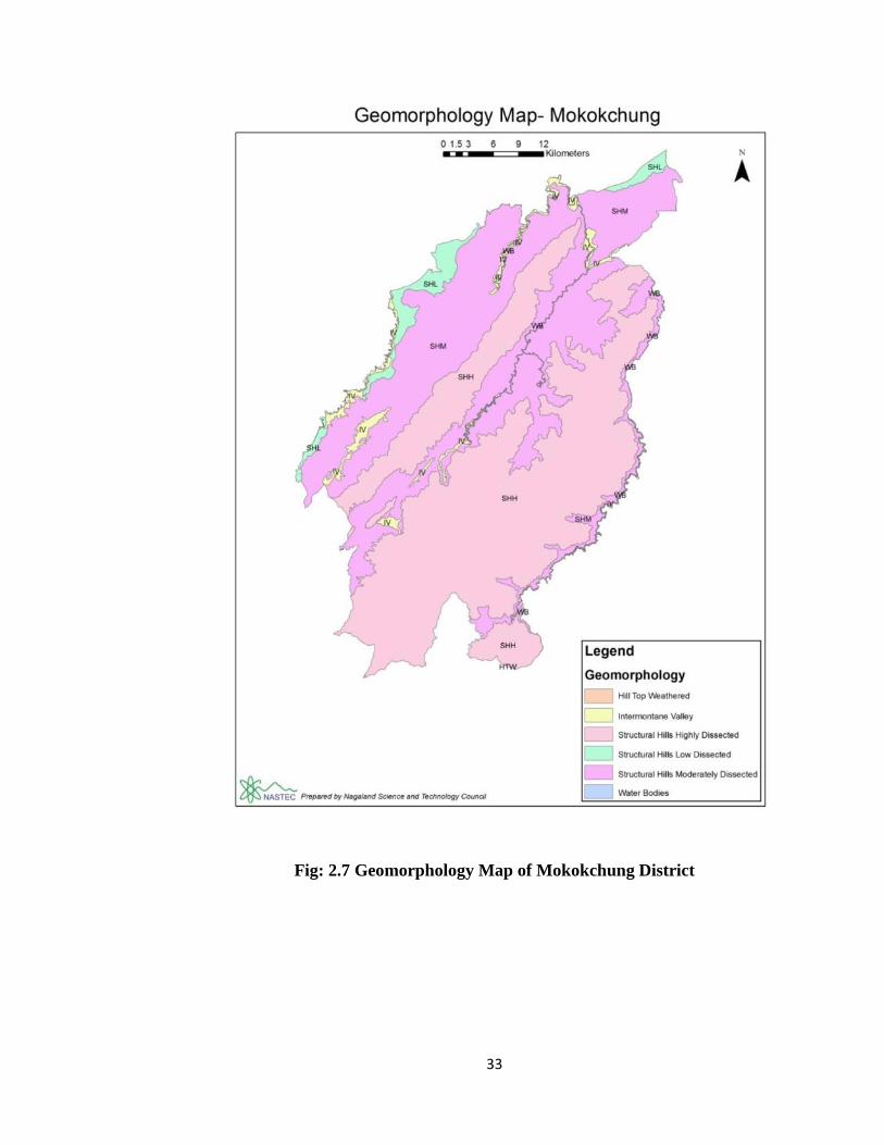
Fig: 2.7 Geomorphology Map of Mokokchung District

34
Fig: 2.8 Mokokchung District Road Network

35
2.4 Drainage Pattern
Streams flowing over a surface are influenced by the structure of surface
which leads to the emergence of different patterns. In other words, drainage
patterns get adapted to the structure of land and apart from the structure other
factors also affect the shape of the drainage pattern. Among them the endogenic
forces are important.
The important rivers which are found in the district are Desai or Tsurang,
Dikhu, Milak, Tsumok, and Menung. They run parallel to the ridges which act as
water dividers either northward or southward except Doyang which cuts across
the middle chain. Direction of tributaries is from south to north in accordance
with its varying nature of topographic conditions. The main rivers are perennial in
nature but volume of water reduces during dry season and often rivers become
almost dry.
Main rivers which make significant drainage system are as follows:
1. Milak
It is the main longest river which flows across the Ao region and known as
Jhansi in Assam. Its source is found in Mokokchung town itself at an altitude of
1300 meters. It flows northward until it leaves the hills and turns westward near
Amguri plains. The river is a bounded line between east of Alongkima, west of
36
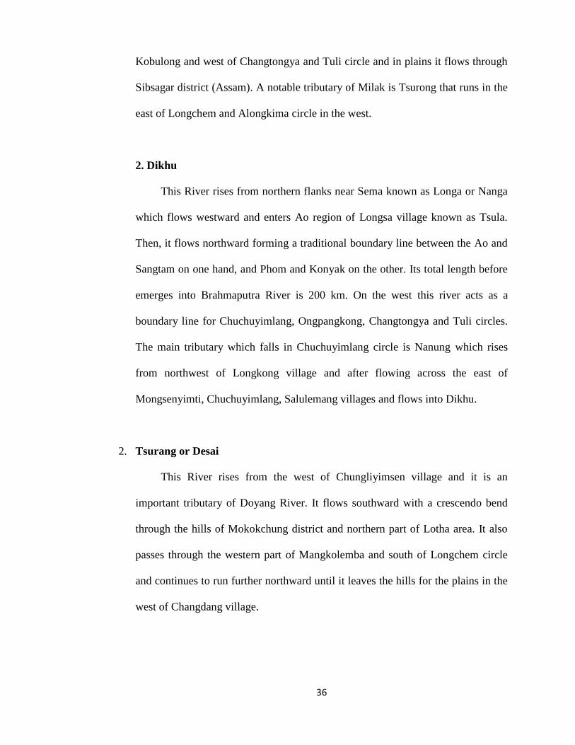
Kobulong and west of Changtongya and Tuli circle and in plains it flows through
Sibsagar district (Assam). A notable tributary of Milak is Tsurong that runs in the
east of Longchem and Alongkima circle in the west.
2. Dikhu
This River rises from northern flanks near Sema known as Longa or Nanga
which flows westward and enters Ao region of Longsa village known as Tsula.
Then, it flows northward forming a traditional boundary line between the Ao and
Sangtam on one hand, and Phom and Konyak on the other. Its total length before
emerges into Brahmaputra River is 200 km. On the west this river acts as a
boundary line for Chuchuyimlang, Ongpangkong, Changtongya and Tuli circles.
The main tributary which falls in Chuchuyimlang circle is Nanung which rises
from northwest of Longkong village and after flowing across the east of
Mongsenyimti, Chuchuyimlang, Salulemang villages and flows into Dikhu.
2. Tsurang or Desai
This River rises from the west of Chungliyimsen village and it is an
important tributary of Doyang River. It flows southward with a crescendo bend
through the hills of Mokokchung district and northern part of Lotha area. It also
passes through the western part of Mangkolemba and south of Longchem circle
and continues to run further northward until it leaves the hills for the plains in the
west of Changdang village.
37
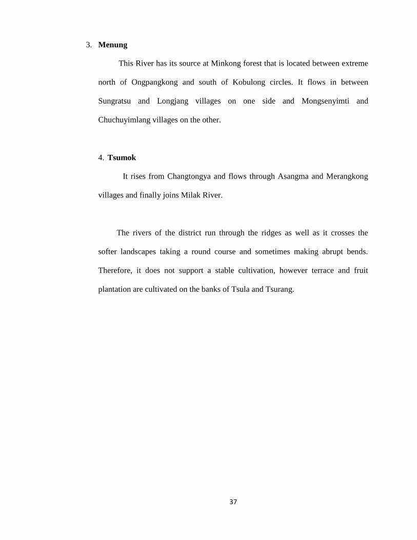
3. Menung
This River has its source at Minkong forest that is located between extreme
north of Ongpangkong and south of Kobulong circles. It flows in between
Sungratsu and Longjang villages on one side and Mongsenyimti and
Chuchuyimlang villages on the other.
4. Tsumok
It rises from Changtongya and flows through Asangma and Merangkong
villages and finally joins Milak River.
The rivers of the district run through the ridges as well as it crosses the
softer landscapes taking a round course and sometimes making abrupt bends.
Therefore, it does not support a stable cultivation, however terrace and fruit
plantation are cultivated on the banks of Tsula and Tsurang.

38
Fig: 2.9 Nagaland Drainage Network

39
Fig: 2.10 Mokokchung District Drainage Network
40
2.5 Soil
Soils are the most valuable life supporting natural resource for the society
since they produce food, fiber and fodder which are basic to our very existence.2
For a sustained utilization of soil resource, it is imperative to know the nature,
characteristics and extent of different soils, their qualities, produce capacity and
suitability for all alternative landuse. Soil formation increase about 8mm per
century and 8mm per century (or might be higher) in formation under agriculture
due to ploughing – it aerates the soil and increases the rate of leaching.3
The ecosystem significantly influences the process of soil formation. In
Nagaland, large altitudinal variations have given rise to diversity in climate and
vegetation. The soil has been developed on shales and sandstones. Soils of
Nagaland are derived from tertiary rocks belonging to Barail and Disang series.
They are generally acidic, rich in organic carbon but poor in available of
phosphate and potash content except in the valleys and in the foothills with
comparatively level land and gentle gradients.
The State has identified 72 soils families and was mapped into 36 soil units.
The area wise distribution of different soils (order, suborder, great group and sub
2 Soils of Nagaland (Their kinds, distribution, characterization and interpretations) foroptimizing Landuse-Dept. of Soil & Water Conservation, Government of Nagaland, Kohima.pp.83 The Environment (Principles of Applications), Chris Park. pp.611.

41
groups). The Soils of Nagaland belong to four orders, seven suborders, 10 great
groups and 14 subgroups. (Fig: 2.11). It is also observed that Inceptisols is the
dominant soils followed by Ultisols, Entisols and Alfisols.
The soils of Mokokchung district belongs to Barail series mostly acidic in
nature. The PH content varies from 5.6 to 5.8 on an average. Acidity is found
higher around Changki area followed by Ongpangkong and Changtongya –Tuli
area. Soils found in foothills are rich in deposits and is fertile which is good for
cultivation. Organic carbon content is high in higher altitudes while foothills
which are continuously cultivated lands have low content of organic carbon. The
soils are poor in phosphate (Pƨ Oƽ) excluding some patches adjoining
Mokokchung town, Tuli-Merangkong and Waromung village areas. Three major
type of soils are found in the district-
1. Alluvial soil (Recent alluvium soils –Entisols), Old alluvium (oxizol and
ultisols) and Mountain valley soil (Entisols).
2. Forest soil and
3. Non-lateriate soils.
Alluvial soils are confined along the foothills in the valleys of Tuli,
Changki, Bhaghty, Tzurang and plains located on the right bank of Milak River.
These soils are transported largely made up of silt, sand and clay. Content of the
soil is usually deficient in nitrogen and humus content requires regular addition of
fertilizers and manures.

42
Fig: 2.11 Soil Map of Nagaland

43
Fig: 2.12 Soil Map of Mokokchung District

44
Forest soils are generally found at a height which varies from 900 meters to
1800 meters and are found mostly around deciduous forests. Such kind of soils is
rich in humus and deep but slightly acidic in reactions which are fertile for
growing variety of crops. Non-lateriate Red soils are formed due to alteration of
moist and dry seasons. This type of soil is found in the hilly slopes and hilly tops
except in higher altitudes. It contains organic matter due to presence of high
humus and degree of high porosity. The color red soil is due to presence of iron-
oxide and aluminum which contains acidic and have less quantity of phosphate
and potash. Such soils are hard when dry and sticky and when it gets wet, it is
regarded as residual soil. The fertility of the soil in the district is due to content of
minerals and humus as well as with the prevail of climatic condition. Overall the
soil in the region is loose and boggy because it is formed by falling of leaves,
branches and the decayed annual undergrowth and shrubs.
The inherent problem of soil erosion is further aggravated due to extensive
practice of slash and burn or shifting cultivation and deforestation. This ultimately
leads to rapid run-off on steep slopes and less vegetation cover and the deposition
of materials in the valleys and in the low-lying areas. To avoid soil erosion, use of
physical and biological barriers is being carried out for soil conservation.

45
2.6 Climate
Climate is a complex of meteorological conditions. It exists in any given
area and imparts individuality to the landscape of that area.⁴
The most important among the numerous meteorological elements are
precipitation, temperature, relative humidity and evaporation. Weather and
climate are the dynamic features of a physical environment. Indian climate forms
a part of climatic patterns of South East Asia. Northeast India has been located at
20 ̊N to 29 ̊30’N latitude and 84 ̊46 ’E to 97 ̊30’ E longitudes. It passes the tropic
of cancer across the southern part by providing a tropical type of climate. The
climate of Nagaland is controlled by its terrain features varying from tropical to
temperate conditions. The hill ranges and mountains with the foothills, plains and
sheltered valley marked with climatic variations which determines to a great
extent in rainfall distribution. Mokokchung district has a sub-tropical humid type
of climate while valleys and the lower range adjoining the Assam plains
experience a warm climate. The temperature of the district varies from 28 ̊C –
30 ̊C and winter temperature varies from 10 ̊C – 15 ̊C.
⁴Geography of India-Balbir Singh Negi, U.B Singh (1998-1999) pp.17
46
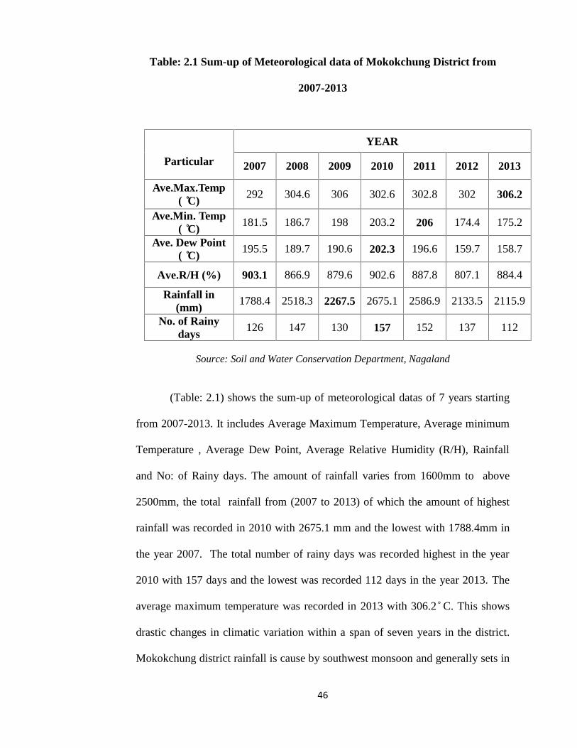
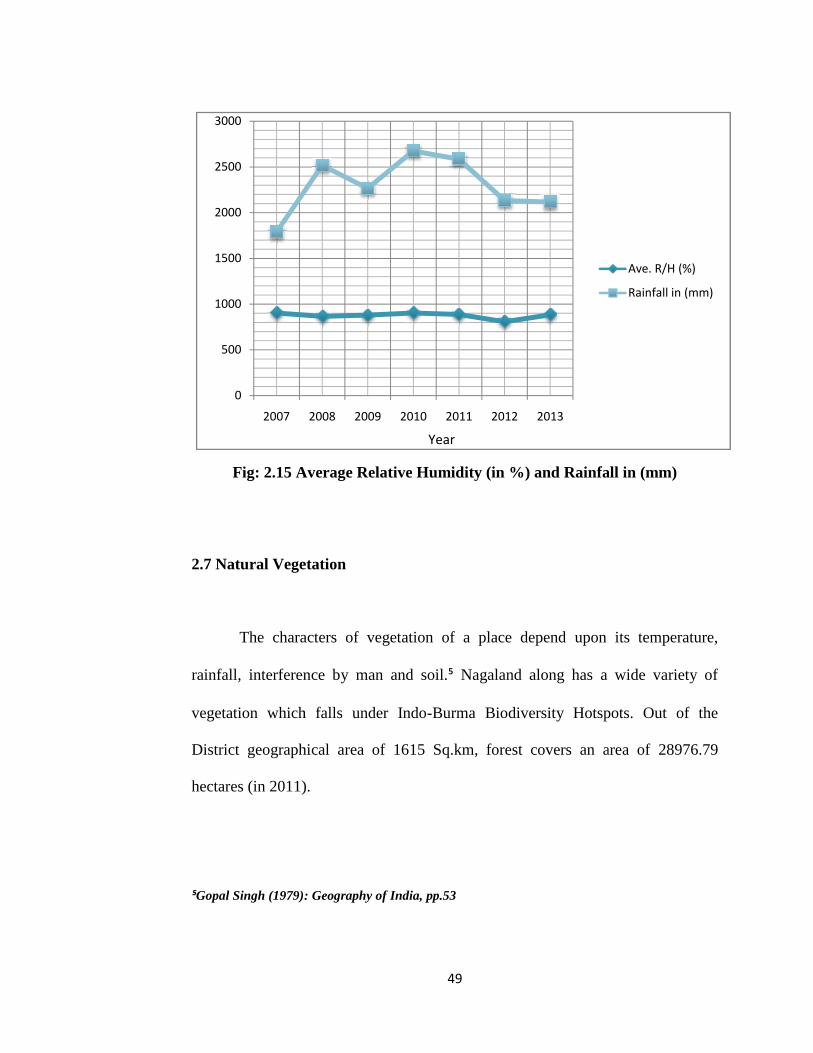
Table: 2.1 Sum-up of Meteorological data of Mokokchung District from
2007-2013
Particular
YEAR
2007 2008 2009 2010 2011 2012 2013
Ave.Max.Temp( ̊C)
292 304.6 306 302.6 302.8 302 306.2
Ave.Min. Temp( ̊C)
181.5 186.7 198 203.2 206 174.4 175.2
Ave. Dew Point( ̊C)
195.5 189.7 190.6 202.3 196.6 159.7 158.7
Ave.R/H (%) 903.1 866.9 879.6 902.6 887.8 807.1 884.4
Rainfall in(mm)
1788.4 2518.3 2267.5 2675.1 2586.9 2133.5 2115.9
No. of Rainydays
126 147 130 157 152 137 112
Source: Soil and Water Conservation Department, Nagaland
(Table: 2.1) shows the sum-up of meteorological datas of 7 years starting
from 2007-2013. It includes Average Maximum Temperature, Average minimum
Temperature , Average Dew Point, Average Relative Humidity (R/H), Rainfall
and No: of Rainy days. The amount of rainfall varies from 1600mm to above
2500mm, the total rainfall from (2007 to 2013) of which the amount of highest
rainfall was recorded in 2010 with 2675.1 mm and the lowest with 1788.4mm in
the year 2007. The total number of rainy days was recorded highest in the year
2010 with 157 days and the lowest was recorded 112 days in the year 2013. The
average maximum temperature was recorded in 2013 with 306.2 ̊ C. This shows
drastic changes in climatic variation within a span of seven years in the district.
Mokokchung district rainfall is cause by southwest monsoon and generally sets in
47
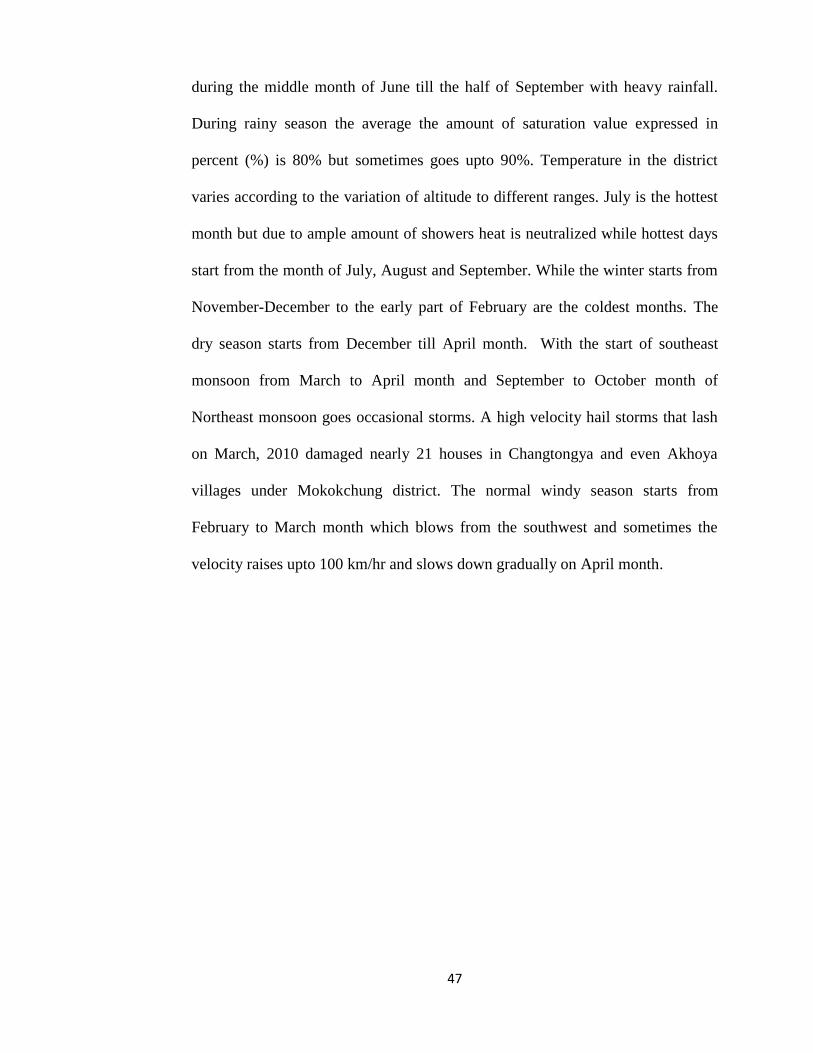
during the middle month of June till the half of September with heavy rainfall.
During rainy season the average the amount of saturation value expressed in
percent (%) is 80% but sometimes goes upto 90%. Temperature in the district
varies according to the variation of altitude to different ranges. July is the hottest
month but due to ample amount of showers heat is neutralized while hottest days
start from the month of July, August and September. While the winter starts from
November-December to the early part of February are the coldest months. The
dry season starts from December till April month. With the start of southeast
monsoon from March to April month and September to October month of
Northeast monsoon goes occasional storms. A high velocity hail storms that lash
on March, 2010 damaged nearly 21 houses in Changtongya and even Akhoya
villages under Mokokchung district. The normal windy season starts from
February to March month which blows from the southwest and sometimes the
velocity raises upto 100 km/hr and slows down gradually on April month.
48
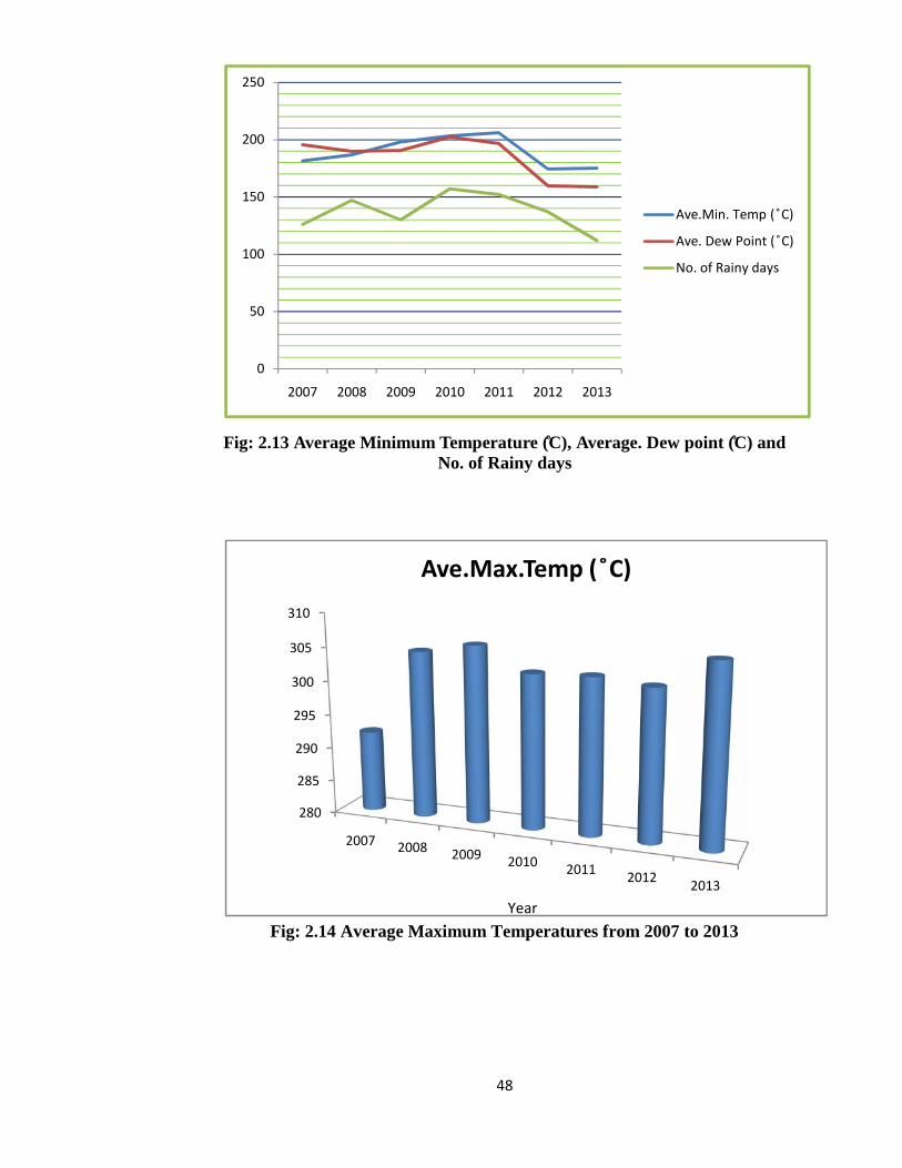
Fig: 2.13 Average Minimum Temperature (̊C), Average. Dew point (̊C) andNo. of Rainy days
Fig: 2.14 Average Maximum Temperatures from 2007 to 2013
0
50
100
150
200
250
2007 2008
280
285
290
295
300
305
310
2007
48
Fig: 2.13 Average Minimum Temperature (̊C), Average. Dew point (̊C) andNo. of Rainy days
Fig: 2.14 Average Maximum Temperatures from 2007 to 2013
2008 2009 2010 2011 2012 2013
Ave.Min. Temp ( ̊C)
Ave. Dew Point ( ̊C)
No. of Rainy days
2007 2008 2009 2010 2011 2012
Ave.Max.Temp ( ̊C)
Year
48
Fig: 2.13 Average Minimum Temperature (̊C), Average. Dew point (̊C) andNo. of Rainy days
Fig: 2.14 Average Maximum Temperatures from 2007 to 2013
Ave.Min. Temp ( ̊C)
Ave. Dew Point ( ̊C)
No. of Rainy days
2013
49
Fig: 2.15 Average Relative Humidity (in %) and Rainfall in (mm)
2.7 Natural Vegetation
The characters of vegetation of a place depend upon its temperature,
rainfall, interference by man and soil.⁵ Nagaland along has a wide variety of
vegetation which falls under Indo-Burma Biodiversity Hotspots. Out of the
District geographical area of 1615 Sq.km, forest covers an area of 28976.79
hectares (in 2011).
⁵Gopal Singh (1979): Geography of India, pp.53
0
500
1000
1500
2000
2500
3000
2007 2008
49
Fig: 2.15 Average Relative Humidity (in %) and Rainfall in (mm)
2.7 Natural Vegetation
The characters of vegetation of a place depend upon its temperature,
rainfall, interference by man and soil.⁵ Nagaland along has a wide variety of
vegetation which falls under Indo-Burma Biodiversity Hotspots. Out of the
District geographical area of 1615 Sq.km, forest covers an area of 28976.79
hectares (in 2011).
⁵Gopal Singh (1979): Geography of India, pp.53
2008 2009 2010 2011 2012 2013
Year
49
Fig: 2.15 Average Relative Humidity (in %) and Rainfall in (mm)
2.7 Natural Vegetation
The characters of vegetation of a place depend upon its temperature,
rainfall, interference by man and soil.⁵ Nagaland along has a wide variety of
vegetation which falls under Indo-Burma Biodiversity Hotspots. Out of the
District geographical area of 1615 Sq.km, forest covers an area of 28976.79
hectares (in 2011).
⁵Gopal Singh (1979): Geography of India, pp.53
Ave. R/H (%)
Rainfall in (mm)

50
Most of the virgin forests are found in Tsurang forest that lies in
Changkikong and Japukong range and near Milak of Tuli areas respectively. It
has three Government Protected Forest i.e. Chubi (134.8 hectares), Minkong
(275.32 hectares) and Longsa (18.00 hectares) which comes upto 428.00 hectares.
The district of Mokokchung with its hilly topography and few patches of
plains has an average altitude of 1500 meters well suited to support dense natural
vegetation. With the due course of time practice of shifting cultivation by the
people for centuries has however destroyed much of the luxuriant exotic forest
canopy which leads to soil erosion. The region consists of both deciduous and
evergreen forests being deciduous most part of the trees found in lower latitude.
Mixed forest of both evergreen and deciduous trees is present.
The type of forest which is found in the district consists of:
1. Evergreen (Upto an altitude of 1000 meters)
2. Mixed deciduous and evergreen forest (From 1000- 2000 meters)
Forest intake vegetation covers provide lots of essential items for the
people. People in this region under study have been living in adjustment with the
environment though the perfect and orderly co-existences with the forest and
vegetation zone seems to be missing. Plantation of various crops and fast growing
species and small patches are also being cultivated.

51
1. Arbore- culture – trees like Chakranta, Eucaleptus etc.
2. Citrus and non-citrus fruits like pears, oranges, guava and pineapple etc.
3. Economic plantation like Sal, Teak etc.
The region is richly endowed with wide diversity of flora and fauna their
survival is it risk due to human interference. So any disturbance found in their
existence would hamper the ecological balance and extreme care should be
implemented to maintain a perfect harmony towards the awareness and protection
of the environment to safeguard the rich natural biodiversity.