Embed Size (px)
Citation preview
CHAPTER 2
Geology of Unga Island and the northwestern part of Popof Island
By James R. Riehle, Frederic H. Wilson, Nora Shew, and Willis H. White
U.S. GEOLOGICAL SURVEY OPEN-FILE REPORT 99-136
Geological and Geophysical Setting of the Gold-Silver Vein Systems of Unga Island,southwestern Alaska
CONTENTS
Previous geologic studies.. . . . . . . . . . . . . . . . . . . . . . . . . . . . . . . . . . . . . . . . . . . . . . . . . . . . . . . . .3
Summary of the regional geologic and tectonic history .. . . . . . . . . . . . . . . . . . . . . . .3
Geologic history of Unga Island and northwestern Popof Island.. . . . . . . . . . . .7
Popof volcanism ... . . . . . . . . . . . . . . . . . . . . . . . . . . . . . . . . . . . . . . . . . . . . . . . . . . . . . . . . . . . . . .7
Miocene volcanic rocks and deposits. . . . . . . . . . . . . . . . . . . . . . . . . . . . . . . . . . . . . . . . . .7
Alteration.. . . . . . . . . . . . . . . . . . . . . . . . . . . . . . . . . . . . . . . . . . . . . . . . . . . . . . . . . . . . . . . . . . . . . . . . . . 10
References cited.. . . . . . . . . . . . . . . . . . . . . . . . . . . . . . . . . . . . . . . . . . . . . . . . . . . . . . . . . . . . . . . . . . 13
Description of map units . . . . . . . . . . . . . . . . . . . . . . . . . . . . . . . . . . . . . . . . . . . . . . . . . . . . . . . . . 15
Figures
Figure 1. Simplified regional geologic map ... . . . . . . . . . . . . . . . . . . . . . . . . . . . . . . .4 Figure 2. Terrane maps .. . . . . . . . . . . . . . . . . . . . . . . . . . . . . . . . . . . . . . . . . . . . . . . . . . . . . . . .6 Figure 3. Thin-section photomicrographs .. . . . . . . . . . . . . . . . . . . . . . . . . . . . . . . . . . .9 Figure 4. Structural cross-section of Unga Island .. . . . . . . . . . . . . . . . . . . . . . . . 12
Plate
Plate 1. Geologic map... . . . . . . . . . . . . . . . . . . . . . . . . . . in "C2 Geology" directory
Table
Table 1. K-Ar age determinations for volcanic rocks fromUnga and Popof Islands .. . . . . . . . . . . . . . . . . . . . . . . . . . . . . . . . . . . . . . . . . . . . . . . . . . . . . . . . 19
Geology of Unga Island and the northwestern part of Popof Island
James R. Riehle, Frederic H. Wilson, Nora Shew, and Willis H. White
PREVIOUS GEOLOGIC STUDIES
The first geologic map of Unga Island was published by Atwood (1911; scale 1:250,000),who correctly inferred the middle Tertiary age of the volcanic rocks and made the importantdistinction between the lava flows and the intrusive domes. Although Burk's (1964)reconnaissance map of the Alaska Peninsula (scale 1:250,000) has been modified in somerespects, it does correct Atwood's map by replacing the Kenai Formation on northwestern UngaIsland with the Unga Conglomerate and by recognizing the older Stepovak Formation elsewhereon Unga and Popof Islands.
U.S. Geological Survey (USGS) field studies that were focused on the mineral-resourcepotential of the Alaska Peninsula began in the late 1970's. These studies led to a geologic map ofthe Port Moller quadrangle--including Unga Island--at 1:250,000 scale (Wilson and others,1995), as well as summaries of mineral occurrences and geochronological studies (Wilson andothers, 1988, 1994) and a formal revision of the stratigraphic units of the Alaska Peninsula(Detterman and others, 1996). As follow-up to the regional studies, a detailed study of the veinsystems on Unga Island was undertaken as a collaborative effort between USGS and privateindustry (White and Queen, 1989). The fieldwork leading to the present report and geologic mapwas started in 1978 (Riehle and others, 1982) and was completed as part of the vein study. Theobjective was a better understanding of the geologic setting of the vein systems: the geologichistory of the host rocks, the structural controls on the veins, and the types of processes thatlikely caused the mineralization.
SUMMARY OF THE REGIONAL GEOLOGIC AND TECTONIC HISTORY
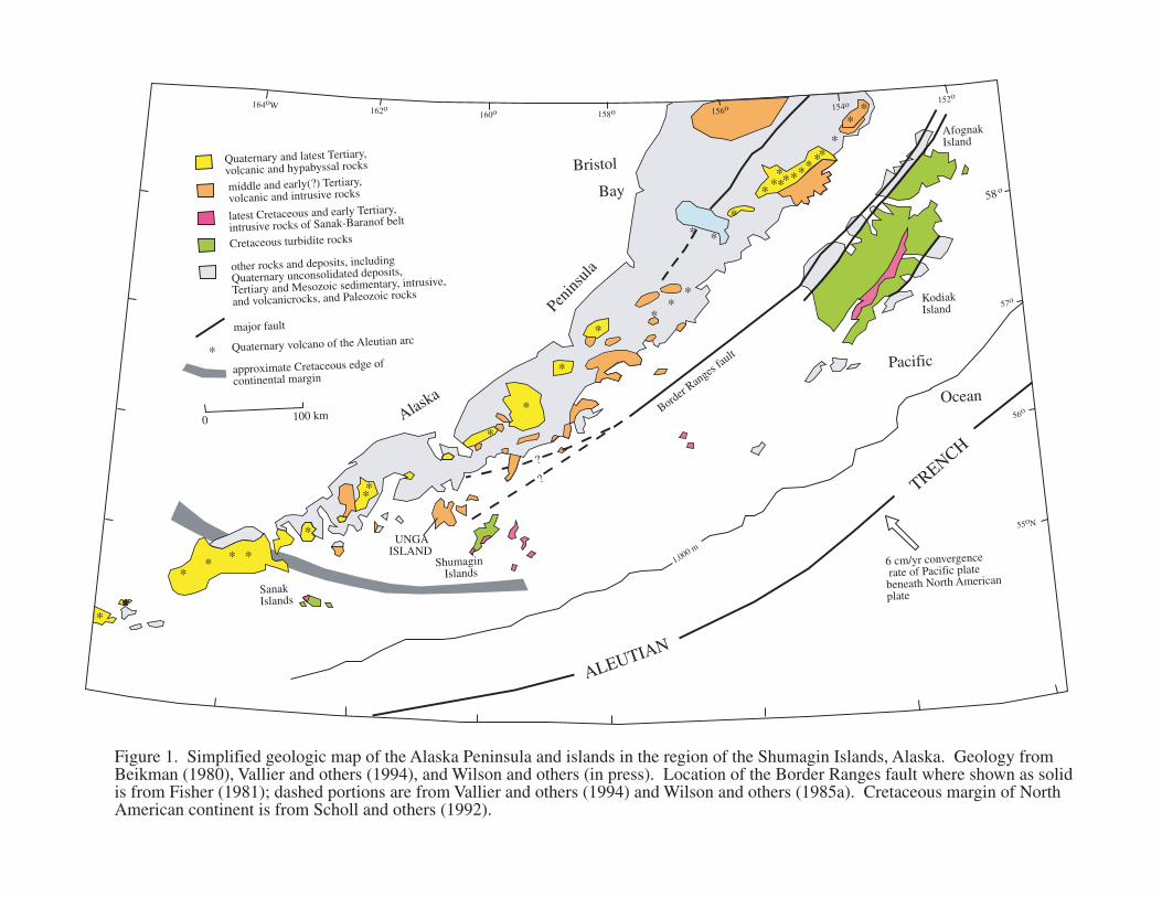
The Shumagin Islands are sited on the continental shelf 350 km southwest of KodiakIsland. The group lies from 40 to 120 km toward the Aleutian trench from the active Aleutianvolcanic arc and so is part of the Aleutian forearc (fig. 1). The northwestern islands of the group,including Unga and Popof Islands, are informally referred to as the inner Shumagins and theremainder as the outer Shumagins. A recent summary of the geology of the Alaska Peninsulaand the adjacent continental shelf by Vallier and others (1994) is the main source for the geologicoverview here. Regional geologic maps are those by Beikman (1980, scale 1:2,500,000; re-published as Plate 1 in Plafker and Berg, 1994) and an Alaska Peninsula compilation (Wilsonand others, in press) at 1:500,000, which includes recent USGS mapping.
Besides subduction, two major and controversial tectonic processes that have helped toshape the southern Alaska continental margin are terrane migration and rotation of the mainland.Both are a consequence of plate tectonics: Terranes of previously separated crustal blocks havemigrated due to sea-floor spreading, and some believe that southwestern Alaska has rotatedcounterclockwise in response to collision of the northwest-migrating collection of terranes withSiberia. The two types of evidence for these processes--geologic and paleomagnetic--have beensummarized by Plafker and Berg (geologic; 1994) and Hillhouse and Coe (paleomagnetic;
1,000 m
ALEUTIAN
TRENCH
6 cm/yr convergence rate of Pacific plate beneath North American
plate
Bristol
Bay
Pacific
OceanAlaska
Penins
ula
Quaternary and latest Tertiary,
volcanic and hypabyssal rocks
middle and early(?) Tertiary,
volcanic and intrusive rocks
latest Cretaceous and early Tertiary,
intrusive rocks of Sanak-Baranof belt
Cretaceous turbidite rocks
other rocks and deposits, including
Quaternary unconsolidated deposits,
Tertiary and Mesozoic sedimentary, intrusive,
and volcanicrocks, and Paleozoic rocks
* Quaternary volcano of the Aleutian arcmajor fault
approximate Cretaceous edge of
continental margin
164oW162o
160o 158o
?
?
*
*
*
**
* *
*
*
**
** * * Shumagin
Islands
Sanak Islands
Kodiak Island
Afognak Island
Border Ran
ges fau
lt
*
*
*
*
** ** ****
**
**
0 100 km
156o 154o 152o
58o
57o
56o
55oN
UNGA ISLAND
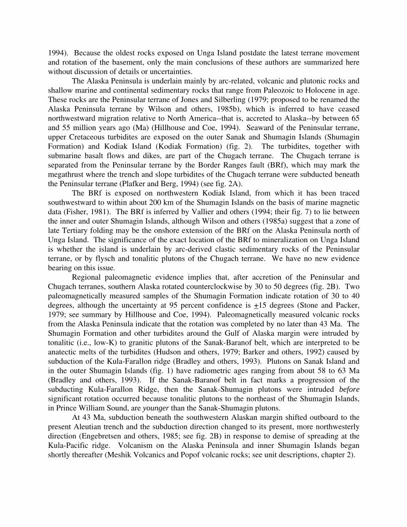
Figure 1. Simplified geologic map of the Alaska Peninsula and islands in the region of the Shumagin Islands, Alaska. Geology from Beikman (1980), Vallier and others (1994), and Wilson and others (in press). Location of the Border Ranges fault where shown as solid is from Fisher (1981); dashed portions are from Vallier and others (1994) and Wilson and others (1985a). Cretaceous margin of North American continent is from Scholl and others (1992).
1994). Because the oldest rocks exposed on Unga Island postdate the latest terrane movementand rotation of the basement, only the main conclusions of these authors are summarized herewithout discussion of details or uncertainties.
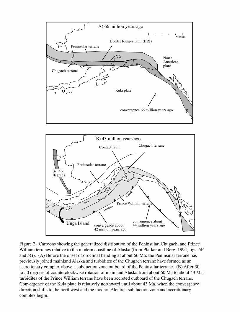
The Alaska Peninsula is underlain mainly by arc-related, volcanic and plutonic rocks andshallow marine and continental sedimentary rocks that range from Paleozoic to Holocene in age.These rocks are the Peninsular terrane of Jones and Silberling (1979; proposed to be renamed theAlaska Peninsula terrane by Wilson and others, 1985b), which is inferred to have ceasednorthwestward migration relative to North America--that is, accreted to Alaska--by between 65and 55 million years ago (Ma) (Hillhouse and Coe, 1994). Seaward of the Peninsular terrane,upper Cretaceous turbidites are exposed on the outer Sanak and Shumagin Islands (ShumaginFormation) and Kodiak Island (Kodiak Formation) (fig. 2). The turbidites, together withsubmarine basalt flows and dikes, are part of the Chugach terrane. The Chugach terrane isseparated from the Peninsular terrane by the Border Ranges fault (BRf), which may mark themegathrust where the trench and slope turbidites of the Chugach terrane were subducted beneaththe Peninsular terrane (Plafker and Berg, 1994) (see fig. 2A).
The BRf is exposed on northwestern Kodiak Island, from which it has been tracedsouthwestward to within about 200 km of the Shumagin Islands on the basis of marine magneticdata (Fisher, 1981). The BRf is inferred by Vallier and others (1994; their fig. 7) to lie betweenthe inner and outer Shumagin Islands, although Wilson and others (1985a) suggest that a zone oflate Tertiary folding may be the onshore extension of the BRf on the Alaska Peninsula north ofUnga Island. The significance of the exact location of the BRf to mineralization on Unga Islandis whether the island is underlain by arc-derived clastic sedimentary rocks of the Peninsularterrane, or by flysch and tonalitic plutons of the Chugach terrane. We have no new evidencebearing on this issue.
Regional paleomagnetic evidence implies that, after accretion of the Peninsular andChugach terranes, southern Alaska rotated counterclockwise by 30 to 50 degrees (fig. 2B). Twopaleomagnetically measured samples of the Shumagin Formation indicate rotation of 30 to 40degrees, although the uncertainty at 95 percent confidence is +15 degrees (Stone and Packer,1979; see summary by Hillhouse and Coe, 1994). Paleomagnetically measured volcanic rocksfrom the Alaska Peninsula indicate that the rotation was completed by no later than 43 Ma. TheShumagin Formation and other turbidites around the Gulf of Alaska margin were intruded bytonalitic (i.e., low-K) to granitic plutons of the Sanak-Baranof belt, which are interpreted to beanatectic melts of the turbidites (Hudson and others, 1979; Barker and others, 1992) caused bysubduction of the Kula-Farallon ridge (Bradley and others, 1993). Plutons on Sanak Island andin the outer Shumagin Islands (fig. 1) have radiometric ages ranging from about 58 to 63 Ma(Bradley and others, 1993). If the Sanak-Baranof belt in fact marks a progression of thesubducting Kula-Farallon Ridge, then the Sanak-Shumagin plutons were intruded beforesignificant rotation occurred because tonalitic plutons to the northeast of the Shumagin Islands,in Prince William Sound, are younger than the Sanak-Shumagin plutons.
At 43 Ma, subduction beneath the southwestern Alaskan margin shifted outboard to thepresent Aleutian trench and the subduction direction changed to its present, more northwesterlydirection (Engebretsen and others, 1985; see fig. 2B) in response to demise of spreading at theKula-Pacific ridge. Volcanism on the Alaska Peninsula and inner Shumagin Islands beganshortly thereafter (Meshik Volcanics and Popof volcanic rocks; see unit descriptions, chapter 2).
Prince William terrane
Peninsular terrane
Chugach terrane
30-50degrees
convergence about 44 million years ago
A) 66 million years ago
B) 43 million years ago
?
?
0 500 km
Kula plate
North American plate
Chugach terrane
Peninsular terrane
convergence 66 million years ago
Border Ranges fault (BRf)
Contact fault
convergence about 42 million years ago
Aleutian
trench
Unga Island
BRf
Figure 2. Cartoons showing the generalized distribution of the Peninsular, Chugach, and Prince William terranes relative to the modern coastline of Alaska (from Plafker and Berg, 1994, figs. 5F and 5G). (A) Before the onset of oroclinal bending at about 66 Ma: the Peninsular terrane has previously joined mainland Alaska and turbidites of the Chugach terrane have formed as an accretionary complex above a subduction zone outboard of the Peninsular terrane. (B) After 30 to 50 degrees of counterclockwise rotation of mainland Alaska from about 60 Ma to about 43 Ma: turbidites of the Prince William terrane have been accreted outboard of the Chugach terrane. Convergence of the Kula plate is relatively northward until about 43 Ma, when the convergence direction shifts to the northwest and the modern Aleutian subduction zone and accretionary complex begin.

The Meshik Volcanics and age-equivalent rocks to the north in the Katmai and Iliamnaquadrangles formed a discontinuous volcanic arc about 110 km inboard from the Aleutiansubduction zone during late Eocene and Oligocene time (fig. 1).
GEOLOGIC HISTORY OF UNGA ISLAND AND NORTHWESTERN POPOF ISLAND
The oldest rocks exposed on Unga Island and northwestern Popof Island are intertidal toshallow marine, sandstone and siltstone of the Stepovak Formation (unit Ts) of late Eocene andearly Oligocene age. The Stepovak Formation was deposited on the continental shelf inboardfrom the Aleutian trench, which had shifted southward from a position at the Beringian margin(Scholl and others, 1992) a few million years earlier.
Popof volcanism
Volcanism began with eruption of submarine lava flows in latest Eocene or earliestOligocene time. The oldest dated lava flow from Unga Island is 37 Ma (unit Tpu; Table 1) andthere are four other ages of unit Tpu between 34 and 37 Ma. The Stepovak Formation (unit Ts)grades laterally and vertically into coarse volcaniclastic rocks of the Popof volcanic rocks, or isdisconformably overlain by lava flows of the Popof volcanic rocks (Detterman and others, 1996).Evidence for contemporaneous sedimentation and volcanism includes clastic dikes rooted infossiliferous sandstone that cut through submarine lava flows on the northwest shore of PopofIsland, and soft-sediment deformation of marine sediments where they are adjacent to submarinelava masses on the south shore of Unga Island.
Volcaniclastic deposits having angular clasts to several meters diameter and intimatelymixed and deformed masses of lava and sediments--peperites--are mapped together as unit Tps.The volcaniclastics and peperites are distinguished from the Stepovak Formation, although unitTps is interpreted to be a near-vent equivalent of the Stepovak Formation. Clast pores of somebreccias are filled by calcite, which was probably deposited from seawater heated by lava flows.Unit Tps also includes small-volume, submarine ash-flow deposits.
Possible vents are marked by opposing dips of stratocone deposits on the headland 2 kmsouth of Apollo Mountain and in the northwestern corner of Acheredin Bay. Other vents of theinitial lava flows are now obscured by burial or erosion. The dominant composition of theseearly lavas on Unga Island is andesitic, and it is unlikely that such viscous lavas would havespread more than a kilometer or two from vents, especially if erupted into seawater. Andesiticdomes (unit Tpd), which are mapped separately from unit Tpu, may have been coeval with someof the initial lava flows and in any case mark vent sites.
Although lava flows of unit Tpu are mainly andesitic, lava flows and a small dome onnorthwestern Popof Island of low-silica basaltic andesite composition (51-52% SiO2) areincluded in unit Tpu. Additional low-silica lavas may be mixed with andesitic lavas at the baseof unit Tpu on Unga Island. Other lava masses included in unit Tpu have dacitic and even low-silica rhyolitic compositions and are probably small, poorly exposed domes.
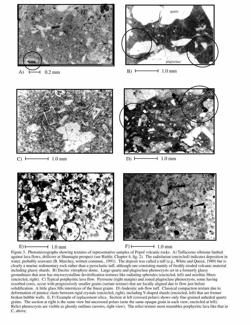
Ash-flow deposits that are sufficiently voluminous to be mapped separately compose abiotite-bearing tuff unit (Tptb) and a hornblende-bearing tuff unit (Tpth). Both are dacitic inbulk composition and although they could be the result of a single heterogeneous eruption, theirspatial separation on Unga Island suggests that they are instead the products of differenteruptions. Because of pervasive silicification and alteration, the hornblende tuff has not been
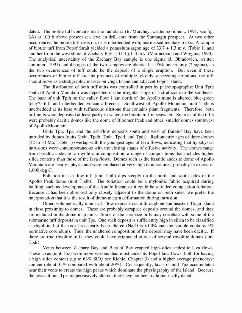
dated. The biotite tuff contains marine radiolaria (B. Murchey, written commun., 1991; see fig.3A) at 100 ft above present sea level in drill core from the Shumagin prospect. At two otheroccurrences the biotite tuff rests on, or is interbedded with, marine sedimentary rocks. A sampleof biotite tuff from Popof Strait yielded a potassium-argon age of 33.7 + 1.3 m.y. (Table 1) andanother from the west shore of Zachary Bay is 31.3 + 0.3 m.y. (Marincovich and Wiggins, 1990).The analytical uncertainty of the Zachary Bay sample is one sigma (J. Obradovich, writtencommun., 1991) and the ages of the two samples are identical at 95% uncertainty (2 sigma), sothe two occurrences of tuff could be the deposit of a single eruption. But even if theseoccurrences of biotite tuff are the products of multiple, closely succeeding eruptions, the tuffshould serve as a stratigraphic marker on Unga Island and adjacent Popof Island.
The distribution of both tuff units was controlled in part by paleotopography: Unit Tpthsouth of Apollo Mountain was deposited on the irregular slope of a stratocone to the southeast.The base of unit Tpth on the valley floor 1 km north of the Apollo mine is altered, blue-green(clay?) tuff and interbedded volcanic breccia. Southwest of Apollo Mountain, unit Tpth isinterbedded at its base with tuffaceous siltstone that contains plant fragments. Therefore, bothtuff units were deposited at least partly in water, the biotite tuff in seawater. Sources of the tuffswere probably dacitic domes like the dome of Bloomer Peak and other, smaller domes southwestof Apollo Mountain.
Units Tpu, Tps, and the ash-flow deposits south and west of Baralof Bay have beenintruded by domes (units Tpdu, Tpdb, Tpda, Tpdd, and Tpdr). Radiometric ages of three domes(32 to 34 Ma; Table 1) overlap with the youngest ages of lava flows, indicating that hypabyssalintrusions were contemporaneous with the closing stages of effusive activity. The domes rangefrom basaltic andesite to rhyolitic in composition, a range of compositions that includes highersilica contents than those of the lava flows. Domes such as the basaltic andesite dome of ApolloMountain are nearly aphyric and were emplaced at very high temperatures, probably in excess of1,000 deg C.
Foliation in ash-flow tuff (unit Tpth) dips steeply on the north and south sides of theApollo Peak dome (unit Tpdb). The foliation could be a mylonitic fabric acquired duringfaulting, such as development of the Apollo linear, or it could be a folded compaction foliation.Because it has been observed only closely adjacent to the dome on both sides, we prefer theinterpretation that it is the result of dome-margin deformation during intrusion.
Other, volumetrically minor ash-flow deposits occur throughout southeastern Unga Islandin close proximity to domes. These are probably carapace deposits around the domes, and theyare included in the dome map units. Some of the carapace tuffs may correlate with some of thesubmarine tuff deposits in unit Tps. One such deposit is sufficiently high in silica to be classifiedas rhyolitic, but the rock has clearly been altered (Na2O is <1.0% and the sample contains 5%normative corundum). Thus, the unaltered composition of the deposit may have been dacitic. Ifthere are true rhyolitic tuffs, they could have originated at one of several rhyolitic domes (unitTpdr).
Vents between Zachary Bay and Baralof Bay erupted high-silica andesitic lava flows.These lavas (unit Tpz) were more viscous than most andesitic Popof lava flows, both for havinga high silica content (up to 63% SiO2; see Riehle, Chapter 3) and a higher average phenocrystcontent (about 35% compared with about 20%). Consequently, lavas of unit Tpz accumulatednear their vents to create the high peaks which dominate the physiography of the island. Becausethe lavas of unit Tpz are pervasively altered, they have not been radiometrically dated.
A) B)
D)C)
E) F)
0.2 mm 1.0 mm
1.0 mm1.0 mm
1.0 mm 1.0 mm
quartz
plagioclase
Figure 3. Photomicrographs showing textures of representative samples of Popof volcanic rocks. A) Tuffaceous siltstone faulted against lava flows, drillcore at Shumagin prospect (see Riehle, Chapter 4, fig. 2). The radiolarian (encircled) indicates deposition in water, probably seawater (B. Murchey, written commun., 1991). The deposit was called a tuff (e.g., White and Queen, 1989) but is clearly a marine sedimentary rock rather than a pyroclastic tuff, although one consisting mainly of freshly eroded volcanic material including glassy shards. B) Dacitic vitrophyre dome. Large quartz and plagioclase phenocrysts set in a formerly glassy groundmass that now has microcrystalline devitrification textures like radiating spherules (encircled, left) and axiolitic fibers (encircled, right). C) Typical porphyritic lava flow. Pyroxene (right margin) and zoned plagioclase phenocrysts, some having resorbed cores, occur with progressively smaller grains (seriate texture) that are locally aligned due to flow just before solidification. A little glass fills interstices of the finest grains. D) Andesitic ash-flow tuff. Classical compaction texture due to deformation of pumice clasts between rigid crystals (encircled, right), including Y-shaped shards (encircled, left) that are former broken bubble walls. E, F) Example of replacement silica. Section at left (crossed polars) shows only fine-grained anhedral quartz grains. The section at right is the same view but uncrossed polars (note the same opaque grain in each view; encircled at left). Relict phenocrysts are visible as ghostly outlines (arrows, right view). The relict texture most resembles porphyritic lava like that in C, above.
There is no evidence for an unconformity between lavas of unit Tpz and the underlying(?) lavasof unit Tpu; moreover, the degree of erosional modification is more similar to that of unit Tputhan that of the younger Miocene volcanic rocks (discussed below). Thus, the lavas of unit Tpzare probably approximately coeval with the Popof volcanic rocks. However, a bulk-rock quartz-sericite age from unit Tpz is 14.6 Ma (Table 1, sample 88AWs028) so we conservatively allowthat unit Tpz could be as young as Miocene. But the alteration age is most likely an effect of theMiocene volcanism that occurs 3 km west of the sample site.
Lava flows of unit Tpz were intruded by hornblende-bearing sills and dikes. Theoccurrence of hornblende in these hypabyssal intrusives is not due simply to a higher silicacontent, because high-silica andesites of unit Tpu either have no hornblende or (rarely) havereacted pseudomorphs. Hornblende in the dikes and sills may have been stabilized by a higherwater pressure in the hypabyssal environment. In any case, pervasive hydrothermal alteration ofunit Tpz is indicated by widespread calcite, chlorite, and epidote (propylitic alteration) and bycolor anomalies (oxidized pyrite) on bedrock surfaces. The alteration is presumably a result ofthe combination of protracted effusive volcanism, a longer period of cooling in the thick pile oflava flows, and hypabyssal intrusive activity.
Miocene volcanic rocks and deposits
A distinctly younger period of volcanism followed Popof volcanism, producing lavaflows, domes, carapace breccias and tuffs in the northwestern part of Unga Island. Tuffsinterbedded with early Miocene sedimentary rocks on the southern shore of Zachary Bay may beequivalents of carapace breccias around domes from 2 to 3 km away. Tuff samples include low-silica rhyolite and andesite based on silica contents, but most of these younger tuffs have beenchemically altered (see Riehle, Chapter 3) and their initial compositions are uncertain. Sixradiometric ages range from 11 to 21 Ma (Table 1). Some color anomalies and alteration inPopof volcanic rocks (units Tpu and Tpz) southeast of the Miocene domes may be Mioceneeffects on the Oligocene rocks.
No Miocene volcanic rocks occur in southeastern Unga Island. A small outcrop ofsedimentary rock midway between Apollo Mountain and Orange Mountain may be what Ellisand Apel (1991, p. 16) refer to as "andesite sediments...beneath the fresh andesite flow...". If thesedimentary rock is stratigraphically beneath the flow, then this rock belongs to unit Tps. Butthis sedimentary rock has leaf casts and conglomerate in which volcanic pebbles are highlyrounded. Such features are previously unknown in the Stepovak Formation but are characteristicof the Miocene Unga Formation, so we interpret the outcrop to be an erosional outlier of UngaFormation.
ALTERATION
Alteration, silica replacement, and quartz veining have affected lava flows, tuffs, andvolcaniclastic rocks of the Miocene volcanic rocks but even more so those of the Popof volcanicrocks. Alteration ranges from propylitic (widespread) to argillic or sericitic (more localized).Some of the alteration is concentrated along lineaments such as the Apollo trend or local faults.Ellis and Randolph (1991) suggest a progression in which introduced pyrite increases inabundance from weak to intense argillic. They also report the occurrence of secondary gypsumand barite, which we did not see.
A K-Ar age on vein adularia from the Apollo lineament is 34.0 m.y. (Table 1, sample89AWw130), which indicates that at least some of the alteration and silicification wascontemporaneous with the main period of Popof volcanism. The chemical aspects of alterationare discussed more fully by Riehle (Chapter 3) and the nature and origins of the lineaments byRiehle (Chapter 4).
An important aspect of the alteration is discussed here in detail because it bears on thegeologic map--the origin of the "Orange Mountain Resistivity Low" (OMRL) identified by Ellisand Apel (1991). The OMRL occupies the area between Orange and Apollo Mountains and theShumagin claims (see geologic map, pl. 1, and Cady and Smith, Chapter 5, figs. 5-7). Ellis andApel conclude that elevated bedrock conductivity in this broad area is due to extensive alterationof Popof volcanic rocks, and that alteration preferentially affected tuffs because of their highinitial porosity and permeability. The implication is that the OMRL is underlain chiefly by tuffs.However, we include the area of the OMRL in unit Tpu, which is mainly lava flows but havinglocal tuffs, and this merits brief explanation.
Ellis and Apel (1991) and Ellis and Randolph (1991) acknowledge that alteration andsilicification (map unit "S" near Orange Mountain, pl. 1) are so extensive that in most cases theoriginal lithology cannot be discerned; in the one case where it could, the parent rock was aporphyritic lava flow. We examined about 15 thin sections, both USGS and industry, fromwithin and adjacent to the OMRL expressly to try to identify the origin of the silicified rocks. In5 cases, no hint of original texture remains. In one case, a rock that now consists entirely of fine-grained quartz retains a ghostly porphyritic texture; the rock was probably an andesitic lava flow(figs. 3E, F). Of the remaining sections, two are epiclastic tuffs and the remainder areporphyroaphanitic lavas. One of the lavas has veinlets of tuffaceous siltstone and is probably apeperite. The OMRL is an area of mainly low relief in which bedrock is obscured by soil andvegetation; nonetheless, the available data do not indicate that tuffs are the dominant lithologictype. Consequently we believe the area is best characterized as mainly lava flows including localtuffs, but further work, supported by abundant thin-section analysis, may reverse thisclassification.
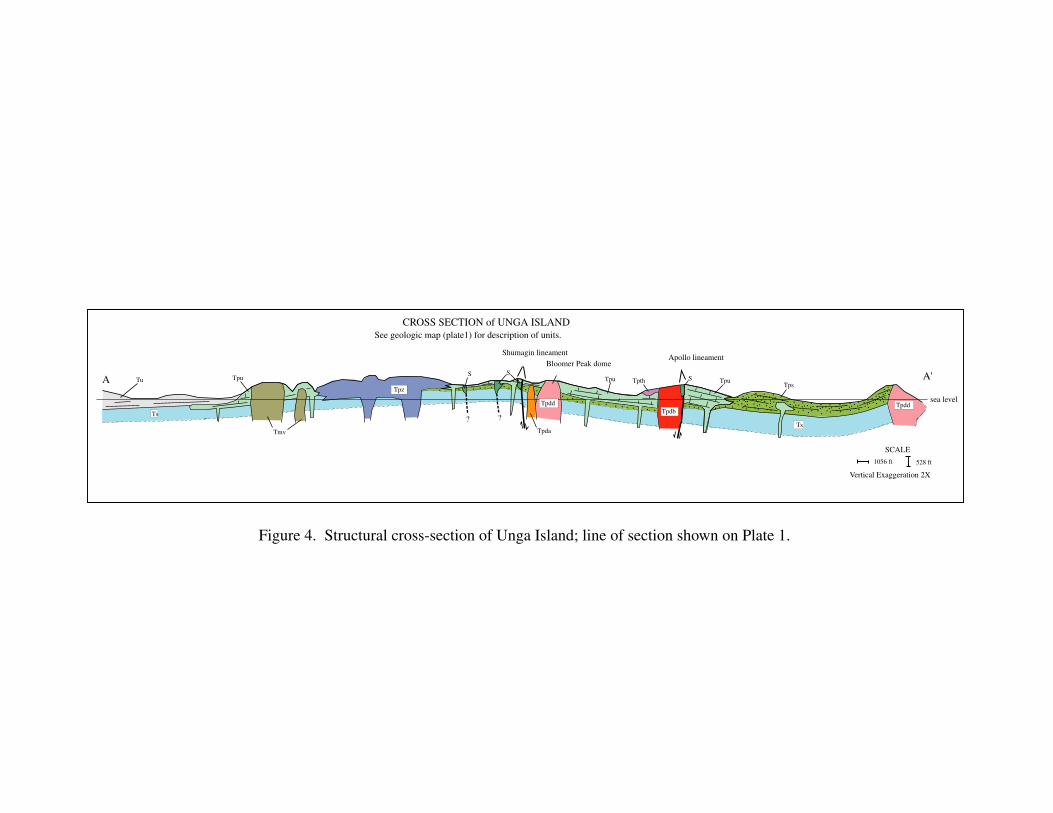
One reason for the difficulty in identifying original rock types is that, in hand specimen,some rocks adjacent to the bodies of replacement silica appear to have lithic chips suggestive oftuff but that upon microscopic examination turn out to be clasts of a tectonic breccia. Moreover,drill-hole logs (on file at the Aleut Corp., Anchorage) along the Shumagin trend clearly show adominance in the shallow subsurface of volcanic(?) clastic rocks. The Shumagin trend lies on ornear the axis of an anticline (fig. 4 and pl. 1), thus, any clastic rocks are likely to be Stepovakequivalents (unit Tps) rather than pyroclastic tuffs.
In summary, we agree with Ellis and Apel (1991) that clastic rocks are generally moresusceptible to alteration by hydrothermal fluids than lava flows: Tuffaceous horizons betweenlava flows would have been permissive of lateral fluid flow and silicification. Moreover, clasticrocks appear to dominate in the shallow subsurface along the Shumagin trend. But identificationof primary lithologies in now-altered rocks in the OMRL has proven to be tricky, and withoutfurther detailed thin-section study, we believe that the exact proportion of lava flows andvolcaniclastic rocks at the ground surface in the OMRL remains uncertain.
sea level.... . .. .
.. . . . . . . . . . . . .
.. . . .
. ..
. . . . . . . . . . . . ..
. . . .. .
.. . . . . . . . . . . . .
.. . . .
. ..
. . . . . . . . . . . . ..
. . . .. .
.. . . . . . . . . . . . .
.. . . .
. ..
. . . . . . . . . . . . ..
??
Bloomer Peak domeApollo lineament
. ..
.
..
.. ..
..
..
..
..
.
..
..
.
.
. .
.
..
.
..
Shumagin lineament
SCALE
1056 ft 528 ft
Vertical Exaggeration 2X
CROSS SECTION of UNGA ISLAND
A A'
Tpdd
Ts
TpsTpu
Tpdb
TpthTpu
Tpdd
Tpda
S
Tpz
Tmv
Tpu
Ts
Tu
See geologic map (plate1) for description of units.
SS
Figure 4. Structural cross-section of Unga Island; line of section shown on Plate 1.
REFERENCES CITED
Atwood, W.W., 1911, Geology and mineral resources of parts of the Alaska Peninsula: U.S.Geological Survey Bulletin 467, 137 p., 14 pl.
Barker, Fred, Farmer, G.L., Ayuso, R.A., Plafker, George, and Lull, J.S., 1992, The 50 Magranodiorite of the eastern Gulf of Alaska: melting in an accretionary prism in the forearc:Jour. of Geophysical Research, v. 97, p. 6757-6778.
Beikman, H.M., 1980, Geologic map of Alaska: U.S. Geological Survey Special Map, scale1:2,500,000, 2 pl.
Bradley, D.C., Haeussler, P.J., and Kusky, T.M., 1993, Timing of early Tertiary ridge subductionin southern Alaska, in Dusel-Bacon, Cynthia, and Till, A.B., eds., Geologic Studies inAlaska by the U.S. Geological Survey, 1992: U.S. Geological Survey Bulletin 2068, p. 163-177.
Burk, C.A., 1965, Geology of the Alaska Peninsula--Island arc and continental margin:Geological Society of America Memoir 99, 250 p.
Dall, W.H., 1882, Notes on Alaska Tertiary deposits: American Journal of Science, 3d ser., v. 24,p. 67-68.
Detterman, R.L., Case, J.E., Miller, J.W., Wilson, F.H., and Yount, M.E., 1996, Stratigraphicframework of the Alaska Peninsula: U.S. Geological Survey Bulletin 1969-A, 74 p.
Ellis, W.T., and Randolph, D.B., 1991, Unga project, 1991 final report; Battle MountainExploration Co., Alaska District, 3 volumes, for The Aleut Corp., Anchorage, AK.
Ellis, W.T., and Apel, R.A., 1991, Unga/Alaska Peninsula Project, 1990 final report; BattleMountain Exploration Co., Alaska District, 3 volumes, for The Aleut Corp., Anchorage, AK.
Engebretsen, D.C., Cox, Allan, and Gordon, R.G., 1985, Relative motions between oceanic andcontinental plates in the Pacific basins: Geological Society of America, Special Paper 206,59 p.
Fisher, M.A., 1981, Location of the Border Ranges fault southwest of Kodiak Island, Alaska:Geological Society of America Bulletin, v. 92, p. 19-30.
Hillhouse, J.W., and Coe, R.S., 1994, Paleomagnetic data from Alaska, in Plafker, George, andBerg, H.C., eds., The Geology of Alaska: Geological Society of America, The Geology ofNorth America, v. G-1, p. 797-812.
Hudson, Travis, Plafker, George, and Peterman, Zell, 1979, Paleogene anatexis along the Gulf ofAlaska margin: Geology, v. 7, p. 573-577.
Jones, D.L., and Silberling, N.J., 1979, Mesozoic stratigraphy; The key to tectonic analysis ofsouthern and central Alaska: U.S. Geological Survey Open-file Report 79-1200, 37 p.
Knappen, R.S., 1929, Geology and mineral resources of the Aniakchak district, Alaska: U.S.Geological Survey Bulletin, v. 797-F, p. 161-227.
Plafker, George, and Berg, H.C., 1994, Overview of the geology and tectonic evolution ofAlaska, in Plafker, George, and Berg, H.C., eds., The Geology of Alaska: GeologicalSociety of America, The Geology of North America, v. G-1, p. 989-1022.
Scholl, D.W., Stevenson, A.J., Mueller, Steve, Geist, Eric, Engebretsen, D.C., and Vallier, T.L.,1992, Exploring the notion that southeast-Asian-type escape tectonics and trench cloggingare involved in regional-scale deformation of Alaska and the formation of the Aleutian-Bering Sea region, in Flower, Martin, McCabe, Robert, and Hilde, Thomas, convenors,Southeast Asia structure, tectonics, and magmatism: Geodynamics Research InstituteSymposium, Texas A&M University, p. 57-63.
Stone, D.B., and Packer, D.R., 1979, Paleomagnetic data from the Alaskan Peninsula: GeologicalSociety of America Bulletin, v. 90, p. 545-560.
Vallier, T.L., Scholl, D.W., Fisher, M.A., Bruns, T.R., Wilson, F.H., von Huene, Roland, andStevenson, A.J., 1994, Geologic framework of the Aleutian arc, Alaska, in Plafker, George,and Berg, H.C., eds., The Geology of Alaska: Geological Society of America, The Geologyof North America, v. G-1, p. 367-388.
Wilson, F.H., 1985, The Meshik arc--an Eocene to earliest Miocene magmatic arc on the AlaskaPeninsula: Alaska Division of Geological and Geophysical Surveys Professional Report no.88, 14 p.
Wilson, F.H., Case, J.E., and Detterman, R.L., 1985a, Preliminary description of a Miocene zoneof structural complexity, Port Moller and Stepovak Bay quadrangles, in Bartsch-Winkler,Susan, and Reed, K.M., eds., The United States Geological Survey in Alaska:Accomplishments during 1983: U.S. Geological Survey Circular 945, p. 55-56.
Wilson, F.H., Detterman, R.L., and Case, J.E., 1985b, The Alaska Peninsula terrane--adefinition: U.S. Geological Survey open-file report 85-450, 19 p.
Wilson, F.H., Detterman, R.L., and DuBois, G.D., in press, Geologic framework of the AlaskaPeninsula, southwest Alaska, and the Alaska Peninsula terrane: U.S. Geological SurveyBulletin 1969-B, scale 1:500,000, 36 ms pages.
Wilson, F.H., Detterman, R.L., Miller, J.W., and Case, J.E., 1995, Geologic map of the PortMoller, Stepovak Bay, and Simeonof Island quadrangles, Alaska Peninsula, Alaska: U.S.Geological Survey Miscellaneous Investigations Series Map I-2272, scale 1:250,000.
Wilson, F.H., and Shew, Nora, 1992, Map and tables showing geochronology and whole-rockgeochemistry of selected samples, Ugashik and part of Karluk quadrangles, Alaska: U.S.Geological Survey Miscellaneous Field Studies Map MF-1539-E, scale 1:250,000.
Wilson, F.H., Shew, Nora, DuBois, G.D., and Bie, S.W., 1994, Sample locality map andanalytical data for potassium-argon ages in the Port Moller, Stepovak Bay, and SimoneofIsland quadrangles, Alaska Peninsula: U.S. Geological Survey Miscellaneous Field StudiesMap MF-2155-E, scale 1:250,000.
Wilson, F.H., White, W.W., and DuBois, G.D., 1988, Brief descriptions of mines, prospects, andmineral occurrences in the Port Moller and Stepovak Bay quadrangles, Alaska Peninsula:U.S. Geological Survey Open-file Report 88-666, 128 p., 1 pl., scale 1:250,000.
White, W.W., and Queen, L.D., 1989, Preliminary geologic and rock-chip geochemical data fromdrill core and trenches at the Shumagin gold deposit, Unga Island, Alaska: U.S. GeologicalSurvey Open-file Report 89-361, 36 p.
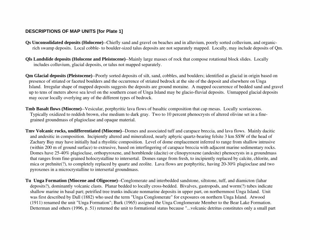
DESCRIPTIONS OF MAP UNITS [for Plate 1]
Qs Unconsolidated deposits (Holocene)--Chiefly sand and gravel on beaches and in alluvium, poorly sorted colluvium, and organic- rich swamp deposits. Local cobble- to boulder-sized talus deposits are not separately mapped. Locally, may include deposits of Qm.
Qls Landslide deposits (Holocene and Pleistocene)--Mainly large masses of rock that compose rotational block slides. Locally includes colluvium, glacial deposits, or talus not mapped separately.
Qm Glacial deposits (Pleistocene)--Poorly sorted deposits of silt, sand, cobbles, and boulders; identified as glacial in origin based on presence of striated or faceted boulders and the occurrence of striated bedrock at the site of the deposit and elsewhere on Unga Island. Irregular shape of mapped deposits suggests the deposits are ground moraine. A mapped occurrence of bedded sand and gravel up to tens of meters above sea level on the southern coast of Unga Island may be glacio-fluvial deposits. Unmapped glacial deposits may occur locally overlying any of the different types of bedrock.
Tmb Basalt flows (Miocene)--Vesicular, porphyritic lava flows of basaltic composition that cap mesas. Locally scoriaceous. Typically oxidized to reddish brown, else medium to dark gray. Two to 10 percent phenocrysts of altered olivine set in a fine- grained groundmass of plagioclase and opaque material.
Tmv Volcanic rocks, undifferentiated (Miocene)--Domes and associated tuff and carapace breccia, and lava flows. Mainly dacitic and andesitic in composition. Incipiently altered and mineralized, nearly aphyric quartz-bearing felsite 3 km SSW of the head of Zachary Bay may have initially had a rhyolitic composition. Level of dome emplacement inferred to range from shallow intrusive (within 200 m of ground surface) to extrusive, based on interfingering of carapace breccia with adjacent marine sedimentary rocks. Domes have 25-40% plagioclase, orthopyroxene, and hornblende (dacite) or clinopyroxene (andesite) phenocrysts in a groundmass that ranges from fine-grained holocrystalline to intersertal. Domes range from fresh, to incipiently replaced by calcite, chlorite, and mica or prehnite(?), to completely replaced by quartz and zeolite. Lava flows are porphyritic, having 20-30% plagioclase and two pyroxenes in a microcrystalline to intersertal groundmass.
Tu Unga Formation (Miocene and Oligocene)--Conglomerate and interbedded sandstone, siltstone, tuff, and diamicton (lahar deposits?), dominantly volcanic clasts. Planar bedded to locally cross-bedded. Bivalves, gastropods, and worm(?) tubes indicate shallow marine in basal part; petrified tree trunks indicate nonmarine deposits in upper part, on northernmost Unga Island. Unit was first described by Dall (1882) who used the term "Unga Conglomerate" for exposures on northern Unga Island. Atwood (1911) renamed the unit "Unga Formation"; Burk (1965) assigned the Unga Conglomerate Member to the Bear Lake Formation. Detterman and others (1996, p. 51) returned the unit to formational status because "...volcanic detritus constitutes only a small part
of the Bear Lake Formation..." Detterman and others (1996) consider the Unga Formation to range from late Oligocene to middle Miocene in age, based on plant fossils and pollen.
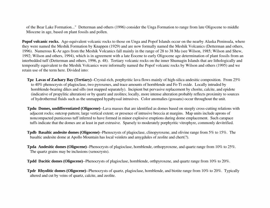
Popof volcanic rocks. Age-equivalent volcanic rocks to those on Unga and Popof Islands occur on the nearby Alaska Peninsula, wherethey were named the Meshik Formation by Knappen (1929) and are now formally named the Meshik Volcanics (Detterman and others,1996). Numerous K-Ar ages from the Meshik Volcanics fall mainly in the range of 28 to 38 Ma (see Wilson, 1985; Wilson and Shew,1992; Wilson and others, 1994), which is in agreement with a late Eocene to early Oligocene age determination of plant fossils from aninterbedded tuff (Detterman and others, 1996, p. 48). Tertiary volcanic rocks on the inner Shumagin Islands that are lithologically andtemporally equivalent to the Meshik Volcanics were informally named the Popof volcanic rocks by Wilson and others (1995) and weretain use of the term here. Divided into:
Tpz Lavas of Zachary Bay (Tertiary)--Crystal-rich, porphyritic lava flows mainly of high-silica andesitic composition. From 25% to 40% phenocrysts of plagioclase, two pyroxenes, and trace amounts of hornblende and Fe-Ti oxide. Locally intruded by hornblende-bearing dikes and sills (not mapped separately). Incipient but pervasive replacement by chorite, calcite, and epidote (indicative of propylitic alteration) or by quartz and zeolites; locally, more intense alteration probably reflects proximity to sources of hydrothermal fluids such as the unmapped hypabyssal intrusives. Color anomalies (gossans) occur throughout the unit.
Tpdu Domes, undifferentiated (Oligocene)--Lava masses that are identified as domes based on steeply cross-cutting relations with adjacent rocks; outcrop pattern; large vertical extent; or presence of intrusive breccia at margins. Map units include aprons of noncompacted pumiceous tuff inferred to have formed in minor explosive eruptions during dome emplacement. Such carapace tuffs indicate that the domes are at least in part extrusive. Sparsely to moderately porphyritic vitrophyre, commonly devitrified.
Tpdb Basaltic andesite domes (Oligocene)--Phenocrysts of plagioclase, clinopyroxene, and olivine range from 5% to 15%. The basaltic andesite dome at Apollo Mountain has local veinlets and amygdules of zeolite and chert(?).
Tpda Andesitic domes (Oligocene)--Phenocrysts of plagioclase, hornblende, orthopyroxene, and quartz range from 10% to 25%. The quartz grains may be inclusions (xenocrysts).
Tpdd Dacitic domes (Oligocene)--Phenocrysts of plagioclase, hornblende, orthpyroxene, and quartz range from 10% to 20%.
Tpdr Rhyolitic domes (Oligocene)--Phenocrysts of quartz, plagioclase, hornblende, and biotite range from 10% to 20%. Typically altered and cut by veins of quartz, calcite, and zeolite.
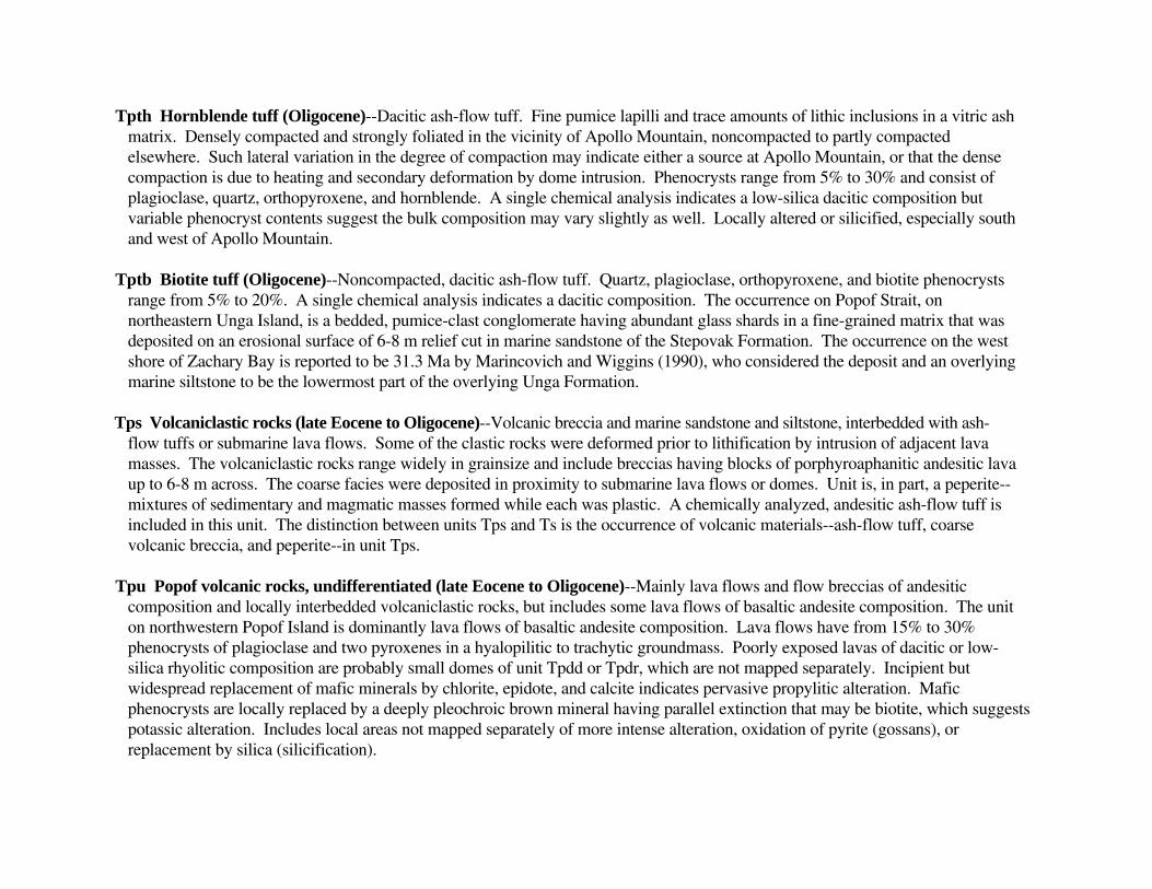
Tpth Hornblende tuff (Oligocene)--Dacitic ash-flow tuff. Fine pumice lapilli and trace amounts of lithic inclusions in a vitric ash matrix. Densely compacted and strongly foliated in the vicinity of Apollo Mountain, noncompacted to partly compacted elsewhere. Such lateral variation in the degree of compaction may indicate either a source at Apollo Mountain, or that the dense compaction is due to heating and secondary deformation by dome intrusion. Phenocrysts range from 5% to 30% and consist of plagioclase, quartz, orthopyroxene, and hornblende. A single chemical analysis indicates a low-silica dacitic composition but variable phenocryst contents suggest the bulk composition may vary slightly as well. Locally altered or silicified, especially south and west of Apollo Mountain.
Tptb Biotite tuff (Oligocene)--Noncompacted, dacitic ash-flow tuff. Quartz, plagioclase, orthopyroxene, and biotite phenocrysts range from 5% to 20%. A single chemical analysis indicates a dacitic composition. The occurrence on Popof Strait, on northeastern Unga Island, is a bedded, pumice-clast conglomerate having abundant glass shards in a fine-grained matrix that was deposited on an erosional surface of 6-8 m relief cut in marine sandstone of the Stepovak Formation. The occurrence on the west shore of Zachary Bay is reported to be 31.3 Ma by Marincovich and Wiggins (1990), who considered the deposit and an overlying marine siltstone to be the lowermost part of the overlying Unga Formation.
Tps Volcaniclastic rocks (late Eocene to Oligocene)--Volcanic breccia and marine sandstone and siltstone, interbedded with ash- flow tuffs or submarine lava flows. Some of the clastic rocks were deformed prior to lithification by intrusion of adjacent lava masses. The volcaniclastic rocks range widely in grainsize and include breccias having blocks of porphyroaphanitic andesitic lava up to 6-8 m across. The coarse facies were deposited in proximity to submarine lava flows or domes. Unit is, in part, a peperite-- mixtures of sedimentary and magmatic masses formed while each was plastic. A chemically analyzed, andesitic ash-flow tuff is included in this unit. The distinction between units Tps and Ts is the occurrence of volcanic materials--ash-flow tuff, coarse volcanic breccia, and peperite--in unit Tps.
Tpu Popof volcanic rocks, undifferentiated (late Eocene to Oligocene)--Mainly lava flows and flow breccias of andesitic composition and locally interbedded volcaniclastic rocks, but includes some lava flows of basaltic andesite composition. The unit on northwestern Popof Island is dominantly lava flows of basaltic andesite composition. Lava flows have from 15% to 30% phenocrysts of plagioclase and two pyroxenes in a hyalopilitic to trachytic groundmass. Poorly exposed lavas of dacitic or low- silica rhyolitic composition are probably small domes of unit Tpdd or Tpdr, which are not mapped separately. Incipient but widespread replacement of mafic minerals by chlorite, epidote, and calcite indicates pervasive propylitic alteration. Mafic phenocrysts are locally replaced by a deeply pleochroic brown mineral having parallel extinction that may be biotite, which suggests potassic alteration. Includes local areas not mapped separately of more intense alteration, oxidation of pyrite (gossans), or replacement by silica (silicification).
Ts Stepovak Formation (late Eocene and early Oligocene)--Fine-grained marine conglomerate, sandstone, and siltstone. Beds exposed on northern Unga and Popof Islands are rich in pelecypod and gastropod shells and worm(?) tubes, indicating an inner neritic environment and late Eocene age (R.C. Allison, written commun., 1980). The overall age range of the formation throughout its occurrence on the southern Alaska Peninsula and inner Shumagin Islands is late Eocene and early Oligocene (Detterman and others, 1996). The unit grades laterally and upwards into the volcaniclastic rocks of unit Tps and the Popov volcanic rocks. Originally named by Burk (1965) for exposures on the adjacent mainland, the unit is informally subdivided into a lower siltstone and upper sandstone by Detterman and others (1996). The lower member includes laminated siltstone of a deep-water turbidites, whereas the upper unit is mainly volcaniclastics, which are inferred to have had contemporaneous sources in the Meshik Volcanics. Rhythmically bedded mudstone and siltstone exposed in a seacliff on the eastern headland of Delarof Harbor may be the top of the lower member, or may be a local basin fill. Exposures elsewhere on northern Unga and Popof Islands, however, are clearly the upper sandstone member.
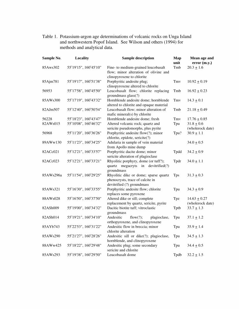
Table 1. Potassium-argon age determinations of volcanic rocks on Unga Island and northwestern Popof Island. See Wilson and others (1994) for methods and analytical data.
Sample No. Locality Sample description Mapunit
Mean age and error (m.y.)
85Aws302 55o19'15", 160o45'10" Fine- to medium-grained leucobasaltflow; minor alteration of olivine andclinopyroxene to chlorite
Tmb 20.3 + 1.6
85Ajm781 55o19'17", 160o51'38" Porphyritic andesite plug;clinopyroxene altered to chlorite
Tmv 10.92 + 0.19
56953 55o17'58", 160o45'50" Leucobasalt flow; chlorite replacinggroundmass glass(?)
Tmb 16.92 + 0.23
85AWs300 55o17'19", 160o43'32" Hornblende andesite dome; hornblendealtered to chlorite and opaque material
Tmv 14.3 + 0.1
82AJm507 55o12'40", 160o50'54" Leucobasalt flow; minor alteration ofmafic mineral(s) by chlorite
Tmb 21.18 + 0.49
56228 55o18'23", 160o43'47" Hornblende andesite dome; fresh Tmv 17.76 + 0.8582AWs015 55o10'08", 160o46'32" Altered volcanic rock; quartz and
sericite pseudomorphs, plus pyriteTpu 31.8 + 0.6
(wholerock date)56968 55o11'20", 160o36'26" Porphyritic andesite flow(?); minor
chlorite, epidote, sericite(?)Tpu? 30.9 + 1.1
89AWw130 55o11'23", 160o34'25" Adularia in sample of vein materialfrom Apollo mine dump
34.0 + 0.5
82ACc021 55o12'21", 160o33'57" Porphyritic dacite dome; minorsericite alteration of plagioclase
Tpdd 34.2 + 0.9
82ACc023 55o12'21", 160o33'21" Rhyolitic porphyry, dome (or tuff?);quartz megacryts in devitrified(?)groundmass
Tpdr 34.0 + 1.1
85AWs296a 55o11'54", 160o29'25" Rhyolitic dike or dome; sparse quartzphenocrysts, trace of calcite indevitrified (?) groundmass
Tps 31.3 + 0.3
85AWs321 55o16'30", 160o33'55" Porphyritic andesite flow; chloritereplaces some pyroxene
Tpu 34.3 + 0.9
88AWs028 55o16'50", 160o37'50" Altered dike or sill; completereplacement by quartz, sericite, pyrite
Tpz 14.63 + 0.27(wholerock date)
82ASh009 55o19'00", 160o34'32" Dacitic biotite tuff; vitroclasticgroundmass
Tptb 33.7 + 1.3
82ASh014 55o19'21", 160o34'10" Andesitic flow(?); plagioclase,orthopyroxene, and clinopyroxene
Tpu 37.1 + 1.2
85AYb743 55o22'53", 160o31'22" Andesitic flow in breccia; minorchlorite alteration
Tpu 35.9 + 1.4
85AWs290 55o21'27", 160o28'26" Andesitic sill or dike(?); plagioclase,hornblende, and clinopyroxene
Tpu 34.5 + 1.3
88AWw425 55o18'22", 160o29'48" Andesitic plug; some secondarysericite and chlorite
Tpu 34.4 + 0.5
85AWs293 55o19'38", 160o29'50" Leucobasalt dome Tpdb 32.2 + 1.5