Embed Size (px)
Citation preview

Geology of theLibby Thrust Belt ofNortwestern Montana nd ItsImpications to Regional Tectonics
U.S. GEOLOGICAL SURVEY PROFESSIONAL PAPER
Geology of the Libby Thrust Belt of Northwestern Montana and Its Implications to Regional Tectonics
By JACK E. HARRISON and EARLE R. CRESSMAN
U.S. GEOLOGICAL SURVEY PROFESSIONAL PAPER 1524
A description and interpretation of a formerly unknown Cretaceous thrust belt in previously folded Proterozoic strata
UNITED STATES GOVERNMENT PRINTING OFFICE, WASHINGTON : 1993
U.S. DEPARTMENT OF THE INTERIOR
BRUCE BABBITT, Secretary
U.S. GEOLOGICAL SURVEY
Dallas L. Peck, Director
Any use of trade, product, or firm names in this publication isfor descriptive purposes only and does not imply endorsement
by the U.S. Government.
Library of Congress Cataloging-in-Publication Data
Harrison, Jack Edward, 1924-Geology of the Libby thrust belt of northwestern Montana and its implications to regional tectonics /
by Jack E. Harrison and Earle R. Cressman.p. cm. (Geological Survey professional paper ; 1524)
Includes bibliographical references. Supt.ofDocs.no.: I 19.16:P15241. Thrust faults (Geology) Montana. 2. Geology, Stratigraphic Proterozoic. 3. Geology,
Structural Montana. I. Cressman, Earle Rupert, 1923- . II. Title. III. Series: U.S. Geological Survey professional paper ; 1524. QE606.5.U6H37 1994551.8'7 dc20 92-4327
CIP
For sale by USGS Map DistributionBox 25286, Building 810
Denver Federal CenterDenver, CO 80225
CONTENTS
Abstract.......................................................................................... 1Introduction.................................................................................... 2
Purpose of this study ............................................................. 3Previous work......................................................................... 3The geologic map.................................................................... 5Acknowledgments................................................................... 6
Geology........................................................................................... 7Regional geologic setting........................................................ 7Belt Supergroup...................................................................... 7
Prichard Formation........................................................ 8Burke Formation............................................................. 9Revett Formation............................................................ 9St. Regis Formation........................................................ 10Spokane Formation......................................................... 11Empire Formation .......................................................... 11Wallace Formation.......................................................... 12Helena Formation........................................................... 13Snowslip Formation........................................................ 14Purcell Lava.................................................................... 15Shepard Formation......................................................... 16Mount Shields Formation .............................................. 16Bonner Quartzite............................................................ 18McNamara Formation.................................................... 19Libby Formation ............................................................. 19
Cambrian strata..................................................................... 20Flathead Quartzite......................................................... 20Wolsey Shale................................................................... 21
Geology ContinuedCambrian strata Continued
Dolomite of Fishtrap Creek........................................... 21Surficial deposits.................................................................... 21
Glacial deposits.............................................................. 21Lake sediments .............................................................. 21Landslide deposits.......................................................... 22Alluvial deposits............................................................. 22
Intrusive igneous rocks......................................................... 22Mafic sills........................................................................ 22Felsic calc-alkalic plutons.............................................. 23Pyroxenite....................................................................... 23Syenite............................................................................ 24Dikes............................................................................... 24
Structure................................................................................ 25Folds and faults.............................................................. 26
Syndepositional folds............................................... 26Older tectonic folds.................................................. 27Interaction of the older folds with the Libby thrust
belt........................................................................ 28Thrust faults and associated folds ......................... 30Deep folds and faults interpreted from geophysical
data....................................................................... 35Implications of basement-cored folds..................... 35Strike-slip faults...................................................... 35High-angle normal faults and associated folds..... 36
Discussion of tectonic history............................................... 37References cited............................................................................. 39
ILLUSTRATIONS
PLATE 1. Geologic map of the Libby thrust belt, northwestern Montana........................................................................................ In pocket2. Geologic cross sections through the Libby thrust belt, northwestern Montana.............................................................. In pocket
FIGURE 1. Generalized geologic map of Belt terrane ...................................................................................................................................... 22. Index map showing I°x2° quadrangles containing Belt terrane.................................................................................................. 33. Correlation of geologic units in the Belt Supergroup.................................................................................................................... 44. Diagrammatic illustration of a typical sedimentary cycle in the Helena Formation................................................................. 135. Variations in lithology of the Snowslip Formation........................................................................................................................ 156. Thickness variations within members of the Mount Shields Formation .................................................................................... 177. Principal folds and thrust faults in and near the Libby thrust belt........................................................................................... 288. Interpretative sketch illustrating effects of older Proterozoic doubly plunging folds ................................................................ 299. Diagram of folds in footwall and hanging wall of a listric thrust................................................................................................ 31
10. Relation of box fold and listric thrust to Pinkham thrust and data from the Gibbs No. 1 borehole........................................ 3311. Generalized lithologic and geophysical logs, Gibbs No. 1 borehole ............................................................................................. 34
TABLE
TABLE 1. Calculations for Eocene and younger extension across the Libby thrust belt............................................................................... 38
in

GEOLOGY OF THE LIBBY THRUST BELT OFNORTHWESTERN MONTANA AND ITS
IMPLICATIONS TO REGIONAL TECTONICS
By JACK E. HARRISON and EARLE R. CHESSMAN
ABSTRACT
New geologic mapping and application of stratigraphic details previously unknown in Belt rocks of Middle Proterozoic age in the northwestern corner of Montana has led to the definition of a pre viously unrecognized thrust belt. The zone, herein named the Libby thrust belt, is a complex of thrust and high-angle normal and reverse faults about 15 mi wide and 100 mi long that extends southerly from the Canadian border through Libby, Montana, to the Hope fault zone.
Dominating the bedrock of the area is the Belt Supergroup, a sequence of low-grade metamorphic strata at least 50,000 ft thick that accumulated as siliciclastic and carbonate sediments along the continental margin about 1,400-900 m.y. ago. The lowest exposed strata (Prichard Formation) contain turbidites and black pyritic argillites representing early deposits in a rift zone. The base of the Prichard is not exposed. Above the Prichard is the Ravalli Group, a sequence of quartzites, siltites, and argillites showing shallow-water features and that suggest the rate of basin filling approximated the rate of basin subsidence. The Ravalli Group includes in ascending order the Burke, Revett, St. Regis, Spokane, and Empire Formations. Overlying the Ravalli Group is the middle Belt carbonate, an informal grouping which includes the stratigraphically equivalent and laterally interfingering Wal lace and Helena Formations. The Wallace is characterized by car bonate-bearing siliciclastics; whereas, the Helena is characterized by cyclic deposits of calcite- and dolomite-cemented silt beds that alternate with dolomite beds. Overlying the middle Belt carbonate is the Missoula Group, a sequence of red and green siliciclastic beds, some carbonate, and the Purcell Lava. Formations of the Missoula Group in ascending order include the Snowslip, Shepard, and Mount Shields Formations, the Bonner Quartzite, and the McNamara and Libby Formations. Most formations reflect shal low-water deposits of braided stream, mud flat, and shallow-shelf environments. The top of the Missoula Group is eroded and is overlain disconformably at a few places by the Flathead Quartzite of early Middle Cambrian age.
Paleozoic sedimentary rocks are sparse in the area and are con fined mostly to the Libby thrust belt. They include, in ascending order, the Middle Cambrian Flathead Quartzite, the Wolsey Shale, the Middle and Upper Cambrian dolomite of Fishtrap Creek, and one small outcrop area of unnamed Ordovician quartz arenite and dolomite beds (mapped with Cambrian dolomite).
Intrusive into the Belt strata are Middle to Late Proterozoic sills, Cretaceous felsic plutons, Cretaceous pyroxenite and syenite, and sparse Tertiary(?) dikes of quartz latite porphyry and diorite. A pyroxenite-syenite complex a few miles east of Libby, Montana, is a major source of vermiculite.
Surficial deposits cover about one-third of the area. These deposits include glacial debris, glacial lake sediments, sparse land slide deposits, and alluvium. The glacial debris, deposited in the Pleistocene by both continental and alpine glaciers, is extensive and at places mantles the terrane to within a few hundred feet of the summits of peaks and ridges that reach elevations of 6,000 to 7,000 ft.
Structure in the area is complex and includes Proterozoic folds, Cretaceous thrust faults and associated folds, and hundreds of Eocene and younger high-angle and listric normal extension faults. A series of 16 cross sections drawn at about 5 mi intervals across the thrust belt illustrates the structural style and complexities of the area.
Proterozoic folds include penecontemporaneous slump struc tures, in zones generally a few tens of feet thick, and post-Belt broad open folds. These broad open folds commonly are double- plunging, have wavelengths of a few miles and amplitudes of a few thousand feet, and form the broad structural framework of the northwest corner of Montana.
Cutting through, offsetting, and at places refolding the old folds are a series of listric to flat thrust faults, imbricate thrust faults, and associated upright to overturned local folds. These features have a structural style and stress direction distinctly different from the older folds and represent response to complex plate inter actions that began along the western continental margin in Juras sic time and whose continental override gradually progressed eastward. Age of the thrusting in the map area is probably Creta ceous. The Libby thrust belt was formed where one of the old anti clines (Sylvanite) had its limbs steepened and thrust eastward toward the west flank of the Purcell anticlinorium. A complex of listric thrust faults ripped apart the old syncline between the anti clinal structures to form the long, relatively narrow thrust zone.
Eocene and younger extension that is widespread in the West ern United States is represented by high-angle and listric normal faults and by backsliding on many of the Cretaceous thrust faults. Amount of movement on these extensional structures ranges from
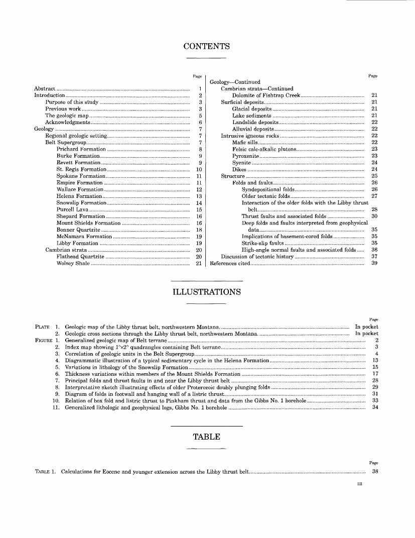
LIBBY THRUST BELT, NORTHWESTERN MONTANA
50'
EXPLANATION
Tertiary volcanic rocks
Tertiary to Jurassic intrusive rocks
Quaternary to Cambrian sedimentary rocks
' Late Proterozoic rocks (Windermere System of Canada)
Middle Proterozoic Belt Supergroup (Purcell Supergroup of Canada) Stipple shows areas of high- grade metamorphism; may include some pre- Belt rocks
Early Proterozoic pre- Belt metamorphic rocks
Contact
High-angle fault
Right-lateral fault
Thrust fault Sawteeth on upper plate
Anticline
Syncline
FIGURE 1. Generalized map of area of Belt terrane. Modified from Tectonic Map of North America (King, 1969).
a few tens to several thousands of feet. The minimum total exten sion across the Libby thrust belt as measured along each of the 16 cross sections ranges from 1 to 9 percent and is at places more than 3 mi.
An attempt to examine deep structures within and on both sides of the Libby thrust belt is made by combining surface geology and down-plunge projections of structures with available seismic, deep- sounding magnetotelluric, and gravity profiles that are discussed largely in a separate report. The weight of evidence as interpreted from each of these data sets leads to the conclusion that the broad open Proterozoic folds are cored by basement rocks and that slices of basement have been moved on Mesozoic thrust and Tertiary
listric normal faults above a basal surface (or zone) of detachment within the folded basement.
INTRODUCTION
The U.S. Geological Survey has maintained since 1970 a program of systematic geological and geophys ical study of terrane in the northwestern United States that contains the Middle Proterozoic Belt
INTRODUCTION
118° 112° CANADA 110°
48Approximate
limit of Belt terrane
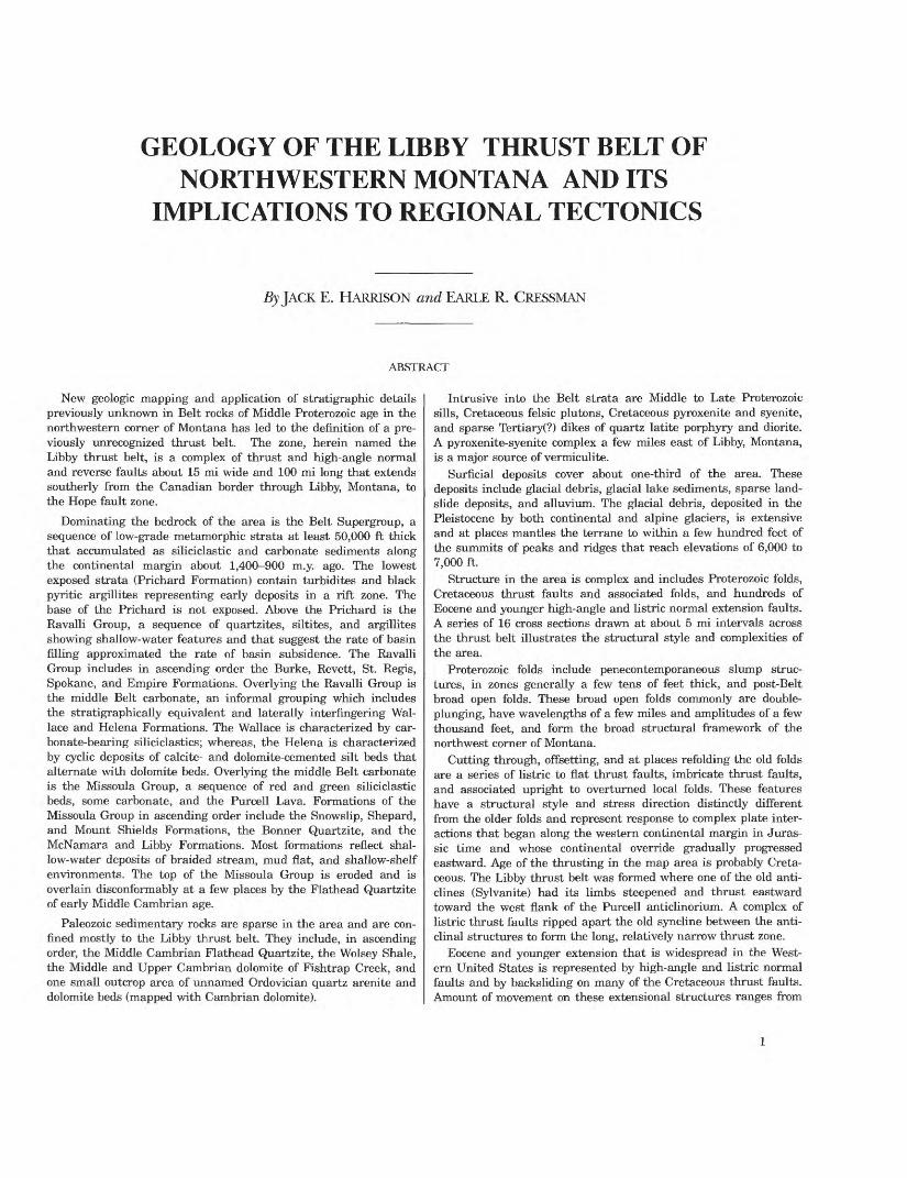
FIGURE 2. Index map showing I°x2° quadrangles containing Belt terrane. Lined pattern indicates completed maps; dotted pattern indicates maps in preparation.
Spokane (Griggs, A. B., 1973)Choteau (Mudge, M. R., and others, 1982)Wallace (Harrison, J. E., and others, 1986)Kalispell (Harrison, J. E., and others, 1992)Butte (Wallace, C. A., and others, 1987)Sandpoint (Miller, F. K., written commun., 1990)Dillon (Ruppel, E. T., and others, 1993)White Sulphur Springs (Reynolds, M.W, oral commun., 1989)
Supergroup. This terrane represents the remnants of the large Middle Proterozoic Belt basin, whose original size and shape are as yet uncertain. Belt rocks are exposed over an area of about 50,000 mi2 in northwestern Montana, northern Idaho, and east ern Washington (fig. 1). Geologic mapping has been done primarily for I°x2° quadrangles at 1:250,000 scale (fig. 2), although small areas have been mapped at 1:62,500 or larger scales for metallic mineral resource appraisal of Wilderness areas or to study particular scientific problems related to the Belt. Geophysical studies include preparation of aeromag- netic and gravity maps of the entire Belt terrane as well as local magnetotelluric surveys for specific problems.
PURPOSE OF THIS STUDY
By 1977 the cumulative geologic data from the then incomplete Wallace and Kalispell I°x2° quad rangles (fig. 2) pointed clearly to the fact that all Belt terrane in the United States north of the Lewis and Clark line (fig. 1) was allochthonous. Adjacent
Belt-Purcell terrane in Canada had earlier been interpreted as an allochthon (see for example, Price and Mountjoy, 1970), but the extent of thrusting in the United States could not be evaluated until new geologic mapping was extended in westernmost Montana from the Lewis and Clark line north to the Canadian border. The first report on the extent of thrusting in this area was published in 1980 (Harri son and others).
Within the large allochthon a previously unknown thrust belt, about 15 mi wide and 100 mi long, has now been defined as extending more or less south ward from just above the Canadian border about 10 mi east of the Idaho-Montana state line through Libby, Montana, to the Hope fault zone (fig. 1 and pi. 1). This report presents the first detailed descrip tion and interpretation of the thrust belt, which we call the Libby thrust belt. We also expand on some of the implications of the thrust belt to regional tecton ics that were previously reported only briefly (Harri son and Cressman, 1985; Harrison and others, 1985).
PREVIOUS WORK
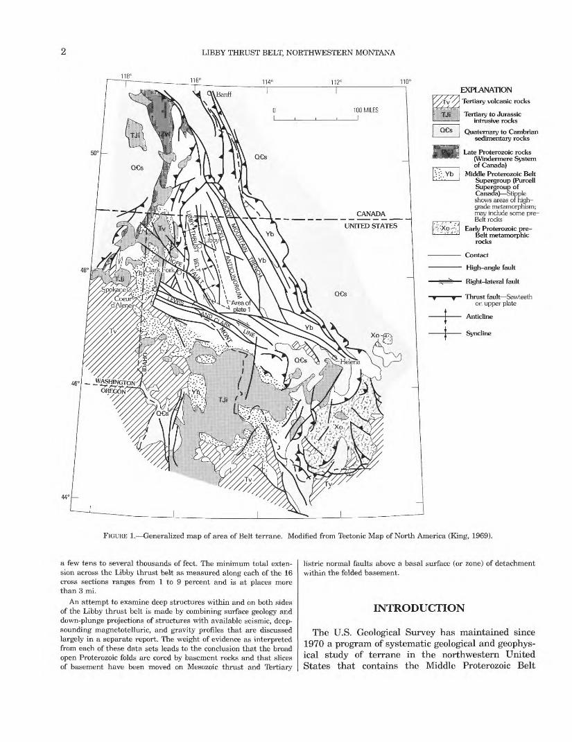
Early reconnaissance geology that included our study area was done by Calkins (1909). He recog nized and named the Lenia (Moyie) fault and identi fied in the valley of Bull Lake a fault that he suggested was a thrust. Kirkham, who mapped the Moyie thrust fault in Boundary County, Idaho (Kirkham and Ellis, 1926) connected the Moyie with the Lenia and with the thrust in Bull Lake valley (Kirkham, 1930), thus correctly identifying what is now known to be a major thrust system in the U.S. and adjacent parts of Canada.
The first detailed geological study of part of the area was done by Gibson (1948), who mapped the Libby 30-minute quadrangle in the southwest corner of the Kalispell I°x2° quadrangle. He used the stratigraphic terminology for Belt rocks that had been established by Ransome and Calkins (1908) for the Coeur d'Alene district of Idaho and also defined and named the Libby Formation, which was a new stratigraphic unit of the Belt Supergroup above the highest unit exposed in the Coeur d'Alene section (the Striped Peak Formation) (fig. 3). Gibson observed "long, steeply-dipping, persistent faults, which commonly trend north to northwest and have large displacements ***" (p. 40), and he noted multi ple movements on what he considered to be high- angle normal and reverse faults.
On the geologic map of Montana (Ross and others, 1955), the sources for geologic data in the northwest

LIBBY THRUST BELT, NORTHWESTERN MONTANA
Gibson (1948; scale 1:125,000)
Libby Formation
StripedPeak
Formation
Wallace Formation
Ravalli Formation
Prichard Formation
Ross and others (1955; scale 1:500,000)
Missoula Group
Wallace Formation
Ravalli Group
Prichard Formation
Skipp in Ross (1963; scale 1:250,000)
Libby Formation
StripedPeak
Formation
Wallace Formation
Ravalli Group
Prichard Formation
John (1970; scale 1:125,000)
Libby Formation
Striped
Formation
Wallace Formation
Siyeh Formation
LowerPieyan
unit
Ravalli Group
Prichard Formation
Wells and others (1981; scale 1:62,500)
Libby Formation
o Upper member
£ Middle member o_^;
CO 03
°- Lower IB memberQ.
55
Formation
Revett Formation
Burke
Prichard Formation
Not exposed
Van Loenen (1984; scale 1:50,000)
Not exposed
i i ii >. HGlGPISWallace \ Formation
FormationsLower ? Lower
Wallace Fm\ Helena Fm
Empire Formation
St. Regis Formation
Revett Formation
Upper Burke Formation
Lower Burke Formation
Transition member of Prichard Formation
Upper Prichard Formation
Lower Prichard Formation
Not exposed
FIGURE 3. Correlation of units in the Belt Supergroup used on various geologic maps in
corner of Montana are Gibson (1948) and " *** a manuscript map by G.S. Lambert, Montana Bureau of Mines and Geology, 1924, or *** later maps com piled by that Bureau from various sources." The Montana geologic map used four units for Belt rocks (fig. 3), and a few high-angle faults were shown in the area.
Reconnaissance geologic mapping of Lincoln and Flathead Counties by Willis M. Johns of the Montana Bureau of Mines and Geology was begun in 1958. Two of his preliminary maps (Johns, 1959, 1960)
were available to B.A.L. Skipp, who compiled the geologic map to accompany Ross's paper on the Belt Series of Montana (1963). Johns's final summary was published in 1970, and his geologic map at 1:125,000 has served as the principal reference on regional geology of the northwestern corner of Montana for many years. The map showed for the first time Cam brian strata along Swamp Creek and in two expo sures within 20 mi to the southeast of Swamp Creek. Also shown is the Pinkham thrust fault (fig. 7), which trends north-northwest about parallel to and
INTRODUCTION
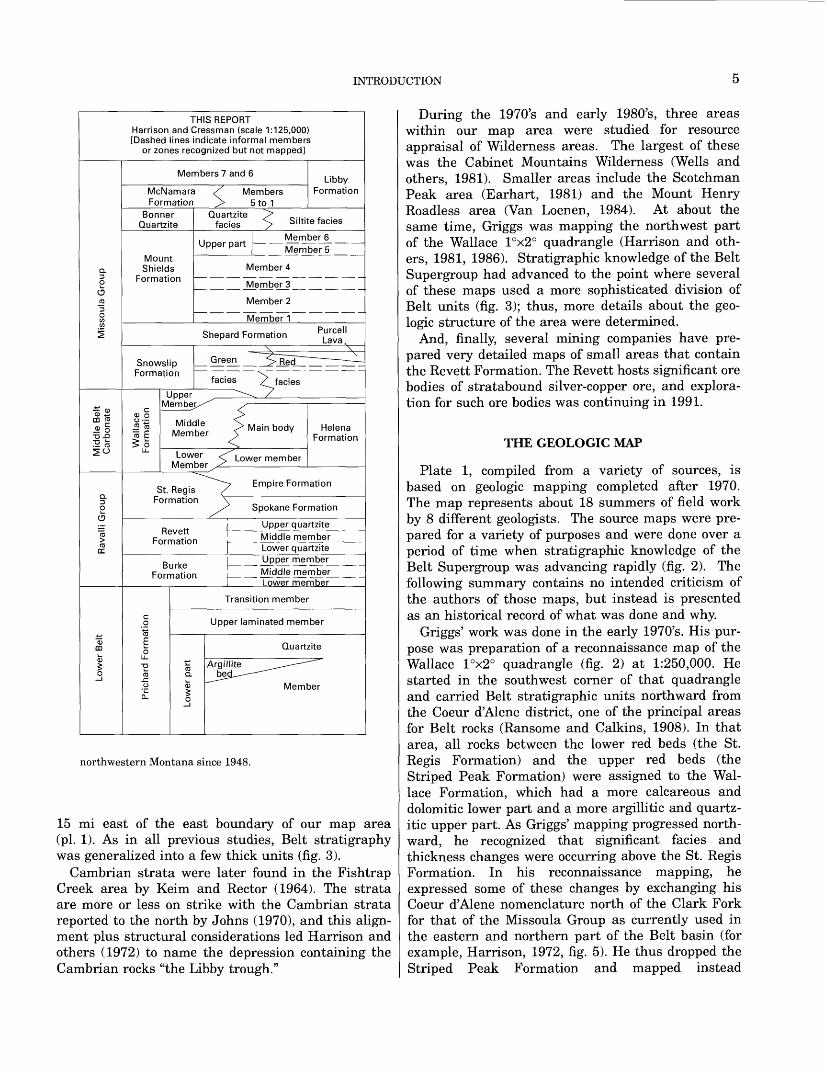
THIS REPORTHarrison and Cressman (scale 1:125,000)[Dashed lines indicate informal members
or zones recognized but not mapped]
Members? and 6
McNamara Formation
Bonner Quartzite
MountShields
Formation
Members 5to1
Libby Formation
Quartzite facies Siltite facies
Upper partMember 6 Member 5
Member 4
Member3
Member 2
Member 1
Shepard Formation Purcell Lava,
Revett Formation
i_ _ Upper quartzite_ ' _ M|dd]e member | Lower quartzite
Burke Formation
Upper member JVHddje member Lower member
Transition member
Upper laminated member
Quartzite
Argillite bee
Member
northwestern Montana since 1948.
15 mi east of the east boundary of our map area (pi. 1). As in all previous studies, Belt stratigraphy was generalized into a few thick units (fig. 3).
Cambrian strata were later found in the Fishtrap Creek area by Keim and Rector (1964). The strata are more or less on strike with the Cambrian strata reported to the north by Johns (1970), and this align ment plus structural considerations led Harrison and others (1972) to name the depression containing the Cambrian rocks "the Libby trough."
During the 1970's and early 1980's, three areas within our map area were studied for resource appraisal of Wilderness areas. The largest of these was the Cabinet Mountains Wilderness (Wells and others, 1981). Smaller areas include the Scotchman Peak area (Earhart, 1981) and the Mount Henry Roadless area (Van Loenen, 1984). At about the same time, Griggs was mapping the northwest part of the Wallace I°x2° quadrangle (Harrison and oth ers, 1981, 1986). Stratigraphic knowledge of the Belt Supergroup had advanced to the point where several of these maps used a more sophisticated division of Belt units (fig. 3); thus, more details about the geo logic structure of the area were determined.
And, finally, several mining companies have pre pared very detailed maps of small areas that contain the Revett Formation. The Revett hosts significant ore bodies of stratabound silver-copper ore, and explora tion for such ore bodies was continuing in 1991.
THE GEOLOGIC MAP
Plate 1, compiled from a variety of sources, is based on geologic mapping completed after 1970. The map represents about 18 summers of field work by 8 different geologists. The source maps were pre pared for a variety of purposes and were done over a period of time when stratigraphic knowledge of the Belt Supergroup was advancing rapidly (fig. 2). The following summary contains no intended criticism of the authors of those maps, but instead is presented as an historical record of what was done and why.
Griggs' work was done in the early 1970's. His pur pose was preparation of a reconnaissance map of the Wallace I°x2° quadrangle (fig. 2) at 1:250,000. He started in the southwest corner of that quadrangle and carried Belt stratigraphic units northward from the Coeur d'Alene district, one of the principal areas for Belt rocks (Ransome and Calkins, 1908). In that area, all rocks between the lower red beds (the St. Regis Formation) and the upper red beds (the Striped Peak Formation) were assigned to the Wal lace Formation, which had a more calcareous and dolomitic lower part and a more argillitic and quartz- itic upper part. As Griggs' mapping progressed north ward, he recognized that significant facies and thickness changes were occurring above the St. Regis Formation. In his reconnaissance mapping, he expressed some of these changes by exchanging his Coeur d'Alene nomenclature north of the Clark Fork for that of the Missoula Group as currently used in the eastern and northern part of the Belt basin (for example, Harrison, 1972, fig. 5). He thus dropped the Striped Peak Formation and mapped instead

6 LIBBY THRUST BELT, NORTHWESTERN MONTANA
Snowslip, Shepard, Mount Shields, Bonner, McNamara, and Libby Formations above a thin upper member of the Wallace Formation.
The Cabinet Mountains Wilderness southwest of Libby (pi. 1) was mapped during the summer of 1972 for metallic mineral resource appraisal (Wells and others, 1981). The focus was on mineralized veins and the potential for undiscovered stratabound sil ver-copper deposits. New regional mapping on the Kalispell I°x2° quadrangle (fig. 2) had not yet reached westward to the Cabinet Mountains, so the field geologists decided to use Coeur d'Alene nomen clature and definitions of units as previously used by Gibson (1948) and Johns (1970). A subdivision of the Striped Peak Formation similar to that of the nearby Clark Fork, Idaho, area (Harrison and Jobin, 1963) was used. We now recognize that the lower member of the Striped Peak Formation as mapped in the Clark Fork area and the Wilderness is the lower part of the Mount Shields Formation, the middle part of the Striped Peak is the upper part of the Mount Shields, and the upper part of the Striped Peak is the Bonner Quartzite (Harrison and others, 1986, fig. 2 on pi. 1) On our compilation, the Striped Peak For mation has been dropped and Mount Shields and Bonner used for appropriate map units. The Wallace Formation on the Wilderness map conforms to Coeur d'Alene terminology and includes all rocks from the red beds below (the St. Regis Formation) to the red beds above (the Mount Shields Formation). When later regional mapping carried lithostratigraphic units and facies into the area of the Cabinet Moun tains, it became apparent that the Wallace as mapped in the Cabinet Mountains Wilderness con tains not only the lower, middle, and upper members of the Wallace Formation but also the green facies of the Snowslip Formation and the Shepard Formation. On our compilation we have retained the original unit (a combination of the Shepard, Snowslip, and Wallace Formations) within the Wilderness area, as mapped by Gibson (1948) and by Wells and others (1981), largely because the loss of stratigraphic data does not seriously affect our structural analysis but also because the rugged Wilderness is now closed to helicopter landings. The time and effort required to remap the Wallace for purposes of this report would not be cost efficient.
Geology of the Scotchman Peak (southwest edge of plate 1 and west into Idaho) and Mount Henry (northeast corner of plate 1) areas was mapped in the mid-1970s (Earhart, 1981) and early 1980s (Van Loenen, 1984) for mineral resource appraisal. By 1980 regional mapping by Harrison on the Kalispell I°x2° quadrangle had reached the borders of the
Mount Henry area, thus allowing Van Loenen to identify and map 12 lithostratigraphic units of regional extent below the Missoula Group in an area where only 5 map units had been identified previ ously (Johns, 1970).
Geologic mapping of parts of the Revett Formation has been done since 1970 by several mining compa nies. This ore-hosting formation has been mapped and measured in great detail at various spots. ASARCO, for example, recognizes 3 members and identifies 5 beds in the upper member alone (Hayes, 1983, p. 52). Such detail is not available in most of our map area, and the Revett Formation is shown as a single map unit on plate 1.
The remainder of the study area has been mapped by Harrison and Cressman. We have mapped 24 units in the Belt Supergroup as well as 2 facies vari ants, and we recognize and describe an additional 18 informal members that could be mapped at larger scales (fig. 3). Cressman's work has been focused pri marily on the Prichard Formation; the Yaak River area was mapped at 1:48,000 to obtain details of Pri chard stratigraphy (Cressman and Harrison, 1986). Harrison has been primarily concerned with the Belt stratigraphy above the Prichard and with regional structure. Mapping by both of us has been done on 7 l /2-minute quadrangles, some of which were mapped in significant detail in complex areas and some of which were done in reconnaissance for compilation at smaller scales.
The base for plate 1 is an enlargement to 1:125,000 of parts of the Wallace and Kalispell I°x2° quadran gles (scale of 1:250,000). Such enlargements com monly present some problems. Geology was compiled from maps on topographic bases at scales ranging from 1:1,000 to 1:62,500 with most at 1:24,000. Pho tographic reduction of those maps did not fit the topography of the base as well as we would have liked, so contacts and other lines on the source maps were hand transferred to fit the 1:125,000 topo graphic base. In the process, the original thickness of some stratigraphic units are distorted at places.
Despite all the caveats to the user, the geologic map is the most detailed compilation yet prepared for about 3,000 mi2 of Belt terrane in northwestern Montana. We consider it more than adequate for our structural analysis of the Libby thrust belt.
ACKNOWLEDGMENTS
We are grateful to ASARCO for allowing us access to detailed maps of the Mount Vernon area from which we compiled the generalized geology of that area. Atlantic Richfield and Marathon Oil Companies
GEOLOGY
generously supplied us with logs from the No. 1 Gibbs deep borehole and gave access to cuttings from that borehole. Staff of Amoco Production compared notes with us on the lithologic log. Staff of Texaco USA kindly discussed a series of seismic lines that extended into the west edge of the Libby thrust belt. Noranda Exploration, Inc., generously supplied data from their drilling program at Liver Peak. Ray Kajawa, Zonalite Division of W. R. Grace, and Com pany, gave a tour of the Rainy Creek mine and aided in sample collection. C. J. Potter, of COCORP and Cornell University, generously gave us early access to COCORP lines MT-1 and MT-2, which cross the Libby thrust belt. Potter and Ted Yoos, also of Cor nell, exchanged thoughts on interpretation of the seismic data in exchange for our thoughts on the geo logic and structural setting of the area. Phoenix Exploration gave us five deep magnetotelluric sound ings in a line across the Purcell anticlinorium. We have benefited over the years from discussions of Belt stratigraphy of the map area with our col leagues J. W. Whipple and C. A. Wallace and with Don Winston, University of Montana. Our colleague M. W. Reynolds provided help on Proterozoic struc ture of the eastern Belt terrane and on possible interpretations of seismic data across the Libby thrust belt. We are indebted to Karl S. Kellogg and Betty A. Skipp for their patient and helpful critical reviews of the complicated geologic map and sections as well as their suggestions to improve the text of this report. Both of these reviewers would prefer to interpret all folds in the area as being a result of Mesozoic thrusting rather than, as we prefer, a result of Precambrian folding that has been refolded during the later thrusting.
GEOLOGY
REGIONAL GEOLOGIC SETTING
The Libby thrust belt is about in the center of Belt terrane (fig. 1) and includes a minimum of 46,000 ft of Belt strata. The base of the Belt is not exposed and the top is eroded. Most of the Belt Supergroup in the central part of Belt terrane is fine grained, and rocks as coarse as medium-grained sand are rare. Depositional environments, according to a series of authors at Belt Symposium II (Hobbs, 1984), range from turbidites in the lower Belt through marine marginal, tidal flat, and shallow shelf deposits in the rest of the section. Other interpretations of deposi- tional environments are presented by a series of authors in Montana Bureau of Mines and Geology
Special Publication 94 (1986, S. M. Roberts, ed.), which also contains an outstanding collection of color photographs that illustrate typical bedding, lamina tion, and small-scale sedimentary features of Belt rocks. Belt rocks show effects of regional metamor- phism that range from the biotite zone of the green- schist facies in the lower Belt through chlorite- sericite rocks in the middle Belt to high-grade diagenesis at the top of the upper part .(Maxwell and Hower, 1967).
Structurally the Libby thrust belt is a zone of east- directed thrusts in the middle of a major allochthon (fig. 1). Eastward thrusting began as a result of com plex plate interactions along the western continental margin about 200 m.y. ago (Monger and Price, 1979), progressed eastward, and lasted intermittently until about 60 m.y. ago (Schmidt, 1978, p. 62). Thrusting in the Libby thrust belt appears to have occurred either prior to or at about 100 m.y. ago.
About 200 high-angle normal or listric normal faults cut or join the thrust faults in the map area (pis. 1 and 2). These high-angle faults, along with backsliding on some thrust faults, represent post- thrusting extension of the entire Belt terrain north of a wide zone of west-northwest-trending strike-slip faults, the Lewis and Clark line (fig. 1).
BELT SUPERGROUP
Bedrock in the map area is predominantly strata of the Belt Supergroup of Middle Proterozoic age. The cross sections (pi. 2) show the vertical successions and some of the lateral variations of the lithostrati- graphic map units. Many of the facies changes are not well displayed in surface geology, largely because of sporadic exposure owing to glacial cover as well as complexities in structure. For example, the sequence and thickness of formations above the Revett Forma tion on the Moyie thrust plate west of Bull Lake (pi. 1) differs significantly from that exposed near the junction of the Fisher and Kootenai Rivers near the east-central part of the map (pi. 1). Section /-/' and the eastern parts of sections J through P (pi. 2) illus trate diagrammatically some of the necessary changes, but the sections also illustrate that these changes were not actually seen.
Structure and stratigraphy are obviously inter twined in preparation of a geologic map. The princi pal purpose of this report is to examine structure of the area, but the necessary definitions and descrip tions of map units are given first in the following pages.
LIBBY THRUST BELT, NORTHWESTERN MONTANA
PRICHARD FORMATION
Continuous natural exposures of the Prichard For mation are uncommon, and its character can best be seen in the northwestern part of the study area in road cuts along the Yaak River, along logging roads both north and south of the river, and in the south western part of the study area along logging roads north of Deep Creek (pi. 1).
The Prichard Formation consists of two major facies, both of which are present in the map area. One consists dominantly of quartzite; this facies forms the core of the Sylvanite anticline and the exposures of Prichard west of the Moyie thrust. The second facies is dominantly argillite and siltite and makes up the Prichard exposed on both sides of the Vermilion River in the south-central part of the map area (pi. 1).
The Prichard Formation has been divided into sev eral informal members. In areas of the quartzite facies these are, from the base up, a quartzite mem ber that makes up most of the formation, an argillite bed that is intercalated in the upper part of the quartzite member, an upper laminated argillite mem ber, and a member that is transitional in lithology and position between the more typical Prichard For mation below and the Burke Formation above.
The quartzite member consists mostly of medium- to light-gray, very fine grained to fine-grained, slightly feldspathic quartzite in beds that average 1.3 ft thick. The quartzites are turbidites, and beds gen erally grade to argillite in their upper part. Sole marks, mostly flutes and grooves, are present at the base of some beds. The quartzite beds commonly are grouped into sets that average 40 ft thick. These alternate with sets 20-30 ft thick of interbedded and interlaminated dark- to medium-gray siltite and argillite. The beds and laminae are planar. Much of the siltite and argillite contains pyrite or pyrrhotite that weather to give outcrops a characteristic rusty brown color. Randomly oriented xenoblastic biotite is present throughout the member. The quartzite mem ber extends from about 3,400 ft below the top of the Prichard to the base of exposures, an interval of about 15,000 ft. The interval contains about 2,700 ft of intercalated mafic sills plus the 800 ft thick argil lite member, which leaves a cumulative thickness of about 11,500 ft for the quartzite member.
The argillite bed is 800 ft thick and extends from about 2,000 to 2,800 ft below the top of the quartzite member. The argillite bed consists mostly of medium- light-gray silty argillite in beds 0.5 to 1.5 ft thick. Some of the argillite is banded light- and dark-gray, and the dark layers contain pyrrhotite laminae. A
few beds of massive silty argillite or argillic siltite near the base of the bed exhibit slump folds and slump breccia. Xenoblastic biotite is common throughout the bed, and xenoblastic chlorite is com mon locally. The entire unit weathers moderate brown to brownish gray. Upper and lower contacts are sharp.
The quartzite member is overlain by the upper laminated member that consists of 1,000 to 2,000 ft of planar-interlaminated dark-gray argillite and olive-gray to medium-light-gray argillite or siltite. The beds are graded from light colored laminae at the base to dark at the top, and the graded beds com monly are 0.1 to 0.5 inches thick. The unit has a dis tinct lined appearance in outcrop. Metamorphic biotite is ubiquitous in the rock. Pyrite and pyrrho tite grains and laminae in the dark-gray argillite weather to give a rusty color to outcrops. The mem ber grades by interlayering from the quartzite mem ber below expressed as a progressively greater spacing and thinning upward of quartzite beds. The interlayered zone is commonly a few tens of feet thick, and the contact has been placed on top of the uppermost quartzite layer.
Laminated argillite of the upper member is over lain by the transition member, which consists of rocks intermediate in character between the light- and dark-gray laminated argillite of the upper mem ber of the Prichard Formation and the interlayered greenish-gray siltite and argillite of the lower mem ber of the Burke Formation. This transitional mem ber consists mostly of interlaminated light-gray to greenish-gray siltite and dark-gray argillite. The laminae range from slightly wavy to lenticular. Cross-lamination, cut-and-fill structures, and fluid- escape structures are present as are sparse ripple marks. The member contains some interbedded silt ite and quartzite, particularly in the upper and lower parts. Siltite in the lower part is generally gray but becomes greenish-gray near the top of the member. A few siltite beds in the upper part contain calcite cement. The transitional member ranges in thickness from 1,500 to 2,100 ft. The basal contact is sharp, as it separates uniformly laminated argillite below from interlayered argillite and siltite above.
Both the upper laminated and transition members are present throughout the map area, but near the Vermilion River they were mapped together as a sin gle unit by Griggs (in Harrison and others, 1986), and west of McDonald and Cable Mountains the transition member was included by Wells and others (1981) in the Burke Formation (pi. 1).
The exposures near the Vermilion River belong to the argillite facies of the Prichard Formation. There
BELT SUPERGROUP 9
the upper laminated member, which is identical to the upper laminated member in areas of the quartz- ite facies, is underlain by 2,700 ft of argillite that contains a few beds of quartzite, 1,000 ft of interbed- ded quartzite and argillite in which the quartzite is dominant, and more than 2,500 ft of argillite similar to that in the upper laminated member. These three units were mapped by Griggs (in Harrison and oth ers, 1986) as a single unit called the lower member of the Prichard (pi. 1).
The thickest exposure of the Prichard in the map area is in the Sylvanite anticline where the interval from the top of the formation to the base of expo sure is about 18,300 ft. The interval contains 1,900 ft of mafic sills that are intruded into the Prichard, which leaves a thickness of 16,400 ft for the sedimentary rock.
BURKE FORMATION
Strata assigned to the Burke Formation are partic ularly well exposed on Roderick Mountain about 24 mi northwest of Libby, Montana, and on ridges in the southern Cabinet Mountains (pi. 1). Burke rocks tend to form cliffs and underlie ridge tops or steep slopes. A regional summary of the Burke lithologies between Coeur d'Alene, Idaho, and Ravalli, Montana, includ ing a partial section measured in our map area near Plains, Montana, is given by Mauk (1983).
Although we have mapped the Burke as a single unit, in most areas it can be divided into three infor mal members. The lower member is dominantly interlayered beds of greenish-gray argillite and silt- ite. Beds range in thickness from a few inches to a few feet, and they give a blocky-flaggy appearance to most outcrops. Laminations, to use terminology rec ommended by Campbell (1967), are largely even par allel, although some display wavy laminations where sparse ripple marks are present. Argillite beds con tain graded couplets that have a dark-greenish-gray silty argillite at the base and lighter green argillite at the top. Broken surfaces of both argillite and silt- ite commonly show a light-gray weathering rind. Tiny euhedral magnetite crystals are characteristic of the siltite beds, and secondary biotite flakes are scat tered through both the argillite and siltite layers. The magnetite is sufficiently abundant to be readily detected in outcrop by a stud-finder magnet and causes a distinct positive anomaly on low-level aero- magnetic maps. Where the lower member was identi fied separately, it ranges from about 500 to 1,300 ft thick. The unit grades into the middle member by interlayering over a few tens of feet.
Abundant blocky coarse siltite to very fine grained quartzite in beds a foot to 10 ft thick characterizes the middle member of the Burke. The siltite is com monly a pale purple gray or has purple stripes paral lel to bedding. Scattered beds of gray or greenish- gray hue are interlayered with the purple-colored rocks. Laminations are mostly evenly spaced and parallel. Long planar crossbeds are present at a few outcrops. The siltite is slightly feldspathic and shows sparsely disseminated biotite and magnetite at places. Interbedded with the siltite is a subordinate amount of purple or green thinly laminated argillite. Small scale sedimentary structures are rare. Thick ness of the unit commonly is about 1,300 ft. This member grades into the upper member by interlayer ing over a few hundred feet.
The upper member consists of purple argillite and interlaminated argillite and siltite interbedded with green interlaminated argillite and siltite. The lower part of the member is dominantly argillite that has a variety of laminations that range from even to wavy and from parallel to nonparallel. Small-scale sedi mentary structures, such as cut-and-fill, mud chips, fluid-escape structures, ripple marks, and mud cracks, increase in abundance toward the top of the unit where laminations are evenly spaced and even parallel to wavy parallel. The unit is slightly calcare ous at places and contains sparse flakes of secondary biotite. A few of the green beds contain sparse chal- copyrite or chalcocite. Near the top, beds of crossbed- ded quartz arenite a few inches to a few feet thick appear and increase in abundance upward. The con tact with the overlying Revett Formation is drawn where the first thick cosets of the crossbedded quartzite appear. Thickness of the upper member of the Burke is commonly a few hundred feet.
Total thickness of the Burke ranges from 2,600 ft on the Sylvanite anticline in the northwest part of the map area, to about 3,030 ft in the northeastern part of the area (Van Loenen, 1984), to about 5,600 ft in the southeastern part of the map area. About 4,800 ft of Burke are reported for the southern Cabi net Mountains (Wells and others, 1981), but this fig ure includes at least 600 ft of the transition member of the Prichard.
REVETT FORMATION
Abundant quartzite in the Revett Formation forms resistant outcrops in areas of steep relief. Among the better exposures are those on the cliffs west of Bull Lake, on the ridge tops and steep slopes of the south ern Cabinet Mountains, on Seven Point Mountain south of the Vermilion River, and on the steep valley
10 LIBBY THRUST BELT, NORTHWESTERN MONTANA
walls near the mouth of the Thompson River about 4 mi southeast of Thompson Falls, Montana (pi. 1).
The Revett Formation has been studied more intensively than any other Belt Formation in the map area, primarily because it hosts several major stratabound silver-copper ore deposits in the south western quarter of the map area. Detailed measured sections, along with sedimentological analyses and interpretations of depositional environment, are given by Hayes (1983) for the Spar Lake area and the Troy mine (west of Bull Lake), by Mauk (1983) for the area near Plains, Montana, by Bowden (1977) for Seven Point Mountain, and by Wingerter (1982) for sections at the east and west edges of the map area at about the latitude of Libby. White (in Thorson and others, 1983) has described the section at the mouth of the Thompson River. Additional pro prietary data from maps, measured sections, geo physical surveys, drill holes, and assays of cores are held by several mining companies. In general, the diagenetic sulfide ore is associated regionally with the more permeable strata that are in the reduced (white or green) strata rather than the oxidized (pur ple or purple gray) strata (Harrison, 1974).
In most areas the Revett Formation can be divided into three informal members consisting of lower and upper quartzite-rich members and a mid dle member that contains significantly more argillite and siltite. The following descriptions of these mem bers are derived from the detailed studies listed above as well as from our observations in the entire area of the map.
Characteristic lithology in the lower quartzite member of the Revett is blocky thick bedded felds- pathic quartzite in 20- to 50-ft thick sequences. Many beds show cross lamination, although some are pla nar. Ripple cross-lamination, load structures, and channels are displayed in some outcrops. The quartz ite is commonly pale purple gray or contains purple stripes, although parts or all of the quartzites are green or white in the southern Cabinet Mountains. Purple-striped quartzite commonly shows Liesegang rings of purple hematitic coloration both along and across bedding. Magnetite in tiny euhedral crystals or larger rounded masses is sufficiently abundant at some places to show as a high anomaly on low-level aeromagnetic maps. Heavy-mineral concentrations are conspicuous on cross-bedding surfaces at a few outcrops. Interbedded with the quartzite are intervals of purple or green interlaminated argillite and siltite or argillitic siltite. Sedimentary structures include mud cracks, mud chips, and ripple marks. These argillitic and silty beds commonly contain sparse flakes of secondary biotite. The unit is generally
several hundred feet thick but is about 2,000 ft thick in the southeastern part of the map area.
The middle member of the Revett is dominantly sil tite and argillite with scattered beds a few feet to a few tens of feet thick of quartzite. Argillite beds are purple or green, generally display even to wavy paral lel laminations, and commonly contain thin graded couplets that show silty argillite at the base grading upwards to argillite. Sedimentary structures include mud cracks, mud chips, ripple marks, and fluid escape structures. Siltite is commonly pale purple and planar laminated, and the siltite alternates with beds of argillite. Quartzite beds are similar to those in the lower and upper members. Thickness of the member commonly is several hundred feet and ranges from about 700 ft in the southern part of the map area to about 200 ft on Arbo Mountain in the northwestern part (T. S. Hayes, written commun., 1985).
The upper quartzite member of the Revett contains three sequences dominated by quartzite similar to the lower member of the Revett that are separated by sequences of argillite and siltite similar to that of the middle member of the Revett. West of Bull Lake, the quartzite has conspicuous iron-carbonate cement that gives the white quartzite a freckled appearance in fresh rock and a rusty appearance when weath ered. It also has particularly conspicuous climbing ripple marks, ripple cross-laminations, and channels, as well as cross bedding. Thickness ranges from about 400 ft in the south to about 250 ft in the north. Contact with the overlying St. Regis Formation is gradational by interlayering and is placed at the top of the uppermost thick sequence of blocky quartzite. West of Bull Lake, the Revett is overlain sharply by green carbonate-bearing argillite of the Empire For mation or by a few feet of St. Regis argillite beneath the Empire.
Total thickness of the Revett ranges from about 3,100 ft at the Thompson River in the south to about 2,000 ft at places on the east flank of the Sylvanite anticline. All members tend to thin and become more argillitic to the north, but the lower quartzite mem ber thins the most.
ST. REGIS FORMATION
Abundant argillite beds in the St. Regis Formation causes it generally to form slopes and crop out poorly, but exposures are good in the cliffs west of the Thompson River near Thompson Falls, Montana, and near road cuts at the south end of Lake Koocanusa (pi. 1). Fair exposure of the formation is found on Blue Mountain about 9 mi northeast of Libby and on
BELT SUPERGROUP 11
Boulder Mountain in the northeast part of the map area.
The St. Regis consists of beds a few to several tens of feet thick of purple interlaminated argillite and siltite that alternate with beds of green interlami nated argillite and siltite. Laminations are mostly even parallel, but some are wavy and discontinuous. Sedimentary structures include mud cracks, mud chips, ripple marks, and fluid-escape structures. Pale purple or green siltite beds a few inches thick are scattered through the formation and are more abun dant near the base. Both the argillitic and silty beds contain disseminated iron-carbonate or dolomite specks and cement at some places. The formation is intertongued with the overlying Empire Formation in the eastern and northeastern part of the map area but appears to be sharply overlain by the Empire in the south and west. The St. Regis ranges in thick ness from about 1,000 ft in the south to about 600 ft in the north; on the Moyie thrust plate west of Bull Lake the formation is only a few tens of feet thick.
SPOKANE FORMATION
Rocks assigned to the Spokane Formation crop out along the southeast edge of the map area (pi. 1). The Spokane contains three informal members. Upper and lower members are similar to the St. Regis For mation but commonly contain more carbonate. The middle member is composed predominantly of planar laminated purple siltite that has some interbedded purple or green argillite. The presence of this siltite, which is widespread in the Spokane Formation over hundreds of square miles to the east of the map area, is the basis for assignment to that formation. The Spokane, like the St. Regis, is gradational by inter- layering into the Revett Formation below and is over lain fairly sharply by the Empire Formation above. Thickness of the Spokane in the map area ranges from about 1,200 ft to 1,600 ft.
EMPIRE FORMATION
The best exposed, almost complete section of the Empire Formation is in road cuts at the east end of Libby Dam at the south end of Lake Koocanusa (pi. 1). Other good exposures include the road cuts north of the Kootenai River about 3.5 mi southeast of Rainy Creek, the ridge trending north from Boulder Mountain in the northeast part of the map area, and around Stanley Peak in the central part of the map area. A tongue of Empire in the St. Regis Formation is displayed in road cuts on the west side of Lake
Koocanusa about a mile north of Libby Dam; the tongue can be traced for about 2 mi north-northwest to a point where outcrop becomes poor.
Characteristic lithology of the Empire Formation is thinly laminated dark-green and light-green dolo- mitic argillite and silty argillite. Laminations are even parallel to wavy and discontinuous. Fluid- escape structures are conspicuous in most outcrops and are commonly 6 inches or more high and 6-8 inches wide at the top. Horizontal pods of white or pink calcite are particularly abundant in the upper half of the section; these pods weather out leaving voids in many outcrops. Pyrite cubes are common in the more carbonate-rich strata.
Variations in the Empire Formation within the map area include differences in color, lithologic con tent, and thickness. Along the east edge of the map area from about Libby Dam northward, the Empire has very dark green to blackish-green silty argillite laminations whose color is due in part to fresh detri- tal biotite (Van Loenen, 1984) along with the usual secondary chlorite that gives the green tint to the rocks. In the southeastern exposures of the Empire a few purple interlaminated argillite and siltite beds occur near the middle of the formation. At Libby Dam, a white, dense, cherty quartzite bed about 2 ft thick crops out near the base of the section. White dolomitic quartzite lenses and beds a few inches thick are sparsely present in many areas. Thin, impure dolomite beds form a small percentage of the Empire in the northern part of the area. In general, the formation thins from north to south and from east to west. The thickest section reported (Van Loenen, 1984) is a minimum of 2,000 ft on Boulder Mountain, but only about 200 ft are present near the southwest corner of the map area. An unknown thickness of Empire may have been included with the lower member of the Wallace Formation in sev eral areas where exposure was poor or where no attempt was made to distinguish the two units.
Where the lower member of the Helena Formation overlies the Empire, the contact is relatively sharp and is placed where beds of orange-weathering dense dolomite and thinly interlaminated apple-green argil lite and brown-weathering coarse siltite first appear. Where the lower member of the Wallace Formation overlies or, perhaps, interfingers with the Empire, the contact is more difficult to place. The lower mem ber of the Wallace and the Empire both are domi- nantly interlaminated dark and light green dolomitic argillite that contains horizontal calcareous pods. In general, argillite assigned to the lower member of the Wallace is distinctly more dolomitic, contains irregu lar vertical calcite ribbons (molar tooth structures),

12 LIBBY THRUST BELT, NORTHWESTERN MONTANA
and has interbedded feldspathic quartzite beds 1-2 ft thick.
WALLACE FORMATION
The Wallace Formation generally crops out well, and good exposures can be found in most areas where the formation occurs. Among the best expo sures are those in logging road cuts on the south side of Miller Creek about 21 mi south of Libby, in logging road cuts and natural exposures on the south side of Government Mountain in the west-central part of the map area, and on Yaak Mountain about 7 mi north of Troy.
Three informal members of the Wallace Formation are recognized in the map area, although only one or two are present in certain parts of the area. These members include a lower member of green dolomitic argillite and siltite, a middle member of interbedded white quartzite and black laminated argillite, and an upper member of thinly laminated black or green argillite. These members are present in the same lithologic sequence in the lower two thirds of the Wallace at Wallace, Idaho, and have been carried north from there on the Wallace I°x2° quadrangle (Harrison and others, 1986). Assignment of strata to the upper member becomes problematical the farther north one proceeds from the Wallace area, because a green facies of the Snowslip Formation comes in from the east, overlies the middle member of the Wallace, and probably interfingers with the upper member of the Wallace.
The lower member of the Wallace Formation con sists largely of blocky, green, calcareous and dolo mitic argillite and argillitic siltite. Laminations are even parallel in graded couplets that range in thick ness from a fraction of an inch to a few inches. Molar tooth structure is sparsely present as are horizontal pods of calcite. Interlayered with the green beds is white to pale green feldspathic quartzite in beds a few inches to 2 ft thick. The thicker quartzite beds are more common in the southern part of the map area. Beds of dense orange-weathering argillitic dolo mite a foot or less thick are interlayered in the lower member of the Wallace in the northeast corner of the map area. Lithology of this dolomite is characteristic of the lower member of the Helena Formation, and these beds are interpreted to be tongues of lower member of the Helena interfingering with lower member of the Wallace. Thus, the lower member of the Wallace appears to grade by interlayering into the Empire Formation below and by intertonguing laterally with the lower member of the Helena. Where the lower member of the Wallace overlies the
St. Regis Formation, the contact has been placed on top of the uppermost bed of purple argillite and silt ite of the St. Regis Formation. Contact between the lower and middle members of the Wallace is by inter- layering of those members over a zone a few feet thick. Thickness of the lower member of the Wallace ranges from about 1,200 to 1,800 ft. Part of the vari ation in thickness is due to difficulty in selecting the lower contact where green argillitic beds of the Wal lace are interlayered with similar strata of the Empire Formation below.
The middle member of the Wallace Formation has distinct lithology and bedding structure. It consists of wavy beds a few inches to a few feet thick of thinly laminated black argillite alternating with discontinu ous beds and lenses of white fine-grained quartzite. Desiccation cracks are common at places in the black argillite. The quartzite tends to have planar lamina tions, although some low-angle cross-laminations occur in some outcrops. Load structures, flame struc tures, and ball-and-pillow are common at places. Molar tooth structure and irregular calcite pods are conspicuous at places and may extend vertically across several feet of interlayered argillite and quartzite. Such high-carbonate zones are scattered through the member but are fairly consistent at the top and base of the unit. The more calcareous parts of the member are generally pyritic. Beds several feet thick of planar laminated green argillite (similar to those of the lower member) and of thinly laminated black or green argillite (similar to those of the upper member) occur sparsely through the middle member. In the southwestern part of the map area, beds of fragmental carbonate a few inches thick and beds of molar tooth carbonate a few feet thick are found in a few outcrops. In the northeast corner of the map area, beds of the middle member of the Wallace are intertongued with beds of the main body the Helena Formation on a scale of a few tens to a few hundreds of feet. Along the eastern edge of the map, inter tonguing is less common, and the map units are shown separately where either Wallace or Helena lithologies clearly dominate. The intertonguing of Helena and Wallace is shown diagrammatically on several of the cross sections (pi. 2). Contact of the middle member of Wallace with the overlying unit, either the upper member of Wallace or the Snowslip Formation (fig. 3), is gradational over a zone a few tens of feet thick. Thickness of the middle member of Wallace is about 6,000 ft in the central and west parts of the map area, but it thins eastward where it intertongues with and overlies the main body of the Helena Formation (fig. 3) and is only 1,000 ft thick at the east-central edge of the map (pi. 2, sec. K-K'}.
BELT SUPERGROUP 13
The upper member of the Wallace Formation con sists of thinly to very thinly laminated graded cou plets of black or dark green argillite and greenish- gray silty argillite. Sedimentary structures are not abundant but include at places mud chips, desicca tion cracks, and small scale cut-and-fill structures. The member grades upward into somewhat more thickly laminated couplets of dark-green argillite and light-green siltite that has been assigned to the green facies of the Snowslip Formation. The contact has been placed where the thicker laminations that con tain more siltite with chlorite on bedding planes first dominate the section. In the southeast part of the map area, Griggs (Harrison and others, 1986) mapped as upper member of Wallace all black or green argillitic strata above the middle member of Wallace and below the first red beds in the Snowslip. Thickness of the upper member of Wallace is about 2,400 ft in the southeastern part of the area where it may include an unknown amount of strata that some geologists might assign to the Snowslip Formation. The unit thins northward to about 400 ft near O'Brien Creek about 5 mi north of Troy, Montana. The upper member either is not present or is indis tinguishable from the green facies of the overlying Snowslip Formation in most of the western and northern parts of the map area.
HELENA FORMATION
The Helena Formation is particularly well exposed in deep road cuts at the west end of Libby Dam and for about a mile south of the dam. The lower mem ber and the main body of the Helena are continu ously exposed for several hundred feet above and below the contact, and the typical lithologies, bedding structures, and other features of the strata are spec tacularly displayed.
Two informal members of the Helena Formation are recognized in the area a lower dolomite, argil lite, and quartzite member and the main body of the cyclic-bedded Helena. The lower member consists of alternating beds a few feet to a few tens of feet thick of dense orange-weathering dolomite and thinly interlaminated apple-green to tan argillite and brown-weathering quartzite. The dolomite commonly is pyritic and displays irregular pods of calcite as well as molar tooth structure. The argillite and quartzite are in even parallel laminations that con sist of interlaminated green and tan argillite inter- bedded with brown-weathering quartzite that rarely is as thick as half an inch. Layers of dolomite and silty dolomite several hundred feet thick and similar
to that in the main body of the Helena are scattered through the lower member. We place the contact between the lower member and the main body on top of the highest bed of the thinly laminated argillite. As the interlayered zone can be several hundred feet thick, the precise location of the contact in areas of poor exposure is questionable. The lower member of Helena is about 3,000 ft thick in the northeast corner of the map; it thins rapidly to the west where it interfingers with the lower member of the Wallace (pi. 2, sec. A-A'), and it thins gradually southward along the east side of the map area. About 150 ft of lower member of Helena is present between the Empire and middle member of Wallace strata on the Moyie thrust plate west of Bull Lake; no lower mem ber of Helena is recognized in the next exposures of the appropriate part of the Belt Supergroup a few miles to the west near Clark Fork, Idaho (Harrison and Jobin, 1963).
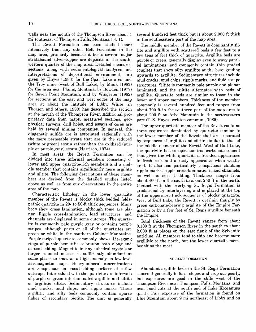
Distinct lithologic cycles in units a few tens of feet thick characterize the main body of the Helena For mation. These cycles have been described in detail by O'Connor (1967) and Eby (1977). A typical cycle as seen in our map area is illustrated in figure 4. The lithologic cycle begins on a cut (erosional) surface
8 FEET
FIGURE 4. Diagrammatic illustration of a typical depositional cycle in the Helena Formation. Bed 1 is quartzite, 2 is dolomitic siltite, and 3 is dense dolomite. Within bed 2, the black ovoids and irregular lines are calcite segregations.
14 LIBBY THRUST BELT, NORTHWESTERN MONTANA
and consists of a bed of white quartzite or interlay- ered white quartzite and black thinly laminated argillite. This bed commonly is less than a foot thick. Sharply overlying the lower bed is gray to greenish- gray dolomite siltite. This middle bed is blocky and commonly displays molar tooth structures as well as calcite pods and irregular blobs; the bed ranges from about 2 to 20 ft thick. The upper bed in the cycle is a massive, dense, gray, conchoidal-fracturing dolomite that weathers tan to light orange and is topped by an erosional surface. The upper bed commonly has about the same thickness as the middle bed. Com plete cycles are seen in many exposures, but com monly the lower bed is missing. Within the middle bed is a tripartite cycle of sedimentary structures (fig. 4) that show a lower zone of horizontal calcite pods grading upward into a zone of calcite in vertical ovoids and irregular blobs that in turn grades upward into irregular vertical ribbons of calcite (molar tooth structure). All three of these structures can occur independently, but, most commonly, the horizontal and vertical pods occur together, followed in frequency by all three structures in the same bed. The main body of the Helena Formation is about 2,600 ft thick in the southeast part of the map area and, in general, it thins by intertonguing to the west with the middle member of the Wallace Formation. Everywhere in the map area the main body of the Helena is overlain by strata of the middle member of Wallace above an interlayered gradational zone sev eral tens of feet thick above the Helena.
SNOWSLIP FORMATION
The Snowslip Formation, which consists of a green argillite facies and a red-bed facies (fig. 5), is exposed in many parts of the map area, but sections that are both complete and well exposed are rare. One of the better sections in the green facies is in cuts along the railroad tracks about 12 mi west of Libby. Parts of the red-bed (or stratotype) facies are fairly well exposed on the mountain west of Bonnet Top at the north edge of the map area and on the ridges south of Swede Mountain, which is about 4 mi east-southeast of Libby. A complete red-bed section that shows the rela tions of the Purcell Lava to the Snowslip is reasonably well exposed on the ridges north of Buck Creek about 3 mi south of the mouth of the Fisher River. Transi tion zones from red-bed facies to green facies, where the red beds thin and become fewer in number, are exposed in the stripe of Snowslip that extends south ward from Miller Creek almost to the south edge of the map area (pi. 1). Black argillite beds of the
Snowslip are particularly well displayed in a road cut on the west side of the Fisher River at its confluence with the Kootenai River.
Regional variations within the Snowslip Formation are shown in figure 5. The red-bed facies is predomi nantly interbedded red and green siltite and argillite and is similar to the section at the type section (Childers, 1963) at the south edge of Glacier National Park; the green facies consists predominantly of green siltite and argillite. The stratotype facies con sists dominantly of beds from a few to several tens of feet thick of red interlaminated argillite and siltite interbedded with green interlaminated argillite and siltite. Laminations are mostly even parallel. Sedi mentary structures include mud chips, mud cracks, ripple marks, fluid-escape structures, small scale cut- and-fill structures, and small soft-sediment folds. Chlorite flakes on bedding surfaces are common. Thin beds of dolomite or red quartzite crop out in a few places. This red-bed facies is represented by the section exposed around Buck Creek (fig. 5). Separat ing upper and lower zones of stratotype facies is a marker zone, not present at the type section, of black and green thinly interlaminated argillite and siltite. This informal member displays small soft-sediment folds, desiccation cracks, small scale cut-and-fill structures, and fluid-escape structures. The member is always directly underlain and overlain by green strata of the Snowslip. The marker zone is about 400 ft thick in the southeast part of the map area and generally thickens from east to west (fig. 5). This marker zone plus the adjacent green beds represent a mid-formation transgressive cycle. The stratotype facies of Snowslip is confined to a zone about 10 mi wide along the eastern edge of the map area and to outcrops at the north edge of the map.
The green facies of the Snowslip is similar to the green argillite and siltite of the stratotype facies. Laminations are even parallel, and couplets a few tenths to 2 inches thick are composed of dark-green argillitic siltite grading upwards to light-green argil lite. This facies is well exposed on Government Mountain and many other areas in the western part of the map area. The black argillite marker bed is thicker and other black argillite beds make their appearance the farther west the Snowslip extends (fig. 5). Red beds gradually decrease in number and thickness from east to west (fig. 5), and we have dis tinguished green facies Snowslip on the map where red beds are nearly or completely absent.
Total thickness of the Snowslip ranges from about 2,000 ft in the southeast to as much as 4,500 ft near the center of the mapped area. Some of this apparent
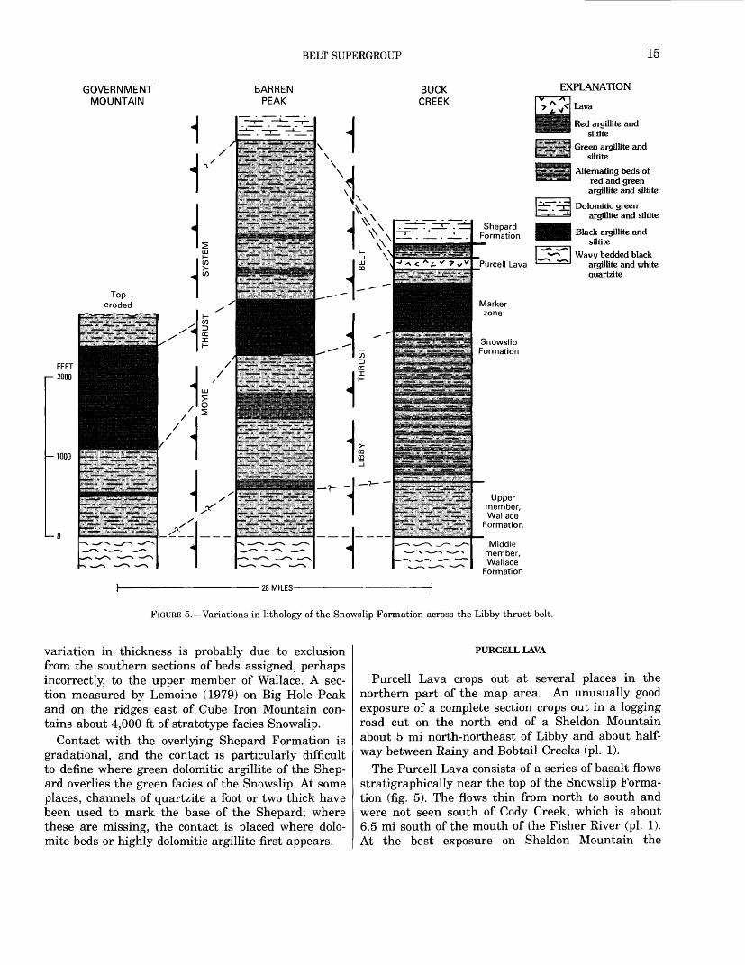
BELT SUPERGROUP 15
GOVERNMENT MOUNTAIN
BARREN PEAK
BUCK CREEK
28 MILES-
Shepard Formation
Purcell Lava
EXPLANATION
Lava
Red argillite and siltite
Green argillite and siltite
Alternating beds of red and green argillite and siltite
Dolomitic green argillite and siltite
Black argillite and siltite
Wavy bedded black argillite and white quartzite
Snowslip Formation
Uppermember.Wallace
Formation
Middlemember,Wallace
Formation
FIGURE 5. Variations in lithology of the Snowslip Formation across the Libby thrust belt.
variation in thickness is probably due to exclusion from the southern sections of beds assigned, perhaps incorrectly, to the upper member of Wallace. A sec tion measured by Lemoine (1979) on Big Hole Peak and on the ridges east of Cube Iron Mountain con tains about 4,000 ft of stratotype facies Snowslip.
Contact with the overlying Shepard Formation is gradational, and the contact is particularly difficult to define where green dolomitic argillite of the Shep ard overlies the green facies of the Snowslip. At some places, channels of quartzite a foot or two thick have been used to mark the base of the Shepard; where these are missing, the contact is placed where dolo mite beds or highly dolomitic argillite first appears.
PURCELL LAVA
Purcell Lava crops out at several places in the northern part of the map area. An unusually good exposure of a complete section crops out in a logging road cut on the north end of a Sheldon Mountain about 5 mi north-northeast of Libby and about half way between Rainy and Bobtail Creeks (pi. 1).
The Purcell Lava consists of a series of basalt flows stratigraphically near the top of the Snowslip Forma tion (fig. 5). The flows thin from north to south and were not seen south of Cody Creek, which is about 6.5 mi south of the mouth of the Fisher River (pi. 1). At the best exposure on Sheldon Mountain the

16 LIBBY THRUST BELT, NORTHWESTERN MONTANA
formation consists of 17 flows. The lower three flows are about 16 ft thick each and consist of long (1-2 in.) tabular plagioclase crystals in a fine-grained and highly altered groundmass. The lower flow rests on uneven wavy green beds of the Snowslip. Vague pil low structures and conspicuous vesicles occur at the tops of the porphyritic flows. The upper 14 flows average about 7 ft thick each and consist of fine grained basalt at the base grading upward into vesic- ulated tops. About 2 inches of green argillite sepa rates two of the flows. The rock is altered, and the vesicles are filled by quartz and calcite. Bases of some flows contain pebbles of the underlying unit. Maximum thickness of all flows is about 160 ft in the north central part of the map area.
SHEPARD FORMATION
The Shepard Formation crops out reasonably well in most of the map area where it occurs. Particularly good exposures of complete sections are on Cube Iron Mountain in the southeastern part of the map area and in the canyon of the Kootenai River about 12 mi west of Libby (pi. 1).
A variety of generally carbonate-rich lithologies are found in the Shepard. Most common are beds of platy, tan-weathering pale-green dolomitic argillite in graded couplets a tenth to a few tenths of an inch thick. Laminations are dominantly even parallel. Next most abundant are beds of green uneven-bed ded slightly dolomitic or calcareous interlaminated argillite and siltite that commonly display small- scale cut-and-fill structures, mud chips, ripple marks, and small molar-tooth structures where the vertical (and at places horizontal) calcite ribbons are rarely more than an inch long. Larger molar-tooth struc tures and horizontal calcite pods occur in impure dolomite beds that form another common lithology. These more dominant lithologies are interbedded at many places, though measured sections by Lemoine (1979) in the southeastern and southwestern parts of the map area indicate that most carbonate-rich rocks are in the lower part of the Shepard. Sparsely present at places are white quartzite beds as thick as 1 ft. Zones several feet thick of red interlaminated argillite and siltite are found at a few places interca lated in the more argillitic green beds, but these red beds have only been observed in the northern two- thirds of the map area. Stromatolite beds as thick as 10 ft occur in some outcrops and are particularly well exposed in the klippe of Shepard south of Buck Creek (pi. 1). Pyrite is common in most carbonate- rich rocks, and the large half-inch cubes in the
formation are probably the source of the name for Cube Iron Mountain. Black laminated argillite first appears in a westward direction in the Shepard For mation on Berray Mountain, which is near the lead ing thrust of the Moyie thrust system. Lemoine (1979) identifies a zone of black argillite about 250 ft thick whose top is about 850 ft below the top of the Shepard in his measured section on the south side of Berray Mountain. The black beds are sandwiched between green argillite and siltite zones that are sev eral hundred feet thick.
Contact with the overlying Mount Shields Forma tion is sharp and is placed at the base of the lowest red to maroon quartzite beds.
The Shepard Formation is particularly subject to deformation near thrust surfaces and commonly shows internal shears or chevron folds where it was caught up in tectonic environments that caused tight to overturned folds in other Belt formations. Where tectonic thinning or thickening does not appear to be a factor, the Shepard ranges in thick ness from about 2,800 ft on the Moyie thrust plate in the southwest part of the area to about 2,000 ft in the rest of the area.
MOUNT SHIELDS FORMATION
No well-exposed complete section of the Mount Shields Formation is known in the map area. How ever, all parts of the formation can be seen in road cuts, stream cuts, and other natural exposures in the area of Kootenai Falls and in the strip of Mount Shields that trends north then northeast from there to Little Tom Mountain (pi. 1).
Six informal members of the Mount Shields can be recognized in the map area (fig. 6). At places the upper two members have been mapped separately as the upper part of the Mount Shields. Member 1 at the base of the formation is composed dominantly of red to maroon quartzite and red siltite in beds that range from less than a foot to 3 ft thick. Films or thin partings of red argillite occur at the tops of most beds. The rock tends to split on those partings, and the broken rock or talus at outcrops gives the mis leading impression that the member contains abun dant argillite. Both the quartzite and siltite commonly display cross stratification and may con tain mud chips. The quartzite is slightly feldspathic and is the coarsest grained Belt rock in the area, commonly being a poorly sorted mixture of medium- and coarse-grained sand. Heavy minerals on bedding surfaces are abundant at some exposures. Stromato lites in beds a few feet thick are rare, but are

BELT SUPERGROUP 17
116°00' 115°00'
CLARK FORK SYLVANITEANTICLINE
(SA)Siltite facies of
Bonner Quartzite (Striped Peak 4)
Inferred isopachs on Mount Shields
Formation, in thousands of feet
Stiepard Fm (Wallace 4 and 5}Clark
Fork I 1,300ft)|
Shepard FormationL-2
Big Creek X(2,300 ft}/ 4
' X 5^ V 6
Superiordo,oooft)
V
SOUTHERNLIBBY TROUGH
(SLT)
Bonner Quartzite
1,2,3
Shepard Formation
Generalized lithology of informal members of the Mount Shields Formation: 6. Black and green laminated argillite5. Boxwork limestone interbedded with green dolomitic argillite 4. Green dolomitic argillite and siltite 3. Red and green argillite with salt casts 2. Flat-laminated pink dolomitic very fine grained quartzite 1. Red medium-grained quartzite and red siltite; red argillite partings
FIGURE 6. Thickness variations within members of the Mount Shields Formation and inferred isopach map of the entire formation.
reported by Lemoine (1979) in a measured section on the south side of Berray Mountain, are exposed on top of that mountain, outcrop north of Wolf Creek (north of Wolf Mountain), and are displayed in road cuts near Kootenai Falls along Highway 2 and about 3 mi west of the map area. Member 1 thins to the north and east from about 1,000 ft in the southeast ern part of the map area to about 300 ft in the north- central area and to only 150 ft in the Clark Fork area (fig. 6).
Member 2 is dominantly a pale-red or green, flat- laminated, coarse-grained siltite to fine-grained quartzite. The rock is blocky, feldspathic, and dolo mitic. Dolomite is in brown-weathering cement, streaks, and pods that are commonly an inch thick and a foot long parallel to the bedding. Parts of the quartzite show small cross beds and climbing ripple marks. Thin red or green argillite beds cap 6 ft or thicker layers of quartzite. Minor amounts of red or green argillite or argillitic siltite in beds a few feet
thick are randomly distributed through the member. Argillitic rocks generally show even parallel laminations, although beds capping quartzite com monly show ripple marks. At the top is one or more beds of red or buff stromatolites and oolites in a zone 20-100 ft thick. At the rare places where the stromatolite zone is missing, a zone of very dolo mitic siltite occurs. We place the contact directly on top of the stromatolite or dolomitic zone. This mem ber ranges in thickness from about 1,450 to 700 ft in the map area, and it thins to only 150 ft in the Clark Fork area (fig. 6).
Member 3 consists of layers a few feet to a few tens of feet thick of alternating red and green beds of inter- laminated argillite and siltite. Laminations are mostly even parallel to uneven parallel, and most are in graded couplets an inch or less thick. Sedimentary structures include mud chips, mud cracks, ripple marks, and fluid-escape structures. Salt casts are plentiful, particularly in the red beds but also in some
18 LIBBY THRUST BELT, NORTHWESTERN MONTANA
green beds. Pyrite is sparsely present, and small amounts of chalcopyrite or chalcocite occur in some green beds. This member is 700 to 1,200 ft thick in the map area but thins to about 300 ft at Clark Fork (fig. 6). Contact with the overlying member is gradational over a few tens to a few hundred feet.
Member 4 is blocky, green, dolomitic silty argillite. Laminations are even parallel and couplets grade from a dark-green silty argillite upward to a lighter green argillite. A few carbonate beds about a foot thick are scattered through the section and bioherms of elongated stromatolites occur in a few places in the lower part of the member. Ripple marks are common in the argillitic rocks, and some beds con tain salt casts. Contact with the overlying member 5 is gradational and is placed at the base of the first bed of boxwork limestone. Member 4 ranges in apparent thickness from about 350 to 550 ft in the map area; part of the variation is probably due to the difficulty of placing the contact consistently in the upper and lower gradational zones. However, the member thins to zero to the east at Clark Fork (fig. 6) and is known from mapping on the Kalispell I°x2° quadrangle (Harrison and others, 1992) to thicken to the north and east.
Gray silty limestone and dolomite that has conspic uous boxwork structure is the defining lithology for member 5. The boxwork is formed by vertical quartz veinlets combined with thin siltite laminations along bedding in the carbonate; boxes average about an inch on a side and are left in relief when the lime stone weathers out. The limestone weathers readily to a punky orange light-weight cellular mass that is held together by the siliceous boxes. Stromatolite mats and heads are found at places in the limestone. Green dolomitic silty argillite in beds as thick as 30 ft are interlayered with the boxwork limestone. These argillitic beds are similar to those of member 4. Thickness of the unit averages a few hundred feet (fig. 6) where exposed, but it is missing to the east and does not occur in the Mount Shields Formation in the Fishtrap Creek area west of Richards Peak (pi. 1), which is east of the lead thrust of the Libby thrust belt.
Member 6, at the top of the Mount Shields, is a black and green or white thinly laminated argillite and siltite. Laminations are wavy to even parallel. Sedimentary structures include conspicuous small- scale slump folds and sparse Desiccation cracks. Pyrite is common at places. Contact with the overly ing Bonner Quartzite is sharp. Thickness of this member is generally a few hundred feet (fig. 6), but like member 5, it is missing east of the lead thrust in the Libby thrust belt (pi. 1).
The marked thinning of the Mount Shields Forma tion between the Libby thrust belt and Clark Fork (fig. 6) reflects the east side of what has been inter preted as a dome formed by differential subsidence (Harrison, 1972). To the west of Clark Fork, the Mount Shields thickens toward the Chewelah area of eastern Washington (Miller and Clark, 1975). McMechan (1981) dismissed the dome on the basis of what she correctly identified as erroneous regional correlations by Harrison (1972) of units of the Mis- soula Group in the south part of Belt terrane near Missoula, Montana, with the upper part of the Wal lace and Striped Peak Formations near Clark Fork, Idaho. New geologic mapping has now filled the gap between Clark Fork and Missoula, which allows the tracing of facies in the Mount Shields Formation and Bonner Quartzite between those areas. The corrected correlations are shown by Harrison and others (1986, sheet 1, fig. 1) and in figure 6 of this report. This agrees, with minor variations, with McMechan's pro posed correlations of Canadian and U.S. formations (1981, figs. 10 and 11), which also show an unex plained mid-basin thinning of the upper part of the Dutch Creek (=Gateway=Mount Shields) Formation and its equivalents as it passes from north to south and east to west over the dome in the Clark Fork area. Thus, the interpretation of a dome is reinforced by more detailed data than was available to support the original interpretation, although its timing is changed slightly. Also, some of the previously unknown complications caused by strike-slip and thrust faulting in the eastern part of the dome are shown in figure 6.
BONNER QUARTZITE
The Bonner Quartzite crops out at several places in the southern two-thirds of the map area. A quartz- ite facies, similar to that at Bonner near Missoula, Montana (Nelson and Dobell, 1961, p. 199-201), is exposed sporadically in the southeastern area. A silt ite facies is well exposed in road and railroad cuts about 3 mi west of Libby and in cliffs on the north side of the Kootenai River about 8 mi west of Libby (pi. 1).
The facies of the Bonner Quartzite that is similar to that at Bonner has characteristic beds of red to pink, micaceous, arkosic, crossbedded, fine- to medium-grained quartzite containing red argillite interclasts. Crossbeds are both tabular and trough, and climbing ripples are common. Interbeds of red laminated argillite several feet thick increase in abundance to the north. Scattered beds of laminated,
BELT SUPERGROUP 19
green, fine-grained quartzite as much as 30 ft thick are sparsely present in the south and are slightly more abundant in the north. The quartzite facies gradually changes northward to a siltite facies, which we map north of lat 48° 15'. The siltite facies is char acterized by red to maroon, flat-laminated, fine grained quartzite or coarse siltite in beds a few feet thick interlayered with beds of red laminated argil- lite. Minor amounts of green laminated quartzite and siltite occur at places. Pink crossbedded quartzite of the quartzite facies forms only a few percent of the strata. Contact with the overlying McNamara or Libby Formation is sharp. Thickness of the Bonner is about 1,000 ft.
MCNAMARA FORMATION
The McNamara Formation as used in this report includes all the red and green argillitic strata above the Bonner Quartzite and below the lowest black laminated argillite of the Libby Formation. Expo sures of the McNamara are limited to the southeast ern part of the map area, and no McNamara is recognized north of lat 48°15/ (pi. 1). Moderately good exposures of the formation occur in the Fish- trap Creek area, particularly on the mountain to the west of the junction of Fishtrap Creek and the Thompson River.
Typical McNamara Formation consists of beds sev eral feet thick of red interlaminated argillite and silt ite that alternate with beds of green interlaminated argillite and siltite. Thin laminations of chert or chert in chips are characteristic of the formation. Laminations are most commonly even parallel, but some beds show wavy laminations. Sedimentary structures are abundant and include mud chips, mud cracks, ripple marks, small scale cut-and-fill struc tures, and fluid-escape structures. White to green quartzite layers and lenses a few inches thick may show crossbedding. Some outcrops display stromato lites in mats or heads. In general, red strata are thicker and more abundant in the south part of the map area and east of the lead thrust in the Libby thrust belt. The contact with the overlying Libby For mation, defined as the base of the first black argillite bed above the red or green strata, is sharp; however, green strata similar to those of the McNamara are interlayered with the black argillite over a zone many tens of feet thick. Thickness of the McNamara Formation as defined above ranges from a maximum of about 1,000 ft to 0 where it interfingers laterally with the Libby Formation.
LIBBY FORMATION
The Libby Formation was named by Gibson (1948) for extensive exposures of gray and greenish-gray argillite on the mountains north and south of the canyon of the Kootenai River about 8 mi west of Libby, Montana. The most complete section of the Libby Formation is on Flagstaff Mountain on the north side of the Kootenai River (pi. 1). These expo sures are on the east-dipping flank of the Sylvanite anticline (pi. 1). Less complete and less well-exposed sections of the Libby occur throughout much of the central and southern parts of the Libby thrust belt, particularly in the area of Fishtrap Creek (pi. 1). Kidder (1988) has measured sections on Flagstaff Mountain and in the Fishtrap Creek area, and the following descriptions are based in large part on Kid der's studies.
The Libby Formation has been subdivided by Kid der (1985, 1988) into seven informal members. The upper two members were mapped together as the upper part of the Libby Formation on Flagstaff Mountain (pi. 1). Contacts between all seven mem bers are gradational over several tens of feet except where otherwise noted in these descriptions.
The basal member is dominantly a dark-gray argil lite thinly interlaminated with dark-green siltite lay ers that have sharp bases and graded tops. Laminae are predominantly parallel but are in places wavy. Laminae thickness ranges from less than 0.1 to about 0.3 inch. Concretions and pyrite occur sparsely in a few beds. The member is about 180 ft thick.
The second member consists of alternating light- green and dark-green parallel-laminated siltite. Some zones a few feet thick are characterized by wavy lam inations. Other sedimentary structures include fluid- escape structures, shrinkage cracks, starved ripple marks, small scale cut-and-fill structures, flat rip-up clasts of siltite and rare chert, and load structures. This member is about 280 ft thick.
The third member is similar to the overlying and underlying parallel-to-wavy laminated green siltites but can be distinguished by its carbonate content, which occurs mainly as flat-mat to mound-shaped stromatolites that generally are in beds less than 3 ft thick. Stromatolitic zones occur about every 30 ft. Some of these zones are accompanied by oolites at the base or top of the stromatolite bed. Oolite beds as thick as 2 ft and not associated with stromatolites are also present, as are some dark-gray argillite beds. This member is about 950 ft thick.
The fourth member is characterized by wavy- laminated green argillite and siltite. Parallel lamina tion, which characterizes the second member, is
20 LIBBY THRUST BELT, NORTHWESTERN MONTANA
present but is not common. Ovoid carbonate concre tions that range in diameter from 1 to 10 inches are present in parts of the unit. Thickness of this mem ber is about 1,380 ft.
The fifth member is poorly exposed, but sparse exposures and float indicate that it consists of alter nating dark-gray argillite and wavy-laminated green siltite at the base that grades upward into parallel- laminated, platy, dark-gray argillite interlaminated with dark blue-green silty argillite. This member is about 1,850 ft thick. The upper contact is transitional from the argillite into wavy-laminated green siltite that has scattered small stromatolites and then into the overlying quartzite-bearing member.
The sixth member is a dark greenish-gray, blocky weathering, hummocky cross-laminated, coarse siltite to fine-grained quartzite. Some of the quartzite weathers to light greenish gray. The base of this member consists of planar-bedded coarse siltite over lain by gently undulating laminated siltite. Much of the rest of this member displays low-angle cross- stratification; bed tops are commonly hummocky and have 3 to 6 inches of relief on hummocks that are spaced 3 to 6 ft apart. Siltite or quartzite beds are 3 to 15 ft thick and are separated by 1- to 3-inch-thick partings of even parallel-laminated silty argillite. Rip-up clasts of silty argillite and chert, where present, are associated with scoured bases of the cross-stratified beds. Argillitic partings at places dis play shrinkage cracks. Thickness of this member is about 510 ft.
The seventh and uppermost member is a dark olive-gray silty argillite that appears in most expo sures to be structureless, but laminations less than 0.1 inch thick are observable at a few places. Mini mum thickness of this member is about 415 ft. The top of the formation is eroded in the Libby area.
The Libby Formation in the Fishtrap Creek area displays thickness and facies changes from the Flag staff Mountain area, and the upper part of the Libby is missing beneath the unconformity of early Middle Cambrian age. The basal dark-gray argillite of the Libby area is underlain at Fishtrap Creek by a pale greenish-yellow siltite unit of the McNamara Forma tion. The dark-gray argillite thins to about 65 ft and is underlain by about 130 ft of the greenish-yellow siltite. The second member of the Libby thickens at Fishtrap Creek to about 510 ft because of the addi tion of several zones of fine-grained quartzite. The carbonate-bearing member at Libby changes laterally to a facies rich in channel-fill quartzite lenses that are interbedded with green parallel-laminated siltite. The siltite zones commonly have maroon argillite tops that display Desiccation cracks or fluid-escape
structures. Carbonate is rare at Fishtrap Creek where this member thins to about 295 ft. Detailed correlation from Libby to Fishtrap Creek above the carbonate member is tenuous. Low-angle, cross-strat ified, fine-grained quartzite just below the unconfor mity at Fishtrap Creek may correlate to the quartzite in the upper part of the Libby Formation at Flagstaff Mountain, but faulting and limited expo sure at Fishtrap Creek render this a very tentative correlation.
The lowest three members of the Libby Formation thin from Libby, Montana, to Clark Fork, Idaho, and thus lend further support to the concept of a high area in the basin floor as discussed in the section of this report on the Mount Shields Formation. Thick nesses for the lower three members of the Libby at Clark Fork in ascending order are 155, 120, and 600 ft. About 1,000 ft of the fourth member is present at Clark Fork beneath the eroded top of the formation.
General descriptions of the Belt rocks in the Wal lace I°x2° quadrangle just below the unconformity at the base of the Cambrian Flathead Quartzite are given by Harrison and others (1986) as follows:
An oxidized zone, commonly a few feet thick, occurs beneath the Flathead in iron-rich rocks of the Belt, which include most argillites, siltites, and impure carbonates but not the quartzites or purer limestones and dolomites. The basal few feet of the Flathead may contain quartzite pebbles of the underlying Belt rocks, and the base of the Flathead is com monly reddish in color for three feet or more above the iron- bearing and weathered Belt units.
Those features are found in the Libby Formation at the unconformity in the Fishtrap Creek area, and in addition, a zone of silicification or a cherty bed about 2 inches thick commonly occurs along the unconformity.
CAMBRIAN STRATA
FLATHEAD QUARTZITE
Flathead Quartzite crops out only in the southeast ern part of the map area. Particularly good exposures can be found in a series of quarries just east of Fish- trap Creek south of its junction with Beartrap Fork (pi. 1). These quarries also expose the disconformity between the Middle Proterozoic Belt Supergroup and the Middle Cambrian Flathead.
The Flathead Quartzite consists of a lower unit of purple to maroon medium-grained quartz arenite that grades upward, and at places laterally, into a buff coarse-grained quartz arenite. The quartz aren ite is in part parallel laminated, but small crossbeds and ripple marks are common in the lower part and

CAMBRIAN STRATA 21
conglomeratic lenses on foresets of crossbeds are common in the upper part (Bush and others, 1984). Pebbles of the underlying Belt rocks are found at the base of the Flathead in some places. The lower part of the Flathead contains worm borings, worm marks, and some unidentified trace fossil tracks. Total thick ness of the formation is 25-30 ft.
WOLSEY SHALE
The Wolsey Shale is soft and friable and does not crop out well. Exposures are found in logging road cuts through the formation and in sporadic low out crops on ridges in the Fishtrap Creek area (pi. 1).
This shale unit was correlated to the Wolsey Shale of central northern Montana by Keim and Rector (1964), and the name Wolsey has been accepted by others studying the rocks of the Fishtrap Creek area (for example, Bush and Fischer, 1981; Bush and oth ers, 1984). The shale contains fossil trilobites and brachiopods that are of early Middle Cambrian age.
The Wolsey shale is dominantly an olive, fissile, thinly laminated rock. Bush and others (1984) described scattered beds of glauconitic crossbedded sandstone and, in the upper two-thirds of the forma tion, dolomitic lime mudstones interbedded with the olive shale. The contact is gradational to the overly ing formation and is drawn where dolomite first dom inates the section.
DOLOMITE OF FISHTRAP CREEK
An unnamed carbonate formation overlies the Wol sey Shale at Fishtrap Creek, crops out in a line of discontinuous exposure for about 30 mi to the north- northeast, and has been found in an isolated expo sure about 7 mi south of Troy (pi. 1). The formation was originally designated informally as the "Fishtrap dolomite" by Keim and Rector (1964), a term subse quently used by Bush and Fischer (1981). Because these rocks has never been named formally, we will refer to it as the dolomite of Fishtrap Creek.
Aadland (1979) divided the dolomite of Fishtrap Creek into five major units. The lower (number 1) member, about 800 ft thick, is dark gray limey mud- stone interlayered with shale. Member 2 is about 190 ft thick and "is characterized by three oolite pellet dolograinstone beds which are separated by thinner dolomudstone beds" (Bush and others, 1984). Mem ber 3 is dolomitic algal laminite interbedded with fine-grained crystalline dolomite; the member is about 300 ft thick. Member 4 is about 290 ft thick and is shale interbedded with minor amounts of
siltstone and impure dolomite. Member 5, at the top, is about 1,350 ft thick and is recrystallized dolomite. On the basis of stratigraphic correlations, Aadland (1979) suggested that the upper two members are Late Cambrian in age.
Bush, Kachek, and Webster (1985) found a sequence of quartz arenite and dolomite about 335 ft thick with an erosional top overlying the upper mem ber of the dolomite of Fishtrap Creek. Several small isolated exposures of the beds have been included with the Cambrian dolomite in this tiny area of our geologic map. However, the outcrops yield conodonts of Early Ordovician age (Bush and others, 1985).
SURFICIAL DEPOSITS
The map area is extensively covered by surficial deposits, largely of Pleistocene age (pi. 1). In many areas, bedrock exposures appear as islands in a sea of glacial debris that, in the north part of the map, covers the terrane to an elevation of about 6,000 ft.
GLACIAL DEPOSITS
Alden (in Gibson 1948; Alden, 1953) described and interpreted the glacial deposits in the Libby quadran gle and incorporated that data into a broader view that included all of western Montana. Mountain gla ciers coalescing into piedmont glaciers and eventu ally being overridden by a continental ice sheet that had repeated advances and retreats has left a com plex of glacial and fluvioglacial deposits in the map area. Lobes of the continental ice sheet moved south along the valley of Lake Creek and reached at least as far south as the North Fork of Bull River (Alden, 1953, pi. 1; G. M. Richmond, oral commun., 1985).
Glacial till and moraines are the most common deposits north of the Kootenai River, although such deposits are also present south of the Kootenai. Gla cial erratics of various kinds of granitic rocks unknown in the map area are found at a few places in the till. Along the Kootenai River and south of it gravels at various levels on benches and terraces are common in the major stream courses; till, end moraines, and alluvial fan deposits are present along the edges of those valleys and up the tributaries that head in amphitheaters or cirques.
LAKE SEDIMENTS
Buff laminated Pleistocene silt and some clay that hold steep faces in road or stream cuts have been mapped as lake sediment. These beds, at places as
22 LIBBY THRUST BELT, NORTHWESTERN MONTANA
thick as 300 ft, are interlayered with gravel and till and record part of the complicated history of multiple ponding and drainage events during Pleistocene gla- ciation (Alden, in Gibson, 1948, p. 49-61). Beds of lake silt are found as high as about 3,400 ft in eleva tion, as low as 2,000 ft, and at many places in between. Glacial silts along the Kootenai River and in drainages connecting to it are assigned by Alden (1953) to Glacial Lake Kootenai and those along the Clark Fork to Glacial Lake Missoula.
LANDSLIDE DEPOSITS
Two small landslide deposits are shown on the map. One is about a mile northeast of Savage Lake and consists of debris from the Shepard Formation mixed with glacial till. The second is on the road to McKillop Creek about 2 mi north of its junction with U. S. Highway 2. The McKillop Creek road has been built across tumbled blocks of Libby Formation that slid westward from the steep wall of a narrow valley, crossed the stream, and rode a short distance up the other valley wall.
ALLUVIAL DEPOSITS
Gravel, sand, silt, and clay in flood plains and low terraces along many present stream courses have been mapped as Holocene alluvium. Most streams are still cutting down through glacial deposits that filled valleys during the Pleistocene, and separation of Pleistocene from Holocene valley fill has been arbi trary at places.
INTRUSIVE IGNEOUS ROCKS
Intrusive igneous rocks in the map area are of Proterozoic, Early Cretaceous, and Tertiary ages. The Proterozoic intrusives are sills of diorite or gab- bro. Early Cretaceous plutons range widely in com position from granite to pyroxenite. A single Eocene pluton of quartz monzonite porphyry is known to be buried under Mount Silcox, and a few quartz latite porphyry and diorite dikes in the Prichard Forma tion near Callahan Creek are inferred to be Tertiary in age.
MAFIC SILLS
Mafic sills are abundant in the lower part of the Prichard Formation everywhere in the map area, although they were not mapped separately in the
south-central area. The sills also occur in the Burke, Wallace, and Snowslip Formations in the northern half of the map area. The best exposures are in the cirques and on the ridges in the northwestern part of the map area.
The mafic sills are diorite to gabbro in composition and range in thickness from a few feet to 1,500 ft. The rock is medium to coarse grained and is greenish black to mottled black and white. Principal minerals are hornblende and plagioclase, commonly accompa nied by various amounts of augite, quartz, and biotite. Minor amounts of potassium feldspar, pyrite, and ilmenite-magnetite occur in some samples. The rock commonly is altered, particularly the mafic min erals, and chlorite, calcite, or epidote are visible at many outcrops as well as in cuttings from the #1 Gibbs borehole. This probable auto-alteration (Bishop, 1973, p. 57-58) has destroyed most of the magnetite, and the sills commonly are not expressed in aeromagnetic data. Most sills display a finer grained chill margin. A hornfels zone a few hundred feet thick in the host Belt rocks is common around the thicker sills, but thinner sills have thinner con tact zones. Sills commonly persist for many miles and maintain approximately the same stratigraphic position. A few cut through the section, commonly at low angles (pi. 2, sec G-G').
An unusual massive quartzite bed in the lower part of the Prichard Formation directly overlies a sill that is 200-300 ft thick and crops out in the Meadow Creek area in the northwest part of the map area (pi. 1). The bed lacks bedding and internal structure and commonly contains matrix supported, randomly ori ented, plate-shaped bodies of silty argillite about a foot in diameter and an inch thick (Cressman and Harrison, 1986). The configuration probably resulted from fluidization that broke the bed apart during intrusion of the sill at the base of the bed.
Age of the sills is Proterozoic, but the number of separate intrusive events is uncertain. The sills in nearby areas outside the map area are scattered throughout the Belt Supergroup essentially from bot tom to top (Harrison and others, 1986). Only one sill, in the lower part of the Prichard near Bonners Ferry, Idaho, just west of the mapped area, about 10 mi west of Troy, Montana, has been found that has a zircon-bearing granitic differentiate. Igneous zircon from that sill yielded an age of 1,430±30 m.y. (Zart- man and others, 1982). This has influenced us to assign the mafic sills in the Prichard to the Middle Proterozoic. Attempts to date the sills in any part of the Belt Supergroup by K-Ar and Rb-Sr methods have generally been equivocal, as those methods yield ages of 700-900 m.y, even on sills from the
INTEUSIVE IGNEOUS EOCKS 23
Prichard (Obradovich and Peterman, 1968; Marvin and others, 1984). Clearly, the sills in the upper part of the Belt must be younger than 1,430 m.y. The top of the Belt can be no older than about 1,250 m.y. (Elston, 1984) and probably is as young as 900 m.y. (Obradovich and others, 1984). Harrison (1972) sug gested three periods of intrusion of the sills, at about 1,400, 1,100, and 700 m.y. As a consequence of the uncertainty in age, we have assigned the sills above the Prichard to the Middle to Late Proterozoic.
FELSIC CALC-ALKALIC PLUTONS
Plutons ranging in composition from granite to granodiorite are intruded into Belt strata in the southern half of the map area. The largest exposed plutons are the Dry Creek stock in the Cabinet Mountains east of Bull Lake and the Vermilion River stock near the mouth of the Vermilion River (pi. 1). A buried quartz porphyry pluton under Mount Silcox is known from drill holes (pi. 2, sec. P-P'). Three smaller exposures of granitic rocks similar to the Dry Creek stock occur a few miles north, west, and south of Dry Creek (pi. 1).
According to Gibson (1948, p. 24-28), the Dry Creek stock is a very light gray, massive, medium- grained quartz monzonite to granodiorite that con sists principally of quartz, potash feldspar, andesine, and biotite. Minor constituents include hornblende, apatite, zircon, and monazite. The rock is sheared and foliated where it is cut by faults, particularly on the west side of the stock (Wells and others, 1981, p. 17). A minimum age of 73±2 m.y. was determined by Rb/Sr isochron on microcline and biotite from the Dry Creek stock (Z. E. Peterman in Wells and others, 1981, p. 17). An unusually high initial Sr87/Sr86 ratio of 0.7130 as determined from the isochron on microcline and biotite suggests postcrystallization exchange, and we infer that this stock probably belongs to the 100 m.y. old intrusive event that is common in this region (Marvin and others, 1984), rather than representing a unique event.
The Vermilion River stock is a medium- to coarse grained gray hornblende granodiorite. Principal con stituents are potash feldspar, plagioclase, horn blende, and quartz. Hornblende at places has been altered to biotite or chlorite. On the southwest side near the Hope fault zone (pi. 1) the pluton is sheared and altered. Zircon from the granodiorite yields an age of 103±8 m.y. (Marvin and others, 1984).
Buried under Mount Silcox is a quartz monzonite porphyry that has been explored by Noranda Explo ration, Inc., for molybdenite and scheelite. Core and descriptions provided to us by Noranda staff show
the buried pluton, called the Liver Peak stock, to be a leucocratic quartz monzonite porphyry. Fresh hydrothermal biotite in selvage around sulfide vein- lets yielded a K-Ar age of about 40 m.y.; zircon and biotite from the quartz monzonite yielded ages of about 45 and 50 m.y, respectively (Marvin and oth ers, 1984).
All stocks and plutons show contact metamorphic zones around them. Clastic Belt rocks have been altered to biotite hornfels; carbonate-bearing strata are altered to a hornfels, commonly displaying tremo- lite, clinozoisite, or epidote. Alteration zones are par ticularly conspicuous and several thousand feet wide around the Dry Creek and Liver Peak stocks. The contact zone around the Vermilion River stock is not as obvious, probably because the stock intruded the Prichard Formation which was already regionally metamorphosed to the biotite zone of the greenschist facies prior to intrusion of the stock.
PYROXENITE
Pyroxenite is the principal ultramafic rock in the pyroxenite-syenite complex exposed in a stock at Rainy Creek and on top of Vermiculite Mountain. Altered pyroxenite in this stock is the main source of vermiculite in the United States and is mined by the Zonalite Division, W R. Grace, and Company. The most extensive study of the igneous complex was done by Boettcher (1966, 1967); the descriptions that follow are derived largely from his work plus map ping around the body by one of the writers (J.E. Har rison) and a single visit to the open-pit mine to collect samples for radiometric age dating.
The ultramafic complex consists of a biotitite core that is surrounded by biotite pyroxenite and finally an outer ring of magnetite pyroxenite. The biotitite core consists almost entirely of randomly oriented books of biotite that range in size from half-an-inch to more than 3 ft in diameter. A sample of the bioti tite was analyzed by C. E. Hedge, U.S. Geological Survey, to determine the age of the biotite. Hedge (unpub. data, 1982) reported:
ppm Eb = 356, ppm Sr = 33.5, Eb87/Sr86 = 30.98, Sr87/Sr86 = 0.7499. Assuming an initial Sr87/Sr86 ratio of 0.704, the age of the mineral is 104 ± 3 m.y.
Boettcher (1966, p. 19) reported a Rb/Sr age on the biotitite of 94 m.y; no analytical data or limit of error are given.
Biotite pyroxenite, consisting essentially of clinopy- roxene, vermiculite, hydrobiotite, and biotite, is the economically important rock of the complex. This pyroxenite contains all the economically important vermiculite deposits. The vermiculite is intimately
24 LIBBY THRUST BELT, NORTHWESTERN MONTANA
mixed with pyroxene in various proportions. Boet- tcher suggested (1966, p. 144) that hydrobiotite is a hydrothermal alteration product of original biotite, whereas vermiculite is a low temperature product of leaching of the biotite by ground waters.
Magnetite pyroxenite of the outer zone in the ultramafic complex is medium to coarse grained and consists of clinopyroxene, magnetite, and biotite with minor amounts of andradite, sphene, and biotite or vermiculite. Dikes and apophyses of this rock cut the biotite pyroxenite. The abundant magnetite causes a pronounced magnetic high anomaly in the aeromag- netic data (M.D. Kleinkopf, oral commun., 1989).
A small amount of fenite in Belt rocks at the north contact of the complex suggested to Boettcher (1967, p. 549) that carbonatite may be a part of the complex at depth.
In the Rainy Creek area, the complex intrudes a syncline where limbs steepen in the vicinity of the complex. On the north side of the pluton, the syn cline plunges southward, so the complex occupies the center of an elongate structural basin (pi. 1; pi. 2, sec. H-H'}. In contrast, the top of the complex is a flat dome that dips outward. We suggest that the complex is mushroom-shaped laccolith and that the over-steepened strata of the syncline were forced down to make room beneath for the complex, whereas the strata above were domed. The lack of cognate inclusions or blocks of Belt rocks within the complex further supports the concept that the igne ous rocks forcefully split the stratigraphic units to create room for the intrusives without causing loss of coherence of the host rocks.
Data on relative age of intrusion and of regional faulting are shown by maps in and around the com plex. A backslid thrust fault, showing a minimal reverse throw of 3,000 ft, that follows the axis of the syncline to the south (pi. 1) is not identifiable in maps of the mine (Boettcher, 1967, pi. 1 and figs. 2 and 3) and does not appear to offset the contacts between the complex and the Belt strata. The thrust is steep as seen on topography and is not likely to wrap around the east side of the complex. These rela tions suggest that the 104 m.y. old complex post dates thrusting.
SYENITE
Syenite forms a stock on Bobtail Creek and a plu ton and dikes in the pyroxenite-syenite complex along Rainy Creek. The Bobtail Creek pluton is pre dominantly a coarse-grained porphyritic syenite that contains darker segregations rich in pyroxene and
amphibole. Gibson (1948, p. 30) described the rock as follows:
The minerals most abundant in the stock are orthoclase, pyroxene, and andesine, which together make up more than 90 percent of the rock. Orthoclase in large euhedral grains is commonly the predominant mineral, but in the ferro- magnesian facies it may amount to only 10 percent or even less. Andesine is almost invariably present, and in some places it is abundant enough to justify calling the rock a monzonite. The accessory minerals apatite, magnetite, and sphene occur in all specimens; zircon and pyrite are present in a few. Hornblende varies greatly in amount and in a few places is almost as abundant as pyroxene. A little sericite, chlorite, epidote, allanite, zoisite, leucoxene, rutile, and iron oxide have grown at the expense of other minerals.
The syenite in the igneous complex at Rainy Creek is slightly different from that of the Bobtail Creek stock. Boettcher (1966, p. 16) gave the following description of the syenite and its relations to the ultramafic rocks at Rainy Creek and on Vermiculite Mountain:
The large body of syenite that borders the ultramafic pluton on the southwest extends through the outer magnetite pyroxenite into the inner pyroxenite zone. The bulk of the exposed syenite is hololeucrocratic, coarse-grained, quartz- free rock consisting of microcline microperthite with about 20 to 30 percent muscovite pseudomorphic after nepheline. Where exposed, the syenite near the contact with the Belt Series contains quartz, no muscovite, and, locally, aegirine- augite. An apophysis of syenite, which contains aegirine- augite, extends from the large syenite mass into the pyrox enite and to the west end of the open pit mine, where it divides into many smaller dikes. These and many other alkaline syenite dikes cut the pyroxenite, magnetite pyrox enite, and biotitite. Almost without exception, alteration zones of fibrous tremolite and carbonate have formed at the expense of the pyroxenite in contact with these dikes.
Belt strata adjacent to both the Bobtail Creek and Rainy Creek bodies of syenite show contact metamor- phic effects. Pelitic rocks have been coarsened by recrystallization and show conspicuous growth of biotite. Carbonate-bearing strata contain moderately abundant clinozoisite and epidote, which give a dis tinct greenish cast to the rocks.
Boettcher (1966, p. 95) considered the ultramafic rocks and the syenite at Rainy Creek to be comag- matic. The age of the syenite would then be about that of the pyroxenite complex, which is about 100 m.y.
DIKES
A few dikes of quartz latite porphyry and diorite were intruded into the Prichard Formation near Cal- lahan Creek and on Grouse Mountain (pi. 1). Many dikes are highly altered and are associated with silver-lead veins (Gibson, 1948, p. 97-109). Gibson
STRUCTURE 25
(1948, p. 34) noted that the less altered diorite dikes are composed chiefly of hornblende and andesine. Age of these rocks is uncertain, but they are probably related in time to the diabase and porphyry dikes of the Idaho Panhandle. Those dikes are early Tertiary in age (Harrison and others, 1972).
STRUCTURE
Structural analysis of the Libby thrust belt is based on the geologic map (pi. 1), supplementary observations at critical outcrops, and a set of 16 cross sections (pi. 2). The analysis uses map patterns and observed fold and fault types projected along strike or plunge to a series of sections drawn approximately parallel to the direction of tectonic transport. These studies are the first step in constructing balanced cross sections from newly completed geologic map ping across the entire United States part of the Rocky Mountain thrust belt, of which the Libby thrust belt is a small but critical part. The cross sec tions of this report are primarily constrained only by surface geology, and data are projected only to 14,000 ft below sea level in an area where basement and the basal surface of detachment can be projected from the work of Bally and others (1966) or Price and Fermor (1985) to be at least 40,000 ft below sea level.
Cross sections on plate 2 are balanced in the sense that they have been cut apart and restored to assure that footwall and hanging wall match and that the geometry and rock volumes shown in the sections are possible. In addition, bed lengths are the same when measured at the base of the Snowslip Formation and at the base of the Burke Formation between the axial surfaces of the easternmost and westernmost synclines on sections K and L (pi. 2). Other sections have insufficient data across them to apply the bed length test (Dahlstrom, 1969).
A series of logical but empirical rules, assumptions, and geometric methods have been developed over the past 20 years for analyzing geologic maps, drill-hole information, and seismic data in thrust belts (for example, in the Rocky Mountain fold and thrust belt see Bally and others, 1966; Dahlstrom, 1969, 1970; Price and Mountjoy, 1970; Elliott, 1976; and Price, 1981). Although these ground rules are primarily designed for predicting geometry of strata in deep crustal sections, many are applicable to shallower sections. The following discussion on structure will describe some of the details of the folds and faults of the Libby thrust belt, will list the assumptions made in constructing the cross sections, and will identify where the structures seen in the area are similar to
or differ from Rocky Mountain thrust belt structures found elsewhere.
Before discussing details of the folds and thrust faults, we need to list the series of assumptions that were involved in preparation of the geologic map and cross sections, which are the principal means by which thrusting and folding is analyzed. Some of the assumptions may seem obvious, but they are listed here for completeness.
1. The thickness and facies variations of strati- graphic units change gradually between areas where thickness and facies can be determined. Extensive faulting in the map area disrupts the stratigraphic sequence to the point where complete sections of for mations and members are rare and widely scattered, so variations must be interpolated on some logical basis between those complete sections.
2. Proterozoic mafic sills are persistent at about the same stratigraphic interval over long distances. The sills are most abundant in the Prichard Forma tion and have been traced for many miles in surface exposures on 1:250,000 regional geologic maps (Har rison and others, 1981, 1986, 1992). The thicker sills encountered in the ARCO-Marathon Gibbs No. 1 borehole (fig. 11) are assumed to be persistent and are projected into the Prichard Formation shown in the east end of the cross sections (pi. 2). These sills form prominent seismic reflectors and can be identi fied in seismic lines from the Libby thrust belt east to the Rocky Mountain trench (Harrison and others, 1985).
3. The throw on a high-angle normal fault is essentially constant along its strike unless the fault ends in a fold or is intersected by another fault. Where joined by another high-angle fault, the throw then becomes the approximate mathematical sum or difference of the throws on the two intersecting faults.
4. Nonvertical faults that intersect on the map must intersect in cross sections drawn near their intersection on the map.
5. Thrust faults cut up section in the direction of tectonic transport except where they locally cut through pre-thrust folds.
6. The amount of tectonic transport on a given thrust fault is approximately the same from one of the closely spaced cross sections to the next, and changes due to horizontal rotation gradually increase along the length of the fault away from the point of rotation, such as in a transfer zone.
7. Total apparent displacement on a thrust system (frontal thrust plus overlying splays or imbricates) is the mathematical sum of the forward translation on
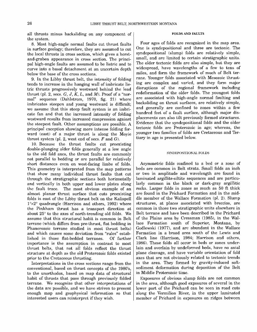
26 LIBBY THRUST BELT, NORTHWESTERN MONTANA
all thrusts minus backsliding on any component of the system.
8. Most high-angle normal faults cut thrust faults in surface geology; therefore, they are assumed to cut the local thrusts in cross section, which gives a horst- and-graben appearance in cross section. The princi pal high-angle faults are assumed to be listric and to curve into a basal detachment at an uncertain depth below the base of the cross sections.
9. In the Libby thrust belt, the intensity of folding tends to increase in the hanging wall of imbricate lis tric thrusts progressively westward behind the lead thrust (pi. 2, sees. G, J, K, L, and M). Proof of a "nor mal" sequence (Dahlstrom, 1970, fig. 21) where imbricates steepen and young westward is difficult; we assume that this steep fault system is an imbri cate fan and that the increased intensity of folding westward results from increased compression against the steepest fault. Other assumptions are possible. A principal exception showing more intense folding for ward (east) of a major thrust is along the Moyie thrust system (pi. 2, west end of sees. F and G).
10. Because the thrust faults cut preexisting double-plunging older folds generally at a low angle to the old fold axes, the thrust faults are commonly not parallel to bedding or are parallel for relatively short distances even on west-facing limbs of folds. This geometry is interpreted from the map patterns that show many individual thrust faults that cut through the stratigraphic sections both horizontally and vertically in both upper and lower plates along the fault trace. The most obvious example of an almost planar thrust surface that cuts preexisting folds is east of the Libby thrust belt on the Kalispell I°x2° quadrangle (Harrison and others, 1992) where the Pinkham thrust has a transport direction at about 25° to the axes of north-trending old folds. We assume that this structural habit is common in Belt terrane (which differs from pre-thrust, flat bedding in Phanerozoic terrane studied in most thrust belts) and which causes some deviation from "rules" estab lished in those flat-bedded terranes. Of further importance is the assumption in contrast to most thrust belts, that not all folds reflect the thrust structure at depth as the old Proterozoic folds existed prior to the Cretaceous thrusting.
Interpretations in the cross sections range from the conventional, based on thrust concepts of the 1980's, to the unorthodox, based on map data of structural habit of thrusts that pass through previously folded terrane. We recognize that other interpretations of the data are possible, and we have striven to present enough map and geophysical information so that interested users can reinterpret if they wish.
FOLDS AND FAULTS
Four ages of folds are recognized in the map area. One is syndepositional and three are tectonic. The syndepositional (slump) folds are relatively simple, small, and are limited to certain stratigraphic units. The older tectonic folds are also simple, but they are widespread, have wavelengths of a few to tens of miles, and form the framework of much of Belt ter rane. Younger folds associated with Mesozoic thrust ing are complex and varied, and they form major disruptions of the regional framework including redeformation of the older folds. The youngest folds are associated with high-angle normal faulting and backsliding on thrust surfaces, are relatively simple, and generally are confined to zones within a few hundred feet of a fault surface, although major dis placements can also tilt previously formed structures. Evidence that the syndepositional folds and the older tectonic folds are Proterozoic in age; whereas, the younger two families of folds are Cretaceous and Ter tiary in age is presented below.
SYNDEPOSITIONAL FOLDS
Asymmetric folds confined to a bed or a zone of beds are common in Belt strata. Small folds an inch or two in amplitude and wavelength are found in laminated argillite-siltite sequences and are particu larly common in the black or dark-gray argillitic rocks. Larger folds in zones as much as 50 ft thick are found in the Prichard Formation and in the mid dle member of the Wallace Formation (pi. 2). Slump structures, at places associated with breccias, are common in those two stratigraphic units elsewhere in Belt terrane and have been described in the Prichard of the Plains area by Cressman (1985), in the Wal lace Formation south of Superior, Montana, by Godlewski (1977), and are abundant in the Wallace Formation in a broad area south of the Lewis and Clark line (Harrison, 1984; Harrison and others, 1986). These folds all occur in beds or zones under lain and overlain by undeformed beds, have no axial plane cleavage, and have variable orientation of fold axes that are not obviously related to tectonic trends in the area. They formed by gravity-induced soft- sediment deformation during deposition of the Belt in Middle Proterozoic time.
Exposures of obvious slump folds are not common in the area, although good exposures of several in the lower part of the Prichard can be seen in road cuts along the Vermilion River, in the upper laminated member of Prichard in exposures on ridges between
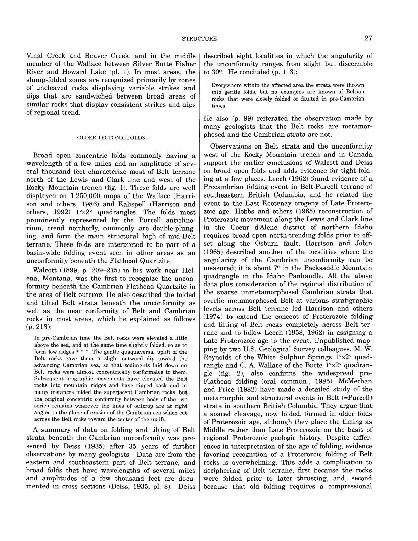
STRUCTURE 27
Vinal Creek and Beaver Creek, and in the middle member of the Wallace between Silver Butte Fisher River and Howard Lake (pi. 1). In most areas, the slump-folded zones are recognized primarily by zones of uncleaved rocks displaying variable strikes and dips that are sandwiched between broad areas of similar rocks that display consistent strikes and dips of regional trend.
OLDER TECTONIC FOLDS
Broad open concentric folds commonly having a wavelength of a few miles and an amplitude of sev eral thousand feet characterize most of Belt terrane north of the Lewis and Clark line and west of the Rocky Mountain trench (fig. 1). These folds are well displayed on 1:250,000 maps of the Wallace (Harri- son and others, 1986) and Kalispell (Harrison and others, 1992) I°x2° quadrangles. The folds most prominently represented by the Purcell anticlino- rium, trend northerly, commonly are double-plung ing, and form the main structural high of mid-Belt terrane. These folds are interpreted to be part of a basin-wide folding event seen in other areas as an unconformity beneath the Flathead Quartzite.
Walcott (1899, p. 209-215) in his work near Hel ena, Montana, was the first to recognize the uncon formity beneath the Cambrian Flathead Quartzite in the area of Belt outcrop. He also described the folded and tilted Belt strata beneath the unconformity as well as the near conformity of Belt and Cambrian rocks in most areas, which he explained as follows (p. 213):
In pre-Cambrian time the Belt rocks were elevated a little above the sea, and at the same time slightly folded, so as to form low ridges * * *. The gentle quaquaversal uplift of the Belt rocks gave them a slight outward dip toward the advancing Cambrian sea, so that sediments laid down on Belt rocks were almost concentrically conformable to them. Subsequent orographic movements have elevated the Belt rocks into mountain ridges and have tipped back and in many instances folded the superjacent Cambrian rocks, but the original concentric conformity between beds of the two series remains wherever the lines of outcrop are at right angles to the plane of erosion of the Cambrian sea which cut across the Belt rocks toward the center of the uplift.
A summary of data on folding and tilting of Belt strata beneath the Cambrian unconformity was pre sented by Deiss (1935) after 35 years of further observations by many geologists. Data are from the eastern and southeastern part of Belt terrane, and broad folds that have wavelengths of several miles and amplitudes of a few thousand feet are docu mented in cross sections (Deiss, 1935, pi. 8). Deiss
described eight localities in which the angularity of the unconformity ranges from slight but discernible to 30°. He concluded (p. 113):
Everywhere within the affected area the strata were thrown into gentle folds, but no examples are known of Beltian rocks that were closely folded or faulted in pre-Cambrian times.
He also (p. 99) reiterated the observation made by many geologists that the Belt rocks are metamor phosed and the Cambrian strata are not.
Observations on Belt strata and the unconformity west of the Rocky Mountain trench and in Canada support the earlier conclusions of Walcott and Deiss on broad open folds and adds evidence for tight fold ing at a few places. Leech (1962) found evidence of a Precambrian folding event in Belt-Purcell terrane of southeastern British Columbia, and he related the event to the East Kootenay orogeny of Late Protero- zoic age. Hobbs and others (1965) reconstruction of Proterozoic movement along the Lewis and Clark line in the Coeur d'Alene district of northern Idaho requires broad open north-trending folds prior to off set along the Osburn fault. Harrison and Jobin (1965) described another of the localities where the angularity of the Cambrian unconformity can be measured; it is about 7° in the Packsaddle Mountain quadrangle in the Idaho Panhandle. All the above data plus consideration of the regional distribution of the sparse unmetamorphosed Cambrian strata that overlie metamorphosed Belt at various stratigraphic levels across Belt terrane led Harrison and others (1974) to extend the concept of Proterozoic folding and tilting of Belt rocks completely across Belt ter rane and to follow Leech (1958, 1962) in assigning a Late Proterozoic age to the event. Unpublished map ping by two U.S. Geological Survey colleagues, M. W. Reynolds of the White Sulphur Springs I°x2° quad rangle and C. A. Wallace of the Butte I°x2° quadran gle (fig. 2), also confirms the widespread pre- Flathead folding (oral commun., 1985). McMechan and Price (1982) have made a detailed study of the metamorphic and structural events in Belt (=Purcell) strata in southern British Columbia. They argue that a spaced cleavage, now folded, formed in older folds of Proterozoic age, although they place the timing as Middle rather than Late Proterozoic on the basis of regional Proterozoic geologic history. Despite differ ences in interpretation of the age of folding; evidence favoring recognition of a Proterozoic folding of Belt rocks is overwhelming. This adds a complication to deciphering of Belt terrane, first because the rocks were folded prior to later thrusting, and, second because that old folding requires a compressional
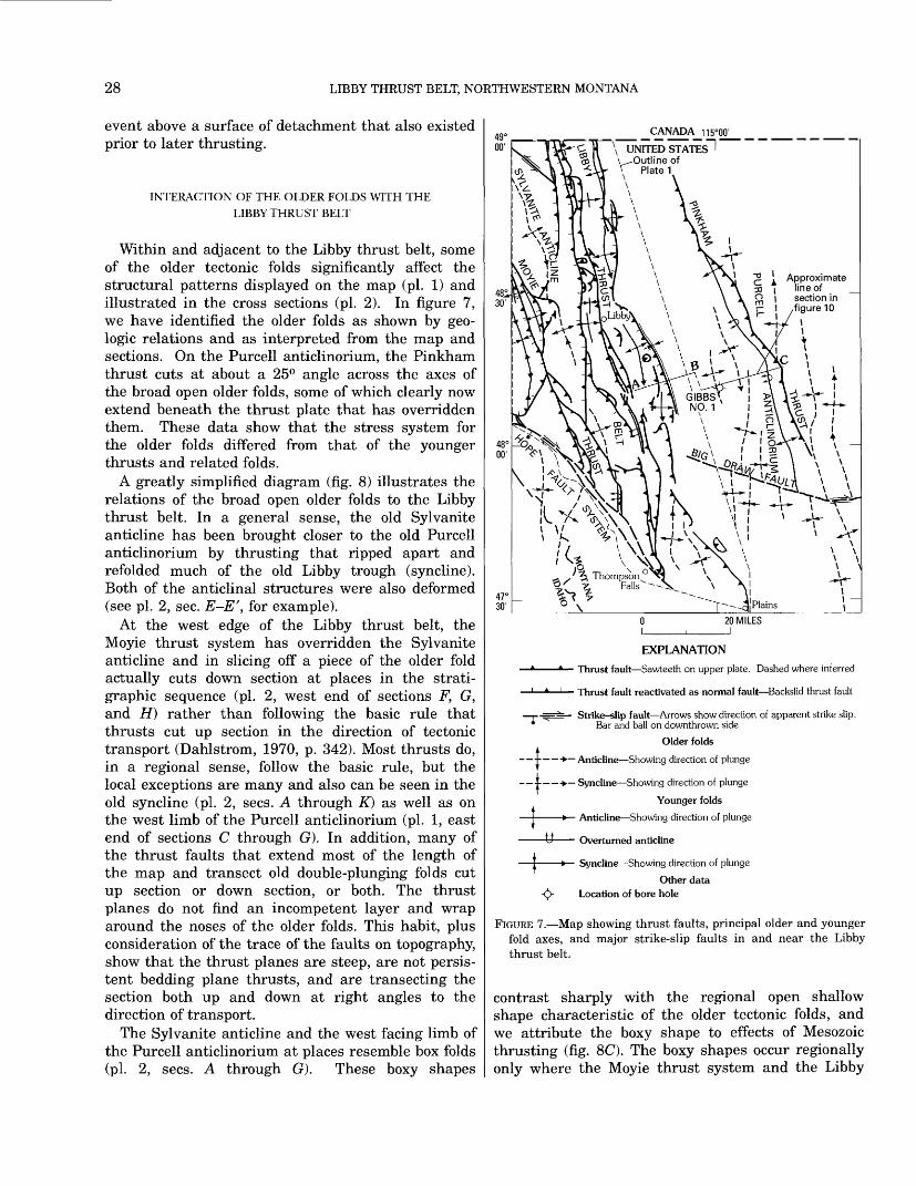
28 LIBBY THRUST BELT, NORTHWESTERN MONTANA
event above a surface of detachment that also existed prior to later thrusting.
INTERACTION OF THE OLDER FOLDS WITH THE LIBBY THRUST BELT
Within and adjacent to the Libby thrust belt, some of the older tectonic folds significantly affect the structural patterns displayed on the map (pi. 1) and illustrated in the cross sections (pi. 2). In figure 7, we have identified the older folds as shown by geo logic relations and as interpreted from the map and sections. On the Purcell anticlinorium, the Pinkham thrust cuts at about a 25° angle across the axes of the broad open older folds, some of which clearly now extend beneath the thrust plate that has overridden them. These data show that the stress system for the older folds differed from that of the younger thrusts and related folds.
A greatly simplified diagram (fig. 8) illustrates the relations of the broad open older folds to the Libby thrust belt. In a general sense, the old Sylvanite anticline has been brought closer to the old Purcell anticlinorium by thrusting that ripped apart and refolded much of the old Libby trough (syncline). Both of the anticlinal structures were also deformed (see pi. 2, sec. E-E', for example).
At the west edge of the Libby thrust belt, the Moyie thrust system has overridden the Sylvanite anticline and in slicing off a piece of the older fold actually cuts down section at places in the strati- graphic sequence (pi. 2, west end of sections F, G, and H) rather than following the basic rule that thrusts cut up section in the direction of tectonic transport (Dahlstrom, 1970, p. 342). Most thrusts do, in a regional sense, follow the basic rule, but the local exceptions are many and also can be seen in the old syncline (pi. 2, sees. A through K) as well as on the west limb of the Purcell anticlinorium (pi. 1, east end of sections C through G). In addition, many of the thrust faults that extend most of the length of the map and transect old double-plunging folds cut up section or down section, or both. The thrust planes do not find an incompetent layer and wrap around the noses of the older folds. This habit, plus consideration of the trace of the faults on topography, show that the thrust planes are steep, are not persis tent bedding plane thrusts, and are transecting the section both up and down at right angles to the direction of transport.
The Sylvanite anticline and the west facing limb of the Purcell anticlinorium at places resemble box folds (pi. 2, sees. A through G). These boxy shapes
__ CANADA 115°00'
V UNITED STATES^
Approximate line of section in figure 10
EXPLANATION
-* Thrust fault Sawteeth on upper plate. Dashed where inferred
-1 Thrust fault reactivated as normal fault Backslid thrust fault
-T--== Strike-slip fault Arrows show direction of apparent strike slip. Bar and ball on downthrown side
Older folds
- t * Anticline Showing direction of plunge
- + > Syncline Showing direction of plunge
Younger folds
> Anticline Showing direction of plunge
JJ_ Overturned anticline
t » Syncline Showing direction of plunge
Other data -(J> Location of bore hole
FIGURE 7. Map showing thrust faults, principal older and younger fold axes, and major strike-slip faults in and near the Libby thrust belt.
contrast sharply with the regional open shallow shape characteristic of the older tectonic folds, and we attribute the boxy shape to effects of Mesozoic thrusting (fig. 8C). The boxy shapes occur regionally only where the Moyie thrust system and the Libby
STRUCTURE 29
North \- - Incipient thrust\ plane and
WPA \ transport \ direction
SA WPA
Fault bend PINKHAM Box fold \ THRUST
"T Incipient thrust
A. Incipient thrust parallels bedding or contacts at places but cuts across others. Remnant Cambrian strata discon- formable in syncline.
C. Simplified present thrust structure. Sylvanite anticline steepened and apparent axis deformed, thrust splays al most destroy Libby syncline, and stepped thrust plus ramp fold deform west edge of Purcell anticlinorium. Some thrust surfaces reactivated by normal movement during Cenozoic extension. Dozens of Cenozoic listric normal extension faults not shown.
NorthWPA
EXPLANATION
SA Sylvanite anticline
LS Libby syncline or trough
LTB Libby thrust belt
WPA Fold at west edge of Purcell anticlinorium
FEET 30,000 r
APPROXIMATE SCALES15 MILES
B. Old folds steepened by compression in upper plate and "out of the syncline" thrust splay forms along west-facing limb of Purcell anticlinorium.
FIGURE 8. INTERPRETATIVE SKETCH ILLUSTRATING EFFECTS OF OLDER PROTEROZOIC DOUBLY PLUNG ING FOLDS ON YOUNGER MESOZOIC THRUSTS AND FOLDS THAT CROSS THEM AT A LOW ANGLE
30 LIBBY THRUST BELT, NORTHWESTERN MONTANA
thrust belt converge. The east side of the Purcell anticlinorium, for example, is a relatively simple limb of a concentric fold panel that dips about 30° easterly (Harrison and others, 1992). Box folds formed in thrust terrane of the southern Canadian Rocky Mountains are illustrated by Dahlstrom (1970, p. 365-372), who shows photographs of spectacular exposures. The Libby thrust belt does contain some small box folds that fit the concept of ramp (fault bend) folds related to thrusting, but we attribute the boxy shape of the Sylvanite anticline and the west limb of the Purcell anticlinorium to oversteepening of flanks of older concentric folds during later thrusting. We suggest that the steep east limb of the Sylvanite anticline in the north part of the map area (pi. 1) reflects drag folding in the upper plates of thrust faults within the Libby thrust belt (pi. 2, sees. A through C), and that the steep west limb of the Pur cell anticlinorium (pi. 2, sees. A through G) reflects refolding and local downwarping of an older more open fold (pi. 2, sees. A through P).
THRUST FAULTS AND ASSOCIATED FOLDS
Age of thrusting and related folding in the north ern part of the Rocky Mountain fold and thrust belt has been well established by studies too numerous to list. Proterozoic rocks are thrust over Paleozoic and Mesozoic strata that in turn are cut by Cretaceous and Tertiary plutons and by grabens filled by Ter tiary sediments. Within the Libby thrust belt, plu tons intruded at about 100 m.y. cut the thrusts and associated folds (pi. 1; pi. 2, sees. G, H, I, J, and AO, which indicates that the thrusting and associated folding is about 100 m.y. or older. This places the age of the Libby thrust belt at about the middle of the long tectonic interval of continental override of western North America that began in the northern Rockies about 200 m.y. ago and ended about 60 m.y. ago (Monger and Price, 1979).
The Libby thrust belt extends from the Hope fault on the south northward at least to the Canadian bor der (fig. 7). A tectonic element that bounds the north end of the Libby thrust belt has yet to be defined. The south edge of a detailed geologic map by H0y and Daikow (1982) is just 18 mi north of the Cana dian border due north of the Libby thrust belt and includes a complete section of Purcell (equivalent to Belt) strata similar to that in the Libby area. How ever, the area in Canada between the Moyie thrust on the west and the Rocky Mountain trench on the east, including what appears to be the extension of the Sylvanite anticline (Leech, 1960), shows no
evidence of thrusting. This suggests that a major structure (lateral ramp?, tear fault?, or?) is "hiding" in that 18 mi gap of poorly exposed and poorly acces sible Belt terrane immediately north of the border.
Determination of the family of structural forms in a given area is fundamental to interpretation of the structural history and to projection of surface data to depth (Dahlstrom, 1970, p. 339-340). In many areas, these structural forms are displayed in spectacular exposures of significant relief, as illustrated, for example, by Dahlstrom (1970) in the foothills area of the Canadian Rocky Mountains and by Woodward and others (1985) for parts of the Wyoming thrust belt. A glance at any topographic map showing forest cover within the Libby thrust belt indicates the lim ited outcrop areas visible on aerial photographs or from looking across steep valleys. Here, knowledge of the structural forms is won largely from data gath ered from ground level traverses during geologic mapping and permissible projections of those data. Fault surfaces are rarely exposed because of Holocene weathered debris in topographic notches and valleys formed during erosion that started about 60 m.y. ago or because of Pleistocene glacial cover over much of the area.
The family of faults related to thrusting are rela tively simple in the Libby thrust belt. Low angle thrust faults have steep imbricates extending from them as is typical of the Rocky Mountain fold and thrust belt (Bally and others, 1966; Dahlstrom, 1970; and Price and Fermor, 1985). At places the flat thrusts must ramp up through the strata, and one area shows possible horses (pi. 1, center of sees. F and G). Missing from the Libby thrust belt, and per haps missing from Belt terrane north of the Lewis and Clark line except for Glacier National Park, are the long thrust flats along bedding-planes so charac teristic of thrust terranes where the original sedi mentary panel was flat (not folded) before thrusting (see, for example, Armstrong and Oriel, 1965; Bally and others, 1966; Dahlstrom, 1970; Royse and others, 1975; Elliott, 1976; Suppe and Chang, 1980; Price, 1981; Woodward and others, 1985; and Price and Fermor, 1985).
The family of folds associated with the thrusting is complex and varied. Part of the complexity is due to folding in upper plates of listric thrusts, part to refolding of previously folded strata, part to differen tial strain in different stratigraphic units that range widely in lithologic composition, and part probably due to ramping on thrusts below our cross sections but above the basal surface of detachment beneath the Libby thrust belt (Harrison and others, 1992, sees. A-A and B-B').
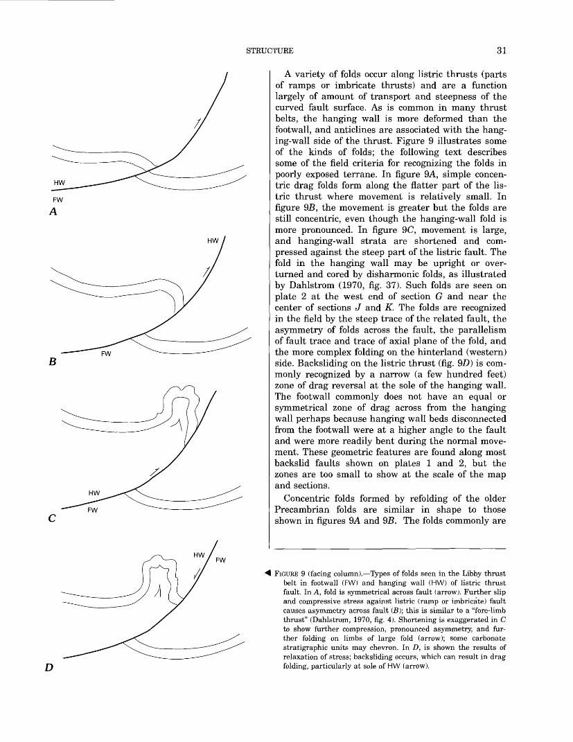
STRUCTURE 31
FW
A
HW
D
A variety of folds occur along listric thrusts (parts of ramps or imbricate thrusts) and are a function largely of amount of transport and steepness of the curved fault surface. As is common in many thrust belts, the hanging wall is more deformed than the footwall, and anticlines are associated with the hang ing-wall side of the thrust. Figure 9 illustrates some of the kinds of folds; the following text describes some of the field criteria for recognizing the folds in poorly exposed terrane. In figure 9A, simple concen tric drag folds form along the flatter part of the lis tric thrust where movement is relatively small. In figure 95, the movement is greater but the folds are still concentric, even though the hanging-wall fold is more pronounced. In figure 9C, movement is large, and hanging-wall strata are shortened and com pressed against the steep part of the listric fault. The fold in the hanging wall may be upright or over turned and cored by disharmonic folds, as illustrated by Dahlstrom (1970, fig. 37). Such folds are seen on plate 2 at the west end of section G and near the center of sections J and K. The folds are recognized in the field by the steep trace of the related fault, the asymmetry of folds across the fault, the parallelism of fault trace and trace of axial plane of the fold, and the more complex folding on the hinterland (western) side. Backsliding on the listric thrust (fig. 9.D) is com monly recognized by a narrow (a few hundred feet) zone of drag reversal at the sole of the hanging wall. The footwall commonly does not have an equal or symmetrical zone of drag across from the hanging wall perhaps because hanging wall beds disconnected from the footwall were at a higher angle to the fault and were more readily bent during the normal move ment. These geometric features are found along most backslid faults shown on plates 1 and 2, but the zones are too small to show at the scale of the map and sections.
Concentric folds formed by refolding of the older Precambrian folds are similar in shape to those shown in figures 9A and 95. The folds commonly are
FIGURE 9 (facing column). Types of folds seen in the Libby thrust belt in footwall (FW) and hanging wall (HW) of listric thrust fault. In A, fold is symmetrical across fault (arrow). Further slip and compressive stress against listric (ramp or imbricate) fault causes asymmetry across fault (B); this is similar to a "fore-limb thrust" (Dahlstrom, 1970, fig. 4). Shortening is exaggerated in C to show further compression, pronounced asymmetry, and fur ther folding on limbs of large fold (arrow); some carbonate stratigraphic units may chevron. In D, is shown the results of relaxation of stress; backsliding occurs, which can result in drag folding, particularly at sole of HW (arrow).
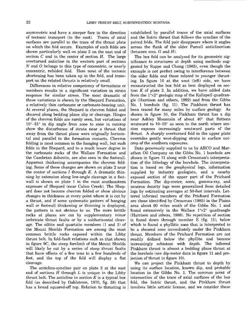
32 LIBBY THRUST BELT, NORTHWESTERN MONTANA
asymmetric and have a steeper face in the direction of tectonic transport (to the east). Traces of axial surfaces are parallel to the trace of the thrust plate on which the fold occurs. Examples of such folds are shown particularly well on plate 2 on the east end of section C and in the center of section H. The large overturned anticline in the western part of sections N and O belongs to this type of concentric, or nearly concentric, refolded fold. Here most of the tectonic shortening has been taken up in the fold, and trans port on the related thrusts is relatively small.
Differences in relative competency of formations or members results in a significant variation in strain response for similar stress. The most dramatic of these variations is shown by the Shepard Formation, a relatively thin carbonate or carbonate-bearing unit. At several places, the Shepard is chevron folded and sheared along bedding plane slip or cleavage. Hinges of the chevron folds are rarely seen, but variations of 10°-15° in dip angle from zone to zone in outcrop show the disturbance of strata near a thrust that away from the thrust plane were originally horizon tal and parallel to the formation contacts. Chevron folding is most common in the hanging wall, but such folds in the Shepard, and to a much lesser degree in the carbonate rocks of the Wallace Formation and the Cambrian dolomite, are also seen in the footwall. Apparent thickening accompanies the chevron fold ing. Some of these changes are shown on plate 2 near the center of sections / through K. A dramatic thin ning by extension along low-angle cleavage in a foot- wall is shown on plate 1 in the most southeastern exposure of Shepard (near Calico Creek). The Shep ard does not become chevron folded or show obvious changes in thickness at every point where it is cut by a thrust, and if some systematic pattern of hanging wall or footwall thickening or thinning is displayed, the pattern is not obvious to us. The more brittle rocks at places are cut by supplementary minor imbricate thrust faults or by a subhorizontal cleav age. The siltite and quartzite members (1 and 2) of the Mount Shields Formation are among the most common brittle rocks exposed within the Libby thrust belt. In fold-fault relations such as that shown in figure 9C, the steep forelimb of the Mount Shields will likely be cut by a series of steep thrust faults that have offsets of a few tens to a few hundreds of feet, and the top of the fold will display a flat cleavage.
The anticline-syncline pair on plate 2 at the east end of sections H through L is unique in the Libby thrust belt. The anticline in section K is a typical box fold (as described by Dahlstrom, 1970, fig. 38) that has a broad squared-off top. Relation to thrusting is
established by parallel traces of the axial surfaces and the listric thrust that follows the syncline of the paired folds. The fold pair disappears where it angles across the flank of the older Purcell anticlinorium (between sees. G and H).
The box fold can be analyzed for its geometric sig nificance to structures at depth using methods sug gested by Suppe and Chang (1983), even though the example is not perfect owing to interference between the older folds and those related to younger thrust ing. In figure 10 at the west (left) side, we have reconstructed the box fold as best displayed on sec tion K of plate 2. In addition, we have added data from the I°x2° geologic map of the Kalispell quadran gle (Harrison and others, 1992) and from the Gibbs No. 1 borehole (fig. 11). The Pinkham thrust has been traced for many miles by surface geology. As shown in figure 10, the Pinkham thrust has a dip near Ashley Mountain of about 40° that flattens westward to 10-15° as seen to the north where ero sion exposes increasingly westward parts of the thrust. A sharply overturned fold in the upper plate overrides gently west-dipping strata in surface out crop of the southern exposures.
Data generously supplied to us by ARCO and Mar athon Oil Company on the Gibbs No. 1 borehole are shown in figure 11 along with Cressman's interpreta tion of the lithology of the borehole. The interpreta tion is based on the geophysical logs, information supplied by industry geologists, and a nearby exposed section of the upper part of the Prichard Formation. The dip-meter, sonic, gamma-ray, and neutron density logs were generalized from detailed logs by estimating averages at 50-foot intervals. Let tered informal members of the Prichard Formation are those identified by Cressman (1985) in the Plains area about 60 miles south of the Gibbs No. 1 and found extensively in the Wallace I°x2° quadrangle (Harrison and others, 1986). No repetition of section is found down through member E (fig. 11), below which is found a phyllitic zone that is interpreted to be a sheared zone immediately under the Pinkham thrust. Members of the Prichard Formation are not readily defined below the phyllite and become increasingly schistose with depth. The inferred Pinkham thrust is almost a bedding plane thrust at the borehole (see dip-meter data in figure 11 and pro jection of thrust in figure 10).
We can project the Pinkham thrust to depth by using its surface location, known dip, and probable location in the Gibbs No. 1. The common point of intersection of the trace of axial surfaces of the box fold, the listric thrust, and the Pinkham thrust involves little artistic license, and we consider these
STRUCTURE 33
WEST
A BWolf
Mountain Island Lake
EAST
cAsh ley
Mountain
FEET 10,000 -]
40,000
East end of section I
K-K, plate 2 PURCELL ANTICLINORIUM _ Trace of axial Ground -( \ surfaces \ surface
FEET- 10,000
- SEA LEVEL
h 10,000
- 20,000
- 30,000
Basement40,000
10,000 20,000 30,000 40,000 50,000 60,000 FEETI____I____|____I____I____i
I 10 MILES
FIGURE 10. Relation of box fold and listric thrust shown on section K of plate 2 to Pinkham thrust and subsurface data from Gibbs No. 1 borehole. Box fold is restored to original shape by removal of younger extensional displacement on listric thrust and high-angle and flat normal faults (not shown). M - Missoula Group, C - Helena and Wallace Formations, R - Ravalli Group, P - Prichard Formation. See text for discussion. At B, eastern end of section is offset about 15,000 ft southward to define a parallel line of section that passes through the Gibbs No. 1 (approximate line of section shown in fig.7).
intersections as more than coincidence. We relate the box fold to a probable ramp in the Pinkham thrust (fig. 10). The ramp extends from the basal surface of detachment and, following movement on the Pinkham, was extended up through the syncline as a listric thrust that later backslid. This listric fault is the lead thrust in the southern part of the complex of flat and steep thrusts (fig. 7) that we define as the Libby thrust belt.
The question of what is beneath the Prichard For mation under the Purcell anticlinorium has serious consequences for models of thrusting and for oil and gas potential of the region. Although the Gibbs No. 1 borehole has provided much useful information on the stratigraphy and physical properties of the Pri chard and its sills on the crest of the anticlinorium, the borehole was entirely within the Prichard (figs. 10 and 11). We are left, therefore, with interpreta tion of geologic and geophysical data to arrive at a solution to the question: "What fills the hole between the Pinkham thrust and the basal surface of detachment?"
The base of the Prichard Formation has not been seen or penetrated by drilling in Belt terrane, so its thickness is not certain. Cressman (1985) has mapped and described about 25,000 ft of combined Prichard, sills, and the Prichard-Burke transition zone (not included in the Prichard in Cressman,
1985) in the Plains area. Cressman recognizes two major depositional cycles within the Prichard, and the lowest strata could be approaching the base of the formation. About 18,000 ft of combined Prichard and sills are exposed on the Sylvanite anticline (pi. 1). There, the facies are more quartzitic (Cressman, 1989) and similar to the equivalent Aldridge Forma tion of southern British Columbia. The Sylvanite anticline does not expose rocks below "middle Ald ridge" of Canadian usage. Thick continuous expo sures of Aldridge in southern British Columbia have been mapped by H0y and Daikow (1982) and include about 15,000 ft of combined Aldridge and sills from the upper part of "lower Aldridge" to the top of the formation. In the Dewar Creek area (British Colum bia) at the north end of the Purcell anticlinorium, Reesor (1958, p. 6) reported a total of about 15,500 ft of combined Aldridge and sills that includes about 4,500 ft of "lower Aldridge." These data suggest that the thickest sections of the Prichard or its equiva lents is near the Plains area, so in figure 10 we use 25,000 ft for the combined thickness of Prichard and sills to illustrate the geometry of strata beneath the Purcell anticlinorium. A few thousand feet of addi tional strata would not significantly affect the problem.
The base of the Prichard appears to be at and above the basal surface of detachment (fig. 10). The

34 LIBBY THRUST BELT, NORTHWESTERN MONTANA
SonicTHOUSANDS
OF FEET 0 -I
2-
3-
4 -
5-
6-
7-
9-
10-
12-
13-
14-
15-
16-
17-
18-1
Gamma Ray
Neutron Density
BURKE FORMATION
Surface section Little Wolf Creek
PRICHARD FORMATION
ARCOGibbs 1
(Informal members of Cressman, 1985)
Member H
" =f7,±
Transition member
Upper laminated argillite member
-Argillite bed
Lower part
22 Member G
10
8 Member F
5 Member E
^. Pinkham thrust*-12
-.12
00
Members A through D?
^35
EXPLANATION
Diorite sill
Argillite
Siltite
Dolomitic siltite
Calcareous siltite
Poorly sorted quartzite
Well-sorted quartzite
Phyllite
Mica schist
Mylonite
Hornblende- and garnet- bearing quartz lenses
Interlaminated and closely interbedded siltite and argillite in proportion shown
12 Direction and amount of dip
FIGURE 11. Generalized lithologic and geophysical logs, Gibbs No. 1 borehole (long 114°49', lat 48°13'). Data provided by courtesy of ARCO Exploration and Marathon Oil Companies. Surface section at Little Wolf Creek and lithologic log interpretation by E. R. Cressman.
STRUCTURE 35
space beneath the Prichard must be filled either by basement crystalline rock on which the Prichard was deposited or by repetition of Prichard directly above deeper basement on another thrust fault. The near est thrust fault on the surface is about 40 mi east of the Gibbs No. 1 (Harrison and others, 1992), and any reasonable dip on the thrust brings it down to the surface of detachment several miles east of the sec tion shown in figure 10. An alternative is a large duplex in Prichard above lower basement, but we see no evidence of this in seismic data shown to us by proprietary owners. Thus, the rocks beneath the Pri chard seems most likely on geologic grounds to con sist of basement. The schistose rocks near the bottom of the Gibbs No. 1 (fig. 11) are interpreted to be sheared basal Prichard above a flexure near the Pri- chard-basement contact. This interpretation is based partly on the observation that the lowest rocks in the borehole (Prichard members A to D?) are exposed in the nearby Plains area (Cressman, 1985) and are not schistose even though burial metamorphism would have been equal at the two localities. The extra shearing at the borehole is attributed to slippage above folded basement that is either absent or not as severe in the Plains area.
DEEP FOLDS AND FAULTS INTERPRETED FROM GEOPHYSICAL DATA
Geophysical data in and adjacent to the Libby thrust belt were obtained from M.D. Kleinkopf (writ ten commun., 1989). These data include gravity, aero- magnetic, seismic, and magnetotelluric information. Analyses of these data by Kleinkopf and colleagues demonstrate that most data sets do not have a unique solution, but, that among various interpretations, all are permissive of a single interpretation. That inter pretation involves a layered, gneissic basement in con tact with metamorphosed lower Belt along a zone of little geophysical contrast and infers that gneissic basement forms cores of some of the larger folds. Such an interpretation is compatible with geologic interpre tations from projections of surface geology along double-plunging major folds within the thick strati- graphic Belt section. The projections allow inferences of deep structure to about 8 mi below the surface. The geophysical and geologic interpretations are also com patible with concepts of Belt basin history that (1) infers crustal stretching followed by convergence that mark the beginning and end of formation of the Belt basin (for example, see Cressman, 1989, p. 71), and (2) pre-Flathead Quartzite (Cambrian) folding of Belt strata above a basal zone of detachment in the basement.
IMPLICATIONS OF BASEMENT-CORED FOLDS
Our conclusion that a crystalline core probably exists beneath the Purcell anticlinorium leads to two major implications. First, oil and gas potential in the area are quite low. Minor methane shows recorded in logs of the Gibbs No. 1 may represent Proterozoic gas that survived a complex metamorphic and tectonic geologic history of rocks that at one time had a mod est (3-5%?) organic content in some units. The gas appears to be more a novelty than a resource. Sec ond, the probability of folded basement beneath the Purcell anticlinorium suggests that the Proterozoic basal surface of detachment was "thick skinned" (involved basement). Thus, the behavior of structures in central Belt terrane described in this report may differ, in detail at least, from the "thin skinned" behavior of the Phanerozoic wedge as displayed in the foothills of the southern Canadian Rocky Moun tains and in Glacier National Park. Some of the con trasts are well illustrated in the regional cross section west of Calgary by Price and Fermor (1985) where the intense folding, long bedding-plane thrusts, and close-spaced imbrication of the Phanero zoic sedimentary wedge differs strikingly from the open folds and few thrusts shown in Proterozoic Belt terrane of the Purcell anticlinorium. The ground rules for thin-skinned thrusting defined by Dahl- strom (1970) are applied by Price and Fermor (1985) both to Phanerozoic and Proterozoic rocks in the carefully prepared balanced section west of Calgary. We prefer to accept the data from McMechan and Price (1982) confirming Proterozoic folding of Belt and Purcell strata, and also to incorporate basement in folds of the Purcell anticlinorium as well as show thrusts that locally cut down section through the Proterozoic folds, as they do in the Libby thrust belt and nearby areas to the east.
STRIKE-SLIP FAULTS
High-angle strike-slip faults of the Hope fault sys tem bound the map area (pi. 1 and fig. 7) on the south, an additional one is displayed near the north west corner of the map, and another (Big Draw fault) occurs just north of Bend on the Thompson River in the southeast part of the map. The strike-slip fault in the northwest appears to be a simple tear in a thrust plate. The thrust is accompanied by a mono- clinal fold on the northeast side of the tear (pi. 2, sec. A-A') that accommodated a greater tectonic shorten ing there and refolded the flank of the old Sylvanite anticline.
36 LIBBY THRUST BELT, NORTHWESTERN MONTANA
The fault near Bend extends from a complex of poorly exposed faults along Elk Creek (pi. 1) east ward (fig. 7) about 50 mi to the Rocky Mountain trench at Flathead Lake (Harrison and others, 1986). The fault passes through Big Draw, for which it is named, has a right-lateral displacement of about 4 miles that dissipates into horsetails in the Rocky Mountain trench, and has apparent down-to-the- south stratigraphic throw of a few thousand feet. The fault offsets fold axes of the Purcell anticlinorium (fig. 7) but appears to terminate rather than offset Tertiary high-angle normal faults (Harrison and oth ers, 1986). The Big Draw fault is probably related to Mesozoic thrusting, but relations are not clearly defined.
The Hope fault system, a zone of strike-slip and down-to-the-south faults that bounds the south end of the map area, has a long geologic history. The Hope fault system extends at least from the Purcell trench, which is about 35 mi west of the map area, along the southern edge of the map to a junction with the Lewis and Clark line about 19 mi southeast of the map area (fig. 1; Harrison and others, 1986). Evidence based on thickness, habit, and non-continu ity of Proterozoic sills across the Hope fault system in the Idaho Panhandle indicates that some form of the fault may have been present in the Proterozoic (Harrison and others, 1972, p. 5). Also documented is movement on the zone as recent as Eocene as shown by porphyry dikes intruded into extensional fractures at 50 m.y. ago (Harrison and others, 1972, p. 6-8).
Exposures of faults in the Hope fault zone are rare, as the zone is followed by the wide valley of the Clark Fork (pi. 1). At a few places on the northeast valley wall a zone of gouge identifies a strand of the zone. At the west end of the zone on plate 1, a sliver of Cambrian sedimentary rock is caught between slices of Belt rocks in the fault zone. The Cambrian rocks are several thousand feet structurally below stratigraphically equivalent rocks that crop out unconformably on Belt both east and west of the Hope fault. The edge of the 100 m.y. old pluton at the mouth of the Vermilion River (pi. 1) is sheared along the Hope fault system.
Absolute amount of lateral movement on the Hope fault is difficult to determine because of (1) a greater development of thrust faults and related folds north of the Hope than south of it (Harrison and others, 1986), and (2) an uncertain component of down-to- the-south dip slip. Using a best match of contacts and fold axes, Harrison and others (1974, p. 12-13) noted an apparent right-lateral offset of about 16 mi, and an inferred true strike slip of about 8 mi. The
fact that faults of the Moyie thrust system and of the Libby thrust belt end at the Hope fault zone indi cates that the old (Proterozoic?) strike-slip zone acted as a tear fault during Mesozoic thrusting. Some of the total displacement on the Hope must reflect movement that began about 100 m.y. ago when the Libby thrust belt was formed and continued during thrusting that lasted until about 60 m.y. ago (Schmidt, 1978). The abundance of thrust faults and apparent larger tectonic translation on them north of the Hope fault system compared with translation south of the Hope (Harrison and others, 1986) also requires a right-lateral movement during the thrust ing. A possible younger left-lateral movement may have occurred during Eocene and younger extension on high-angle normal faults (see following section). The extension occurred both north and south of the Hope, but we have no reliable measure of the exact amounts. The extensions, therefore, may have added to or subtracted from the present apparent right-lat eral slip, depending on whether the north or south block had the greatest extension.
A peculiar feature related to the Hope fault zone is displayed in the southwest part of the map area (pi. 1). There, several high-angle normal faults end in monoclinal bends as they approach the Hope. These structures are confined between two splays of the Moyie thrust system. The increased structural offset to the north suggests that the northernmost splay of the Hope zone had less movement or was stable dur ing the Tertiary backsliding along faults of the Moyie thrust system. Although these high-angle faults are shown as block faults (pi. 2, sec. K-K, Berray Moun tain area), at least some of them are probably listric into backslid splays of the Moyie frontal thrust.
HIGH-ANGLE NORMAL FAULTS AND ASSOCIATED FOLDS
Belt terrane north of the Lewis and Clark line and west of the Rocky Mountain trench is intensely dis sected by high-angle normal faults. Patterns are well displayed on regional maps (Harrison and others, 1986, 1992). Shown on plate 1 are about 200 high- angle normal faults that have stratigraphic throws ranging from a few tens to a few thousands of feet. We have shown only faults that we can document not only by stratigraphic discontinuities and structural evidence but also that can be traced for a significant distance. Many structural indications of a fault in outcrop either cannot be traced to the next exposure or become obscure in poor exposures of a thick and apparently uniform stratigraphic unit. Most of these faults cut and offset the thrust faults, but some abut
DISCUSSION OF TECTONIC HISTORY 37
or join thrusts. Most high-angle normal faults trend north to northwest, but many also trend west or northeast. Fault sets join or abut, and offsets of one high-angle fault by another are rare.
High-angle normal faults are readily recognized in the field by local deflections in dip and strike of bed ding and by the presence of cleavage. Zones of steep cleavage a few feet wide are commonly seen in out crop and are subparallel to the trace of a fault that itself is rarely exposed. These zones weather down to cause notches in ridges or are followed by stream courses. Drag folds along the faults cause deflections in strike and dip adjacent to the fault, and where a single fold occurs, can be used to demonstrate normal movement on the fault. Along faults of large slip, zones of folds a few hundred feet wide flank the fault. These zones contain multiple small synclines and anticlines. The geometry of the entire folded zone can be used to determine direction of slip on the fault.
These high-angle normal faults form a horst-and- graben pattern. We interpret these faults as repre senting extension fractures of Eocene and younger age that are related in time to the formation of basin-and-range structures south of the Lewis and Clark line (Reynolds, 1979) and to extension in east ern Washington (Fox and Beck, 1985). As such, many of the normal faults, particularly those that dip west, are probably listric and merge with thrusts that have undergone Tertiary backsliding. Other normal faults cut and offset some thrusts at the surface but proba bly merge with one of the lower thrusts at depth, perhaps a thrust beneath those shown on the shallow cross sections.
Regional extent and abundance of the extension faults is uncertain. They have been mapped by sev eral geologists working north of the Lewis and Clark line between the Rocky Mountain trench and the Purcell trench in the United States part of Belt ter- rane. The faults are important from the standpoints of general geologic history and total extension, because even a few tens to a few hundreds of feet of extension per fault requires, when all faults are con sidered collectively, miles of extension. For example, the minimum extension across the Libby thrust belt alone, calculated by using slip on the high-angle faults plus backsliding on thrust faults, is at places more than 3 mi (table 1). Maps and sections of southern British Columbia near the highly faulted Belt terrane of the United States show some horst- and-graben structures (for example, see Leech, 1960; H0y and Daikow, 1982; H0y, 1984), but few seem to be persistent or important enough to show on
regional cross sections through the Purcell anticlino- rium (Price and Fermor, 1985).
DISCUSSION OF TECTONIC HISTORY
The thick sedimentary wedge of Belt rocks, of which the area shown on plate 1 is a small part, accumulated along the western margin of the North American craton in Middle Proterozoic time. The deep basin probably formed along a continental rift margin (Sears and Price, 1978) underlain by attenu ated crust (Price 1984; Cressman, 1984) where verti cal tectonics dominated on the trailing edge (Harrison and Reynolds, 1976; Reynolds, 1984a, 1984b) of the crustal plate on which the basin formed. During sedimentation, deep extension frac tures periodically tapped a source of continental-type basalt that formed basic sills (Bishop, 1973, p. 16) and the Purcell Lava (McGimsey, 1985, p. 21-22). Also affecting the present Libby area was (1) possible early formation of the crustal flaw that eventually became the Hope fault zone and (2) differential sub sidence around the "post-Ravalli dome" (fig. 6; Harri son, 1972, p. 1227-1229).
Two orogenies, in the Middle and Late Proterozoic, are correlated over western Canada by McMechan and Price (1982, p. 484-485). The older event "involved compression, regional metamorphism, and granitic intrusion" whereas the younger "involved uplift, block faulting, and low-grade regional meta morphism." The younger event resulted in deposition of the Late Proterozoic Windermere Supergroup, which includes conglomerates and coarse clastic debris derived in part from uplifted Belt or Purcell rocks (Lis and Price, 1976). Since no Windermere strata occur beneath the unconformity at the base of the Cambrian in the Libby thrust belt, no solid evi dence of the Late Proterozoic event is to be found in the study area. The older folding event, however, is probably identified by the low-angle unconformity between Cambrian and Belt strata. This unconfor mity (essentially a disconformity at most places) can be identified regionally by the varying stratigraphic position of Middle Cambrian Flathead Quartzite over Proterozoic units of the Missoula Group. Most expo sures show a disconformity that has unmetamor- phosed Flathead overlying greenschist-facies rocks of the Belt; angular differences in bedding between the Proterozoic and the Cambrian are commonly too small to measure with confidence. At a few places, such as in the Packsaddle Mountain quadrangle about 16 mi west of the west-central edge of the map area (pi. 1), an angular unconformity of about 7° can
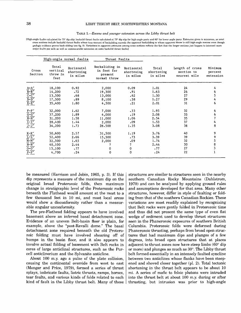
38 LIBBY THRUST BELT, NORTHWESTERN MONTANA
TABLE 1. Eocene and younger extension across the Libby thrust belt
[High-angle faults calculated for 75° dip slip; backslid thrust faults calculated at 75° dip slip for high-angle parts and 60° for lower angle parts. Extension given is minimum, as most cross sections include backslid thrust faults whose true amount of backsliding exceeds the apparent backsliding or whose apparent throw is still high-angle reverse even though geologic evidence proves back-sliding (see fig. 8). Variations in apparent extension among cross sections reflects the fact that the longer sections just happen to intersect more major faults per mile as well as unmeasurable extension on some backslid thrust faults]
High-angle normal faults
Cross Section
A-A'B-B'C-C'D-D'E-E'
F-F'G-G'H-H'I-I'
J_-,T_
K-K'L-L'M-M'N-N'0-0'P-P'
Total vertical throw in
feet
18,10014,20013,50017,50035,400
32,00037,20031,20028,40034,200
50,60052,40032,50048,10015,1004,700
Horizontal shortening in miles
0.92.72.68.89
1.80
1.621.891.581.441.73
2.572.661.652.44.77.24
Thrust Faults
Backsliding in in feet for
presentnormal throw
2,00019,30013,0008,1004,500
7,0004,00011,0002,000
28.500
31,50015,5002,000
?00
Horizontal shortening in miles
0.09.91.62.38.21
.33
.191.06.09
1.35
1.19.73.09?00
Total shortening in miles
1.011.631.301.272.01
1.952.082.541.533.08
3.763.391.742.44.77.24
Length of cross section to
nearest mile
2426272931
3233353738
403932302722
Minimum percent extension
46546
66748
995831
be measured (Harrison and Jobin, 1965, p. 3). If this dip represents a measure of the maximum dip on the original broad Proterozoic folds, then maximum change in stratigraphic level of the Proterozoic rocks beneath the Flathead would amount at the most to a few thousand feet in 10 mi, and most local areas would show a disconformity rather than a measur able angular unconformity.
The pre-Flathead folding appears to have involved basement above an inferred basal detachment zone. Evidence of an uneven Belt-basin floor is plain, for example, above the "post-Ravalli dome." The basal detachment zone required beneath the old Protero zoic folding must have involved shearing off of humps in the basin floor, and it also appears to involve actual folding of basement with Belt rocks in cores of large anticlinal structures, such as the Pur- cell anticlinorium and the Sylvanite anticline.
About 100 m.y. ago a pulse of the plate collision, causing the continental override from west to east (Monger and Price, 1979), formed a series of thrust splays, imbricate faults, listric thrusts, ramps, horses, tear faults, and various kinds of folds related to each kind of fault in the Libby thrust belt. Many of these
structures are similar to structures seen in the nearby southern Canadian Rocky Mountains (Dahlstrom, 1970) and can be analyzed by applying ground rules and assumptions developed for that area. Many other structures, however, differ in style of faulting or fold ing from that of the southern Canadian Rockies. These variations are most readily explained by recognizing that Belt rocks were gently folded in Proterozoic time and thus did not present the same type of even flat wedge of sediment used to develop thrust structures seen in the Phanerozoic exposures of southern British Columbia. Proterozoic folds were deformed during Phanerozoic thrusting, perhaps from broad open struc tures that had maximum dips and plunges of a few degrees, into broad open structures that at places adjacent to thrust zones now have steep limbs (60° dip or more) and plunges as much as 30°. The Libby thrust belt formed essentially in an intensely faulted syncline between two anticlines whose flanks have been steep ened and shoved closer together (pi. 2). Total tectonic shortening in the thrust belt appears to be about 10 mi. A series of mafic to felsic plutons were intruded into the thrust belt at about 100 m.y. during or after thrusting, but intrusion was prior to high-angle
REFERENCES CITED 39
extensional faulting that followed thrusting. The fact that thrusting continued to the east of the Libby thrust belt until about 60 m.y. ago suggests that (1) the 100 m.y. old plutons are detached from their roots and that (2) extension across the entire thrust terrane is probably younger than 60 m.y. a pattern of style and timing of deformation similar to the Basin and Range province of the Western United States.
The Moyie thrust system merges with the southern end of the Libby thrust belt but probably was active concurrently, as 100-m.y-old plutons intrude both thrust systems. Backsliding on some listric thrusts of the Libby thrust belt is apparently transferred to lis tric thrusts of the Moyie system.
Extension following relaxation of the thrusting is represented by the myriad of high-angle normal faults and by backsliding on many of the listric thrust surfaces that is transferred to the flat thrusts into which the listric faults merge. Minor drag folds accompanied these faults, and some faults end along strike in monoclinal bends. The high-angle normal faults display a horst-and-graben pattern at the sur face, but many of the west-dipping faults probably are listric and merge with flat thrusts at depth. Age of the probable Eocene and younger extension is not tightly constrained within the Libby thrust belt. High-angle faults are only shown to be younger than the thrusts and the lOO-m.y.-old plutons.
The youngest tectonic event in the area is recorded by movement along the Hope fault zone. Dilation and intrusion of porphyry dikes can be dated at 50 m.y. a few miles to the west along the fault near the Purcell trench (Harrison and others, 1972). This dilation was originally interpreted (Harrison and oth ers, 1972) as reflecting a right-lateral movement on the Hope fault. In view of the abundant evidence for westward extension ("crustal necking, gneiss-dome formation, diking, and graben formation" according to Fox and Beck, 1985, p. 323) in northern Idaho and northeastern Washington at about 50 m.y. ago, the porphyry-filled tension structures of the Purcell trench are better interpreted as part of that exten sional event that also caused movement along the Hope fault. Extension represented by the abundant high-angle faults and the backslid thrust faults west of the Rocky Mountain trench through the Libby thrust belt to the Purcell trench also logically belong to that 50 m.y.-old event.
REFERENCES CITED
Aadland, R.K., 1977, Cambrian carbonates in the Libby trough, northwest Montana: Geological Society of America Abstracts with Programs, v. 9, no. 6, p. 705.
1979, The Cambrian stratigraphy of the Libby trough,northwestern Montana: Moscow, University of Idaho,unpublished Ph. D. thesis, 323 p.
Alden, W.C., 1953, Physiography and glacial geology of westernMontana and adjacent areas: U.S. Geological SurveyProfessional Paper 231, 200 p.
Armstrong, F.C., and Oriel, S.S., 1965, Tectonic development ofIdaho-Wyoming thrust belt: Bulletin of the AmericanAssociation of Petroleum Geologists, v. 49, no. 11,p. 1847-1866.
Bally, A.W., Gordy, P.L., and Stewart, G.A., 1966, Structure,seismic data, and erogenic evolution of southern CanadianRocky Mountains: Bulletin of Canadian Petroleum Geology, v.14, no. 3, p. 337-381.
Bennett, E.H., II, Kopp, R.S., and Galbraith, J.H., 1975,Reconnaissance geology and geochemistry of the Mt. PendOreille quadrangle and surrounding areas: Idaho Bureau ofMines and Geology Pamphlet 163, 80 p.
Bishop, D.T., 1973, Petrology and geochemistry of the Purcell sillsin Boundary County, Idaho, in Belt Symposium, volume 2:Idaho Bureau of Mines and Geology Special Publication,p. 15-66.
Boettcher, A.L., 1966, The Rainy Creek igneous complex nearLibby, Montana: University Park, Pennsylvania StateUniversity, Ph. D. thesis, 155 p.
1967, The Rainy Creek alkaline-ultramafic igneous complex near Libby, Montana I. Ultramafic rocks and fenite: Journal of Geology, v. 75, no. 2, p. 526-553.
Bowden, T.D., 1977, Depositional processes and environments within the Revett Formation, Precambrian Belt Supergroup, northwestern Montana and northern Idaho: University of California at Riverside, unpublished M.S. thesis, 161 p.
Burmester, R.F., 1985, Preliminary geologic map of the Eastport area, Idaho and Montana: U.S. Geological Survey Open-File Report 85-517, scale 1:48,000.
1986, Preliminary geologic map of the Leonia area, Idaho and Montana: U.S. Geological Survey Open-File Report 86-554, scale 1:48,000.
Bush, J.H., and Fischer, H.J., 1981, Stratigraphic and depositional summary of Middle and Upper Cambrian strata in northwestern Montana, in Second International symposium on the Cambrian System: U.S. Geological Survey Open-File Report 81-743, p. 42-45.
Bush, John, Kachek, Dave, and O'Malley, Dave, 1984, Road log for the Cambrian rocks in the Libby trough, northwestern Montana: in Field trip guides for the 1984 field conference and symposium, Montana Geological Society, p. 51-61.
Bush, J.H., Kachek, D.C., and Webster, G.D., 1985, Newly discovered Ordovician strata, Libby trough, northwestern Montana: Geological Society of America Abstracts with Programs, v. 17, no. 4, p. 211.
Calkins, F.C., 1909, Geological reconnaissance in northern Idaho and northwestern Montana, with notes on the economic geology by D. F. McDonald: U.S. Geological Survey Bulletin 384, 53 p.
Campbell, C.V., 1967, Lamina, laminaset, bed, and bedset: Sedimentology, v. 8, p. 7-26.
Childers, M.O., 1963, Structure and stratigraphy of the southwest Marias Pass area, Flathead County, Montana: Geological Society of America Bulletin, v. 74, no. 2, p. 141-163.
Cressman, E.R., 1984, Paleogeography and paleotectonic setting of the Prichard Formation A preliminary interpretation, in Hobbs, S. W, ed., The Belt: Montana Bureau of Mines and Geology Special Publication 90, p. 8-9.
40 LIBBY THRUST BELT, NORTHWESTERN MONTANA
1985, The Prichard Formation of the lower part of the Belt Supergroup (Middle Proterozoic), near Plains, Sanders County, Montana: U.S. Geological Survey Bulletin 1553, 64 p.
1989, Reconnaissance stratigraphy of the PrichardFormation (Middle Proterozoic) and the early development ofthe Belt basin, Washington, Idaho, and Montana: U.S.Geological Survey Professional Paper 1490, 80 p.
Cressman, E.R., and Harrison, J.E., 1986, Geologic map of theYaak River area, Lincoln County, Montana: U.S. GeologicalSurvey Miscellaneous Field Studies Map MF-1881, scale1:48,000.
Dahlstrom, C.D.A., 1969, Balanced cross sections: CanadianJournal of Earth Sciences, v. 6, p. 743-757.
1970, Structural geology in the eastern margin of the Canadian Rocky Mountains: Bulletin of Canadian Petroleum Geology, v. 18, no. 3, p. 332-406.
Deiss, Charles, 1935, Cambrian-Algonkian unconformity in western Montana: Geological Society of America Bulletin, v. 46, no. 1, p. 95-124.
Earhart, R.L., 1981, Geology of the Scotchman Peak Wilderness Study Area, Lincoln and Sanders Counties, Montana, and Bonner County, Idaho: U.S. Geological Survey Bulletin 1467-A, p. A1-A14.
Eby, D.E., 1977, Sedimentation and early diagenesis within eastern portions of the "middle Belt carbonate interval", Belt Supergroup (Precambrian Y), western Montana: State University of New York at Stony Brook, unpublished Ph. D. thesis, 504 p.
Elliott, David, 1976, The energy balance and deformation mechanisms of thrust sheets: Philosophical Transactions of the Royal Society of London, Anal 283, p. 289-312.
1977, Some aspects of the geometry and mechanics ofthrust belts, Parts 1 and 2: 8th Annual Seminar of theCanadian Society of Petroleum Geologists, University ofCalgary, 95 p.
Elston, D.P., 1984, Magnetostratigraphy of the Belt Supergroup A synopsis, in Hobbs, S.W., ed., The Belt: Montana Bureau ofMines and Geology Special Publication 90, p. 88-90.
Fox, K.F., Jr., and Beck, M.E., Jr., 1985, Paleomagnetic results forEocene volcanic rocks from northeastern Washington and theTertiary tectonics of the Pacific Northwest: Tectonics, v 4,no. 3, p. 323-341.
Gibson, Russell, 1948, Geology and ore deposits of the Libbyquadrangle, Montana, with sections on glaciation by WC.Alden and physiography by J. T. Pardee: U.S. GeologicalSurvey Bulletin 956, 131 p.
Godlewski, D.W, 1977, The origin of the middle Wallace breccias:Geological Society of America Abstracts with Programs, v. 9,no. 6, p. 727.
Griggs, A.B., 1973, Geologic map of the Spokane quadrangle,Washington, Idaho, and Montana: U.S. Geological SurveyMiscellaneous Geologic Investigations Series Map 1-768,scale 1:250,000.
Harrison, J.E. 1965, Geology of the Packsaddle MountainQuadrangle, Idaho: U.S. Geological Survey GeologicQuadrangle Map GQ-375, scale 1:62,500.
1969, Geologic map of part of the Mount Pend Oreille Quadrangle, Idaho-Montana: U.S. Geological Survey Open- File Map, scale 1:62,500.
1972, Precambrian Belt basin of northwestern United States Its geometry, sedimentation, and copper occurrences: Geological Society of America Bulletin, v. 83, no. 5, p.1215-1240.
1974, Copper mineralization in miogeosynclinal elastics of the Belt Supergroup, northwestern United States, in
Bartholome, Paul, ed., Gisements stratiformes et provinces cupriferes: Geological Society of Belgium Special Publication, p. 353-366.
-1984, Stratigraphy and lithocorrelation of the WallaceFormation, in Hobbs, S. W, ed., The Belt: Montana Bureau of Mines and Geology Special Publication 90, p. 24-26.
Harrison, J.E., and Cressman, E.R., 1985, The Libby thrust belt and adjacent structures New factors to consider in thrust tectonics of northwestern Montana: Geological Society of America Abstracts with Programs, v. 17, no. 4, p. 223.
Harrison, J.E., Cressman, E.R., and Kleinkopf, M.D., 1985, Regional structure, the Atlantic Richfield-Marathon Oil No. 1 Gibbs borehole, and hydrocarbon resource potential west of the Rocky Mountain trench in northwestern Montana: U.S. Geological Survey Open-File Report 85-249, 5 p. and 3 illus.
Harrison, J.E., Cressman, E.R., and Whipple, J.W, 1992, Geologic and structure maps of the Kalispell I°x2° quadrangle, Montana: U.S. Geological Survey Miscellaneous Investigations Series Map 1-2267, 2 sheets, scale 1:250,000.
Harrison, J.E., Griggs, A.B., and Wells, J.D., 1974, Tectonic features of the Precambrian Belt basin and their influence on post-Belt structures: U.S. Geological Survey Professional Paper 866, 15 p.
1981, Generalized geologic map of the Wallace I°x2° quadrangle, Montana and Idaho: U.S. Geological Survey Miscellaneous Field Studies Map MF-1354-A, scale 1:250,000.
1986, Geologic and structure maps of the Wallace I°x2° quadrangle, Montana and Idaho: U.S. Geological Survey Miscellaneous Investigations Series Map I-1509-A, 2 sheets, scale 1:250,000.
Harrison, J.E., and Jobin, D.A., 1963, Geology of the Clark Fork quadrangle, Idaho-Montana: U.S. Geological Survey Bulletin 1141-K, p. K1-K38.
1965, Geologic map of the Packsaddle Mountain quadrangle, Idaho: U.S. Geological Survey Quadrangle Map GQ-375, scale 1:62,500.
Harrison, J.E., Kleinkopf, M.D., and Obradovich, J.D., 1972, Tectonic events at the intersection between the Hope fault and the Purcell trench, northern Idaho: U.S. Geological Survey Professional Paper 719, 24 p.
Harrison, J.E., Kleinkopf, M.D., and Wells, J.D., 1980, Phanerozoic thrusting in Proterozoic Belt rocks, northwestern Montana: Geology, v. 8, no. 9, p. 407-411.
Harrison, J.E., and Reynolds, M.W, 1976, Western United States continental margin A stable platform dominated by vertical tectonics in the late Precambrian: Geological Society of America Abstracts with Programs, v. 8, no. 6, p. 905.
Harrison, J.E., and Schmidt, P.W., 1971, Geologic map of the Elmira quadrangle, Idaho: U.S. Geological Survey Quadrangle Map GQ-953, scale 1:62,500.
Hayes, T.S., 1983, Geologic studies on the genesis of the Spar Lake strata-bound copper-silver deposit, Lincoln County, Montana: Stanford, California, Stanford University, unpublished Ph. D. thesis, 340 p.
Hobbs, S.W (ed.), 1984, The Belt: Montana Bureau of Mines and Geology Special Publication 90, 117 p.
Hobbs, S.W, Griggs, A.B., Wallace, R.E., and Campbell, A.B., 1965, Geology of the Coeur d'Alene district, Shoshone County, Idaho: U.S. Geological Survey Professional Paper 478, 139 p.
H0y, Trygve, 1984, Geology of the Cranbrook sheet and the Sullivan mine area: British Columbia Ministry of Energy, Mines, and Petroleum Resources Preliminary Map No. 54, scale 1:50,000.
REFERENCES CITED 41
H0y, Trygve, and Daikow, L., 1982, Geology of the Moyie Lake area: British Columbia Ministry of Energy, Mines, and Petroleum Resources Preliminary Map No. 49, scale 1:50,000.
Johns, W.M., 1959, Progress report on geologic investigations in the Kootenai-Flathead area, northwest Montana: Montana Bureau of Mines and Geology Bulletin 12, pi. 1.
1960, Progress report on geologic investigations in the Kootenai-Flathead area, northwest Montana: Montana Bureau of Mines and Geology Bulletin 17, pis. 1-4.
-1970, Geology and mineral deposits of Lincoln and FlatheadCounties, Montana: Montana Bureau of Mines and GeologyBulletin 79, 182 p.
Keim, J.W., and Rector, R.J., 1964, Paleozoic rocks in northwesternMontana A newly recognized occurrence: Geological Societyof America Bulletin, v. 75, no. 6, p. 575-578.
Kidder, D.L., 1985, Stratigraphy and depositional environments ofthe Libby Formation, Proterozoic Belt Supergroup,northwestern Montana: Geological Society of AmericaAbstracts with Programs, v. 17, no. 4, p. 228.
1988, Stratigraphy, micropaleontology, petrology, carbonate geochemistry, and depositional history of the Proterozoic Libby Formation, Belt Supergroup, northwestern Montana and northeastern Idaho: U.S. Geological Survey Open-File Report 87-635, 133 p.
King, P.B., 1969, Tectonic map of North America: U.S. Geological Survey special map, scale 1:5,000,000.
Kirkham, V.R.D., 1930, The Moyie-Lenia overthrust fault: Journal of Geology, v. 38, p. 364-374.
Kirkham, V.R.D., and Ellis, E.W., 1926, Geology and ore deposits of Boundary County, Idaho: Idaho Bureau of Mines and Geology Bulletin 10, 78 p.
Leech, G.B., 1958, Fernie map-area, west-half, British Columbia: Geological Survey of Canada Paper 58-10, 40 p.
1960, Geology Fernie (west half) Kootenay District, British Columbia: Geological Survey of Canada Map 11-1960, scale 1:253,440. -1962, Metamorphism and granitic intrusions of Precambrian
age in southeastern British Columbia: Geological Survey of Canada Paper 62-13, 8 p.
Lemoine, S.R., 1979, Correlation of the upper Wallace with the lower Missoula Group and resulting facies interpretations, Cabinet and Coeur d'Alene Mountains, Montana: Missoula, University of Montana, unpublished M.S. thesis, 162 p.
Lis, M.G., and Price, R.A., 1976, Large-scale block faulting during deposition of the Windermere Supergroup (Hadrynian) in southeastern British Columbia: Geological Survey of Canada Paper 76-1A, p. 135-136.
Marvin, R.F., Zartman, R.E., Obradovich, J.D., and Harrison, J.E., 1984, Geochronometric and lead isotope data on samples from the Wallace I°x2° quadrangle, Montana and Idaho: U.S. Geological Survey Miscellaneous Field Studies Map MF-1354-G, scale 1:250,000.
Mauk, J.L., 1983, Stratigraphy and sedimentation of the Proterozoic Burke and Revett Formations, Flathead Reservation, western Montana: Missoula, University of Montana, unpublished M.S.thesis, 91 p.
Maxwell, D.T., and Hower, John, 1967, High-grade diagenesis and low-grade metamorphism of illite in the Precambrian Belt Series: American Mineralogist, v. 52, nos. 5-6, p. 843-857.
McGimsey, R.G., 1985, The Purcell Lava, Glacier National Park: U.S. Geological Survey Open-File Report 85-543, 191 p.
McMechan, M.E., 1981, The Middle Proterozoic Purcell Supergroup in the southwestern Rocky and southeastern Purcell Mountains, British Columbia and the initiation of the Cordilleran miogeocline, southern Canada and adjacent
United States: Bulletin of Canadian Petroleum Geology, v. 29, p. 583-621.
McMechan, M.E., and Price, R.A., 1982, Superimposed low-grade metamorphism in the Mount Fisher area, southeastern British Columbia implications for the East Kootenay orogeny: Canadian Journal of Earth Sciences, v. 19, no. 3, p. 476-489.
Miller, F.K., and Clark, L.D., 1975, Geology of the Chewelah-Loon Lake area, Stevens and Spokane Counties, Washington, with a section on Potassium-argon ages of the plutonic rocks by J. C. Engels: U.S. Geological Survey Professional Paper 806, 74 p.
Monger, J.W.H., and Price, R.A., 1979, Geodynamic evolution of the Canadian Cordillera Progress and problems: Canadian Journal of Earth Sciences, v. 16, p. 770-791.
Mudge, M.R., Earhart, R.L., Whipple J.W, and Harrison, J.E., 1982, Geologic and structure map of the Choteau I°x2° quadrangle, western Montana: U.S. Geological Survey Miscellaneous Investigations Series Map 1-1300, 2 sheets, scale 1:250,000.
Nelson, W.H., and Dobell, J.P, 1961, Geology of the Bonner quadrangle, Montana: U.S. Geological Survey Bulletin 1111-F, p. 189-235.
Obradovich, J.D., and Peterman, Z.E., 1968, Geochronology of the Belt Series, Montana: Canadian Journal of Earth Sciences, v. 5, no. 3, pt. 2, p. 737-747.
Obradovich, J.D., Zartman, R.D., and Peterman, Z.E., 1984, Update of the chronology of the Belt Supergroup, in Hobbs, S.W, ed., The Belt: Montana Bureau of Mines and Geology Special Publication 90, p. 82-84.
O'Connor, M.P., 1967, Stratigraphy and petrology across the Precambrian Piegan Group-Missoula Group boundary, southern Mission and Swan Ranges, Montana: Missoula, University of Montana, unpublished Ph. D. thesis, 269 p.
Price, R.A., 1981, The Cordilleran foreland fold and thrust belt in the southern Canadian Rocky Mountains, in McClay, K.R., and Price, N.J., eds., Thrust and nappe tectonics: Geological Society of London Special Publication 9, p. 427-488.
1984, Tectonic evolution of the Purcell (Belt) rocks of the southeastern Canadian Cordillera and adjacent parts of the United States, in Hobbs, S.W, ed., The Belt: Montana Bureau of Mines and Geology Special Publication 90, p. 47-48.
Price, R.A., and Fermor, PR., 1985, Structure section of the Cordilleran foreland thrust and fold belt west of Calgary, Alberta: Geological Survey of Canada Paper 84-14, 1 sheet.
Price, R.A., and Mountjoy, E.W, 1970, Geologic structure of the Canadian Rocky Mountains between Bow and Athabaska Rivers, a progress report: Geological Association of Canada Special Paper No. 6, p. 7-26.
Ransome, F.L., and Calkins, F.C., 1908, The geology and ore deposits of the Coeur d'Alene district, Idaho: U.S. Geological Survey Professional Paper 62, 203 p.
Reesor, J.E., 1958, Dewar Creek map-area with special emphasis on the White Creek batholith, British Columbia: Geological Survey of Canada Memoir 292, 78 p.
Reynolds, M.W, 1979, Character and extent of Basin-Range faulting, western Montana and east-central Idaho: Basin and Range Symposium, Rocky Mountain Association of Geologists, p. 185-193.
1984a, Tectonic setting and development of the Belt basin, northwestern United States, in Hobbs, S.W, ed., The Belt: Montana Bureau of Mines and Geology Special Publication 90, p. 44-45.
42 LIBBY THRUST BELT, NORTHWESTERN MONTANA
1984b, Summary of session on structure and tectonics, in Hobbs, S.W, ed., The Belt: Montana Bureau of Mines and Geology Special Publication 90, p. 52-56.
Rice, H.M.A., 1941, Nelson map-area, east half, British Columbia: Geological Survey of Canada Memoir 228, Map 603A, scale 1:253,440.
Roberts, S.M., 1986, Belt Supergroup: A guide to Proterozoic rocks of western Montana and adjacent areas: Montana Bureau of Mines and Geology Special Publication 94, 311 p.
Ross, C.P, 1963, The Belt Series in Montana, with a geologic map compiled by B.A.L. Skipp and a section on paleontologic criteria by Richard Rezak: U.S. Geological Survey Professional Paper 346, 122 p.
Ross, C.P, Andrews, D.A., and Witkind, I. J., 1955, Geologic map of Montana: U.S. Geological Survey Map, scale 1:500,000.
Royse, F., Jr., Warner, M.A., and Reese, D.L., 1975, Thrust belt structural geometry and related stratigraphic problems, Wyoming-Idaho-northern Utah, in Bolyard, D.W, ed., Deep drilling frontiers of the Central Rocky Mountains: Rocky Mountain Association of Geologists, p. 41-54.
Ruppel, E.T., O'Neill, J.M., and Lopez, D.A., 1993, Geologic map of the Dillon I°x2° quadrangle, Montana: U.S. Geological Survey Miscellaneous Investigations Series Map I-1803-H, scale 1:250,000.
Schmidt, R.G., 1978, Rocks and mineral resources of the Wolf Creek area, Lewis and Clark and Cascade Counties, Montana: U.S. Geological Survey Bulletin 1441, 91 p.
Sears, J.W, and Price, R.A., 1978, The Siberian connection A case for Precambrian separation of the North American and Siberian cratons: Geology, v. 6, no. 5, p. 267-270.
Suppe, John, and Chang, Y.L., 1983, Kink method applied to structural interpretations of seismic sections, western Taiwan: Petroleum Geology of Taiwan, no. 19, p. 29-49.
Thorson, J.P, Balla, J.C., Harrison, J.E., Hayes, T.S., Mauk, Jeff, White, E.G., and Winston, Don, 1983, Central parts of the Belt basin Prichard through Missoula Group rocks with emphasis on the Revett Formation, including a visit to the Troy (Spar Lake) mine Missoula to Libby and return, in Hobbs, S. W., ed., Guide to field trips, Belt Symposium II, University of Montana, p. 35-65.
Van Loenen, R. E., 1984, Geologic map of the Mount Henry Roadless Area, Lincoln County, Montana: U.S. Geological Survey Miscellaneous Field Studies Map MF-1534-A.
Walcott, C. D., 1899, Pre-Cambrian fossiliferous formations: Geological Society of America Bulletin, v. 10, p. 199-244.
Wallace, C.A., Schmidt, R.G., Lidke, D.J., Waters, M.R., Elliott, J.E., French, A.B., Whipple, J.W, Zarske, S.E., Blaskowski, M.J., Heise, B.A., Yoeman, R.A., O'Neill, J.M., Lopez, D.A., Robinson, C.D., and Klepper, M.R., 1987, Preliminary map of the Butte I°x2° quadrangle, western Montana: U.S. Geological Survey Open-File Report 87-292, scale 1:250,000.
Wells, J.D., Lindsey, D.A., and Van Loenen, R.E., 1981, Geology of the Cabinet Mountains Wilderness, Lincoln and Sanders Counties, Montana: U.S. Geological Survey Bulletin 1501-A, p. 9-19.
Wingerter, J.H., 1982, Depositional environment of the Revett Formation, Precambrian Belt Supergroup, northern Idaho and northwestern Montana: Cheney, University of Eastern Washington, unpublished M.S. thesis, 191 p.
Woodward, N.B., Boyer, S.E., and Suppe, John, 1985, An outline of balanced cross-sections: University of Tennessee Department of Geological Sciences Studies in Geology, 2nd edition, 170 p.
Zartman, R.E., Peterman, Z.E., and Gallego, M.D., and Bishop, D.T., 1982, Age of the Crossport C Sill near Eastport, Idaho, in Reid, R.R., and Williams, G.A., eds., Society of Economic Geologists, Coeur d'Alene Conference Proceedings: Idaho Bureau of Mines and Geology Bulletin 24, p. 61-69.
Manuscript approved for publication on December 10, 1991 Edited by Thomas Kohnen Graphics and color design by Patricia L. Wilber Cartography of figures by Patricia L. Wilber Cartography of plates by Michael Kirtley Photocomposition by Shelly A. Fields
£ U.S. GOVERNMENT PRINTING OFFICE 1993 774-049/66055