Embed Size (px)
Citation preview
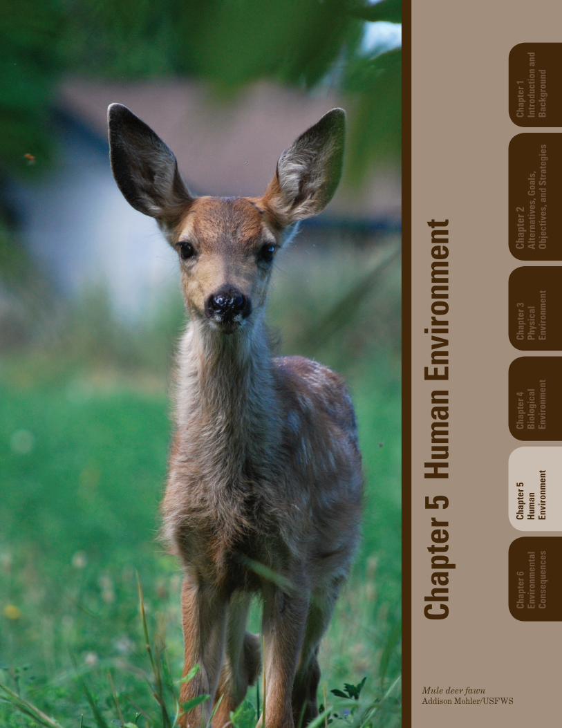
Mule deer fawnAddison Mohler/USFWS
Chap
ter 5
Hum
an E
nviro
nmen
t
Chap
ter 5
Hum
anEn
viro
nmen
t
Chap
ter 4
Biol
ogic
alEn
viro
nmen
t
Chap
ter 3
Phys
ical
Envi
ronm
ent
Chap
ter 2
Alte
rnat
ives
, Goa
ls,
Obj
ectiv
es, a
nd S
trat
egie
s
Chap
ter 1
Intr
oduc
tion
and
Bac
kgro
und
Chap
ter 6
Envi
ronm
enta
lCo
nseq
uenc
es

Deer Flat National Wildlife Refuge Final Comprehensive Conservation Plan and Environmental Impact Statement
Chapter 5. Human Environment 5-1
Chapter 5 Human Environment
5.1 Cultural Resources
Archaeological and other cultural resources are important components of our nation’s heritage. The Service is committed to protecting valuable evidence of plant, animal, and human interactions with each other and the landscape over time. These may include previously recorded or yet undocumented historic, cultural, archaeological, and paleontological resources as well as traditional cultural properties and the historic built environment.
Protection of cultural resources is legally mandated under numerous Federal laws and regulations. Foremost among these are the National Historic Preservation Act, as amended (16 U.S.C. 470 et seq.); the American Antiquities Act (16 U.S.C. 431-433); the Historic Sites Act (16 U.S.C. 461-467); the Archaeological Resources Protection Act, as amended (16 U.S.C. 470aa-mm); and the Native American Graves Protection and Repatriation Act (104 Stat. 3048, Public Law 101-601). The Service’s Native American Policy (USFWS 1994) articulates the general principles guiding the Service’s relationships with Tribal governments in the conservation of fish and wildlife resources. Additionally, the Refuge seeks to maintain a working relationship and consults on a regular basis with the Tribes that are or were traditionally tied to lands and waters within the Refuge.
5.1.1 Native American Cultural Landscape
The ethnographic and historical record is abundant with references to the Shoshone Tribes of western Idaho living in small and widely scattered groups in southwestern Idaho. The archaeological record documents a long tradition of residential use (Green 1982) and intensive harvest of plant and animal resources focused on the river environment (Plew 2000). Each year, the population would reach its greatest annual concentration along the Lower Snake River, including the islands. In 1843, Theodore Talbot, who accompanied John C. Fremont’s mapping expedition, described numerous islands in the Snake River occupied by small huts “surrounded by high platforms covered with drying salmon” (Talbot 1931:54).
Fish, especially the anadromous type, were a primary food source for the Shoshone. Runs of salmon during the late spring and fall brought larger groups together to efficiently harvest and process this staple. Other principal resources found along the river include mussels, small game, waterfowl, and various vegetable materials. The riverine villages, consisting of several extended families, would disperse during warmer months as smaller groups sought resources from higher elevations (Steward 1938), such as camas bulbs and biscuit root gathered from the foothills of the mountains. By late summer, berries and pinenuts would also be procured. Land fowl, such as sage hen, were hunted off the river and in the desert areas. Big game, such as deer or antelope, might be hunted but was not a major food source. For the cold winter months, people returned to the river and subsisted mostly on the stored foods gathered throughout the year. Caches for food storage have been found along the cliffs and crags of the Snake River.
5.1.2 Historic Landscape
The arrival of European explorers and fur traders to the area started in the first decades of the nineteenth century, bringing the seeds of dramatic landscape changes one sees today.
Deer Flat National Wildlife Refuge Final Comprehensive Conservation Plan and Environmental Impact Statement
5-2 Chapter 5. Human Environment
5.1.2.1 Hudson’s Bay Company
The fur trade in this area was conducted, in part, by the North West Company and dominated by Hudson’s Bay Company. The first Fort Boise was built of adobe in 1834 at a spot just downstream of the confluence of the Snake and Boise Rivers. This is the same location as John Reid’s fur-trapping camp during the winter of 1813. Fort Boise originally served Hudson’s Bay Company as a fur-trading post. Within a few years, emphasis switched to salmon fishing (Idaho State Historical Society [ISHS] 1970). At the same time, company policy declared each post should be as self-sufficient as possible, including agricultural production. In 1846, Fort Boise reported 2 tilled acres, 27 head of cattle, and 17 horses (Beckham 1995:13). Floods in 1853 and 1862 obliterated visible evidence of the fort’s location (ISHS n.d). With the advent of Idaho’s gold rush of the 1860s, a second Fort Boise was built by the U.S. Army near the modern city of Boise.
5.1.2.2 Oregon Trail
By the mid-1840s what had been a trickle of fur trappers, missionaries, and a few pioneers became a flood of settlers emigrating on the Oregon Trail. Seeking the fertile lands of the Pacific Northwest, most hurried through the seemingly inhospitable desert of the Snake River Plain (Beckham 1995:32-33). Save for a few choke points, the trail is not a singular track, rather a network of routes. One southern alternative route follows the west bank of the Snake River portion of the Refuge from Guffey Butte to the town of Homedale. The main Oregon Trail passed to the north of Lake Lowell to cross the Snake River at the original Fort Boise. As the fur trade declined, Fort Boise transformed into a convenient point on the Oregon Trail for emigrants to replenish supplies and cross the Snake River. Ferry boat operations began in earnest by 1852 (ISHS 1982:2). The site remained an important ferry crossing during the last half of the nineteenth century.
5.1.2.3 Farming and Ranching
As demonstrated by the modest livestock of the Hudson’s Bay Company forts and the large herds of horses cultivated by the Shoshone, the area was eventually seen to sustain some productivity. Promoting settlement were the various Federal land acquisition laws, such as the Donation Land Claim Act, Homestead Act, and the increasing presence of the U.S. military. Discovery of gold in the 1860s brought miners to the region, providing a ready local market for livestock and produce.
5.1.2.4 Reclamation
As the first waves of emigrants had noted, and later farmers discovered, the area had limited agricultural potential unless an abundant and steady water supply could be applied to the parched landscape. Initial attempts at irrigation had been undertaken by private parties, but economic forces and lack of coordination kept the cultivated acreage in the low thousands of acres. Recognizing a problem and seizing upon a solution, Senator Francis G. Newlands (Nevada) proposed legislation in 1902 that became known as the Newlands Reclamation Act. This Congressional act set up a public-private partnership through which the Federal government would design and build large-scale irrigation projects that would eventually be turned over to local control.
The Boise-Payette Project, one of the earliest projects under the Newlands Reclamation Act, assisted or subsumed the various private irrigation plans to provide a steady and coherent irrigation source. Deer Flat Reservoir, renamed Lake Lowell in 1948, was the first reservoir completed for the Boise
Deer Flat National Wildlife Refuge Final Comprehensive Conservation Plan and Environmental Impact Statement
Chapter 5. Human Environment 5-3
Project. The Boise Project’s successful completion brought tens of thousands of acres into agricultural production.
Lake Lowell was created by impounding water from the New York Canal behind the Upper and Lower embankments. Two minor structures were also constructed at the same time to control overflow events. The Middle (or Forest) embankment was to act as a spillway. It now serves as a road bed. The purpose of the fourth structure, the East Dike, is not known. The lake water level has never risen to the East Dike’s elevation. The structures are listed on the National Register of Historic Places (NRHP) for their role in early federal reclamation activity, and also as an example of the work done by the Civilian Conservation Corps (CCC) and the Works Projects Administration (WPA) during the Great Depression.
5.1.3 Archaeological Sites and Surveys
5.1.3.1 Sites within the Refuge Boundaries
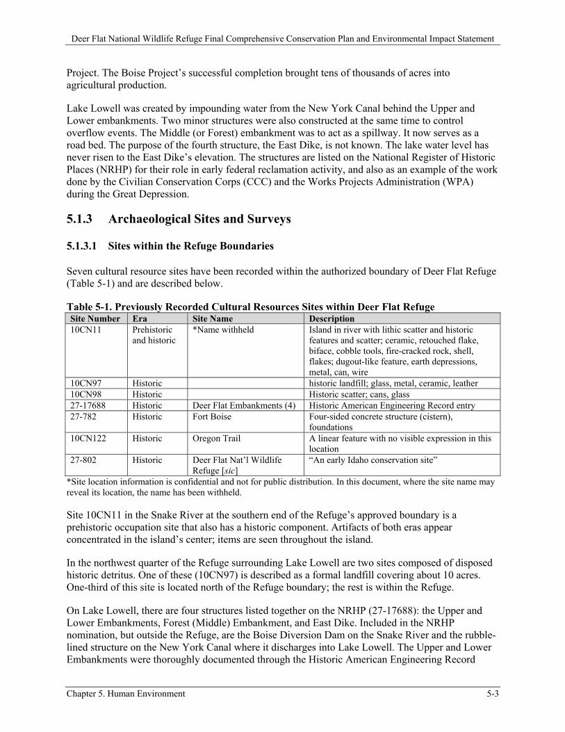
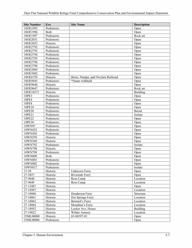
Seven cultural resource sites have been recorded within the authorized boundary of Deer Flat Refuge (Table 5-1) and are described below.
Table 5-1. Previously Recorded Cultural Resources Sites within Deer Flat Refuge Site Number Era Site Name Description 10CN11 Prehistoric
and historic *Name withheld Island in river with lithic scatter and historic
features and scatter; ceramic, retouched flake, biface, cobble tools, fire-cracked rock, shell, flakes; dugout-like feature, earth depressions, metal, can, wire
10CN97 Historic historic landfill; glass, metal, ceramic, leather 10CN98 Historic Historic scatter; cans, glass 27-17688 Historic Deer Flat Embankments (4) Historic American Engineering Record entry 27-782 Historic Fort Boise Four-sided concrete structure (cistern),
foundations 10CN122 Historic Oregon Trail A linear feature with no visible expression in this
location 27-802 Historic Deer Flat Nat’l Wildlife
Refuge [sic] “An early Idaho conservation site”
*Site location information is confidential and not for public distribution. In this document, where the site name may reveal its location, the name has been withheld.
Site 10CN11 in the Snake River at the southern end of the Refuge’s approved boundary is a prehistoric occupation site that also has a historic component. Artifacts of both eras appear concentrated in the island’s center; items are seen throughout the island.
In the northwest quarter of the Refuge surrounding Lake Lowell are two sites composed of disposed historic detritus. One of these (10CN97) is described as a formal landfill covering about 10 acres. One-third of this site is located north of the Refuge boundary; the rest is within the Refuge.
On Lake Lowell, there are four structures listed together on the NRHP (27-17688): the Upper and Lower Embankments, Forest (Middle) Embankment, and East Dike. Included in the NRHP nomination, but outside the Refuge, are the Boise Diversion Dam on the Snake River and the rubble-lined structure on the New York Canal where it discharges into Lake Lowell. The Upper and Lower Embankments were thoroughly documented through the Historic American Engineering Record
Deer Flat National Wildlife Refuge Final Comprehensive Conservation Plan and Environmental Impact Statement
5-4 Chapter 5. Human Environment
(HAER) process. The HAER documentation was undertaken by the Bureau of Reclamation (Reclamation) to facilitate needed modifications to those two structures. These early twentieth century structures are emblematic of large irrigation projects that propelled agricultural development in the region. During the Great Depression, workers with the WPA and the CCC modified the dams.
The Fort Boise site (27-782), as recorded, covers private, State, and Service land. This is the location of the early Hudson’s Bay Company factory situated near the confluence of the Boise and Snake Rivers. The trading post was destroyed during the 1853 flood, but the location remained a convenient ford for travelers on the Oregon Trail (10CN122).
Information provided by the ISHS identifies a point of interest (27-802) within the Fort Boise historic site as “Deer Flat Nat’l Wildlife Refuge” for its role in early twentieth century conservation efforts. No further information was provided about this designation. We surmise that this point is a reminder to record the Refuge landscape for its historic importance for Idaho conservation activities.
There are other CCC/WPA-era structures such as the entrance pillars and some of the original headquarters compound (located in the current maintenance area) for which formal site forms have not been completed.
5.1.3.2 Linear Features
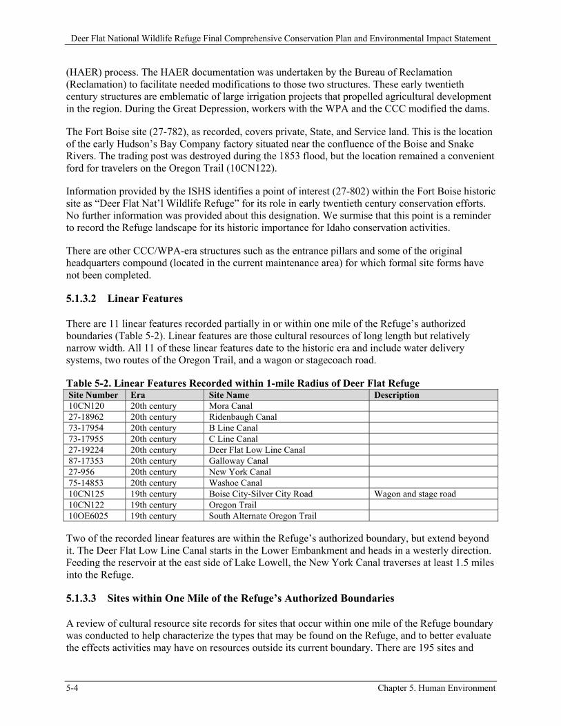
There are 11 linear features recorded partially in or within one mile of the Refuge’s authorized boundaries (Table 5-2). Linear features are those cultural resources of long length but relatively narrow width. All 11 of these linear features date to the historic era and include water delivery systems, two routes of the Oregon Trail, and a wagon or stagecoach road.
Table 5-2. Linear Features Recorded within 1-mile Radius of Deer Flat Refuge Site Number Era Site Name Description 10CN120 20th century Mora Canal 27-18962 20th century Ridenbaugh Canal 73-17954 20th century B Line Canal 73-17955 20th century C Line Canal 27-19224 20th century Deer Flat Low Line Canal 87-17353 20th century Galloway Canal 27-956 20th century New York Canal 75-14853 20th century Washoe Canal 10CN125 19th century Boise City-Silver City Road Wagon and stage road 10CN122 19th century Oregon Trail 10OE6025 19th century South Alternate Oregon Trail
Two of the recorded linear features are within the Refuge’s authorized boundary, but extend beyond it. The Deer Flat Low Line Canal starts in the Lower Embankment and heads in a westerly direction. Feeding the reservoir at the east side of Lake Lowell, the New York Canal traverses at least 1.5 miles into the Refuge.
5.1.3.3 Sites within One Mile of the Refuge’s Authorized Boundaries
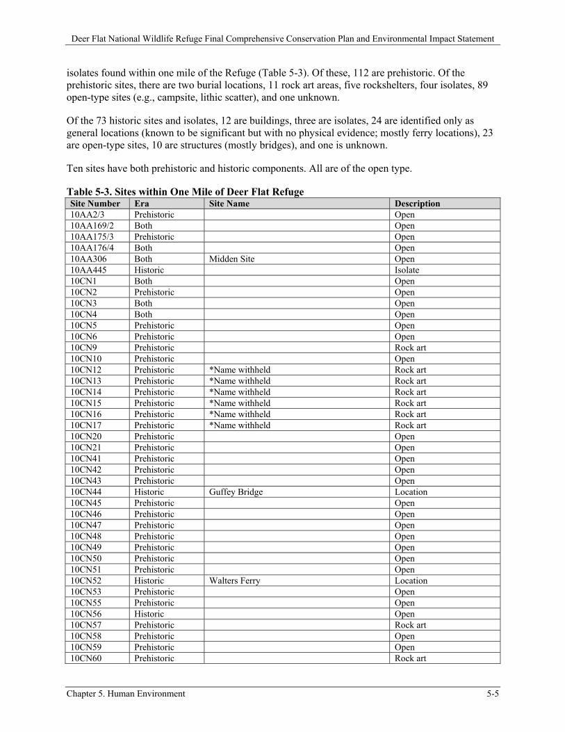
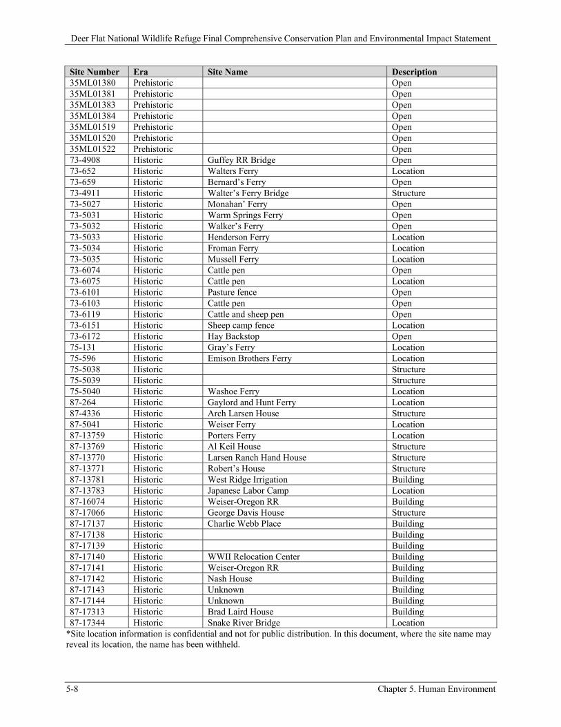
A review of cultural resource site records for sites that occur within one mile of the Refuge boundary was conducted to help characterize the types that may be found on the Refuge, and to better evaluate the effects activities may have on resources outside its current boundary. There are 195 sites and
Deer Flat National Wildlife Refuge Final Comprehensive Conservation Plan and Environmental Impact Statement
Chapter 5. Human Environment 5-5
isolates found within one mile of the Refuge (Table 5-3). Of these, 112 are prehistoric. Of the prehistoric sites, there are two burial locations, 11 rock art areas, five rockshelters, four isolates, 89 open-type sites (e.g., campsite, lithic scatter), and one unknown.
Of the 73 historic sites and isolates, 12 are buildings, three are isolates, 24 are identified only as general locations (known to be significant but with no physical evidence; mostly ferry locations), 23 are open-type sites, 10 are structures (mostly bridges), and one is unknown.
Ten sites have both prehistoric and historic components. All are of the open type.
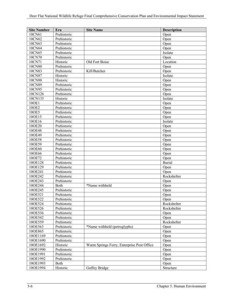
Table 5-3. Sites within One Mile of Deer Flat Refuge Site Number Era Site Name Description 10AA2/3 Prehistoric Open 10AA169/2 Both Open 10AA175/3 Prehistoric Open 10AA176/4 Both Open 10AA306 Both Midden Site Open 10AA445 Historic Isolate 10CN1 Both Open 10CN2 Prehistoric Open 10CN3 Both Open 10CN4 Both Open 10CN5 Prehistoric Open 10CN6 Prehistoric Open 10CN9 Prehistoric Rock art 10CN10 Prehistoric Open 10CN12 Prehistoric *Name withheld Rock art 10CN13 Prehistoric *Name withheld Rock art 10CN14 Prehistoric *Name withheld Rock art 10CN15 Prehistoric *Name withheld Rock art 10CN16 Prehistoric *Name withheld Rock art 10CN17 Prehistoric *Name withheld Rock art 10CN20 Prehistoric Open 10CN21 Prehistoric Open 10CN41 Prehistoric Open 10CN42 Prehistoric Open 10CN43 Prehistoric Open 10CN44 Historic Guffey Bridge Location 10CN45 Prehistoric Open 10CN46 Prehistoric Open 10CN47 Prehistoric Open 10CN48 Prehistoric Open 10CN49 Prehistoric Open 10CN50 Prehistoric Open 10CN51 Prehistoric Open 10CN52 Historic Walters Ferry Location 10CN53 Prehistoric Open 10CN55 Prehistoric Open 10CN56 Historic Open 10CN57 Prehistoric Rock art 10CN58 Prehistoric Open 10CN59 Prehistoric Open 10CN60 Prehistoric Rock art
Deer Flat National Wildlife Refuge Final Comprehensive Conservation Plan and Environmental Impact Statement
5-6 Chapter 5. Human Environment
Site Number Era Site Name Description 10CN61 Prehistoric Open 10CN62 Prehistoric Open 10CN63 Prehistoric Open 10CN64 Prehistoric Open 10CN65 Prehistoric Isolate 10CN70 Prehistoric Open 10CN71 Historic Old Fort Boise Location 10CN80 Prehistoric Open 10CN83 Prehistoric Kill/Butcher Open 10CN87 Historic Isolate 10CN88 Historic Open 10CN89 Prehistoric Open 10CN95 Prehistoric Open 10CN126 Prehistoric Open 10CN135 Historic Isolate 10OE1 Prehistoric Open 10OE2 Prehistoric Open 10OE5 Prehistoric Open 10OE15 Prehistoric Open 10OE16 Prehistoric Isolate 10OE20 Prehistoric Open 10OE48 Prehistoric Open 10OE49 Prehistoric Open 10OE58 Prehistoric Open 10OE59 Prehistoric Open 10OE60 Prehistoric Open 10OE66 Prehistoric Open 10OE72 Prehistoric Open 10OE128 Prehistoric Burial 10OE129 Prehistoric Open 10OE241 Prehistoric Open 10OE242 Prehistoric Rockshelter 10OE243 Prehistoric Open 10OE244 Both *Name withheld Open 10OE245 Prehistoric Open 10OE521 Prehistoric Open 10OE522 Prehistoric Open 10OE524 Prehistoric Rockshelter 10OE526 Prehistoric Rockshelter 10OE536 Prehistoric Open 10OE542 Prehistoric Open 10OE559 Prehistoric Rockshelter 10OE563 Prehistoric *Name withheld (petroglyphs) Open 10OE865 Prehistoric Open 10OE1169 Prehistoric Open 10OE1690 Prehistoric Open 10OE1692 Historic Warm Springs Ferry, Enterprise Post Office Open 10OE1990 Prehistoric Open 10OE1991 Prehistoric Open 10OE1992 Prehistoric Open 10OE1993 Both Open 10OE1994 Historic Guffey Bridge Structure
Deer Flat National Wildlife Refuge Final Comprehensive Conservation Plan and Environmental Impact Statement
Chapter 5. Human Environment 5-7
Site Number Era Site Name Description 10OE1995 Prehistoric Open 10OE1996 Both Open 10OE1997 Prehistoric Rock art 10OE2031 Prehistoric Open 10OE2032 Historic Open 10OE2792 Prehistoric Open 10OE2793 Prehistoric Open 10OE2794 Prehistoric Open 10OE2795 Prehistoric Open 10OE2796 Prehistoric Open 10OE2798 Prehistoric Open 10OE2889 Prehistoric Open 10OE3802 Prehistoric Open 10OE6759 Historic Boise, Nampa, and Owyhee Railroad Open 10OE9445 Prehistoric *Name withheld Open 10OE9646 Historic Open 10OE9647 Prehistoric Rock art 10OE10371 Historic Building 10PE3 Prehistoric Open 10PE4 Prehistoric Open 10PE8 Prehistoric Open 10PE10 Prehistoric Open 10PE20 Prehistoric Burial 10PE21 Prehistoric Isolate 10PE22 Prehistoric Open 10PE30 Prehistoric Open 10WN97 Prehistoric Open 10WN452 Prehistoric Open 10WN456 Prehistoric Open 10WN559 Historic Open 10WN560 Historic Open 10WN792 Prehistoric Isolate 10WN798 Historic Open 10WN799 Prehistoric Open 10WN800 Both Open 10WN801 Prehistoric Open 10WN802 Prehistoric Open 10WN817 Prehistoric Isolate 27-28 Historic Unknown Ferry Open 27-5037 Historic Riverside Ferry Open 27-9648 Historic Ross Camp Location 27-9649 Historic Ross Camp Location 27-13487 Historic Open 27-16967 Historic Location 27-18060 Historic Henderson Ferry Structure 27-18061 Historic Hot Springs Ferry Location 27-18062 Historic Bernard’s Ferry Location 27-18064 Historic Monahan’s Ferry Location 27-18952 Historic Locker Ave. House Building 27-19022 Historic Wilder Armory Location 35ML00000 Historic 03-08397-01 Open 35ML00006 Prehistoric Open
Deer Flat National Wildlife Refuge Final Comprehensive Conservation Plan and Environmental Impact Statement
5-8 Chapter 5. Human Environment
Site Number Era Site Name Description 35ML01380 Prehistoric Open 35ML01381 Prehistoric Open 35ML01383 Prehistoric Open 35ML01384 Prehistoric Open 35ML01519 Prehistoric Open 35ML01520 Prehistoric Open 35ML01522 Prehistoric Open 73-4908 Historic Guffey RR Bridge Open 73-652 Historic Walters Ferry Location 73-659 Historic Bernard’s Ferry Open 73-4911 Historic Walter’s Ferry Bridge Structure 73-5027 Historic Monahan’ Ferry Open 73-5031 Historic Warm Springs Ferry Open 73-5032 Historic Walker’s Ferry Open 73-5033 Historic Henderson Ferry Location 73-5034 Historic Froman Ferry Location 73-5035 Historic Mussell Ferry Location 73-6074 Historic Cattle pen Open 73-6075 Historic Cattle pen Location 73-6101 Historic Pasture fence Open 73-6103 Historic Cattle pen Open 73-6119 Historic Cattle and sheep pen Open 73-6151 Historic Sheep camp fence Location 73-6172 Historic Hay Backstop Open 75-131 Historic Gray’s Ferry Location 75-596 Historic Emison Brothers Ferry Location 75-5038 Historic Structure 75-5039 Historic Structure 75-5040 Historic Washoe Ferry Location 87-264 Historic Gaylord and Hunt Ferry Location 87-4336 Historic Arch Larsen House Structure 87-5041 Historic Weiser Ferry Location 87-13759 Historic Porters Ferry Location 87-13769 Historic Al Keil House Structure 87-13770 Historic Larsen Ranch Hand House Structure 87-13771 Historic Robert’s House Structure 87-13781 Historic West Ridge Irrigation Building 87-13783 Historic Japanese Labor Camp Location 87-16074 Historic Weiser-Oregon RR Building 87-17066 Historic George Davis House Structure 87-17137 Historic Charlie Webb Place Building 87-17138 Historic Building 87-17139 Historic Building 87-17140 Historic WWII Relocation Center Building 87-17141 Historic Weiser-Oregon RR Building 87-17142 Historic Nash House Building 87-17143 Historic Unknown Building 87-17144 Historic Unknown Building 87-17313 Historic Brad Laird House Building 87-17344 Historic Snake River Bridge Location
*Site location information is confidential and not for public distribution. In this document, where the site name may reveal its location, the name has been withheld.
Deer Flat National Wildlife Refuge Final Comprehensive Conservation Plan and Environmental Impact Statement
Chapter 5. Human Environment 5-9
5.1.3.4 Observations
In part due to Federal undertakings for the Morley Nelson Snake River Birds of Prey National Conservation Area (NCA), several cultural resource surveys have occurred on both sides of the Snake River in the Refuge’s southern end. There are many recorded prehistoric occupation and rock art sites, historic structures, and historic debris. This plethora of surveys creates a bias as to site density in that stretch when compared to the rest of the river. With that noted, the landscape does provide numerous locations ideal for rock art. The density of sites along the river banks is genuinely high.
Few of the islands in the Snake River have been systematically surveyed. One that has been surveyed is Sand Island in the NCA. No formal archaeological surveys have been conducted on the islands adjacent to Sand Island (i.e., Guffey and Rail islands). These islands are highly likely to contain significant cultural resources.
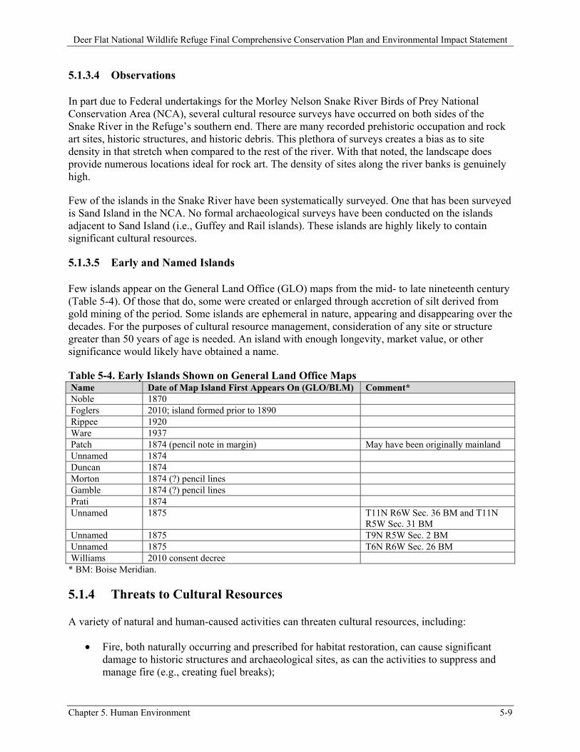
5.1.3.5 Early and Named Islands
Few islands appear on the General Land Office (GLO) maps from the mid- to late nineteenth century (Table 5-4). Of those that do, some were created or enlarged through accretion of silt derived from gold mining of the period. Some islands are ephemeral in nature, appearing and disappearing over the decades. For the purposes of cultural resource management, consideration of any site or structure greater than 50 years of age is needed. An island with enough longevity, market value, or other significance would likely have obtained a name.
Table 5-4. Early Islands Shown on General Land Office Maps Name Date of Map Island First Appears On (GLO/BLM) Comment* Noble 1870 Foglers 2010; island formed prior to 1890 Rippee 1920 Ware 1937 Patch 1874 (pencil note in margin) May have been originally mainland Unnamed 1874 Duncan 1874 Morton 1874 (?) pencil lines Gamble 1874 (?) pencil lines Prati 1874 Unnamed 1875 T11N R6W Sec. 36 BM and T11N
R5W Sec. 31 BM Unnamed 1875 T9N R5W Sec. 2 BM Unnamed 1875 T6N R6W Sec. 26 BM Williams 2010 consent decree
* BM: Boise Meridian.
5.1.4 Threats to Cultural Resources
A variety of natural and human-caused activities can threaten cultural resources, including:
Fire, both naturally occurring and prescribed for habitat restoration, can cause significant damage to historic structures and archaeological sites, as can the activities to suppress and manage fire (e.g., creating fuel breaks);
Deer Flat National Wildlife Refuge Final Comprehensive Conservation Plan and Environmental Impact Statement
5-10 Chapter 5. Human Environment
Erosion, whether the byproduct of fire, wind, waves, or another natural or human-made agent;
Habitat restoration and other land management activities; and Vandalism or “pot” hunting.
Any activity identified in the alternatives being considered, including wetland restoration, construction of new facilities, or changes in public use could have a potential impact to cultural resources. The greatest threats may be posed by earthmoving, removal of structures or alteration of the current erosion patterns occurring during habitat restoration, construction, or other land management activities.
Regardless of the alternative chosen, the Service is committed to protecting valuable evidence of plant, animal, and human interactions with each other and the landscape over time. These may include previously recorded or yet undocumented historic, cultural, archaeological, and paleontological resources as well as traditional cultural properties and the historic built environment. As discussed in Section 5.1, Federal laws and Service policy guide all Refuge actions regarding cultural resources, along with the Refuge’s relationships with relevant Tribes.
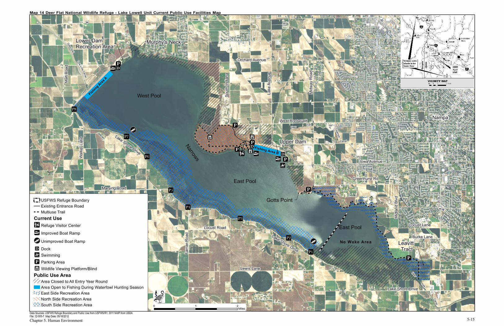
5.2 Refuge Facilities
5.2.1 Fences and Signs
5.2.1.1 Lake Lowell Unit
The Refuge’s boundary for this unit is fenced and posted with boundary signs. It is surrounded primarily by private lands. Signs reading “Area Closed,” “Hunting Area,” and “Nontoxic Shot” are also posted around the boundary as appropriate.
There are standard Refuge entrance signs at the Visitor Center entrance road, the Lower Dam Recreation Area, and between Parking Lot 8 and the Lower Dam. There are nonstandard entrance signs at the Visitor Center, near the east Upper Dam boat launch, at the Lower Dam Recreation Area, and east of Parking Lot 1 in the South Side Recreation Area. There are “Welcome to Your NWRS” signs at the east Upper Dam boat launch and at the entrance to Gotts Point. There are signs about regulations at the Visitor Center entrance road and at all parking areas except the two along the curves of Iowa Avenue.
5.2.1.2 Snake River Islands Unit
All of the Snake River islands are posted with boundary signs. Kiosks at the eight primary boat launches that access Refuge islands (Walter’s Ferry, Marsing, Homedale, Fort Boise Wildlife Management Area, Nyssa, Centennial Park in Payette, Roberts Landing, and Farewell Bend State Park) provide interpretive, regulatory, and orientation information. The maps on the kiosks indicate Refuge and Refuge islands along that particular stretch of river.
Deer Flat National Wildlife Refuge Final Comprehensive Conservation Plan and Environmental Impact Statement
Chapter 5. Human Environment 5-11
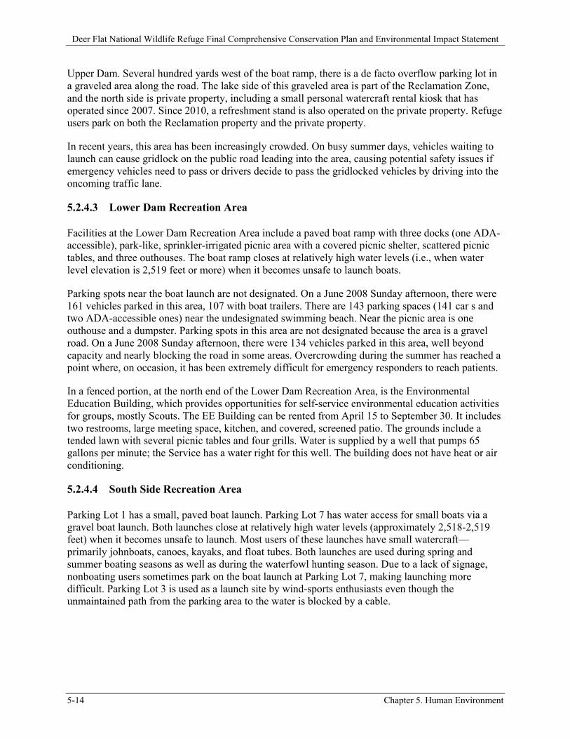
5.2.2 Roads, Parking Areas, and Access Points
5.2.2.1 Lake Lowell Unit Roads
There are five roads on the Refuge. The North Side Recreation Area is accessed via a half-mile paved entrance road that opened in December 2007 and provides access to the Visitor Center. The road is opened by an automatic gate during public use hours (dawn to dusk). A small parking lot outside the gate can be accessed at all times.
The entrance road provides access to a 3.25-mile loop of unpaved road west of the Visitor Center that is used primarily as a trail (Observation Hill Trail). This road is closed to vehicles, with the exception of occasional permitted access to the ADA-accessible wildlife viewing platform and administrative access. (The road accesses Refuge agricultural fields that are closed to the public.) A firebreak that leads from this trail system to the parking lot at the top of the entrance road is often used as a trail by visitors.
There is a one-mile, unpaved road east of the Tio Lane entrance that is closed to vehicles, with the exception of administrative access. This road serves as a trail (East Dike Trail) for visitors.
There is a 3.75-mile unpaved road from the Tio Lane entrance northwest to the Greenhurst Road entrance. It is closed to vehicles, with the exception of administrative access, but serves as a trail for visitors (Kingfisher Trail).
The Kingfisher Trail road travels to the west from the Greenhurst Road entrance and terminates at a gate just past Gotts Point that separates the public area from Refuge maintenance areas and farm fields. This 0.5-mile section of the road is also closed to vehicles, with the exception of administrative access, and serves as a trail for visitors (Gotts Point Trail). Gotts Point Trail is closed from October 1 through January 31 to provide an undisturbed wintering wildlife area. It is gated but open for foot, bicycle, and horse travel from February 1 through September 30.
Parallel to the Gotts Point Trail there is a 0.5-mile, unpaved road leading to Gotts Point from the Greenhurst Road public entrance. This road is currently gated at a parking lot after about 0.2 mile. The road from the parking area to Gotts Point (0.3 mile) is gated but open for foot, bicycle, and horse travel from February 1 through September 30. It is closed October 1 through January 31 to provide an undisturbed wintering wildlife area. The closure of this area to vehicles was enacted in late summer of 2006 due to extreme vandalism and concerns for public safety (see Section 5.6.6). There are two small parking lots adjacent to the lake on the closed portion and an outhouse at the end of the road.
Kingfisher Trail, Gotts Point Trail, and Gotts Point Road were all graded in anticipation of graveling in Summer 2011. Due to unforeseen budget issues, the project was postponed. Graveling of Kingfisher Trail was completed in Fall 2011, with graveling of the Gotts Point Trail and Road to occur later.
A major County road (with traffic of 2,817 vehicles per day, according to the Canyon County Highway District [2009]) runs across the Lower Dam. Paved County roads encircle the Refuge and provide public access to most Refuge parking lots and access points.
Deer Flat National Wildlife Refuge Final Comprehensive Conservation Plan and Environmental Impact Statement
5-12 Chapter 5. Human Environment
5.2.2.2 Lake Lowell Unit Parking Areas and Access Points
There are 19 parking areas around the lake. All are paved except the picnic and swimming beach lots at the Lower Dam Recreation Area and the parking lot at Gotts Point. Parking lots at the Visitor Center entrance road, Visitor Center, east and west ends of the Upper Dam, curves along Iowa Avenue, Tio Lane entrance, and Parking Lot 8 are open all year. The lots at Gotts Point and the Lower Dam Recreation Area are open during the boating season (April 15 to September 30). Parking Lots 1, 2, 3, 7, and 8 are usually open April 15 through the end of waterfowl hunting season (middle or late January). Parking Lots 4, 5, and 6 are open only during hunting season (September to middle or late January).
There are two walk-through access areas at the Lake Lowell Unit that do not have parking facilities associated with them. One walk-through is located at Murphy’s Neck, and the other is located several hundred yards east of the west end of Greenhurst Road. The Murphy’s Neck access is used mostly by anglers, while the access on Greenhurst Road is used mostly by upland game hunters. Users of these access points must park on the shoulders of County roads (Orchard Avenue and Greenhurst Road, respectively).
5.2.2.3 Snake River Islands Unit
There are no roads or parking areas on Refuge islands. Refuge islands are accessed from eight major and five minor boat launches owned and managed by various City, County, State, and Federal agencies.
5.2.3 Trails
5.2.3.1 Lake Lowell Unit
There are six trails open to pedestrians, bicyclists, and equestrians. Dogs must be kept on a leash at all times. In winter, the trails are occasionally used for cross-country skiing and snowshoeing. Refuge trails include:
Nature Trail, a 0.5-mile, unpaved, self-guided loop near the Visitor Center. There is an adjacent wildlife-viewing blind.
Observation Hill Trail, a 3.25-mile loop, internal Refuge road that serves as a trail west of the Visitor Center. There is an adjacent wildlife-viewing platform.
East Dike Trail, a 1.0-mile internal Refuge road that serves as a trail east of the Tio Lane entrance.
Kingfisher Trail, a 3.75-mile internal Refuge road that serves as a trail from Tio Lane entrance to Greenhurst Road entrance.
Gotts Point Trail, a 0.75-mile internal Refuge road that serves as a trail from Greenhurst Road entrance to a gate just north of Gotts Point.
Centennial Trail, a 1.2-mile ADA-accessible historical interpretive trail from the Visitor Center to the viewing platform at the west end of the Upper Dam and then across the historic Upper Dam.
Deer Flat National Wildlife Refuge Final Comprehensive Conservation Plan and Environmental Impact Statement
Chapter 5. Human Environment 5-13
5.2.3.2 Snake River Islands Unit
There are no trails on Refuge islands.
5.2.4 Other Facilities Listed by Refuge Area
There are no facilities on the Snake River Islands Unit. Facilities at the Lake Lowell Unit are discussed below by location. Map 14 shows Lake Lowell Unit public use facilities.
5.2.4.1 North Side Recreation Area
The Visitor Center includes the Refuge administrative offices and over 2,600 square feet of public exhibit space, including a KidSpace activity area, small wildlife-viewing room, 900-square-foot auditorium with a seating capacity around 75, and public restrooms. The Visitor Center is open year-round, except for Federal holidays, from 8 AM to 4 PM weekdays and 10 AM to 4 PM Saturdays. According to a recent survey, 36 percent of visitors indicated that they had gone to the Visitor Center during their visit (Sexton et al. 2012). However, only 22 percent were actually contacted at the Visitor Center during the survey effort. Of those visitors who were contacted at other locations during the survey (n=162), only 23 percent indicated that they did “go to a Visitor Center at the Refuge” (Dietsch 2011).
In 2011, due to overcrowded Refuge offices and the desire to find additional room for Service employees working in leased space, more administrative space was added, and the parking area was repaved and enlarged. The Visitor Center parking lot provides 42 spaces (including two ADA-accessible spaces), but provides none for buses, recreational vehicles, or vehicles with trailers.
Other facilities in the North Side Recreation Area include ADA-accessible wildlife-viewing platforms near the west Upper Dam boat ramp and on the Observation Hill Trail west of the Visitor Center, wildlife-viewing blind along the Nature Trail, ADA-accessible fishing dock at the west end of the Upper Dam (available mid-April to early October), paved boat ramp with two docks, and an outhouse at the boat launch parking area. The parking lot has 88 designated spaces (36 trailer spaces, 44 car spaces, two ADA-accessible trailer spaces, and six ADA-accessible car spaces). The launch closes at relatively high water levels (i.e., a water level elevation of 2,519 feet or more) when it becomes unsafe to launch boats. All facilities are in good condition.
5.2.4.2 East Upper Dam Boat Launch
Facilities at the east Upper Dam boat ramp include a paved boat ramp with two docks, swimming beach designated by docks and a buoy line, and two picnic tables. The Refuge parking lot has 38 spaces (23 trailer, 13 car, and two ADA-accessible ones).
The Canyon County Park across the street provides 56 parking spaces (12 trailer, 42 car, and two ADA-accessible spaces), bathrooms with flush toilets, picnic tables, and grills. Several hundred yards east of the boat ramp, in the curves of Iowa Avenue, there are two paved Refuge parking lots with approximately seven and nine undesignated parking spots. There are no walkways or crosswalks providing pedestrian access to the Refuge, so visitors parking in these lots must walk on the road surface. There are also no Refuge access points immediately across from these parking areas. It is around a 0.25-mile walk from the farthest parking area to the boat launch on the east side of the
Deer Flat National Wildlife Refuge Final Comprehensive Conservation Plan and Environmental Impact Statement
5-14 Chapter 5. Human Environment
Upper Dam. Several hundred yards west of the boat ramp, there is a de facto overflow parking lot in a graveled area along the road. The lake side of this graveled area is part of the Reclamation Zone, and the north side is private property, including a small personal watercraft rental kiosk that has operated since 2007. Since 2010, a refreshment stand is also operated on the private property. Refuge users park on both the Reclamation property and the private property.
In recent years, this area has been increasingly crowded. On busy summer days, vehicles waiting to launch can cause gridlock on the public road leading into the area, causing potential safety issues if emergency vehicles need to pass or drivers decide to pass the gridlocked vehicles by driving into the oncoming traffic lane.
5.2.4.3 Lower Dam Recreation Area
Facilities at the Lower Dam Recreation Area include a paved boat ramp with three docks (one ADA-accessible), park-like, sprinkler-irrigated picnic area with a covered picnic shelter, scattered picnic tables, and three outhouses. The boat ramp closes at relatively high water levels (i.e., when water level elevation is 2,519 feet or more) when it becomes unsafe to launch boats.
Parking spots near the boat launch are not designated. On a June 2008 Sunday afternoon, there were 161 vehicles parked in this area, 107 with boat trailers. There are 143 parking spaces (141 car s and two ADA-accessible ones) near the undesignated swimming beach. Near the picnic area is one outhouse and a dumpster. Parking spots in this area are not designated because the area is a gravel road. On a June 2008 Sunday afternoon, there were 134 vehicles parked in this area, well beyond capacity and nearly blocking the road in some areas. Overcrowding during the summer has reached a point where, on occasion, it has been extremely difficult for emergency responders to reach patients.
In a fenced portion, at the north end of the Lower Dam Recreation Area, is the Environmental Education Building, which provides opportunities for self-service environmental education activities for groups, mostly Scouts. The EE Building can be rented from April 15 to September 30. It includes two restrooms, large meeting space, kitchen, and covered, screened patio. The grounds include a tended lawn with several picnic tables and four grills. Water is supplied by a well that pumps 65 gallons per minute; the Service has a water right for this well. The building does not have heat or air conditioning.
5.2.4.4 South Side Recreation Area
Parking Lot 1 has a small, paved boat launch. Parking Lot 7 has water access for small boats via a gravel boat launch. Both launches close at relatively high water levels (approximately 2,518-2,519 feet) when it becomes unsafe to launch. Most users of these launches have small watercraft—primarily johnboats, canoes, kayaks, and float tubes. Both launches are used during spring and summer boating seasons as well as during the waterfowl hunting season. Due to a lack of signage, nonboating users sometimes park on the boat launch at Parking Lot 7, making launching more difficult. Parking Lot 3 is used as a launch site by wind-sports enthusiasts even though the unmaintained path from the parking area to the water is blocked by a cable.
!y !j
[d
!j
!j
[d
!y!j
"[
!y"@
"[
"[
!r
!D!D
!j
!j
!D
!j
Greenhurst Rd
Lower Dam Recreation Area
Upper Dam
Gotts Point
Leavitt TractP1
Murphy's Neck
P2
P3
P4
P5
P6
P7
P8
Orchard Avenue
West Roosevelt
Iowa Avenue
Locust Lane
Burke LaneLocust Road
Lewis Lane
Marsing Road
Malt R
oad
South
India
na
Lake
Aven
ue
Midw
ay R
oad
Walke
r Lak
e
Farne
r Roa
d
Lake Shore Drive
Lake Shore Drive
Lake Shore Drive
Midla
nd Bl
vd
Fishing Area
A
Fishing Area B
Narrows
Low Line Canal
Deer Flat
New
York
Canal
Deer Flat
Nampa
Canal
¬«45
¬«55
¬«55
¥84
West Pool
East Pool
East Pool
Nampa
No Wake Area
USFWS Refuge BoundaryExisting Entrance RoadMultiuse Trail
Current Use"@ Refuge Visitor Center!y Improved Boat Ramp[d Unimproved Boat Ramp!D Dock!r Swimming!j Parking Area"[ Wildlife Viewing Platform/BlindPublic Use Area
Area Closed to All Entry Year RoundArea Open to Fishing During Waterfowl Hunting SeasonEast Side Recreation AreaNorth Side Recreation AreaSouth Side Recreation Area
Map 14 Deer Flat National Wildlife Refuge - Lake Lowell Unit Current Public Use Facilities Map
Data Sources: USFWS Refuge Boundary and Public Use from USFWS/R1; 2011 NAIP from USDAFile: 12-005-7 Map Date: 05/16/2012
0 21Miles
Chapter 5. Human Environment 5-15

Deer Flat National Wildlife Refuge Final Comprehensive Conservation Plan and Environmental Impact Statement
5-16 Chapter 5. Human Environment
Document continues on next page.
Deer Flat National Wildlife Refuge Final Comprehensive Conservation Plan and Environmental Impact Statement
Chapter 5. Human Environment 5-17
5.2.4.5 East Side Recreation Area
There are no facilities in the East Side Recreation Area.
5.2.4.6 Gotts Point
An outhouse is provided at the end of the 0.3-mile road/trail and is accessible by foot, bike, and horse.
5.2.4.7 Maintenance Area
The maintenance area includes the main shop, boat house, oil house, and a few other outbuildings. There is also the original Refuge administration building, two residences (including one listed on the NRHP), one detached garage, and a historic boat house. An additional equipment storage facility was built in 2011 to accommodate equipment for Service employees using the administrative addition.
5.3 Public Use Overview
5.3.1 Legal Mandates Involving Public Uses on Refuges
All public activities on a refuge are considered closed unless officially open. To officially open a use or extend an existing use, a refuge must first complete a compatibility determination. The following summary of Congressional acts gives a brief explanation of how and when public uses are legally allowed on Refuges.
In 1962, the Refuge Recreation Act (76 Stat. 653; 16 U.S.C. 460k-460k-4) was passed. Refuges were tasked with ensuring “that any present or future recreational use will be compatible with and will not prevent accomplishment of, the primary purposes for which the said conservation areas were acquired or established.” It also says that recreational activities can be appropriate as long as they are not inconsistent with the primary objective of each refuge. If uses do not fit this description the Refuge Recreation Act further states that the refuge will “curtail public recreation use generally or certain types of public recreation use” whenever necessary.
The National Wildlife Refuge System Administration Act of 1966 (Public Law 90-404; 16 U.S.C. 668dd-668ee, et seq.) states that the public could not “enter, use, or otherwise occupy any such area for any purpose” unless such activities were compatible with the major purposes for which the area was established. The Administration Act was further amended by the Refuge System Improvement Act in 1997.
The Refuge System Improvement Act of 1997 (Public Law 105-57) reasserts the need for refuge uses to be compatible and said that compatible wildlife-dependent recreational uses “receive enhanced consideration over other general public uses in planning and management.” It also stated that refuges could not “initiate or permit a new use, or expand, renew, or extend an existing use,” unless the use has been determined to be compatible and consistent with public safety.
Under the Improvement Act, each refuge is required to complete a compatibility determination for existing uses, which estimate the timeframe, location, manner, and purpose of each use. Refuges are also required to identify the effects of each use on refuge resources and purposes of each refuge. Any
Deer Flat National Wildlife Refuge Final Comprehensive Conservation Plan and Environmental Impact Statement
5-18 Chapter 5. Human Environment
use that is found not to be compatible is required to be eliminated or modified to make it compatible. New compatibility determinations are required every 10 to 15 years and with the preparation of the refuge comprehensive conservation plan. The few compatibility determinations that have been previously completed for this Refuge were last approved in 1999. There was little or no mention of possible impacts to Refuge habitat or purpose, and no scientific literature was cited.
5.3.2 General Visitation Information
The Refuge provides opportunities for all wildlife-dependent priority public uses (the “Big Six,” i.e., hunting, fishing, wildlife observation, photography, environmental education, and interpretation) listed in the Refuge System Improvement Act of 1997, as amended. In addition to providing the Big Six activities, many nonwildlife-dependent public uses also currently occur, especially at the Lake Lowell Unit. Some of these uses include high-speed boating, windsurfing, jogging, swimming, sunbathing, horseback riding, and special events such as weddings.
Estimating current visitor numbers at the Refuge is challenging because of the dispersed nature of access points. The Lake Lowell Unit includes 15 individual access points distributed around the 27 miles of county road surrounding the lake. The Snake River Islands Unit includes 14 improved and unimproved boat launches that provide access to Refuge islands, but also provide access to nonrefuge sites and activities. Visitation data for the Snake River Islands Unit, and for some low-participation activities at the Lake Lowell Unit (e.g., mourning dove hunting) are still based on best professional judgment.
Until July 2005, visitor counts were based on best professional judgment and may not accurately reflect visitation at the 16 public access points. Formal visitor counts began at Lake Lowell in July 2005, but sufficient evening and weekend surveys were not completed until December 2006, so we do not have good data to reflect visitation trends.
The Refuge uses two complementary sampling methods to estimate visitation at the Lake Lowell Unit. The number of vehicles at dispersed access points is counted on at least two weekdays and one weekend day per month in each of three time slots (morning, afternoon, and evening). Load factors to correct data from the vehicle count for number of people per vehicle and visitor activities are determined through direct observations of visitor use at Refuge access points. The access points are designated as one of five location types (improved ramp, unimproved ramp, parking lots, fishing spots, and parks), and each location type is observed on at least two weekdays and one weekend day in each of three time slots (morning, afternoon, and evening).
Visitation estimates at the Visitor Center are based on data from a door counter on the front door. Because the total on the counter does not directly correspond with the total number of visitors for a variety of reasons (e.g., visitors are separately counted as they enter and as they depart, and when they leave and re-enter during a single visit), counter data are corrected with a factor developed from direct observations of the number of visitors relative to the counts recorded on the door counter. Participants in environmental education programs and special events are based on direct counts of participants.
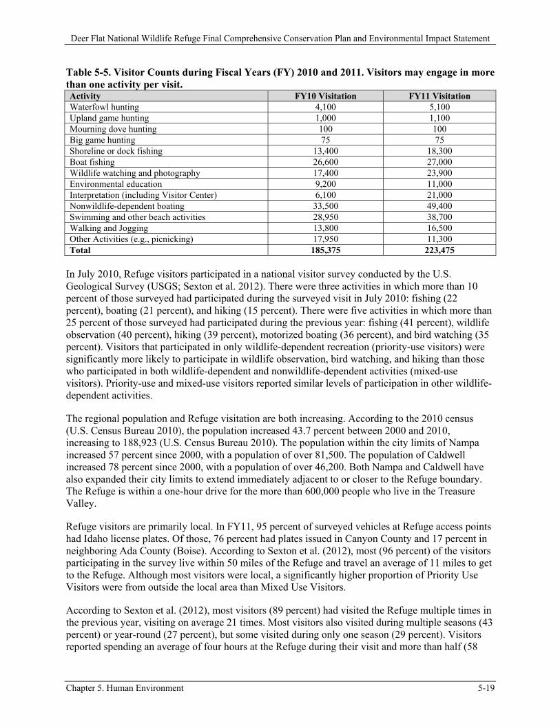
Refuge visitation over the past four years has fluctuated between approximately 167,000 and 225,000. For a more detailed breakdown of visitation, please see Table 5-5.
Deer Flat National Wildlife Refuge Final Comprehensive Conservation Plan and Environmental Impact Statement
Chapter 5. Human Environment 5-19
Table 5-5. Visitor Counts during Fiscal Years (FY) 2010 and 2011. Visitors may engage in more than one activity per visit. Activity FY10 Visitation FY11 Visitation Waterfowl hunting 4,100 5,100 Upland game hunting 1,000 1,100 Mourning dove hunting 100 100 Big game hunting 75 75 Shoreline or dock fishing 13,400 18,300 Boat fishing 26,600 27,000 Wildlife watching and photography 17,400 23,900 Environmental education 9,200 11,000 Interpretation (including Visitor Center) 6,100 21,000 Nonwildlife-dependent boating 33,500 49,400 Swimming and other beach activities 28,950 38,700 Walking and Jogging 13,800 16,500 Other Activities (e.g., picnicking) 17,950 11,300 Total 185,375 223,475
In July 2010, Refuge visitors participated in a national visitor survey conducted by the U.S. Geological Survey (USGS; Sexton et al. 2012). There were three activities in which more than 10 percent of those surveyed had participated during the surveyed visit in July 2010: fishing (22 percent), boating (21 percent), and hiking (15 percent). There were five activities in which more than 25 percent of those surveyed had participated during the previous year: fishing (41 percent), wildlife observation (40 percent), hiking (39 percent), motorized boating (36 percent), and bird watching (35 percent). Visitors that participated in only wildlife-dependent recreation (priority-use visitors) were significantly more likely to participate in wildlife observation, bird watching, and hiking than those who participated in both wildlife-dependent and nonwildlife-dependent activities (mixed-use visitors). Priority-use and mixed-use visitors reported similar levels of participation in other wildlife-dependent activities.
The regional population and Refuge visitation are both increasing. According to the 2010 census (U.S. Census Bureau 2010), the population increased 43.7 percent between 2000 and 2010, increasing to 188,923 (U.S. Census Bureau 2010). The population within the city limits of Nampa increased 57 percent since 2000, with a population of over 81,500. The population of Caldwell increased 78 percent since 2000, with a population of over 46,200. Both Nampa and Caldwell have also expanded their city limits to extend immediately adjacent to or closer to the Refuge boundary. The Refuge is within a one-hour drive for the more than 600,000 people who live in the Treasure Valley.
Refuge visitors are primarily local. In FY11, 95 percent of surveyed vehicles at Refuge access points had Idaho license plates. Of those, 76 percent had plates issued in Canyon County and 17 percent in neighboring Ada County (Boise). According to Sexton et al. (2012), most (96 percent) of the visitors participating in the survey live within 50 miles of the Refuge and travel an average of 11 miles to get to the Refuge. Although most visitors were local, a significantly higher proportion of Priority Use Visitors were from outside the local area than Mixed Use Visitors.
According to Sexton et al. (2012), most visitors (89 percent) had visited the Refuge multiple times in the previous year, visiting on average 21 times. Most visitors also visited during multiple seasons (43 percent) or year-round (27 percent), but some visited during only one season (29 percent). Visitors reported spending an average of four hours at the Refuge during their visit and more than half (58
Deer Flat National Wildlife Refuge Final Comprehensive Conservation Plan and Environmental Impact Statement
5-20 Chapter 5. Human Environment
percent) were part of a group during their visit. Priority Use Visitors spent significantly less time (average of three hours) during their visit than Mixed Use Visitors. Surveyed visitors were generally satisfied with the Refuge (Appendix L):
90 percent were satisfied with the recreational activities and opportunities. 85 percent were satisfied with the Refuge’s information and education, and its resources. 87 percent were satisfied with the services provided by employees or volunteers. 89 percent were satisfied with the Refuge’s conservation of fish, wildlife, and their habitats.
5.3.3 General Access
Visitor access to the Refuge is allowed between sunrise and sunset (i.e., day use only). There are no entrance fees for accessing the Refuge. At the Lake Lowell Unit, 63 percent of the land base is open year-round. Of the remaining 36 percent that constitutes closed areas, 21 percent is closed year-round, 10 percent is closed year-round but used for administrative purposes (e.g., farming, maintenance area, and residences), and 6 percent is closed seasonally (October 1 to January 31) to minimize disturbance to wintering waterfowl. Closed areas, no-wake zones, and seasonal closures that are in place are listed below for each unit.
5.3.3.1 Lake Lowell Unit Closures and Access Points
There are permanent closures in six areas of the Lake Lowell Unit:
The upland area to the northwest of the North Side Recreation Area and to the east of Murphy’s Neck;
The riparian and upland areas between Parking Lot 1 and the New York Canal; Around the osprey-nesting structure that is closest to the Visitor Center; Maintenance Area and farm fields to the west of Gotts Point; Upper Dam Marsh and farm field on Lake Avenue; and Areas surrounding the water control outlets on the Upper and Lower Dams.
There are seasonal closures in five areas of the Lake Lowell Unit:
Wintering wildlife closure at Gotts Point from October 1 to January 31; Wintering wildlife closure at Murphy’s Neck from October 1 to January 31; Winter closure of the Lower Dam Recreation Area from October 1 to April 15; Winter closure of the surface of Lake Lowell from October 1 to April 15, with the exception
of a 200-yard fishing area in front of the Upper and Lower Dams and 200-yard hunting area along the south shoreline between Parking Lots 1 and 8; and
Eagle-nesting closure around the eagle’s nest in the North Side Recreation Area.
There are three no-wake zones currently on Lake Lowell:
The southeast end of Lake Lowell starting at Parking Lot 1; The area surrounding Gotts Point; and Areas surrounding the boat ramps at the Upper and Lower Dams.
Deer Flat National Wildlife Refuge Final Comprehensive Conservation Plan and Environmental Impact Statement
Chapter 5. Human Environment 5-21
Visitor access to the Lake Lowell Unit is provided through 15 individual access points. These access points are as follows:
Main Refuge entrance at the corner of Roosevelt and Indiana Avenues; Upper Dam East Parking Area on Lake Avenue; Gotts Point entrance and parking area at the west end of Greenhurst Road; Tio Lane entrance at the south end of Tio Lane; Parking Lots 1 to 8 on Lake Shore Drive; Lower Dam Recreation Area on Riverside Road; Murphy’s Neck walk-through on the west end of Orchard Avenue; and Hunting access walk-through on the west end of Greenhurst Road.
5.3.3.2 Snake River Islands Unit Closures and Access Points
There is one seasonal closure for the Snake River Islands Unit: the waterfowl nesting closure on all islands between February 1 and May 31. Access to the Snake River Islands Unit is by boat only from several boat launches along the Snake River. These public boat launches are maintained by agencies at different levels of government: City, County, State, and Federal.
5.4 Wildlife-dependent Public Uses
The Refuge System Improvement Act of 1997, as amended, identifies hunting, fishing, wildlife observation, wildlife photography, environmental education, and interpretation as wildlife-dependent, priority public uses for national wildlife refuges. The Refuge provides opportunities to enjoy each of these priority public uses. More details on individual wildlife-dependent recreation opportunities are outlined below.
5.4.1 Hunting
Almost one-quarter (21 percent) of the Lake Lowell Unit is open to bird hunting. Bird hunting is allowed on the East Side and South Side Recreation Areas for mourning dove, upland game birds, ducks, and coots. The entire Lake Lowell Unit is inside a goose hunting closure area designated by the Idaho Department of Fish and Game (IDFG). General state seasons and limits apply; no special Refuge permits are required. In past years, special use permits (SUPs) have been issued to disabled bird hunters allowing ATV use for lake access through the gate east of Parking Lot 8.
The South Side Recreation Area and the area east of Parking Lot 1 to the New York Canal are open to a controlled deer hunt, which includes up to 21 percent of the Lake Lowell Unit (depending on water levels). Hunters must have a controlled deer hunt tag issued by IDFG as well as a Refuge Deer Hunt Permit.
Mourning dove season is during the month of September. Upland game bird seasons are usually mid-October until mid- to late January. While the habitat is not optimal for upland game, hunters seem to appreciate the opportunity, and the area receives steady use.
Waterfowl hunting runs from mid-October until mid- to late January, with a late September or early October youth hunt. In the South Side Recreation Area, human- or electric-powered boats can be
Deer Flat National Wildlife Refuge Final Comprehensive Conservation Plan and Environmental Impact Statement
5-22 Chapter 5. Human Environment
used up to 200 yards from the shore. In the East Side Recreation Area, waterfowl hunting is walk-in only. A youth waterfowl hunt is allowed in all designated waterfowl hunt zones in accordance with IDFG regulations. There are no blinds or designated hunting spots. Portable blinds are allowed if they are removed at the end of each day. Temporary blinds may be constructed from natural vegetation less than 3 inches in diameter and are available on a first-come, first-served basis.
Concerns have been raised about the quality of the waterfowl hunt, with comments about overcrowding and pass shooting. The closest public hunt area for walk-in hunters is at Fort Boise Wildlife Management Area, about 30 miles west, so there is high demand for good hunting closer to population centers. Many hunters with boats go to the Snake River Islands Unit or elsewhere along the Snake River.
All Refuge islands are open to hunting for mourning dove, upland game, waterfowl, coots, and deer. There are no blinds or designated hunting spots. Portable blinds are allowed if removed at the end of each day. Temporary blinds may be constructed from natural vegetation less than 3 inches in diameter and are available on a first-come, first-served basis. General state seasons and limits apply (see typical seasons above), although spring hunts are not allowed during the nesting closure between February 1 and May 31. In recent years, there have been occasional complaints from neighbors on the shoreline about noise from waterfowl hunting. Complaints may increase as development of shoreline homes continues in certain stretches of the river. There have been occasional requests for guided waterfowl hunts on Refuge islands. Guided waterfowl hunting is illegal in Idaho but allowed in Oregon.
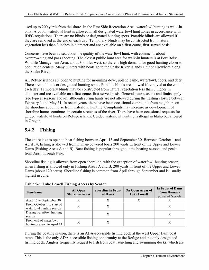
5.4.2 Fishing
The entire lake is open to boat fishing between April 15 and September 30. Between October 1 and April 14, fishing is allowed from human-powered boats 200 yards in front of the Upper and Lower Dams (Fishing Areas A and B). Boat fishing is popular throughout the boating season, and peaks from April through June.
Shoreline fishing is allowed from open shoreline, with the exception of waterfowl-hunting season, when fishing is allowed only in Fishing Areas A and B, 200 yards in front of the Upper and Lower Dams (about 120 acres). Shoreline fishing is common from April through September and is usually highest in June.
Table 5-6. Lake Lowell Fishing Access by Season
Timeframe All Open
Shoreline Areas Shoreline in Front
of Dams On Open Areas of
Lake Lowell
In Front of Dams from Human-
powered Vessels April 15 to September 30 X X X X From October 1 to start of waterfowl hunting season
X X X
During waterfowl hunting season
X X
From end of waterfowl hunting season to April 14
X X X
During the boating season, there is an ADA-accessible fishing dock at the west Upper Dam boat ramp. This is the only ADA-accessible fishing opportunity at the Refuge and the only designated fishing dock. Anglers frequently request to fish from boat launching and swimming docks, which are
Deer Flat National Wildlife Refuge Final Comprehensive Conservation Plan and Environmental Impact Statement
Chapter 5. Human Environment 5-23
posted with signs reading “No fishing from docks.” Currently, rules against fishing from boat docks are not enforced when there is minimal boating traffic and anglers do not interfere with launching boats.
The lake has been stocked with channel catfish and Lahontan cutthroat trout in recent years. In the future, IDFG plans to continue stocking channel catfish as funding is available and stocking is necessary (Kozfkay 2012). General State seasons and limits apply, with the exception that bass fishing is catch-and-release from January 1 through June 30. A 12- to 16-inch slot limit for bass is in place for the rest of the year.
SUPs (with a $100 fee each) are issued to three to five groups each year for bass tournaments. Tournaments can be launched only from the Lower Dam Recreation Area, which offers the most parking. To provide access for a variety of lake users, fishing tournaments cannot be scheduled on consecutive weekends. Fishing tournaments are also not allowed between May 14 and July 9 to minimize disturbance to breeding and nesting birds.
Tournaments are currently limited to 100 boats. Larger-sized bass tournaments limit access of other lake users to the boat launch. In addition, the Refuge has received complaints from other anglers stating tournament participants crowd them out of prime fishing areas. Because bass tournaments at Lake Lowell collect data for IDFG on bass populations, they are considered “conservation tournaments,” which allows them to hold and weigh in bass outside of the normal public regulation. Bass caught during tournaments are placed in an IDFG holding tank after being weighed and measured and are returned to the lake at the tournament’s end.
In order to increase the number of youth anglers and family fishing opportunities at the Refuge, Kids Fishing Day was introduced at the west Upper Dam boat launch in 2009. It moved to Gotts Point in 2010. Youth anglers attending Kids Fishing Day has increased each year and reached 190 in 2011. Volunteers and partners from Canyon County Parks and Recreation, Canyon County Sheriff’s Office, and local fly-fishing and bass clubs help make this event a success.
Currently, some ice fishing occurs when the lake freezes. Low temperatures for extended periods are unusual, and it is uncommon for the entire lake to freeze over. Therefore, anglers are responsible for confirming that ice conditions are safe.
Shoreline fishing is allowed on all islands in the Snake River Islands Unit from June 1 to January 31. Anglers occasionally fish from Refuge islands, but fishing is more common near Refuge islands from boats.
The Idaho Department of Environmental Quality (IDEQ) has collected fish tissue samples that show high mercury concentrations (Section 3.9.1). Subsequently, the Idaho Department of Health and Welfare issued a fish consumption advisory for Lake Lowell in 2003. These advisories are posted at fishing access points around the lake. A Statewide fish consumption advisory has been issued for bass. No information about this advisory for Refuge islands is currently posted on Refuge river kiosks, but information is provided on the Refuge website.
5.4.3 Wildlife Observation and Photography
There are currently no signs directing visitors to prime viewing areas, but wildlife observation and photography do occur throughout the Refuge. Some of the best locations are in the North Side
Deer Flat National Wildlife Refuge Final Comprehensive Conservation Plan and Environmental Impact Statement
5-24 Chapter 5. Human Environment
Recreation Area west of the Visitor Center and at the Tio Lane entrance. From the Tio Lane entrance, the East Dike Trail gives access to wetlands; Kingfisher Trail allows access to riparian forests and the lakeshore. Gotts Point is a popular place for photographing sunsets.
Most wildlife-watching and photography facilities are located in the North Side Recreation Area and include the Visitor Center viewing room and spotting scope, an osprey-nesting webcam, trails, two ADA-accessible wildlife-viewing platforms, and a wildlife-viewing blind.
The most recent compatibility determinations allow walking and jogging (with the exception of competitive jogging) on roads, trails, and firebreaks. Currently, the requirement to remain on roads, trails, and firebreaks is not being communicated to the public, and people frequently leave trails for wildlife observation and photography as well as for other recreational activities.
Informal pamphlets describing a 29.5-mile Lake Lowell Unit Bird Tour, 47-mile Snake River Islands Unit Bird Tour (that guides visitors past 10 Refuge islands), and 0.5-mile Habitat Hike along the Nature Trail are available in the Visitor Center. The best season for viewing a wide variety of wildlife at the Lake Lowell Unit is from September through December, when there are large concentrations of waterfowl and the raptors they attract. The best season for viewing at the Refuge islands is spring, when there are large concentrations of migrating waterfowl. The islands themselves are closed to public entry from February 1 through May 31 (to provide sanctuary to nesting birds), but wildlife observers and photographers can enjoy wildlife from boats.
Only one SUP has been issued for wildlife photography, to a Refuge volunteer who makes his photos available for Refuge use. The same volunteer partnered with the Friends of Deer Flat National Wildlife Refuge (Friends) to offer an on-refuge photography workshop in June 2008. There are currently no designated photography blinds.
5.4.4 Environmental Education
The Refuge offers Environmental Education (EE) programs both on- and off-site to help promote an understanding of wildlife and the natural environment, as well as Deer Flat NWR and the National Wildlife Refuge System (NWRS). In 2010, a new EE program was developed and implemented in partnership with Canyon County Department of Parks, Recreation, and Waterways; Northwest Nazarene University; and the Friends. The new program, Discover Wildlife Journeys, provides more opportunities for children to explore Refuge lands and focuses on experiential learning.
Both on- and off-site programs have been correlated with state educational standards. Requests for on-site programs usually peak in May, while demand for off-site programs is fairly steady between October and May. Other on-site educational offerings include Reading at the Refuge (a preschool reading program) and Scout Day (a popular monthly program for Boy and Girl Scouts begun in January 2008). The Refuge also hosts occasional hunters’ education courses each year put on by IDFG, and has hosted teacher workshops as part of Project WILD and Project Learning Tree.
During FY11, approximately 11,000 people participated in EE programs led by Refuge staff (see Table 5-5); participation was split almost equally between on-site and off-site programming. Considering recent efforts to more directly connect children with nature, it would be beneficial to increase the proportion of programs offered on-site. Teachers often request classroom programs because their ability to participate in field trips is limited by transportation funds and time. In Spring 2011, to increase the amount of on-refuge EE, the Friends began providing full and partial bus
Deer Flat National Wildlife Refuge Final Comprehensive Conservation Plan and Environmental Impact Statement
Chapter 5. Human Environment 5-25
scholarships to local schools who had more than 50 percent of their students receiving free and reduced lunches.
Participation in both on- and off-site EE programs has been steadily increasing since hiring a full-time, 11-month AmeriCorps volunteer or Friends EE Intern each year since Fall 2004. However, some requests for EE programs have been turned down each year since 2008 because demand cannot be met with current staffing levels. Educators, whose requests cannot be accommodated, are referred to the 10 Refuge Traveling Trunks loaned to educators.
The Environmental Education Building at the Lower Dam Recreation Area is available for rent between April 15 and September 30 by teachers and youth group leaders conducting EE programs. The current rental fee is $20 for the first seven days and $20 for every additional seven-day period. In 2011, the building was rented by seven Boy Scout groups and used by over 3,600 people, 3,300 of whom attended either a two-week day camp in June or a two-day day camp in July. This is the only Refuge location where camping is allowed; camping is only allowed in conjunction with EE activities. Half of the groups that rented the building in 2011 camped, with a total of about 150 people. The Refuge has had occasional requests for other on-site camping and occasional requests for non-EE uses of this facility.
5.4.5 Environmental Interpretation
The Visitor Center includes interpretive displays about local natural history (including wildlife and habitats), Refuge history and management activities, the reservoir’s role in irrigation and recreation, and the missions of the NWRS and Reclamation. Movies are also provided, upon request, on topics relating to wildlife biology, the Refuge, NWRS, and Service. No movie currently focuses on the history and importance of the Refuge.
There is a self-guided Nature Trail brochure about habitat that corresponds with numbered posts along the 0.5-mile Nature Trail. In addition, several interpretive signs, purchased and installed by the Friends as part of a Preserve America grant, can be found along the 1.2-mile Centennial Trail from the Visitor Center to the east end of the historic Upper Dam.
Despite requests from the general public and Friends members, regularly scheduled, staff-led interpretive walks and talks are not currently offered, due to limited staff. Volunteer-guided walks have been offered in conjunction with special events in recent years and are usually well attended. The Wild About Life monthly lecture series, begun in January 2007, presents interpretive/educational programs for adults by invited speakers. This popular program is coordinated by the full-time EE Intern.
Many visitors do not realize they are at a national wildlife refuge or, if they do, they don’t understand the mission of Deer Flat and the NWRS. Although brochures are provided in boxes on regulatory signs at all major access points, there are no interpretive signs or maps at the Lake Lowell Unit, with the exception of those along the Centennial Trail. Except for the Visitor Center, high-use Refuge areas do not have staff or volunteers present. Visitors to the Snake River Islands Unit can find informational signs and maps displayed in kiosks at many of the most-used Snake River boat launches along the 113 river miles of the Unit.
Deer Flat National Wildlife Refuge Final Comprehensive Conservation Plan and Environmental Impact Statement
5-26 Chapter 5. Human Environment
5.5 Other Refuge Uses
Although not considered priority uses of the NWRS, as defined by the Refuge System Administration Act, as amended, there are currently several types of nonwildlife-dependent recreation activities occurring on the Refuge.
5.5.1 History of Nonwildlife-dependent Uses
In 1909, Reclamation completed construction of Lake Lowell, a reservoir designed to serve as an off-stream irrigation water storage facility as part of the Boise Project. Recognizing that a reservoir located in an arid environment would attract wildlife, President Theodore Roosevelt established the Refuge in 1909, reserving the reservoir for the purpose of providing a “refuge and breeding grounds for migratory birds and other wildlife.”
From 1909 to 1937, there was no assigned refuge manager, and public use activities went unchecked. In 1911, a Service representative noted 30 rowboats and three gasoline-powered launches on the lake. By the time the first manager arrived, the Refuge was mostly used for picnicking, swimming, fishing, and boating. Starting in the 1940s, many new uses began to occur, including motorboat regattas, waterskiing, ice skating, waterski jumping, retriever meets, water shows, movie filming, and refreshment and motorboat concessions. By 1950, the amount of public use activity caused the Refuge Manager to state in the annual narrative that “it can be forcibly brought to one’s attention here that wildlife and the general public just don’t mix well.” The number of visitor days in May 1951 through August 1951 was estimated at 25,000, excluding fishermen. Managers continued to voice concerns over the amount of public use in the Refuge’s annual narratives for 1955, 1956, 1957, and 1959.
There are several mentions in the 1960s and 1980s of conflicts arising between fishermen and water-skiers/motor boaters. In 1969, the Refuge Manager wrote that recreation is a 24-hour-per-day job at Deer Flat. Lifeguards were hired for the swimming areas, and the Upper and Lower Dams were closed at night to reduce vandalism and littering.
By 1974, refuge managers were attempting to deemphasize nonwildlife-dependent recreation, but since the Refuge had been long-used for picnicking, swimming, boating and waterskiing, they doubted these activities could ever be phased out. A “non-program use evaluation” stated that none of the current types of boating were essential for any programs and that all activities described were in conflict with the Refuge’s purposes.
Upland uses such as jogging, cross-country practice, running meets, horseback riding, cross-country skiing/snowshoeing, and picnicking have taken place on the Refuge. In 1994, compatibility determinations allowing bicycling and jogging were completed with the stipulation that no competitive events would be allowed. At the same time, compatibility determinations also allowed horseback riding, picnicking, and cross-country skiing, with few or no stipulations. The compatibility determinations for upland uses were extended in 1999.
Based on an erroneous assumption that administrative responsibility for on-water uses rested with Reclamation, no compatibility determinations were developed for on-water recreation at this time. Both the Service and Reclamation have since confirmed that the Service has administrative responsibility for on-water uses at Lake Lowell as described earlier on page 1-1. This is because the
Deer Flat National Wildlife Refuge Final Comprehensive Conservation Plan and Environmental Impact Statement
Chapter 5. Human Environment 5-27
management of on-water uses would not conflict with Reclamation’s off-stream storage of water in Lake Lowell for irrigation purposes; in addition, legal authorities provide that the Service needs to manage Lake Lowell for wildlife refuge purposes too.
Between 1980 and present day, more uses have occurred, including jetskiing, wakeboarding, windsurfing, tubing, and kiteboarding. The Lower Dam Recreation Area is now a popular area for swimming, reunions, weddings, birthday parties, and barbeques. From 2000 to 2007, the average annual visitation has been over 162,000 visitors.
5.5.2 Authorization of Nonwildlife-dependent Recreation
There are no compatibility determinations on file for on-water nonwildlife-dependent recreational uses. These uses have occurred without Refuge authorization and, therefore, are contrary to the Refuge Recreation Act of 1962, as amended, and the National Wildlife Refuge Administration Act of 1966, as amended. None of the current on-water Refuge uses can be extended without first completing a compatibility determination.
Some nonwildlife-dependent upland uses (i.e., jogging, walking, horseback riding, picnicking, bicycling, and cross-country skiing) have extremely brief compatibility determinations, completed in 1994 and extended by signature in 1999. These compatibility determinations do not consider the use’s timeframe or budget and staffing needed to manage it, nor do they adequately address potential impacts to wildlife, habitats, and wildlife-dependent users, as required by Service policy (603 FW 2). No scientific research was cited in the determinations, so it is difficult to know what information was used to make the decisions.
As part of the CCP process, the compatibility determinations for all Refuge uses have been reassessed using the best science currently available to consider impacts to wildlife and habitat, as well as wildlife-dependent users (Appendix B).
5.5.3 Boating and Other Water Sports
Between April 15 and September 30, motorized and nonmotorized boats are allowed on the entire lake. Nonwildlife-dependent boating (including use of personal watercraft) is highest in June and July. Between October 1 and April 14, human-powered boats or boats with electric motors are allowed for waterfowl hunting only in the South Side Recreation Area within 200 yards of the water’s edge and human-powered boats are allowed in Fishing Areas A and B.
Improved boat ramps are located at the Lower Dam Recreation Area and the east and west ends of the Upper Dam. Unimproved ramps are available at Parking Lots 1 and 7. Current launching facilities are inadequate for current demand, as indicated by long launch lines and inadequate parking. All ramps are subject to closure from low water levels. Nonwildlife-dependent boaters conflict with anglers and wildlife watchers/photographers. Currently, many nonmotorized boaters launch at Parking Lot 1, inside the no-wake zone, to avoid the high-speed motorized traffic. Unfortunately, Parking Lot 1 often closes before the boating season’s end due to low water levels, and has been seasonally blocked by a beaver dam in recent years. Windsurfers and kiteboarders have commented that Gotts Point and Parking Lot 3 are their most highly used launching sites.
On the east side is a no-wake zone that encompasses about 12 percent of the lake (based on a water level elevation of 2,518 feet). The no-wake zone was instituted in 1990 to reduce disturbance to
Deer Flat National Wildlife Refuge Final Comprehensive Conservation Plan and Environmental Impact Statement
5-28 Chapter 5. Human Environment
nesting bald eagles. Marine deputies with the Canyon County Sheriff’s Office patrol the lake and conduct boat safety inspections, but they are currently unable to enforce Refuge-specific regulations, like the no-wake zone at the lake’s southeast end. Canyon County Marine Patrol deputies currently maintain the boating and swimming docks. According to the USGS’s lake use study (Appendix L), 88 percent of vessels observed in this zone were in compliance with the no-wake regulation.
Power boats, personal watercraft, sailboats, rowboats, canoes, kayaks, windsurfing boards, and kiteboards are all used on the lake. However, according to an observational survey of visitor use on Lake Lowell, conducted in summer 2011 (Appendix L), most (88 percent) are motorboats and 86 percent of those are 16 to 25 feet long.
The survey divided the lake into three areas: West Pool (west of the Narrows), Headquarters section of the East Pool (east of the narrows to the line from Gotts Point south to the south shore), and East section of the East Pool (east of the Headquarters Pool). Boating activities varied slightly between pools. Fishing was the most popular activity on both the West Pool (40 percent of observed boats) and the East section of the East Pool (53 percent) and second-most popular on the Headquarters section of the East Pool (27 percent). Skiing and tubing was the second-most popular activity overall and was most popular on the Headquarters section of the East Pool (29 percent) and second-most popular on the West Pool (22 percent) and East section of the East Pool (21 percent).
The USGS lake use study (Appendix L) also found that, consistent with the observation that the most popular activity was fishing, the most common vessel speed (among 47 percent of boats observed) throughout the lake was idling (i.e., the minimum speed that maintains steerage of a vessel or the speed at which a vessel is normally docked). In addition, consistent with the second-most popular activity being skiing, tubing, and other tow-behind activities, the second-most common vessel speed (36 percent) was planing (i.e., traveling at sufficient speed to partially raise the bow out of the water).
Most boats at Lake Lowell (74 percent) were observed in open water and their locations varied by pool. In the West Pool and east section of the East Pool, where fishing was the most popular activity, boats were less likely to be observed on open water (east section of the East Pool, 64 percent; West Pool, 72 percent) than in the Headquarters section of the East Pool (83 percent), where skiing and tubing was the most popular activity. As might be expected from fishing activities, boats in the West Pool and east section of the East Pool were more likely to be observed in emergent beds (east section of the East Pool, 15 percent; West Pool, 12 percent) or on the edge of emergent beds (east section of the East Pool, 18 percent; West Pool, 8 percent) than in the Headquarters section of the East Pool (emergent beds, 3 percent; edge of emergent beds, 6 percent).
The study also estimated low and peak vessel numbers at one time (VAOT) in each pool. The peak number of VAOT in the East Section of the East Pool was 23 during the Fourth of July weekend. In the Headquarters section of the East Pool, peak number of VAOT was 51 on July 10, but this was not consistent with other counts. The next highest number of VAOT, on Labor Day weekend, was 14. The peak number of VAOT in the West Pool was 23 on August 20. The number of boats per acre calculated for these three areas, using the study’s peak VAOT results, does not exceed published optimum boating densities summarized by the Lake Ripley Management District (2003).
SUPs have been issued in recent years to the Southern Idaho Sailing Association (SISA) to hold regattas at the lake, launching from the Lower Dam Recreation Area. These are reasonably small events, with 17 registered participants in the most recent one. The regattas follow a set course demarcated by buoys. SISA members provide “sail-alongs” for those new to sailing and interested in
Deer Flat National Wildlife Refuge Final Comprehensive Conservation Plan and Environmental Impact Statement
Chapter 5. Human Environment 5-29
learning. According to policy, SUPs should be issued in support of one of the priority uses when that use is both appropriate and compatible. Sailors rarely participate in priority uses. Local boat shops also occasionally demonstrate boats at the lake, and commercial wind sports lessons have been advertised without requesting SUPs.
5.5.4 Walking with Pets, Jogging, Biking, and Horseback Riding
A variety of nonwildlife-dependent activities occur at the Refuge in addition to recreational boating. Walking with pets, jogging, bicycling, and horseback riding occur throughout the year, but these activities peak between April and July. Track teams have historically used the Observation Hill Trail for practice sessions, even though a 1994 compatibility determination did not allow competitive jogging. A number of visitors walk dogs, jog, and bike along the entrance road. Although the posted speed limit is 25 miles per hour, vehicles often travel faster, posing a safety hazard to those recreating on the roadway.
The most recent compatibility determinations allow walking, bicycling, noncompetitive jogging, and horseback riding on maintained roads, trails, and firebreaks. Currently, the requirement to remain on roads, trails, and firebreaks is not being well communicated to the public, and people do leave them. Horseback riding and bicycling are not very common. Some equestrians and bicyclists go off-trail, thus increasing disturbance to wildlife and habitat. Most use by cyclists, horseback riders, and dog walkers appears to occur on the Kingfisher, Gotts Point, and Observation Hill trails. Refuge personnel have noticed that when parts of the Observation Hill Trail have been closed for several months, during recent years to protect a bald eagle nest from disturbance, there has been an increase in the visibility of deer and other wildlife in the closed area, showing the importance of seasonal closures and on-trail travel.
5.5.5 Swimming and Sunbathing
Swimming and other beach activities are popular at Lake Lowell. In FY11, an estimated 38,700 people participated in swimming and other beach activities. The only designated swimming beach on the Refuge is currently located at the east end of the Upper Dam and is marked with docks and buoys. Swimming also occurs along the shoreline to the east and south, including areas accessed via the parking lots along the curved portions of Iowa Avenue, the Lower Dam Recreation Area, Gotts Point, and, occasionally, at other Refuge accesses. Swimming also occurs in conjunction with recreational boating activities. A 2011 swimming fatality occurred outside of the Refuge’s designated swimming area, and emergency response was delayed because of confusion over the victim’s location.
Swimming may occur from Refuge islands, although there are no designated beaches. The Refuge does not have management control of lands below the ordinary high water mark and, therefore, has no control over swimming in the Snake River.
Sunbathing mostly occurs on the docks and beach adjacent to the swimming area at the Upper Dam and on the beach at the Lower Dam Recreation Area. Some sunbathing occurs in conjunction with swimming at easily accessed shoreline areas around the lake, including Gotts Point and Parking Lot 7. Sunbathing is not known to occur on the Refuge islands.
Deer Flat National Wildlife Refuge Final Comprehensive Conservation Plan and Environmental Impact Statement
5-30 Chapter 5. Human Environment
Lake Lowell has persistent problems with water quality and is on the State’s 303(d) list as an impaired water body (Chapter 3). Nutrient-rich irrigation-return flows have combined with summer’s shallower depths and high water temperatures to produce dense blue-green algae blooms. Refuge personnel have also received complaints from recreationists about swimmer’s itch and ear infections. The Refuge does not monitor for these health concerns and issues no warnings. As far as the Refuge knows, no agency is monitoring water quality for swimming-related health risks. The Refuge will report large algal blooms and other health concerns to the Southwest District Health Department, and work with it to test water quality and assess water contact suitability. Southwest District Health will issue warnings if it feels conditions are unsafe.
5.5.6 Geocaching
Geocaching currently occurs on the Refuge. Geocachers use global positioning system (GPS) coordinates to find a small, hidden cache. Geocachers can cause habitat damage by burying caches or placing them in sensitive vegetation. Local geocachers have been notified that the practice is not allowed on the Refuge, but caches are now often placed on private land accessed through off-trail travel across the Refuge. Geocaching demands could potentially be met by providing virtual geocaches—GPS coordinates to legally accessible scenic, historic, or wildlife-related locations—but such a system is currently unavailable.
5.5.7 Winter Sports
Ice skating and ice fishing occasionally occur on the Refuge. Both of these ice-dependent sports occur during seasonal closures for wintering wildlife. Ice sports also raise safety concerns because there are no trained staff members available to conduct systematic ice evaluations, while winter temperatures do not normally provide stable ice conditions. Signs are currently in place to discourage these uses.
Cross-country skiing is currently allowed on roads and trails. Because of the lack of heavy snowfall and/or enduring snow cover in the Treasure Valley, cross-country skiing is an infrequent Refuge use.
There have been requests in the past for ice diving and cross-country skiing when the lake is frozen.
5.5.8 Picnicking and Events
The Lower Dam Recreation Area offers both a covered picnic shelter and scattered picnic tables. Visitors often request reserving the shelter for weddings, birthdays, or other events, but it is currently available on a first-come, first-served basis. There are currently no regulations regarding event size, sound systems/bands, or large tents/inflatables. Several times a year, visitors erect a giant inflatable “bounce house,” and visitors have also installed removable waterslides. Some of these events and event accessories disturb other users and/or wildlife, make use difficult for general Refuge visitors, or present an unnecessary safety hazard.
5.6 Illegal Uses
The Refuge struggles with numerous law enforcement (LE) issues, such as resource violations, trespass into closed areas, theft, gang activity (including “tagging” at most Refuge entrances), alleged
Deer Flat National Wildlife Refuge Final Comprehensive Conservation Plan and Environmental Impact Statement
Chapter 5. Human Environment 5-31
sexual abuse of a child, and assaults. Most violations occur at night and on weekends, but with increasing visitation, they can arise any time. Enforcement of regulations has become increasingly important as pressure from increased visitation/public use affects Refuge resources and increases concerns about visitor safety and user conflicts.
In the past, there were at least two dual-function Refuge LE officers. Currently the Refuge does not have any LE staff. Assistance is provided by the Zone LE officer (who is responsible for eastern Oregon, all of southern Idaho, and northern Nevada). Assistance is also provided by the Canyon County Sheriff’s Office, Canyon County Marine deputies, and IDFG, but these agencies increasingly have other priorities and obligations. These agencies are unable to enforce Refuge-specific regulations, leaving many violators unaccountable for their actions. Violations of Refuge regulations have been catalogued by Refuge staff since 2009 and were also reported to the Refuge by the Canyon County Marine deputies in 2011.
Because of the extent of illegal dumping, littering, and vandalism, some Refuge areas have been restricted. The decision to make Gotts Point a walk-in only area and the gate closures at Parking Lots 1 through 7 during portions of the year were both responses to these illegal activities.
5.6.1 North Side Recreation Area
The most common violations in the North Side Recreation Area include walking with off-leash dogs; horseback riding, walking, jogging, and biking off the maintained road, trail, or firebreak; and entering closed areas (e.g., farm fields, osprey and bald eagle nest areas, Upper Dam Marsh). Off-leash dogs can chase, injure, and kill wildlife. Additionally, they can cause other Refuge visitors to be uneasy. Off-trail users have created many social trails whose use has increased disturbance to wildlife and impacts to wildlife habitat—both upland and riparian habitats.
5.6.2 East Upper Dam Boat Launch
Enforcement issues at this location are associated with heavy public use and include vandalism, litter, and noncompliance with parking restrictions. Other violations include fireworks and occasional vehicle trespass on the beach. This area is across from the County park; Canyon County Marine deputies are often present conducting boat inspections and other enforcement activities.
5.6.3 Lower Dam Recreation Area
This area receives significant use from visitors primarily for nonwildlife-dependent activities and is plagued with enforcement challenges, including vandalism and litter, use of fireworks and metal detectors, night use, trespass of vehicles on the beach and lawn, theft of government and private property, assaults, and other violent crimes. Trespass into this area after October 1 is also quite common and can impact wintering waterfowl using the lawn. Overcrowding during the summer has reached a point where emergency responders have been unable to reach patients.
5.6.4 South Side Recreation Area
Various hunting violations occur in this area, including several poaching cases, use of lead shot, and trespass into closed areas. With the help of IDFG officers, many hunters responsible for violating State hunting regulations have been caught.
Deer Flat National Wildlife Refuge Final Comprehensive Conservation Plan and Environmental Impact Statement
5-32 Chapter 5. Human Environment
Target shooting, paintballing, and vandalism occur regularly. Dumping is common because the road bordering the Refuge (Lake Shore Drive) is a popular route to the County landfill. During low-water years, off-road vehicles can reach the shoreline from boat launches and cause habitat damage.
5.6.5 East Side Recreation Area
The Tio Lane entrance is located at the end of a one-mile County road. With its relative isolation and thick riparian habitat, the entrance has several enforcement issues. It is a favored location for paintballers. The area’s seclusion attracts regular night use. Anglers fishing the New York Canal leave litter, and it is not uncommon to find fire rings. Over 2,500 marijuana plants were discovered in this area in 2005. It is open to hunting and, therefore, has some resource violations. The most common violations along the Kingfisher Trail are similar to those at North Side Recreation Area (e.g., off-leash dogs, horseback riding, walking, jogging, and biking off the maintained road or trail).
5.6.6 Gotts Point
In the years leading up to the Gotts Point road closure (2007), this fairly isolated location was plagued by law enforcement issues, including vandalism of government property (bathroom, signs, fences, gates, and other facilities), human-caused wildfires, litter, dumping, habitat damage from off-road driving, misuse of the gravel road (leading to disrepair), and other unlawful activities (drug use and solicitation). The area was closed several times for extended periods while repair and replacement work was completed.
While enforcement issues are not as pervasive as they were when the road was open out to Gotts Point, there are still problems with off-road driving, litter, and vandalism. These unlawful activities affect both Refuge resources and visitors’ experience. Gotts Point is also a common area to find visitors after sunset in violation of the day use only regulation.
5.6.7 Lake Lowell
Although the Refuge’s airspace is restricted and float plane use on national wildlife refuges is not allowed (50 C.F.R. 27.34), the Refuge has received occasional reports of float planes landing on the lake. A citation was issued in 2005 to a pilot who landed on the lake. During the growing season, it is not unusual to see low-flying crop dusters using the airspace over the Refuge as a turnaround. This low flight can occur over sensitive areas like heron rookeries.
Each season, the Canyon County Marine deputies report violations of the day use only regulation by Refuge boaters. These violations are a safety concern because they can cause harm to the individual through potential stranding on the Refuge at night, as well as disturbance to wildlife.
There are some violations of the no-wake zone in the southeast end of the lake. According to the 2011 USGS lake use study (Appendix L), 12 percent of vessels observed in this zone were not in compliance with the no-wake regulation. Bass fishermen have complained on several occasions about other boaters speeding through the no-wake zone without any repercussions. Access by boat to some closed upland areas has also been documented.
Deer Flat National Wildlife Refuge Final Comprehensive Conservation Plan and Environmental Impact Statement
Chapter 5. Human Environment 5-33
5.6.8 Snake River Islands Unit
Law enforcement coverage has been lacking on the Snake River islands because of limited staffing and logistical difficulties. Common law enforcement issues include litter, fires, camping, and trespass during the waterfowl-nesting season. Hunting violations include use of lead shot for upland game, building permanent hunting blinds, and hunting game that are not open (e.g., raccoons, turkeys).
Like many other Federal lands, growing of illegal drugs on the Refuge has become commonplace. Refuge officers work diligently on both Units to locate and remove illegal grow sites. In 2011, a small marijuana site was located on one of the Refuge islands. Coordination with State and local law enforcement agencies is important in the effort to locate and eradicate such sites.
5.6.9 General
In the past year, the Refuge has noticed an increase in the number of individuals “camping” in their vehicles in Refuge parking areas. According to County Sheriff’s deputies, this is an increasing, local trend, and may be associated with the poor state of the economy and high number of foreclosures.
5.7 Area Outdoor Recreational Opportunities and Trends
Idaho is well known for outdoor recreational opportunities. The State’s 2002 Idaho Outdoor Recreation Survey (cited in Idaho Department of Parks and Recreation [IDPR] 2006) found that the top 10 favorite outdoor activities for adults, in order of preference, were walking; hiking; watching wildlife other than birds or fish; swimming in a pond, lake, or river; viewing fish; bird watching; biking; four-wheel driving; golf; and outdoor photography. The top 10 favorite outdoor activities for kids (as reported by adults) were swimming in a pond, lake, or river; hiking; swimming in a public outdoor pool; walking; biking; watching wildlife other than birds or fish; running; waterskiing or other towing water sports; outdoor basketball; and ATV riding.
IDPR operates 30 State parks and manages registration programs for boats, snowmobiles, and off-highway vehicles. IDPR distributes funds from the registrations and other sources to communities and other agencies to develop and maintain trails, facilities, and programs. Some of these funds have been distributed to Canyon County Parks, Recreation, and Waterways for facilities and services at Lake Lowell (e.g., maintenance of paving, purchase of docks and regulatory buoys).
5.7.1 Nearby Recreational Opportunities
Many parks in Canyon and Ada counties provide local outdoor recreational opportunities. For instance, Canyon County Parks, Recreation, and Waterways administers Idaho’s only archaeological park, Celebration Park. Located near Melba, along the Snake River, Celebration Park supports hiking, fishing, boating, picnicking, camping, horseback riding, bird watching, and interpretive programs. Several large reservoirs in southwest Idaho and eastern Oregon offer many of the same recreational opportunities as Lake Lowell (Table 5-7).
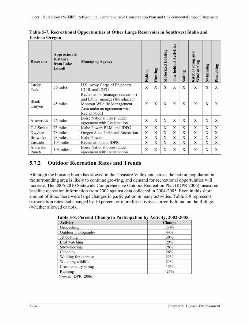
Deer Flat National Wildlife Refuge Final Comprehensive Conservation Plan and Environmental Impact Statement
5-34 Chapter 5. Human Environment
Table 5-7. Recreational Opportunities at Other Large Reservoirs in Southwest Idaho and Eastern Oregon
Reservoir
Approximate Distance from Lake Lowell
Managing Agency
Fis
hin
g
Hu
nti
ng
Mot
oriz
ed B
oati
ng
Tow
-beh
ind
Act
ivit
ies
Sai
ling
Kit
eboa
rdin
g an
d W
ind
surf
ing
Sw
imm
ing
Pic
nic
kin
g
Lucky Peak
36 miles U.S. Army Corps of Engineers, IDPR, and IDFG
X X X X X X X X
Black Canyon
45 miles
Reclamation (manages recreation) and IDFG (manages the adjacent Montour Wildlife Management Area under an agreement with Reclamation)
X X X X X X X X
Arrowrock 56 miles Boise National Forest under agreement with Reclamation
X X X X X X X X
C.J. Strike 73 miles Idaho Power, BLM, and IDFG X X X X X X X X Owyhee 78 miles Oregon State Parks and Recreation X X X X X X X X Brownlee 98 miles Idaho Power X X X X X X X X Cascade 104 miles Reclamation and IDPR X X X X X X X X Anderson Ranch
106 miles Boise National Forest under agreement with Reclamation
X X X X X X X X
5.7.2 Outdoor Recreation Rates and Trends
Although the housing boom has slowed in the Treasure Valley and across the nation, population in the surrounding area is likely to continue growing, and demand for recreational opportunities will increase. The 2006-2010 Statewide Comprehensive Outdoor Recreation Plan (IDPR 2006) measured baseline recreation information from 2002 against data collected in 2004-2005. Even in this short amount of time, there were large changes in participation in many activities. Table 5-8 represents participation rates that changed by 10 percent or more for activities currently found on the Refuge (whether allowed or not).
Table 5-8. Percent Change in Participation by Activity, 2002-2005 Activity Change Geocaching 154% Outdoor photography 44% Jet boating 30% Bird watching 29% Snowshoeing 28% Canoeing 26% Walking for exercise 22% Watching wildlife 21% Cross-country skiing 15% Running -26%
Source: IDPR (2006).
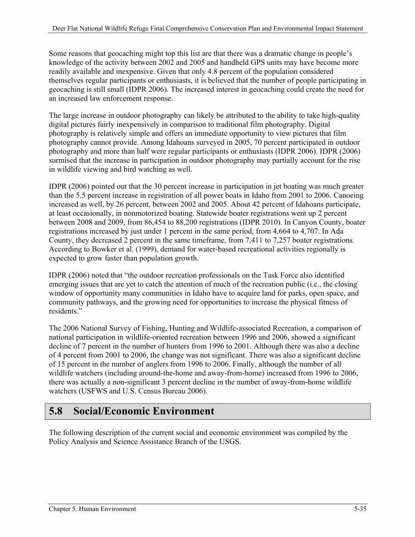
Deer Flat National Wildlife Refuge Final Comprehensive Conservation Plan and Environmental Impact Statement
Chapter 5. Human Environment 5-35
Some reasons that geocaching might top this list are that there was a dramatic change in people’s knowledge of the activity between 2002 and 2005 and handheld GPS units may have become more readily available and inexpensive. Given that only 4.8 percent of the population considered themselves regular participants or enthusiasts, it is believed that the number of people participating in geocaching is still small (IDPR 2006). The increased interest in geocaching could create the need for an increased law enforcement response.
The large increase in outdoor photography can likely be attributed to the ability to take high-quality digital pictures fairly inexpensively in comparison to traditional film photography. Digital photography is relatively simple and offers an immediate opportunity to view pictures that film photography cannot provide. Among Idahoans surveyed in 2005, 70 percent participated in outdoor photography and more than half were regular participants or enthusiasts (IDPR 2006). IDPR (2006) surmised that the increase in participation in outdoor photography may partially account for the rise in wildlife viewing and bird watching as well.
IDPR (2006) pointed out that the 30 percent increase in participation in jet boating was much greater than the 5.5 percent increase in registration of all power boats in Idaho from 2001 to 2006. Canoeing increased as well, by 26 percent, between 2002 and 2005. About 42 percent of Idahoans participate, at least occasionally, in nonmotorized boating. Statewide boater registrations went up 2 percent between 2008 and 2009, from 86,454 to 88,200 registrations (IDPR 2010). In Canyon County, boater registrations increased by just under 1 percent in the same period, from 4,664 to 4,707. In Ada County, they decreased 2 percent in the same timeframe, from 7,411 to 7,257 boater registrations. According to Bowker et al. (1999), demand for water-based recreational activities regionally is expected to grow faster than population growth.
IDPR (2006) noted that “the outdoor recreation professionals on the Task Force also identified emerging issues that are yet to catch the attention of much of the recreation public (i.e., the closing window of opportunity many communities in Idaho have to acquire land for parks, open space, and community pathways, and the growing need for opportunities to increase the physical fitness of residents.”
The 2006 National Survey of Fishing, Hunting and Wildlife-associated Recreation, a comparison of national participation in wildlife-oriented recreation between 1996 and 2006, showed a significant decline of 7 percent in the number of hunters from 1996 to 2001. Although there was also a decline of 4 percent from 2001 to 2006, the change was not significant. There was also a significant decline of 15 percent in the number of anglers from 1996 to 2006. Finally, although the number of all wildlife watchers (including around-the-home and away-from-home) increased from 1996 to 2006, there was actually a non-significant 3 percent decline in the number of away-from-home wildlife watchers (USFWS and U.S. Census Bureau 2006).
5.8 Social/Economic Environment
The following description of the current social and economic environment was compiled by the Policy Analysis and Science Assistance Branch of the USGS.
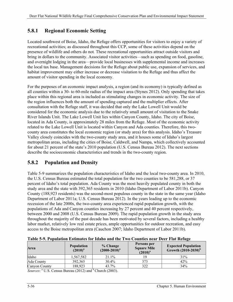
Deer Flat National Wildlife Refuge Final Comprehensive Conservation Plan and Environmental Impact Statement
5-36 Chapter 5. Human Environment
5.8.1 Regional Economic Setting
Located southwest of Boise, Idaho, the Refuge offers opportunities for visitors to enjoy a variety of recreational activities; as discussed throughout this CCP, some of these activities depend on the presence of wildlife and others do not. These recreational opportunities attract outside visitors and bring in dollars to the community. Associated visitor activities—such as spending on food, gasoline, and overnight lodging in the area—provide local businesses with supplemental income and increases the local tax base. Management decisions for the Refuge about public use, expansion of services, and habitat improvement may either increase or decrease visitation to the Refuge and thus affect the amount of visitor spending in the local economy.
For the purposes of an economic impact analysis, a region (and its economy) is typically defined as all counties within a 30- to 60-mile radius of the impact area (Stynes 2012). Only spending that takes place within this regional area is included as stimulating changes in economic activity. The size of the region influences both the amount of spending captured and the multiplier effects. After consultation with the Refuge staff, it was decided that only the Lake Lowell Unit would be considered for the economic analysis due to the relatively small amount of visitation to the Snake River Islands Unit. The Lake Lowell Unit lies within Canyon County, Idaho. The city of Boise, located in Ada County, is approximately 28 miles from the Refuge. Most of the economic activity related to the Lake Lowell Unit is located within Canyon and Ada counties. Therefore, this two-county area constitutes the local economic region (or study area) for this analysis. Idaho’s Treasure Valley closely coincides with the two-county study area, and it houses some of Idaho’s largest metropolitan areas, including the cities of Boise, Caldwell, and Nampa, which collectively accounted for about 21 percent of the state’s 2010 population (U.S. Census Bureau 2012). The next sections describe the socioeconomic characteristics and trends in the two-county region.
5.8.2 Population and Density
Table 5-9 summarizes the population characteristics of Idaho and the local two-county area. In 2010, the U.S. Census Bureau estimated the total population for the two counties to be 581,288, or 37 percent of Idaho’s total population. Ada County was the most heavily populated county in both the study area and the state with 392,365 residents in 2010 (Idaho Department of Labor 2011b). Canyon County (188,923 residents) was the second-most populous county in the state in the same year (Idaho Department of Labor 2011a; U.S. Census Bureau 2012). In the years leading up to the economic recession of the late 2000s, the two-county area experienced rapid population growth, with the populations of Ada and Canyon counties increasing by 27 percent and 40 percent respectively, between 2000 and 2008 (U.S. Census Bureau 2009). The rapid population growth in the study area throughout the majority of the past decade has been motivated by several factors, including a healthy labor market, relatively low real estate prices, ample opportunities for outdoor recreation, and easy access to the Boise metropolitan area (Cauchon 2007; Idaho Department of Labor 2011b).
Table 5-9. Population Estimates for Idaho and the Two Counties near Deer Flat Refuge
Area Population
(2010)a % Change
(2000-2010)a
Persons per Square Mile
(2010)a
Expected Population Growth (2010-2030)b
Idaho 1,567,582 21.1% 19 31% Ada County 392,365 30.4% 373 42% Canyon County 188,923 43.7% 322 34% Sources: a U.S. Census Bureau (2012) and b Church (2003).
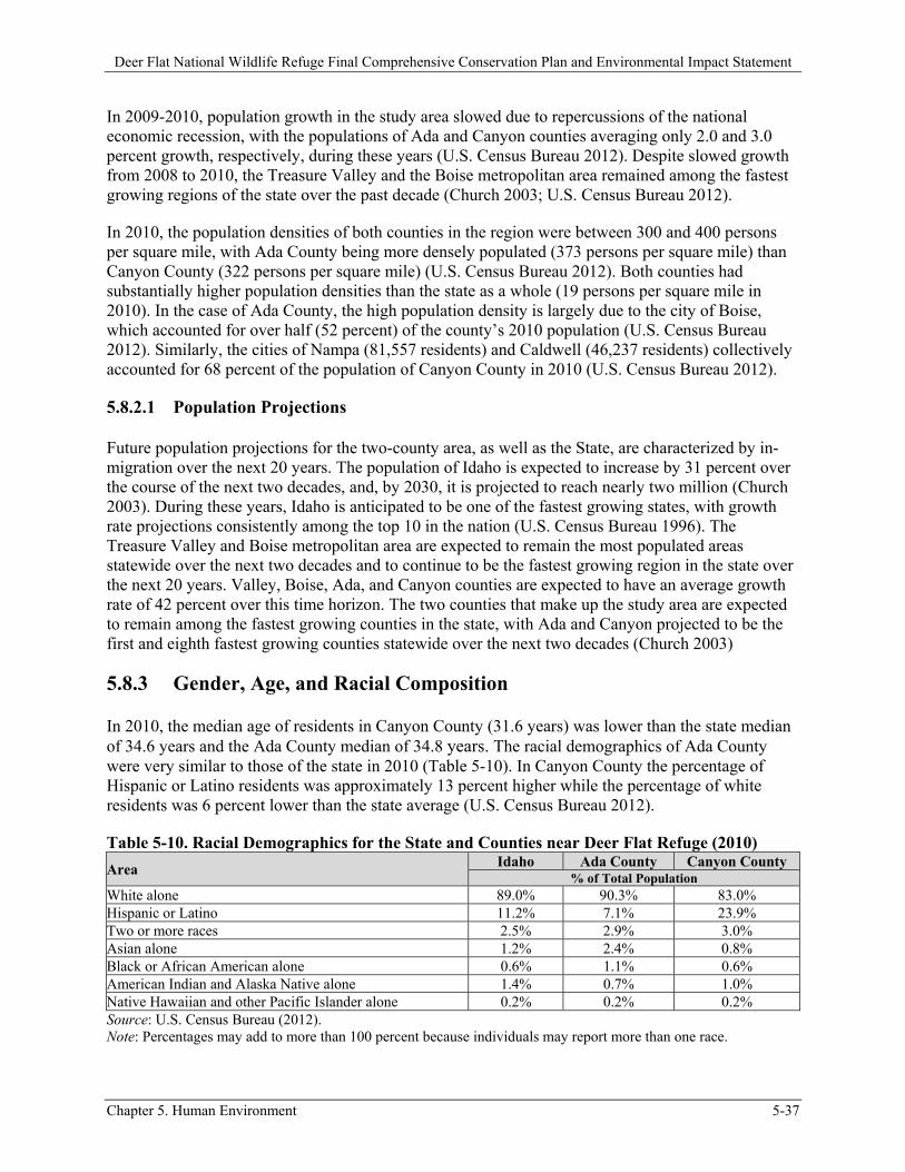
Deer Flat National Wildlife Refuge Final Comprehensive Conservation Plan and Environmental Impact Statement
Chapter 5. Human Environment 5-37
In 2009-2010, population growth in the study area slowed due to repercussions of the national economic recession, with the populations of Ada and Canyon counties averaging only 2.0 and 3.0 percent growth, respectively, during these years (U.S. Census Bureau 2012). Despite slowed growth from 2008 to 2010, the Treasure Valley and the Boise metropolitan area remained among the fastest growing regions of the state over the past decade (Church 2003; U.S. Census Bureau 2012).
In 2010, the population densities of both counties in the region were between 300 and 400 persons per square mile, with Ada County being more densely populated (373 persons per square mile) than Canyon County (322 persons per square mile) (U.S. Census Bureau 2012). Both counties had substantially higher population densities than the state as a whole (19 persons per square mile in 2010). In the case of Ada County, the high population density is largely due to the city of Boise, which accounted for over half (52 percent) of the county’s 2010 population (U.S. Census Bureau 2012). Similarly, the cities of Nampa (81,557 residents) and Caldwell (46,237 residents) collectively accounted for 68 percent of the population of Canyon County in 2010 (U.S. Census Bureau 2012).
5.8.2.1 Population Projections
Future population projections for the two-county area, as well as the State, are characterized by in-migration over the next 20 years. The population of Idaho is expected to increase by 31 percent over the course of the next two decades, and, by 2030, it is projected to reach nearly two million (Church 2003). During these years, Idaho is anticipated to be one of the fastest growing states, with growth rate projections consistently among the top 10 in the nation (U.S. Census Bureau 1996). The Treasure Valley and Boise metropolitan area are expected to remain the most populated areas statewide over the next two decades and to continue to be the fastest growing region in the state over the next 20 years. Valley, Boise, Ada, and Canyon counties are expected to have an average growth rate of 42 percent over this time horizon. The two counties that make up the study area are expected to remain among the fastest growing counties in the state, with Ada and Canyon projected to be the first and eighth fastest growing counties statewide over the next two decades (Church 2003)
5.8.3 Gender, Age, and Racial Composition
In 2010, the median age of residents in Canyon County (31.6 years) was lower than the state median of 34.6 years and the Ada County median of 34.8 years. The racial demographics of Ada County were very similar to those of the state in 2010 (Table 5-10). In Canyon County the percentage of Hispanic or Latino residents was approximately 13 percent higher while the percentage of white residents was 6 percent lower than the state average (U.S. Census Bureau 2012).
Table 5-10. Racial Demographics for the State and Counties near Deer Flat Refuge (2010)
Area Idaho Ada County Canyon County % of Total Population
White alone 89.0% 90.3% 83.0% Hispanic or Latino 11.2% 7.1% 23.9% Two or more races 2.5% 2.9% 3.0% Asian alone 1.2% 2.4% 0.8% Black or African American alone 0.6% 1.1% 0.6% American Indian and Alaska Native alone 1.4% 0.7% 1.0% Native Hawaiian and other Pacific Islander alone 0.2% 0.2% 0.2% Source: U.S. Census Bureau (2012). Note: Percentages may add to more than 100 percent because individuals may report more than one race.
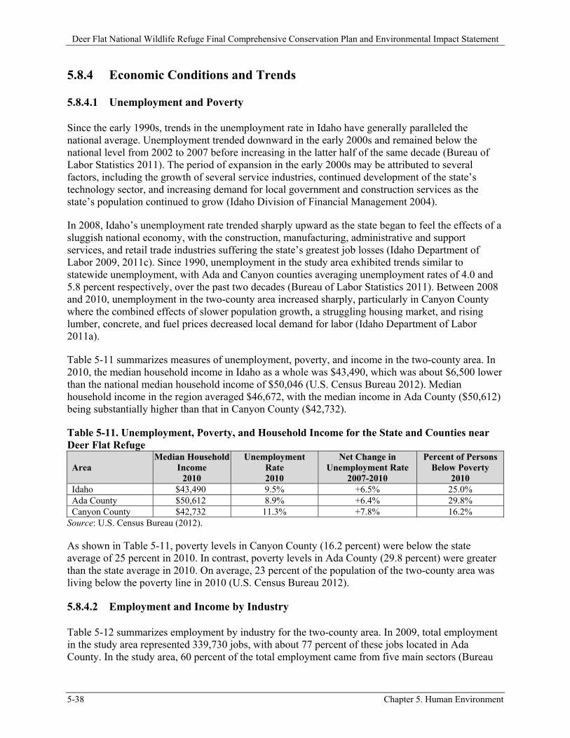
Deer Flat National Wildlife Refuge Final Comprehensive Conservation Plan and Environmental Impact Statement
5-38 Chapter 5. Human Environment
5.8.4 Economic Conditions and Trends
5.8.4.1 Unemployment and Poverty
Since the early 1990s, trends in the unemployment rate in Idaho have generally paralleled the national average. Unemployment trended downward in the early 2000s and remained below the national level from 2002 to 2007 before increasing in the latter half of the same decade (Bureau of Labor Statistics 2011). The period of expansion in the early 2000s may be attributed to several factors, including the growth of several service industries, continued development of the state’s technology sector, and increasing demand for local government and construction services as the state’s population continued to grow (Idaho Division of Financial Management 2004).
In 2008, Idaho’s unemployment rate trended sharply upward as the state began to feel the effects of a sluggish national economy, with the construction, manufacturing, administrative and support services, and retail trade industries suffering the state’s greatest job losses (Idaho Department of Labor 2009, 2011c). Since 1990, unemployment in the study area exhibited trends similar to statewide unemployment, with Ada and Canyon counties averaging unemployment rates of 4.0 and 5.8 percent respectively, over the past two decades (Bureau of Labor Statistics 2011). Between 2008 and 2010, unemployment in the two-county area increased sharply, particularly in Canyon County where the combined effects of slower population growth, a struggling housing market, and rising lumber, concrete, and fuel prices decreased local demand for labor (Idaho Department of Labor 2011a).
Table 5-11 summarizes measures of unemployment, poverty, and income in the two-county area. In 2010, the median household income in Idaho as a whole was $43,490, which was about $6,500 lower than the national median household income of $50,046 (U.S. Census Bureau 2012). Median household income in the region averaged $46,672, with the median income in Ada County ($50,612) being substantially higher than that in Canyon County ($42,732).
Table 5-11. Unemployment, Poverty, and Household Income for the State and Counties near Deer Flat Refuge
Area Median Household
Income 2010
Unemployment Rate 2010
Net Change in Unemployment Rate
2007-2010
Percent of Persons Below Poverty
2010 Idaho $43,490 9.5% +6.5% 25.0% Ada County $50,612 8.9% +6.4% 29.8% Canyon County $42,732 11.3% +7.8% 16.2%
Source: U.S. Census Bureau (2012).
As shown in Table 5-11, poverty levels in Canyon County (16.2 percent) were below the state average of 25 percent in 2010. In contrast, poverty levels in Ada County (29.8 percent) were greater than the state average in 2010. On average, 23 percent of the population of the two-county area was living below the poverty line in 2010 (U.S. Census Bureau 2012).
5.8.4.2 Employment and Income by Industry
Table 5-12 summarizes employment by industry for the two-county area. In 2009, total employment in the study area represented 339,730 jobs, with about 77 percent of these jobs located in Ada County. In the study area, 60 percent of the total employment came from five main sectors (Bureau
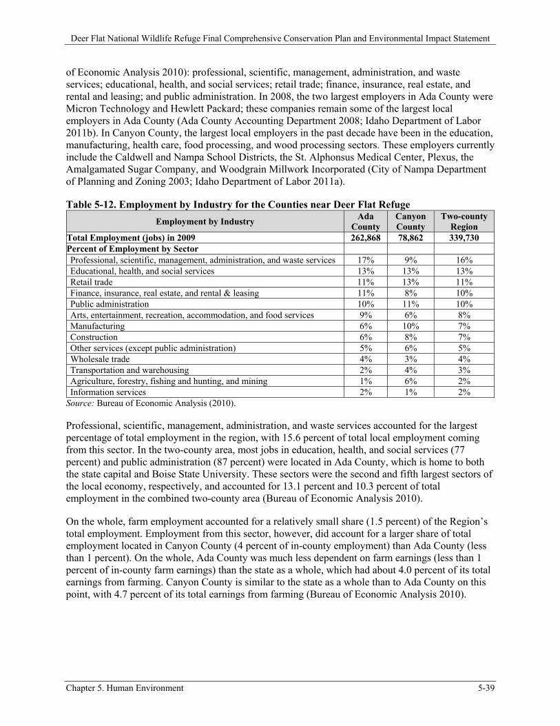
Deer Flat National Wildlife Refuge Final Comprehensive Conservation Plan and Environmental Impact Statement
Chapter 5. Human Environment 5-39
of Economic Analysis 2010): professional, scientific, management, administration, and waste services; educational, health, and social services; retail trade; finance, insurance, real estate, and rental and leasing; and public administration. In 2008, the two largest employers in Ada County were Micron Technology and Hewlett Packard; these companies remain some of the largest local employers in Ada County (Ada County Accounting Department 2008; Idaho Department of Labor 2011b). In Canyon County, the largest local employers in the past decade have been in the education, manufacturing, health care, food processing, and wood processing sectors. These employers currently include the Caldwell and Nampa School Districts, the St. Alphonsus Medical Center, Plexus, the Amalgamated Sugar Company, and Woodgrain Millwork Incorporated (City of Nampa Department of Planning and Zoning 2003; Idaho Department of Labor 2011a).
Table 5-12. Employment by Industry for the Counties near Deer Flat Refuge
Employment by Industry Ada
County Canyon County
Two-county Region
Total Employment (jobs) in 2009 262,868 78,862 339,730 Percent of Employment by Sector
Professional, scientific, management, administration, and waste services 17% 9% 16% Educational, health, and social services 13% 13% 13% Retail trade 11% 13% 11% Finance, insurance, real estate, and rental & leasing 11% 8% 10% Public administration 10% 11% 10% Arts, entertainment, recreation, accommodation, and food services 9% 6% 8% Manufacturing 6% 10% 7% Construction 6% 8% 7% Other services (except public administration) 5% 6% 5% Wholesale trade 4% 3% 4% Transportation and warehousing 2% 4% 3% Agriculture, forestry, fishing and hunting, and mining 1% 6% 2% Information services 2% 1% 2%
Source: Bureau of Economic Analysis (2010).
Professional, scientific, management, administration, and waste services accounted for the largest percentage of total employment in the region, with 15.6 percent of total local employment coming from this sector. In the two-county area, most jobs in education, health, and social services (77 percent) and public administration (87 percent) were located in Ada County, which is home to both the state capital and Boise State University. These sectors were the second and fifth largest sectors of the local economy, respectively, and accounted for 13.1 percent and 10.3 percent of total employment in the combined two-county area (Bureau of Economic Analysis 2010).
On the whole, farm employment accounted for a relatively small share (1.5 percent) of the Region’s total employment. Employment from this sector, however, did account for a larger share of total employment located in Canyon County (4 percent of in-county employment) than Ada County (less than 1 percent). On the whole, Ada County was much less dependent on farm earnings (less than 1 percent of in-county farm earnings) than the state as a whole, which had about 4.0 percent of its total earnings from farming. Canyon County is similar to the state as a whole than to Ada County on this point, with 4.7 percent of its total earnings from farming (Bureau of Economic Analysis 2010).
Deer Flat National Wildlife Refuge Final Comprehensive Conservation Plan and Environmental Impact Statement
5-40 Chapter 5. Human Environment
5.8.5 Land Use and Ownership Changes Surrounding Refuge Lands
5.8.5.1 Current Land Use
As of 2006, about 30 percent of the land in the two-county area near the Refuge was federally owned, with the majority of Federal land ownership in BLM holdings (21 percent of land in the two-county area). About 65 percent of the land in the study area was privately owned, with the remaining 4 percent State-owned (Conservation Biology Institute 2006; data compiled using the Economic Profile System Human Dimensions Toolkit [EPS-HDT] developed by Headwaters Economics).
Ada County is largely covered by grassland and shrubland, which account for about 75 percent of all land cover in the county. Mixed cropland is also prevalent, accounting for 17 percent of the land cover (NASA 2006; data compiled using EPS-HDT). As of 2006, urban development accounted for 6 percent of all land cover in the county (NASA 2006; data compiled using EPS-HDT). Land ownership in Ada County in 2006 was 49 percent private, 43 percent Federal, 7 percent State, and 1 percent under other ownership (i.e., Tribal, City, County, or Other) (Conservation Biology Institute 2006; data compiled using EPS-HDT).
Canyon County is less urbanized than Ada County, with about 3 percent of the county’s land cover in urban development in 2006. Mixed croplands accounted for about 75 percent of the county’s land cover, grassland accounted for 14 percent, and shrubland accounted for 4 percent (NASA 2006; data compiled using EPS-HDT). Water accounted for an additional 2 percent of land cover in Canyon County, with the majority of this coming from Lake Lowell, which covers a total of 14.5 square miles (NASA 2006 data compiled using EPS-HDT; Reclamation n.d.). Land ownership in Canyon County in 2006 was 93 percent privately owned, 6 percent federally owned, 5 percent State-owned, and 1 percent under other ownership (i.e., Tribal, City, County, or Other) (Conservation Biology Institute 2006; data compiled using EPS-HDT).
5.8.5.2 Changes in Land Use
As populations grow, the spread of American cities across the rural landscape has several potential environmental impacts including, for example, decreased watershed permeability, increased noise and air pollution, and the loss of arable land and open spaces (Auld 2001; Knight et al. 1995). In addition to these environmental impacts, urban sprawl may have significant economic impacts on local communities through increased costs of public community services such as emergency response, infrastructure, or public works and utilities (Chen 2000; Speir and Stephenson 2002).
Idaho’s population growth over the past decades has been cause for the continued conversion of rural lands to urban purposes. Between 1982 and 1997, Idaho ranked thirty-fifth in the nation for the most rural acres (205,000 acres) converted for urban growth (Goodwin 2003). About half (45 percent) of this transformation occurred between 1992 and 1997, with over 27,000 acres converted in the two-county study area during this five-year period. Land conversion in Ada and Canyon counties between 1992 and 1997 occurred faster than in any other region in Idaho, with Ada County converting land at a rate of 4,480 acres per year and Canyon County averaging 2,600 acres per year (U.S. Department of Agriculture 2000). Between 1997 and 2007, an additional 130,100 acres of land was developed statewide, resulting in 907,300 total acres of developed land in Idaho and representing a 61 percent increase from 1982 levels (U.S. Department of Agriculture 2009). These trends are likely to continue as statewide and local area populations are projected to continue growing over the next few decades.