Embed Size (px)
Citation preview
Chapter 12A Science-Based Approach to RegionalConservation Planning
Robert J. Steidl, William W. Shaw, and Paul Fromer
Abstract Although single-species approaches have played an important role inconservation in the United States, the Endangered Species Act provides a mech-anism for conservation at larger scales through Habitat Conservation Plans (HCPs).HCPs not only offer the potential for comprehensive conservation planning for awide range of species across broader geographic scales but also provide assurancesthat eliminate risks related to endangered species concerns for nonfederal landown-ers, developers, and planners. Given their benefits, dozens of municipalities haveadopted HCPs to address planning issues related to rare and vulnerable species.The challenge, however, is to develop conservation plans that reliably meet broader-scale conservation and planning objectives while not increasing risks posed to vul-nerable species. Consequently, we designed a science-based framework from whichto develop regional conservation plans, including HCPs. We designed a rigorousprocess that classifies areas based on their relative conservation value as part of aconservation strategy for more than 20,000 km2 of Sonoran desert in Pima County,Arizona. This chapter describes our approach including the fundamental planningelements selected, the process used to quantify the relative biological importance ofeach landscape unit, and how we assembled landscape elements into units that formthe framework of the Sonoran Desert Conservation Plan.
Introduction
Conservation issues in the desert southwest generally reflect those in other parts ofthe United States, although several issues are unique to this arid region. First, largeportions of the landscape remain undeveloped and in relatively natural conditionwith high levels of biological diversity. Second, during the last several decades, thehuman population has increased more in the southwest than in any other area of the
R.J. Steidl (B)School of Natural Resources, University of Arizona, Tucson, AZ 85721, USAe-mail: [email protected]
217A.X. Esparza, G. McPherson (eds.), The Planner’s Guide to Natural ResourceConservation, DOI 10.1007/978-0-387-98167-3_12,C© Springer Science+Business Media, LLC 2009
218 R.J. Steidl et al.
country, a pattern that is predicted to continue in the future (Benedict et al. 2005).Increases in the human population intensify development pressure that inevitablycompromises the structure and function of natural landscapes. To minimize lossesof biological diversity, strategies to constrain and direct the development footprintneed to be enacted quickly as remaining opportunities for conserving large, contigu-ous natural areas will only decrease. Consequently, efficient strategies that identifyareas of high conservation value enable regional planners to maximize the conserva-tion benefits of planning while accommodating growth. Although site- and species-specific conservations surely have value, conservation will be most effective whenimplemented at larger geographic and ecological scales. The history and benefits oflarge-scale ecological conservation are discussed in Chapter 7.
Many regional-scale plans have been initiated in response to practical concernsrelated to species listed as threatened or endangered under the Endangered SpeciesAct (ESA) of 1973. The effects of land-use change on listed species typically havebeen addressed on a single-species and single-parcel basis. This has led to consider-able regulatory complexity and, more importantly, ineffective and fragmented con-servation. The Habitat Conservation Planning (HCP) process was created to ensurethat the impacts of development or other activities on listed species (“incidentaltake”) are minimized and mitigated. In addition to providing relief from regulatorycomplexity, HCPs expand single-species protection provided by ESA to cover mul-tiple species at broader geographic scales. For this process to be meaningful, how-ever, HCPs must provide genuine conservation benefits that exceed the species-levelprotection provided by ESA (Kareiva et al. 1999).
Land-use planning at a broader geographic scale provides the opportunity toenact conservation measures that influence a wider range of organisms and land-scapes and consolidate disparate planning guidelines under a common framework.Broad-scale land-use plans can promote long-term conservation strategies whenthey are designed carefully around contemporary scientific principles and imple-mented expeditiously. Although scientific principles central to the discipline of con-servation biology should guide conservation planning, there are inevitable practicallimitations that hamper application on lands that have already experienced somedevelopment. The degree to which these limitations impede effective conservationplanning varies with the size of the development footprint and the compatibility ofland uses with conservation goals. Given the pressures of an increasing human pop-ulation on land and natural resources, there are few situations outside of nationalparks and reserves where lands can be managed primarily for conservation. There-fore, developing a conservation strategy as part of a comprehensive land-use planrequires balancing conservation ideals and practical realities.
This chapter describes a strategy that positions biological conservation at the cen-ter of future land-use decisions. The strategy ultimately defines a network of con-servation lands across a large geographic area. We discuss a scientific frameworkthat enhances the goals and objectives of regional-scale planning by identifyinglands most suitable for conservation. These lands are found beyond the metropolitanfringe where there are significant opportunities for maintaining valuable biologicaldiversity. Specifically, we describe the method or approach used to classify lands
12 A Science-Based Approach to Regional Conservation Planning 219
based on their potential conservation value. Based on our analyses, we then allo-cated lands to a conservation network around which other regional-planning ele-ments were incorporated. Our overarching goal was to identify and establish anintegrated system of conservation lands that support biodiversity while simultane-ously providing a framework that guides future land use. This framework was thebasis for a comprehensive regional-planning effort in Pima County, Arizona, calledthe Sonoran Desert Conservation Plan. In 2002, the SCDP received an “Outstand-ing Planning Award” by the American Planning Association, which recognized thelong-term value of establishing the regional plan on a foundation designed to con-serve biological diversity.
Sonoran Desert Conservation Plan
The conflict between land development and protection of listed species as mandatedby federal law was the impetus for Pima County’s land-use planning strategy. Butover time, the Sonoran Desert Conservation Plan became a comprehensive frame-work designed to guide future land-use decisions by first ensuring conservation ofnatural and cultural resources important to the region. Development of the plan wasa large, public process guided by a steering committee of about 80 citizens, 12 scien-tific advisory and other technical teams, dozens of working groups, and involvementof more than 150 scientists. One of these technical teams, the Science TechnicalAdvisory Team, was responsible for establishing the network of conservation landsthat are the foundation for all other elements in the plan. These additional elements,however, followed the identification of areas most important for conserving biolog-ical diversity. As such, conservation science guided the development of the entireland-use plan.
The SCDP (http://www.pima.gov/sdcp/) was guided by five goals: (1) defineurban form to prevent urban sprawl and protect natural and cultural resources; (2)provide a natural resource-based framework for making regional land-use decisions;(3) protect habitat for and promote recovery of species listed under ESA; (4) obtaina Section 10 permit under ESA for a multispecies HCP; and (5) develop a sys-tem of conservation lands to ensure persistence of the full spectrum of indigenousplants and animals by maintaining or restoring the ecosystems on which they rely,thereby preventing the need for future listings. This set of interrelated goals wasimplemented through a series of specific objectives that promote recovery of listedand other vulnerable species, reduce threats caused by the introduction of nonnativespecies and other factors that compromise ecosystem structure and function, andfoster long-term viability of species, physical environments, and biotic communi-ties in the region.
This chapter describes the biological foundation of the plan. Discussion focuseson the metric developed to quantify the conservation value of each area in the region,the use of this metric as the primary means of identifying areas of high conservationvalue, and how we synthesized those areas and other conservation targets into a

220 R.J. Steidl et al.
network of conservation lands that became the foundation for the comprehensiveland-use plan. Lands within the network are managed principally for conservation ofbiological diversity. This has implications for all other types of land use as they willeither be located outside the land conservation network or designed to be compatiblewith development guidelines within the network (described later in this chapter).We hope our case study provides a starting point for planners, local governmentofficials, and land managers who seek to design plans using a scientific frameworkgeared to conservation in exurban areas.
Planning Area
Pima County, Arizona, covers an area of approximately 23,786 km2 (9,184 mi2),slightly smaller than the state of New Hampshire. The entire county is characterizedas basin and range topography with isolated mountain ranges surrounded by valleys,encompassing two somewhat distinct ecoregions (Omernik 1987) (Fig. 12.1). Thecentral and western portions of the county are of lower elevation and characterizedby Sonoran desert vegetation (Brown, Lowe and Pase 1980). The eastern portionof the county includes areas of much higher elevation, vegetated with coniferousforests and oak woodlands surrounded by either desert scrub or grasslands.
The region supports unusually high levels of biological diversity because of itsgeographic position between the subtropical and temperate climatic zones of NorthAmerica that include two floristic realms, the Neotropic and Holarctic (Warshall1995). Because the county is located at the edge of the tropics, many species occur
Fig. 12.1 Map of PimaCounty, Arizona. Source:Amanda Borens
12 A Science-Based Approach to Regional Conservation Planning 221
at the northern limits of their geographic range. Further, the range of elevations(from about 300 to 2790 m) and strong regional gradients in precipitation acrossthe region create a wide range of physiographic contrasts that provide conditionssuitable for many species. Annual precipitation generally increases in amount fromwest to east and typically falls in a bimodal pattern with heavy “monsoonal” rainsin summer and lighter rains in winter.
A Process for Large-Scale Conservation Planning
A plan’s geographic scale dictates the suitability of alternative metrics appropriatefor biologically based planning. At small spatial scales, planning is ideally based oncomprehensive field inventories of biological resources. At the largest scales, plan-ning is only realistically based on broad regularities that reflect large-scale patternsand processes. At intermediate regional scales (∼10,000–100,000 km2), compre-hensive inventories for many natural resources are likely impractical. Therefore,biological planning at this scale is usually accomplished through a combination ofsite-specific information and broad-scale patterns, with expert opinion used to meldthese two disparate information sources. But planning efforts based on expert opin-ion are challenging because conclusions often reflect the knowledge and interests ofany particular group of experts. Thus, pinning assessments to objective and explicitcriteria is difficult at times. We therefore sought to develop a process that, althoughbased in part on knowledge of local experts, is quantitative, explicit, and replicableand provides a rigorous foundation for exploring a range of planning alternativesthat can be revised as additional information becomes available. This process issummarized in Fig. 12.2. Given the size of the planning area, analyses relied heav-ily on a geographic information system (GIS). Data resolution varied by source, butthe highest resolution data available were used. In nearly all cases, the fundamen-tal unit of analysis [approximately 300 × 300 m (9 ha)] was based on the digitalelevation model used for analyses.
Landscape-level approaches based on strategies to conserve species assemblages,vegetation communities, and ecosystems are all useful in developing conservationprograms (Noss and Cooperrider 1994). Although each of these targets can guideevaluation of an area’s potential conservation value, our approach began at thescale of individual species (see Fig. 12.2). Quantifying the conservation value ofeach landscape unit in the planning area required selecting a subset of species thatrepresents well the range of structural and functional diversity in the region. In gen-eral, species are most valuable to this process when they use and inhabit the land-scape (grain) across a range of spatial scales so that differences in the conservationvalue of alternative land allocations are maximized. Species provide less informa-tion if (1) they are either rare or very common because these traits provide the leastdiscriminatory power at the landscape scale; (2) they occur only on lands that arealready protected and will therefore be part of all alternative land allocations; and(3) there is limited biological information available about likely distributions andhabitat requirements.

222 R.J. Steidl et al.
Fig. 12.2 A diagram of the process used to develop the SDCP. Source: Steidl, Shaw and Fromer
Provided that a large number of species inhabiting the full range of environ-ments in a planning area are evaluated, the particular suite of species chosen shouldhave little influence on the results of the analysis because a broad range of speciesshould provide sufficient redundancy of environmental features needed to support
12 A Science-Based Approach to Regional Conservation Planning 223
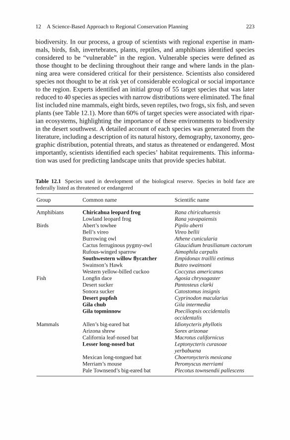
biodiversity. In our process, a group of scientists with regional expertise in mam-mals, birds, fish, invertebrates, plants, reptiles, and amphibians identified speciesconsidered to be “vulnerable” in the region. Vulnerable species were defined asthose thought to be declining throughout their range and where lands in the plan-ning area were considered critical for their persistence. Scientists also consideredspecies not thought to be at risk yet of considerable ecological or social importanceto the region. Experts identified an initial group of 55 target species that was laterreduced to 40 species as species with narrow distributions were eliminated. The finallist included nine mammals, eight birds, seven reptiles, two frogs, six fish, and sevenplants (see Table 12.1). More than 60% of target species were associated with ripar-ian ecosystems, highlighting the importance of these environments to biodiversityin the desert southwest. A detailed account of each species was generated from theliterature, including a description of its natural history, demography, taxonomy, geo-graphic distribution, potential threats, and status as threatened or endangered. Mostimportantly, scientists identified each species’ habitat requirements. This informa-tion was used for predicting landscape units that provide species habitat.
Table 12.1 Species used in development of the biological reserve. Species in bold face arefederally listed as threatened or endangered
Group Common name Scientific name
Amphibians Chiricahua leopard frog Rana chiricahuensisLowland leopard frog Rana yavapaiensis
Birds Abert’s towhee Pipilo abertiBell’s vireo Vireo belliiBurrowing owl Athene cuniculariaCactus ferruginous pygmy-owl Glaucidium brasilianum cactorumRufous-winged sparrow Aimophila carpalisSouthwestern willow flycatcher Empidonax traillii extimusSwainson’s Hawk Buteo swainsoniWestern yellow-billed cuckoo Coccyzus americanus
Fish Longfin dace Agosia chrysogasterDesert sucker Pantosteus clarkiSonora sucker Catostomus insignisDesert pupfish Cyprinodon maculariusGila chub Gila intermediaGila topminnow Poeciliopsis occidentalis
occidentalisMammals Allen’s big-eared bat Idionycteris phyllotis
Arizona shrew Sorex arizonaeCalifornia leaf-nosed bat Macrotus californicusLesser long-nosed bat Leptonycteris curasoae
yerbabuenaMexican long-tongued bat Choeronycteris mexicanaMerriam’s mouse Peromyscus merriamiPale Townsend’s big-eared bat Plecotus townsendii pallescens
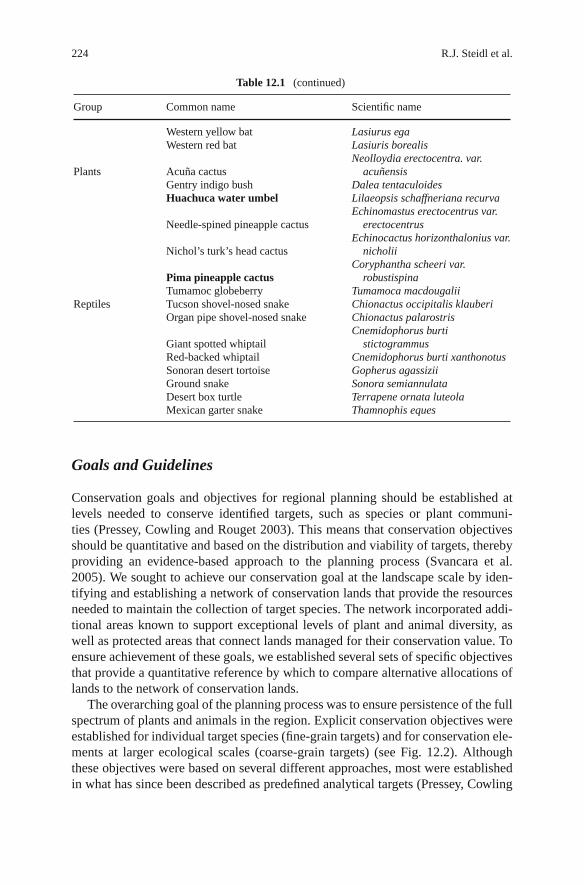
224 R.J. Steidl et al.
Table 12.1 (continued)
Group Common name Scientific name
Western yellow bat Lasiurus egaWestern red bat Lasiuris borealis
Plants Acuña cactusNeolloydia erectocentra. var.
acuñensisGentry indigo bush Dalea tentaculoidesHuachuca water umbel Lilaeopsis schaffneriana recurva
Needle-spined pineapple cactusEchinomastus erectocentrus var.
erectocentrus
Nichol’s turk’s head cactusEchinocactus horizonthalonius var.
nicholii
Pima pineapple cactusCoryphantha scheeri var.
robustispinaTumamoc globeberry Tumamoca macdougalii
Reptiles Tucson shovel-nosed snake Chionactus occipitalis klauberiOrgan pipe shovel-nosed snake Chionactus palarostris
Giant spotted whiptailCnemidophorus burti
stictogrammusRed-backed whiptail Cnemidophorus burti xanthonotusSonoran desert tortoise Gopherus agassiziiGround snake Sonora semiannulataDesert box turtle Terrapene ornata luteolaMexican garter snake Thamnophis eques
Goals and Guidelines
Conservation goals and objectives for regional planning should be established atlevels needed to conserve identified targets, such as species or plant communi-ties (Pressey, Cowling and Rouget 2003). This means that conservation objectivesshould be quantitative and based on the distribution and viability of targets, therebyproviding an evidence-based approach to the planning process (Svancara et al.2005). We sought to achieve our conservation goal at the landscape scale by iden-tifying and establishing a network of conservation lands that provide the resourcesneeded to maintain the collection of target species. The network incorporated addi-tional areas known to support exceptional levels of plant and animal diversity, aswell as protected areas that connect lands managed for their conservation value. Toensure achievement of these goals, we established several sets of specific objectivesthat provide a quantitative reference by which to compare alternative allocations oflands to the network of conservation lands.
The overarching goal of the planning process was to ensure persistence of the fullspectrum of plants and animals in the region. Explicit conservation objectives wereestablished for individual target species (fine-grain targets) and for conservation ele-ments at larger ecological scales (coarse-grain targets) (see Fig. 12.2). Althoughthese objectives were based on several different approaches, most were establishedin what has since been described as predefined analytical targets (Pressey, Cowling
12 A Science-Based Approach to Regional Conservation Planning 225
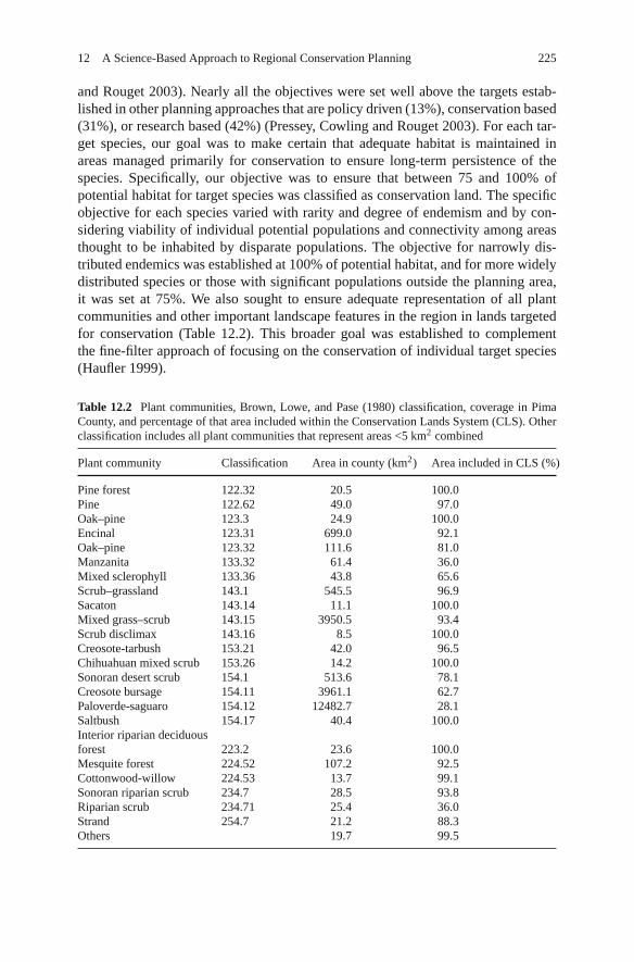
and Rouget 2003). Nearly all the objectives were set well above the targets estab-lished in other planning approaches that are policy driven (13%), conservation based(31%), or research based (42%) (Pressey, Cowling and Rouget 2003). For each tar-get species, our goal was to make certain that adequate habitat is maintained inareas managed primarily for conservation to ensure long-term persistence of thespecies. Specifically, our objective was to ensure that between 75 and 100% ofpotential habitat for target species was classified as conservation land. The specificobjective for each species varied with rarity and degree of endemism and by con-sidering viability of individual potential populations and connectivity among areasthought to be inhabited by disparate populations. The objective for narrowly dis-tributed endemics was established at 100% of potential habitat, and for more widelydistributed species or those with significant populations outside the planning area,it was set at 75%. We also sought to ensure adequate representation of all plantcommunities and other important landscape features in the region in lands targetedfor conservation (Table 12.2). This broader goal was established to complementthe fine-filter approach of focusing on the conservation of individual target species(Haufler 1999).
Table 12.2 Plant communities, Brown, Lowe, and Pase (1980) classification, coverage in PimaCounty, and percentage of that area included within the Conservation Lands System (CLS). Otherclassification includes all plant communities that represent areas <5 km2 combined
Plant community Classification Area in county (km2) Area included in CLS (%)
Pine forest 122.32 20.5 100.0Pine 122.62 49.0 97.0Oak–pine 123.3 24.9 100.0Encinal 123.31 699.0 92.1Oak–pine 123.32 111.6 81.0Manzanita 133.32 61.4 36.0Mixed sclerophyll 133.36 43.8 65.6Scrub–grassland 143.1 545.5 96.9Sacaton 143.14 11.1 100.0Mixed grass–scrub 143.15 3950.5 93.4Scrub disclimax 143.16 8.5 100.0Creosote-tarbush 153.21 42.0 96.5Chihuahuan mixed scrub 153.26 14.2 100.0Sonoran desert scrub 154.1 513.6 78.1Creosote bursage 154.11 3961.1 62.7Paloverde-saguaro 154.12 12482.7 28.1Saltbush 154.17 40.4 100.0Interior riparian deciduousforest 223.2 23.6 100.0Mesquite forest 224.52 107.2 92.5Cottonwood-willow 224.53 13.7 99.1Sonoran riparian scrub 234.7 28.5 93.8Riparian scrub 234.71 25.4 36.0Strand 254.7 21.2 88.3Others 19.7 99.5
226 R.J. Steidl et al.
Modeling Potential Habitat
We explored several approaches to identify areas of high conservation value, allderived from geographic distributions of target species. We considered distributionsbased on the scientific literature, existing databases of documented locations (e.g.,Natural Heritage Program databases), and expert opinion. Although aspects ofeach of these sources were incorporated in the design process, we relied primarilyon models that predict the potential of each landscape unit to provide habitat foreach target species. We chose to model potential habitat because it offered severaldistinct advantages over other alternatives. For example, published distributions aretoo general at and above the regional scale because they focus on the geographiclimits of a species and typically include large areas that are uninhabitable by thespecies of interest. Documented locations are uneven in geographic coverage andare often biased toward areas commonly traveled and underrepresent remote areas.Expert opinion also has significant limitations because “on-the-ground” knowledgeis rarely complete. Most species experts, however, know well the environmentalfeatures that provide habitat for a species. The last and perhaps most significantadvantage of the approach is that habitat can be identified even if the speciesis currently absent from an area. This is especially likely for many jeopardizedspecies. When populations are suppressed, there are almost certainly areas onthe landscape that provide the full range of conditions necessary to function ashabitat for a species, yet are currently unoccupied. Despite being unoccupied, theseareas provide important targets for conservation because they identify areas inwhich threatened and endangered species might recover. Therefore, predicting thedistribution of potential habitat for each species provided useful information andserved as the foundation of the conservation plan.
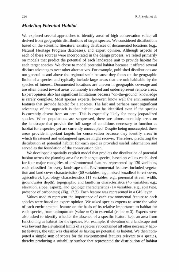
We developed a spatially explicit model that predicts the distribution of potentialhabitat across the planning area for each target species, based on values establishedfor four major categories of environmental features represented by 130 variables,each classified for every landscape unit. Environmental features included vegeta-tion and land cover characteristics (60 variables, e.g., mixed broadleaf forest cover,agriculture), hydrology characteristics (11 variables, e.g., perennial stream width,groundwater depth), topographic and landform characteristics (45 variables, e.g.,elevation, slope, aspect), and geologic characteristics (14 variables, e.g., soil type,presence of carbonates) (Fig. 12.3). Each feature was represented in a GIS layer.
Values used to represent the importance of each environmental feature to eachspecies were based on expert opinion. We asked species experts to score the valueof each environmental feature on the basis of its relative importance to habitat foreach species, from unimportant (value = 0) to essential (value = 3). Experts werealso asked to identify whether the absence of a specific feature kept an area fromfunctioning as habitat for the species. For example, if elevation of a landscape unitwas beyond the elevational limits of a species yet contained all other necessary habi-tat features, the unit was classified as having no potential as habitat. We then com-puted a simple sum of scores for the environmental features relevant to a species,thereby producing a suitability surface that represented the distribution of habitat
12 A Science-Based Approach to Regional Conservation Planning 227
Fig. 12.3 Stylizedillustration of severalenvironmental features usedfor modeling the distributionof potential habitat for eachspecies and the knownlocations and final model forone species. Source: Steidl,Shaw and Fromer
228 R.J. Steidl et al.
potential for each species on each landscape unit. The suitability surface was basedon the presence of environmental features important to habitat for the species andclassified as none, low, moderate, and high.
The modeling process was iterative (Fig. 12.2). Initial distributions of potentialhabitat were evaluated by experts and compared with a database of known loca-tions; models were subsequently refined iteratively until experts thought the modelprovided a parsimonious representation of habitat potential for the species. Thisprocess resulted in a distribution of potential habitat for each target species acrossthe planning area as predicted from biological and physical characteristics of eachlandscape unit (Fig. 12.3).
After exploring a series of alternatives, we reduced the range of scores for habi-tat potential for a species on each landscape unit into two classes: high potentialand less than high potential. A GIS was then used to overlay areas of high potentialhabitat for all species to produce a map portraying species richness (i.e., numberof species with high potential habitat value) for each geographic unit. This met-ric (species richness of target species) became the fundamental measure we usedto classify the landscape into a collection of discrete polygons representing dif-ferent levels of biological value on which we established the Conservation LandsSystem.
Conservation Lands System
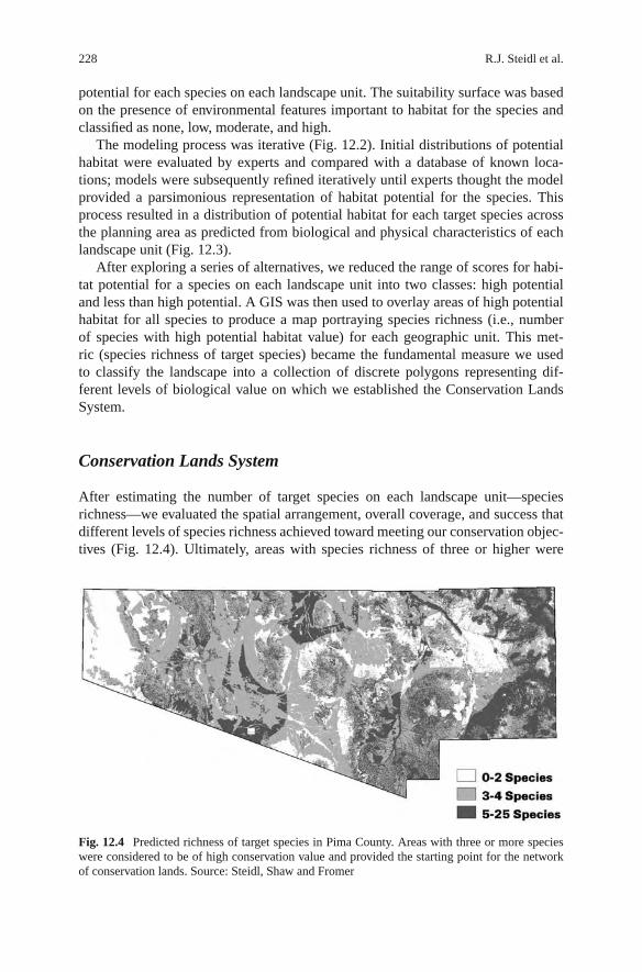
After estimating the number of target species on each landscape unit—speciesrichness—we evaluated the spatial arrangement, overall coverage, and success thatdifferent levels of species richness achieved toward meeting our conservation objec-tives (Fig. 12.4). Ultimately, areas with species richness of three or higher were
Fig. 12.4 Predicted richness of target species in Pima County. Areas with three or more specieswere considered to be of high conservation value and provided the starting point for the networkof conservation lands. Source: Steidl, Shaw and Fromer
12 A Science-Based Approach to Regional Conservation Planning 229
classified as lands with the highest conservation value. These lands were consid-ered necessary components in all possible land allocation alternatives. Therefore,these areas became the starting point for the conservation plan, including the net-work of conservation lands called the Conservation Lands System (CLS). Landswith species richness of five or more were classified as areas of highest biologicalvalue. These lands were classified as the basis for establishing areas designated as“biological core” to represent their high conservation value. Lands with speciesrichness of three or four were classified as areas of moderate to high biologi-cal value. These were identified as “multiple-use” lands, representing their impor-tance for conservation, yet distinguishing them from lands classified as biologicalcore.
The level of species richness used to distinguish lands of differing conserva-tion value will be unique to each planning process and region. Ultimately, thedecision will be the product of the number of target species used in a planningprocess, the range of environments in the target landscape, and the goals estab-lished for each plan. In our case, the levels of species richness identified a parsimo-nious network of lands that achieved the goals and objectives established for reservedesign.
Each land classification within the CLS was associated with conservation targetsthat complement anticipated land-use change. The classifications ranged from 66.7to 95%. Lands classified as “biological core” mandated a lower limit of 75% con-servation (i.e., allow land-use change of 25% or less), “multiple-use” lands requireda lower limit of 66.7% conservation, and “riparian areas” called for a lower limit of95% conservation.
Setting boundaries for contiguous landscape units that share the sameclassification—called a “patch”—followed guidelines reported in the scientific lit-erature on reserve design that maximizes conservation benefits in each patch andacross the network of patches. For example, we sought to maximize the size of eachpatch, minimize distances between adjacent patches, maximize contiguity, and min-imize fragmentation within and among patches. Additionally, we adjusted bound-aries to better meet the conservation objectives established for target species andplant communities (see Table 12.3).
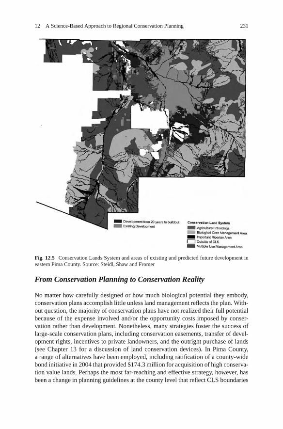
Ultimately, lands within the CLS covered 88% of the 13,723 km2 planning areaand are predicted to preserve an average of 75% of potential habitat (range =28–100%) for the target species at build-out. Within the 12,073 km2 CLS, 57% ofthe lands are federal, 24% state, 14% private, and 5% county/city. With a high per-centage of land in public ownership, achieving the established conservation objec-tives for CLS lands seems tenable, although a portion of state-owned land remainsopen to development. Currently, about 4% of the CLS area is developed, with anadditional 4% predicted to be developed in the future (ESI Corporation 2003).Although the quantity of development predicted at build-out will total <10% ofthe overall CLS, nearly all current and future developments are concentrated in theeastern portion of the county, which compromises the conservation value of theseareas considerably (Fig. 12.5).
230 R.J. Steidl et al.
Table 12.3 Additional biological elements incorporated into the Conservation Lands System forthe Sonoran Desert Conservation Plan
Group Special element
Plant communities Desert ironwood desert scrub (154.12 and 154.13)a
Douglas fir-mixed conifer forests (122.61)Grasslands on unincised floodplains (143.1)Oak–scrub grassland ecotones (123.31 and 143.1)Sacton grasslands (143.14)Saltbush desert scrub (154.17)Upland grasslands, mixed grass–shrub (143.15)
Riparian areas Cottonwood-willow forests (223.21 and 224.53)Mixed-broadleaf deciduous forests (223.22)Mesquite woodlands (224.52)Sonoran riparian scrub (234.71 and 154.1)Cattail (244.71)
Aquatic Streams with perennial and intermittent flowSprings, cienegas, and other aquatic environments
Geologic and other Caves, mine adits, and bridges occupied by batsLimestone outcropsTalus slopes
a Brown, Lowe, and Pase (1980) biotic community classification.
Riparian Areas as a Foundation for Connectivity
Riparian ecosystems typically support more and different species than adjacentupland systems in the southwest and are especially crucial to supporting biodiver-sity in desert biomes (Zaimes 2007). Riparian systems are also especially vulnerableto degradation imposed by development, as illustrated by the high loss of riparianplant communities compared to all other plant communities in the region (Bakeret al. 2004). In addition to providing habitat for riparian species, riparianareas function as corridors for animal movements, especially across arid land-scapes. These corridors form a natural network that links disconnected con-servation lands (see Chapter 10 for a discussion of riparian conservation).Consequently, the conservation goals set for riparian areas are the highestamong all lands (95%), in part because they foster connectivity across thelandscape.
To enhance connectivity, landscape areas with current or anticipated barriersto animal movements were identified because they reduced the large-scaleeffectiveness of the CLS. We also recommended removal of, or modifica-tion to, existing barriers to facilitate movement and enhance connectivityamong conservation lands, particularly those associated with major trans-portation corridors (see Chapter 5 for discussion of wildlife corridors andconnectivity).
12 A Science-Based Approach to Regional Conservation Planning 231
Fig. 12.5 Conservation Lands System and areas of existing and predicted future development ineastern Pima County. Source: Steidl, Shaw and Fromer
From Conservation Planning to Conservation Reality
No matter how carefully designed or how much biological potential they embody,conservation plans accomplish little unless land management reflects the plan. With-out question, the majority of conservation plans have not realized their full potentialbecause of the expense involved and/or the opportunity costs imposed by conser-vation rather than development. Nonetheless, many strategies foster the success oflarge-scale conservation plans, including conservation easements, transfer of devel-opment rights, incentives to private landowners, and the outright purchase of lands(see Chapter 13 for a discussion of land conservation devices). In Pima County,a range of alternatives have been employed, including ratification of a county-widebond initiative in 2004 that provided $174.3 million for acquisition of high conserva-tion value lands. Perhaps the most far-reaching and effective strategy, however, hasbeen a change in planning guidelines at the county level that reflect CLS boundaries
232 R.J. Steidl et al.
and the conservation goals set forth in the SCDP. In Pima County, land-use changemust follow a series of guidelines that ensure that development does not exceedconservation targets established for all lands within the CLS.
Conclusion
A region-wide approach to conservation planning enables a framework that con-serves biodiversity while minimizing the disjointed array of conservation lands thatresult from small-scale conservation driven primarily by opportunism. A syntheticapproach to regional planning is more effective for conservation and reduces theneed for future listings under ESA, hence minimizing the regulatory challengesfaced by developers.
Ultimately, conservation-minded regional planning consists of a set of conse-quential experiments that respond to the uncertainty of large-scale efforts such asthe SDCP. The effectiveness of ambitious plans, such as the SDCP (or any MSHCP),can be reliably established only by measuring temporal changes in the naturalresources that plans seek to conserve. Plans, therefore, must be accompanied by arigorous monitoring program designed to quantify changes in natural resources overtime and measure responses to land management actions. Although HCPs requirea monitoring plan, the strategies that accompany many HCPs have been criticized(Kareiva et al. 1999). The monitoring and adaptive management programs devel-oped for the SCDP respond to these criticisms by moving beyond requirements forMSHCPs. This revised approach ensures persistence of all biodiversity in the regionby moving from monitoring single species to a broader and more ambitious goal ofmonitoring aspects of ecosystem structure and function, as well as threats acrossplanning areas.
Land-use plans must incorporate change by being sufficiently flexible. As landstransition to their future uses, the planning footprint will inevitably change inresponse to unforeseen social pressures, novel conservation opportunities, and newscientific information. Incorporating these changes requires that planning frame-works incorporate new knowledge and respond accordingly; this is the purview ofadaptive management. Land-use plans are only the first step in developing responsi-ble regional management and conservation plans that are ultimately refined as uncer-tainty is reduced through rigorous monitoring and adaptive management (Wilhere2002). Although much effort is devoted to initial planning, monitoring and adap-tive management receive far less attention, including fewer financial and intellectualresources. Until the effectiveness of plans is evaluated rigorously and new informa-tion is collected to refine land-use decisions, regional HCPs pose a risk to the speciesthey are designed to protect.
References
Baker, M. B. Jr., Ffolliott, P. F., DeBano, L. F., and Neary, D. G. 2004. Riparian Areas of theSouthwestern United States. Boca Raton, FL: Lewis Publishers/CRC Press.
12 A Science-Based Approach to Regional Conservation Planning 233
Benedict, M., Drohan, J., and Gravely, J. 2005. Sonoran desert conservation plan, Pima County,Arizona. Green Infrastructure – Linking Lands for Nature and People: Case Study Series # 6.Arlington, VA: The Conservation Fund.
Brown, D. E., Lowe, C. H., and Pase, C. P. 1980. A Digitized Systematic Classification for Ecosys-tems with an Illustrated Summary of the Natural Vegetation of North America. USDA ForestService General Technical Report RM-73. Fort Collins, CO: Rocky Mountain Forest and RangeExperiment Station.
ESI Corporation. 2003. Pima County Economic Analysis. Report to Pima County. Available at:http://www.pima.gov/cmo/sdcp/reports.html. Accessed November 10, 2008.
Haufler, J. B. 1999. Strategies for conserving terrestrial biological diversity. In PracticalApproaches to Conservation of Biological Diversity, eds. R. Baydeck, H. Campa III, andJ. B. Haufler, pp. 17–34. Washington, D.C: Island Press.
Kareiva P., Andelman, S., Doak, D., Elderd, B., Groom, M., Hoekstra, J., Hood, L., James, F.,Lamoreux, J., LeBuhn, G., McCulloch, C., Regetz, J., Savage, L., Ruckelshaus, M., Skelly,D., Wilbur, H., Zamudio, K., and NCEAS HCP working group. 1999. Using Science in HabitatConservation Plans. Santa Barbara, CA: National Center for Ecological Analysis and Synthesis,University of California, Santa Barbara.
Noss, R., and Cooperrider, A. 1994. Saving Nature’s Legacy: Protecting and Restoring Biodiver-sity. Washington, D.C.: Island Press.
Omernik, J. M. 1987. Ecoregions of the conterminous United States. Annals of the Association ofAmerican Geographers 77:118–125.
Pressey, R. L., Cowling, R. M., and Rouget, M. 2003. Formulating conservation targets for biodi-versity pattern and process in the Cape Floristic Region, South Africa. Biological Conservation112:99–127.
Svancara, L. K., Brannon, R., Scott, J. M., Groves, C. R., Noss, R. F., and Pressey, R. L. 2005.Policy-driven versus evidence-based conservation: A review of political targets and biologicalneeds. BioScience 55:989–995.
Warshall, P. 1995. The Madrean sky island archipelago: a planetary overview. In Biodiversity andManagement of the Madrean Archipelago: The Sky Islands of Southwestern United Statesand Northwestern Mexico, eds. L. F. DeBano, G. J. Gottfried, R. H. Hamre, C. B. Edminster,P. F. Ffoliott, and A. Ortega-Rubio, pp. 6–18. Fort Collins, CO: USDA Forest Service, RockyMountain Experimental Station General Technical Report RM-GTR-264.
Wilhere, G. F. 2002. Adaptive management in habitat conservation plans. Conservation Biology16:20–29.
Zaimes G. N. 2007. Understanding Arizona’s Riparian Areas. Tucson, AZ: University of ArizonaCooperative Extension, Publication No. AZ1432.
![Neural Organisation for Communication and Cross-Modal ... · Web viewThe word ‘kick’ for ... itc.it/public/publications/kth-Cerrato_skhirifinal.pdf [Steidl 03] Steidl S., Stemmer](https://img.pdfslide.us/doc/110x75/5c6f92cf09d3f2254c8c207d/neural-organisation-for-communication-and-cross-modal-web-viewthe-word-kick.jpg)