Embed Size (px)
Citation preview
Chapter 10 Decommissioning and
Rehabilitation
Byerwen Coal ProjectChapter 10 – Decommissioning and Rehabilitation
Page 10-i
TABLE OF CONTENTS10.1 Rehabilitation Hierarchy and Goals ...................................................................10-110.2 Decommissioning and Rehabilitation Objectives ...............................................10-110.3 Land Use ..........................................................................................................10-210.3.1 Pre Mine Land Use and Land Suitability................................................................... 10-210.3.2 Potential Post-mine Land Uses................................................................................. 10-210.4 Progressive Rehabilitation ................................................................................10-510.5 Rehabilitation and Decommissioning by Mine Domain ....................................10-1210.5.1 Waste Rock Dumps ................................................................................................ 10-1210.5.2 Final Voids .............................................................................................................. 10-1310.5.3 Mine Infrastructure Areas and CHPPs.................................................................... 10-1510.5.4 Co-disposal Dams ................................................................................................... 10-1610.5.5 Mine Water Management Infrastructure .............................................................. 10-1710.5.6 Drainage Diversions................................................................................................ 10-1710.5.7 Haul Roads and Access Roads ................................................................................ 10-1810.5.8 Train Loading Facilities ........................................................................................... 10-1810.5.9 Linear Infrastructure .............................................................................................. 10-1910.6 Rehabilitation Management and Monitoring ..................................................10-1910.6.1 Soils Management.................................................................................................. 10-1910.6.2 Erosion Control in Rehabilitation Areas ................................................................. 10-2010.6.3 Vegetation Cover Management ............................................................................. 10-2010.6.4 Monitoring and Review.......................................................................................... 10-2110.7 Completion Criteria and Indicators .................................................................10-2210.8 Mine Closure Planning....................................................................................10-2310.8.1 Stakeholders........................................................................................................... 10-2410.8.2 Closure Planning..................................................................................................... 10-2410.8.3 Implementation...................................................................................................... 10-2410.8.4 Standards and Completion Criteria........................................................................ 10-2410.8.5 Relinquishment ...................................................................................................... 10-25
Tables
Table 10-1 Draft Final Land Use and Rehabilitation Schedule ................................................... 10-4Table 10-2 Landform Design Criteria ......................................................................................... 10-5
Figures
Figure 10-1 Progressive Rehabilitation – Year 5.......................................................................... 10-6Figure 10-2 Progressive Rehabilitation – Year 10........................................................................ 10-7Figure 10-3 Progressive Rehabilitation – Year 25 (South)........................................................... 10-8Figure 10-4 Progressive Rehabilitation – Year 25 (North)........................................................... 10-9Figure 10-5 Progressive Rehabilitation – Final Landform (South)............................................. 10-10Figure 10-6 Progressive Rehabilitation – Final Landform (North)............................................. 10-11
Byerwen Coal ProjectChapter 10 – Decommissioning and Rehabilitation
Page 10-1
10. DECOMMISSIONING AND REHABILITATION
10.1 Rehabilitation Hierarchy and GoalsThe Department of Environment and Heritage Protection (EHP) guideline – ‘Rehabilitation requirementsfor mining projects’ (EHP, 2012) (the EHP Guideline) describes the preferred rehabilitation hierarchywhich, in order of decreasing capacity to prevent or minimise environmental harm, is:
1. Avoid disturbance that will require rehabilitation.
2. Reinstate a ‘natural’ ecosystem as similar as possible to the original ecosystem.
3. Develop an alternative outcome with a higher economic value than the previous land use.
4. Reinstate the previous land use (e.g. grazing or cropping).
5. Develop lower value land use.
6. Leave the site in an unusable condition or with a potential to generate future pollution of adverselyaffect environmental values.
The guideline outlines that the strategies listed higher in the hierarchy should be adopted in preferenceto those listed lower. Developing a lower value land use may however be appropriate if that use isacceptable to stakeholders and if all higher strategies are impractical. Leaving the site in an unstablecondition or with potential to cause environmental harm will rarely be acceptable.
The rehabilitation goals, as described in the EHP guideline require rehabilitation of areas disturbed bymining to result in landforms that are:
safe to humans and wildlife non-polluting stable able to sustain an agreed post mining land use.
10.2 Decommissioning and Rehabilitation ObjectivesIn accordance with the EHP guideline the following objectives have been derived for decommissioningand rehabilitation of areas disturbed by the project:
The mine site will be safe to humans and fauna. Mining and rehabilitation will create a landform that is stable and with land use capabilities and/or
suitabilities as determined in the Rehabilitation Management Plan (RMP). Mine wastes anddisturbed land will be rehabilitated so that they are non-polluting and self-sustaining or to acondition where the maintenance requirements are consistent with an agreed post-mining land use.
Surface and ground waters that leave the project area will not be degraded compared to theircondition prior to the commencement of mining operations. Current and future water quality, otherthan water quality impacts associated with subsequent land users, will be maintained at levels thatare within defined water quality criteria.
Hazardous materials will be identified and adequately managed to ensure the site is non-polluting.
Byerwen Coal ProjectChapter 10 – Decommissioning and Rehabilitation
Page 10-2
Potential for acid mine drainage will be determined and will be adequately managed to ensure thesite is non-polluting. Vegetation cover will be established to reduce rates of erosion and sedimentloss.
Final rehabilitation will be designed as permanent self sustaining landforms requiring no ongoingmaintenance or management.
Specific rehabilitation objectives are described below for each mine domain. The mine domains are:
waste rock dumps final voids mine infrastructure areas, including CHPPs co-disposal dams mine water management infrastructure (e.g. mine affected water dams) drainage diversions haul roads and other roads train loading facility linear infrastructure (e.g. power lines and water pipelines).
10.3 Land Use
10.3.1 Pre Mine Land Use and Land Suitability
The dominant land use within the project site is beef cattle grazing on areas cleared of remnantvegetation. Approximately 68% of the land within the project footprint is land that has been previouslydisturbed and modified to allow grazing of cattle. The remaining 32% comprises remnant vegetation, ofwhich approximately 33% is Endangered or Of Concern Regional Ecosystem.
Chapter 14 describes the land suitability assessment for the project area which identified the landclasses of the project site for beef cattle grazing as:
Class 2 – 27% Class 3 – 15% Class 4 – 56% Class 5 – 2%.
10.3.2 Potential Post-mine Land Uses
The primary rehabilitation objective of the rehabilitation program will be to return the site to a stableand self-sustaining landform with a productivity level that conforms to a defined final land use. This willbe achieved through: effective mine closure planning establishment of key performance indicators stabilisation of landforms revegetation with suitable species.
Mine closure planning will consider the choice of post-mining land use. This final land use may notnecessarily be the original use. The final land use will largely be dependent on pre-mining land
Byerwen Coal ProjectChapter 10 – Decommissioning and Rehabilitation
Page 10-3
suitability, landholder preferences for land use, the potential uses of likely rehabilitated landforms, andthe existing use or environmental values of surrounding land.
Determination of post-mining land use will be made in consideration of the rehabilitation hierarchy, asoutlined in Section 10.1.
In accordance with the number one strategy of the rehabilitation hierarchy, the project will avoiddisturbance, where possible. However, the nature of mining activities will result in disturbance. Thoseareas not proposed for disturbance will likely retain the pre-mining land use. Chapter 14 describes theproponent’s commitment to allowing ongoing use of the land for grazing outside operational areas onthe project's mining leases.
As per the rehabilitation hierarchy the next preference following avoidance is the reinstatement of a‘natural’ ecosystem as similar as possible to the original ecosystem. Factors to be considered whendetermining the feasibility of the reinstatement of a ‘natural’ ecosystem include ecological value ofnative vegetation to be disturbed, offsets proposed for native vegetation to be disturbed, benefitsprovided to landholders and technical feasibility of establishing effective and self-sustaining colonisationby the species which either existed pre mine or by species which are consistent with the selectedhabitat conservation value. The majority of remnant vegetation occurs within the footprint of the openpits and waste rock dumps. Reinstatement of ‘natural ecosystems’ on waste rock dumps may be feasiblein the long term, however in the short term the rehabilitation objective is likely to be to stabilise thewaste rock dumps and minimise erosion. This will be achieved by revegetation of waste rock dumpswith fast-growing grass species, which may not represent the ‘natural’ ecosystem, to establishtemporary vegetation cover to reduce erosion.
Where reinstatement of a ‘natural’ ecosystem is not feasible consideration will be made to the nextstrategy outlined within the rehabilitation hierarchy, being the development of an alternative outcomewith a higher economic value than the previous land use. There will be limited opportunities for a post-mine land use with a higher economic value. However project infrastructure, such as dams and roadsmay be retained, which could contribute to a higher economic value of land.
It is considered likely that the rehabilitation strategy for the majority of disturbed areas (waste rockdumps) will be the reinstatement of the previous grazing land use at the same or lower land usesuitability ranking.
There will be some areas of the mine site, such as the final voids, that are not returned to their previousland use. These areas will be developed to a lower value land use, but will be left in a stable conditionthat minimises the potential to generate future pollution or adversely affect environmental values.
Considerations and final determination of post-mine land use for the project site will be documented inthe RMP, described below.
The proponent will develop a RMP which describes the post mine land uses within two years of theeffective date of the environmental authority for the project. The RMP will be based on the followingconsiderations:
An inventory of existing land uses will be conducted. Aspects of this inventory are described in thisEIS (refer Chapter 14) which finds that the land is primarily used for grazing of cattle on improvedand native pastures with areas of remnant vegetation (described in Chapter 18). No areas arecurrently used for cropping. Further analysis of the intensity of grazing may be required to establishcriteria for rehabilitation success following final rehabilitation. In addition the inventory of existingland use will consider farm infrastructure and existing land degradation due to historical agriculturalpractices.
A description of the location and extent of land proposed to be disturbed by mining activities, asdescribed in Chapters 6, 7 and 8 of this EIS.
Byerwen Coal ProjectChapter 10 – Decommissioning and Rehabilitation
Page 10-4
An assessment of post-mining land suitability and post-mining land use options and their communitybenefits.
An assessment of the feasibility to achieve the various options including any ongoing maintenanceor management needs.
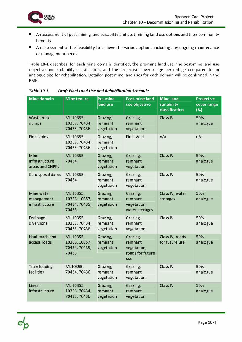
Table 10-1 describes, for each mine domain identified, the pre-mine land use, the post-mine land useobjective and suitability classification, and the projective cover range percentage compared to ananalogue site for rehabilitation. Detailed post-mine land uses for each domain will be confirmed in theRMP.
Table 10-1 Draft Final Land Use and Rehabilitation Schedule
Mine domain Mine tenure Pre-mineland use
Post-mine landuse objective
Mine landsuitabilityclassification
Projectivecover range(%)
Waste rockdumps
ML 10355,10357, 70434,70435, 70436
Grazing,remnantvegetation
Grazing,remnantvegetation
Class IV 50%analogue
Final voids ML 10355,10357, 70434,70435, 70436
Grazing,remnantvegetation
Final Void n/a n/a
Mineinfrastructureareas and CHPPs
ML 10355,70434
Grazing,remnantvegetation
Grazing,remnantvegetation
Class IV 50%analogue
Co-disposal dams ML 10355,70434
Grazing,remnantvegetation
Grazing,remnantvegetation
Class IV 50%analogue
Mine watermanagementinfrastructure
ML 10355,10356, 10357,70434, 70435,70436
Grazing,remnantvegetation
Grazing,remnantvegetation,water storages
Class IV, waterstorages
50%analogue
Drainagediversions
ML 10355,10357, 70434,70435, 70436
Grazing,remnantvegetation
Grazing,remnantvegetation
Class IV 50%analogue
Haul roads andaccess roads
ML 10355,10356, 10357,70434, 70435,70436
Grazing,remnantvegetation
Grazing,remnantvegetation,roads for futureuse
Class IV, roadsfor future use
50%analogue
Train loadingfacilities
ML10355,70434, 70436
Grazing,remnantvegetation
Grazing,remnantvegetation
Class IV 50%analogue
Linearinfrastructure
ML 10355,10356, 70434,70435, 70436
Grazing,remnantvegetation
Grazing,remnantvegetation
Class IV 50%analogue
Byerwen Coal ProjectChapter 10 – Decommissioning and Rehabilitation
Page 10-5
Table 10-2 provides the surface area and indicative maximum slope ranges for various mininglandforms. The maximum slope ranges will be determined in the RMP.
Table 10-2 Landform Design Criteria
Disturbance type Indicative maximum slope range%
Projective surface area (ha)
Final voids – high wall 0-214% or 65o 1,342 ha across four final voids
Final voids – low wall 0-100% or 45o
Co-disposal facilities 0-20% or 11.5o 104
Waste rock dumps 0-20% or 11.5o 4,749
MIA, ROM pad 0-18% or 10o 255
10.4 Progressive RehabilitationThe main features of the progressive rehabilitation process are:
constructing a stable land form consisting of out of pit and in pit waste rock dumps progressively constructing dumps to their final landform design, to minimise reshaping at the end of
mining respreading of topsoil across available reshaped areas contour ripping immediately after topsoil placement to control erosion seeding with an appropriate seed mix prior to the wet season to maximise the benefits of
subsequent rainfall managing direct rainfall and runoff from the rehabilitated landform in sediment dams.
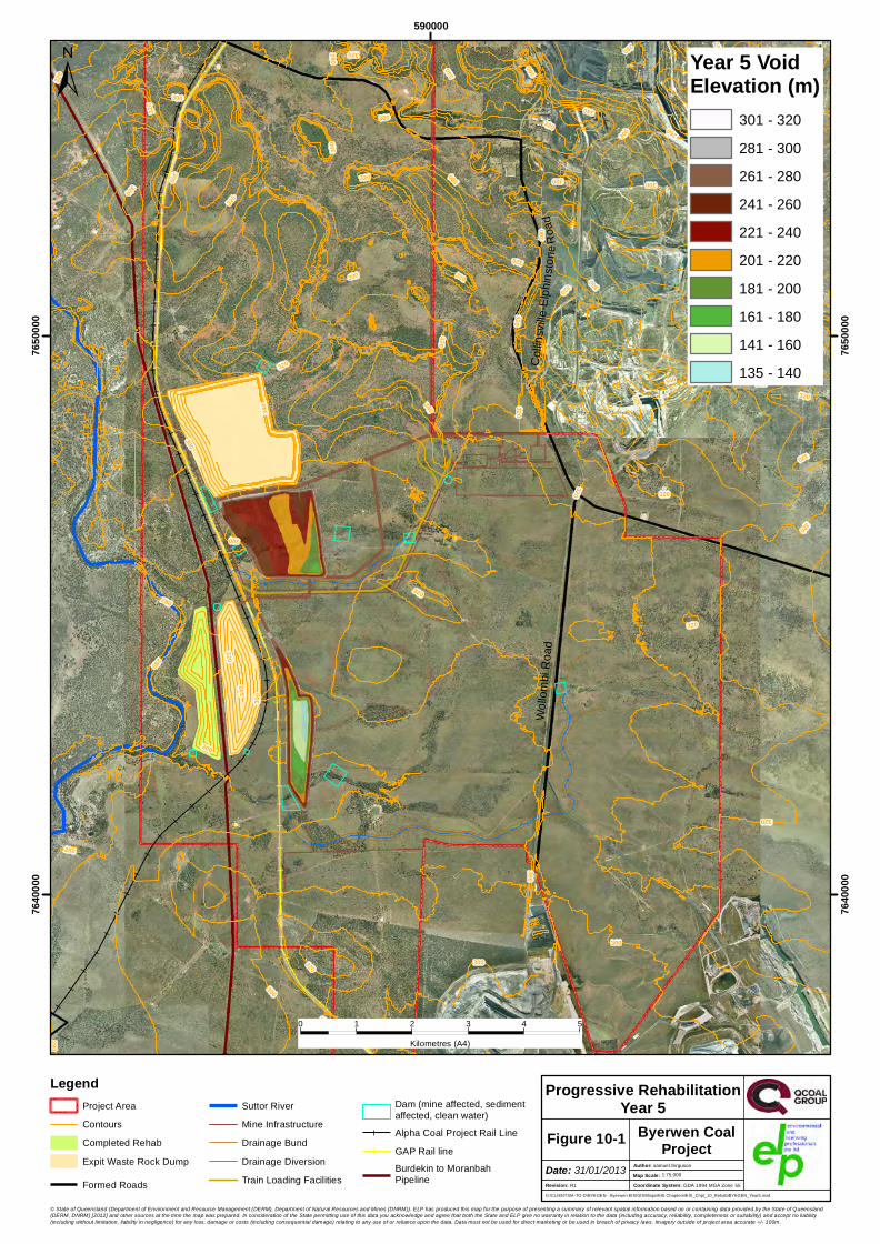
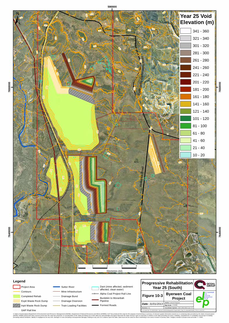
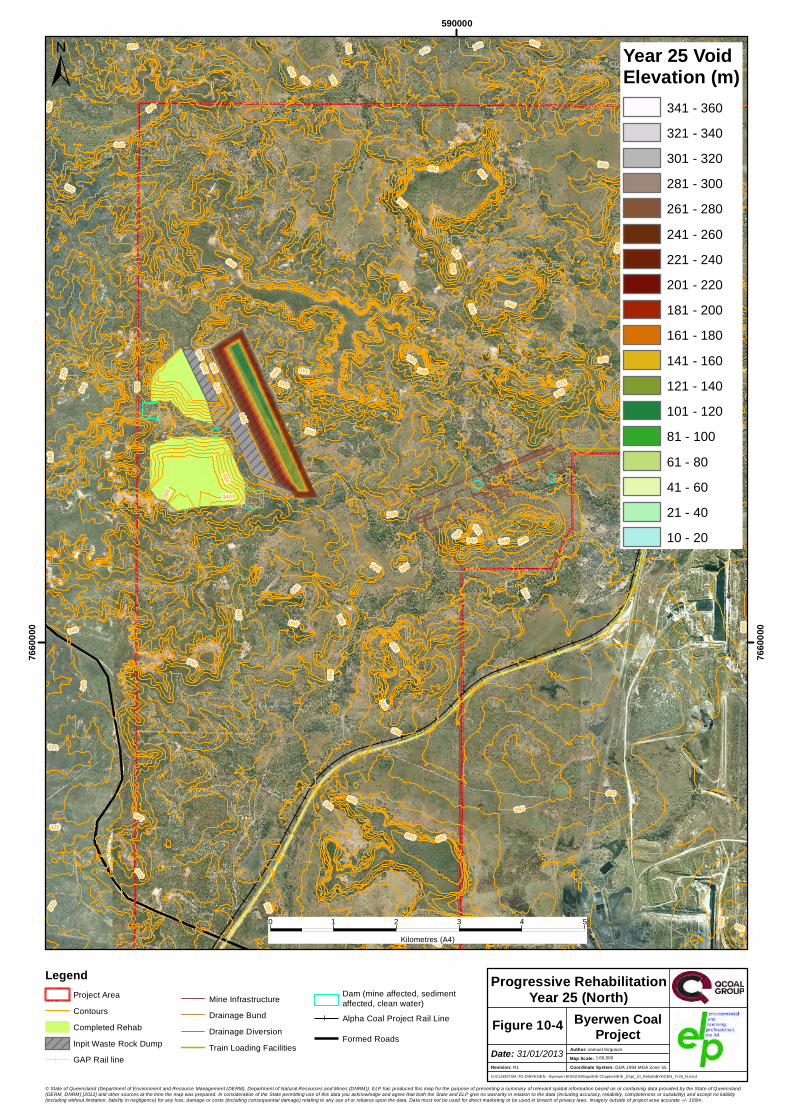
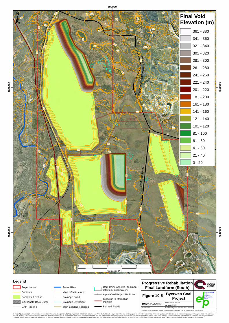
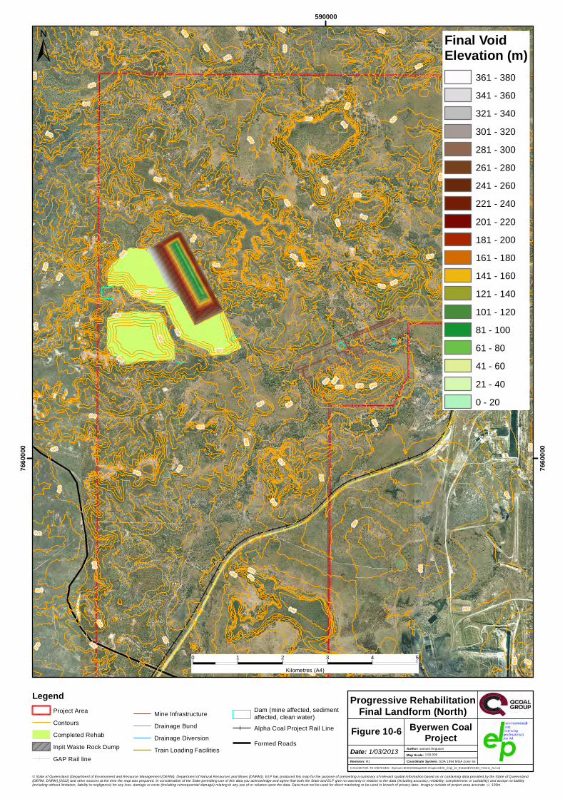
Progressive rehabilitation will minimise the amount of land disturbed at any one time. The indicativeprogramme for progressive rehabilitation of waste rock dumps is shown in Figure 10-1, Figure 10-2,Figure 10-3, Figure 10-4, Figure 10-5 and Figure 10-6. These show rehabilitation at various stages,including waste rock dumps where the landform is being developed and areas of waste rock dumpswhere rehabilitation has been completed in year 5, 10, 25 and the final landform. Progressiverehabilitation will also include the rehabilitation of any areas disturbed during construction that are notrequired for ongoing operations.
The following decommissioning strategies are proposed for various remaining structures post-mineclosure:
Conduct of a contaminated land assessment of relevant locations. This may involve engaging asuitably qualified person (SQP) approved by EHP as a contaminated land specialist1.
Remediation or ongoing management of contaminated land as required. Ongoing management mayinclude retaining parcels of the land on EHP’s Environmental Management Register.
Removal (or sale and removal if appropriate) of all items of the mine infrastructure area, and anytemporary buildings and facilities, unless agreed with the post-mining landowner.
Ripping, application of topsoil, and seeding of land Establishment of safety bunds and fencing for final void areas.
1 For the purposes of preparing site investigation and validation reports and draft site management plans, an SQP is defined inthe Environmental Protection Regulation 2008.
Conti
nues
South
Wollo
mbi R
oad
Collin
svil le
-Elph
inston
eRoa
d
300
280
280
320
260
280
320
320
320320
280
300
320
300
300
340
300 320
320
340
300
320
300
340
320
320
340
300
300
320
320
320
320
300
300
320
320
300
300
320
300
340
320
300300
320
340
260
320
320
300
320
280
300
320
300
320
320
320
300
300
300
300
280
280
300
59000076
4000
0
7640
000
7650
000
7650
000
0 1 2 3 4 5Kilometres (A4)
© State of Queensland (Department of Environment and Resource Management (DERM), Department of Natural Resources and Mines (DNRM)). ELP has produced this map for the purpose of presenting a summary of relevant spatial information based on or containing data provided by the State of Queensland(DERM, DNRM) [2012] and other sources at the time the map was prepared. In consideration of the State permitting use of this data you acknowledge and agree that both the State and ELP give no warranty in relation to the data (including accuracy, reliability, completeness or suitability) and accept no liability(including without limitation, liability in negligence) for any loss, damage or costs (including consequential damage) relating to any use of or reliance upon the data. Data must not be used for direct marketing or be used in breach of privacy laws. Imagery outside of project area accurate +/- 100m.
±
G:\CLIENTS\A-TO-D\BYEGEN - Byerwen EIS\GIS\Maps\EIS Chapters\EIS_Chpt_10_Rehab\BYEGEN_Year5.mxd
1:75,000Coordinate System: GDA 1994 MGA Zone 55
Progressive RehabilitationYear 5
Revision: R1
Author: samuel.ferguson
Figure 10-1Date: 31/01/2013
Byerwen CoalProject
Map Scale:
LegendProject AreaContoursCompleted RehabExpit Waste Rock Dump
Formed Roads
Suttor RiverMine InfrastructureDrainage BundDrainage DiversionTrain Loading Facilities
Dam (mine affected, sediment affected, clean water)Alpha Coal Project Rail LineGAP Rail lineBurdekin to MoranbahPipeline
Year 5 VoidElevation (m)
301 - 320281 - 300261 - 280241 - 260221 - 240201 - 220181 - 200161 - 180141 - 160135 - 140

Conti
nues
South
Wollo
mbi R
oad
Collinsville-Elphinstone Road
320
280
280
320
320
120
280
320
320320
280
320
300
340
140
320
300 320
320
340
160
300
320
340
300
320
340
340
340
300
180
280
300
260
240
320
220
200
320
300
320
320
320
300
280
300
300
320
300
300
300
300
320
300
300
300
320
320 300
320
260
320
320
340
300
320
280
300
300
300
300
320
320
300
300
300
320
280
300
280
59000076
4000
0
7640
000
7650
000
7650
000
0 1 2 3 4 5Kilometres (A4)
© State of Queensland (Department of Environment and Resource Management (DERM), Department of Natural Resources and Mines (DNRM)). ELP has produced this map for the purpose of presenting a summary of relevant spatial information based on or containing data provided by the State of Queensland(DERM, DNRM) [2012] and other sources at the time the map was prepared. In consideration of the State permitting use of this data you acknowledge and agree that both the State and ELP give no warranty in relation to the data (including accuracy, reliability, completeness or suitability) and accept no liability(including without limitation, liability in negligence) for any loss, damage or costs (including consequential damage) relating to any use of or reliance upon the data. Data must not be used for direct marketing or be used in breach of privacy laws. Imagery outside of project area accurate +/- 100m.
±
G:\CLIENTS\A-TO-D\BYEGEN - Byerwen EIS\GIS\Maps\EIS Chapters\EIS_Chpt_10_Rehab\BYEGEN_Year10.mxd
1:75,000Coordinate System: GDA 1994 MGA Zone 55
Progressive RehabilitationYear 10
Revision: R1
Author: samuel.ferguson
Figure 10-2Date: 4/02/2013
Byerwen CoalProject
Map Scale:
LegendProject AreaContoursCompleted RehabExpit Waste Rock DumpInpit Waste Rock DumpGAP Rail line
Suttor RiverFormed RoadsMine InfrastructureDrainage BundDrainage Diversion
Dam (mine affected, sediment affected, clean water)Train Loading FacilitiesAlpha Coal Project Rail LineBurdekin to MoranbahPipeline
Year 10 VoidElevation (m)
341 - 360321 - 340301 - 320281 - 300261 - 280241 - 260221 - 240201 - 220181 - 200161 - 180141 - 160121 - 140101 - 12061 - 10044 - 60
Conti
nues
South
Wollo
mbi R
oad
Collin
svil le
-Elph
inston
eRoa
d
340
300
320
320
280
280
260
320
320
280
320
300
320
320320
280
300
320
300
300
340
300
320
320
320
300
340
300
320
340
340
320
300
300
320
300
280
300
320
320
300
300
300
280
340
300
300
320
320
340
300
320
320
300
320
320
260
320
320
280
300
300
320
300
320
320
300
300
300
300
340
280
300
280
59000076
4000
0
7640
000
7650
000
7650
000
0 1 2 3 4 5Kilometres (A4)
© State of Queensland (Department of Environment and Resource Management (DERM), Department of Natural Resources and Mines (DNRM)). ELP has produced this map for the purpose of presenting a summary of relevant spatial information based on or containing data provided by the State of Queensland(DERM, DNRM) [2012] and other sources at the time the map was prepared. In consideration of the State permitting use of this data you acknowledge and agree that both the State and ELP give no warranty in relation to the data (including accuracy, reliability, completeness or suitability) and accept no liability(including without limitation, liability in negligence) for any loss, damage or costs (including consequential damage) relating to any use of or reliance upon the data. Data must not be used for direct marketing or be used in breach of privacy laws. Imagery outside of project area accurate +/- 100m.
±
G:\CLIENTS\A-TO-D\BYEGEN - Byerwen EIS\GIS\Maps\EIS Chapters\EIS_Chpt_10_Rehab\BYEGEN_Yr25_S_new.mxd
1:75,000Coordinate System: GDA 1994 MGA Zone 55
Progressive RehabilitationYear 25 (South)
Revision: R1
Author: samuel.ferguson
Figure 10-3Date: 31/01/2013
Byerwen CoalProject
Map Scale:
LegendProject AreaContoursCompleted RehabExpit Waste Rock DumpInpit Waste Rock DumpGAP Rail line
Suttor RiverMine InfrastructureDrainage BundDrainage DiversionTrain Loading Facilities
Dam (mine affected, sediment affected, clean water)Alpha Coal Project Rail LineBurdekin to MoranbahPipelineFormed Roads
Year 25 VoidElevation (m)
341 - 360321 - 340301 - 320281 - 300261 - 280241 - 260221 - 240201 - 220181 - 200161 - 180141 - 160121 - 140101 - 12081 - 10061 - 8041 - 6021 - 4010 - 20
320360
320
280
300
28036
0
340
320
280
340
320
240
340
340
280
300
300
240
300
280
380
300
300
280
260
300
360
300
320
300
260
360
280
260
300
340
320
300
320
260
340
340
320
340
340
320
320
340
360340
240
340
300
280
280
360
320
280
360
240
300
220
340
280
320
320
320
340
340
260
280
320
300
280
320
340
360
280
320
240
300
340
300
300
320
280
260
59000076
6000
0
7660
000
0 1 2 3 4 5Kilometres (A4)
© State of Queensland (Department of Environment and Resource Management (DERM), Department of Natural Resources and Mines (DNRM)). ELP has produced this map for the purpose of presenting a summary of relevant spatial information based on or containing data provided by the State of Queensland(DERM, DNRM) [2012] and other sources at the time the map was prepared. In consideration of the State permitting use of this data you acknowledge and agree that both the State and ELP give no warranty in relation to the data (including accuracy, reliability, completeness or suitability) and accept no liability(including without limitation, liability in negligence) for any loss, damage or costs (including consequential damage) relating to any use of or reliance upon the data. Data must not be used for direct marketing or be used in breach of privacy laws. Imagery outside of project area accurate +/- 100m.
±
G:\CLIENTS\A-TO-D\BYEGEN - Byerwen EIS\GIS\Maps\EIS Chapters\EIS_Chpt_10_Rehab\BYEGEN_Yr25_N.mxd
1:60,000Coordinate System: GDA 1994 MGA Zone 55
Progressive RehabilitationYear 25 (North)
Revision: R1
Author: samuel.ferguson
Figure 10-4Date: 31/01/2013
Byerwen CoalProject
Map Scale:
LegendProject AreaContoursCompleted RehabInpit Waste Rock DumpGAP Rail line
Mine InfrastructureDrainage BundDrainage DiversionTrain Loading Facilities
Dam (mine affected, sediment affected, clean water)Alpha Coal Project Rail Line
Formed Roads
Year 25 VoidElevation (m)
341 - 360321 - 340301 - 320281 - 300261 - 280241 - 260221 - 240201 - 220181 - 200161 - 180141 - 160121 - 140101 - 12081 - 10061 - 8041 - 6021 - 4010 - 20
Conti
nues
South
Wollo
mbi R
oad
Collin
svil le
-Elph
inston
eRoa
d
280
320
280
260
320
280
320
320
320320
280
300
320
300
300
340
340
320
280
320
340
300
340
320
340
30034
0
300
320
300
320
300
320
300
300
300
320
320
300
300
320
320
320
280
300
300
300
300
320
340
300
320
320
260
320
340
320
340
300
300
320
300
300
300
320
320
320
300
300
280
300
280
59000076
4000
0
7640
000
7650
000
7650
000
0 1 2 3 4 5Kilometres (A4)
© State of Queensland (Department of Environment and Resource Management (DERM), Department of Natural Resources and Mines (DNRM)). ELP has produced this map for the purpose of presenting a summary of relevant spatial information based on or containing data provided by the State of Queensland(DERM, DNRM) [2012] and other sources at the time the map was prepared. In consideration of the State permitting use of this data you acknowledge and agree that both the State and ELP give no warranty in relation to the data (including accuracy, reliability, completeness or suitability) and accept no liability(including without limitation, liability in negligence) for any loss, damage or costs (including consequential damage) relating to any use of or reliance upon the data. Data must not be used for direct marketing or be used in breach of privacy laws. Imagery outside of project area accurate +/- 100m.
±
G:\CLIENTS\A-TO-D\BYEGEN - Byerwen EIS\GIS\Maps\EIS Chapters\EIS_Chpt_10_Rehab\BYEGEN_FLform_S.mxd
1:75,000Coordinate System: GDA 1994 MGA Zone 55
Progressive RehabilitationFinal Landform (South)
Revision: R1
Author: samuel.ferguson
Figure 10-5Date: 1/03/2013
Byerwen CoalProject
Map Scale:
LegendProject AreaContoursCompleted RehabInpit Waste Rock DumpGAP Rail line
Suttor RiverMine InfrastructureDrainage BundDrainage DiversionTrain Loading Facilities
Dam (mine affected, sediment affected, clean water)Alpha Coal Project Rail LineBurdekin to MoranbahPipelineFormed Roads
Final VoidElevation (m)
361 - 380341 - 360321 - 340301 - 320281 - 300261 - 280241 - 260221 - 240201 - 220181 - 200161 - 180141 - 160121 - 140101 - 12081 - 10061 - 8041 - 6021 - 400 - 20
360
280
320
280
360
340
320
280
320
240
340
340
280
240
300
280
380
300
300
280
300
260
360
300
320 300
260
360
280
280
260
340
320
300
300
280
320
320
340
340
340
280
320
260
300
320
340
320
340
360
300
340
240
340
300
280
320
360
320
280
360
240
360
220
300
300
280
340
320
320
320
340
340
260
280 320
300
340
300
280
320
320
240
340
320
300
300
260
280
59000076
6000
0
7660
000
0 1 2 3 4 5Kilometres (A4)
© State of Queensland (Department of Environment and Resource Management (DERM), Department of Natural Resources and Mines (DNRM)). ELP has produced this map for the purpose of presenting a summary of relevant spatial information based on or containing data provided by the State of Queensland(DERM, DNRM) [2012] and other sources at the time the map was prepared. In consideration of the State permitting use of this data you acknowledge and agree that both the State and ELP give no warranty in relation to the data (including accuracy, reliability, completeness or suitability) and accept no liability(including without limitation, liability in negligence) for any loss, damage or costs (including consequential damage) relating to any use of or reliance upon the data. Data must not be used for direct marketing or be used in breach of privacy laws. Imagery outside of project area accurate +/- 100m.
±
G:\CLIENTS\A-TO-D\BYEGEN - Byerwen EIS\GIS\Maps\EIS Chapters\EIS_Chpt_10_Rehab\BYEGEN_FLform_N.mxd
1:60,000Coordinate System: GDA 1994 MGA Zone 55
Progressive RehabilitationFinal Landform (North)
Revision: R1
Author: samuel.ferguson
Figure 10-6Date: 1/03/2013
Byerwen CoalProject
Map Scale:
LegendProject AreaContoursCompleted RehabInpit Waste Rock DumpGAP Rail line
Mine InfrastructureDrainage BundDrainage DiversionTrain Loading Facilities
Dam (mine affected, sediment affected, clean water)Alpha Coal Project Rail Line
Formed Roads
Final VoidElevation (m)
361 - 380341 - 360321 - 340301 - 320281 - 300261 - 280241 - 260221 - 240201 - 220181 - 200161 - 180141 - 160121 - 140101 - 12081 - 10061 - 8041 - 6021 - 400 - 20
Byerwen Coal ProjectChapter 10 – Decommissioning and Rehabilitation
Page 10-12
10.5 Rehabilitation and Decommissioning by Mine Domain
10.5.1 Waste Rock Dumps
The rehabilitation objectives for waste rock dumps are:
Establishment of a post-mine land use in accordance with the RMP. Dump slopes are geotechnically stable. Erosion rates are managed to levels that do not compromise post-mine land use. Surface and near surface soil properties will support the proposed land use. Vegetation cover is established to minimise erosions rates. Run-off or seepage water quality does not present a risk of environmental harm. Landform does not present a risk to people and stock. Ongoing management requirements are similar to non-mined land.
Waste rock dumps will be designed, shaped, capped with topsoil and revegetated in accordance with aMine Waste Management Plan. The design of dumps is an important part of the rehabilitation process.Dumps will be designed and engineered to be geotechnically stable and safe. The final landform ofwaste rock dumps will be determined in the RMP. Dumps will be levelled out to cap all materials andshaped to provide a gently undulating landform. Final landforms are anticipated to be 60 m increasedelevation compared to existing landform.
The characterisation of waste rock is described in Chapter 9. Typically in an open-cut mining operationweathered waste rock would be mined and dumped before unweathered materials, since weatheredwaste rock is closest to the surface. This is likely to be the case for the project and hence mostweathered waste rock is unlikely to report to final landform surfaces. Therefore, weathered waste rock(not including topsoil and suitable subsoil) should not report to final waste rock dump surfaces to anysignificant extent, and should not pose significant management issues for the project. The geotechnicalstability of waste rock will be determined to ensure that waste rock design and construction results ingeotechnically stable dumps. Testing will also be undertaken to determine the propensity of waste rockto erode given that most waste rock materials are expected to be sodic, to varying degrees, with varyingdegrees of salinity.
As with most coal mines in the Bowen Basin that generate sodic materials, Permian (primarilyunweathered) materials (Moranbah, Fort Cooper and Rangal Coal Measures) are generally moreamenable to amelioration and vegetation growth, through the addition of fertiliser, than Tertiarymaterials (primarily weathered materials). Dump slopes will be well stabilised against erosion to reducethe risk of significant erosion of potentially dispersive sodic Permian materials.
For final rehabilitation of waste rock dumps, it is proposed that Permian waste rock be used for theouter slopes to limit potential for dispersion and erosion, with Tertiary waste rock preferentiallydisposed into the central (inner) zones of waste rock piles. Where this strategy cannot be fully achieved(due to mine waste scheduling) and Tertiary waste rock is required to report to outer surfaces there aretwo proposed options:
establish a slope gradient of less than 10% with a cover of non-dispersive Permian material; or if steep outer slopes are required, a thick cover of durable rock will be placed, which may or may not
be Permian material.
Chapter 9 identifies where waste rock is potentially sodic and potentially dispersive. Ideally, highly sodicand dispersive materials should be identified, selectively handled and placed within the core of spoilpiles away from final surfaces, or returned to voids during mining. However, since most waste rock is
Byerwen Coal ProjectChapter 10 – Decommissioning and Rehabilitation
Page 10-13
expected to be sodic (to varying degrees), this method of managing sodic material may not be possible.Therefore, it is likely that material designated for use on final surfaces would require a topsoil cover oramendment if used as an additional source of topsoil.
Poor quality Permian material may also require covering with selective benign and erosion resistantmaterial. Under certain circumstances sodic waste rock can be disposed close to final surfaces if thesalinity is high and if the rate of salt release is low (leaching is controlled), as under these conditions theability for the waste rock to become dispersive is balanced to some degree by the inherent saltconcentration in the waste rock (which limits cation exchange processes). Research on some Australianmines has shown this to occur (Vacher et al., 2004), however the balance between the inherent saltconcentration, the initial sodicity and the expected or potential rate of leaching (flushing) of salts mustbe carefully understood.
Notwithstanding, The proponent has committed to undertaking revegetation/rehabilitation field trialsfor waste rock materials when operations commence and bulk materials become available.
Irrespective of the waste rock reporting to the exterior of waste rock dumps, suitable topsoil andsubsoils that have been stripped prior to mining will be applied to the surface of the dumps. A SoilManagement Plan will be developed to identify the soils best suited to rehabilitation at therecommended depth (300mm) from the potentially available surface and subsurface materials.Chapter 13 identifies that there is suitable surface and subsurface materials to achieve this depth ofcover for rehabilitation. There are approximately 47 million m3 of suitable surface and subsurfacematerial, which provides sufficient volume to select the optimal soils for rehabilitation to a depth ofcover of 300mm.
The rehabilitation strategy for establishing geotechnically stable and formed waste rock dumps is to:
rip waste rock material to between 0.5 - 1 m apply stripped subsoils and topsoil material (minimum of 100 mm) scarify the surface (immediately before seeding) seed with an appropriate seed mix control weed species.
Ongoing monitoring of the success of rehabilitation will be undertaken in accordance with the RMP.
Surface run-off and seepage from waste rock dumps, including any rehabilitated areas, will bemonitored for ‘standard’ water quality parameters, including pH, electrical conductivity, sulfate (andother major ions) and a broad suite of soluble metals.
10.5.2 Final Voids
The rehabilitation objectives for the final voids are:
Post-mine land use is a void containing water that has little or no risk of overtopping. Voids are isolated from surface water flows. Water quality does not present a risk of environmental harm to surface waters or groundwater. Voids are stable over the long term. Safety risk to people, fauna and stock is managed and access to void water is limited. Future potential use of the voids is maximised (where practicable).
Typically, a single final void will remain after completion of mining for each pit. To reduce the numberand footprint of final voids:
SP2 will be backfilled with waste rock from SP1
Byerwen Coal ProjectChapter 10 – Decommissioning and Rehabilitation
Page 10-14
EP1 will be backfilled with waste rock from EP2 WP1 will be backfilled with waste rock from SP1 and WP2 and a single final void will remain in the
northern part of west pit (WP3).
The final landform will include four final voids in SP1, WP3, EP2 and NP.
A technical report has been prepared by KBR to assess of the risk of discharge from final voids andpredict water quality within the final voids (refer Appendix 13). Chapter 11 describes the findings ofKBR’s technical report, the results of which are summarised below:
Water inflows from groundwater, surface water runoff and direct rainfall will result in the formationof pit lakes within these voids. These pit lakes will increase in depth and area slowly, over severalhundred years, until a steady state condition is reached where water losses (evaporation) areequivalent to water inputs.
An uncertainty analysis was completed that indicates that under no conditions will water fromwithin the void rise to the final void rim. Therefore discharges to the surface water system shouldnot occur.
It is most likely that the steady state water level of all four pits will lie below the regionalgroundwater level, meaning that they will cause a permanent groundwater drawdown. As the voidswill form a regional sink, environmental discharge to surrounding groundwater is not expected.
Groundwater associated with the coal measures is expected to be the primary source of void waterinflow. This groundwater is slightly alkaline and brackish and generally contains low concentrationsof nutrients and metals. As the pit lakes mature, the salinity is expected to gradually increasecausing strong and permanent stratification to occur. The salinity of near surface water is expectedto be much lower than at depth, with high dissolved oxygen, neutral to slightly alkaline, with low tovery low dissolved metal concentrations.
Final void water depth is unlikely to be at a depth where it can be accessed safely by fauna or livestock.Water quality is unlikely to be suitable for stock use or as a source of aquatic ecosystem habitat.Therefore the primary objectives of final void design will be to:
isolate the void from surface water and groundwater systems by minimising the catchment extentand creating a permanent groundwater sink
exclude humans, fauna and stock from the final voids.
This is the preferred approach as the void water quality is expected to be poorer than surface watersystems and the void can be configured to avoid overflows. These objectives can be achieved by:
constructing a bund around final voids (nominally minimum 2 m high with 4 m base and located10 m beyond the area potentially affected by any instability of the pit highwall)
limiting access to the final void through bund walls, tree planting, fencing, signage and landholderand community awareness.
Final void design will consider the geotechnical stability of high walls and low walls formed by wasterock dumps. The geotechnical or slope stability of the highwall will be determined through considerationall relevant variables (e.g. shear strength, number of benches, water inflows, fractures and faults) intoengineering design. Drainage will be generally directed away from the highwall to limit slopedeterioration.
Byerwen Coal ProjectChapter 10 – Decommissioning and Rehabilitation
Page 10-15
The low wall (comprising the in-pit waste rock dumps) will be battered back from the angle of repose toensure the long term geotechnical stability of the face. Determination of geotechnical stability will bebased on an assessment of the waste rock material, the likely degree of settlement, and the degree ofweathering expected in the long term. Drainage over the low wall will be minimised and controlled toreduce erosion. Erosion control can be achieved by limiting the length of slope, minimising the degree ofslope and maximising the amount of protection provided to the surface by vegetation cover.
As described in Chapter 16, there is no risk of a watercourse flooding the final void. Surface water flowsinto the final void will be limited to the catchment of the void and part of the waste rock dumps. Bundsdeveloped during operations to separate clean overland flows from mining operations will be retainedduring rehabilitation.
10.5.3 Mine Infrastructure Areas and CHPPs
The rehabilitation objectives for the mine infrastructure areas (including product and ROM coalstockpile, administration, workshop, maintenance, fuel storage and waste management areas) andCHPPs are:
establishment of post-mine land use in accordance with the RMP hazardous or contaminated material or areas are identified and managed infrastructure is dismantled and removed erosion rates are managed to levels that do not compromise post-mine land use run-off or seepage water quality does not present a risk of environmental harm ongoing management requirements are similar to non-mined land.
The CHPP and mining support infrastructure will be dismantled and removed upon completion of themining operations. The plant concrete bases and footings will be removed and the area ripped,reshaped and topsoil applied before revegetation. Drainage control through ripping, profiling or theprovision of erosion control structures will also be undertaken. Any infrastructure that is considered tobe of beneficial use to the subsequent landholder will be retained, if requested.
A contaminated land assessment of the coal stockpile areas, fuel storage area, chemical storage areas,waste storage/transfer areas, effluent treatment plant area, treated effluent irrigation area and anyother potentially contaminated sites will be undertaken to identify any potential contamination.Management of any contaminated areas may include on-site remediation, removal to an appropriatelylicensed waste disposal facility or encapsulation on-site to prevent the release of contaminants. Wherecontaminated land cannot be remediated in the post-mining landscape it will be managed on-site.
Any metals or materials that may contaminate the site (e.g. batteries, waste oils) will be removed fromsite and disposed of at an appropriately licensed waste disposal facility.
Some wastes may be buried on site in the in-pit waste rock dumps, including tyres and constructionwaste. The majority of wastes will have low potential to cause contamination through seepage. Thosewastes that have to the potential to cause contamination through seepage will be disposed of in cellswithin the waste rock dump that will contain any contaminated seepage. Any metal with the potentialto react with waste rock and result in contamination of groundwater will not be disposed of in the in-pitwaste rock dumps.
Drainage control through ripping, profiling or the provision of erosion control structures will also beundertaken. Any infrastructure that is considered to be of beneficial use to the subsequent landholderwill be retained, if requested.
Once decommissioned, the rehabilitation strategy for infrastructure areas will be to:
rip compacted areas to between 0.5 - 1 m
Byerwen Coal ProjectChapter 10 – Decommissioning and Rehabilitation
Page 10-16
apply stripped subsoils and topsoil material (average between 100-150 mm) scarify the surface (immediately before seeding) seed with appropriate seed mix control weed species.
10.5.4 Co-disposal Dams
The rehabilitation objectives for co-disposal dams are:
Establishment of a post-mine land use in accordance with the RMP. Final landform is geotechnically stable. Erosion rates are managed to levels that do not compromise post-mine land use. Potentially contaminated materials are adequately managed. Vegetation cover is established to minimise erosions rates. Run-off or seepage water quality does not present a risk of environmental harm. Landform does not present a risk to people and stock. No ongoing specific management requirements.
Two co-disposal dams, one near the southern CHPP and one near the northern CHPP, are proposed.These will be used for storing reject material during the initial years of operation of each CHPP(nominally the first 10 years of operations of each CHPP). In subsequent years, all reject material will bedisposed of in-pit. The strategy for disposing of coarse and fine waste reject into pit voids will reduce thearea of land required for the management of rejects.
Chapter 9 describes the characterisation of reject material. In summary:
Potential coal reject is expected to generate alkaline, low- to medium-salinity run-off and seepagefollowing surface exposure.
The total sulfur concentration of all samples is generally low (75th percentile = 0.19%; 90thpercentile = 0.4%), however some coal reject materials contain sulfide concentrations sufficient, ontheir own, to generate acid (i.e. in the absence of any neutralising materials).
About 75% of potential coal reject samples, and therefore the bulk coal reject material, is expectedto be NAF. About 20% of potential coal reject samples have been classified as potentially acidforming (PAF), with most of these samples having very low sulfur concentrations, and thereforehave a ‘low capacity’ to generate significant acid.
Total metal and metalloid concentrations in potential coal reject samples are low – below theapplied health-based guideline levels for soils.
During operations, the characteristics of the co-disposed coal rejects will be further assessed to informthe RMP. The decommissioning, closure and post-closure aspects of coal reject co-disposal dams willalso be addressed as part of the RMP.
The following general principles will be adopted for the closure of co-disposal dams:
Co-disposal dam rehabilitation will be undertaken after drying of the dams. The rejects surface will be covered with a soil cover system and capped with a store and release
capping layer, including clay layer and benign overburden material, to prevent further rainwateringress into the rejects, and will be topsoiled and vegetated.
Byerwen Coal ProjectChapter 10 – Decommissioning and Rehabilitation
Page 10-17
The design of the soil cover system will be documented in the RMP, but will principally comprise acover of suitable waste rock and topsoil to a final nominal re-profiled thickness of 3 m.
Rejects will be covered with a capillary break if required to prevent the vertical movement of salts.The cover will be designed to provide a relatively flat low gradient final landform.
The rehabilitated co-disposal dams will be vegetated with an appropriate seed mix. If required, co-disposal dams will be placed on the EHP’s Environmental Management Register. The catchment of dams will be limited to the area within the embankments with clean water flows
diverted around dams. Once the soil cover system is installed (and the out of pit co-disposal facility is ‘closed’), surface
water and groundwater will continue to be monitored for the same or similar suite of parameters asduring operations of the facility.
Waste rock will be suitable to use as a soil cover, as it is alkaline, has low sulfur, is likely to have a highfactor of safety and very low probability of acid generation, and will have excess capacity to neutraliseany acidity generated by coal reject materials. However waste rock may potentially generate medium-to high-salinity surface run-off and seepage and will require a topsoil ‘cap’ to use as a growth medium.
10.5.5 Mine Water Management Infrastructure
The rehabilitation objectives for mine water management infrastructure (mine affected water dams,sediment dams, clean water dams and associated pipes and pumps) are the same as those for the co-disposal dams described in Section 10.5.4. There is potential for beneficial use of some mine watermanagement infrastructure by landholders. Mine water management infrastructure will be retainedwhere agreed by the post-mining landowner.
Any plan to retain water storage facilities post mining will consider the water quality and quantityrequirements. These requirements will vary depending on whether the site is to be used for stock,wildlife, or human consumption, irrigation or recreational uses. Such a land use option may needseparate hydrological and/or hydrogeological assessments. Criteria of achievement will show that allenvironmental and water quality requirements consistent with the use have been met and that theintended users of the water have a need for the facility. Responsibility for ongoing operation andmanagement of dams, that will benefit the landholder, will be transferred to the landholder followingmine closure.
Water storage dams will either be retained as water storages for the post-mining land use orrehabilitated. The rehabilitation process will entail dewatering, removal of any embankments,revegetation and monitoring. Rehabilitation will vary depending on the storage history. Dams thatcontained saline water or other contaminants may require further remediation. The general principlesthat will be adopted for closure of dams that contained saline water or other contaminants are thesame as those for the co-disposal dams described in Section 10.5.4.
If not retained as water storages, water storage dams will be returned to grazing land as occurred pre-mining, and will generally be able to be used for beef cattle grazing. Dams that have contained salinewater are likely to only be returned to cattle grazing land.
10.5.6 Drainage Diversions
The design of drainage diversions is described in Chapter 8 and Chapter 16. The objectives for drainagediversions are to:
create a drainage that operates as part of a self-sustaining stream system and promotes nutrientprocessing, ecological connectivity and sediment storage and transport

Byerwen Coal ProjectChapter 10 – Decommissioning and Rehabilitation
Page 10-18
whenever practical, avoid the use of artificial grade control structures or other structures that arelikely to require maintenance beyond life of mine
include natural, locally and regionally occurring geomorphic and habitat features create a drainage where the diversion and adjoining reaches establish a state of dynamic
equilibrium (equal rates of sediment erosion and deposition).
The establishment of riparian vegetation will be a key component of drainage diversions. Riparianvegetation plays an integral role in creating and maintaining the stability of newly constructed channelsand in providing habitat. There is a risk that a large flow event, in excess of the design storm event couldoccur in the diversion before riparian vegetation has become established to the point where it resistslarge flows.
Assessment of riparian vegetation will be undertaken as part of the detailed design to provide a basis fordeveloping the detailed revegetation plan. Revegetation will include the use of a mixture of locallyindigenous groundcover, shrubs and overstorey species and, if available, the introduction of woodydebris for additional habitat once the vegetation has established.
Drainage diversions will be retained following mine closure, as they will have been designed thoughbest-practice measures to provide stable landform and by mine closure, would be established with long-term riparian vegetation and aquatic habitat. At the conclusion of mining, the drainage diversions will beleft in a stable and sustainable condition in line with the RMP. There should be no requirement forongoing maintenance and management of diversions and levee banks following mine closure.
10.5.7 Haul Roads and Access Roads
The rehabilitation objectives for haul roads and access roads are:
Establishment of post-mine land use in accordance with the RMP. Hazardous or contaminated material or areas are identified and managed. Erosion rates are managed to levels that do not compromise post-mine land use. Run-off or seepage water quality does not present a risk of environmental harm. Ongoing management requirements are similar to non-mined land.
A number of the roads may be retained for use by future landowners post-mine closure andrehabilitation. Agreement for ongoing use and management of roads will be sought with landholders orthird parties. Some roads will also be temporarily retained following rehabilitation as access roads forrehabilitation monitoring purposes. This will be determined in consultation with stakeholders and localcouncil.
Management of any contaminated areas may include on-site remediation, removal to an appropriatelylicensed waste disposal facility or encapsulation on-site to prevent the release of contaminants.
The majority of roads across in the project area will be highly compacted. Rehabilitation, whererequired, will accordingly require deep ripping, profiling, application of topsoil and seeding. Drainageconstruction will be applied where necessary.
Roads which are selected to remain at the project site post-mine closure may require sedimentcontainment measures to minimise potential erosion and sediment entering into waterways.
10.5.8 Train Loading Facilities
The rehabilitation objectives for train loading facilities (TLFs) are:
Establishment of post-mine land use in accordance with the RMP.
Byerwen Coal ProjectChapter 10 – Decommissioning and Rehabilitation
Page 10-19
Removal of infrastructure, unless approved for use by another party. Hazardous or contaminated material or areas are identified and managed. Erosion rates are managed to levels that do not compromise post-mine land use. Run-off or seepage water quality does not present a risk of environmental harm. Ongoing management requirements are similar to non-mined land.
At the end of mine life, the TLFs (incorporating rail loop and rail spur) will be decommissioned, includingremoval of all infrastructure (rails, sleepers) and rail ballast material except if the infrastructure isapproved for use by another party.
Management of any contaminated areas may include on-site remediation, removal to an appropriatelylicensed waste disposal facility or encapsulation on-site to prevent the release of contaminants.
Following decommissioning, the TLFs will require deep ripping, profiling, application of topsoil andseeding.
10.5.9 Linear Infrastructure
The rehabilitation objectives for linear infrastructure (power lines and water pipelines) are:
Establishment of a post-mine land use in accordance with the RMP. Removal of infrastructure, unless approved for use by another party or where removal of buried
infrastructure would create more environmental damage than leaving in-situ. Erosion rates are managed to levels that do not compromise post-mine land use. Run-off or seepage water quality does not present a risk of environmental harm. Ongoing management requirements are similar to non-mined land.
The power lines/power poles and water pipelines may be retained, by agreement, for future use bylandholders, local government or another project. If they are not retained, infrastructure will beremoved from site and disturbance corridors will be undergo deep ripping, profiling, application oftopsoil and seeding.
Buried water pipelines will be left in-situ as the pipeline rights of way will be progressively rehabilitatedfollowing construction and installation. This will avoid creating additional disturbance and rehabilitationrequirements associated with removal of pipelines.
10.6 Rehabilitation Management and MonitoringIn the initial years of operation, out of pit waste rock dumps will be formed. Thus progressiverehabilitation will only commence once out of pit waste rock dumps are stabilised.
10.6.1 Soils Management
Unless soil quality dictates otherwise, surface soils and subsoils in areas proposed for disturbance willbe stripped and stockpiled in the initial years of operation for use in rehabilitation once waste rockdumps are stabilised. Once waste rock dumps are stabilised, topsoil stripped in advance of theexpanding open pit will be reused for rehabilitation with no or minimal stockpiling. The objective is tominimise the period of stockpiling so as to maximise the rehabilitation potential of the soils.
The management of surface soils and subsoils to be used in rehabilitation will consider the following:
Surface material is invariably of greater agronomic value than waste rock and therefore will besalvaged where appropriate (to a nominal depth of 0.3 m) for use in rehabilitation activities.
Byerwen Coal ProjectChapter 10 – Decommissioning and Rehabilitation
Page 10-20
Where the disturbance activity involves surface infrastructure, such as roads and infrastructureareas, the decision to salvage surface soils and subsoils will be made in the context of the inherentlimitations of these soils. Exposure of problematic soils (e.g. dispersive, saline and / or sodic) maypresent a greater environmental risk than not collecting the soils ahead of disturbance.
Surface soil material (nominally 0 – 0.3 m) will be salvaged and stored separately. Any suitable soilbelow this (using recommended stripping depths) will also be harvested and stockpiled.
Wherever practicable, salvaged soil material will be directly placed on areas to be rehabilitated.
The selection of locations for soil stockpiles will be incorporated into mine planning and drainagedesign. Soils stockpiles will typically be located in the footprint of future open pit areas to minimise thetotal disturbance footprint. The locations, creation date, source of soil, soil properties and volumes of allsoil stockpiles will be recorded in a Soil Management Plan and this plan will be updated if stockpiles arerelocated or if soils are used in rehabilitation.
Surface soils and subsoils will be stripped, handled and stockpiled separately. Soil quality declines instorage particularly after the first year. Where stripped soils cannot be directly placed, they will bestockpiled. Stockpiles will not exceed a maximum height of 2 m. Stockpiles will be located away fromdrainage lines or watercourses and areas that may be subject to flooding or water logging or where theycould be impacted by vehicular traffic and contamination from mine wastes. Diversion banks or drainswill be installed upslope of stockpiles to minimise run-on and stockpile erosion. Sediment fencing will beinstalled downslope of the stockpile to minimise sediment export.
Soil stockpiles will be sown with a protective cover (e.g. fast growing pasture species) selected forrehabilitation.
10.6.2 Erosion Control in Rehabilitation Areas
The objective during rehabilitation will be to establish long term sustainable erosion control, primarilythrough the establishment of vegetation cover. Temporary structures, such as contour banks, bunds,lined channels of water flow and sediment ponds, may be required in the initial phases of rehabilitationto contain sediment and erosion. The susceptibility of an area to erosion depends on a combination offactors including climatic conditions, nature of the terrain, soil characteristics and vegetation cover.Detailed assessments of these factors will be considered in rehabilitation planning. Erosion control ofwaste rock dumps will be a factor of slope angle, slope length and height. Sediment and erosion controlis further described in Chapter 13.
The best means of erosion control is a dense, permanent vegetation cover. However, the establishmentof vegetation takes time. The period of erosion susceptibility and the degree of possible erosion damagewill be reduced by suitable management methods such as ripping the rehabilitation area, application oftopsoil and sowing at the same time, sowing in favourable climatic conditions, using suitable speciesthat are quick growing or bind the soil whilst limiting grazing and traffic.
Satisfactory rehabilitation of land disturbed by mining will be considered to have been achieved whenerosion within the rehabilitated area is comparable to that within similar undisturbed areas in the samelocality.
10.6.3 Vegetation Cover Management
Trials will be undertaken to establish the optimum species to provide vegetation cover of waste rockdumps and other disturbed areas. Success is dependent on climatic factors, soil quality, proposed landuse, landform and drainage patterns. Revegetation techniques will consider the extremes in climate thatexist at the site and potential long term changes in climate.
Byerwen Coal ProjectChapter 10 – Decommissioning and Rehabilitation
Page 10-21
It is anticipated that where surface soils can be directly placed over final landforms, contained seedbank will be sufficient to regenerate the area. Direct seeding is the preferred method for enhancingregeneration of vegetation from soils. However other methods such as direct planting of nursery stockwill be investigated. Where it is proposed to seed with native species, these will be collected, wherepossible, from surrounding undisturbed areas during the construction and initial operational periods.Collection will continue over the mine life. Maintenance of retained areas of existing vegetation couldalso provide a source of seed for mine rehabilitation works.
In some areas of disturbance the primary aim may be erosion control, in which case fast growing, sterile,annual grasses and legumes (that are not declared weeds or that do not have the potential to spread asweeds) may be preferred. Legumes provide the added benefit of introducing nitrogen to the soil. Inother instances planting may be with native grasses or existing, exotic pasture species preferred forgrazing. If native species are unsuccessful, introduced stoloniferous grasses will be used to achieve rapidsurface coverage. Buffel grass or a similar species may be used in areas identified for grazing where asuitable buffer to native vegetation is established using a non-invasive cover crop mixed with nativegrass seed.
Where it is intended to plant woody vegetation or trees, these will be planted in areas where grasscover is controlled to prevent grass cover from out competing woody vegetation or trees. Native treespecies, already present in the area will be planted in preference to other species.
Where appropriate, trees and logs cleared from disturbance areas will be relocated for later use inrehabilitation. Progressive rehabilitation of mined areas will incorporate the provision of nest hollowsand microhabitat features such as trees and logs from existing cleared vegetation.
Surface preparation is critical to revegetation success. This may include contour ripping, even spreadingof topsoil and other growth media and erosion and sediment controls. Fertiliser and other soilameliorants are likely to be required to promote plant growth, with the type and quantity dependent onsoils quality. Field trials may be conducted to determine optimal fertiliser regimes.
Some areas requiring rehabilitation may require specialist revegetation methods, such as steep slopesand dam embankments. For example, jute mesh or other suitable matting material is useful for steepersloping land. Mulching or hydro-mulching may also aid rehabilitation and limit erosion.
Regardless of the species selected for revegetation, weed controls will be implemented on a regularbasis. Weed control and management practices will be implemented on the entire project area,including control of declared weeds and other weeds with potential to impact revegetation success.Vehicle wash down facilities located at the mine site will be used to clean vehicles of weed seeds.Material or fill used in any works (including rehabilitation) that is imported to site, will be required to beinspected and declared weed free.
Planning for rehabilitation will consider annual or seasonal requirements and hence activities will betimed to ensure that erosion control structures, topsoil spreading and seeding operations are conductedat the optimal time of the year. As rainfall in the area of the project is annually unreliable, seedingoperations may have to be delayed until appropriate weather conditions are available. In addition,irrigation of rehabilitated areas may be undertaken to promote growth.
10.6.4 Monitoring and Review
Monitoring and assessment of progressive rehabilitation processes will be undertaken throughout theproject life. Assessment involves measuring indicators of rehabilitation success against establishedcriteria.
It is generally expected that rehabilitation vegetation should be established within 2 years of planting. Inthe initial years of revegetation, monitoring will occur a number of times per year, but once vegetation
Byerwen Coal ProjectChapter 10 – Decommissioning and Rehabilitation
Page 10-22
is established monitoring may occur annually until completion criteria indicate successful revegetation.From this point monitoring may occur every three years until the surrender of the mining lease.
Monitoring of rehabilitation success will be conducted at locations representative of the range ofconditions impacting the rehabilitating areas. Annual reviews will be conducted of monitoring data toassess trends and monitoring program effectiveness.
Monitoring of soil erosion in rehabilitated areas will be included as part of the rehabilitation program.Monitoring is useful to identify where soil conservation strategies (either structural measures orvegetation) are proving inadequate and where rectification measures are required.
If monitoring and assessment results indicate that the rehabilitation objectives may not be achieved,then the rehabilitation strategy will be modified. Non-compliance with the established objectives,completion criteria and indicators will trigger a review of processes such as planning and design, and/orrepair and maintenance of failed rehabilitation work.
As rehabilitation technologies, strategies and monitoring techniques change and/or are improved overtime, the proponent will regularly review and update the project’s rehabilitation and monitoringprocedures to include the most effective processes and strategies.
10.7 Completion Criteria and IndicatorsA RMP will be developed for the project within two years of the effective date of the environmentalauthority. In accordance with the Strategic Framework for Mine Closure2, the RMP will describecompletion criteria and establish a set of indicators which will demonstrate the successful completion ofthe closure process.
In order to establish standards, completion criteria and indicators, the proponent will review all relevantlegislation and industry codes of practice, and consult all stakeholders. Completion criteria will bedeveloped that provide a clear definition of successful rehabilitation for each domain at the mine site.
For all indicators that are selected, the RMP will:
state what objective(s) the indicator relates to justify the selection of the indicator, including how the relationship between the indicator and the
objective has been established state how the indicator is to be measured state how the results will be reported and interpreted.
Completion criteria and indicators will be developed for:
agricultural productivity of the land in accordance with pre-existing productivity benchmarks whereareas are returned to a grazing land use
suitable vegetation cover rates of erosion and sediment loss suitable soil quality geotechnical stability of rehabilitated areas, including slope length, slope angle, rate of sediment
loss, geotechnical studies quality of water runoff at various upstream and downstream monitoring locations containment and treatment of any polluted runoff
2 Australia and New Zealand Minerals and Energy Council and Minerals Council of Australia, Strategic Framework for MineClosure 2000
Byerwen Coal ProjectChapter 10 – Decommissioning and Rehabilitation
Page 10-23
engineering standards and certifications for decommissioned and rehabilitated infrastructure remediation of any contaminated land.
Indicators of rehabilitation success that are applicable to revegetation include plant and litter cover,plant density and species composition, plant yields, presence and content of weeds, soil erosion, soilnutrient status, soil salinity and microbial population.
Where the intention is to reinstate the previous grazing land use the success of pasture species plantingmay be gauged by the whether the area can support the intended stocking rates.
Where the intention is reinstate a natural ecosystem, nearby undisturbed vegetation communities canbe used as a reference to assess the success of rehabilitation. Vegetation surveys, as conducted for thisEIS, will provide input into species dominant ecosystems and distribution and abundance of species. It isnot intended, nor is it reasonably practicable, to create native vegetation communities with the sameabundance and distribution of undisturbed native vegetation. Completion criteria will be nominated torepresent rather than recreate exactly representative native vegetation communities. If areas are to berevegetated with native species, completion criteria and indicators may include measuring, relative to arepresentative site, vegetation cover, vegetation diversity, fauna and flora abundance, soil qualityparameters, downstream water quality, landform stability and rates of erosion.
In addition completion criteria and indicators will be developed for the final void (and any other areasthat are potentially not returned to grazing land) which include:
geotechnical stability of the final void security and access to the final void.
Where dams are retained for the future benefit of landholders, completion criteria and indicators will bedeveloped to establish the quality of the water and the risk posed by future changes in water quality.
Completion criteria to determine success of final rehabilitation and hence surrender of the mining leasewill be developed in conjunction with the administering authority.
10.8 Mine Closure PlanningThe proponent will develop a Mine Closure Plan four years prior to final coal processing. This sectiondescribes the processes involved in the mine closure planning, including the development of a MineClosure Plan.
In keeping with the objective of ecologically sustainable development (ESD) as required by theEnvironmental Protection Act 1994 (EP Act), the fundamental objective of mine closure is to attainoperationally and economically feasible closure while taking into account community priorities,environmental requirements and sustainability of the rehabilitation and the final land use.
Rehabilitation and decommissioning strategies will be implemented to ensure that project areas whichhave been mined, affected by mining operations and/or affected by activities ancillary to miningoperations are left:
tidy and safe, with public safety risks reduced to acceptable levels with final landforms that are stable and resistant to erosive processes suitable for the agreed post-mining land uses within the limits of appropriate and agreed levels of contamination in a condition which satisfies community, agency and landowners expectations in a condition that meets the agreed discharge licence conditions
Byerwen Coal ProjectChapter 10 – Decommissioning and Rehabilitation
Page 10-24
in compliance with all EM Plan and Plan of Operation commitments.
The proponent will prepare a Mine Closure Plan which will list the specific operational activities requiredto be undertaken in order to complete rehabilitation and decommissioning of the project. The criteriafor achieving self-sustaining final landforms will be developed as part of the Mine Closure Plan callingupon site specific rehabilitation trials, monitoring and research programs.
The Mine Closure Plan will:
identify all stakeholders and interested parties and enable them to have their interests consideredduring the mine closure process
ensure the process of closure occurs in an orderly, cost-effective and timely manner ensure the cost of closure is adequately represented in company accounts and that the community
is not left with a liability ensure there is clear accountability, and adequate resources, for the implementation of the closure
plan establish a set of indicators which will demonstrate the successful completion of the closure process reach a point where the company has met agreed completion criteria to the satisfaction of the
Responsible Authority.
10.8.1 Stakeholders
The Mine Closure Plan will identify stakeholders and interested parties. This includes employees,management, shareholders, local businesses and services providers, landholders, neighbours andnearby residents, local government, NGOs and community groups, conservation organisations,regulators and other government agencies.
A consultation programme will be developed to communicate and engage with stakeholders andinterested parties. Consultation will commence prior to the decommissioning and final rehabilitationstages of the project.
10.8.2 Closure Planning
Mine closure planning will adopt a risk based approach and will incorporate technical, economic socialand long term considerations. The Mine Closure Plan will include a number of subsidiary plans whichtypically include: a final rehabilitation plan and a decommissioning plan.
The RMP is considered as the first stage of planning for land use post mining activities (refer to Section10.3), requiring consideration of longer term objectives during operation. The RMP is intended to be a“living” document that will be reviewed and updated during mining operations and will be part of theMine Closure Plan.
Adequate financial provision will be made for the cost of mine closure.
10.8.3 Implementation
The accountability for resourcing and implementing the Mine Closure Plan will be clearly identified.Adequate resources will be provided to assure conformance with the Mine Closure Plan. The on-goingmanagement and monitoring requirements after closure will be assessed and adequately provided for.
10.8.4 Standards and Completion Criteria
Completion criteria are an agreed set of environmental indicators which, upon being met, willdemonstrate successful rehabilitation of the site. Completion criteria will be developed that are specific
Byerwen Coal ProjectChapter 10 – Decommissioning and Rehabilitation
Page 10-25
to the mine, and reflect the unique set of environmental, social and economic circumstances of the site.Standards and completion criteria will recognize the legislative framework and consider all relevantindustry codes of practice existing at the time of closure. Completion criteria are the basis on whichsuccessful rehabilitation is determined and will be developed in consultation with stakeholders.
Specific performance indicators will be developed to measure progress in meeting the completioncriteria. The environmental indicators are intended to demonstrate whether the ecological processeswhich will lead to successful rehabilitation are trending in the right direction. This will enable earlyintervention and remedial actions where trends are not positive.
10.8.5 Relinquishment
The proponent will provide financial assurance for the decommissioning and rehabilitation costsassociated with disturbances during the operational period. Relinquishment of this financial assurancewill only occur once the regulator is satisfied that decommissioning and rehabilitation is successful.