Embed Size (px)
Citation preview

Wetlands Ecology and Management 9: 409–420, 2001.© 2001 Kluwer Academic Publishers. Printed in the Netherlands. 409
Changes in the distribution of mangroves and saltmarshes in Jervis Bay,Australia
N. Saintilan & K. WiltonAustralian Catholic University, PO Box 968, North Sydney 2059, Australia
Received 5 July 1999; accepted in revised form 22 June 2000
Key words: elevation, incursion, mangroves, nutrients, saltmarsh, sea-level
Abstract
The decline of saltmarsh in Currambene Creek and Cararma Inlet, in Jervis Bay, eastern Australia, in the period1944–1999 has been documented through photogrammetric analysis. The area of saltmarsh has declined in Cur-rambene Creek by approximately 52.5% and in Cararma Inlet by approximately 35%. In Currambene Creek thedecline of saltmarsh is primarily due to the landward encroachment of mangroves, while in Cararma Creek theseaward encroachment of Melaleuca and Casuarina have more significantly contributed to losses of saltmarsh.Regional sea-level rise is excluded as a primary cause of this transgression. A more plausible hypothesis involvesan increase in the delivery of freshwater and nutrients to the intertidal environments in response to higher rainfalland catchment modifications.
Introduction
A landward incursion of mangroves into saltmarsh en-vironments in the estuaries of southeastern Australiaover the last five decades has been established as awidespread trend in a review of photogrammetric sur-veys (Saintilan and Williams, 1999, 2000). In manyplaces the invasion of saltmarshes by mangroves hasled to a serious decline in the areal extent of salt-marsh (McTainsh et al., 1988; Mitchell and Adam,1989a; Williams et al., 1999). Many estuaries on thesouth coast of New South Wales have been affected,including Currambene Creek, Jervis Bay (CSIRO,1994).
In a review of this phenomenon, Saintilan and Wil-liams (1999) identified seven key hypotheses whichmight explain mangrove transgression into saltmarshin southeast Australia. Briefly, these hypotheses were:i) sea-level rise has allowed the colonisation of the
saltmarsh by mangroves,ii) an increase in rainfall has freshened the upper
intertidal environment,iii) increases in nutrient loads in estuaries and the
subsequent fertilisation of the saltmarsh plain hasfacilitated landward colonisation by mangroves,
iv) mangroves are recolonising areas from which theyhave been cleared,
v) modifications to the estuarine channel or entrancehave altered tidal patterns in the estuary,
vi) the intertidal flat has subsided,vii) saltmarsh is a pioneer species and is subsequently
replaced by mangrove.Many of these hypotheses can be tested by examininghistorical records and present-day environmental con-ditions. Hypothesis (i) can be tested by comparing thevertical extent of change with the extent of sea-levelrise in the period. Hypothesis (ii) can be examined bycomparing rainfall trends with the timing of changeand the response of glycophytes in the upper saltmarshfringe. Hypothesis (iii) can be tested by comparing thenutrient content of soils from affected and unaffectedareas. If hypothesis (iv) were true, mangrove stumpsshould be observable. The remaining hypotheses aremore difficult to test post hoc, though a combina-tion of elevational modelling and stratigraphic analysiscan provide some insights, particularly in relation tohypothesis (vii).
This paper quantifies the rate of change in the inter-tidal communities of the two principal creeks of JervisBay over the period of air photographic records and,
410
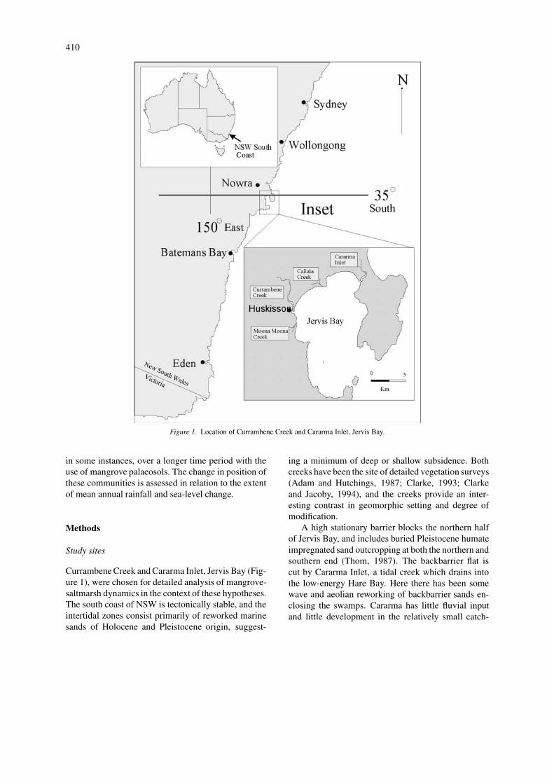
Figure 1. Location of Currambene Creek and Cararma Inlet, Jervis Bay.
in some instances, over a longer time period with theuse of mangrove palaeosols. The change in position ofthese communities is assessed in relation to the extentof mean annual rainfall and sea-level change.
Methods
Study sites
Currambene Creek and Cararma Inlet, Jervis Bay (Fig-ure 1), were chosen for detailed analysis of mangrove-saltmarsh dynamics in the context of these hypotheses.The south coast of NSW is tectonically stable, and theintertidal zones consist primarily of reworked marinesands of Holocene and Pleistocene origin, suggest-
ing a minimum of deep or shallow subsidence. Bothcreeks have been the site of detailed vegetation surveys(Adam and Hutchings, 1987; Clarke, 1993; Clarkeand Jacoby, 1994), and the creeks provide an inter-esting contrast in geomorphic setting and degree ofmodification.
A high stationary barrier blocks the northern halfof Jervis Bay, and includes buried Pleistocene humateimpregnated sand outcropping at both the northern andsouthern end (Thom, 1987). The backbarrier flat iscut by Cararma Inlet, a tidal creek which drains intothe low-energy Hare Bay. Here there has been somewave and aeolian reworking of backbarrier sands en-closing the swamps. Cararma has little fluvial inputand little development in the relatively small catch-

411
ment area. However, the saltmarsh plain is extensive,and relatively undisturbed.
By contrast, Currambene Creek has a relativelylarge catchment draining agricultural and urban land,and the saltmarsh environments have been grazed inthe past. The town of Huskisson is situated at themouth of the creek, and the creek is a popular site forboating. There is evidence of Pleistocene inner barriersands occurring in a small area 0.5 km west of themouth of Currambene Creek (Paterson, 1975; Thom,1987). The mangrove and saltmarsh environments ofCurrambene occur on both flooded Pleistocene andprograded Holocene material.
Stratigraphic analysis
Longer-term changes in the extent of mangroves canbe gauged through stratigraphic analysis of upper-intertidal soils (Mitchell and Adam, 1989b; Saintilanand Hashimoto, 1999). The occurrence of fossil man-grove root systems beneath the saltmarsh plain is anindication of a vegetation succession from mangroveto saltmarsh with fluvial and/or marine accretion ofthe intertidal flat. Such data can place historic observa-tions of mangrove-saltmarsh dynamics in the contextof changes over centuries and millennia (Saintilan andHashimoto, 1999).
A hand auger was used to retrieve cores from thesaltmarsh plain along two transects extending fromthe mangrove-saltmarsh boundary to the saltmarsh-Casuarina boundary in Cararma Inlet and CurrambeneCreek (Figures 2, 3).
In both transects preserved root material of thegrey mangrove, Avicennia marina was retrieved from0.2–0.5 metres below the contemporary saltmarsh sur-face. At Cararma Inlet, a dense layer of estuarineshells was found at approximately 0.7 metres beneaththe upper intertidal saltmarsh plain.
Shells were washed and submitted to acid etchbefore standard radiometric dating. Sands containingpreserved mangrove roots were excavated, and rootsretrieved individually from the mud matrix. Rootswere then given an acid/alkali/acid pre-treatment be-fore undergoing standard radiometric dating. Themeasured age of shell and root material was convertedinto the conventional C14 age after applying 13C/12Ccorrections.
Photogrammetry
Photogrammetric analysis in this survey was under-taken using the Wild Aviolyt AC3 stereo plotter. This
instrument produces high resolution digital spatialdata from stereo pairs of aerial photograph diaposit-ives (Hanslow et al., 1997). The stereo plotter hasthe advantage of rectifying distortion in photo scaleand differences in scale between photographs, aswell as allowing high resolution magnification of im-ages, assisting in interpretation. Ground control wasbased on Integrated Survey Grid (ISG) control pointsprovided by the NSW Lands Department. Data outputwas downloaded to a CADD system for analysis andpresentation.
Photographic runs of Currambene Creek used inthe photogrammetry were Jervis Bay Run 1, 1949;Jervis Bay Run 1, 1961; Jervis Bay Run 1, 1975; 1986Huskisson/Callala Beaches 1993 and NSW4126 for1997. Photographic runs of Cararma Inlet were Jer-vis Bay-Nowra Run C 1948; Jervis Bay Run 1, 1961;NSW Coastal Wetlands Run 60 1981; and NSW4474Cabbage Tree Swamp for 1999.
Pure mangrove habitat was defined as mangrovewith less than 10 m canopy gaps. A mixed or eco-tone category was identified as areas of mangrove andsaltmarsh where the gap between mangrove canopywas between 10 and 20 metres. Saltmarsh was definedas vegetated intertidal areas with a greater than 20 mcanopy gap between mangroves, though Casuarinaand Melaleuca were identified as separate categories.Only mangrove and saltmarsh areas common to allphotographs were included in the analysis.
Topographic analysis
The method for measuring inundation frequency inintertidal environments is a modification of that de-scribed in English et al. (1997). Rods marked withwater-soluble dye were inserted along transects placedat equal intervals across the intertidal plain before anight Spring tide. A total of 120 rods were used in eachof Cararma Inlet and Currambene Creek for this pur-pose. The tide acts as a level, the depth of inundationat each pole was recorded. The species composition ofthe surrounding vegetation was recorded for each rodposition, providing a basis for the description of theelevation at which each species was observed.

412
Figure 2. Location of study areas and stratigraphic cores.

413
Figure 3. Stratigraphic profile within Cararma Creek, Jervis Bay, from the creek edge ‘A’ to the landward edge of the saltmarsh ‘B’ as inFigure 2.
Results
Stratigraphic analysis and C14 dating
Mangrove roots found beneath Juncus saltmarsh in theCurrambene saltmarsh core dated to 1320 ± 70 C14yrs BP. Shell deposited at the base of the intertidal unitin Cararma Inlet dated to 3200 ± 60 C14 yrs BP, andthe mangrove roots within the same Cararma Inlet coredated to 1920 ± 90 C14 yrs BP.
Changes in the area of mangroves and saltmarshes
The areal extent of ‘pure’ saltmarsh in the CurrambeneCreek study area declined from 48 hectares in 1949 to27.2 hectares in 1993 (Figure 4). Further, the area ofmixed mangrove and saltmarsh habitat declined from26.7 hectares in 1949 to 12 hectares in 1993. Overallthe habitat of saltmarsh declined by 52.5% from 74.7hectares in 1949 to 39.2 hectares in 1993.
Areas of pure mangrove habitat increased from34.1 hectares to 44.9 hectares in 1993. Since 1975in particular, the area of pure mangrove habitat hasexpanded substantially at the expense of the mixedmangrove and saltmarsh habitat.
The area of saltmarsh in Cararma Inlet has declinedby 35% from 176.5 hectares in 1949 to 114.2 hectaresin 1999. The trend is that of a steady decline with little
sign of attenuation (Figures 5 and 6). In contrast toCurrambene Creek, the mangrove-saltmarsh boundaryin Cararma Inlet has been relatively stable, with littleoverall increase in the area of mangrove. Most salt-marsh loss has been due to the expansion of terrestrialspecies at the landward edge of the saltmarsh (Casuar-ina, Melaleuca, Eucalyptus and miscellaneous) whichincreased in area from a combined 80 hectares in 1961to 128 hectares in 1999.
Tidal inundation
The longest period of sea-level data for the region isFort Denison, Sydney Harbour, 150 km to the north.Five-year running means of sea-level for this dataset (Figure 7) indicate sea-levels approximately 4 cmhigher for the period 1950–2000 compared to the firsthalf of the century. This provides a benchmark againstwhich changes in the vertical position of mangrovesin the intertidal zone may be gauged. Topographicmaps were generated on the basis of flooding depthsmeasured using marker poles (Figure 8).
Single factor analysis of variance was performedwith a post hoc Student-Newman-Kuels test to determ-ine the elevational associations of species encounteredin the elevation survey. At Cararma Inlet, where thesaltmarsh plain was widest, Avicennia marina wasconsistently found in the lowest elevation, forming

414
Figure 4. The distribution of intertidal wetland communities, Currambene Creek, 1949 and 1993.
an association with Samolus repens at its landwardedge. Sporobolus virginicus forms a group at inter-mediate elevation. Halosarcia pergranulata, Sarco-cornia quinqueflora and Gahnia filum form an uppersaltmarsh association, with Juncus kraussii and Casu-arina glauca occurring at a level rarely inundated bySpring tides.
Within Currambene Creek the elevation of thespecies was less distinct. Avicennia marina, Sam-olus repens, Sporobolus virginicus and Sarcocorniaquinqueflora could not be statistically differentiatedon the basis of elevation. Only Juncus kraussii and
Casuarina glauca occurred at significantly higher el-evations.
The elevation at which Juncus kraussii and Sarco-cornia quinqueflora were found growing in Curram-bene Creek with respect to tidal inundation was lowerthan that at Cararma Inlet. Samolus repens, Sporo-bolus virginicus and Avicennia marina grew at com-parable elevations within the two creeks with respectto tidal inundation.

415
Figure 5. The distribution of intertidal wetland communities, Cararma Inlet. 1949 and 1993.
Discussion
Reconstruction of vegetation history in Cararma Inletand Currambene Creek
At circa 3000 BP Cararma Inlet appears to havebeen a shallow estuarine lake sheltered behind a com-plex Pleistocene-Holocene barrier. The lake must havebeen highly productive source of shellfish, gaugingfrom the thick, dense deposits of intact estuarine bi-valves which have been located at 0.7 m below at leastten hectares of the upper saltmarsh surface.
Tidal reworking of aeolian and wash-over depositshas gradually infilled the lake, creating an intertidalwetland, dominated circa 2000 BP by mangroves.Continued accretion has seen the gradual replacementof mangroves with saltmarsh, so that mangroves nowform a fringe to the tidal creek, and the inlet is domin-ated by one of the most extensive saltmarsh plains onthe south coast of New South Wales. Rates of verticalaccretion over the previous 2000 years have averagedapproximately 0.5–0.8 mm per year.
Currambene Creek has a more complex history,given the greater extent of probable Pleistocene mater-ial and the involvement of both fluvial and tidal sedi-

416
Figure 6. Changes in the area of intertidal wetland communities, Currambene Creek and Cararma Inlet between 1949 and 1999.
Figure 7. Sea-level trends at Fort Denison, 1915–1998.
mentation through the latter Holocene. On the mainintertidal flat immediately upstream of Huskisson,there is no stratigraphic evidence of prior occupationof the upper intertidal flat by mangroves, nor is thereevidence of the marine bivalves so prominent in theprofile at Cararma Inlet. However, mangrove rootswere found beneath the Juncus plain 2 kilometres up-stream, suggesting that some, though not all, of thecurrent point bars have accreted in the previous twothousand years, and a succession from mangrove tosaltmarsh has occurred. The C14 age of this man-
grove material suggests a rate of accretion slightlymore rapid than that found at Cararma Inlet, of approx-imately 1 mm per year. These results are comparableto rates of accretion established using the same tech-nique in the Hawkesbury River estuary (Saintilan andHashimoto, 1999).
The more sporadic occurrence of mangrovepalaeo-material in the intertidal plains of CurrambeneCreek may reflect the more important contribution ofchannel meandering and horizontal accretion in thecreation of point bars. Cut-off meanders are obvious

417
Figure 8. Elevation of selected intertidal environments in Currambene Creek and Cararma Inlet.

418
Figure 9. Rainfall for Point Perpendicular, Jervis Bay; 1889–1998. Data from the Bureau of Meteorology.
in the upper tidal reaches, and some are currently oc-cupied by relict mangroves. With continued accretionthese will presumably be replaced by saltmarsh.
Recent changes in the distribution of mangroves andsaltmarsh
Mangrove has increased in area in Currambene Creekat the expense of saltmarsh. The distance over whichmangrove transgression has occurred on the largestintertidal flat in Currambene Creek in some placesexceeds 700 metres. The loss of saltmarsh to man-grove incursion in Currambene Creek is of similarmagnitude to that described in many NSW estuaries(Saintilan and Williams, 1999).
The mangrove-saltmarsh boundary in Cararma In-let has been more stable. Within this system a consid-erable proportion of saltmarsh loss has been due to theencroachment of Casuarina and Melaleuca onto thesaltmarsh plain. The seaward encroachment of Casu-arina onto the saltmarsh plain has also been describedfor the nearby Minamurra estuary by Chafer (1998),and suggests an alteration in the hydrology of the up-per intertidal plain unrelated to fluctuations in the tidalprism.
Inferences regarding sea-level rise and mangrovetransgression
Within Currambene Creek, the vertical range trans-gressed by mangroves in the photographic period(1949–1993) far exceeds the degree of regional sea-level rise. Judging by the position of the mangrove-saltmarsh boundary in Currambene Creek in 1949, theposition of the boundary in 1993, and the difference
in inundation depth between poles at both locations,mangroves have extended their vertical range in someplaces within Currambene Creek by up to 30 cm.This is likely to be a conservative estimate in that in-undation frequency, and hence vertical accretion, ishigher in lower elevation environments (Stoddart etal., 1989).
At both Currambene Creek and Cararma Inlet theelevation at which saltmarsh replaces mangrove is ap-proximately the position of the mean highest diurnaltide. The implication is that mangroves in CurrambeneCreek have moved to the position with respect to tidalinundation that they have been consistently occupyingin Cararma Inlet. The result is consistent with the sup-position that biotic and/or physio-chemical factors hadexcluded mangroves from sections of the Currambeneintertidal flat in the first half of the century.
A further factor telling against a simple translationof vegetation communities in response to sea-level riseis the stability of the saltmarsh-terrestrial boundary.The only instances of Casuarina dieback in Curram-bene Creek are clearly fire-related, and in CararmaInlet the terrestrial species are advancing onto thesaltmarsh plain.
Inferences regarding rainfall, nutrients and mangroveencroachment
Higher rainfall in the second half of the century hasbeen a regional trend for southeastern Australia (Hen-nesey et al., 1999), and rainfall patterns at PointPerpendicular, Jervis Bay, follow this trend (Figure 9).Mean annual rainfall for the period 1899–1949 was1150 mm/yr., compared to 1360 mm/yr for the period

419
1950–1998. A landward encroachment of mangroveswith increased rainfall is consistent with the observa-tion of Saenger (1995) that the relative proportion ofmangroves and saltmarsh within Australian estuariesis significantly related to average annual precipitation.
The encroachment of both mangrove and terrestrialglycophytes onto the saltmarsh plain would be consist-ent with the freshening of the intertidal environmentwhich would result from increased precipitation. How-ever, rainfall is also an important source of nitrogen.Nitrogen has been found to be limiting to mangrovegrowth (Boto and Wellington, 1983). Decreased saltmarsh may be due to increased rainfall both fresheningthe intestinal environment and contributing nitrogen.
Increases in nutrient levels within estuaries fol-lowing urbanisation is well established for the region(Zann, 1995), as is the proportion of rainfall reachingthe estuary from urbanised catchments. This study hasshown a contrast between the high degree of mangroveincursion in Currambene Creek, with a highly mod-ified catchment, and the stable mangrove/saltmarshboundary in Cararma Inlet, with an unmodified catch-ment. This trend is consistent with that emerging froma review of twenty-eight photogrammetric surveys(Saintilan and Williams, 2000), which showed thehighest level of mangrove incursion to be in modified,and in particular urbanised catchments. The sugges-tion by Wilton (2000) that the degree of mangroveincursion may be related to the degree of urbanisationwarrants an examination of the potential role of nu-trient and sediment inputs in urbanised catchments inaltering the balance between mangrove and saltmarsh.
Acknowledgements
This research was jointly funded by the Lower Shoal-haven Catchment Management Committee, the NSWDepartment of Land and Water Conservation, andAustralian Catholic University through the InternalResearch Grants Scheme. The Macintosh Centre forQuaternary Dating (University of Sydney) conductedthe radiocarbon analysis. The photogrammetric surveywas conducted with the assistance of Christine Gray(Department of Land and Water Conservation). PeterClarke is thanked for helpful clarification of the aimsand insights of the CSIRO monitoring program.
References
Adam, P. and Hutchings, P. 1987. The saltmarshes and mangrovesof Jervis Bay. Wetlands (Australia) 6(2): 58–64.
Boto, K.G. and Wellington J.T. 1983. Phosphorus and nitrogen nu-tritional status of a northorn Australian mangrove forest. MarineEcology Progress Series 11: 63–69.
Chafer C.J. 1998. A spatio-temporal analysis of estuarine vegeta-tion change in the Minnamurra River 1938–1997. MinnamurraEstuary Management Committee.
Clarke, P.J. 1993. Mangroves, saltmarsh and peripheral vegetationof Jervis Bay. Cunninghamia 3(1): 231–254.
Clarke, P.J. and Jacoby, C.A. 1994. Baseline studies of saltmarshplants in south-eastern Australia: biomass and productivity. Aus-tralian Journal of Freshwater and Marine Research 45: 1521–28.
CSIRO, 1994. Jervis Bay Baseline Studies, Final Report, May 1994.CSIRO Division of Fisheries, Marmion Research Laboratories.
English, S., Wilkinson, C. and Baker, V. 1997. Survey Manual forTropical Marine Resources. (2nd edition) Australian Institute ofMarine Science, Townsville.
Hanslow, D.J., Clout, B., Evans, P. and Coates, B. 1997. Mon-itoring Coastal Change Using Photogrammetry. In: Bliss E.(ed.) Islands: Economy, Society and Environment. ConferenceProceedings, Second Joint Conference, Institute of AustralianGeographers and New Zealand Geographical Society, Universityof Tasmania.
Hennessy, K.J., Suppiah, R. and Page, C.M. 1999. Australian Rain-fall Changes 1910–1995. Australian Meteorological Magazine48: 1–13.
McTainsh G., Iles B. and Saffigna P. 1988. Spatial and temporal pat-terns of mangroves at Oyster Point Bay, south east Queensland,1944–83. Proc. R. Soc. Qld. 99: 83–91.
Mitchell, M.L. and Adam, P. 1989a. The decline of saltmarsh inBotany Bay. Wetlands (Australia) 8: 55–60.
Mitchell, M.L. and Adam, P. 1989b. The relationship betweenmangrove and saltmarsh communities in the Sydney Region.Wetlands (Australia) 8: 37–46.
Paterson I.B.L. 1975. The Geology and low-cost extractive re-sources of the Nowra-Jervis Bay area. Geological Survey ofNSW Report GS 1974/208.
Saenger P. 1995. The status of Australian estuaries and enclosedmarine waters. In: Zann, L. and Kailola P. (eds.), State of theMarine Environment Report for Australia: Technical Annex 1,The Marine Environment. GBRMPA/Ocean Rescue 2000, pp.53–73.
Saintilan, N. and Hashimoto, T.K. 1999. Mangrove-saltmarsh dy-namics on a prograding bayhead delta, Hawkesbury River, NewSouth Wales, Australia. Hydrobiologia 413: 95–102.
Saintilan, N. and Williams, R.J. 1999. Mangrove transgression intosaltmarsh environments in southeast Australia. Global Ecologyand Biogeography 8: 117–124.
Saintilan N. and Williams R.J., 2000. Short note: the decline ofsaltmarsh in southeastern Australia: results of recent surveys.Wetlands (Australia) 18(2): 49–54.
Stoddart D.R., Reed D.J. and French J.R. 1989. Understanding salt-marsh accretion, Scolt Head Island, Norfolk, England. Estuaries:228–236.
Thom, B.G. 1987. Geomorphology of the Jervis Bay area. Wetlands(Australia) 6(2): 19–21.
Williams R.J., Watford F.A. and Balashov V. 1999. Kooragang Wet-land Rehabilitation Project: Changes in wetland fish habitats ofthe lower Hunter River. NSW Fisheries Office of Conservation,Fisheries Research Institute, Cronulla, NSW.

420
Wilton K. 2000. Changes in the distribution of mangroves andsaltmarshes in Careel Bay, Pitwater. Wetlands (Australia) inpress.
Zann L.P. 1997. Our Sea, Our Future. Major findings of the Stateof the Marine Evironment Report for Australia. Ocean Res-cue 2000, Department of Environment, Sport and Territories,Canberra.