Embed Size (px)
Citation preview

www.gfz-potsdam.de
GFZ Section 2.3
CHAMP: Overview of Final ME Products and Format Description
Scientific Technical Report STR19/10 – Data

Recommended citation:
GFZ Section 2.3 (2019): CHAMP: Overview of Final ME Products and Format Description, (Scientific Technical Report STR - Data; 19/10), Potsdam: GFZ German Research Centre for Geosciences. DOI: https://doi.org/10.2312/GFZ.b103-19104
The data described in this report are published as:
Rother, Martin; Michaelis, Ingo (2019): CH-ME-3-MAG - CHAMP 1 Hz Combined Magnetic Field Time Series (Level 3), Potsdam: GFZ Data Services.DOI: https://doi.org/10.5880/GFZ.2.3.2019.004
Rother, Martin; Michaelis, Ingo (2019): CH-ME-3-ASC-BOOM - CHAMP 1 Hz Satellite Attitude Time Series in Quaternion Format (Level 3), Potsdam: GFZ Data Services.DOI: https://doi.org/10.5880/GFZ.2.3.2019.005
Rother, Martin; Michaelis, Ingo (2019): CH-ME-2-FGM-SCI - CHAMP 50 Hz Magnetic Field Vector Time Series in Sensor- and ECEF-(NEC)-System (Level 2), Potsdam: GFZ Data Services.DOI: https://doi.org/10.5880/GFZ.2.3.2019.006
Rother, Martin; Michaelis, Ingo (2019): CH-ME-2-PLPT - CHAMP Electron Density and Temperature Time Series in Low Time Resolution (Level 2), Potsdam: GFZ Data Services. DOI: https://doi.org/10.5880/GFZ.2.3.2019.007
Imprint
Telegrafenberg D-14473 Potsdam
Published in Potsdam, Germany November 2019
ISSN 2190-7110
DOI: https://doi.org/10.2312/GFZ.b103-19104 URN: urn:nbn:de:kobv:b103-19104
This work is published in the GFZ series Scientific Technical Report (STR)
and electronically available at GFZ website www.gfz-potsdam.de

CHAMP:
Overview of
Final ME Products
and
Format Description
GFZ Section 2.3
November 11, 2019
Contents
1. Introduction 3
1.1. Document structure . . . . . . . . . . . . . . . . . . . . . . . . . . . . . . . . . . . 31.2. Acronyms and miscellaneous definitions . . . . . . . . . . . . . . . . . . . . . . . . 31.3. Times, Positions and Systems . . . . . . . . . . . . . . . . . . . . . . . . . . . . . . 3
2. CHAMP 4
2.1. Instrumentation . . . . . . . . . . . . . . . . . . . . . . . . . . . . . . . . . . . . . . 42.2. Data . . . . . . . . . . . . . . . . . . . . . . . . . . . . . . . . . . . . . . . . . . . . 6
3. Formats and Directory Layout 7
3.1. CDF Files . . . . . . . . . . . . . . . . . . . . . . . . . . . . . . . . . . . . . . . . . . 73.2. ASCII Listings . . . . . . . . . . . . . . . . . . . . . . . . . . . . . . . . . . . . . . 73.3. Directory Layout . . . . . . . . . . . . . . . . . . . . . . . . . . . . . . . . . . . . . 8
4. Further Documentation and References 8
4.1. References . . . . . . . . . . . . . . . . . . . . . . . . . . . . . . . . . . . . . . . . . 84.2. Technical Format Descriptions . . . . . . . . . . . . . . . . . . . . . . . . . . . . . 9
Appendix A. More Detailed Descriptions 10
A.1. Level 3 Final Magnetic Field Time Series . . . . . . . . . . . . . . . . . . . . . . . 10A.1.1. Name identifier . . . . . . . . . . . . . . . . . . . . . . . . . . . . . . . . . . 10A.1.2. Description . . . . . . . . . . . . . . . . . . . . . . . . . . . . . . . . . . . . 10A.1.3. CDF Skeleton . . . . . . . . . . . . . . . . . . . . . . . . . . . . . . . . . . . 18
A.2. Attitude information from the star cameras on the boom . . . . . . . . . . . . . . . 27A.2.1. Name Identifier . . . . . . . . . . . . . . . . . . . . . . . . . . . . . . . . . . 27A.2.2. Description . . . . . . . . . . . . . . . . . . . . . . . . . . . . . . . . . . . . 27
A.3. Vector magnetic data with high time resolution . . . . . . . . . . . . . . . . . . . . 34A.3.1. Name identifier . . . . . . . . . . . . . . . . . . . . . . . . . . . . . . . . . . 34A.3.2. Tabulated overviews . . . . . . . . . . . . . . . . . . . . . . . . . . . . . . . 34A.3.3. CDF Skeleton . . . . . . . . . . . . . . . . . . . . . . . . . . . . . . . . . . . 35
1STR 19/10. GFZ German Research Centre for Geosciences. DOI: 10.2312/GFZ.b103-19104

Contents
A.4. Electron density and temperatures . . . . . . . . . . . . . . . . . . . . . . . . . . . 45A.4.1. Name identifier . . . . . . . . . . . . . . . . . . . . . . . . . . . . . . . . . . 45A.4.2. Description . . . . . . . . . . . . . . . . . . . . . . . . . . . . . . . . . . . . 45
2STR 19/10. GFZ German Research Centre for Geosciences. DOI: 10.2312/GFZ.b103-19104
1. Introduction
This text describes the content of the data files with the final public magnetic field time series de-rived from measurements by the satellite CHAMP from 2000 until 2010 – or of important associateddata.
1.1. Document structure
1. After this intro follows a brief general description of the CHAMP satellite mission, the rele-vant instrumentation and the type of data gathered. The four products described here arederivatives of only a small subset of the CHAMP data, connected to magnetic and electric fieldtime series.
2. For the products in the focus of this document, the data types, the used file formats and thedirectory structure of the public data are outlined.
3. The third and final part of this document is an appendix, where some older, canonicaldocuments are collected. These texts and tables partly served as data descriptions or READMEsalready during the mission phase of CHAMP or were accompanied with delivered data sets.These documents are presented here in the appendix, so far as there are still applicable,mostly unchanged. The technical description of the final Level-3 1 Hz magnetic field productis more detailed than the ones for the other products.
1.2. Acronyms and miscellaneous definitions
Name Description
CHAMP CHAllenging Minisatellite PayloadFGM Instrumentation on CHAMP : FluxGate MagnetometerISDC Information System and Data Center, GFZME Magnetic/Electric Field(s)NEC Earth Centered Earth Fixed reference frame, North-East-CentreOVM Instrumentation on CHAMP , Overhauser magnetometerPLP Instrumentation on CHAMP , Planar Langmuir ProbeASC Advanced Stellar CompassPLPT Name-id of a data set using Planar Langmuir
Probe data, but with Temperatures includedSCI SCIence dataCDF Common Data Format, by NASA, see https://cdf.gsfc.nasa.gov/MJD Modified Julian Day, a floating point number
number used at least for the CHAMP and Swarmsatellite missions
ISDC Information System and Data Center,GFZ, Global Earth Science Data
Table1: List of acronyms
1.3. Times, Positions and Systems
• MJD (Modified Julian Day) is a time representation used in several ESA and other satellitemissions. It can be taken as the time distance to the beginning of the year 2000.0 in floatingpoint days. Unlike the standard JD (Julian Date) day counter, this MJD day is starting atmidnight. See in the Swarm Documentation SW-HB-DTU-GS-0001, Section 3.3, Standardsand Conventions.
3STR 19/10. GFZ German Research Centre for Geosciences. DOI: 10.2312/GFZ.b103-19104

2. CHAMP
• Epoch: Internal standard time representation for the CDF format used for the time seriesin CHAMP CDF files. It has a precision down to milliseconds, which is sufficient for the MEproducts. CDF-internally it is stored as the milliseconds passed since a given epoch.
• Positions: The positions, if given in the products, i.e. radius (or altitude), longitude andlatitude, are given in a mere spherical, geocentric coordinate system, not in a geodetic one.Subsequently the reference level for altitude is not an ellipsoid or such, but just a referencesphere with the (in geomagnetic context) common radius of 6371.2 km. The latitude andlongitude are angles in floating point degrees, radius and altitude are given in km.
• Coordinate Systems: There is a distinction between two flavours of reference systems:
1. The physical coordinate systems, like the celestial frame (Conventional Celestial Refer-ence System, CRS, i.e. J2000) or the Conventional Terrestrial Reference Systems (TRS)or the derived local systems like the North-East-Center system in a TRS system.
2. The more technical, arbitrary satellite related coordinate systems, like a common satel-lite body-fixed system, or a synthetic system created for the optical bench using andcombining the ASC attitude signals, or the individual reference frames of the measuringsensors (i.e. the FGM sensor), if applicable. This sensor systems are usually importantfor the instrument specific in-flight calibration of the readings. See the designations inthe description of the Variables for the Level 3 Mag product for example.
2. CHAMP
CHAMP (CHAllenging Minisatellite Payload) was a German small satellite mission for geoscientificand atmospheric research and applications, managed by GFZ . With its highly precise, multi-functional and complementary payload elements (magnetometer, accelerometer, star sensor, GPSreceiver, laser retro reflector, ion drift meter) and its orbit characteristics (near polar, low alti-tude, long duration) CHAMP generated highly precise gravity and magnetic field measurementssimultaneously for the first time and over a 10 years period. The measurements include boththe spatial and temporal variations of the two fields. The CHAMP mission has opened a new erain geopotential research and has become a significant contributor to the International Decade ofGeopotential Research. With the satellite CHAMP launched by a Russian COSMOS launch vehicle onJuly 15, 2000 and an initial altitude of 454 km, the mission ended on September 19 2010, afterten years, two month and four days, or after 58277 orbits.1
For further information please see the CHAMP website at GFZ (https://www.gfz-potsdam.de/champ/)and the technical references and technical documentations indicated in sections 4.1 and 4.2.
2.1. Instrumentation
CHAMP products are categorised by the area of interest (here ME, magnetic and electric fields).In focus are data like FGM and MAG for magnetic field readings, ASC for related and used attitudeinformation from the star camera on the boom and PLP data from the Planar Langmuir Probe,here named as PLPT, because processed electron temperature data are merged in (see Rother et al.,2010). The instruments dedicated for orbit determination and analyses of gravitational potentialare not mentioned further.
1Mostly cited from the old CHAMP website.
4STR 19/10. GFZ German Research Centre for Geosciences. DOI: 10.2312/GFZ.b103-19104

2.1. Instrumentation
The most significant data sources for the products described are:
Overhauser Magnetometer OVM: Scalar magnetometer installed at the tip of the CHAMP boom(Figure 1). The available sampling rate is 1 Hz, the time coverage of the data is expected tobe nearly perfect. As an instrument to measure the absolute intensity of the magnetic field(without instrument specific or temperature dependencies) it is needed in particular for thein-flight calibration of the vector magnetic field instruments.
Star Sensors ASC: Two pairs of advanced star sensors, one pair inserted on top of the body,the other pair mounted on an optical bench at CHAMP ’s boom (Figure 1). The pairing ofthe sensors is intended to supply redundancy against dazzling by the sun or the moon. Thequality of the available attitude information is best in periods, where both sensors of a pairare not blinded and delivering mergeable attitude information. The nominal sampling rateis 1 Hz.
Fluxgate Magnetometer FGM: Two vector magnetometer mounted together with the ASC sen-sors on the optical bench of the boom (Figure 1). The FGM sensor is able to gather magneticfield vectors by a much higher frequency than the scalar magnetometer OVM or the ASCinstrument. The internal maximal sampling rate was 50 Hz. For in-flight calibration and inscientific standard products 1 Hz averages were used.
Planar Langmuir Probe (PLP): The Langmuir Probe, mounted at the front of the CHAMP satelliteon the Digital Ion Drift (DIDM) Meter (Figure 1), is heading in nominal flight direction and isable to measure satellite potential, the electron density of the environment and the electrontemperature. The period between usable readings is expected to be 15 s.
5STR 19/10. GFZ German Research Centre for Geosciences. DOI: 10.2312/GFZ.b103-19104

2. CHAMP
2.2. Data
There is a distinction between magnetic field readings and related formats on one hand and theones for star camera data (ASC) and data from the Planar Langmuir Probe (PLP) on the other.The Level 3 data are intended be finally corrected data, focusing on the internal consistency.Level 2 data are calibrated and corrected time series as well, but more limited on one dedicatedinstrument.
Product Identifier Level Source Comment
CH-ME-3-MAG 3 FGM, OVM, ASC Combined magnetic field time seriesCH-ME-3-ASC-BOOM 3 ASC Processed, cleaned quaternions describing the
satellite attitudeCH-ME-2-FGM-SCI 2 FGM, ASC Vector magnetic field in NEC and sensor FGM-
system in unaveraged 50 Hz time resolutionCH-ME-2-PLPT 2 PLP Electron Density and Temperature
Table 2: Product overview.
The ASC (CH-ME-3-ASC-BOOM) and PLP (CH-ME-2-PLPT) data product are ASCII files, while themagnetic field readings are in a binary format (CDF), a usual distribution format for magneticfield readings from LEO satellite missions. The reading efficiency, flexibility and the possibility toembed all information and data attributes may be paid by some programming overhead required.Several data processing environments like Python, Matlab or IDL provide tools for accessing CDF-files.
During and after the CHAMP mission various versions of the time series (ASC and magnetic field)were produced and used in the scientific community, in particular of the 1 Hz magnetic fieldreadings. These were accessible via the ISDC (Information System and Data Center), a dedicateddata portal at GFZ. The ISDC was transferred from the old system to a combination of anFTP-server (data access) with front-end (https://isdc.gfz-potsdam.de/). The public datasets accessible via the new ISDC, as described in this document, in particular CH-ME-3-MAG, areintended to supersede all former versions. The old ISDC-server with the previous versions will notbe longer available.
In this document we describe Level 2 and 3 data products indicated in Table 2: these levelsdenominate different stages of calibration, finalisation and averaging/merging. In particular theMAG Level 3 product CH ME 3 MAG is the time series data product for the magnetic field readingsand intended to be the fully and final corrected ME data set in 1 Hz time resolution to be used bymost of the scientific community.
In particular for external field studies, 50 Hz magnetic field readings are available as FGM-SCI Level2 files. In this product, all floating values values are given as DOUBLE to have a homogeneous datarepresentation. Subsequently the size of a single, daily FGM-SCI 50 Hz file is of about 300MByte.
6 STR 19/10. GFZ German Research Centre for Geosciences. DOI: 10.2312/GFZ.b103-19104

3. Formats and Directory Layout
The fact of the disparate formats of the data is mainly caused by historical decisions and customs.
This document, in particular the parts in the appendix, is a collection of existing descriptions,which may had accompanied the data for quite a while. For the products in CDF format, theCDF skeleton representations, a technical, but exhaustive CDF related description of the productsinternal structure, are given as well. (See Sections A.3.3 and A.1.3.)
3.1. CDF Files
The specific format of the files for the magnetic field readings may not need any descriptionhere, as these files are in CDF (Common Data Format) and are intended to be self-describing.CDF is a binary format with a set of library functions for efficient access. As maintained byNASA, CDF is used in the solar, satellite, space physics and astronomical community. Usersare referred to the CDF homepage http://cdf.gsfc.nasa.gov/ and particularly the FAQ athttp://cdf.gsfc.nasa.gov/html/FAQ.html for more information on the format.
For accessing the CHAMP CDF data, a working CDF installation is required. The software is knownto be compatible with all relevant platforms. An installed CDF package offers a set of ready-to-usetool-kits, which allow browsing inside the CDF files as well as an interactive extraction of selecteddata and even limited modification. Accessing the CDF library functions directly in the user’s ownprograms will grant the highest efficiency and flexibility. Some common interpreter languages suchas Matlab, Python and IDL also support access to CDF files with easy-to-use interfaces. From thebeginning the CHAMP data were created with the older CDF version 2.6.7, as it was intended touse the same CDF library version for all CHAMP ME data. Newer versions of the CDF library claimto be backward compatible to earlier versions, but there may be some minor quirks.
In contrast to this tradition, the Level-2 FGM-SCI-NEC have been produced with CDF version3.3.0. This Level 2 50 Hz FGM-SCI data are (loss-less) compressed internally to significantly reducethe file-size. This should be transparent for the users accessing the files directly or indirectly viaprocessing software by the CDF library, but the size-reduction is paid by an increased time requiredfor reading.
This text gives first an overview of the content of the data file types (see Appendix 4.2), in aCDF-format case followed by the CDF Skeleton, a CDF-internal, complete technical description ofthe CDF file layout.
In the CH-ME-FGM-SCI case only a short tabulated overview is given; the valid format descriptionis the CDF skeleton text!
Pleas keep in mind: For the uncompressing of the data during access with the CDF library functionsyou may need writing access on the data file location or your working directory.
3.2. ASCII Listings
The (old but still valid) description of the ASCII file type CH-ME-3-ASC-BOOM is provided inAppendix reproduced in the appendix A.2.2. The used data format for the ASC-data is a non-standard ASCII list format without fully regular white-spaced delimited columns, but still dividedin a descriptive header and in a data record section.
The CH-ME-2-PLPT product shows simple ASCII listing layout. A hash (#)-indicated readableheader is followed by a data body. The body is a listing with regularly formatted white-spacedelimited columns.
7STR 19/10. GFZ German Research Centre for Geosciences. DOI: 10.2312/GFZ.b103-19104

4. Further Documentation and References
3.3. Directory Layout
The data sets available in the corresponding ME subdirectory on the FTP server of the new ISDCare splitted into Level-2 and Level-3 data, not by the sensors). The four products (see Table 2)are given in daily files, the files are grouped by years in accordingly named directories.
champ
|
+--- ME
|
+---Level2
| |
| +---NEC-SCI
| | |
| | +---<years>
| | |
| | +---<daily-files>
| +---PLPT
| |
| +---<years>
| |
| +---<daily-files>
+---Level3
|
+---ASC-BOOM
| |
| +---<years>
| |
| +---<daily-files>
|
+---MAG
|
+---<years>
|
+---<daily-files>
4. Further Documentation and References
4.1. References
• CHAMP Announcement of Opportunity (2001), 71 p.
http://op.gfz-potsdam.de/champ/docs CHAMP/CH-GFZ-AO-001.PDF.
• Schwintzer, P.; Luhr, H.; Reigber, C.; Grunwaldt, L.; Forste, C. (2002): CHAMP ReferenceSystems, Transformations and Standards. 7 p.
http://op.gfz-potsdam.de/champ/docs CHAMP/CH-GFZ-RS-002.PDF.
• Bock, R.; Luhr, H. (2001): CHAMP Attitude Aberration Correction. 18 p.
http://op.gfz-potsdam.de/champ/docs CHAMP/ch-gfz-tn-2702.pdf.
• Fan Yin (2010): Mathematic approaches for the calibration of the CHAMP satellite magneticfield measurements, PhD-Thesis, Universitat Potsdam.
https://nbn-resolving.org/um:nbn:de:kobv:517-opus-41201.
• Yin, F.; Luhr, H.; Rauberg, J.; Michaelis, I. and Cai, H. (2013): Characterization of CHAMP
8STR 19/10. GFZ German Research Centre for Geosciences. DOI: 10.2312/GFZ.b103-19104

4.2. Technical Format Descriptions
magnetic data anomalies: magnetic contamination and measurement timing. MeasurementScience and Technology, IOP Publishing, 24, 075005.
https://doi.org/doi:10.1088/0957-0233/24/7/075005.
• Rother, M.; Schlegel, K.; Luhr, H.; and Cooke, D. (2010): Validation of CHAMP electrontemperature measurements by incoherent scatter radar data, Radio Sci., 45, RS6020.
https://doi.org/10.1029/2010RS004445.
4.2. Technical Format Descriptions
• Forste, C. (2001): Reference to Data Formats used within the CHAMP project. 3 p.
http://op.gfz-potsdam.de/champ/docs CHAMP/CH-FORMAT-REFLINKS.pdf.
• Forste, C.; Schwintzer, P.; Reigber, C. (2002): The CHAMP Data Format. 9 p.
http://op.gfz-potsdam.de/champ/docs CHAMP/CH-GFZ-FD-001.pdf.
• Konig, R.; Schwintzer, P.; Reigber, C. (2001): The CHAMP Orbit Format CHORB. 4 p.
http://op.gfz-potsdam.de/champ/docs CHAMP/CH-GFZ-FD-002.pdf.
• Forste, C.; Schwintzer, P.; Reigber, C. (2003): CHAMP Gravity Field Solution Data For-mats. 8 p.
http://op.gfz-potsdam.de/champ/docs CHAMP/CH-GFZ-FD-003.pdf.
• Rother, M. (2001): CHAMP Fluxgate Magnetometer Data Description (CDF). 10 p.
http://op.gfz-potsdam.de/champ/docs CHAMP/CH-FGM-DATA-FORMAT.pdf.
• Rother, M. (2001): CHAMP Overhauser Magnetometer Data Description (CDF). 6 p.
http://op.gfz-potsdam.de/champ/docs CHAMP/CH-OVM-DATA-FORMAT.pdf.
• Claudia Stolle, Swarm Level 2 Processing System (2011), Swarm Level 2 Product DataHandbook, National Space Institute – DTU Space, SW-HB-DTU-GS-0001, Rev. 1A, 2011-11-30.
HTMLversion on
https://earth.esa.int/web/guest/missions/esa-eo-missions/swarm/data-handbook.
9STR 19/10. GFZ German Research Centre for Geosciences. DOI: 10.2312/GFZ.b103-19104

A. More Detailed Descriptions
A. More Detailed Descriptions
A.1. Level 3 Final Magnetic Field Time Series
A.1.1. Name identifier
The identifier of this data type in the product file name is CH-ME-3-MAG.
A.1.2. Description
The following description is included here from a plain ASCII file, which had served as a descriptionof the final MAG Level 3 product file and partly accompanied the data. It is embedded hereliterally and unchanged, with it’s own, unrelated section numbering.
Format description of CHAMP L3 MAG data files
___________________________________________________
Helmholtz Centre Potsdam
GFZ German Research Centre For Geosciences
Section 2.3, Earth’s Magnetic Field
Jan Rauberg,
Ingo Michaelis,
Martin Rother,
Hermann Luehr.
24 March 2014.
Text Version 1.03
1. INTRODUCTION
---------------
This text briefly describes the content of the data files that contain
magnetic field time series measured by the satellite CHAMP from 2000 until
2010. Described are the so-called Level 3 data files, the final data
product, and the fully corrected (and for the time being the best
available) data set.
The specific format of the files itself does not need any description here,
as the files are all in CDF (Common Data Format). This is a binary format
with a set of library functions for efficient access. Maintained by NASA,
they are used in the solar, satellite, space physics and astronomical
community. Users are referred to the CDF homepage
’http://cdf.gsfc.nasa.gov/’ and particularly the FAQ
’http://cdf.gsfc.nasa.gov/html/FAQ.html’ for general information. For
accessing the CHAMP L3 CDF data, a working CDF installation is required.
The software is known to be compatible with all relevant platforms. An
installed CDF package offers a set of ready to use toolkit programs, which
allow browsing inside the CDF files as well as an interactive extraction of
10 STR 19/10. GFZ German Research Centre for Geosciences. DOI: 10.2312/GFZ.b103-19104
A.1. Level 3 Final Magnetic Field Time Series
selected data and even limited modification. Using calls to the CDF library
functions in the user’s own programs will grant the highest efficiency and
flexibility. Some common interpreter languages such as ’Matlab’ and ’IDL’
support CDF with easy-to-use interfaces. The data are created with the
older CDF version 2.6.7, as it is intended to use the same CDF library
version for all CHAMP ME data. Newer versions of the CDF library claim to
be backward compatible to earlier versions, but there may be some minor
quirks.
Subsequently this text focuses on the semantics of labelling data columns
inside CHAMP L3, describing the data content, and providing useful hints
for users.
2. GENERAL OUTLINE
------------------
The CHAMP L3 data files hold:
* time series of the measured and corrected vector magnetic field
-- in local Cartesian North-East-Center coordinates,
-- in coordinates of the FGM sensor system,
-- a scalar magnetic field value,
-- a time stamp in native format supported by CDF ,
-- the position in geocentric coordinates,
-- the quaternion vector from the star camera which was used for the
rotation of the measured vector into the NEC system
-- a set of flags dedicated to give information about the status and
quality of the corresponding data.
See detailed description of the named variables below.
* as common for CDF files, global attributes and variable-attached
attributes only described in limited detail.
Each of the CHAMP L3 data files are named following the convention
’CH-ME-3-MAG+YYYY-MM-DD.cdf’,
* where ’YYYY’ is the integer year with four digits,
* ’MM’ the month of the year as integer of two digits, with a leading
zero if necessary,
* ’DD’ the day of the month as integer in two digits, with a leading
zero if necessary.
There is no version number, but history information is available as a
11STR 19/10. GFZ German Research Centre for Geosciences. DOI: 10.2312/GFZ.b103-19104

A. More Detailed Descriptions
dedicated ’global attribute’ inside each CDF file. There is exactly one
file for each day in this L3 version and there is no data overlap to
neighbouring days. The time, formatted in the native format supported by
CDF, is UTC. The precision in time is one millisecond. In case of an
additional leap-second, data belonging to this additional second are
dropped entirely.
3. DESCRIPTION OF VARIABLES
----------------------------
3.1 IN BRIEF
A good CDF product file claims to be self-describing by embedded
information inside each CDF file, which is a generic feature of the CDF.
An overview and additional comments on the content follow. We start with a
short list of the variables available. Variables can be divided further
into two categories: the data variables like time, position, or
corrected/processed magnetic field measurements and some descriptive flags,
holding status and quality information on variables.
Variable Brief Description Type CDF-dim
--------------------------------------------------------------------------
EPOCH CDF epoch, time stamp of record epoch 0
GEO_LAT geocentric latitude real8 0
GEO_LON geocentric longitude real8 0
GEO_ALT geocentric altitude (above 6371.2) real8 0
GEO_STAT status information returned during int4 1[3]
interpolating RSO or PDO position data
FGM_VEC vector data in FGM coordinate system, real4 1[3]
FGM_SCAL scalar data based on both, OVM and FGM data real4 0
This is of higher quality than |FGM|
FGM_FLAGS flags for FGM as heritage directly from byte 1[2]
Level 1 or gained during processing Level 3
NEC_VEC vector data in NEC coordinate system real4 1[3]
ASC_QUAT quaternion vector of star camera used real8 1[4]
to calculate transformation into NEC
ASC_MODE star camera modes - 0 or 1 for camera byte 0
1 - 4 (body and boom)
ASC_STAT status information of star camera - 5 digits int4 0
in decimal representation
3.2 DESCRIPTION
It is highly recommended to pay attention to the flags, which are described
in fully below. The following are extended general comments on the naming
conventions of variables:
EPOCH: The CDF epoch format is an internal time representation of the
CDF-library, which should be transparent to the user and can be
converted to other time representations, in particular to a readable
12STR 19/10. GFZ German Research Centre for Geosciences. DOI: 10.2312/GFZ.b103-19104

A.1. Level 3 Final Magnetic Field Time Series
civil time, by CDF library functions. The epoch format seems to be
entirely appropriate for the time period and span of the CHAMP data set,
and it supports the required accuracy down to the millisecond.
GEO_LAT, GEO_LON: This latitude and longitude position information is
given in degree and is in a geocentric coordinate system (WGS84); for
comparison with locations in geodetic coordinates on the surface of the
Earth the variable GEO_LAT needs to be converted. The accuracy of the
positioning given is expected to be in the range less than the dimension
of the spacecraft.
GEO_ALT: Altitude information is given in km above a reference sphere
with a radius of 6371.2 km, a value commonly used in geomagnetic
modelling.
GEO_STAT: The positions given are derived from other CHAMP product
files. The related processing includes interpolation, handling small
gaps and switching to the CHAMP PDO product instead of the default RSO
product, if the latter shows too large or too many gaps. There are three
integer values, the optimal values are 0 (no gaps), 20 (interpolation is
able to use the full default set of base points), and 0 (the RSO
position data are used).
NEC_VEC: This product provides corrected magnetic field vector data in a
local Cartesian coordinate system moving with the satellite. The
component x points towards geographic North, y towards East, and z to
the Earth’s center; NEC (North-East-Center) coordinate system. It has
much in common with the spherical coordinate system (radius, theta,
phi), but with different signs.
The magnetic field time series in this NEC system requires orbit and
attitude information for its transformation from the magnetometer system
into the NEC frame. There is some additional noise introduced by the
transformations. The dependence on data from several instruments causes
additional data gaps. These are filled with NaN (not a number).
FGM_VEC: This is the corrected magnetic field vector in a coordinate
system moving with the satellite, and the axes are aligned with the
FGM-1 sensor. The advantage of this data product lies in the fact that
the readings are not affected by the noise and uncertainty of the
attitude information provided by the star sensor for a transformation
into the NEC system. The vector data in FGM system may allow derivation
of independent correction (Euler) angles between FGM and ASC (star
camera) system as by-product of co-estimating during geomagnetic
modelling, if desired.
FGM_SCAL: A hybrid product of scalar OVM readings and FGM vector field
readings, calibrated and merged with the intention to combine the
advantages of both instruments, the absolute accuracy of the OVM
magnetometer and the lower noise level of the FGM readings.
FGM_FLAGS: There are flags contained in two bytes providing information
about the instrument status and data quality. In case of good data the
first byte is zero. However, for some application data with non-zero
13STR 19/10. GFZ German Research Centre for Geosciences. DOI: 10.2312/GFZ.b103-19104

A. More Detailed Descriptions
flag may also be useful. More details about the flags are given below.
ASC_QUAT: The attitude information is provided by the star camera(s) as
quaternions, four double precision values, describing the orientation of
the corresponding star camera in celestial coordinates. There are two
ASC camera heads on the boom providing the attitude of the Common
Reference frame which is used for the transformation of the vector
magnetometer data into the NEC frame.
ASC_MODE: The bit field of flags carried by this byte is indicating
which star cameras on CHAMP had been active. There are two ASC camera
heads on the boom close to the vector magnetometer (on a common optical
bench) and two ASC camera heads on the body of CHAMP. Only camera heads
on the boom have been used. More details are given below.
ASC_STAT: This variable provides information about the internal
processing, e.g. the star camera quality information. The most
significant information is stored in the first digit indicating which of
the star camera has contributed Common Reference attitude (single mode)
or whether both ASCs contributed providing an improved attitude (dual
mode). More details are given below.
3.3 DESCRIPTION OF THE FLAGS
First we give a brief recommendation of which
flags to look for and what are expected to be reasonable values (see
3.3.1), we then attempt to describe the flags’ content (see 3.3.2) in more
detail.
3.3.1 RECOMMENDED FLAGS
The following flags contain the most important information. Expected
default values which indicate the best data quality are listed.
GEO_STAT:
1. 0
2. 20
3. 0
FGM_FLAGS:
byte1
bit2-3 (sample freq 50Hz) = 00
bit4 (no torquer correction) = 0
other bits can be neglected
byte2
bit4 (no L3 correction) = 0
other bits can be neglected
ASC_STAT:
1. digit = 7 (dual mode boom)
14STR 19/10. GFZ German Research Centre for Geosciences. DOI: 10.2312/GFZ.b103-19104
A.1. Level 3 Final Magnetic Field Time Series
other digits can be neglected
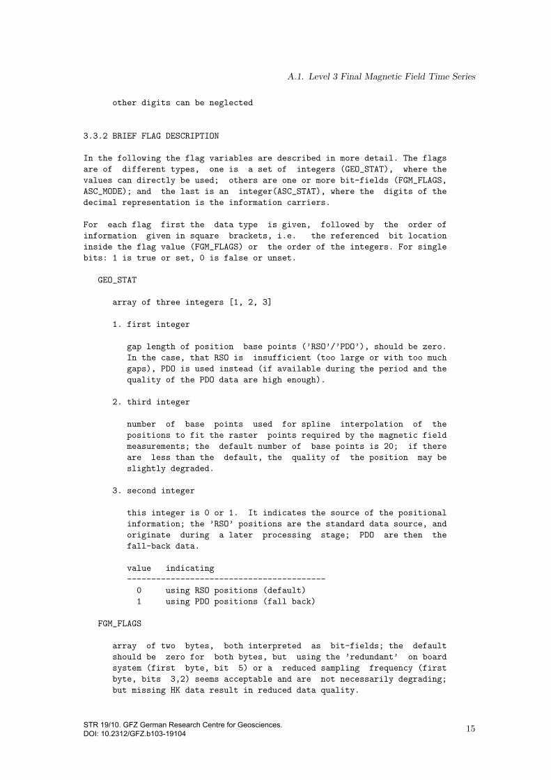
3.3.2 BRIEF FLAG DESCRIPTION
In the following the flag variables are described in more detail. The flags
are of different types, one is a set of integers (GEO_STAT), where the
values can directly be used; others are one or more bit-fields (FGM_FLAGS,
ASC_MODE); and the last is an integer(ASC_STAT), where the digits of the
decimal representation is the information carriers.
For each flag first the data type is given, followed by the order of
information given in square brackets, i.e. the referenced bit location
inside the flag value (FGM_FLAGS) or the order of the integers. For single
bits: 1 is true or set, 0 is false or unset.
GEO_STAT
array of three integers [1, 2, 3]
1. first integer
gap length of position base points (’RSO’/’PDO’), should be zero.
In the case, that RSO is insufficient (too large or with too much
gaps), PDO is used instead (if available during the period and the
quality of the PDO data are high enough).
2. third integer
number of base points used for spline interpolation of the
positions to fit the raster points required by the magnetic field
measurements; the default number of base points is 20; if there
are less than the default, the quality of the position may be
slightly degraded.
3. second integer
this integer is 0 or 1. It indicates the source of the positional
information; the ’RSO’ positions are the standard data source, and
originate during a later processing stage; PDO are then the
fall-back data.
value indicating
-----------------------------------------
0 using RSO positions (default)
1 using PDO positions (fall back)
FGM_FLAGS
array of two bytes, both interpreted as bit-fields; the default
should be zero for both bytes, but using the ’redundant’ on board
system (first byte, bit 5) or a reduced sampling frequency (first
byte, bits 3,2) seems acceptable and are not necessarily degrading;
but missing HK data result in reduced data quality.
15STR 19/10. GFZ German Research Centre for Geosciences. DOI: 10.2312/GFZ.b103-19104
A. More Detailed Descriptions
bits of byte 1, in the order: [8 7 6 5 4 3 2 1]
bit(s) comment
----------------------------------------------------------------
1 adc (first sample is abnormal or not); ok (0), not ok (1)
3+2
bits indicating
------------------------------
00 sample freq is 50 Hz
01 sample freq is 10 Hz
10 sample freq is 1 Hz
11 sample freq is illegal
4 no HK of the torquer current are available for correction;
ok (0), no data (1)
5 redundant OBDU (OnBoardDataUnit); off (0), on (1)
6 bad average distribution; ok (0), bad (1)
7 the OVM frequency is corrected; (0), no (1)
8 no HK data are available for correction in ovm processing;
ok (0), no HK (1)
bits of byte 2, in the order: [8 7 6 5 4 3 2 1]
bit flag comment
----------------------------------------------------------------
1 on L3 processing, ovm is interpolated; ok (0), interp (1)
2 on L3 processing, fgm is interpolated; ok (0), interp (1)
3 on L3 processing, delta is interpolated;
ok (0), interp (1)
4 on L3 processing, value is not corrected;
ok (0), no corr (1)
5 empty
6 FGM Burst mode; compression on (1), off (0)
7 L2 ovm gps error corrected; no (0), corr (1)
8 L2 fgm gps error corrected; no (0), corr (1)
ASC_MODE
bits, in the order [8 7 6 5 4 3 2 1].
bit comment
----------------------------------------------------------------
8 - 5 Not used
4 camera 1 (boom)
3 camera 2 (boom)
2 camera 3 (body)
1 camera 4 (body)
ASC_STAT
digits in a integer number of maximal five digits:
16 STR 19/10. GFZ German Research Centre for Geosciences. DOI: 10.2312/GFZ.b103-19104

A.1. Level 3 Final Magnetic Field Time Series
with digits ordered by 12345:
place comment
----------------------------------------------------------------
1 a mode in the range 0 - 7 [multiplier is 10000]
val comment
------------------------------------------------------
0 no data
1 not available
2 single data boom, chu2cr static
3 not available
4 not available
5 not available
6 single data boom, chu2cr dynamic
7 dual data boom
2 filtered (0: no, 1: yes) [multiplier is 1000]
3 chu2cr (angle estimation method) [multiplier is 100]
chu - camera head unit reference frame,
cr - common reference frame
val comment
------------------------------------------------------
0 static
1 dynamic
2 dual
4 jump correction [multiplier is 10]
flagging application and effect of jump correction
(chu1, chu2 - boom; chu3, chu4 - body)
val comment
------------------------------------------------------
0 no
1 chu1 or chu3
2 chu2 or chu4
3 (chu1 and chu2) or (chu3 and chu4)
5 flagging interpolating of data-gaps [multiplier is 1]
val comment
------------------------------------------------------
0 no
1 chu1 or chu3
2 chu2 or chu4
3 (chu1 and chu2) or (chu3 and chu4)
4. ADDITIONAL HINTS
-------------------
17STR 19/10. GFZ German Research Centre for Geosciences. DOI: 10.2312/GFZ.b103-19104

A. More Detailed Descriptions
4.1. With the CDF toolbox program ’cdfexport’ it is possible to create
listing files from L3 CDF data files using the command line without
additional programming. By initially using ’cdfexport’ on a CDF file
interactively in a terminal, a file with current settings can be saved (see
’action’ menue). Assuming an appropriately installed ’cdfexport’ is in the
search path of the shell and the settings file written during the
interactive use of ’cdfexport’ is named ’default.set’, a command in a
’bash’ shell may look like (some environment variables set for
shortening...):
IN__FILE=’CH-ME-3-MAG+2010-09-03.cdf’
OUT_FILE=’ch-me-3-mag-out.list’
OPTIONS=’-batch text -settings default.set’
cdfexport ${OPTIONS} -text ${OUT_FILE} ${IN__FILE}
For details it may be required to read the CDF user manual, in particular
the ’Toolkit Reference’ section.
A.1.3. CDF Skeleton
! Skeleton table for the "CH-ME-3-MAG.cdf" CDF.
! Generated: Friday, 15-Mar-2019 01:55:26
! CDF created/modified by CDF V2.6.7
! Skeleton table created by CDF V3.7.0_0
#header
CDF NAME: CH-ME-3-MAG+*.cdf
DATA ENCODING: NETWORK
MAJORITY: ROW
FORMAT: SINGLE
! Variables G.Attributes V.Attributes Records Dims Sizes
! --------- ------------ ------------ ------- ---- -----
0/12 8 13 0/z 0
! CDF_COMPRESSION: None
! (Valid compression: None, GZIP.1-9, RLE.0, HUFF.0, AHUFF.0)
! CDF_CHECKSUM: None
! (Valid checksum: None, MD5)
#GLOBALattributes
! Attribute Entry Data
! Name Number Type Value
! --------- ------ ---- -----
"PRODUCT" 1: CDF_CHAR { "CH-ME-3-MAG" } .
18 STR 19/10. GFZ German Research Centre for Geosciences. DOI: 10.2312/GFZ.b103-19104

A.1. Level 3 Final Magnetic Field Time Series
"TITLE" 1: CDF_CHAR { "CHAMP ME MAG" } .
"HISTORY" 1: CDF_CHAR { "skeleton version: " -
"2014-Mar-10" }
2: CDF_CHAR { "level 3 processor version:" -
" 2014-Mar-10" }
3: CDF_CHAR { "CDF created: Wed Apr 20 " -
"14:12:35 2016" } .
"MJD2000" 1: CDF_DOUBLE { 3681.0 } .
"EPOCH_S" 1: CDF_EPOCH { 29-Jan-2010 00:00:00.140 } .
"EPOCH_E" 1: CDF_EPOCH { 29-Jan-2010 23:59:59.140 } .
"NR_OF_RECORDS" 1: CDF_INT4 { 86400 } .
"MAG_ID" 1: CDF_INT2 { 1 } .
#VARIABLEattributes
"VALIDMIN"
"VALIDMAX"
"SCALEMIN"
"SCALEMAX"
"UNIT"
"FORMAT"
"HEADS"
"SYSTEM"
"MODEL"
"REFRADIUS"
"SAMPLE"
"INFO"
"FILLVAL"
#variables
! No rVariables.
#zVariables
! Variable Data Number Record Dimension
! Name Type Elements Dims Sizes Variance Variances
! -------- ---- -------- ---- ----- -------- ---------
"EPOCH" CDF_EPOCH 1 0 T
! VAR_COMPRESSION: None
! (Valid compression: None, GZIP.1-9, RLE.0, HUFF.0, AHUFF.0)
! VAR_SPARSERECORDS: None
! (Valid sparserecords: None, sRecords.PAD, sRecords.PREV)
19STR 19/10. GFZ German Research Centre for Geosciences. DOI: 10.2312/GFZ.b103-19104

A. More Detailed Descriptions
! VAR_PADVALUE: 01-Jan-0000 00:00:00.000
! Attribute Data
! Name Type Value
! -------- ---- -----
"VALIDMIN" CDF_INT4 { 1 }
"UNIT" CDF_CHAR { "millisecond since 01-Jan-0000 " -
"00:00:00.000 (CDF epoch)" }
"FORMAT" CDF_CHAR { "F20.10" }
"INFO" CDF_CHAR { "time, UT (epoch)" } .
! RV values were not requested.
! Variable Data Number Record Dimension
! Name Type Elements Dims Sizes Variance Variances
! -------- ---- -------- ---- ----- -------- ---------
"GEO_LAT" CDF_REAL8 1 0 T
! VAR_COMPRESSION: None
! (Valid compression: None, GZIP.1-9, RLE.0, HUFF.0, AHUFF.0)
! VAR_SPARSERECORDS: None
! (Valid sparserecords: None, sRecords.PAD, sRecords.PREV)
! VAR_PADVALUE: 4.67632e-310
! Attribute Data
! Name Type Value
! -------- ---- -----
"VALIDMIN" CDF_REAL8 { -90.0 }
"VALIDMAX" CDF_REAL8 { 90.0 }
"UNIT" CDF_CHAR { "degree" }
"FORMAT" CDF_CHAR { "F15.10" }
"SYSTEM" CDF_CHAR { "geocentric geographic" }
"INFO" CDF_CHAR { "latitude" }
"FILLVAL" CDF_REAL8 { nan } .
! RV values were not requested.
! Variable Data Number Record Dimension
! Name Type Elements Dims Sizes Variance Variances
! -------- ---- -------- ---- ----- -------- ---------
"GEO_LON" CDF_REAL8 1 0 T
! VAR_COMPRESSION: None
! (Valid compression: None, GZIP.1-9, RLE.0, HUFF.0, AHUFF.0)
! VAR_SPARSERECORDS: None
! (Valid sparserecords: None, sRecords.PAD, sRecords.PREV)
! VAR_PADVALUE: 4.67632e-310
20STR 19/10. GFZ German Research Centre for Geosciences. DOI: 10.2312/GFZ.b103-19104

A.1. Level 3 Final Magnetic Field Time Series
! Attribute Data
! Name Type Value
! -------- ---- -----
"VALIDMIN" CDF_INT4 { -180 }
"VALIDMAX" CDF_INT4 { 180 }
"UNIT" CDF_CHAR { "degree" }
"FORMAT" CDF_CHAR { "F15.10" }
"SYSTEM" CDF_CHAR { "geocentric geographic" }
"INFO" CDF_CHAR { "longitude" }
"FILLVAL" CDF_REAL8 { nan } .
! RV values were not requested.
! Variable Data Number Record Dimension
! Name Type Elements Dims Sizes Variance Variances
! -------- ---- -------- ---- ----- -------- ---------
"GEO_ALT" CDF_REAL8 1 0 T
! VAR_COMPRESSION: None
! (Valid compression: None, GZIP.1-9, RLE.0, HUFF.0, AHUFF.0)
! VAR_SPARSERECORDS: None
! (Valid sparserecords: None, sRecords.PAD, sRecords.PREV)
! VAR_PADVALUE: 4.67632e-310
! Attribute Data
! Name Type Value
! -------- ---- -----
"VALIDMIN" CDF_INT4 { 0 }
"VALIDMAX" CDF_INT4 { 1000 }
"UNIT" CDF_CHAR { "km" }
"FORMAT" CDF_CHAR { "F10.6" }
"SYSTEM" CDF_CHAR { "geocentric geographic" }
"REFRADIUS" CDF_REAL4 { 6371.2 }
"INFO" CDF_CHAR { "altitude above reference sphere" }
"FILLVAL" CDF_REAL8 { nan } .
! RV values were not requested.
! Variable Data Number Record Dimension
! Name Type Elements Dims Sizes Variance Variances
! -------- ---- -------- ---- ----- -------- ---------
"GEO_STAT" CDF_INT4 1 1 3 T T
! VAR_COMPRESSION: None
! (Valid compression: None, GZIP.1-9, RLE.0, HUFF.0, AHUFF.0)
! VAR_SPARSERECORDS: None
! (Valid sparserecords: None, sRecords.PAD, sRecords.PREV)
! VAR_PADVALUE: 1583833392
21STR 19/10. GFZ German Research Centre for Geosciences. DOI: 10.2312/GFZ.b103-19104

A. More Detailed Descriptions
! Attribute Data
! Name Type Value
! -------- ---- -----
"FORMAT" CDF_CHAR { "I5" }
"INFO" CDF_CHAR { "status information for positions; " -
"column 1 - number of gaps in " -
"interpolation interval; column 2 - " -
"flag for PDO used instead of RSO; " -
"column 3 - number of basePoints used " -
"for interpolation" }
"FILLVAL" CDF_INT4 { -1 } .
! RV values were not requested.
! Variable Data Number Record Dimension
! Name Type Elements Dims Sizes Variance Variances
! -------- ---- -------- ---- ----- -------- ---------
"FGM_VEC" CDF_REAL4 1 1 3 T T
! VAR_COMPRESSION: None
! (Valid compression: None, GZIP.1-9, RLE.0, HUFF.0, AHUFF.0)
! VAR_SPARSERECORDS: None
! (Valid sparserecords: None, sRecords.PAD, sRecords.PREV)
! VAR_PADVALUE: 4.16817e+18
! Attribute Data
! Name Type Value
! -------- ---- -----
"VALIDMIN" CDF_INT4 { -99999 }
"VALIDMAX" CDF_INT4 { 99999 }
"UNIT" CDF_CHAR { "nT" }
"FORMAT" CDF_CHAR { "F15.3" }
"SYSTEM" CDF_CHAR { "CHAMP FGM-1 sensor system" }
"SAMPLE" CDF_CHAR { "1 Hz" }
"INFO" CDF_CHAR { "B-vector in FGM-1 sensor system" } .
! RV values were not requested.
! Variable Data Number Record Dimension
! Name Type Elements Dims Sizes Variance Variances
! -------- ---- -------- ---- ----- -------- ---------
"FGM_SCAL" CDF_REAL4 1 0 T
! VAR_COMPRESSION: None
! (Valid compression: None, GZIP.1-9, RLE.0, HUFF.0, AHUFF.0)
! VAR_SPARSERECORDS: None
! (Valid sparserecords: None, sRecords.PAD, sRecords.PREV)
22 STR 19/10. GFZ German Research Centre for Geosciences. DOI: 10.2312/GFZ.b103-19104

A.1. Level 3 Final Magnetic Field Time Series
! VAR_PADVALUE: 4.16817e+18
! Attribute Data
! Name Type Value
! -------- ---- -----
"VALIDMIN" CDF_INT4 { 0 }
"VALIDMAX" CDF_INT4 { 99999 }
"UNIT" CDF_CHAR { "nT" }
"FORMAT" CDF_CHAR { "F15.3" }
"SYSTEM" CDF_CHAR { "CHAMP FGM-1 sensor system" }
"SAMPLE" CDF_CHAR { "1 Hz" }
"INFO" CDF_CHAR { "scalar B-field in FGM-1 sensor system" } .
! RV values were not requested.
! Variable Data Number Record Dimension
! Name Type Elements Dims Sizes Variance Variances
! -------- ---- -------- ---- ----- -------- ---------
"FGM_FLAGS" CDF_UINT1 1 1 2 T T
! VAR_COMPRESSION: None
! (Valid compression: None, GZIP.1-9, RLE.0, HUFF.0, AHUFF.0)
! VAR_SPARSERECORDS: None
! (Valid sparserecords: None, sRecords.PAD, sRecords.PREV)
! VAR_PADVALUE: 48
! Attribute Data
! Name Type Value
! -------- ---- -----
"VALIDMIN" CDF_UINT1 { 0 }
"VALIDMAX" CDF_UINT1 { 255 }
"UNIT" CDF_CHAR { "bit field" }
"FORMAT" CDF_CHAR { "I8" }
"INFO" CDF_CHAR { "FGM quality information (flags),### " -
"bits of byte 1 (8 7 6 5 4 3 2 1): # 1 " -
"- adc (first sample anormal = 1, ok = " -
"0); # 3,2 sample frequency (00 = " -
"sample freq is 50 Hz, 01 = sample " -
"freq is 10 Hz, 10 = sample freq is 1" -
" Hz, 11 = sample freq is illegal); # " -
"4 - torquer overlap (ok = 0, not ok = " -
"1); # 5 - OnBoardDataUnit (OBDU) " -
"(standard = 0, redundant = 1); # 6 - " -
"bad average distribution (ok = 0, bad " -
"= 1); # 7 - ovm frequency correction " -
"(no = 0, yes = 1); # 8 - ovm hk " -
"overlapped (yes = 0, no = 1); ### bits" -
" of byte 2 (8 7 6 5 4 3 2 1): # 1 - L3" -
" ovm interpolated (no = 0, yes = 1); #" -
" 2 - L3 fgm interpolated (no = 0, yes " -
23STR 19/10. GFZ German Research Centre for Geosciences. DOI: 10.2312/GFZ.b103-19104

A. More Detailed Descriptions
"= 1); # 3 - L3 delta interpolated (no " -
"= 0, yes = 1); # 4 - L3 value " -
"corrected for OVM (ok = 0, no = 1); # " -
"5 - empty; # 6 - FGM Burst mode " -
"(compression on = 1, off = 0); # 7 - " -
"L2 ovm GPS error corrected (no = 0, " -
"corrected = 1); # 8 - L2 fgm GPS error" -
" corrected (no = 0, corrected = 1); " } .
! RV values were not requested.
! Variable Data Number Record Dimension
! Name Type Elements Dims Sizes Variance Variances
! -------- ---- -------- ---- ----- -------- ---------
"NEC_VEC" CDF_REAL4 1 1 3 T T
! VAR_COMPRESSION: None
! (Valid compression: None, GZIP.1-9, RLE.0, HUFF.0, AHUFF.0)
! VAR_SPARSERECORDS: None
! (Valid sparserecords: None, sRecords.PAD, sRecords.PREV)
! VAR_PADVALUE: 4.16817e+18
! Attribute Data
! Name Type Value
! -------- ---- -----
"VALIDMIN" CDF_INT4 { -99999 }
"VALIDMAX" CDF_INT4 { 99999 }
"UNIT" CDF_CHAR { "nT" }
"FORMAT" CDF_CHAR { "F15.3" }
"SYSTEM" CDF_CHAR { "NEC (North East Centered) system" }
"SAMPLE" CDF_CHAR { "1 Hz" }
"INFO" CDF_CHAR { "B-vector in NEC system" }
"FILLVAL" CDF_REAL4 { nan } .
! RV values were not requested.
! Variable Data Number Record Dimension
! Name Type Elements Dims Sizes Variance Variances
! -------- ---- -------- ---- ----- -------- ---------
"ASC_QUAT" CDF_REAL8 1 1 4 T T
! VAR_COMPRESSION: None
! (Valid compression: None, GZIP.1-9, RLE.0, HUFF.0, AHUFF.0)
! VAR_SPARSERECORDS: None
! (Valid sparserecords: None, sRecords.PAD, sRecords.PREV)
! VAR_PADVALUE: 4.67632e-310
! Attribute Data
! Name Type Value
24STR 19/10. GFZ German Research Centre for Geosciences. DOI: 10.2312/GFZ.b103-19104

A.1. Level 3 Final Magnetic Field Time Series
! -------- ---- -----
"VALIDMIN" CDF_INT4 { -1 }
"VALIDMAX" CDF_INT4 { 1 }
"UNIT" CDF_CHAR { "-" }
"FORMAT" CDF_CHAR { "F15.10" }
"SAMPLE" CDF_CHAR { "1 Hz" }
"INFO" CDF_CHAR { "ASC quaternions for ICRF " -
"(International Celestial Reference " -
"System) -> CRF (Common Reference " -
"System) transformation" }
"FILLVAL" CDF_REAL8 { nan } .
! RV values were not requested.
! Variable Data Number Record Dimension
! Name Type Elements Dims Sizes Variance Variances
! -------- ---- -------- ---- ----- -------- ---------
"ASC_MODE" CDF_UINT1 1 0 T
! VAR_COMPRESSION: None
! (Valid compression: None, GZIP.1-9, RLE.0, HUFF.0, AHUFF.0)
! VAR_SPARSERECORDS: None
! (Valid sparserecords: None, sRecords.PAD, sRecords.PREV)
! VAR_PADVALUE: 48
! Attribute Data
! Name Type Value
! -------- ---- -----
"VALIDMIN" CDF_UINT1 { 1 }
"VALIDMAX" CDF_UINT1 { 15 }
"UNIT" CDF_CHAR { "bit field" }
"FORMAT" CDF_CHAR { "I2" }
"INFO" CDF_CHAR { "Star camera mode (from left to right):" -
" 1st A1 Camera 1 Boom; 2nd A2 Camera 2" -
" Boom; 3rd B1 Camera 1 Body; 4rd B2 " -
"Camera 2 Body" }
"FILLVAL" CDF_UINT1 { 0 } .
! RV values were not requested.
! Variable Data Number Record Dimension
! Name Type Elements Dims Sizes Variance Variances
! -------- ---- -------- ---- ----- -------- ---------
"ASC_STAT" CDF_UINT4 1 0 T
! VAR_COMPRESSION: None
! (Valid compression: None, GZIP.1-9, RLE.0, HUFF.0, AHUFF.0)
! VAR_SPARSERECORDS: None
25STR 19/10. GFZ German Research Centre for Geosciences. DOI: 10.2312/GFZ.b103-19104

A. More Detailed Descriptions
! (Valid sparserecords: None, sRecords.PAD, sRecords.PREV)
! VAR_PADVALUE: 1583833392
! Attribute Data
! Name Type Value
! -------- ---- -----
"VALIDMIN" CDF_UINT4 { 1 }
"VALIDMAX" CDF_UINT4 { 99999 }
"UNIT" CDF_UCHAR { "integer field" }
"FORMAT" CDF_UCHAR { "I5" }
"INFO" CDF_UCHAR { "star camera quality information, ### " -
"1st digit is flagging ASC source: 0 = " -
"no data available, 2 = single data " -
"boom, chu2cr static, 6 = single data " -
"boom + chu2cr dynamic, 7 = dual data " -
"boom; ### 2nd digit is filtered flag: " -
"0 = no, 1 = yes; ### 3rd digit is " -
"flagging chu2cr transformation mode: 0" -
" = static, 1 = dynamic, 2 = dual; ### " -
"4th digit is flagging jump correction:" -
" 0 = no, 1 = chu1/3, 2 = chu2/4, 3 = " -
"chu1/3 and chu2/4; ### 5th digit is " -
"flagging interpolated gaps: 0 = no " -
"interpolation 1 = chu1/3, 2 = chu2/4, " -
"3 = chu1/3 and chu2/4;" }
"FILLVAL" CDF_INT4 { 0 } .
! RV values were not requested.
#end
26STR 19/10. GFZ German Research Centre for Geosciences. DOI: 10.2312/GFZ.b103-19104

A.2. Attitude information from the star cameras on the boom
A.2. Attitude information from the star cameras on the boom
A.2.1. Name Identifier
The identifier of this data type in the product file name is CH-ME-3-ASC-BOOM.
A.2.2. Description
The following description is included here from a plain ASCII file, which had served as a descriptionof the ASC data and partly accompanied the data. It is embedded here literally and mostlyunchanged, with it’s own, unrelated section numbering.
The CHASC-Format (CHAMP Advanced Stellar Compass Star Format) Level 3
------
follows the CHACC-Format
Last Revision: 21-Aug-2001.
1. Format description:
----------------------
1.1. general:
- the length of a line should not exceed 80 characters
- the CHACC-format data files consists of a header and data lines.
- comment lines are possible at any position (except of the first line),
the first character of a comment line is ’*’
1.2. header:
The header consists of
- the first line (= format identification line), which starts with ’%’
- additional lines, every header line consists of a
first character ’+’, followed by a keyword (9 characters)
and header data (details given below), this lines
may be given in any order
The header ends with the first line, which doesn’t start with ’*’, ’%’ or ’+’.
Detailed header lines format description:
=========================================================================
- First line (format and data revision identification line)
Columns 1 - 6 A6 ’%chxxx’ format identifier:
’%chacc’ = Accelerometer data Level-1 or -2
’%chasc’ = only Advanced Stellar Compass Level-2 data
’%chfgm’ = only formatted fgm-data
’%chshk’ = satellite housekeeping data (OG relevant)
Column 7 1X unused
Column 8 -19 A12 ’version x.x ’ format version
27STR 19/10. GFZ German Research Centre for Geosciences. DOI: 10.2312/GFZ.b103-19104
A. More Detailed Descriptions
Column 20 1X unused
Columns 21-32 A12 ’revision y ’ data revision
Column 33 1X unused
Columns 34-37 I4 year of file creation
Column 38 1X unused
Columns 39-40 I2 month of file creation
Column 41 1X unused
Columns 42-43 I2 day of file creation
Column 44 1X unused
Columns 45-46 I2 hour of file creation
Column 47 1X unused
Columns 48-49 I2 minute of file creation
Columns 50 1X unused
Columns 51-59 A9 Name of the institution (abbreviated)
Columns 60 1X unused
Columns 61-80 A20 Name of the operator
- satellite identification
Columns 1 -10 A10 ’+satellite’ keyword
Column 11 1X unused
Columns 12-18 I7 SLR adopted COSPAR number of the satellite
Column 19 1X unused
Columns 20-39 A20 name of the satellite
- data type specification
This line specifies the data, which are kept in the file.
Columns 1 -10 A10 ’+data_____’ keyword
Colums 11-.... n(1X,A3) list of the keywords of all data types
of the data lines below (including
the time), the keywords are identical to the
keywords used in the data lines
n = number of different data types (including time)
(see the examples below)
- reference systems specification line
Columns 1 -10 A10 ’+reference’ keyword
Columns 11-.... n(1X,A3) list of the abbreviations of the reference systems
of the different data types (including the time),
the order of this keywords corresponds with the
order of the data type keywords in the
’+data_____’-line above!
Examples for reference system keywords:
’gps’ - GPS-Time
’utc’ - Coordinated universal time
’gpp’ -
’cis’ - Conventional Intertial System
’ifx’ - Instrument Fixed System
’sbf’ - Spacecraft Body Fixed
’---’ - for thrusters and H/K data, where
no reference system is required
28 STR 19/10. GFZ German Research Centre for Geosciences. DOI: 10.2312/GFZ.b103-19104
A.2. Attitude information from the star cameras on the boom
(see examples below)
- first epoch specification
Columns 1 -10 A10 ’+first____’ keyword
Column 11 1X unused
Columns 12-15 I4 year of first epoch
Column 16 1X unused
Columns 17-18 I2 month of first epoch
Column 19 1X unused
Columns 20-21 I2 day of first epoch
Column 22 1X unused
Columns 23-24 I2 hour of first epoch
Columns 25 1X unused
Columns 26-27 I2 minute of first epoch
Columns 28 1X unused
Columns 29-38 F10.7 second of first epoch
- last epoch specification
Columns 1 -10 A10 ’+last_____’ keyword
Column 11 1X unused
Columns 12-15 I4 year of last epoch
Column 16 1X unused
Columns 17-18 I2 month of last epoch
Column 19 1X unused
Columns 20-21 I2 day of last epoch
Column 22 1X unused
Columns 23-24 I2 hour of last epoch
Columns 25 1X unused
Columns 26-27 I2 minute of last epoch
Columns 28 1X unused
Columns 29-38 F10.7 second of last epoch
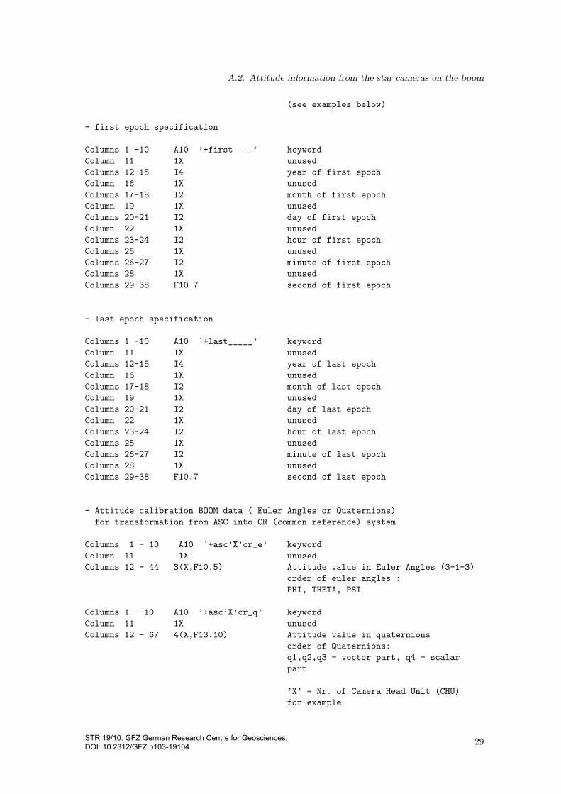
- Attitude calibration BOOM data ( Euler Angles or Quaternions)
for transformation from ASC into CR (common reference) system
Columns 1 - 10 A10 ’+asc’X’cr_e’ keyword
Column 11 1X unused
Columns 12 - 44 3(X,F10.5) Attitude value in Euler Angles (3-1-3)
order of euler angles :
PHI, THETA, PSI
Columns 1 - 10 A10 ’+asc’X’cr_q’ keyword
Column 11 1X unused
Columns 12 - 67 4(X,F13.10) Attitude value in quaternions
order of Quaternions:
q1,q2,q3 = vector part, q4 = scalar
part
’X’ = Nr. of Camera Head Unit (CHU)
for example
29STR 19/10. GFZ German Research Centre for Geosciences. DOI: 10.2312/GFZ.b103-19104
A. More Detailed Descriptions
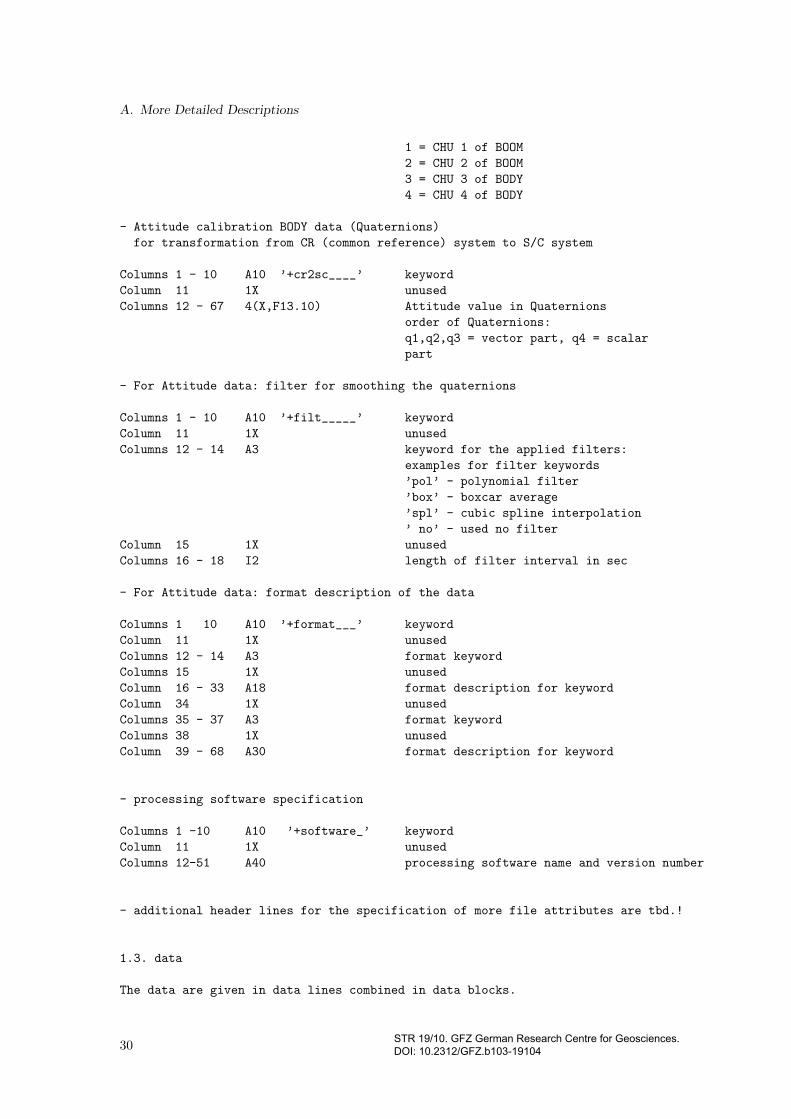
1 = CHU 1 of BOOM
2 = CHU 2 of BOOM
3 = CHU 3 of BODY
4 = CHU 4 of BODY
- Attitude calibration BODY data (Quaternions)
for transformation from CR (common reference) system to S/C system
Columns 1 - 10 A10 ’+cr2sc____’ keyword
Column 11 1X unused
Columns 12 - 67 4(X,F13.10) Attitude value in Quaternions
order of Quaternions:
q1,q2,q3 = vector part, q4 = scalar
part
- For Attitude data: filter for smoothing the quaternions
Columns 1 - 10 A10 ’+filt_____’ keyword
Column 11 1X unused
Columns 12 - 14 A3 keyword for the applied filters:
examples for filter keywords
’pol’ - polynomial filter
’box’ - boxcar average
’spl’ - cubic spline interpolation
’ no’ - used no filter
Column 15 1X unused
Columns 16 - 18 I2 length of filter interval in sec
- For Attitude data: format description of the data
Columns 1 10 A10 ’+format___’ keyword
Column 11 1X unused
Columns 12 - 14 A3 format keyword
Columns 15 1X unused
Column 16 - 33 A18 format description for keyword
Column 34 1X unused
Columns 35 - 37 A3 format keyword
Columns 38 1X unused
Column 39 - 68 A30 format description for keyword
- processing software specification
Columns 1 -10 A10 ’+software_’ keyword
Column 11 1X unused
Columns 12-51 A40 processing software name and version number
- additional header lines for the specification of more file attributes are tbd.!
1.3. data
The data are given in data lines combined in data blocks.
30STR 19/10. GFZ German Research Centre for Geosciences. DOI: 10.2312/GFZ.b103-19104

A.2. Attitude information from the star cameras on the boom
The basic structure of a single line is a keyword of 3 characters,
followed by the data.
A data blocks starts with a data line containing a measurement
epoch. All these following data lines are related to this epoch and
these lines may be given in any order.
A new epoch line starts a new data block.
The last data block ends with the ’%eof’-line.
Detailed data lines format description:
=================================================================
- UTC Time Line
Columns 1 - 3 A3 ’tim’ keyword
Column 4 1X unused
Columns 5 - 8 I4 year
Column 9 1X unused
Columns 10-11 I2 month
Column 12 1X unused
Columns 13-14 I2 day
Column 15 1X unused
Columns 16-17 I2 hour
Column 18 1X unused
Columns 19-20 I2 minute
Column 21 1X unused
Columns 22-31 F10.4 second
- Attitude line
Columns 1 - 3 A3 ’att’ keyword
Column 4 1X unused
Columns 5 8 I4 star imager 1 - 4 flags
In the order: asc_a1, asc_a2, asc_b3,asc_b4
meaning: star imager included to this data
’0’ = not included
’1’ = included
Column 9 1X unused
Columns 10 - 64 4(X,F13.10) Attitude value in quaternions
(value range of all components: -1.0 .... +1.0)
order of Quaternions:
q1,q2,q3 = vector part, q4 = scalar part
Column 65 F5.2 relative errors
1.4. last line
the content of the last line is ’%eof’, this indicates the end of the file
2. Examples :
This is an example for an attitude data file (level-2 product).
All numbers are dummies, this is no simulation
2.1. Attitude Level-2-Data
(Advanced Stellar Compass, boom, preprocessed, CH-ME-2-ASC-BOOM)
31STR 19/10. GFZ German Research Centre for Geosciences. DOI: 10.2312/GFZ.b103-19104

A. More Detailed Descriptions
%chasc version 2.0 revision 0 2001 8 20 15:35 GFZ Sungchan Choi
+satellite 0003902 CHAMP
+data_____ tim att
+reference utc cis
+first____ 2001 04 10 00 00 0.1400000
+last_____ 2001 04 10 00 06 6.1400000
+asc1-cr_e 1.74100 128.99541 -0.00285
+asc1-cr_q 0.9024604684 0.0139371969 0.0064337971 0.4304990868
+asc2-cr_e 179.10812 -129.00436 -0.00515
+asc2-cr_q -0.0069842388 -0.9025747103 0.4304634224 0.0033696754
+filt_____ pol 20
+format___ tim (A3,1X,I4,4(1X,I2.2),1X,F10.4) att (A3,1X,4I1,4(1X,F13.10),F5.2)
+software_ ch_me_asc_12_boom version 2.00
*comment1
*comment2
tim 2001 04 10 00 00 0.1400
att 1100 -0.0830847653 0.1131861781 0.4020327729 0.9047958114 0.00
tim 2001 04 10 00 00 1.1400
att 1100 -0.0828501589 0.1126905249 0.4020747622 0.9048605320 0.00
tim 2001 04 10 00 00 2.1400
att 1100 -0.0826159053 0.1121952117 0.4021164244 0.9049249847 0.00
tim 2001 04 10 00 00 3.1400
att 1100 -0.0823815405 0.1117007710 0.4021569265 0.9049895171 0.00
tim 2001 04 10 00 00 4.1400
att 1100 -0.0821461056 0.1112050308 0.4021982087 0.9050536224 0.00
tim 2001 04 10 00 00 5.1400
att 1100 -0.0819105174 0.1107091754 0.4022388075 0.9051177202 0.00
tim 2001 04 10 00 00 6.1400
att 1100 -0.0816752929 0.1102138866 0.4022794854 0.9051813417 0.00
tim 2001 04 10 00 00 7.1400
att 1100 -0.0814403208 0.1097188218 0.4023195848 0.9052448321 0.00
tim 2001 04 10 00 00 8.1400
att 1100 -0.0812048087 0.1092235528 0.4023597151 0.9053080438 0.00
tim 2001 04 10 00 00 9.1400
att 1100 -0.0809692855 0.1087274666 0.4023999038 0.9053709904 0.00
tim 2001 04 10 00 00 10.1400
att 1100 -0.0807332073 0.1082314770 0.4024401212 0.9054336229 0.00
%eof
2.2. Attitude Level-2-Data
(Advanced Stellar Compass, body, preprocessed, CH-OG-2-ASC-BODY)
%chasc version 2.0 revision 0 2001 08 20 15:00 GFZ Sungchan Choi
+satellite 0003902 CHAMP
+data_____ tim att
+reference gps cis
+first____ 2000 07 26 00 00 0.0000000
+last_____ 2000 07 26 01 06 21.0000000
+cr2sc____ -0.0000935753 -0.0017925315 0.0020178324 0.9999963492
+filt_____ NO
+format___ tim (A3,1X,I4,4(1X,I2.2),1X,F10.4) att (A3,1X,4I1,4(1X,F13.10),F5.2)
+software_ ch_me_asc_12_body version 2.00
32STR 19/10. GFZ German Research Centre for Geosciences. DOI: 10.2312/GFZ.b103-19104

A.2. Attitude information from the star cameras on the boom
*comment1
*comment2
tim 2000 07 26 00 00 0.00
att 0011 0.0135647896 -0.6965858498 -0.0398309235 0.7162385524 0.00
tim 2000 07 26 00 00 1.00
att 0011 0.0138079955 -0.6961402894 -0.0407884789 0.7166131123 0.00
tim 2000 07 26 00 00 2.00
att 0011 0.0140468713 -0.6956966916 -0.0417497755 0.7169838011 0.00
tim 2000 07 26 00 00 3.00
att 0011 0.0142814132 -0.6952508367 -0.0427094054 0.7173550293 0.00
tim 2000 07 26 00 00 4.00
att 0011 0.0145139589 -0.6948016786 -0.0436583696 0.7177283157 0.00
tim 2000 07 26 00 00 5.00
att 0011 0.0147483274 -0.6943533633 -0.0446004585 0.7180993724 0.00
tim 2000 07 26 00 00 6.00
att 0011 0.0149780274 -0.6939057331 -0.0455469784 0.7184678009 0.00
tim 2000 07 26 00 00 7.00
att 0011 0.0152030139 -0.6934541405 -0.0465009150 0.7188378845 0.00
tim 2000 07 26 00 00 8.00
att 0011 0.0154267566 -0.6930068647 -0.0474468395 0.7192025541 0.00
tim 2000 07 26 00 00 9.00
att 0011 0.0156573986 -0.6925560261 -0.0483866187 0.7195691402 0.00
tim 2000 07 26 00 00 10.00
att 0011 0.0158894551 -0.6920992184 -0.0493338949 0.7199391500 0.00
tim 2000 07 26 00 00 11.00
att 0011 0.0161171456 -0.6916450166 -0.0502725961 0.7203055535 0.00
tim 2000 07 26 00 00 12.00
att 0011 0.0163439432 -0.6911930056 -0.0512053890 0.7206685287 0.00
tim 2000 07 26 00 00 13.00
att 0011 0.0165736482 -0.6907388374 -0.0521476014 0.7210310784 0.00
%eof
----------------------------------------------------------------------------
33STR 19/10. GFZ German Research Centre for Geosciences. DOI: 10.2312/GFZ.b103-19104

A. More Detailed Descriptions
A.3. Vector magnetic data with high time resolution
A.3.1. Name identifier
The identifier of this data type in the product file name is CH-ME-2-FGM-SCI.
A.3.2. Tabulated overviews
The following description lists the CDF contents in a tabulated way, first the global options, followedby the variables itself. The value items with the name part List do have the VAR-TYPE attributemetadata and are added for convenience on display and plotting with the dedicated software tool.
Global Options
Global Option/NETWORK ENCODING
Name Typ Description
Global/gAttributes
PRODUCT CDF CHAR CH-ME-2-FGM-SCITITLE CDF CHAR CHAMP ME MAG SCI (50Hz)HISTORY CDF CHAR skeleton version 2018-May-08MJD2000 CDF INT4 Modified Julian Day (2000) of first vectorNR OF RECORDS CDF CHAR 0CREATOR CDF CHAR fgmsci2cdf (Ingo Michaelis)REFRADIUS CDF CHAR 6371.2 kmFile naming convention CDF CHAR source mission group data
version descriptor datatype yyyyMMddData type CDF CHAR Fluxgate MagnetometerLogical source CDF CHAR CH-ME-2-FGM-SCILogical source description CDF CHAR [CALIBRATED] Fluxgate Magnetometer
Magnetic field > nTLogical file id CDF CHAR CH-ME-2-FGM-SCI-yyyy-mm-ddMission group CDF CHAR MEPI affiliation CDF CHAR GFZ PotsdamSource name CDF CHAR CHAllenging Minisatellite PayloadProject CDF CHAR CHAMP - CHAllenging Minisatellite PayloadPI name CDF CHAR GFZ PotsdamCOSPAR ID CDF CHAR 2000-039BData version CDF CHAR 2TEXT CDF CHAR FluxGate MagnetometerInstrument type CDF CHAR FluxGate MagnetometerDescriptor CDF CHAR Fluxgate MagnetometerDatatype CDF CHAR Fluxgate MagnetometerDiscipline CDF CHAR Geoscience, Athmospheric scienceAcknowledgement CDF CHAR DLR, GFZLINK TITLE CDF CHAR CHAMP - CHAllenging Minisatellite Payloadspase DatasetResourceID CDF CHAR spase://...Generated by CDF CHAR fgmsci2cdf (I.M.)Rules of use CDF CHAR tbdGeneration date CDF CHAR 0000-00-00HTTP LINK CDF CHAR https://www.gfz-potsdam.de/champ/
LINK TEXT CDF CHAR CHAMP - CHAllenging Minisatellite PayloadMODS CDF CHAR Rev- 2018-05-08Time resolution CDF CHAR 0.02s typical
34 STR 19/10. GFZ German Research Centre for Geosciences. DOI: 10.2312/GFZ.b103-19104
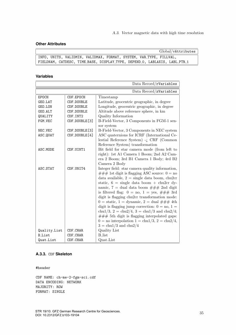
A.3. Vector magnetic data with high time resolution
Other Attributes
Global/vAttributes
INFO, UNITS, VALIDMIN, VALIDMAX, FORMAT, SYSTEM, VAR TYPE, FILLVAL,
FIELDNAM, CATDESC, TIME BASE, DISPLAY TYPE, DEPEND 0, LABLAXIS, LABL PTR 1
Variables
Data Record/rVariables
Data Record/zVariables
EPOCH CDF EPOCH TimestampGEO LAT CDF DOUBLE Latitude, geocentric geographic, in degreeGEO LON CDF DOUBLE Longitude, geocentric geographic, in degreeGEO ALT CDF DOUBLE Altitude above reference sphere, in kmQUALITY CDF INT2 Quality InformationFGM VEC CDF DOUBLE[3] B-Field-Vector, 3 Components in FGM-1 sen-
sor systemNEC VEC CDF DOUBLE[3] B-Field-Vector, 3 Components in NEC systemASC QUAT CDF DOUBLE[4] ASC quaternions for ICRF (International Ce-
lestial Reference System) -¿ CRF (CommonReference System) transformation
ASC MODE CDF UINT1 Bit field for star camera mode (from left toright): 1st A1 Camera 1 Boom; 2nd A2 Cam-era 2 Boom; 3rd B1 Camera 1 Body; 4rd B2Camera 2 Body
ASC STAT CDF UNIT4 Integer field: star camera quality information,### 1st digit is flagging ASC source: 0 = nodata available, 2 = single data boom, chu2crstatic, 6 = single data boom + chu2cr dy-namic, 7 = dual data boom ### 2nd digitis filtered flag: 0 = no, 1 = yes, ### 3rddigit is flagging chu2cr transformation mode:0 = static, 1 = dynamic, 2 = dual ### 4thdigit is flagging jump correction: 0 = no, 1 =chu1/3, 2 = chu2/4, 3 = chu1/3 and chu2/4;### 5th digit is flagging interpolated gaps:0 = no interpolation 1 = chu1/3, 2 = chu2/4,3 = chu1/3 and chu2/4
Quality List CDF CHAR Quality ListB List CDF CHAR B listQuat List CDF CHAR Quat List
A.3.3. CDF Skeleton
#header
CDF NAME: ch-me-2-fgm-sci.cdf
DATA ENCODING: NETWORK
MAJORITY: ROW
FORMAT: SINGLE
35STR 19/10. GFZ German Research Centre for Geosciences. DOI: 10.2312/GFZ.b103-19104

A. More Detailed Descriptions
! Variables G.Attributes V.Attributes Records Dims Sizes
! --------- ------------ ------------ ------- ---- -----
0/10 7 7 0/z 0
#GLOBALattributes
! Attribute Entry Data
! Name Number Type Value
! --------- ------ ---- -----
"PRODUCT" 1: CDF_CHAR { "CH-ME-2-FGM-SCI" } .
"TITLE" 1: CDF_CHAR { "CHAMP ME MAG SCI (50Hz)" } .
"HISTORY" 1: CDF_CHAR { "skeleton version 2018-May-08" } .
"MJD2000" 1: CDF_CHAR { "0.0" } .
"NR_OF_RECORDS" 1: CDF_CHAR { "0" } .
"CREATOR" 1: CDF_CHAR { "fgmsci2cdf (I.M.)" } .
"REFRADIUS" 1: CDF_CHAR { "6371.2 km" } .
"File_naming_convention" 1: CDF_CHAR { "source_mission_group_data_data_" -
"version_descriptor_datatype_yyyyMMdd" } .
"Data_type" 1: CDF_CHAR { "FGM>Fluxgate Magnetometer" } .
"Logical_source" 1: CDF_CHAR { "CH-ME-2-FGM-SCI" } .
"Logical_source_description" 1: CDF_CHAR { "[CALIBRATED] Fluxgate Magnetometer " -
"Magnetic field>nT" } .
"Logical_file_id" 1: CDF_CHAR { "CH-ME-2-FGM-SCI-yyyy-mm-dd" } .
"Mission_group" 1: CDF_CHAR { "ME" } .
"PI_affiliation" 1: CDF_CHAR { "GFZ Potsdam" } .
"Source_name" 1: CDF_CHAR { "CH>CHAllenging Minisatellite Payload" } .
"Project" 1: CDF_CHAR { "CHAMP - CHAllenging Minisatellite Payload" } .
"PI_name" 1: CDF_CHAR { "GFZ Potsdam" } .
"COSPAR_ID" 1: CDF_CHAR { "2000-039B" } .
"Data_version" 1: CDF_CHAR { "2" } .
"TEXT" 1: CDF_CHAR { "FluxGate Magnetometer" } .
"Instrument_type" 1: CDF_CHAR { "FluxGate Magnetometer" } .
"Descriptor" 1: CDF_CHAR { "FGM>Fluxgate Magnetometer" } .
"Datatype" 1: CDF_CHAR { "SCI>Fluxgate Magnetometer" } .
"Discipline" 1: CDF_CHAR { "Geoscience" }
2: CDF_CHAR { "Athmospheric science" } .
"Acknowledgement" 1: CDF_CHAR { "DLR, GFZ" } .
"LINK_TITLE" 1: CDF_CHAR { "CHAMP - CHAllenging Minisatellite Payload" } .
"spase_DatasetResourceID" 1: CDF_CHAR { "spase://..." } .
"Generated_by" 1: CDF_CHAR { "fgmsci2cdf (I.M.)" } .
"Rules_of_use" 1: CDF_CHAR { "tbd" } .
"Generation_date" 1: CDF_CHAR { "0000-00-00" } .
"HTTP_LINK" 1: CDF_CHAR { "https://www.gfz-potsdam.de/champ/" } .
"LINK_TEXT" 1: CDF_CHAR { "CHAMP - CHAllenging Minisatellite Payload" } .
"MODS" 1: CDF_CHAR { "Rev- 2018-05-08" } .
"Time_resolution" 1: CDF_CHAR { "0.02s typical" } .
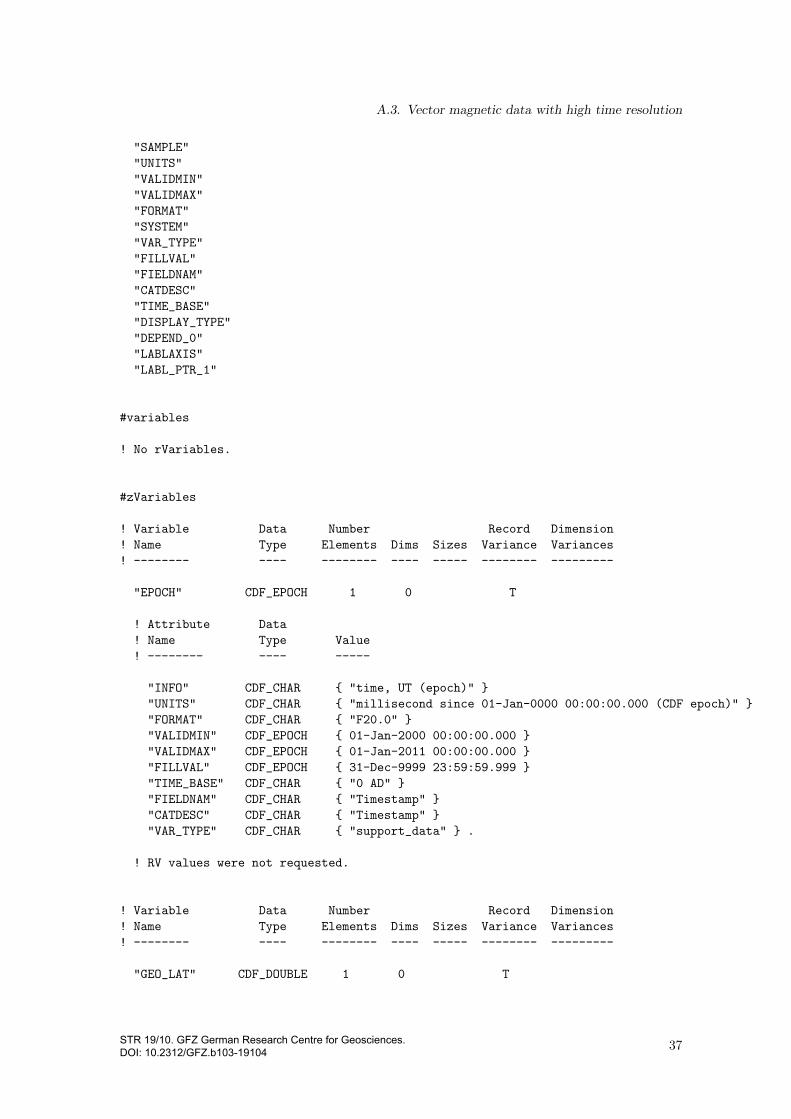
#VARIABLEattributes
"INFO"
36STR 19/10. GFZ German Research Centre for Geosciences. DOI: 10.2312/GFZ.b103-19104
A.3. Vector magnetic data with high time resolution
"SAMPLE"
"UNITS"
"VALIDMIN"
"VALIDMAX"
"FORMAT"
"SYSTEM"
"VAR_TYPE"
"FILLVAL"
"FIELDNAM"
"CATDESC"
"TIME_BASE"
"DISPLAY_TYPE"
"DEPEND_0"
"LABLAXIS"
"LABL_PTR_1"
#variables
! No rVariables.
#zVariables
! Variable Data Number Record Dimension
! Name Type Elements Dims Sizes Variance Variances
! -------- ---- -------- ---- ----- -------- ---------
"EPOCH" CDF_EPOCH 1 0 T
! Attribute Data
! Name Type Value
! -------- ---- -----
"INFO" CDF_CHAR { "time, UT (epoch)" }
"UNITS" CDF_CHAR { "millisecond since 01-Jan-0000 00:00:00.000 (CDF epoch)" }
"FORMAT" CDF_CHAR { "F20.0" }
"VALIDMIN" CDF_EPOCH { 01-Jan-2000 00:00:00.000 }
"VALIDMAX" CDF_EPOCH { 01-Jan-2011 00:00:00.000 }
"FILLVAL" CDF_EPOCH { 31-Dec-9999 23:59:59.999 }
"TIME_BASE" CDF_CHAR { "0 AD" }
"FIELDNAM" CDF_CHAR { "Timestamp" }
"CATDESC" CDF_CHAR { "Timestamp" }
"VAR_TYPE" CDF_CHAR { "support_data" } .
! RV values were not requested.
! Variable Data Number Record Dimension
! Name Type Elements Dims Sizes Variance Variances
! -------- ---- -------- ---- ----- -------- ---------
"GEO_LAT" CDF_DOUBLE 1 0 T
37STR 19/10. GFZ German Research Centre for Geosciences. DOI: 10.2312/GFZ.b103-19104

A. More Detailed Descriptions
! Attribute Data
! Name Type Value
! -------- ---- -----
"INFO" CDF_CHAR { "latitude" }
"UNITS" CDF_CHAR { "degree" }
"VALIDMIN" CDF_DOUBLE { -90.0 }
"VALIDMAX" CDF_DOUBLE { 90.0 }
"FILLVAL" CDF_DOUBLE { -1.0e+31 }
"FORMAT" CDF_CHAR { "F15.10"}
"SYSTEM" CDF_CHAR { "geocentric geographic" }
"FIELDNAM" CDF_CHAR { "Geocentric latitude" }
"CATDESC" CDF_CHAR { "Position" }
"DEPEND_0" CDF_CHAR { "EPOCH" }
"LABLAXIS" CDF_CHAR { "Latitude" }
"VAR_TYPE" CDF_CHAR { "data" }
"DISPLAY_TYPE" CDF_CHAR { "time_series" } .
! RV values were not requested.
! Variable Data Number Record Dimension
! Name Type Elements Dims Sizes Variance Variances
! -------- ---- -------- ---- ----- -------- ---------
"GEO_LON" CDF_DOUBLE 1 0 T
! Attribute Data
! Name Type Value
! -------- ---- -----
"INFO" CDF_CHAR { "longitude" }
"UNITS" CDF_CHAR { "degree" }
"VALIDMIN" CDF_DOUBLE { -180.0 }
"VALIDMAX" CDF_DOUBLE { 180.0 }
"FILLVAL" CDF_DOUBLE { -1.0e+31 }
"FORMAT" CDF_CHAR { "F15.10"}
"SYSTEM" CDF_CHAR { "geocentric geographic" }
"FIELDNAM" CDF_CHAR { "Geocentric longitude" }
"CATDESC" CDF_CHAR { "Position" }
"DEPEND_0" CDF_CHAR { "EPOCH" }
"LABLAXIS" CDF_CHAR { "Longitude" }
"VAR_TYPE" CDF_CHAR { "data" }
"DISPLAY_TYPE" CDF_CHAR { "time_series" } .
! RV values were not requested.
! Variable Data Number Record Dimension
! Name Type Elements Dims Sizes Variance Variances
! -------- ---- -------- ---- ----- -------- ---------
"GEO_ALT" CDF_DOUBLE 1 0 T
38STR 19/10. GFZ German Research Centre for Geosciences. DOI: 10.2312/GFZ.b103-19104

A.3. Vector magnetic data with high time resolution
! Attribute Data
! Name Type Value
! -------- ---- -----
"INFO" CDF_CHAR { "altitude above reference sphere" }
"UNITS" CDF_CHAR { "km" }
"VALIDMIN" CDF_DOUBLE { 0.0 }
"VALIDMAX" CDF_DOUBLE { 999.9 }
"FILLVAL" CDF_DOUBLE { -1.0e+31 }
"FORMAT" CDF_CHAR { "F10.6"}
"SYSTEM" CDF_CHAR { "geocentric geographic" }
"FIELDNAM" CDF_CHAR { "Geocentric altitude" }
"CATDESC" CDF_CHAR { "Position" }
"DEPEND_0" CDF_CHAR { "EPOCH" }
"LABLAXIS" CDF_CHAR { "Altitude" }
"VAR_TYPE" CDF_CHAR { "data" }
"DISPLAY_TYPE" CDF_CHAR { "time_series" } .
! RV values were not requested.
! Variable Data Number Record Dimension
! Name Type Elements Dims Sizes Variance Variances
! -------- ---- -------- ---- ----- -------- ---------
"QUALITY" CDF_INT2 1 1 2 T T
! Attribute Data
! Name Type Value
! -------- ---- -----
"INFO" CDF_CHAR { "Quality information" }
"UNITS" CDF_CHAR { "Bit-Field" }
"VALIDMIN" CDF_INT2 { 0 }
"VALIDMAX" CDF_INT2 { 32767 }
"FILLVAL" CDF_INT2 { 32768 }
"FORMAT" CDF_CHAR { "I16"}
"FIELDNAM" CDF_CHAR { "Quality" }
"CATDESC" CDF_CHAR { "FGM" }
"DEPEND_0" CDF_CHAR { "EPOCH" }
"LABLAXIS" CDF_CHAR { "Quality" }
"VAR_TYPE" CDF_CHAR { "data" }
"LABL_PTR_1" CDF_CHAR { "Quality_List" }
"DISPLAY_TYPE" CDF_CHAR { "time_series" } .
! RV values were not requested.
! Variable Data Number Record Dimension
! Name Type Elements Dims Sizes Variance Variances
! -------- ---- -------- ---- ----- -------- ---------
"FGM_VEC" CDF_DOUBLE 1 1 3 T T
39STR 19/10. GFZ German Research Centre for Geosciences. DOI: 10.2312/GFZ.b103-19104

A. More Detailed Descriptions
! Attribute Data
! Name Type Value
! -------- ---- -----
"INFO" CDF_CHAR { "B-vector in FGM-1 sensor system" }
"UNITS" CDF_CHAR { "nT" }
"VALIDMIN" CDF_DOUBLE { -99999.9 }
"VALIDMAX" CDF_DOUBLE { 99999.9 }
"FILLVAL" CDF_DOUBLE { -1.0e+31 }
"FORMAT" CDF_CHAR { "F15.3"}
"SAMPLE" CDF_CHAR { "50 Hz" }
"SYSTEM" CDF_CHAR { "CHAMP FGM-1 sensor system" }
"FIELDNAM" CDF_CHAR { "FGM_FGM" }
"CATDESC" CDF_CHAR { "FGM" }
"DEPEND_0" CDF_CHAR { "EPOCH" }
"LABLAXIS" CDF_CHAR { "B_FGM" }
"VAR_TYPE" CDF_CHAR { "data" }
"LABL_PTR_1" CDF_CHAR { "B_List" }
"DISPLAY_TYPE" CDF_CHAR { "time_series" } .
! RV values were not requested.
! Variable Data Number Record Dimension
! Name Type Elements Dims Sizes Variance Variances
! -------- ---- -------- ---- ----- -------- ---------
"NEC_VEC" CDF_DOUBLE 1 1 3 T T
! Attribute Data
! Name Type Value
! -------- ---- -----
"INFO" CDF_CHAR { "B-vector in NEC system" }
"UNITS" CDF_CHAR { "nT" }
"VALIDMIN" CDF_DOUBLE { -99999 }
"VALIDMAX" CDF_DOUBLE { 99999 }
"FILLVAL" CDF_DOUBLE { -1.0e+31 }
"FORMAT" CDF_CHAR { "F15.3"}
"SAMPLE" CDF_CHAR { "50 Hz" }
"SYSTEM" CDF_CHAR { "NEC (North East Centered) system" }
"FIELDNAM" CDF_CHAR { "FGM_NEC" }
"CATDESC" CDF_CHAR { "FGM" }
"DEPEND_0" CDF_CHAR { "EPOCH" }
"LABLAXIS" CDF_CHAR { "B_NEC" }
"VAR_TYPE" CDF_CHAR { "data" }
"LABL_PTR_1" CDF_CHAR { "B_List" }
"DISPLAY_TYPE" CDF_CHAR { "time_series" } .
! RV values were not requested.
! Variable Data Number Record Dimension
! Name Type Elements Dims Sizes Variance Variances
40STR 19/10. GFZ German Research Centre for Geosciences. DOI: 10.2312/GFZ.b103-19104
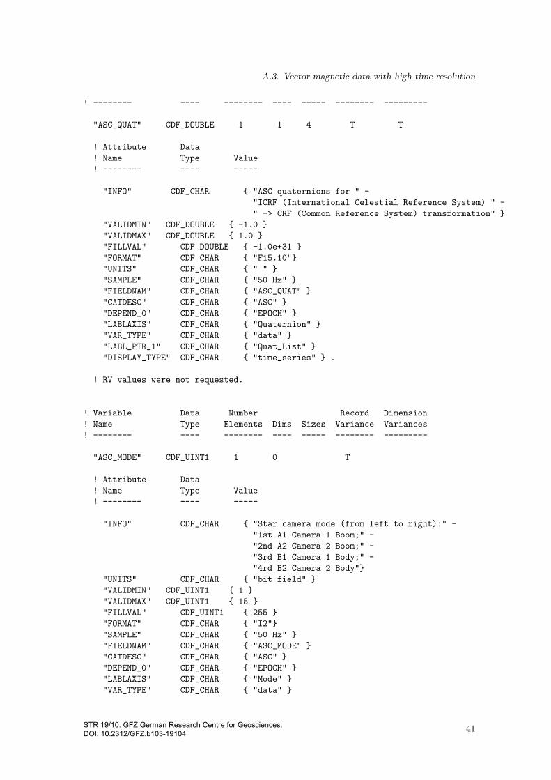
A.3. Vector magnetic data with high time resolution
! -------- ---- -------- ---- ----- -------- ---------
"ASC_QUAT" CDF_DOUBLE 1 1 4 T T
! Attribute Data
! Name Type Value
! -------- ---- -----
"INFO" CDF_CHAR { "ASC quaternions for " -
"ICRF (International Celestial Reference System) " -
" -> CRF (Common Reference System) transformation" }
"VALIDMIN" CDF_DOUBLE { -1.0 }
"VALIDMAX" CDF_DOUBLE { 1.0 }
"FILLVAL" CDF_DOUBLE { -1.0e+31 }
"FORMAT" CDF_CHAR { "F15.10"}
"UNITS" CDF_CHAR { " " }
"SAMPLE" CDF_CHAR { "50 Hz" }
"FIELDNAM" CDF_CHAR { "ASC_QUAT" }
"CATDESC" CDF_CHAR { "ASC" }
"DEPEND_0" CDF_CHAR { "EPOCH" }
"LABLAXIS" CDF_CHAR { "Quaternion" }
"VAR_TYPE" CDF_CHAR { "data" }
"LABL_PTR_1" CDF_CHAR { "Quat_List" }
"DISPLAY_TYPE" CDF_CHAR { "time_series" } .
! RV values were not requested.
! Variable Data Number Record Dimension
! Name Type Elements Dims Sizes Variance Variances
! -------- ---- -------- ---- ----- -------- ---------
"ASC_MODE" CDF_UINT1 1 0 T
! Attribute Data
! Name Type Value
! -------- ---- -----
"INFO" CDF_CHAR { "Star camera mode (from left to right):" -
"1st A1 Camera 1 Boom;" -
"2nd A2 Camera 2 Boom;" -
"3rd B1 Camera 1 Body;" -
"4rd B2 Camera 2 Body"}
"UNITS" CDF_CHAR { "bit field" }
"VALIDMIN" CDF_UINT1 { 1 }
"VALIDMAX" CDF_UINT1 { 15 }
"FILLVAL" CDF_UINT1 { 255 }
"FORMAT" CDF_CHAR { "I2"}
"SAMPLE" CDF_CHAR { "50 Hz" }
"FIELDNAM" CDF_CHAR { "ASC_MODE" }
"CATDESC" CDF_CHAR { "ASC" }
"DEPEND_0" CDF_CHAR { "EPOCH" }
"LABLAXIS" CDF_CHAR { "Mode" }
"VAR_TYPE" CDF_CHAR { "data" }
41STR 19/10. GFZ German Research Centre for Geosciences. DOI: 10.2312/GFZ.b103-19104

A. More Detailed Descriptions
"DISPLAY_TYPE" CDF_CHAR { "time_series" } .
! RV values were not requested.
! Variable Data Number Record Dimension
! Name Type Elements Dims Sizes Variance Variances
! -------- ---- -------- ---- ----- -------- ---------
"ASC_STAT" CDF_UINT4 1 0 T
! Attribute Data
! Name Type Value
! -------- ---- -----
"INFO" CDF_CHAR { "star camera quality information," -
"### 1st digit is flagging ASC source:" -
"0 = no data available," -
"2 = single data boom, chu2cr static," -
"6 = single data boom + chu2cr dynamic," -
"7 = dual data boom" -
"### 2nd digit is filtered flag: 0 = no, 1 = yes" -
"### 3rd digit is flagging chu2cr transformation mode:" -
"0 = static, 1 = dynamic, 2 = dual" -
"### 4th digit is flagging jump correction:" -
"0 = no, 1 = chu1/3, 2 = chu2/4, 3 = chu1/3 and chu2/4;" -
"### 5th digit is flagging interpolated gaps:" -
"0 = no interpolation " -
"1 = chu1/3, 2 = chu2/4, 3 = chu1/3 and chu2/4" }
"UNITS" CDF_CHAR { "integer field" }
"VALIDMIN" CDF_UINT4 { 1 }
"VALIDMAX" CDF_UINT4 { 99999 }
"FILLVAL" CDF_UINT4 { 4294967295 }
"FORMAT" CDF_CHAR { "I5"}
"SAMPLE" CDF_CHAR { "50 Hz" }
"FIELDNAM" CDF_CHAR { "ASC_STAT" }
"CATDESC" CDF_CHAR { "ASC" }
"DEPEND_0" CDF_CHAR { "EPOCH" }
"LABLAXIS" CDF_CHAR { "Status" }
"VAR_TYPE" CDF_CHAR { "data" }
"DISPLAY_TYPE" CDF_CHAR { "time_series" } .
! RV values were not requested.
! Variable Data Number Record Dimension
! Name Type Elements Dims Sizes Variance Variances
! -------- ---- -------- ---- ----- -------- ---------
"Quality_List" CDF_CHAR 10 1 2 F T
! Attribute Data
! Name Type Value
! -------- ---- -----
42STR 19/10. GFZ German Research Centre for Geosciences. DOI: 10.2312/GFZ.b103-19104

A.3. Vector magnetic data with high time resolution
"CATDESC" CDF_CHAR { "Quality_List" }
"FIELDNAM" CDF_CHAR { "Quality_List" }
"FORMAT" CDF_CHAR { "A11" }
"VAR_TYPE" CDF_CHAR { "metadata" }
"UNITS" CDF_CHAR { " " } .
! NRV values follow...
[1] = { "quality 00" }
[2] = { "quality 01" }
! Variable Data Number Record Dimension
! Name Type Elements Dims Sizes Variance Variances
! -------- ---- -------- ---- ----- -------- ---------
"B_List" CDF_CHAR 2 1 3 F T
! Attribute Data
! Name Type Value
! -------- ---- -----
"CATDESC" CDF_CHAR { "B_List" }
"FIELDNAM" CDF_CHAR { "B_List" }
"FORMAT" CDF_CHAR { "A11" }
"VAR_TYPE" CDF_CHAR { "metadata" }
"UNITS" CDF_CHAR { "nT" } .
! NRV values follow...
[1] = { "Bx" }
[2] = { "By" }
[3] = { "Bz" }
! Variable Data Number Record Dimension
! Name Type Elements Dims Sizes Variance Variances
! -------- ---- -------- ---- ----- -------- ---------
"Quat_List" CDF_CHAR 2 1 4 F T
! Attribute Data
! Name Type Value
! -------- ---- -----
"CATDESC" CDF_CHAR { "Quat_List" }
"FIELDNAM" CDF_CHAR { "Quat_List" }
"FORMAT" CDF_CHAR { "A11" }
"VAR_TYPE" CDF_CHAR { "metadata" }
"UNITS" CDF_CHAR { " " } .
43STR 19/10. GFZ German Research Centre for Geosciences. DOI: 10.2312/GFZ.b103-19104

A. More Detailed Descriptions
! NRV values follow...
[1] = { "q1" }
[2] = { "q2" }
[3] = { "q3" }
[4] = { "q4" }
#end
44STR 19/10. GFZ German Research Centre for Geosciences. DOI: 10.2312/GFZ.b103-19104

A.4. Electron density and temperatures
A.4. Electron density and temperatures
A.4.1. Name identifier
The identifier of this data type in the product file name is CH-ME-2-PLPT.
A.4.2. Description
As the file format is a mere whitespace delimited ASCII listing without a complex structure, acopy of the list-header and a brief, cutout example are sufficient as a description.
List header
# CH-ME-2-PLPT+YYYY-MM-DD_V
#
# created from : <file name> (temperature corrected)
# @ : YYYY-MM-DD by rauberg
#
# first time (UTC) : YYYY-MM-DD hh:mm:s.sss
# mjd (UTC) : <mjd2000>
# gps (gps) : <gps second, integer>
#
# end time (UTC) : YYYY-MM-DD hh:mm:s.sss
# mjd (UTC) : <mjd2000, float>
# gps (gps) : <gps second, integer>
#
#----------------------------------------------------------------------------------------
# GPS YYYY MM DD hh mm ss radius latitude longitude electron electron
# geocentr geocentr density temperature
# [s] [km] [deg] [deg] [1/cm^3] [K]
#----------------------------------------------------------------------------------------
<data>
Brief cutout example
# CH-ME-2-PLPT+2006-01-02_1.dat
#
# created from : plp_den_YYYYDDD.dat (temperature corrected)
# @ : 2012-01-27 by rauberg
#
# first time (UTC) : 2006-01-02 00:00:06.000
# mjd (UTC : 2193.0000694444
# gps (GPS) : 820195220
#
# end time (UTC) : 2006-01-02 23:59:51.000
# mjd (UTC : 2193.9998958333
# gps (GPS) : 820281605
#
#
#----------------------------------------------------------------------------------------
# GPS YYYY MM DD hh mm ss radius latitude longitude electron electron
# geocentr geocentr density temperature
# [s] [km] [deg] [deg] [1/cm^3] [K]
45STR 19/10. GFZ German Research Centre for Geosciences. DOI: 10.2312/GFZ.b103-19104
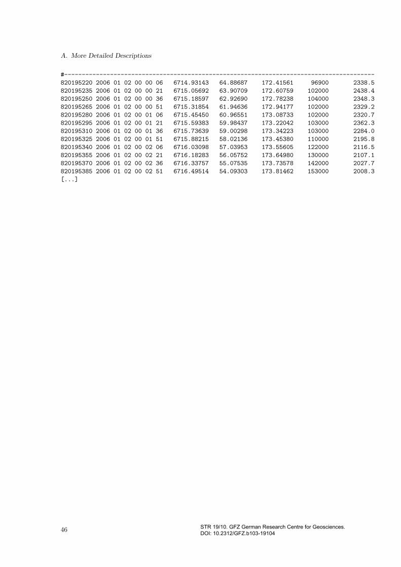
A. More Detailed Descriptions
#----------------------------------------------------------------------------------------
820195220 2006 01 02 00 00 06 6714.93143 64.88687 172.41561 96900 2338.5
820195235 2006 01 02 00 00 21 6715.05692 63.90709 172.60759 102000 2438.4
820195250 2006 01 02 00 00 36 6715.18597 62.92690 172.78238 104000 2348.3
820195265 2006 01 02 00 00 51 6715.31854 61.94636 172.94177 102000 2329.2
820195280 2006 01 02 00 01 06 6715.45450 60.96551 173.08733 102000 2320.7
820195295 2006 01 02 00 01 21 6715.59383 59.98437 173.22042 103000 2362.3
820195310 2006 01 02 00 01 36 6715.73639 59.00298 173.34223 103000 2284.0
820195325 2006 01 02 00 01 51 6715.88215 58.02136 173.45380 110000 2195.8
820195340 2006 01 02 00 02 06 6716.03098 57.03953 173.55605 122000 2116.5
820195355 2006 01 02 00 02 21 6716.18283 56.05752 173.64980 130000 2107.1
820195370 2006 01 02 00 02 36 6716.33757 55.07535 173.73578 142000 2027.7
820195385 2006 01 02 00 02 51 6716.49514 54.09303 173.81462 153000 2008.3
[...]
46 STR 19/10. GFZ German Research Centre for Geosciences. DOI: 10.2312/GFZ.b103-19104