Embed Size (px)
Citation preview
Ch 3 – Pressure, Altitude & Ch 3 – Pressure, Altitude & DensityDensity
Ch 3 – Pressure, Altitude & Ch 3 – Pressure, Altitude & DensityDensity
• IntroductionIntroduction– Pressure and its variations have Pressure and its variations have
important applications for aviation, important applications for aviation, ranging from measurements of altitude ranging from measurements of altitude and airspeed to the prediction of winds and airspeed to the prediction of winds and weather.and weather.
– This chapter focuses on several of these This chapter focuses on several of these applications.applications.
– When you complete the chapter, you will When you complete the chapter, you will have a good physical understanding of have a good physical understanding of atmospheric pressure, altimetry, and atmospheric pressure, altimetry, and density altitude (Lester, 2006).density altitude (Lester, 2006).
Ch 3 – Pressure, Altitude & Ch 3 – Pressure, Altitude & DensityDensity
• IntroductionIntroduction– You will develop important background You will develop important background
knowledge about the global patterns of knowledge about the global patterns of atmospheric pressure.atmospheric pressure.
– This information will prove useful in the This information will prove useful in the next chapter when we examine the next chapter when we examine the causes and characteristics of causes and characteristics of atmospheric winds (Lester, 2006).atmospheric winds (Lester, 2006).
Ch 3 – Pressure, Altitude & Ch 3 – Pressure, Altitude & DensityDensity
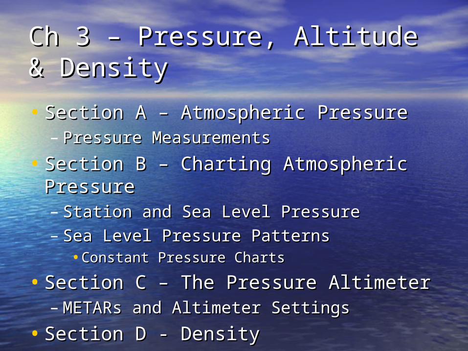
• Section A – Atmospheric PressureSection A – Atmospheric Pressure– Pressure MeasurementsPressure Measurements
• Section B – Charting Atmospheric Section B – Charting Atmospheric PressurePressure– Station and Sea Level PressureStation and Sea Level Pressure– Sea Level Pressure PatternsSea Level Pressure Patterns
•Constant Pressure ChartsConstant Pressure Charts
• Section C – The Pressure AltimeterSection C – The Pressure Altimeter– METARs and Altimeter SettingsMETARs and Altimeter Settings
• Section D - DensitySection D - Density
Ch 3 – Pressure, Altitude & Ch 3 – Pressure, Altitude & DensityDensity
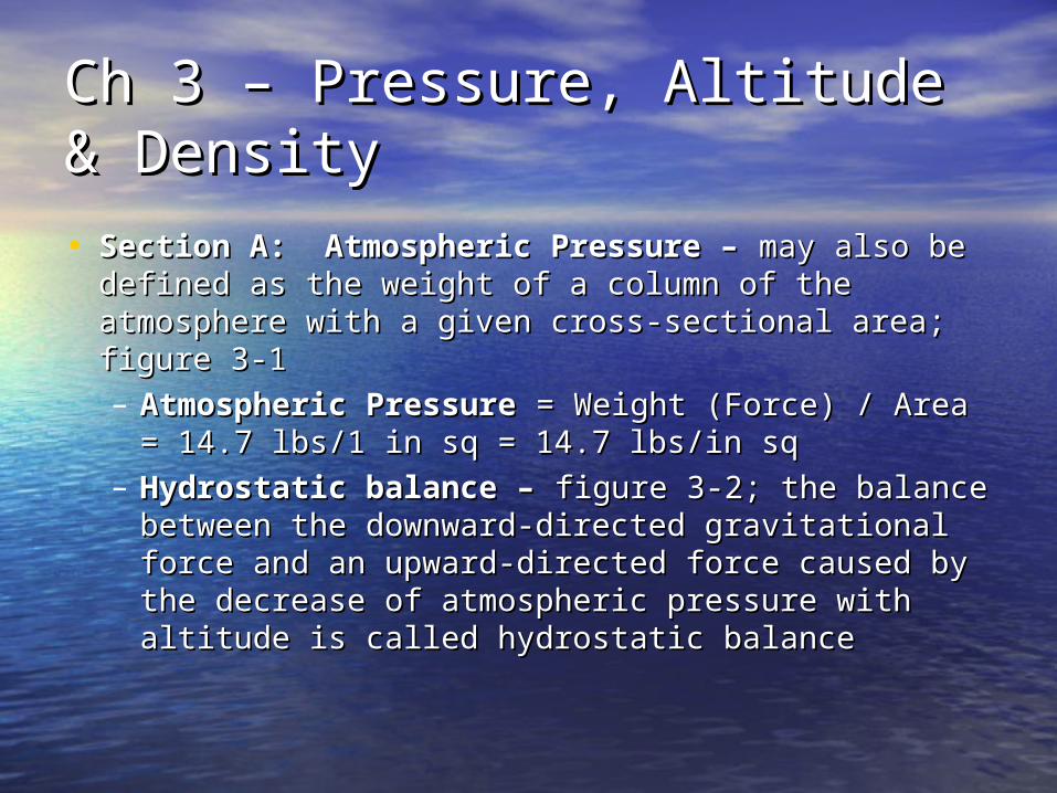
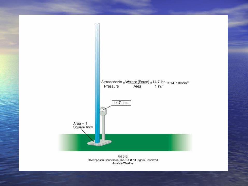
• Section A: Atmospheric Pressure – Section A: Atmospheric Pressure – may also may also be defined as the weight of a column of the be defined as the weight of a column of the atmosphere with a given cross-sectional area; atmosphere with a given cross-sectional area; figure 3-1 figure 3-1 – Atmospheric PressureAtmospheric Pressure = Weight (Force) / = Weight (Force) /
Area = 14.7 lbs/1 in sq = 14.7 lbs/in sqArea = 14.7 lbs/1 in sq = 14.7 lbs/in sq– Hydrostatic balance – Hydrostatic balance – figure 3-2; the balance figure 3-2; the balance
between the downward-directed gravitational between the downward-directed gravitational force and an upward-directed force caused by force and an upward-directed force caused by the decrease of atmospheric pressure with the decrease of atmospheric pressure with altitude is called hydrostatic balancealtitude is called hydrostatic balance
Ch 3 – Pressure, Altitude & Ch 3 – Pressure, Altitude & DensityDensity
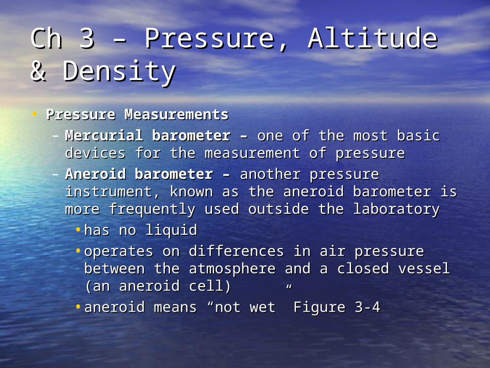
• Pressure MeasurementsPressure Measurements– Mercurial barometer – Mercurial barometer – one of the most basic one of the most basic
devices for the measurement of pressuredevices for the measurement of pressure– Aneroid barometer – Aneroid barometer – another pressure another pressure
instrument, known as the aneroid barometer is instrument, known as the aneroid barometer is more frequently used outside the laboratorymore frequently used outside the laboratory
•has no liquidhas no liquid
•operates on differences in air pressure between operates on differences in air pressure between the atmosphere and a closed vessel (an aneroid the atmosphere and a closed vessel (an aneroid cell)cell)
•aneroid means “not wet” Figure 3-4aneroid means “not wet” Figure 3-4
Ch 3 – Pressure, Altitude & Ch 3 – Pressure, Altitude & DensityDensity• Section B: Charting Atmospheric PressureSection B: Charting Atmospheric Pressure
– Station and Sea Level Pressure – Station and Sea Level Pressure – surface surface pressure measurements are most useful if they pressure measurements are most useful if they can be compared with nearby measurements can be compared with nearby measurements at the same altitudeat the same altitude•over land areas, the direct comparison of over land areas, the direct comparison of
station pressures are usually difficult station pressures are usually difficult because weather stations are often at because weather stations are often at different altitudes; Figure 3-5different altitudes; Figure 3-5
•the atmospheric pressure measured or the atmospheric pressure measured or estimated at an elevation equal to mean sea estimated at an elevation equal to mean sea levellevel
Ch 3 – Pressure, Altitude & Ch 3 – Pressure, Altitude & DensityDensity
•this extrapolated sea level pressure (station this extrapolated sea level pressure (station pressure corrected for elevation) is used by pressure corrected for elevation) is used by pilots to determine altitudepilots to determine altitude
•also used in aviation reports to depict the also used in aviation reports to depict the atmospheric pressure of a reporting locationatmospheric pressure of a reporting location
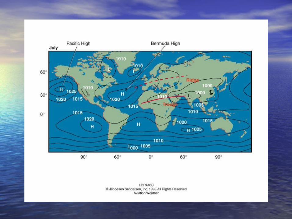
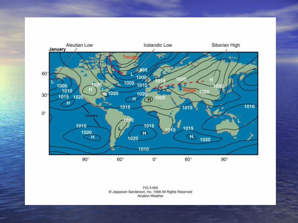
Ch 3 – Pressure, Altitude & Ch 3 – Pressure, Altitude & DensityDensity• Sea Level Pressure Patterns Sea Level Pressure Patterns
– Surface analysis charts – Surface analysis charts – a chart which a chart which shows pressure as well as other meteorological shows pressure as well as other meteorological conditions at the surface of the earthconditions at the surface of the earth•Isobars – Isobars – lines of constant pressure; figure lines of constant pressure; figure
3-63-6•High (H) High (H) – location where the sea level – location where the sea level
pressure is high compared to its pressure is high compared to its surroundingssurroundings
•Ridge – Ridge – an elongated region of relatively an elongated region of relatively high pressure high pressure

Ch 3 – Pressure, Altitude & Ch 3 – Pressure, Altitude & DensityDensity
•Low (L) – Low (L) – a roughly circular area with a a roughly circular area with a lower sea level pressure in the center as lower sea level pressure in the center as compared to the surrounding regioncompared to the surrounding region
•Trough – Trough – an elongated region of relatively an elongated region of relatively low pressure; these features are to a surface low pressure; these features are to a surface analysis chart what mountains and valleys analysis chart what mountains and valleys are to a topographical chartare to a topographical chart

Ch 3 – Pressure, Altitude & Ch 3 – Pressure, Altitude & DensityDensity
• Pressure gradient – Pressure gradient – a difference in pressure a difference in pressure over a given distanceover a given distance
• Semi-permanent pressure systems – Semi-permanent pressure systems – Bermuda High, Aleutian Low, Siberian High, Bermuda High, Aleutian Low, Siberian High, Icelandic Low, Pacific HighIcelandic Low, Pacific High
Ch 3 – Pressure, Altitude & Ch 3 – Pressure, Altitude & DensityDensity
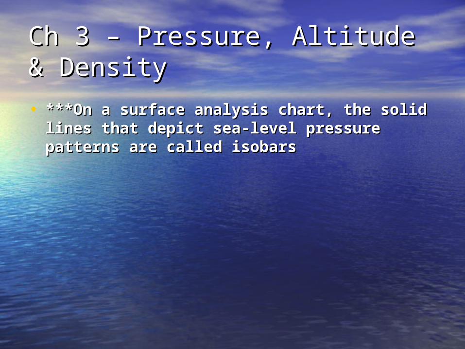
• ***On a surface analysis chart, the solid ***On a surface analysis chart, the solid lines that depict sea-level pressure patterns lines that depict sea-level pressure patterns are called isobarsare called isobars
Ch 3 – Pressure, Altitude & Ch 3 – Pressure, Altitude & DensityDensity
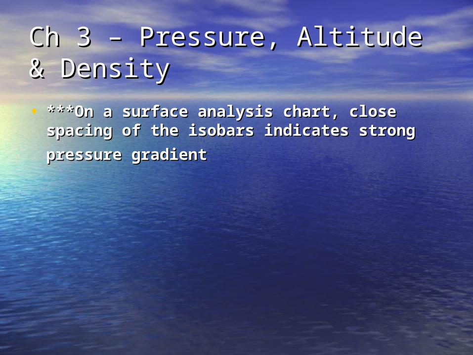
• ***On a surface analysis chart, close spacing ***On a surface analysis chart, close spacing of the isobars indicates strong pressure of the isobars indicates strong pressure
gradientgradient

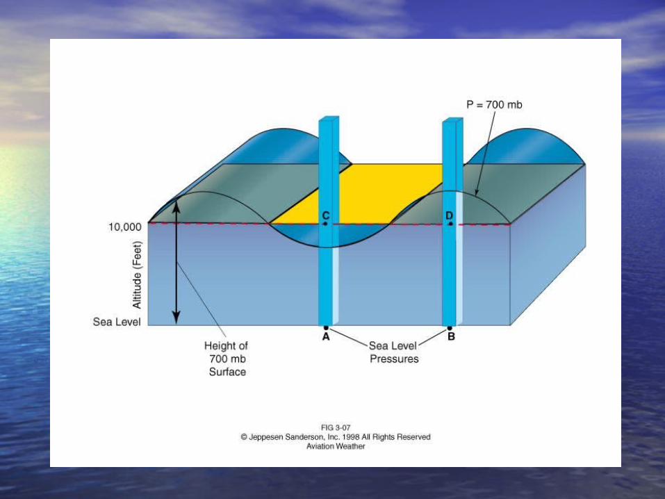
Ch 3 – Pressure, Altitude & Ch 3 – Pressure, Altitude & DensityDensity• Constant Pressure Charts – Constant Pressure Charts – a constant a constant
pressure surface is one where the pressure is the pressure surface is one where the pressure is the same at all pointssame at all points– like the ocean’s surface, a constant pressure like the ocean’s surface, a constant pressure
surface is not necessarily levelsurface is not necessarily level– many upper air weather charts that you may many upper air weather charts that you may
use are called constant pressure analysis use are called constant pressure analysis charts or simply constant pressure charts; charts or simply constant pressure charts; figure 3-7figure 3-7
– the interpretation of a constant pressure chart the interpretation of a constant pressure chart is identical with the sea level pressure chart as is identical with the sea level pressure chart as far as highs, lows, troughs, ridges and far as highs, lows, troughs, ridges and gradients are concernedgradients are concerned
Ch 3 – Pressure, Altitude & Ch 3 – Pressure, Altitude & DensityDensity
– the main difference is one of terms used to the main difference is one of terms used to describe the elementsdescribe the elements
•on constant pressure surfaces, lines of on constant pressure surfaces, lines of constant height are called contours rather constant height are called contours rather than isobarsthan isobars
•gradients are height gradients rather than gradients are height gradients rather than pressure gradients; figure 3-8pressure gradients; figure 3-8
Ch 3 – Pressure, Altitude & Ch 3 – Pressure, Altitude & DensityDensity
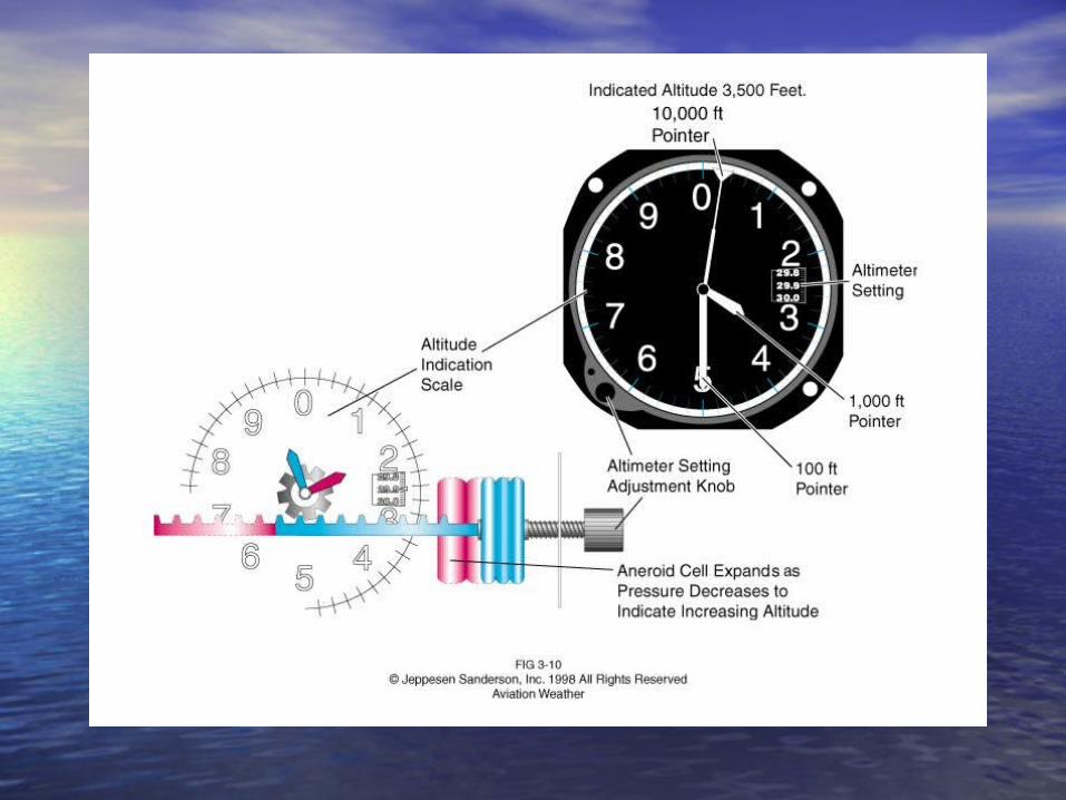
• Pressure Altitude – Pressure Altitude – the altitude of a given the altitude of a given pressure surface in the standard atmosphere; pressure surface in the standard atmosphere; figure 3-9figure 3-9– pilots can determine pressure altitude by pilots can determine pressure altitude by
setting the standard sea level pressure, 29.92 setting the standard sea level pressure, 29.92 inches Hg in the aircraft altimeterinches Hg in the aircraft altimeter
Ch 3 – Pressure, Altitude & Ch 3 – Pressure, Altitude & DensityDensity
• ***Pressure altitude is the altitude indicated ***Pressure altitude is the altitude indicated when the altimeter setting is 29.92. when the altimeter setting is 29.92. – If you set your altimeter at 29.92 and fly at 18,289 If you set your altimeter at 29.92 and fly at 18,289
feet indicated altitude, you will be flying along the feet indicated altitude, you will be flying along the 500 mb constant pressure surface500 mb constant pressure surface
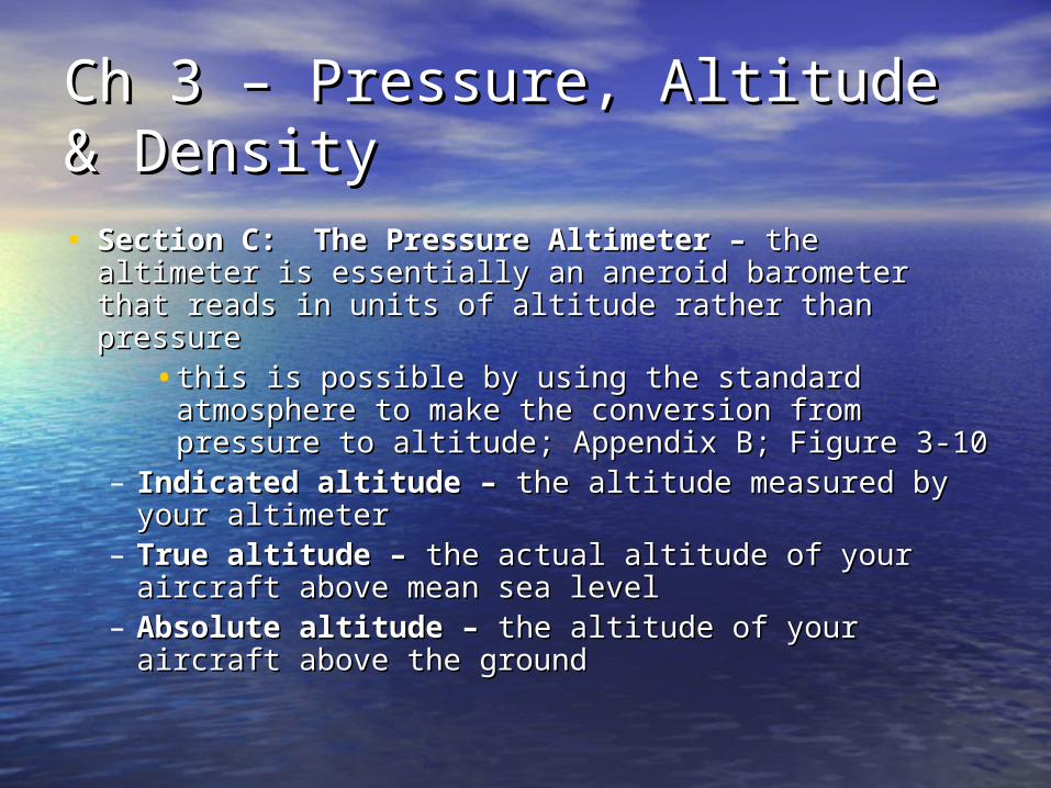
Ch 3 – Pressure, Altitude & Ch 3 – Pressure, Altitude & DensityDensity• Section C: The Pressure Altimeter – Section C: The Pressure Altimeter – the the
altimeter is essentially an aneroid barometer that altimeter is essentially an aneroid barometer that reads in units of altitude rather than pressurereads in units of altitude rather than pressure
•this is possible by using the standard this is possible by using the standard atmosphere to make the conversion from atmosphere to make the conversion from pressure to altitude; Appendix B; Figure 3-10pressure to altitude; Appendix B; Figure 3-10
– Indicated altitude – Indicated altitude – the altitude measured by the altitude measured by your altimeteryour altimeter
– True altitude – True altitude – the actual altitude of your the actual altitude of your aircraft above mean sea levelaircraft above mean sea level
– Absolute altitude – Absolute altitude – the altitude of your aircraft the altitude of your aircraft above the groundabove the ground
Ch 3 – Pressure, Altitude & Ch 3 – Pressure, Altitude & DensityDensity
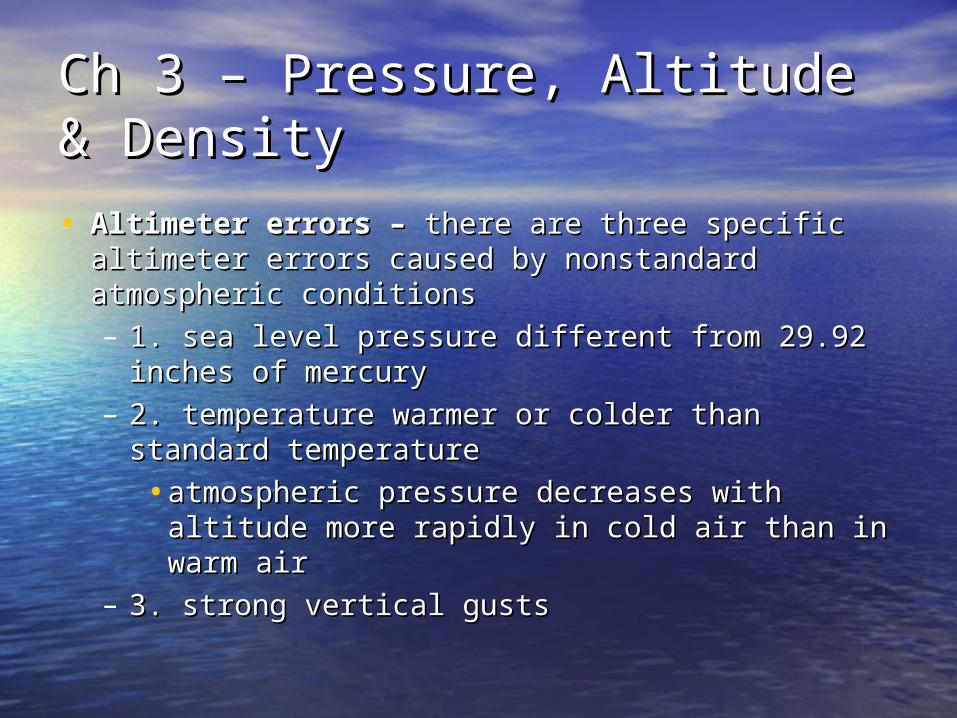
• Altimeter errors – Altimeter errors – there are three specific there are three specific altimeter errors caused by nonstandard altimeter errors caused by nonstandard atmospheric conditionsatmospheric conditions– 1. sea level pressure different from 29.92 1. sea level pressure different from 29.92
inches of mercuryinches of mercury– 2. temperature warmer or colder than standard 2. temperature warmer or colder than standard
temperaturetemperature
•atmospheric pressure decreases with altitude atmospheric pressure decreases with altitude more rapidly in cold air than in warm airmore rapidly in cold air than in warm air
– 3. strong vertical gusts3. strong vertical gusts
Ch 3 – Pressure, Altitude & Ch 3 – Pressure, Altitude & DensityDensity
• ***Altimeter setting is the value to which ***Altimeter setting is the value to which the barometric pressure scale on the the barometric pressure scale on the altimeter is set so the altitude indicates altimeter is set so the altitude indicates true altitude at field elevationtrue altitude at field elevation

Ch 3 – Pressure, Altitude & Ch 3 – Pressure, Altitude & DensityDensity
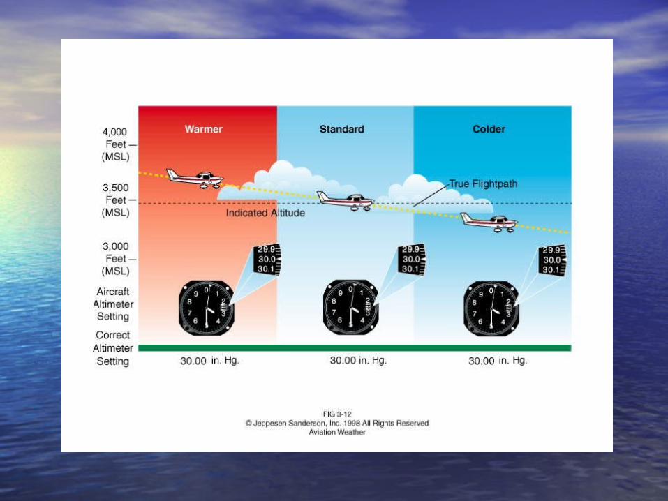
• ***On warm days pressure surfaces are ***On warm days pressure surfaces are raised and the indicated altitude is lower raised and the indicated altitude is lower than true altitudethan true altitude
Ch 3 – Pressure, Altitude & Ch 3 – Pressure, Altitude & DensityDensity
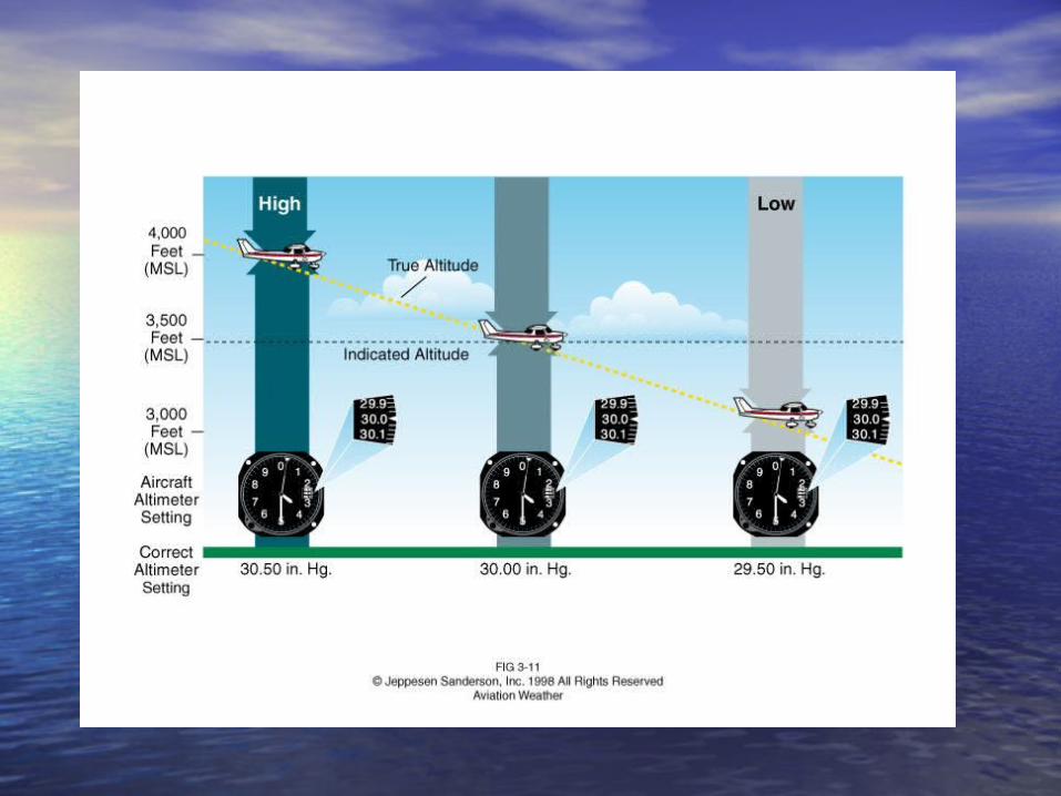
• Altimeter setting – Altimeter setting – figure 3-10; variable sea figure 3-10; variable sea level pressure is usually taken care of by level pressure is usually taken care of by adjusting the altimeter to the proper altimeter adjusting the altimeter to the proper altimeter settingsetting– this is the sea level pressure determined from this is the sea level pressure determined from
the station pressure and the standard the station pressure and the standard atmosphereatmosphere
Ch 3 – Pressure, Altitude & Ch 3 – Pressure, Altitude & DensityDensity
• METARs and Altimeter Settings METARs and Altimeter Settings – Aviation Routine Weather Report (METAR) Aviation Routine Weather Report (METAR)
– – altimeter settings for airports worldwide are altimeter settings for airports worldwide are reported and transmitted regularly with other reported and transmitted regularly with other weather information in a standard coded weather information in a standard coded formatformat
•these reports are commonly available to these reports are commonly available to pilots; figure 3-13pilots; figure 3-13
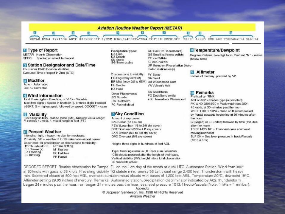
Ch 3 – Pressure, Altitude & Ch 3 – Pressure, Altitude & DensityDensity• Type of Report Type of Report
– Aviation selected special weather report Aviation selected special weather report (SPECI) – (SPECI) – the special METAR weather the special METAR weather observation is an unscheduled report indicating observation is an unscheduled report indicating a significant change in one or more elementsa significant change in one or more elements
– Station Designator and Date/Time of Station Designator and Date/Time of Report – Report – each reporting station is listed by its each reporting station is listed by its four-letter International Civil Aviation four-letter International Civil Aviation Organization (ICAO) identifierOrganization (ICAO) identifier• in the contiguous 48 states, the letter “K” in the contiguous 48 states, the letter “K”
prefixes the three-letter domestic location prefixes the three-letter domestic location identifieridentifier

Ch 3 – Pressure, Altitude & Ch 3 – Pressure, Altitude & DensityDensity• Modifier – Modifier – when a METAR is created by a totally when a METAR is created by a totally
automated weather observation station, the automated weather observation station, the modifier AUTO will follow the date/time elementmodifier AUTO will follow the date/time element– RMK A02 indicates the weather observing RMK A02 indicates the weather observing
equipment used has the capability of equipment used has the capability of distinguishing precipitation typedistinguishing precipitation type
– the modifier COR is used to indicate a the modifier COR is used to indicate a corrected METAR which replaces a previously corrected METAR which replaces a previously disseminated reportdisseminated report
– no modifier indicates a manual station or no modifier indicates a manual station or manual input at an automated stationmanual input at an automated station
Ch 3 – Pressure, Altitude & Ch 3 – Pressure, Altitude & DensityDensity
• Temperature and Dew-point – Temperature and Dew-point – the current air the current air temperature and dew-point are reported in two-temperature and dew-point are reported in two-digit form in degrees Celsius and are separated digit form in degrees Celsius and are separated by a slashby a slash
• Altimeter – Altimeter – reported in inches of mercury in a reported in inches of mercury in a four digit group without the decimal point and is four digit group without the decimal point and is prefixed by an “A”prefixed by an “A”
Ch 3 – Pressure, Altitude & Ch 3 – Pressure, Altitude & DensityDensity• Remarks – Remarks – the remarks section begins with “RMK”the remarks section begins with “RMK”
– the remark “SLP134” refers to the sea level the remark “SLP134” refers to the sea level pressure of 1013.4 hecto Pascals (hPa)pressure of 1013.4 hecto Pascals (hPa)
– the leading 9 or 10 is omittedthe leading 9 or 10 is omitted– prefix the number with a 9 or 10prefix the number with a 9 or 10
•whichever brings it closer to 1,000.0whichever brings it closer to 1,000.0– a remark such as “T00081016” refers to the a remark such as “T00081016” refers to the
temperature and dew point in tenths degrees temperature and dew point in tenths degrees CelsiusCelsius• in this example, the first zero in the sequence in this example, the first zero in the sequence
indicates a plus value for temperature (+.8C) indicates a plus value for temperature (+.8C) and the leading “one” in the sequence shows a and the leading “one” in the sequence shows a minus value for dew point (-1.6 C).minus value for dew point (-1.6 C).
Ch 3 – Pressure, Altitude & Ch 3 – Pressure, Altitude & DensityDensity
• Section D: Density – Section D: Density – aircraft performance aircraft performance depends critically on atmospheric densitydepends critically on atmospheric density
Ch 3 – Pressure, Altitude & Ch 3 – Pressure, Altitude & DensityDensity
• ***Pressure altitude and density altitude ***Pressure altitude and density altitude have the same value at standard have the same value at standard temperature in the standard atmospheretemperature in the standard atmosphere
Ch 3 – Pressure, Altitude & Ch 3 – Pressure, Altitude & DensityDensity• Density Altitude – Density Altitude – the altitude above mean sea level the altitude above mean sea level
at which a given atmospheric density occurs in the at which a given atmospheric density occurs in the standard atmospherestandard atmosphere– can be interpreted as pressure altitude corrected for can be interpreted as pressure altitude corrected for
non-standard temperature differencesnon-standard temperature differences– in warmer than standard surface conditions, you in warmer than standard surface conditions, you
would say that the density altitude is “high” that is, would say that the density altitude is “high” that is, operation of your aircraft in a high density altitude operation of your aircraft in a high density altitude condition is equivalent to taking off from a higher condition is equivalent to taking off from a higher airport during standard conditionsairport during standard conditions
– in a high density altitude situation, the actual density in a high density altitude situation, the actual density at the surface is found above the airport elevation in at the surface is found above the airport elevation in the standard atmosphere; figure 3-14 the standard atmosphere; figure 3-14
SummarySummary
• Atmospheric pressure is an essential Atmospheric pressure is an essential component of aviation weather basics.component of aviation weather basics.
• An understanding of pressure is the foundation An understanding of pressure is the foundation for understanding such diverse and important for understanding such diverse and important topics as altimetry, winds, and storms.topics as altimetry, winds, and storms.
• In this chapter, you have learned about the In this chapter, you have learned about the useful relationship between atmospheric useful relationship between atmospheric pressure and the weight of the atmosphere pressure and the weight of the atmosphere and how that relationship allows us to and how that relationship allows us to measure pressure and altitude (Lester, 2006).measure pressure and altitude (Lester, 2006).
SummarySummary
• Details about the distribution of Details about the distribution of average sea level pressure around average sea level pressure around the globe, as well as the terminology the globe, as well as the terminology and methods for the interpretation of and methods for the interpretation of atmospheric pressure charts at the atmospheric pressure charts at the surface and aloft should now be part surface and aloft should now be part of your growing knowledge of of your growing knowledge of aviation weather (Lester, 2006).aviation weather (Lester, 2006).
SummarySummary
• You have gained valuable insight into the You have gained valuable insight into the effects of atmospheric variations in effects of atmospheric variations in pressure and temperature on the accuracy pressure and temperature on the accuracy of pressure altimeter measurements.of pressure altimeter measurements.
• You have been introduced to standard You have been introduced to standard weather reports available to pilots.weather reports available to pilots.
• In particular, you have learned where to In particular, you have learned where to find locations of the reporting stations, find locations of the reporting stations, times, pressures, temperatures, and times, pressures, temperatures, and altimeter settings in those reports.altimeter settings in those reports.
SummarySummary
• Finally, you have become familiar Finally, you have become familiar with the concept of density altitude with the concept of density altitude and its impact on aircraft and its impact on aircraft performance (Lester, 2006).performance (Lester, 2006).