Embed Size (px)
Citation preview
ATSB TRANSPORT SAFETY INVESTIGATION REPORT
Aviation Occurrence Investigation – AO-2007-014
Final
VFR into IMC
83 km north-east of Broome Airport, WA
20 June 2007
VH-NRT
Cessna Aircraft Company C208 Caravan


ATSB TRANSPORT SAFETY INVESTIGATION REPORT
Aviation Occurrence Investigation AO-2007-014
Final
VFR into IMC 83 km north-east of Broome Airport, WA
20 June 2007
VH-NRT
Cessna Aircraft Company C208 Caravan
Released in accordance with section 25 of the Transport Safety Investigation Act 2003

Published by: Australian Transport Safety Bureau
Postal address: PO Box 967, Civic Square ACT 2608
Office location: 15 Mort Street, Canberra City, Australian Capital Territory
Telephone: 1800 621 372; from overseas + 61 2 6274 6440
Accident and incident notification: 1800 011 034 (24 hours)
Facsimile: 02 6247 3117; from overseas + 61 2 6247 3117
E-mail: [email protected]
Internet: www.atsb.gov.au
© Commonwealth of Australia 2008.
This work is copyright. In the interests of enhancing the value of the information contained in this
publication you may copy, download, display, print, reproduce and distribute this material in
unaltered form (retaining this notice). However, copyright in the material obtained from other
agencies, private individuals or organisations, belongs to those agencies, individuals or
organisations. Where you want to use their material you will need to contact them directly.
Subject to the provisions of the Copyright Act 1968, you must not make any other use of the
material in this publication unless you have the permission of the Australian Transport Safety
Bureau.
Please direct requests for further information or authorisation to:
Commonwealth Copyright Administration, Copyright Law Branch
Attorney-General’s Department, Robert Garran Offices, National Circuit, Barton ACT 2600
www.ag.gov.au/cca
ISBN and formal report title: see ‘Document retrieval information’ on page iii.
- ii -
DOCUMENT RETRIEVAL INFORMATION
Report No. Publication date No. of pages ISBN
AO-2007-014 1 May 2008 17 978-1-921490-16-3
Publication title
VFR into IMC – 83 km north-east of Broome Airport, WA – 20 June 2007 – VH-NRT,
Cessna Aircraft Company C208 Caravan
Prepared by Reference No.
Australian Transport Safety Bureau May2008/Infrastructure 08120
PO Box 967, Civic Square ACT 2608 Australia
www.atsb.gov.au
Acknowledgements
Figure 1: Airservices Australia
Figure 2: Bureau of Meteorology
Abstract
On 20 June 2007, at approximately 0615 Western Standard Time, a Cessna Aircraft Company C208
Caravan float plane, registered VH-NRT, departed Broome Airport, WA on a Visual Flight Rules
(VFR) charter flight to Talbot Bay. On board the aircraft were the pilot and 10 passengers.
About 35 to 40 minutes into the flight, the weather conditions deteriorated and the pilot elected to
discontinue the flight and return to Broome. During the return flight, the aircraft entered an area of
reduced in-flight visibility that resulted in the loss of the visual horizon.
Whilst manoeuvring the aircraft to regain visual meteorological conditions (VMC), the pilot became
disoriented. The pilot made a general radio broadcast requesting assistance, which was intercepted
by the crew of another aircraft who then provided advice and reassurance to the pilot. The pilot was
able to regain control of the aircraft and, shortly after, resume the remainder of the flight.
The approach to Broome required the non-instrument-rated pilot to descend through cloud before
becoming visual and landing.
This incident highlighted the risks of inadvertent flight into Instrument Meteorological Conditions
(IMC) and of the recovery from those conditions, particularly in respect of a pilot that does not hold
an instrument rating.
- iii -
THE AUSTRALIAN TRANSPORT SAFETY BUREAU
The Australian Transport Safety Bureau (ATSB) is an operationally independent
multi-modal bureau within the Australian Government Department of
Infrastructure, Transport, Regional Development and Local Government. ATSB
investigations are independent of regulatory, operator or other external bodies.
The ATSB is responsible for investigating accidents and other transport safety
matters involving civil aviation, marine and rail operations in Australia that fall
within Commonwealth jurisdiction, as well as participating in overseas
investigations involving Australian registered aircraft and ships. A primary concern
is the safety of commercial transport, with particular regard to fare-paying
passenger operations.
The ATSB performs its functions in accordance with the provisions of the
Transport Safety Investigation Act 2003 and Regulations and, where applicable,
relevant international agreements.
Purpose of safety investigations
The object of a safety investigation is to enhance safety. To reduce safety-related
risk, ATSB investigations determine and communicate the safety factors related to
the transport safety matter being investigated.
It is not the object of an investigation to determine blame or liability. However, an
investigation report must include factual material of sufficient weight to support the
analysis and findings. At all times the ATSB endeavours to balance the use of
material that could imply adverse comment with the need to properly explain what
happened, and why, in a fair and unbiased manner.
Developing safety action
Central to the ATSB’s investigation of transport safety matters is the early
identification of safety issues in the transport environment. The ATSB prefers to
encourage the relevant organisation(s) to proactively initiate safety action rather
than release formal recommendations. However, depending on the level of risk
associated with a safety issue and the extent of corrective action undertaken by the
relevant organisation, a recommendation may be issued either during or at the end
of an investigation.
The ATSB has decided that when safety recommendations are issued, they will
focus on clearly describing the safety issue of concern, rather than providing
instructions or opinions on the method of corrective action. As with equivalent
overseas organisations, the ATSB has no power to implement its recommendations.
It is a matter for the body to which an ATSB recommendation is directed (for
example the relevant regulator in consultation with industry) to assess the costs and
benefits of any particular means of addressing a safety issue.
About ATSB investigation reports: How investigation reports are organised and
definitions of terms used in ATSB reports, such as safety factor, contributing safety
factor and safety issue, are provided on the ATSB web site www.atsb.gov.au.
- iv -
FACTUAL INFORMATION
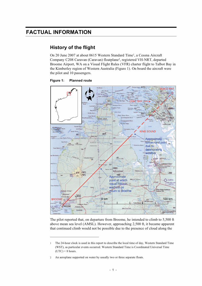
History of the flight
On 20 June 2007 at about 0615 Western Standard Time1, a Cessna Aircraft
Company C208 Caravan (Caravan) floatplane2, registered VH-NRT, departed
Broome Airport, WA on a Visual Flight Rules (VFR) charter flight to Talbot Bay in
the Kimberley region of Western Australia (Figure 1). On board the aircraft were
the pilot and 10 passengers.
Figure 1: Planned route
The pilot reported that, on departure from Broome, he intended to climb to 5,500 ft
above mean sea level (AMSL). However, approaching 2,500 ft, it became apparent
that continued climb would not be possible due to the presence of cloud along the
1 The 24-hour clock is used in this report to describe the local time of day, Western Standard Time
(WST), as particular events occurred. Western Standard Time is Coordinated Universal Time
(UTC) + 8 hours.
2 An aeroplane supported on water by usually two or three separate floats.
- 1 -
intended flight path. The pilot therefore decided to level the aircraft at about
2,500 ft and to continue towards Talbot Bay. The pilot recalled that, when about
56 km from Broome, a lower layer of cloud began to build up below the aircraft.
About 167 km from Broome (approximately 35 to 40 minutes into the flight), the
weather conditions deteriorated further with increasing cloud. The pilot reported
showers and ‘a wall of cloud’ ahead, around which he was unable to divert.
The pilot was in communication with the pilot of a second company aircraft that
was a short distance ahead, also en-route to Talbot Bay. The pilot of that aircraft
was reported to be operating at a lower altitude, and described improved weather
conditions in the vicinity of King Sound (Figure 1). The occurrence pilot was
unable to descend into those reported improved flight conditions as he was between
two layers of cloud and unable to see the ground.
Recognising that the deteriorating weather conditions were making visual flight
impractical, the pilot elected to discontinue the flight and return to Broome. The
return leg of the flight was conducted between the two layers of cloud. The lower
layer was described by the pilot as being essentially overcast at approximately
2,000 to 2,200 ft. The upper layer of cloud was reported by the pilot to have been at
approximately 2,500 ft, with observed gaps in the clouds.
The pilot recalled that, when about 83 km from Broome, the aircraft entered an area
of rain showers that reduced the visibility to the point that there was no discernible
visual horizon. In an attempt to regain visual flight conditions, the pilot commenced
a left turn, without reference to the aircraft’s instruments, to what he recalled was
an area of improved visibility. The pilot reported that, following the turn, he began
to feel disorientated and had difficulty controlling the aircraft’s roll attitude.
The pilot made a general radio broadcast on the West Kimberley Common Traffic
Advisory Frequency (CTAF) seeking assistance. That broadcast was received by
the crew of another aircraft that was approaching to land at Cone Bay,
approximately 130 km to the north-east (Figure 1). The crew discontinued their
approach at Cone Bay in order to provide assistance to the pilot of the Caravan.
The copilot of the assisting aircraft initially advised the pilot of the Caravan to
concentrate on maintaining the aircraft’s orientation using its attitude indicator3.
After confirming that the Caravan pilot was maintaining the aircraft’s attitude with
reference to its instruments, the assisting copilot coached the pilot to set cruise
power, and to maintain level flight with reference to the vertical speed indicator4.
The crew of the assisting aircraft reported that, about 5 minutes after the initial
radio contact, ‘the pilot of the aircraft sounded less stressed and advised us he was
in level flight’. On request from the crew of the assisting aircraft, the pilot of the
Caravan advised that ‘he was 15 NM [28 km] north-east of Broome and at an
altitude of A028 [2,800 ft]’. The pilot of the Caravan subsequently advised that he
was continuing to Broome, that he required no further assistance and that he was
commencing a descent for a short period of time in an attempt to regain visual flight
conditions.
3 An attitude indicator, also known as an artificial horizon, uses a gyroscope to display an aircraft’s
orientation relative to the earth.
4 A vertical speed indicator detects the rate of change of static air pressure to provide an indication
of the rate of climb or descent of an aircraft, in feet per minute.
- 2 -
Broome
Talbot Bay
Surface trough
The descent was commenced from above the Broome 25 NM (46 km) minimum
sector altitude (MSA)5 of 2,200 ft, although the pilot stated that he was not aware of
the lowest safe altitude (LSALT)6 applicable to his location at that time. The pilot
indicated that he was using a Global Positioning System (GPS) moving map display
to provide an indication of the surrounding terrain.
During the descent, the pilot contacted Broome Radio (see Aerodrome information
discussion on page 5) and advised them of the incident and requested that they
monitor his return to Broome. A short time later, the aircraft descended clear of
cloud at an undetermined altitude, and the pilot was able to regain sight of the
ground.
The pilot reported landing at Broome at about 0730.
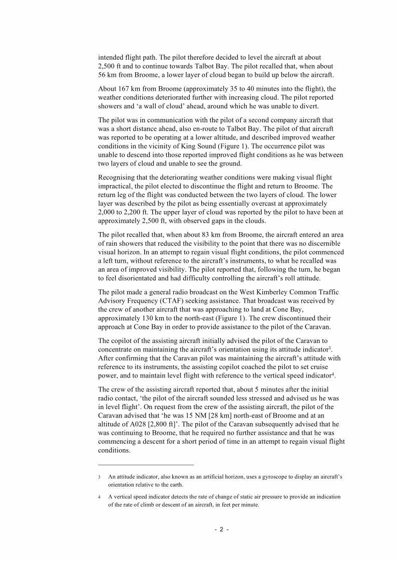
Meteorological information
The Bureau of Meteorology (BoM) advised that, at the time of the incident, a
surface trough that was orientated north-west to south-east was located about
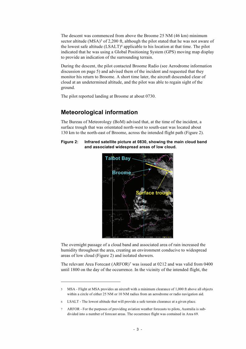
130 km to the north-east of Broome, across the intended flight path (Figure 2).
Figure 2: Infrared satellite picture at 0830, showing the main cloud band
and associated widespread areas of low cloud.
The overnight passage of a cloud band and associated area of rain increased the
humidity throughout the area, creating an environment conducive to widespread
areas of low cloud (Figure 2) and isolated showers.
The relevant Area Forecast (ARFOR)7 was issued at 0212 and was valid from 0400
until 1800 on the day of the occurrence. In the vicinity of the intended flight, the
5 MSA - Flight at MSA provides an aircraft with a minimum clearance of 1,000 ft above all objects
within a circle of either 25 NM or 10 NM radius from an aerodrome or radio navigation aid.
6 LSALT - The lowest altitude that will provide a safe terrain clearance at a given place.
7 ARFOR - For the purposes of providing aviation weather forecasts to pilots, Australia is sub-
divided into a number of forecast areas. The occurrence flight was contained in Area 69.
- 3 -

forecast indicated areas8 of precipitation and broken9 stratiform cloud with a base of
800 to 1,000 ft and extending up to 3,000 ft. Cumuliform cloud was forecast above
that layer of cloud, with tops up to 15,000 ft. Forecast visibility was 3,000 m in
showers and 2,000 m in rain.
A subsequent BoM analysis of the available weather data from the area indicated
that the cloud base was likely to have been as initially forecast.
The relevant Terminal Area Forecast10 (TAF) for Broome was issued at 0003 and
was valid from 0000 until 2000 on the day of the occurrence. The TAF indicated
scattered cloud at 1,200 ft, broken cloud at 2,000 ft and visibility in excess of
10 km. From 0900, conditions were forecast to improve with broken cloud at
2,500 ft. No precipitation was forecast.
An updated TAF, issued at the approximate departure time of the flight, forecast
broken cloud at 2,500 ft from 0800. The pilot was unable to access that updated
TAF prior to departure.
Data produced by the Broome automatic weather station (AWS)11 during the flight
included:
• a METAR12 that was issued at 0600 and indicated no significant cloud
• a SPECI13 that was issued at 0630 (about 15 minutes after the flight departed
Broome) and indicated that there was broken cloud at 1,400 ft
• a second SPECI that was issued at 0700, and indicated overcast cloud at 1,400 ft
• a METAR that was issued at 0800, indicating scattered cloud at 1,400 ft and
broken cloud at 6,500 ft.
The pilot reported that he obtained the relevant meteorological data, including the
0212 ARFOR, prior to commencing the flight. He stated that the forecast conditions
8 A subjective term that is used by BoM forecasters to indicate the presence of significant weather.
Those ‘areas’ are of no defined dimension.
9 Broken meaning 5 to 7 oktas. An okta is the unit of measurement that is used to report the total
sky area that is visible to the celestial horizon. One okta is equal to 1/8th of that visible sky area.
The term okta is also used to forecast or report the amount of cloud in an area, along a route or at
an airfield. The numbers of oktas of cloud are reported or forecast as follows: Few (FEW),
meaning 1 to 2 oktas; Scattered (SCT), meaning 3 to 4 oktas; Broken (BKN), meaning 5 to 7
oktas, and Overcast (OVC), meaning 8 oktas.
10 TAF - A statement of the meteorological conditions expected for a specified period in the airspace
within a 5NM radius of the centre of a runway complex. Cloud heights are given above the
aerodrome elevation.
11 AWS - Electronic recording device at prescribed locations that automatically takes observations of
a number of actual meteorological conditions including, in the case of an advanced AWS (such as
located at Broome Airport): wind direction and speed, temperature, humidity, cloud and visibility.
12 Routine observation reports of the meteorological conditions at specified locations. METARS are
issued at fixed times, hourly or half-hourly and made available as part of a pilot’s pre-flight
briefing, or on request to an aircraft in flight.
13 Special reports of meteorological conditions at aerodromes issued whenever weather conditions
fluctuate about or below specified criteria.
- 4 -
were similar to those experienced on the previous day, when he had successfully
completed the same flight to Talbot Bay and return.
The chief pilot and the crew of the assisting aircraft all described the weather
conditions at the time of the incident, and in the preceding days, as worse than the
fine conditions that generally prevailed in the Kimberley region during the dry
season.
Aerodrome information
Within the prescribed hours of operation, Broome Airport includes the provision of
an Automatic Aerodrome Information Service (AAIS) Certified Air/Ground Radio
Service (CA/GRS). In addition, ‘Broome Radio’ provided a CA/GRS on
126.0 MHz. The pilot’s arrival at Broome was within the prescribed hours of
operation.
A CA/GRS is an aerodrome-based radio information service that enhances aircraft
safety by providing pilots with operational information at a particular aerodrome.
Notwithstanding, pilots retain authority and responsibility for the application of any
information received from a CA/GRS.
The information provided by a CA/GRS can include:
• known relevant traffic in the vicinity of, and manoeuvring on the aerodrome
• local operational information relevant to the safety of operations
• weather conditions and operational information including:
– wind direction and speed
– aerodrome QNH
– estimated cloud base, visibility and present weather.
This information is broadcast on a discrete AAIS radio frequency, the weather
information being derived from approved measuring equipment. The Broome AAIS
was available on frequency 126.55 MHz.
There was no evidence that the pilot accessed the information available on the
AAIS.
Operational information
Pilot and operator information
The pilot held a Commercial Pilot (Aeroplane) Licence and a valid Class 1 Medical
Certificate issued by the Civil Aviation Safety Authority (CASA). He was
employed as a pilot on a seasonal basis, and remunerated according to the number
of hours that he flew.
The pilot had accumulated 1,665.2 hours total flying experience, of which
629.4 hours were on type. He did not hold an Instrument Rating or a Night VFR
Rating.
The pilot reported that his total instrument flying experience was 10.5 hours gained
while training for his private and commercial pilot licences. His most recent
- 5 -

instrument flying was of 0.2 hours duration as part of a flight review in March
2005.
The chief pilot reported that the operation was conducted solely under the VFR and,
due to the seasonal nature of the operation, predominantly in fine weather. As such,
company line checks did not include training in recovery from inadvertent entry
into Instrument Meteorological Conditions (IMC)14. Localised weather effects,
including the possibility of reduced visibility due to widespread smoke, were
emphasised by the chief pilot during pilots’ induction training.
Similarly, the operator’s operations manual provided limited guidance to assist
pilots’ in their weather-related decision-making, and did not specify any recovery
procedures in the event of inadvertent entry into IMC.
Relevant Visual Meteorological Conditions criteria
Flight under the VFR requires specified minimum conditions of visibility and
distance from cloud that are collectively known as Visual Meteorological
Conditions (VMC). The variables that can affect those specified conditions include:
the class of airspace in which a flight is undertaken, the height of that flight and the
type of aircraft.
Flight at the originally intended altitude of 5,500 ft would have required the
following VMC criteria:
• a minimum flight visibility of 5,000 m
• the flight to have been conducted 1,000 ft vertically and 1,500 m horizontally
from any cloud.
The pilot’s flight at the amended altitude of about 2,500 ft required the following
VMC criteria:
• minimum flight visibility of 5,000 m
• flight to be conducted clear of cloud and in sight of the ground or water.
VFR flight on top of more than scattered cloud
In relation to VFR flight on top of more than scattered cloud, Aeronautical
Information Publication (AIP) ENR 1.1 – Navigation Requirements included the
following notes:
• Paragraph 19.2.1b.
Flight above more than SCT cloud, or over featureless land areas, or over the
sea, may preclude visual position fixing at the required intervals and may
therefore make visual navigation impracticable.
• Note 3 to, paragraph 19.2.1g.
14 IMC. Conditions in terms of visibility and distance from cloud that are less than the minima for
flight under the VFR.
- 6 -

Pilots should not initiate VFR flight on top of more than SCT cloud when
weather conditions are marginal. Before committing to operate VFR flight on
top of more than SCT cloud, pilots should be confident that meteorological
information used is reliable and current and clearly indicates that the entire
flight will be able to be conducted in VMC.
In addition, the navigation requirements of AIP ENR 1.1 paragraph 19.2 for flight
above more than SCT cloud included that a pilot that was not qualified15 to navigate
by the use of radio navigation systems must navigate by visual reference to the
ground or water. AIP GEN 1.5 paragraph 8.5.4.1(a). allowed the use of GPS ‘to
supplement map reading and other visual navigation techniques.’ The term
‘supplement’ did not absolve the pilot from the VFR navigation requirements of
AIP ENR 1.1 paragraph 19.2.1.
Weather-related decision-making
There has been extensive research into pilot weather-related decision-making. That
research was most recently reviewed during the Australian Transport Safety Bureau
(ATSB) investigation into the VFR into IMC occurrence that occurred 76 km north
of Brisbane, Qld on 11 October 2005 and involved a Kawasaki Heavy Industries
BK117 B-2 helicopter, registration VH-BKS (investigation report BO/200505107,
available at www.atsb.gov.au).
Pilots can increase their understanding of weather-related decision-making, and
potentially reduce the incidence of VFR into IMC events, via the CASA-produced
DVD VFR into IMC - Weather to Fly (available at www.casa.gov.au).
Additional information
Spatial disorientation
In order to correctly sense the orientation of the body relative to its environment,
information is processed from the:
• eyes (Visual system)
• inner ear (Vestibular system)
• skin, muscles, joints and tendons (Proprioceptive system).
Spatial disorientation results when the brain receives conflicting or ambiguous
information from those sensory systems. The resulting state of confusion is
dangerous for a pilot, as it can lead to incorrect control inputs and the resultant loss
of aircraft control.
A more in-depth examination of spatial disorientation as a factor in aviation
occurrences can be found in the ATSB aviation research and analysis report
B2007/0063 An overview of spatial disorientation as a factor in aviation accidents
and incidents (available at www.atsb.gov.au).
15 Meaning the holder of an instrument or night VFR rating.
- 7 -
VFR flight into IMC
The risks associated with VFR flight into IMC have been discussed previously in a
number of ATSB safety investigation and research reports, including
BO/200304282, BO/200505107 and B2005/0127. The consequences of that event
include that 76% of VFR into IMC accidents result in fatalities.
In addition, VFR flight into IMC has been identified by CASA as a critical factor in
many incidents. In response, CASA has attempted to educate pilots of the
associated risks via its Flight Safety Australia magazine, and examined those risks
as part of its recent Crash Scene Investigator workshops.
- 8 -
ANALYSIS
This incident highlights the risks of inadvertent flight into Instrument
Meteorological Conditions (IMC) and of the recovery from those conditions,
particularly in respect of a pilot that does not hold an instrument rating. The
following discussion examines the factors that contributed to the development of
the incident.
Weather-related decision-making
Prior to departure, the available Terminal Area Forecast (TAF) and observed
weather at Broome indicated that the weather in the vicinity of the aerodrome was
suitable for the visual departure and, if required, a landing. However, the special
weather report that was issued 15 minutes after the pilot’s departure from Broome,
and to which the pilot did not have ready access, indicated that those weather
conditions had deteriorated since that time.
The observed build-up of cloud as the flight progressed was consistent with the area
forecast, and alerted the pilot to the risk of his not being able to maintain Visual
Meteorological Conditions (VMC) as he climbed to his planned cruise altitude of
5,500 ft. The pilot’s decision to amend his departure and cruise altitudes was
intended to reduce that risk.
The difficulty experienced by the pilot flying between the two layers of cloud, and
inability of the pilot to descend due to extensive cloud cover, was reflective of the
forecast weather. Ultimately, by the time that the pilot elected to return to Broome,
his inability to see the ground meant that he was not in VMC, and could not satisfy
the requirements for navigation under the Visual Flight Rules (VFR).
As a result of the generally fine conditions that prevailed in the Kimberley region
during the dry season, the pilot had limited recent exposure to weather-related
operational decision-making. Similarly, the limited weather-related
decision-making guidance provided in the operator’s operations manual most likely
increased the difficulty faced by the pilot during the preparation for, and conduct of
the flight.
It could be expected that remotely-based pilots facing circumstances similar to
those experienced in this occurrence would benefit from the periodic review of the
Civil Aviation Safety Authority (CASA)-produced DVD VFR into IMC - Weather
to Fly.
Recovery from inadvertent entry into IMC
The conditions affecting the pilot’s return to Broome resulted in flight by the pilot
in weather conditions that were less than VMC and for which the pilot was not
qualified. The pilot’s attempts to manoeuvre the aircraft with limited or no visual
cues contributed to his disorientation and resulting difficulty controlling the aircraft,
with potentially severe consequences.
The pilot’s decision to request assistance, and the ability of the flight crew of the
aircraft at Cone Bay to provide appropriate input and guidance, helped resolve the
pilot’s disorientation and allowed him to continue the return to Broome. That
- 9 -

interaction indicated the application of sound crew resource management (CRM) on
the part of all concerned.
The descent on approach to Broome was made with no consideration by the pilot of
the potential utility of the relevant Broome safety heights, or of the operational
information available from the Broome Automatic Aerodrome Information Service
(AAIS) Certified Air/Ground Radio Service (CA/GRS). In that case, the pilot may
have unwittingly restricted the availability of other more appropriate options for the
approach and landing. The result was an elevated risk of collision with terrain.
The inclusion of recovery options in the operator’s operations manual, for
application in the event of inadvertent entry into IMC, may have influenced the
pilot’s actions in those circumstances.
- 10 -
FINDINGS
From the evidence available, the following findings are made with respect to the
Visual Flight Rules (VFR) flight into Instrument Meteorological Conditions (IMC)
that occurred 83 km north-east of Broome Airport, WA on 20 June 2007 and
involved Cessna Aircraft Company C208 Caravan, registration VH-NRT. They
should not be read as apportioning blame or liability to any particular organisation
or individual.
Contributing safety factor
• The aircraft was flown into conditions that deteriorated below Visual
Meteorological Conditions (VMC) and for which the pilot was not qualified.
Other safety factors
• The pilot manoeuvred the aircraft in weather conditions that were conducive to
pilot disorientation.
• The pilot descended the aircraft in IMC without consideration of the relevant
Broome safety heights.
• The company operations manual provided limited guidance to assist pilots in
their weather-related decision-making during the preparation for, and conduct of
flights. (Safety issue)
• The company operations manual did not specify any recovery procedures in the
event of inadvertent entry into IMC. (Safety issue)
Other key finding
• The pilot’s decision to seek assistance contributed to the resolution of the
disorientation experienced, and indicated the application of sound crew resource
management (CRM).
- 11 -

SAFETY ACTION
The safety issues identified during this investigation are listed in the Findings and
Safety Actions sections of this report. The Australian Transport Safety Bureau
(ATSB) expects that all safety issues identified by the investigation should be
addressed by the relevant organisation(s). In addressing those issues, the ATSB
prefers to encourage relevant organisation(s) to proactively initiate safety action,
rather than to issue formal safety recommendations or safety advisory notices.
All of the responsible organisations for the safety issues identified during this
investigation were given a draft report and invited to provide submissions. As part
of that process, each organisation was asked to communicate what safety actions, if
any, they had carried out or were planning to carry out in relation to each safety
issue relevant to their organisation.
Australian Transport Safety Bureau
Weather-related decision-making
Safety issue
The company operations manual provided limited guidance to assist pilots in their
weather-related decision-making during the preparation for, and conduct of flights.
Operator comment
During the investigation and its consideration of the draft report, the operator
indicated that it would consider the development of procedures that would support
pilots’ weather-related decision-making during the preparation for, and conduct of
flights. The indication was that that guidance would be included in its operator’s
operations manual.
ATSB comment
The ATSB made a number of attempts to obtain confirmation of any safety action
taken by the operator in response to this safety issue. However, due to
circumstances beyond the operator’s control, the operator has, as yet, been unable
to respond.
This investigation report could be expected to prove relevant to a number of other
operators and to pilots in general. That relevance is timely, given the approach of
winter and the accompanying weather patterns in a large part of Australia. On that
basis, it was decided to progress the release of the final report to the public, rather
than delaying the release pending the operator’s input.
A safety risk analysis was carried out by the ATSB and, on that basis, it was
determined that safety action would be sought by the operator via the following
safety recommendation.
- 12 -
ATSB safety recommendation AO-2007-014-SR-029
The Australian Transport Safety Bureau recommends that the operator address this
safety issue.
Recovery from inadvertent entry into Instrument Meteorological Conditions
Safety Issue
The company operations manual did not specify any recovery procedures in the
event of inadvertent entry into Instrument Meteorological Conditions (IMC).
Operator comment
During the investigation and consideration of the draft report, the operator indicated
that it would develop procedures for application by pilots in the event of inadvertent
entry into IMC for inclusion in its operations manual. The operator suggested that
those procedures would be incorporated into existing emergency training, and
would include the initial requirement to control the aircraft and options for recovery
to Visual Meteorological Conditions (VMC).
ATSB comment
The ATSB made a number of attempts to obtain confirmation of any safety action
taken by the operator in response to this safety issue. However, due to
circumstances beyond the operator’s control, the operator has, as yet, been unable
to respond.
This investigation report could be expected to prove relevant to a number of other
operators and to pilots in general. That relevance is timely, given the approach of
winter and the accompanying weather patterns in a large part of Australia. On that
basis, it was decided to progress the release of the final report to the public, rather
than delaying the release pending the operator’s input.
A safety risk analysis was carried out by the ATSB and, on that basis, it was
determined that safety action would be sought by the operator via the following
safety recommendation.
ATSB safety recommendation AO-2007-014-SR-030
The Australian Transport Safety Bureau recommends that the operator address this
safety issue.
- 13 -

![Cessna Aircraft Company C208 Caravan€¦ · On request from the crew of the assisting aircraft, the pilot of the Caravan advised that ‘he was 15 NM [28 km] north-east of Broome](https://img.pdfslide.us/doc/110x75/5fade945b7e96c2e1870a762/cessna-aircraft-company-c208-on-request-from-the-crew-of-the-assisting-aircraft.jpg)