Embed Size (px)
Citation preview

March 2017
cedarrivercis_projectsummarysheets_051517 i
Cedar River Capital Investment Strategy Report
Project Summary Sheets
CONTENTS
C. State Route 169 Flood Reduction Feasibility Study ...................................................................................... 3
D. Maplewood Neighborhood Improvements .................................................................................................... 5
E. Lower Jones Road Neighborhood Improvements ......................................................................................... 8
F. Herzman Levee Setback and Trail Stabilization ............................................................................................ 11
G. Jan Road Neighborhood Improvements ........................................................................................................ 14
H. 1. Lower Cedar River Flood Risk Reduction Feasibility Study ................................................................. 17
H. 2. Renton Levee Certification Improvements ................................................................................................ 20
I. Cedar River Trail Site A Bank Stabilization ....................................................................................................... 22
J. Strategic Acquisitions to Support Future Projects ........................................................................................ 24
K. Residential Flood Hazard Mitigation ................................................................................................................ 26
L & M. Byers Road Neighborhood Improvements ........................................................................................... 28
N. Rhode and Getchman Neighborhood Improvements .............................................................................. 31
O. Rafter’s Park – Doris Creek Neighborhood Improvements ..................................................................... 35
P. Dorre Don Neighborhood Improvements ...................................................................................................... 39
Q. Elliott Bridge Reach Neighborhood Improvements ................................................................................... 43
R & S. Arcadia Reach Neighborhood Improvements ...................................................................................... 47
T. Lower Cedar River Maintenance Dredging Project – Future .................................................................... 49
U. Orchard Grove Neighborhood Improvements ............................................................................................. 51
V. SE Bain Road Neighborhood Improvements ................................................................................................ 54


March 2017
Cedar River Corridor Capital Investment Strategy Report—Project Summary Sheets 3
C. State Route 169 Flood Reduction Feasibility Study
Problem Location
SR 169 between RM 11.0 and RM 11.3.
Problem Statement
During moderate to larger flood events, local drainage combined with high river stages, causes
inundation of SR 169 near the intersection of Cedar Grove Road SE, forcing closure of SR 169. In
addition, numerous residences along the flooded portion of the highway become isolated.
Site Context
This segment of SR 169 runs along the left bank of the river, and is situated in a localized low
point, extending for a distance of approximately 0.25 miles to the northwest from the
intersection with Cedar Grove Road SE. The Cedar River Trail (CRT) is located between the
highway and the river, and is elevated above the roadway. The CRT6 Revetment is coincident
with the trail prism in this area. An unnamed stream conveys local hillside drainage from the
southwest into a roadside ditch located within the Washington State Department of
Transportation (WSDOT) right-of-way, and eventually flows into the river via culverts through
the trail prism and the CRT6 Revetment. Numerous residential driveways on the south side of
SR 169 are accessed directly from this section of highway.
Flood and Erosion Risk
Although this portion of the highway and adjacent neighborhood is not necessarily subject to
river flooding, as the revetment provides freeboard during the 100-year return period flood
March 2017
4 Cedar River Corridor Capital Investment Strategy Report—Project Summary Sheets
event, conveyance of local drainage to the river may be limited by the inadequacy of the
existing drainage system, causing a ponding condition on the landward side of the trail. High
water surface elevations in the river exacerbate the flooding conditions on the road. Inundation
is significant enough to require closure of SR 169, even at modest river flood flows. Closure of
this major transportation corridor disrupts both local and economically-significant regional
traffic.
Risk Reduction Proposals
It is recommended that a feasibility study be conducted to better understand the mechanism of
flooding and evaluate flood risk reduction opportunities for the highway and adjacent
neighborhood, and the potential offsite effects of them. Opportunities include, but are not
limited to, elevating SR 169, upgrading the local drainage infrastructure, and/or installing
backflow prevention gates. Coordination with WSDOT will be required in developing, assessing,
and implementing potential solutions.
Potential Project Benefits - Depending on Alternative(s) Selected
Reduce the frequency and duration of closures of SR 169
Reduce isolation of residents during flood events
Cost Estimate
The cost for the feasibility study is estimated to be $260K. The study costs would be paid for
with Flood Control District (FCD) funds. Future project implementation resulting from this study
may be cost shared with WSDOT.
Implementation Considerations
There is an opportunity to leverage funding for this project through coordination with WSDOT.
The unnamed stream system is fish-bearing, which will have to be a consideration when
developing alternative solutions.
Sequencing Considerations
This project is a high priority for near-term (6-year) action due to the fact that SR 169 is the
primary east-west transportation corridor for Cedar River valley residents.

March 2017
Cedar River Corridor Capital Investment Strategy Report—Project Summary Sheets 5
D. Maplewood Neighborhood Improvements
Problem Location
Right bank of the river between RM 3.5 and RM 4.25.
Problem Statement
On the right bank, there are 31 homes located within the severe channel migration hazard area
and an additional 7 homes located within the moderate channel migration hazard area. While
most of the neighborhood is on higher ground out of the 100-year floodplain, approximately
65 homes could be surrounded by floodwater during a 100-year flood. These flooding and
channel migration risks could be significantly increased if a landslide were to occur on the left
bank slope on the opposite side of the river of the Maplewood neighborhood.
Site Context
This is a densely populated neighborhood in the right bank floodplain. Most of the homes are
located on higher ground. At the upstream end, the Erickson Levee provides protection for
homes on the right bank but does not tie into high ground at either end. The Person Revetment
lines the base of a steep slope on the opposite bank, helping reduce erosion and undercutting,
but not completely prohibiting the potential for landsliding from above. Several privately owned
revetments line the right bank, most of which are generally not in solid structural condition.
Flood and Erosion Risk
The steep slope on the left bank between RM 3.5 and RM 4.1 exhibits historical evidence of
landslide activity and therefore has been identified as a potential landslide hazard area.
Reactivation of a historical deep-seated slide could deposit debris into the river, and cause the

March 2017
6 Cedar River Corridor Capital Investment Strategy Report—Project Summary Sheets
river to back up, which could push flows into the neighborhood. However, the potential for
landsliding is unknown. Flood modeling shows the river could overtop the bank at the upstream
end of the neighborhood, due to extreme flooding (greater than 50-year), which could be made
worse if a landslide were to block the channel. Overbank flows would follow a low-lying flow path
through the right bank neighborhood, inundating multiple roadways, flooding homes, and
isolating residents.
Flood Event
Flooding Risks Erosion Risks
Number of
People with
Flooding Above
Finished Floor
Number of
People with
Floodwater
Surrounding
Occupied
Structures
Number of
People Isolated
Due to Roadway
Inundation
Number of
People in
Moderate or
Severe Channel
Migration Hazard
Area
Length of Roads
in Moderate or
Severe Channel
Migration Hazard
Area (feet)
20-year 0 0 0 94 1,365
100-year 7 99 0
Risk Reduction Proposals
It is recommended that a site-specific, detailed landslide risk assessment study be conducted
along the left bank valley wall between RM 3.5 and RM 4.1. Additionally, it is recommended that
a feasibility study be conducted to determine if modifications to the Erickson Levee can mitigate
flood risks in the right bank floodplain of the Maplewood neighborhood.
Potential Project Benefits - Depending on Alternative(s) Selected
Define landslide-related risks, which have been of concern for years
Future project based on study results could reduce frequency and extent of overbank
inundation in right bank neighborhood
Cost Estimate
The cost of the landslide risk assessment study is estimated to be $330K. The cost of the
feasibility study focused on the Erickson Levee is estimated to be $110K.
Implementation Considerations
Raising or extending the Erickson Levee would encroach on the yards of several homes and
would require several easements or full or partial acquisitions. If a study indicates there is
notable risk of landslide-related flooding, subsequent work would be needed to define potential
mitigating actions. Project elements resulting from the study which protect or enhance habitat
or recreational opportunities and amenities could leverage funding, streamline permitting,
garner stakeholder support, and help achieve regional multi-objective goals.
Sequencing Considerations
Both the landslide risk assessment study and the feasibility study should be considered for
either near-term (6-year) or medium-term action depending on the funding available. The

March 2017
Cedar River Corridor Capital Investment Strategy Report—Project Summary Sheets 7
results of the landslide risk assessment study will inform the feasibility study of the Erickson
Levee.

March 2017
8 Cedar River Corridor Capital Investment Strategy Report—Project Summary Sheets
E. Lower Jones Road Neighborhood Improvements
Problem Location
Left and right bank from RM 5.7 to RM 6.2.
Problem Statement
Homes along SE Jones Road are highly flood-prone and are in the severe channel migration
hazard area. Revetments protecting infrastructure on both left and right banks are over-
steepened and at risk of damage or failure. SE Jones Road is inundated at low to moderate flood
levels, cutting off access to homes and the Cedar River Montessori School.
Site Context
The right bank in this reach contains a residential neighborhood. SE Jones Road serves the
neighborhood, and is the sole access to 156th Place SE and the Cedar River Montessori School.
At the upstream end, the Buck’s Curve Revetment provides erosion protection to the road.
Downstream, a row of single-family homes is fronted by a series of private revetments that are
of unknown condition. Since 1998, King County has been reducing risks on the right bank
through property buyouts; five have been completed to date. On the left bank, the Cedar River
Trail Site 1 (CRT1) Revetment is the sole protection for significant infrastructure, including
SR 169, the trail, and a Verizon fiber optic trunk line. Revetments protecting both banks have
been repaired multiple times since 1990.
Flood and Erosion Risk
The Buck’s Curve and CRT1 Revetments are over-steepened, with little or no buffer between
top-of-bank and the infrastructure they protect. CRT1 Revetment is showing signs of significant

March 2017
Cedar River Corridor Capital Investment Strategy Report—Project Summary Sheets 9
vulnerability to erosion and slumping, potentially threatening the highway, trail, and fiber optic
utility, and is considered to be the highest risk erosion hotspot in the corridor.
Most of the length of SE Jones Road plus 11 homes in this area are within the severe channel
migration hazard area, and are highly susceptible to erosion. Twenty five homes are in the
100-year floodplain, two of which are flooded by just a 20-year return period event. Flooding of
SE Jones Road is initiated during a 5-year return period flood, leading to isolation of residents
and the school. During a 100-year return period flood, the depth of water on the road would
exceed 4 feet.
Flood Event
Flooding Risks Erosion Risks
Number of
People with
Flooding Above
Finished Floor
Number of
People with
Floodwater
Surrounding
Occupied
Structures
Number of
People Isolated
Due to Roadway
Inundation
Number of
People in
Moderate or
Severe Channel
Migration Hazard
Area
Length of Roads
in Moderate or
Severe Channel
Migration Hazard
Area (feet)
20-year 0 5 0 70 3,680
100-year 15 63 56
Risk Reduction Proposals
It is recommended that structural improvements include raising or setting back SE Jones Road,
reinforcing the CRT1 Revetment, acquiring 8 high-risk homes along the right bank, setting back
and stabilizing the right bank, and removing the downstream portion of Buck’s Curve Revetment.
A detailed alternatives analysis is proposed to determine the most cost-effective alternative for
the road improvement, and will include consideration of the following two mutually exclusive
solutions:
a) Raise SE Jones Road in-place and acquire right-of-way for raised roadway.
b) Set back and raise SE Jones Road and acquire three additional parcels and portions of
three other parcels for the realigned road right-of-way.
Potential Project Benefits - Depending on Alternative(s) Selected
Improve integrity of the CRT1 Revetment to protect the highway, trail, and fiber optic
utility
Reconnect floodplain areas and increase capacity to convey flood flows away from the
CRT1 Revetment
Improve floodplain function to facilitate expansion of salmon spawning and rearing
habitats
Reduce the frequency of SE Jones Road flooding and improve access during floods
Get severely flood- and erosion-prone residents out of harm’s way
Reduce vulnerability of SE Jones Road to erosion damage
Cost Estimate
The project cost for Solution “a” ranges between $9.2M and $9.6M, including $3.1M in property
acquisition costs. The project cost for Solution “b” ranges between $10.8M and $11.1M,

March 2017
10 Cedar River Corridor Capital Investment Strategy Report—Project Summary Sheets
including $3.9M in property acquisitions. Funds awarded by a Floodplains by Design (FbD) grant
may offset a portion of the acquisition costs. There may be an opportunity for funding
partnerships on project elements providing strong habitat benefits.
Implementation Considerations
Raising the road in place would exacerbate flood impacts and flood risks to homes remaining
riverward of the road. Owners of five of the eight high-risk homes have expressed willingness to
sell to King County. Setting back the road would provide greater protection for the CRT1
Revetment and reconnect up to 9 acres of floodplain. Geographic overlap of flood risk reduction
project elements with other complementary floodplain objectives creates an opportunity for
project partnerships. Project elements that protect or enhance habitat or recreational
opportunities and amenities could leverage funding, streamline permitting, garner stakeholder
support, and help achieve regional multi-objective goals.
Sequencing Considerations
This project is proposed in the near-term (6-year CIP) because it ranks as one of the most severe
risk areas in the corridor due to the number of people affected by flooding and erosion, the
vulnerability of the trail and highway to erosion, and the condition of the County revetments.
The eight homes adjacent to the river are all on the acquisition list for the current FbD grant.

March 2017
Cedar River Corridor Capital Investment Strategy Report—Project Summary Sheets 11
F. Herzman Levee Setback and Trail Stabilization
Problem Location
The left and right bank of the river between RM 6.3 and RM 6.7.
Problem Statement
Both the Cedar River Trail Site 2 (CRT2) Revetment and the Herzman Levee have been repeatedly
damaged by erosion and scour. While the Herzman Levee provides channel migration protection
to 8 homes, it forces the river directly at the CRT2 Revetment, threatening the trail and SR 169.
Site Context
On the right bank, the Herzman Levee reduces risks due to channel migration for SE Jones Road
and 8 homes. On the left bank, the CRT2 Revetment is the sole protection for SR 169, the Cedar
River Trail, and a Verizon fiber optic trunk line. The top of the left bank is within 5 feet of the trail
along part of the revetment, providing very little buffer in the event of failure. At the upper end
of the project area, the disconnected left bank floodplain protected by the Riverbend Lower
Levee is mapped as a severe avulsion hazard, due partially to the availability of a short, steep
flow path through Cavanaugh Pond. This hazard is located within the Riverbend Levee Setback
and Floodplain Restoration project (Riverbend Project) area, a multi-objective flood hazard
reduction and habitat restoration project that is currently in the design phase.
Flood and Erosion Risk
The Herzman Levee is prone to seepage, has an excessively steep riverward slope, and has been
repaired twice since 1990. It does not tie into high ground at the downstream end, and thus the
area behind it floods, impacting private property and a single-family home. On the opposite
bank, erosion and channel migration threaten to undermine or cut behind the CRT2 Revetment,
which shows evidence of vulnerability, putting the highway, trail, and fiber optic utility at risk of

March 2017
12 Cedar River Corridor Capital Investment Strategy Report—Project Summary Sheets
failure. The CRT2 Revetment has been repaired 4 times since 1995, and the bank remains over-
steepened. This revetment is the second highest risk bank erosion hotspot in the corridor.
Risk Reduction Proposals
On the left bank, it is recommended that the CRT2 Revetment be reinforced and extended
upstream and downstream. On the right bank, it is additionally recommended that up to 5 flood-
prone properties behind the Herzman Levee be acquired; the levee be partially or completely
removed or set back; and that a side channel be constructed in the floodplain to convey high
flows away from the CRT2 Revetment. A detailed alternatives analysis is proposed to evaluate the
most cost-effective of the following two levee setback alternatives:
a) Remove the downstream 385 LF of the levee and build 450 LF of setback levee with a
biorevetment fronting it, acquire 1 parcel and portions of 2 additional parcels, and
extend the CRT2 Revetment 150 LF upstream and 200 LF downstream.
b) Remove the downstream 780 LF of the levee and build 1,080 LF of setback biorevetment,
acquire 2 parcels and portions of 3 additional parcels, and extend the CRT2 Revetment
150 LF upstream and 200 LF downstream.
Potential Project Benefits - Depending on Alternative(s) Selected
Increase resilience of the Herzman Levee and CRT2 Revetment
Improve protection of the highway, trail, and the Verizon fiber optic trunk line
Reduce flood flow velocities impinging against flood protection facilities on both banks,
and improve habitat function
Reconnect and promote conveyance of flood flows in undeveloped portions of the
floodplain
Improve floodplain function, including side-channels, to facilitate expansion of salmon
spawning and rearing habitats
Reduce water surface elevations and right bank inundation upstream of the Herzman
Levee
Cost Estimate
The project cost for levee modification solution “a” is estimated to be $5.0M, including
reinforcement of the CRT2 Revetment and $240K in property acquisition costs. The project cost
for levee modification solution “b” is estimated to be $5.9M, including reinforcement of the
CRT2 Revetment and $670K in property acquisitions. Costs may be offset by an existing
Floodplains by Design (FbD) grant, which includes funding for acquisitions and preliminary
design of a Herzman Levee modification project in conjunction with the Riverbend Project. There
may be an opportunity for additional funding partnerships on project elements providing strong
habitat benefits.
Implementation Considerations
Preliminary (30 percent) design of the project is funded by a FbD grant. Hydraulic modeling and
conceptual design for both the Herzman and Riverbend projects are most efficiently and
effectively done cooperatively. The two projects should continue to be designed and possibly
constructed in tandem due to geographic overlap and likely interactions of project elements.
The Riverbend Project is expected to address the avulsion risk hazard through Cavanaugh Pond.
Setting back the Herzman Levee would provide greater protection for the CRT2 Revetment and
reconnect up to 6 acres of floodplain. Geographic overlap of flood risk reduction project
elements with other complementary floodplain objectives creates an opportunity for project
partnerships. Project elements that protect or enhance habitat or recreational opportunities and

March 2017
Cedar River Corridor Capital Investment Strategy Report—Project Summary Sheets 13
amenities could leverage funding, streamline permitting, garner stakeholder support, and help
achieve regional multi-objective goals. Continuing to jointly leverage partnership funding for
both projects will increase the probability of future grant awards.
Sequencing Considerations
This project is proposed in the near-term 6-year CIP because of the vulnerability of the
CRT2 Revetment, the ability to leverage grant funding, and the fact that it is a coordinated
project with the Riverbend Project. Four of the parcels identified for acquisition are on the list for
the current FbD grant.

March 2017
14 Cedar River Corridor Capital Investment Strategy Report—Project Summary Sheets
G. Jan Road Neighborhood Improvements
Problem Location
Left and right bank of the river between RM 12.6 and RM 13.3.
Problem Statement
A neighborhood of 15 single-family homes on the right bank is isolated during low to moderate
flood events due to flooding of the sole access road. Many of these homes are located within the
severe or moderate channel migration hazard area. On the left bank, SR 169 and the Cedar River
Trail are at risk due to bank erosion and scour vulnerability of the CRT7 Revetment.
Site Context
The Jan Road Levee, on the right bank at the upstream end of this reach, protects a private road
that serves as sole access for the neighborhood. The levee functions like a revetment to deflect
flows, but does not provide flood containment beyond a moderate flood event. Taylor Creek
enters the Cedar River at the upstream end of the levee and neighborhood. The confluence of
Taylor Creek with the river was moved to this location during construction of SR 18
improvements a few miles upriver. The longer stream length reduced the channel gradient of
the creek, leading to aggradation near its mouth. On the left bank, the CRT7 Revetment is the
sole protection for SR 169 and the trail.
Flood and Erosion Risk
When the Cedar River is running high, Taylor Creek overtops its banks, sending fast-moving flow
over SE 197th Place and through the neighborhood to the north. These high flows lead to
frequent damage to SE 197th Place and 221st Avenue SE and isolate most of the neighborhood's

March 2017
Cedar River Corridor Capital Investment Strategy Report—Project Summary Sheets 15
residents. Continued aggradation in Taylor Creek will increase the duration and frequency of
overtopping. The Jan Road Levee redirects flows away from the neighborhood, but overbank
flooding behind and downstream from the levee floods the homes and sole access road. In total
17 homes are surrounded by water in a 100-year return period flood event, with 3 of them prone
to damage in just a 20-year return period flood event. Eight homes are within the moderate or
severe channel migration hazard area. Flows redirected by the Jan Road Levee threaten the
CRT7 Revetment on the opposite bank, which is both high and steep, and has very little buffer at
the top-of-bank. Failure of the CRT7 Revetment due to erosion and slumping would result in
damage to the trail and potentially to SR 169.
Flood Event
Flooding Risks Erosion Risks
Number of
People with
Flooding Above
Finished Floor
Number of
People with
Floodwater
Surrounding
Occupied
Structures
Number of
People Isolated
Due to Roadway
Inundation
Number of
People in
Moderate or
Severe Channel
Migration Hazard
Area
Length of Roads
in Moderate or
Severe Channel
Migration Hazard
Area (feet)
20-year 2 7 39 22 635
100-year 7 41 39
Risk Reduction Proposals
It is recommended that a detailed alternatives analysis be conducted to identify a recommended
alternative. The alternatives analysis will include consideration of the following three potential
solutions, which could be implemented independently or together:
a) Acquire 1 at risk property on the right bank near RM 13.3. Raise SE 197th Place and
221st Avenue SE and replace the existing culvert under SE 197th Place for greater
capacity to convey Taylor Creek overflows.
b) Remove the downstream portion of the Jan Road Levee and construct a side channel in
the right bank floodplain to reduce pressure on the CRT7 Revetment. Acquire necessary
easements for side channel construction.
c) Acquire 7 high-risk homes on the right bank near RM 12.8. Elevate 5 at-risk homes that
are outside of the CMZ in the right bank floodplain; remove Ramon Revetment.
Potential Project Benefits - Depending on Alternative(s) Selected
Reduce frequency and duration of road inundation and reduce isolation risks during
flooding
Reduce pressure on CRT7 Revetment by setting back the Jan Road Levee and conveying
flood flows onto reconnected floodplain areas
Moves people out of harm’s way where flood risks cannot feasibly be alleviated
Improve floodplain function, including side-channels, to facilitate expansion of salmon
spawning and rearing habitats
Cost Estimate
Project costs range between $1.6M and $2.3M for solution “a” (including $380K for property
acquisition); range between $3.1M and $3.3M for solution “b” (including $260K for property

March 2017
16 Cedar River Corridor Capital Investment Strategy Report—Project Summary Sheets
acquisition); and are $4.9M for solution “c” (including $3.4M for property acquisition and home
elevations). These costs would be additive if more than one solution is implemented. There may
be an opportunity for funding partnerships on project elements providing strong habitat
benefits.
Implementation Considerations
The road through the neighborhood is privately owned and maintained, and most likely does
not meet current design standards. Any modifications to raise the road and install a new culvert
may require a design variance. Long-term maintenance responsibilities for the road would need
to be established. Raising the road in place could exacerbate flood impacts for the homes
located between the river and the road, as well as some homes on the opposite side of the river
downstream, many of which are already at high risk of flooding. Setting back the Jan Road Levee
would provide greater protection for the CRT7 Revetment and reconnect up to 19 acres of
floodplain.
Geographic overlap of flood risk reduction project elements with other complementary
floodplain objectives creates an opportunity for project partnerships. Project elements that
protect or enhance habitat or recreational opportunities and amenities could leverage funding,
streamline permitting, garner stakeholder support, and help achieve regional multi-objective
goals. King County is planning a restoration project at the mouth of Taylor Creek that may
involve modifications to the Rhode and/or Getchman levee upstream of this neighborhood, and
that could result in realignment of river flow approaching the Jan Road Levee. Any Jan Road
Neighborhood projects should be coordinated with this upstream project.
Sequencing Considerations
This project is a high priority because of the severity and extent of flooding and erosion risks,
and is thus proposed as a near-term (6-year CIP) action. All of the parcels identified for possible
acquisition are included in the current Floodplains by Design grant.

March 2017
Cedar River Corridor Capital Investment Strategy Report—Project Summary Sheets 17
H. 1. Lower Cedar River Flood Risk Reduction Feasibility Study
Problem Location
The project area encompasses the left and right bank floodplains between RM 0.0 and RM 1.7 of
the lower Cedar River, within the municipal boundaries of the City of Renton.
Problem Statement
During floods larger than the 100-year return period flood event, floodwaters could overtop the
left and right banks at several locations in this reach, resulting in extensive flooding of the
densely developed left and right bank floodplains of the Cedar River. Additionally, the 100-year
flood peak water surface elevation is higher than the low chord elevation of many of the bridges
in this reach. Sediment deposition in the lower 1.2 miles of the reach reduces channel capacity
and requires periodic dredging to maintain conveyance.
Site Context
The furthest downstream 1.2 miles of the Cedar River is protected by a series of levees and
floodwalls that were constructed as the Cedar River Section 205 Flood Damage Reduction
Project (Section 205 Project). Upstream of the Section 205 Project, there are no floodwalls or
levees, except for the 400 linear foot (LF) floodwall adjacent to the former City Hall on the left
bank near RM 1.5. The City of Renton is currently pursuing FEMA accreditation for the
Section 205 Project.
Flood and Erosion Risk
During the 100-year flood event, the levee and floodwall system of the Section 205 Project
would not be overtopped. However, overtopping of the left and right banks could occur at four

March 2017
18 Cedar River Corridor Capital Investment Strategy Report—Project Summary Sheets
locations upstream of the Section 205 Project, resulting in minor localized flooding of roadways.
During floods equal to or larger than the 200-year return period flood event, extensive
overtopping of the left and right banks upstream of Logan Avenue could occur. This would
result in extensive inundation of residential areas, portions of the downtown core, the municipal
airport and possibly The Boeing Company’s Renton Production Facility. During both the
200-year and 500-year flood events, water surface elevations would exceed the low chord
elevation of all of the bridges in this reach, increasing upstream water elevations.
Risk Reduction Proposals
It is recommended that a feasibility study be conducted to determine the extent to which bridge
modifications, new levee construction and improvements to existing levees and floodwalls
would provide increased level of protection for the lower Cedar River between RM 0.0 and
RM 1.7. The study should also address the feasibility, and associated costs and benefits, of
widening the channel downstream of Logan Avenue to provide additional sediment storage
capacity and reduce the required frequency of dredging. As part of the feasibility study, a cost-
benefit analysis would be conducted to provide the information necessary to make a decision as
to the most cost-effective level of protection for downtown Renton.
Potential Project Benefits - Depending on Alternative(s) Selected
Prevent potential flood damage in the residential areas in both the left and right bank
floodplains of the Cedar River
Prevent flood damage and economic disruptions in the commercial center of downtown
Renton, the Renton Municipal Airport and the Boeing Production Facility
Reduce or prevent flood damage and disruption of public use at Renton Library (located
on a bridge over the river) and flood damage to the former Renton City Hall building
Reduce backwater caused by the bridges
Reduce the likelihood of bridge damage from high water and floating woody debris
Reduce the required frequency of maintenance dredging
Improve channel complexity and survival of out-migrating juvenile salmon
Cost Estimate
The cost estimate for a feasibility study is approximately $500K.
Implementation Considerations
King County would likely lead this study. However, City of Renton staff would have significant
involvement in defining the scope and furnishing information essential to completing a
comprehensive and defensible study. Also, City of Renton involvement will be necessary as the
study will consider significant infrastructure modifications (channel widening, levee raising, and
bridge improvements) that impact the City and many of its stakeholders. Geographic overlap of
flood risk reduction project elements with other complementary floodplain objectives creates an
opportunity for project partnerships. Project elements that protect or enhance habitat or
recreational opportunities and amenities could leverage funding, streamline permitting, garner
stakeholder support, and help achieve regional multi-objective goals.

March 2017
Cedar River Corridor Capital Investment Strategy Report—Project Summary Sheets 19
Sequencing Considerations
This project is a high priority due to the unique economic consequences of flooding in
downtown Renton, and is therefore recommended for either near-term (6-year CIP) or medium-
term action depending on the funding available. While the downtown Renton core experiences
no river related flood impacts during a 100-year flood, the widespread flooding at higher flows
would impact a large population that lives and works in this area and trigger cleanup and
infrastructure-related costs for the City and countless private property owners.

March 2017
20 Cedar River Corridor Capital Investment Strategy Report—Project Summary Sheets
H. 2. Renton Levee Certification Improvements
Problem Location
The City of Renton owns levees and floodwalls along the river between Logan Avenue North and
Lake Washington, from river mile (RM) 0 to RM 1.1. Original levees and floodwalls were
constructed by the Corps of Engineers as part of the Renton 205 Project in 1998.
Problem Statement
Developed lands bordering both sides of the river will remain subject to restrictive and costly
floodplain regulations and flood insurance requirements under the National Flood Insurance
Program unless the City can certify that the levees and floodwalls meet several federal criteria.
The City anticipates needing to implement some capital improvements and commit to other
flood fighting actions to achieve the desired certification.
Site Context
The lower mile of the river is managed to prevent overbank flooding to protect the Boeing
Production Facility, Renton Municipal Airport, and adjacent roads and other development.
Flood and Erosion Risk
The depth of floodwater in the lower river is affected by sediment deposition in the river
channel, which in turn, affects how much freeboard the levees and floodwalls provide. The City
plans regular dredging of the sediments to maintain capacity for flood flows.

March 2017
Cedar River Corridor Capital Investment Strategy Report—Project Summary Sheets 21
Risk Reduction Proposals
The City of Renton is defining actions that will be needed to achieve certification. This was
partially documented in a Phase I report completed in 2016. By August of 2017, the City
anticipates a final consultant report that will document the needs and provide options for
addressing the deficiencies. Types of improvements may include increasing the system
freeboard, and geotechnical improvements to address newer seismic design standards for flood
walls.
Potential Project Benefits
Avoid flood insurance requirements and regulatory requirements that are imposed on land
development actions in regulated floodplain areas. Levee certification also provides a level of
security that the flood protection system will contain the 100 year FEMA flood standard, as well
as assure eligibility for Corps of Engineers assistance, under P.L. 84-99, with adequate
maintenance.
Cost Estimate
Planning level cost estimate is approximately $5,000,000. More detailed cost estimates will be
available in August of 2017 pending completion of the consultant study.
Implementation Considerations
The City of Renton would take the lead on any actions needed to achieve certification through
FEMA. The City will review options for implementation after receipt of the consultant study.
Sequencing Considerations
This project is high priority due to the number of homes and businesses at risk, including the
Renton Boeing Plant and the Renton Municipal Airport.

March 2017
22 Cedar River Corridor Capital Investment Strategy Report—Project Summary Sheets
I. Cedar River Trail Site A Bank Stabilization
Problem Location
Left bank of the river at RM 2.45, across the river from the Riviera Apartments.
Problem Statement
Erosion of the river bank is occurring in close proximity to the Cedar River Trail, and tension
cracks in the trail pavement indicate the advancing erosion could undermine the trail. If the
erosion continues, a slope failure from above the trail could be triggered, which could deposit
material in the river and increase flood risk to the Riviera Apartments and neighboring single-
family homes across the river.
Site Context
This site is located on a parcel within the city of Renton, on the west edge of the Royal Hills
Landslide complex that spans most of the left bank along the confined reach of the Cedar River
upstream of the I-405 crossing. The parcel is owned by the City but includes an easement
granted to King County for “river protection.” The site is approximately 1,000 feet downstream
of the Haddad Revetment on the same bank; the downstream end of the Haddad Revetment is
relatively indistinct.
Flood and Erosion Risk
Bank erosion at this location was identified in a floating reconnaissance of the river in November
2014 to support the corridor planning work, and confirmed via additional reconnaissance on the
bank in 2016. Significant erosion at this location could close the trail for an extended period and
require expensive repairs to the trail and river bank. If the river erodes the bank significantly

March 2017
Cedar River Corridor Capital Investment Strategy Report—Project Summary Sheets 23
further, a larger-scale failure of the trail prism could occur, which could trigger an even larger-
scale slope failure above the trail. This could result in a significant volume of landslide material
depositing in the river, raising water levels and increasing flood and bank erosion potential
across the river on the right bank.
Risk Reduction Proposals
It is recommended that the eroded section of the bank be repaired with a bioengineered
revetment that stabilizes the toe of the bank and prevents slumping at the top of bank, while
not extending out into the river channel that is relatively confined in this area.
Potential Project Benefits
Stabilize the eroding slope
Prevent future damage to the heavily used trail
Prevent potential for increased flooding and/or erosive damage at the Riviera
Apartments and adjacent single-family homes
Cost Estimate
The project cost for the bank repair is estimated to range between $540K and $890K.
Implementation Considerations
This project would require coordination with the City of Renton and King County Parks
Department. The project would also need to comply with zero rise and compensatory storage
requirements in the King County flood hazard regulations. Maintaining as much of the existing
mature vegetation between the trail and the river is critical for this project. It is important that
offsite impacts, such as deflection of flow energy to the opposite river bank, be minimized or
avoided. Geographic overlap of flood risk reduction project elements with other complementary
floodplain objectives creates an opportunity for project partnerships. Project elements that
protect or enhance habitat or recreational opportunities and amenities could leverage funding,
streamline permitting, garner stakeholder support, and help achieve regional multi-objective
goals.
Sequencing Considerations
This project is a high priority due to the potential for significant consequences of a larger-scale
slope failure at this location if the project is not implemented, and is thus recommended for
either near-term (6-year CIP) or medium-term action depending on the funding available.

March 2017
24 Cedar River Corridor Capital Investment Strategy Report—Project Summary Sheets
J. Strategic Acquisitions to Support Future Projects
Problem Location
Project locations that address flood and erosion risks located throughout the Cedar River
corridor extending from the mouth at RM 0.0 to RM 19.7 at the upstream end of the Arcadia
Reach.
Problem Statement
Acquisitions are needed to provide the right-of-way for constructing flood risk reduction
projects. Acquisitions policy emphasizes voluntary acquisitions, calling for a focus on building
relationships, creating understanding, and establishing a readiness to act when a property
owner determines they are ready.
Site Context
The ability to design and build flood risk reduction projects is dependent on having access to, or
ownership of, the underlying lands. It is preferable to purchase these lands from willing sellers,
even though Washington State law specifically does allow condemnation for flood control
purposes. This project focuses on working cooperatively with willing sellers, and therefore
requires acquisitions to occur when the timing works for the landowner, often well in advance of
the start of a project. King County has acquired 106 individual properties for flood risk reduction
projects in the Cedar River since 1994, paving the way for 5 completed, and 8 proposed, large
scale projects. Past efforts have shown that it commonly takes 10 years or more to acquire all
the lands needed to build a project.
Flood and Erosion Risk
Many neighborhoods in the Cedar River corridor bear significant exposure to flood and erosion
risks. Of the 4,400 acres in Cedar River corridor, 1,580 acres are in the 100-year floodplain and
1,370 acres are in the channel migration zone. These hazards affect 571 homes and 10.7 miles of
local roads corridor-wide, including recurring closures of SR 169 in Maple Valley. High priority
flood risk reduction projects are recommended throughout the basin to address these problems.
Solutions include retrofitting levees, setting back and raising roadways, and constructing off-
channel conveyance.
Risk Reduction Proposals
In many locations along the Cedar River, homes are built in the very locations where flood and
erosion risks are highest and where flood risk reduction projects are proposed—often adjacent to
levees, revetments, or the river bank. Constructing projects to reduce large scale flood and
erosion risks will require right-of-way acquisition.
This corridor-wide approach to acquisitions proposes to acquire 27 properties, 21 of which have
homes on them, deemed necessary to construct any of the alternatives proposed for the
following neighborhood CIP projects:
Byers Road Neighborhood Improvements (11)
Rhode and Getchman Neighborhood Improvements (7)
Elliott Bridge Reach Neighborhood Improvements (3)
Rafter’s Park – Doris Creek Neighborhood Improvements (6)
Emphasis will be placed on timing acquisitions to coincide with landowner willingness.

March 2017
Cedar River Corridor Capital Investment Strategy Report—Project Summary Sheets 25
Potential Project Benefits
Allow construction of neighborhood scale flood risk reduction projects
Acquire homes from willing sellers rather than using condemnation
Reduce sale of high-risk homes to new families
Expedite successful implementation of CIP projects
Remove at-risk homes from harm’s way
Improve floodplain function to facilitate expansion of salmon spawning and rearing
habitats
Cost Estimate
Costs for property acquisitions are based on an appraisal of fair market value plus closing
transaction costs, demolition, relocation, and site stabilization. Typical single-family home
property acquisition costs in the Cedar River basin range from $300,000 to $700,000. An annual
allocation of $1,600,000 could acquire approximately 3 to 4 homes per year. Grant funds may be
leveraged for eligible projects to expedite acquisitions and CIP delivery. Costs may be offset by
an existing Floodplains by Design grant, which includes funding for acquisitions in multiple
high-risk neighborhoods.
Implementation Considerations
Flood risk reduction acquisitions create an opportunity for project partnerships that enhance
habitat or recreational opportunities and amenities, leverage funding, streamline permitting,
garner stakeholder support, and help achieve regional multi-objective goals.
Sequencing Considerations
Acquisition of right-of-way is an essential first step to implementing flood risk reduction
projects in high-risk neighborhoods. Allocating an annual budget will help support efforts to
leverage grants and partnerships.
March 2017
26 Cedar River Corridor Capital Investment Strategy Report—Project Summary Sheets
K. Residential Flood Hazard Mitigation
Problem Location
High-risk residential areas are located from RM 2.1 to RM 19.7.
Problem Statement
Severe risks due to flooding, erosion, and channel migration affect individual homes throughout
the Cedar River Corridor. Flood risk reduction projects proposed in this report will benefit many,
but not all of them.
Site Context
The only part of the Cedar River basin that has capability for containment of a 100-year flood is
the lowest 1.2 miles in downtown Renton. Flooding and channel migration hazards affect a large
portion of the basin, most of it developed for rural residential use. Where the risks are largely
due to flood inundation and ponding or slow moving water, home elevations may be a viable
solution. In areas where homes are at risks due to channel migration or fast and deep flows, as is
common in much of the Cedar River basin, acquisition is generally preferable.
Flood and Erosion Risk
In the Cedar River corridor, there are 571 homes that are located in either the 100-year
floodplain or the Channel Migration Zone, and the majority are in both. In the highest risk
neighborhoods, projects are recommended to reduce the impacts. However, due to the extent
of hazards in the Cedar River corridor, a detailed analysis indicates that 90 homes will remain at
high risk, and many others at moderate risk, even after completion of flood risk reduction
projects described in the Capital Investment Strategy.
Risk Reduction Proposals
This project recommends mitigating risk for individual homes that are not protected by a flood
risk reduction project. These mitigation actions will be developed and implemented in
partnership with willing homeowners. Mitigation activities may include:
Elevating high-risk homes where flood flows are slow moving or ponded and outside the
channel migration zone
Acquiring high-risk homes in areas of fast or deep flood flows and areas subject to
channel migration hazards
Potential Project Benefits
Acquire highest risk homes from willing sellers, removing them from harm’s way, in
locations where risks will remain even after completing all identified CIPs
Reduce flood risks to individual at-risk homes
Reduce sale of high-risk homes to new families
Improve floodplain function to facilitate expansion of salmon spawning and rearing
habitats

March 2017
Cedar River Corridor Capital Investment Strategy Report—Project Summary Sheets 27
Cost Estimate
Costs for property acquisitions are based on an appraisal of fair market value plus closing
transaction costs, demolition, relocation, and site stabilization. Typical single-family home
property acquisition costs in the Cedar River basin range from $300,000–$700,000. Elevation
projects typically cost $175,000. An annual allocation of $800,000 could acquire 1 to 2 homes,
enable 4 to 5 home elevations, or a combination.
Implementation Considerations
There is an opportunity to leverage funding for this project through use of existing Floodplains
by Design grant, which includes funding for acquisitions in multiple high-risk neighborhoods.
Flood risk reduction acquisitions create an opportunity for project partnerships that enhance
habitat or recreational opportunities and amenities, leverage funding, streamline permitting,
garner stakeholder support, and help achieve regional multi-objective goals.
Sequencing Considerations
Timing of individual home elevations and acquisitions should be coordinated with the
homeowner. Allocating an annual budget will help support efforts to leverage grants and
partnerships.

March 2017
28 Cedar River Corridor Capital Investment Strategy Report—Project Summary Sheets
L & M. Byers Road Neighborhood Improvements
Problem Location
Left bank of the river from RM 11.45 to RM 12.95.
Problem Statement
Fast-moving flow during flood events has historically damaged roads and homes in this
neighborhood. The entire neighborhood is inundated in a 100-year return period flood event,
and much of it is inundated in only the 20-year return period event. Deep flooding frequently
inundates and blocks access to Byers Road SE, which is the sole access route for the
neighborhood, and can overtop Cedar Grove Road SE, which is heavily used for commercial,
industrial and residential traffic.
Site Context
This low-lying rural residential neighborhood on the left bank floodplain lies between the river
and SR 169 and is bordered at the upstream end by the Byers Curve Levee and at the
downstream end by Cedar Grove Road SE. High ground on much of the right bank concentrates
overbank flows in the left bank floodplain. Byers Road SE is the sole ingress and egress for the
neighborhood. During major flood events, an informal earthen ramp is made available by King
County Parks to connect Byers Road SE to the Cedar River Trail, to provide residents with an
emergency evacuation route.
Flood and Erosion Risk
The entire neighborhood is vulnerable to flooding and isolation in the 20-year and greater
magnitude flood events, and 18 homes are in the severe channel migration hazard area as well.

March 2017
Cedar River Corridor Capital Investment Strategy Report—Project Summary Sheets 29
The Byers Curve Levee overtops during high water, and overbank flows have caused damage to
homes, roads, and the levee itself. In addition to fast and deep overbank flows, residents close to
the river are also vulnerable to having their homes damaged by bank erosion. At the downstream
end of the neighborhood, utilities underneath the Cedar Grove Road SE embankment are
vulnerable to damage when fast-moving floodwaters overtop the road and erode the shoulder,
as happened in the November 1990 and February 1996 flood events. Inundation of Byers
Road SE and Cedar Grove Road SE can also isolate residents, and the neighborhood has required
emergency evacuations in the past. A shallow landslide hazard has been identified on the right
bank between RM 11.7 and RM 12.2 that could cause a backwater condition in the river,
exacerbating overbank flooding from upstream through the neighborhood.
Flood Event
Flooding Risks Erosion Risks
Number of
People with
Flooding Above
Finished Floor
Number of
People with
Floodwater
Surrounding
Occupied
Structures
Number of
People Isolated
Due to Roadway
Inundation
Number of
People in
Moderate or
Severe Channel
Migration Hazard
Area
Length of Roads
in Moderate or
Severe Channel
Migration Hazard
Area (feet)
20-year 2 31 77 48 840
100-year 29 77 77
Risk Reduction Proposals
It is recommended that a permanent, engineered emergency egress route be constructed from
the neighborhood to the Cedar River Trail to replace the informal one; and that 7 high-risk
homes and 4 vacant parcels be acquired behind the Byer’s Curve Levee for a future capital
project. Additionally, it is recommended that a feasibility study, including detailed 2D hydraulic
modeling and evaluation of known landslide hazards, be conducted to evaluate other flood risk
reduction opportunities to mitigate residual flood risks. Opportunities may include elevating
Cedar Grove Road SE, elevating other roads in the neighborhood, and/or modifying the Byer’s
Curve Levee.
Potential Project Benefits - Depending on Alternative(s) Selected
Reduce isolation risks during flood events for remaining residents
Move people out of harm’s way where flood and erosion risks cannot feasibly be
alleviated
Reduce overtopping of Cedar Grove Road SE and resulting damages to the road and
utilities within the right-of-way
Cost Estimate
The project cost for the emergency egress route improvements is estimated to be $150K. The
7 high-risk homes and the 4 vacant parcels are estimated to cost $4.0M (including 10-year site
establishment and site maintenance costs). The cost of the feasibility study is estimated to be
$330K. Funds awarded by a Floodplains by Design (FbD) grant may offset a portion of the
acquisition costs.

March 2017
30 Cedar River Corridor Capital Investment Strategy Report—Project Summary Sheets
Implementation Considerations
Severe flooding risks in the Jan Road neighborhood immediately upstream could be
exacerbated if flood protection measures implemented on the left bank, to protect the Byers
Road neighborhood, have a backwater effect. Actions in these two adjacent neighborhoods
should be coordinated. Any modifications to the Byers Curve Levee and/or Cedar Grove Road SE
would require detailed 2D hydraulic modeling to understand upstream and downstream
hydraulic effects and any need for mitigation. Future projects to set back the levee or divert a
portion of high flows through the area could provide floodplain or side-channel connections
beneficial for habitat restoration. Geographic overlap of flood risk reduction project elements
with other complementary floodplain objectives creates an opportunity for project partnerships.
Project elements that protect or enhance habitat or recreational opportunities and amenities
could leverage funding, streamline permitting, garner stakeholder support, and help achieve
regional multi-objective goals.
Sequencing Considerations
The feasibility study and emergency egress project are both high priorities because of the
severity and extent of flooding and erosion risks, and should be considered for either near-term
(6-year CIP) or medium-term action depending on the funding available. Four of the homes
behind the Byer’s Curve Levee are included on the acquisition list for the current FbD grant.

March 2017
Cedar River Corridor Capital Investment Strategy Report—Project Summary Sheets 31
N. Rhode and Getchman Neighborhood Improvements
Problem Location
Left and right banks of the river between RM 13.3 and RM 14.0.
Problem Statement
Flood flows overtop the Rhode Levee and the left bank downstream of the levee, sending fast
moving water through the neighborhood in the left bank floodplain, cutting off roads and
isolating homes. Taylor Creek overtops its banks, flooding a portion of Maxwell Road SE on the
right bank floodplain.
Site Context
At the upstream end of the reach, the Rhode and Getchman levees on the left and right banks of
the river, respectively, act to constrain the river; however they overtop and flood the residential
floodplains behind them. The Rhode Levee has been repaired 3 times since 1990. The Rutledge-
Johnson Revetment at the downstream end of the neighborhood on the left bank is designed
only for erosion protection. Since 2000, King County has been reducing flood risks in this area
by means of acquisitions with willing sellers; 22 homes in the neighborhood have been acquired
to date. Taylor Creek flows within the right bank floodplain in a channel that was relocated from
its historical alignment as part of SR 18 construction. Portions of the creek alignment are ditched
along Maxwell Road SE and portions have been restored.

March 2017
32 Cedar River Corridor Capital Investment Strategy Report—Project Summary Sheets
Flood and Erosion Risk
The levee and revetment facilities in this area do not provide flood containment. The Rhode
Levee on the left bank overtops and floods the neighborhood behind it in as little as a 20-year
return period flood event, and to a much greater extent in a 100-year return period flood event.
There are 11 homes remaining in the left and right bank floodplains that are vulnerable to both
flood damage and channel migration. Overbank flows on the left bank regularly cut off the sole
access road serving the neighborhood. Maxwell Road SE near the Getchman Levee is located
between Taylor Creek and the river, and is partially inundated in the 50-year return period and
greater flood magnitudes. Available information indicates that Maxwell Road SE could be
passable in the 50-year and up to the 100-year flood event in the low spot near the Taylor Creek
crossing, but additional analysis is needed to determine if roadway blockage could affect a much
greater number of residents east of the river valley.
Flood Event
Flooding Risks Erosion Risks
Number of
People with
Flooding Above
Finished Floor
Number of
People with
Floodwater
Surrounding
Occupied
Structures
Number of
People Isolated
Due to Roadway
Inundationa
Number of
People in
Moderate or
Severe Channel
Migration Hazard
Area
Length of Roads
in Moderate or
Severe Channel
Migration Hazard
Area (feet)
20-year 0 0 0 19 855
100-year 2 34 5
a A greater number of people could be isolated by inundation of Maxwell Road SE in the 100-year flood event, but defining the
impacts requires in depth analysis of the likely depth of water on the road that was beyond the scope of the corridor planning
effort.
Risk Reduction Proposals
It is recommended that a detailed alternatives analysis be conducted to identify a recommended
alternative. The alternatives analysis will include consideration of the following three potential
actions, some of which can be done independently, or all can be done together:
a) Acquire 7 remaining parcels with 9 at-risk homes in the left bank floodplain.
b) Remove the Rhode Levee and construct a side channel through the left bank floodplain.
Remove part or all of the Rutledge-Johnson Revetment and construct a side channel in
the left bank floodplain behind it to reduce pressure on the downstream Jan Road Levee
and CRT7 Revetment.
c) Acquire 1 high-risk property on the right bank at RM 13.7. Raise Maxwell Road SE in-
place. Improve the conveyance capacity of Taylor Creek and the Taylor Creek culverts in
the vicinity of Maxwell Road SE.
Potential Project Benefits - Depending on Alternative(s) Selected
Eliminate a frequently repaired facility (Rhode Levee)
Reduce pressure on right bank Getchman Levee, and reduce flooding on Maxwell
Road SE
Reduce pressure on Jan Road Levee and the CRT7 Revetment
Reconnect side-channel and floodplain areas

March 2017
Cedar River Corridor Capital Investment Strategy Report—Project Summary Sheets 33
Move people out of harm’s way where flood and erosion risks cannot feasibly be
alleviated, while increasing flood storage in the floodplain
Reduce flooding of local roads serving a large geographic area
Improve flood flow conveyance adjacent to Maxwell Road SE while improving Taylor
Creek habitat
Reduce overbank flooding in the Jan Road Neighborhood
Improve floodplain function, including side-channels, to facilitate expansion of salmon
spawning and rearing habitats
Cost Estimate
Project cost for solution “a” is estimated to be $3.8M (including 10-year site establishment and
site maintenance costs). Project cost for solution “b” ranges between $3.8M and $4.5M. Project
cost for solution “c” ranges between $2.3M and $4.1M (including $400K for property
acquisition). Funds awarded by a Floodplains by Design (FbD) grant may offset a portion of the
acquisition costs for solutions “a” and “c.” There may be an opportunity for funding
partnerships on project elements providing strong habitat benefits.
Implementation Considerations
Acquisition of flood-prone homes and setting back levees and revetments would complete risk
reduction work begun nearly two decades ago. King County is planning a restoration project at
the mouth of Taylor Creek that may involve modifications to the Rhode and/or Getchman levee
in this neighborhood, and that could result in realignment of river flow approaching the Jan
Road Levee downstream. Any Rhode and Getchman Neighborhood projects should be
coordinated with project plans downstream in the Jan Road Neighborhood and with the Taylor
Creek restoration project.
The full benefits of reducing pressure on the CRT7 Revetment would only be realized if both the
Jan Road Levee and Rutledge-Johnson Revetment were removed (partially or completely). Levee
removal and levee and revetment setbacks would also reconnect up to 10 acres of floodplain.
Geographic overlap of flood risk reduction project elements with other complementary
floodplain objectives creates an opportunity for project partnerships. Project elements that
protect or enhance habitat or recreational opportunities and amenities could leverage funding,
streamline permitting, garner stakeholder support, and help achieve regional multi-objective
goals.
Sequencing Considerations
As a result of previous acquisitions, some of the risks in this neighborhood have already been
alleviated, and completion of acquisitions in this neighborhood is an essential first step that
should be considered for either near-term (6-year CIP) or medium-term action depending on
the funding available. All 7 at-risk parcels recommended for acquisition are on the list for the
current FbD grant.


March 2017
Cedar River Corridor Capital Investment Strategy Report—Project Summary Sheets 35
O. Rafter’s Park – Doris Creek Neighborhood Improvements
Problem Location
Both banks of the river from RM 15.4 to RM 16.2, with residential development primarily along
the right bank.
Problem Statement
This low-lying neighborhood is prone to flooding, channel migration, and avulsion risks. This is an
area of the river with a wide channel migration zone and two potential avulsion pathways, both
of which create risk for residents of the neighborhood.
Site Context
Revetments line the outside bends on both banks through this neighborhood. At the
downstream end, the Banchero Barnes Revetment overtops during large floods but provides
limited erosion protection to 9 homes on the right bank. Doris Creek is a side channel of the
river just upstream from this revetment; it runs very close to more than a dozen homes adjacent
to Dorre Don Way SE. In recent years, the flow in Doris Creek has increased, and residents have
attempted to partially block the channel to prevent it from widening and taking on more of the
river’s flow. Just upstream, the river is also showing potential to avulse into another side channel
on the left bank. Such an avulsion would result in the main flow of the river heading directly into
the residential areas on the right bank between RM 16.0 and RM 16.2, while moving away from
the Edwards Revetment on the left bank.

March 2017
36 Cedar River Corridor Capital Investment Strategy Report—Project Summary Sheets
Flood and Erosion Risk
The entire neighborhood along the right bank is vulnerable to flooding and erosion risks, as well
as channel migration risks associated with the potential for avulsion of the main channel into the
Doris Creek side channel. Additionally, an active avulsion path is forming in a left bank side
channel between RM 16.5 and RM 16.1, which in the future will increase flood and channel
migration risks for right bank homes between RM 16.0 and RM 16.2. Twenty-eight (28) homes on
the right bank side of the river are in the severe channel migration hazard area. Three (3) homes
are subject to inundation in a 20-year return period flood event and a total of 17 homes are
subject to flooding in a 100-year return period event. Residents of 13 homes could become
isolated if the private bridge that crosses Doris Creek and/or their sole access road is damaged
by an avulsion during a flood event. If the Banchero Barnes Revetment becomes compromised by
channel migration the erosion risk could increase for 9 homes along the right bank behind it.
Flood Event
Flooding Risks Erosion Risks
Number of
People with
Flooding Above
Finished Floor
Number of
People with
Floodwater
Surrounding
Occupied
Structures
Number of
People Isolated
Due to Roadway
Inundation
Number of
People in
Moderate or
Severe Channel
Migration Hazard
Area
Length of Roads
in Moderate or
Severe Channel
Migration Hazard
Area (feet)
20-year 0 7 68 94 2,145
100-year 5 51 80
Risk Reduction Proposals
It is recommended that the inlet to the Doris Creek side channel be hydraulically roughened to
prevent risk of channel avulsion and that a side channel be constructed immediately
downstream of the Doris Creek side channel inlet to safely convey the diverted flows
downstream, reduce pressure on the Edwards Revetment, and reduce water surface elevations
upstream. This project will require acquisition of 4 high-risk properties, and 2 adjacent vacant
parcels, on the right bank between RM 16.0 and RM 16.1.
Potential Project Benefits - Depending on Alternative(s) Selected
Reduce avulsion potential through Doris Creek side channel and reduce pressure on the
Edwards Revetment
Avert risks to public safety that would result from the potential avulsion immediately
upstream of the neighborhood and allow for safe interaction between the river and its
floodplain
Reduce threat of erosion damage to homes, roads, and utilities serving the homes
Move people out of harm’s way where flood and erosion risks cannot feasibly be
alleviated
Provide safe flood flow conveyance through the floodplain and enhance habitat
Improve floodplain function, including side-channels, to facilitate expansion of salmon
spawning and rearing habitats
March 2017
Cedar River Corridor Capital Investment Strategy Report—Project Summary Sheets 37
Cost Estimate
The project cost is estimated to be approximately $3.7M, including $1.4M in property acquisition
costs and 10 years of site monitoring and maintenance costs following construction. There may
be opportunities for funding partnerships on project elements providing strong habitat benefits
Implementation Considerations
The river could potentially shift significantly in this area in the future. Future channel migration
and removal of at-risk homes in the avulsion pathway may lead to safe reconnection of up to
7 acres of floodplain. Capital project actions in this area should be coordinated with actions
upstream in the Dorre Don Neighborhood problem area. A field assessment should be
conducted along the Doris Creek side channel, especially along the downstream portion, to
determine the extent and condition of any private revetment facilities. Geographic overlap of
flood risk reduction project elements with other complementary floodplain objectives creates an
opportunity for project partnerships. Project elements that protect or enhance habitat or
recreational opportunities and amenities could leverage funding, streamline permitting, garner
stakeholder support, and help achieve regional multi-objective goals.
Sequencing Considerations
The project is a high priority because of the severity and extent of flooding and erosion risks,
and should be considered for either near-term (6-year CIP) or medium-term action depending
on the funding available.

March 2017
Cedar River Corridor Capital Investment Strategy Report—Project Summary Sheets 39
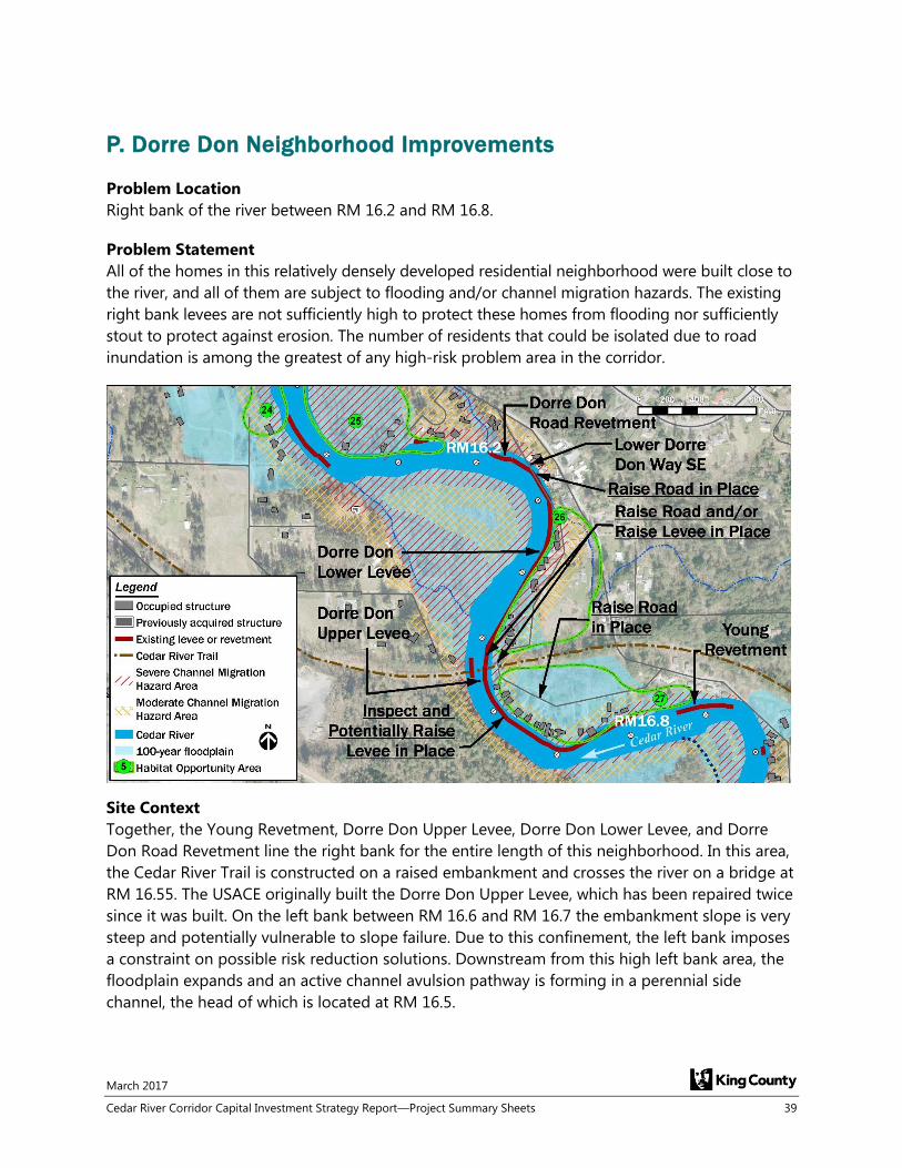
P. Dorre Don Neighborhood Improvements
Problem Location
Right bank of the river between RM 16.2 and RM 16.8.
Problem Statement
All of the homes in this relatively densely developed residential neighborhood were built close to
the river, and all of them are subject to flooding and/or channel migration hazards. The existing
right bank levees are not sufficiently high to protect these homes from flooding nor sufficiently
stout to protect against erosion. The number of residents that could be isolated due to road
inundation is among the greatest of any high-risk problem area in the corridor.
Site Context
Together, the Young Revetment, Dorre Don Upper Levee, Dorre Don Lower Levee, and Dorre
Don Road Revetment line the right bank for the entire length of this neighborhood. In this area,
the Cedar River Trail is constructed on a raised embankment and crosses the river on a bridge at
RM 16.55. The USACE originally built the Dorre Don Upper Levee, which has been repaired twice
since it was built. On the left bank between RM 16.6 and RM 16.7 the embankment slope is very
steep and potentially vulnerable to slope failure. Due to this confinement, the left bank imposes
a constraint on possible risk reduction solutions. Downstream from this high left bank area, the
floodplain expands and an active channel avulsion pathway is forming in a perennial side
channel, the head of which is located at RM 16.5.

March 2017
40 Cedar River Corridor Capital Investment Strategy Report—Project Summary Sheets
Flood and Erosion Risk
The entire neighborhood along the right bank is vulnerable to flooding, to isolation due to road
inundation, and to erosion due to channel migration, despite numerous existing flood protection
facilities. During the November 1990 flood (a 60-year return period event), the river breached or
overtopped Dorre Don Upper Levee, flooding the neighborhood and inundating the upstream
portion of Lower Dorre Don Way SE. The downstream portion of Lower Dorre Don Way SE is
inundated during floods with 20-year and greater return periods, thus isolating residents.
Flood Event
Flooding Risks Erosion Risks
Number of
People with
Flooding Above
Finished Floor
Number of
People with
Floodwater
Surrounding
Occupied
Structures
Number of
People Isolated
Due to Roadway
Inundation
Number of
People in
Moderate or
Severe Channel
Migration Hazard
Area
Length of Roads
in Moderate or
Severe Channel
Migration Hazard
Area (feet)
20-year 19 39 38 94 1,270
100-year 31 48 48
Risk Reduction Proposals
It is recommended that a feasibility study be conducted to determine if modifications to Dorre
Don Road Revetment, Dorre Don Lower Levee, and/or Dorre Don Upper Levee will result in
meaningful flood risk reduction and to determine what level of protection can be provided. The
study would also evaluate other structural improvements such as raising Lower Dorre Don Way
SE upstream and downstream of the trail crossing and farther downstream near RM 16.3. The
study would also consider acquisitions of high-risk homes from willing sellers, which may be a
necessity to accomplish any levee modifications in close proximity to numerous homes.
Potential Project Benefits - Depending on Alternative(s) Selected
Reduce frequency and duration of road inundation and improve access for many
residents during major flood events
Move people out of harm’s way where flood and erosion risks cannot feasibly be
alleviated, while increasing flood storage
Improve the level of flood protection provided by the levee system
Reduce channel migration risks for residents along the right bank
Improve floodplain function to facilitate expansion of salmon spawning and rearing
habitats
Cost Estimate
The cost of the feasibility study is estimated to be $350K.
Implementation Considerations
Although originally built by the USACE, recent repairs to the Dorre Don Upper Levee have been
completed by King County. However, future modifications to this levee may require
coordination with the USACE. Raising the road near the upstream end of the neighborhood is
challenging due to the proximity of fences and numerous driveway connections, and also due to

March 2017
Cedar River Corridor Capital Investment Strategy Report—Project Summary Sheets 41
roadside drainage issues. If a future proposal is to include raising a levee or the road in-place,
compensatory flood storage and zero-rise mitigation will need to be provided. Project
considerations in this neighborhood should be coordinated with those in the upstream Orchard
Grove neighborhood.
If future projects result in removal or setback of levees or revetments, up to 3 acres of floodplain
could be reconnected to the river. Geographic overlap of flood risk reduction project elements
with other complementary floodplain objectives creates an opportunity for project partnerships.
Project elements that protect or enhance habitat or recreational opportunities and amenities
could leverage funding, streamline permitting, garner stakeholder support, and help achieve
regional multi-objective goals.
Sequencing Considerations
This neighborhood has one of the highest concentrations of risk to homes in the corridor.
However, as there are no straightforward solutions to reduce risks in this area, the feasibility
study is needed to identify potential alternatives. The feasibility study should be considered for
either medium-term or long-term action depending on the funding available, in order to define
subsequent long-term actions.


March 2017
Cedar River Corridor Capital Investment Strategy Report—Project Summary Sheets 43
Q. Elliott Bridge Reach Neighborhood Improvements
Problem Location
Left and right bank of the river from RM 5.0 to RM 5.6.
Problem Statement
Homes on both sides of the river are located in the floodplain and also in the severe channel
migration hazard area. SE Jones Place is the sole access road for homes on the right bank, and
faces risks from both flooding and erosion.
Site Context
King County has already acquired 18 of the most severely flood-prone homes in this reach on
both the left and right banks, all of which were located within the 100-year floodplain and/or
channel migration zone. There are three County maintained flood protection facilities in this
area. The Punnett Briggs Revetment provides erosion protection to 4 homes on the downstream
right bank, and was partially destroyed/buried by the Nisqually Earthquake in 2001. The Elliott
Bridge and Orting Hill levees have largely been made obsolete through buyouts of the highly
flood-prone properties behind them. King County recently partnered with WSDOT to implement
a wetland mitigation project on the right bank just downstream of 154th Place SE. The former
Elliott Bridge crossed the river near RM 5.4; its former bridge abutments obstruct flood
conveyance, but provide some flow deflection in front of two homes. The new 154th Place SE
Bridge crosses the river at the upstream end of this reach. Madsen Creek and its overflow
channel pass through this area in the left bank floodplain. The City of Renton’s Ron Regis Park,
providing parking and access to the Cedar River Trail and ball fields, is located in the left bank
floodplain.

March 2017
44 Cedar River Corridor Capital Investment Strategy Report—Project Summary Sheets
Flood and Erosion Risk
Flood buyouts have reduced risks in this reach, but 11 remaining homes on both the left and
right banks are vulnerable to flooding in the 100-year return period flood event, 7 of them in just
a 20-year return period event. Most of these homes can also be isolated when access roads are
inundated during flooding. The western end of SE Jones Place on the right bank, and 7 homes
along the road, are in the severe channel migration hazard area and are built on relic landslide
deposits. Damage to the road would indefinitely compromise access for a total of 8 homes.
Inundation of SE Jones Place in a 100-year flood event would also isolate these 8 homes. Future
landslide risks exist on the right bank between RM 4.4 and RM 5.5 posing risks to homes due
directly to the unstable slopes and to the potential backwater effects upstream. Bank erosion is
occurring on the left bank of the Cedar River within Ron Regis Park, impacting trails within the
park. In the left bank floodplain, overbank flows from the Madsen Creek channel and the larger
Madsen Creek overflow channel result in flooding of homes and the shoulder of SR 169.
Excessive sediment deposition in the overflow channel is a contributor to the problem.
Flood Event
Flooding Risks Erosion Risks
Number of
People with
Flooding Above
Finished Floor
Number of
People with
Floodwater
Surrounding
Occupied
Structures
Number of
People Isolated
Due to Roadway
Inundation
Number of
People in
Moderate or
Severe Channel
Migration Hazard
Area
Length of Roads
in Moderate or
Severe Channel
Migration Hazard
Area (feet)
20-year 5 15 10 22 2,260
100-year 15 41 53
Risk Reduction Proposals
It is recommended that the 2 remaining high-risk properties within the severe channel migration
hazard area on the right bank and the one remaining at-risk property within the severe channel
migration hazard area on left bank be acquired, that a portion of SE Jones Place near RM 5.3 be
raised-in-place to reduce frequency of inundation, and that the upstream end of the Punnett
Briggs Revetment be reinforced to prevent outflanking. Additionally, it is recommended that a
feasibility study be completed to evaluate opportunities to address residual flood and landslide
risks in this reach and bank erosion in Ron Regis Park. Opportunities include, but are not limited
to, removing abandoned bridge approaches, removing unnecessary left bank levee facilities,
realigning Madsen Creek, elevating homes, and acquiring flood- and erosion-prone properties.
Potential Project Benefits - Depending on Alternative(s) Selected
Reduce frequency of inundation of SE Jones Place and reduce isolation of homes
Improve resiliency of the Punnett Briggs Revetment
Move people out of harm’s way where flood and erosion risks cannot feasibly be
alleviated, while increasing flood storage
Reconnect floodplain areas and improve flood flow conveyance and side channel habitat
Improve floodplain function, including side-channels, to facilitate expansion of salmon
spawning and rearing habitats
Reduce bank erosion in Ron Regis Park

March 2017
Cedar River Corridor Capital Investment Strategy Report—Project Summary Sheets 45
Cost Estimate
The project cost is estimated to be $2.6M, of which $1.3M is for property acquisitions. Funds
awarded by a Floodplains by Design (FbD) grant may offset a portion of the acquisition costs.
The cost of the feasibility study to evaluate additional flood and landslide risk reduction
opportunities is estimated to be $240K. There may be an opportunity for funding partnerships
on project elements providing strong habitat benefits.
Implementation Considerations
SE Jones Place may not meet current road standards, and modification may require a design
variance. There may be an opportunity to partner with the City of Renton on a solution to
address erosion concerns in Ron Regis Park and flooding concerns associated with Madsen
Creek. Setback or removal of obsolete levees and/or revetments could reconnect up to 10 acres
of floodplain. Geographic overlap of flood risk reduction project elements with other
complementary floodplain objectives creates an opportunity for project partnerships. Project
elements that protect or enhance habitat or recreational opportunities and amenities could
leverage funding, streamline permitting, garner stakeholder support, and help achieve regional
multi-objective goals. Opportunities to leverage funding and partnerships to integrate habitat
improvements within the Madsen Creek corridor represent a particular consideration that should
be investigated as part of the feasibility study.
Sequencing Considerations
As a result of previous property acquisitions, some of the risks have already been alleviated.
Completion of high-risk property acquisitions in this area, in addition to implementation of the
other recommended structural solutions, should be considered for either near-term (6-year CIP)
or medium-term action depending on the funding available. The three remaining high-risk
properties are included on the acquisition list for the current FbD grant.

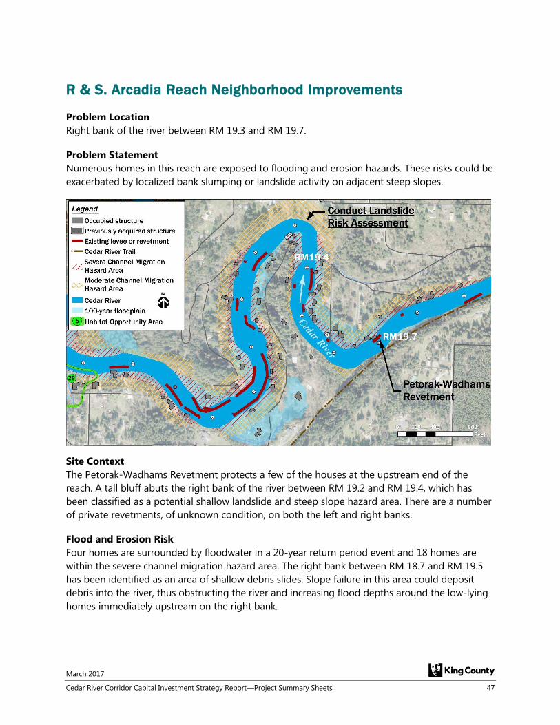
March 2017
Cedar River Corridor Capital Investment Strategy Report—Project Summary Sheets 47
R & S. Arcadia Reach Neighborhood Improvements
Problem Location
Right bank of the river between RM 19.3 and RM 19.7.
Problem Statement
Numerous homes in this reach are exposed to flooding and erosion hazards. These risks could be
exacerbated by localized bank slumping or landslide activity on adjacent steep slopes.
Site Context
The Petorak-Wadhams Revetment protects a few of the houses at the upstream end of the
reach. A tall bluff abuts the right bank of the river between RM 19.2 and RM 19.4, which has
been classified as a potential shallow landslide and steep slope hazard area. There are a number
of private revetments, of unknown condition, on both the left and right banks.
Flood and Erosion Risk
Four homes are surrounded by floodwater in a 20-year return period event and 18 homes are
within the severe channel migration hazard area. The right bank between RM 18.7 and RM 19.5
has been identified as an area of shallow debris slides. Slope failure in this area could deposit
debris into the river, thus obstructing the river and increasing flood depths around the low-lying
homes immediately upstream on the right bank.

March 2017
48 Cedar River Corridor Capital Investment Strategy Report—Project Summary Sheets
Flood Event
Flooding Risks Erosion Risks
Number of
People with
Flooding Above
Finished Floor
Number of
People with
Floodwater
Surrounding
Occupied
Structures
Number of
People Isolated
Due to Roadway
Inundation
Number of
People in
Moderate or
Severe Channel
Migration Hazard
Area
Length of Roads
in Moderate or
Severe Channel
Migration Hazard
Area (feet)
20-year 2 10 0 85 945
100-year 17 53 65
Risk Reduction Proposals
It is recommended that a site specific landslide risk assessment study be conducted for the right
bank between RM 18.7 and RM 19.5. In addition, property acquisitions are recommended for up
to 6 of the homes on the right bank between RM 19.4 and RM 19.7 that are at high risk due to
existing flood and channel migration hazards.
Potential Project Benefits - Depending on Alternative(s) Selected
Move people out of harm’s way where flood and erosion risks cannot feasibly be
alleviated
Improve understanding of landslide-related risk
Reconnect floodplain areas
Cost Estimate
The cost of a reconnaissance-level landslide risk assessment study is estimated to be $140K. The
cost to acquire the 6 high-risk properties is estimated to be $3.2M.
Implementation Considerations
Acquisition of homes and setting back the right bank of the river could reconnect up to 2 acres
of floodplain. Flood risk reduction acquisitions create an opportunity for project partnerships
that enhance habitat or recreational opportunities and amenities, leverage funding, streamline
permitting, garner stakeholder support, and help achieve regional multi-objective goals.
Sequencing Considerations
The landslide risk assessment study is proposed as a long-term action, to inform potential
additional long-term actions.

March 2017
Cedar River Corridor Capital Investment Strategy Report—Project Summary Sheets 49
T. Lower Cedar River Maintenance Dredging Project – Future
Problem Location
The project site is located near the mouth of the Cedar River between RM 1.2 and RM 0.0,
entirely within the municipal boundaries of the City of Renton. This portion of the river is part of
the Lower Cedar River Section 205 Flood Damage Reduction Project (Section 205 Project).
Problem Statement
The lower Cedar River flows in an engineered channel that was constructed in 1912, located in an
area where the river historically deposited sediment across an expansive alluvial fan. With levees
and floodwalls constructed on both banks of the river, the sediment that would normally be
spread across the alluvial fan now deposits in the lower 1.2 miles of the river, thus requiring
periodic dredging of the channel to maintain 100-year flood level of protection by the levee and
floodwall system.
Site Context
The Section 205 Project was originally designed and permitted by the US Army Corps of
Engineers (USACE), was locally sponsored by the City of Renton, and was constructed in 1998.
The Section 205 Project included dredging of the channel and construction of levees and
floodwalls along both banks of the lower 1.2 miles of the river to provide 100-year flood level of
protection. The Section 205 Project design assumed periodic dredging of the channel would be
required in the future to maintain the designed level of protection provided by the levees and
floodwalls. After construction, it was estimated that channel dredging would be required every
3 years on average to meet project objectives. However, bed aggradation since 1998 occurred

March 2017
50 Cedar River Corridor Capital Investment Strategy Report—Project Summary Sheets
less rapidly than anticipated, and it wasn’t until 18 years later that maintenance dredging was
required in 2016. As the river will continue to aggrade, future maintenance dredging will be
required.
Flood and Erosion Risk
Major infrastructure at risk in the floodplain includes Renton Municipal Airport on the left bank
and The Boeing Company’s Renton Production Facility on the right bank. Additionally, a large
number of residential and commercial structures on the left and right banks would be at risk if
the 100-year flood level of protection is not maintained with this maintenance dredging project.
Risk Reduction Proposals
Maintenance dredging is a mandated maintenance responsibility for the City of Renton as per
the Project Cooperation Agreement between the USACE and the City of Renton. Thus, no other
alternatives to maintenance dredging are proposed. As part of the environmental impact
analysis for the original 1998 Section 205 Project, the USACE considered several alternatives to
dredging, none of which met the project objectives.
Potential Project Benefits
Maintain greater than 100-year flood level of protection for the valuable economic assets
that border the river
Provide up to 200-year flood level of protection; this level of protection would be
greatest immediately following dredging, and would gradually diminish over time as the
channel aggrades again
Increase vertical clearance between the 100-year water surface elevation and the low
chord of the superstructure at Logan Avenue North and Williams Avenue bridges
Cost Estimate
Planning level total project cost for a potential future maintenance dredging project, in 2016
dollars, is $15.2M. This is based on adding a 15 percent contingency to the $13.2M total project
cost for the 2016 maintenance dredge project.
Implementation Considerations
Dredging will require actions to mitigate impacts to wetland, river and riparian habitats. The
$13.2M cost for completion of the 2016 project included approximately $600,000 in mitigation
costs. The planning level project cost for the future project is therefore inclusive of mitigation
costs. In 2015 the City of Renton completed a study of Chinook salmon habitat restoration
opportunities in the lower Cedar River in conjunction with WRIA 8. The City intends to consider
some of the study recommendations as mitigation options for future dredging.
Dredging will require implementation of a maintenance and monitoring plan. The $13.2M cost
for completing the 2016 project included approximately $650,000 in maintenance and
monitoring costs for the 10-year monitoring period. The planning level project cost estimate for
the future project is therefore inclusive of monitoring and maintenance costs.
Sequencing Considerations
Since dredging of the lower river was completed in 2016, and future dredging would not likely
be required for at least another 10 to 15 years, this project is proposed as a long-term action.

March 2017
Cedar River Corridor Capital Investment Strategy Report—Project Summary Sheets 51
U. Orchard Grove Neighborhood Improvements
Problem Location
Right bank of the river from RM 17.0 to RM 17.6.
Problem Statement
The homes in the upstream part of this relatively densely developed residential neighborhood are
prone to frequent flooding, to isolation resulting from inundation of the sole access road, and to
damage due to channel migration.
Site Context
The Orchard Grove Levee (RM 17.3 to RM 17.6) is the only County maintained facility in this
neighborhood. It has been repaired twice since 1990. Privately-built revetments line the right
bank between RM 17.3 and RM 17.1, protecting 12 homes. A steep, undeveloped bank
potentially vulnerable to slope failure is located across the river from the residential
neighborhood. This bank imposes a constraint on possible risk reduction solutions.
Flood and Erosion Risk
The channel is steeper and the floodplain area is narrower here than in many other parts of the
corridor. There are 28 homes in this neighborhood located in the severe channel migration
hazard area, and 17 of them would be surrounded by floodwater in a 100-year return period
flood event. The low-lying residential area behind the Orchard Grove Levee, including Dorre Don
Way SE, floods relatively frequently. Across the river, the left bank rises to a high bluff and is
mapped as a landslide hazard area. If a landslide were to occur on the bluff it could block the
river, posing more serious risks to the low-lying homes on the right bank. On the right bank
between RM 17.3 and RM 17.1, the privately owned revetments, which protect homes against
channel migration risks, are generally in poor condition.

March 2017
52 Cedar River Corridor Capital Investment Strategy Report—Project Summary Sheets
Flood Event
Flooding Risks Erosion Risks
Number of
People with
Flooding Above
Finished Floor
Number of
People with
Floodwater
Surrounding
Occupied
Structures
Number of
People Isolated
Due to Roadway
Inundation
Number of
People in
Moderate or
Severe Channel
Migration Hazard
Area
Length of Roads
in Moderate or
Severe Channel
Migration Hazard
Area (feet)
20-year 2 12 46 68 15
100-year 12 41 109
Risk Reduction Proposals
It is recommended that a detailed alternatives analysis be conducted to identify a recommended
alternative. The alternatives analysis will include consideration of the following three potential
solutions, which could be implemented independently or together:
a) Raise the low-lying section of Dorre Don Way SE/SE 238th Street and possibly realign the
roadway further inland, which would also smooth out a sharp curve that does not meet
current road design standards. Realignment of the road will require acquisition of
2 properties.
b) Construct a side channel in left bank floodplain between RM 16.8 and RM 17.2 and install
engineered log structures in the main channel to deflect flow away from the eroding
right bank.
c) Acquire up to 11 high-risk homes from willing sellers on the right bank immediately
adjacent to the river between RM 17.2 and RM 17.6.
Potential Project Benefits - Depending on Alternative(s) Selected
Improve access and reduce isolation risks for many residents during major flood events
Move people out of harm’s way where flood and erosion risks cannot feasibly be
alleviated, while increasing flood storage
Reduce risks due to channel migration for right bank properties near RM 17.3
Improve floodplain function, including side-channels, to facilitate expansion of salmon
spawning and rearing habitats
Cost Estimate
Project cost for solution “a” is estimated to be $1.9M (including $875K for property acquisitions).
Project cost for solution “b” is estimated to be $3.6M, and project cost for solution “c” is
estimated to be $4.9M (including 10-year site establishment and site maintenance costs). There
may be an opportunity for funding partnerships on project elements providing strong habitat
benefits.
Implementation Considerations
The existing roadway makes a hairpin turn amid the neighborhood—realigning the road further
inland at this location would put the road on higher ground while also improving sight distance,
but would require purchasing two properties. Setting back the levee or streambanks could
provide opportunity to reconnect up to 3 acres of floodplain. If a new left bank side channel is
created/encouraged at the downstream end of this neighborhood, the design would need to
ensure hazards in the downstream Dorre Don neighborhood are not worsened. A new side
channel in the left bank floodplain would have habitat benefits, in addition to flood risk benefits.
Geographic overlap of flood risk reduction project elements with other complementary

March 2017
Cedar River Corridor Capital Investment Strategy Report—Project Summary Sheets 53
floodplain objectives creates an opportunity for project partnerships. Project elements that
protect or enhance habitat or recreational opportunities and amenities could leverage funding,
streamline permitting, garner stakeholder support, and help achieve regional multi-objective
goals.
Sequencing Considerations
This project is proposed as either a medium-term or long-term action.

March 2017
54 Cedar River Corridor Capital Investment Strategy Report—Project Summary Sheets
V. SE Bain Road Neighborhood Improvements
Problem Location
Left and right bank floodplains between RM 14.6 and RM 15.1.
Problem Statement
Floodwaters overtop left bank revetments, inundate SE Bain Road, and surround homes. Many of
the left bank homes are located close to the top of bank, and 13 of them are located within the
severe channel migration hazard area. Five homes on the right bank are also located within the
severe channel migration hazard area; two of these were recently acquired by the City of Seattle.
The potential for landslides in the Royal Arch Reach just downstream of this area could increase
flood and channel migration risks for these homes.
Site Context
The Lower Bain Road Revetment lines the left bank in front of this small neighborhood,
mitigating but not eliminating erosion risk. On the opposite side of the river, WSDOT built a
floodplain wetland mitigation site as part of the SR 18 improvements. Any action taken to direct
more floodwater to the right bank side of the river needs to address implications for that
mitigation site.
Flood and Erosion Risk
Eight homes are in both the 20-year floodplain and severe channel migration hazard area. A total
of 18 structures are located within the severe channel migration hazard area, and an additional
2 structures are located within the moderate channel migration hazard area. The neighborhood
could be isolated due to inundation of SE Bain Road during a 100-year return period flood.

March 2017
Cedar River Corridor Capital Investment Strategy Report—Project Summary Sheets 55
Finally, the steep slopes along the left bank between RM 14.1 and RM 14.7 (Royal Arch Reach)
downstream of this neighborhood have been identified as an area of shallow debris slides. Slope
failure in this area could deposit debris into the river, thus causing backwater conditions that
increase flood risks for upstream residents in the project reach.
Flood Event
Flooding Risks Erosion Risks
Number of
People with
Flooding Above
Finished Floor
Number of
People with
Floodwater
Surrounding
Occupied
Structures
Number of
People Isolated
Due to Roadway
Inundation
Number of
People in
Moderate or
Severe Channel
Migration Hazard
Area
Length of Roads
in Moderate or
Severe Channel
Migration Hazard
Area (feet)
20-year 0 10 0 48 110
100-year 12 24 97
Risk Reduction Proposals
It is recommended that an alternatives analysis be conducted to determine the most cost‐
effective solution for the left bank problems. As a first step, the integrity of the Lower Bain Road
and Bain Road revetments should be assessed to evaluate their current level of effectiveness and
the feasibility of either extending them or raising them in place. The alternatives analysis will
include consideration of the following four potential solutions, which could be implemented
independently or together:
a) Construct engineered log structure flow deflectors extending from the left bank
downstream of SR 18 to deflect flow away from the left bank revetments into a
previously constructed right bank side channel.
b) Raise-in-place and extend the Lower Bain Road Revetment further downstream
c) Acquire three properties on 221st Avenue SE that are on the right bank within the severe
channel migration hazard area, downstream of the WSDOT wetland mitigation site.
Construct a side channel on the right bank that connects with a previously constructed
channel.
d) Conduct a reconnaissance-level landslide risk assessment in the Royal Arch Reach just
downstream of this neighborhood (RM 14.1 to RM 14.7) to assess whether landslide
hazards merit consideration of additional actions or buyouts.
Potential Project Benefits - Depending on Alternative(s) Selected
Improve level of flood protection for low-lying homes near the river on left bank
Reduce vulnerability of the Lower Bain Road Revetment to erosion damage
Reduce frequency of SE Bain Road inundation
Move people out of harm’s way where flood and erosion risks cannot feasibly be
alleviated
Improve floodplain function, including side-channels, to facilitate expansion of salmon
spawning and rearing habitats

March 2017
56 Cedar River Corridor Capital Investment Strategy Report—Project Summary Sheets
Cost Estimate
Project cost for solution “a” is estimated to be $1.5M (including $110K for property acquisition).
Project cost for solution “b” is estimated to be $2.7M, including 10 years of site monitoring and
maintenance. Project cost for solution “c” is estimated to be $2.3M (including $1.0M for property
acquisition and including 10 years of site monitoring and maintenance). The landslide study is
estimated to cost $50K. There may be an opportunity for funding partnerships on project
elements providing strong habitat benefits.
Implementation Considerations
Raising, extending, or otherwise modifying the County's left bank facilities would require
construction work in very close proximity to several homes and encroach on their yards.
Easements would be needed from those property owners. If flow is deflected into the right bank
floodplain amid WSDOT's mitigation site, coordination with WSDOT would be required. Side-
channel creation could reconnect up to 6 acres of floodplain. The City of Seattle’s Habitat
Conservation Program has been actively purchasing right bank flood-prone homes in this reach
in order to create a habitat restoration project. Recently this work has been funded in part by
the same Floodplains by Design grant that funds the King County Herzman and Riverbend
projects design work and property acquisitions farther downstream in the corridor. Geographic
overlap of flood risk reduction project elements with other complementary floodplain objectives
creates an opportunity for project partnerships. Project elements that protect or enhance habitat
or recreational opportunities and amenities could leverage funding, streamline permitting,
garner stakeholder support, and help achieve regional multi-objective goals. In particular, King
County should consider further partnering with the City of Seattle in this area to address
ongoing flood risk and habitat improvements in tandem.
Sequencing Considerations
This project is proposed as a long-term action because the existing level of risk to residents and
other infrastructure is not as great as in other problem areas in the corridor.