Embed Size (px)
Citation preview
34 GIWA REGIONAL ASSESSMENT 40B AMAZON BASIN CAUSAL CHAIN ANALYSIS 35
This section aims to identify the root causes of the environmental
and socio-economic impacts resulting from those issues and
concerns that were prioritised during the assessment, so that
appropriate policy interventions can be developed and focused
where they will yield the greatest benefits for the region. In order
to achieve this aim, the analysis involves a step-by-step process
that identifies the most important causal links between the
environmental and socio-economic impacts, their immediate
causes, the human activities and economic sectors responsible
and, finally, the root causes that determine the behaviour of those
sectors. The GIWA Causal chain analysis also recognises that,
within each region, there is often enormous variation in capacity
and great social, cultural, political and environmental diversity.
In order to ensure that the final outcomes of the GIWA are viable
options for future remediation, the Causal chain analyses of the
GIWA adopt relatively simple and practical analytical models and
focus on specific sites within the region. For further details, please
refer to the chapter describing the GIWA methodology.
Introduction
The Amazon Basin is the largest river basin on the planet and also one
of the least understood. Its natural areas are still quite well preserved
and relatively uninhabited. With the exception of Bolivia, the majority
of the population of each of the seven countries that share the Amazon
Basin (Brazil, Bolivia, Peru, Colombia, Ecuador, Venezuela and Guyana) is
located in other regions of these countries outside the Basin. Within the
Amazon Basin, only five cities possess more than 1 million inhabitants,
two located in Brazil, two in Bolivia and one in Peru. Three more cities
have populations that range between 300 000 and 1 million inhabitants,
two in Peru and one in Brazil (Goulding et al. 2003).
The reduced number of urban centres in the Amazon Basin has helped
preserve the ecological processes within the Basin. Unfortunately
however, the relatively low population within the Amazon Basin also
means that the level of attention that central governments dedicate to
the area is disproportional to its size or its environmental importance.
As a consequence, local administrations do not have sufficient capacity
to implement ecologically and economically sustainable management
due to the shortage of funds from federal budgets and lack of basic
information or statistics. Although this situation might prevail in all
Amazon countries, the specific situation varies among countries sharing
the Basin and also between different regions within a single country.
The GIWA Causal chain analysis aims to identify the root causes that
threaten the maintenance of the aquatic ecological processes upon
which human survival depends. Considering the dimension and
heterogeneity of the Amazon Basin, this analysis was not feasible
for the entire region. Table 1 show the division of catchments within
the Amazon Basin and their transboundary classification (national or
international). The Madeira River has the largest catchment within the
Amazon Basin and is the third biggest river in South America, surpassed
only by the Amazon and Paraná rivers. Among the international basins
of the Amazon (Caquetá-Japurá, Juruá, Madeira, Marañón, Napo, Nebro,
Purus and Putumayo-Içá) (Figure 3, Table 1), the Madeira River is the
most populated and possesses serious environmental problems. More
than half of the population of Bolivia, including the capital La Paz,
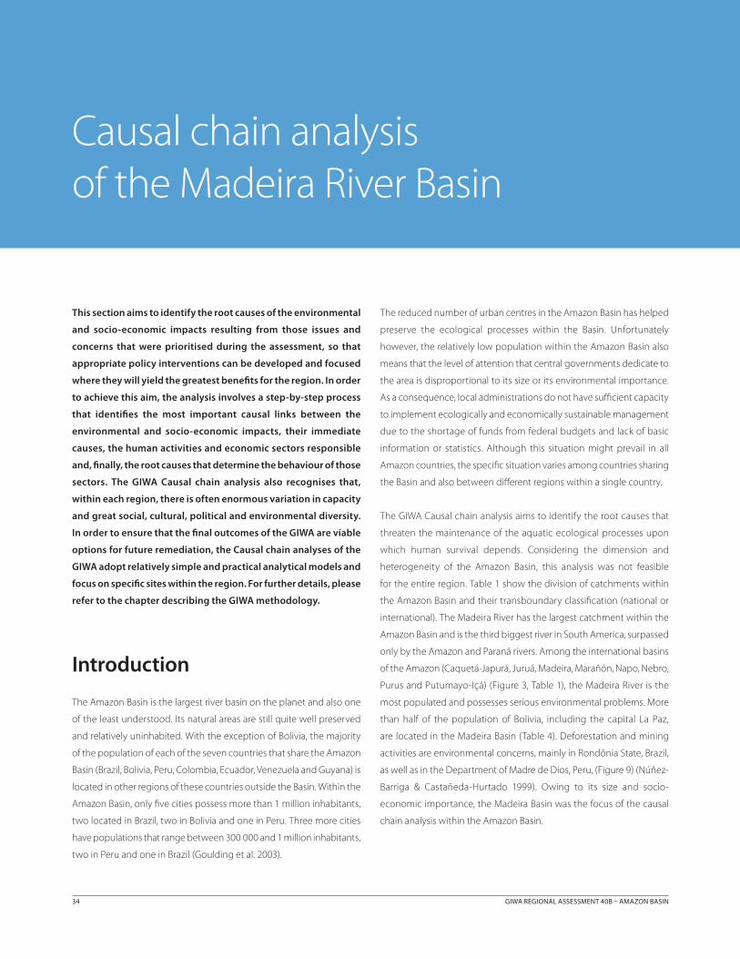
are located in the Madeira Basin (Table 4). Deforestation and mining
activities are environmental concerns, mainly in Rondônia State, Brazil,
as well as in the Department of Madre de Dios, Peru, (Figure 9) (Núñez-
Barriga & Castañeda-Hurtado 1999). Owing to its size and socio-
economic importance, the Madeira Basin was the focus of the causal
chain analysis within the Amazon Basin.
Causal chain analysis of the Madeira River Basin
34 GIWA REGIONAL ASSESSMENT 40B AMAZON BASIN CAUSAL CHAIN ANALYSIS 35
System description
Geographic and demographic settingsThe Madeira River is the largest tributary of the Amazonas River
extending 3 352 km and possessing the largest drainage area
(1 380 000 km2), the greatest flow (6 700 km3/year), sediment discharges
(667.4 million tonnes per year), and oscillations in water level (21.8 m).
The Madeira Basin represents approximately one fifth of the total
drainage area of the Amazon Basin. Fifty percent of the Madeira Basin is
located in Bolivia, 40% in Brazil and 10% in Peru (Carvalho & Cunha 1998,
Dunne et al. 1998, Goulding et al. 2003) and, within these countries, it
drains 14 different states.
The headwaters of the Madeira River are located near Cochabamba,
in the upper Mamoré River, about 4 600 km away from the Atlantic
Ocean. Four tributaries of the Madeira River are responsible for more
than 60% of all freshwater discharge: Mamoré, Guaporé-Itenez, Beni and
Madre de Dios. The Mamoré and Beni rivers have their headwaters in
the Bolivian Andes, while the Madre de Dios originates in the Peruvian
Andes and the Guaporé-Itenez River stems from the Brazilian Shield.
These four rivers are navigable from below the foothills of the Andes
until their confluence, near Guajará-Mirim. However, between Guajará-
Mirim and Porto Velho, these rivers are united along a sequence of
waterfalls, where navigation is impossible. Below the San Antonio Fall,
1 070 km from the mouth, vessels may navigate during the high water
period. Otherwise, in the dry months between June and November,
these reaches are only navigable by craft drawing less that 2 m of water
(Goulding et al. 2003).
The Madeira Basin supports a significant Bolivian population, but it is
sparsely inhabited in Peru and in Brazil. More than 50% of the Bolivian
population is located in the Madeira Basin, including the capital La Paz.
In contrast, less than 1% of the Peruvian and Brazilian population live
in the Madeira Basin (Table 4). The Bolivian departments have three
drainage areas: Madeira, Titicaca and Paraná. Some departments are
drained by more than one basin, for instance: Madeira and Paraná (Santa
Cruz, Potosi and Chuquisaca) and Madeira and Titicaca (La Paz). Only
Pando and Beni lie completely within the Madeira River Basin.
The population of Peru is primarily concentrated on the Pacific coast
and, while 16% of the Peruvians live within the Amazon Basin, only 0.4%
reside in the Madeira Basin, mainly in the Department of Madre de Dios
(Table 4). The headwaters of the Madre De Dios River is located in the
Andes in the Departments of Madre De Dios, Cusco and Puno, but these
departments are sparsely inhabited.
Beni Mam
oré Guaporé-Itenez
Madre de Dios
Deforestation
Brazil
Bolivia
Peru
Santa Cruz de La Sierra
Guajara-Mirim
Porto Velho
La Paz
Cuzco
0 250 Kilometres
Roads
Rivers
© GIWA 2003
Figure 9 Deforested areas in the Madeira Basin. (Source: GIWA Task team 2003)
Table 4 Population in relation to river basins.
Basin1
Population Population
Total (2002) Total of important cities
x 1000 % Basin2 x 1000 %
Boliv
ia
Madeira (2002) 1 919 22.6
Boliv
ia
Madeira3 3 559 68
Madeira and Paraná (2002) 2 808 33.1 Paraná4 658 13
Madeira and Titicaca (2002) 2 407 28.4 Titicaca5 982 19
Paraná (2002) 941 11.1
Titicaca (2002) 402 4.7
Peru
Amazonas (2002) 2 415 15.9
Peru
Amazonas6 2 415 16
Pacífico (2002) 12 534 82.4 Pacífico7 12 534 82
Titicaca (2002) 258 1.7 Titicaca8 258 2
Madeira (2002) 86 0.3 Madeira9 68 0.4
Braz
il
North Region (2000) 12 920 7.6
Madeira (2000) 1 397 0.9
Acre (2000) 28 0.02
Amazon Basin (2000) 133 0.1
Pará (2000) 6.8 0.004
Rondônia (2000) 1 229 0.8
Notes: 1The population data is related to geopolitical areas and not individual river basins e.g. some Bolivian departments are drained by more than one river basin. 2Population of cities localised in one or more basins; 3La Paz, Cochabamba, Guayaramerin, Trinidad; 4Santa Cruz de la Sierra; 5Oruro; 6 Iquitos, Pucallpa; 7 Lima; 8Puno; 9 Puerto Maldonado.
(Source: GIWA Task team 2003)
36 GIWA REGIONAL ASSESSMENT 40B AMAZON BASIN CAUSAL CHAIN ANALYSIS 37
The majority of the Amazon River Basin is located in the North region
of Brazil but it extends slightly into the Middle-West and Northeast
regions. The Brazilian population, on the other hand, is concentrated
in the Southeast and Northeast regions. Only about 7% of the entire
Brazilian population reside within the North region and less than 1% in
the Madeira Basin. However, despite its current low density, the present
rate of population growth in this region is greater than in other parts
of Brazil (Table 4).
Climatic and hydrologic characteristicsThe climate of the Madeira Basin varies from cold and dry, in the Andes,
to tropical and rainy in the Amazon lowlands. The climate in the Peruvian
Andes can be divided according to altitude. In the Janca region, which is
located over 4 800 m above sea level, the climate is extremely cold and
the ground is permanently covered with snow. The Puna region, famous
for its populations of alpacas and llamas, is situated between altitudes
ranging from 4 100 m to 4 800 m, and is characterised by a dry and cold
climate where the temperature oscillates between -10° and 20° C. The
Suni or Jalca region located between 3 500 m and 4 100 m is generally
cold with seasonal rainfall. The Quechua region ranges between
2 500 m to 3 500 m and is the most inhabited and modified region.
The climate is dry with cold temperatures and seasonal rainy periods.
The Yunga region situated on the lower slopes of the Andes ranges
between 500 m and 2 300 m, is characterised by a spring climate and
a dense and highly diverse cloud forest. The areas below 500 m are the
Amazon lowlands, which, with the exception of the largest savannah
zone in Bolivia, are generally covered by forests. In the lowlands of the
Madeira Basin, the annual precipitation ranges between 1 000 mm and
2 500 mm, while the foothills of the Andes receive between 5 000 mm
and 10 000 mm per year. Rainfall varies throughout the year with the
dry season occurring between May and September and rainfall peaks
occurring between November and April (Goulding et al. 2003).
The level of water in the rivers of Madeira Basin varies according to
seasonal fluctuations in rainfall and exhibits peak in February along
the foothills of the Andes, and between February and March in the
downstream sections of these rivers. The Madeira River, below the
Teotônio Falls, exhibits the greatest variation in annual discharge of any
river in the Amazon Basin. This is due both to high rainfall and relatively
narrow floodplains compared with the river discharge. In addition,
the backwater phenomenon occurs in the lower Madeira rivers due
to the natural dam effect caused by the greater elevation of water in
the Amazon River. The peak discharge from the lower Madeira River
occurs at least two months earlier than in the Amazon River (Goulding
et al. 2003).
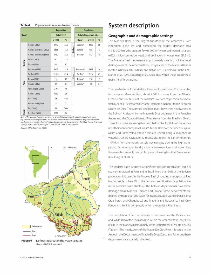
Principal economic sectors and processesThe main socio-economic activities in the region are gold mining,
logging, fishing, cattle farms and agriculture (Figure 10).
Gold mining
Large alluvial gold deposits were discovered along the Tapajós, Madeira,
Tocantins, Xingu and the Negro rivers between 1979 and 1987 (Hanai
1999). During the 1980s and 1990s, gold mining was very important
in the Madeira Basin and mining activities are now concentrated in
the region of Madre de Dios, in Peru (Núñez-Barriga & Castañeda-
Figure 11 Gold mining activity in the Madeira River headwaters.(Photo: R. Barthem)
Brazil
BoliviaPeru
Gold Mining
Logging
Fishing
Tourism
River transport
0 250 Kilometres
Roads
Rivers
© GIWA 2003Hydroelectric dam
Figure 10 Anthropogenic pressure in the Madeira River Basin.(Source: GIWA Task team 2003)
36 GIWA REGIONAL ASSESSMENT 40B AMAZON BASIN CAUSAL CHAIN ANALYSIS 37
Hurtado 1999) (Figure 11) where it is the most significant contributor to
the regions economy. Unfortunately however, gold mining is also the
biggest cause of habitat modification and pollution in the region.
Logging
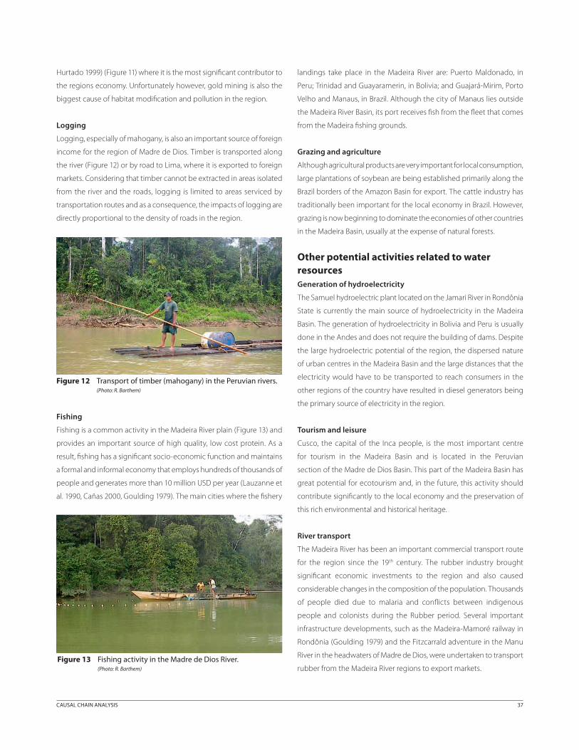
Logging, especially of mahogany, is also an important source of foreign
income for the region of Madre de Dios. Timber is transported along
the river (Figure 12) or by road to Lima, where it is exported to foreign
markets. Considering that timber cannot be extracted in areas isolated
from the river and the roads, logging is limited to areas serviced by
transportation routes and as a consequence, the impacts of logging are
directly proportional to the density of roads in the region.
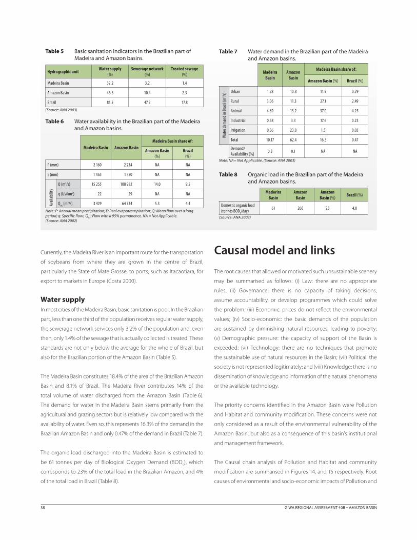
Fishing
Fishing is a common activity in the Madeira River plain (Figure 13) and
provides an important source of high quality, low cost protein. As a
result, fishing has a significant socio-economic function and maintains
a formal and informal economy that employs hundreds of thousands of
people and generates more than 10 million USD per year (Lauzanne et
al. 1990, Cañas 2000, Goulding 1979). The main cities where the fishery
landings take place in the Madeira River are: Puerto Maldonado, in
Peru; Trinidad and Guayaramerin, in Bolivia; and Guajará-Mirim, Porto
Velho and Manaus, in Brazil. Although the city of Manaus lies outside
the Madeira River Basin, its port receives fish from the fleet that comes
from the Madeira fishing grounds.
Grazing and agriculture
Although agricultural products are very important for local consumption,
large plantations of soybean are being established primarily along the
Brazil borders of the Amazon Basin for export. The cattle industry has
traditionally been important for the local economy in Brazil. However,
grazing is now beginning to dominate the economies of other countries
in the Madeira Basin, usually at the expense of natural forests.
Other potential activities related to water resourcesGeneration of hydroelectricity
The Samuel hydroelectric plant located on the Jamari River in Rondônia
State is currently the main source of hydroelectricity in the Madeira
Basin. The generation of hydroelectricity in Bolivia and Peru is usually
done in the Andes and does not require the building of dams. Despite
the large hydroelectric potential of the region, the dispersed nature
of urban centres in the Madeira Basin and the large distances that the
electricity would have to be transported to reach consumers in the
other regions of the country have resulted in diesel generators being
the primary source of electricity in the region.
Tourism and leisure
Cusco, the capital of the Inca people, is the most important centre
for tourism in the Madeira Basin and is located in the Peruvian
section of the Madre de Dios Basin. This part of the Madeira Basin has
great potential for ecotourism and, in the future, this activity should
contribute significantly to the local economy and the preservation of
this rich environmental and historical heritage.
River transport
The Madeira River has been an important commercial transport route
for the region since the 19th century. The rubber industry brought
significant economic investments to the region and also caused
considerable changes in the composition of the population. Thousands
of people died due to malaria and conflicts between indigenous
people and colonists during the Rubber period. Several important
infrastructure developments, such as the Madeira-Mamoré railway in
Rondônia (Goulding 1979) and the Fitzcarrald adventure in the Manu
River in the headwaters of Madre de Dios, were undertaken to transport
rubber from the Madeira River regions to export markets.
Figure 12 Transport of timber (mahogany) in the Peruvian rivers.(Photo: R. Barthem)
Figure 13 Fishing activity in the Madre de Dios River.(Photo: R. Barthem)
38 GIWA REGIONAL ASSESSMENT 40B AMAZON BASIN CAUSAL CHAIN ANALYSIS 39
Causal model and links
The root causes that allowed or motivated such unsustainable scenery
may be summarised as follows: (i) Law: there are no appropriate
rules; (ii) Governance: there is no capacity of taking decisions,
assume accountability, or develop programmes which could solve
the problem; (iii) Economic: prices do not reflect the environmental
values; (iv) Socio-economic: the basic demands of the population
are sustained by diminishing natural resources, leading to poverty;
(v) Demographic pressure: the capacity of support of the Basin is
exceeded; (vi) Technology: there are no techniques that promote
the sustainable use of natural resources in the Basin; (vii) Political: the
society is not represented legitimately; and (viii) Knowledge: there is no
dissemination of knowledge and information of the natural phenomena
or the available technology.
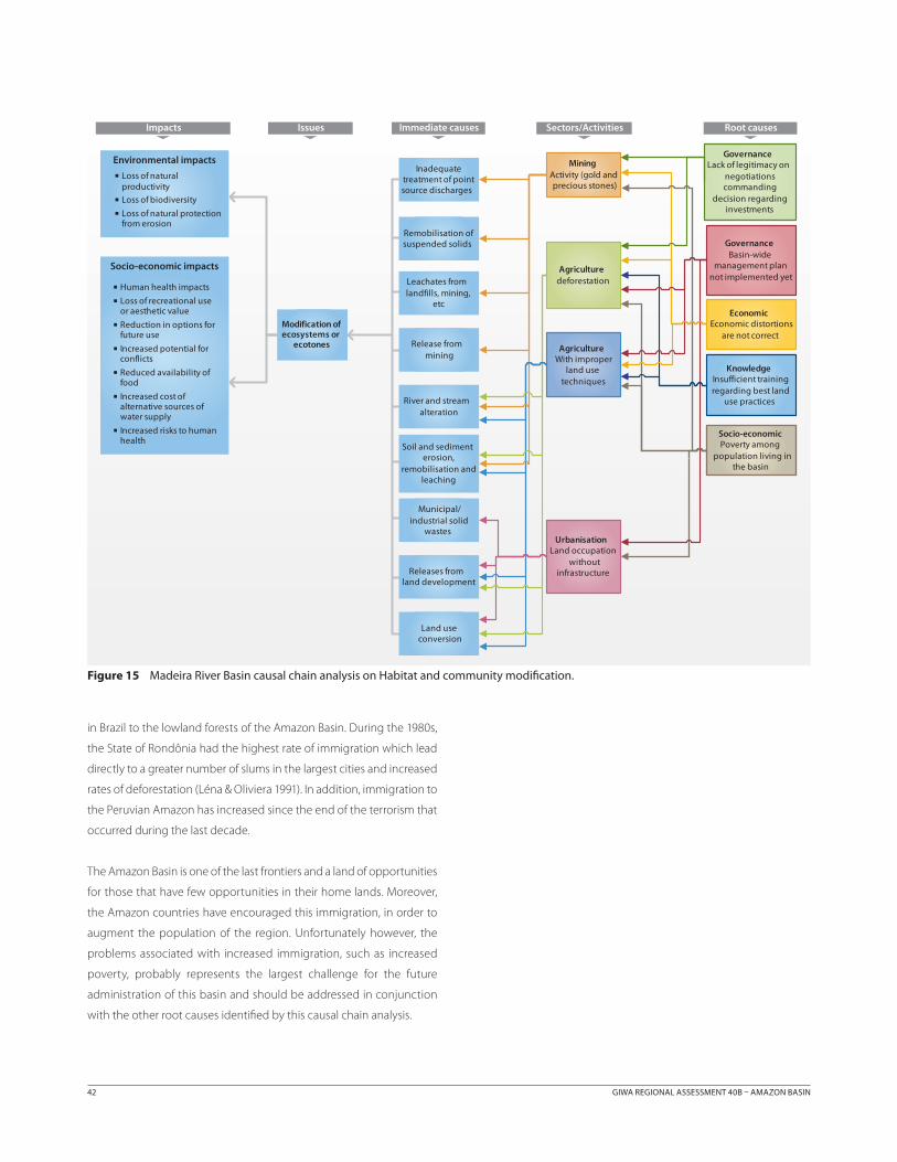
The priority concerns identified in the Amazon Basin were Pollution
and Habitat and community modification. These concerns were not
only considered as a result of the environmental vulnerability of the
Amazon Basin, but also as a consequence of this basin's institutional
and management framework.
The Causal chain analysis of Pollution and Habitat and community
modification are summarised in Figures 14, and 15 respectively. Root
causes of environmental and socio-economic impacts of Pollution and
Currently, the Madeira River is an important route for the transportation
of soybeans from where they are grown in the centre of Brazil,
particularly the State of Mate Grosse, to ports, such as Itacaotiara, for
export to markets in Europe (Costa 2000).
Water supplyIn most cities of the Madeira Basin, basic sanitation is poor. In the Brazilian
part, less than one third of the population receives regular water supply,
the sewerage network services only 3.2% of the population and, even
then, only 1.4% of the sewage that is actually collected is treated. These
standards are not only below the average for the whole of Brazil, but
also for the Brazilian portion of the Amazon Basin (Table 5).
The Madeira Basin constitutes 18.4% of the area of the Brazilian Amazon
Basin and 8.1% of Brazil. The Madeira River contributes 14% of the
total volume of water discharged from the Amazon Basin (Table 6).
The demand for water in the Madeira Basin stems primarily from the
agricultural and grazing sectors but is relatively low compared with the
availability of water. Even so, this represents 16.3% of the demand in the
Brazilian Amazon Basin and only 0.47% of the demand in Brazil (Table 7).
The organic load discharged into the Madeira Basin is estimated to
be 61 tonnes per day of Biological Oxygen Demand (BOD5), which
corresponds to 23% of the total load in the Brazilian Amazon, and 4%
of the total load in Brazil (Table 8).
Table 8 Organic load in the Brazilian part of the Madeira and Amazon basins.
Maderira Basin
Amazon Basin
Amazon Basin (%)
Brazil (%)
Domestic organic load (tonnes BOD
5/day)
61 260 23 4.0
(Source: ANA 2003)
Table 7 Water demand in the Brazilian part of the Madeira and Amazon basins.
Madeira Basin
Amazon Basin
Madeira Basin share of:
Amazon Basin (%) Brazil (%)
Wat
er d
eman
d in
Braz
il (m
3 /s) Urban 1.28 10.8 11.9 0.29
Rural 3.06 11.3 27.1 2.49
Animal 4.89 13.2 37.0 4.25
Industrial 0.58 3.3 17.6 0.23
Irrigation 0.36 23.8 1.5 0.03
Total 10.17 62.4 16.3 0.47
Demand/ Availability (%)
0.3 0.1 NA NA
Note: NA= Not Applicable. (Source: ANA 2003)
Table 6 Water availability in the Brazilian part of the Madeira and Amazon basins.
Madeira Basin Amazon BasinMadeira Basin share of:
Amazon Basin (%)
Brazil (%)
P (mm) 2 160 2 234 NA NA
E (mm) 1 465 1 320 NA NA
Avai
labi
lity
Q (m3/s) 15 255 108 982 14.0 9.5
q (l/s/km2) 22 29 NA NA
Q95
(m3/s) 3 429 64 734 5.3 4.4
Note: P: Annual mean precipitation; E: Real evapotranspiration; Q: Mean flow over a long period; q: Specific flow; Q
95: Flow with a 95% permanence. NA = Not Applicable.
(Source: ANA 2002)
Table 5 Basic sanitation indicators in the Brazilian part of Madeira and Amazon basins.
Hydrographic unitWater supply
(%)Sewerage network
(%)Treated sewage
(%)
Madeira Basin 32.2 3.2 1.4
Amazon Basin 46.5 10.4 2.3
Brazil 81.5 47.2 17.8
(Source: ANA 2003)
38 GIWA REGIONAL ASSESSMENT 40B AMAZON BASIN CAUSAL CHAIN ANALYSIS 39
Habitat and community modification were identified as Governance
failures, Market and policy failures, Lack of knowledge, and Poverty and
demographic factors.
Immediate causes and sectorsDeforestation
Until January 1978, the deforested area corresponded to 85 100 km2
(2.2% of the total area) as a result of four centuries of human action.
After 1978, there was a significant increase in the occupation of the
region, mainly due to governmental programmes, which resulted
in an expansion of the deforested areas. In 1999, 440 630 km2 (11.7%
of the total area) were deforested. Data from the Brazilian National
Institute for Space Research (INPE, Instituto Nacional de Pesquisas
Espaciais) indicated that the total area deforested during 1999 and
2000 was 17 259 km2 and 19 836 km2 respectively. According to current
estimates, approximately 15% of the original Amazon forest has already
been destroyed (ANA 2003).
Pollution
Chemicals and suspended solids are the main pollutants in this region
and originate primarily from gold mining activities in Peruvian and
Brazilian rivers and from the deforestation of large areas, especially in
the headwaters of the southeast Amazon Basin, in Brazil. At present,
localised pollution problems exist, particularly around urban centres,
but are still not a major overall concern for the Amazon Basin.
Chemical agricultural wastes and mercury contamination are the main
cause of chemical pollution in the Amazon Basin. The impacts caused
by these pollutants do not affect large areas because agricultural
activities are not widespread and because gold mining activities
occur in only a few concentrated areas. The present level of pollution
is considered low when compared with historical data obtained from
important agricultural areas in Brazil (Torres et al. 2002). The source of
mercury contamination of organisms is still not completely understood
because mercury might have originated from both gold mining
activities and from natural regional sources. The problematic areas for
chemical pollution are regions where gold mining activities are intense,
particularly in the Andean region, the State of Rondônia (Brazil) and
the Madeira River. Mercury levels in most fish species consumed by the
Amazon population are below the limit recommended for consumption
by the Brazilian legislation, but some areas show some contamination
(Kehrig et al. 1998, Brabo et al. 2000).
The concentration of suspended solids in rivers arising from the
Andean region is naturally high, but the rivers from the Amazon plain
and Brazilian Shield, which usually have very low concentrations of
sediments, have experienced an increase of solid residues in suspension.
This is caused mainly by gold mining activities and the erosion caused
by deforestation for agricultural and cattle raising activities.
The rivers and beaches close to the great urban centres exhibit large
amounts of solid residues that affect the health of local people and
tourism. The low percentages of collection and treatment of domestic
sewage leads to significant pollution. Some small streams of the great
urban centres are completely blocked by solid wastes and this increases
health problems, specifically those related to insect-transmitted
diseases (e.g. mosquito transmitted diseases).
Oil spills occur occasionally in areas where petroleum is exploited and
during fuel transportation procedures. There are no records of great
damages occasioned by oil spills so far.
Habitat and community modification
Habitat and community modification is a pivotal question among all
the environmental concerns. The enormous area affected and the long
duration of the consequences of the impacts brought by these factors
are perhaps the main reasons for considering this concern so important
and in need of management.
Deforestation is the main activity that causes loss of ecosystems in the
Amazon Basin at the present time. Recently opened areas are clearly
identifiable on satellite images in large regions of the Brazilian Shield,
headwaters of the Guaporé, Aripuanã and others rivers. The oldest
modifications to ecosystems occurred in the tundra-like vegetation,
Puna, in the Andes zone, due to agricultural activities of the Andean
people. The impact of such historical agriculture on the aquatic
system is unclear, but the recent agriculture and cattle established
in the floodplain areas, mainly in the lower Amazon, has cleared the
flooded forest that represents a source of food for several important
commercial fishes.
Fish community modification: The composition of fish species in
most of the Amazon Basin is still determined by natural events. The
introduction of alien species, such as trout and kingfish, has brought
about permanent and negative consequences mainly in the Andean
waters, rivers and lakes. Alien species have been introduced in other
areas of the Amazon, but they have either not survived or have not yet
established viable populations.
Habitat modification: Local extinction of species may occur as
a result of large habitat modifications, such as the construction of
hydroelectric dams. Although migratory fish are most affected by such
40 GIWA REGIONAL ASSESSMENT 40B AMAZON BASIN CAUSAL CHAIN ANALYSIS 41
developments, poor knowledge of the aquatic fauna of the Amazon
Basin certainly contributes to underestimating the consequences.
The dependence of the Amazon Basin on its rich hydrographic
network is graphically illustrated when extreme hydrological events
occur. For example, droughts reduce stream flow which, in turn restricts
navigation in some waterways, while increased flows cause flooding
over large areas of floodplain, influencing the dynamics of several
animal and plant species and affecting the conservation of biodiversity
within the Amazon Basin.
Root causesThe results of the causal chain analyses of Pollution and Habitat and
community modification indicated that both concerns share the most
important root causes: 1) Governance failures, 2) Market and policy
failures, 3) Poverty, and 4) Lack of knowledge (Figures 14 and 15).
Root cause 1: Governance failures
Two aspects of Governance failures related to the complexity of the
problem and the difficulty to practicable mechanisms to resolve
conflicts between different interests were identified during the causal
chain analysis. These aspects were related to: (i) the lack of legitimacy
on negotiations commanding decisions regarding investments; and
(ii) the absence of a basin-wide management plan.
Lack of legitimacy on negotiations commanding decision
regarding investments: Three countries and 14 states administer
the Madeira Basin. There are no effective fora in these administrative
institutions, designated to discuss or decide on the development
or conservation policies of this basin. The discussions that do occur
consider each economic sector, such as mining, agriculture, logging
and conservation, of each country independently. Consequently,
there is an enormous lack of integration and legitimacy of
negotiations associated with decisions concerning investments.
The most important forum for discussions in the Amazon Basin is
the Amazon Cooperation Treaty (ACT) (see Annex IV). This treaty is
a relevant multi-lateral agreement for the promotion of cooperation
between the Amazon countries (Brazil, Bolivia, Colombia, Ecuador,
Guyana, Peru, Surinam and Venezuela) to promote sustainable
development in the region. However, this treaty is not implemented
by the Amazon countries to make decisions or to implement policies
related to the sustainable development in this region. Thus far, the
Madeira Basin and the other catchments within the Amazon Basin
do not possess an integrated institutional framework dedicated to
integrated management of the Basin.
Basin-wide management plan not yet implemented: The lack
of legitimate base of negotiations, governing decisions regarding
investments, results in a precarious basin-wide management plan. One
of the most important issue related to the development of the Amazon
Basin is deforestation, which may modify habitats over an enormous
area, resulting in unpredictable climate changes. The governments of
the Amazon countries understand the necessity of preserving part of
the forest to maintain the ecological processes in this basin. Parks and
reserves have been established in many areas of the Amazon in order
to preserve the region’s biodiversity. However, it is not clear how much
deforestation has taken place or which are the most important areas of
the Amazon forest that should be preserved in order to maintain the
ecological functions of the Basin. Unfortunately however, some habitat
modifications have already occurred on a large scale but the knowledge
and understanding of the ecological mechanisms that guarantee the
equilibrium of this basin are relatively recent. Data illustrating the
importance of the forest for maintaining the hydrological cycles in
the region were only obtained during the 1970s and 1980s (Salati et al.
1978, Salati & Vose 1984). Also, the commercial exploitation during the
1990s of the large catfish, which undertakes long migrations between
the estuary and the headwaters of the Amazon, illustrated the need of
an international fishery management plan to regulate the exploitation
of those stocks (Barthem & Goulding 1997).
In addition, some specific habitats have an enormous importance that
is not immediately obvious. The flooded areas are traditionally used for
grazing and the cultivation of rice and jute, and farmers remove the
flooded forest to increase their production area. This economic expansion
causes a negative impact on fishery, because the flooded forest is an
important source of food and shelter for fish communities (Goulding
1980, Goulding 1981, Goulding & Carvalho 1982, Goulding 1989).
The implementation of a basin-wide management plan depends
primarily on the legitimacy of the parts that must be able to negotiate
decisions regarding investments, as well as on increased knowledge of
the ecological processes occurring in the Basin.
Root cause 2: Market and policy failures: misconceptions about
resource availability
There is a common misconception among resource users that the
natural resources of the Amazon Basin are inexhaustible which leads
to unsustainable exploitation, extinction of species and resource
shortages. Many of the different economic sectors within the Madeira
Basin have, at some time, held this belief and, as a consequence, not
taken enough care to preserve their own investments. The deforestation
caused by traditional activities such as timber extraction and agriculture
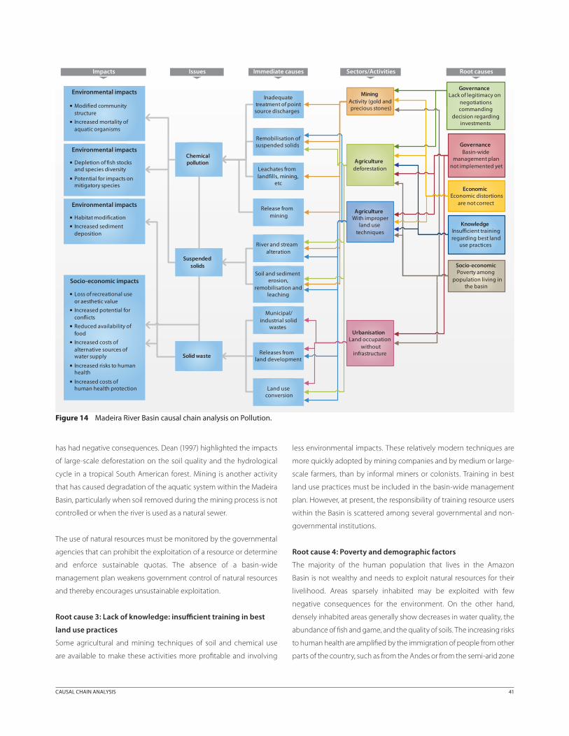
40 GIWA REGIONAL ASSESSMENT 40B AMAZON BASIN CAUSAL CHAIN ANALYSIS 41
has had negative consequences. Dean (1997) highlighted the impacts
of large-scale deforestation on the soil quality and the hydrological
cycle in a tropical South American forest. Mining is another activity
that has caused degradation of the aquatic system within the Madeira
Basin, particularly when soil removed during the mining process is not
controlled or when the river is used as a natural sewer.
The use of natural resources must be monitored by the governmental
agencies that can prohibit the exploitation of a resource or determine
and enforce sustainable quotas. The absence of a basin-wide
management plan weakens government control of natural resources
and thereby encourages unsustainable exploitation.
Root cause 3: Lack of knowledge: insufficient training in best
land use practices
Some agricultural and mining techniques of soil and chemical use
are available to make these activities more profitable and involving
less environmental impacts. These relatively modern techniques are
more quickly adopted by mining companies and by medium or large-
scale farmers, than by informal miners or colonists. Training in best
land use practices must be included in the basin-wide management
plan. However, at present, the responsibility of training resource users
within the Basin is scattered among several governmental and non-
governmental institutions.
Root cause 4: Poverty and demographic factors
The majority of the human population that lives in the Amazon
Basin is not wealthy and needs to exploit natural resources for their
livelihood. Areas sparsely inhabited may be exploited with few
negative consequences for the environment. On the other hand,
densely inhabited areas generally show decreases in water quality, the
abundance of fish and game, and the quality of soils. The increasing risks
to human health are amplified by the immigration of people from other
parts of the country, such as from the Andes or from the semi-arid zone
Figure 14 Madeira River Basin causal chain analysis on Pollution.
IssuesImpacts
Environmental impacts
Immediate causes Sectors/Activities Root causes
Environmental impacts
Environmental impacts
Environmental impacts
Socio-economic impacts
Habitat modification Increased sediment
deposition
GovernanceBasin-wide
management plan not implemented yet
GovernanceLack of legitimacy on
negotiations commanding
decision regarding investments
EconomicEconomic distortions
are not correct
Knowledge Insufficient training regarding best land
use practices
Agriculturedeforestation
MiningActivity (gold and precious stones)
AgricultureWith improper
land use techniques
Inadequate treatment of point source discharges
Land use conversion
Chemical pollution
Modified community structure
Increased mortality of aquatic organisms
Depletion of fish stocks and species diversity
Potential for impacts on mitigatory species
Socio-economicPoverty among
population living in the basin
UrbanisationLand occupation
without infrastructure
Remobilisation of suspended solids
Leachates from landfills, mining,
etc
Release from mining
River and stream alteration
Soil and sediment erosion,
remobilisation and leaching
Municipal/industrial solid
wastes
Releases from land development
Loss of recreational use or aesthetic value
Increased potential for conflicts
Reduced availability of food
Increased costs of alternative sources of water supply
Increased risks to human health
Increased costs of human health protection
Suspended solids
Solid waste
42 GIWA REGIONAL ASSESSMENT 40B AMAZON BASIN
in Brazil to the lowland forests of the Amazon Basin. During the 1980s,
the State of Rondônia had the highest rate of immigration which lead
directly to a greater number of slums in the largest cities and increased
rates of deforestation (Léna & Oliviera 1991). In addition, immigration to
the Peruvian Amazon has increased since the end of the terrorism that
occurred during the last decade.
The Amazon Basin is one of the last frontiers and a land of opportunities
for those that have few opportunities in their home lands. Moreover,
the Amazon countries have encouraged this immigration, in order to
augment the population of the region. Unfortunately however, the
problems associated with increased immigration, such as increased
poverty, probably represents the largest challenge for the future
administration of this basin and should be addressed in conjunction
with the other root causes identified by this causal chain analysis.
Figure 15 Madeira River Basin causal chain analysis on Habitat and community modification.
IssuesImpacts Immediate causes Sectors/Activities Root causes
Environmental impacts
Socio-economic impacts
GovernanceBasin-wide
management plan not implemented yet
GovernanceLack of legitimacy on
negotiations commanding
decision regarding investments
EconomicEconomic distortions
are not correct
Knowledge Insufficient training regarding best land
use practices
Agriculturedeforestation
MiningActivity (gold and precious stones)
AgricultureWith improper
land use techniques
Inadequate treatment of point source discharges
Land use conversion
Socio-economicPoverty among
population living in the basin
UrbanisationLand occupation
without infrastructure
Remobilisation of suspended solids
Leachates from landfills, mining,
etc
Release from mining
River and stream alteration
Soil and sediment erosion,
remobilisation and leaching
Municipal/industrial solid
wastes
Releases from land development
Modification of ecosystems or
ecotones
Loss of natural productivity
Loss of biodiversity Loss of natural protection
from erosion
Human health impacts Loss of recreational use
or aesthetic value Reduction in options for
future use Increased potential for
conflicts Reduced availability of
food Increased cost of
alternative sources of water supply
Increased risks to human health